A Framework for Integrating and Reasoning About Geospatial Data Compressed Publication Version
5
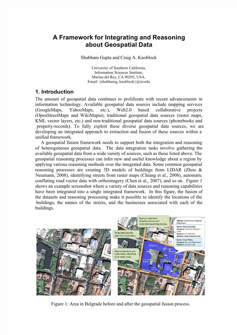
A Framework for Integrating and Reasoning about Geospatial Data Shubham Gupta and Craig A. Knoblock University of Southern California, Information Sciences Institute, Marina del Rey, CA 90292, USA, Email: {shubhamg, knoblock}@isi. edu 1. Introduction The amount of geospatial data continues to proliferate with recent advancements in information technology. Available geospatial data sources include mapping services (GoogleMaps, YahooMaps, etc.), Web2.0 based collaborative projects (OpenStreetMaps and WikiMapia), traditional geospatial data sources (raster maps, KML vector layers, etc.) and non-traditional geospatial data sources (phonebooks and property-records). To fully exploit these diverse geospatial data sources, we are developing an integrated approach to extraction and fusion of these sources within a unified framework. A geospatial fusion framework needs to support both the integration and reasoning of heterogeneous geospatial data. The data integration tasks involve gathering the available geospatial data from a wide variety of sources, such as those listed above. The geospatial reasoning processes can infer new and useful knowledge about a region by applying various reasoning methods over the integrated data. Some common geospatial reasoning processes are creating 3D models of buildings from LIDAR (Zhou & Neumann, 2008), identifying streets from raster maps (Chiang et al., 2008), automatic conflating road vector data with orthoimagery (Chen et al., 2007), and so o n. Figure 1 shows an example screenshot where a variety of data sources and reasoning capabilities have been integrated into a sing le integrated framework. In this figu re, the fusion of the datasets and reasoning processing make it possible to identify the locations of the buildings, the names of the streets, and the businesses associated with each of the buildings. Figure 1: Area in Belgrade before and after the geospatial fusion process.
-
Upload
shubygupta -
Category
Documents
-
view
223 -
download
0
Transcript of A Framework for Integrating and Reasoning About Geospatial Data Compressed Publication Version
8/8/2019 A Framework for Integrating and Reasoning About Geospatial Data Compressed Publication Version
http://slidepdf.com/reader/full/a-framework-for-integrating-and-reasoning-about-geospatial-data-compressed 1/5
A Framework for Integrating and Reasoningabout Geospatial Data
Shubham Gupta and Craig A. Knoblock
University of Southern California,
Information Sciences Institute,
Marina del Rey, CA 90292, USA,
Email: {shubhamg, knoblock}@isi.edu
1. Introduction
The amount of geospatial data continues to proliferate with recent advancements ininformation technology. Available geospatial data sources include mapping services
(GoogleMaps, YahooMaps, etc.), Web2.0 based collaborative projects
(OpenStreetMaps and WikiMapia), traditional geospatial data sources (raster maps,KML vector layers, etc.) and non-traditional geospatial data sources (phonebooks and
property-records). To fully exploit these diverse geospatial data sources, we are
developing an integrated approach to extraction and fusion of these sources within a
unified framework.A geospatial fusion framework needs to support both the integration and reasoning
of heterogeneous geospatial data. The data integration tasks involve gathering the
available geospatial data from a wide variety of sources, such as those listed above. The
geospatial reasoning processes can infer new and useful knowledge about a region by
applying various reasoning methods over the integrated data. Some common geospatial
reasoning processes are creating 3D models of buildings from LIDAR (Zhou &
Neumann, 2008), identifying streets from raster maps (Chiang et al., 2008), automaticconflating road vector data with orthoimagery (Chen et al., 2007), and so on. Figure 1
shows an example screenshot where a variety of data sources and reasoning capabilities
have been integrated into a single integrated framework. In this figure, the fusion of
the datasets and reasoning processing make it possible to identify the locations of the
buildings, the names of the streets, and the businesses associated with each of the
buildings.
Figure 1: Area in Belgrade before and after the geospatial fusion process.

8/8/2019 A Framework for Integrating and Reasoning About Geospatial Data Compressed Publication Version
http://slidepdf.com/reader/full/a-framework-for-integrating-and-reasoning-about-geospatial-data-compressed 2/5
To provide a common platform for such data integration and geospatial reasoning tasks,
we have developed an integration framework that allows the user to interactively fuse
different kinds of geospatial data sources and exploit the integrated data to carry out
various geospatial reasoning processes. In the next section, we describe our approach
and its implementation in a system called InfoFuse.
2. A Framework for Geospatial Data Integration and Reasoning
We are developing a framework for integrating and reasoning about geospatial data.
The various geospatial layers are integrated on top of a base layer, such as the satelliteimagery for a given area. The system imports other data into the system and converts
them into a uniform KML format. The reasoning processes then operate on the datalayers that are available and either generates new layers or associates the results of the
reasoning with the existing layers. This uniform approach to representing and reasoningabout the data hides the heterogeneity present in the input data formats from the
geospatial reasoning processes, thus allowing the reasoning processes to focus on thelogic. This heterogeneity has been a major hurdle for achieving semantic
interoperability of geospatial data sources (Sboui et al. 2007). The reasoning methods
are able to exploit the integrated data and present the results on a map or image usingthis framework.
To illustrate the underlying approach of our framework, we describe an exampletask of identifying the buildings visible in the aerial imagery. Figure 2 shows the
interface for InfoFuse, which is implemented on top of GoogleMaps. The right columnshows the various operations available to import and reason about data. This figure
shows the streets and buildings for a given region in Belgrade. At this point the system
has imported the data for each of the streets shown from the white pages and yellow
pages for Belgrade. The next task is to apply an information reasoning process to
determine which address is associated with which building.
Figure 2: InfoFuse: A system for integrating and reasoning about geospatial data.
8/8/2019 A Framework for Integrating and Reasoning About Geospatial Data Compressed Publication Version
http://slidepdf.com/reader/full/a-framework-for-integrating-and-reasoning-about-geospatial-data-compressed 3/5
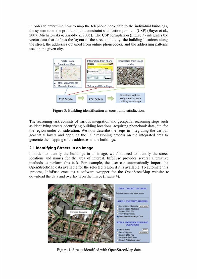
In order to determine how to map the telephone book data to the individual buildings,
the system turns the problem into a constraint satisfaction problem (CSP) (Bayer et al.,
2007; Michalowski & Knoblock, 2005). The CSP formulation (Figure 3) integrates the
vector data that defines the layout of the streets in a city, the building locations along
the street, the addresses obtained from online phonebooks, and the addressing patterns
used in the given city.
The reasoning task consists of various integration and geospatial reasoning steps such
as identifying streets, identifying building locations, acquiring phonebook data, etc. for
the region under consideration. We now describe the steps in integrating the various
geospatial layers and applying the CSP reasoning process on the integrated data to
generate the mapping of the addresses to the buildings.
2.1 Identifying Streets in an Image
In order to identify the buildings in an image, we first need to identify the street
locations and names for the area of interest. InfoFuse provides several alternative
methods to perform this task. For example, the user can automatically import the
OpenStreetMap data available for the selected region if it is available. To automate this
process, InfoFuse executes a software wrapper for the OpenStreetMap website todownload the data and overlay it on the image (Figure 4).
Figure 3: Building identification as constraint satisfaction.
Figure 4: Streets identified with OpenStreetMap data.

8/8/2019 A Framework for Integrating and Reasoning About Geospatial Data Compressed Publication Version
http://slidepdf.com/reader/full/a-framework-for-integrating-and-reasoning-about-geospatial-data-compressed 4/5
The user can also import an existing KML road vector layer that is available. If no
existing data can be found for the selected region, the user can create the road vector
layer by interactively drawing the road lines on the image and labeling the roads using
another source such as a paper map.
2.2 Identifying Building LocationsThe next step is to identify the locations of the buildings in an image. InfoFuse
provides several different ways to perform this task. This can be done by manually
drawing points or polygons to represent the buildings (Figure 5), loading in an existing
KML layer for the building locations, or extracting data from another source, such as
WikiMapia, which contains a lot of user-generated information about a location (such
as houses, businesses, airports, etc.).
2.3 Identifying Building Addresses and Linking Business Data
To gather current information about people and businesses for a region, InfoFuse uses
wrappers to extract data from the Yellow Page and White Page websites. InfoFuse
executes the wrappers to extract the data for each street, links the extracted data with
the road vector data, and makes it available for viewing. Figure 2 shows the businesseslisting and phonebook data in the popup for the street Usko!ka of Belgrade City.
The CSP reasoner combines the road vector data, the building location data, and the
phone book data in a reasoning process to map the addresses to the individual buildings. This reasoning process takes the phone book data associated with the roadsvectors, performs the reasoning over data, and links the resulting data to the individual
buildings (Bayer et al., 2007; Michalowski & Knoblock, 2005).
In the interface, the user invokes the constraint reasoning process using the “Exploit
Constraints” option. InfoFuse displays the generated mapping with color-coded
placemarks (Figure 6). Instances of building variables that are mapped to a single
address are depicted with green placemarks and instances mapped to multiple addresses
are depicted with red placemarks. The ambiguity of multiple possible addresses
mapped to a single location is due to the uncertainty that may be present in the input
data, such as missing addresses in the phonebook.
Figure 5: Building locations manually identified as polygons.

8/8/2019 A Framework for Integrating and Reasoning About Geospatial Data Compressed Publication Version
http://slidepdf.com/reader/full/a-framework-for-integrating-and-reasoning-about-geospatial-data-compressed 5/5
3. Discussion
The work on InfoFuse provides a proof-of-concept of our approach to building a
integration and reasoning framework for geospatial data. In this initial work we
focused on a specific integration task to solve the problem of identifying buildings in
imagery by combining highly diverse types of sources (road vector data, building
locations, and telephone books). The approach described is implemented and has been
applied to the data that is available online for the city of Belgrade.
In future work, we plan to generalize this work such that we can dynamically fuse
a much broader set of sources without having to engineer the integration of thosesources in advance. In order to make that possible, we plan to develop a general
information fusion framework that can be applied to a variety of geospatial integration
and reasoning tasks. This requires extending the framework to support the rapidintegration of new data sources and new reasoning methods. In addition, we will
develop the tools for importing a range of diverse sources as well as a library of reasoning algorithms that can operate on the available data.
References
C.-C. Chen, C. A. Knoblock, and C. Shahabi, 2006, Automatically conflating road vector data with
orthoimagery. GeoInformatica, 10(4):495–530.
Y.-Y. Chiang, C. A. Knoblock, C. Shahabi, and C.-C. Chen, 2008, Automatic and accurate extraction of road intersections from raster maps. GeoInformatica, 13(2):121–157.
K.M Bayer, M. Michalowski, B.Y. Choueiry, and C.A. Knoblock, 2007, Reformulating CSPs for
Scalability with Application to Geospatial Reasoning. Proceedings of CP 2007 , Lecture Notes in
Computer Science 4741, 164-179.
M. Michalowski, and C.A. Knoblock, 2005, A Constraint Satisfaction Approach to Geospatial
Reasoning. Proceedings of the Twentieth National Conference on Artificial Intelligence.
T. Sboui, Y. Bédard, J. Brodeur, and T. Badard, 2007, A Conceptual Framework to Support
Interoperability of Geospatial DataCubes. Lecture Notes in Computer Science 4802, 378–387.
Q. Zhou and U. Neumann, 2008, Fast and Extensible Building Modeling from Airborne LiDAR Data.
Proceedings of the 16th ACM SIGSPATIAL International Conference on Advances in Geographic
Information Systems.
Figure 6: InfoFuse displays the resulting mapping