a characterization of the christmas tree black coral (antipathes ...
82
1 A CHARACTERIZATION OF THE CHRISTMAS TREE BLACK CORAL (ANTIPATHES DENDROCHRISTOS) COMMUNITY ON THREE SEAMOUNTS IN THE SOUTHERN CALIFORNIA BIGHT FROM A SURVEY USING A MANNED SUBMERSIBLE Mary Yoklavich 1 , Tom Laidig 1 , Andrew Taylor 1 , Diana Watters 1 , Lisa Krigsman 1 , Milton Love 2 1 NOAA Fisheries, SWFSC, Fisheries Ecology Division, Santa Cruz, CA 2 University of California Santa Barbara, Marine Science Institute A REPORT TO NOAA DEEP-SEA CORAL RESEARCH AND TECHNOLOGY PROGRAM July 15, 2013
Transcript of a characterization of the christmas tree black coral (antipathes ...

1
A CHARACTERIZATION OF THE CHRISTMAS TREE BLACK CORAL (ANTIPATHES DENDROCHRISTOS) COMMUNITY ON THREE SEAMOUNTS
IN THE SOUTHERN CALIFORNIA BIGHT FROM A SURVEY USING A MANNED SUBMERSIBLE
Mary Yoklavich1, Tom Laidig1, Andrew Taylor1, Diana Watters1, Lisa Krigsman1, Milton Love2
1 NOAA Fisheries, SWFSC, Fisheries Ecology Division, Santa Cruz, CA
2 University of California Santa Barbara, Marine Science Institute
A REPORT TO NOAA DEEP-SEA CORAL RESEARCH AND TECHNOLOGY PROGRAM
July 15, 2013

2
Offshore sea floor habitats in the Southern California Bight (SCB) are diverse compared to other areas of the Pacific coast, and include a number of rocky banks, seamounts, basins, and submarine canyons spanning about 75,000 km2. SCB habitats also are influenced by a dynamic mixing of cold, nutrient-rich water from the California Current and warmer water from the south. Complexity in both the oceanographic and topographic aspects of habitat promotes highly varied assemblages of demersal organisms, which include overfished and ESA-listed species (Love et al. 2002; Butler et al. 2006; Love et al. 2009) and dense stands of deep-sea corals and sponges (DSC; Tissot et al. 2006; Bright 2007). The SCB is bordered by one of the most populated areas along the Pacific coast, with 10 million residents in the greater Los Angeles area alone. Waters of the SCB have been intensively fished both commercially and recreationally to depths over 300 m for at least 40 years; most fishing has been by lines and traps, with little trawling activities in the SCB. Competing activities and multiple stressors in this area necessitate effective spatial management of marine resources. In an effort to protect these valuable resources from harvest or damage, large conservation areas and habitat areas of particular concern have been established by the Pacific Fisheries Management Council (NMFS 2005). The State of California and NOAA’s Channel Islands National Marine Sanctuary also have implemented a series of smaller marine protected areas that are closed to fishing around the Channel Islands. As is the case worldwide, most aspects of the taxonomy, biology, and ecology of the DSC on rocky banks and seamounts in the SCB remain to be studied. Much of what we know about any of these DSC has come from chance collections during research cruises or from fisheries bycatch, and more recently from in situ observations made during visual surveys using manned submersibles and remotely operated vehicles (Tissot et al. 2006; Love et al. 2007). Such opportunities have provided new insight into the ecology of DSC and its association with valuable fisheries, and have even resulted in the discovery of new species of corals (e.g., the Christmas tree black coral [Antipathes dendrochristos]; Opresko 2005; Yoklavich and Love 2005). In 2010, the NOAA Deep-Sea Coral Research and Technology Program (DSCRTP) initiated a three-year study to advance our understanding of DSC off the west coast of the U.S. As part of this study, we conducted a cruise during Fall 2010, which focused on the biology and ecology of the Christmas tree black coral and their use by demersal fishes on three deep offshore banks in the SCB (Hidden Reef, Footprint, and Piggy Bank). Our report provides a summary of the methods and results from underwater surveys of these coral colonies and associated habitats, sponges, and fishes. These surveys were a collaborative effort among researchers from the Southwest Fisheries Science Center (SWFSC) and the University of California Santa Barbara. The objectives of our research were to: 1. Quantify habitat-specific density and size composition of Christmas tree black corals; 2. Determine fish associations with these black corals; 3. Evaluate change in the black corals eight years after an initial baseline survey was conducted; 4. Quantify other corals and sponges occurring at the Hidden Reef study site; 5. Collect corals and sponges to verify identifications on the three study sites.
INTRODUCTION AND SCIENTIFIC OBJECTIVES
Characterization of Christmas Trees Study Area: SoCal Bight

3
The Hidden Reef study site covers about 290 km2 and is located within the Cowcod Conservation Area (CCA), which was closed to bottom-contact fishing gear by the Pacific Fishery Management Council in 2001. This area also was protected in 2006 under Essential Fish Habitat (EFH) regulations (NMFS 2005). Prior to CCA and EFH designation, this area was a longtime focus of intense fishing effort in southern CA. In 2002, we conducted underwater surveys of demersal fishes, structure-forming invertebrates (including Christmas tree black corals), and sea floor habitats (rock, cobble, boulder, and mud) at this study site using the Delta submersible. Since these initial surveys, we have mapped the sea floor at this study site using multibeam acoustics (Goldfinger et al. 2007); this has provided us with a much better idea of the likely distribution and amount of complex rock habitat with which the Christmas tree black coral community could be associated.
STUDY SITE
Characterization of Christmas Trees Study Area: SoCal Bight
Hidden Reef study site, located in the Southern California Bight. Dive tracks (overlaid on gray-scale hill-shaded bathymetry) are depicted from comparative surveys of Christmas tree black coral (Antipathes dendrochristos) communities using the two-person submersibles Delta in 2002 and Dual DeepWorker in 2010.

4
From our earlier survey, the Hidden Reef study area was found to be a “hot spot” of Christmas tree black corals (Tissot et al. 2006), which are of particular interest because they are a large (up to 2.5 m height), relatively new species (Opresko, 2005) that potentially can serve as habitat for fishes and invertebrates and can be vulnerable to human activities. In our current report, we quantify the extent to which these structure-forming corals are associated with fishes and also use the established baseline information from our 2002 surveys to monitor the health of the Christmas tree black corals and associated organisms after eight years of protection within the conservation areas.
Characterization of Christmas Trees Study Area: SoCal Bight
The Footprint and Piggy Bank study sites, located in the Southern California Bight. Location is depicted of eight dives from surveys of Christmas tree black coral (Antipathes dendrochristos) communities using a two-person submersible Dual DeepWorker in Fall 2010.
The Footprint and Piggy Bank study sites are located within the Channel Islands National Marine Sanctuary, in the general vicinity of 33°54.84’ N and 119°28.35’ W in the SCB. The Footprint is about 10 km2 in area, ranging in depth from 80 to 500 m. Piggy Bank is about 30 km2 in area and ranges in depth from 275 to 900 m. These banks have been designated as EFH by NOAA Fisheries and the Pacific Fisheries Management Council and are within the Footprint Marine Reserve.

5
These areas are especially important because they represent extensive, deep, rocky habitats, which are uncommon within the Sanctuary. They are accessible from nearby ports and protected from adverse sea conditions. The shallowest parts of the Footprint and Piggy Bank (to a depth of 360 m) have been surveyed in previous years using the Delta submersible, resulting in archived geo-referenced video tapes and still photographs of DSC (including Christmas tree black corals) and demersal fishes and habitats along quantified dive tracks (Love et al. 2009).
Underwater visual surveys were planned to span from 400 m to the top of each seamount, specifically in regions that had a high probability of comprising rocky substratum types and associated DSC communities. High-resolution maps of bathymetry and backscatter from multibeam acoustic surveys and associated interpreted maps of sea floor substratum types were critical in designing and locating visual surveys prior to our study (Dartnell et al. 2005; P. Dartnell, USGS unpublished data, Goldfinger et al. 2007).
Characterization of Christmas Trees Study Area: SoCal Bight

6
Underwater surveys of Christmas tree black corals, associated demersal fishes, habitat, other corals, and sponges were conducted using non-extractive transect methods and direct observations from the Dual DeepWorker 2-person submersible (DDW; owned and operated by Nuytco Research Ltd., Vancouver, BC) off of the F/V Velero IV, 5 October – 10 October 2010. Video images were collected with a high-definition (HD) digital camera located toward the front and starboard side of DDW and a standard definition (SD) camera at the front and beneath the superstructure of the submersible. The SD camera was positioned to collect images of organisms that were close to the submersible and likely not visible in the HD camera. A scientific observer inside the submersible verbally annotated the HD video footage during each dive. Two parallel red lasers were installed at 20 cm apart on either side of the HD video camera to estimate size of organisms in the images. A green crossing laser was used to estimate distance away from the submersible (which was 2 m when the green and red laser spots were aligned). Digital still and hand-held video cameras were used to document topside activities during the cruise. Dive information (start and end time, location of dives, etc.) also was recorded in a logbook during the cruise. The DDW was equipped with a Sea-Bird SBE19 CTD with oxygen sensor, which continuously recorded temperature, conductivity, pressure, and dissolved oxygen concentration during the dives. Navigation data, including range and bearing from the ship to the DDW, were collected via a Linkquest Tracklink 1500 USBL system during each dive. These data were integrated with the ship’s GPS using Fugro Pelagos WinFrog software. Tracking data were provided to the science team as DAT files in ASCII format. Visual surveys of Christmas tree black corals and associated habitats, fishes, and macro-invertebrates (including other corals and sponges), were conducted in the Hidden Reef study site along quantitative strip transects using DDW during daytime. Transects were conducted for fifteen minutes at depths from 81 to 259 m at similar locations and sea floor substratum types (e.g., high-relief rock and boulders and low-relief cobble fields) to those of the 2002 transects. All corals, sponges, and fishes within a 2-m-wide strip transect were counted and measured by the observer inside the submersible. At the Footprint and Piggy Bank study sites, visual surveys of Christmas tree black corals and associated fishes, habitats, and macro-invertebrates were conducted on each dive at depths 72-437 m. The scientific observer inside DDW verbally recorded the dimensions (cm; height and width) of each
FIELD SURVEY METHODS
Characterization of Christmas Trees Study Area: SoCal Bight

7
Christmas tree coral and the identification and size of all associated fishes. The submersible specifically would slowly pass close to each Christmas tree coral to allow a thorough inspection of associated organisms; the image of each black coral was centered in the video camera to help in later video identification of associated organisms. Large colonies were encircled in order for the observer to determine presence of associated fishes. Because the goal of these dives was to examine Christmas tree black corals and associated fishes, the DDW pilot tried to remain in hard or mixed habitats. Biological samples were collected using a manipulator arm on DDW, and stored in a box until completion of the dive. Immediately following the dive, these samples were processed, photographed, labeled, and stored in ethanol following protocols outlined in Etnoyer et al. (2006). Navigation data associated with the DDW’s USBL tracking system were edited in a series of steps to improve the accuracy of the dive tracks. Duplicate records were identified and removed, and data were filtered to remove those records exceeding maximum speed (0.5 m/s) of the DDW in survey mode. Edited dive tracks were plotted in ArcGIS, and spurious data points were removed based on the type of activities being performed by DDW (e.g., conducting a survey transect, collecting specimens, maneuvering around a large sea floor feature such as a pinnacle) as noted in the dive logbook. The data were linearly interpolated to 3-second intervals, which is the rate that the original data generally were collected. Interpolated data were smoothed using a boxcar running average with an 11-point window. During the transects, DDW maintained a relatively consistent altitude <2 m off the sea floor and a constant speed of 0.25-0.5 m/s (0.5-1.0 knots), depending on substratum type (i.e., generally slower speed in complex habitats). Quality and resolution of video images from the HD video camera were excellent; these images, along with the audio data recorded by the observer inside the submersible, were used to identify and quantify the Christmas tree black corals, sponges, corals, fishes, and sea floor habitats on each transect. The length of each transect was estimated using ArcMap. The area of each transect was calculated as the product of length and width. The sea floor was classified by type of substratum, in order of decreasing particle size and vertical relief (as described in Greene et al. 1999): rock ridge (R), boulder (B), cobble (C), flat rock (F), and mud (M). A two-character code was used to quantify patches of uniform substratum type along each transect (as described in Yoklavich et al. 2000). The primary character in the code represented the substratum type that accounted for at least 50% of the patch, and the secondary character represented the substratum type that accounted for at least 20% of the patch (e.g., CM represented a patch of at least 50% cobbles and at least 20% mud). The area of each habitat patch was estimated as the product of the transect width (2 m, measured from the crossing laser dot in the field of view) and the length of the patch, as determined from the geographic position at the beginning and end of each patch. Temperature, depth, salinity, and dissolved oxygen were derived from raw data at one-second intervals, using the CTD’s Sea-Bird Electronics SBEDataProcessing-Win32 software ‘filter’, ‘align’, ‘derive’, and ‘bin average’ modules. Data were plotted in R. Corals, sponges, and fishes were identified to the lowest possible taxonomic level and enumerated. Some sponges were classified by general morphology (i.e., upright flat, foliose, mound, branching, barrel, and vase) when species identification was difficult. Densities of corals, sponges, and fishes were estimated by dividing total number of each taxon by the area surveyed. Maximum width and height of each Christmas tree coral and total length of each fish were estimated to nearest 5-cm using the paired
POST-DIVE DATA ANALYSES
Characterization of Christmas Trees Study Area: SoCal Bight

8
lasers. Physical damage to the Christmas tree corals was recorded. Distance was estimated between the fishes and the Christmas tree corals. Fishes were considered to be associated with the corals if they were less than one body length away or in direct contact with the coral. The condition of each Christmas tree coral was determined to be healthy (<10% of organism is dead), dying (10-50% is dead), or dead (>50% of organism dead). Frequency and type of derelict fishing gear and other marine debris also were documented along the video transects. All collected specimens were sent to experts of the various taxonomic groups for identification. All data, including navigation, water characteristics, habitat type, and information associated with the corals, sponges, and fishes, were entered into a geo-referenced, relational database in Microsoft Access.
Characterization of Christmas Trees Study Area: SoCal Bight

9
The following is a summary, by dive, of the densities and sizes of Christmas tree black corals, fishes, and sea floor habitats surveyed during quantitative transects conducted on 11 of these dives (Dive 0019 was aborted). We also present profiles of sea temperature, salinity, and dissolved oxygen with depth during the dives. Health of the Christmas tree black corals is reported, along with incidence of marine debris on each dive. Other corals (in addition to Christmas tree black corals) and sponges were quantified during transects on four dives (Dive 0020-0023).
Over 13 hours of video images were collected during daytime (est. 0800 - 2000) operations on 12 dives on the Hidden Reef, Footprint, and Piggy Bank study sites.
Date PI Dive # Method StartTime
EndTime
StartLat (N)
StartLong (W)
End Lat (N)
EndLong (W)
05 Oct 2010 M. Yoklavich 0016 Submersible 14:49 15:28 33˚ 57.844’ 119˚ 29.053’ 33˚ 57.729’ 119˚ 28.848’
05 Oct 2010 M. Yoklavich 0017 Submersible 17:01 17:27 33˚ 57.743’ 119˚ 28.853’ 33˚ 57.629’ 119˚ 28.952’
06 Oct 2010 M. Yoklavich 0018 Submersible 12:19 13:50 33˚ 56.913’ 119˚ 28.187’ 33˚ 57.103’ 119˚ 28.613’
06 Oct 2010 M. Yoklavich 0019 Submersible 16:46 16:56 33˚ 57.242’ 119˚ 28.989’ 33˚ 57.242’ 119˚ 28.989’
07 Oct 2010 M. Yoklavich 0020 Submersible 09:47 12:45 33˚ 42.545’ 119˚ 08.318’ 33˚ 42.319’ 119˚ 07.832’
07 Oct 2010 M. Yoklavich 0021 Submersible 18:02 19:06 33˚ 44.234’ 119˚ 10.178’ 33˚ 44.039’ 119˚ 09.938’
08 Oct 2010 M. Yoklavich 0022 Submersible 08:35 10:26 33˚ 39.622’ 119˚ 10.635’ 33˚ 39.277’ 119˚ 09.531’
08 Oct 2010 M. Yoklavich 0023 Submersible 15:52 17:08 33˚ 33.506’ 119˚ 00.856’ 33˚ 33.815’ 119˚ 01.455’
09 Oct 2010 M. Yoklavich 0024 Submersible 12:47 15:18 33˚ 57.962’ 119˚ 29.606’ 33˚ 57.770’ 119˚ 29.054’
09 Oct 2010 M. Yoklavich 0025 Submersible 19:09 20:16 33˚ 57.525’ 119˚ 28.843’ 33˚ 57.606’ 119˚ 29.056’
10 Oct 2010 M. Yoklavich 0026 Submersible 08:27 09:34 33˚ 55.182’ 119˚ 28.440’ 33˚ 55.128’ 119˚ 28.279’
10 Oct 2010 M. Yoklavich 0027 Submersible 13:01 13:31 33˚ 55.330’ 119˚ 29.417’ 33˚ 55.307’ 119˚ 29.317’
SUMMARY OF DIVES
Characterization of Christmas Trees Study Area: SoCal Bight

10
Project U.S. West Coast Deep Coral Cruise
Chief Scientist M. Yoklavich
Contact Information NMFS, SWFSC, [email protected]
Purpose Determine fish associations with black corals
Vessel / Vehicle F/V Velero IV; Dual DeepWorker submersible
Submersible Pilot Jeff Heaton
Scientific Observer Lisa Krigsman
External Digital Video HD: 52 min; SD: 1 tape
Positioning System Ship: GPS; Submersible: USBL
CTD Sensors Yes
O2 Sensor Yes
Specimens collected No
Other Logbook, Access database
Report Analyst T. Laidig
Date Compiled December 2012
DIVE NUMBER: DDW 0016 STUDY AREA: The Footprint
STATION OVERVIEW

11
Habitat Surveyed (Total Area = 1,172 m2)
0
20
40
60
80
Hard Mixed Sediment
Per
cen
tag
e
Date 05 Oct 2010 Starting Latitude (N) 33˚ 57.844’
Minimum Bottom Depth (m) 141 Starting Longitude (W) 119˚ 29.053’
Maximum Bottom Depth (m) 194 Ending Latitude (N) 33˚ 57.729’
Start Bottom Time (PDT) 14:49 Ending Longitude (W) 119˚ 28.848’
End Bottom Time (PDT) 15:28 Surface Current n/a
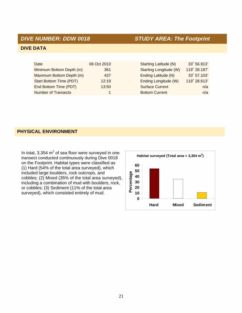
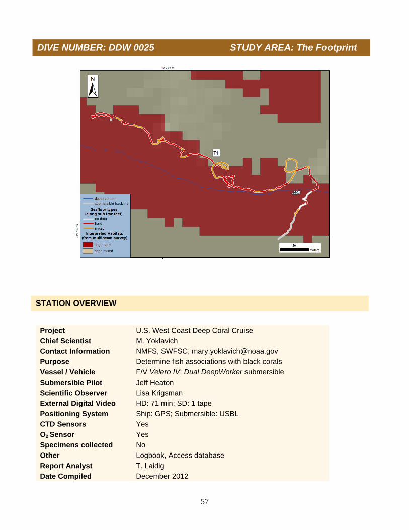
Number of Transects 1 Bottom Current n/a In total, 1,172 m2 of sea floor were surveyed in one transect conducted continuously during Dive 0016 on the Footprint. Habitat types were classified as (1) Hard (74% of the total area surveyed), which included large boulders, rock outcrops, and cobbles; (2) Mixed (15% of the total area surveyed), including a combination of mud with boulders, rock, or cobbles; (3) Sediment (11% of the total area surveyed), which consisted entirely of mud.
PHYSICAL ENVIRONMENT
DIVE DATA
DIVE NUMBER: DDW 0016 STUDY AREA: The Footprint

12
Data on depth, conductivity, temperature, and oxygen were collected during descent (A and B), and at depth along the track line (C and D). Temperature ranged from 17.5°C at the sea surface to 9.3°C on the sea floor at 177 m depth. Salinity (as estimated from conductivity, temperature, and pressure) ranged from 33.5 psu at the sea surface to 34.2 psu on the sea floor. Dissolved oxygen ranged from 5.8 ml/l at the sea surface to 1.5 ml/l on the sea floor at 177 m depth.
A. B.
C. D.
DIVE NUMBER: DDW 0016 STUDY AREA: The Footprint

13
No Christmas tree black corals occurred on the transect of Dive 0016. At least 20 taxa of fishes were identified during Dive 0016 along the top of the Footprint Bank. A total of 547 individual fishes were enumerated, and an overall density of 466 fish per 1,000 m2 of sea floor was estimated from one continuous transect. At least 13 species of rockfishes (Sebastes), dominated by unidentified Sebastomus, and bank and shortbelly rockfishes, comprised 96% of fish density. The remainder of the fish assemblage included shortspine combfish, lingcod, poachers, hagfish, and Dover sole.
Scientific name Common name Number Fishes Eptatretus spp. Unidentified hagfish 1
Agonidae Unidentified poachers 3
Microstomus pacificus Dover sole 1
Sebastes chlorostictus Greenspotted rockfish 3 Sebastes constellatus Starry rockfish 2 Sebastes elongatus Greenstriped rockfish 2 Sebastes entomelas Widow rockfish 1 Sebastes goodei Chilipepper 1 Sebastes jordani Shortbelly rockfish 38 Sebastes levis Cowcod 5 Sebastes miniatus Vermilion rockfish 6 Sebastes ovalis Speckled rockfish 2 Sebastes paucispinis Bocaccio 3 Sebastes rubrivinctus Flag rockfish 2 Sebastes rufus Bank rockfish 95 Sebastes spp. Unidentified Sebastomus 358 Sebastes spp. Young-of-the-year rockfish 1 Sebastes wilsoni Pygmy rockfish 7
Ophiodon elongatus Lingcod 2 Zaniolepis frenata Shortspine combfish 14
BIOLOGICAL ENVIRONMENT: CHRISTMAS TREES
BIOLOGICAL ENVIRONMENT: FISHES
DIVE NUMBER: DDW 0016 STUDY AREA: The Footprint

14
Three man-made debris items (a soda can and two monofilament fishing lines) were documented during Dive 0016. Damage potentially caused by these three items was not observed.
ADDITIONAL COMMENTS
IMAGE GALLERY
DIVE NUMBER: DDW 0016 STUDY AREA: The Footprint
A chilipepper and two greenspotted rockfishes on a rock ridge at 194 m.
A bank rockfish swimming over a sponge-covered rock ridge at 170 m.
Vase and barrel sponges on rock ridge at 170 m. A tan vase sponge (Sigmadocia spp.) and other vase sponges at 160 m.

15
Project U.S. West Coast Deep Coral Cruise
Chief Scientist M. Yoklavich
Contact Information NMFS, SWFSC, [email protected]
Purpose Determine fish associations with black corals
Vessel / Vehicle F/V Velero IV; Dual DeepWorker submersible
Submersible Pilot Jeff Heaton
Scientific Observer Diana Watters
External Digital Video HD: 28 min; SD: 1 tape
Positioning System Ship: GPS; Submersible: USBL
CTD Sensors Yes
O2 Sensor Yes
Specimens collected No
Other Logbook, Access database
Report Analyst T. Laidig
Date Compiled December 2012
DIVE NUMBER: DDW 0017 STUDY AREA: The Footprint
STATION OVERVIEW

16
Date 05 Oct 2010 Starting Latitude (N) 33˚ 57.743’
Minimum Bottom Depth (m) 147 Starting Longitude (W) 119˚ 28.853’
Maximum Bottom Depth (m) 167 Ending Latitude (N) 33˚ 57.629’
Start Bottom Time (PDT) 17:01 Ending Longitude (W) 119˚ 28.952’
End Bottom Time (PDT) 17:27 Surface Current n/a
Number Transects 1 Bottom Current n/a
In total, 782 m2 of sea floor were surveyed during one transect conducted continuously on Dive 0017 on the Footprint. Habitat types were classified as (1) Hard (90% of the total area surveyed), which included large boulders, rock outcrops, and cobbles or (2) Mixed (10% of the total area surveyed), including a combination of mud with boulders, rock, or cobbles. No soft sediment habitat was observed
PHYSICAL ENVIRONMENT
DIVE DATA
Habitat surveyed (total area = 782 m2)
0
20
40
60
80
100
Hard Mixed Sediment
Per
cen
tag
e
DIVE NUMBER: DDW 0017 STUDY AREA: The Footprint

17
Data on depth, conductivity, temperature, and oxygen were collected during descent (A and B) and at depth along the track line (C and D) on Dive 0017. Temperature ranged from 17.5°C at the sea surface to 9.5°C on the sea floor at 156 m depth. Salinity (as estimated from conductivity, temperature, and pressure) ranged from 33.5 psu at the sea surface to 34.1 psu on the sea floor. The range in oxygen was from 5.8 ml/l at the sea surface to 1.7 ml/l on the sea floor at 156 m.
B.
B.
C.
D.
DIVE NUMBER: DDW 0017 STUDY AREA: The Footprint
A

18
Two Christmas tree black corals, with a density of 2.5 colonies per 1,000 m2, occurred on Dive 0017. The colonies were small, averaging 300 cm2 in area (range = 200-400 cm2). Both colonies were healthy with no damage, and gray in color. Sponges were associated with both colonies. No fishes were associated with either colony. At least 12 taxa were identified during Dive 0017 along one continuous transect on the top of the Footprint. A total of 445 individual fishes was enumerated, and an overall density of 569 fish per 1,000 m2 of sea floor was estimated. At least 9 species of rockfishes (Sebastes), dominated by unidentified Sebastomus comprised 98% of fish density. The remainder of the fish assemblage included shortspine combfish and spotted ratfish. No fish were associated with the two Christmas tree black corals on this dive.
Scientific name Common name Number Fishes Sebastes constellatus Starry rockfish 1 Sebastes hopkinsi Squarespot rockfish 48 Sebastes jordani Shortbelly rockfish 24 Sebastes levis Cowcod 1 Sebastes ovalis Speckled rockfish 9 Sebastes paucispinis Bocaccio 9 Sebastes rufus Bank rockfish 41 Sebastes spp. Unidentified Sebastomus 262 Sebastes wilsoni Pygmy rockfish 38 Sebastes zacentrus Sharpchin rockfish 1
Hydrolagus colliei Spotted ratfish 2 Zaniolepis frenata Shortspine combfish 9
BIOLOGICAL ENVIRONMENT: CHRISTMAS TREES
BIOLOGICAL ENVIRONMENT: FISHES
DIVE NUMBER: DDW 0017 STUDY AREA: The Footprint
19
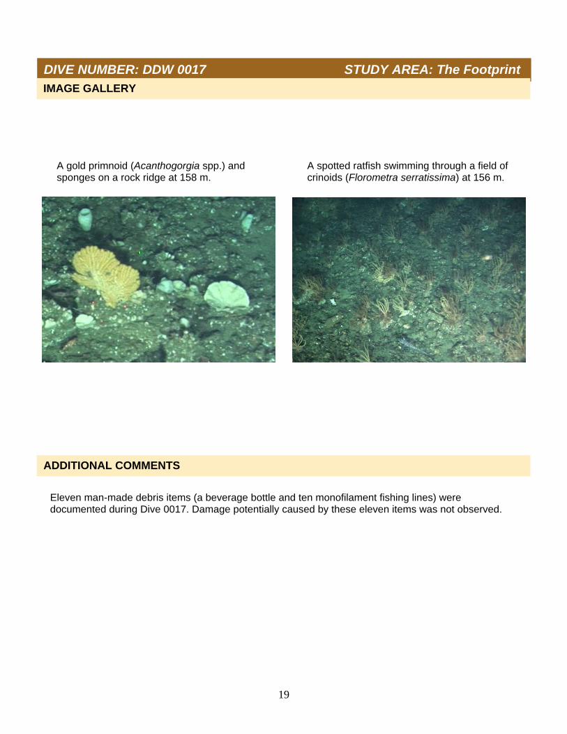
Eleven man-made debris items (a beverage bottle and ten monofilament fishing lines) were documented during Dive 0017. Damage potentially caused by these eleven items was not observed.
ADDITIONAL COMMENTS
DIVE NUMBER: DDW 0017 STUDY AREA: The Footprint
IMAGE GALLERY
A spotted ratfish swimming through a field of crinoids (Florometra serratissima) at 156 m.
A gold primnoid (Acanthogorgia spp.) and sponges on a rock ridge at 158 m.

20
Project U.S. West Coast Deep Coral Cruise
Chief Scientist M. Yoklavich
Contact Information NMFS, SWFSC, [email protected]
Purpose Determine fish associations with black corals
Vessel / Vehicle F/V Velero IV / Dual DeepWorker submersible
Submersible Pilot Doug Bishop
Scientific Observer Tom Laidig
External Digital Video HD: 104 min; SD: 1 tape
Positioning System Ship: GPS; Submersible: USBL
CTD Sensors Yes
O2 Sensor Yes
Specimens collected No
Other Logbook, Access database
Report Analyst T. Laidig
Date Compiled December 2012
DIVE NUMBER: DDW 0018 STUDY AREA: The Footprint
STATION OVERVIEW
21
Habitat surveyed (Total area = 3,354 m2)
0
10
2030
40
50
60
Hard Mixed Sediment
Per
cen
tag
e
Date 06 Oct 2010 Starting Latitude (N) 33˚ 56.913’
Minimum Bottom Depth (m) 361 Starting Longitude (W) 119˚ 28.187’
Maximum Bottom Depth (m) 437 Ending Latitude (N) 33˚ 57.103’
Start Bottom Time (PDT) 12:19 Ending Longitude (W) 119˚ 28.613’
End Bottom Time (PDT) 13:50 Surface Current n/a
Number of Transects 1 Bottom Current n/a
In total, 3,354 m2 of sea floor were surveyed in one transect conducted continuously during Dive 0018 on the Footprint. Habitat types were classified as (1) Hard (54% of the total area surveyed), which included large boulders, rock outcrops, and cobbles; (2) Mixed (35% of the total area surveyed), including a combination of mud with boulders, rock, or cobbles; (3) Sediment (11% of the total area surveyed), which consisted entirely of mud.
PHYSICAL ENVIRONMENT
DIVE DATA
DIVE NUMBER: DDW 0018 STUDY AREA: The Footprint

22
Data on depth, conductivity, temperature, and oxygen were collected during descent (A and B) and at depth along the track line (C and D) of dive 0018. Temperature ranged from 17.9°C at the sea surface to 7.2°C on the sea floor at 437 m depth. Salinity (as estimated from conductivity, temperature, and pressure) ranged from 33.5 psu at the sea surface to 34.3 psu on the sea floor. The range in oxygen was from 5.9 ml/l at the sea surface to 0.5 ml/l on the sea floor at 437 m.
A.
D. C.
B.
DIVE NUMBER: DDW 0018 STUDY AREA: The Footprint
23
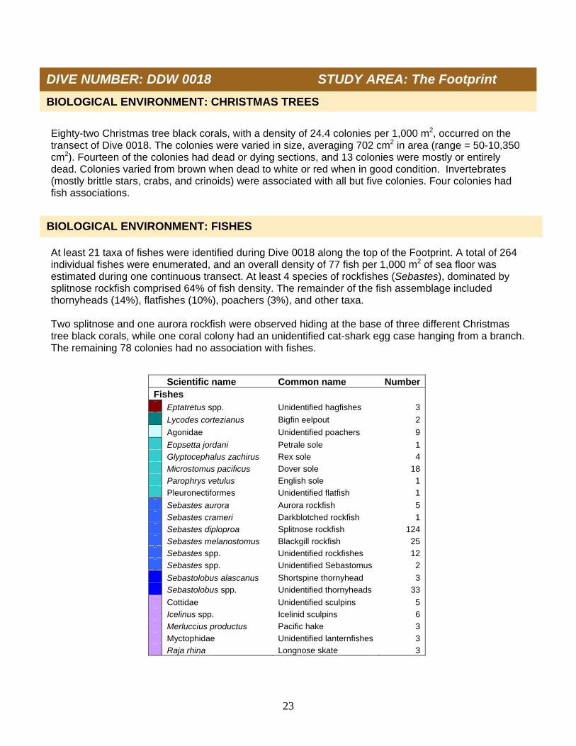
Eighty-two Christmas tree black corals, with a density of 24.4 colonies per 1,000 m2, occurred on the transect of Dive 0018. The colonies were varied in size, averaging 702 cm2 in area (range = 50-10,350 cm2). Fourteen of the colonies had dead or dying sections, and 13 colonies were mostly or entirely dead. Colonies varied from brown when dead to white or red when in good condition. Invertebrates (mostly brittle stars, crabs, and crinoids) were associated with all but five colonies. Four colonies had fish associations. At least 21 taxa of fishes were identified during Dive 0018 along the top of the Footprint. A total of 264 individual fishes were enumerated, and an overall density of 77 fish per 1,000 m2 of sea floor was estimated during one continuous transect. At least 4 species of rockfishes (Sebastes), dominated by splitnose rockfish comprised 64% of fish density. The remainder of the fish assemblage included thornyheads (14%), flatfishes (10%), poachers (3%), and other taxa. Two splitnose and one aurora rockfish were observed hiding at the base of three different Christmas tree black corals, while one coral colony had an unidentified cat-shark egg case hanging from a branch. The remaining 78 colonies had no association with fishes. Scientific name Common name Number
Fishes Eptatretus spp. Unidentified hagfishes 3
Lycodes cortezianus Bigfin eelpout 2
Agonidae Unidentified poachers 9
Eopsetta jordani Petrale sole 1 Glyptocephalus zachirus Rex sole 4 Microstomus pacificus Dover sole 18 Parophrys vetulus English sole 1 Pleuronectiformes Unidentified flatfish 1
Sebastes aurora Aurora rockfish 5 Sebastes crameri Darkblotched rockfish 1 Sebastes diploproa Splitnose rockfish 124 Sebastes melanostomus Blackgill rockfish 25 Sebastes spp. Unidentified rockfishes 12 Sebastes spp. Unidentified Sebastomus 2
Sebastolobus alascanus Shortspine thornyhead 3 Sebastolobus spp. Unidentified thornyheads 33
Cottidae Unidentified sculpins 5 Icelinus spp. Icelinid sculpins 6 Merluccius productus Pacific hake 3 Myctophidae Unidentified lanternfishes 3 Raja rhina Longnose skate 3
BIOLOGICAL ENVIRONMENT: CHRISTMAS TREES
BIOLOGICAL ENVIRONMENT: FISHES
DIVE NUMBER: DDW 0018 STUDY AREA: The Footprint

24
Two man-made debris items (both monofilament fishing lines) occurred during Dive 0018. Damage potentially caused by these two items was not observed.
ADDITIONAL COMMENTS
IMAGE GALLERY
A large barrel sponge with an Icelinid sculpin next to a small white Christmas tree black coral at 387 m depth.
A dead Christmas tree black coral covered in epifauna at 380 m depth.
A large fingered goblet vase sponge (Heterochone calyx) at 376 m depth.
A red Christmas tree black coral at 380 m depth.
DIVE NUMBER: DDW 0018 STUDY AREA: The Footprint

25
Project U.S. West Coast Deep Coral Cruise
Chief Scientist M. Yoklavich
Contact Information NMFS, SWFSC, [email protected]
Purpose Determine fish associations with black corals
Vessel / Vehicle F/V Velero IV; Dual DeepWorker submersible
Submersible Pilot Doug Bishop
Scientific Observer Milton Love
External Digital Video HD: 0 min; SD: 0 tape
Positioning System Ship: GPS; Submersible: USBL
CTD Sensors Yes
O2 Sensor Yes
Specimens collected No
Other Logbook, Access database
Report Analyst T. Laidig
Date Compiled December 2012
DIVE NUMBER: DDW 0019 STUDY AREA: Piggy Bank
STATION OVERVIEW
26
Date 06 Oct 2010 Starting Latitude (N) 33˚ 57.242’
Minimum Bottom Depth (m) 385 Starting Longitude (W) 119˚ 28.989’
Maximum Bottom Depth (m) 385 Ending Latitude (N) 33˚ 57.242’
Start Bottom Time (PDT) 16:46 Ending Longitude (W) 119˚ 28.989’
End Bottom Time (PDT) 16:56 Surface Current n/a
Number 15-min Transects 0 Bottom Current n/a
Navigation failed (no tracking signal transmitted from DDW) upon reaching the sea floor at a depth of 385 m, and Dive 0019 was aborted after testing the navigation system for 10 minutes. The scientific observer noted a small (20 cm in height) dead Christmas tree black coral on sea floor, and a thick layer of squid in water column at about 330 m water depth.
DIVE DATA
DIVE NUMBER: DDW 0019 STUDY AREA: Piggy Bank

27
Project U.S. West Coast Deep Coral Cruise
Chief Scientist M. Yoklavich
Contact Information NMFS, SWFSC, [email protected]
Purpose 1) Estimate black coral density 2) Determine fish associations with black corals 3) Evaluate change in black coral community
Vessel / Vehicle F/V Velero IV; Dual DeepWorker submersible
Submersible Pilot Jeff Heaton
Scientific Observer Tom Laidig
External Digital Video HD: 193 min; SD: 1 tape
Positioning System Ship: GPS; Submersible: USBL
CTD Sensors Yes
O2 Sensor Yes
Specimens collected Yes
Other Logbook, Access database
Report Analyst T. Laidig
Date Compiled December 2012
DIVE NUMBER: DDW 0020 STUDY AREA: Hidden Reef
STATION OVERVIEW
28
Habitat surveyed (Total area = 4,337 m2)
0.0
20.0
40.0
60.0
80.0
100.0
Hard Mixed Sediment
Per
cen
tag
e
Date 07 Oct 2010 Starting Latitude (N) 33˚ 42.545’
Minimum Bottom Depth (m) 128 Starting Longitude (W) 119˚ 08.318’
Maximum Bottom Depth (m) 211 Ending Latitude (N) 33˚ 42.319’
Start Bottom Time (PDT) 09:47 Ending Longitude (W) 119˚ 7.832’
End Bottom Time (PDT) 12:45 Surface Current n/a
Number 15-min Transects 7 Bottom Current n/a
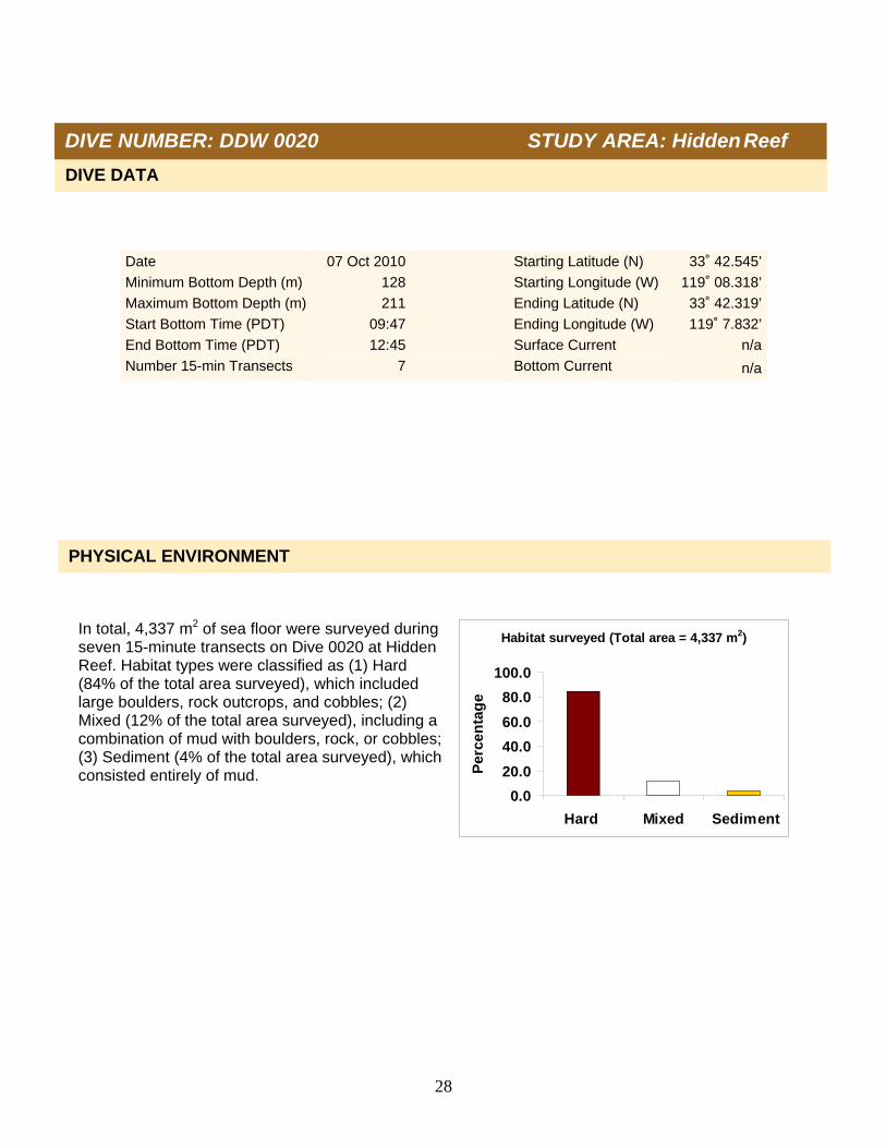
In total, 4,337 m2 of sea floor were surveyed during seven 15-minute transects on Dive 0020 at Hidden Reef. Habitat types were classified as (1) Hard (84% of the total area surveyed), which included large boulders, rock outcrops, and cobbles; (2) Mixed (12% of the total area surveyed), including a combination of mud with boulders, rock, or cobbles; (3) Sediment (4% of the total area surveyed), which consisted entirely of mud.
PHYSICAL ENVIRONMENT
DIVE DATA
DIVE NUMBER: DDW 0020 STUDY AREA: Hidden Reef

29
Data on depth, conductivity, temperature, and oxygen were collected during descent (A and B) and at depth along the track line (C and D) of Dive 0020. Temperature ranged from 18.7°C at the sea surface to 8.3°C on the sea floor at 205 m depth. Salinity (as estimated from conductivity, temperature, and pressure) ranged from 33.6 psu at the sea surface to 34.2 psu on the sea floor. Dissolved oxygen ranged from 5.2 ml/l at the sea surface (6.0 ml/l at the thermocline) to 1.1 ml/l on the sea floor at 205 m.
A. B.
C. D.
DIVE NUMBER: DDW 0020 STUDY AREA: Hidden Reef

30
A total of 100 Christmas tree black corals, with a density of 23.1 colonies per 1,000 m2, occurred during the 7 transects on Dive 0020. The colonies generally were large, averaging 2,110 cm2 in area (range = 50-40,000 cm2); some colonies were over 1 m in height. Fourteen colonies contained dead or dying sections, four colonies were mostly or completely dead, and one colony was knocked over. Most colonies were white or red. Invertebrates (crinoids, brittle stars, and crabs) were associated with all but 30 colonies; 10 colonies were associated with fishes. A total of 643 individual corals, comprising at least 16 taxa, was enumerated from seven 15-minute transects conducted during Dive 0020 on Hidden Reef. An overall density of 148 corals per 1,000 m2 of sea floor was estimated. Cup corals (including Desmophyllum dianthus) and Lophelia pertusa accounted for 52% of the coral density. The remaining coral density comprised fan-like gorgonians (22%, including Plumarella longispina, Acanthogorgia spp., Paragorgia spp., and Parastenella ramosa), the Christmas tree black coral (16%), unidentified zoanthids (7%), the mushroom coral (2%, Anthomastus ritteri), and 1% or less for stick-like gorgonians (including both Swiftia spp. and Euplexaura spp., which could not be distinguished reliably from video footage alone), sea pens, and soft coral. All of these corals, with the exception of sea pens, occurred on either hard or mixed habitats. One pale pink primnoid specimen was collected on Dive 0020, and identified by Stephen Cairns (National Museum of Natural History, Smithsonian Institution, Washington DC) as Plumarella longispina.
BIOLOGICAL ENVIRONMENT: CORALS
Scientific name Common name Number Corals Acanthogorgia spp. Gold coral 12 Paragorgia spp. Sea fan (white with red polyps) 4 Parastenella ramosa Primnoid 2 Plumarella longispina Primnoid 124
Plexauridae #1 Sea fans (red w/ white polyps) 4 Plexauridae #2 Sea fan (red w/ yellow polyps) 1 Swiftia sp. Red sea fan 1
Antipathes dendrochristos Christmas tree black coral 100
Desmophyllum dianthus Cockscomb cup coral 44 Lophelia pertusa White cup coral 183 Scleractinia Unidentified cup corals 105
Anthomastus ritteri Mushroom coral 12
Zoantharia Unidentified zoanthid corals 45
Anthoptilum grandiflorum Feather boa sea pen 1 Pennatulacea #1 Sea pen (thin) 1
Clavularia spp. Soft coral 4
DIVE NUMBER: DDW 0020 STUDY AREA: Hidden Reef
BIOLOGICAL ENVIRONMENT: CHRISTMAS TREES

31
A total of 1,352 individual sponges from at least 16 different taxa was enumerated from 7 15-minute transects conducted during Dive 0020 on Hidden Reef. An overall density of 312 sponges per 1,000 m2 of sea floor was estimated. Vase sponges (Heterochone calyx, Sigmadocia spp., Staurocalyptus spp. and others) were most abundant (26% of the total density), followed by foliose (22%, Farrea occa, Thenea muricata spp., and others), barrel (18%), branching (16%, Rhizaxinella gadus and others), upright flat (8%), and shelf (5%), and mound sponges (2%). The category ‘Other’ represented 3% of total sponge density and included Asbestopluma spp. among other sponges. Most of the sponges occurred on hard and mixed habitats. Two Demospongia specimens were collected during Dive 0020, which William Austin (Khoyatan Marine Laboratory, Sidney, BC) identified as the club sponge (Rhizaxinella gadus) and the tan vase sponge (Sigmadocia spp.).
Scientific name Common name Number Sponges Porifera #3 Unidentified barrel sponges 245
Heterochone calyx Fingered goblet vase sponge 2 Porifera #5 Unidentified vase sponges 270 Sigmadocia spp. Tan vase/trumpet sponge 76 Staurocalyptus spp. Picasso sponge 1
Porifera #4 Unidentified shelf sponges 70
Porifera #2 Unidentified upright flat sponges 111
Farrea occa Lace (or cloud) foliose sponge 7 Porifera #1 Unidentified foliose sponges 220 Porifera #8 Unidentified tube sponges 37 Thenea muricata Foliose sponge (clear) 37
Porifera #6 Unidentified mound sponges 22
Porifera #7 Unidentified branching sponges 88 Rhizaxinella gadus Club sponge 131
Asbestopluma spp. #1 Predatory pipecleaner sponge 23 Porifera #12 Unidentified sponges 12
BIOLOGICAL ENVIRONMENT: SPONGES
DIVE NUMBER: DDW 0020 STUDY AREA: Hidden Reef
32
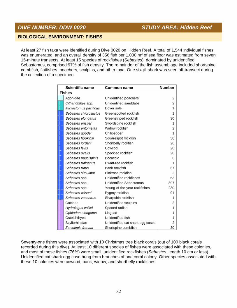
At least 27 fish taxa were identified during Dive 0020 on Hidden Reef. A total of 1,544 individual fishes was enumerated, and an overall density of 356 fish per 1,000 m2 of sea floor was estimated from seven 15-minute transects. At least 15 species of rockfishes (Sebastes), dominated by unidentified Sebastomus, comprised 97% of fish density. The remainder of the fish assemblage included shortspine combfish, flatfishes, poachers, sculpins, and other taxa. One sixgill shark was seen off-transect during the collection of a specimen. Seventy-one fishes were associated with 10 Christmas tree black corals (out of 100 black corals recorded during this dive). At least 10 different species of fishes were associated with these colonies, and most of these fishes (76%) were small, unidentified rockfishes (Sebastes, length 10 cm or less). Unidentified cat shark egg case hung from branches of one coral colony. Other species associated with these 10 colonies were cowcod, bank, widow, and shortbelly rockfishes.
Scientific name Common name Number Fishes Agonidae Unidentified poachers 2
Citharichthys spp. Unidentified sanddabs 2 Microstomus pacificus Dover sole 1
Sebastes chlorostictus Greenspotted rockfish 1 Sebastes elongatus Greenstriped rockfish 30 Sebastes ensifer Swordspine rockfish 1 Sebastes entomelas Widow rockfish 2 Sebastes goodei Chilipepper 1 Sebastes hopkinsi Squarespot rockfish 58 Sebastes jordani Shortbelly rockfish 20 Sebastes levis Cowcod 20 Sebastes ovalis Speckled rockfish 20 Sebastes paucispinis Bocaccio 6 Sebastes rufinanus Dwarf-red rockfish 1 Sebastes rufus Bank rockfish 67 Sebastes simulator Pinkrose rockfish 2 Sebastes spp. Unidentified rockfishes 53 Sebastes spp. Unidentified Sebastomus 897 Sebastes spp. Young-of-the-year rockfishes 230 Sebastes wilsoni Pygmy rockfish 91 Sebastes zacentrus Sharpchin rockfish 1
Cottidae Unidentified sculpins 3 Hydrolagus colliei Spotted ratfish 1 Ophiodon elongatus Lingcod 1 Osteichthyes Unidentified fish 1 Scyliorhinidae Unidentified cat shark egg cases 2 Zaniolepis frenata Shortspine combfish 30
BIOLOGICAL ENVIRONMENT: FISHES
DIVE NUMBER: DDW 0020 STUDY AREA: Hidden Reef
33
Two man-made debris items (a monofilament fishing line and a thick line or cable) were documented during Dive 0020. The thick line was draped across rocky outcrops and covered with invertebrates including feather stars (crinoid, Florometra serratissima) and encrusting and vase sponges. Damage potentially caused by these two items was not observed.
ADDITIONAL COMMENTS
IMAGE GALLERY
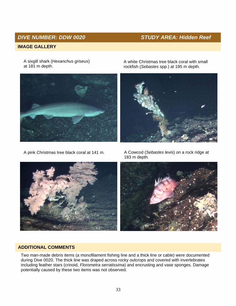
A sixgill shark (Hexanchus griseus) at 181 m depth.
A white Christmas tree black coral with small rockfish (Sebastes spp.) at 195 m depth.
A pink Christmas tree black coral at 141 m. A Cowcod (Sebastes levis) on a rock ridge at 183 m depth.
DIVE NUMBER: DDW 0020 STUDY AREA: Hidden Reef

34
Project U.S. West Coast Deep Coral Cruise
Chief Scientist M. Yoklavich
Contact Information NMFS, SWFSC, [email protected]
Purpose 1) Estimate black coral density 2) Determine fish associations with black corals 3) Evaluate change in black coral community
Vessel / Vehicle F/V Velero IV; Dual DeepWorker submersible
Submersible Pilot Jeff Heaton
Scientific Observer Mary Yoklavich
External Digital Video HD: 68 min; SD: 1 tape
Positioning System Ship: GPS; Submersible: USBL
CTD Sensors Yes
O2 Sensor Yes
Specimens collected No
Other Logbook, Access database
Report Analyst T. Laidig
Date Compiled December 2012
DIVE NUMBER: DDW 0021 STUDY AREA: Hidden Reef
STATION OVERVIEW
35
Habitat surveyed (Total area = 1,507 m2)
010203040506070
Hard Mixed Sediment
Per
cen
tag
e
Date 07 Oct 2010 Starting Latitude (N) 33˚ 44.234’
Minimum Bottom Depth (m) 81 Starting Longitude (W) 119˚ 10.178’
Maximum Bottom Depth (m) 141 Ending Latitude (N) 33˚ 44.039’
Start Bottom Time (PDT) 18:02 Ending Longitude (W) 119˚ 09.938’
End Bottom Time (PDT) 19:06 Surface Current n/a
Number 15-min Transects 4 Bottom Current n/a
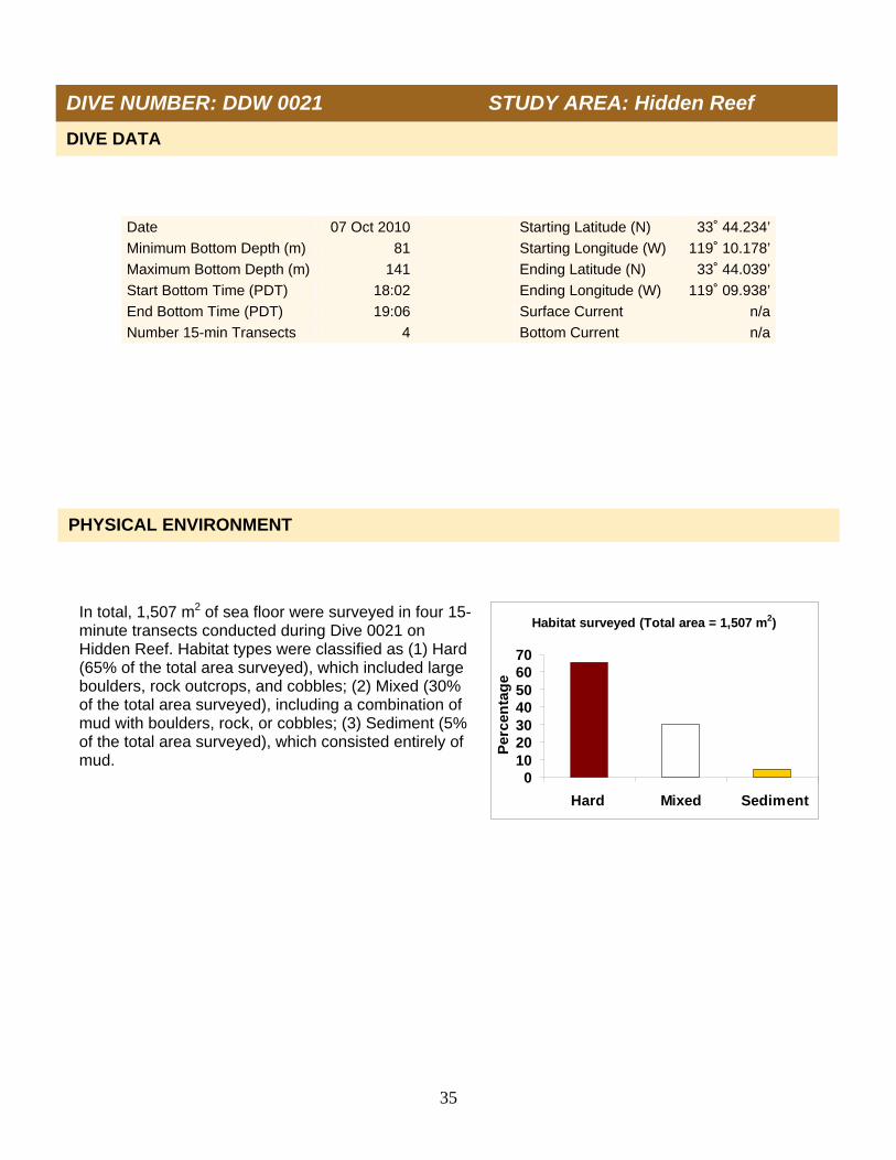
In total, 1,507 m2 of sea floor were surveyed in four 15-minute transects conducted during Dive 0021 on Hidden Reef. Habitat types were classified as (1) Hard (65% of the total area surveyed), which included large boulders, rock outcrops, and cobbles; (2) Mixed (30% of the total area surveyed), including a combination of mud with boulders, rock, or cobbles; (3) Sediment (5% of the total area surveyed), which consisted entirely of mud.
PHYSICAL ENVIRONMENT
DIVE DATA
DIVE NUMBER: DDW 0021 STUDY AREA: Hidden Reef

36
Data on depth, conductivity, temperature, and oxygen were collected during descent (A and B) and at depth along the track line (C and D) on Dive 0021. Temperature ranged from 19.2°C at the sea surface to 8.9°C on the sea floor at 128 m depth. Salinity (as estimated from conductivity, temperature, and pressure) ranged from 33.6 psu at the sea surface to 34.2 psu on the sea floor. Dissolved oxygen ranged from 5.8 ml/l at the sea surface (6.0 ml/ at the thermocline) to 1.6 ml/l on the sea floor at 128 m.
A. B.
C. D.
DIVE NUMBER: DDW 0021 STUDY AREA: Hidden Reef
37
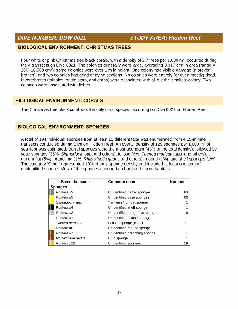
Four white or pink Christmas tree black corals, with a density of 2.7 trees per 1,000 m2, occurred during the 4 transects on Dive 0021. The colonies generally were large, averaging 8,317 cm2 in area (range = 200 -16,500 cm2); some colonies were over 1 m in height. One colony had visible damage (a broken branch), and two colonies had dead or dying sections. No colonies were entirely (or even mostly) dead. Invertebrates (crinoids, brittle stars, and crabs) were associated with all but the smallest colony. Two colonies were associated with fishes. The Christmas tree black coral was the only coral species occurring on Dive 0021 on Hidden Reef. A total of 194 individual sponges from at least 11 different taxa was enumerated from 4 15-minute transects conducted during Dive on Hidden Reef. An overall density of 129 sponges per 1,000 m2 of sea floor was estimated. Barrel sponges were the most abundant (43% of the total density), followed by vase sponges (35%, Sigmadocia spp. and others), foliose (6%, Thenea muricata spp. and others), upright flat (5%), branching (1%, Rhizaxinella gadus and others), mound (1%), and shelf sponges (1%). The category ‘Other’ represented 10% of total sponge density and included at least one taxa of unidentified sponge. Most of the sponges occurred on hard and mixed habitats.
BIOLOGICAL ENVIRONMENT: CORALS
Scientific name Common name Number Sponges Porifera #3 Unidentified barrel sponges 83
Porifera #5 Unidentified vase sponges 66 Sigmadocia spp. Tan vase/trumpet sponge 1
Porifera #4 Unidentified shelf sponge 1
Porifera #2 Unidentified upright flat sponges 9
Porifera #1 Unidentified foliose sponge 1 Thenea muricata Foliose sponge (clear) 11
Porifera #6 Unidentified mound sponge 1
Porifera #7 Unidentified branching sponge 1 Rhizaxinella gadus Club sponge 1
Porifera #12 Unidentified sponges 19
BIOLOGICAL ENVIRONMENT: SPONGES
BIOLOGICAL ENVIRONMENT: CHRISTMAS TREES
DIVE NUMBER: DDW 0021 STUDY AREA: Hidden Reef
38
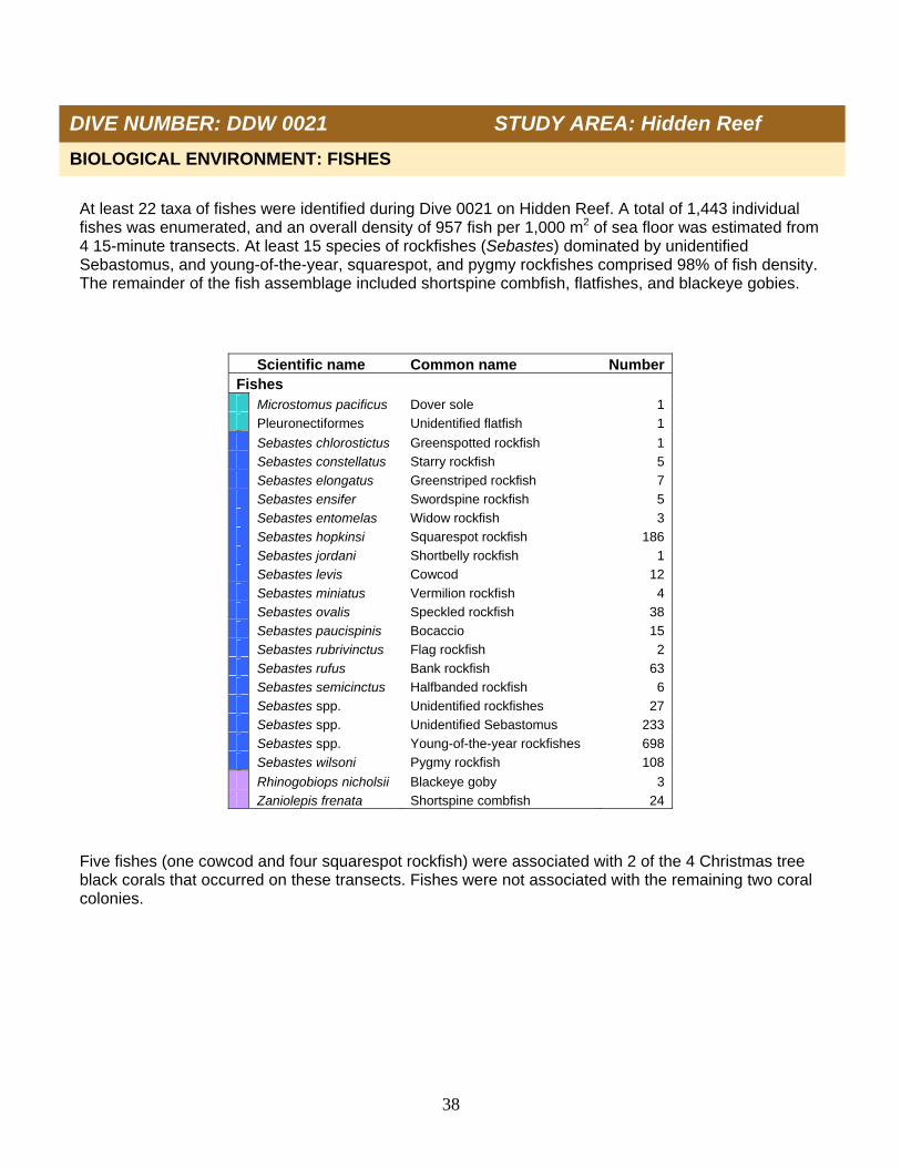
At least 22 taxa of fishes were identified during Dive 0021 on Hidden Reef. A total of 1,443 individual fishes was enumerated, and an overall density of 957 fish per 1,000 m2 of sea floor was estimated from 4 15-minute transects. At least 15 species of rockfishes (Sebastes) dominated by unidentified Sebastomus, and young-of-the-year, squarespot, and pygmy rockfishes comprised 98% of fish density. The remainder of the fish assemblage included shortspine combfish, flatfishes, and blackeye gobies. Five fishes (one cowcod and four squarespot rockfish) were associated with 2 of the 4 Christmas tree black corals that occurred on these transects. Fishes were not associated with the remaining two coral colonies.
Scientific name Common name Number Fishes Microstomus pacificus Dover sole 1 Pleuronectiformes Unidentified flatfish 1
Sebastes chlorostictus Greenspotted rockfish 1 Sebastes constellatus Starry rockfish 5 Sebastes elongatus Greenstriped rockfish 7 Sebastes ensifer Swordspine rockfish 5 Sebastes entomelas Widow rockfish 3 Sebastes hopkinsi Squarespot rockfish 186 Sebastes jordani Shortbelly rockfish 1 Sebastes levis Cowcod 12 Sebastes miniatus Vermilion rockfish 4 Sebastes ovalis Speckled rockfish 38 Sebastes paucispinis Bocaccio 15 Sebastes rubrivinctus Flag rockfish 2 Sebastes rufus Bank rockfish 63 Sebastes semicinctus Halfbanded rockfish 6 Sebastes spp. Unidentified rockfishes 27 Sebastes spp. Unidentified Sebastomus 233 Sebastes spp. Young-of-the-year rockfishes 698 Sebastes wilsoni Pygmy rockfish 108
Rhinogobiops nicholsii Blackeye goby 3 Zaniolepis frenata Shortspine combfish 24
BIOLOGICAL ENVIRONMENT: FISHES
DIVE NUMBER: DDW 0021 STUDY AREA: Hidden Reef

39
No man-made debris items were observed during the 4 15-minute transects conducted on Dive 0021.
ADDITIONAL COMMENTS
IMAGE GALLERY
DIVE NUMBER: DDW 0021 STUDY AREA: Hidden Reef
Flag (Sebastes rubrivinctus) and bank rockfishes (Sebastes rufus) near field of crinoids (Florometra serratissima) at 132 m depth.
A cowcod (Sebastes levis) under a white Christmas tree black coral at 113 m depth.
Greenspotted rockfish (Sebastes chlorostictus) over rocky habitat at 112 m depth.
A white Christmas tree black coral at 113 m depth.

40
Project U.S. West Coast Deep Coral Cruise
Chief Scientist M. Yoklavich
Contact Information NMFS, SWFSC, [email protected]
Purpose 1) Estimate black coral density 2) Determine fish associations with black corals 3) Evaluate change in black coral community
Vessel / Vehicle F/V Velero IV; Dual DeepWorker submersible
Submersible Pilot Doug Bishop
Scientific Observer Linda Snook
External Digital Video HD: 121 min; SD: 1 tape
Positioning System Ship: GPS; Submersible: USBL
CTD Sensors Yes
O2 Sensor Yes
Specimens collected No
Other Logbook, Access database
Report Analyst T. Laidig
Date Compiled December 2012
DIVE NUMBER: DDW 0022 STUDY AREA: Hidden Reef
STATION OVERVIEW
41
Habitat surveyed (Total area = 3,836 m2)
0
20
40
60
80
100
Hard Mixed Sediment
Per
cen
tag
e
Date 08 Oct 2010 Starting Latitude (N) 33˚ 39.622’
Minimum Bottom Depth (m) 158 Starting Longitude (W) 119˚ 10.635’
Maximum Bottom Depth (m) 259 Ending Latitude (N) 33˚ 39.277’
Start Bottom Time (PDT) 08:35 Ending Longitude (W) 119˚ 09.531’
End Bottom Time (PDT) 10:26 Surface Current n/a
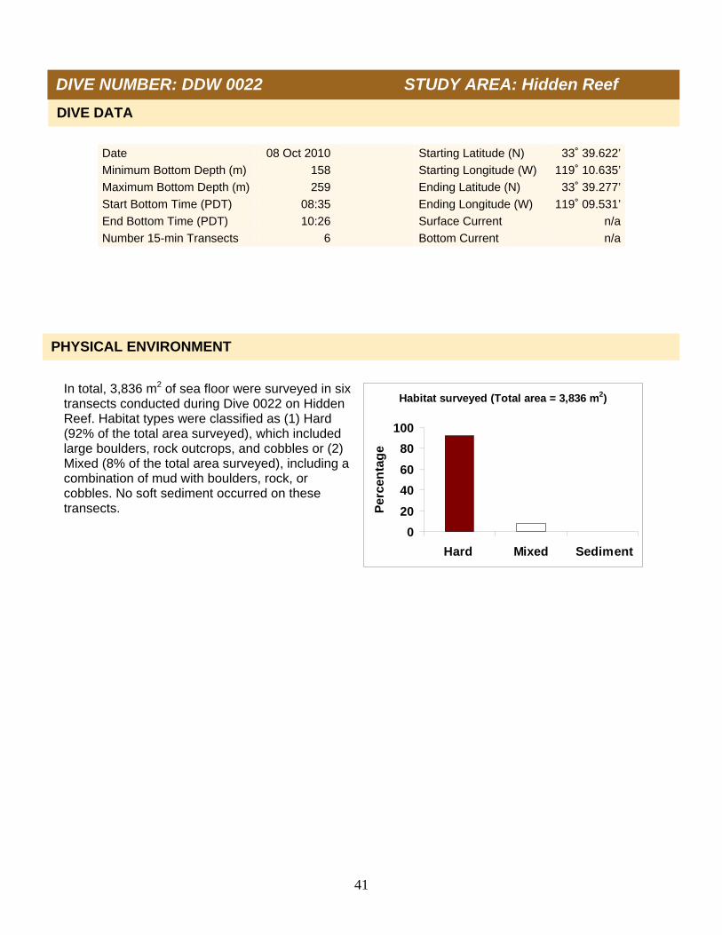
Number 15-min Transects 6 Bottom Current n/a In total, 3,836 m2 of sea floor were surveyed in six transects conducted during Dive 0022 on Hidden Reef. Habitat types were classified as (1) Hard (92% of the total area surveyed), which included large boulders, rock outcrops, and cobbles or (2) Mixed (8% of the total area surveyed), including a combination of mud with boulders, rock, or cobbles. No soft sediment occurred on these transects.
PHYSICAL ENVIRONMENT
DIVE DATA
DIVE NUMBER: DDW 0022 STUDY AREA: Hidden Reef

42
Data on depth, conductivity, temperature, and dissolved oxygen were collected during descent (A and B) and at depth along the track line (C and D) of Dive 0022. Temperature ranged from 18.4°C at the sea surface to 8.7°C on the sea floor at 259 m depth. Salinity (as estimated from conductivity, temperature, and pressure) ranged from 33.6 psu at the sea surface to 34.2 psu on the sea floor. Dissolved oxygen ranged from 5.5 ml/l at the sea surface (6.0 ml/l at the thermocline) to 1.3 ml/l on the sea floor at 259 m.
DIVE NUMBER: DDW 0022 STUDY AREA: Hidden Reef
B. A.
C. D.
43
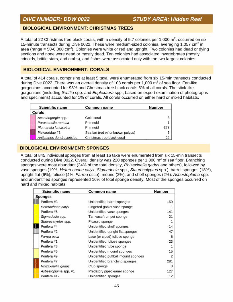
A total of 22 Christmas tree black corals, with a density of 5.7 colonies per 1,000 m2, occurred on six 15-minute transects during Dive 0022. These were medium-sized colonies, averaging 1,057 cm2 in area (range = 50-6,000 cm2). Colonies were white or red and upright. Two colonies had dead or dying sections and none were dead or mostly dead. Ten colonies had associated invertebrates (mostly crinoids, brittle stars, and crabs), and fishes were associated only with the two largest colonies. A total of 414 corals, comprising at least 5 taxa, were enumerated from six 15-min transects conducted during Dive 0022. There was an overall density of 108 corals per 1,000 m2 of sea floor. Fan-like gorgonians accounted for 93% and Christmas tree black corals 5% of all corals. The stick-like gorgonians (including Swiftia spp. and Euplexaura spp., based on expert examination of photographs and specimens) accounted for 1% of corals. All corals occurred on either hard or mixed habitats. A total of 845 individual sponges from at least 16 taxa were enumerated from six 15-min transects conducted during Dive 0022. Overall density was 220 sponges per 1,000 m2 of sea floor. Branching sponges were most abundant (34% of the total density, Rhizaxinella gadus and others), followed by vase sponges (19%, Heterochone calyx, Sigmadocia spp., Staurocalyptus spp.), barrel sponges (18%), upright flat (6%), foliose (4%, Farrea occa), mound (2%), and shelf sponges (2%). Asbestopluma spp. and unidentified sponges represented 16% of total sponge density. Most of the sponges occurred on hard and mixed habitats.
Scientific name Common name Number Corals Acanthogorgia spp. Gold coral 8 Parastenella ramosa Primnoid 1 Plumarella longispina Primnoid 378
Plexauridae #3 Sea fan (red w/ unknown polyps) 5
Antipathes dendrochristos Christmas tree black coral 22
BIOLOGICAL ENVIRONMENT: CORALS
Scientific name Common name Number Sponges Porifera #3 Unidentified barrel sponges 150
Heterochone calyx Fingered goblet vase sponge 1 Porifera #5 Unidentified vase sponges 141 Sigmadocia spp. Tan vase/trumpet sponge 21 Staurocalyptus spp. Picasso sponge 1
Porifera #4 Unidentified shelf sponges 14
Porifera #2 Unidentified upright flat sponges 47
Farrea occa Lace (or cloud) foliose sponge 6 Porifera #1 Unidentified foliose sponges 23 Porifera #8 Unidentified tube sponge 1
Porifera #6 Unidentified mound sponges 15 Porifera #9 Unidentified puffball mound sponges 2
Porifera #7 Unidentified branching sponges 281 Rhizaxinella gadus Club sponge 3
Asbestopluma spp. #1 Predatory pipecleaner sponge 127 Porifera #12 Unidentified sponges 12
BIOLOGICAL ENVIRONMENT: SPONGES
BIOLOGICAL ENVIRONMENT: CHRISTMAS TREES
DIVE NUMBER: DDW 0022 STUDY AREA: Hidden Reef

44
At least 26 taxa of fishes were identified during Dive 0022 on Hidden Reef. A total of 1,397 individual fishes was enumerated, and an overall density of 363 fish per 1,000 m2 of sea floor was estimated from four 15-minute transects. At least 14 species of rockfishes (Sebastes), dominated by unidentified Sebastomus and bank rockfish, comprised 95% of fish density. The remainder of the fish assemblage included shortspine combfish, hagfish, and unidentified cat shark egg cases, among other species. Two small unidentified rockfishes were associated with one Christmas tree black coral, while seven unidentified cat shark egg cases were hanging from the branches of two coral colonies. Fishes were not associated with the remaining 20 colonies on this dive.
Scientific name Common name NumberFishes Eptatretus spp. Unidentified hagfishes 5
Agonidae Unidentified poacher 1
Sebastes chlorostictus Greenspotted rockfish 2 Sebastes crameri Darkblotched rockfish 1 Sebastes elongatus Greenstriped rockfish 35 Sebastes ensifer Swordspine rockfish 62 Sebastes gillii Bronzespotted rockfish 1 Sebastes goodei Chilipepper 10 Sebastes jordani Shortbelly rockfish 51 Sebastes levis Cowcod 16 Sebastes ovalis Speckled rockfish 1 Sebastes paucispinis Bocaccio 12 Sebastes rosenblatti Greenblotched rockfish 1 Sebastes rubrivinctus Flag rockfish 7 Sebastes rufus Bank rockfish 139 Sebastes spp. Unidentified rockfishes 2 Sebastes spp. Unidentified Sebastomus 986 Sebastes spp. Young-of-the-year rockfish 1 Sebastes wilsoni Pygmy rockfish 5
Cottidae Unidentified sculpins 2 Hydrolagus colliei Spotted ratfish 1 Icelinus spp. Icelinid sculpin 1 Ophiodon elongatus Lingcod 1 Plectobranchus evides Bluebarred prickleback 2 Scyliorhinidae Unidentified cat shark egg cases 6 Zaniolepis frenata Shortspine combfish 46
BIOLOGICAL ENVIRONMENT: FISHES
DIVE NUMBER: DDW 0022 STUDY AREA: Hidden Reef
45
Four man-made debris items (a wine bottle, a beer can, a fishing weight, and a monofilament fishing line) were observed during Dive 0022. Damage potentially caused by these four items was not observed.
ADDITIONAL COMMENTS
IMAGE GALLERY
DIVE NUMBER: DDW 0022 STUDY AREA: Hidden Reef
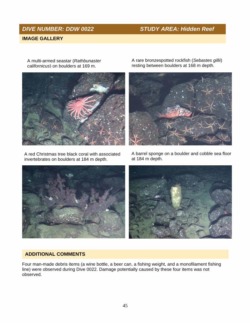
A rare bronzespotted rockfish (Sebastes gillii) resting between boulders at 168 m depth.
A multi-armed seastar (Rathbunaster californicus) on boulders at 169 m.
A red Christmas tree black coral with associated invertebrates on boulders at 184 m depth.
A barrel sponge on a boulder and cobble sea floor at 184 m depth.

46
Project U.S. West Coast Deep Coral Cruise
Chief Scientist M. Yoklavich
Contact Information NMFS, SWFSC, [email protected]
Purpose 1)Estimate black coral density 2)Determine fish associations with black corals 3)Evaluate change in black coral community
Vessel / Vehicle F/V Velero IV; Dual DeepWorker submersible
Submersible Pilot Doug Bishop
Scientific Observer Mary Nishimoto
External Digital Video HD: 93 min; SD: 1 tape
Positioning System Ship: GPS; Submersible: USBL
CTD Sensors Yes
O2 Sensor Yes
Specimens collected Yes
Other Logbook, Access database
Report Analyst T. Laidig
Date Compiled December 2012
DIVE NUMBER: DDW 0023 STUDY AREA: Hidden Reef
STATION OVERVIEW

47
Date 08 Oct 2010 Starting Latitude (N) 33˚ 33.506’
Minimum Bottom Depth (m) 135 Starting Longitude (W) 119˚ 00.856’
Maximum Bottom Depth (m) 251 Ending Latitude (N) 33˚ 33.815’
Start Bottom Time (PDT) 15:52 Ending Longitude (W) 119˚ 01.455’
End Bottom Time (PDT) 17:08 Surface Current n/a
Number 15-min Transects 4 Bottom Current n/a
Habitat surveyed (Total area = 2,648 m2)
0
20
40
60
80
Hard Mixed Sediment
Pe
rce
nta
ge
PHYSICAL ENVIRONMENT
DIVE DATA
In total, 2,648 m2 of sea floor was surveyed in four transects conducted during Dive 0023 using the Dual DeepWorker from the F/V Velero IV on Hidden Reef. Habitat types were classified as (1) Hard (28% of the total area surveyed), which included large boulders, rock outcrops, and cobbles; (2) Mixed (70% of the total area surveyed), including a combination of mud with boulders, rock, or cobbles; (3) Sediment (2% of the total area surveyed), which consisted entirely of mud.
DIVE NUMBER: DDW 0023 STUDY AREA: Hidden Reef

48
Data on depth, conductivity, temperature, and dissolved oxygen were collected during descent (A and B) and at depth along the track line (C and D) on Dive 0023. Temperature ranged from 17.4°C at the sea surface to 9.1°C on the sea floor at 251 m depth. Salinity (as estimated from conductivity, temperature, and pressure) ranged from 33.6 psu at the sea surface to 34.2 psu on the sea floor. Dissolved oxygen ranged from 5.8 ml/l at the sea surface (6.0 ml/l at the thermocline) to 1.6 ml/l on the sea floor at 251 m.
DIVE NUMBER: DDW 0023 STUDY AREA: Hidden Reef
A.
B.
C. D.

49
A total of 14 Christmas tree black corals, with a density of 5.3 colonies per 1,000 m2, occurred on four 15-min transects on Dive 0023. These were small colonies, averaging 269 cm2 in area (range = 50-600 cm2); there were no large colonies (>1 m in height). All colonies were upright, either white or red, and only 1 colony was dead or mostly dead. Four trees had associated invertebrates (crinoids and crabs), and no fishes were associated with any Christmas tree black corals. At least 7 taxa representing 350 corals were recorded on 4 15-min transects during Dive 0023. Overall density was 132 corals per 1,000 m2 of sea floor. Fan-like gorgonians (including Paragorgia stephencairnsi, Parastenella ramosa, and Plumarella longispina) accounted for 94% of the coral density. Christmas tree black corals accounted for 4% of all corals and 8 unidentified taxa accounted for 2% of corals. All corals occurred on either hard or mixed habitats. One coral specimen was collected, and identified by Stephen Cairns (National Museum of Natural History, Smithsonian Institution, Washington DC) as the golden primnoid (Acanthogorgia spp.). At least 14 taxa of 909 individual sponges were enumerated from 4 15-min transects during Dive 0023. Overall density was 343 sponges per 1,000 m2 of sea floor. Upright flat sponges comprised 49% of total density, followed by vase (29%, Sigmadocia spp. and others), barrel sponges (6%), foliose (5%, Thenea occa and others), mound (5%), shelf (3%), and branching sponges (<1%, Rhizaxinella gadus and others). Asbestopluma spp. and unidentified sponges were 2% of total density. Most of the sponges occurred on hard and mixed habitats.
Scientific name Common name Number Corals Hexacorallia/Octocorallia Unidentified corals 8
Gorgonacea Unidentified sea fan 1 Paragorgia spp. Sea fan (white with red polyps) 1 Paragorgia stephencairnsi Primnoid 5 Parastenella ramosa Primnoid 3 Plumarella longispina Primnoid 318
Antipathes dendrochristos Christmas tree black coral 14
BIOLOGICAL ENVIRONMENT: CORALS
DIVE NUMBER: DDW 0023 STUDY AREA: Hidden Reef
BIOLOGICAL ENVIRONMENT: CHRISTMAS TREES
BIOLOGICAL ENVIRONMENT: SPONGES
Scientific name Common name Number Sponges Porifera #3 Unidentified barrel sponges 58
Porifera #5 Unidentified vase sponges 266 Sigmadocia spp. Tan vase/trumpet sponge 2
Porifera #4 Unidentified shelf sponges 31
Porifera #2 Unidentified upright flat sponges 444
Porifera #1 Unidentified foliose sponges 9 Porifera #8 Unidentified tube sponges 3 Thenea muricata Foliose sponge (clear) 35
Porifera #6 Unidentified mound sponges 42 Porifera #9 Unidentified puffball mound sponges 2
Porifera #7 Unidentified branching sponge 1 Rhizaxinella gadus Club sponge 1
Asbestopluma spp. #1 Predatory pipecleaner sponge 5 Porifera #12 Unidentified sponges 10
50
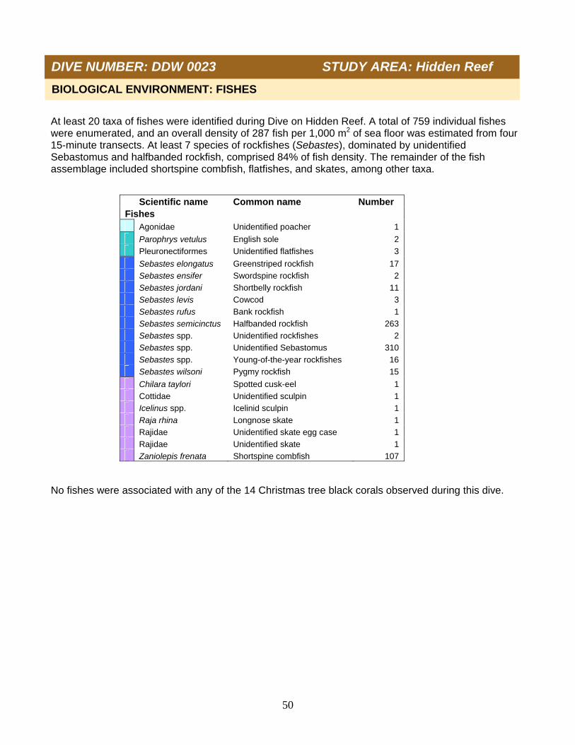
At least 20 taxa of fishes were identified during Dive on Hidden Reef. A total of 759 individual fishes were enumerated, and an overall density of 287 fish per 1,000 m2 of sea floor was estimated from four 15-minute transects. At least 7 species of rockfishes (Sebastes), dominated by unidentified Sebastomus and halfbanded rockfish, comprised 84% of fish density. The remainder of the fish assemblage included shortspine combfish, flatfishes, and skates, among other taxa. No fishes were associated with any of the 14 Christmas tree black corals observed during this dive.
Scientific name Common name Number Fishes Agonidae Unidentified poacher 1
Parophrys vetulus English sole 2 Pleuronectiformes Unidentified flatfishes 3
Sebastes elongatus Greenstriped rockfish 17 Sebastes ensifer Swordspine rockfish 2 Sebastes jordani Shortbelly rockfish 11 Sebastes levis Cowcod 3 Sebastes rufus Bank rockfish 1 Sebastes semicinctus Halfbanded rockfish 263 Sebastes spp. Unidentified rockfishes 2 Sebastes spp. Unidentified Sebastomus 310 Sebastes spp. Young-of-the-year rockfishes 16 Sebastes wilsoni Pygmy rockfish 15
Chilara taylori Spotted cusk-eel 1 Cottidae Unidentified sculpin 1 Icelinus spp. Icelinid sculpin 1 Raja rhina Longnose skate 1 Rajidae Unidentified skate egg case 1 Rajidae Unidentified skate 1 Zaniolepis frenata Shortspine combfish 107
BIOLOGICAL ENVIRONMENT: FISHES
DIVE NUMBER: DDW 0023 STUDY AREA: Hidden Reef

51
One man-made debris items (a green beverage bottle) was observed during Dive 0023. Damage potentially caused by this item was not observed.
ADDITIONAL COMMENTS
IMAGE GALLERY
DIVE NUMBER: DDW 0023 STUDY AREA: Hidden Reef
A crab on a mud and cobble sea floor at 175 m depth
A barrel sponge on a cobble and mud habitat at 178 m.
Vase and barrel sponges on cobble and mud sea floor at 158 m depth.
Collecting a gold primnoid (Acanthogorgia spp.) at 153 m depth.

52
Project U.S. West Coast Deep Coral Cruise
Chief Scientist M. Yoklavich
Contact Information NMFS, SWFSC, [email protected]
Purpose Determine fish associations with black corals
Vessel / Vehicle F/V Velero IV; Dual DeepWorker submersible
Submersible Pilot Jeff Heaton
Scientific Observer Tom Laidig
External Digital Video HD: 155 min; SD: 1 tape
Positioning System Ship: GPS; Submersible: USBL
CTD Sensors Yes
O2 Sensor Yes
Specimens collected No
Other Logbook, Access database
Report Analyst T. Laidig
Date Compiled December 2012
DIVE NUMBER: DDW 0024 STUDY AREA: The Footprint
STATION OVERVIEW
53
Date 09 Oct 2010 Starting Latitude (N) 33˚ 57.962’
Minimum Bottom Depth (m) 72 Starting Longitude (W) 119˚ 29.606’
Maximum Bottom Depth (m) 147 Ending Latitude (N) 33˚ 57.770’
Start Bottom Time (PDT) 12:47 Ending Longitude (W) 119˚ 29.054’
End Bottom Time (PDT) 15:18 Surface Current n/a
Number of Transects 1 Bottom Current n/a
DIVE DATA
Habitat surveyed (Total area = 4,668 m2)
0
20
40
60
80
100
Hard Mixed Sediment
Per
cen
tag
e
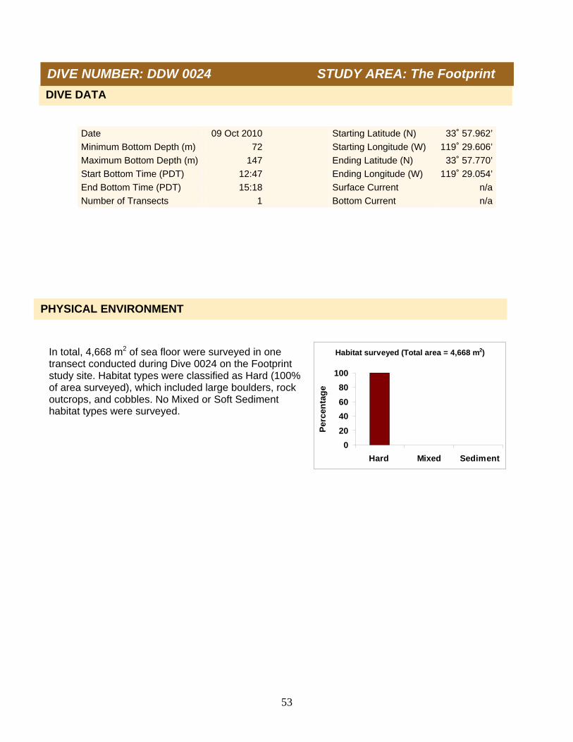
In total, 4,668 m2 of sea floor were surveyed in one transect conducted during Dive 0024 on the Footprint study site. Habitat types were classified as Hard (100% of area surveyed), which included large boulders, rock outcrops, and cobbles. No Mixed or Soft Sediment habitat types were surveyed.
PHYSICAL ENVIRONMENT
DIVE NUMBER: DDW 0024 STUDY AREA: The Footprint

54
Data on depth, conductivity, temperature, and dissolved oxygen were collected during descent (A and B) and at depth along the track line (C and D) on Dive 0024. Temperature ranged from 19.2°C at the sea surface to 9.8°C on the sea floor at 106 m depth. Salinity (as estimated from conductivity, temperature, and pressure) ranged from 33.5 psu at the sea surface to 34.1 psu on the sea floor. Dissolved oxygen ranged from 5.5 ml/l at the surface (6.0 ml/l at the thermocline) to 1.8 ml/l on the sea floor at 106 m.
DIVE NUMBER: DDW 0024 STUDY AREA: The Footprint
A. B.
C.
D.

55
A total of 4 Christmas tree black corals, with a density of 0.9 colonies per 1,000 m2, occurred on transect during Dive 0024. These colonies varied in size, averaging 3,800 cm2 in area (range = 200-12,000 cm2); 1 colony was >1 m in height and width. Colonies were white or red. One colony had dead or dying sections. All but one colony had associated invertebrates (crinoids, crabs, anemones, and sponges). Fishes were associated with only the largest colony. At least 22 taxa of fishes were identified on the top of the Footprint during Dive 0024. A total of 11,229 individual fishes was enumerated, and an overall density of 2,406 fish per 1,000 m2 of sea floor was estimated during one continuous transect. At least 13 species of rockfishes (Sebastes), dominated by unidentified Sebastomus and squarespot, shortbelly, and pygmy rockfishes, comprised 99% of fish density. The remainder of the fish assemblage included shortspine combfish, unidentified sanddabs, lingcod, and other taxa. Two squarespot and one unidentified rockfishes were associated with 1 Christmas tree black coral colony. Fishes were not associated with the other 3 coral colonies.
Scientific name Common name Number Fishes Citharichthys spp. Unidentified sanddabs 15
Sebastes chlorostictus Greenspotted rockfish 5 Sebastes constellatus Starry rockfish 22 Sebastes elongatus Greenstriped rockfish 1 Sebastes entomelas Widow rockfish 4 Sebastes hopkinsi Squarespot rockfish 4983 Sebastes jordani Shortbelly rockfish 1115 Sebastes levis Cowcod 26 Sebastes miniatus Vermilion rockfish 6 Sebastes ovalis Speckled rockfish 37 Sebastes paucispinis Bocaccio 53 Sebastes rubrivinctus Flag rockfish 10 Sebastes semicinctus Halfbanded rockfish 408 Sebastes spp. Unidentified rockfishes 327 Sebastes spp. Unidentified Sebastomus 2455 Sebastes spp. Young-of-the-year rockfishes 23 Sebastes wilsoni Pygmy rockfish 1687
Hydrolagus colliei Spotted ratfish 1 Ophiodon elongatus Lingcod 12 Rhinogobiops nicholsii Blackeye goby 3 Torpedo californica Pacific electric ray 1 Zaniolepis frenata Shortspine combfish 35
DIVE NUMBER: DDW 0024 STUDY AREA: The Footprint
BIOLOGICAL ENVIRONMENT: CHRISTMAS TREES
BIOLOGICAL ENVIRONMENT: FISHES

56
Five man-made debris items (two beer cans, a fishing weight, a monofilament fishing line, and an unidentified line) were observed during Dive 0024. Damage potentially caused by these five items was not observed.
ADDITIONAL COMMENTS
DIVE NUMBER: DDW 0024 STUDY AREA: The Footprint
IMAGE GALLERY
A Christmas tree black coral on a boulder at 120 m.
A Christmas tree black coral in a boulder and cobble field at 110 m depth.
A sponge garden on a rock ridge at 124 m. Boulder and cobble habitat at 100 m depth.
57
Project U.S. West Coast Deep Coral Cruise
Chief Scientist M. Yoklavich
Contact Information NMFS, SWFSC, [email protected]
Purpose Determine fish associations with black corals
Vessel / Vehicle F/V Velero IV; Dual DeepWorker submersible
Submersible Pilot Jeff Heaton
Scientific Observer Lisa Krigsman
External Digital Video HD: 71 min; SD: 1 tape
Positioning System Ship: GPS; Submersible: USBL
CTD Sensors Yes
O2 Sensor Yes
Specimens collected No
Other Logbook, Access database
Report Analyst T. Laidig
Date Compiled December 2012
DIVE NUMBER: DDW 0025 STUDY AREA: The Footprint
STATION OVERVIEW

58
Date 09 Oct 2010 Starting Latitude (N) 33˚ 57.525’
Minimum Bottom Depth (m) 161 Starting Longitude (W) 119˚ 28.843’
Maximum Bottom Depth (m) 271 Ending Latitude (N) 33˚ 57.606’
Start Bottom Time (PDT) 19:09 Ending Longitude (W) 119˚ 29.056’
End Bottom Time (PDT) 20:16 Surface Current n/a
Number of Transects 1 Bottom Current n/a
0
20
40
60
80
Hard Mixed Sediment
Per
cen
tag
e
Habitat surveyed (Total area = 1,735 m2)
PHYSICAL ENVIRONMENT
DIVE DATA
DIVE NUMBER: DDW 0025 STUDY AREA: The Footprint
In total, 1,735 m2 of sea floor were surveyed during one transect conducted on Dive 0025 on the Footprint. Habitat types were classified as (1) Hard (60% of the total area surveyed), which included large boulders, rock outcrops, and cobbles; (2) Mixed (40% of the total area surveyed), including a combination of mud with boulders, rock, or cobbles. No Soft Sediment habitat was observed.

59
Data on depth, conductivity, temperature, and dissolved oxygen were collected during descent (A and B) and at depth along the track line (C and D) on Dive 0025. Temperature ranged from 19.0°C at the sea surface to 8.8°C on the sea floor at 241 m depth. Salinity (as estimated from conductivity, temperature, and pressure) ranged from 33.6 at the sea surface to 34.2 psu on the sea floor. Dissolved oxygen ranged from 5.5 ml/l at the sea surface (5.9 ml/l at the thermocline) to 1.2 ml/l on the sea floor at 241 m.
DIVE NUMBER: DDW 0025 STUDY AREA: The Footprint
A.
B.
C D.
60
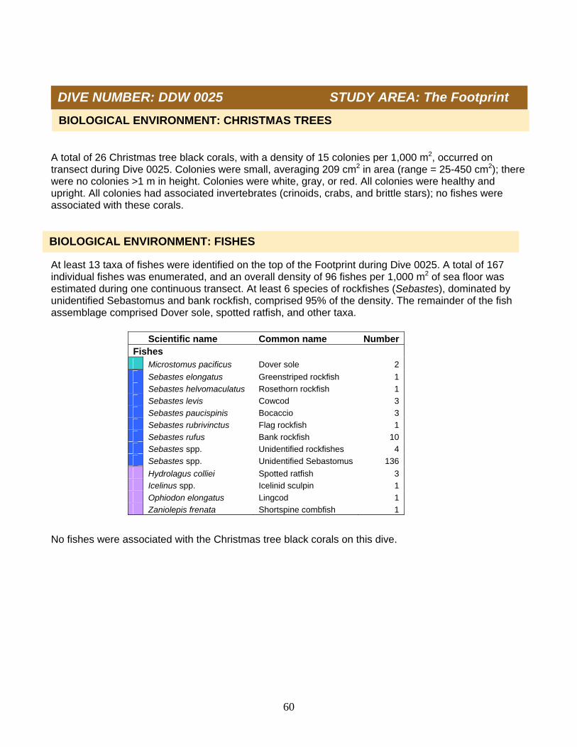
A total of 26 Christmas tree black corals, with a density of 15 colonies per 1,000 m2, occurred on transect during Dive 0025. Colonies were small, averaging 209 cm2 in area (range = 25-450 cm2); there were no colonies >1 m in height. Colonies were white, gray, or red. All colonies were healthy and upright. All colonies had associated invertebrates (crinoids, crabs, and brittle stars); no fishes were associated with these corals. At least 13 taxa of fishes were identified on the top of the Footprint during Dive 0025. A total of 167 individual fishes was enumerated, and an overall density of 96 fishes per 1,000 m2 of sea floor was estimated during one continuous transect. At least 6 species of rockfishes (Sebastes), dominated by unidentified Sebastomus and bank rockfish, comprised 95% of the density. The remainder of the fish assemblage comprised Dover sole, spotted ratfish, and other taxa. No fishes were associated with the Christmas tree black corals on this dive.
Scientific name Common name NumberFishes Microstomus pacificus Dover sole 2
Sebastes elongatus Greenstriped rockfish 1 Sebastes helvomaculatus Rosethorn rockfish 1 Sebastes levis Cowcod 3 Sebastes paucispinis Bocaccio 3 Sebastes rubrivinctus Flag rockfish 1 Sebastes rufus Bank rockfish 10 Sebastes spp. Unidentified rockfishes 4 Sebastes spp. Unidentified Sebastomus 136
Hydrolagus colliei Spotted ratfish 3 Icelinus spp. Icelinid sculpin 1 Ophiodon elongatus Lingcod 1 Zaniolepis frenata Shortspine combfish 1
BIOLOGICAL ENVIRONMENT: CHRISTMAS TREES
DIVE NUMBER: DDW 0025 STUDY AREA: The Footprint
BIOLOGICAL ENVIRONMENT: FISHES
61
Eight man-made debris items (six monofilament fishing lines, a brown beverage bottle, and a hand fishing net) were observed during Dive 0025. Damage potentially caused by these eight items was not observed.
ADDITIONAL COMMENTS
IMAGE GALLERY
DIVE NUMBER: DDW 0025 STUDY AREA: The Footprint
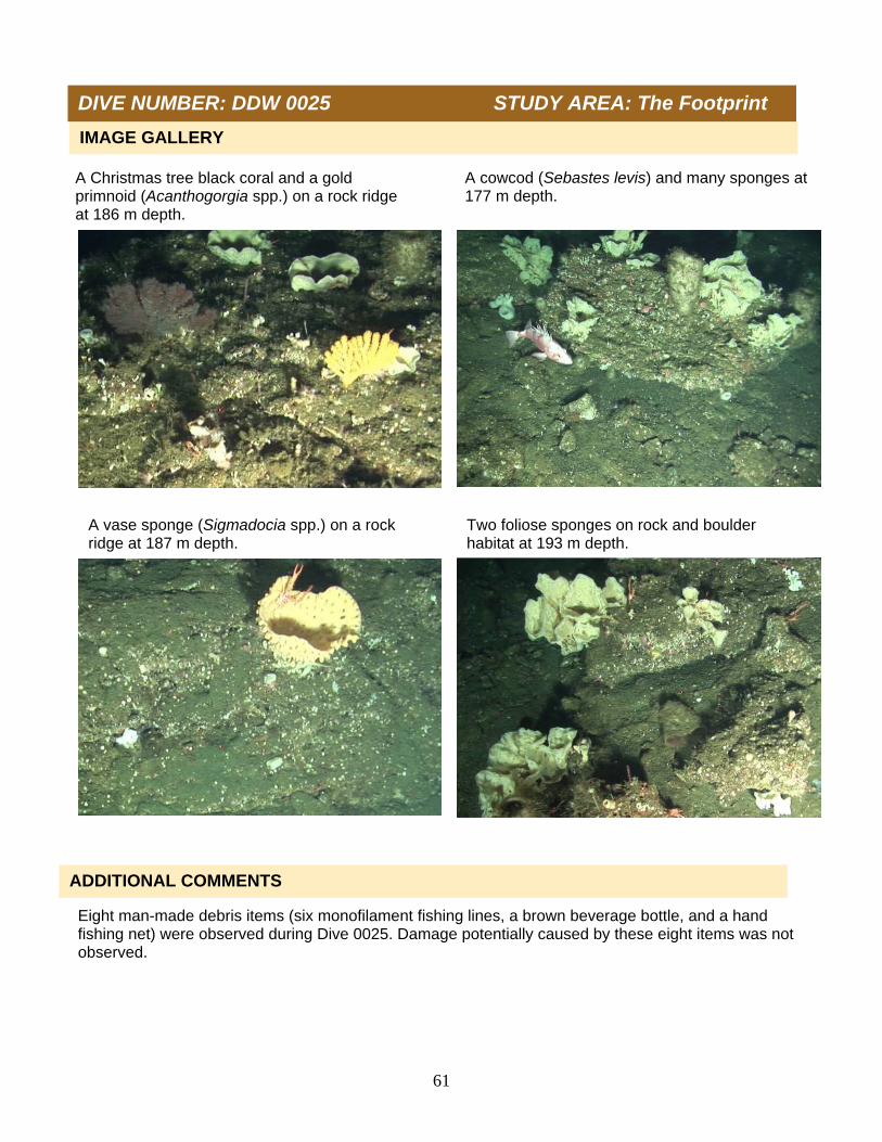
A Christmas tree black coral and a gold primnoid (Acanthogorgia spp.) on a rock ridge at 186 m depth.
A cowcod (Sebastes levis) and many sponges at 177 m depth.
A vase sponge (Sigmadocia spp.) on a rock ridge at 187 m depth.
Two foliose sponges on rock and boulder habitat at 193 m depth.

62
Project U.S. West Coast Deep Coral Cruise
Chief Scientist M. Yoklavich
Contact Information NMFS, SWFSC, [email protected]
Purpose Determine fish associations with black corals
Vessel / Vehicle F/V Velero IV; Dual DeepWorker submersible
Submersible Pilot Doup Bishop
Scientific Observer Mary Yoklavich
External Digital Video HD: 72 min; SD: 1 tape
Positioning System Ship: GPS; Submersible: USBL
CTD Sensors Yes
O2 Sensor Yes
Specimens collected Yes
Other Logbook, Access database
Report Analyst T. Laidig
Date Compiled December 2012
DIVE NUMBER: DDW 0026 STUDY AREA: Piggy Bank
STATION OVERVIEW

63
Date 10 Oct 2010 Starting Latitude (N) 33˚ 55.182’
Minimum Bottom Depth (m) 263 Starting Longitude (W) 119˚ 28.440’
Maximum Bottom Depth (m) 308 Ending Latitude (N) 33˚ 55.128’
Start Bottom Time (PDT) 08:27 Ending Longitude (W) 119˚ 28.279’
End Bottom Time (PDT) 09:34 Surface Current n/a
Number of Transects 1 Bottom Current n/a
0
20
40
60
80
100
Hard Mixed Sediment
Per
cen
tag
e
Habitat surveyed (Total area = 2,106 m2)
DIVE DATA
PHYSICAL ENVIRONMENT
DIVE NUMBER: DDW 0026 STUDY AREA: Piggy Bank
A total 2,106 m2 of sea floor was surveyed in one continuous transect conducted during Dive 0026 on the Piggy Bank. Habitat types were classified as (1) Hard (87% of the total area surveyed), which included large boulders, rock outcrops, and cobbles; (2) Mixed (6% of the total area surveyed), including a combination of mud with boulders, rock, or cobbles; (3) Soft Sediment (7% of the total area surveyed) comprised entirely of mud

64
Data on depth, conductivity, temperature, and dissolved oxygen were collected during descent (A and B) and at depth along the track line (C and D) on Dive 0026. Temperature ranged from 19.1°C at the sea surface to 8.4°C on the sea floor at 279 m depth. Salinity (as estimated from conductivity, temperature, and pressure) ranged from 33.6 psu at the sea surface to 34.3 psu on the sea floor. Dissolved oxygen ranged from 5.4 ml/l at the sea surface (6.0 ml/l at the thermocline) to 0.9 ml/l on the sea floor at 279 m.
DIVE NUMBER: DDW 0026 STUDY AREA: Piggy Bank
A. B.
C. D

65
A total of 6 Christmas tree black corals, with a density of 2.8 colonies per 1,000 m2, occurred on transect during Dive 0026. Colonies generally were large, averaging 1,900 cm2 in area (range = 750-4,500 cm2); 1 colony was >1 m in width. Colonies were white, gray, or red, and all were upright. No colony had any sign of dead or dying sections. All colonies had associated invertebrates (mostly crinoids, crabs, and brittle stars); only one colony was associated with a fish. Three coral specimens were collected during Dive 0026; Stephen Cairns (National Museum of Natural History, Smithsonian Institution, Washington DC) identified the pale pink primnoid (Plumarella longispina) and the bubblegum coral (Paragorgia arborea), and Sandra Brooke received specimens of Lophelia pertusa for genetic and reproductive studies. At least 14 taxa of fishes were identified on the top of the Piggy Bank during Dive 0026. A total of 431 individual fishes was enumerated, and an overall density of 205 fishes per 1,000 m2 of sea floor was estimated from one continuous transect. At least 7 species of rockfishes (Sebastes), dominated by unidentified Sebastomus, and bank and shortbelly rockfishes, comprised 96% of the density. The remainder of the fish assemblage included unidentified cat shark egg cases, flatfishes, poachers, spotted ratfish, and bluebarred pricklebacks. One unidentified Sebastomus rockfish was associated with one Christmas tree black coral observed on this dive. The remaining 5 coral colonies were not associated with fishes.
Scientific name Common name Number Fishes Agonidae Unidentified poachers 6
Microstomus pacificus Dover sole 2 Pleuronectiformes Unidentified flatfish 1
Sebastes aurora Aurora rockfish 1 Sebastes constellatus Starry rockfish 1 Sebastes diploproa Splitnose rockfish 2 Sebastes helvomaculatus Rosethorn rockfish 1 Sebastes jordani Shortbelly rockfish 38 Sebastes rufus Bank rockfish 285 Sebastes spp. Unidentified rockfish 1 Sebastes spp. Unidentified Sebastomus 85
Hydrolagus colliei Spotted ratfish 1 Plectobranchus evides Bluebarred prickleback 1 Scyliorhinidae Unidentified cat shark egg cases 6
BIOLOGICAL ENVIRONMENT: FISHES
DIVE NUMBER: DDW 0026 STUDY AREA: Piggy Bank
BIOLOGICAL ENVIRONMENT: CHRISTMAS TREES

66
No man-made debris items were observed during Dive 0026.
ADDITIONAL COMMENTS
DIVE NUMBER: DDW 0026 STUDY AREA: Piggy Bank
IMAGE GALLERY
A bubblegum coral (Paragorgia arborea) on rock ridge at 283 m depth.
A Christmas tree black coral and a fingered goblet vase sponge (Heterochone calyx) on rock ridge at 289 m depth.
Two vase sponges on cobble and boulder habitat at 303 m depth.
Two Christmas tree black corals on rocky ridge at 285 m depth.
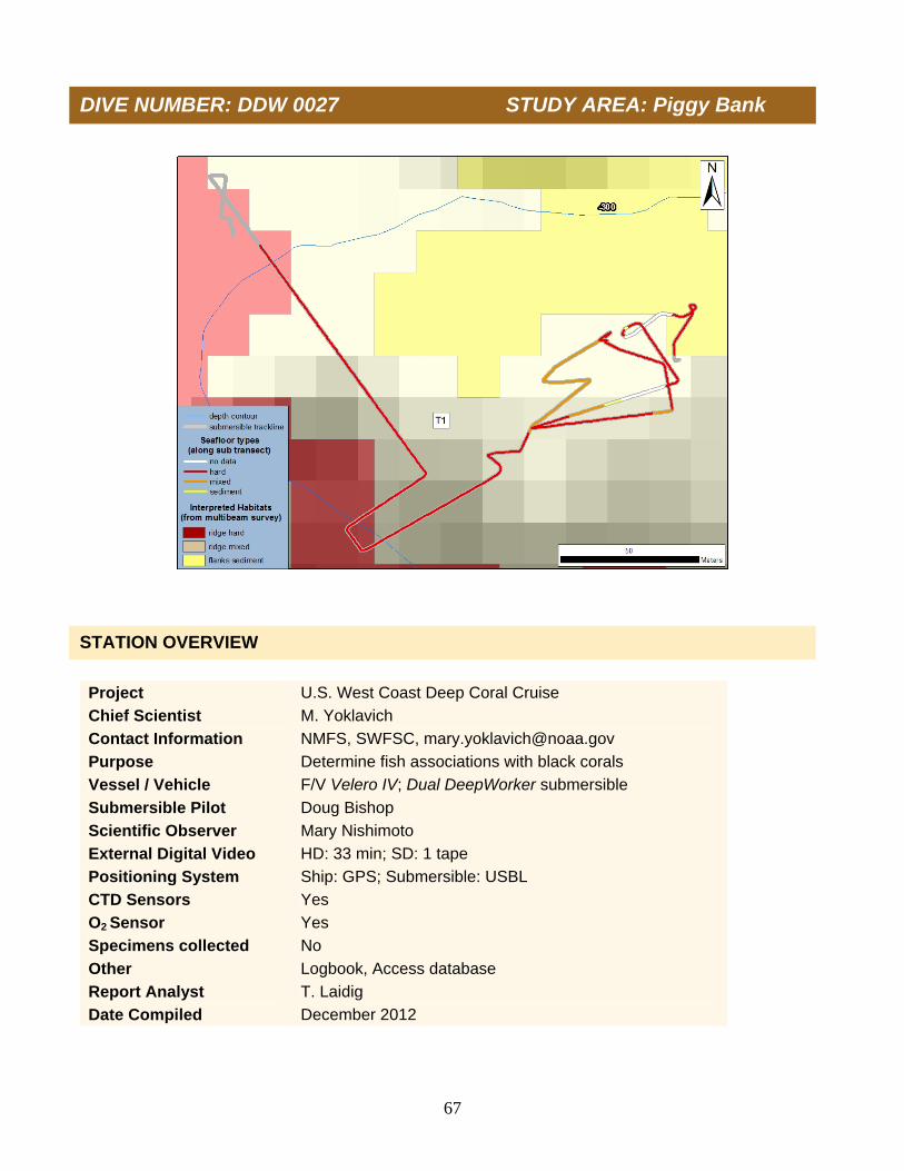
67
Project U.S. West Coast Deep Coral Cruise
Chief Scientist M. Yoklavich
Contact Information NMFS, SWFSC, [email protected]
Purpose Determine fish associations with black corals
Vessel / Vehicle F/V Velero IV; Dual DeepWorker submersible
Submersible Pilot Doug Bishop
Scientific Observer Mary Nishimoto
External Digital Video HD: 33 min; SD: 1 tape
Positioning System Ship: GPS; Submersible: USBL
CTD Sensors Yes
O2 Sensor Yes
Specimens collected No
Other Logbook, Access database
Report Analyst T. Laidig
Date Compiled December 2012
DIVE NUMBER: DDW 0027 STUDY AREA: Piggy Bank
STATION OVERVIEW

68
Habitat surveyed (Total area = 1,021 m2)
0
20
40
60
80
100
Hard Mixed Sediment
Pe
rce
nta
ge
Date 10 Oct 2010 Starting Latitude (N) 33˚ 55.330’
Minimum Bottom Depth (m) 258 Starting Longitude (W) 119˚ 29.417’
Maximum Bottom Depth (m) 322 Ending Latitude (N) 33˚ 55.307’
Start Bottom Time (PDT) 13:01 Ending Longitude (W) 119˚ 29.317’
End Bottom Time (PDT) 13:31 Surface Current n/a
Number of Transects 1 Bottom Current n/a In total, 1,021 m2 of sea floor were surveyed on one continuous transect on the Piggy Bank during Dive 0027. Habitat types were classified as (1) Hard (80% of the total area surveyed), which included large boulders, rock outcrops, and cobbles; (2) Mixed (18% of the total area surveyed), including a combination of mud with boulders, rock, or cobbles; (3) Soft Sediment (2% of the total area surveyed) comprising mud.
PHYSICAL ENVIRONMENT
DIVE NUMBER: DDW 0027 STUDY AREA: Piggy Bank
DIVE DATA

69
Data on depth, conductivity, temperature, and dissolved oxygen were conducted during descent (A and B) and at depth along the track line (C and D) on Dive 0027. Temperature ranged from 19.7°C at the sea surface to 8.0°C on the sea floor at 321 m depth. Salinity (as estimated from conductivity, temperature, and pressure) ranged from 33.7 psu at the sea surface to 34.3 psu on the sea floor. Dissolved oxygen ranged from 5.4 ml/l at the sea surface (6.0 ml/l at the thermocline) to 0.8 on the sea floor at 321 m.
B.A.
C. D.
DIVE NUMBER: DDW 0027 STUDY AREA: Piggy Bank

70
A total of 12 Christmas tree black corals, with a density of 11.8 colonies per 1,000 m2, occurred on transect during Dive 0027. The colonies were small to medium, averaging 542 cm2 in area (range = 25-1,650 cm2). Colonies were white, gray, pink, or red, and all were upright. One colony had a dead or dying section, but none appeared mostly dead. All colonies had associated invertebrates (crinoids, crabs, and brittle stars), but only 1 colony was associated with a fish taxon. At least 10 taxa of fishes were identified on the top of Piggy Bank during Dive 0027. A total of 131 individual fishes was enumerated, and an overall density of 127 fish per 1,000 m2 of sea floor was estimated during one continuous transect. At least 3 species of rockfishes (Sebastes), dominated by unidentified Sebastomus and bank, comprised 90% of fish density. The remainder of the fish assemblage included Dover sole, poachers, hagfish, thornyheads, Icelinid sculpins ,and unidentified cat shark egg cases. One unidentified cat shark egg case was hanging in one coral colony. Fishes were not associated with the remaining 11 colonies.
Scientific name Common name NumberFishes Eptatretus spp. Unidentified hagfish 1
Agonidae Unidentified poacher 1
Microstomus pacificus Dover sole 6
Sebastes diploproa Splitnose rockfish 9 Sebastes rufus Bank rockfish 58 Sebastes simulator Pinkrose rockfish 1 Sebastes spp. Unidentified Sebastomus 50
Sebastolobus spp. Unidentified thornyhead 1
Icelinus spp. Icelinid sculpins 2 Scyliorhinidae Unidentified cat shark egg cases 2
DIVE NUMBER: DDW 0027 STUDY AREA: Piggy Bank
BIOLOGICAL ENVIRONMENT: CHRISTMAS TREES
BIOLOGICAL ENVIRONMENT: FISHES

71
Five man-made debris items (monofilament fishing lines) were observed during Dive 0027. Damage potentially caused by these five items was not observed.
ADDITIONAL COMMENTS
IMAGE GALLERY
DIVE NUMBER: DDW 0027 STUDY AREA: Piggy Bank
A multi-armed seastar (Rathbunaster californicus) and a Sebastomus rockfish (Sebastes spp.) on a boulder and cobble habitat at 300 m depth.
A Christmas tree black coral and basketstars (Gorgonocephalus eucnemis) on a boulder and cobble habitat at 294 m depth.
A Christmas tree black coral and basketstar (Gorgonocephalus eucnemis) on boulder and cobble habitat at 290 m depth.
A bubblegum coral (Paragorgia arborea) and a rosethorn rockfish (Sebastes helvomaculatus) in a field of Lophelia pertusa at 262 m depth.

72
We identified at least 20 taxa of corals, 17 taxa of sponges, and 56 taxa of fishes from the quantitative transects on 11 dives (dive 0019 was aborted) conducted on Hidden Reef (21 15-min transects), Footprint (5 longer transects), and Piggy Bank (2 longer transects). We collected 8 specimens, including 4 corals and 2 sponges, which have been identified by various experts. A total of 1,543 corals, 3,300 sponges, and 18,357 fishes were enumerated during this study. Densities ranged from 3 to148 corals/1,000 m2, 129 to 343 sponges/1,000 m2, and 79 to 2,406 fishes/1,000 m2. Densest corals were Christmas tree black coral, the primnoid Plumarella longispina, and Lophelia pertusa. Highest densities of sponges were vase, barrel, branching, and upright flat groups. The highest densities of fishes were unidentified Sebastomus, squarespot, pygmy, and shortbelly rockfishes. We classified 27,166 m2 of sea floor substrata. The original two-character-code substratum types were aggregated into three general categories for this analysis: the ‘Hard’ category included rock ridge, boulder, cobble, and flat rock in various proportions and comprised 75% of the survey; ‘Mixed’ category included varying amounts of mud with rock ridge, boulder, cobble, or flat rock and comprised 20% of the survey; and ‘Soft Sediment’ was represented entirely by mud and comprised 5% of the survey. A rock ridge (classified as Hard substratum). Boulders and cobbles (classified as Hard substratum).
Mud and cobble (classified as Mixed substratum). A mud sea floor (classified as Soft Sediment).
OVERALL SUMMARY:
Characterization of Christmas Trees Study Area: SoCal Bight

73
Scientific Name Common Name Taxon Scientific Name Common Name Taxon Acanthogorgia spp. Gold coral Coral Porifera #3 Unidentified barrel sponges Sponge
Paragorgia spp. Sea fan (white with red polyps) Coral Heterochone calyx Fingered goblet vase sponge Sponge
Paragorgia arborea Bubblegum coral Coral Porifera #5 Unidentified vase sponges Sponge
Paragorgia stephencairnsi Primnoid Coral Sigmadocia spp. Tan vase/trumpet sponge Sponge
Parastenella ramosa Primnoid Coral Staurocalyptus spp. Picasso sponge Sponge
Plumarella longispina Primnoid Coral Porifera #4 Unidentified shelf sponges Sponge
Plexauridae #1 Sea fan (red w/ white polyps) Coral Porifera #2 Unidentified upright flat sponges Sponge
Plexauridae #2 Sea fan (red w/ yellow polyps) Coral Farrea occa Lace (or cloud) foliose sponge Sponge
Plexauridae #3 Sea fan (red w/ unknown polyps) Coral Porifera #1 Unidentified foliose sponges Sponge
Swiftia sp. Red sea fan Coral Porifera #8 Unidentified tube sponges Sponge
Antipathes dendrochristos Christmas tree black coral Coral Porifera #6 Unidentified mound sponges Sponge
Desmophyllum dianthus Cockscomb cup coral Coral Porifera #9 Unidentified puffball mound sponges Sponge
Lophelia pertusa White cup coral Coral Porifera #7 Unidentified branching sponges Sponge
Scleractinia Unidentified cup corals Coral Rhizaxinella gadus Club sponge Sponge
Anthomastus ritteri Mushroom coral Coral Asbestopluma spp. #1 Predatory pipecleaner sponge Sponge
Zoantharia Unidentified zoanthid corals Coral Porifera #12 Unidentified sponges Sponge
Anthoptilum grandiflorum Feather boa sea pen Coral Thenea muricata Foliose sponge (clear) Sponge
Pennatulacea #1 Sea pen (thin) Coral
Clavularia spp. Soft coral Coral Hexacorallia/Octocorallia Unidentified corals Coral
Coral and sponge taxa observed from video surveys conducted with a submersible on the three banks in southern California, 5 – 10 October 2010.
Characterization of Christmas Trees Study Area: SoCal Bight

74
Scientific name Common name Scientific name Common name Eptatretus spp. Unidentified hagfishes Sebastes rubrivinctus Flag rockfish Lycodes cortezianus Bigfin eelpout Sebastes rufinanus Dwarf-red rockfish Agonidae Unidentified poachers Sebastes rufus Bank rockfish Citharichthys spp. Unidentified sanddabs Sebastes semicinctus Halfbanded rockfish Eopsetta jordani Petrale sole Sebastes simulator Pinkrose rockfish Glyptocephalus zachirus Rex sole Sebastes spp. Unidentified rockfishes Microstomus pacificus Dover sole Sebastes spp. Unidentified Sebastomus Parophrys vetulus English sole Sebastes spp. Young-of-the-year rockfishes Pleuronectiformes Unidentified flatfishes Sebastes wilsoni Pygmy rockfish Sebastes aurora Aurora rockfish Sebastes zacentrus Sharpchin rockfish Sebastes chlorostictus Greenspotted rockfish Sebastolobus alascanus Shortspine thornyhead Sebastes constellatus Starry rockfish Sebastolobus spp. Unidentified thornyheads Sebastes crameri Darkblotched rockfish Chilara taylori Spotted cusk-eel Sebastes diploproa Splitnose rockfish Cottidae Unidentified sculpins Sebastes elongatus Greenstriped rockfish Hydrolagus colliei Spotted ratfish Sebastes ensifer Swordspine rockfish Icelinus spp. Icelinid sculpins Sebastes entomelas Widow rockfish Merluccius productus Pacific hake Sebastes gillii Bronzespotted rockfish Myctophidae Unidentified lanternfishes Sebastes goodei Chilipepper Ophiodon elongatus Lingcod Sebastes helvomaculatus Rosethorn rockfish Osteichthyes Unidentified fishes Sebastes hopkinsi Squarespot rockfish Plectobranchus evides Bluebarred prickleback Sebastes jordani Shortbelly rockfish Raja rhina Longnose skate Sebastes levis Cowcod Rajidae Unidentified skate egg cases Sebastes melanostomus Blackgill rockfish Rajidae Unidentified skates Sebastes miniatus Vermilion rockfish Rhinogobiops nicholsii Blackeye goby Sebastes ovalis Speckled rockfish Scyliorhinidae Unidentified cat shark egg cases Sebastes paucispinis Bocaccio Torpedo californica Pacific electric ray Sebastes rosenblatti Greenblotched rockfish Zaniolepis frenata Shortspine combfish
Fish taxa observed from video surveys conducted with a submersible on the three banks in southern California, 5 – 10 October 2010.
Characterization of Christmas Trees Study Area: SoCal Bight
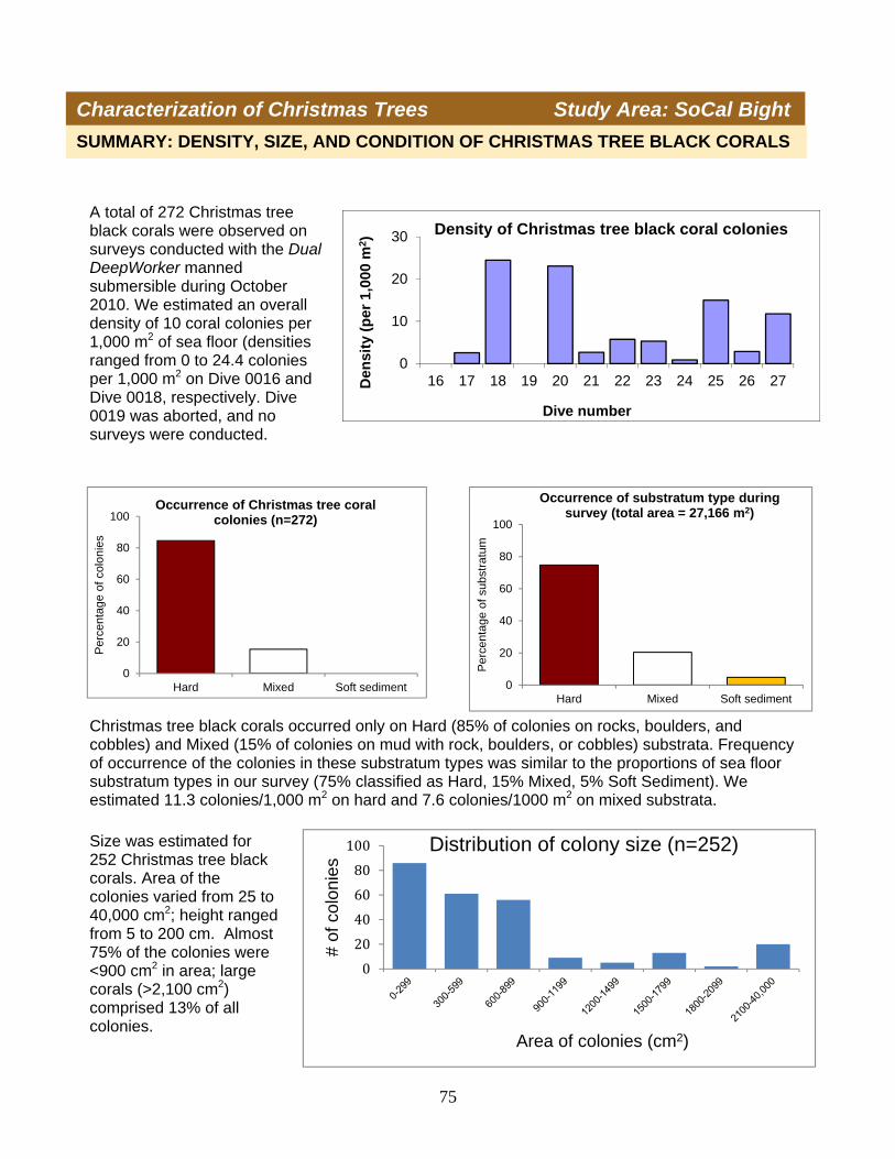
75
Size was estimated for 252 Christmas tree black corals. Area of the colonies varied from 25 to 40,000 cm2; height ranged from 5 to 200 cm. Almost 75% of the colonies were <900 cm2 in area; large corals (>2,100 cm2) comprised 13% of all colonies.
Characterization of Christmas Trees Study Area: SoCal Bight
SUMMARY: DENSITY, SIZE, AND CONDITION OF CHRISTMAS TREE BLACK CORALS
0
20
40
60
80
100
Hard Mixed Soft sediment
Per
cent
age
of s
ubst
ratu
m
Occurrence of substratum type during survey (total area = 27,166 m2)
0
20
40
60
80
100
Hard Mixed Soft sediment
Per
cent
age
of c
olon
ies
Occurrence of Christmas tree coral colonies (n=272)
0
20
40
60
80
100
# of
col
onie
s
Area of colonies (cm2)
Distribution of colony size (n=252)
A total of 272 Christmas tree black corals were observed on surveys conducted with the Dual DeepWorker manned submersible during October 2010. We estimated an overall density of 10 coral colonies per 1,000 m2 of sea floor (densities ranged from 0 to 24.4 colonies per 1,000 m2 on Dive 0016 and Dive 0018, respectively. Dive 0019 was aborted, and no surveys were conducted.
0
10
20
30
16 17 18 19 20 21 22 23 24 25 26 27Den
sity
(p
er 1
,000
m2)
Dive number
Density of Christmas tree black coral colonies
Christmas tree black corals occurred only on Hard (85% of colonies on rocks, boulders, and cobbles) and Mixed (15% of colonies on mud with rock, boulders, or cobbles) substrata. Frequency of occurrence of the colonies in these substratum types was similar to the proportions of sea floor substratum types in our survey (75% classified as Hard, 15% Mixed, 5% Soft Sediment). We estimated 11.3 colonies/1,000 m2 on hard and 7.6 colonies/1000 m2 on mixed substrata.

76
Christmas tree black corals generally were healthy, with little or no obvious damage. Only 19% of the colonies were dying or entirely dead. One broken and dead colony (base and stem about 0.5 m in height) was assumed to be the remains of a large colony (0.7 m in height; 1.4 m in width) surveyed several years earlier at the same location.
Characterization of Christmas Trees Study Area: SoCal Bight
0
50
100
150
200
250
Healthy Dying Dead
# of
col
onie
s
Condition of coral colonies(n=272)
020406080
100120140160180
White/gray Red/pink Orange
# o
f co
rals
Color of Christmas tree colonies (n=255)Healthy Christmas tree black coral colonies were either white or gray (66%), red or pink (32%), or orange (2%). All four of the orange colonies occurred on Dive 0020.
Healthy Christmas tree coral colony, with crinoids on surrounding rock.
Dying Christmas tree coral, with crinoids on dead sections of colony.
Dead Christmas tree coral covered in crinoids and zoanthids.
During this survey, we noted a greater number of invertebrates (e.g., crinoids, sponges, tunicates, zoanthids, bivalves, brittle stars) on dead Christmas tree corals than on healthy colonies (see also Yoklavich et al. 2011). We surmise that healthy corals protect themselves from such colonization.

77
ASSOCIATIONS OF FISHES WITH CHRISTMAS TREE BLACK CORALS
Fish Taxa Total number Total number on/near colonies on survey
(n= 94 fishes) (n= 18,357 fishes)
Young rockfishes (10 cm) 55 1,397 Cat shark egg cases 13 16 Squarespot rockfish 7 5,275
Bank rockfish 4 759 Unidentified Sebastomus 6 5,774
Cowcod 2 86 Halfbanded rockfish 1 677 Splitnose rockfish 2 135
Widow rockfish 1 10 Aurora rockfish 1 6
Sharpchin rockfish 1 2 Shortbelly rockfish 1 1,298
Pygmy rockfish 0 1,951 Others 0 971
Characterization of Christmas Trees Study Area: SoCal Bight
Fishes were associated with 21 Christmas tree black corals (<8% of the 272 individual colonies observed during this survey). We defined ‘associated’ to be < 1 fish body length away from or in direct contact with the coral colony. A total of 94 fishes (<1% of the 18,357 fishes counted on the survey) from 12 taxa were considered to be associated with the 21 coral colonies. Young rockfish (<10 cm) and cat shark egg cases were most frequently associated with these corals. Fishes associated with the colonies were 5-45 cm in total length.
Fishes typically associated with the largest colonies; there were fishes near/on 8 colonies (40%) in the largest size category. Only 1-5% of the corals in the three smallest size categories were associated with fishes.
A greater percentage of dying and dead coral colonies were associated with fishes (24% and 11%, respectively) than that of healthy corals (5% of which had associated fishes).
0
20
40
60
80
100
# o
f co
lon
ies
Area of colonies (cm2)
Fish Association and Colony Size (n=252)
With fish (n=20)
Without fish (n=232)
1%
5%5%
11% 20%
23%
0%
40%
0
50
100
150
200
250
Healthy Dying Dead
# o
f co
lon
ies
Fish Association and Condition of Coral Colonies
With fish (n=21)
Without fish (n=251)

78
Characterization of Christmas Trees Study Area: SoCal Bight
CHANGE IN CHRISTMAS TREE BLACK CORALS
05
1015202530354045
20 21 22 23
Den
sity
(#/
1000
m2)
Dive number
Density of Christmas Tree Black Corals
2002
2010
We evaluated density, size composition, and condition of Christmas tree black corals that were surveyed on Hidden Reef in 2002 and again in 2010. Dives conducted in 2010 were located in the vicinity and depth of the 2002 dives (see map on p.3). The amount of substratum types (Hard, Mixed, Soft Sediment) varied among the dives and between the two surveys.
0
1
2
3
4
Hard Mixed Soft sediment
Are
a (1
000
m2)Substratum Types - Dive 0023
Solid = 2002 , Striped = 2010
0
1
2
3
4
Hard Mixed Soft sediment
Are
a (1
000
m2)
Substratum Types - Dive 0022Solid = 2002, Striped = 2010
0
1
2
3
4
Hard Mixed Soft sediment
Are
a (1
000
m2)
Substratum Types - Dive 0021Solid = 2002, Striped = 2010
0
1
2
3
4
Hard Mixed Soft sediment
Are
a (1
000
m2)
Substratum Types - Dive 0020Solid = 2002, Striped = 2010
Highest densities of Christmas tree black corals occurred on Dive 0020 and 0023 in both years, but those densities significantly declined from 2002 to 2010 at those two sites. Lowest densities were estimated from counts on Dives 0021 and 22 in both years.

79
Characterization of Christmas Trees Study Area: SoCal Bight
CHANGE IN CHRISTMAS TREE BLACK CORALS
Most Christmas tree black corals were small (<900 cm2) in both the 2002 and 2010 surveys, and size of these small colonies did not differ between years. There were relatively more large colonies (>2,100 cm2) observed in the 2010 survey compared to those in 2002.
0
5
10
15
20
25
30
35
40
300 600 900 1200 1500 1800 2100 >2100
# o
f co
ral c
olo
nie
s
Area of colonies (cm2)
Coral colony size
2002
2010
(n = 95)
(n=126)
0
10
20
30
40
50
60
70
80
90
100
Healthy Dying Dead
Per
cen
tag
e o
f co
lon
ies
Condition of corals
2002 (n=106)
2010 (n=140)
Most Christmas tree black corals were healthy in both the 2002 and 2010 surveys, but the relative amount of healthy colonies declined from 2002 to 2010. The proportion of dead and dying colonies doubled in 2010.

80
Condition of corals
1) A total of 272 Christmas tree black corals were observed during 11 dives (~ 13 hours) on three offshore banks in the Southern California Bight.
2) Christmas tree black corals occurred only on Hard (85% of colonies) and Mixed (15%)
substrata.
3) We estimated an overall density of 10 Christmas tree black corals/1,000 m2. a. Coral density declined from 2002 to 2010.
4) Most colonies were relatively small (<900 cm2), but about 13% of the colonies were >2,100
cm2 in area (width x height). Some individual colonies were up to 200 cm tall. a. Relatively more large colonies were observed in the 2010 survey than in 2002.
5) Over 80% of the black coral colonies were healthy.
a. A much greater number of macro-invertebrates were living on dead or dying black corals, compared to healthy colonies.
b. A greater percentage of dead or dying colonies were associated with fishes. c. The relative number of healthy colonies declined from 2002 to 2010.
6) Only 94 fishes (<1% of all fishes on the survey) were associated with only 21 Christmas tree
black corals (<8% of the colonies on the survey). a. Young, small (<10 cm) unidentified rockfishes (Sebastes spp.) and cat shark egg cases
were most frequently associated with these corals. b. These fishes typically associated with the largest colonies. c. More dying and dead coral colonies were associated with fishes, compared with healthy
colonies.
7) All data from this survey have been added to a comprehensive database of DSC throughout the Southern California Bight. a. These data have been used in recent habitat-based models to map predicted distribution
and densities of Christmas tree black corals throughout the Bight. b. These data, maps, and models will help researchers and managers to understand
habitat requirements of these corals and to prioritize areas for future field work and protection.
CONCLUSION
Characterization of Christmas Trees Study Area: SoCal Bight
81
We thank Nuytco’s Dual DeepWorker team and the captain and crew of the F/V Velero IV for their outstanding efforts to safely and competently operate the submersible and support vessel. We appreciate the assistance of M. Nishimoto and L. Snook with data collection and J. Field for use of the CTD. Thanks to S. Cairns and W. Austin for their assistance in identifying specimens of deep-sea corals and sponges. NOAA NMFS SWFSC and DSCRTP supported this research; we especially thank Tom Hourigan, Fan Tsao, and the West Coast DSC Plan Team. Bright, J. 2007. Abundance and distribution of structure-forming invertebrates and their association with
fishes at the Channel Islands “Footprint” off the southern coast of California. M.S. Thesis, Washington State University, Vancouver, WA. 66 p.
Butler, J., M. Neuman, D. Pinkard, R. Kvitek, and G. Cochrane. 2006. The use of multibeam sonar
mapping techniques to refine population estimates of the endangered white abalone (Haliotis sorenseni). Fishery Bulletin 104:521-532.
Dartnell, P., G. Cochrane, and M. E. Dunaway. 2005. Multibeam bathymetry and backscatter data:
Northeastern Channel Islands region, Southern California. U.S. Geological Survey Open-File Report 05-1153, http://pubs.usgs.gov/of/2005/1153.
Etnoyer, P., S. D. Cairns, J. A. Sanchez, J. K. Reed, J. V. Lopez, W. W. Schroeder, S. D. Brooke, L.
Watling, A. Baco-Taylor, G. C. Williams, A. Lindner, S.C. France, and A.W. Bruckner. 2006. Deep-Sea coral collection protocols. NOAA Technical Memorandum NMFS-OPR-28, Silver Spring, MD. 53 p.
Goldfinger, C., C. Romsos, J. Chaytor, M. Yoklavich, M. Amend, D. Watters, W. Wakefield, and L.
Huffnagle. 2007. Multibeam sonar surveys and geological habitat mapping of the seafloor within the Cowcod Conservation Areas, Southern California Continental Borderland. Cooperative Research Report, Oregon State University and National Oceanic and Atmospheric Administration, ATSML Report 07-01, 40 pp.
Greene, H. G., M. M. Yoklavich, R. M. Starr, V. M. O’Connell, W. W. Wakefield, D. E. Sullivan, J. E.
McRea, and G. M. Cailliet. 1999. A classification scheme for deep sea floor habitats. Oceanologica Acta 22:663–678.
Love, M. S., M. M. Yoklavich, B. A. Black, and A. H. Andrews. 2007. Age of black coral (Antipathes
dendrochristos Opresko, 2005) colonies, with notes on associated invertebrate species. Bulletin of Marine Science 80:391-400.
Love, M. S., M. Yoklavich, and D. M. Schroeder. 2009. Demersal fish assemblages in the Southern
California Bight based on visual surveys in deep water. Environmental Biology Fishes 84:55-68. Love, M. S., M. Yoklavich, and L. Thorsteinson. 2002. The Rockfishes of the Northeast Pacific.
University of California Press, Berkeley and Los Angeles, CA. 405 p.
ACKNOWLEDGMENTS
REFERENCES
Characterization of Christmas Trees Study Area: SoCal Bight

82
NMFS (National Marine Fisheries Service). 2005. Pacific Coast Groundfish Fishery Management Plan, Essential Fish Habitat Designation and Minimization of Adverse Impacts, Final Environmental Impact Statement. Dec 2005.
Opresko, D. 2005. A new species of antipatharian coral (Cnidaria: Anthozoa: Antipatharia) from the
Southern California Bight. Zootaxa 852:1-10. Tissot, B., M. Yoklavich, M. Love, K. York, and M. Amend. 2006. Benthic invertebrates that form habitat
on deep banks off southern California, with special reference to deep sea coral. Fishery Bulletin 104:167-181.
Yoklavich, M., and M. Love. 2005. Christmas tree black corals: a new species discovered off southern
California. Current: The Journal of Marine Education 21:27-30. Yoklavich, M. M., H. G. Greene, G. M. Cailliet, D. E. Sullivan, R. N. Lea, and M. S. Love. 2000. Habitat
associations of deep-water rockfishes in a submarine canyon: an example of a natural refuge. Fishery Bulletin 98:625-641.
Yoklavich, M., T. Laidig, L. Krigsman, A. Taylor, D. Watters, M. Love, L. Lundsten, and B. Negrete.
2011. A characterization of the coral and sponge community on Piggy Bank seamount in southern California from a survey using a remotely operated vehicle. Report to the NOAA Deep-Sea Coral Research and Technology Program. 63 p.
Participants BACK ROW: Mike Leask (F/V Velero IV), Jeff Heaton (Nuytco Research, Ltd), Lisa Krigsman (NMFS SWFSC), Linda Snook (UC Santa Barbara), Mary Nishimoto (UC Santa Barbara), Diana Watters (NMFS SWFSC), Andrew Taylor (NMFS SWFSC). FRONT ROW: Tom Laidig (NMFS SWFSC), Sasha LeBaron (Nuytco Research, Ltd), Milton Love (UC Santa Barbara), Mary Yoklavich (NMFS SWFSC), Paul Dunn (F/V Velero IV), Jeff (Nuytco Research, Ltd), Rob Millsap (F/V Velero IV), Doug Bishop (Nuytco Research, Ltd), Irv Leask (F/V Velero IV), crew (Nuytco Research, Ltd)
Characterization of Christmas Trees Study Area: SoCal Bight