A Breakthrough in Oil Palm Precision Agriculture: Smart Management of Oil Palm Plantations with...
52
Redmond Ramin Shamshiri, PhD 2016 Next
-
Upload
redmond-ramin-shamshiri -
Category
Education
-
view
914 -
download
2
Transcript of A Breakthrough in Oil Palm Precision Agriculture: Smart Management of Oil Palm Plantations with...

Redmond Ramin Shamshiri, PhD
2016
Next

Next Prev
Precision Agriculture (Satellite Farming) has faced a breakthrough shift since risings of UAVs
Conventional Remote Sensing platforms are being replaced by integrated UAVs
Precision Agriculture
UAV
Wireless
Sensor
Networks
Robotics
Automation
Control
GPS
GIS
VRT
Remote
Sensing
As a flexible remote sensing platform
Crop/ Tree Scouting
Health/growth assessment
Inventory management
Yield estimation / Monitoring
Weed and disease detection
Mapping (2D, 3D, GIS, NDVI)
Risk/Hazard/Safety management
Soil condition assessment
VRT
Robotics harvesting
Academic and Research application
Typical Applications in Agriculture
RGB
Infrared
NIR
Hyperspectral
Multispectral
Thermal
Mapping software, Mobile Apps
Integrated with Commercial
sensors/Cameras/Software
UAVs & Robotics are the future of Precision Ag
Precision Agriculture of Oil Palm is one of the largest
market in Malaysia to be hit by UAVs
Redmond Ramin Shamshiri, 2016. UAV for Oil Palm Precision Agriculture. https://florida.academia.edu/RaminShamshiri

Next Prev
Precision Agriculture is about optimizing returns on inputs while preserving resources
PA is a farming Management concept based on Sensing, Measuring and Assessment
Sensing Components
Sensors , Cameras Platform
Ground-based
Handheld Vehicle mounted
Airborne
Satellite UAV Piloted Airplanes
o RGB
o Hyperspectral
o Multispectral
o Thermal
o NDVI
o Infrared
o NIR
Fixed wing Multi-rotor
Redmond Ramin Shamshiri, 2016. UAV for Oil Palm Precision Agriculture. https://florida.academia.edu/RaminShamshiri

Next Prev
Traditional Scouting o Traditional scouting requires spending hours and hours of visualizing
o Involves manual operations, ineffective techniques
o Limitation of human/labor resources (Not on demand)
o Repeated dull tasks (i.e., Palm census) o Not a pleasant environment to work (hot, humid)
o Hazard/ Safety (Falling from trees, bugs, snakes, etc)
o Generates Inaccurate/biased statistics
o Requires expert knowledge/Post processing (i.e., lab analysis of data)
o Generates limited information (Does not provide comprehensive result)
o Ignored parameters due to measurement’s difficulties (i.e., tree height,
canopy diameter, tasks that involves climbing trees)
Satellite remote sensing
o Cost
o Low resolution
o Difficulties of access (Not on-demand)
Ground sensing
o Time consuming
o Limited field of view
Redmond Ramin Shamshiri, 2016. UAV for Oil Palm Precision Agriculture. https://florida.academia.edu/RaminShamshiri
Next Prev
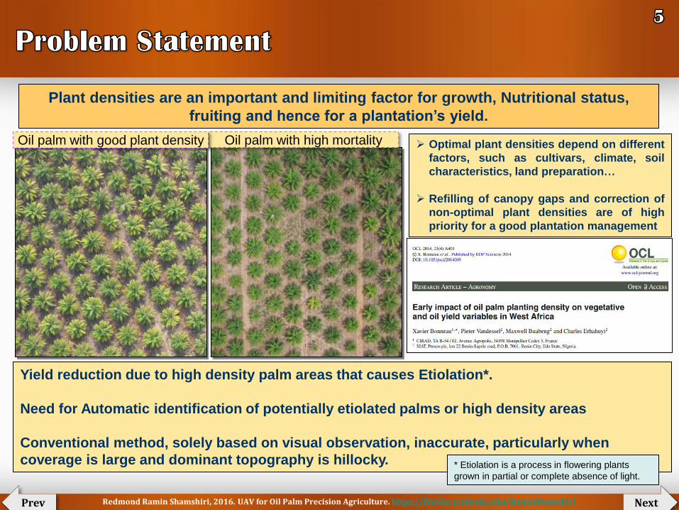
Plant densities are an important and limiting factor for growth, Nutritional status,
fruiting and hence for a plantation’s yield.
Oil palm with high mortality Oil palm with good plant density Optimal plant densities depend on different
factors, such as cultivars, climate, soil
characteristics, land preparation…
Refilling of canopy gaps and correction of
non-optimal plant densities are of high
priority for a good plantation management
Yield reduction due to high density palm areas that causes Etiolation*.
Need for Automatic identification of potentially etiolated palms or high density areas
Conventional method, solely based on visual observation, inaccurate, particularly when
coverage is large and dominant topography is hillocky. * Etiolation is a process in flowering plants
grown in partial or complete absence of light.
Redmond Ramin Shamshiri, 2016. UAV for Oil Palm Precision Agriculture. https://florida.academia.edu/RaminShamshiri

Next Prev
Main Objective
To develop/adapt a flexible remote sensing platform by integrating UAV, Sensors,
and robust machine vision system for Smart Management of Oil Palm Plantations
Smart Management involves:
A: Smart Inventory Management
B: Smart Growth/Health Assessment
“Smart” refers to:
Autonomous monitoring, data processing and
decision making
Redmond Ramin Shamshiri, 2016. UAV for Oil Palm Precision Agriculture. https://florida.academia.edu/RaminShamshiri

Next Prev
Specific Objectives
1. To setup and operate a multi-rotor UAV remote sensing system for Oil Palm plantations
2. To produce 2D and 3D visual maps of the fields under study
(including Blocks, rivers, roads, boundaries)
3. To produce NDVI (Vegetation stress) and GIS maps for health and growth assessment
4. To develop a robust, real-time machine vision system for the following tasks
(4.1) Inventory management
Palm census and density, track and record
Crown diameter estimation, Canopy size
Palm height measurements
Plantable, Unplantable, Overplanted areas
Palms distance
(4.2) Yield mapping system
Detection/Quantification of fresh fruit bunches from UAV images
Yield per Palm and Yield per ha
Redmond Ramin Shamshiri, 2016. UAV for Oil Palm Precision Agriculture. https://florida.academia.edu/RaminShamshiri

Next Prev
Consideration for a flexible design
Small size
Light-weight
Affordable
Autonomous
Stable (against wind and other disturbances)
Shifting between multiple sensors
Payload
Flight time
Safety (For operator, environment, and platform)
Low-altitude flight
On-Demand flight (Ease of access operation)
Repair and Maintenance costs
Redmond Ramin Shamshiri, 2016. UAV for Oil Palm Precision Agriculture. https://florida.academia.edu/RaminShamshiri

Next Prev
Redmond Ramin Shamshiri, 2016. UAV for Oil Palm Precision Agriculture. https://florida.academia.edu/RaminShamshiri

Next Prev
Redmond Ramin Shamshiri, 2016. UAV for Oil Palm Precision Agriculture. https://florida.academia.edu/RaminShamshiri

Next Prev
Redmond Ramin Shamshiri, 2016. UAV for Oil Palm Precision Agriculture. https://florida.academia.edu/RaminShamshiri

Next Prev
Redmond Ramin Shamshiri, 2016. UAV for Oil Palm Precision Agriculture. https://florida.academia.edu/RaminShamshiri

Next Prev
Redmond Ramin Shamshiri, 2016. UAV for Oil Palm Precision Agriculture. https://florida.academia.edu/RaminShamshiri

Next Prev
0
2
4
6
8
10
12
14
16
18
20
Billio
n U
S D
ollar Palm Oil Export ($)
0
10
20
30
40
50
60
% o
f th
e t
ota
l w
orl
d
Palm Oil Export (% of the total)
Oil Palm contribute to 12 billion USD of Malaysian economy
Potential for monitoring oil-palm plantations in such a
great detail has been never possible
Redmond Ramin Shamshiri, 2016. UAV for Oil Palm Precision Agriculture. https://florida.academia.edu/RaminShamshiri

Next Prev
Automatic palm detection, counting, size measurements, etc
Calculation of planted areas (for replanting or thinning)
Analyzing Palm status based on orthomosaics and digital elevation models
Generating valuable information based on each and every individual palm
Classification of palms based on crown size, height, vegetation indices, etc
Such information can be used for appropriate management decisions (maximize yields)
Yield Estimation Model development Correlation between palm height (𝒙𝟏) , crown size (𝒙𝟐), age (𝒙𝟑), vegetation index (𝒙𝟒) , …, and yield
𝒀𝒊𝒆𝒍𝒅 = 𝒇𝒖𝒏𝒄(𝒙𝟏, 𝒙𝟐, 𝒙𝟑, 𝒙𝟒…)
This research will provide growers/managers with a tool for:
A model that is based on a comprehensive information of each palm location, size, and health, will
provide managers with an estimation of yield, and make decisions for sustainable practices methods for
production increase without necessary needs for expanding the plantation into natural forests
Redmond Ramin Shamshiri, 2016. UAV for Oil Palm Precision Agriculture. https://florida.academia.edu/RaminShamshiri

Next Prev
Accurate planted area
Creation of Palm trees inventory database for specific plot
Total land use
Palm distances to specific areas
Canopy diameter estimation
Tree height measurements
Calculating palm density for specific plot
Creation of 2D, 3D, GIS, NDVI maps for plantation
Monitoring Healthy/Unhealthy palms (Stress assessment)
Monitoring exposed soil (VRT application)
Quantification of FFB, Estimation of mature fruits
Calculating yields for each palm from the acquired images
Yield monitoring
Creation of yield maps
Chlorophyll analysis
Drought assessment
Biomass indication
Leaf area index
Growth monitoring
Weed detection
Inventory management decision support systems
Yield Model Development
Academic and Research application
Redmond Ramin Shamshiri, 2016. UAV for Oil Palm Precision Agriculture. https://florida.academia.edu/RaminShamshiri

Next Prev
Research phases
1. Platform setup, integrating UAV, sensors and software
2. Creating high quality 2D and 3D maps of the area
3. Developing custom-built programs/algorithms for smart inventory management
4. Developing custom-built programs/algorithms for smart Health/growth assessment
UAV Setup
Flight Preparation
Test and trials
Mission planning
Image acquisition
Video streaming
Camera/Sensor
setups
Calibration
Image processing
Creating 2D, 3D,
GIS, NDVI Maps
(Pix4Dmapper,
Agisoft)
Image/Map
interpretation
GIS analysis
Custom software
Correlation
analysis
Management
strategies
Decision makings
Reports
generation
UAV images need to be photogrammetrically processed and translated into accurate 2D
orthomosaics and maps, 3D models and surface models, and other GIS datasets
Orthomosaics, 3D Models and Digital Surface Models, 3D Flythrough Videos,
Multispectral Image Mosaics, Index Maps, (i.e., NDVI) needs to be processed/interpreted
DATA
COLLECTION
Data
Processing
Mapping
Modeling
Data analyzing
Results /
Reports
Methodology steps
Redmond Ramin Shamshiri, 2016. UAV for Oil Palm Precision Agriculture. https://florida.academia.edu/RaminShamshiri

Next Prev
UAV Platform Sensors
(Cameras) Application
Software
Programming
(Processing)
Multi-rotor Fixed wing
Multi-rotor UAVs
launch and land vertically
are favored where space is tight
Fixed-wing UAV
Requires suitable space to launch and land
Can provide longer flight duration
Can carry a heavier payload.
In-flight stability, flight-time duration
and payloads are major paramount
concerns
RGB
NIR
NDVI
Thermal
Multispectral
Hyperspectral
LiDAR
Onboard
GPS Auto flight
Controller
Redmond Ramin Shamshiri, 2016. UAV for Oil Palm Precision Agriculture. https://florida.academia.edu/RaminShamshiri

The quadrocopter UAV,
model md4-1000
DJI Phantom, a small
hobbyist quadcopter
MōVI M10 - Digital 3-Axis Gyro-
Stabilized , Price: $4,995
Fixed Wing, ebee Low-cost: affordable by oil palm growers
Modular sensor system (shifting different sensors)
Higher flight time, more ha coverage
Payload
Mobile applications
Data sharing
Wireless networks
Commercial UAVs are expensive,
Not designed for operation inside oil-palm plantations
Might need protection frames
Factors to be considered
Built from scratch UAV
Quadcopter micro UAV
'microdrones md4-200' with
the prototype MSMS
multispectral sensor
The camera system on
board the Oktokopter
Setting up a UAV
Purchase, Adapt, Or Build from Scratch?
Next Prev Redmond Ramin Shamshiri, 2016. UAV for Oil Palm Precision Agriculture. https://florida.academia.edu/RaminShamshiri

Next Prev
Sony A6000 Visible Sensor Focus Points: 179 True Resolution: 24.3Mp Pixel Size: 15.1 µm² ISO: 1347 ISO Image Quality: 82 Dynamic Range: 13.1 EV Colour Depth:24.1 bits Resolution (GSD):1.5cm – 4.5cm
Lumix LX7 Sensor Details True Resolution:10.1Mp Aperture Range:F1.4 - F2.3 Max Shutter Speed: 1 second ISO:80 - 6400 ISO Image Quality: 82 Resolution (GSD): 5cm @400ft Format:RAW, JPG Image Stabilisation:roll & anti-shake
Visible (RGB)
Lumix LX7 Infrared Sensor True Resolution:10.1Mp Aperture Range:F1.4 - F2.3 Max Shutter Speed: 1 second ISO:80 - 6400 ISO Image Quality: 82 Resolution (GSD): 5cm @400ft Format:RAW, JPG Image Stabilisation:roll and anti-shake
Canon S110-NIR, 12 MP, adapted to be controlled by drones autopilot Acquires image data in the NIR band Resolution: 12 MP Ground resolution at 100 m: 3.5 cm/px Sensor size: 7.44 x 5.58 mm Pixel pitch: 1.86 um Image format: JPEG and/or RAW
Healthy plants have a
strong near infrared
reflectivity, called the
"Red Edge".
Infrared\ Near Infrared
Redmond Ramin Shamshiri, 2016. UAV for Oil Palm Precision Agriculture. https://florida.academia.edu/RaminShamshiri

Next Prev
−1 ≤ 𝑁𝐷𝑉𝐼 =𝑋%− 𝑌%
𝑋%+ 𝑌%≤ +1
SUN
Y%
X%
Normalized Difference Vegetation Index (NDVI): measurement of the amount of live vegetation in an area
RGB NIR NDVI
NDVI<0 : Dead plants NDVI< 𝟎. 𝟑𝟑 Unhealthy plants 0.33< NDVI< 0.66: Healthy plant NDVI>0.66 Very healthy plants
NDVI - TWIN LUMIX LX7 low cost, rugged, high resolution imaging solution for NDVI, agricultural and archeological data analysis. provides true R and IR information from different sensors, providing the clean photogrammetric information required for vegetation anaysis processing. Combined with a 5cm resolution at 400ft this sensor provides a host of benefits for the agronomist and archeaologist . True Resolution:10.1Mp, Aperture Range:F1.4 - F2.3 Max Shutter Speed: 1 second, ISO:80 - 6400 ISO Image Quality: 82, Resolution (GSD): 5cm @400ft Format:RAW, JPG, Image Stabilisation:roll and anti-shake
Canon PowerShot SX260 12.1 MegaPixel Digital Camera Models: XNiteCanonSX260: UV+Visible+IR XNiteCanonSX260: IR- Only XNiteCanonSX260NDVI: 3-Band Vegetation Stress Remote Sensing Camera
Redmond Ramin Shamshiri, 2016. UAV for Oil Palm Precision Agriculture. https://florida.academia.edu/RaminShamshiri

Next Prev
High Resolution Uncooled Thermal
Camera: Tau 640
Optris PI450 Temperature range: -20°C to 900°C Spectral range: 7,5 bis 13 µm Optical resolution: 382 x 288px Frame rate 80 Hz capture single images at a rate one per 2 seconds. Each pixel from each image has an exact temperature associated with it.
High Resolution thermal imaging can assist
disease detection and water stress in Oil Palms,
or for scouting at nights, fire hazard alarm
Thermal Sensors Multispectral Sensor
To identify Oil Palm stress factors, soil types, fertilizers, or
insecticides
To identify differentiate plant species or recognize other plant
(weeds, etc),
To identify soil or chemical conditions that are, in each case, able
to be identified by their unique spectral signature.
To graphically illustrate vegetation indices such as NDVI that are
defined by relationships of specific narrow-band wavelengths.
With each exposure, 4 or 6 separate bands of visible or near-
infrared radiation move through each camera's lens and filter to
form a separate monochromatic image on the camera's sensor.
Tetracam MCA6 contains 4 or 6 factory-aligned multi-spectral cameras Each sensor captures a 5.2 Megapixel image on the MCA4 and 7.8 Megapixel images on the MCA6 User selectable filters PixelWrench2 software allows for viewing and analysing the images. contains 4 or 6 factory-aligned multi-spectral cameras.
Redmond Ramin Shamshiri, 2016. UAV for Oil Palm Precision Agriculture. https://florida.academia.edu/RaminShamshiri
Next Prev
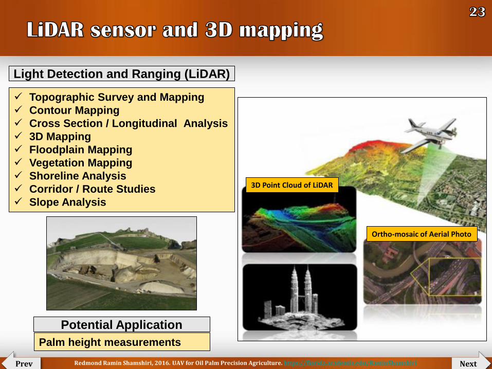
Topographic Survey and Mapping
Contour Mapping
Cross Section / Longitudinal Analysis
3D Mapping
Floodplain Mapping
Vegetation Mapping
Shoreline Analysis
Corridor / Route Studies
Slope Analysis
3D Point Cloud of LiDAR
Ortho-mosaic of Aerial Photo
Light Detection and Ranging (LiDAR)
Potential Application
Palm height measurements
Redmond Ramin Shamshiri, 2016. UAV for Oil Palm Precision Agriculture. https://florida.academia.edu/RaminShamshiri

Next Prev
Routescene LidarPod
Redmond Ramin Shamshiri, 2016. UAV for Oil Palm Precision Agriculture. https://florida.academia.edu/RaminShamshiri

Orthomosaics 3D Models Vegetation, Health, growth
analysis
Convert thousands of UAV images into
Geo-referenced 2D maps
Orthomosaics models
3D surface models
point clouds
SampleVideoPIX4D
8700 USD unlimited use in time
3500 USD /year (rent)
350 USD /month (rent)
Price
Next Prev Redmond Ramin Shamshiri, 2016. UAV for Oil Palm Precision Agriculture. https://florida.academia.edu/RaminShamshiri

Process thousands of aerial images
Suitable for a non-specialist operator
Generate high- resolution Geo-Ref
orthophotos
Exceptionally detailed Geo-Ref DEMs*
Fully automated workflow
Easy integration to the Q-Pods system
Create projects using more than one
camera and process imagery together
(i.e., NIR and RGB) * DEM: Digital Elevation Model
SampleVideoAgisoft
Price: £400.00
Next Prev Redmond Ramin Shamshiri, 2016. UAV for Oil Palm Precision Agriculture. https://florida.academia.edu/RaminShamshiri

Next Prev
Creating smart data for decision support
systems
Images source: Adapted from Terracentra
GIS tasks
Essentials of GIS & Aerial Image Interpretation
Map Generation
Creating Workflows
Management of Spatial Data
Natural Color Images
Multi-spectral Images
Digital Elevation Models
Multi-temporal Images
Redmond Ramin Shamshiri, 2016. UAV for Oil Palm Precision Agriculture. https://florida.academia.edu/RaminShamshiri

Next Prev
Images source: Adapted from Terracentra
Redmond Ramin Shamshiri, 2016. UAV for Oil Palm Precision Agriculture. https://florida.academia.edu/RaminShamshiri

Plantation Infrastructure Inventory, road mapping,
inventory and monitoring is very important for
efficient plantation management.
Fertility Mapping, detecting and mapping
of oil palm fertility or palm vigorous
growth level
Identifying unhealthy palms
Next Prev Redmond Ramin Shamshiri, 2016. UAV for Oil Palm Precision Agriculture. https://florida.academia.edu/RaminShamshiri

Next Prev
Estimated/Precise Palm tree counts in a selected area of interest
Plot size: (ha)
Palm counts: 2500
Palm density: 100 trees/ha
Redmond Ramin Shamshiri, 2016. UAV for Oil Palm Precision Agriculture. https://florida.academia.edu/RaminShamshiri

Finding average
distance of a plot to
the river/road
Next Prev Redmond Ramin Shamshiri, 2016. UAV for Oil Palm Precision Agriculture. https://florida.academia.edu/RaminShamshiri

Identification of poor spots examples
Next Prev Redmond Ramin Shamshiri, 2016. UAV for Oil Palm Precision Agriculture. https://florida.academia.edu/RaminShamshiri

Calculating total unplanted area from Geo-referenced maps
S1 S2
S3
S4
S5
S6
Total Unplanted Area = 𝑺𝒊𝒏𝒊=𝟏
Images source: Adapted from Terracentra
Next Prev Redmond Ramin Shamshiri, 2016. UAV for Oil Palm Precision Agriculture. https://florida.academia.edu/RaminShamshiri

Next Prev
PLOT B
Tree Counting methods
Training rules Commercial Software Other techniques
Redmond Ramin Shamshiri, 2016. UAV for Oil Palm Precision Agriculture. https://florida.academia.edu/RaminShamshiri

Next Prev
Training Area = 0.9 Sqr.Inch
Training Count = 4
Study Area=10.3305 Sqr.Inch
Estimated count= ?
Estimated count = Factor × Training count
= 45.9
1
2
3
4
5
7
19
21 10
11
12
13
14
15
16
17
18
25 20
46
22
23
24
9
26
27
28
29
30
31
32
33
34
35
36
37
38
39
40
41
42
43
44
45
8
6
0.5 0.4
= ---------- = 11.47 Factor = Study Area
Training
Area
______
0.9
10.33
Accuracy: 97.6%
Manual count ≅ 47
Redmond Ramin Shamshiri, 2016. UAV for Oil Palm Precision Agriculture. https://florida.academia.edu/RaminShamshiri
Next Prev
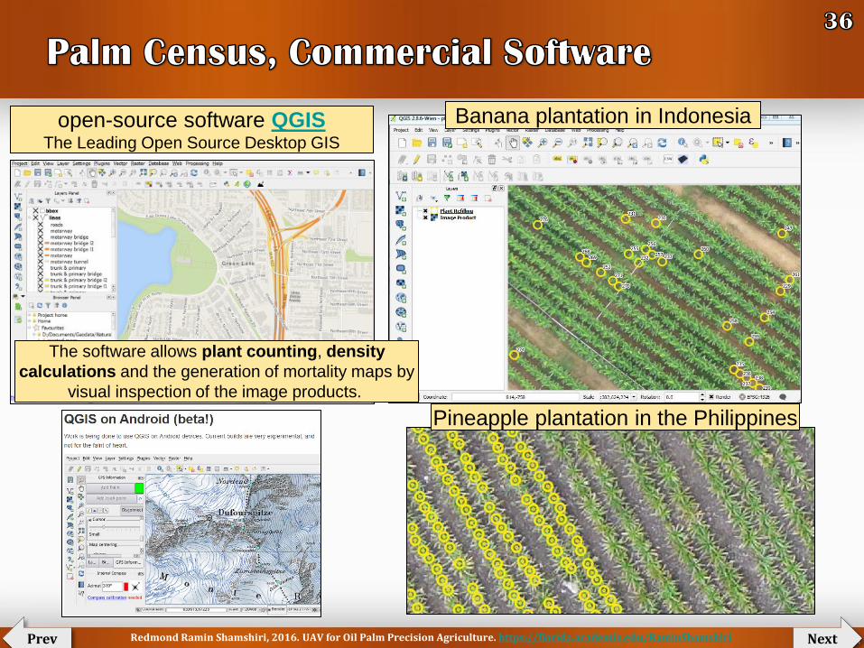
open-source software QGIS The Leading Open Source Desktop GIS
Banana plantation in Indonesia
Pineapple plantation in the Philippines
The software allows plant counting, density
calculations and the generation of mortality maps by
visual inspection of the image products.
Redmond Ramin Shamshiri, 2016. UAV for Oil Palm Precision Agriculture. https://florida.academia.edu/RaminShamshiri

Next Prev
ERDAS IMAGINE's Spatial Modeler (NIR thresholding)
RGB, NIR NIR LPF Image
EDF Image Threshold Image
Redmond Ramin Shamshiri, 2016. UAV for Oil Palm Precision Agriculture. https://florida.academia.edu/RaminShamshiri

Next Prev
The overall performance (detection rate)
between 0.916 to 0.998.
Redmond Ramin Shamshiri, 2016. UAV for Oil Palm Precision Agriculture. https://florida.academia.edu/RaminShamshiri

Next Prev
photogrammetric point clouds
Digital surface model
Local maximum display tree position
Photogrammetric point clouds Technique
Redmond Ramin Shamshiri, 2016. UAV for Oil Palm Precision Agriculture. https://florida.academia.edu/RaminShamshiri

The mapping accuracy amounts for 86.1% for the entire
study area and 98.2% for dense growing palm stands.
Photogrammetric point clouds Technique
Next Prev Redmond Ramin Shamshiri, 2016. UAV for Oil Palm Precision Agriculture. https://florida.academia.edu/RaminShamshiri

Next Prev
Correlating between palm heights, ages, and yield
Redmond Ramin Shamshiri, 2016. UAV for Oil Palm Precision Agriculture. https://florida.academia.edu/RaminShamshiri

Next Prev
Crown (Canopy) Volume
Crown diameter
Redmond Ramin Shamshiri, 2016. UAV for Oil Palm Precision Agriculture. https://florida.academia.edu/RaminShamshiri

Next Prev
Correlating between image and mass of FFB
Redmond Ramin Shamshiri, 2016. UAV for Oil Palm Precision Agriculture. https://florida.academia.edu/RaminShamshiri

Next Prev
X=% of Indexed pixels, No. of FFB, etc
Y=
We
igh
t (K
g)
FFB detection/quantification Geo-referenced
Redmond Ramin Shamshiri, 2016. UAV for Oil Palm Precision Agriculture. https://florida.academia.edu/RaminShamshiri

Next Prev
Autopilot and mission control
Visual servo control mechanism for FFB detection
Breakthrough innovative ideas (i.e., Night-mission flights)
Making smarter UAV platforms that can learn while flying
Techniques for Improving accuracy and resolution
Development of customized sensors with built-in algorithms for specific task
Improvement of low altitude flight mission
Improvement of flight control over actuator limits and noise (i.e., Controller
Design for Stabilizing of an Autonomous fixed wing Crop Surveillance
Osprey Drone with Actuator Limits and Sensor Noise)
Redmond Ramin Shamshiri, 2016. UAV for Oil Palm Precision Agriculture. https://florida.academia.edu/RaminShamshiri

Next Prev
Reducing labor force on field
Developing GIS dabase, 2D, 3D, NDVI, and thermal maps
Reducing labor hazards
Reducing management time
Palm tree tagging
Monitoring fungal disease with different sensors
Potential to be extended to other fields in Malaysia, i.e., rice and rubber
Further contribution
Smart pesticide control
Enhanced pollination
Constant track and record of growth condition
Drastically help growers in decision making
Early warnings for disease
A ground for autonomous robotic harvesting
Academic application
Rubber plantation
Redmond Ramin Shamshiri, 2016. UAV for Oil Palm Precision Agriculture. https://florida.academia.edu/RaminShamshiri

Next Prev
FFB quantification is the first step toward building cost-effective robotic
harvesting system for existing palm trees
UAV can contribute to mechanization of Oil Palm Agriculture
Re-design
Building the
prototype Simulation
Field
experiments
Evaluation
Improvement
Preliminary
design
Remote
API
Serial
port
Plugins
ROS
nodes
Control
Mechanisms
Embedded
Child Script
Redmond Ramin Shamshiri, 2016. UAV for Oil Palm Precision Agriculture. https://florida.academia.edu/RaminShamshiri

Next Prev
RGB
NIR NDVI
Palm heights, density,
Crown Diameter, Volume,
FFB quantification, etc
Predicted Yield
Disease detection
Management decisions
Nutrient contents, N, P, K, Mg, B
Redmond Ramin Shamshiri, 2016. UAV for Oil Palm Precision Agriculture. https://florida.academia.edu/RaminShamshiri

Next Prev
Link to
draft
Link to
draft
Redmond Ramin Shamshiri, 2016. UAV for Oil Palm Precision Agriculture. https://florida.academia.edu/RaminShamshiri

Next Prev
PrecisionHawk will presented its drone
platform for early disease detection on
February 4, 2016 at Dubai Internet City.
Redmond Ramin Shamshiri, 2016. UAV for Oil Palm Precision Agriculture. https://florida.academia.edu/RaminShamshiri
Next Prev
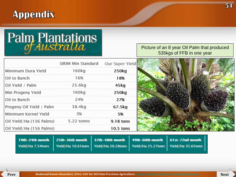
Picture of an 8 year Oil Palm that produced
535kgs of FFB in one year
Redmond Ramin Shamshiri, 2016. UAV for Oil Palm Precision Agriculture. https://florida.academia.edu/RaminShamshiri

(UPM)
(UPM)
(Univ of Florida)
(Univ of Florida)
(Univ of Florida)
(Wageningen UR)
For their insightful suggestions and ideas
Next Prev Redmond Ramin Shamshiri, 2016. UAV for Oil Palm Precision Agriculture. https://florida.academia.edu/RaminShamshiri