A bicycle ride through the History of Mt. · PDF fileA bicycle ride through the History of Mt....
9
Mountain High Snowsport Club presents Timberline to Rhododendron A bicycle ride through the History of Mt. Hood The thick yellow line is the modern Highway 26. The thinner more wiggly white line is the older highway, now abandoned. Laurel Hill, the steepest part of the Barlow trail, is just left of the ―Mile 51‖ marker. On this bike ride, we shall visit: * West Leg Road, the original road to Timberline. Skiable during the winter, but paved and open to car traffic in the summer. * The original highway, the one on which President Roosevelt drove up. * Historic buildings in Government Camp: Mt. Hood Museum, Huckleberry Inn, Cascade Lodge, Charlie's Pub. * The starting point for the SkiWay aerial tram, the bus on cables to Timberline. * Laurel Hill - the steepest part of the original Barlow Trail. * The "bat cave" - which is actually a narrow tunnel made for horses. Yes, for the US Cavalry! After all, that's how Government Camp got its name. It was military outpost for a while. * The Little Zig Zag Falls (just a beautiful nature spot). * Kiwanis Camp Rd. (a starting point for several Mt. Hood hiking trails) NOTE: Most of the riding will be on paved surfaces. A street bike is perfectly OK.
-
Upload
phamkhuong -
Category
Documents
-
view
217 -
download
3
Transcript of A bicycle ride through the History of Mt. · PDF fileA bicycle ride through the History of Mt....
Mountain High Snowsport Club presents
Timberline to Rhododendron A bicycle ride through the History of Mt. Hood
The thick yellow line is the modern Highway 26.
The thinner more wiggly white line is the older highway, now abandoned.
Laurel Hill, the steepest part of the Barlow trail, is just left of the ―Mile 51‖ marker.
On this bike ride, we shall visit:
* West Leg Road, the original road to Timberline. Skiable during the winter, but paved
and open to car traffic in the summer.
* The original highway, the one on which President Roosevelt drove up.
* Historic buildings in Government Camp: Mt. Hood Museum, Huckleberry Inn,
Cascade Lodge, Charlie's Pub.
* The starting point for the SkiWay aerial tram, the bus on cables to Timberline.
* Laurel Hill - the steepest part of the original Barlow Trail.
* The "bat cave" - which is actually a narrow tunnel made for horses. Yes, for the US
Cavalry! After all, that's how Government Camp got its name. It was military outpost
for a while.
* The Little Zig Zag Falls (just a beautiful nature spot).
* Kiwanis Camp Rd. (a starting point for several Mt. Hood hiking trails)
NOTE: Most of the riding will be on paved surfaces. A street bike is perfectly OK.
2
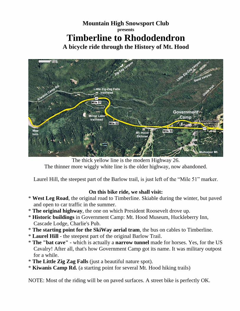
Mt. Hood
Cabin on the Summit of Mt. Hood
A cabin was built on top of Mt. Hood and served as a firefinder lookout station and
permanent living quarters for a watchman. The cabin was manned from 1915 to 1933 by
a succession of 12 hardy individuals.
Elijah Coleman proposed the plan to the
Forest Service and actually built the cabin,
with the help of several people who were paid
$5 a day for hauling all the timber and
building tools up the mountain, including 120
pounds of nails.
Elijah manned the cabin for the first 4 years,
during which time he became a legendary
figure on the mountain, regularly spotting
dozens of forest fires and reporting them to
the Forest Service over miles of telephone
wire that he himself strung all the way to the
summit and had to take down in September
for winter storage. The wire also required
frequent repairs.
Elijah also rescued numerous people on the
mountain, moving with extraordinary speed
and agility up and down the mountain, often
more than once in a single day.
First Lookout Station on the summit of Mt. Hood, 1915.
Elijah (Lige) Coleman on the left.
Photo US Forest Service.
Published in ”Mt. Hood - A Complete History” by Jack Grauer, 1975, page 58.
3
Climbing to the Summit of Mt. Hood
The earliest reported climbers of Mt. Hood were not always truthful.
It is widely suspected that Thomas Dryer, publisher of the Weekly Oregonian, did not
really reach the summit in his August 1854 expedition with several other people, though
he had published a controversial account of it in his own newspaper. Members of his
team used some ridiculous mathematical equation, based on the latitude of 44 degrees,
the temperature, the southeast exposure, the depth of the snow and the meltage of the
snow in the afternoon, to calculate the height of Mt. Hood as 18,361 feet. The actual
height is 11,500 feet.
A Mr. Belden claimed, in October 1854, to have climbed the mountain. He found the
summit to be at 19,400 feet, and that breathing was very difficult. Above 18,000 feet he
claimed blood oozed from pores in the skin, eyes bled, and blood rushed from their ears.
The first well documented climb came on August 6, 1857. This climb was made by
Henry L. Pittock (who later succeeded Thomas Dryer as editor of the Weekly
Oregonian), Prof. L.J.Powell, William S. Buckley, W. Lyman Chittenden, and
James G. Deardorff.
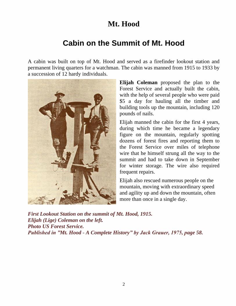
The Summit Ski Area in 1927.
Note that the Summit ski area is
not on the summit of Mt. Hood,
but rather at the highest point of
the mountain pass on Highway 26.
The ski area is located on the
North-East end of Government
Camp.
4
Timberline Lodge
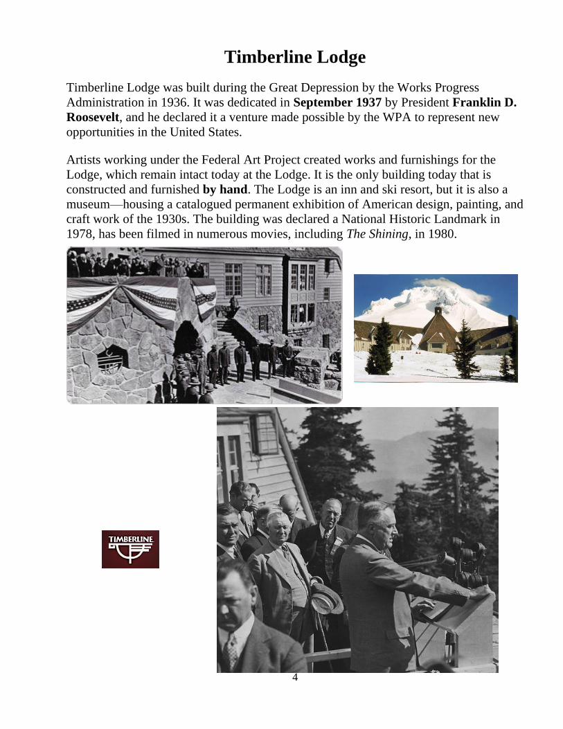
Timberline Lodge was built during the Great Depression by the Works Progress
Administration in 1936. It was dedicated in September 1937 by President Franklin D.
Roosevelt, and he declared it a venture made possible by the WPA to represent new
opportunities in the United States.
Artists working under the Federal Art Project created works and furnishings for the
Lodge, which remain intact today at the Lodge. It is the only building today that is
constructed and furnished by hand. The Lodge is an inn and ski resort, but it is also a
museum—housing a catalogued permanent exhibition of American design, painting, and
craft work of the 1930s. The building was declared a National Historic Landmark in
1978, has been filmed in numerous movies, including The Shining, in 1980.
5
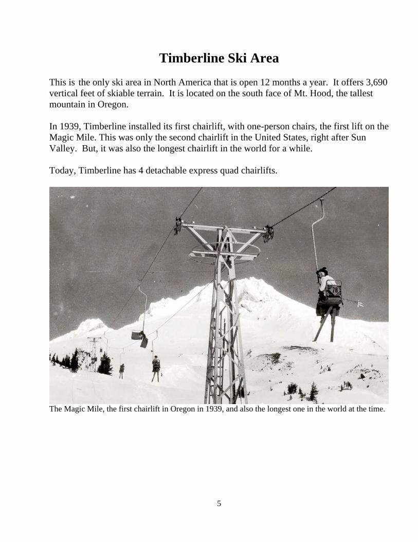
Timberline Ski Area
This is the only ski area in North America that is open 12 months a year. It offers 3,690
vertical feet of skiable terrain. It is located on the south face of Mt. Hood, the tallest
mountain in Oregon.
In 1939, Timberline installed its first chairlift, with one-person chairs, the first lift on the
Magic Mile. This was only the second chairlift in the United States, right after Sun
Valley. But, it was also the longest chairlift in the world for a while.
Today, Timberline has 4 detachable express quad chairlifts.
The Magic Mile, the first chairlift in Oregon in 1939, and also the longest one in the world at the time.

6
Government Camp
Government Camp began in 1849 when the first U.S. regiment of Mounted Riflemen
crossed the plains into Oregon country arriving at The Dalles. Most of the troops and
their equipment were transported downriver to Vancouver, Washington by boat. Plans
changed and some of the troops were ordered to proceed to Oregon City via the Oregon
Trail.
Bogged down by mud and snow, with half of the livestock lost or dead and soldiers near
total exhaustion, Lt. David Frost abandoned 45 Cavalry wagons in October 1849, before
starting down Laurel Hill. Their noted presence beside the Barlow Road became the
namesake of the alpine village - Government Camp.
Government Camp in 1928
Rhododendron was Rowe The town of Rhododendron used to be called Rowe, back at the beginning of the 20th
century. Henry S. Rowe, mayor of Portland from June 1900 to January 1902, built
Rhododendron Inn in 1905 on the 160-acre homestead he had purchased from Henry
Hammond for $1,200.
7
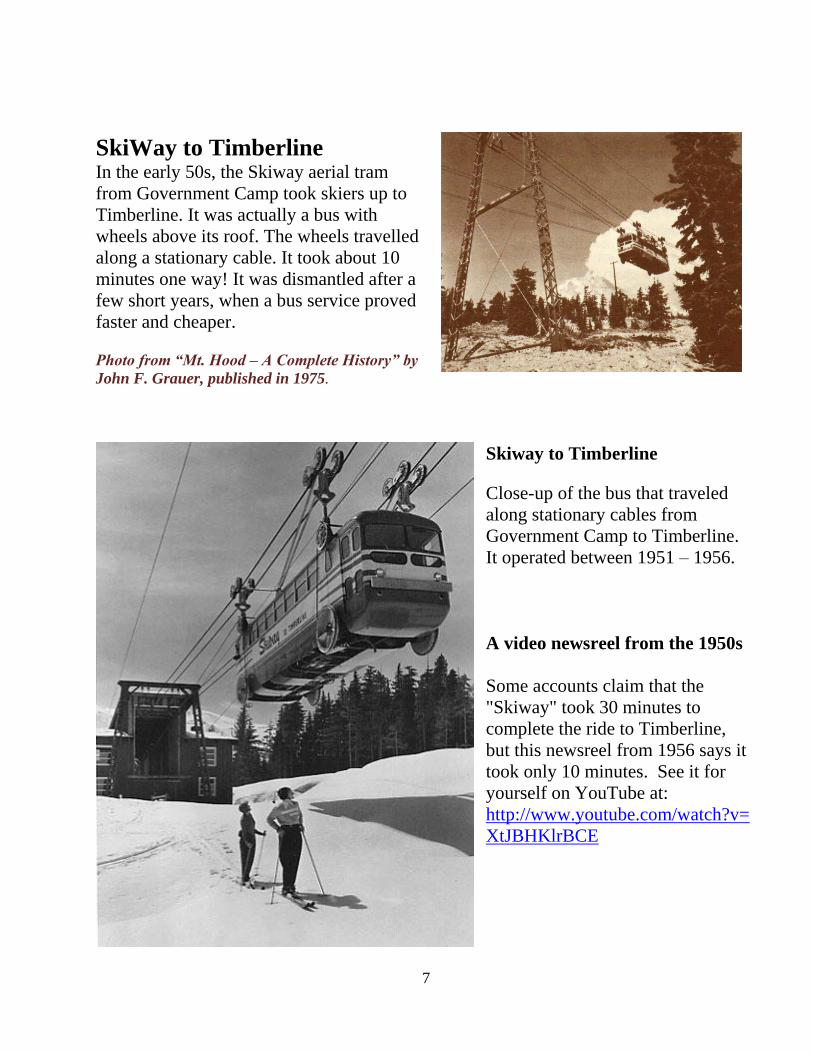
SkiWay to Timberline In the early 50s, the Skiway aerial tram
from Government Camp took skiers up to
Timberline. It was actually a bus with
wheels above its roof. The wheels travelled
along a stationary cable. It took about 10
minutes one way! It was dismantled after a
few short years, when a bus service proved
faster and cheaper.
Photo from “Mt. Hood – A Complete History” by
John F. Grauer, published in 1975.
Skiway to Timberline
Close-up of the bus that traveled
along stationary cables from
Government Camp to Timberline.
It operated between 1951 – 1956.
A video newsreel from the 1950s
Some accounts claim that the
"Skiway" took 30 minutes to
complete the ride to Timberline,
but this newsreel from 1956 says it
took only 10 minutes. See it for
yourself on YouTube at:
http://www.youtube.com/watch?v=
XtJBHKlrBCE
8
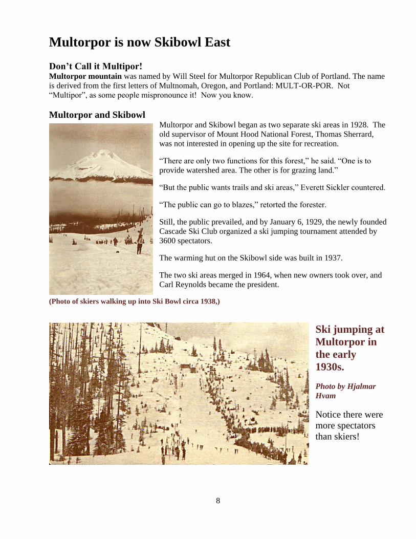
Multorpor is now Skibowl East
Don’t Call it Multipor! Multorpor mountain was named by Will Steel for Multorpor Republican Club of Portland. The name
is derived from the first letters of Multnomah, Oregon, and Portland: MULT-OR-POR. Not
―Multipor‖, as some people mispronounce it! Now you know.
Multorpor and Skibowl Multorpor and Skibowl began as two separate ski areas in 1928. The
old supervisor of Mount Hood National Forest, Thomas Sherrard,
was not interested in opening up the site for recreation.
―There are only two functions for this forest,‖ he said. ―One is to
provide watershed area. The other is for grazing land.‖
―But the public wants trails and ski areas,‖ Everett Sickler countered.
―The public can go to blazes,‖ retorted the forester.
Still, the public prevailed, and by January 6, 1929, the newly founded
Cascade Ski Club organized a ski jumping tournament attended by
3600 spectators.
The warming hut on the Skibowl side was built in 1937.
The two ski areas merged in 1964, when new owners took over, and
Carl Reynolds became the president.
(Photo of skiers walking up into Ski Bowl circa 1938,)
Ski jumping at
Multorpor in
the early
1930s.
Photo by Hjalmar
Hvam
Notice there were
more spectators
than skiers!
9
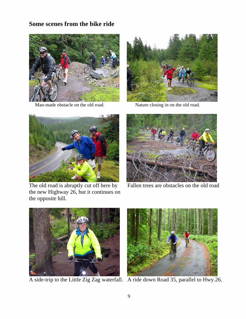
Some scenes from the bike ride
Man-made obstacle on the old road. Nature closing in on the old road.
The old road is abruptly cut off here by Fallen trees are obstacles on the old road
the new Highway 26, but it continues on
the opposite hill.
A side-trip to the Little Zig Zag waterfall. A ride down Road 35, parallel to Hwy.26.