
900, 916 and 920 Caledonia Road – Official Plan Amendment ...
24
Staff report for action – Refusal Report – 900, 916 and 920 Caledonia Road 1 STAFF REPORT ACTION REQUIRED 900, 916 and 920 Caledonia Road – Official Plan Amendment Application – Refusal Report Date: October 19, 2015 To: Planning and Growth Management Committee From: Chief Planner and Executive Director, City Planning Division Wards: Ward No. 15 – Eglinton-Lawrence Reference Number: P:\2015\ClusterB\PLN\PGMC\PG15110 (13 252271 NNY 15 OZ) SUMMARY An application has been submitted to amend the Official Plan designation on lands located west of Caledonia Road south of Lawrence Avenue West, from Employment Areas to Neighbourhoods to permit a development consisting of approximately 316 ground-oriented residential units, an 817m 2 retail block fronting Caledonia Road and a new public road system at 900, 916 and 920 Caledonia Road. This application has city-wide implications because it seeks to convert lands designated as Employment Areas. Planning and Growth Management Committee has already considered the proposed conversion through the recently-completed Official Plan and Municipal Comprehensive Reviews. City Council decided through Official Plan Amendment 231 (OPA 231) that the site should be retained as Employment Areas and designated as General Employment Areas. The applicant has appealed OPA 231 with respect to this site and it is before the Ontario Municipal Board. This report reviews and recommends refusal of the application to amend the Official Plan for the subject lands. PG8.3
-
Upload
nguyenthien -
Category
Documents
-
view
224 -
download
0
Transcript of 900, 916 and 920 Caledonia Road – Official Plan Amendment ...

Staff report for action – Refusal Report – 900, 916 and 920 Caledonia Road 1
STAFF REPORT ACTION REQUIRED
900, 916 and 920 Caledonia Road – Official Plan Amendment Application – Refusal Report
Date: October 19, 2015
To: Planning and Growth Management Committee
From: Chief Planner and Executive Director, City Planning Division
Wards: Ward No. 15 – Eglinton-Lawrence
Reference
Number:
P:\2015\ClusterB\PLN\PGMC\PG15110
(13 252271 NNY 15 OZ)
SUMMARY
An application has been submitted to amend the Official Plan designation on lands
located west of Caledonia Road south of Lawrence Avenue West, from Employment
Areas to Neighbourhoods to permit a development consisting of approximately 316
ground-oriented residential units, an 817m2 retail block fronting Caledonia Road and a
new public road system at 900, 916 and 920 Caledonia Road.
This application has city-wide implications because it seeks to convert lands designated
as Employment Areas. Planning and Growth Management Committee has already
considered the proposed conversion
through the recently-completed Official
Plan and Municipal Comprehensive
Reviews. City Council decided through
Official Plan Amendment 231 (OPA 231)
that the site should be retained as
Employment Areas and designated as
General Employment Areas. The applicant
has appealed OPA 231 with respect to this
site and it is before the Ontario Municipal
Board.
This report reviews and recommends
refusal of the application to amend the
Official Plan for the subject lands.
PG8.3

Staff report for action – Refusal Report – 900, 916 and 920 Caledonia Road 2
RECOMMENDATIONS
The City Planning Division recommends that:
1. City Council refuse the application to amend the Official Plan at 900, 916 and 920
Caledonia Road for the following reasons:
a. The proposal conflicts with the Growth Plan for the Greater Golden
Horseshoe;
b. The proposal is inconsistent with the PPS;
c. The proposal does not conform to the City's Official Plan;
d. The proposal does not implement the City's recently-completed Municipal
Comprehensive Review and Official Plan Review respecting employment
lands; and
e. The proposal is inappropriate and does not represent good planning.
2. In the event of an appeal, City Council authorize the City Solicitor and
appropriate staff to appear at the Ontario Municipal Board in support of this
position.
3. In the event of an appeal, City Council authorize the City Solicitor to seek
consolidation of this matter with upcoming hearings related to OPA 231 before
the Ontario Municipal Board.
Financial Impact The recommendations in this report have no financial impact.
DECISION HISTORY
Municipal Comprehensive Review
The Official Plan was brought into force in June 2006 by the Ontario Municipal Board
(OMB). Under Section 26 of the Planning Act, a municipality is required to review its
Official Plan within five years of it coming into force. The City commenced an Official
Plan Review in May, 2011 which included a comprehensive review of employment
policies and lands designated Employment Areas.
Under Section 2.2.6.5 of the Growth Plan, the City may convert employment lands for
non-employment uses only through a Municipal Comprehensive Review. The Municipal
Comprehensive Review (MCR) examined the City's designated areas of employment and
assessed the Official Plan policies related to these areas. All municipal planning
Staff report for action – Refusal Report – 900, 916 and 920 Caledonia Road 3
decisions are to implement the Provincial Policy Framework which, via the Provincial
Policy Statement (PPS) and Growth Plan for the Greater Golden Horseshoe (Growth
Plan), provide for municipalities to only permit the conversion of lands within
employment areas for non-employment purposes if it is established through a
comprehensive review consisting of a series of criteria that are met. The criteria are as
follows:
a) there is a need for the conversion;
b) the municipality will meet the employment forecasts allocated to the municipality
pursuant to the Growth Plan;
c) the conversion will not adversely affect the overall viability of the employment
area, and achievement of the intensification target, density targets, and other
policies of the Growth Plan;
d) there is existing or planned infrastructure to accommodate the proposed
conversion;
e) the lands are not required over the long term for the employment purposes for
which they are designated; and
f) cross-jurisdictional issues have been addressed.
By a letter dated August 27, 2012, a request was made for a re-designation from
Employment Areas to a non-employment use to permit ground-related residential uses on
the lands at 900, 916 and 920 Caledonia Road.
As of October 16, 2013 staff had received 125 requests/applications to convert
Employment Areas to non-employment uses. Staff from City Planning and Economic
Development and Culture worked closely to consider and evaluate these
requests/applications to convert employment lands for non-employment purposes. For
each conversion request/application staff conducted research on the site and the
surrounding areas, the health and viability of the employment areas, employment
activities that might be affected by the introduction of a sensitive use or through the
operations have an adverse effect on new residents or users of non-residential sensitive
uses, and existing community and physical infrastructure, among other matters. Where a
conversion request was near an industry that could affect new sensitive uses, or have their
operations affected by the introduction of sensitive uses, staff endeavoured to visit these
businesses and interview them to gain a better understanding of their operations. As per
the request of Council, the Ministry of the Environment D-series guidelines were
incorporated into this review.
Staff reported out to Planning and Growth Management Committee at their meeting of
November 21, 2013 with final assessments on 112 of the conversion requests to introduce
additional uses beyond the permitted employment uses including a request for the subject
property at 900, 916 and 920 Caledonia Road. The matter went before City Council on
December 16, 2013.

Staff report for action – Refusal Report – 900, 916 and 920 Caledonia Road 4
Official Plan Amendment (OPA) 231 At the same meeting that City Council considered conversion requests for employment
lands as described above, City Council adopted OPA 231, which amended Official Plan
policies for economic health, employment lands and designations.
The decision document can be accessed at this link:
http://app.toronto.ca/tmmis/viewAgendaItemHistory.do?item=2013.PG28.2
The effect of the new Official Plan policies was to: preserve 97 per cent of the City's
employment lands for business and future job growth; limit sensitive uses in employment
areas that could affect the functioning of area businesses; create new Official Plan
designations for Employment Areas; and to promote the maintenance and growth of
office space and jobs on rapid transit. OPA 231 was approved, with minor modifications
by the Province in July 2014 and there were 178 appeals of that decision to the Ontario
Municipal Board, including appeals of the entire Official Plan Amendment. The first
prehearing at the Ontario Municipal Board took place on March 12, 2015 where issues
regarding party and participant status were resolved. At a second hearing on June 22,
2015 the OMB issued an order bringing into force the redesignation of sites under OPA
231 from Employment Area to other land use designations, and brought into force and
effect a number of Official Plan policies except as they pertain to lands still under site
specific appeals. A third prehearing is scheduled to take place on October 22, 2015.
The subject site was specifically considered by Planning and
Growth Management Committee and City Council where a determination was made that
the site should be retained as Employment Areas.
Solicitors for the applicant have appealed Official Plan Amendment 231 by letters dated
July 28, 2014 and July 29, 2014 as it pertains to the property at 900, 916 and 920
Caledonia Road.
Pre-Application Consultation
A pre-application consultation meeting was not held with the applicant to discuss
complete application submission requirements.
ISSUE BACKGROUND
Proposal
The proposal is for a total of 316 residential units, an 817 square metre retail block
fronting Caledonia Road and a new public road system.
The proposed site plan (See Attachment 2) illustrates the creation of three public streets
with right-of-ways of 16.5 metres each and three public lanes with widths of 6.0 metres
each. Streets A and B would intersect with Caledonia Road with Street A generally
aligning with the Caledonia Road/Glen Park Avenue intersection and Street B aligning
with the signalized intersection of Caledonia Road and Glencairn Avenue.

Staff report for action – Refusal Report – 900, 916 and 920 Caledonia Road 5
These new streets along with Caledonia Road set up four development blocks with all the
proposed residential units fronting on existing or proposed public streets. A total of 218
stacked townhouse apartments would be located in the middle block north of Street B and
south of Street A with access to a single level of underground parking provided from
Street A. Pedestrian walkways are proposed east/west and north/south through the
stacked townhouse blocks.
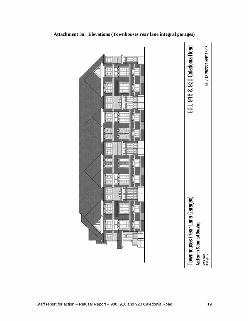
Eighty townhouses are proposed along two blocks adjacent to the north and south
property lines. Integral garages are proposed within the rear of the dwelling units, and
would be accessed by new public lanes A and B, which run parallel to the north and south
property lines from Caledonia Road.
Eighteen townhouses are proposed along the westerly property line which abuts a
Canadian National rail corridor. Detached garages are proposed at the rear that would be
accessed by a new public lane C. A berm, security fence and sound barrier would be
located along lane C's west side, abutting the Canadian National railway and industrial
uses beyond. The setback of these dwelling units from the rail corridor property line is
proposed at 25.25 metres.
The tenure of the residential units is proposed to be market condominium for the stacked
townhouses and market condominium common element for the townhouses.
A small retail block of approximately 817 square metres will be located along Caledonia
Road. The applicant anticipates that in keeping with the requested Neighbourhoods
designation, small-scale retail uses will occupy this block. A total of 18 surface parking
spaces are proposed for the retail uses behind the retail block and accessed by a new rear
public lane from either Public Street A or Public Street B.
A single level of underground parking is proposed in the middle block beneath the
stacked townhouses. A total of 218 parking spaces for residents and 30 parking spaces
for visitors are proposed and vehicular access to a ramp would be from the proposed
Street 'A'. The 18 townhouses along the west property line and the 80 townhouses
located along the southern and northern property lines are provided with their own
parking spaces, either in rear garages in the case of the western townhouses or in integral
garages in the case of the townhouses along the north and south property lines. In both
cases, access would be from rear public lanes.
One type "G" loading space and one type "B" loading space have been proposed, both
obtaining access from the proposed Street 'A'.
Garbage storage is proposed in two stand-alone buildings located along the proposed
Street 'A' adjacent to the loading spaces. One garbage building will serve the retail uses
while the other building would serve the stacked townhouse units.

Staff report for action – Refusal Report – 900, 916 and 920 Caledonia Road 6
The conceptual site plan does not indicate where bicycle parking and storage would be
located. The site statistics from the applicant indicate that a total of 6 spaces would be
provided on-site at-grade for the retail use – 5 spaces being for short term bicycle parking
and 1 space being for long term parking.
The applicant has proposed two on-site private open spaces to serve the residents. One
private amenity area of approximately 1500 square metres is proposed to be located in the
northwest corner of the site abutting an existing landscape open space on the adjacent
apartment property. A second amenity space approximately 975 square metres in size is
proposed in the northeast corner of the site, adjacent to Caledonia Road and opposite an
existing municipal parkette, Glen Park Parkette, at the northeast corner of Caledonia
Road and Glen Park Avenue.
The Site Statistics are presented on the Application Data Sheet (See Attachment 6).
Site and Surrounding Area
The 4.37 hectare site is located on the west side of Caledonia Road south of Lawrence
Avenue West opposite the intersection of Caledonia Road with Glen Park Avenue and
Glencairn Avenue.
The rectangular-shaped site has a frontage of 159 metres along Caledonia Road and a
depth of 277 metres. A Canadian National Rail line abuts the west property boundary of
the site. Three industrial buildings currently occupy the subject site and provide vehicle
servicing, office, a place of worship, service, warehousing, wholesaling and retailing.
The two facilities at 900 and 920 Caledonia Road are approximately 150,000 and
100,000 square feet in size respectively. An auto repair, and service centre currently
occupies the smaller building located at 916 Caledonia Road.
Land uses surrounding the site are as follows (See Attachment 1):
North: Blocks of three-storey townhouses line the south, west and north perimeter lot
lines of the property to the north and four 12-storey apartment buildings are
located in the centre of the site (Lotherton Pathway). Detached dwellings are
located north of this block.
East: To the east of the site is an established residential neighbourhood along
Glencairn Avenue and Glenpark Avenue comprised of low-rise detached homes.
Glen Park Parkette (a municipal park) is located at the northeast corner of Glen
Park Avenue across Caledonia Road. Employment uses (retail showroom) are
located across Caledonia Road at Tycos Drive.
South: To the south are employment uses within a designated Employment Areas and
located within an Employment District (Warehouse, industrial uses (tile,
flooring and kitchen products) and office uses).

Staff report for action – Refusal Report – 900, 916 and 920 Caledonia Road 7
West: To the west is a rail corridor owned by Metrolinx, purchased from Canadian
National Railway in 2009, and known commonly as the Barrie GO line. Beyond
the rail corridor are employment uses within designated Employment Areas
(Private waste transfer, recycling and concrete crushing facilities, City of
Toronto – Ingram Waste Transfer Station (Solid Waste Management Services),
Snow Camp/Salt Depot (Transportation Services), place of worship , automobile
repair, and store fixture sales).
Provincial Policy Statement, 2014
The Provincial Policy Statement (PPS) 2014 provides policy direction on matters of
provincial interest related to land use planning and development. These policies support
the goal of enhancing the quality of life of all Ontarians. Key policy objectives include:
building strong communities; wise use and management of resources; and protecting
public health and safety.
The PPS requires the City to promote economic development and competitiveness by:
a) Providing for an appropriate mix and range of employment (including industrial,
commercial and institutional uses) to meet long-term needs;
b) Providing opportunities for a diversified economic base, including maintaining a
range and choice of suitable sites for employment uses which support a wide
range of economic activities and ancillary uses, and take into account the needs of
existing and future businesses;
c) Planning for, protecting and preserving employment areas for current and future
uses; and
d) Ensuring the necessary infrastructure is provided to support current and projected
needs.
The PPS defines employment areas as those areas designated in an Official Plan for
clusters of business and economic activities including, but not limited to, manufacturing,
warehousing, offices, and associated retail and ancillary facilities.
Section 1.3.2 of the PPS states that the city may only give consideration to converting
lands within employment areas to non-employment uses when a comprehensive review
has met the following two-part test:
a) The land is not required for employment purposes over the long-term; and
b) That there is a need for the conversion.
The 2014 PPS also provides that new development proposed on lands adjacent to
transportation corridors should be designed to be compatible with the corridor and avoid,
mitigate or minimize negative impacts on, and from, the transportation corridor as
described below.
Section 1.2.6 of the 2014 PPS requires that "Major facilities and sensitive land uses
should be planned to ensure they are appropriately designed, buffered and/or separated

Staff report for action – Refusal Report – 900, 916 and 920 Caledonia Road 8
from each other to prevent or mitigate adverse effects from odour, noise and other
contaminants, minimize risk to public health and safety, and to ensure the long-term
viability of major facilities".
Major facilities are defined as facilities which may require separation from sensitive land
uses, including but not limited to airports, transportation infrastructure and corridors, rail
facilities, marine facilities, sewage treatment facilities, waste management systems, oil
and gas pipelines, industries, energy generation facilities and transmission systems, and
resource extraction activities.
A Waste Management System means sites and facilities to accommodate solid waste from
one or more municipalities and includes recycling facilities, transfer stations, processing
sites and disposal sites.
A sensitive land use includes buildings, amenity areas, or outdoor spaces where routine
or normal activities, occurring at reasonably expected times would experience one or
more adverse effects from contaminant discharges generated by a nearby major facility.
Sensitive land uses may be a part of the natural or built environment. Examples may
include, but are not limited to: residences, day care centres, and educational and health
facilities.
Section 1.6.9.1 of the 2014 PPS requires that planning for land uses in the vicinity of rail
facilities shall be undertaken so that: their long-term operation and economic role is
protected and rail facilities and sensitive land uses are appropriately designed, buffered
and/or separated from each other, in accordance with policy 1.2.6 described above.
City Council’s planning decisions are required to be consistent with the PPS.
Growth Plan for the Greater Golden Horseshoe
The Growth Plan provides a framework for managing growth in the Greater Golden
Horseshoe including: directions for where and how to grow; the provision of
infrastructure to support growth; and protecting natural systems and cultivating a culture
of conservation. City Council’s planning decisions are required by the Planning Act to
conform, or not conflict, with, the Growth Plan for the Greater Golden Horseshoe.
The Growth Plan requires the City to maintain an adequate supply of lands providing
locations for a variety of appropriate employment uses in order to accommodate the
employment growth forecasts of the Plan. The Plan requires municipalities to promote
economic development and competitiveness by:
a) providing for an appropriate mix of employment uses including industrial,
commercial and institutional uses to meet long-term needs;
b) providing opportunities for a diversified economic base, including maintaining a
range and choice of suitable sites for employment uses which support a wide
Staff report for action – Refusal Report – 900, 916 and 920 Caledonia Road 9
range of economic activities and ancillary uses, and take into account the needs of
existing and future businesses;
c) planning for, protecting and preserving employment areas for current and future
uses; and
d) ensuring the necessary infrastructure is provided to support current and forecasted
employment needs.
The definition of an employment area in the Growth Plan is the same as that used in the
PPS.
Municipalities may permit conversion of lands within employment areas to non-
employment uses only through a Municipal Comprehensive Review. The Growth Plan
clarifies and strengthens the application of the PPS as it applies to employment lands, in
particular by clarifying the definition of Municipal Comprehensive Review by defining it
as: “an Official Plan review, or an Official Plan Amendment, initiated by a municipality
that comprehensively applies the policies and schedules of this Plan" (Growth Plan).
Consistent with the PPS, the Growth Plan limits such conversions only where it has been
demonstrated through the Municipal Comprehensive Review that it meets a number of
criteria, as follows:
a) There is a need for the conversion;
b) The City will meet its employment forecasts allocated to the City pursuant to the
Growth Plan;
c) The conversion will not adversely affect the overall viability of the employment
area and the achievement of the intensification target, density targets and other
policies of the Growth Plan;
d) There is existing and planned infrastructure to accommodate the proposed
conversion;
e) The lands are not required over the long term for the employment purposes for
which they are designated; and
f) Cross-jurisdictional issues have been considered.
The PPS and the Growth Plan require municipalities to promote economic development
and competitiveness by planning for, protecting and preserving employment areas for
current and future employment uses. Approval of the subject application without first
undertaking a Municipal Comprehensive Review would be contrary to the Places to
Grow Act 2005 which requires that all municipal planning decisions conform with the
Growth Plan.

Staff report for action – Refusal Report – 900, 916 and 920 Caledonia Road 10
Official Plan
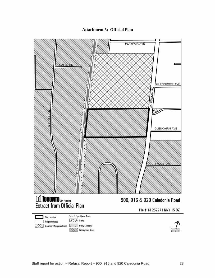
At the time of the application, this site was identified as Employment Districts on Map 2
(Urban Structure Map) of the Official Plan. The map and the associated policies in
Chapter 2 of the Plan set out a policy framework and strategy for managing Toronto’s
growth. In keeping with the relevant policies, lands within Employment Districts are
identified as locations targeted for future growth to meet the Plan’s employment goals. It
is a key policy directive of the Official Plan to protect and promote Employment Districts
in order to:
a) maintain and grow the City’s tax base;
b) attract new and expand existing employment clusters that are key to Toronto’s
competitive advantage;
c) develop quality Employment Districts that are globally competitive locations for
national and international business and offer a wide choice of sites for new business;
d) nurture Toronto’s diverse economic base;
e) provide a good overall balance between population and employment growth by
creating job opportunities for Toronto residents;
f) provide a range of employment opportunities for Toronto residents that can be
reached by means other than the private automobile; and
g) create and sustain well-paid, stable and fulfilling employment opportunities for all
Torontonians.
As part of the OMB hearing of OPA 231 appeals, the OMB issued an Order on June 22,
2015 that amended Map 2 to remove the Employment Districts and to refer to
Employments Areas. The Employment Areas policies of OPA 231 remain under appeal
and are not yet in force.
The subject site is designated Employment Areas on Map 16 - Land Use Plan of the
Official Plan. Employment Areas are places of business and economic activity. Uses that
support this function consist of: offices, manufacturing, warehousing, distribution,
research and development facilities, utilities, media facilities, parks, hotels, retail outlets
ancillary to the preceding uses, and restaurants and small scale stores and services that
serve area businesses and workers. To ensure that the Employment Areas function well
and are attractive to new uses, the Plan sets out criteria for development. Specifically, the
Plan states that "Development will contribute to the creation of competitive, attractive,
highly functional Employment Areas by supporting the economic function of the areas,
mitigating the effects of noise, vibration or other matters that will be detrimental to other
business or the amenity of neighbouring areas and treating the boundary between
Employment Areas and residential lands to minimize nuisance impacts."

Staff report for action – Refusal Report – 900, 916 and 920 Caledonia Road 11
To promote strong communities and a competitive economy, the Plan also contains a
number of policies (3.4.21 and 4.6.6) to ensure industries and sensitive land uses will be
appropriately designed, buffered and/or separated from each other to prevent adverse
effects from noise, vibration, odour and other contaminants and to promote safety. The
Plan further states that adverse impacts are to be mitigated, the boundary between these
uses will be treated with landscaping, fencing or other measures and that the proponent
will be responsible for any required mitigative measures.
Zoning
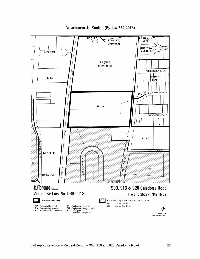
The site is zoning "M1" under the former City of North York Zoning By-law No. 7625.
The "M1" zone permits a variety of industrial, commercial and some institutional uses
but does not permit residential uses.
The subject site is zoned EL 1.0, Employment Light Industrial Zone, under Zoning By-
law No. 569-2013 that was enacted on May 9, 2013 (See Attachment 4). It has been
appealed under section 34(19) of the Planning Act. Even though it is under appeal, the
new City-wide Zoning By-law will be applied to applications filed after its enactment.
The subject application was received on October 17, 2013 and the new city-wide zoning
by–law is, therefore, in effect for this application.
The EL 1.0 zoning permits a variety of industrial, commercial and institutional uses but
does not permit residential uses.
The numerical value following the zone symbol in the zone label indicates the permitted
maximum floor space index of all land uses on a lot, 1.0 in this case.
Zoning By-law Amendment and Draft Plan of Subdivision Applications
The applicant has not submitted an application for Zoning By-law Amendment or an
application for Draft Plan of Subdivision.
Reasons for the Application
Amendments to the City's Official Plan are required to permit residential development
through the conversion of employment lands.
The applicant is proposing to redesignate the subject property at 900, 916 and 920
Caledonia Road from Employment Areas to Neighbourhoods on Map 17 Land Use Plan.
This change is required to permit the proposed ground-related residential use.
Community Consultation
The proposed conversion was subject to consultation through the Official Plan and
Municipal Comprehensive Reviews.
Agency Circulation
The application was circulated to all appropriate agencies and City Divisions.

Staff report for action – Refusal Report – 900, 916 and 920 Caledonia Road 12
Site Plan Control
The property is subject to site plan control approval; however a site plan application has
not been submitted.
Application Submission
The following reports/studies were submitted with the application:
Architectural Plans;
Planning Justification Study;
Transportation Considerations Report; and
Employment Area Economic Impact Analysis
A Notification of Incomplete Application issued on November 5, 2013 and again, on
October 6, 2014 identifies the outstanding material required for a complete application
submission as follows:
Boundary Survey
Topographical Survey;
Context Plan;
Concept Landscape Plan;
Community Services/Facilities Study;
Contaminated Site Assessment; and
Transportation Impact Study.
The outstanding material was submitted on May 8, 2015 and a Notification of Complete
Application was subsequently issued on June 24, 2015.
COMMENTS
Provincial Plans and Policy Statement (PPS)
The applicant is proposing to amend the Official Plan by redesignating the site from
Employment Areas to Neighbourhoods to permit ground-related residential uses.
Both the Growth Plan for the Greater Golden Horseshoe (Growth Plan) and the
Provincial Policy Statement 2014 (PPS) contain a number of policies related to
employment areas including the requirement for Planning authorities to plan for, protect
and preserve these areas for current and future uses. They state that Planning authorities
may permit the conversion of lands within employment areas to non-employment uses
only through a comprehensive review or municipal comprehensive review that has
demonstrated that the land is not required for employment purposes over the long term
and that there is a need for the conversion. The conversion is not to adversely affect the
overall viability of the employment areas.
Staff report for action – Refusal Report – 900, 916 and 920 Caledonia Road 13
The applicant participated in the City's Official Plan and Municipal Comprehensive
Review by requesting that the subject site be converted and the Official Plan land use
designation be changed from Employment Areas to Neighbourhoods. The analysis that
was conducted as part of the Municipal Comprehensive Review, noted that the
introduction of residential uses on the site will adversely affect the overall viability of the
larger Employment Areas. The proposed conversion of the lands would reduce the
inventory of lands designated Employment Areas and available for those uses that are
only provided for within Employment Areas. It was staff's opinion that the lands should
be retained for employment uses and there was no need for the requested conversion to
meet the City's population forecasts as provided by the Growth Plan. As the staff report
dated November 5, 2013 indicated on this particular conversion request, as of 2012 110
people were employed by 13 firms on the lands. Between 2006 and 2011, levels of
employment on the lands ranged annually between 113 and 151 persons.
No information has been submitted as part of this application to demonstrate that the land
is not required for employment purposes over the long term or that there is a need to
convert the site to non-employment uses. For these reasons the proposal is not consistent
with the PPS and does not conform to and conflicts with the Growth Plan for the Greater
Golden Horseshoe.
Official Plan
At the time of the application, the Official Plan stated that Employment Districts shown
on Map 2 will be protected and promoted exclusively for economic activity in order to
maintain and grow the tax base, attract new employment, foster competitiveness, nurture
a diverse economic base, provide for balanced growth between population and
employment, and provide job opportunities for Toronto residents.
The Employment Districts are large areas comprised exclusively of lands where the
Employment Areas land use designation applies. They form part of the long term growth
management and job intensification strategy of the Official Plan. Lands shown as
Employment Districts on Map 2 are needed for employment purposes over the long term
to accommodate part of the job growth projected to 2031 and to ensure the City’s fiscal
health. The Employment Areas land use designation is intended for a wide range of
employment uses and specifically does not include residential land uses.
The City has completed its Municipal Comprehensive Review in the form of Official
Plan Amendment 231. Through that process it has been determined the subject lands will
be retained for employment uses and designated as General Employment Areas. For this
reason, the application to redesignate the subject property from Employment Areas to
Neighbourhoods is inappropriate.
The Ontario Municipal Board has not yet made any decisions on lands designated
Employment Areas. At this time, the only determination of the Ontario Municipal Board
is for those lands where OPA 231 converted lands to other designations.

Staff report for action – Refusal Report – 900, 916 and 920 Caledonia Road 14
As residential uses are not considered appropriate, the application has not been evaluated
against all Official Plan policies that would otherwise apply.
Compatibility with Surrounding Land Uses
Section 2 of the Planning Act requires that the council of a municipality shall have regard
for matters of provincial interest such as the orderly development of safe and healthy
communities and the protection of public health and safety. One of the main principles of
the Provincial Policy Statement 2014 is to reduce the potential for public cost or risk to
Ontario’s residents by directing development away from areas where there is risk to
public health or safety or property damage. Specifically, Section 1.1.1 (c) states that
healthy, livable and safe communities are sustained by avoiding development and land
use patterns which may cause environmental or public health and safety concerns.
Section 1.2.6 also states that major industries and sensitive land uses should be planned to
ensure they are appropriately designed, buffered and/or separated from each other to
prevent or mitigate adverse effects from odour, noise and other contaminants, and
minimize risk to public health and safety.
These policy principles have been carried over to the City's Official Plan which broadly
seeks to “create an attractive and safe city that evokes pride, passion and a sense of
belonging – a city where people of all ages and abilities can enjoy a good quality of life.”
More specifically, the Plan contains policies (3.4.21 and 4.6.6) related to carefully
controlling development so that industries and sensitive land uses are protected from
negative impact and that the boundary between Employment Areas and residential lands
are treated with measures to minimize nuisance impacts.
While there are situations where residential uses and employment uses are located in
close proximity, every attempt should be made to buffer, isolate or limit the interface
between these uses to avoid unmanageable conflicts. For consistency with the PPS and
the Official Plan, the proposed development should not result in environmental
conditions or mitigation measures which negatively impact future residents or the
existing uses and planned context.
The site is located in an area with a mix of residential, commercial and industrial uses. It
is located adjacent to a busy rail corridor which provides regional rail service between
Union Station and areas north of the City of Toronto.
A development concept was submitted with the application for Official Plan Amendment
which illustrates how the proposed land use change would be reflected in a development
on the site. While the concept plan does not form part of the amendment to the Official
Plan being requested, it does provide information how land use compatibility uses may be
addressed and what the future intent for the site by the owner may be in terms of built
form and density.
The proposed Neighbourhoods designation would allow for the introduction of sensitive
uses (i.e. residential) on the site which would be in close proximity to a rail corridor and
industrial properties. The applicant has not submitted any supporting studies relating to

Staff report for action – Refusal Report – 900, 916 and 920 Caledonia Road 15
noise, vibration or air quality to determine if residential uses would be appropriate on the
site. Of particular concern is the asphalt recycling facility (Ingram Asphalt) located
approximately 40.0 metres west from the southwest corner of the subject site which has
the potential to impose noise, dust, and vibration impacts on nearby residential uses
including the subject site. Other facilities located nearby include a private recycling plant
(Optimum Waste and Recycling) located approximately 110.00 metres south and west of
the subject site and a City of Toronto waste transfer station and snow camp (Ingram
York) located approximately 200 metres to the southwest of the subject site, all of which
may have negative impacts on nearby residential developments, including the subject
site. The two waste transfer stations are a noted source of odours and noise.
In terms of the conceptual site layout it is noted that the applicant is proposing a setback
along the west side of the site abutting the rail corridor that appears to be less than that
required between dwelling units and a rail line. The westerly wall of the westernmost
townhouse block is located 25.25 metres from the property line of the rail corridor
instead of the 30.00 metres typically required. In this regard, the proposal does not meet
the Federation of Canadian Municipalities/Railway Association of Canada (FCM/RAC)
Guidelines concerning rail corridors. These townhouses will also have a view to the west
out over the rail line as well as existing industrial uses to the west.
Staff are of the opinion that residential uses on this site are not compatible with existing
industry in the area. The introduction of sensitive land use on this site would adversely
impact the viability of existing industries.
CONCLUSION The City of Toronto has recently completed a Municipal Comprehensive Review for a
number of requested conversions from Employment Areas to another designation
including a request for the subject lands at 900, 916 and 920 Caledonia Road. It was
determined through that process that there is no need to convert the subject lands to meet
the provincial population forecast for Toronto or to address an incompatibility of
Employment Areas permissions with existing adjacent land uses. The Province has now
made a decision on the City-initiated OPA 231 respecting Official Plan policies for
economic health, employment lands and designations. As a result, the requested Official
Plan Amendment for redesignation from Employment Areas to Neighbourhoods can not
be supported.
The introduction of residential uses on the site has the potential to adversely affect the
overall viability of the larger Employment Areas. The proposed conversion of the lands
would reduce the inventory of lands designated Employment Areas and available for
those uses that are only provided for within Employment Areas.
The introduction of residential uses on the site has the potential to be impacted by
existing employment uses operating in the immediate area including two waste transfer
stations and an asphalt recycling operation.

Staff report for action – Refusal Report – 900, 916 and 920 Caledonia Road 16
The proposed application conflicts with the Growth Plan for the Greater Golden
Horseshoe and is not consistent with the Provincial Policy Statement as it fails to
demonstrate that the land is not required for employment purposes over the long term.
The proposal does not conform to the City's Official Plan in regard to the policies related
to Employment Areas. The application also does not conform to Council-adopted and
Ministry-approved OPA No. 231.
Finally, there are concerns in terms of land use compatibility between the existing
industrial uses and the proposed sensitive land use on the site. It is City Planning staff's
position that the request for redesignation from Employment Areas to Neighbourhoods is
not appropriate and does not represent good planning. This employment area, which
specializes in a design and décor focus, is generally healthy and vibrant and it is
important to protect it to ensure its' continued prosperity.
It is staff's recommendation that the request for an Official Plan Amendment on the lands
known as 900, 916 and 920 Caledonia Road be refused.
It is also recommended that in the event of an appeal by the applicant, City Council
authorize the City solicitor and appropriate staff to appear at the Ontario Municipal Board
in support of this position.
CONTACT Cathie Ferguson, Senior Planner
Tel. No. (416) 395-7117
Fax No. (416) 395-7155
E-mail: [email protected]
SIGNATURE
_______________________________
Jennifer Keesmaat, MES, MCIP, RPP
Chief Planner and Executive Director
City Planning Division
ATTACHMENTS Attachment 1: Context Plan
Attachment 2: Proposed Site Plan
Attachment 3a: Elevations (Townhouses rear lane integral garages)
Attachment 3b: Elevations (Townhouses rear lane detached garages)
Attachment 3c: Elevations (Stacked Townhouses)
Attachment 4: Zoning (By-law 569-2013)
Attachment 5: Official Plan
Attachment 6: Application Data Sheet

Staff report for action – Refusal Report – 900, 916 and 920 Caledonia Road 17
Attachment 1: Context Plan

Staff report for action – Refusal Report – 900, 916 and 920 Caledonia Road 18
Attachment 2: Proposed Site Plan
Staff report for action – Refusal Report – 900, 916 and 920 Caledonia Road 19
Attachment 3a: Elevations (Townhouses rear lane integral garages)

Staff report for action – Refusal Report – 900, 916 and 920 Caledonia Road 20
Attachment 3b: Elevations (Townhouses rear lane detached garages)

Staff report for action – Refusal Report – 900, 916 and 920 Caledonia Road 21
Attachment 3c: Elevations (Stacked Townhouses)
Staff report for action – Refusal Report – 900, 916 and 920 Caledonia Road 22
Attachment 4: Zoning (By-law 569-2013)
Staff report for action – Refusal Report – 900, 916 and 920 Caledonia Road 23
Attachment 5: Official Plan
Staff report for action – Refusal Report – 900, 916 and 920 Caledonia Road 24
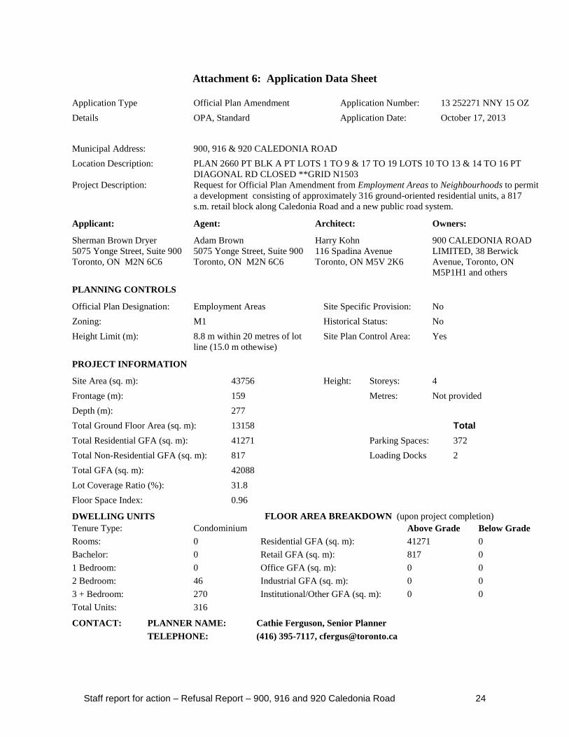
Attachment 6: Application Data Sheet
Application Type Official Plan Amendment Application Number: 13 252271 NNY 15 OZ
Details OPA, Standard Application Date: October 17, 2013
Municipal Address: 900, 916 & 920 CALEDONIA ROAD
Location Description: PLAN 2660 PT BLK A PT LOTS 1 TO 9 & 17 TO 19 LOTS 10 TO 13 & 14 TO 16 PT
DIAGONAL RD CLOSED **GRID N1503
Project Description: Request for Official Plan Amendment from Employment Areas to Neighbourhoods to permit
a development consisting of approximately 316 ground-oriented residential units, a 817
s.m. retail block along Caledonia Road and a new public road system.
Applicant: Agent: Architect: Owners:
Sherman Brown Dryer
5075 Yonge Street, Suite 900
Toronto, ON M2N 6C6
Adam Brown
5075 Yonge Street, Suite 900
Toronto, ON M2N 6C6
Harry Kohn
116 Spadina Avenue
Toronto, ON M5V 2K6
900 CALEDONIA ROAD
LIMITED, 38 Berwick
Avenue, Toronto, ON
M5P1H1 and others
PLANNING CONTROLS
Official Plan Designation: Employment Areas Site Specific Provision: No
Zoning: M1 Historical Status: No
Height Limit (m): 8.8 m within 20 metres of lot
line (15.0 m othewise)
Site Plan Control Area: Yes
PROJECT INFORMATION
Site Area (sq. m): 43756 Height: Storeys: 4
Frontage (m): 159 Metres: Not provided
Depth (m): 277
Total Ground Floor Area (sq. m): 13158 Total
Total Residential GFA (sq. m): 41271 Parking Spaces: 372
Total Non-Residential GFA (sq. m): 817 Loading Docks 2
Total GFA (sq. m): 42088
Lot Coverage Ratio (%): 31.8
Floor Space Index: 0.96
DWELLING UNITS FLOOR AREA BREAKDOWN (upon project completion)
Tenure Type: Condominium Above Grade Below Grade
Rooms: 0 Residential GFA (sq. m): 41271 0
Bachelor: 0 Retail GFA (sq. m): 817 0
1 Bedroom: 0 Office GFA (sq. m): 0 0
2 Bedroom: 46 Industrial GFA (sq. m): 0 0
3 + Bedroom: 270 Institutional/Other GFA (sq. m): 0 0
Total Units: 316
CONTACT: PLANNER NAME: Cathie Ferguson, Senior Planner
TELEPHONE: (416) 395-7117, [email protected]


