9 · The Growth of an Empirical Cartography in Hellenistic ... · The Growth ofan Empirical...
13
9 · The Growth of an Empirical Cartography in Hellenistic Greece PREPARED BY THE EDITORS FROM MATERIALS SUPPLIED BY GERMAINE AUJAe There is no complete break between the development of cartography in classical and in Hellenistic Greece. In contrast to many periods in the ancient and medieval world, we are able to reconstruct throughout the Greek period-and indeed into the Roman-a continuum in cartographic thought and practice. Certainly the achievements of the third century B.C. in Alexandria had been prepared for and made possible by the scientific progress of the fourth century. Eudoxus, as we have seen, had already formulated the geocentric hypothesis in mathematical models; and he had also translated his concepts into celestial globes that may be regarded as anticipating the sphairopoiia. 1 By the beginning of the Hellenistic period there had been developed not only the various celestial globes, but also systems of concentric spheres, together with maps of the inhabited world that fostered a scientific curiosity about fundamental carto- graphic questions. The relative smallness of the inhab- ited world, for example, later to be proved by Erato- sthenes, had already been dimly envisaged. It had been the subject of comment by Plato,2 while Aristotle had quoted a figure for the circumference of the earth from "the mathematicians" at four hundred thousand stades. 3 He does not explain how he arrived at this figure, which may have been Eudoxus's estimate. Aristotle also be- lieved that only the ocean prevented a passage around the world westward from the Straits of Gibraltar to India. In spite of these speculations, however, Greek carto- graphy might have remained largely the province of phi- losophy had it not been for a vigorous and parallel growth of empirical knowledge. Indeed, one of the sa- lient trends in the history of Hellenistic cartography is the growing tendency to relate theories and mathemat- ical models to newly acquired facts about the world- especially those gathered in the course of Greek explo- ration or embodied in direct observations such as those recorded by Eratosthenes in his scientific measurement of the circumference of the earth. Despite a continuing lack of surviving maps and original texts throughout the period-which continues to limit our understanding of the changing form and content of cartography-it can be shown that by its end a markedly different carto- graphic image of the inhabited world had emerged. That such a change should occur is due both to po- litical and military factors and to cultural developments within Greek society as a whole. With respect to the latter, we can see how Greek cartography started to be influenced by a new infrastructure for learning that had a profound effect on the growth of formalized know- ledge in general. Of particular importance for the history of the map was the growth of Alexandria as a major center of learning, far surpassing in this respect the Macedonian court at Pella. It was at Alexandria that Euclid's famous school of geometry flourished in the reign of Ptolemy II Philadelphus (285-246 B.C.). And it was at Alexandria that this Ptolemy, son of Ptolemy I Soter, a companion of Alexander, had founded the li- brary, soon to become famous throughout the Mediter- ranean world. The library not only accumulated the greatest collection of books available anywhere in the Hellenistic period but, together with the museum, like- wise founded by Ptolemy II, also constituted a meeting place for the scholars of three continents. Demetrius of Phalerum (b. ca. 350 B.C.), Athenian statesman, writer, and disciple of Aristotle, had been asked to start the library, which was endowed with many scientific works 1. See chapter 8, "The Foundations of Theoretical Cartography in Archaic and Classical Greece," p. 136 and n. 33. 2. Plato (ca. 429-347 B.C.) was conscious of the relative smallness of the inhabited world on the surface of the globe; see above, p. 137. 3. Aristotle On the Heavens 2.14.298a.15 ff; see On the Heavens, trans. W. K. C. Guthrie, Loeb Classical Library (Cambridge: Harvard University Press; London: William Heinemann, 1939) and The Geo- graphical Fragments of Hipparchus, ed. D. R. Dicks (London: Athlone Press, 1960), 24. The stade, (T'r&8Lov, in origin the distance covered by a plow in a single draft, consisted of 600 Greek feet; but the length of a foot was subject to some local variation in the Greek world. Some authors take the modern equivalent of a stade to be 185 meters or 607 feet; see Jacob Skop, "The Stade of the Ancient Greeks," Surveying and Map- ping 10 (1950): 50-55, and Dicks, Geographical Fragments, 42-46 (above). Other authors disagree and cite 148-58 meters; see Irene Fischer, "Another Look at Eratosthenes' and Posidonius' Determi- nations of the Earth's Circumference," Quarterly Journal of the Royal Astronomical Society 16 (1975): 152-67, and Dennis Rawlins, "The Eratosthenes-Strabo Nile Map," Archive for History of Exact Sciences 26 (1982): 211-19. In view of this controversy, the authors and editors have deliberately avoided using modern equivalents for the stade throughout the History. 148
Transcript of 9 · The Growth of an Empirical Cartography in Hellenistic ... · The Growth ofan Empirical...
9 · The Growth of an Empirical Cartography in
Hellenistic Greece
PREPARED BY THE EDITORS FROM MATERIALS SUPPLIEDBY GERMAINE AUJAe
There is no complete break between the development ofcartography in classical and in Hellenistic Greece. Incontrast to many periods in the ancient and medievalworld, we are able to reconstruct throughout the Greekperiod-and indeed into the Roman-a continuum incartographic thought and practice. Certainly theachievements of the third century B.C. in Alexandria hadbeen prepared for and made possible by the scientificprogress of the fourth century. Eudoxus, as we have seen,had already formulated the geocentric hypothesis inmathematical models; and he had also translated hisconcepts into celestial globes that may be regarded asanticipating the sphairopoiia. 1 By the beginning of theHellenistic period there had been developed not only thevarious celestial globes, but also systems of concentricspheres, together with maps of the inhabited world thatfostered a scientific curiosity about fundamental cartographic questions. The relative smallness of the inhabited world, for example, later to be proved by Eratosthenes, had already been dimly envisaged. It had beenthe subject of comment by Plato,2 while Aristotle hadquoted a figure for the circumference of the earth from"the mathematicians" at four hundred thousand stades.3
He does not explain how he arrived at this figure, whichmay have been Eudoxus's estimate. Aristotle also believed that only the ocean prevented a passage aroundthe world westward from the Straits of Gibraltar toIndia.
In spite of these speculations, however, Greek cartography might have remained largely the province of philosophy had it not been for a vigorous and parallelgrowth of empirical knowledge. Indeed, one of the salient trends in the history of Hellenistic cartography isthe growing tendency to relate theories and mathematical models to newly acquired facts about the worldespecially those gathered in the course of Greek exploration or embodied in direct observations such as thoserecorded by Eratosthenes in his scientific measurementof the circumference of the earth. Despite a continuinglack of surviving maps and original texts throughout theperiod-which continues to limit our understanding ofthe changing form and content of cartography-it canbe shown that by its end a markedly different cartographic image of the inhabited world had emerged.
That such a change should occur is due both to political and military factors and to cultural developmentswithin Greek society as a whole. With respect to thelatter, we can see how Greek cartography started to beinfluenced by a new infrastructure for learning that hada profound effect on the growth of formalized knowledge in general. Of particular importance for the historyof the map was the growth of Alexandria as a majorcenter of learning, far surpassing in this respect theMacedonian court at Pella. It was at Alexandria thatEuclid's famous school of geometry flourished in thereign of Ptolemy II Philadelphus (285-246 B.C.). And itwas at Alexandria that this Ptolemy, son of Ptolemy ISoter, a companion of Alexander, had founded the library, soon to become famous throughout the Mediterranean world. The library not only accumulated thegreatest collection of books available anywhere in theHellenistic period but, together with the museum, likewise founded by Ptolemy II, also constituted a meetingplace for the scholars of three continents. Demetrius ofPhalerum (b. ca. 350 B.C.), Athenian statesman, writer,and disciple of Aristotle, had been asked to start thelibrary, which was endowed with many scientific works
1. See chapter 8, "The Foundations of Theoretical Cartography inArchaic and Classical Greece," p. 136 and n. 33.
2. Plato (ca. 429-347 B.C.) was conscious of the relative smallnessof the inhabited world on the surface of the globe; see above, p. 137.
3. Aristotle On the Heavens 2.14.298a.15 ff; see On the Heavens,trans. W. K. C. Guthrie, Loeb Classical Library (Cambridge: HarvardUniversity Press; London: William Heinemann, 1939) and The Geographical Fragments ofHipparchus, ed. D. R. Dicks (London: AthlonePress, 1960), 24.
The stade, (T'r&8Lov, in origin the distance covered by a plow in asingle draft, consisted of 600 Greek feet; but the length of a foot wassubject to some local variation in the Greek world. Some authors takethe modern equivalent of a stade to be 185 meters or 607 feet; seeJacob Skop, "The Stade of the Ancient Greeks," Surveying and Mapping 10 (1950): 50-55, and Dicks, Geographical Fragments, 42-46(above). Other authors disagree and cite 148-58 meters; see IreneFischer, "Another Look at Eratosthenes' and Posidonius' Determinations of the Earth's Circumference," Quarterly Journal of the RoyalAstronomical Society 16 (1975): 152-67, and Dennis Rawlins, "TheEratosthenes-Strabo Nile Map," Archive for History ofExact Sciences26 (1982): 211-19. In view of this controversy, the authors and editorshave deliberately avoided using modern equivalents for the stadethroughout the History.
148
The Growth of an Empirical Cartography in Hellenistic Greece
and quickly increased in size. The librarians not onlybrought together existing texts, they corrected them forpublication, listed them in descriptive catalogs, and triedto keep them up to date.4 Thus Alexandria became aclearinghouse for cartographic and geographical knowledge; it was a center where this could be codified andevaluated and where, we may assume, new maps as wellas texts could be produced in parallel with the growthof empirical knowledge.
EXPLORATION AND DISCOVERY IN THEREFORM OF THE WORLD MAP
The other great factor underlying the increasing realismof maps of the inhabited world in the Hellenistic periodwas the expansion of the Greek world through conquestand discovery, with a consequent acquisition of newgeographical knowledge. In this process of strengtheningthe empirical content of maps the conquests of Alexander the Great, king of Macedon (356-323 B.C.), wereespecially crucial in providing the Greeks with a far moredetailed knowledge of the East than previously had beenpossible. There is no doubt that Alexander had beeninfluenced by existing geographical lore, some of it expressed in map form and was to contribute substantiallyto Greek understanding of this Eastern world. In takingup the plan originally conceived by his father Philip toorganize an attack against Persia, he was certainly notunprepared. He had been taught by Aristotle and hadlearned from him that the inhabited world, from theStraits of Gibraltar to India, was relatively small andprobably bounded by the ocean. This was clear to thegeographers of the period, just as was the fact that thewestern part of the known world was bounded by theAtlantic Ocean. This belief explains why Alexander notonly wanted to explore the whole of the inhabited worldeast of the Aegean, but also had a firm hope of reachingthe Eastern Ocean, the existence of which had not sofar been witnessed by the Greeks.
He thus instructed his secretaries to prepare a brieffor the journey in great detail and to gather all availableinformation about the countries he would cross. Xenophon had recently described Asia Minor, and Ctesias ofCnidus had described Persia and India.5 No doubtAlexander collected all kinds of maps, general sketchesof the inhabited world or regional maps indicating themain roads through the country, especially Persia, wherethe roads were very well organized, with posting stationsat regular intervals.6
It is also clear that the whole expedition was plannedwith the deliberate aim of expanding existing geographical knowledge. Alexander took a large group of scholarswith him-zoologists, doctors, historians, and surveyors-to compile a complete account of all interesting
149
phenomena observed on the way and to verify all information that had been furnished by others. So Eumenes of Cardia (ca. 362-316 B.C.) was entrusted withkeeping the daily report of the expedition and wroteEphemerides, used by later historians but now lost. Theso-called bematistai,7 Baito and Diognetus, had to keepthe record of every distance between halting places andto describe the geographical features-fauna, flora, nature of the soil, and landscape-of each country. Theimportance of the bematistai to the history of mappingis that their Itinerary was probably illustrated bysketches or local maps. The whole expedition, in fact,became a most important primary source of new cartographic data. 8 Its topographical notes were drawn onby such later geographers as Isidorus of Charax (fl. ca.A.D. 25).
The information collected by Alexander's expeditionwas of course greatly influenced by the vagaries of itsprogress; in no sense can it be regarded as systematic oreven reconnaissance mapping-in the modern senseof the areas traversed. In fact Alexander was preventedfrom carrying out his original plan by his soldiers, whorefused to cross the Indus River and continue east to theexternal ocean. But he decided to explore at least theIndian (Southern) Ocean, so he sailed down the Industo the sea. There he split up his troops into three contingents: one of them, under Nearchus, was to sail toward Babylon through the Indian Ocean and the PersianGulf; another contingent, under Alexander himself, wasto go by land along the coast, to support the fleet ifnecessary; the rest of the army was to return to Babylonby a route farther north.9 So at least some of the countrybetween the Aegean Sea, the Taurus Mountains, theIndus River, and the Indian Ocean was explored as aresult of Alexander's expedition.
4. This perhaps explains the complete loss of scientific works ofprevious periods: they were considered out of date and were replacedby more recent manuscripts. For a description of the library, see Edward Alexander Parson, The Alexandrian Library: Glory of the Hellenic World (Amsterdam, London, New York: Elsevier Press, 1952).
5. Xenophon (ca. 430-354 B.C.) had been in charge of the army ofmercenaries after Cyrus's death in Cunaxa; he led it through AsiaMinor to the Black Sea. His Anabasis is the story of this expedition.Ctesias of Cnidus, who was a physician at Artaxerxes' court (he waswith him at Cunaxa), wrote a history of Persia, Persica, in twentythree volumes and a history of India, Indica, now both lost.
6. Herodotus History 5.52-54; see The History ofHerodotus, trans.George Rawlinson, 2 vols. (London: J. M. Dent; New York: E. P.Dutton, 1910).
7. The bematistai had to measure (bematizein) the progress of thearmy every day, but the word itself is not found in this context.
8. For details on Alexander's expeditions, see William WoodthorpeTarn, Alexander the Great, 2 vols. (Cambridge: Cambridge UniversityPress; New York: Macmillan, 1948).
9. Nearchus's periplus is recorded in Arrian's Indica, and the wholeexpedition in Arrian's Anabasis.
150
Later geographers used the accounts of Alexander'sjourneys extensively to make maps of Asia and to fill inthe outline of the inhabited world. The ambition of Eratosthenes to draw a general map of the oikoumene basedon new discoveries was also partly inspired by Alexander's exploration. 10
Among the contemporaries of Alexander was Pytheas,a navigator and astronomer from Massalia (Marseilles),who as a private citizen embarked upon an explorationof the oceanic coasts of western Europe. In his treatiseOn the Ocean, Pytheas relates his journey and providesgeographical and astronomical information about thecountries he observed. This treatise is now lost and isknown to us only in fragments through comments madeby several later writers whom Strabo quotes. Some ofthese writers, among whom was Polybius, regarded Pytheas as a liar, a view shared by Strabo himself. 11 It wasalready well known by Pytheas's time that the continental interior of Europe just north of the Black Sea wasextremely cold. Given this, the reports by Pytheas thathigh latitudes of the Atlantic seaboard were habitablemust have been indeed hard to believe.
It is difficult to reconstruct from the fragmentary evidence exactly where Pytheas traveled. While modernscholars agree that the voyage took place, they are notin agreement on its extent, particularly north of the British Isles.12 Neither are they agreed on exactly when ittook place, although the evidence seems to point towarda date between 325 and 320 B.C.
13 It seems, though,that having left Massalia, Pytheas put into Gades(Cadiz), then followed the coasts of Iberia and Franceto Brittany, crossing to Cornwall and sailing north alongthe west coast of England and Scotland to the OrkneyIslands. From there, some authors believe, he made anArctic voyage to Thule (probably Iceland) after whichhe penetrated the Baltic.14 The confirmation of thesources of tin (in the ancient Cassiterides or Tin Islands)and amber (in the Baltic) was of primary interest to him,together with new trade routes for these commodities. IS
For the first part of his voyage, from Massalia toTartessus, Pytheas may have used a version of an ancientGreek geographical description of these coasts knownas the Massaliote Periplus-it was almost certainly compiled in Massalia-dating probably from about 500 B.C.
We know of this periplus through the Ora Maritima ofthe Roman antiquary Rufius Festus Avienius some ninehundred years later. Avienius's work can be traced backto a second-century B.C. version associated with a personknown as Pseudo-Scymnus and-from the archaic toponymy and omission of authors later than Thucydides-further back to the fifth century B.C.
16
While Pytheas's reports of the northern lands brandedhim as a liar, his skill in mathematics was more widelyacknowledged. Eratosthenes and Timaeus both respected his contribution to the world map, although
Cartography in Ancient Europe and the Mediterranean
their views are muted by Strabo's prejudiced account.17
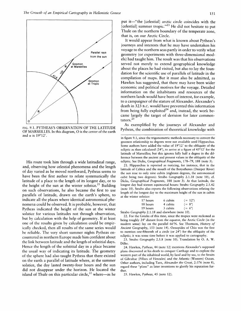
Pytheas was in fact a skilled astronomer who succeededin establishing the exact position of the celestial pole, apoint in the sky not marked by a star, but which, alongwith three faint stars, makes up a rectangle. 18 He alsoaccurately fixed the latitude of Marseilles, indicating thatat midday on the date of the summer solstice "the ratioof the index [gnomon] of the sun-dial to the shadow. . '. is that of one hundred and twenty to forty-twominus one-fifth."19 We can calculate from this the difference in latitude between Marseilles and the summertropic as 19°12', compared with its currently measuredvalue of about 19°50' (fig. 9.1).20
10. Strabo Geography 1.2.1; see The Geography of Strabo, 8 vols.,ed. and trans. Horace Leonard Jones, Loeb Classical Library (Cambridge: Harvard University Press; London: William Heinemann,1917-32). See also Strabo, Geographie, ed. Germaine Aujac et al.(Paris: Belles Lettres, 1966-).
11. Strabo Geography 1.4.3, 2.4.1, 4.2.1 (note 10).12. The standard edition of Pytheas is Fragmenta, ed. Hans Joachim
Mette (Berlin: Walter de Gruyter, 1952). More recent work includesC. F. C. Hawkes, Pytheas: Europe and the Greek Explorers, EighthJ. L. Myres Memorial Lecture (Oxford: Blackwell, 1977), which is anexcellent modern summary of the issues surrounding Pytheas's voyagewith a helpful bibliography, and the articles of Roger Dion, especiallyhis, "OU Pytheas voulait-il aller?" in Melanges d'archeologie et d'histoire offerts aAndre Piganiol, 3 vols., ed. Raymond Chevallier (Paris:SEVPEN, 1966), 3: 1315-36.
13. Hawkes, Pytheas, 44 (note 12) dates it 325 B.C.
14. For various views, see J. Oliver Thomson, History of AncientGeography (Cambridge: Cambridge University Press, 1948; reprintedNew York: Biblo and Tannen, 1965), 149, and Hawkes, Pytheas, 3339 and map 9 (note 12).
15. Hawkes, Pytheas, 1-2 (note 12).16. Hawkes, Pytheas, 17-22 and map 6 (note 12). Editions of
Avienius's Ora Maritima include Avieni Ora Maritima (Periplus Massiliensis saec. VI. a.C.), ed. Adolf Schulten, Fontes Hispaniae Antiquae,fasc. 1 (Barcelona: A. Bosch, 1922), and his companion book Tartessos: Ein Beitrag zur altesten Geschichte des Westens (Hamburg:L. Friederichsen, 1922); Ora Maritima, ed. Edward Adolf Sonnenschein (New York: Macmillan, 1929); Ora Maritima, ed. Andre Berthelot (Paris: H. Champion, 1934); and Ora Maritima, or a Description of the Seacoast from Brittany Round to Massilia, ed. J. P. Murphy(Chicago: Ares, 1977). For the transmission of this periplus, Hawkesagrees with the views of Schulten, Avieni Ora Maritima and Tartessos.For references to commentaries on Schulten's work, see Hawkes, Pytheas, 20 n. 52 (note 12). On the influence of Carthaginian knowledgeof coasts west of the Straits of Gibraltar transmitted to the Greeks atthis time, see Jacques Ramin, Le Periple d'HannonlThe Periplus ofHanno, British Archaeological Reports, Supplementary Series 3 (Oxford: British Archaeological Reports, 1976).
17. See footnote 11 above, for example, and Strabo Geography3.4.4, 4.2.1, 7.3.1 (note 10).
18. Hipparchus, In Arati et Eudoxi Phaenomena commentariorumlibri tres, ed. C. Manitius (Leipzig: Teubner, 1894), 1.4.1. See alsoDicks, Geographical Fragments, 171 (note 3). Hawkes, Pytheas, 4445 (note 12) misinterprets Dicks in thinking that the Pole Star (a UrsaeMinoris) was one of the four stars in the rectangle.
19. Strabo Geography 2.5.41 (note 10).20. It is important to realize that Pytheas would not have arrived
at the true value for the latitude of Marseilles using the method outlined
The Growth of an Empirical Cartography in Hellenistic Greece 151
Parallel rays
from the sun
FIG. 9.1. PYTHEAS'S OBSERVATION OF THE LATITUDEOF MARSEILLES. In this diagram, 0 is the center of the earthand a is 19°12'.
His route took him through a wide latitudinal range,and, observing how celestial phenomena and the lengthof day varied as he moved northward, Pytheas seems tohave been the first author to relate systematically thelatitude of a place to the length of its longest day, or tothe height of the sun at the winter solstice.21 Buildingon such observations, he also became the first to useparallels of latitude, drawn on the earth's sphere, toindicate all the places where identical astronomical phenomena could be observed. It is probable, however, thatPytheas indicated the height of the sun at the wintersolstice for various latitudes not through observation,but by calculation with the help of geometry. If at leastone of the results given by calculation could be empirically checked, then all results of the same series wouldbe reliable. The very short summer nights Pytheas encountered in northern Europe made him confident aboutthe link between latitude and the length of solstitial days.Hence the length of the solstitial day in a place becamethe usual way of indicating its latitude. The geometryof the sphere had also taught Pytheas that there existedon the earth a parallel of latitude where, at the summersolstice, the day lasted twenty-four hours and the sundid not disappear under the horizon. He located theisland of Thule on this particular circle,22 where-as he
put it-"the [celestial] arctic circle coincides with the[celestial] summer tropic. ,,23 He did not hesitate to putThule on the northern boundary of the temperate zone,that is, on our Arctic Circle.
It would appear from what is known about Pytheas'sjourneys and interests that he may have undertaken hisvoyage to the northern seas partly in order to verify whatgeometry (or experiments with three-dimensional models) had taught him. The result was that his observationsserved not merely to extend geographical knowledgeabout the places he had visited, but also to lay the foundation for the scientific use of parallels of latitude in thecompilation of maps. But it must also be admitted, asHawkes has suggested, that there may have been widereconomic and political motives for the voyage. Detailedinformation on the inhabitants and resources of thenorthern lands would have been of interest, for example,to a campaigner of the stature of Alexander. Alexander'sdeath in 323 B.C. would have prevented this informationfrom being fully exploited24 and, instead, the work became largely the target of derision for later commentators.25
As exemplified by the journeys of Alexander andPytheas, the combination of theoretical knowledge with
in figure 9.1, since the trigonometric methods necessary to convert thegnomon relationship to degrees were not available until Hipparchus.Some authors have added the value of 19°12' to the obliquity of theecliptic as then calculated (24°), to arrive at a figure of 43°12' for thelatitude of Marseilles; but this ignores fully half a degree in the difference between the ancient and present values in the obliquity of theecliptic. See Dicks, Geographical Fragments, 178-79, 188 (note 3).
21. Hipparchus is reported as noticing, for instance, that in thelatitude of Celtica and the mouth of the Borysthenes (Dnieper River)the sun rose to only nine cubits (eighteen degrees, the astronomicalcubit being two degrees): Strabo Geography 2.1.18 (note 10); cf.Dicks, Geographical Fragments, 188 (note 3). At that latitude, thelongest day had sixteen equinoctial hours: Strabo Geography 2.5.42(note 10). Strabo also reports the following observations relating thelength of the longest day to the maximum height of the sun in cubitsat the winter solstice:
17 hours 6 cubits (= 12°)18 hours 4 cubits (= 8°)19 hours 3 cubits (= 6°)
Strabo Geography 2.1.18 and elsewhere (note 10).22. For the Greeks of this rime, since the tropics were reckoned as
being roughly 24° distant from the equator, the Arctic Circle (in themodern sense) lay on the parallel 66°N. See Thomson, History ofAncient Geography, 153 (note 14). Oenopides of Chio was the firstto mention one-fifteenth of a circle (or 24°) for the obliquity of theecliptic; it was some time before it was applied to cartography.
23. Strabo Geography 2.5.8 (note 10). Translation by o. A. W.Dilke.
24. Hawkes, Pytheas, 44 (note 12) mentions Alexander's supposedplans discovered at his death to conquer Carthage and to explore thewestern part of the inhabited world, by land and by sea, to the Straitsof Gibraltar (Pillars of Hercules) and the Atlantic (Western) Ocean.Other authors, including Tarn, Alexander the Great, 2:376 (note 8),regard these "plans" as later inventions to glorify his reputation further.
25. Hawkes, Pytheas, 45 (note 12).
152
direct observation and the fruits of extensive travel gradually provided new data for the compilation of worldmaps. While we can assume a priori that such a linkagewas crucial to the development of Hellenistic cartography, there is no hard evidence, as in so many otheraspects of its history, that allows us to reconstruct thetechnical processes and physical qualities of the mapsthemselves. Not even the improved maps that resultedfrom these processes have survived, and the literary references to their existence (enabling a partial reconstruction of their content) can even in their entirety refer onlyto a tiny fraction of the number of maps once made andonce in circulation. In this case too, our generalizationsare founded on the chance survival of references madeby individual authors to maps.
First in this category, and roughly contemporaneouswith both Alexander and Pytheas, is the map undertakenby Dicaearchus of Messana (Messina) (fl. ca. 326-296B.C.). A pupil of Aristotle and a contemporary of Theophrastus (ca. 370-288/285 B.C.), Dicaearchus is acknowledged both by ancient writers and by modern historians of cartography and geography to have made asignificant contribution.26 Strabo puts him, with Democritus, Eudoxus, and Ephorus, among philosophers ofthe second age who were responsible for considerableadvances in geographical science.27 We know that hespent most of his life in the Peloponnese, especially atSparta, and wrote various works on politics, literature,history, and philosophy.
In his Circuit of the Earth (Periodos ges), now lost,Dicaearchus included a map and a description of theinhabited world. Like Democritus, he thought that theknown inhabited world was half again as long as it wasbroad, a proportion of three to two.28 Strabo, followingPolybius, criticizes some distances supplied by Dicaearchus, such as the ten thousand stades from the Peloponnese to the Straits of Gibraltar, or the estimate ofover ten thousand stades from the Peloponnese to thehead of the Adriatic Sea.29 Strabo, questioning thesefigures, criticizes Dicaearchus for having underestimatedthe length of the inhabited world and overestimated itsbreadth.
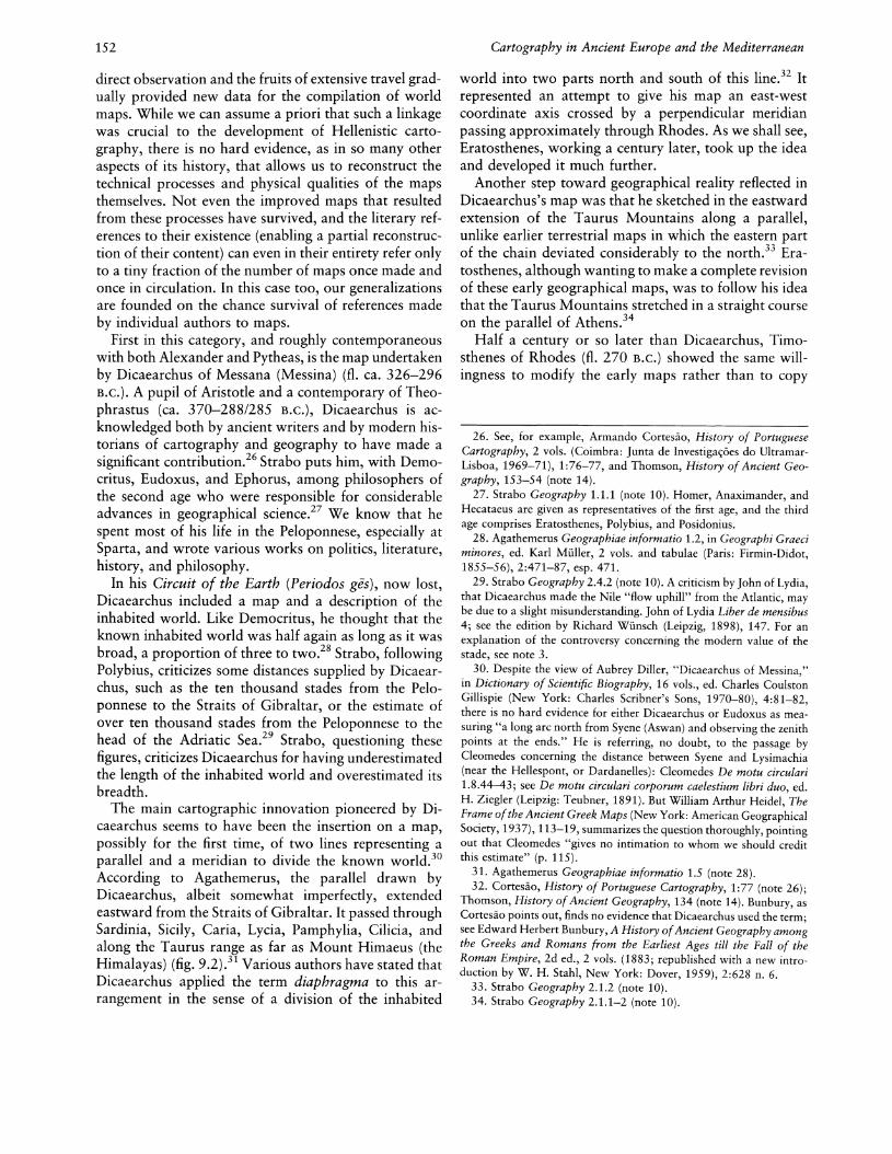
The main cartographic innovation pioneered by Dicaearchus seems to have been the insertion on a map,possibly for the first time, of two lines representing aparallel and a meridian to divide the known world.30
According to Agathemerus, the parallel drawn byDicaearchus, albeit somewhat imperfectly, extendedeastward from the Straits of Gibraltar. It passed throughSardinia, Sicily, Caria, Lycia, Pamphylia, Cilicia, andalong the Taurus range as far as Mount Himaeus (theHimalayas) (fig. 9.2).31 Various authors have stated thatDicaearchus applied the term diaphragma to this arrangement in the sense of a division of the inhabited
Cartography in Ancient Europe and the Mediterranean
world into two parts north and south of this line.32 Itrepresented an attempt to give his map an east-westcoordinate axis crossed by a perpendicular meridianpassing approximately through Rhodes. As we shall see,Eratosthenes, working a century later, took up the ideaand developed it much further.
Another step toward geographical reality reflected inDicaearchus's map was that he sketched in the eastwardextension of the Taurus Mountains along a parallel,unlike earlier terrestrial maps in which the eastern partof the chain deviated considerably to the north.33 Eratosthenes' although wanting to make a complete revisionof these early geographical maps, was to follow his ideathat the Taurus Mountains stretched in a straight courseon the parallel of Athens.34
Half a century or so later than Dicaearchus, Timosthenes of Rhodes (fl. 270 B.C.) showed the same willingness to modify the early maps rather than to copy
26. See, for example, Armando Cortesao, History of PortugueseCartography, 2 vols. (Coimbra: Junta de Investiga~6es do UltramarLisboa, 1969-71), 1:76-77, and Thomson, History of Ancient Geography, 153-54 (note 14).
27. Strabo Geography 1.1.1 (note 10). Homer, Anaximander, andHecataeus are given as representatives of the first age, and the thirdage comprises Eratosthenes, Polybius, and Posidonius.
28. Agathemerus Geographiae informatio 1.2, in Geographi Graeciminores, ed. Karl Muller, 2 vols. and tabulae (Paris: Firmin-Didot,1855-56), 2:471-87, esp. 471.
29. Strabo Geography 2.4.2 (note 10). A criticism by John of Lydia,that Dicaearchus made the Nile "flow uphill" from the Atlantic, maybe due to a slight misunderstanding. John of Lydia Liber de mensibus4; see the edition by Richard Wunsch (Leipzig, 1898), 147. For anexplanation of the controversy concerning the modern value of thestade, see note 3.
30. Despite the view of Aubrey Diller, "Dicaearchus of Messina,"in Dictionary of Scientific Biography, 16 vols., ed. Charles CoulstonGillispie (New York: Charles Scribner's Sons, 1970-80), 4:81-82,there is no hard evidence for either Dicaearchus or Eudoxus as measuring "a long arc north from Syene (Aswan) and observing the zenithpoints at the ends." He is referring, no doubt, to the passage byCleomedes concerning the distance between Syene and Lysimachia(near the Hellespont, or Dardanelles): Cleomedes De motu circulari1.8.44--43; see De motu circulari corporum caelestium libri duo, ed.H. Ziegler (Leipzig: Teubner, 1891). But William Arthur Heidel, TheFrame ofthe Ancient Greek Maps (New York: American GeographicalSociety, 1937), 113-19, summarizes the question thoroughly, pointingout that Cleomedes "gives no intimation to whom we should creditthis estimate" (p. 115).
31. Agathemerus Geographiae informatio 1.5 (note 28).32. Cortesao, History of Portuguese Cartography, 1:77 (note 26);
Thomson, History of Ancient Geography, 134 (note 14). Bunbury, asCortesao points out, finds no evidence that Dicaearchus used the term;see Edward Herbert Bunbury, A History ofAncient Geography amongthe Greeks and Romans from the Earliest Ages till the Fall of theRoman Empire, 2d ed., 2 vols. (1883; republished with a new introduction by W. H. Stahl, New York: Dover, 1959), 2:628 n. 6.
33. Strabo Geography 2.1.2 (note 10).34. Strabo Geography 2.1.1-2 (note 10).
The Growth of an Empirical Cartography in Hellenistic Greece 153
FIG. 9.2. RECONSTRUCTED WORLD MAP OF DICAEARCHUS, THIRD CENTURY B.C. The inhabited world is divided by the diaphragm (approximately 36°N) and a perpendicular to this at Rhodes.After Armando Cortesao, History of Portuguese Cartography,2 vols. (Coimbra: Junta de Investigar;oes do Ultramar-Lisboa,1969-71), vol. 1, fig. 16.
Caspian SeaCaecias
(Summer rising)
IndiaEurus
(Winter rising)
Red SeaEthiopia
Euronotus
Black SeaLake Maeolis
Boreas
Scythia(Beyond Thracia)
AparctiasCeltica
Thrascius
GaramantesLeuconotus
or Libonotus
IberiaArgestes
(Summer setting)
WesternEthiopia
Lips(Winter setting)
Ethiopia(Beyond Egypt)
Notus
FIG. 9.3. TIMOSTHENES' SYSTEM OF THE WINDS. Therelationship between winds, regions, and peoples as proposedby Admiral Timosthenes of Rhodes (third century B.C.).
Pillars BactrianaWest --------~=--------East
Zephyrus Ape/iotes
,
"ThU~
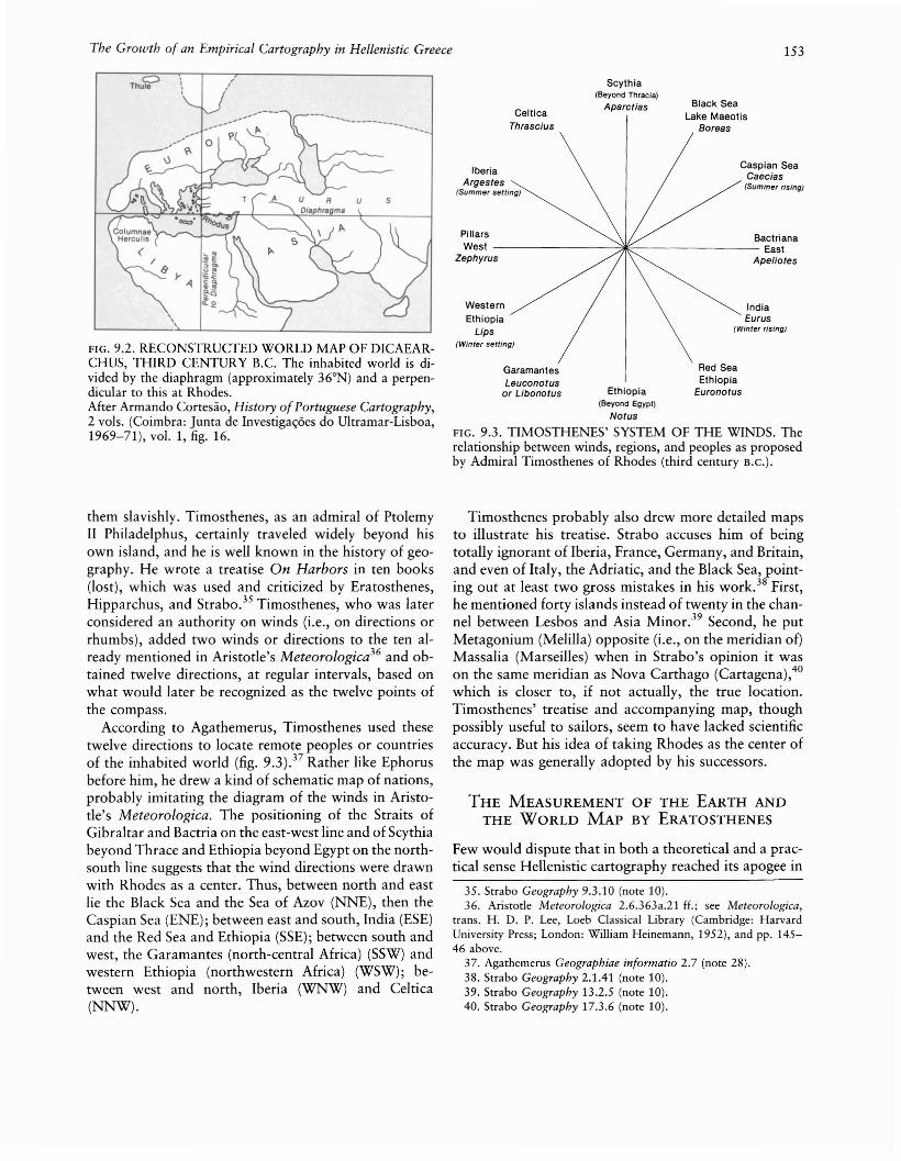
them slavishly. Timosthenes, as an admiral of PtolemyII Philadelphus, certainly traveled widely beyond hisown island, and he is well known in the history of geography. He wrote a treatise On Harbors in ten books(lost), which was used and criticized by Eratosthenes,Hipparchus, and Strabo.35 Timosthenes, who was laterconsidered an authority on winds (i.e., on directions orrhumbs), added two winds or directions to the ten already mentioned in Aristotle's Meteorologica36 and obtained twelve directions, at regular intervals, based onwhat would later be recognized as the twelve points ofthe compass.
According to Agathemerus, Timosthenes used thesetwelve directions to locate remote peoples or countriesof the inhabited world (fig. 9.3).37 Rather like Ephorusbefore him, he drew a kind of schematic map of nations,probably imitating the diagram of the winds in Aristotle's Meteorologica. The positioning of the Straits ofGibraltar and Bactria on the east-west line and of Scythiabeyond Thrace and Ethiopia beyond Egypt on the northsouth line suggests that the wind directions were drawnwith Rhodes as a center. Thus, between north and eastlie the Black Sea and the Sea of Azov (NNE), then theCaspian Sea (ENE); between east and south, India (ESE)and the Red Sea and Ethiopia (SSE); between south andwest, the Garamantes (north-central Africa) (SSW) andwestern Ethiopia (northwestern Africa) (WSW); between west and north, Iberia (WNW) and Celtica(NNW).
Timosthenes probably also drew more detailed mapsto illustrate his treatise. Strabo accuses him of beingtotally ignorant of Iberia, France, Germany, and Britain,and even of Italy, the Adriatic, and the Black Sea, pointing out at least two gross mistakes in his work. 38 First,he mentioned forty islands instead of twenty in the channel between Lesbos and Asia Minor. 39 Second, he putMetagonium (Melilla) opposite (i.e., on the meridian of)Massalia (Marseilles) when in Strabo's opinion it wason the same meridian as Nova Carthago (Cartagena),40which is closer to, if not actually, the true location.Timosthenes' treatise and accompanying map, thoughpossibly useful to sailors, seem to have lacked scientificaccuracy. But his idea of taking Rhodes as the center ofthe map was generally adopted by his successors.
THE MEASUREMENT OF THE EARTH ANDTHE WORLD MAP BY ERATOSTHENES
Few would dispute that in both a theoretical and a practical sense Hellenistic cartography reached its apogee in
35. Strabo Geography 9.3.10 (note 10).36. Aristotle Meteorologica 2.6.363a.21 H.; see Meteorologica,
trans. H. D. P. Lee, Loeb Classical Library (Cambridge: HarvardUniversity Press; London: William Heinemann, 1952), and pp. 14546 above.
37. Agathemerus Geographiae informatio 2.7 (note 28).38. Strabo Geography 2.1.41 (note 10).39. Strabo Geography 13.2.5 (note 10).40. Strabo Geography 17.3.6 (note 10).

154
the work of the polymath Eratosthenes (ca. 275-194B.C.). His was a lasting contribution to the developmentof mapping, and with some justification he has beenvariously assigned a founding role in geography, cartography, and geodesy.4l Although we are acquaintedwith his contribution only through later writers ratherthan through his original texts,42 it is absolutely clearthat in two scientific endeavors he surpassed both hispredecessors and his contemporaries. The first of thesewas his measurement of the circumference of the earth,which was methodologically simple but brilliant.43 Thesecond was his construction of a world map based onboth parallels and meridians, which was of seminal importance not only in the subsequent development of mapprojections but also in the eventual scientific and practical use of maps. Such a cartographic invention wasequally applicable in chorographical or regional mapping and in geographical or world mapping, so that itskey significance for the history of the map needs to befully described.
Eratosthenes was born a Greek, in Cyrene (NorthAfrica); going to Athens as a young man, he took lessonsat one time from the Stoics and at another from theAcademicians, among whom he was particularly influenced by Arcesilas of Pitane (Candarli), who had beena disciple of the mathematician Autolycus. In the workof Eratosthenes, as in that of his predecessors, the importance of his mastery of the geometry of the sphereand of the geocentric hypothesis cannot be overemphasized as providing the point of departure-as wellas the theoretical framework-for the development ofhis cartographic ideas.44 Eratosthenes' scientific distinction later attracted the attention of Ptolemy III Euergetes,king of Egypt 246-221 B.C. The king asked him to cometo Alexandria as tutor to his son Philopator (born ca.245 B.C.) and to take over the direction of the librarywhen Apollonius left for Rhodes after adverse criticismof his poem Argonautica. At Alexandria, Eratostheneswas to compose two works on geographical subjects:one, Measurement of the Earth, explained the methodused to find the circumference of the earth; the other,entitled Geographica, in three books, gave instructionsfor making a map of the inhabited world. Both worksare lost, but Strabo, who begins his own work by acriticism of the Geographica, affords us fairly clearknowledge of its contents, and Cleomedes of the secondcentury A.D. gives a brief summary of the Measurementof the Earth.45
From Cleomedes we learn that the method Eratosthenes used to evaluate the circumference of the earthwas based on the geometry of the sphere.46· Accordingto the geocentric hypothesis, by which the earth wasreduced to a point,47 the sun's rays are parallel whenfalling on any point of the earth. It was known that
Cartography in Ancient Europe and the Mediterranean
Syene (Aswan) in Egypt was situated under the tropic;at midday on the summer solstice there was no shadow,
41. Cortesao, History of Portuguese Cartography, 1:78-79 (note26); D. R. Dicks, "Eratosthenes," in Dictionary of Scientific Biography, 4:388-93 (note 30).
42. R. M. Bentham, "The Fragments of Eratosthenes of Cyrene"(typescript for Ph.D. thesis, University of London, 1948-author diedbefore thesis was submitted); see also Die geographischen Fragmentedes Eratosthenes, ed. Hugo Berger (Leipzig: Teubner, 1898). We knowof Eratosthenes' Geographica mostly through Strabo.
43. Gerald R. Crone, Maps and Their Makers: An Introduction tothe History ofCartography, 5th ed. (Folkestone, Kent: Dawson; J-Iamden, Conn.: Archon Books, 1978), 3.
44. In this respect Eratosthenes was heir to a continuous traditionof mathematical learning that can be traced back at least as far asEudoxus, from whose day onward it is likely that treatises entitledSphaerica had existed. Autolycus of Pitane (fl. 310 B.C.) was clearlya'link in this chain of writers influencing Eratosthenes. Although Autolycus's textbook On the Sphere in Motion, composed about 330B.C., was not an original work, it was a competent summary of anumber of basic theorems concerning celestial phenomena for givenplaces of observation, and it explained clearly the geometric relationship between the sky and the earth and the need for astronomicalknowledge to define the position on the earth of any place of observation. See Autolycus of Pitane, La sphere en mouvement, ed. andtrans. Germaine Aujac, Jean-Pierre Brunet, and Robert Nadal (Paris:Belles Lettres, 1979). It is also likely that the writings of Euclid (fl.Alexandria ca. 300 B.C.) were known to Eratosthenes. The Elementshad been completed about 300 B.C., but Euclid was also the authorof a small treatise entitled Phaenomena, which applied specifically tothe celestial sphere the conclusions Autolycus drew for rotating spheresin general. After establishing the geometry of the rotating celestialsphere, Euclid examined the rising and setting of stars as a means ofmeasuring time at night; to do this he had to analyze the relationshipbetween the observer's horizon and the ecliptic on the celestial sphere,which is different for each parallel on the earth. A brief summary ofthis work is given by Pierre Chiron, "Les Phenomenes d'Euclide," inL'astronomie dans t antiquite classique, Actes du Colloque tenu al'Universite de Toulouse-Le Mirail, 21-23 Octobre 1977 (Paris: BellesLettres, 1979), 83-89. For early spherical astronomy, see Otto Neugebauer, A History of Ancient Mathematical Astronomy (New York:Springer-Verlag, 1975), 748-67.
45. Cleomedes De motu circulari (note 30). The original Greek titleis KUKA.LKT] E>Ewpl:<X 'TWV ME'TEWpWV.
46. Cleomedes De motu circulari 1.10 (note 30). An English translation of book 1, chap. 10, appears in Cortesao, History ofPortugueseCartography, 1:141-43 (note 26).
47. In the geocentric hypothesis, as explained in Euclid's Phaenomena, the sky of the fixed stars was compared to a sphere rotatingaround one diameter called the world axis. In the middle, the earthwas reduced to a point that acted as center to the sphere; the fixedstars moved along parallel circles (being on a rotating sphere, theywere all circles of the sphere perpendicular to the axis of rotation).The greatest of these parallel circles Euclid recognized as the celestialequator. But two other great circles were important: the oblique circleof the ecliptic (called the "zodiac" by Euclid; see Chiron, "Phenomenesd'Euclide," 85 [note 44]), and the circle of the visible horizon (theastronomical horizon dividing the visible celestial hemisphere fromthe invisible one), which remained motionless during the apparentmotion of the celestial sphere (fig. 8.8). Euclid Phaenomena 1 andprop. 1, see Euclid, Opera omnia, 9 vols., cd. J. L. Heiberg andH. Menge (Leipzig: Teubner, 1883-1916), vol. 8, Phaenomena etscripta musica [and] Fragmenta (1916).
The Growth of an Empirical Cartography in Hellenistic Greece 155
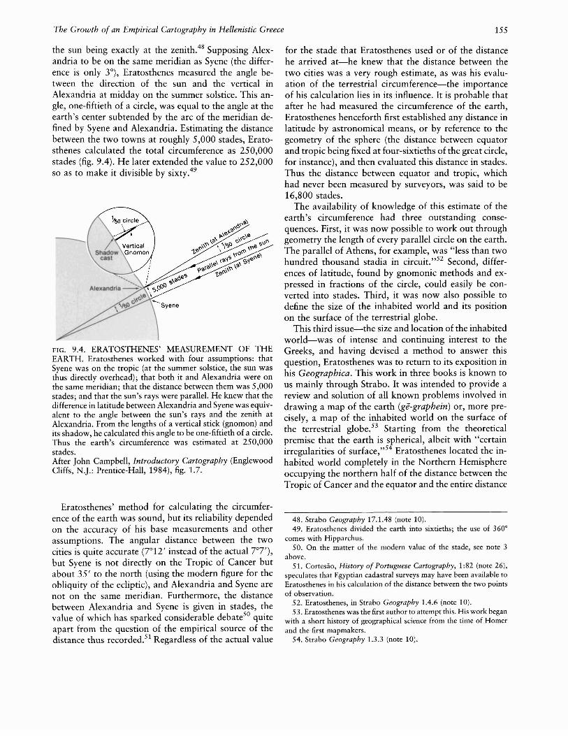
the sun being exactly at the zenith.48 Supposing Alexandria to be on the same meridian as Syene (the difference is only 3°), Eratosthenes measured the angle between the direction of the sun and the vertical inAlexandria at midday on the summer solstice. This angle, one-fiftieth of a circle, was equal to the angle at theearth's center subtended by the arc of the meridian defined by Syene and Alexandria. Estimating the distancebetween the two towns at roughly 5,000 stades, Eratosthenes calculated the total circumference as 250,000stades (fig. 9.4). He later extended the value to 252,000so as to make it divisible by sixty.49
FIG. 9.4. ERATOSTHENES' MEASUREMENT OF THEEARTH. Eratosthenes worked with four assumptions: thatSyene was on the tropic (at the summer solstice, the sun wasthus directly overhead); that both it and Alexandria were onthe same meridian; that the distance between them was 5,000stades; and that the sun's rays were parallel. He knew that thedifference in latitude between Alexandria and Syene was equivalent to the angle between the sun's rays and the zenith atAlexandria. From the lengths of a vertical stick (gnomon) andits shadow, he calculated this angle to be one-fiftieth of a circle.Thus the earth's circumference was estimated at 250,000stades.After John Campbell, Introductory Cartography (EnglewoodCliffs, N.).: Prentice-Hall, 1984), fig. 1.7.
Eratosthenes' method for calculating the circumference of the earth was sound, but its reliability dependedon the accuracy of his base measurements and otherassumptions. The angular distance between the twocities is quite accurate (7°12' instead of the actual ]07'),but Syene is not directly on the Tropic of Cancer butabout 35' to the north (using the modern figure for theobliquity of the ecliptic), and Alexandria and Syene arenot on the same meridian. Furthermore, the distancebetween Alexandria and Syene is given in stades, thevalue of which has sparked considerable debate50 quiteapart from the question of the empirical source of thedistance thus recorded.51 Regardless of the actual value
for the stade that Eratosthenes used or of the distancehe arrived at-he knew that the distance between thetwo cities was a very rough estimate, as was his evaluation of the terrestrial circumference-the importanceof his calculation lies in its influence. It is probable thatafter he had measured the circumference of the earth,Eratosthenes henceforth first established any distance inlatitude by astronomical means, or by reference to thegeometry of the sphere (the distance between equatorand tropic being fixed at four-sixtieths of the great circle,for instance), and then evaluated this distance in stades.Thus the distance between equator and tropic, whichhad never been measured by surveyors, was said to be16,800 stades.
The availability of knowledge of this estimate of theearth's circumference had three outstanding consequences. First, it was now possible to work out throughgeometry the length of every parallel circle on the earth.The parallel of Athens, for example, was "less than twohundred thousand stadia in circuit. ,,52 Second, differences of latitude, found by gnomonic methods and expressed in fractions of the circle, could easily be converted into stades. Third, it was now also possible todefine the size of the inhabited world and its positionon the surface of the terrestrial globe.
This third issue-the size and location of the inhabitedworld-was of intense and continuing interest to theGreeks, and having devised a method to answer thisquestion, Eratosthenes was to return to its exposition inhis Geographica. This work in three books is known tous mainly through Strabo. It was intended to provide areview and solution of all known problems involved indrawing a map of the earth (ge-graphein) or, more precisely, a map of the inhabited world on the surface ofthe terrestrial globe.53 Starting from the theoreticalpremise that the earth is spherical, albeit with "certainirregularities of surface,"54 Eratosthenes located the inhabited world completely in the Northern Hemisphereoccupying the northern half of the distance between theTropic of Cancer and the equator and the entire distance
48. Strabo Geography 17.1.48 (note 10).49. Eratosthenes divided the earth into sixtieths; the use of 3600
comes with Hipparchus.50. On the matter of the modern value of the stade, see note 3
above.51. Cortesao, History of Portuguese Cartography, 1:82 (note 26),
speculates that Egyptian cadastral surveys may have been available toEratosthenes in his calculation of the distance between the two pointsof observation.
52. Eratosthenes, in Strabo Geography 1.4.6 (note 10).53. Eratosthenes was the first author to attempt this. His work began
with a short history of geographical science from the time of Homerand the first mapmakers.
54. Strabo Geography 1.3.3 (note 10).
38,000
Stades3,400
10,000about 8,100
5,000about 11,500
156
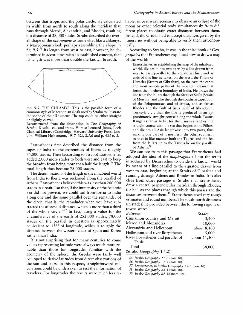
between that tropic and the polar circle. He calculatedits width from north to south along the meridian thatruns through Meroe, Alexandria, and Rhodes, resultingin a distance of 38,000 stades. Strabo described the overall shape of the oikoumene as somewhat like a chlamys,a Macedonian cloak perhaps resembling the shape infig. 9.5.55 Its length from west to east, however, he determined in accordance with an established concept, thatits length was more than double the known breadth.
FIG. 9.5. THE CHLAMYS. This is the possible form of acommon style of Macedonian cloak used by Strabo to illustratethe shape of the oikoumene. The top could be either straightor slightly curved.Reconstructed from the description in The Geography ofStrabo, 8 vols., ed. and trans. Horace Leonard Jones, LoebClassical Library (Cambridge: Harvard University Press; London: William Heinemann, 1917-32),2.5.6 and p. 435 n. 3.
Eratosthenes first described the distance from thecapes of India to the extremities of Iberia as roughly74,000 stades. Then (according to Strabo) Eratosthenesadded 2,000 more stades to both west and east to keepthe breadth from being more than half the length.56 Thetotal length thus became 78,000 stades.
The determination of the length of the inhabited worldfrom India to Iberia was reckoned along the parallel ofAthens. Eratosthenes believed this was less than 200,000stades in circuit, "so that, if the immensity of the AtlanticSea did not prevent, we could sail from Iberia to Indiaalong one and the same parallel over the remainder ofthe circle, that is, the remainder when you have subtracted the aforesaid distance, which is more than a thirdof the whole circle. ,,57 In fact, using a value for thecircumference of the earth of 252,000 stades, 78,000stades on the parallel in question is approximatelyequivalent to 138 0 of longitude, which is roughly thedistance between the western coast of Spain and Korearather than India.
It is not surprising that for many centuries to comevalues representing latitude were always much more reliable than those for longitude. Familiar with thegeometry of the sphere, the Greeks were fairly wellequipped to derive latitudes from direct observations ofthe sun and stars. In this respect, straightforward calculations could be undertaken to test the information oftravelers. For longitudes the results were much less re-
Cartography in Ancient Europe and the Mediterranean
liable, since it was necessary to observe an eclipse of themoon or other celestial body simultaneously from different places to obtain exact distances between them.Instead, the Greeks had to accept distances given by theitineraries without being able to verify them astronomically.
According to Strabo, it was in the third book of Geographica that Eratosthenes explained how to draw a mapof the world:
Eratosthenes, in establishing the map of the inhabitedworld, divides it into two parts by a line drawn fromwest to east, parallel to the equatorial line; and asends of this line he takes, on the west, the Pillars ofHeracles [Straits of Gibraltar], on the east, the capesand most remote peaks of the mountain-chain thatforms the northern boundary of India. He draws theline from the Pillars through the Strait of Sicily [Straitsof Messina] and also through the southern capes bothof the Peloponnesus and of Attica, and as far asRhodes and the Gulf of Issus [Gulf of Iskenderun,Turkey]; . . . then the line is produced in an approximately straight course along the whole TaurusRange as far as India, for the Taurus stretches in astraight course with the sea that begins at the Pillars,and divides all Asia lengthwise into two parts, thusmaking one part of it northern, the other southern;so that in like manner both the Taurus and the Seafrom the Pillars up to the Taurus lie on the parallelof Athens.58
We can see from this passage that Eratosthenes hadadopted the idea of the diaphragma (if not the term)introduced by Dicaearchus to divide the known worldby means of a line parallel to the equator, drawn fromwest to east, beginning at the Straits of Gibraltar andrunning through Athens and Rhodes to India. It is alsoclear from other passages in Strabo that Eratosthenesdrew a central perpendicular meridian through Rhodes,for he lists the places through which this passes and thedistances between them.59 Eratosthenes used very roughestimates and round numbers. The south-north distances(in stades) he provided between the following regions ortowns were:BetweenCinnamon country and MeroeMeroe and AlexandriaAlexandria and HellespontHellespont and river BorysthenesRiver Borysthenes and parallel of
ThuleTotal
(Strabo Geography 1.4.2).
55. Strabo Geography 2.5.6 (note 10).56. Strabo Geography 1.4.5 (note 10).57. Eratosthenes, in Strabo Geography 1.4.6 (note 10).58. Strabo Geography 2.1.1 (note 10).59. Strabo Geography 2.5.42 (note 10).
The Growth of an Empirical Cartography in Hellenistic Greece 157
THE DISSEMINATION OF CARTOGRAPHICKNOWLEDGE
60. Strabo Geography 2.1.22-23 (note 10).61. Strabo Geography 2.1.40 (note 10).62. Bunbury, History of Ancient Geography, facing p. 660 (note
32), and Cortes~o, History of Portuguese Cartography, 1:83-84 andfig. 19 (note 26).
63. Dicks, Geographical Fragments, 159 (note 3).64. Cortesao, History of Portuguese Cartography, 1:84 (note 26).
INDIA
...-,.".,.,- .....r----l THIRDI
: SECTION ARIANAIIL _
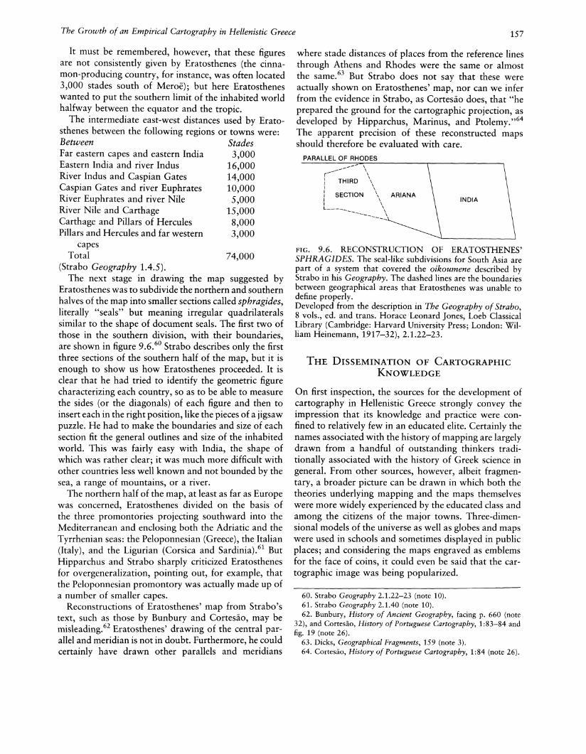
where stade distances of places from the reference linesthrough Athens and Rhodes were the same or almostthe same.63 But Strabo does not say that these wereactually shown on Eratosthenes' map, nor can we inferfrom the evidence in Strabo, as Cortesao does, that "heprepared the ground for the cartographic projection, asdeveloped by Hipparchus, Marinus, and Ptolemy.,,64The apparent precision of these reconstructed mapsshould therefore be evaluated with care.
PARALLEL OF RHODES
FIG. 9.6. RECONSTRUCTION OF ERATOSTHENES'SPHRAGIDES. The seal-like subdivisions for South Asia arepart of a system that covered the oikoumene described byStrabo in his Geography. The dashed lines are the boundariesbetween geographical areas that Eratosthenes was unable todefine properly.Developed from the description in The Geography of Strabo,8 vols., ed. and trans. Horace Leonard Jones, Loeb ClassicalLibrary (Cambridge: Harvard University Press; London: William Heinemann, 1917-32),2.1.22-23.
On first inspection, the sources for the development ofcartography in Hellenistic Greece strongly convey theimpression that its knowledge and practice were confined to relatively few in an educated elite. Certainly thenames associated with the history of mapping are largelydrawn from a handful of outstanding thinkers traditionally associated with the history of Greek science ingeneral. From other sources, however, albeit fragmentary, a broader picture can be drawn in which both thetheories underlying mapping and the maps themselveswere more widely experienced by the educated class andamong the citizens of the major towns. Three-dimensional models of the universe as well as globes and mapswere used in schools and sometimes displayed in publicplaces; and considering the maps engraved as emblemsfor the face of coins, it could even be said that the cartographic image was being popularized.
It must be remembered, however, that these figuresare not consistently given by Eratosthenes (the cinnamon-producing country, for instance, was often located3,000 stades south of Meroe); but here Eratostheneswanted to put the southern limit of the inhabited worldhalfway between the equator and the tropic.
The intermediate east-west distances used by Eratosthenes between the following regions or towns were:Between StadesFar eastern capes and eastern India 3,000Eastern India and river Indus 16,000River Indus and Caspian Gates 14,000Caspian Gates and river Euphrates 10,000River Euphrates and river Nile 5,000River Nile and Carthage 15,000Carthage and Pillars of Hercules 8,000Pillars and Hercules and far western 3,000
capesTotal 74,000
(Strabo Geography 1.4.5).The next stage in drawing the map suggested by
Eratosthenes was to subdivide the northern and southernhalves of the map into smaller sections called sphragides,literally "seals" but meaning irregular quadrilateralssimilar to the shape of document seals. The first two ofthose in the southern division, with their boundaries,are shown in figure 9.6.60 Strabo describes only the firstthree sections of the southern half of the map, but it isenough to show us how Eratosthenes proceeded. It isclear that he had tried to identify the geometric figurecharacterizing each country, so as to be able to measurethe sides (or the diagonals) of each figure and then toinsert each in the right position, like the pieces of a jigsawpuzzle. He had to make the boundaries and size of eachsection fit the general outlines and size of the inhabitedworld. This was fairly easy with India, the shape ofwhich was rather clear; it was much more difficult withother countries less well known and not bounded by thesea, a range of mountains, or a river.
The northern half of the map, at least as far as Europewas concerned, Eratosthenes divided on the basis ofthe three promontories projecting southward into theMediterranean and enclosing both the Adriatic and theTyrrhenian seas: the Peloponnesian (Greece), the Italian(Italy), and the Ligurian (Corsica and Sardinia).61 ButHipparchus and Strabo sharply criticized Eratosthenesfor overgeneralization, pointing out, for example, thatthe Peloponnesian promontory was actually made up ofa number of smaller capes.
Reconstructions of Eratosthenes' map from Strabo'stext, such as those by Bunbury and Cortesao, may bemisleading.62 Eratosthenes' drawing of the central parallel and meridian is not in doubt. Furthermore, he couldcertainly have drawn other parallels and meridians
158
An interesting pointer to the popularity of maps inAthens at the beginning of the third century B.C. is provided by Theophrastus, disciple and successor of Aristotle and a contemporary of Dicaearchus. He requestsin his will "that the small portico adjoining the shrineof the Muses shall be rebuilt no worse than before, andthat the panels (pinakas) showing maps of the earth (gesperiodoi) shall be put up in the lower cloister.,,65 Thiswill, transcribed verbatim by Diogenes Laertius, suggeststhat the custom of drawing maps on wooden panels andshowing them in public or semipublic places for information was well established.66 The maps described wereexisting fixtures, easily movable like other paintings;they could be displayed with other types of pictures, inthe company of which they became a familiar type ofimage.
Nor was this the sole example of such public cartographic displays. Although the allusion is literary andrefers to an earlier period, a passage in the epic of Apollonius Rhodius (fl. ca. 267-260 B.C.) extends the practiceoutside Athens, claiming that the Colchians, on thesoutheast coast of the Black Sea, were originally colonists from Egypt. "They preserve," he says, "the engravings of their fathers on pillars, on which are markedall the ways and the limits of the sea and land as youjourney on all sides round.,,67 The word rendered as"engravings" means "scratchings" in Homer-fromwhom Apollonius often drew his vocabulary-so thepoet is implying roughly incised lines.
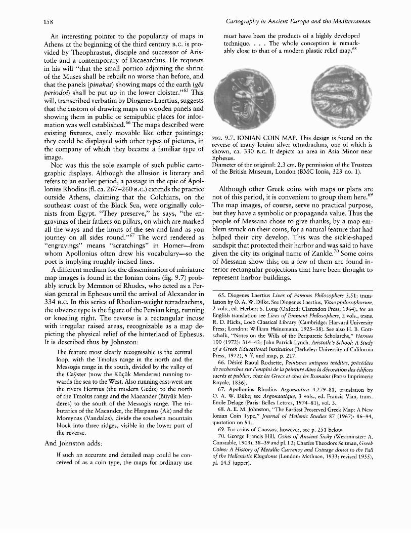
A different medium for the dissemination of miniaturemap images is found in the Ionian coins (fig. 9.7) probably struck by Memnon of Rhodes, who acted as a Persian general in Ephesus until the arrival of Alexander in334 B.C. In this series of Rhodian-weight tetradrachms,the obverse type is the figure of the Persian king, runningor kneeling right. The reverse is a rectangular incusewith irregular raised areas, recognizable as a map depicting the physical relief of the hinterland of Ephesus.It is described thus by Johnston:
The feature most clearly recognisable is the centralloop, with the Tmolus range in the north and theMessogis range in the south, divided by the valley ofthe Cayster (now the Ku~uk Menderes) running to
wards the sea to the West. Also running east-west arethe rivers Hermus (the modern Gediz) to the northof the Tmolus range and the Maeander (Buyuk Menderes) to the south of the Messogis range. The tributaries of the Maeander, the Harpasus (Ak) and theMorsynas (Vandalas), divide the southern mountainblock into three ridges, visible in the lower part ofthe reverse.
And Johnston adds:
If such an accurate and detailed map could be conceived of as a coin type, the maps for ordinary use
Cartography in Ancient Europe and the Mediterranean
must have been the products of a highly developedtechnique. . . . The whole conception is remarkably close to that of a modern plastic relief map.6S
FIG. 9.7. IONIAN COIN MAP. This design is found on thereverse of many Ionian silver tetradrachms, one of which isshown, ca. 330 B.C. It depicts an area in Asia Minor nearEphesus.Diameter of the original: 2.3 em. By permission of the Trusteesof the British Museum, London (BMC Ionia, 323 no. 1).
Although other Greek coins with maps or plans arenot of this period, it is convenient to group them here.69
The map images, of course, serve no practical purpose,but they have a symbolic or propaganda value. Thus thepeople of Messana chose to give thanks, by a map emblem struck on their coins, for a natural feature that hadhelped their city develop. This was the sickle-shapedsandspit that protected their harbor and was said to havegiven the city its original name of Zankle.70 Some coinsof Messana show this; on a few of them are found interior rectangular projections that have been thought torepresent harbor buildings.
65. Diogenes Laertius Lives of Famous Philosophers 5.51; translation by O. A. W. Dilke. See Diogenes Laertius, Vitae philosophorum,2 vols., ed. Herbert S. Long (Oxford: Clarendon Press, 1964); for anEnglish translation see Lives of Eminent Philosophers, 2 vols., trans.R. D. Hicks, Loeb Classical Library (Cambridge: Harvard UniversityPress; London: William Heinemann, 1925-38). See also H. B. Gottschalk, "Notes on the Wills of the Peripatetic Scholarchs," Hermes100 (1972): 314-42; John Patrick Lynch, Aristotle's School: A Studyof a Greek Educational Institution (Berkeley: University of CaliforniaPress, 1972),9 ff. and map, p. 217.
66. Desire Raoul Rochette, Peintures antiques inedites, precedeesde recherches sur temploi de la peinture dans la decoration des edificessacres et publics, chez les Grecs et chez les Romains (Paris: ImprimerieRoyale, 1836).
67. Apollonius Rhodius Argonautica 4.279-81, translation byO. A. W. Dilke; see Argonautique, 3 vols., ed. Francis Vian, trans.Emile Delage (Paris: Belles Lettres, 1974-81), vol. 3.
68. A. E. M. Johnston, "The Earliest Preserved Greek Map: A NewIonian Coin Type," Journal of Hellenic Studies 87 (1967): 86-94,quotation on 91.
69. For coins of Cnossos, however, see p. 251 below.70. George Francis Hill, Coins of Ancient Sicily (Westminster: A.
Constable, 1903),38-39 and pI. 1.2; Charles Theodore Seltman, GreekCoins: A History of Metallic Currency and Coinage down to the Fallof the Hellenistic Kingdoms (London: Methuen, 1933; revised 1955),pI. 14.5 (upper).
The Growth of an Empirical Cartography in Hellenistic Greece
A more doubtful example is on a coin of Phocaea(Foca), north of Smyrna (Izmir) in Ionia; this has a drawing of the common seal (the animal; Greek phoke, originof their city name) on the obverse.7! On the reverse,however, is what could be a city plan, showing threequarters of a square, with a possible harbor and river.Other coins of Phocaea have a complete square, although the layout differs somewhat from Livy's laterdescription of the town plan.72
Another factor contributing to this wider understanding of maps was, as already noted, that the early Greeka~tronomers and philosophers had a well-developed mechanical flair. Rather than confining their geometric hypotheses solely to diagrams drawn on flat surfaces, theyexpressed them in three-dimensional models, whetherglobes or mechanical representations of the workings ofthe celestial system. In particular, the study of sphairopoiia (U<pULp01ToLLu)-a branch of mechanics the object of which was to represent celestial rotations73while serving as a method of research into the laws ofcosmic motion through the construction of models ofthe cosmos, also helped bridge the gap between purelytheoretical speculation and its wider understanding in amore tangible form. Pappus, a distinguished Alexandrian mathematician (fl. A.D. 320), defines experts inmechanics as "those who know sphairopoiia, a technique used to construct representations of the movingsky through the regular and circular motion of water.,,74
One of these experts was Archimedes (287-212 B.C.),a contemporary and friend of Eratosthenes, exerted aninfluence on astronomical and geographical thinking,and hence on the maps and models that represented thesetheories. Born in Syracuse, Archimedes was the son ofPheidias, an astronomer. He visited Alexandria, wherehe mixed in the intellectual circle of astronomers andphilosophers such as Conan of Samos (fl. 245 B.C.) andhis pupil Dositheus of Pelusium (fl. 230 B.C.),75 andwhere he also met Eratosthenes, with whom he laterconducted a scientific correspondence. Archimedes wasa favorite at the court of Hieron II (ca. 306-215 B.C.),ruler of Syracuse, becoming famous for the various machines he invented, especially those used to repulse Roman assailants at the siege of Syracuse.76
Among numerous other works, Archimedes composeda treatise (lost) on sphairopoiia, which led to a greatlyimproved representation of the universe. His project wasindeed ambitious-an attempt to build a model of the"terrestrial system" based on the geocentric hypothesisand to make it work as in reality. The design was suchthat the celestial sphere, the planets, and the earth wereall parts of one intricate mechanism, which could be setin motion so as to simulate the apparent rotation of thestellar sphere and the various motions of the main planets. From this work, as well as from other contemporary
159
and later sources, it becomes clear that in the time ofArchimedes it was quite usual to make all kinds of models imitating the various movements in the universe. Furthermore, celestial globes, like the ones introduced byEudoxus and made familiar by Aratus, were exhibitedfrequently in schools or in public places. And armillaryspheres such as that reconstructed in figure 8.8, in whichthe sphere of the fixed stars was reduced to its maincircles (equator, tropics, ever-visible and never-visiblecircles, zodiac, colures) and the earth could be envisionedin the center, helped demonstrate to a wider audiencethe effects of latitude on celestial phenomena.
Archimedes also constructed a number of globes. Atleast two of them were taken to Rome by Marcus Claudius Marcellus after the fall of Syracuse in 212 B.C.; theyare described enthusiastically (but rather vaguely) byCicero.77 One of them, apparently of striking appearance, was well known to the people of Rome and hadbeen put in the temple of Virtue. It was probably a solidcelestial globe, showing the whole series of constellations' or rather the characters and animals representingthem. These kinds of globes were usually elegantlydrawn and then brightly colored. A second globe, which
71. William Smith, Dictionary of Greek and Roman Geography, 2vols. (London: J. Murray, 1870), 2:603; S. W. Grose, FitzwilliamMuseum: Catalogue of the McClean Collection of Greek Coins (Cambridge: Cambridge University Press, 1929), 3: 143 and pI. 285.22.There is, however, some resemblance to the plan given by F. Sartiaux,"Recherches sur Ie site de l'ancienne Phocee," Comptes Rendus desSeances de fAcademie des Inscriptions et Belles-Lettres (1914): 6-18,esp. 6-7.
72. Livy [History of Rome] 37.31.7-10; see Livy, 14 vols., trans.B. O. Foster et aI., Loeb Classical Library (Cambridge: Harvard University Press; London: William Heinemann, 1919-59).
73. The word cr<pULp01TOLLU is mentioned by Geminus, in ProclusCommentary on the Elements of Euclid; see In primum Euclidis Elementorum librum commentarii, ed. G. Friedlein (Leipzig: Teubner,1873), p. 41, 1. 16, and also in Geminus Introduction to Phenomena12.23, 12.27, 14.9, 16.19, 16.27, and 16.29; see Introduction auxphenomenes, ed. and trans. Germaine Aujac (Paris: Belles Lettres,1975).
74. Pappus of Alexandria Synagoge (Collection) 8.2, translation byo. A. W. Dilke; see Collectionis quae supersunt, 3 vols., ed. F. Hultsch(Berlin: Weidmann, 1867-78), vol. 3.
75. Both were astronomers: Conon of Samos identified a new constellation that he named the Lock of Berenice; Dositheus constructedan astronomical calendar. See Ivor Bulmer-Thomas, "Conon of Samos," and D. R. Dicks, "Dositheus," in Dictionary of Scientific Biography, 3:391 and 4:171-72, respectively (note 30).
76. Archimedes' inventions are discussed in Aage Gerhardt Drachmann, The Mechanical Technology of Greek and Roman Antiquity:A Study of Literary Sources, Acta Historica Scientiarum Naturaliumet Medicinalium, 17 (Copenhagen: Munksgaard, 1961).
77. Cicero The Republic 1.14; Edward Luther Stevenson, Terrestrialand Celestial Globes: Their History and Construction, Including aConsideration of Their Value as Aids in the Study of Geography andAstronomy, 2 vols., Publications of the Hispanic Society of America,no. 86 (New Haven: Yale University Press, 1921; reprinted New Yorkand London: Johnson Reprint Corporation, 1971), 1:15-17.
160
was held to be the masterpiece of Archimedes, at firstglance did not seem extraordinary. Marcellus kept it inhis own house. It was not a celestial globe, but a kindof planetarium. While it lacked the beautiful drawingand attractive colors that probably gave the globe in thetemple of Virtue its charm, it was a major contributionto mechanical science, modeling the motions of the sun,the moon, and five planets. Marcus Fadius Gallus, whenpresenting it to Cicero, declared: "What is admirable inthe invention of Archimedes is this: he caused a singlerotation to put into constant action bodies moving invarious and unequal orbits, at different speeds." AndCicero goes on: "When Gallus put this sphere in motion,the moon placed itself under the sun after as many rotations as days are needed for doing so in the sky itself;so that an eclipse of the sun took place in the artificialsphere, as in the sky. And the moon also went into theshadow thrown by the earth when the light of the suncame from exactly the opposite direction.,,78 The construction of this planetarium made Archimedes famousamong educated Romans, who were impressed by thehigh level of knowledge and skill it had required.79 Later
BIBLIOGRAPHYCHAPTER 9 THE GROWTH OF AN EMPIRICAL
CARTOGRAPHY IN HELLENISTIC GREECE
Aristotle. Meteorologica. Translated by H. D. P. Lee. LoebClassical Library. Cambridge: Harvard University Press;London: William Heinemann, 1952.
Aujac, Germaine. La geographie dans Ie monde antique. Paris:Presses Universitaires, 1975.
Autolycus of Pitane. La sphere en mouvement. Edited andtranslated by Germaine Aujac, Jean-Pierre Brunet, and Robert Nadal. Paris: Belles Lettres, 1979.
Broche, G. E. Pytheas Ie Massaliote. Paris: Societe Fran<;aised'Imprimerie, 1936.
Dicks, D. R., ed. The Geographical Fragments of Hipparchus.London: Athlone Press, 1960.
Diogenes Laertius. Lives of Eminent Philosophers. 2 vols.Translated by R. D. Hicks. Loeb Classical Library. Cam-
Cartography in Ancient Europe and the Mediterranean
on, some people-to Cicero's indignation-even expressed the view that the model was better than reality:"that Archimedes, in his imitation of the rotations ofthe celestial sphere, was a better constructor than Natureitself ... whereas (Cicero asserts) natural movementsare very much better planned than imitated ones.,,80
It is clear that the construction of such models-liketheir representation in two dimensions-could raise fundamental questions, going beyond the purely astronomical and geographical and expressing concern aboutman's place in the universe in relation to its very purposeand plan.
78. Cicero The Republic 1.14.22, translation by O. A. W. Dilke;see La Republique, 2 vols., trans. Esther Breguet (Paris: Belles Lettres,1980), vol. 1.
79. Cf. also Cicero Tusculan Disputations 1.25.63; see TusculanDisputations, trans. J. E. King, Loeb Classical Library (Cambridge:Harvard University Press; London: William Heinemann, 1933).
80. Cicero De natura deorum 2.35.88, translation by O. A. W.Dilke; see also De natura deorum [and] Academica, trans. H. Rackham, Loeb Classical Library (Cambridge: Harvard University Press;London: William Heinemann, 1924).
bridge: Harvard University Press; London: William Heinemann, 1925-38.
---a Vitae philosophorum. 2 vols. Edited by Herbert S.Long. Oxford: Clarendon Press, 1964.
Dubois, M. Examen de la Geographie de Strabon. Paris: Imprimerie Nationale, 1891.
Eratosthenes. Die geographischen Fragmente des Eratosthenes. Edited by Hugo Berger. Leipzig: Teubner, 1898.
Hawkes, C. F. C. Pytheas: Europe and the Greek Explorers.Eighth J. L. Myres Memorial Lecture. Oxford: Blackwell,1977.
Muller, Karl, ed. Geographi Graeci minores. 2 vols. and tabulae. Paris: Firmin-Didot, 1855-56.
Pytheas of Massilia. Fragmenta. Edited by Hans JoachimMette. Berlin: Walter de Gruyter, 1952.
Thalamas, Amedee. La Geographie d'Eratosthene. Versailles:Imprimerie Ch. Barbier, 1921.