9 Road Drainage and the Water Environment
77
A9 Dualling: Luncarty to Pass of Birnam DMRB Stage 3 Environmental Statement Chapter 9: Road Drainage and the Water Environment Page 1 of Chapter 9 9 Road Drainage and the Water Environment The assessment considers the potential impacts of the proposed scheme in terms of surface water hydrology, flood risk, fluvial geomorphology and water quality, and identifies measures for mitigating these impacts. There are several environmentally sensitive waterbodies within the study area. The largest of these include the Shochie Burn, Ordie Burn and Garry Burn; these are tributaries of the River Tay SAC and salmonid waters, and share the same ecological designations. The assessment was informed by consultation, desk-based assessments, site walkover and topographic survey. Hydraulic modelling of the three largest watercourses; Shochie Burn, Ordie Burn and Garry Burn, was undertaken to assess the capacity of the existing crossings structures on the proposed scheme and also to assess potential flood risk. Mitigation during construction will include adherence to relevant SEPA Pollution Prevention Guidelines (PPGs). With the implementation of the proposed mitigation during construction, residual impacts on all waterbodies would be reduced to Slight or Negligible significance. Mitigation for the operational phase will include use of Sustainable Drainage Systems (SUDS) to protect receiving waterbodies, and inclusion of agricultural land within the CPO to provide compensatory storage areas to accommodate water during a flood event where the proposed scheme encroaches into areas identified as part of existing floodplains. With proposed mitigation, the vast majority of residual impacts during operation would be reduced to Neutral, with a small number of Slight significance impacts. Only the residual water quality impacts on Gelly Burn (north) could be considered to potentially remain significant, although the mitigation measures have been agreed with SEPA and are considered to be acceptable. 9.1 Introduction 9.1.1 This chapter presents the assessment of the proposed scheme in terms of the surface water environment, which includes hydrology, flood risk, fluvial geomorphology and water quality. The chapter is supported by the following appendices, which are cross-referenced where relevant: Appendix A9.1 (Surface Water Hydrology); Appendix A9.2 (Flood Risk); Appendix A9.3 (Water Quality Calculations); Appendix A9.4 (Residual Impacts); and Appendix A9.5 (Watercourse Crossings). 9.1.2 Water is a resource that is essential to all animal and plant life. It is also necessary for industry, agriculture, waste disposal, many forms of transport, recreation and sport. The maintenance and improvement of the quality of our drinking water, watercourses, groundwater resources and coastal waters is central to UK Government and European policy. 9.1.3 This chapter sets out the assessment methods (Section 9.2), describes the baseline conditions (Section 9.3), and identifies potential impacts that could occur in the absence of mitigation (Section 9.4). Mitigation to avoid, reduce or offset the potential impacts is then described in Section 9.5 and residual impacts following implementation of this mitigation are then identified in Section 9.6. 9.2 Approach and Methods Structure of Assessment 9.2.1 The assessment of impacts on attributes of the surface water environment in this chapter includes: Hydrology and Flood Risk: potential impacts on the flow of water on or near the land surface. Fluvial Geomorphology: landforms associated with river channels and the sediment transport processes which form them.
Transcript of 9 Road Drainage and the Water Environment

A9 Dualling: Luncarty to Pass of Birnam DMRB Stage 3 Environmental Statement Chapter 9: Road Drainage and the Water Environment
Page 1 of Chapter 9
9 Road Drainage and the Water Environment
The assessment considers the potential impacts of the proposed scheme in terms of surface water hydrology, flood risk, fluvial geomorphology and water quality, and identifies measures for mitigating these impacts.
There are several environmentally sensitive waterbodies within the study area. The largest of these include the Shochie Burn, Ordie Burn and Garry Burn; these are tributaries of the River Tay SAC and salmonid waters, and share the same ecological designations.
The assessment was informed by consultation, desk-based assessments, site walkover and topographic survey. Hydraulic modelling of the three largest watercourses; Shochie Burn, Ordie Burn and Garry Burn, was undertaken to assess the capacity of the existing crossings structures on the proposed scheme and also to assess potential flood risk.
Mitigation during construction will include adherence to relevant SEPA Pollution Prevention Guidelines (PPGs). With the implementation of the proposed mitigation during construction, residual impacts on all waterbodies would be reduced to Slight or Negligible significance.
Mitigation for the operational phase will include use of Sustainable Drainage Systems (SUDS) to protect receiving waterbodies, and inclusion of agricultural land within the CPO to provide compensatory storage areas to accommodate water during a flood event where the proposed scheme encroaches into areas identified as part of existing floodplains. With proposed mitigation, the vast majority of residual impacts during operation would be reduced to Neutral, with a small number of Slight significance impacts. Only the residual water quality impacts on Gelly Burn (north) could be considered to potentially remain significant, although the mitigation measures have been agreed with SEPA and are considered to be acceptable.
9.1 Introduction
9.1.1 This chapter presents the assessment of the proposed scheme in terms of the surface water environment, which includes hydrology, flood risk, fluvial geomorphology and water quality. The chapter is supported by the following appendices, which are cross-referenced where relevant:
Appendix A9.1 (Surface Water Hydrology);
Appendix A9.2 (Flood Risk);
Appendix A9.3 (Water Quality Calculations);
Appendix A9.4 (Residual Impacts); and
Appendix A9.5 (Watercourse Crossings).
9.1.2 Water is a resource that is essential to all animal and plant life. It is also necessary for industry, agriculture, waste disposal, many forms of transport, recreation and sport. The maintenance and improvement of the quality of our drinking water, watercourses, groundwater resources and coastal waters is central to UK Government and European policy.
9.1.3 This chapter sets out the assessment methods (Section 9.2), describes the baseline conditions (Section 9.3), and identifies potential impacts that could occur in the absence of mitigation (Section 9.4). Mitigation to avoid, reduce or offset the potential impacts is then described in Section 9.5 and residual impacts following implementation of this mitigation are then identified in Section 9.6.
9.2 Approach and Methods
Structure of Assessment
9.2.1 The assessment of impacts on attributes of the surface water environment in this chapter includes:
Hydrology and Flood Risk: potential impacts on the flow of water on or near the land surface.
Fluvial Geomorphology: landforms associated with river channels and the sediment transport processes which form them.

A9 Dualling: Luncarty to Pass of Birnam DMRB Stage 3 Environmental Statement Chapter 9: Road Drainage and the Water Environment
Page 2 of Chapter 9
Water Quality: various attributes of a watercourse including the ecological and physiological status of various parameters (directly linked to water quality), as well as biodiversity, dilution and removal of waste products, and water supply.
9.2.2 The surface water environment is intrinsically linked to groundwater and ecological receptors, considered in Chapter 8 (Geology, Contaminated Land and Groundwater) and Chapter 10 (Ecology and Nature Conservation) respectively. Commercial and recreational use of the water environment is considered in Chapter 7 (Community and Private Assets). The specialist teams undertaking each of these assessments worked closely together to cover interactions between these topics, and cross-referencing is provided throughout this chapter where relevant.
Legislative Context
Water Framework Directive (WFD)
9.2.3 The Water Framework Directive (WFD), which is transposed into Scottish law by the ‘Water Environment and Water Services (Scotland) Act 2003’ (WEWS Act), sets targets for restoring and improving the ecological status of waterbodies. Under the WFD, the status of water is assessed using a range of parameters including chemical, ecological, physical, morphological and hydrological measures to give a holistic assessment of aquatic ecological health. The objectives of the WFD are for all waterbodies to achieve or maintain an overall status of ‘good’ by 2015 or over agreed timescales, up to 2027. Artificial or heavily modified waterbodies (HMWB) have less stringent targets to meet, however, these waterbodies need to achieve at least ‘good ecological potential’ over the same timescales.
9.2.4 To achieve the WFD objectives, SEPA introduced a risk-based classification system in 2009. This includes five quality classes (High, Good, Moderate, Poor and Bad) and establishes a requirement to identify and monitor a range of existing pressures on waterbodies which may threaten the objectives of the WFD. These pressures are generally anthropogenic and may include point source discharges, abstractions and morphological alterations such as culverts, impoundments and channel straightening. To help fulfil WFD aims, a new planning process called river basin planning has also been implemented, involving the production of a River Basin Management Plan (RBMP) for the Scotland river basin district and supplementary Area Management Plans outlining how the water environment will be managed and improved to meet WFD objectives over time. Consideration has been given to the requirements of the WFD (2006/60/EC) during assessment of the sensitivity of watercourses and selection of mitigation measures.
Controlled Activities Regulations (CAR)
9.2.5 One of the key tools in achieving the WFD objectives is the Water Environment (Controlled Activities) (Scotland) Regulations 2011 (as amended) (CAR) (Scottish Government, 2013). This legislation controls engineering works within inland surface waters, as well as point source discharges, abstractions and impoundments. There are three different levels of authorisation under CAR: General Binding Rules (GBR), Registration and Licence (either Simple or Complex). The level of regulation increases as the activity poses a higher risk to the integrity and status of the water environment. The level of authorisation under CAR for the proposed scheme will depend on the specific activities involved, however, is likely to range from GBRs covering short road drainage discharges, to Simple Licences for longer road drainage discharges (draining over 1km in length), as well as larger watercourse crossings and realignments. Activities requiring CAR authorisation are required to be determined by SEPA prior to the start of construction.
Scottish Planning Policy (SPP)
9.2.6 Scottish Planning Policy (SPP) (Scottish Government, 2010) requires planning authorities to consider all sources of flooding (coastal, fluvial, pluvial, groundwater, sewers and blocked culverts) and their associated risks when preparing development plans and reviewing planning applications.
A9 Dualling: Luncarty to Pass of Birnam DMRB Stage 3 Environmental Statement Chapter 9: Road Drainage and the Water Environment
Page 3 of Chapter 9
9.2.7 The aims of SPP in relation to flooding are:
to prevent developments which would be at significant risk of being affected by flooding;
to prevent developments which would increase the probability of flooding elsewhere; and
to provide a risk framework from which to identify a site’s flood risk category and the related appropriate planning response.
Study Area
9.2.8 The baseline study area for this assessment extends 1km either side of the centreline of the proposed scheme (Figure 9.1). However, for hydrological analysis, the full catchment areas of the watercourses crossed by the proposed scheme have been considered, which extend beyond the 1km study area (Figure 9.2).
Determination of Baseline Conditions
9.2.9 Baseline conditions were identified through a combination of consultation, desk-based assessment and site walkovers.
9.2.10 The desk-based assessment has taken into account relevant DMRB guidance, legislation and regulations, including those listed below:
DMRB Volume 11, Section 3, Part 10 (HD 45/09): Road Drainage and the Water Environment (Highways Agency et al., 2009);
Review of Impact Assessment Tools and Post Project Monitoring Guidelines, Report to SEPA (Haycocks Associates, 2005);
River Geomorphology: A Practical Guide (Environment Agency, 1998);
Scottish Planning Policy (SPP) (Scottish Government, 2010);
The Climate Change (Scotland) Act 2009;
The Flood Risk Management (Scotland) Act 2009;
The Water Environment (Controlled Activities) (Scotland) Regulations 2011 (as amended) (CAR);
SEPA CAR Practical Guide (SEPA, 2013a);
Technical Flood Risk Guidance for Stakeholders (SS-NFR-P-002) (SEPA, 2013b);
CAR Guidance for transport infrastructure projects (SEPA and Transport Scotland, 2011); and
WFD policy guidance ‘The Future for Scotland’s Waters, Guiding Principles on the Technical Requirements of the Water Framework Directive’ (SEPA, 2002).
Consultation
9.2.11 Details of the consultation process are provided in Chapter 6 (Consultation and Scoping). Consultations of particular relevance to this assessment were undertaken with regulatory bodies and key stakeholders including SEPA, SNH and the Tay District Salmon Fisheries Board (DSFB).
9.2.12 Advice and guiding principles from SEPA has been taken into consideration during the design and assessment stages (EIA consultation letter responses dated 08 March and 03 April 2013). The draft ES and supporting appendices were also reviewed by SEPA in between December 2013 and January 2014, with comments taken into account during completion of the assessments and finalisation of the ES.
A9 Dualling: Luncarty to Pass of Birnam DMRB Stage 3 Environmental Statement Chapter 9: Road Drainage and the Water Environment
Page 4 of Chapter 9
Desk-based Assessment
9.2.13 Data were collated from the following sources:
A9 Dualling: Strategic Environmental Assessment - Environmental Report, June 2013;
A9 SEA Report Addendum Appendix F: Strategic Flood Risk Assessment, November 2013;
A9 Dualling: Luncarty to Pass of Birnam Strategic Planning Study – Stage 2 DMRB Environmental Assessment (Atkins, 2009);
Flood Estimation Handbook (FEH) CD-ROM v.3 (CEH, 2009);
Ordnance Survey (OS) Explorer Map 379: Dunkeld, Aberfeldy & Glen Almond;
SEPA Indicative River and Coastal Flood Map (Scotland) (SEPA, 2010a); and
SEPA River Basin Management Plan (RBMP) Interactive Map (SEPA, 2011).
Site Walkovers and Surveys
9.2.14 Walkover surveys of the study area were undertaken on 10-12 April 2013 to visually inspect surface water features in order to gain an understanding of the local topography, hydrological regime, and to gather field data for the water quality, geomorphology and flood risk assessments.
9.2.15 A number of other surveys were undertaken, including:
A LIDAR survey of the section of A9 between Luncarty and Pass of Birnam by URS in February-March 2012 to enable production of a Digital Terrain Model (DTM).
Channel cross-section and hydraulic structure surveys in March-April 2013 using conventional surveying techniques to inform mathematical models representing the existing situation, and an additional channel cross-section survey of tributary 4 of Ordie Burn in November 2013.
Surveys of the minor culverts crossing the existing A9 in September 2013.
Findings of the Ground Investigation
9.2.16 Ground investigations (GI) have been undertaken for the proposed scheme, as described in Chapter 8 (Geology, Contaminated Land and Groundwater). Relevant information from the GI was used to inform the water environment assessment.
Hydraulic Modelling
9.2.17 Details of the methods used for hydraulic modelling are provided in Appendix A9.2 (Flood Risk).
Impact Assessment
9.2.18 The impact assessment has been carried out using the general approach outlined in Chapter 5 (Overview of Assessment) and in accordance with the DMRB HD 45/09 (Highways Agency et al., 2009). The approach has also been informed by guidance from SEPA, where appropriate.
9.2.19 The level of significance of an impact (both without and with mitigation) has been determined based on the sensitivity/importance of an attribute of a surface water feature combined with the magnitude of potential impact, during both construction and operation.
Importance (Sensitivity)
9.2.20 The sensitivity/importance of an attribute of a surface water feature was categorised on a scale of ‘very high’ to ‘low’, in accordance with the criteria provided in Table 9.1. Attributes include water quality, dilution of waste products, conveyance of flow and biodiversity.

A9 Dualling: Luncarty to Pass of Birnam DMRB Stage 3 Environmental Statement Chapter 9: Road Drainage and the Water Environment
Page 5 of Chapter 9
9.2.21 The sensitivities assigned to each attribute of a feature are relevant to the surveyed reach and not necessarily the entire catchment. For example, a small tributary may be within the catchment of a designated salmonid water, but not be considered to be of very high sensitivity in terms of water quality for reasons such as size, morphology, location, bed quality and low likelihood of supporting substantial salmonid populations. Table 9.1 below has been used as a guide rather than a rigid classification tool, and specialist judgement has also been used.
Table 9.1: Criteria to Assess the Sensitivity of Attributes
Sensitivity / Importance
Criteria
Very High Attribute has a high quality and rarity on regional or national scale.
Hydrology and Flood Risk: a watercourse with direct flood risk to the adjacent populated areas, with greater than 100 residential properties at risk or critical social infrastructure units such as hospitals, schools, safe shelters or other land use of great value that has been susceptible to flooding in the past or is likely to be flooded in the future. A watercourse/hydrological feature with hydrological importance to: i) sensitive and protected ecosystems of international status; ii) critical economic and social uses (e.g. water supply, navigation, recreation, amenity etc. A watercourse/floodplain/hydrological feature that provides critical flood alleviation benefits.
Fluvial Geomorphology:
Note, for very high sensitivity the watercourse must show no signs of previous modification and/or be experiencing no morphological pressures at the current time.
Sediment regime: a watercourse that appears to be in complete natural equilibrium. That is, it is operating as a sediment source, sink or transfer zone and is not undergoing excessive unnatural deposition and/or erosion. It may also be the case that such an environment supports a range of species and habitats which would be sensitive to a change in suspended sediment concentrations and turbidity such as migratory salmon or freshwater pearl mussels.
Channel morphology: a watercourse that exhibits a natural range of morphological features such as pools and riffles, active gravel bars and varied river bank types, with no signs of modifications or morphological pressures.
Natural fluvial processes: a watercourse where there is a diverse range of fluvial processes which are free from any modification or anthropogenic influence, which would be highly vulnerable to changes as a result of modifications.
Water Quality: Site protected/designated under EC or UK habitat legislation (SAC, SPA, SSSI, Drinking Water Protection Zone, Ramsar site, salmonid water). WFD overall status of ‘High’. None or only limited anthropogenic pressures on the waterbody not significantly affecting the aims of the WFD. Regionally important potable water source. Water quality complies with Environmental Quality Standards (EQS). EC designated Salmonid/Cyprinid Fishery. Species protected under EC legislation. Watercourse widely used for recreation, directly related to watercourse quality (e.g. swimming, salmon fishery).
High Attribute has a high quality and rarity on local scale.
Hydrology and Flood Risk: a watercourse with direct flood risk to the adjacent populated areas, with 1-100 residential properties or industrial premises at risk from flooding. A watercourse /hydrological feature with hydrological importance to: i) sensitive and protected ecosystems of national designation; ii) locally important economic and social uses (e.g. water supply, navigation, recreation, amenity etc.). A watercourse/floodplain/hydrological feature providing significant flood alleviation benefits.
Fluvial Geomorphology:
Sediment regime: a watercourse that appears to be in natural equilibrium. That is, it is operating as a sediment source, sink or transfer zone and is not undergoing excessive unnatural deposition and/or erosion. It may also be the case that such an environment supports a range of species and habitats which would be sensitive to a change in suspended sediment concentrations and turbidity such as migratory salmon or freshwater pearl mussels.
Channel morphology: a watercourse that exhibits a natural range of morphological features such as pools and riffles, active gravel bars and varied river bank types, with very limited signs of modifications or morphological pressures.
Natural fluvial processes: a watercourse where there is a diverse range of fluvial processes which have very limited signs of modifications or anthropogenic influences, which would be vulnerable to changes in fluvial processes as a result of modifications.
Water Quality: WFD overall status of ‘Good’. Water quality complies with EQS. Major cyprinid fishery. Species protected under EC or UK legislation. Watercourse used for recreation and locally important potable water source.
Medium Attribute has a medium quality and rarity on local scale.
Hydrology and Flood Risk: a watercourse with a possibility of direct flood risk to less populated areas without any critical social infrastructure units such as hospitals, schools, safe shelters and/or utilisable agricultural fields. A watercourse/hydrological feature with some but limited hydrological importance to: i) sensitive or protected ecosystems; ii) economic and social uses (e.g. water supply, navigation, recreation, amenity etc); iii) the flooding of property (or land use of value) with 10 or fewer industrial properties at risk

A9 Dualling: Luncarty to Pass of Birnam DMRB Stage 3 Environmental Statement Chapter 9: Road Drainage and the Water Environment
Page 6 of Chapter 9
Sensitivity / Importance
Criteria
from flooding A watercourse/floodplain/hydrological feature that provides some flood alleviation benefits.
Fluvial Geomorphology:
Sediment regime: a watercourse that shows signs of modification and is recovering a natural equilibrium. That is, it is operating as a source, sink or transfer zone but may be undergoing elevated levels of deposition and/or erosion. It may also be the case that such an environment supports limited species and habitats which may be slightly sensitive to a change in suspended sediment concentrations and turbidity.
Channel morphology: a watercourse that exhibits a limited range of morphological features such as pools and riffles, few active gravel bars and relatively uniform bank types, with signs of modifications and morphological pressures. There may be signs of recovery of morphological features, such as the development of berms within an over wide channel.
Natural fluvial processes: a watercourse where there is a limited range of fluvial processes which are influenced by modifications or anthropogenic influences, which would be vulnerable to changes in fluvial processes as a result of modifications.
Water Quality: WFD overall status of ‘Moderate’. Likely to exhibit a measurable degradation in water quality as a result of anthropogenic factors. May be subject to improvement plans by SEPA. Watercourse not widely used for recreation and local potable water source.
Low Attribute has a low quality and rarity on local scale.
Hydrology and Flood Risk: a watercourse passing through uncultivated agricultural land. A watercourse with minimal hydrological importance to: i) sensitive or protected ecosystems; ii) economic and social uses (e.g. water supply, navigation, recreation, amenity); iii) with a low probability of flooding of residential and industrial properties and is a watercourse/floodplain/hydrological feature that provides minimal flood alleviation benefits.
Fluvial Geomorphology:
Sediment regime: a watercourse that has a highly modified sediment regime. That is, the natural equilibrium of the watercourse as a source, sink or transfer zone has been changed by channel modifications or anthropogenic pressures. The watercourse may have insufficient capacity to recover its natural equilibrium and is stable acting as a transfer or sink of sediment. It may also be the case that such an environment does not support any significant species sensitive to changes in suspended solids concentration or turbidity.
Channel morphology: a watercourse that exhibits no morphological diversity; uniform flow, gravel bars are absent and bank types uniform. Such watercourses may have been subject to past modification such as bank protection and culverting. The watercourse is likely to be stable with insufficient capacity to develop morphological features.
Natural fluvial processes: a watercourse which shows no evidence of active fluvial processes and is not likely to be affected by modification to boundary conditions.
Water Quality: WFD overall status of ‘Poor’ or ‘Bad’. Highly likely to be affected by anthropogenic factors. Heavily engineered or artificially modified and may dry up during summer months. Fish sporadically present or restricted; no species of conservation concern. Not used for recreation or water supply.
Impact Magnitude
9.2.22 The magnitude of impact is influenced by timing, scale, size and duration of change to the baseline conditions, and can be either adverse or beneficial, as defined in Table 9.2.
9.2.23 For impacts on water quality, one of the aspects considered is whether the water quality in the receiving watercourse would achieve a ‘pass’, when using the Highways Agency’s Water Risk Assessment Tool (HAWRAT). Appendix A9.3 (Water Quality Calculations) provides details of the HAWRAT methodology.
Table 9.2: Estimating the Magnitude of the Predicted Impact on Water Features
Magnitude Typical Examples
Major Adverse
Results in loss of attribute and/or quality and integrity of the attribute.
Hydrology and Flood Risk: major changes to flow regime (low, mean and/or high flows – at the site, upstream and/or downstream). An alteration to a catchment area in excess of a 25% reduction or increase. Significant increase in the extent of “medium to high risk” areas (classified by the Risk Framework of Scottish Planning Policy, SPP). This means there would be significantly more areas/properties at risk from flooding by the 0.5% or greater Annual Exceedance Probability (AEP) (1 in 200-year return period) flow.
A9 Dualling: Luncarty to Pass of Birnam DMRB Stage 3 Environmental Statement Chapter 9: Road Drainage and the Water Environment
Page 7 of Chapter 9
Magnitude Typical Examples
Major Adverse
continued
Fluvial Geomorphology:
Sediment regime: major change to the natural equilibrium through modification, significantly changing the natural function of the watercourse (sediment source, sink or transfer zone). This may arise from a major increase in amount of fine sediment and turbidity in the watercourse.
Channel morphology: major impacts on channel morphology through the removal of a wide range of morphological features and/or replacing a large extent of the natural bed and/or banks with artificial material. Major channel realignment, significantly altering natural channel planform and bank profiles, and typically resulting in the loss of sinuosity, increased channel gradient and higher stream powers with increased risk of erosion and changes to natural channel processes such as deposition.
Natural fluvial processes: major interruption to fluvial processes such as channel planform evolution or erosion and deposition.
Water Quality: Major shift away from the baseline conditions. Equivalent to downgrading two WFD classes, e.g. from Good to Poor, or any change that downgrades a site in quality status as this does not comply with the WFD. Failure of both soluble and sediment-bound pollutants in Highways Agency Water Risk Assessment Tool (HAWRAT) and compliance failure with EQS values. Calculated risk of pollution from a spillage >2% annually. Total loss or extensive change to a fishery, water supply or designated conservation site.
Moderate Adverse
Results in effect on integrity of attribute, or loss of part of attribute.
Hydrology and Flood Risk: moderate shift away from baseline conditions and moderate changes to the flow regime. An alteration to a catchment area in excess of 10% but less than 25%. Moderate increase in the extent of “medium to high risk” areas (SPP). An increase in peak flood level (1% annual probability) >10 mm resulting in an increased risk of flooding to >100 residential properties OR an increase of >50 mm resulting in an increased risk of flooding to 1-100 residential properties.
Fluvial Geomorphology:
Sediment regime: moderate change to the natural equilibrium through modification, partially changing the natural function of the watercourse (sediment source, sink or transfer zone). This may arise from a moderate increase in amount of fine sediment and turbidity in the watercourse.
Channel morphology: moderate impact on channel morphology through the removal of a range of morphological features and/or replacing a medium extent of the natural bed and/or banks with artificial material. Channel realignment resulting in a moderate change in channel planform and bank profiles typically resulting in some loss of sinuosity, increased channel gradient and higher stream powers. Erosion risk may increase and there may be some change to natural channel processes.
Natural fluvial processes: moderate interruption to fluvial processes such as channel planform evolution or erosion.
Water Quality: A moderate shift from the baseline conditions that may be long-term or temporary. Equivalent to downgrading one class, e.g. from Moderate to Poor. Failure of both soluble and sediment-bound pollutants in HAWRAT but compliance with EQS values. Calculated risk of pollution from a spillage >1% annually and <2% annually. Partial loss in productivity of a fishery or water supply.
Minor Adverse
Results in some measurable change in attributes quality or vulnerability.
Hydrology and Flood Risk: slight changes to the flow regime. An alteration to a catchment area in excess of 1% but less than 10%. Slight increase in the extent of “medium to high risk” areas (SPP). An increase in peak flood level (1% annual probability) >10 mm resulting in an increased risk of flooding to fewer than 10 industrial properties.
Fluvial Geomorphology:
Sediment regime: minor change to the natural equilibrium through modification, locally changing the natural function of the watercourse (sediment source, sink or transfer zone). This may arise from a slight increase in amount of fine sediment and turbidity in the watercourse.
Channel morphology: limited impact on channel morphology, through removal of some morphological features and/or replacing a small extent of the natural bed and/or banks with artificial material. Minor realignments, typically localised around structures such as culverts and bridges having limited impact on channel planform, gradient, bank profiles and channel processes.
Natural fluvial processes: slight change in fluvial processes operating in the river; any change is likely to be highly localised.
Water Quality: Minor shift away from the baseline conditions. Equivalent to minor but measurable change within the WFD classification scheme. Failure of either soluble or sediment-bound pollutants in HAWRAT. Calculated risk of pollution from a spillage >0.5% annually and <1% annually.
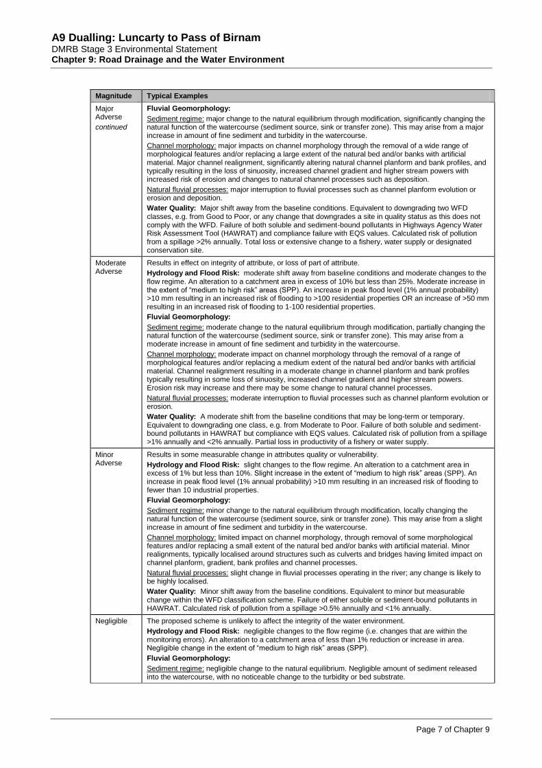
Negligible The proposed scheme is unlikely to affect the integrity of the water environment.
Hydrology and Flood Risk: negligible changes to the flow regime (i.e. changes that are within the monitoring errors). An alteration to a catchment area of less than 1% reduction or increase in area. Negligible change in the extent of “medium to high risk” areas (SPP).
Fluvial Geomorphology:
Sediment regime: negligible change to the natural equilibrium. Negligible amount of sediment released into the watercourse, with no noticeable change to the turbidity or bed substrate.

A9 Dualling: Luncarty to Pass of Birnam DMRB Stage 3 Environmental Statement Chapter 9: Road Drainage and the Water Environment
Page 8 of Chapter 9
Magnitude Typical Examples
Negligible
continued
Channel morphology: no significant impact on channel morphology in the local vicinity of proposed site.
Natural fluvial processes: no change in fluvial processes operating in the river; any change is likely to be highly localised.
Water Quality: No perceptible changes to water quality and no change within the WFD classification scheme. No risk identified by HAWRAT (Pass both soluble and sediment-bound pollutants). Risk of pollution from a spillage <0.5%.
Minor Beneficial
Results in some beneficial effect on attribute or a reduced risk of negative effect occurring.
Hydrology and Flood Risk: Minor improvement over baseline conditions. It will involve a reduction in peak flood level (1% annual probability) >10 mm.
Fluvial Geomorphology:
Sediment regime: Slight improvement towards natural equilibrium. That is returning the function of the watercourse (sediment source, sink or transfer of sediment) to a natural one.
Channel morphology: Limited improvement to morphological diversity. Introduction of some in-channel features, such as placement of cobbles/ boulders to improve in-channel habitat. Minor improvements to improve channel sinuosity and increase morphological diversity.
Natural fluvial processes: Slight change to fluvial processes which results in improved river forms and habitats.
Note: beneficial impacts will only arise on modified watercourses. The greatest improvement will occur on watercourses that have a uniform morphology, acting as a transfer (larger watercourses) or sink (minor watercourses with limited flow and overgrown vegetation) of sediment and no signs of active fluvial processes.
Water Quality: Minor improvement over baseline conditions. HAWRAT assessment of either soluble or sediment-bound pollutants becomes Pass from an existing site where the baseline was a Fail condition. Calculated reduction in existing spillage risk by 50% or more (when existing spillage risk is <1% annually).
Moderate Beneficial
Results in moderate improvement of attribute quality.
Hydrology and Flood Risk: A measurable improvement over baseline conditions involving a reduction in peak flood level (1% annual probability) >50 mm.
Fluvial Geomorphology:
Sediment regime: Moderate improvement towards natural equilibrium. That is returning the function of the watercourse (sediment source, sink or transfer of sediment) to a natural one.
Channel morphology: Moderate improvement to morphological diversity. Introduction of some sinuosity to mitigate impacts of channel straightening elsewhere in the catchment, enabling the recovery of fluvial process within the reach. Channel narrowing and the introduction of in-channel features throughout the improved reach, such as coarse substrate to create morphological diversity.
Natural fluvial processes: Moderate change to fluvial processes which results in improved river forms and habitats.
Water Quality: A moderate improvement over baseline conditions, which may result in the upgrade of quality status in line with the requirements of the WFD. HAWRAT assessment of both soluble and sediment-bound pollutants becomes Pass from an existing site where the baseline was a Fail condition. Calculated reduction in existing spillage risk by 50% or more (when existing spillage risk is >1% annually).
Major Beneficial
Results in major improvement of attribute quality.
Hydrology and Flood Risk: Major improvement over baseline conditions. The reduction in peak flood level (1% annual probability) is to be >100 mm.
Fluvial Geomorphology:
Sediment regime: Major improvement towards natural equilibrium. That is returning the function of the watercourse (sediment source, sink or transfer of sediment) to a natural one.
Channel morphology: Major improvement to morphological diversity through river restoration. Improved sinuosity similar to natural conditions identified on historical maps which enables natural reinstatement of fluvial processes resulting in high morphological diversity. Recreation of fluvial landforms and habitats such as ox bow lakes and wetland habitat and the introduction of features to improve habitat diversity.
Natural fluvial processes: Major change to fluvial processes which results in improved river forms and habitats.
Water Quality: Major improvement over baseline conditions, whereby the removal or likelihood of removal of existing pressures, results in the watercourse meeting the requirements of the WFD.
Impact Significance
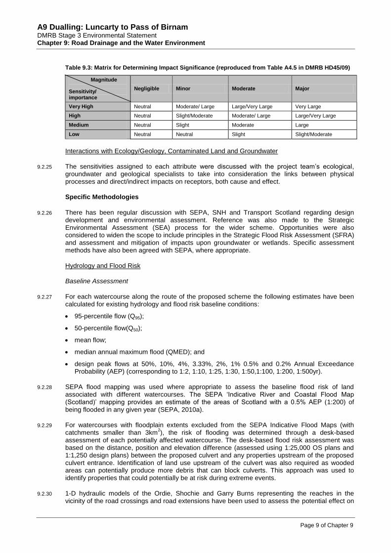
9.2.24 The significance of impact (both without and with mitigation) was determined as a function of the sensitivity or importance of the attribute/feature and the magnitude of the impact, as outlined in Table 9.3.
A9 Dualling: Luncarty to Pass of Birnam DMRB Stage 3 Environmental Statement Chapter 9: Road Drainage and the Water Environment
Page 9 of Chapter 9
Table 9.3: Matrix for Determining Impact Significance (reproduced from Table A4.5 in DMRB HD45/09)
Magnitude
Sensitivity/ importance
Negligible Minor Moderate Major
Very High Neutral Moderate/ Large Large/Very Large Very Large
High Neutral Slight/Moderate Moderate/ Large Large/Very Large
Medium Neutral Slight Moderate Large
Low Neutral Neutral Slight Slight/Moderate
Interactions with Ecology/Geology, Contaminated Land and Groundwater
9.2.25 The sensitivities assigned to each attribute were discussed with the project team’s ecological, groundwater and geological specialists to take into consideration the links between physical processes and direct/indirect impacts on receptors, both cause and effect.
Specific Methodologies
9.2.26 There has been regular discussion with SEPA, SNH and Transport Scotland regarding design development and environmental assessment. Reference was also made to the Strategic Environmental Assessment (SEA) process for the wider scheme. Opportunities were also considered to widen the scope to include principles in the Strategic Flood Risk Assessment (SFRA) and assessment and mitigation of impacts upon groundwater or wetlands. Specific assessment methods have also been agreed with SEPA, where appropriate.
Hydrology and Flood Risk
Baseline Assessment
9.2.27 For each watercourse along the route of the proposed scheme the following estimates have been calculated for existing hydrology and flood risk baseline conditions:
95-percentile flow (Q95);
50-percentile flow(Q50);
mean flow;
median annual maximum flood (QMED); and
design peak flows at 50%, 10%, 4%, 3.33%, 2%, 1% 0.5% and 0.2% Annual Exceedance Probability (AEP) (corresponding to 1:2, 1:10, 1:25, 1:30, 1:50,1:100, 1:200, 1:500yr).
9.2.28 SEPA flood mapping was used where appropriate to assess the baseline flood risk of land associated with different watercourses. The SEPA ‘Indicative River and Coastal Flood Map (Scotland)’ mapping provides an estimate of the areas of Scotland with a 0.5% AEP (1:200) of being flooded in any given year (SEPA, 2010a).
9.2.29 For watercourses with floodplain extents excluded from the SEPA Indicative Flood Maps (with catchments smaller than 3km
2), the risk of flooding was determined through a desk-based
assessment of each potentially affected watercourse. The desk-based flood risk assessment was based on the distance, position and elevation difference (assessed using 1:25,000 OS plans and 1:1,250 design plans) between the proposed culvert and any properties upstream of the proposed culvert entrance. Identification of land use upstream of the culvert was also required as wooded areas can potentially produce more debris that can block culverts. This approach was used to identify properties that could potentially be at risk during extreme events.
9.2.30 1-D hydraulic models of the Ordie, Shochie and Garry Burns representing the reaches in the vicinity of the road crossings and road extensions have been used to assess the potential effect on

A9 Dualling: Luncarty to Pass of Birnam DMRB Stage 3 Environmental Statement Chapter 9: Road Drainage and the Water Environment
Page 10 of Chapter 9
flood risk. The hydraulic models of the watercourses have used the channel and structure details obtained during topographical survey work undertaken in Spring 2013.
9.2.31 Interrogation of the 1-D hydraulic models of the Ordie, Shochie and Garry Burns was undertaken to refine understanding of the 0.5% AEP (1:200) event flood depth and extent for these watercourses. The models were constructed using the ISIS river modelling software package and utilised inputs of the following information:
0.5% AEP (1:200) event peak flows derived using Flood Estimation Handbook (FEH) methodology;
channel cross-section and hydraulic structure information collected by topographic survey; and
other hydraulic and connectivity information, which was established during a site walkover.
9.2.32 All necessary hydrological catchment characteristics were obtained from OS maps, soils, geological and land use maps and the FEH CD-ROM Version 3 (CEH, 2009). Hydrometric data of the two gauges in the study area, namely, Station No. 15027 Garry Burn (Loakmill) and 15028 Ordie Burn (Luncarty) were acquired from SEPA.
9.2.33 It is noted that some of the waterbodies, especially those located near Cairnleith Moss that are currently crossed by the A9, are relatively small, ungauged catchments. Flow estimation on ungauged watercourses is generally subject to significant uncertainties. To increase the confidence in the standard desk-based flow and flood risk estimates, each watercourse was carefully inspected during site visits undertaken in April 2013. The catchment boundaries for these small catchments were established from 1m contours derived from LIDAR data, and checked against the position of watercourses observed on aerial images and the SEPA 1:10,000 scale RBMP interactive map. The hydrological analyses used desk-based procedures and gauged data from donor/analogue catchments.
9.2.34 Appendix A9.1 (Surface Water Hydrology) identifies the flow parameters and methodologies that were used to calculate these estimates and provides information on the key baseline parameters for each of the watercourses on which there could be an impact.
Impact Assessment
9.2.35 Flood risk assessments have been undertaken based on SEPA’s Technical Flood Risk Guidance for Stakeholders (SEPA, 2013b). The flood risk assessment (Appendix A9.2) is based on the 0.5% AEP (1 in 200-year return period) design flow for current and future scenarios. An allowance is also made for climate change, as explained in paragraph 9.2.38 below.
9.2.36 In line with HD 45/09 guidance (Highways Agency et al., 2009), where a new road scheme has the potential to affect floodplain capacity, an assessment (details provided in Appendix A9.2: Flood Risk) was undertaken on the following.
the potential reduction of capacity;
the effectiveness of the proposed mitigation works; and
the residual impact of the proposed scheme on flood risk.
9.2.37 Post-development changes to catchment parameters were determined by recalculating parameters for the catchments with the proposed scheme in place. The parameters assessed were catchment area size and extent of urbanisation.
Allowance for climate change
9.2.38 Guidance on allowance for climate change has been taken from a scoping study regarding climate change and hydrological parameters (SEPA, 2005). SEPA does not define a specific value, but suggests that the sensitivity of flows within flood risk analysis could be carried out up to a 20% increase for the east of Scotland. This is considered the maximum change and evidence suggests

A9 Dualling: Luncarty to Pass of Birnam DMRB Stage 3 Environmental Statement Chapter 9: Road Drainage and the Water Environment
Page 11 of Chapter 9
that by 2050 there is more likely to be an increase of approximately 15% in the east of Scotland (Price & McKenna, 2003). Technical Flood Risk Guidance for Stakeholders (SS-NFR-P-002) (SEPA, 2013b) states that current fluvial guidance (published by DEFRA) recommends that the 0.5% AEP (1:200) event peak flow estimate should be increased by 20%. This has been included in this assessment; all references to 0.5% AEP (1:200) design scenario flood events in this chapter therefore incorporate this allowance.
Fluvial Geomorphology
Baseline Assessment
9.2.39 The baseline assessment combined a desk-based assessment and field survey.
9.2.40 The desk study utilised existing data sources to identify current known geomorphological conditions and trends in river behaviour. A summary description of data sources is provided in Table 9.4.
Table 9.4: Data Sources examined during the Desk Study
Data Source Information Provided
Contemporary OS Plans Provide basic contextual information, such as elevation, relative relief and an indication of channel gradient.
Geological Maps
(solid and drift plus soils)
Enables an understanding of the likely channel boundary conditions. This, in addition to the soils data, help indicate the likely quantity and calibre of sediment released.
Aerial Photography Provide basic contextual information about the site such as land use and vegetation types. Also provides information on the distribution of geomorphological features which help the contemporary and past geomorphological processes to be better understood.
Historical Maps Allow changes in river channel planform to be determined over periods of up to 150 years, which provide an understanding of the nature of fluvial processes and allow trends in channel behaviour to be assessed.
9.2.41 A field study was undertaken between 10 and 12 April 2013. This comprised a walkover survey by a geomorphologist to inspect the watercourses visually in the vicinity of the proposed works. The field study was designed to build on the findings of the desk study in determining the geomorphological forms and processes at each site. The range of geomorphological information collected during the field study is summarised in Table 9.5.
Table 9.5: Information gathered during Field Study
Data Source Information Provided
Geomorphological Mapping
Geomorphological mapping, involving producing a map of geological features, is a well established technique for characterising river channels. This allows:
the pattern of existing erosion and deposition to be recorded;
the dominant function of differing sections of channel to be determined (sediment source, transfer and sink); and
the spatial arrangement of morphological forms to be determined allowing inferences to be made about contemporary and past geomorphological processes, thus enabling the identification of trends in channel behaviour. The impact of past management practices were also examined enabling inferences to be made about the potential consequences of interference to be made.
Boundary Condition Information
Determining the nature of boundary materials (bed and bank) enables an insight to be gained into the intrinsic controls on patterns of erosion and deposition. This allows the likelihood of morphological adjustments to channel interference to be determined.
Impact Assessment
9.2.42 As DMRB HD45/09 (Highways Agency et al., 2009) does not outline a specific methodology to enable the geomorphological impacts to be evaluated, the methodology adopted in this assessment was developed using the guidelines from Research and Development Programmes of the National Rivers Authority, Environment Agency and SNH, including Environment Agency (1998a) and Sear et al. (2010).

A9 Dualling: Luncarty to Pass of Birnam DMRB Stage 3 Environmental Statement Chapter 9: Road Drainage and the Water Environment
Page 12 of Chapter 9
Water Quality
Baseline Assessment
9.2.43 A range of information was used to inform the baseline water quality assessment, including:
Biological and physico-chemical water quality data from SEPA-monitored watercourses within the study area. Where no data exists for smaller/minor watercourses, surrounding land use, potential pollution sources and any known/recorded freshwater species were used to infer existing water quality.
A review of information contained within the online SEPA RBMP interactive map including the current WFD water quality classification status, existing anthropogenic pressures and any improvement measures identified, and fisheries designations of monitored waterbodies within the study area. This is in line with the requirements of the WFD, as detailed in this section above (Legislative Context).
Road drainage network associated with the existing A9 and junction infrastructure and potential pollutant and runoff pathways to watercourses.
Records of contaminated land.
Impact Assessment Methodology
9.2.44 The water quality impact assessment during construction considered:
the potential effect of silt-laden runoff and suspended solids entering watercourses as a result of exposed surfaces and earthworks;
the potential effect of oils, fuels and other hazardous substances entering watercourses as a result of construction activities;
the pollution dilution/dispersal capacity of watercourses;
the disposal, treatment and attenuation of surface water runoff; and
the handling and storage of materials, fuels and oils, and potential for spillage.
9.2.45 The assessment of water quality impacts during the operation of the proposed scheme was carried out based on the methods set out in the DMRB HD 45/09 (Highways Agency et al., 2009). Two separate calculations have been undertaken to assess impacts to the receiving waters from the mainline carriageway drainage arrangements, using HAWRAT. Refer to Appendix A9.3 (Water Quality Calculations) for detailed information on the methodologies for these assessments:
routine runoff assessment; and
risk of accidental spillage (resulting in a serious pollution incident).
Limitations to Assessment
9.2.46 There are certain limitations within each discipline with regards to the assessment methodologies, as outlined in the following paragraphs.
Hydrology and Flood Risk
9.2.47 As noted previously, two operational hydrometric gauges are available in the study area; all other watercourses in the study area are ungauged, and more limited data are therefore available. However, suitable recognised methodologies have been applied to these ungauged catchments to provide estimates of flows.
9.2.48 Flood risk related to groundwater sources is not specifically addressed in this chapter, however flood risk in relation to artesian conditions is considered in Chapter 8 (Geology, Contaminated Land and Groundwater).

A9 Dualling: Luncarty to Pass of Birnam DMRB Stage 3 Environmental Statement Chapter 9: Road Drainage and the Water Environment
Page 13 of Chapter 9
Fluvial Geomorphology
9.2.49 The walkover surveys provide a snapshot of the watercourses and processes occurring at one point in time. However, conditions which vary seasonally (such as vegetation growth, land use, and water levels) can affect fluvial processes and changes to the morphology of the channel. The predominant sediment regime and stability of the watercourse was inferred through the features observed. Where bank material was found to be obscured due to vegetation growth and limited access, observations were made at upstream and downstream locations and nearby tributaries to help indicate the boundary conditions.
Water Quality
9.2.50 No water quality information was available from SEPA for some of the minor/small watercourses impacted by the proposed scheme. However, information obtained from site visit observations, surrounding land use and any downstream designations have been taken into consideration during the assessment.
9.2.51 HAWRAT is an indicative assessment tool only, and the pass/fail result is not intended to be rigid. Therefore, in any instances where a ‘fail’ result is registered, the proposed scheme drainage design has been discussed with SEPA in order to ensure adequate protection of the water environment.
9.2.52 HAWRAT is primarily designed for trunk roads and motorways with relatively high of traffic (>10,000 annual average daily traffic; AADT) volumes. The HAWRAT assessment reported in this chapter is for the A9 mainline carriageway only, as agreed with SEPA.
9.3 Baseline Conditions
A9 Dualling: Strategic Environmental Assessment (SEA)
9.3.1 As part of the A9 Dualling Programme SEA (Halcrow, 2013), a strategic flood risk assessment (SFRA) was undertaken for the wider programme of A9 dualling from Perth to Inverness, of which the proposed scheme forms part. The outcomes and guidance of the SFRA, including the recommendations for Sustainable Drainage Systems (SUDS) and strategic considerations for water, were reviewed and taken into account in this assessment as appropriate.
9.3.2 SEA recommendations in relation to SUDS comprise;
a general strategic principle on the separation of road surface runoff from surrounding environmental surface water runoff;
A9 SUDS design is informed by landscape and ecological specialists to secure maximum additional benefits in terms of integration within the surrounding landscape, minimising visual impact and delivering ecological enhancement. A specific strategic study to provide A9 SUDS design guidance would support a consistent approach along the route; and
detailed consultation with SEPA, SNH and other key stakeholders to specifically consider the issues and risks around SUDS, to provide strategic design guidance on the levels of treatment required before discharge to SAC designated areas, and to agree guidance on SUDS in the flood zone.
Introduction
9.3.3 The baseline conditions reflect the Do-Minimum Scenario, which is based on an assumption of no proposed scheme and continued use of the A9 and associated road infrastructure. A summary of the existing road drainage network is also provided in this section.
9.3.4 Surface waterbodies identified within the study area, generally located from south to north, include the following as listed below, and as shown on Figure 9.1. It is noted that a number of watercourses in the study area, including the Shochie, Ordie and Garry Burns, are tributaries of the

A9 Dualling: Luncarty to Pass of Birnam DMRB Stage 3 Environmental Statement Chapter 9: Road Drainage and the Water Environment
Page 14 of Chapter 9
River Tay, and share the same ecological designations. The River Tay is on the periphery of the 1km study area and is not directly affected by the proposed scheme. However, a number of key tributaries of the River Tay are directly affected and will ultimately flow into this larger watercourse.
River Tay. Garry Burn.
Shochie Burn. Un-named pond 2.
Un-named tributary of Shochie Burn. Un-named pond 3.
Ordie Burn. Ardonachie Burn.
Benchil Burn. Corral Burn.
Un-named tributary 1 of Ordie Burn. Un-named tributary 1 of Gelly Burn (north).
Un-named tributary 2 of Ordie Burn. Un-named tributary 2 of Gelly Burn (north).
Un-named tributary 3 of Ordie Burn. Un-named tributary 3 of Gelly Burn (north).
Gelly Burn (south). Gelly Burn (north).
Un-named tributary 4 of Ordie Burn. Broomhill Burn.
Un-named tributary 5 of Ordie Burn. Birnam Burn.
Un-named tributary 6 of Ordie Burn. Un-named tributary of River Tay.
Scoping out
9.3.5 In addition to the waterbodies listed above, there are a number of un-named ponds within the 1km study area that have been scoped out of the assessment. The majority of these ponds are located some distance from watercourses and are assumed to be generally groundwater fed and provide no treatment to surface runoff draining into the nearby watercourses.
9.3.6 A number of un-named drains have been scoped out as they are considered to be very minor field- or road drainage ditches and do not appear to flow into any larger watercourses. Un-named drain 4 currently conveys road drainage from the A9 to Cairnleith Moss SSSI (refer to ‘Existing Road Drainage Network’ at end of this section); however, it would cease to receive road runoff with the proposed scheme in place, and therefore is also scoped out.
Waterbody Descriptions
9.3.7 The characteristics of each waterbody are provided below. Table 9.6 at the end of this section provides the sensitivity/importance category assigned for each waterbody for the attributes described in the text (i.e. hydrology and flood risk, fluvial geomorphology etc).
River Tay
9.3.8 The River Tay originates in western Scotland and drains much of the lower Highlands region. The watercourse flows easterly through a number of lochs including Loch Dochhart, Loch Lubhair and Loch Tay, before flowing south through Perth where it becomes tidal and discharges to the Firth of Tay. It is the longest river in Scotland and has a catchment area of approximately 5,000km
2.
Hydrology and Flood Risk
9.3.9 SEPA’s Indicative River & Coastal Flood Map (Scotland) (SEPA, 2010a) indicates that inundation of extensive areas are likely in the vicinity of the confluence of the Shochie Burn with the River Tay confluence during a 1:200yr flood event. The flooding could extend as far as Luncarty and approximately 1.5km downstream to Waulkmill.

A9 Dualling: Luncarty to Pass of Birnam DMRB Stage 3 Environmental Statement Chapter 9: Road Drainage and the Water Environment
Page 15 of Chapter 9
Fluvial Geomorphology
9.3.10 The River Tay briefly flows within the study area near the confluence with Shochie Burn. At this location the width of the river is approximately 100m. It is categorised as being a mid-altitude river, which has a large catchment area dominated by siliceous geology. It is not classed as artificial or heavily modified. The overall status of the waterbody is moderate ecological status. The pressures identified on the waterbody are related to morphological alterations from multiple pressures and point source pollution from sewage disposal, which affects dissolved oxygen and ammonia levels. The overall hydromorphology parameter is classified as moderate as a result of morphological alterations and pressures. Hydrology is assessed as high. The majority of the land use in the study area is arable fields and woodland. The River Tay has been assessed to have a potentially high sensitivity to disturbance.
Water Quality
9.3.11 The River Tay is designated under the EU Habitats Directive (92/43/EEC) as a Special Area of Conservation (SAC) due to its populations of salmon, lamprey species and otter, and due to the presence of oligotrophic to mesotrophic standing waters. Refer to Chapter 10 (Ecology and Nature Conservation) for further details. The River Tay, together with its associated tributaries, are designated under the FWFD (2006/44/EC) as salmonid waters; a protected area under the WFD; refer to Chapter 10 (Ecology and Nature Conservation) for further details.
9.3.12 The River Tay is also a designated Drinking Water Protection Zone, achieving a condition of Pass in 2010 (SEPA, 2011). The waterbody is fast flowing, with an estimated low flow (Q95) of 38.0m
3/s,
and has a high pollutant dilution/dispersal capacity.
Shochie Burn
9.3.13 The Shochie Burn (Plate 9.1) is one of the largest watercourses in the study area and is a tributary of the River Tay. It has a length of approximately 22km from its source in the hills west of Bankfoot to its confluence with the River Tay, and has a catchment area of approximately 38.3km
2 at
Luncarty.
9.3.14 The Shochie Burn flows in an easterly direction through a primarily rural catchment, and passes under the existing A9 close to Luncarty (approximate NGR NO 092 303), through a 46m long twin box culvert (each 4.5m wide by 2.5m high). Upstream of the A9 crossing, the Shochie Burn flows into the Shochie Burn Loch which includes a fish ladder to facilitate fish passage. Downstream, it is joined by the Ordie Burn to the north of Luncarty, before flowing over two large weirs and then discharging into the River Tay at approximate NGR NO 102 300.
Plate 9.1: Shochie Burn
a) Upstream view of Shochie Burn to west of A9 b) Upstream view of A9 culvert to east of A9

A9 Dualling: Luncarty to Pass of Birnam DMRB Stage 3 Environmental Statement Chapter 9: Road Drainage and the Water Environment
Page 16 of Chapter 9
Hydrology and Flood Risk
9.3.15 SEPA’s online Indicative River & Coastal Flood Map (SEPA, 2010a) shows that a narrow corridor of land along the entire length of Shochie Burn is likely to be affected by fluvial flooding during a 1:200yr flood event. It was identified during site visits that the approximately 50m wide floodplain corridor along the reach upstream of twin culverts had evidence of past flooding. There was no additional evidence in relation to extent and depth during extreme flood events along the burn.
Fluvial Geomorphology
9.3.16 Shochie Burn has a varied channel morphology. The bed is composed of a variety of substrate sizes from fine gravel to boulders, with the predominant bed substrate being cobble. The burn has a moderate gradient with glide and run flow and is approximately 2.5m deep with steep, tree lined banks (Plate 9.1a). Low water width is approximately 9m and bankfull width is approximately 15m. The banks are composed of clay-sand mix with moderate cohesion. Rip rap protects the left bank face for approximately 50m downstream of the A9 culvert. The trees shade the river and create riverine habitats that benefit fish and mammal fauna, through fallen woody debris and exposed tree roots, and also help to stabilise the river banks and protect against erosion. One large site of erosion was observed upstream of the A9, supplying fine sediment from the steep valley side that abuts the burn. A few small depositional features were found, typically comprised of cobbles.
9.3.17 Upstream of the A9 the burn has an asymmetric floodplain in places due to natural topography. Flow is also confined and partially disconnected from floodplain through embankments upstream and downstream of the A9. At NO 089 302 the flow of the burn is impounded by a weir (dam) which prevents downstream transfer of sediment and regulates flow. In addition, downstream of the confluence with Ordie Burn there are two major weirs which disrupt the transfer of flow and sediment.
9.3.18 The majority of land use is tilled arable fields which have a potential fine sediment supply. However, no point sources of sediment from the fields were recorded. At the A9 crossing the bed and banks of the river have been modified and have a localised unnatural uniform morphology (Plate 9.1b). Through the culvert the bed is composed of laid stone and the banks are constructed of concrete with a vertical profile. Overall, the form of the burn is stable and the dominant function of the burn is a sediment transfer zone. Overall, Shochie Burn is assessed to have a high sensitivity to disturbance, despite having some modification present.
Water Quality
9.3.19 SEPA classified the Shochie Burn as having an overall status of ‘Good’ in 2008, sub-divided into an overall ecological status of ‘Good’ and overall chemical status of ‘Pass’, thereby meeting the requirements of the WFD. No existing pressures have been identified by SEPA on this waterbody (SEPA, 2011).
9.3.20 Based on surrounding land use, the Shochie Burn is considered likely to receive pollution from the following sources: untreated/partially treated road drainage from the A9 (drainage outfall observed on left bank immediately downstream of the A9 crossing) and other minor roads, including the B9099; diffuse agricultural runoff from the rural catchment; and potential sediment and sediment-bound contaminants from the disused Battleby Landfill spoil heap. There are also known sites of disturbed ground and a sand/gravel pit historically used for mineral abstraction within 60m of the watercourse upstream and downstream of the A9. Refer to Chapter 8 (Geology, Contaminated Land and Groundwater) for further information on potential sources of contamination.
9.3.21 The DMRB Stage 2 Environmental Assessment (Atkins, 2009) identified five existing discharge consents to the Shochie Burn within the study area; four consents granted to Luncarty Sewage Treatment Works (STW) in the vicinity of the confluence with the River Tay (approximate NGR NO 102 299) and one consent to Battleby Farm upstream of Shochie Burn Loch (approximate NGR NO 083 295). However, the waterbody is moderate/fast flowing and has a medium pollutant dilution/dispersal capacity.

A9 Dualling: Luncarty to Pass of Birnam DMRB Stage 3 Environmental Statement Chapter 9: Road Drainage and the Water Environment
Page 17 of Chapter 9
9.3.22 As discussed above, the Shochie Burn is a major tributary of the River Tay. The River Tay, together with its associated tributaries, is designated as a SAC and salmonid waters (SEPA, 2011). Fish surveys along the Shochie Burn in summer 2013 identified a number of migratory species including lamprey, eel and sea trout. Consultation with the Tay DSFB indicated that salmon are present in the upstream catchment. Refer to Chapter 10 (Ecology and Nature Conservation) for further information.
Un-named tributary of the Shochie Burn
9.3.23 This is an un-named tributary of the Shochie Burn (Plate 9.2) located within the vicinity of the proposed scheme but not crossed by it. The tributary joins Shochie Burn approximately 300m upstream of the A9 culvert crossing of the Shochie Burn. The un-named tributary is culverted on a farm track by a 0.5m diameter pipe culvert approximately 50m upstream of its confluence with the Shochie Burn.
Plate 9.2: Upstream view of un-named tributary of Shochie Burn
Hydrology and Flood Risk
9.3.24 Due to the drainage area of the watercourse being less than 3km², no indication to the extent of flooding is given by SEPA’s Indicative River & Coastal Flood Map (SEPA, 2010a). A search for reports of flooding from the watercourse did not return any useful information. However, within the immediate area, as there appears to be widespread inundation in places, it is likely that the un-named site will be subject to some degree of inundation during a 1:200yr flood event.
Fluvial Geomorphology
9.3.25 The un-named tributary of Shochie Burn has a narrow, straight, trapezoidal and over-deep channel with a uniform morphology (Plate 9.2). Low water width is approximately 0.75m and bankfull width is approximately 3m. Depth of channel is approximately 2m. Land surrounding the tributary is tilled and there is only a narrow strip (approximately 1m) of long grass between the watercourse and the tilled land. Therefore these fields are a potential diffuse source of fine sediment. The tributary has a moderate gradient with coarse gravel-cobble bed (typical sediment size is between 30 and 80mm). Some fine sediment overlays the bed. Limited signs of erosion and deposition were observed during the walkover survey. Bank faces were observed to be vegetated, indicating a stable watercourse which acts as a sediment transfer zone. Due to its modified nature, the un-named tributary is assessed to have a low sensitivity to disturbance.
Water Quality
9.3.26 This un-named tributary of the Shochie Burn is not classified by SEPA and no water quality information was available. It flows through a rural catchment and is therefore considered likely to receive diffuse agricultural runoff. It is not known to support any designated freshwater-dependent ecosystems. The waterbody is slow flowing and has a low pollutant dilution/dispersal capacity.

A9 Dualling: Luncarty to Pass of Birnam DMRB Stage 3 Environmental Statement Chapter 9: Road Drainage and the Water Environment
Page 18 of Chapter 9
Ordie Burn
9.3.27 The Ordie Burn (Plate 9.3) is a watercourse with natural channel sections of similar size to the Shochie Burn. It has a length of approximately 28km, from its source in the hills west of Bankfoot to its confluence with the Shochie Burn, and has a catchment area of approximately 57.3km
2 at
Luncarty Gauging Station (15028), located immediately downstream of A9 culvert crossing. It flows in a south-easterly direction through primarily rural catchment.
9.3.28 The Ordie Burn passes under the existing A9 approximately 1km further north to the Shochie Burn (approximate NGR NO 090 312), through a 30m long twin box culvert (each box 4.5m wide by 2.5m high). After flowing over a large weir downstream of the A9 crossing, it continues towards its confluence with the Shochie Burn at approximate NGR NO 095 304. The Shochie Burn then discharges into the River Tay approximately 1km downstream of the Ordie-Shochie confluence. A historic Mill Lade, now in-filled with vegetation, used to source its water supply from the Ordie Burn, downstream of the A9 crossing at approximate NGR NO 091 308.
Plate 9.3: Ordie Burn
a) Downstream land use, varied flow and trees b) Downstream erosion of right bank at the weir
Hydrology and Flood Risk
9.3.29 The SEPA Indicative River & Coastal Flood Map (SEPA, 2010a) shows that a narrow corridor of land along the entire length of Ordie Burn is likely to be affected by fluvial flooding during a 1:200yr flood event, and SEPA has advised that the Ordie Burn is flashy in nature. The inundation affects a much wider area along both banks of the Ordie Burn downstream of its confluence with the Garry Burn. The photographs taken during the site walkover inspection of 10-12 April 2013 show the presence of a large amount of flood debris at the inlet to the culvert and debris marks on the surrounding vegetation immediately downstream of the culvert. Currently normal flows are only conveyed through the right hand (western) cell of the culvert, with the left hand (eastern) cell having a raised natural bed invert possibly due to deposition over time, and appearing to operate only during high flow events. SEPA in its consultation response indicated that it would wish that the current flow regime is maintained (i.e. the left cell is only operational during high flow events). The results of hydraulic analysis show that the twin rectangular box culverts under A9 embankment control flow during extreme flood events, with approximately 1.4m surcharge at the current scenario 1:200yr flood event.
Fluvial Geomorphology
9.3.30 Ordie Burn has a varied morphology and diverse riverine habitats. The burn has an irregularly meandering semi-natural planform and varied channel width, and has a predominantly cobble bed, with some gravels and boulders. The average low water width is approximately 12m and bankfull width is about 15m. The depth of the channel is between 1.25m and 1.85m. Typically, one or both banks are tree lined, providing shade, exposed tree roots and in-channel large woody debris. The varied width, cobble and gravel deposits and large woody debris all create varied flow types.

A9 Dualling: Luncarty to Pass of Birnam DMRB Stage 3 Environmental Statement Chapter 9: Road Drainage and the Water Environment
Page 19 of Chapter 9
9.3.31 The dominant flow types are runs and glides. Land is mixture of tilled arable field and grazed fields of improved grassland (Plate 9.3a). The grazed land is typically fenced, reducing the risk of potential fine sediment sources. The burn has been historically modified and is crossed three times within the study area; by the A9, the B9099 and by a minor side road off the A9. At the A9 watercourse crossing, the natural banks have been replaced with artificial material, including concrete and rip rap. The flow has been impounded by a major weir at NO 09112 31182 and is embanked for approximately 150m. The weir affects the longitudinal connectivity of the burn, disrupting the transfer of sediment and flow. Several areas of erosion were observed during the walkover survey, namely erosion of a steep valley side near the weir (Plate 9.3b) and upstream near the confluence of un-named tributary 4 of Ordie Burn (at NO 08504 31921). Overall, the burn is stable and is primarily a sediment transfer zone with areas of lateral migration where it acts as an exchange of sediment. Ordie Burn has been assessed to have a high sensitivity to disturbance due to its high geomorphological diversity.
Water Quality
9.3.32 SEPA classified the Ordie Burn as having an overall status of ‘Good’ in 2008. No existing pressures have been identified by SEPA on this waterbody (SEPA, 2011). However, based on surrounding land use, the Ordie Burn is considered likely to receive untreated/partially treated road drainage from the A9 and other minor roads, including the B9099, as well as diffuse agricultural runoff from the rural catchment. There is also a known gravel pit historically used for mineral abstraction within 40m of the watercourse, immediately downstream of the A9. Refer to Chapter 8 (Geology, Contaminated Land and Groundwater) for further information on potential sources of contamination.
9.3.33 The DMRB Stage 2 Environmental Assessment (Atkins, 2009) identified four existing discharge consents to the Ordie Burn within the study area granted to the Bankfoot STW, upstream of the confluence with the Garry Burn (approximate NGR NO 070 337). The waterbody is moderate/fast flowing and has a medium pollutant dilution/dispersal capacity.
9.3.34 As discussed above, the Ordie Burn is a tributary of the River Tay. The River Tay, together with its associated tributaries, is designated as a SAC and salmonid waters (SEPA, 2011). Fish surveys along the Ordie Burn in summer 2013 identified a number of migratory species including lamprey and eel. Refer to Chapter 10 (Ecology and Nature Conservation) for further details.
Benchil Burn
9.3.35 The Benchil Burn (Plate 9.4) originates in a location near Airntully and flows for approximately 8km in a southerly direction to its confluence with the Ordie Burn immediately downstream of the B9099 crossing (approximate NGR NO 094 306).
Plate 9.4: Benchil Burn - upstream view at confluence with Ordie Burn
A9 Dualling: Luncarty to Pass of Birnam DMRB Stage 3 Environmental Statement Chapter 9: Road Drainage and the Water Environment
Page 20 of Chapter 9
Hydrology and Flood Risk
9.3.36 SEPA’s Indicative River & Coastal Flood Map (SEPA, 2010a) indicates that out of bank flows are likely along the entire mid-lower reaches of the Benchil Burn during a 1:200yr event, with extensive inundation around Nether Benchil.
Fluvial Geomorphology
9.3.37 Benchil Burn is a small watercourse with a modified nature, straight planform and fine gravel-cobble bed. The low water width is between 1.5m and 3.5m. The burn has a rectangular and trapezoidal cross-section with vertical and steep bank profiles, and is between 0.3m and 1.5m deep. It passes through mixed land use of woodland and tilled land, and the banks are vegetated with trees, shrubs and grass. It is confined for a short distance upstream of the confluence with Ordie Burn by the B9099 road (Plate 9.4). A small area of rip rap was observed during the walkover survey downstream of the B9099 road bridge. Limited signs of erosion and deposition were noted, suggesting that the watercourse is stable and a sediment transfer zone. Benchil Burn is assessed to have a low sensitivity to disturbance.
Water Quality
9.3.38 Benchil Burn is not classified by SEPA and no water quality information was available. It flows through a rural catchment and is therefore considered likely to receive diffuse agricultural runoff and very intermittent road discharge from the B9099 in its lower extent. It is not known to support any designated freshwater-dependent ecosystems. The waterbody is slow flowing and has a low pollutant dilution/dispersal capacity.
Un-named tributary 1 of the Ordie Burn
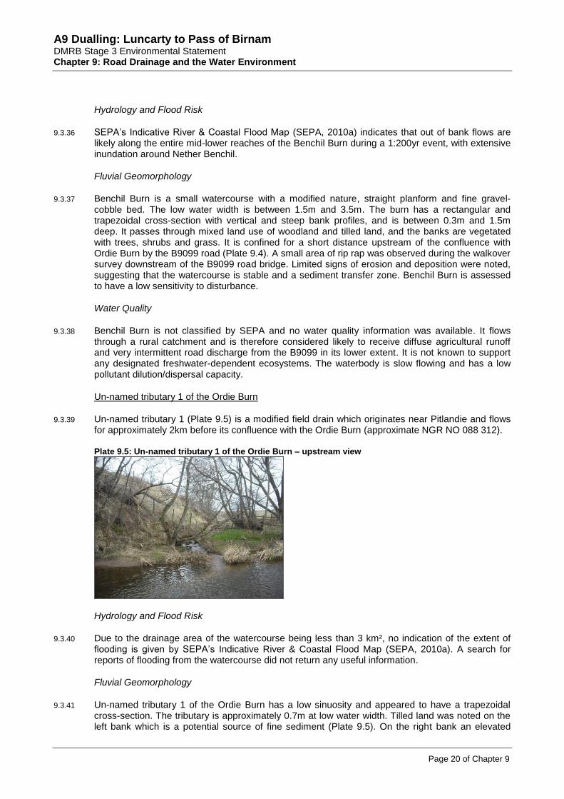
9.3.39 Un-named tributary 1 (Plate 9.5) is a modified field drain which originates near Pitlandie and flows for approximately 2km before its confluence with the Ordie Burn (approximate NGR NO 088 312).
Plate 9.5: Un-named tributary 1 of the Ordie Burn – upstream view
Hydrology and Flood Risk
9.3.40 Due to the drainage area of the watercourse being less than 3 km², no indication of the extent of flooding is given by SEPA’s Indicative River & Coastal Flood Map (SEPA, 2010a). A search for reports of flooding from the watercourse did not return any useful information.
Fluvial Geomorphology
9.3.41 Un-named tributary 1 of the Ordie Burn has a low sinuosity and appeared to have a trapezoidal cross-section. The tributary is approximately 0.7m at low water width. Tilled land was noted on the left bank which is a potential source of fine sediment (Plate 9.5). On the right bank an elevated

A9 Dualling: Luncarty to Pass of Birnam DMRB Stage 3 Environmental Statement Chapter 9: Road Drainage and the Water Environment
Page 21 of Chapter 9
topography was observed, creating an asymmetrical floodplain. The bed substrate was found to be predominantly cobble, with some scattered boulders and some sand. During the survey, the banks appeared vegetated and consequently are assumed to be stable and the channel is assessed as a transfer of sediment. Un-named tributary 1 of the Ordie Burn has been assessed to have a low sensitivity to disturbance.
Water Quality
9.3.42 Un-named tributary 1 of the Ordie Burn is not classified by SEPA and no water quality information was available. It flows through a rural catchment and is therefore considered likely to receive diffuse agricultural runoff and is not known to support any designated freshwater-dependent ecosystems. The waterbody is slow flowing and has a low pollutant dilution/dispersal capacity.
Un-named tributaries 2 and 3 of the Ordie Burn
9.3.43 Un-named tributary 2 (Plate 9.6) is a very short, ephemeral ditch located between the A9 northbound carriageway and the Ordie Burn (confluence at approximate NGR NO 088 313).
9.3.44 Un-named tributary 3 is an ephemeral ditch which originates in the vicinity of a minor road which links Stanley to the A9, and flows in an approximate south direction prior to being culverted under the existing A9. Downstream of the A9, the tributary flows into a pond (Un-named pond 1), and from the outlet, has a short reach before discharging to the Ordie Burn (approximate NGR NO 087 315). Upstream of the A9, the channel is partially open and partially culverted along its reach and currently receives runoff from the natural catchment and side road at its upstream extent. Un-named pond 1 is considered to be an artificial ‘decoy’ pond for wildfowl shooting, which is not believed to receive or to attenuate/treat road drainage from the A9 and has therefore been scoped out of further assessment.
Plate 9.6: Un-named tributaries 2 and 3 of the Ordie Burn
a) Un-named tributary 2 of the Ordie Burn – upstream view b) Un-named tributary 3 of the Ordie Burn – upstream view
Hydrology and Flood Risk
9.3.45 Due to the seasonal nature of flows within the un-named watercourses and the extent of area drained by the watercourses; no indication of flood risk is given by SEPA’s Indicative River & Coastal Flood Map (SEPA, 2010a). However, it is worth noting that on the main branch of the Ordie Burn, inundation is extensive and it is likely that areas within the immediate vicinity would be subject to some degree of flooding during a 1:200yr flood event.
Fluvial Geomorphology
9.3.46 Un-named tributary 2 of the Ordie Burn at the time of survey was found to be a dry, grass-lined, shallow field drain, overgrown with vegetation. The channel is a depression along the foot of a small hill (Plate 9.6a). The predominant land use noted during the walkover survey was tilled fields, within 1m of the channel boundary. Due to the overgrown and shallow nature of the channel it is

A9 Dualling: Luncarty to Pass of Birnam DMRB Stage 3 Environmental Statement Chapter 9: Road Drainage and the Water Environment
Page 22 of Chapter 9
determined to be stable and likely to act as a sediment sink following heavy or prolonged rainfall. It has been assessed to have a low sensitivity to disturbance.
9.3.47 Un-named tributary 3 emerges from an un-named pond and flows a short distance between tilled fields before joining the Ordie Burn. There is a narrow buffer strip (1-3m) between the tilled fields and the burn, but no point sources of sediment were observed (Plate 9.6b). It has a low sinuosity and a shallow bed (approximately 0.4m). The channel is approximately 1m wide and the banks are vegetated with long grass. The bed is comprised of fine and coarse gravel and vegetated with some emergent macrophytes. Broadleaf trees grow along right bank. Limited signs of erosion and deposition were observed during the walkover survey, indicating stability. The tributary was determined to act as a sediment transfer zone. The upstream pond acts as a sediment sink. The un-named tributary 3 of the Ordie burn has been assessed to have a low sensitivity to disturbance.
Water Quality
9.3.48 These minor tributaries of the Ordie Burn are not classified by SEPA and no water quality information was available. Un-named tributaries 2 and 3 are ephemeral and likely to receive field and untreated/partially treated road drainage from the A9 intermittently. The tributaries are slow flowing, or dry, have low pollutant dilution/dispersal capacities and are not known to support any designated freshwater-dependent ecosystems.
Gelly Burn (south)
9.3.49 Gelly Burn (Plate 9.7) originates near Cowford and flows for approximately 5km in an easterly direction until its confluence with the Ordie Burn (approximate NGR NO 085 317).
Plate 9.7: Gelly Burn – view upstream (south)
Hydrology and Flood Risk
9.3.50 SEPA’s Indicative River & Coastal Flood Map (SEPA, 2010a) indicates flooding over both banks of the watercourse along its entire reach. The larger extent of flooding is apparent in the vicinity of its confluence with the Ordie Burn during a 1:200yr flood event.
Fluvial Geomorphology
9.3.51 Gelly Burn (south) has a low sinuosity planform. The surrounding land is tilled, meaning that it is a potential source of sediment. There is a narrow, 2m buffer strip protecting the river against elevated levels of fine sediment from surface runoff. The channel is approximately 1m deep. The banks have a steep profile but are vegetated with grass and trees and there are limited signs of erosion (Plate 9.7). The bed is likely to be a mix of gravels, cobbles and boulders. Boulders and gravel were observed at the confluence with Ordie Burn. No deposition was recorded. The burn has a low to moderate gradient with a run flow. The low flow width is approximately 0.75m – 1m and bankfull width is approximately 2m. The channel appears to be stable and acts as a transfer of sediment. Gelly Burn (south) has been assessed as having a medium sensitivity to disturbance.

A9 Dualling: Luncarty to Pass of Birnam DMRB Stage 3 Environmental Statement Chapter 9: Road Drainage and the Water Environment
Page 23 of Chapter 9
Water Quality
9.3.52 Gelly Burn (south) is not classified by SEPA and no water quality information was available. It flows through a rural catchment and is therefore considered likely to receive diffuse agricultural runoff and is not known to support any designated freshwater-dependent ecosystems. The waterbody is slow flowing and has a low pollutant dilution/dispersal capacity.
Un-named tributaries 4, 5 & 6 of the Ordie Burn
9.3.53 These un-named tributaries of the Ordie Burn (Plate 9.8) have been grouped together for ease of reporting. Un-named tributary 5 and the middle reach of tributary 4 are road drainage ditches along either side of the A9 carriageway in the vicinity of Westwood to the east and East Mains to the west. Un-named tributary 6 and the upper/lower sections of tributary 4 are modified field drainage ditches. Un-named tributaries 5 and 6 flow into un-named tributary 4, which is culverted beneath the A9 (NGR NO 083 327) and an un-named road at Newmill further downstream (NGR NO 084 323), prior to discharging into the Ordie Burn at approximate NGR NO 085 319.
Plate 9.8: Un-named tributaries 4, 5 and 6 of the Ordie Burn
a) Un-named tributary 4 of the Ordie Burn - downstream view east of the A9.
b) Un-named tributary 4 of the Ordie Burn - downstream view west of the A9.
c) Un-named tributary 5 of watercourse – downstream view west of the A9
d) Un-named tributary 6 – upstream view east of the A9
Hydrology and Flood Risk
9.3.54 Due to the drainage area of the watercourses being less than 3 km²; no indication of flood risk is given by SEPA’s Indicative River & Coastal Flood Map (SEPA, 2010a). Anecdotal evidence indicates that during rainfall events, runoff flows down the steep access track from Westwood, in the vicinity of Un-named tributary 4 of Ordie Burn, and leads to surface flooding of the fields adjacent to the A9 carriageway.

A9 Dualling: Luncarty to Pass of Birnam DMRB Stage 3 Environmental Statement Chapter 9: Road Drainage and the Water Environment
Page 24 of Chapter 9
Fluvial Geomorphology
9.3.55 Un-named tributary 4 of Ordie Burn has been modified in a number of ways. It starts on the east side of the A9 near Westwood Farm and flows alongside the farm track and then parallel to the A9 in an over-deep, trapezoidal channel (Plate 9.8a). At its deepest the banks of the river are approximately 2m high. Emerging from A9 culvert the tributary’s cross-section is much smaller (approximately 0.5m by 0.5m) and sinuous. Approximately 200m downstream of the culvert the stream becomes embanked and perched above the field (Plate 9.8b). The channel width increases and gradient decreases, causing sediment to be deposited along the river bed. Land use is predominantly grassland, with one field of tilled land recorded downstream of the A9 culvert. Overall, the tributary has a low gradient and low sinuosity. The bed is comprised of gravel (fine and coarse) and cobble, with an overlay of silt along the channel margins between the A9 culvert and confluence with Ordie Burn. The channel is narrowing through deposition and its primary function is a sediment sink. It has been assessed as having a low sensitivity to disturbance.
9.3.56 Un-named tributary 5 of Ordie Burn is an artificial, deep, trapezoidal, grass and shrub lined roadside ditch flowing parallel to the A9 (Plate 9.8c). The channel is between 1.5 and 2m deep. The low flow width is 0.5m and the bankfull width is approximately 4m. The bed of the river is grass and is silted across the section. At the time of survey little water was observed. Due to the vegetation the channel is stable and with increased flows would probably act predominantly as a sediment sink following rainfall. Un-named tributary 5 of Ordie Burn has been assessed to have a low sensitivity to disturbance.
9.3.57 Un-named tributary 6 of Ordie Burn is a straightened, deep, trapezoidal field ditch which runs perpendicular to the A9 and has a uniform morphology (Plate 9.8d). The channel was observed to be grass lined with little flow at time of survey. There is tilled land either side of the channel with a narrow buffer strip (approximately 1m wide) composed of grass and a single tree line on the left bank. The channel appears stable with no signs of erosion or deposition. The amount of flow following a rainfall event will however, affect the function of the watercourse. The primary function would be a sediment sink because it is grass lined and the hydraulic roughness would slow low to moderate flows resulting in sediment deposition. However, if there are very high flows then this would cause the watercourse to act as a sediment transfer zone. Due to its modified nature, the un-named tributary 6 of Ordie Burn has been assessed to have a low sensitivity to disturbance.
Water Quality
9.3.58 These minor tributaries of the Ordie Burn are not classified by SEPA and no water quality information was available. Un-named tributaries 4 and 5 are likely to receive road drainage from the A9 and un-named tributary 6 and the upper/lower sections of tributary 4 are considered likely to receive diffuse agricultural runoff from the rural catchment. Den Quarry, historically used for mineral abstraction, is located at the upstream extent of un-named tributary 4. Refer to Chapter 8 (Geology, Contaminated Land and Groundwater) for further information on potential sources of contamination. These tributaries are not known to support any designated freshwater-dependent ecosystems, are slow flowing and have low pollutant dilution/dispersal capacities.
9.3.59 The Atkins Stage 2 Report (2009) identified a private surface water abstraction at Newmill Farm, in the vicinity of un-named tributary 4 of the Ordie Burn (approximate NGR NO 085 322).
Garry Burn
9.3.60 Garry Burn (Plate 9.9) is approximately 13km in length and originates in Obney Hills, approximately 6km north-west of Bankfoot. It follows a steep course from its source to Bankfoot and joins the Ordie Burn to the south of Bankfoot near the Bankfoot STW (approximate NGR NO 071 334). Downstream of Bankfoot, the watercourse runs in a channel located in close proximity to the toe of the current northbound A9 embankment. It has a predominantly rural catchment area of approximately 23.1km
2 at its confluence with the Ordie Burn.

A9 Dualling: Luncarty to Pass of Birnam DMRB Stage 3 Environmental Statement Chapter 9: Road Drainage and the Water Environment
Page 25 of Chapter 9
Plate 9.9: Garry Burn
a) Garry Burn - downstream view through Bankfoot b) View of Garry Burn downstream of the B867
Hydrology and Flood Risk
9.3.61 SEPA’s Indicative River & Coastal Flood Map (SEPA, 2010a) shows that a narrow corridor of land along the entire length of Garry Burn is likely to be affected by fluvial flooding during a 1:200yr flood event. The inundation affects a much wider area along both banks of the Garry Burn through the town of Bankfoot and the reach downstream along the current A9 embankment. The presence of significant inundation in the floodplain in the immediate vicinity of the current A9 embankment necessitates a detailed investigation of the extent of the area affected by flooding during a 1:200yr flood event and the proposed widening of the embankment using a mathematical model of the Garry Burn in order to assess the potential impact on the current levels of floodplain storage.
Fluvial Geomorphology
9.3.62 Upstream and downstream of Bankfoot, the Garry Burn flows through tilled arable and rough pasture fields. Through Bankfoot the burn is surrounded by houses and gardens (Plate 9.9a), and some localised areas of erosion were observed during the survey. The burn has a low sinuosity and has been deepened (up to 2m) and re-profiled to have a trapezoidal cross-section. The low flow width is approximately 3m and bankfull width is approximately 5m. The flow capacity has increased due to the deepening, which has also reduced floodplain connectivity to protect houses from flooding. The bed comprises mixed substrate from gravel to large cobbles, with some silt and sand along margins. The banks are composed of a sand and clay mix, with a low cohesion. The banks have been stabilised with stone walls, rip rap, gabion baskets and trees and shrubs.
9.3.63 Downstream of Bankfoot the channel depth reduces and the bank profiles are less steep. However, an embankment along the left bank reduces floodplain connectivity. Berms (permanent vegetated sediment deposits) have developed along the margins of the channel (Plate 9.9b), causing it to narrow (to approximately 2m). Bankfull width is still approximately 5m. Varied flow types were observed during the walkover survey, but was predominantly runs with some faster sections of unbroken standing waves. The channel appears to be stable, having adjusted to historic modifications and it acts primarily as a sediment transfer zone. Garry Burn is assessed to have a medium sensitivity to disturbance which takes into consideration the historical modifications and bank protection whilst meriting the recovery of morphological diversity through natural adjustments.
Water Quality
9.3.64 SEPA classified the Garry Burn as having an overall status of ‘Good’ in 2008. No existing pressures have been identified by SEPA on this waterbody (SEPA, 2011). However, based on surrounding land use, the Garry Burn is considered likely to receive untreated/partially treated road drainage from the A9 and other minor roads, including the B867 and roads within Bankfoot, and in its upstream and downstream reaches, may also receive diffuse agricultural runoff from the rural catchment. The watercourse may also receive polluted runoff from works located immediately west of the A9 (approximate NGR NO 072 347). Refer to Chapter 8 (Geology, Contaminated Land and Groundwater) for further information on potential sources of contamination.

A9 Dualling: Luncarty to Pass of Birnam DMRB Stage 3 Environmental Statement Chapter 9: Road Drainage and the Water Environment
Page 26 of Chapter 9
9.3.65 The DMRB Stage 2 Report (Atkins, 2009) identified one existing discharge consent to the Garry Burn within the study area granted to a private household at Loakmill (approximate NGR NO 075 339). The waterbody has a moderate flow and has a low/medium pollutant dilution/dispersal capacity.
9.3.66 As discussed above, the Garry Burn is a tributary of the River Tay. The River Tay, together with its associated tributaries, is designated as a SAC and salmonid waters (SEPA, 2011). Fish surveys along the Garry Burn in summer 2013 identified a number of migratory species including lamprey and eel. Refer to Chapter 10 (Ecology and Nature Conservation) for further details.
Un-named ponds 2 & 3
9.3.67 These two surface waterbodies have been grouped together for ease of reporting. Un-named ponds 2 and 3 are SUDS ponds and collect road drainage from sections of the A9 and the B867. Treated road drainage from both ponds discharge into the Garry Burn. Refer to Chapter 10 (Ecology and Nature Conservation) for further information on these ponds.
Hydrology and Flood Risk
9.3.68 SEPA’s Indicative River & Coastal Flood Map (SEPA, 2010a) shows that during a 1:200yr flood event, the areas where un-named ponds 2 & 3 are sited may be subject to flood water inundation. Whilst Pond 3 appears to be sited slightly outwith the reported flood risk area, un-named pond 2 sited north of the settlement of Loak lies within an area reported to be at risk from flooding.
Fluvial Geomorphology
9.3.69 No geomorphological assessments of ponds were undertaken.
Water quality
9.3.70 These un-named ponds are not classified by SEPA and no water quality information was available. Their primary function is to treat and attenuate road runoff prior to discharge to the Garry Burn and they are therefore considered to have a high pollutant dilution/dispersal capacity. These features are not known to support any designated freshwater-dependent ecosystems.
Ardonachie Burn
9.3.71 Ardonachie Burn (Plate 9.10) is a small watercourse, approximately 2.6km in length and originates near the southern boundary of Cairnleith Moss. It flows in a south-easterly direction for approximately 1.5km and then continues in a westerly direction until its confluence with the Garry Burn, immediately downstream of the A9 crossing to the south of Bankfoot (approximate NGR NO 072 348). It has a rural catchment area of approximately 1.7km
2 at its crossing by the A9 culvert.
Plate 9.10: Ardonachie Burn
a) Ardonachie Burn – downstream view with Cairnleith Moss in the background
b) Ardonachie Burn - downstream view with the A9 in the background

A9 Dualling: Luncarty to Pass of Birnam DMRB Stage 3 Environmental Statement Chapter 9: Road Drainage and the Water Environment
Page 27 of Chapter 9
Hydrology and Flood Risk
9.3.72 SEPA’s Indicative River & Coastal Flood Map (SEPA, 2010a) does not indicate a risk of fluvial flooding for this watercourse possibly due to its catchment area being smaller than 3.0km
2.
Currently there is no other evidence of past flooding along the Ardonachie Burn. The existing A9 culvert would be significantly surcharged in the 1:200yr flood event.
Fluvial Geomorphology
9.3.73 Ardonachie Burn is a small watercourse with an approximate width of 0.5m upstream of the A9. It originates in moorland near Cairnleith Moss. Where the burn originates, the channel is overgrown with vegetation, comprising mainly long grasses and shrubs (Plate 9.10a). There is little flow and the burn is likely to act as a sediment sink. The burn has an overall low sinuosity. Upstream of the A9 the burn has a low sinuosity low flow channel within a straightened and embanked high flow channel (Plate 9.10b). The depth of the bankfull channel is approximately 0.75m (embankment 0.5m). The burn has a low gradient through the rough pasture field to the east of the A9. The field is grazed by horses and was observed to have signs of trampling which is a source of fine sediment. There is a small marshy area of floodplain around the inlet of the A9 culvert. The bed is composed of gravel, cobble and silt bed. Overall the channel is stable and acts as a transfer of sediment. Ardonachie Burn has been assessed to have a low sensitivity to disturbance.
Water quality
9.3.74 Ardonachie Burn is not classified by SEPA and no water quality information was available. It flows through a rural catchment and is therefore considered likely to receive diffuse agricultural runoff and possibly road discharge from the A9 in its lower extent. Craig Quarry, historically used for mineral abstraction, is located immediately adjacent to the watercourse upstream of the A9. Refer to Chapter 8 (Geology, Contaminated Land and Groundwater) for further information on potential sources of contamination. It is not known to support any designated, freshwater-dependent ecosystems. The waterbody is slow flowing and has a low pollutant dilution/dispersal capacity.
Corral Burn
9.3.75 Corral Burn (Plate 9.11) flows for approximately 5km from its source near Muirheadston in a south-easterly direction to its confluence with the Garry Burn at approximate NGR NO 070 351. Its upstream catchment is predominantly rural and downstream it has been artificially straightened through Bankfoot to its confluence.
Plate 9.11: Corral Burn
View across residential garden to Corral Burn which has been reinforced with brick wall

A9 Dualling: Luncarty to Pass of Birnam DMRB Stage 3 Environmental Statement Chapter 9: Road Drainage and the Water Environment
Page 28 of Chapter 9
Hydrology and Flood Risk
9.3.76 SEPA’s Indicative River & Coastal Flood Map (SEPA, 2010a) shows the floodplain areas over both banks of the watercourse are likely to be affected by inundation during a 1:200yr flood event, and historical records indicate that it has overtopped the banks at Bankfoot. It appears that the extent of inundation would be larger at reaches where channelisation has occurred.
Fluvial Geomorphology
9.3.77 Corral Burn is a major tributary of Garry Burn. Through the study area it is a modified channel that flows through the village of Bankfoot. The burn has been deepened (to approximately 1m) to reduce floodplain connectivity, and has a rectangular and trapezoidal cross-section. The banks have been reinforced with concrete, stone and brick walls or have been re-profiled through residential gardens (Plate 9.11). The natural banks are composed of earth (clay/sand mix) and cobbles, and are vegetated with grass, shrubs and trees. The burn has a gravel, cobble and rubble bed and there are some submerged linear macrophtyes growing. The channel width is approximately 2.5m-3m. The flow type was found during the walkover survey to be varied, namely a slow run (rippled flow) and glide sequence. As a result of the modifications and confinement the burn is stable and acts predominantly as a sediment transfer zone, with localised areas of erosion. Corral Burn has been assessed to have a low sensitivity to disturbance.
Water quality
9.3.78 The Corral Burn is not classified by SEPA and no water quality information was available. The majority of its upper and middle reaches flow through a rural catchment and is therefore considered likely to receive diffuse agricultural runoff. Downstream, it flows through Bankfoot and is considered likely to receive road runoff from a number of roads including the B867. The waterbody is slow flowing and has a low pollutant dilution/dispersal capacity.
9.3.79 The Corral Burn is a tributary of the River Tay. Although it does not share the designation of a SAC, the Corral Burn is designated as salmonid waters (SEPA, 2011). However, as discussed in Section 9.2 (Approach and Methods), the sensitivity of the burn in terms of water quality is likely to be more influenced by its highly modified nature and its route through an urban catchment in its downstream extent.
Un-named tributaries 1, 2 & 3 of the Gelly Burn (north)
9.3.80 Un-named tributaries 2 and 3 (Plate 9.12) flow east and are culverted beneath the A9 in circular pipe culverts of approximately 0.6m and 1m diameters, respectively. Un-named tributary 1 originates immediately east of the A9. Both un-named tributaries 1 and 2 flow through woodland to the south of Gelly Burn and join the Gelly Burn at approximate NGR NO 071 373, approximately 250m east of the A9. Un-named tributary 3 flows through recently felled woodland upstream of the A9, and dense woodland downstream of the A9 towards the confluence with the Gelly Burn (north) at approximate NGR NO 075 374.
Hydrology and Flood Risk
9.3.81 The banks of un-named tributaries which feed into the Gelly Burn are not shown as being inundated during a 1:200yr flood event in SEPA’s Indicative River & Coastal Flood Map (SEPA, 2010a); due to their respective catchments being less than the 3km² threshold. Inundation of the floodplain is reported as likely at the confluence by Douglasfield and extending to the downstream confluence with the River Tay.
Fluvial Geomorphology
9.3.82 Un-named tributary 1 of Gelly Burn (north) originates to the east of the A9. The vegetated road side ditch/swale along the east side of the A9 flows into the burn following periods of heavy or prolonged rainfall. The channel is between 1.5m and 1.75m and between 0.5m and 0.75m deep. It

A9 Dualling: Luncarty to Pass of Birnam DMRB Stage 3 Environmental Statement Chapter 9: Road Drainage and the Water Environment
Page 29 of Chapter 9
has a straight planform and the bed and banks are composed of peat (Plate 9.12a). The tributary flows through mixed woodland, predominantly comprising conifer trees. Due to the vegetation and limited signs of erosion, the channel appears stable. The low gradient, vegetated banks and peaty/silty bed all indicate that the tributary is a sediment sink. The un-named tributary 1 of Gelly Burn has been assessed to have a low sensitivity to disturbance.
Plate 9.12: Un-named tributaries 1, 2 & 3 of the Gelly Burn (north)
a) Gelly Burn tributary 1 - downstream view to the east of A9. b) Gelly Burn tributary 2 - downstream to the west of A9.
c) Gelly Burn tributary 2 – downstream view to the east of A9. d) Gelly Burn tributary 3 - upstream view to the west of A9
9.3.83 Un-named tributary 2 of Gelly Burn (north) originates as an undefined channel which becomes more defined towards the inlet of the A9 culvert. The tributary has a straight planform. Once defined the channel increases to 2.25m and has a varied depth between 0.40 and 0.75m deep. The shallow banks have a vertical profile. The bed and banks are composed of peat apart from the concrete culvert under the A9. Upstream (west) of the A9 the land use on the left of the channel is rough pasture/moorland and broadleaf woodland on the right bank (Plate 9.12b). Downstream (east) of the A9 the watercourse flows through a predominantly conifer woodland (Plate 9.12c). No perceptible flow was observed at the time of survey. The A9 road drainage (swales) feed into the stream and these would increase the amount of flow in the burn during periods of heavy or prolonged rainfall. Due to the vegetation and limited signs of erosion the channel appears stable. The low gradient, vegetated channel cross-section and peaty/silty bed indicates the channel is a sink of sediment. The un-named tributary 2 of Gelly Burn has been assessed to have a low sensitivity to disturbance.
9.3.84 To the west of the A9 the land surrounding un-named tributary 3 has been deforested and the tributary has been stripped of vegetation and excavated (Plate 9.12d). The burn has a trapezoidal cross-section with exposed bank material, with a straight channel with steep bank faces. The low flow width of the channel is approximately 0.60m and bankfull width is approximately 1.75m. The depth of the channel is between 1.50m and 1.75m. The banks are a mixture of peat, clay and sand. The bed of the river is composed of fine sediment, namely silt, clay and some fine gravel. This section of the burn is a sediment source. The burn has a uniform morphology. Downstream, to the east of the A9, the channel also has a straight planform, however, the channel is completely vegetated with grass, shrubs and trees. The low flow width of the channel is approximately 0.4m and the bankfull width is 0.6m. The bed is peaty and vegetated. The channel still has low

A9 Dualling: Luncarty to Pass of Birnam DMRB Stage 3 Environmental Statement Chapter 9: Road Drainage and the Water Environment
Page 30 of Chapter 9
morphological diversity and is stable. Due to the vegetation it is likely to be a sediment sink. The un-named tributary 3 of Gelly Burn has been assessed to have a low sensitivity to disturbance.
Water quality
9.3.85 These minor tributaries of the Gelly Burn are not classified by SEPA and no water quality information was available. Located within a wooded and peaty catchment, the waters are likely to have an enriched nutrient content, and in addition, may receive road drainage from the A9 in their upper reaches. These tributaries are not known to support any designated freshwater-dependent ecosystems, are slow flowing and have a very low pollutant dilution/dispersal capacity.
Gelly Burn (north)
9.3.86 The Gelly Burn (north) (Plate 13) originates near Gelly to the west of the A9. After flowing east for a short distance it is culverted beneath the A9 in an approximate 0.9m diameter culvert and then flows in a north-easterly direction to its confluence with the River Tay at approximate NGR NO 095 395. It has a rural upstream catchment of approximately 0.16km
2 at the A9 embankment.
However, its natural catchment is likely to include a much larger area including the lower slopes of Obney Hills and Gelly Wood to the west.
Plate 9.13: Gelly Burn (north)
a) Gelly Burn – upstream view to the west of A9. b) Gelly Burn - downstream view to the east of A9
Hydrology and Flood Risk
9.3.87 SEPA’s Indicative River & Coastal Flood Map (SEPA, 2010a) indicates a risk of fluvial flooding at the downstream extent of Gelly Burn. Floodplain inundation during a 1:200yr flood event is likely to extend from the confluence by Douglasfield to the downstream confluence with the River Tay.
Fluvial Geomorphology
9.3.88 Gelly Burn has a low sinuous planform and a peaty grass lined cross-section. The right bank is continuously reinforced with a stone wall and has a vertical profile, with the left bank having a steep profile. The depth of the channel is approximately 1m and the bed is composed of fine substrate, typically peat and silt, although some gravels were present. The low flow width is approximately 1.2m and bankfull width is approximately 1.6m. Upstream of the A9 the burn is surrounded by rough pasture/moorland (Plate 9.13a). Downstream of the A9 there is rough pasture on left bank and conifer woodland on right bank (Plate 9.13b). There was little flow in the channel at the time of survey. The vegetated bank faces and limited signs of erosion and deposition indicate that the channel is stable. The tall vegetation acts as a sink for fine sediment due to increased hydraulic roughness. Due to the vegetated cross-section and continuous stone lining Gelly Burn has been assessed to have a low sensitivity to disturbance.
Water Quality
9.3.89 The Gelly Burn is not classified by SEPA and no water quality information was available. Located within a rural and peaty catchment, the water is likely to have an enriched nutrient content and be

A9 Dualling: Luncarty to Pass of Birnam DMRB Stage 3 Environmental Statement Chapter 9: Road Drainage and the Water Environment
Page 31 of Chapter 9
affected by diffuse agricultural runoff. It may also receive road drainage from the A9 and other minor roads in its upper and lower reaches. The waterbody is modified and ephemeral in nature and is not known to support any designated freshwater-dependent ecosystems.
9.3.90 The Gelly Burn is a tributary of the River Tay, although it does not share any of the ecological designations with the larger watercourse.
Broomhill Burn
9.3.91 Broomhill Burn (Plate 14) is a small watercourse of approximately 3km in length and is a tributary of the Gelly Burn (north). It originates in a dense vegetated / wooded area near Saddle Stone, and after flowing east for a short distance, is culverted beneath the A9 in a small diameter circular concrete culvert (approximate NGR NO 067 378). It continues to flow through woodland areas in a north-easterly direction for approximately 2.5km to its confluence with the Gelly Burn (approximate NGR NO 089 385) near Douglasfield and flows into the River Tay near the village of Gellyburn. It has a rural catchment area of approximately 0.21km
2 upstream of the existing A9 embankment.
Plate 9.14: Broomhill Burn
a) Broomhill Burn – upstream view to the west of A9. b) Broomhill Burn - downstream view to the east of A9
Hydrology and Flood Risk
9.3.92 SEPA’s Indicative River & Coastal Flood Map (SEPA, 2010a) indicates a risk of fluvial flooding for the Broomhill Burn from the point of its confluence with the Gelly Burn and extending approximately 1.5km downstream to the Gelly Burn – River Tay confluence.
Fluvial Geomorphology
9.3.93 Broomhill Burn is a largely undefined peaty channel to the west of the A9. The channel is overgrown with tall moorland vegetation (Plate 9.14a). There are pockets of conifer woodland. To the east of the A9, Broomhill Burn flows through dense mixed woodland. Where accessible the burn has an overdeepened, trapezoidal cross-section, with a low flow width of 1m and a bankfull width between 2m and 3m (Plate 9.14b). The burn is approximately 1.6m to 1.8m deep. The burn has a coarse gravel and peaty bed. Several hundred metres downstream of the A9 there have been many drainage ditches dug within the mixed woodland, creating a source of sediment. Overall the channel is stable and due to the tall vegetation acts primarily as a sink for sediment. Broomhill Burn has been assessed to have a low sensitivity to disturbance.
Water Quality
9.3.94 Broomhill Burn is not classified by SEPA and no water quality information was available. Located within a wooded and peaty catchment, the water is likely to have an enriched nutrient content and may receive road drainage from the A9 in its upper reaches. This watercourse is not known to support any designated freshwater-dependent ecosystems, is slow flowing and has a low pollutant dilution/dispersal capacity.

A9 Dualling: Luncarty to Pass of Birnam DMRB Stage 3 Environmental Statement Chapter 9: Road Drainage and the Water Environment
Page 32 of Chapter 9
Birnam Burn
9.3.95 Birnam Burn (Plate 15) is a small tributary of the River Tay, originating in a marshy area and flowing through a series of lochs (Stare Dam and Rohallion Loch to the west, and Mill Dam SSSI to the east) before flowing north-east beneath the existing A9 and Byres of Murthly Sawmill, and outfalling to the River Tay (approximate NGR NO 057 395). The upstream loch closest to the proposed scheme (Mill Dam) is a designated SSSI due to species-rich basin fen (refer to Chapter 10: Ecology and Nature Conservation). The Mill Dam SSSI is considered to be fed by both ground and surface water inputs and the lochs are considered to be hydrologically linked. Historically, the Mill Dam SSSI was artificially impounded by an earth dam and sluice to serve the mills at Murthly.
Plate 9.15: Birnam Burn
Upstream view of the culvert at Woodmill.
Hydrology and Flood Risk
9.3.96 SEPA’s Indicative River & Coastal Flood Map (SEPA, 2010a) indicates a risk of fluvial flooding for the Birnam Burn from its confluence with the River Tay and extending approximately 1km upstream to Byres of Murthley and including a reach of the river crossed by the A9 carriageway.
Fluvial Geomorphology
9.3.97 Birnam Burn has been extensively straightened downstream of Mill Dam and realigned to run alongside field and road boundaries. The realignment continues downstream of the saw mill until the burn enters a steep wooded valley. The burn is likely to have an artificial trapezoidal profile within the realigned section (a geomorphological site visit was not made). The burn becomes more sinuous downstream within the wooded valley and is likely to have a greater diversity of flow types. Land use within the valley is broadleaf woodland and coniferous plantation until its confluence with the River Tay. The burn is culverted under tracks, rail and roads (see Plate 9.15). The photo shows gravel/pebble channel substrate with exposed cobbles. Flow types include runs and glides.
Water Quality
9.3.98 Birnam Burn is not classified by SEPA and no water quality information was available. Located within a rural and predominantly wooded catchment, the water is likely to have an enriched nutrient content. It may also receive road drainage from the A9 as well as contaminated runoff from the Byres of Murthly Sawmill. It is not known to support any designated freshwater-dependent ecosystems. However, the Mill Dam supports habitat and flora species of conservation importance (refer to Chapter 10: Ecology and Nature Conservation). The burn has a low pollutant dilution/dispersal capacity, likely to be exacerbated by upstream impoundment in the lochs.
9.3.99 Despite being a tributary of the River Tay, the Birnam Burn does not share the designation of a SAC or salmonid waters (SEPA, 2011).

A9 Dualling: Luncarty to Pass of Birnam DMRB Stage 3 Environmental Statement Chapter 9: Road Drainage and the Water Environment
Page 33 of Chapter 9
Un-named tributary of the River Tay
9.3.100 This small tributary of the River Tay originates near Byres of Murthly and flows for approximately 2.5km in an easterly direction, through a reservoir, before flowing north-east to its confluence with the River Tay at approximate NGR NO 073 403. It has a predominantly rural catchment area of approximately 1.17km
2 at its confluence with the River Tay.
Hydrology and Flood Risk
9.3.101 SEPA’s Indicative River & Coastal Flood Map (SEPA, 2010a) indicates a risk of fluvial flooding on the un-named watercourse extending along a 0.5km reach upstream from its confluence with the River Tay. Inundation of the floodplain during a 1:200yr flood event is likely to extend from the confluence with the River Tay and including the grounds at Murthly Castle.
Fluvial Geomorphology
9.3.102 This tributary originates in a wooded valley composed of broadleaf woodland and coniferous trees and flows into a reservoir. Downstream of the reservoir the valley opens out and the burn is straightened alongside field boundaries with broadleaf woodland on the right bank and improved grassland on the left bank. The burn retains an artificial realigned planform through the grounds of Murthly Castle to its confluence with the River Tay with improved grassland on both banks. Immediately upstream of the confluence, the land use returns to broadleaf woodland.
Water Quality
9.3.103 This un-named tributary of the River Tay is not classified by SEPA and no water quality information was available. It flows through a rural and wooded catchment and is therefore considered likely to receive diffuse agricultural runoff and is not known to support any designated freshwater-dependent ecosystems. It may also receive road drainage from the A9. The waterbody is slow flowing and has a low pollutant dilution/dispersal capacity. Despite being a tributary of the River Tay, it does not share the designation of a SAC or salmonid waters (SEPA, 2011).
Existing Road Drainage Network
9.3.104 The main watercourses currently receiving road drainage from this section of the A9 include the Shochie Burn, Ordie Burn, Garry Burn, Un-named drain 4 and Un-named tributary 2 of the Gelly Burn (north). Un-named drain 4 is an ephemeral drainage ditch, which drains towards the Cairnleith Moss Site of Special Scientific Interest (SSSI). Contaminated road runoff may therefore discharge to the SSSI during and after heavy rainfall periods. The SSSI is designated for its extensive area of lagg fen which surrounds a raised bog and has been assessed as a groundwater-dependent terrestrial ecosystem. Refer to Chapter 10 (Ecology and Nature Conservation) for further information on Cairnleith Moss SSSI.
9.3.105 The existing drainage arrangement includes some isolated areas of treatment prior to outfall to certain watercourses. Where the existing A9 is in cutting, runoff from cut slopes is conveyed via filter drains situated along the carriageway verge, which provides a limited amount of filtration prior to runoff discharging to a watercourse. As discussed above, Un-named ponds 2 and 3 are SUDS ponds. Un-named pond 2 receives road runoff from the A9 and a short section of the B867 road. Un-named pond 3 receives road drainage from the A9 carriageway and a short section of Bankfoot Junction. Treated road drainage from both SUDS ponds currently outfalls to the Garry Burn.
Summary of Waterbody Sensitivities
9.3.106 Table 9.6 summarises the importance/sensitivity of each attribute of a surface waterbody, identified within the study area, using the criteria outlined in Table 9.1 and DMRB HD 45/09 guidance.

A9 Dualling: Luncarty to Pass of Birnam DMRB Stage 3 Environmental Statement Chapter 9: Road Drainage and the Water Environment
Page 34 of Chapter 9
Table 9.6: Sensitivity/Importance of each Attribute of Surface Waterbodies
Waterbody Sensitivity/Importance
Hydrology and Flood Risk
Fluvial Geomorphology
Water Quality
Water Quality Dilution and Removal of Waste Products
Biodiversity Water Supply
River Tay High High Very High High Very High Very High
Shochie Burn Low High Very High Medium Very High Low
Un-named tributary of Shochie Burn Low Low Medium Low Low Low
Ordie Burn Medium High Very High Medium Very High Low
Benchil Burn Medium Low Medium Low Low Low
Un-named tributary 1 of Ordie Burn Low Low Medium Low Low Low
Un-named tributary 2 of Ordie Burn Low Low Low Low Low Low
Un-named tributary 3 of Ordie Burn Low Low Low Low Low Low
Gelly Burn (south) Low Medium Medium Low Low Low
Un-named tributary 4 of Ordie Burn Medium Low Low Low Low Medium
Un-named tributary 5 of Ordie Burn Low Low Low Low Low Low
Un-named tributary 6 of Ordie Burn Low Low Low Low Low Low
Garry Burn Medium Medium Very High Medium Very High Low
Un-named pond 2 Low N/A Low High Low Low
Un-named pond 3 Low N/A Low High Low Low
Ardonachie Burn Low Low Medium Low Low Low
Corral Burn Medium Low Medium Low Low Low
Un-named tributary 1 of Gelly Burn (north) Low Low Low Low Low Low
Un-named tributary 2 of Gelly Burn (north) Low Low Low Low Low Low
Un-named tributary 3 of Gelly Burn (north) Low Low Low Low Low Low
Gelly Burn (north) Low Low Low Low Low Low
Broomhill Burn Low Low Medium Low Low Low
Birnam Burn Low Low Medium Low Medium Low
Un-named tributary of the River Tay Low Low Medium Low Low Low

A9 Dualling: Luncarty to Pass of Birnam DMRB Stage 3 Environmental Statement Chapter 9: Road Drainage and the Water Environment
Page 35 of Chapter 9
9.4 Potential Impacts
Introduction
9.4.1 This section describes potential impacts on the water environment that could arise in the absence of mitigation, during both construction and operational phases of the proposed scheme. Residual impacts taking into account the proposed mitigation are provided in Section 9.6 and Appendix A9.4 (Residual Impacts). Details of the proposed scheme are provided in Chapter 4 (The Proposed Scheme) and the key construction works on or near each waterbody is summarised in Table 9.8 below. Proposals and justification for watercourse crossing extensions are provided in Appendix A9.5 (Watercourse Crossings).
9.4.2 Generic potential impacts are described, followed by specific impacts on water features, firstly during the construction and then the operational phases of the proposed scheme. Potential impacts on the water environment are described separately for each of the three specialist disciplines/attributes, as detailed in Section 9.2 (Approach and Methods). The results of the HAWRAT water quality assessment are presented at the end of this section.
9.4.3 Due to the distance of some waterbodies from the proposed scheme or as a result of the proposed scheme drainage design, no potential impacts are identified for the following features and these are therefore not considered further:
Un-named tributary of the Shochie Burn;
Benchil Burn;
Un-named tributaries 1 and 2 of Ordie Burn;
Gelly Burn (south);
Un-named tributary 5 of Ordie Burn (road widening on east side of carriageway only in this location and therefore not anticipated to be affected);
Un-named tributary 6 of Ordie Burn (taken into pre-earthwork drainage);
Un-named ponds 2 and 3 (to be in-filled by earthworks and proposed scheme footprint);
Corral Burn;
Birnam Burn; and
Un-named tributary of the River Tay.
Generic Construction Impacts
Hydrology and Flood Risk
9.4.4 Potential impacts during construction of the proposed scheme could include soil compaction from works traffic, alteration of runoff pathways, dewatering of watercourses and increased flood risk.
9.4.5 Temporary haul roads may cause a temporary increase in runoff due to reduced infiltration rates in the area of the road.
9.4.6 The construction phase of the project could result in alterations to the hydrological and flood regimes of receiving watercourses. Temporary discharge of working area drainage may also have an impact on the sediment regime of the receiving watercourse. During the construction phase, other temporary works that could affect surface hydrology and flood risk include the following:
watercourse diversions to facilitate culvert and bridge construction and may result in constrictions in conveyance; and
runoff control measures (temporary, during works), which could include swales and geotextile-wrapped straw bale barriers.

A9 Dualling: Luncarty to Pass of Birnam DMRB Stage 3 Environmental Statement Chapter 9: Road Drainage and the Water Environment
Page 36 of Chapter 9
9.4.7 The severity of the impacts is likely to be higher during periods of intense or prolonged rainfall. Construction materials and plant within the floodplain of watercourses may increase localised flood risk and could be damaged during a flood event. In addition, flood risk could be heightened by works in the floodplain, either constraining or resulting in a temporary loss of the existing floodplain.
Fluvial Geomorphology
9.4.8 Potential impacts during the construction phase mostly relate to suspended solids. In addition, weather conditions would also influence the severity of impacts. The majority of these impacts would worsen with intense or prolonged rainfall events during the construction phase.
9.4.9 Table 9.7 outlines potential generic impacts on the geomorphology during the construction of the proposed scheme. The main potential impacts relate to an increase in fine sediment delivery, a reduction in morphological diversity and a change in natural fluvial processes of river channels.
Table 9.7: Potential Impacts on Geomorphology during the Construction Phase
Source of Impact Potential Impacts
Suspended Solids
Increased fine sediment supply to watercourses may result from runoff, construction and operation of temporary roads, plant and vehicle washing, excavations, earthworks and excavations.
Sediment Regime
A possible increase in turbidity and siltation may occur.
Channel Morphology
A reduction in diversity of the channel bed due to smothering by fine sediment as a result of increased fine sediment supply. The ecology of gravel bed channels could also be affected.
Natural Fluvial Processes
Loss of active features such as exposed gravel deposits due to smothering by fine sediment and subsequent vegetation colonisation could result. Increased sediment delivery may impact on any sites of ecological importance located downstream.
Vegetation Clearance
May reduce river channel stability, increasing the potential for erosion and sediment release. Likely to be greatest where vegetation clearance is required on slopes and particularly where woodland clearance is required.
Sediment Regime
An increase in supply of fine sediment through bank instability, especially during the winter months is likely.
Channel Morphology
Reduced morphological diversity due to loss of tree roots and/or woody debris. Woody debris within the channel can encourage the formation of different geomorphological features such as riffles, deposits and pools. In addition, smothering of the bed by silt as a result of increased fine sediment supply can cause a loss in the morphological diversity of the bed.
Natural Fluvial Processes
Vegetation clearance may reduce river bank stability, increasing the rates of erosion which can increase the rate at which channel changes shape in response to flow variation. Increased sediment delivery may impact on any sites of ecological importance located downstream.
Culvert Installation
The watercourse crossings would involve culverting.
Sediment Regime
Installation would increase the volume of sediment directly entering the channel and consequently increase turbidity.
Channel Morphology
Channel bed would be disturbed or destroyed in the vicinity of the installation.
Natural Fluvial Processes
Planform change may be constrained at the site of culvert installation. Planform change may increase downstream, through erosion and deposition, due to increased sediment supply.
The prevention of channel migration may have adverse consequences for both WFD (2000/60/EC) targets and habitat diversity.
Channel Realignment
Realignment proposed for un-named tributary 4 of Ordie Burn, un-named tributary 3 of Gelly Burn and Broomhill Burn (vertical only).
Sediment Regime
An increase in sediment supply would occur during cutting a new course. A subsequent increase in channel erosion is likely if the channel is straightened and gradient is increased. Sediment may be introduced from accidental damage to river banks or watercourses resulting from plant movement or other construction activities.
Channel Morphology
Bedforms that have developed over a long period of time may be disturbed or destroyed. Without mitigation, the new channel would lack morphological diversity. The reduction of morphological diversity may have adverse consequences for both WFD (2000/60/EC) targets and habitat diversity.
Natural Fluvial Processes
Channel instability may be triggered by straightening, particularly during high flows.

A9 Dualling: Luncarty to Pass of Birnam DMRB Stage 3 Environmental Statement Chapter 9: Road Drainage and the Water Environment
Page 37 of Chapter 9
Source of Impact Potential Impacts
Outfalls
The construction of outfalls within the banks of watercourses may lead to sediment release.
Sediment Regime
Installation could increase the volume of sediment directly entering the channel and consequently cause an increase in turbidity.
Channel Morphology
Construction activities may lead to localised modifications to the channel morphology although this is likely to be highly site-specific.
Natural Fluvial Processes
The stability of the river banks may be reduced during installation leading to the potential for higher rates of erosion. This is likely to be highly site-specific.
Water Quality
9.4.10 Although effects on water quality are likely to be short-term and acute during the construction phase, they could have a longer term chronic effect on aquatic ecology and groundwater resources.
9.4.11 During the construction phase, pollution from mobilised suspended solids from construction sites would present the greatest risk to the water quality of watercourses. In particular, suspended solids found in construction site runoff can lower the chemical or ecological quality of a watercourse. The effects of sedimentation can be felt at various locations along a river, for example, larger particles would be deposited on the stream bed closer to the source of pollution than finer sediments, which can be transported further and affect distant, downstream sections.
9.4.12 Runoff from construction sites can also contain toxic elements, which could have adverse effects on in-stream flora and fauna. Such toxic elements may build up on the stream bed and remain in situ for some time before they are degraded or dispersed. There would also be a risk from accidental spillage of fuels, lubricants and hydraulic fluids from mobile or stationary plant, which could potentially enter watercourses and cause acute pollution incidents.
9.4.13 Accidental release of concrete or unset cement into watercourses can result from the washings of plant and machinery or from a spill during concrete pouring. These materials are highly alkaline and if they enter surface waters or groundwater, have the potential to cause adverse effects on aquatic life through elevation of water pH.
9.4.14 Accidental/uncontrolled release of sewage from sewers through damage to pipelines during service diversion, or from on-site welfare facilities, can enter and pollute watercourses and groundwater.
9.4.15 Potential changes in groundwater levels associated with road cuttings, could result in the dewatering of watercourses. Refer to Chapter 8 (Geology, Contaminated Land and Groundwater) for further details.
Specific Construction Impacts
9.4.16 This section provides an assessment of the potential construction impacts on each of the surface waterbodies, which have remained scoped in. This is based on the key construction works proposed on or near each of the waterbodies, presented in Table 9.8. Further information on the proposals and justification for watercourse crossing extensions are provided in Appendix A9.5 (Watercourse Crossings), and the location of crossing points is shown on Figure 9.2.
Table 9.8: Construction Activities on or near Waterbodies
Waterbody Construction Activities
River Tay None. Construction works and temporary/permanent increased impermeable area in wider catchment.
Shochie Burn Road widening and earthworks associated with the new A9 southbound carriageway.
Culvert extension under A9 widened road embankment. Length of Extension = 20.6m with a 9.5m wide portal frame culvert extension to existing 46m twin cell box culvert (66.6m total length). Culvert includes scour apron under bed. New 6m wingwalls on culvert extension (Culvert No. 1 on Figure 9.2).
10m bank and bed rock armour (rip-rap) scour protection upstream of culvert inlet.

A9 Dualling: Luncarty to Pass of Birnam DMRB Stage 3 Environmental Statement Chapter 9: Road Drainage and the Water Environment
Page 38 of Chapter 9
Waterbody Construction Activities
Construction of new outfall, SUDS detention basin and access/maintenance track in catchment.
Pre-earthwork drainage ditches and outfalls (each approx 1.3m length).
Ordie Burn Road widening and earthworks associated with the new A9 southbound carriageway and grade-separated junction provided north of Luncarty providing access to Tullybelton and Stanley.
Construction of accommodation overbridge at Pitlandie Farm providing access to Pitlandie, Northleys and Cramflat Farms within catchment.
Culvert extension under A9 widened road embankment. Length of Extension = 15.6m with a 9.5m wide portal frame culvert extension to existing 30m twin cell box culvert (45.6m total length). Culvert includes scour apron under bed. New 6m wingwalls on culvert extension (Culvert No. 2 on Figure 9.2)
10m bank and bed rock armour (rip-rap) scour protection upstream of culvert inlet.
New Ordie Burn Overbridge at Tullybelton Junction. 30m between abutments.
Construction of new outfall and two SUDS detention basins (connect to same outfall). Main SUDS basin on west side of carriageway drains the mainline; additional SUDS basin on east side of carriageway drains Luncarty side road.
Construction of SUDS basin access/maintenance track in catchment.
Construction of new swale and outfall draining Tullybelton side road to west of Tullybelton Junction.
New access track for potentially severed land to east of A9 carriageway between approx ch1380 and ch1475 in catchment.
Pre-earthwork drainage ditches and outfalls (each approx 1.3m length).
Un-named tributary 3 of Ordie Burn
Culvert extension under A9 widened road embankment at Marlehall. Culvert diameter = 750mm. 33m (approx.) extension to existing 50m pipe culvert (83m total length) (Culvert No. 2b on Figure 9.2).
Un-named tributary 4 of Ordie Burn
Road widening and earthworks associated with the new A9 southbound carriageway and grade-separated junction provided north of Luncarty providing access to Tullybelton and Stanley.
Between access track to Westwood and A9 crossing, channel to be taken into pre-earthwork drainage.
Culvert extension under A9 widened road embankment. Culvert diameter = 900mm. 25m extension to existing 35m pipe culvert (60m total length). (Culvert No. 2a on Figure 9.2).
3 new pipe culverts (900mm diameter each) (Culvert Nos. 2c on Figure 9.2).
Channel realignment (165m) under Tullybelton grade-separated junction.
Garry Burn Road widening, side road realignment and earthworks for upgraded Bankfoot South Junction.
New access track linking B867 to Loakmill Farm in catchment.
Construction of new SUDS detention basin (utilising existing outfall from current drainage arrangements in the area and therefore a new SUDS outfall is not required to the Garry Burn).
Pre-earthwork drainage ditches and outfall (approx 1.3m length).
Ardonachie Burn
Road widening and earthworks associated with the new A9 southbound carriageway and Bankfoot North Junction.
Culvert extension under A9 widened road embankment. Culvert diameter = 900mm. 16m extension to existing 60m pipe culvert (76m total length) (Culvert No. 3 on Figure 9.2).
Pre-earthwork drainage ditches and outfalls (each approx 1.3m length).
Un-named tributary 1 of Gelly Burn (north)
Road widening and earthworks associated with the new A9 southbound carriageway.
Culvert extension under A9 widened road embankment. Culvert diameter = 600mm. 32m (approx.) extension to existing 23m pipe culvert (55m total length) (Culvert No. 5a on Figure 9.2).
New network culvert under Gelly Burn SUDS access/maintenance track.
Un-named tributary 2 of Gelly Burn (north)
Road widening and earthworks associated with the new A9 southbound carriageway.
Culvert extension under A9 widened road embankment and Gelly Burn SUDS basin access track. Culvert diameter = 600mm. 30m extension to existing 25m pipe culvert (55m total length) (Culvert No. 6 on Figure 9.2).
Un-named tributary 3 of Gelly Burn (north)
Road widening and earthworks associated with the new A9 southbound carriageway.
Channel realignment associated with construction of Gelly Overbridge (approx. 4m shortening to existing 107m length of channel; new channel 103m).
Culvert extension under A9 widened road embankment. Culvert diameter = 1050mm. 18m extension to existing 27m pipe culvert (45m total length) (Culvert No. 9 on Figure 9.2).
Gelly Burn (north)
Road widening and earthworks associated with the new A9 southbound carriageway.
Culvert extension under A9 widened road embankment. Culvert diameter = 900mm. 30m extension to existing 25m pipe culvert (55m total length) (Culvert No. 7 on Figure 9.2).
Construction of new outfall and SUDS detention basin and new network culvert under access/maintenance track.
Broomhill Burn
Road widening and earthworks associated with the new A9 southbound carriageway.
Culvert extension under A9 widened road embankment. Culvert diameter = increase to 450mm (twin pipe) from existing 375mm twin pipe. 12m extension to existing 18m twin pipe culvert (30m total length) (Culvert No. 10 on Figure 9.2).
Vertical channel realignment associated with increased culvert size under mainline.
Gelly access track in catchment.

A9 Dualling: Luncarty to Pass of Birnam DMRB Stage 3 Environmental Statement Chapter 9: Road Drainage and the Water Environment
Page 39 of Chapter 9
River Tay
Hydrology and Flood Risk
9.4.17 Proposed construction works along the tributaries of the River Tay crossed by the existing A9 may locally encroach into floodplain areas, but these areas would be extremely small in comparison to the catchment size of the River Tay. Results of the hydraulic analyses (Appendix 9.2: Flood Risk) have indicated that the post-development flows in the Ordie and Shochie Burns are insignificantly different to the pre-development condition. Therefore, it is considered that overall impact of these works on the hydrology and flood risk of the River Tay would be of negligible magnitude and Neutral significance.
Fluvial Geomorphology
9.4.18 There is potential for release of sediment from the road widening, earthworks and culvert extensions on the Ordie Burn and Shochie Burn, which could be transferred downstream to the River Tay. Some fine sediment may be deposited behind the weirs located on both of the burns. The release of sediment would be temporary and the deposition of the fine sediment is likely to be transferred downstream to the Tay or deposited on the floodplain during a flood event. The overall potential impact of these works on the River Tay’s geomorphology would be of negligible magnitude and Neutral significance.
Water Quality
9.4.19 The construction activities would not directly affect the River Tay. However, indirect impacts could potentially occur as a result of works within the wider catchment and its tributaries. Impacts may include release of suspended solids and contaminated runoff as a result of exposed surfaces and a range of construction activities within the catchment.
9.4.20 Taking into consideration the SAC and salmonid designations, and the high dilution (Q95 = 38.0m
3/s) and dispersion capacity of this waterbody, the unmitigated impacts on the attributes
‘Water Quality’ and ‘Biodiversity’ of the River Tay are considered to be minor magnitude and of Moderate/Large significance. Unmitigated impacts on the attributes ‘Dilution and Removal of Waste Products’ and ‘Water Supply’ are considered to be of negligible magnitude and Neutral significance.
Shochie Burn
Hydrology and Flood Risk
9.4.21 Potential construction works on the Shochie Burn will involve extension of the current twin cell rectangular culvert by 20.6m (from 46m to 66.6m) with a portal frame culvert and embankment widening associated with the new southbound carriageway of the A9. A scour apron will also be provided below the bed within the culvert. The construction activities may cause slightly higher runoff rates from compacted land in the immediate vicinity of the construction site. This has the potential to enhance localised ponding of water or uncontrolled discharge to adjacent waterbodies. It is, however, unlikely to cause a marked change to the flow regime since the site is small compared to the catchment area. It is considered that the overall potential impact of these works on the Shochie Burn would be of minor magnitude and Neutral significance.
Fluvial Geomorphology
9.4.22 There may be a release of sediment from the road widening, earthworks, culvert extensions and outfall installations on the Shochie Burn. This may be deposited on the river bed, particularly behind the weirs where the flow is impounded or along the river margins. This would overlay the cobble that comprises the river bed, reducing the morphological diversity of the river. Fine sediment may also be transferred downstream to the River Tay.

A9 Dualling: Luncarty to Pass of Birnam DMRB Stage 3 Environmental Statement Chapter 9: Road Drainage and the Water Environment
Page 40 of Chapter 9
9.4.23 In addition, vegetation clearance, including trees, would be required to extend the length of the existing A9 culvert and install an outfall. This may release sediment into the channel and leave parts of the channel bare and vulnerable to fluvial erosion.
9.4.24 In-channel works to extend the culvert would temporarily divert flow and disturb the bed substrates. Diverting the flow would interrupt more natural fluvial processes, potentially causing scour where flow velocities are increased or deposition where flow velocities are decreased. Machinery used in the channel may displace or compress the cobbles lining the bed, affecting river morphology.
9.4.25 The overall potential impact of these works on the Shochie Burn’s geomorphology would be of moderate magnitude and Moderate/Large significance.
Water Quality
9.4.26 Contaminated runoff, particularly silt, can drain to watercourse as a result of exposed surfaces and areas of new temporary and permanent hardstanding. In-channel culvert extension and outfall construction works, as well as construction of the road, SUDS pond and SUDS access track, have the potential to result in increased sedimentation and spillage of fuels, chemicals and other hazardous substances into the watercourse.
9.4.27 The nearest cutting widening works are located adjacent to the Shochie Burn. Due to the very localised dewatering effects, the baseflow level within the Shochie Burn is considered to be unaffected. Cutting widening may also disturb a historic sand/gravel pit located to the south of the watercourse (between approximate ch300-ch420). This may introduce a minor increase in suspended solids into the watercourse; refer to Chapter 8 (Geology, Contaminated Land and Groundwater) for further details.
9.4.28 The watercourse has a medium dilution (Q95 = 0.056m3/s) and dispersion capacity, which could
partially ameliorate any increases in turbidity and pollutants in the water column. Taking into consideration the SAC and salmonid designations of this important tributary of the River Tay, the unmitigated impacts on the attributes ‘Water Quality’ and ‘Biodiversity’ of the Shochie Burn are considered to be of moderate magnitude and Large/Very Large significance. Unmitigated impacts on the attributes ‘Dilution and Removal of Waste Products’ and ‘Water Supply’ are considered to be of negligible magnitude and Neutral significance.
Ordie Burn
Hydrology and Flood Risk
9.4.29 Proposed construction works on the Ordie Burn involve extension of the current twin cell rectangular culvert by 15.6m (from 30m to 45.6m) with a portal frame culvert, embankment widening associated with the new southbound carriageway of the A9 and an overbridge structure at Tullybelton Junction. A scour apron will also be provided below the bed within the culvert. The vertical alignment of the approach road to the Newmill Culvert on the Ordie Burn will be changed as part of the proposed scheme. The construction activities may cause slightly higher runoff rates from compacted land in the immediate vicinity of the construction site. This has the potential to enhance localised ponding of water or uncontrolled discharge to adjacent waterbodies. It is, however, unlikely to cause a marked change to the flow regime since the site is small compared to the catchment area. It is considered that the overall potential impact of these works on the Ordie Burn would be of minor magnitude and Slight significance.
Fluvial Geomorphology
9.4.30 There is potential for sediment release from the earthworks, culvert extensions, overbridges, swales and outfall installation on the Ordie Burn. This may be deposited on the river bed, particularly behind the weir where the flow is impounded, or along the river margins. This would overlay the cobble that comprises the river bed, reducing morphological diversity. Fine sediment may also be transferred downstream to the Shochie Burn or further downstream to the River Tay.

A9 Dualling: Luncarty to Pass of Birnam DMRB Stage 3 Environmental Statement Chapter 9: Road Drainage and the Water Environment
Page 41 of Chapter 9
9.4.31 In addition, vegetation clearance, including trees, would be required to extend the length of the existing A9 culvert and install an outfall. This may release sediment into the channel and leave parts of the channel bare and vulnerable to fluvial erosion.
9.4.32 In-channel works to extend the culvert would temporarily divert flow and disturb the bed substrates. Diverting the flow would interrupt more natural fluvial processes, potentially causing scour where flow velocities are increased or deposition where flow velocities are decreased. The machinery used in the channel may displace or compress the cobbles lining the bed, which would affect river morphology.
9.4.33 The overall impact of these works on the Ordie Burn’s geomorphology would be of moderate magnitude and Moderate/Large significance.
Water Quality
9.4.34 Contaminated runoff, particularly silt, could drain to the watercourse as a result of exposed surfaces and areas of new temporary and permanent hardstanding. In-channel culvert extension and outfall construction works, as well as construction of the road, SUDS features, access tracks, overbridge structures and other works within the catchment, could result in increased sedimentation and spillage of fuels, chemicals and other hazardous substances into the watercourse.
9.4.35 The nearest cutting widening works are located adjacent to the Ordie Burn. Due to the very localised dewatering effects, the baseflow level within the Ordie Burn is considered to be unaffected. Cutting widening may also disturb a historic gravel pit located to the north of the watercourse. This may introduce a minor increase in suspended solids into the watercourse; refer to Chapter 8 (Geology, Contaminated Land and Groundwater) for further details.
9.4.36 The watercourse has a medium dilution (Q95 = 0.053 m3/s) and dispersion capacity, which could
partially ameliorate any increases in turbidity and pollutants in the water column. Taking into consideration the relatively large number of construction works within or in close proximity to the watercourse, as well as the SAC and salmonid designations of this important tributary of the River Tay, the unmitigated impacts on the attributes ‘Water Quality’ and ‘Biodiversity’ of the Ordie Burn have been assigned moderate magnitude and therefore Large/Very Large significance. Unmitigated impacts on the attributes ‘Dilution and Removal of Waste Products’ and ‘Water Supply’ have been assigned negligible magnitude and therefore Neutral significance.
Un-named tributary 3 of Ordie Burn
9.4.37 This un-named tributary of the Ordie Burn is only considered in terms of hydrology and flood risk, as there are not considered to be any potential impacts on geomorphology or water quality due to the ephemeral nature of the watercourse and the lack of proposed outfall.
Hydrology and Flood Risk
9.4.38 Construction work will mainly involve embankment widening with a new southbound carriageway and extension of the existing 750mm diameter Marlehall Pipe Culvert by approximately 33m (from 50m to 83m). The construction activities may cause slightly higher runoff rates from compacted land and is likely to cause minor changes to the flow regime. It is considered that the overall impact of these works would be of minor magnitude and of Neutral significance.
Un-named tributary 4 of Ordie Burn
Hydrology and Flood Risk
9.4.39 Construction works will mainly involve embankment widening associated with the new southbound carriageway of the A9 and grade-separated junction provided north of Luncarty providing access to Tullybelton and Stanley. This will require channel realignment and three culverts underneath the

A9 Dualling: Luncarty to Pass of Birnam DMRB Stage 3 Environmental Statement Chapter 9: Road Drainage and the Water Environment
Page 42 of Chapter 9
raised junction arrangement. The construction activities may cause slightly higher runoff rates from compacted land in the immediate vicinity of the construction site. This has the potential to enhance localised ponding of water or uncontrolled discharge to adjacent waterbodies. It is likely to cause some minor change to the local flood regime as this stream has a history of flooding in the Newmill area. Increased runoff from the construction activities does have the potential to convey increased sediment loads into the watercourse at the location of the construction. It is considered that the overall impact of these works on this watercourse would be of minor magnitude and therefore of Slight significance.
Fluvial Geomorphology
9.4.40 The widening of the A9 would require the un-named tributary 4 of Ordie Burn to be realigned parallel to the carriageway to the east and three culverts installed and the channel realigned at Tullybelton Junction (165m channel realignment). The realignments would potentially cause sediment to be released into the watercourse, particularly whilst initially bare and free from vegetation and following periods of heavy or prolonged rainfall. The new channel is likely to have a trapezoidal cross-section similar to its existing form. The sediment transported downstream of the A9 from the first realignment would probably be deposited on the base of the burn upstream of Tullybelton Junction. At this location deposition is the dominant process due to the low gradient and increased width of the channel. Additional sediment supply would increase the amount of sediment already stored as deposition/siltation in the system. Since the existing gravel and cobble bed is overlain by fine sediment there would be little change to the morphology of the channel downstream of the A9.
9.4.41 Sediment released during the construction of the three culverts underneath Tullybelton Junction would be transported downstream and is likely to be deposited within the channel or along the channel margin and banks. The watercourse has a low gradient and broadleaf emergent macrophytes are narrowing the channel and would trap sediment transported downstream. The bed of the river between Tullybelton Junction and Ordie Burn is predominantly fine sediment and therefore there would be little change to the morphology of the channel downstream. Minimal sediment transport is likely in Ordie Burn and any introduction of sediment by the works is likely to be deposited within the Ordie Burn channel.
9.4.42 Sediment may also be released from the road widening, earthworks and culvert extension. As previously mentioned, this is likely to be deposited along the bed of the river with little change to the morphology of the channel.
9.4.43 The overall impact of these works on the un-named tributary 4 of Ordie Burn’s geomorphology would be of moderate magnitude and Slight significance.
Water Quality
9.4.44 Impacts related to the construction of three pipe culverts and channel realignment may include release of suspended solids and silts from channel disturbance and exposed surfaces. Culverting and channel realignment associated with road construction could also result in increased sedimentation and spillage of fuels, chemicals and other hazardous substances into the watercourse. As discussed above, the drainage channel will be taken into pre-earthwork drainage upstream of the A9 crossing.
9.4.45 Taking into consideration the low dilution and dispersion capacity, the unmitigated impacts on the attributes ‘Water Quality’, ‘Biodiversity’ and ‘Water Supply’ of this un-named tributary downstream of the A9 have been assigned major magnitude and therefore Slight, Moderate and Large significance, respectively. Unmitigated impacts on the attribute ‘Dilution and Removal of Waste Products’ has been assigned negligible magnitude and therefore Neutral significance.
A9 Dualling: Luncarty to Pass of Birnam DMRB Stage 3 Environmental Statement Chapter 9: Road Drainage and the Water Environment
Page 43 of Chapter 9
Garry Burn
Hydrology and Flood Risk
9.4.46 Proposed construction works on the Garry Burn involve road widening and earthworks associated with the upgraded A9/B867 junction to the south of Bankfoot. The construction activities may cause slightly higher runoff rates from compacted land in the immediate vicinity of the construction site. This has the potential to enhance localised ponding of water or uncontrolled discharge to adjacent waterbodies. It is, however, unlikely to cause a marked change to the flow regime since the site is small compared to the catchment area; though this increased runoff does have the potential to convey increased sediment loads into the watercourse at the location of the construction. It is considered that the overall impact of these works on the Garry Burn would be negligible magnitude and therefore a Neutral significance.
Fluvial Geomorphology
9.4.47 The construction of a new outfall may cause sediment to be released into the channel. The works are likely to be localised and therefore release a minor amount of sediment. Trees line the bank of the Garry Burn and therefore clearance may be required, which may also release sediment into the channel. During construction, the banks of the river would be altered and therefore the morphology reduced locally.
9.4.48 In one of the tributaries of the Garry Burn (Ardonachie Burn), there may be sediment released as a result of the road widening, earthworks and culvert extension at its downstream extent. This is likely to be transported downstream and deposited on the bed of Garry Burn. This would overlay the cobble that comprises the river bed, reducing the morphology of the river. During higher flows sediment may be deposited onto the berms or floodplain.
9.4.49 The overall impact of these works on the Garry Burn’s geomorphology would be of minor magnitude and Slight significance.
Water Quality
9.4.50 Contaminated runoff, particularly silt, could drain to the watercourse as a result of exposed surfaces and areas of new temporary and permanent hardstanding. In-channel outfall construction works, as well as road construction in the vicinity of the watercourse, could result in increased sedimentation and pollution risk of spillage of fuels, chemicals and other hazardous substances.
9.4.51 The Garry Burn flows parallel to the A9 carriageway adjacent to three cutting areas (approximately 100m at its closest extent). Due to the very localised dewatering effects, the baseflow of the Garry Burn is considered to be unaffected; refer to Chapter 8 (Geology, Contaminated Land and Groundwater) for further details.
9.4.52 The watercourse has a low/medium dilution (Q95 = 0.019m3/s) and dispersion capacity, which could
partially ameliorate any increases in turbidity and pollutants in the water column. Taking into consideration the SAC and salmonid designations of this tributary, the unmitigated impacts on the attributes ‘Water Quality’ and ‘Biodiversity’ of the Garry Burn have been assigned moderate magnitude and therefore Large/Very Large significance. Unmitigated impacts on the attributes ‘Dilution and Removal of Waste Products’ and ‘Water Supply’ have been assigned negligible magnitude and therefore Neutral significance.
Ardonachie Burn
Hydrology and Flood Risk
9.4.53 Potential construction works on the Ardonachie Burn will involve road widening and earthworks associated with the new A9 southbound carriageway and widening of existing Bankfoot underbridge. The construction activities may cause slightly higher runoff rates from compacted land

A9 Dualling: Luncarty to Pass of Birnam DMRB Stage 3 Environmental Statement Chapter 9: Road Drainage and the Water Environment
Page 44 of Chapter 9
in the immediate vicinity of the construction site. This has the potential to enhance localised ponding of water or if uncontrolled discharge to adjacent waterbodies. It is, however, unlikely to cause a marked change to the flow regime since the site is small compared to the catchment area; though this increased runoff does have the potential to convey increased sediment loads into the watercourse at the location of the construction. It is considered that the overall impact of these works on the Ardonachie Burn would be minor magnitude and therefore Neutral significance.
Fluvial Geomorphology
9.4.54 There may be sediment released into Ardonachie Burn as a result of the road widening, earthworks and culvert extension. This is likely to be transported downstream and deposited on the bed of Garry Burn. During the construction works, the banks may be exposed and more vulnerable to erosion.
9.4.55 In-channel works to install the culvert would temporarily divert flow and disturb the bed substrates. Diverting the flow would interrupt more natural fluvial processes occurring, potentially causing scour where flow velocities are increased or deposition where flow velocities are decreased. The machinery used in the channel may displace or compress the bed, but the existing bed is vegetated and predominantly composed of fine sediment. However, due to the localised works at the downstream extent of the watercourse, the impact on morphology of the bed would be limited.
9.4.56 The overall impact of these works on the Ardonachie Burn’s geomorphology would be of moderate magnitude and Slight significance.
Water Quality
9.4.57 In-channel culvert extension and outfall construction works near its downstream extent, and road construction within the catchment, could result in increased sedimentation and spillage of fuels, chemicals and other hazardous substances into the watercourse.
9.4.58 The footprint of the Garry Burn SUDS pond may disturb Craig Quarry, which is located immediately adjacent to Ardonachie Burn. This may cause a minor increase in suspended solids to the burn.
9.4.59 Impacts are likely to be limited to the very lower reaches of this small watercourse. Taking into consideration the low dilution and dispersion capacity, the unmitigated impacts on the attributes ‘Water Quality’ and ‘Biodiversity’ of the Ardonachie Burn have been assigned minor magnitude and therefore Slight significance and Neutral, respectively. Unmitigated impacts on the attributes ‘Dilution and Removal of Waste Products’ and ‘Water Supply’ have been assigned negligible magnitude and therefore Neutral significance.
Un-named tributary 1 of Gelly Burn (north)
Hydrology and Flood Risk
9.4.60 Construction works will mainly involve road widening, construction/extension of two culverts and earthworks associated with the new A9 southbound carriageway. The construction activities may cause slightly higher runoff rates from compacted land in the immediate vicinity of the construction site. This has the potential to enhance localised ponding of water or uncontrolled discharge to adjacent waterbodies. It is, however, unlikely to cause a marked change to the flow regime since the site is small compared to the catchment area; though this increased runoff does have the potential to convey increased sediment loads into the watercourse at the location of the construction. The overall impact of these works would be negligible magnitude and therefore Neutral significance.
Fluvial Geomorphology
9.4.61 There may be sediment released into un-named tributary 1 of Gelly Burn as a result of the road widening, earthworks and construction/extension of two culverts. The sediment is likely to be

A9 Dualling: Luncarty to Pass of Birnam DMRB Stage 3 Environmental Statement Chapter 9: Road Drainage and the Water Environment
Page 45 of Chapter 9
deposited on the bed of the stream, trapped by the grass and other vegetation along the bed and banks. The bed is already composed of fine sediment so there is likely to be limited impact from the road works.
9.4.62 In-channel works to install the culvert would temporarily divert flow and disturb the bed substrates. Diverting the flow would interrupt more natural fluvial processes, potentially causing scour where flow velocities increased or deposition where flow velocities decreased. Machinery used in the channel may displace or compress the bed, but the existing bed is vegetated and predominantly composed of fine sediment and there would therefore be limited impact on morphology.
9.4.63 The overall impact of these works on the un-named tributary 1 of Gelly Burn’s geomorphology would be of moderate magnitude and Slight significance.
Water Quality
9.4.64 Impacts related to the construction/extension of two culverts and road construction could result in increased sedimentation and spillage of fuels, chemicals and other hazardous substances into the upper reaches of this woodland drain. Taking into consideration the very low dilution and dispersion capacity, the unmitigated impacts on the attributes ‘Water Quality’ and ‘Biodiversity’ of this un-named tributary have been assigned moderate magnitude and therefore Slight significance. Unmitigated impacts on the attributes ‘Dilution and Removal of Waste Products’ and ‘Water Supply’ have been assigned negligible magnitude and therefore Neutral significance.
Un-named tributary 2 of Gelly Burn (north)
Hydrology and Flood Risk
9.4.65 Construction works will mainly involve road widening, culvert extension and earthworks associated with the new A9 southbound carriageway. The construction activities may cause slightly higher runoff rates from compacted land in the immediate vicinity of the construction site. This has the potential to enhance localised ponding of water or if uncontrolled discharge to adjacent waterbodies. It is, however, unlikely to cause a marked change to the flow regime since the site is small compared to the catchment area; though this increased runoff does have the potential to convey increased sediment loads into the watercourse at the location of the construction. The overall impact of these works on would be negligible magnitude and Neutral significance.
Fluvial Geomorphology
9.4.66 There may be sediment released into un-named tributary 2 of Gelly Burn as a result of the road widening, earthworks and culvert extension. The sediment is likely to be deposited on the bed of the stream, trapped by the grass and vegetation along the bed and banks. The bed is already composed of fine sediment so there is likely to be limited impact from the road works.
9.4.67 In-channel works to install the culvert would temporarily divert flow and disturb the bed substrates. Diverting the flow would interrupt more natural fluvial processes, potentially causing scour where flow velocities are increased or deposition where flow velocities are decreased. The machinery used in the channel may displace or compress the bed, but the existing bed is vegetated and predominantly composed of fine sediment. Therefore the impact on morphology of the bed would be limited.
9.4.68 The overall impact of these works on the un-named tributary 2 of Gelly Burn’s geomorphology would be of moderate magnitude and Slight significance.
Water Quality
9.4.69 Impacts related to a culvert extension and road construction could result in increased sedimentation and spillage of fuels, chemicals and other hazardous substances into the watercourse. Taking into consideration the very low dilution and dispersion capacity, the

A9 Dualling: Luncarty to Pass of Birnam DMRB Stage 3 Environmental Statement Chapter 9: Road Drainage and the Water Environment
Page 46 of Chapter 9
unmitigated impacts on the attributes ‘Water Quality’ and ‘Biodiversity’ of this un-named tributary have been assigned minor adverse magnitude and therefore Neutral significance. Unmitigated impacts on the attributes ‘Dilution and Removal of Waste Products’ and ‘Water Supply’ have been assigned negligible magnitude and therefore a Neutral significance.
Un-named tributary 3 of Gelly Burn (north)
Hydrology and Flood Risk
9.4.70 Construction works will mainly involve road widening, culvert extension, channel realignment and earthworks associated with the new A9 southbound carriageway. The construction activities may cause slightly higher runoff rates from compacted land in the immediate vicinity of the construction site. This has the potential to enhance localised ponding of water or uncontrolled discharge to adjacent waterbodies. It is, however, unlikely to cause a marked change to the flow regime since the site is small compared to the catchment area; though this increased runoff does have the potential to convey increased sediment loads into the watercourse at the location of the construction. The overall impact of these works on would be negligible magnitude and Neutral significance.
Fluvial Geomorphology
9.4.71 There may be sediment released into un-named tributary 3 of Gelly Burn as a result of the road widening, earthworks from the construction of the main carriageway and the embankments for Gelly Bridge, channel realignment and a culvert extension. The sediment is likely to be deposited on the bed of the stream, trapped by the grass and other vegetation along the bed and banks to the east. The bed is already composed of fine sediment so there is likely to be limited impact.
9.4.72 In-channel works to install the culvert would temporarily divert flow and disturb the bed substrates. Diverting the flow would interrupt natural fluvial processes, potentially causing scour where flow velocities are increased or deposition where flow velocities are decreased. The machinery used in the channel may displace or compress the bed, but the existing bed is vegetated and predominantly composed of fine sediment and impacts on bed morphology would be limited.
9.4.73 The overall impact of these works on the un-named tributary 3 of Gelly Burn’s geomorphology would be of moderate magnitude and Slight significance.
Water Quality
9.4.74 Impacts related to a culvert extension and channel realignment, as well as road/bridge construction within the catchment, could result in increased sedimentation and spillage of fuels, chemicals and other hazardous substances into the watercourse. The close proximity of Gelly Overbridge embankment to the realigned channel could result in additional silt-laden runoff entering the watercourse. Taking into consideration the very low dilution and dispersion capacity, the unmitigated impacts on the attributes ‘Water Quality’ and ‘Biodiversity’ of this un-named tributary have been assigned moderate adverse magnitude and therefore Slight significance. Unmitigated impacts on the attributes ‘Dilution and Removal of Waste Products’ and ‘Water Supply’ have been assigned negligible magnitude and therefore Neutral significance.
Gelly Burn (north)
Hydrology and Flood Risk
9.4.75 Construction works will mainly involve road widening and earthworks associated with the new A9 southbound carriageway. The construction activities may cause slightly higher runoff rates from compacted land in the immediate vicinity of the construction site. This has the potential to enhance localised ponding of water or uncontrolled discharge to adjacent waterbodies. It is, however, unlikely to cause a marked change to the flow regime since the site is small compared to the catchment area; though this increased runoff does have the potential to convey increased sediment

A9 Dualling: Luncarty to Pass of Birnam DMRB Stage 3 Environmental Statement Chapter 9: Road Drainage and the Water Environment
Page 47 of Chapter 9
loads into the watercourse at the location of the construction. The overall impact of these works would be negligible magnitude and Neutral significance.
Fluvial Geomorphology
9.4.76 There may be sediment released into Gelly Burn as a result of the road widening, earthworks, culvert extension and installation of an outfall. The sediment is likely to be deposited on the bed of the stream, trapped by the grass and other vegetation along the bed and banks. The bed is already composed of fine sediment so there is likely to be limited impact from the road works.
9.4.77 In-channel works to install the culvert would temporarily divert flow and disturb the bed substrates. Diverting the flow would interrupt natural fluvial processes, potentially causing scour where flow velocities are increased or deposition where flow velocities are decreased. The machinery used in the channel may displace or compress the bed, but the existing bed is vegetated and predominantly composed of fine sediment, and impacts on bed morphology would be limited.
9.4.78 The overall impact of these works on the Gelly Burn’s geomorphology would be of moderate magnitude and Slight significance.
Water Quality
9.4.79 Contaminated runoff, particularly silt, could drain to the watercourse as a result of exposed surfaces and areas of new temporary and permanent hardstanding. Impacts related to construction/extension of two culverts and outfall construction works, as well as road and SUDS access track construction, could result in increased sedimentation and spillage of fuels, chemicals and other hazardous substances into the watercourse.
9.4.80 The watercourse has a low dilution and dispersion capacity. The unmitigated impacts on the attribute ‘Water Quality’ of the Gelly Burn (north) has been assigned moderate adverse magnitude and therefore Slight significance. Unmitigated impacts on the attributes ‘Biodiversity’, ‘Dilution and Removal of Waste Products’ and ‘Water Supply’ have been assigned negligible magnitude and therefore Neutral significance.
Broomhill Burn
Hydrology and Flood Risk
9.4.81 Construction works will mainly involve road widening, culvert upgrading (larger diameter culvert with extended length), vertical channel realignment and earthworks associated with the new A9 southbound carriageway. The enlarged culvert diameter would provide increased conveyance capacity, which would compensate the effects of the existing surcharged conditions (refer to Appendix A9.2: Flood Risk). Therefore, the post-development flow regime would not be significantly different from that of the pre-development condition. The construction activities may cause slightly higher runoff rates from compacted land in the immediate vicinity of the construction site. This has the potential to enhance localised ponding of water or uncontrolled discharge to adjacent waterbodies. It is, however, unlikely to cause a marked change to the flow regime since the site is small compared to the catchment area; though this increased runoff does have the potential to convey increased sediment loads to the watercourse at the location of the construction. The overall impact of these works would be of minor magnitude and Neutral significance.
Fluvial Geomorphology
9.4.82 There may be sediment released into Broomhill Burn as a result of the road widening, earthworks, channel realignment and culvert extension. The sediment is likely to be deposited on the bed of the stream, trapped by the grass and other vegetation along the bed and banks. The bed is already composed of fine sediment so there is likely to be limited impact from the road works. The realignment may increase risk of sediment release to the watercourse, particularly whilst initially bare and free from vegetation and following periods of heavy or prolonged rainfall. The new

A9 Dualling: Luncarty to Pass of Birnam DMRB Stage 3 Environmental Statement Chapter 9: Road Drainage and the Water Environment
Page 48 of Chapter 9
channel is likely to have a trapezoidal cross-section similar to its existing form. The sediment transported would probably be deposited on the bed of the burn downstream of the works. Additional sediment supply would increase the amount of sediment already stored as deposition/siltation in the system. Since the existing gravel and peaty bed is overlain by fine sediment there would be little change to the morphology of the channel downstream of the A9.
9.4.83 In-channel works to install the culvert would temporarily divert flow and disturb the bed substrates. Diverting the flow would interrupt more natural fluvial processes occurring potentially causing scour where flow velocities are increased or deposition where flow velocities are decreased. The machinery used in the channel may displace or compress the bed, but the existing bed is vegetated and predominantly composed of fine sediment. Therefore the impact on morphology of the bed would be limited.
9.4.84 The overall impact of these works on the Broomhill Burn’s geomorphology would be moderate magnitude and Slight significance.
Water Quality
9.4.85 Culvert extension works, channel realignment and road construction within the catchment could result in increased sedimentation and spillage of fuels, chemicals and other hazardous substances into the watercourse. Taking into consideration the low dilution and dispersion capacity, the unmitigated impacts on the attributes ‘Water Quality’ and ‘Biodiversity’ of the Broomhill Burn have been assigned moderate adverse magnitude and therefore Moderate and Slight significance, respectively. Unmitigated impacts on the attributes ‘Dilution and Removal of Waste Products’ and ‘Water Supply’ have been assigned negligible magnitude and therefore Neutral significance.
Generic Operational Impacts
9.4.86 The proposed scheme includes a new southbound A9 carriageway, road improvements including modified junctions, new access tracks and associated cuttings and embankments, as well as a permanent drainage system.
Hydrology and Flood Risk
9.4.87 The following aspects of road drainage may have an impact on the localised water environment along the proposed scheme route:
Impermeable areas: impermeable areas increase the overall volume of water reaching the watercourse, as less is lost to infiltration. Road runoff may also reach the receiving watercourse earlier than pre-scheme conditions which may result in the flood response of the catchment becoming more ‘flashy’, increasing flood risk and stream power downstream.
Discharge of road drainage: road drainage would drain to an outfall discharging to a receiving watercourse. Alterations to the hydrological and flood regimes of receiving watercourses may occur if there is no suitably designed attenuation of surface water runoff.
Reduced catchment: constriction or severing of established flow paths may lead to an increased flood risk; changes to sediment regime via changes to gradient and size of watercourse leading to impacts upon geomorphology and subsequently water quality. Alterations to the flow regime could also have associated impacts on the ecological status of a watercourse.
Pre-earthworks drainage: prior to construction, it would be necessary to construct a pre-earthworks drainage system to prepare the work corridor. At this stage any small watercourses or catchment areas identified as suitable are incorporated into the pre-earthworks drainage system. The drainage system would remain in place throughout the operation of the proposed scheme and can result in permanent re-direction of discharge for affected watercourses. Catchment areas could increase or decrease depending on the outfall point of the pre-earthworks drainage system and where appropriate this is taken into account in the specific impact assessments.

A9 Dualling: Luncarty to Pass of Birnam DMRB Stage 3 Environmental Statement Chapter 9: Road Drainage and the Water Environment
Page 49 of Chapter 9
Floodplain storage capacity can be reduced if embankments or other structures are built within the floodplain. The reduced storage of flood water passes additional water downstream where it could potentially have an adverse negative impact.
Earthworks partially spanning a floodplain can cause a constraint in the movement of flood waters along the floodplain and result in increased flooding upstream.
Alteration to, or the construction of, culverts (or bridges) can affect flow carrying capacity of a channel. Imposing a constriction will potentially result in high flood levels upstream. Conversely opening up a culvert could worsen the flood risk downstream if it acted as a flood retention structure.
Fluvial Geomorphology
Road drainage including outfalls
9.4.88 An increase in road area and road drainage discharging to a watercourse may lead to an increase in fine sediment supply. The actual volume of sediment generated by the operation of the drainage network would vary between watercourses depending on the length of road from which runoff is generated. Effects on the geomorphology of watercourses could include:
Sediment regime: an increase in transportation (turbidity) and deposition of fine sediment (sediment deposition).
Channel morphology: a reduction of morphological, and consequently ecological, diversity due to fine sediment deposition on the bed.
Natural fluvial processes: a reduction in dynamic processes due to channel sediment deposition. For example, the smothering of gravel surfaces, such as bars, by fine sediment can encourage vegetation colonisation increasing the stability of the feature and changing the nature of associated habitats.
9.4.89 The outfall structures themselves may also be vulnerable to scour from flow in the watercourse into which they discharge. They also alter the structure and material of the banks. The following effects could result:
Sediment regime: scour around outfalls could lead to local increases in sediment supply to the watercourse. The magnitude of this is likely to be limited and would be proportional to the size of the watercourse and size of the outfall structure itself.
Channel morphology: introduction of artificial material to protect the outfall from fluvial damage. Misplacement of an outfall could induce scour around the outfall which would lead to localised changes in channel morphology.
Natural fluvial processes: outfalls provide fixed points along river banks which can alter fluvial processes through increases in scour or changes in rates of bank erosion. In addition, where erosion around an outfall causes the structure to project into the river channel it may lead to localised alterations to flow and patterns of sediment deposition. These effects are likely to be highly localised and proportional to the size of the watercourse.
9.4.90 An increase in discharge (flow) in the watercourse during rainfall events may occur as a result of the increase in the volume of water supplied to the channel. This may increase the activity of geomorphological processes within the channel. The following effects may result:
Sediment regime: an increase in turbidity and a greater competence to entrain and transport sediment (fine and coarse material) downstream may occur.
Channel morphology: erosion of the channel bed and banks could increase. Morphological diversity could be reduced, or improved, depending on sediment supply.
Natural fluvial processes: adjustment to different flow and sediment regime, for example, a flashier regime would provide more energy for erosion leading to increased lateral migration and/or bed lowering (incision). This could be a beneficial effect where it results in an

A9 Dualling: Luncarty to Pass of Birnam DMRB Stage 3 Environmental Statement Chapter 9: Road Drainage and the Water Environment
Page 50 of Chapter 9
improvement to morphological diversity or, alternatively, an adverse effect where it leads to an increase in fine sediment supply which smothers the bed causing a reduction in bed variation.
Watercourse crossings – culverting
9.4.91 Watercourse crossings for this scheme comprise culvert extension and installation. Culverting watercourses could have a range of effects:
Sediment regime: an artificial culvert bed can enhance sediment transfer at high flows. Under normal flows, sediment could accumulate within the culvert particularly where it has a low gradient and/or a greater width than the natural channel. This is likely to reduce stream power leading to sediment deposition within the culvert, potentially reducing its water conveyance capacity. This may increase both flood risk and lead to sediment starvation downstream. Where culverting increases channel gradient, scour of the bed and banks at culvert outlets often occurs leading to an increase in the supply of sediment to the watercourse in this location.
Channel morphology: morphological diversity of the channel is lost due to artificial bed/ banks.
Natural fluvial processes: culverts would constrain the channel, preventing lateral and vertical adjustment.
Channel realignment
9.4.92 The potential operational effects of channel realignments are as follows:
Sediment regime: a major change in sediment regime may occur. A new channel course may result in a change in the rate of sediment supply, transfer downstream and location and amount of deposition. Changes in boundary materials through realignment into materials more prone to erosion are likely to increase the volume of sediment supplied to the channel. Realignment into more resistant materials would reduce sediment supply. Increases in channel gradient as a result of realignment would result in an increase in stream power leading to greater erosion rates, reducing channel stability and promoting increased sediment transfer downstream. Conversely a reduction in channel gradient would be likely to lead to increased deposition within the channel.
Channel morphology: changes in sediment supply may alter the morphology of the channel. In some cases disruption to the channel bed may be short lived and realignment may actually improve the channel morphology. Along modified (engineered) channels, realignment may offer an opportunity to restore/rehabilitate the watercourse.
Natural fluvial processes: as described above, realignments can alter the nature of fluvial processes operating within a reach. An increase in erosion and/or deposition can have feedback effects potentially leading to a reduction in channel stability, increasing lateral migration or triggering bed incision for example. An increase in the rate of channel processes could lead to an increase in morphological quality. However, increased sediment transfer downstream can result in adverse consequences such as channel siltation.
Water Quality
9.4.93 A future increase in traffic volumes could lead to an increase in the volume of contaminated road runoff entering the drainage system and downstream watercourses. There are a wide range of pollutants found in road runoff which may have an effect on the receiving waters and associated ecology, including suspended solids and contaminants bound to them (such as metals and phosphorus); biodegradable organic materials (such as debris and grass cuttings); diffuse sources with high levels of nutrients (nitrogen and phosphorus); de-icing salt (chloride); and oil and related compounds.
9.4.94 However, it is likely that the proposed scheme would result in beneficial impacts due to the higher standard of highway design and improved drainage compared to the existing road drainage network which only offers some isolated areas of treatment provision (refer to Section 9.3: Baseline

A9 Dualling: Luncarty to Pass of Birnam DMRB Stage 3 Environmental Statement Chapter 9: Road Drainage and the Water Environment
Page 51 of Chapter 9
Conditions - Existing Road Drainage Network). This is discussed in more detail below and in Appendix A9.3 (Water Quality Calculations).
9.4.95 New or extended culverts could potentially change the riverbed morphological diversity and sediment regime of a watercourse and this could have an associated effect on water quality by mobilising suspended solids and releasing previously ‘locked’ contaminants into the water column.
9.4.96 New or extended culverts may also have an effect on water quality due to oxygen sags caused by the lack of light, which restricts aquatic plant photosynthesis, and rapid microbiological degradation of biodegradable matter. Structures that are relatively wide and/or short in length would tend to allow better light penetration and therefore have a lower effect on water quality. Any reduction in surface area through culverts will also likely reduce atmospheric oxygenation of the water.
9.4.97 Channel realignments could potentially change the sediment regime of a watercourse, resulting in increased effects of erosion or deposition, and this could have an associated effect on water quality by mobilising suspended solids and releasing previously ‘locked’ contaminants into the water column. Changes in turbulence can also affect atmospheric oxygenation of the water.
Specific Operational Impacts
9.4.98 This section provides an assessment of the potential operational impacts on each of the surface waterbodies, which have remained ‘scoped in’ to the assessment, informed as appropriate by review of construction activities presented in Table 9.8. A summary of the results of the HAWRAT water quality assessment is presented at the end of this section and detailed methodology and calculation spreadsheets are provided in Appendix A9.3 (Water Quality Calculations).
9.4.99 Four new drainage outfalls are proposed to discharge to waterbodies during the operational phase, as summarised in Table 9.9 below. The location of the outfalls and drainage run extents are shown on Figure 9.3 (Water Mitigation Proposals).
Table 9.9: Proposed Scheme Drainage Network
Receiving Water Body Outfall Location (NGR)
Road Drainage Length (m) Approximate Impermeable Road Drainage Area m
2 (ha)
Shochie Burn NO 0920 3030 2080 55,010 (5.501)
Ordie Burn NO 0850 3190 3450 98,740 (9.874)
Garry Burn NO 0716 3480 1730 45,910 (4.591)
Gelly Burn (north) NO 0680 3740 1800 39,040 (3.904)
River Tay
Hydrology and flood risk
9.4.100 There will be no additional operational impact on the hydrology and flood risk within the River Tay.
Fluvial Geomorphology
9.4.101 There is likely to be an impact of negligible magnitude and Neutral significance on the river’s sediment regime, morphology and fluvial processes due to operation of the proposed scheme.
Water Quality
9.4.102 Although there are SAC and salmonid designations, the high dilution (Q95=38.0m3/s) and
dispersion capacity of this waterbody and distance from the proposed scheme mean that potential impacts on all water quality attributes of the River Tay have been assigned negligible magnitude and therefore Neutral significance.

A9 Dualling: Luncarty to Pass of Birnam DMRB Stage 3 Environmental Statement Chapter 9: Road Drainage and the Water Environment
Page 52 of Chapter 9
Shochie Burn
Hydrology and flood risk
9.4.103 The results of hydraulic analysis indicate that the 0.5% AEP (1:200) design scenario flood event is largely contained within the channel of the Shochie Burn, particularly at the entrance to the culvert. The modelling also demonstrates that the proposed scheme (including widening of the A9 at this location and additional embankments upstream) will not result in the loss of functional floodplain storage. Overall, the potential impact is assessed as of negligible magnitude and Neutral significance on flood risk both upstream and downstream of the proposed culvert extension.
Fluvial Geomorphology
9.4.104 The culvert extension and outfall installation would increase the amount of artificial bank protection and the culvert would extend the length of the artificial bed. The existing A9 watercourse crossing is a twin box culvert which is wider than the natural channel and at low flow water flows through both sides of the culvert. At low flow the burn has a glide flow type reflecting a smooth bedform, low gradient and uniform morphology, which would be extended as the culvert length increased. The banks are reinforced with stone rip rap upstream of the existing culvert on the right bank and downstream along the left bank reducing the impact of the proposed scheme compared to an unmodified channel. However, the banks have a steep profile and downstream vegetation has established around the rip rap, which would be removed to create a uniform morphology and limited riverine habitat. Similarly, the outfall installation would replace natural bank material with artificial bank protection, potentially having a localised adverse impact on the burn. The extension of the culvert may locally disrupt natural fluvial processes. Changing the width, gradient and boundary material of the burn through the culvert may cause scour or deposition to occur upstream or downstream of the structure. Increasing the width of the channel and reducing the gradient may cause deposition to occur along the base of the culvert.
9.4.105 There is a risk of poor placement and alignment of the outfall which could locally alter fluvial processes and cause scour around the structure. This would increase sediment input into the burn and cause smothering of the coarse bed substrate by fine sediment and would alter the morphology of the channel.
9.4.106 Overall the impacts of the operation of the proposed scheme on Shochie Burn are considered to have a moderate magnitude and Moderate/Large significance.
Water Quality
9.4.107 Without mitigation, untreated road drainage and a poorly designed outfall and culvert extension could result in an increase in suspended solids and contaminated road runoff entering the Shochie Burn.
9.4.108 Routine runoff assessment indicates a ‘pass’ result for soluble and sediment-bound pollutants prior to mitigation. The spillage risk assessment indicates a worst-case return period for this scheme of 1 in 3,103 years. Refer to Tables 9.10, 9.11 and 9.12 below. Taking into account the medium dilution (Q95 = 0.056m
3/s) and dispersion capacity, the unmitigated impacts on all water quality
attributes of the Shochie Burn have been assigned negligible magnitude and therefore a Neutral significance.
Ordie Burn
Hydrology and flood risk
9.4.109 The results of hydraulic analysis indicate that the proposed scheme would raise the water level immediately upstream of the A9 Ordie Burn culvert by 251mm in the 0.5% AEP (1:200) flood event. This results in a predicted volume increase of 1,039m
3 compared to the pre-development scenario.

A9 Dualling: Luncarty to Pass of Birnam DMRB Stage 3 Environmental Statement Chapter 9: Road Drainage and the Water Environment
Page 53 of Chapter 9
The raised water level would diminish upstream and the backwater effect is predicted to extend 550m upstream.
9.4.110 Given the topography of the river corridor upstream of the Ordie Burn crossing, with rising steep slopes immediately beyond the right hand bank and beyond the left hand floodplain, the predicted increase in flood extent immediately upstream of the culvert as a result of the raised water level in the 0.5% AEP (1:200) flood event is predicted to be less than 4m. The loss of functional floodplain storage due to the proposed scheme at this location is 2,592m
3.
9.4.111 Although modelling indicates that flood risk upstream of the A9 culvert crossing would increase, the culvert constrains downstream flow in flood conditions, and the downstream impact for the 0.5%AEP (1:200) design scenario flood event would be of negligible magnitude and Neutral significance.
9.4.112 In addition, the new approach road from the Tullybelton/Stanley Junction to the Ordie Burn Newmill culvert requires a raised road embankment with a wider footprint projecting onto the Ordie Burn functional floodplain. This is predicted to reduce floodplain storage by 8,963m
3 and result in
displacing flood water upstream, thereby ‘shifting’ the functional floodplain northwards to extend over an area of agricultural land which is currently unaffected in the 0.5% AEP (1:200) flood event. This is assessed as an impact of negligible magnitude and Neutral significance.
9.4.113 Overall, it is considered that the impact of the proposed scheme on the hydrology and flood risk of Ordie Burn would be of minor magnitude and Slight significance. However, the flood risk immediately downstream of the works would remain of Neutral significance.
Fluvial Geomorphology
9.4.114 The culvert extension and outfall installations would increase the amount of artificial bank protection along the burn but would maintain a natural bed. Changing the bank profile and material would reduce the morphology of the channel and remove riverine habitats, particularly those provided by the trees lining the banks. Changing the width, gradient and boundary material of the burn through the culvert may cause scour or deposition to occur upstream or downstream of the structure. The existing A9 watercourse crossing is a twin cell culvert, which at high flows is wider than the natural channel. At low flow the water attaches to the right hand side of the culvert. At low flow there is a glide flow type reflecting a smooth bedform, low gradient and uniform morphology, which would be extended as the culvert length increased. Similarly the outfall installation would replace natural bank material with artificial bank protection, having a localised adverse impact on the burn.
9.4.115 There is a risk of poor placement and alignment of the outfall which could locally alter fluvial processes and cause scour around the structure. This would increase sediment input into the burn and cause smothering of the coarse bed substrate by fine sediment and would alter the morphology of the channel.
9.4.116 Overall the impacts of the operation of the proposed scheme on Ordie Burn are considered to have a moderate magnitude and Moderate/Large significance.
Water Quality
9.4.117 Without mitigation, untreated road drainage and a poorly designed outfall and culvert extension could result in an increase in suspended solids and contaminated road runoff entering Ordie Burn.
9.4.118 Routine runoff assessment indicates a ‘pass’ result for soluble and sediment-bound pollutants prior to mitigation. The spillage risk assessment indicates a worst-case return period for this scheme of 1 in 1,855 years. Refer to Tables 9.10, 9.11 and 9.12 below. Taking into account the medium dilution (Q95 = 0.053m
3/s) and dispersion capacity, the unmitigated impacts on all water quality
attributes of the Ordie Burn have been assigned negligible magnitude and therefore Neutral significance.

A9 Dualling: Luncarty to Pass of Birnam DMRB Stage 3 Environmental Statement Chapter 9: Road Drainage and the Water Environment
Page 54 of Chapter 9
Un-named tributary 3 of Ordie Burn
9.4.119 This un-named tributary is only considered in terms of hydrology and flood risk, as there are not considered to be any potential impacts on geomorphology or water quality due to the ephemeral nature of the watercourse and the lack of proposed outfall.
Hydrology and Flood Risk
9.4.120 The existing culvert will be extended upstream, however, the peak flow at the inlet to the culvert is hydraulically controlled by an existing upstream stone conduit. The stone conduit extends approximately 300m upstream and a short 10m reach exists between the stone conduit exit and the entrance to the existing culvert. Given the hydraulic control exerted by the stone conduit the river flow at this location for the 0.5% AEP (1:200) design scenario flood event will be retained in-bank, and the extension of the culvert and road widening at this location would therefore not affect flood risk. The impact of the works on the hydrology and flood risk of the tributary would be of negligible magnitude and Neutral significance.
Un-named tributary 4 of Ordie Burn
Hydrology and flood risk
9.4.121 The results of hydraulic analysis indicate that the existing 35m pipe culvert (900m diameter) on the Un-named tributary 4 of Ordie Burn (Crossing 2a on Figure 9.2) would surcharge at the 0.5% AEP (1:200) design scenario flood event. The length of the existing pipe culvert will increase to 60m as part of the proposed scheme, and is predicted to surcharge at the 0.5% AEP (1:200) design scenario peak flow at 2.64m
3/s. The height difference between the culvert soffit level and current
oad formation level is 2m and a relatively narrow floodplain exists beyond both the left and right hand bank. Therefore, although there would be no flood risk to the road, approximately 215m
3 of
functional floodplain storage will be lost as a result of the culvert extension and road widening. The proposed scheme design includes widening of the existing channel to form a two-stage channel to provide the relatively small additional storage volume required.
9.4.122 The existing culvert downstream of the A9 crossing on the Un-named Tributary 4 of Ordie Burn (Crossing 2c on Figure 9.2) will be replaced by a three pipe culvert system in series under the Stanley/Tullybelton Junction. During the 0.5% AEP (1:200) flood event, this un-named tributary and the adjacent Ordie Burn are hydraulically connected. The encroachment of the proposed scheme onto the functional floodplain at this location is modelled as resulting in an increased flood risk upstream (refer to the impacts on the Ordie Burn floodplain above). Given the hydraulic connectivity between this un-named tributary and the Ordie Burn, and to prevent flood water passing downstream via the culverts off the un-named tributery, a hydraulic control by means of an orifice plate will be provided at the entrance to the new culvert system. Therefore the overall impact of these works on un-named Tributary 4 at this location is assessed as of minor magnitude and Slight significance.
9.4.123 Although the flood risk upstream would potentially be affected as described above, the impact on downstream flood risk for the 0.5% AEP (1:200) design scenario flood event would be of negligible magnitude and Neutral significance.
Fluvial Geomorphology
9.4.124 The realigned channel along the main carriageway is likely to have the same cross-sectional form as the existing channel, which is an over-deep, straight and trapezoidal channel. The channel realignment around the new three pipe culverts is likely to also have a trapezoidal cross section, but would be overwide rather than over-deep. The bed of the existing channel in the location of the proposed realignment is composed of gravel and cobble with some silt overlay. Downstream of the A9 to the confluence with Ordie Burn the gradient and sinuosity of the channel decreases, and the width increases causing fine sediment to be deposited and a greater amount of silt overlays the burn’s bed. The bed of the realigned channel at both locations may comprise fine sediment rather

A9 Dualling: Luncarty to Pass of Birnam DMRB Stage 3 Environmental Statement Chapter 9: Road Drainage and the Water Environment
Page 55 of Chapter 9
than gravel and cobbles, which would slightly reduce the overall morphological diversity of the channel. Prior to vegetation re-establishing, the bank face would be bare and a potential source of sediment. This would be deposited along the bed of the burn downstream of the A9, increasing the amount of sediment in the system. As vegetation re-establishes the channel is likely to act as a sediment sink.
9.4.125 The extension of the culvert under the main carriageway and the introduction of two new pipe culverts and a replacement pipe culvert at Tullybelton Junction would replace natural, vegetated, earth (sand-clay mix) banks with artificial material. The culvert would also change the form of the burn. The existing cross-section of the burn is straight, trapezoidal, and over-deep upstream of the A9 and overwide in places downstream of the A9 and already has a low morphological diversity. Therefore, there would be a limited change to the morphology of the burn. However, changing the width, gradient and boundary material of the burn through the culvert may cause scour or deposition to occur upstream or downstream of the structure. Increasing the width of the channel and reducing the gradient may cause deposition to occur along the base of the culvert.
9.4.126 Overall the impacts of the operation of the proposed scheme on un-named tributary 4 of Ordie Burn are considered to have a major magnitude and Slight/Moderate significance.
Water Quality
9.4.127 Without mitigation, poorly designed culverts and channel realignment could result in release of suspended solids and long-term change to sediment supply. Taking into consideration the low dilution and dispersion capacity, the unmitigated impacts on the attributes ‘Water Quality’, ‘Biodiversity’ and ‘Water Supply’ have been assigned moderate adverse magnitude and therefore of Slight and Moderate significance respectively. Unmitigated impacts on the attribute ‘Dilution and Removal of Waste Products’ has been assigned negligible magnitude and therefore Neutral significance.
Garry Burn
Hydrology and flood risk
9.4.128 The results of hydraulic analysis indicate a neutral impact with regards to flood risk associated with the Garry Burn both upstream and downstream of the proposed new road layout at Bankfoot. The loss of functional floodplain to accommodate the new road layout at this location has no impact on peak water level, as the water level is controlled by downstream embankments which will not be affected by the proposed scheme. No flood risk management measures are proposed at this location. Therefore, it is considered that the overall impact on the hydrology and flood risk of the Garry Burn would be of negligible magnitude and Neutral significance.
Fluvial Geomorphology
9.4.129 Installation of an outfall would replace natural bank material with artificial bank protection, which would alter the morphology of the channel at this location. Misplacement of the outfall may locally alter fluvial processes and cause scour around the structure. This would increase sediment input into the burn and cause smothering of the coarse bed substrate by fine sediment and would alter the form of the channel. This would cause a localised adverse impact on the burn.
9.4.130 Overall the impacts of the operation of the proposed scheme on Garry Burn are considered to have a minor magnitude and Slight significance.
Water Quality
9.4.131 Without mitigation, untreated road drainage and a poorly designed outfall could result in an increase in suspended solids and contaminated road runoff entering the Garry Burn.

A9 Dualling: Luncarty to Pass of Birnam DMRB Stage 3 Environmental Statement Chapter 9: Road Drainage and the Water Environment
Page 56 of Chapter 9
9.4.132 Routine runoff assessment indicates a ‘pass’ result for soluble and sediment-bound pollutants prior to mitigation. The spillage risk assessment indicates a worst-case return period for this scheme of 1 in 2,107 years. Refer to Tables 9.10, 9.11 and 9.12 below. Taking into account the low/medium dilution (Q95 = 0.019m
3/s) and dispersion capacity, the unmitigated impacts on all water quality
attributes of the Garry Burn have been assigned negligible magnitude and therefore Neutral significance.
Ardonachie Burn
Hydrology and flood risk
9.4.133 The existing culvert for the Ardonanchie Burn (Crossing No. 3 on Figure 9.2) is 60m long with a diameter of 0.9m. It has a hydraulic capacity in a free flowing condition of 0.70m³/s, which is less than the predicted 20% AEP (1:5) flood event flow. The culvert will therefore currently be surcharged for events rarer than this, including the 0.5% AEP (1:200) flood event on which the proposed scheme design is considered.
9.4.134 To accommodate the proposed scheme, the culvert length will be increased to 76m. The predicted 0.5% AEP (1:20) design scenario flood event flow at this location is 2.51m
3/s. During this event, the
culvert inlet will be surcharged. However, allowing for the required head of water at the culvert inlet to pass the peak flow, the available freeboard to road level is 2.78m and hence the flood risk to the A9 is considered to be negligible.
9.4.135 It is estimated that approximately 77m3 of floodplain storage will be lost as a result of the culvert
extension and road widening. It is proposed that the existing channel will be widened to form a two-stage channel to provide this relatively small additional storage volume.
9.4.136 The impact on flood risk is considered to be neutral and hence the impact on the Ardonachie Burn would be of minor magnitude and Neutral significance.
Fluvial Geomorphology
9.4.137 The extension of the A9 culvert would replace natural vegetated earth banks and a gravel-silt bed with artificial material. Extending the culvert would increase the length of channel with a uniform morphology. Changing the width, gradient and boundary material of the burn through the culvert may cause scour or deposition to occur upstream or downstream of the structure. Increasing the width and reducing the gradient of the channel may cause deposition to occur.
9.4.138 Overall the impacts of the operation of the proposed scheme on Ardonachie Burn are considered to have a moderate magnitude and Slight significance.
Water Quality
9.4.139 Without mitigation, a poorly designed culvert extension could result in release of suspended solids and long-term change to sediment supply. As impacts are likely to be limited to the very lower reaches of this small watercourse and taking into consideration the low dilution and dispersion capacity, the unmitigated impacts on all water quality attributes of the Ardonachie Burn have been assigned negligible magnitude and therefore Neutral significance.
Un-named tributary 1 of Gelly Burn (north)
Hydrology and flood risk
9.4.140 The existing culvert (Crossing 5a on Figure 9.2) is 23m long with a diameter of 0.6m. The free flowing hydraulic capacity of the culvert is 0.31m³/s, which is greater than the predicted peak flow associated with the 0.5% AEP (1:200) design scenario flood event.

A9 Dualling: Luncarty to Pass of Birnam DMRB Stage 3 Environmental Statement Chapter 9: Road Drainage and the Water Environment
Page 57 of Chapter 9
9.4.141 To accommodate the proposed scheme, the existing culvert will be extended downstream 32m to a total length of 55m. The free flowing capacity of the culvert will remain greater than the design event. The available freeboard between predicted upstream water level and road level of the proposed scheme is 0.55m and hence the flood risk to the A9 is considered to be low.
9.4.142 Assessment of the upstream and downstream channel suggests that for the 0.5% AEP (1:200) design scenario flood event, the predicted water level will be ‘in-bank’. Therefore, no floodplain storage would be lost as a result of the proposed scheme. It is considered that the impact on the hydrology and flood risk of this tributary would be of negligible magnitude and therefore Neutral significance.
Fluvial Geomorphology
9.4.143 The extension of the A9 culvert would replace a natural vegetated peaty bed and banks with artificial material. The grass and moss that vegetates the banks and bed helps to trap sediment and acts as a sink for sediment, whereas a concrete bed and banks is likely to act as a transfer of sediment. However, increasing the width of the channel and reducing the gradient may cause deposition to occur along the base of the culvert. Changing the width, gradient and boundary material of the burn through the culvert may cause scour or deposition to occur upstream or downstream of the structure.
9.4.144 Overall the impacts of the operation of the proposed scheme on un-named tributary 1 of Gelly Burn are considered to have a moderate magnitude and Slight significance.
Water Quality
9.4.145 Without mitigation, poorly designed culverts could result in release of suspended solids and long-term change to sediment supply. Taking into consideration the minor increase in culvert lengths and the very low dilution and dispersion capacity, the unmitigated impacts on all water quality attributes of this un-named tributary have been assigned negligible magnitude and therefore Neutral significance.
Un-named tributary 2 of Gelly Burn (north)
Hydrology and flood risk
9.4.146 The existing culvert (Crossing 6 on Figure 9.2) is 25m long with a diameter of 0.6m. It conveys water from a tributary of the Gelly Burn beneath the A9 and the existing hydraulic capacity of the culvert in a free flowing condition is 0.33m³/s, which is greater than the predicted peak flow associated with the 0.5% AEP (1:200) design scenario flood event.
9.4.147 To accommodate the proposed scheme, the existing culvert will be extended downstream by 30m to a total length of 55m. The free flowing capacity of the culvert will remain greater than the 0.5% AEP (1:200) design scenario flood event. The available freeboard between predicted upstream water level and road level of the proposed scheme is 2.83m and hence the flood risk to the A9 is considered to be low.
9.4.148 Assessment of the upstream and downstream channel suggests that for the 0.5% AEP (1:200) design scenario flood event, the predicted water level will be ‘in-bank’. Therefore no floodplain storage would be lost as a result of the proposed culvert extension and road widening. The impact of the works on the hydrology and flood risk of the tributary would be of negligible magnitude and therefore Neutral significance.
Fluvial Geomorphology
9.4.149 The extension of the A9 culvert would replace a natural vegetated peaty bed and banks with artificial material. The grass that vegetates the banks and bed helps to trap sediment and acts as a sink for sediment, whereas a concrete bed and banks is likely to act as a transfer of sediment.

A9 Dualling: Luncarty to Pass of Birnam DMRB Stage 3 Environmental Statement Chapter 9: Road Drainage and the Water Environment
Page 58 of Chapter 9
However, increasing the width of the channel and reducing the gradient may cause deposition to occur along the base of the culvert. Changing the width, gradient and boundary material of the burn through the culvert may cause scour or deposition upstream or downstream of the structure.
9.4.150 Overall the impacts of the operation of the proposed scheme on un-named tributary 2 of Gelly Burn are considered to have a moderate magnitude and Slight significance.
Water Quality
9.4.151 Without mitigation, a poorly designed culvert could result in release of suspended solids and long-term change to sediment supply. Taking into consideration the very low dilution and dispersion capacity, the unmitigated impacts on all water quality attributes of this un-named tributary have been assigned negligible magnitude and therefore Neutral significance.
Un-named tributary 3 of Gelly Burn (north)
Hydrology and flood risk
9.4.152 The existing culvert (Crossing 9 on Figure 9.2) is 27m long with a diameter of 1.05m. The existing hydraulic capacity of the culvert in a free flowing condition is 1.41m³/s, which is greater than the predicted peak flow associated with the 0.5% AEP (1:200) design scenario flood event.
9.4.153 To accommodate the proposed scheme, the existing culvert will be extended downstream by 18m to a total length of approximately 45m. The free flowing capacity of the culvert will remain greater than the 0.5% AEP (1:200) design scenario event. The available freeboard between predicted upstream water level and road level of the proposed scheme is 2.94m and hence the flood risk to the A9 is considered to be low.
9.4.154 Assessment of the upstream and downstream channel suggests that for the design event, the predicted water level will be ‘in-bank’. Therefore, no floodplain storage would be lost as a result of the proposed culvert extension and road widening. The impact of the works on the hydrology and flood risk of this tributary would be negligible magnitude and therefore Neutral significance.
Fluvial Geomorphology
9.4.155 The extension of the A9 culvert would replace a natural vegetated peaty bed and banks with artificial material. The tall grass that vegetates the banks and bed on the east side of the carriageway (downstream) helps to trap sediment and acts as a sink for sediment, whereas a concrete bed and banks is likely to act as a transfer of sediment. However, increasing the width of the channel and reducing the gradient may cause deposition to occur along the base of the culvert. Changing the width, gradient and boundary material of the burn through the culvert may cause scour or deposition to occur upstream or downstream of the structure.
9.4.156 The channel realignment along the access track to Gelly and Murthly Estate is likely to have a trapezoidal channel and be devoid of morphological features. The overbridge embankments would encroach within the floodplain of the tributary and potentially extend to the watercourses edge. This may increase the amount of fine sediment and surface runoff entering the burn. The additional sediment is likely to be deposited downstream. The bed is already composed of fine sediment so there is likely to be limited change to the morphology of the river bed. Additional runoff may locally affect the fluvial processes occurring within the river, potentially increasing flow diversity.
9.4.157 Overall the impacts of the operation of the proposed scheme on un-named tributary 3 of Gelly Burn are considered to have a moderate magnitude and Slight significance.
Water Quality
9.4.158 Without mitigation, a poorly designed culvert and channel realignment can enable release of suspended solids and long-term change to sediment supply. Taking into consideration the very low

A9 Dualling: Luncarty to Pass of Birnam DMRB Stage 3 Environmental Statement Chapter 9: Road Drainage and the Water Environment
Page 59 of Chapter 9
dilution and dispersion capacity, the unmitigated impacts on the attributes ‘Water Quality’ and ‘Biodiversity’ of this un-named tributary have been assigned minor magnitude and therefore Neutral significance. Unmitigated impacts on the attributes ‘Dilution and Removal of Waste Products’ and ‘Water Supply’ have been assigned negligible magnitude and therefore Neutral significance.
Gelly Burn (north)
Hydrology and flood risk
9.4.159 The two existing culverts in sequence (Crossing 7 on Figure 9.2) are each 25m long with a diameter of 0.9m. The existing hydraulic capacity of the culvert system, in a free flowing condition is 0.98m³/s, which is greater than the predicted peak flow associated with the 0.5% AEP (1:200) design scenario event.
9.4.160 To accommodate the proposed scheme, the existing culvert will be extended 30m downstream with a total length of 55m. The free flowing capacity of the culvert will remain greater than the design event. The available freeboard between predicted upstream water level and road level of the proposed A9 is 3.11m and hence the flood risk to the A9 road is considered to be low.
9.4.161 Assessment of the upstream and downstream channel suggests that for the design event, the predicted water level will be ‘in-bank’. Therefore, no floodplain storage would be lost as a result of the proposed culvert extension and road widening. The impact of the works on the watercourse would be of negligible magnitude and therefore Neutral significance.
Fluvial Geomorphology
9.4.162 The extension of the A9 culvert would replace natural vegetated peaty bed and left bank with artificial material. The existing right bank is reinforced with a stone wall, creating a vertical profile. The culvert would change the profile of the right bank but would retain the artificial material. The grass that vegetates the banks and bed helps to trap sediment and acts as a sink for sediment, whereas a concrete bed and banks is likely to act as a transfer of sediment. However, increasing the width of the channel and reducing the gradient may cause deposition to occur along the base of the culvert. Changing the width, gradient and boundary material of the burn through the culvert may cause scour or deposition to occur upstream or downstream of the structure.
9.4.163 Installation of an outfall would replace natural bank material with artificial bank protection and would alter the morphology of the channel at this location. In the event of misplacement of the outfall, there would be potential local alteration of fluvial processes and scour around the structure. This would increase sediment input into the burn and cause smothering of the coarse bed substrate by fine sediment, potentially altering the form of the channel. This would cause a localised adverse impact on the burn.
9.4.164 Overall the impacts of the operation of the proposed scheme on Gelly Burn are considered to have a moderate magnitude and Slight significance.
Water Quality
9.4.165 Without mitigation, untreated road drainage and a poorly designed outfall and culverts could result in release of suspended solids and contaminated road runoff entering the Gelly Burn.
9.4.166 Routine runoff assessment indicates a ‘fail’ result for soluble and sediment-bound pollutants prior to mitigation. The spillage risk assessment indicates a worst-case return period for the proposed scheme of 1 in 3,888 years. Refer to Tables 9.10, 9.11 and 9.12 below. Taking into consideration the low dilution and dispersion capacity, as well as the ‘fail’ result for the routine runoff assessment, the unmitigated impact on the attribute ‘Water Quality’ of the Gelly Burn has been assigned major adverse magnitude and therefore Slight/Moderate significance. Unmitigated impacts on the attributes ‘Biodiversity’, ‘Dilution and Removal of Waste Products’ and ‘Water Supply’ have been assigned negligible magnitude and therefore Neutral significance.

A9 Dualling: Luncarty to Pass of Birnam DMRB Stage 3 Environmental Statement Chapter 9: Road Drainage and the Water Environment
Page 60 of Chapter 9
9.4.167 The HAWRAT results are discussed on the following page; the HAWRAT tool is indicative only and the pass/fail result is not intended to be rigid. Due to the low flow and dilution potential of the Gelly Burn and the limitations of the HAWRAT tool, it is not possible to achieve a ‘pass’ result. The proposed scheme drainage design has been discussed with SEPA in order to ensure adequate protection of the water environment.
Broomhill Burn
Hydrology and flood risk
9.4.168 The existing twin barrel 375mm diameter culverts will be replaced with twin barrel 450mm diameter culverts. This is required to alleviate the flood risk to the A9 and increase the available freeboard. To accommodate the new culverts, the channel upstream and downstream will be re-graded and the channel volumetric capacity downstream will be increased. Given the small magnitude of the 0.5% AEP (1:200) design scenario event flow (0.37m
3/s), it is considered that the increase in
channel volumetric capacity downstream of the culvert will attenuate any marginal increase in pass forward flow as a result of the increased diameter of the culverts. Therefore, the impact of the works on the watercourse is considered to be of negligible magnitude and Neutral significance.
Fluvial Geomorphology
9.4.169 The extension of the A9 culvert would replace a natural vegetated peaty bed and banks with artificial material. The trees and grass that colonise the banks and bed help to trap sediment and acts as a sediment sink, whereas a concrete bed and banks is likely to act as a transfer of sediment. However, increasing the width of the channel and reducing the gradient may cause deposition to occur along the base of the culvert. Changing the width, gradient and boundary material of the burn through the culvert may cause scour or deposition to occur upstream or downstream of the structure.
9.4.170 Overall the impacts of the operation of the proposed scheme on Broomhill Burn are considered to have a moderate magnitude and Slight significance.
Water Quality
9.4.171 Without mitigation, a poorly designed culvert extension could result in release of suspended solids and long-term change to sediment supply. Taking into consideration the low dilution and dispersion capacity, the unmitigated impacts on all water quality attributes of the Broomhill Burn have been assigned negligible magnitude and therefore Neutral significance.
HAWRAT Results
9.4.172 This assessment provides a worst case scenario of the potential impacts of road runoff. Refer to Appendix A9.3 (Water Quality Calculations) for methodology and calculation spreadsheets.
9.4.173 Tables 9.10 and 9.11 show the results of three step approach used in the HAWRAT assessment:
Step 1: pollutant concentrations in highway runoff only (i.e. before mixing in the watercourse);
Step 2: pollutant concentrations after mixing (i.e. taking into account the flow in the watercourse); and
Step 3: with proposed mitigation in place.
9.4.174 Step 2 also incorporates two ‘tiers’ of assessment for sediment accumulation, based on different levels of input parameters. If one or more risks are defined as unacceptable at Tier 1 (i.e. Fail), then a more detailed Tier 2 assessment is undertaken,
9.4.175 All watercourses return a HAWRAT ‘Fail’ at Step 1, as this is for pollutant concentrations in runoff only. All soluble and sediment-bound pollutant and spillage risk assessments return a ‘pass’ at
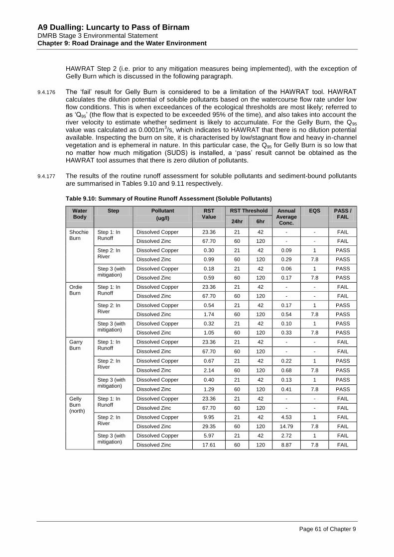
A9 Dualling: Luncarty to Pass of Birnam DMRB Stage 3 Environmental Statement Chapter 9: Road Drainage and the Water Environment
Page 61 of Chapter 9
HAWRAT Step 2 (i.e. prior to any mitigation measures being implemented), with the exception of Gelly Burn which is discussed in the following paragraph.
9.4.176 The ‘fail’ result for Gelly Burn is considered to be a limitation of the HAWRAT tool. HAWRAT calculates the dilution potential of soluble pollutants based on the watercourse flow rate under low flow conditions. This is when exceedances of the ecological thresholds are most likely; referred to as ‘Q95’ (the flow that is expected to be exceeded 95% of the time), and also takes into account the river velocity to estimate whether sediment is likely to accumulate. For the Gelly Burn, the Q95 value was calculated as 0.0001m
3/s, which indicates to HAWRAT that there is no dilution potential
available. Inspecting the burn on site, it is characterised by low/stagnant flow and heavy in-channel vegetation and is ephemeral in nature. In this particular case, the Q95 for Gelly Burn is so low that no matter how much mitigation (SUDS) is installed, a ‘pass’ result cannot be obtained as the HAWRAT tool assumes that there is zero dilution of pollutants.
9.4.177 The results of the routine runoff assessment for soluble pollutants and sediment-bound pollutants are summarised in Tables 9.10 and 9.11 respectively.
Table 9.10: Summary of Routine Runoff Assessment (Soluble Pollutants)
Water Body
Step Pollutant
(ug/l)
RST Value
RST Threshold Annual Average
Conc.
EQS PASS / FAIL
24hr 6hr
Shochie Burn
Step 1: In Runoff
Dissolved Copper 23.36 21 42 - - FAIL
Dissolved Zinc 67.70 60 120 - - FAIL
Step 2: In River
Dissolved Copper 0.30 21 42 0.09 1 PASS
Dissolved Zinc 0.99 60 120 0.29 7.8 PASS
Step 3 (with mitigation)
Dissolved Copper 0.18 21 42 0.06 1 PASS
Dissolved Zinc 0.59 60 120 0.17 7.8 PASS
Ordie Burn
Step 1: In Runoff
Dissolved Copper 23.36 21 42 - - FAIL
Dissolved Zinc 67.70 60 120 - - FAIL
Step 2: In River
Dissolved Copper 0.54 21 42 0.17 1 PASS
Dissolved Zinc 1.74 60 120 0.54 7.8 PASS
Step 3 (with mitigation)
Dissolved Copper 0.32 21 42 0.10 1 PASS
Dissolved Zinc 1.05 60 120 0.33 7.8 PASS
Garry Burn
Step 1: In Runoff
Dissolved Copper 23.36 21 42 - - FAIL
Dissolved Zinc 67.70 60 120 - - FAIL
Step 2: In River
Dissolved Copper 0.67 21 42 0.22 1 PASS
Dissolved Zinc 2.14 60 120 0.68 7.8 PASS
Step 3 (with mitigation)
Dissolved Copper 0.40 21 42 0.13 1 PASS
Dissolved Zinc 1.29 60 120 0.41 7.8 PASS
Gelly Burn (north)
Step 1: In Runoff
Dissolved Copper 23.36 21 42 - - FAIL
Dissolved Zinc 67.70 60 120 - - FAIL
Step 2: In River
Dissolved Copper 9.95 21 42 4.53 1 FAIL
Dissolved Zinc 29.35 60 120 14.79 7.8 FAIL
Step 3 (with mitigation)
Dissolved Copper 5.97 21 42 2.72 1 FAIL
Dissolved Zinc 17.61 60 120 8.87 7.8 FAIL

A9 Dualling: Luncarty to Pass of Birnam DMRB Stage 3 Environmental Statement Chapter 9: Road Drainage and the Water Environment
Page 62 of Chapter 9
Table 9.11: Summary of Routine Runoff Assessment (Sediment-Bound Pollutants)
Receiving Water Body
Step Low-flow velocity (m/s)
Velocity deposition threshold (m/s)
DI value DI
threshold PASS / FAIL
Shochie Burn Step 2 (Tier 1) 0.01
0.1 35
100 PASS
Step 2 (Tier 2) 0.26 0 PASS
Ordie Burn Step 2 (Tier 1) 0.01
0.1 66
100 PASS
Step 2 (Tier 2) 0.25 0 PASS
Garry Burn Step 2 (Tier 1) 0.01
0.1 53
100 PASS
Step 2 (Tier 2) 0.17 0 PASS
Gelly Burn (north)
Step 2 (Tier 1) 0.00
0.1
245
100
FAIL
Step 2 (Tier 2) 0.03 1216 FAIL
Step 3 0.03 1034 FAIL
9.4.178 The spillage risk assessment is summarised in Table 9.12. Refer to Appendix A9.3 (Water Quality Calculations) for methodology and calculation spreadsheets.
Table 9.12: Summary of Spillage Risk Assessment
Receiving Waterbody
Threshold of Acceptability
(% AEP)
Spillage Risk (% AEP) Within Acceptable Limits? Without mitigation With mitigation
Shochie Burn
0.5%
0.032% 0.016% Yes
Ordie Burn 0.054% 0.027% Yes
Garry Burn 0.047% 0.024% Yes
Gelly Burn (north) 1% 0.026% 0.013% Yes
9.4.179 Although all watercourses with the exception of Gelly Burn passed the HAWRAT with no mitigation in place, SUDS are a legal requirement in Scotland for new developments, including new and improved road schemes, and therefore SUDS proposals are considered in Section 9.5 (Mitigation).
9.4.180 Based on discussions with SEPA, the proposed scheme includes provision for two levels of SUDS for each outfall prior to discharging to watercourses. The only exception is for a short section of Pitlandie side road (at ch1000) where one level of drainage is proposed prior to discharge. This has been approved by SEPA. Discharge of the side road drainage is as follows:
ch0-ch112: one level of treatment provided through filter drains outfalling to the Ordie Burn. The provision of a swale was disregarded due to the restricted land available and the road level being too low.
ch112-ch368: two levels of treatment through filter drains and Shochie Burn detention basin, prior to discharge to the Shochie Burn.
9.5 Mitigation
Introduction
9.5.1 The objectives of the mitigation measures outlined in this section are to avoid/prevent, reduce or offset the potential impacts described in Section 9.4 (Potential Impacts).
9.5.2 It should be noted that in addition to the measures proposed in this section, there has been significant environmental input to the design process to help inform the most sustainable design and drainage solution. This iterative approach has included discussion of proposed engineering options, their associated potential environmental impacts, and recommending measures that limit the impacts on the water environment. SEPA has also been consulted at various stages to review the proposals and agree aspects such as the number of treatment levels required; this is explained further in the following section.
A9 Dualling: Luncarty to Pass of Birnam DMRB Stage 3 Environmental Statement Chapter 9: Road Drainage and the Water Environment
Page 63 of Chapter 9
9.5.3 Mitigation proposals for the proposed scheme are detailed on the following figures:
drainage design and SUDS on Figure 9.3 (Water Mitigation Proposals); and
landscape and ecological mitigation on Figure 11.2 (Landscape Mitigation).
Approach to Mitigation
9.5.4 Mitigation measures typically comprise solutions aimed at the source of the impact. The risk of causing deterioration in status of each waterbody can be reduced by aiming to ‘design out’ risks.
9.5.5 As stated in Section 9.2 (Approach and Methods - Specific Methodologies), consultation with SEPA and SNH was undertaken prior to and during the EIA process to seek guidance on surface water drainage, pollution prevention measures and engineering activities on waterbodies. The Tay DSFB was contacted for relevant ecological information and existing A9 drainage arrangements were obtained from BEAR and Perth & Kinross Council, where available. Further information on the consultation process is provided in Chapter 6 (Consultation and Scoping).
Controlled Activities Regulations 2011 (as amended) (CAR)
9.5.6 Engineering work and construction activities in most waterbodies, as well as road outfalls draining over 1km of road, will require a licence under the terms of CAR, as specified in Section 9.2 (Approach and Methods – Legislative Context). Works adjacent to waterbodies may require a CAR licence, registration or compliance with General Binding Rules (GBRs). A CAR application will be made to SEPA for the higher risk activities which will include detailed information on the following:
The proposed activity, its design and the reasons for the chosen design, as well as alternatives considered and reasons for rejection. The solution taken forward will be the best practicable environmental option, taking into account environmental, engineering, economic, and health and safety considerations. Proposals and justification for engineering solutions (i.e. scour protection measures at culverts and outfalls, and watercourse crossing extensions, are provided in this section and Appendix A9.5 (Watercourse Crossings), as requested by SEPA.
Details of the potential impacts to the water environment, including baseline environmental information and relevant environmental assessments.
Details of the mitigation included in the design, aimed at reducing the potential impacts.
A detailed construction methodology for all engineering activities.
9.5.7 Discussions on CAR authorisation and applications have been undertaken with SEPA and will continue during detailed design and mitigation refinement through the CAR application process.
Generic Construction Mitigation
9.5.8 The Contractor will be required under Section 20A and 55A of the Roads (Scotland) Act 1984 to comply with the mitigation requirements outlined in the paragraphs below.
9.5.9 Prior to construction, the Contractor shall prepare a Construction Environmental Management Plan (CEMP), or equivalent, which will address and mitigate risks identified in the ES (Mitigation Item W1), and will be approved by SEPA prior to construction. In addition, the Environmental Site Manager or a suitably qualified member of the construction team, e.g. Environmental Clerk of Works (EnvCoW), will ensure that the mitigation measures identified within the CEMP are fully implemented and activities carried out in such a manner as to prevent or reduce impacts on the surface water environment (Mitigation Item W2).
9.5.10 Measures to avoid, reduce or control pollution of surface water and groundwater will incorporate SEPA requirements and CIRIA guidelines for pollution control, including relevant Pollution Prevention Guidelines (PPGs), as listed in Section 9.7 (References) and the SEPA (2009) Good Practice Guide: Temporary Construction Methods (Mitigation Item W3).

A9 Dualling: Luncarty to Pass of Birnam DMRB Stage 3 Environmental Statement Chapter 9: Road Drainage and the Water Environment
Page 64 of Chapter 9
9.5.11 To reduce potential increases in flows into the receiving watercourses during construction, the period of exposure of bare areas and uncontrolled runoff from newly paved areas will be limited as far as practicable (Mitigation Item W4).
9.5.12 During temporary construction works, consideration will be given to flood impacts. Plant and material will be stored in safe areas above the 1:200yr flood event floodplain, where practicable, and the aim will be for temporary construction works to be resistant to flood impacts in order to prevent movement or damage during potential flooding events (Mitigation Item W5).
Working In-stream and Adjacent to Watercourses
9.5.13 The Contractor will be required to prepare construction method statements for any in-stream working for approval by SEPA prior to these specific works (Mitigation Item W6). The method statement will include measures to:
protect fish;
deal with flowing water appropriately e.g. temporary diversions, over-pumping;
reduce the risk of mobilisation of sediments to an acceptable level by employing reasonably practicable measures;
protect banks where they are particularly vulnerable to erosion;
undertake diversion of flow back into a channel in a manner that reduces the risk of erosion, with temporary bank stabilisation incorporated if necessary;
avoid unnecessary in-stream working; and
comply with SEPA’s Good Practice Guide: Temporary Construction Methods (SEPA, 2009).
9.5.14 Where channel realignment is proposed (Un-named tributary 4 of Ordie Burn, Un-named tributary 3 of Gelly Burn and Broomhill Burn (vertical only)) the following principles should be followed where possible (Mitigation Item W7):
construct the new channel as early as possible prior to diverting flow from the existing channel to the new course to allow vegetation to colonise bank faces; and
minimise the length of channel realignment.
Runoff from the Working Area
9.5.15 During construction of the roadway and associated works, temporary drainage systems will alleviate localised flood risk and help to prevent obstruction of surface runoff pathways (Mitigation Item W8). Temporary SUDS systems or equivalent to reduce the potential for contaminated runoff to watercourses will be used. A number of these temporary SUDS will be incorporated into the operational drainage network when the road is completed, but additional site-specific SUDS may be required during construction and will be removed once construction is complete. Care must be taken to avoid clogging and/or compaction of SUDS which are to be used during the operational phase.
Sedimentation and Earthworks
9.5.16 During the initial stage of construction, temporary SUDS systems or equivalent to reduce the potential for contaminated runoff to watercourses will be implemented (Mitigation Item W9).
9.5.17 In addition, appropriate control measures for construction site runoff and sedimentation (Mitigation Item W10) will include:
cleaning of roads to reduce mud and dust deposits (away from watercourses, into appropriate drainage sites);
limit exposed bare areas and uncontrolled runoff from newly paved areas;

A9 Dualling: Luncarty to Pass of Birnam DMRB Stage 3 Environmental Statement Chapter 9: Road Drainage and the Water Environment
Page 65 of Chapter 9
covering and bunding, if required, of soil stockpiles;
use of silt fences where appropriate;
early covering/seeding/planting of exposed surfaces where practicable;
where appropriate, provision of peripheral cut-off ditches or drainage system to intercept runoff from outside the working area such that it does not encroach on the working area;
lay suitable surfacing materials in site compound and on main access routes; and
regular proactive visual inspection of the sedimentation measures and receiving watercourses.
9.5.18 If flocculants are considered necessary to aid settlement of fine suspended solids, such as clay particles, the chemicals used must first be approved by SEPA (Mitigation Item W11).
9.5.19 Where required, CAR authorisation will be obtained from SEPA and oil interceptor(s) will be provided for vehicle parking areas, if required by SEPA (Mitigation Item W12).
9.5.20 The Contractor will be required to comply with the relevant sections of BS6031:2009 Code of Practice for Earthworks with respect to protection of water quality and control of site drainage including washings, dewatering, abstractions and surface water (Mitigation Item W13).
9.5.21 Where the Contractor considers the use of alternative materials to those assumed at the Stage 3 design stage for use as fill, e.g. in embankments, agreement with SEPA will be required prior to use of such material (Mitigation Item W14).
Watercourse Crossings
9.5.22 Advice and guiding principles from SEPA on new and extended watercourse crossings has been taken into consideration (consultation responses dated 08 March and 03 April 2013 and comments received on the draft ES and design proposals in January 2014). Opportunities to design to avoid the need for new or amended watercourse crossings were carefully considered in the first instance.
9.5.23 Where necessary, new and extended culverts will require in-channel works, and to reduce the potential for sediment release it is recommended that works are conducted during forecast low flow periods and the length of channel disturbed will be minimised as far as practicable (Mitigation Item W15). Guidance on river crossings and culvert design contained in SEPA’s Good Practice Guides (SEPA, 2008a, 2009 and 2010b) and CIRIA C689 (2010) will be followed. Measures to alleviate risks to the water environment associated with the construction of watercourse crossings will be included in the Contractor’s CEMP and approved by SEPA.
9.5.24 Requirements for grey (hard) bank scour protection (e.g. rock armour, rip-rap, gabion baskets) at culverts will be limited to that absolutely required and options for use of alternatives such as none or green (soft) bank scour protection (e.g. vegetation, geotextile matting) has been considered as part of the DMRB Stage 3 design process. This is explained in more detail in the ‘Generic Operational Mitigation’ section below.
Outfalls
9.5.25 Effective mitigation for impacts associated with outfalls will be based on the following principles (Mitigation Item W16), in accordance with SEPA’s guidance WAT-SG-28 – Intakes and Outfalls (SEPA, 2008b):
Construction of outfalls will not be conducted during periods of high flow, in order to reduce the risk of scour and erosion around the outfall structures or to the disturbed river bank.
Limit the extent of channel/bank disturbance; consider the use of set-bank outfalls first and use of swales rather than directly excavating into a watercourse.
Where practicable, provide sediment fences to prevent sediment wash into the watercourses.

A9 Dualling: Luncarty to Pass of Birnam DMRB Stage 3 Environmental Statement Chapter 9: Road Drainage and the Water Environment
Page 66 of Chapter 9
As with culverts, use of grey bank scour protection at outfalls will be limited to that absolutely required. Options for use of alternatives such as none or green bank scour protection have been considered as part of the DMRB Stage 3 design process. This is explained in more detail in the ‘Generic Operational Mitigation’ section below.
Oil and Fuels
9.5.26 Best practice measures associated with storage of oils and fuel will be followed in compliance with The Water Environment (Oil Storage) (Scotland) Regulations 2006, SEPA PPG02 and PPG26, and will be included within the Contractor’s CEMP (Mitigation Item W17).
Chemical Storage, Handling and Use
9.5.27 Effective mitigation for impacts associated with storage, handling and use of chemicals will be based on the following measures (Mitigation Item W18):
PPG26 will be followed. Chemicals stored in drums will, as far as practicable, be stored within a secondary containment system. Containers without secondary containment will not be placed within 10m of a watercourse or waterbody or within 50m of a spring, well or borehole.
Chemical stores will be located above the 0.5% AEP (1 in 200-year return period) flood level.
Pesticides, including herbicides, should only be used if there are no alternative practicable measures, and will be used in accordance with the manufacturer’s instructions and application rates. Choice of pesticides should be those with least harm to the environment (i.e. least toxic and least persistent) suitable for the required purpose. Pesticide use near watercourses will require prior approval of SEPA.
Controls for Use of Concrete, Cement and Grout
9.5.28 Concrete mixing and washing areas (Mitigation Item W19) will:
be located more than 10m from watercourses and waterbodies;
have settlement and re-circulation systems for water reuse;
have a contained area for washing out and cleaning of concrete batching plant or ready mix lorries; and
collect wash-waters and, where necessary, discharge to foul sewer (with the sewerage provider’s permission) or contain wash-water for authorised disposal off-site.
9.5.29 Washwater from concrete and cement works will not be discharged to the water environment. These waste waters will be collected and, where necessary, discharged to the foul sewer (with the sewerage provider’s permission) or off-site disposal authorisation sought (Mitigation Item W20).
Sewage Disposal
9.5.30 Sewage from site facilities will be disposed of appropriately (Mitigation Item W21) either to:
foul sewer with the permission of Scottish Water; or
appropriate treatment and discharge agreed with Building Control and SEPA in advance of construction in accordance with PPG04 and CAR.
Service Diversions and Excavation/Ground Penetration near Services
9.5.31 Service diversions, protection of utilities and local water supplies, excavations and ground penetration will be carried out according to good practice (Mitigation Item W22). Potential services will be identified using information from the service provider and through survey where necessary. Measures will be taken to prevent damage to services and to avoid pollution during service diversions, excavation and ground penetration.
A9 Dualling: Luncarty to Pass of Birnam DMRB Stage 3 Environmental Statement Chapter 9: Road Drainage and the Water Environment
Page 67 of Chapter 9
Management of Potentially Contaminated Land
9.5.32 Where works are proposed within areas of potentially contaminated land or where potentially contaminated groundwater is present, appropriate risk management measures will be implemented to reduce the risk of pollution to an acceptably low level. Mitigation measures are identified separately in Chapter 8 (Geology, Contaminated Land and Groundwater) and not repeated here.
Programme of Works
9.5.33 The potential impact of the proposed scheme can be reduced through timely implementation of certain aspects of the construction works. A programme will be developed to facilitate the practicable implementation of mitigation measures at the stage where their application will be most effective (Mitigation Item W23). In particular:
Detention basins will be scheduled for construction early in the programme, to allow settlement and treatment of any pollutants contained in site runoff and to control the rate of flow before water is discharged into a receiving watercourse. Additional temporary settlement ponds may also be required during construction, particularly in the vicinity of sensitive waterbodies.
In-channel works and works within the floodplain, i.e. construction activities or presence of personnel or construction plant within the 0.5% AEP (1 in 200-year return period) floodplain, will be avoided during periods of high flow and increased flood risk, for health and safety reasons. In-channel works will avoid spawning periods in salmonid watercourses. More detailed information on this can be found in Chapter 10 (Ecology and Nature Conservation) along with work timings for particular species.
9.5.34 A detailed method statement for the layout and management of each part of the working area subject to a CAR licence will be provided to SEPA for approval a minimum of four weeks, or by a date otherwise agreed with SEPA, prior to start of construction (Mitigation Item W24). The method statement will identify, where appropriate, the location of drainage ditches, settlement ponds and sediment fences throughout the site to reduce the impact of turbid runoff whilst maintaining efficient operation of the site. This will involve a combined site visit and consultation between the EnvCoW, design engineer, construction site manager, and representatives of SEPA or SNH.
Monitoring and Inspection during Construction
9.5.35 In the designated SAC watercourses, namely the Shochie, Ordie and Garry Burns, the Contractor will be required to monitor water quality prior to, during and post-construction (Mitigation Item W25). Parameters, duration, frequency and limits of sampling will be agreed with SEPA in advance of construction. Monitoring of smaller watercourses, particularly those near Cairnleith Moss SSSI, may also be required, as advised by SEPA and SNH.
9.5.36 Regular inspections will be carried out by the EnvCoW to identify and recommend appropriate actions for aspects such as unacceptably high pollution risk, or any suspected incidences of pollution (Mitigation Item W26). Where necessary, a Pollution Incident Response Plan will be implemented, in line with SEPA PPG21 and PPG22. This will include formulation of emergency procedures to address accidental pollutant releases and spillages, and will include appropriate staff briefings, toolbox talks and other staff training, as required (Mitigation Item W27).
Table 9.13: Summary of Generic Mitigation Measures during Construction
Source of Impact Mitigation
Flood Risk To reduce potential increases in runoff into the receiving watercourses during construction, the period of exposure of bare areas and uncontrolled runoff from newly paved areas will be limited as far as practicable.
During temporary construction works, plant and material will be stored in safe areas outside the flood risk area where practicable, and the aim will be for temporary construction works to be resistant to flood impacts to prevent movement or damage during potential flooding events.
During construction of a new roadway and associated works, temporary drainage systems will alleviate localised flood risk and prevent obstruction of surface runoff pathways.

A9 Dualling: Luncarty to Pass of Birnam DMRB Stage 3 Environmental Statement Chapter 9: Road Drainage and the Water Environment
Page 68 of Chapter 9
Source of Impact Mitigation
In-channel works in watercourses
Preparation of construction method statements for approval by SEPA.
Compliance with PPGs including PPG01, PPG05, PPG06 and SEPA Good Practice Guides.
Compliance with CAR 2011 (as amended) authorisation requirements.
Runoff from working area
Temporary drainage systems to alleviate localised flood risk; temporary (and permanent) SUDS systems (or equivalent) to reduce potential for contaminated runoff to waterbodies.
Adherence to CIRIA C648 (CIRIA, 2006a and b) and C697 (CIRIA 2007a and b).
Other runoff and erosion control measures to include as appropriate: provision of wheel washes more than 10m from watercourses and appropriate disposal of dirty water; cleaning of roads; limit exposed bare areas; covering of stockpiles; use of silt fences; provision of peripheral cut-off ditches to intercept runoff from entering working area; regular inspection and monitoring of receiving watercourses.
Any flocculants to be approved in advance by SEPA.
Temporary discharge consents to be obtained from SEPA, where required.
Compliance with relevant sections of BS6031:2009.
Watercourse crossings
Works to be conducted in low flow conditions.
Compliance with CAR 2011 (as amended) authorisation requirements and SEPA Good Practice Guides.
Grey bank scour protection, at culverts limited to that absolutely required and consideration given to alternative options, e.g. none or green bank protection.
Outfall construction Construction will not be conducted during periods of high flow.
Sediment fences will be used to prevent sediment being washed into watercourse.
Limit extent of channel/bank disturbance and compliance with SEPA Good Practice Guide.
Compliance with CAR 2011 (as amended) authorisation requirements.
Grey bank scour protection at outfalls, limited to that absolutely required and consideration given to alternative options, e.g. none or green bank protection.
Refuelling Compliance with the Water Environment (Oil Storage) (Scotland) Regulations 2006 (Scottish Executive 2006).
Compliance with PPG02.
Bunded areas of sufficient storage capacity (at least 110% of maximum tank capacity) with impervious walls and floor lining for the storage of fuel, oil and chemicals.
Appropriate measures, including site security, to avoid spillages.
Compliance with the Pollution Incident Control Plan and SEPA PPG21 and PPG22.
Oil/fuel leaks and spillages
Stationary plant will be fitted with drip trays and emptied regularly; plant machinery to be properly maintained.
Spillage kits will be stored at key locations on site.
Compliance with the Pollution Incident Control Plan and SEPA PPG21 and PPG22.
Chemical storage, handling and use
Compliance with PPG26.
Appropriate storage and containment of chemicals; stores to be located above the 0.5% AEP (1 in 200-year return period) flood level.
Concrete, cement and grout
Concrete mixing and washing areas will be located more than 10m from waterbodies.
Wash water will not be discharged to the water environment and will be disposed of appropriately.
Sewage disposal Compliance with PPG04.
Sewage to be disposed of appropriately in compliance with SEPA and CAR.
Service diversions and excavation/ ground penetration
Adherence to best practice.
Contaminated land and sediment
In areas where ground contains elevated concentrations of contaminants, appropriate measures will be implemented to reduce risk of surface water pollution to an acceptably low level. Refer to Chapter 8: Geology, Contaminated Land and Groundwater).
Generic Operational Mitigation
Drainage
9.5.37 The drainage system of the proposed scheme has been designed in accordance with the following guidance:
Control of Pollution from Highway Drainage Discharges, Report 142 (CIRIA, 1997).
Sustainable Drainage Systems, CIRIA C609 (CIRIA, 2004).
The SUDS Manual, CIRIA C697 (CIRIA, 2007a).

A9 Dualling: Luncarty to Pass of Birnam DMRB Stage 3 Environmental Statement Chapter 9: Road Drainage and the Water Environment
Page 69 of Chapter 9
Site handbook for the construction of SUDS, CIRIA C698 (CIRIA, 2007b).
SUDS for Roads (SCOTS, 2010).
DMRB HA 103/06: Vegetated Drainage Systems for Highway Runoff (Highways Agency et al., 2006a).
DMRB HA 119/06: Grassed Surface Water Channels for Highway Runoff (Highways Agency et al., 2006b).
9.5.38 Where it has been identified as necessary for road drainage to discharge to receiving watercourses, mitigation will be designed to limit the volume of discharge and the risk to water quality. Where required, authorisation for the road drainage discharge under CAR 2011 (as amended) will be obtained from SEPA (Mitigation Item W28).
9.5.39 As noted previously, SEPA has been consulted throughout the progression of the drainage design, and has requested the provision of a minimum of two levels of treatment for the proposed scheme. As discussed in Section 9.4 (Potential Impacts), the only exception is for a short section of Pitlandie side road (at ch1000) where one level of drainage is proposed prior to discharge. This has been previously discussed and approved by SEPA. SEPA also advised that where a section of road is in close proximity to a designated site, any requirements for additional levels should be agreed with SNH. SNH was therefore consulted regarding the drainage design in the vicinity of Cairnleith Moss SSSI, as road drainage from the existing A9 is currently discharged via un-named drain 4 to the SSSI. The combination of HAWRAT assessment results, proposed scheme drainage design and mitigation measures have demonstrated that there would be no adverse impact to the integrity and qualifying interests of any designated sites.
9.5.40 For each outfall, a ‘treatment train’ of SUDS measures will be incorporated to attenuate the road runoff to pre-development rates, reduce the polluting load carried within this runoff to acceptable levels and significantly reduce the risk of any accidental spillages (Mitigation Item W29). The drainage arrangements for the mainline carriageway will consist of two levels of treatment in line with the SEPA request (see previous paragraph), and as explained further in Tables 9.14 and 9.15 below. The mainline drainage runs, SUDS measures and outfall locations are shown on Figure 9.3.
9.5.41 The proposed scheme drainage design also removes the existing drainage outfall to Cairnleith SSSI, and all road drainage in this area is routed north and suitably treated and attenuated prior to discharge to the Gelly Burn (north) outfall. SNH was content with this proposal as it was demonstrated to present no risk to the SSSI.
9.5.42 All proposed SUDS systems will be designed with an impermeable liner to reduce any identified risk of pollution to groundwater, unless otherwise agreed with SEPA by the contractor. This is particularly important for the Shochie Burn detention basin, which is located close to an area of identified contaminated land. This requirement is covered by mitigation explained in Chapter 8: Geology, Contaminated Land and Groundwater, and supporting Figure 8.3 which identifies areas of contaminated land.
9.5.43 SUDS basins will be sized to attenuate and store the 1% AEP (1 in 100 year return period) + 20% climate change flood event and restrict the outflow to the greenfield pre-development runoff rate of 50% AEP (1 in 2 year return period) flood event. SUDS systems will be located outwith the functional (0.5% AEP) floodplain (Mitigation Item W30).
9.5.44 The hydraulic and water quality performance potential of each SUDS technique has informed the drainage design based on their primary functions and capabilities. SUDS have been selected to include different stages of the ‘treatment train’ (pre-treatment, conveyance, source, site or regional controls). The primary functions and the water quality treatment processes for each SUDS technique included within the proposed scheme design is listed in Table 9.14.

A9 Dualling: Luncarty to Pass of Birnam DMRB Stage 3 Environmental Statement Chapter 9: Road Drainage and the Water Environment
Page 70 of Chapter 9
Table 9.14: Primary Functions and Capabilities of Proposed Scheme SUDS
SUDS Treatment System
Component Primary functions and capabilities
Filter Drains Management Train Suitability Conveyance, Source Control
Water Quantity Conveyance, Detention
Water Quality Filtration, Adsorption, Biodegradation, Volatilisation
Swale (dry) Management Train Suitability Conveyance, Source Control, Site Control
Water Quantity Conveyance, Detention
Water Quality Sedimentation, Filtration, Adsorption, Biodegradation
Detention Basin (dry)
Management Train Suitability Site Control, Regional Control
Water Quantity Detention
Water Quality Sedimentation, Biodegradation
Source: CIRIA (2007a)
9.5.45 The potential indicative pollution removal efficiency and design robustness of the different SUDS techniques to meet the required hydraulic and water quality design criteria, are presented in Table 9.15. This information has been taken from CIRIA C609 (CIRIA, 2004), DMRB HA 103/06 and DMRB HD 45/09 guidance and has been used to inform the pollutant/spillage risk reduction efficiencies used within HAWRAT road drainage calculations. Where a range has been given in published guidance and uncertainty exists, the lower end of the range has been used, which follows a precautionary approach. This is particularly the case for assessing the capability of SUDS in series. In addition, the last column provides the optimum indicative pollutant reduction efficiencies by which certain SUDS measures could be expected to reduce the risk of an accidental spillage, in line with DMRB HD 45/09 guidance (Highways Agency et al., 2009).
Table 9.15: Treatment Systems Efficiency and Design Robustness of SUDS
SUDS measure Function Reduction capability (%)
Filter drains only Treatment for solubles None-Low
Settlement of sediments Low
Spillage risk reduction ~ 40%
Detention basin only Treatment for solubles Low-Moderate
Settlement of sediments None-Low
Spillage risk reduction ~ 50%
Filter drains and detention basin (in series)
Treatment for solubles Low-Moderate
Settlement of sediments Low
Spillage risk reduction ~ 50%
Sources: CIRIA (2004); Highways Agency et al. (2006a and 2009)
Outfall Structures
9.5.46 Each outfall will be correctly positioned, informed by a geomorphologist or appropriately qualified person, to limit scour potential around the culvert. The outfall location and design will be such that there would be no significant alteration to flow patterns which may lead to turbulence and/or excessive deflection of flow towards the bed or banks of the channel. The outfall will not project into the channel and will not be located where flow converges with river banks causing higher shear stresses or where active bank erosion is occurring (Mitigation Item W31). Design and construction of outfall structures will comply with best practice in CIRIA and DMRB and take cognisance of SEPA’s Good Practice Guide: Intakes and Outfalls (SEPA, 2008b) (Mitigation Item W32).
9.5.47 Alternative options of scour protection at drainage outfalls were considered during development of the DMRB Stage 3 design. Grey bank protection is considered most appropriate at pipe outfalls, primarily to restrain the pipe end as movement of the pipe end may lead to pipe joints opening up, resulting in leaks and the integrity of the pipe being compromised. Both green bank and grey bank protection options were considered at drainage outfalls; green bank protection options (e.g.
A9 Dualling: Luncarty to Pass of Birnam DMRB Stage 3 Environmental Statement Chapter 9: Road Drainage and the Water Environment
Page 71 of Chapter 9
geomatting or set-back outfalls such as swales) were considered first, in line with SEPA guidance WAT-SG-28 (SEPA, 2008). However, these were rejected for the following reasons:
Geomatting: this would provide insufficient scour protection to the receiving watercourse and have insufficient time to establish due to the discharge from the drainage network.
Setback outfalls: this would require additional land-take to provide a swale/wetland upstream of the discharge point. It was also noted that due to flow velocity and high stream energies of some watercourses, the river banks at discharge points would be likely to require additional grey bank scour protection to prevent erosion.
Other grey bank protection options (e.g. rip rap, gabion mattresses): these would require the most significant bank modifications.
Maintenance of Road Drainage Network
9.5.48 To avoid failure or sub-optimal operation of the road drainage network, maintenance of its components will be necessary. Regular inspection to inform on maintenance frequency requirements will be required, with the minimum recommended maintenance as follows (Mitigation Item W33):
maintenance of filter drains include inspection and weed control, removal of sediment and vegetation build up, replacement of clogged filter material typically at least once every 10 years;
maintenance of filtration devices include inspections, grass cutting and site rubbish removal, annual reinstatement of eroded areas or damaged vegetation and removal of sediment;
regular maintenance of SUDS facilities to enable efficient operation and the settlement of solids and removal of pollutants (such as hydrocarbons);
regular maintenance of receiving watercourses and culverts to reduce the risk of blockages and associated flood risk;
if herbicides are used, those recommended by SEPA for use near watercourses are to be applied in line with manufacturer’s instructions to reduce pollution of watercourses; and
provision of scour protection at the drainage discharge outfall to protect the banks and bed of the receiving watercourse and to limit erosion.
New and Extended Culverts
9.5.49 During the design of the proposed new culvert crossings and the proposed culvert extensions, discussions have been held with engineers, ecologists, geomorphologists and SEPA representatives. These have provided input at key design stages to facilitate incorporation of appropriate mitigation measures, for example to identify the correct gradient and width of channel to prevent siltation through the culvert or scour around the structure, and create or maintain a natural bed where possible.
9.5.50 Culvert design contained in CIRIA C689 (2010) and DMRB HA 107/04 (Highways Agency et al., 2004) will be followed. Based on SEPA guidance, it is proposed that existing culverts be extended without limiting their existing hydraulic capacity (Mitigation Item W34). The extensions may lead to building within the existing floodplain. Mitigation for infill within the floodplain may be provided through compensatory storage if necessary (see below).
9.5.51 Culvert extensions will be match the existing structures in most cases to ensure that there is no change in form (widening, narrowing and separation) which could interrupt sediment transport (Mitigation Item W35). The only exceptions are where ‘betterment’ is provided (i.e. existing undersized Broomhill Burn Culvert being widened) and the Shochie Burn and Ordie Burn mainline culverts. The Shochie Burn and Ordie Burn culvert extensions will match the dimensions of the existing culverts but the form will be portal frame structures in preference to box culverts. Specific proposals and justification for watercourse crossing extensions are provided in Appendix A9.5 (Watercourse Crossings).

A9 Dualling: Luncarty to Pass of Birnam DMRB Stage 3 Environmental Statement Chapter 9: Road Drainage and the Water Environment
Page 72 of Chapter 9
9.5.52 The need for, and form of, scour protection at culverts was carefully reviewed as part of the development of the Stage 3 design. The scour assessment at culverts was based on the predicted 0.5% AEP (1:200) design scenario flood event and followed the methodology presented in DMRB BD 97/12 ‘The assessment of Scour and Other Hydraulic Actions at Highways Structures’ (Highways Agency et al., 2012). The assessment took into account any known history of scour problems and gave the structure a risk rating to indicate whether it was susceptible to scour.
9.5.53 Grey bank scour protection was considered necessary to prevent possible future undermining/outflanking at the inlet structure where the risk rating was assessed as High and taking into account the importance of the A9 structures and the potential consequence of failure. Scour protection has not been proposed at culverts where the flow velocity has been calculated as <1m/s, which is not considered to present a risk to the integrity of the structures.
Channel Realignments
9.5.54 The detailed design of channel realignments should include the input from a range of appropriate specialists (e.g. engineers, ecologists and geomorphologists), as well as SEPA representatives where appropriate, to incorporate appropriate mitigation measures and consider any feasible improvements to the watercourses morphology and habitats (Mitigation Item W36).
9.5.55 Where channel realignment is proposed (un-named tributary 4 of Ordie Burn, un-named tributary 3 of Gelly Burn (north) and Broomhill Burn (vertical realignment), the following principles should be followed where practicable (Mitigation Item W37):
minimise length of realignment;
maintain gradient of watercourse; and
increase sinuosity of channel, create low flow channel to narrow channel and reduce siltation potential.
9.5.56 The realignment of un-named tributary 3 of Gelly Burn (north) should occur before commencing the construction of the embankments of the access track overbridge to Gelly and Murthly Estate. The realignment should be constructed at least 2m from the base of the proposed embankments. This is to reduce the amount of sediment introduced to the channel during construction. The new channel should not be deeper than the existing channel (Mitigation Item W38).
Compensatory Storage
9.5.57 Where the proposed scheme may affect the functional floodplain, potential to incorporate mitigation measures including the provision of compensatory storage has been investigated as part of the design process. The approach adopted and summarised in the following paragraphs below has been agreed with SEPA). Refer to Appendix A9.2 for details of calculations and assessment.
Shochie Burn
9.5.58 Numerical modelling predicts that the 0.5% AEP (1:200) design scenario flood is largely contained within the natural channel, particularly at the entrance to the culvert, and the proposed scheme is not expected to result in a loss of functional floodplain. Modelling has further demonstrated that the proposed scheme will have a neutral impact on flood risk both upstream and downstream of the proposed Shochie Burn culvert extension. Therefore, the provision of flood mitigation measures, such as compensatory storage is not required at this location.
Ordie Burn
9.5.59 As described in Section 9.4 (Potential Impacts), flood risk upstream is predicted to increase with some loss of functional floodplain storage due to the proposed scheme, whereas the flood risk downstream will remain neutral.

A9 Dualling: Luncarty to Pass of Birnam DMRB Stage 3 Environmental Statement Chapter 9: Road Drainage and the Water Environment
Page 73 of Chapter 9
9.5.60 Opportunities to acquire land within the CPO for compensatory storage on either the left or right hand bank were investigated. However, due to the existing topography of the site this would require significant ground excavation and removal of material with increased impacts on the current landowner and potential for detrimental impact on the adjacent SAC designation due to risk of sediment being released into the watercourse during the construction phase.
9.5.61 The flood extent is not predicted to increase significantly with the proposed scheme (less than 4m) and the land is currently subjected to flooding with low impact on existing land use i.e. agricultural (grazing), and there are no other significant high risk flood receptors nearby. Allowing the land to continue to flood, albeit to a greater depth and possibly greater frequency, has been confirmed as the preferred option and agreed with SEPA. The area of land subjected to an increased risk of flooding for the 0.5% AEP (1:200) design scenario flood event will be included in the CPO to provide a compensatory storage area (Mitigation Item 39).
Ordie Burn and its tributary at Newmill
9.5.62 The modelling predicts that flood risk upstream of the proposed scheme at Newmill will increase with loss of functional flood plain storage, whereas the flood risk downstream will remain neutral.
9.5.63 Opportunities to acquire land within the CPO for compensatory storage on a volume for volume and level for level basis were investigated. Due to the local topography, the available location to provide this level of compensatory storage would be ground located beyond the left hand floodplain. However, provision of compensatory storage at this location would require extensive ground excavation and removal of material, with increased impacts on the current landowner (which are already substantial due to other essential land requirements) and potential for detrimental impact on the adjacent SAC designation due to risk of sediment being released into the watercourse during the construction phase.
9.5.64 The flood extent is not predicted to increase significantly with the proposed scheme, although a new area to the north will be at risk of flooding. The land including the new flood risk area is currently used as agricultural (grazing) land and the impact due to occasional flooding is considered to be low, and there are no other high risk flood receptors are nearby. Allowing the land to continue to flood, albeit to a greater depth and possibly greater frequency, has been confirmed as the preferred option and agreed with SEPA. The area of land subjected to an increased risk of flooding for the 0.5% AEP (1:200) design scenario flood event will be included in the CPO to provide a compensatory storage area (Mitigation Item W40).
Garry Burn
9.5.65 The modelling results suggest that there will be some minor loss of functional floodplain storage (approximately 600m
3), as the new road layout results in a ‘squeeze’ of the existing floodplain
extent. However, the result of the hydraulic model indicates that there would be no change to the predicted water level and flood extent, both upstream and downstream for the 0.5% AEP (1:200) design scenario flood event with the proposed scheme. The overall impact on the watercourse is considered to be neutral, Therefore, no flood risk management measures, such as compensatory floodplain storage, would be required for the Garry Burn.
Ardonachie Burn (Crossing 3)
9.5.66 It estimated that approximately 77m3 of floodplain storage would potentially be lost as a result of
the culvert extension and road widening. However, the proposed scheme includes embedded mitigation whereby the existing channel will be widened to form a two-stage channel to win the relatively small compensatory storage volume required (Mitigation Item W41).
Un-named tributary 4 of Ordie Burn upstream of A9 (Crossing 2a)
9.5.67 It is estimated that approximately 215m3 of floodplain storage would potentially be lost as a result
of the extension of the existing A9 culvert and road widening. However, the proposed scheme

A9 Dualling: Luncarty to Pass of Birnam DMRB Stage 3 Environmental Statement Chapter 9: Road Drainage and the Water Environment
Page 74 of Chapter 9
includes embedded mitigation whereby the existing channel will be widened to form a two-stage channel to win the relatively small compensatory storage volume required (Mitigation Item W42).
Other Minor Watercourses Crossings
9.5.68 The flow in the other minor watercourses remains in-bank at the 0.5% AEP (1:200) design scenario flood event. Thus no floodplain storage is lost as a result of extension of the existing culverts and hence no compensatory storage is required.
Outfalls
9.5.69 As discussed in Section 9.4 (Specific Operational Impacts: HAWRAT Results), one watercourse Gelly Burn fails the HAWRAT routine runoff assessment for soluble and sediment-bound pollutants after the implementation of mitigation, due to the extremely low Q95 value calculated for the watercourse. In this particular case, the Q95 for Gelly Burn is so low, no matter how much mitigation (SUDS) is installed, it will not sufficiently improve the situation to give a ‘pass’ result. The HAWRAT tool is therefore not applicable for this particular site. As noted previously, SEPA has been consulted through the design of the proposed scheme drainage and no further mitigation is proposed.
9.6 Residual Impacts
9.6.1 Following implementation of the mitigation outlined in Section 9.5, the potential for impacts on the water environment will be avoided/prevented, reduced or offset.
9.6.2 Residual impacts during both the construction and operational phases are summarised for each attribute of the waterbody in Appendix A9.4. The vast majority of residual impacts would be reduced to Neutral significance, due to the adoption of appropriate mitigation measures. The remaining residual impacts that would not be of Neutral significance are listed below.
Construction Impacts
9.6.3 A Slight to Moderate significance impact on the geomorphology of Shochie Burn and Ordie Burn.
9.6.4 A Slight significance impact on hydrology and flood risk in Ordie Burn and un-named tributary 4 of Ordie Burn.
9.6.5 A Slight significance impact on the geomorphology of un-named tributary 4 of Ordie Burn and a Slight significance impact on a drinking water supply associated with the same watercourse.
Operational Impacts
9.6.6 A Slight to Moderate significance impact on the geomorphology of Shochie Burn and Ordie Burn.
9.6.7 A Slight significance impact on hydrology and flood risk in Ordie Burn, un-named tributary 4 of Ordie Burn..
9.6.8 A Slight significance of impact on the geomorphology of un-named tributary 4 of Ordie Burn. It should be noted that proposed mitigation in the form of widening to form a two-stage channel on this tributary may result in localised improvements to geomorphological diversity.
9.6.9 For Gelly Burn (north), a Slight/Moderate significance impact on the attribute ‘Water Quality’ is reported. This is because of the failure of the HAWRAT assessment and the implications of this for the assessment. However, the pass/fail results of HAWRAT are indicative only and are not applicable for this particular site. The mitigation measures are considered to be robust and have been agreed with SEPA.

A9 Dualling: Luncarty to Pass of Birnam DMRB Stage 3 Environmental Statement Chapter 9: Road Drainage and the Water Environment
Page 75 of Chapter 9
9.7 References
Atkins (2009). A9 Dualling: Luncarty to Pass of Birnam Strategic Planning Study - Stage 2 Environmental Assessment Report.
British Standards Institute (2009) BS 6031:2009 Code of Practice for Earthworks.
CEH (2009). Flood Estimation Handbook, CD-Rom Version 3. Centre for Ecology and Hydrology.
CIRIA (1997). Control of Pollution from Highway Drainage Discharges, Report 142, Construction Industry Research and Information Association.
CIRIA (2004). Sustainable Drainage Systems, CIRIA C609 Wilson, S., Bray, R. and Cooper, P.
CIRIA (2006a). Control of Water Pollution from Linear Construction Projects: Technical Guidance, CIRIA C648 Murnane, E., Heap, A. and Swain, A.
CIRIA (2006b). Control of Water Pollution from Linear Construction Projects: Site Guide, CIRIA C649 Murnane, E., Heap, A. and Swain, A.
CIRIA (2007a). The SUDS Manual, CIRIA C697 Woods-Ballard, B., Kellagher, R., Martin, P., Jefferies, C., Bray, R. and Shaffer, P.
CIRIA (2007b). Site handbook for the construction of SUDS C698 Woods-Ballard, B., Kellagher, R., Martin, P., Jefferies, C., Bray, R. and Shaffer, P.
CIRIA (2010). Culvert Design and Operation Guide, CIRIA C689 Balkham, M., Kitchen, A. and Fosbeary, C.
Dangerous Substances Directive (76/464/EEC).
Environment Agency (1998a). River Geomorphology: A Practical Guide.
Environment Agency (1998b). Treatment of Highway Runoff Using Constructed Wetlands.
European Commission (1992). Council Directive (92/43/EEC) on the conservation of natural habitats and wild flora and fauna. Habitats Directive.
European Union (2000). Directive (2000/60/EC) of the European Parliament and the Council establishing a framework for the Community action in the field of water policy. Water Framework Directive.
European Union (2006). Directive (2006/44/EC of the European Parliament and of the Council on the quality of fresh waters needing protection or improvement in order to support fish life. Freshwater Fish Directive.
Hamilton, R. S. and Harrison, R. M. (1991). Highway Pollution, Elsevier Science Publications.
Haycocks Associates, 2005): Review of Impact Assessment Tools and Post Project Monitoring Guidelines, Report to SEPA.
Highways Agency et al. (2004). HA 107/04: Design Manual for Roads and Bridges (DMRB), Volume 4, Section 2, Part 7, Design of Outfall and Culvert Details, 2004. The Highways Agency, Scottish Executive Development Department, The National Assembly for Wales and The Department of Regional Development Northern Ireland.

A9 Dualling: Luncarty to Pass of Birnam DMRB Stage 3 Environmental Statement Chapter 9: Road Drainage and the Water Environment
Page 76 of Chapter 9
Highways Agency et al. (2006a). HA 103/06: Design Manual for Roads and Bridges (DMRB), Volume 4, Section 2, Part 1, Vegetated Drainage Systems for Highway Runoff, 2006. The Highways Agency, Scottish Executive Development Department, The National Assembly for Wales and The Department of Regional Development Northern Ireland.
Highways Agency et al. (2006b). HA 119/06: Design Manual for Roads and Bridges (DMRB), Volume 4, Section 2, Part 9, Grassed Surface Water Channels for Highway Runoff, 2006. The Highways Agency, Scottish Executive Development Department, The National Assembly for Wales and The Department of Regional Development Northern Ireland.
Highways Agency et al. (2009). HD 45/09: Design Manual for Roads and Bridges (DMRB), Volume 11, Section 3, Part 10, Road Drainage and the Water Environment, 2009. The Highways Agency, Scottish Executive Development Department, The National Assembly for Wales and The Department of Regional Development Northern Ireland.
Highways Agency et al. (2012) BD 97/12: Design Manual for Roads and Bridges (DMRB), Volume 3, Section 4, Part 21, The assessment of Scour and Other Hydraulic Actions at Highways Structures, May 2012. The Highways Agency, Transport Scotland, Welsh Government and The Department of Regional Development Northern Ireland.
Price, D.J. and McKenna, J.E. (2003) Climate change: Review of levels of protection offered by flood prevention schemes UKCIP02 update. Scottish Executive Research Report 2003/05.
SCOTS (2010) SUDS for Roads. The Society of Chief Officers of Transportation for Scotland.
Scottish Executive (2003). Water Environment and Water Services (Scotland ) Act 2003.
Scottish Executive (2006). Water Environment (Oil Storage) (Scotland) Regulations 2006.
Scottish Government (2010). Scottish Planning Policy.
Scottish Government (2013). The Water Environment (Controlled Activities) (Scotland) Regulations 2011 (as amended).
Sear, A.D. and Newson, M.D. (2010) Guidebook of Applied Fluvial Geomorphology, Thomas Telford, London.
SEPA (2002). The Future for Scotland’s Waters: Guiding Principles on the Technical Requirements of the Water Framework Directive.
SEPA (2006). Code of Practice for the Owners and Operators of Underground Storage Tanks.
SEPA (2007). Supporting Guidance (WAT-SG-21) Environmental Standards for River Morphology, Version 1, March 2007.
SEPA (2008a). Engineering in the Water Environment Good Practice Guide: Bank Protection Rivers and Lochs (WAT-SG-23). First edition, April 2008.
SEPA (2008b). Engineering in the Water Environment Good Practice Guide: Intakes and Outfalls (WAT-SG-28), First edition, October 2008.
SEPA (2009). Engineering in the Water Environment Good Practice Guide: Temporary Construction Methods (WAT-SG-29), First edition, March 2009.
SEPA (2010a) Indicative River and Coastal Flood Map (Scotland) www.multimap.com/clients/places.cgi?client=sepa.
A9 Dualling: Luncarty to Pass of Birnam DMRB Stage 3 Environmental Statement Chapter 9: Road Drainage and the Water Environment
Page 77 of Chapter 9
SEPA (2010b). Engineering in the Water Environment: Good Practice Guide – River Crossings (WAT-SG-25), Second edition, November 2010.
SEPA (2011) River Basin Management Plan (RBMP) Interactive Map [online]. http://gis.sepa.org.uk/rbmp/.
SEPA (2013a). The Water Environment (Controlled Activities) (Scotland) Regulations 2011 (as amended): A Practical Guide, Version 7 July 2013.
SEPA (2013b). Technical Flood Risk Guidance for Stakeholders (SS-NFR-P-002), version 7, September 2013.
SEPA and Transport Scotland (2011). CAR – Guidance for transport infrastructure projects.
SEPA Pollution Prevention Guidelines (PPGs): PPG01 – General guide to the prevention of pollution; PPG02 – Above Ground Oil Storage Tanks; PPG03 – Use and design of oil separators in surface water drainage systems; PPG04 – Treatment and disposal of sewage where no foul sewer is available; PPG05 – Works and maintenance in or near water; PPG06 – Working at construction and demolition sites; PPG07 – Safe storage: the safe operation of refuelling facilities; PPG08 – Safe storage and disposal of used oils; PPG13 – Vehicle washing and cleaning; PPG18 – Managing fire water and major spillages; PPG20 – Dewatering Underground Ducts and Chambers; PPG21 – Pollution Incident Response Planning; and PPG22 – Incident response: dealing with spills; PPG26 – Safe storage: Drums and Intermediate Bulk Containers.