
#847 - Oregon State Universityoregonstate.edu/dept/eoarc/sites/default/files/847_the_northern... ·...
6
This article appeared in a journal published by Elsevier. The attached copy is furnished to the author for internal non-commercial research and education use, including for instruction at the authors institution and sharing with colleagues. Other uses, including reproduction and distribution, or selling or licensing copies, or posting to personal, institutional or third party websites are prohibited. In most cases authors are permitted to post their version of the article (e.g. in Word or Tex form) to their personal website or institutional repository. Authors requiring further information regarding Elsevier’s archiving and manuscript policies are encouraged to visit: http://www.elsevier.com/authorsrights #847
Transcript of #847 - Oregon State Universityoregonstate.edu/dept/eoarc/sites/default/files/847_the_northern... ·...

This article appeared in a journal published by Elsevier. The attachedcopy is furnished to the author for internal non-commercial researchand education use, including for instruction at the authors institution
and sharing with colleagues.
Other uses, including reproduction and distribution, or selling orlicensing copies, or posting to personal, institutional or third party
websites are prohibited.
In most cases authors are permitted to post their version of thearticle (e.g. in Word or Tex form) to their personal website orinstitutional repository. Authors requiring further information
regarding Elsevier’s archiving and manuscript policies areencouraged to visit:
http://www.elsevier.com/authorsrights
#847
Author's personal copy
The Northern Great Basin: A
Region of Continual ChangeBy Tony Svejcar
On the Ground
• The Great Basin of the United States hasexperienced large climatic fluctuations over thepast 10,000 years. Lake Bonneville (the remnant ofwhich is the Great Salt Lake) at one time coveredalmost 20,000 square miles, which is about thesize of Lake Michigan. The fact that the region isinternally drained amplifies the effects of climaticshifts on the Great Basin environment.
• Euro-American exploration also had dramatic effects onthe Great Basin environment. Some of the earlyexploration involved intentional destruction of resources(decimatingbeaver populations) tomake the region lessappealing to potential competitors. The removal ofbeaver would have affected riparian areas of the GreatBasin as early as the 1820s.
• The American settlement period was also fairlydestructive. The various Homestead Acts were notdesigned with the Great Basin in mind and the mix ofhomesteaded (private) and un-homesteaded (public)land created a chaotic setting where the first person toarrive used the forage. This situation persisted until theTaylor Grazing Act of 1934.
• There are clearly reasons for concern over theexpansion of annual grasses and extensive wildfires.However, recent planning efforts associated withimproving habitat for greater sage-grouse provideexamples where science and management havebeen integrated, and there is a much needed focuson evaluating the success of management practices.The outcome of these efforts should be increasedaccountability for those involved in rangelandmanagement in the northern Great Basin.
Keywords: historical change, homesteads, wildfire,shrub steppe.
Rangelands 37(3):114—118doi: 10.1016/j.rala.2015.03.002© 2015 The Society for Range Management
he Great Basin of the western United States hasbeen written off as an ecological disaster by some.But out of challenges come opportunities. In thisarticle, I provide a brief history of the region, and
point to some of the opportunities and challenges. The GreatBasin can be defined several ways, but regardless of definition,it covers much of Nevada, western Utah, southern Idaho,southeastern Oregon, and parts of eastern California. Themost common definition of the Great Basin is the hydrologicdefinition—the region where none of the flowing water travelsto the ocean. Many people are amazed to learn that a regionthis size can be totally unconnected to the oceans. The Sierrasto the west and the Rockies to the east play a major role inshaping the Great Basin. This “internal drainage” is onereason the area has experienced such dramatic changes overthe past 12,000 years; a change in climate influences not justthe vegetation, but also the surface area of water.
Another way to characterize the Great Basin is based on“floristics” or dominant vegetation types. This definition generallyinvolves the area dominated by shrub/grass plant communities(often called shrub steppe). The dominant shrubs are oftenspecies of sagebrush (Artemisia sp.) or saltbush (Artiplex sp.).This definition tends to be applied to a broader area than doesthe hydrologic definition. For this discussion, I focus on thenorthern Great Basin.
Fairly Distant History
Although I don’t want to dwell too much on the distantpast, it is necessary to go back an Epoch or two to understandthe Great Basin.*, 1 During the Miocene and Pliocene Epochs(about 24 to 1.8 million years ago), there was massive volcanicactivity, uplifting of mountains, huge dams and associated
T
* Much of the historical information cited in this article comes from the
remarkably well-documented Humbolt River Chronology, Nevada Water Basin
Information and Chronology Series, published by the Nevada Division ofWater
Resources. The series has two parts relevant to this article: Part II – Pre-
Twentieth Century. Available at: http://water.nv.gov/mapping/chronologies/
humboldt/hrc-pt2.pdf. Accessed 21 August 2014; and Part III – Twentieth and
Twenty-First Centuries Available at: http://water.nv.gov/mapping/
chronologies/humboldt/hrc-pt3.pdf. Accessed 21 August 2014.
Rangelands114
#847

Author's personal copy
lakes, and serious regional warming. By the end of thePliocene, the current geologic landscape was pretty well set.However, climate and biology would still undergo majorchanges. The Pleistocene Epoch (The Last Ice Age 1.8million to 11,700 years ago) created a much differentenvironment than what we see today. The Cascades andSierras had significant glaciers, and the cool relatively wetconditions created huge inland lakes. At this point, there wasno drainage to the ocean in the hydrologic Great Basin. Sowhen the climate became wetter and cooler (lower evapora-tion), the stage was set for the pluvial lakes of the Great Basin.
The Great Basin in general was characterized by a lot ofsurface water and many marshes during this period. The twolargest lakes were Lake Lahontan to the west and LakeBonneville to the east. TheGreat Salt Lake is a remnant of LakeBonneville, which at its peak was almost 20,000 square miles(about the size of Lake Michigan) and more than 1,000 feetdeep. The highest shoreline of this ancient lake was 5,100 feetand is referred to as the Bonneville Bench. To the west, LakeLahontan coveredmore than 8,500 squaremiles in northwesternNevada, northeastern California, and southern Oregon. Themaximum depth was about 900 feet at present day PyramidLake. At its peak, this Ice Age lake was equal to 8% of Nevada’ssurface area. During the early Pleistocene, the shoreline wasabout 4,590 feet above sea level and by late Pleistocene the levelwas 4,380 feet above sea level. The gradual warming at the end ofthe Pleistocene (about 10,000 years ago) spelled the beginning ofthe end for all that lakefront property in the Great Basin.
Evidence suggests that humans entered the region about12,000 years ago, and they made use of the lakefront property.Much of the early human activity was associated with the lakesand marshes of the Great Basin. In that respect, human habitshave not really changed that much.We still tend to congregatearound lakes and rivers. When European explorers firstarrived (late 1700s in the south, early 1800s in the north), theregion was inhabited by a collection of Great Basin tribes,including the Paiute, Ute, and Shoshone. The Native Americanpopulation may have played a major role in shaping land-scape-level vegetation patterns. There is substantial evidence thatthe early inhabitants of the Great Basin were active in using fireto manipulate vegetation and thus influenced the observations ofearly Euro-American explorers and settlers.2
Recorded History
Some parts of the historical record are better than others,but at least there are bits and pieces that can be woventogether. There are some broad periods or themes that can bedeveloped. The first period involves early exploration and furtrapping. The early Spanish explorers visited parts of thesouthern Great Basin as they traveled in the southwesternUnited States and southern California. By the early 1800s, furtrappers with the British Hudson Bay Company madenumerous trips across southeastern Oregon and into parts ofIdaho and northern Nevada. Peter Skeen Ogden led a series ofexploratory trips to the area in the late 1820s. The British
Hudson Bay Company employed a “scorch and burn” strategywhen it came to beaver trapping. They knew the beaverrepresented an economic resource for the region that woulddraw Spanish and American fur companies. In an attempt toreduce the interest in the region, they intentionally over-trapped populations of beavers.3 This activity probably had ahuge effect on riparian areas and wetlands.
The next phase of activity revolved around the mineralresources of the region.Mining had a boomperiod in parts of theGreat Basin; and with mining came the need for infrastructure,including transportation. Many of the “Forty-Niners” travelingto California in search of gold crossed through the HumboldtRiver Valley in northernNevada. The late 1840s and early 1850swas a period of unprecedented westward migration and set theregion up for the settlement that was to follow. Before themining boom, much of the European settlement in the far westwas restricted to the western parts of Washington, Oregon, andCalifornia. There were many derogatory comments about theGreat Basin from those traveling through this part of the country.The one that might sum it up the best: “God-forsaken countrythat never was designed to be the habitation of a Christian orcivilized man.”4 So the folks from places with lots of water,green pastures, and forests were not too impressed with geologicand biological diversity of the Great Basin.
Butwith time, themining activity and grazing potential of thenorthern Great Basin did attract settlers. As crop acreagesincreased in more productive areas, livestock producers were leftto find new areas for their animals. Certainly, the mining activitywas very important to the economic base of the region, butanother boomwas to follow—the demand for freshmeat. Part ofthe demand was in fact driven by the influx of miners; but therewas also demand in the eastern United States. There was anenormous amount of speculation in livestock especially in thenorthern Great Plains—with money flowing in from the easternUnited States and evenEurope. Aswithmost economic bubbles,the return on investment was just too good to pass up. Therewere cattle and sheep on Great Basin rangeland but also largenumbers of beasts of burden—horses and oxen. Livestock alsoprovided “horsepower” during this period of history; however,that started to change with the railroad. By October 1, 1868, theCentral Pacific Railroad reached Winnemucca, Nevada, fromthe west and opened for business. In May 1869, the CentralPacific and Union Pacific Railroads met at Promontory Point,Utah.At that point, it was possible to transport products into andout of the northern Great Basin to either the east or west.*
Everything appeared to be in place for the big livestockboom—land seemed abundant, venture capital was flowing in,demand was good, and transportation was available. But theopen-range operations that depended on land that was nothomesteaded and was still in federal ownership had limitedability to adjust to harsh weather conditions. Even thoselivestock operations with mostly deeded (private) land were notprepared for either harshwinters or extended drought. It was thetough winters that would burst this particular bubble. First, onthe northern Plains, the winter of 1886-1887 caused about halfof the livestock in Wyoming and Montana to perish. Therangeland was severely overstocked and raising hay for winter
2015 115

Author's personal copy
feeding had not yet caught on. Further west, the winter of1889-1890 proved to be the rough one. In northern Nevada,drifting snow and –40°F temperatures resulted in severelivestock losses. One cattle company west of Elko, Nevadareported 98% winter death losses.* The situation in both areaswas compounded by the dry year preceding the hard winter.Weather caused a destocking of the rangeland and the nature ofthe livestock industry would change. In the future, morelong-term operations would have base property (deeded land)where hay would be raised as winter feed to complementrangeland grazed during the spring, summer, and fall months.
So again, the northern Great Basin went through a periodof turmoil, in this case where man and nature were clearly atodds over how things should turn out. More turmoil wouldcome, some of which was a result of the limited understandingof the region by those running the country. There were avariety of ways settlers could acquire land in the region. Thevarious Homestead Acts were intended to put most federallands in private ownership. The original Homestead Act wassigned by President Lincoln in 1862 and allowed settlers toacquire 160 acres for only the cost of filing a claim.5 Not manyfamilies could survive on 160 acres in the northern GreatBasin. In the Great Basin, the land around water washomesteaded and unclaimed dryer sites were grazed on afirst-come basis. The unclaimed areas created the disputesreferred to as the “range wars.” People with deeded property inan area may have felt they had priority in use of theseunclaimed lands; but in reality whoever got there first, usedthe forage. There were many roaming sheep bands that usedforage before the “locals” had a chance. More than a fewHollywood films resulted from this little segment of history.
The Enlarged Homestead Act of 1909 allowed for 320acres and the Stock-Raising Homestead Act of 1916 allowed640 acres.5 Major JohnWesley Powell was sent to evaluate thisregion of the country. He reported in 1878 that a farm unitshould be not less than 2,560 acres and should have irrigatablelands and small streams.6 The US Congress thought Powell’s
suggestions were out of line. Congressmen and senators did notjump on a plane and go have a field hearing back then, so mostpeople in Washington, DC had no idea what the Great Basinwas like; many still don’t. Given that much of the land could notbe homesteaded, it remained in the public domain.
Therewas nomanagement of the unclaimed public lands untilthe federal TaylorGrazingActwas passed in 1934. So therewas along period of unrestricted, heavy grazing pressure that resulted inseverely reduced rangeland productivity and health. There werenumerous government reports outlining just how bad thesituation had become.7 In Utah, there was flooding that causedportions of hillsides to flow into towns because therewas no intactvegetation to hold the soil in place. The Taylor Grazing Actrequired that a grazing lease be tied to a parcel of private land toprovide consistency over time. The federal land was administeredby either the Department of Interior or the Department ofAgriculture. The range wars were a thing of the past and thenorthern Great Basin entered into a period of relative calm.
Present Day
It seems wemay have moved past the period of relative calm.There are continuing conflicts over land use, which increasinglyseem to result in litigation; there are huge wildfires (Fig. 1);continued human encroachment; the spread of a host of invasiveplants (and animals); and the specter of climate change effects.
It would be hard to argue that rangeland conditions havenot improved from the early 1900s to the present, butconcerns remain over the effects of grazing on sagebrushrangeland and associated riparian systems. With the expan-sion in the human population, there is much more demand foropen space and recreation—so much for the earlier quoteabout the northern Great Basin not being habitable.
Modern human activity has an effect on the fire cycle of theregion, and this change influences much about vegetation andhabitat structure. The role of fire has changed in oppositedirections depending on where you happen to be. At the lowerelevations, there is an increase in cheatgrass (Bromus tectorum L.)and other exotic annual grasses and extensive human activity(camping, vehicle use, fireworks, trash burning, and so on)that can result in a high fire frequency. Why? Because theinvasive annual grasses are very flammable, form a continuousfuel bed, and dry early in the season compared with nativegrasses. Invaded rangeland is ready to burn before the periodof heavy summer recreation and high lightning strike activity.How much has fire frequency increased? There are areas thathistorically burned every 35 to 80 years, and now burn every 4to 10 years.8 And the timing can be earlier now than it washistorically. The increased fire frequency and change in timingcan have very negative consequences on native vegetation. Theintroduction of cheatgrass in the late 1800s (it was thought tobe a contaminant in wheat seed) has dramatically changedportions of the Great Basin. The really bad news is thatcheatgrass appears to grow even faster as atmospheric carbondioxide increases.9 Although there may be arguments aboutmany aspects of climate change, there seems to be little
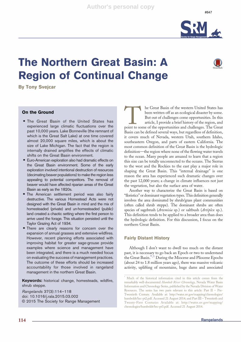
Figure 1. Buzzard Complex fire, which burned about 400,000 acres insoutheastern Oregon in 2014. At one time a fire this size would have beenextraordinary, but large rangeland fires have become rather common in thenorthern Great Basin.
Rangelands116
Author's personal copy
disagreement that atmospheric carbon dioxide is increasing.More cheatgrass biomass further increases wildfire risk.
The fire situation is reversed on the higher elevation sites(above 5,000 feet or so). In this case, the plant communitiesare more productive than those at the lower elevations andhave a shorter historic fire return interval—every 15 to 30years depending on the site. However, up to this point,cheatgrass has not come to dominate these sites (although thatcould change). The low level of cheatgrass, removal of fuel byheavy grazing, and active fire suppression actually reduced thefire frequency during the 1900s, especially during the early tomiddle part of the century. One result has been a dramaticincrease in woody plants, juniper species in particular.Compared with historical conditions, there probably is morewoody vegetation (juniper) at the higher elevations and lesswoody vegetation (sagebrush) at many lower elevations, atleast over significant portions of the region.
In recent years there has been tremendous focus onimproving Great Basin habitat for greater sage-grouse(Centrocercus urophasianus). This sagebrush-obligate specieswill be evaluated for a federal endangered species listing in thenear future. Current efforts are generally focused on improvinghabitat and applying management prescriptions such that anendangered species listing will not be deemed necessary. Frommy perspective, there are at least two major needs that haveemerged from these efforts:
1. Improved tools and approaches for integrating scienceinto the initial decision-making process; and
2. Better documentation of habitat responses to manage-ment treatments.
These needs arise from a general focus on accountability ontwo fronts—the public wants to know that sound decisions arebeing made, and increasingly management decisions must beexplained and justified in a court of law.
The interest in accountability in rangeland managementhas been underway for some time. The Conservation EffectsAssessment Project (CEAP) was initiated in 2003 to evaluateU.S. Department of Agriculture (USDA) conservationprograms.10 This effort was broken into cropland andrangeland segments. Rangeland CEAP was a comprehensiveanalysis of peer-reviewed research associated with USDA-Natural Resources Conservation Service (NRCS) rangelandmanagement practices. The basic conclusion of the CEAPeffort was that NRCS used science in its planning process, butthere was no systematic monitoring to allow ecological orsocioeconomic evaluation of conservation efforts.10
In the Great Basin, as in much of the western United States,the rangeland management profession is being asked to do abetter job of documenting the effects of our actions, andadjusting where necessary. Although this scrutiny can feel a littleintimidating, it also provides a great opportunity. Many of theforces acting on our profession are causing regular interactionsamong scientists, policymakers, and land managers. There isalso evidence of increasing interaction among professions, asmultiple players are engaged in all the greater sage-grouse
planning efforts. I suggest that applied scientists spend moretime evaluating how their results will be used to make decisions.In other words, field testing the application of research resultsand working with managers to refine the presentation ofscientific concepts. There is also a clear need for simple, efficientmethods to capture information on the outcomes of manage-ment/conservation efforts. There are always risks associatedwith broad standardization, but the more consistency there is inmonitoring protocols the easier it is to aggregate data and scaleup. There is a need to evaluate the success of individualpractices, but also a need to aggregate multiple practices athigher spatial scales. For example, it would be nice to know howoften a particular seeding treatment works; it would also be niceto know how many acres of greater sage-grouse habitat havebeen restored in a county or a region (by all treatments).
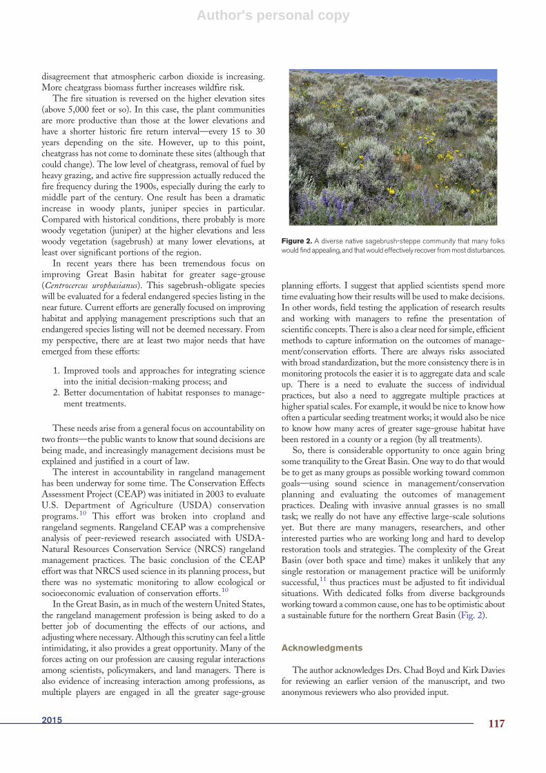
So, there is considerable opportunity to once again bringsome tranquility to the Great Basin. One way to do that wouldbe to get as many groups as possible working toward commongoals—using sound science in management/conservationplanning and evaluating the outcomes of managementpractices. Dealing with invasive annual grasses is no smalltask; we really do not have any effective large-scale solutionsyet. But there are many managers, researchers, and otherinterested parties who are working long and hard to developrestoration tools and strategies. The complexity of the GreatBasin (over both space and time) makes it unlikely that anysingle restoration or management practice will be uniformlysuccessful,11 thus practices must be adjusted to fit individualsituations. With dedicated folks from diverse backgroundsworking toward a common cause, one has to be optimistic abouta sustainable future for the northern Great Basin (Fig. 2).
Acknowledgments
The author acknowledges Drs. Chad Boyd and Kirk Daviesfor reviewing an earlier version of the manuscript, and twoanonymous reviewers who also provided input.
Figure 2. A diverse native sagebrush-steppe community that many folkswould find appealing, and thatwould effectively recover frommost disturbances.
2015 117

Author's personal copy
References
1. BISHOP, E.M. 2003. In search of ancient Oregon: a geologic andnatural history. Portland, OR, USA: Timber Press [288 pp.].
2. MCADOO, J.K., B.W. SCHULTZ, AND S.R. SWANSON. 2013.Aboriginal precedent for activemanagement of sagebrush-perennialgrass communities of the Great Basin. Rangeland Ecology &Management 66:241-253.
3. CLINE, G.G. 1974. Peter Skene Odgen and the Hudson’s BayCompany. Norman, OK, USA: University of Oklahoma Press[258 pp.].
4. HINES, G. 1851. Oregon: its history, conditions, and prospects.Buffalo, NY, USA: Geo. H. Derby and Co. [201 pp., see www.rootsweb.com/~ormultno/index.htm for an, online version].
5. SUMMARY OF HOMESTEAD ACTS, Available at: http://en.wikipedia.org/wiki/Homesteadact (Accessed 21 August 2014).
6. YOUNG, J.A., AND B.A. SPARKS. 1985. Cattle in the cold desert.Logan, UT, USA: Utah State University Press [255 pp.].
7. GRIFFITHS, D. 1902. Forage conditions of the northern border ofthe Great Basin. Washington DC, USA: U.S. Department ofAgriculture, Bureau of Plant Industry [60 pp.].
8. WHISENANT, S.G. 1990. Changing fire frequencies on Idaho’sSnake River Plains: ecological and management implications. In:
MCARTHUR ED, ROMNEY EM, SMITH SD, & TUELLER PT,editors. Proceedings-symposium on cheatgrass invasion, shrubdie-off, and other aspects of shrub biology and management(Tech. Rep. INT-276). Washington DC, USA: USDA-ForestService Gen. p. 4-10.
9. ZISKA, L.H., J.B. REEVES, AND B. BLANK. 2005. The impact ofrecent increases in atmospheric CO2 on biomass production andvegetative retention of Cheatgrass (Bromus tectorum): implicationsfor fire disturbance. Global Change Biology 11:1325-1332.
10. BRISKE, D.D., L.W. JOLLEY, L.F. DURIANCIK, AND J.P.DOBROWOLSKI. 2011. Introduction to the conservation effectsassessment project and the rangeland literature synthesis. In: &BRISKE DD, editor. Conservation benefits of rangeland practices:assessment, recommendations, and knowledge gapes. Lawrence,KS, USA: Allen Press. p. 1-8.
11. BOYD, C.S., AND T.J. SVEJCAR. 2009. Managing complexproblems in rangeland ecosystems. Rangeland Ecology &Management 62:491-499.
Author is Research Leader, USDA–ARS, Eastern OregonAgricultural Research Center, Burns, OR 97720.
Rangelands118


![Enzymes II - Oregon State Universityoregonstate.edu/instruct/bb450/450material/Keynotes/10Enzymes.pdfMichaelis)Menten,Kinetics • Vmax and Kcat Vmax [Enzyme Used] = [Product] [Enzyme](https://static.fdocuments.net/doc/165x107/5e75841310de0e0b173bc785/enzymes-ii-oregon-state-u-michaelismentenkinetics-a-vmax-and-kcat-vmax-enzyme.jpg)


![stream geomorp limno [Read-Only] - Oregon State Universityoregonstate.edu/instruct/fw456/lecture/pdf/stream_geomorphology.pdf · (like a horizontal paddle wheel) ... Uniform Flow](https://static.fdocuments.net/doc/165x107/5a730e167f8b9ab1538e2d97/stream-geomorp-limno-read-only-oregon-state-u-like-a-horizontal-paddle.jpg)


