810.1 TOOLS IN INTEGRATED RESOURCE MANAGEMENT …
163
1 COUNTY FOREST COMPREHENSIVE LAND USE PLAN TABLE OF CONTENTS CHAPTER 800 I NTEGRATED RESOURCE MANAGEMENT Section Subject Page 800 CHAPTER OBJECTIVES………………………………………………….. 805 INTEGRATED RESOURCE MANAGEMENT APPROACH……….……… 810 SUSTAINABLE FORESTRY…………………………………………………... 810.1 TOOLS IN INTEGRATED RESOURCE MANAGEMENT……………… 810.1.1 Compartment Recon…………………………………………………….. 810.1.2 Forest Habitat Classification System…………………………………… 810.1.3 Soil Surveys…………………………………………………………….. 810.1.4 Ecological Landscapes of Wisconsin…………………………………… 810.1.5 Integrated Pest Management… ………………………………………… 810.1.6 Best Management Practices for Water Quality…………………………. 810.1.7 Fire Management……………………………………………………..… 810.1.7.1 Prescribed Fire………………………………………………. 810.1.8 Outside Expertise, Studies and Survey…………………………………. 810.1.9 Local Silvicultural Field Trials…………………………………………. 815 MANAGEMENT CONSIDERATIONS TO REDUCE LOSS ……………… 815.1 RISK FACTORS……………………………………………………….….. 815.1.1 Wind……………………………………………………………………... 815.1.2 Flooding………………………………………………………………….. 815.1.3 Fire……………………………………………………………………….. 815.1.4 Climate Change………………………………………………………….. 815.1.5 Timber Markets………………………………………………………….. 820 PLANT COMMUNITIES MANAGEMENT…………………………........... 820.1 SILVICULTURAL PRACTICES/TREATMENTS……………………….. 820.1.1 Natural Regeneration…………………………………………………… 820.1.1.1 Clearcutting/Coppice……………………………………….. 820.1.1.2 Shelterwood / Seed Tree……………………………………
Transcript of 810.1 TOOLS IN INTEGRATED RESOURCE MANAGEMENT …

1
COUNTY FOREST COMPREHENSIVE LAND USE PLAN
TABLE OF CONTENTS
CHAPTER 800
INTEGRATED RESOURCE MANAGEMENT
Section Subject Page
800 CHAPTER OBJECTIVES…………………………………………………..
805 INTEGRATED RESOURCE MANAGEMENT APPROACH……….………
810 SUSTAINABLE FORESTRY…………………………………………………...
810.1 TOOLS IN INTEGRATED RESOURCE MANAGEMENT………………
810.1.1 Compartment Recon……………………………………………………..
810.1.2 Forest Habitat Classification System……………………………………
810.1.3 Soil Surveys……………………………………………………………..
810.1.4 Ecological Landscapes of Wisconsin……………………………………
810.1.5 Integrated Pest Management… …………………………………………
810.1.6 Best Management Practices for Water Quality………………………….
810.1.7 Fire Management……………………………………………………..…
810.1.7.1 Prescribed Fire……………………………………………….
810.1.8 Outside Expertise, Studies and Survey………………………………….
810.1.9 Local Silvicultural Field Trials………………………………………….
815 MANAGEMENT CONSIDERATIONS TO REDUCE LOSS ………………
815.1 RISK FACTORS……………………………………………………….…..
815.1.1 Wind……………………………………………………………………...
815.1.2 Flooding…………………………………………………………………..
815.1.3 Fire………………………………………………………………………..
815.1.4 Climate Change…………………………………………………………..
815.1.5 Timber Markets…………………………………………………………..
820 PLANT COMMUNITIES MANAGEMENT…………………………...........
820.1 SILVICULTURAL PRACTICES/TREATMENTS………………………..
820.1.1 Natural Regeneration……………………………………………………
820.1.1.1 Clearcutting/Coppice………………………………………..
820.1.1.2 Shelterwood / Seed Tree……………………………………

2
Section Subject Page
820.1.1.3 All Aged Regeneration Harvests……………………………
820.1.1.4 Prescribed Burning…………………………………………..
820.1.1.5 Soil Scarification……………………………………………
820.1.2 Artificial Regeneration…………………………………………………
820.1.2.1 Mechanical Site Preparation…………………………….….
820.1.2.2 Chemical Site Preparation……………………………….…
820.1.2.3 Prescribed Burning……………………………….…………
820.1.2.4 Tree Planting / Seeding……………………….…………….
820.1.3 Intermediate Treatments………………………………….…………….
820.1.3.1 Mechanical Release…………………………….…………..
820.1.3.2 Chemical Release………………………………….…….….
820.1.3.3 Non-Commercial Thinning (TSI)……………….…………..
820.1.3.4 Thinning / Intermediate Cuts……………………………….
820.1.3.5 Pruning……………………………………………………..
820.2 SILVICULTURAL PRESCRIPTIONS……………………………………
820.2.1 Even-Aged Management………………………………………………..
820.2.1.1 Aspen ………………………………………………………
820.2.1.2 Jack Pine …………………………………………….……...
820.2.2 Uneven-Aged Management……………………………………………...
820.2.2.1 Northern Hardwood…………………………………………
820.2.2.2 Swamp Hardwood…………………………………………...
820.3 LOCALLY UNCOMMON TREES / FOREST TYPES…………………...
820.3.1 American Elm……………………………………………………………………
820.3.2 Butternut………………………………………………………………………….
820.3.3 Eastern Hemlock…………………………………………………………….….
820.3.x Other………………………………………………………………………...……
820.4 FOREST TYPES REQUIRING INTENSIVE EFFORT TO REGENERATE
820.4.1 White Birch……………………………………………………………….
820.4.2 Northern Red Oak………………………………………………….……..
820.4.x Others…………………………………………………..…………………
820.5 INVASIVE PLANT SPECIES OF CONCERN…………………..………………..
820.6 LEGALLY PROTECTED AND SPECIAL CONCERN PLANT SPECIES.
820.7 TREE RETENTION GUIDELINES…………………………………………

3
Section Subject Page
820.8 BIOMASS HARVESTING GUIDELINES…………………………………
825 ANIMAL SPECIES MANAGEMENT……………………………..………......
825.1 TECHNICAL PLANNING……………………………………….…………
825.2 GUIDELINES………………………………………………….……………
825.3 INVENTORY………………………………………………...………………
825.4 RESOURCE MANAGEMENT CONSIDERATIONS FOR WILDLIFE…..
825.5 IMPORTANCE OF HABITATS…………………………………………...
825.5.1 Non-forested Wetlands………………………………………….……………...
825.5.2 Aquatic Habitats……………………………………………..……………….…
825.5.3 Riparian and Other Non-managed Areas…………….……………………...
825.5.4 Early Successional Forests…………………………………………………….
825.5.5 Conifers…………………………………………………………………………..
825.5.6 Oak Management……………………………………………….………………
825.5.7 Uneven/All-aged Management……………………………….………………..
825.5.8 Large Forest Blocks……………………………………………..………….…..
825.5.9 Grasslands, Openings, Upland Brush………………………...………………
825.5.x Other Local Habitats…………………………………………………….…..….
825.6 INTENSIVE WILDLIFE MANAGEMENT PROJECTS………………….
825.6.1 Wisconsin Wildlife Action Plan / SGCN…………………………………
825.7 FISH AND WATERS MANAGEMENT…………………………………..
825.7.1 Technical Planning and Surveys………………………………………….
825.7.2 Special Projects…………………………………………………………...
825.7.3 Shoreland Zoning…………………………………………………………
825.7.4 Access and Development…………………………………………………
825.7.5 Important Water Resources…………………………………………….…
830 EXCEPTIONAL RESOURCES, UNIQUE AREAS …………….………….…
830.1 HCVFs FOR FSC AND DUAL-CERTIFIED COUNTIES…..
830.2 AREAS RECOGNIZED BY STATE OR FEDERAL
GOVERNMENT……………………………………………………………
830.2.1 State Natural Areas…………………………………………………..
830.2.2 State Scientific Areas…………………………………………………

4
Section Subject Page
830.2.3 Endangered Species Habitats…………………………………..……………...
830.2.4 Rare Communities…………………………………………………………………
830.2.x Others……………………………………………………………………….………
830.3 AREAS RECOGNIZED BY COUNTY OR LOCALLY……………….….
830.3.1 Forests with Old Growth Characteristics………………………….…………
830.3.2 Wildlife Sites (Hibernacula, Rookeries, Special Habitats)…………………
830.3.3 Savannas, Barrens, etc……………………………………………………
830.3.4 Geological Features of Significance……………………………………...
830.3.5 Waterfalls, Wild Rivers, Wild Lakes………………………………….….
830.3.6 Unique Forest Types, Benchmark Stands, etc…………………………..
830.3.7 Endangered or Threatened Species Habitat……………………………..
830.4 CULTURALLY SIGNIFICANT SITES……………………………………
830.4.1 Burial Mounds, Cemeteries………………………………………………
830.4.2 Logging Camps, Dams, Forest History…………………………………..
830.4.3 Landmarks………………………………………………………………..
830.4.4 Other……………………………………………………………………..
835 AESTHETICS………………………………………………..………….……
835.1 AESTHETIC MANAGEMENT…………………………………….………
835.2 AESTHETIC MANAGEMENT ZONES…………………………………..
835.2.1 Aesthetic Management Zone Examples…………………………………..
835.2.2 Aesthetic Management Prescriptions/Options……………………………
835.2.3 Regulated Aesthetic Management Zone Areas……………………………
835.2.3.1 Scenic Riverway……………………………………………...
835.2.3.2 Scientific/Natural Area……………………………………….
835.2.3.3 Scenic Highway Easements……………………………….….
835.2.3.4 Scenic Riverway Easements………………………………….
840 LANDSCAPE MANAGEMENT………………………………..………………..
840.1 CONSERVATION OF BIOLOGICAL DIVERSITY……………..………..
840.2 HABITAT FRAGMENTATION……………………………………………
845 INTEGRATED RESOURCE MANAGEMENT UNITS……………………………
845.1 OBJECTIVES…………………………………………………………………
845.2 UNIT NARRATIVES…………………………………………………………

5
800 CHAPTER OBJECTIVES
1. To introduce and communicate to the public, the County Board of Supervisors,
and to the Wisconsin DNR, the integrated resource approach and management
strategies hat forestry, wildlife and other natural resource staff will use on the
Bayfield County Forest during this planning period.
2. Counties may also wish to consider the establishment of "Integrated Resource
Management Units" (IRMU). If established, IRMU’s will identify and
summarize the natural resources, as well as any social and/or physical
management potential that exists within each unit. If established , a summary of
each IRMU can be found in the Appendix (Chapter 3000).
805 INTEGRATED RESOURCE MANAGEMENT APPROACH
Integrated Resource Management is defined as: "the simultaneous consideration of
ecological, physical, economic, and social aspects of lands, waters and resources in
developing and implementing multiple-use, sustained yield management" (Helms, 1998).
This balance of ecological, economic, and social factors is the framework within which
the Bayfield County Forest is managed.
The working definition of Integrated Resource Management generally means, in large
part, keeping natural communities of plants and animals and their environments healthy
and productive so people can enjoy and benefit from them now and in the future.
This Chapter is intended to help communicate how the County Forest will be managed
within an integrated resource framework.
810 SUSTAINABLE FORESTRY
As per Wisconsin Administrative Code and State Statutes, sustainable forestry is defined
as: the practice of managing dynamic forest ecosystems to provide ecological, economic,
social and cultural benefits for present and future generations. NR 44.03(12) Wis. Adm.
Code and s.28.04(1)(e), Wis. Stats.

6
As stated in Chapter 100, and for the purpose of this Chapter, sustainable forestry will be
defined as : to develop, apply, maintain and promote sustainable forest management
strategies that address the present demands of society without sacrificing the needs of
future generations.
In doing so, Bayfield County will integrate the primary emphasis of growing and
harvesting trees for a variety of forest products together with: ensuring adequate and
acceptable regeneration/reforestation of all managed stands (both natural and artificial);
the creation and maintenance of diverse and rich wildlife habitat; the conservation and
protection of water, soil and air quality; the development and maintenance of ecosystem
and biological diversity; the development and maintenance of a variety of public
recreational opportunities (both motorized and non-motorized); and aesthetics; all while
recognizing the need to modify and adapt sustainable forest management strategies to
address a variety of dynamic factors, including a progressively changing climate.
810.1 INTEGRATED RESOURCE MANAGEMENT TOOLS
810.1.1 Forest Reconnaissance
The County will consult and utilize the compartment reconnaissance procedures as
established in the DNR Public Forest Lands Handbook 2460.5. WisFIRS will serve as
the primary database for housing recon information. The County Forest will be
monitored on a routine and regular basis, at a level determined by the Administrator, and
further elaborated in the Workplan. Compartment and stand level reconnaissance
procedures will be utilized to maintain accurate and current forest information.
In some situations, cover type specific reconnaissance may be performed in attempts to
capture current information regarding the growth, health, and/or development of a
particular species or complex. Some examples of more recent species level
reconnaissance projects include: a re-inventory of mature jack pine stands in the BBMA;
collecting updated stand information on mature red oak, swamp conifer and swamp
hardwood stands to help determine management priorities; collecting similar information

7
on mature stands of northern hardwood to determine which silvicultural methods will be
best suited for the type (even-aged or all-aged); and a sub-sample of the aspen type to
determine if Hypoxylon is impacting the development of the stand.
In general, one goal of the reconnaissance program is conduct a complete re-inventory of
the County Forest every 15 to 20 years. The Department will also continue to develop
and maintain other databases for the management and analysis of recon information. See
the Workplan and Accomplishment Report for more information on forest reconnaissance
on the County Forest.
810.1.2 Continuous Forest Inventory (CFI)
In 2018, the Department established a permanent framework for collecting additional
information on the growth and development of the County Forest. A total of about 667
permanent continuous forest inventory (CFI) plots will be established on the County
Forest (estimated to be completed by 2022). The CFI plots will be established
throughout all cover types on the County Forest and will conform with Wisconsin DNR
CFI protocols. Once established, each CFI plot will be re-measured roughly every five
years, in perpetuity.
One of the primary objectives of implementing a permanent CFI program is to collect
statistically sound stand information that will be used to report on the status and trends of
the County Forest. The multitude of data that will be collected as part of every plot will
be used to track variables like, but not limited to: forest extent, forest cover (by type),
volume, growth, quality, mortality, removals, regeneration, habitat, health (both at the
stand level and forest wide), carbon sequestration, invasive species, soils, down woody
debris, biomass, insects and disease, herbivory, and more.
Current reconnaissance (compartment and stand level) and other forest monitoring efforts
provide a stable foundation. However, CFI will cover a broader depth of forest attributes;
will provide significantly greater analysis and reporting capabilities; and will supplement
information obtained through annual and routine reconnaissance. In addition, CFI will

8
not replace the need to continue monitoring the forest on a stand or compartment level
basis.
The CFI program will produce a wealth of information to assist the Department in
various planning and decision making processes (both short and long term). Factors
and/or questions like annual volume growth per cover type, product and/or quality
development, responses to forest management, level of carbon sequestration, extent of
invasive species, impacts of insects and/or disease, impacts of climate change, etc., will
all be attainable with the statistically sound information gleaned from CFI.
See the Appendix for a link to the DNR CFI documents. See the Workplan for detailed
goals and objectives associated with the CFI program. See the Accomplishment report
for a summary of completed work.
810.1.3 Regeneration/Reforestation Monitoring
All stands that were reforested artificially (planted or seeded) and most that were
regenerated naturally will require some form of seedling surveys, survival counts or
similar form of reforestation/regeneration monitoring. Monitoring the development of a
newly regenerating stand is an integral part of the reforestation process.
In general, the Department utilizes two forms of evaluation methods when assessing
reforestation activities: the Forest Regeneration Metric (FRM) is used to evaluate stands
that are regenerating naturally; and a more standard seedling survival count is used to
evaluate stands that were reforested artificially. Other methods of assessing reforestation
activities may be utilized as determined by the Administrator.
Data collected from all monitoring methods are used to assess the development of the
stand in a variety of ways, some of which include: calculating the stocking levels of
desired tree species; evaluating the survival and quality of established seedlings;
assessing the degree and/or intensity of undesirable competition; indicating existence of
insects and/or disease, and, if present, the extent of threats/impacts to the stand; assessing

9
the level of herbivory, if present; and anything else of note. The results of each survey
provides valuable information when determining the effectiveness of the reforestation
activity, if any additional inputs by the Department will be required to achieve the desired
future condition and the next management prescription for the stand.
DNR stocking charts and/or similar publications are used as a reference to help determine
the minimum number of desirable seedlings required to successfully reforest a stand.
Additional inputs (i.e. supplemental planting, reseeding, and/or additional site prep work)
may be required if a significant portion of a stand is regenerating at levels under the
desired thresholds.
810.1.3.1 Artificial Reforestation Monitoring
On planted sites, seedling counts are generally administered at one, two, three,
five and ten years, or some combination thereof, after the regeneration activity.
Typically, a planted site is surveyed about five times during the first ten years. If
an issue is discovered, it is addressed as soon as possible.
Due to the extra time required for seed to germinate and establish, the first survey
conducted on sites that were seeded may occur around 3 to 4 years after the
reforestation activity. Typically, two to three additional seedling counts are
administered up to year ten. A seeded site is generally surveyed three to four
times during the first ten years.
Additional seedling surveys may be necessary if issues were noted during the
previous assessment or if additional inputs were conducted by the Department
(i.e. supplemental planting, competition control, deer browse, etc).
810.1.3.2 Forest Regeneration Metric (FRM)
Seedling counts on stands regenerating naturally are typically conducted two to
four years after harvest (depending on the forest type). One to two additional
surveys may also be required to determine success. Some stands may receive

10
additional monitoring after ten years of age, especially if issues are discovered or
if stands aren’t responding to treatment.
The FRM survey methodology is the primary tool used to assess natural
regeneration. FRM was established, in part, to develop general survey
methodology designed to assess natural regeneration by seedling and sapling size
classes, thus providing a better, more scientific way to quantify results and
discover/address potential issues.
FRM is generally administered on hardwood stands, but can also be used on any
stand where the goal is natural regeneration. See the DNR Silviculture Handbook
for more detailed information on FRM.
Refer to the Workplan for details on artificial and natural reforestation monitoring on the
County Forest. Also refer to the Accomplishment report for a summary of completed
work.
810.1.4 Forest Habitat Classification System
The Forest Habitat Classification System (A Guide to Forest Communities and Habitat
Types of Northern Wisconsin Second Edition; Kotar, et al.) is a natural classification
system for identifying and interpreting forest communities and the sites on which they
develop. It utilizes a systematic interpretation and analysis of natural vegetation with
emphasis on understory species.
Habitat types that occupy similar positions along the soil moisture-nutrient gradient can
be grouped into broader categories. This soil moisture grouping can facilitate more
effective ways to analyze data and develop short and long term forest management goals
and objectives. Soil moisture groups are identified on every stand and managed in
WisFIRS.
See the DNR Silviculture Handbook for more information on the Forest Habitat
Classification System.

11
810.1.5 Soil Surveys
Department staff's knowledge of forest ecology and their experience across the landscape
can assist in associating forest habitat types and site indices with soil type information.
These associations can be beneficial in determining management prescriptions for
specific sites. WisFIRS contains soil survey data, and this information can also be found
on the NRCS website-based soil survey.
810.1.6 Ecological Landscapes of Wisconsin
The Ecological Landscapes of Wisconsin (WDNR Handbook 1805.1) is an ecological
land classification system based on the National Hierarchical Framework of Ecological
Units (NHFEU). A combination of physical and biological factors including climate,
geology, topography, soils, water, and vegetation are used to help distinguish and classify
different ecological landscapes. These landscapes provide a useful tool and insight into
ecosystem management. Land areas identified and mapped in this manner are known as
ecological units.
Generally accepted silvicultural systems are prescribed on a stand level scale, often in
recognition of the stand’s position within the larger ecological landscape.
See the Appendix for a link to the DNR website describing Ecological Landscapes.
810.1.7 Integrated Pest Management
Integrated pest management is generally defined as: the maintenance of destructive
agents, including insects, at tolerable levels, by the planned use of a variety of preventive,
suppressive, or regulatory tactics and strategies that are ecologically and economically
efficient and socially acceptable.
The Committee has the authority to approve and direct the use of pesticides and other
reasonable alternatives in an integrated pest management program on the County Forest.
Refer to Chapter 600 for more detailed discussion and integrated pest management
strategies.

12
810.1.8 Best Management Practices for Water Quality
The most practical and cost-effective method to assure that forestry operations do not
adversely affect water quality on the County Forest is to utilize "best management
practices" (BMP's) as described in Wisconsin's Forestry Best Management Practices for
Water Quality. Publication number FR-093. See the Appendix for a link to the BMP
manual.
Consistent with the aforementioned manual, Bayfield County will utilize BMP's on the
County Forest with the understanding that the application of which may be modified to
address specific site conditions and/or unique situations, as determined by the
Administrator and/or in consultation with other natural resource professionals, if
necessary. Modifications will provide equal or greater water quality protection or have
no significant impact on water quality.
Areas with highly erodible soil types, proximity to streams or lakes, or steep slopes may
require additional mitigating measures in excess of those outlined in the BMP manual.
All Department employees practicing forestry will receive BMP training. Additionally,
Bayfield County will encourage BMP training of all logging contractors that operate on
County timber sales.
810.1.9 Fire Management
Information on fire management in located in Chapter 600.
810.1.9.1 Prescribed Fire
Prescribed burning on the County Forest may play an important role in various
forest management practices. Many of the plant communities present today are a
result of or otherwise dependent upon routine and/or regular wildfires.
As the needs are presented to regenerate or maintain timber types or other plant
communities, the Department will examine the costs and benefits of each
opportunity, in coordination with the DNR. Increased regulations, the various

13
costs associated with completing a prescribed burn, and the risk of breakouts and
uncontrolled fires will also be considered.
All prescribed burning will be done in accordance with Wisconsin State Statutes
26.12, 26.14, and the DNR Prescribed Burn Handbook 4360.5 and in cooperation
with the DNR, as described in Chapter 600 of this Plan.
810.1.9.2 Fire Pre-suppression
The County will initiate programs and actions to mitigate wildfire hazards. Wildfire
pre-suppression activities will be carried out in coordination with the DNR, local
towns and fire departments, Forest Service, and others as appropriate. Fire
mitigation measures on timber sales may include the lopping and scattering of slash,
slash free zones along property lines and access roads and expanding road corridors
to create larger defensible zones. Timber sale contracts will also have provisions to
modify harvest operations depending on the fire danger and stipulate suppression
responsibilities of the purchaser.
810.1.9.3 Fuel Breaks
Fuel breaks will also be used as a fire management tool in large areas of contiguous
hazardous fuels and ignition potential. Fuel breaks will take many forms including:
Lakes, streams, wetlands, and other natural features.
Timber type changes, i.e. deciduous types adjacent to conifers.
Widening road corridors and establishing brush free zones.
Maintaining a system of open land up to ¼ mile in width in the areas of
highest potential ignition and risk.
The most intensive use of fuel breaks on the County Forest is the maintained system
located in the BBMA in the Town of Barnes (see the Appendix for maps of the fuel
break system). This area is located in the NW Sands ecological landscape, has a
high concentration of red and jack pine plantations and significant potential ignition
sources due to the proximity of numerous private properties and developments.

14
The Community Wildfire Protection Plan for the Towns of Barnes and Drummond
in Northwestern Wisconsin was developed to address the potential risks to the
community from the devastating impacts of wildfire. The plan seeks to establish
priorities for protection of life, property and critical infrastructure within the
wildland-urban interface (WUI), or the areas where human development
intermixes with wildland vegetation and fuels.
As per the Wildfire Protection Plan, the County Forest fire mitigation system in the
Town of Barnes will utilize enhanced clearing widths along Town and County
Forest Roads in addition to the maintenance of roughly ¼ mile wide, multi-purpose,
fuel breaks.
See the Appendix for a maps of the fuel break system and a link to the Barnes-
Drummond Wildfire Protection Plan. See Chapter 600 for more information on fire
management. Refer to the Workplan for more information on the planned wildfire
mitigation/maintenance activities.
810.1.10 Outside Expertise, Studies and Survey
Additional data and/or information may be required to help make management decisions
on the County Forest. When required, as determined by the Department, this information
will be solicited from other professional agencies and/or individuals, who are recognized
as having the best capability and/or technical expertise to produce the material of interest,
including, but not limited to:
Water Resources: WDNR.
Wildlife Resources: WDNR.
Soil Resources: NRCS.
Mineral Resources: WDNR.
Wetland Resources: WDNR, Army Corps of Engineers, County Zoning.
Navigable Streams: WDNR, Army Corps of Engineers, County Zoning.
Floodplains: County Zoning.
Cultural Resources: WDNR, State Historical Society.

15
Entomology / Pathology: WDNR.
Endangered Resources: WDNR.
Forestry: Cooperative Field Trials (see DNR website), US Forest Service.
Other subjects as needed.
810.1.11 Local Silvicultural Field Trials
To date, numerous field trials have been completed or are ongoing on the Bayfield
County Forest. See the DNR website for the most up to date summary of these field
trials.
810.1.12 Carbon Assessments, Accounting and Marketing
The County Forest provides an important ecosystem function in the form of carbon
sequestration, or the uptake and storage of carbon in the forest and associated wood
products. Sequestration and similar topics regarding carbon have evolved over time,
especially in light of concerns regarding a potentially changing climate and resulting
negative impacts. The recognition and management of carbon is another potential
option to consider when developing sound sustainable management strategies for the
County Forest.
Data regarding carbon sequestration is collected as part of the CFI program.
Information from the CFI program can be used to develop, assess and analyze carbon
stocks and trends on the County Forest (or carbon accounting). Carbon stock and trend
information, in conjunction with other similar assessments on forest carbon, can help
the Department better understand the correlation between carbon storage, previous
management practices and disturbance impacts.
The results of any carbon analysis project could have the potential to alter and/or
modify certain approaches or strategies regarding the sustainable management of the
County Forest, as determined by the Administrator and/or Committee.

16
Carbon assessments, accounting and marketing (carbon offsets) will be explored by the
Administrator. If marketing carbon offsets is determined to be a potential, the
Administrator will summarize and present findings to the Committee for further action.
If a carbon project is developed and adopted by the Department, as approved by the
Committee, it will be addressed and summarized in the Workplan.
815 MANAGEMENT CONSIDERATIONS TO REDUCE LOSS
Numerous factors can impact the growth and development of the County Forest.
Management decisions can help mitigate the impacts of some factors. Below are a few of
the more common risk factors that can impact the County Forest:
815.1 RISK FACTORS
815.1.1 Wind
Strong winds can create significant damage to the County Forest. Windthrow and stem
breakage can impact individual trees or entire stands. In some instances, heavy storms
have the potential to damage hundreds to thousands of acres. The resulting damage can
be sporadic or impact large contiguous blocks of timber.
Maintaining the health and vigor of the County Forest is one of the best ways to prepare
for strong wind events. While complete protection from potential damage is impossible,
healthy, vigorous trees have more robust crowns, minimal forks and/or crooks, and
strong, expansive root systems that can help the tree survive strong wind events.
In addition, trees that are developing on relatively shallow soils can be more susceptible
to windthrow. Management prescriptions in these stands should also account for this
added susceptibility. Northern hardwood stands developing in IRMU 6 have a history of
windthrow.

17
The County Forest will be surveyed after major significant storm events to locate areas of
wind damage. Minor instances of wind damage is naturally and generally not considered
an issue. However, if the damage is extensive and significant, as determined by the
Department, timber sales will be established to salvage as much of the damaged trees as
possible.
815.1.2 Flooding
Major flooding events also have the potential to significantly impact the County Forest.
While not as common as wind events, repeated instances of high water or intensive storm
events have the potential to create significant levels of damage. More commonly, floods
or significant rain events can negatively impact County Forest infrastructure i.e. roads
and trails. Localized flooding created by beaver activity can also cause damage to county
infrastructure and forest resources. Known problem areas are routinely monitored by
Department staff, with the more significant issues addressed accordingly.
Incorporating BMP’s for Water Quality on all timber sales, as well as road and/or trail
construction and/or maintenance activities is one of the most effective ways to mitigate
the potential effects of significant water events. Additionally, when managing forested
stands in locations where the soils are prone to fluctuations in the water table, it is
important to consider the type and timing of each silvicultural treatment. Some even-
aged methods could evoke a swamping effect, where a raised water table creates
conditions less suitable for the establishment of a new stand.
815.1.3 Fire
Wildfire is discussed more extensively in Chapter 600 as well as section 810 of this
Chapter. Refer to those sections for more information on wildfire protection measures.
815.1.4 Climate Change
All trees will eventually be impacted by a potentially changing climate. Some trees could
realize an expansion of suitable habitat and benefit from a changing climate. While other
trees would most likely experience a decrease in suitable habitat, an increase in
18
susceptibility to biotic and abiotic stressors, and be negatively impacted by climate
change.
One of the most effective ways to mitigate or prepare for the potential impacts of a
changing climate is to maintain the health and vigor of the forest. Healthy, productive,
vigorous trees are more likely to withstand some of the additional stressors initiated by a
changing climate. Additionally, developing management strategies that target the
regeneration of trees best suited for each site is another way address some of the concerns
associated with climate change. Species currently developing on marginal sites or
locations that are better suited for other timber types could be considered for conversion.
The Department will continue to collaborate with the DNR, USFS and other natural
resource professionals regarding the management of the County Forest and the potential
impacts of a changing climate. If modifications and/or adjustments to the management
strategies prescribed for each cover type are necessary, as a response to climate change,
as determined by the Administrator, they will be addressed in the Workplan.
815.1.5 Timber Markets/Economics
As stated in Chapter 100, one of the primary objectives of County Forest lands, as
defined in the mission statement, as well as the purpose of County Forest Law, is
sustainable timber production. Multiple-use management of these renewable forest
resources generate numerous economic and social benefits including, but not limited to,
quality forest/timber products, recreational opportunities, tourism, natural resource
related jobs, improved quality of life and other similar amenities. The raw forest
products generated from the management of the County Forest provides a direct,
important and significant source of revenue to the County, as well as the Towns that
contain County Forest lands; while timber production, recreation and tourism related
activities/industries foster local and regional economic development and support job
growth.

19
The Department generally advertises two timber sale offerings per calendar year. One
offering is held in the spring (generally in May) and the other in the fall (generally in
November). Timber sales are established every year based, in part, on the sustainable
harvest goals developed as part of each respective Workplan. When a timber sale is sold,
each timber sale contract is generally awarded for a period of two or three years, but is
eligible for annual one-year extensions. It is relatively common for a timber sale contract
to be active over a period of four to five years (and sometimes longer).
Timber markets have traditionally been fairly volatile. As a result, stumpage prices have
also been unstable and unpredictable. One primary goal of the Department is to produce
a relatively stable, consistent, predictable, even-flow of potential forest products (and
volume) every year through the routine and regular establishment of timber sales. This is
achieved primarily through accomplishments of the annual sustainable harvest goals (i.e.
acreage control). Since there is typically six months between timber sale offerings and
markets are, at best, unpredictable, modifying lettings to coincide with stronger stumpage
prices is generally perceived as impractical.
However, in times of extremely poor market conditions or events, a delay in the offering
of specific timber sales (i.e. species and/or products that are most impacted by
significantly lower than average stumpage prices) should be considered. In contrast,
when stronger markets are predicted (especially those forecasted to continue for an
appreciable amount of time), annual timber sale establishment priorities could be
modified to target those forest types with stronger stumpage value first.
Economic potential and/or impacts are generally considered with every timber sale and
should be used in combination with other guidelines as part of the overall integrated
resource management goals and objectives for the County Forest. Additionally, a greater
emphasis on economic considerations could be incorporated in the development of
silvicultural goals and objectives for most timber types, if doing so does not compromise
the integrity of the resource and overall mission of the Department.

20
Other options could be considered to address timber sale offering strategies when market
conditions are on either end of the spectrum (either extremely poor or strong). If the
Administrator recommends a drastic modification and/or adjustment in standard or
otherwise customary approaches to or marketability of certain timber sales or forest
products, the Committee will be informed and additional action may be required. For
more information on forest economics, refer to the Economics Considerations section of
the DNR Silviculture handbook.
820 PLANT COMMUNITIES MANAGEMENT
Bayfield County recognizes the importance of maintaining the diversity of the Forest as
part of a larger scale, ecosystem framework. However, the process involved in making
management decisions to encourage or discourage specific tree species and/or plant
communities is complex and dynamic. It includes, but is not limited to, an understanding
of:
Goals and Objectives of the County;
Integration of landscapes, soils, climate, and vegetative factors;
Habitat classification;
Past, present and future desired condition;
Surrounding ownership patterns and general management objectives;
Wildlife habitat and other similar values;
Social needs.
Economic factors.
820.1 SILVICULTURAL PRACTICES/TREATMENTS
The Society of American Foresters defines silviculture as:
“the art and science of controlling the establishment, growth, composition, health,
and quality of forests and woodlands to meet the diverse needs and values of
landowners and society on a sustainable basis.”
Typically, silvicultural guidelines are designed to enhance the growth, quality, vigor,
and/or composition of a stand. Prescriptions are applied across a variety of landscapes

21
and developmental stages, and generally utilize even aged or uneven aged systems. The
management of a large and diverse forest, such as the Bayfield County Forest, requires a
unified, systematic, integrated resource management approach.
The DNR Public Forest Lands Handbook (2460.5) and Silvicultural Handbook (2431.5)
will be referenced as guidelines for management practices used on the County Forest.
820.1.1 Natural Regeneration
Where feasible, reforestation will be encouraged through the use of silvicultural
methods that promote and foster the natural regeneration, recruitment and development
of native tree species on the County Forest. In general, the particular silvicultural
technique applied will depend on the biological functions and/or ecological needs of the
desired tree species or forest type being considered for management.
820.1.1.1 Clearcutting/Coppice
Clearcutting is a silvicultural method commonly used to regenerate an even-aged
stand of primarily shade intolerant species. The removal of most or all trees
located within a stand will simulate a more intensive disturbance, thus facilitating
the regeneration and growth of species such as aspen, jack pine and white birch.
This method is also used as a final rotation harvest in species such as red oak, red
pine and others (generally referred to as an overstory removal). Tree retention
guidelines are followed when prescribing a clearcut or coppice harvest, though
may be modified to address specific concerns.
820.1.1.2 Shelterwood / Seed Tree
Shelterwood and seed tree harvests are silvicultural methods often used to
regenerate mid-shade tolerant to shade tolerant tree species by manipulating
overstory and understory vegetation. These methods are designed to regenerate
an even-aged stand and normally involve the removal of most of the overstory, in
two or more cuttings, after the new stand is established. The overstory serves to

22
influence understory conditions, create a favorable environment for reproduction,
and provide a seed source.
A clearcut (or overstory removal) is generally prescribed once the desired level of
regeneration has been attained. Though, in some seed tree prescriptions, the final
overstory removal harvest is omitted to minimize damage to the advanced
regeneration. This method is commonly applied to regenerate red oak, white
pine, white birch, and some stands of northern hardwoods (when managing even
aged). Tree retention guidelines are followed when prescribing shelterwood and
seed tree harvests, though may be modified to address specific concerns.
820.1.1.3 All Aged Regeneration Harvests
All aged regeneration harvests are generally applied to manage shade tolerant
species. “Gaps” in the forest canopy facilitate the establishment and recruitment
of numerous shade tolerant to mid-tolerant species like sugar maple, yellow birch,
red maple and basswood. Over time, multiple entries into the stand will develop a
variable structure of age classes. In general, the presence of at least three distinct
age classes is required to be classified as an all-aged stand.
All aged regeneration harvests may be prescribed in the form of single tree
selection (or gaps), group selection or patch selection. This method is generally
used to maintain stands of northern hardwoods, when converting other stands to
northern hardwoods and occasionally in swamp hardwoods (when managing for
all-aged characteristics)
820.1.1.4 Prescribed Burning
Prescribed burning may be utilized as a tool to promote desired regeneration. A
number of forest types in Bayfield County are ecologically linked to fire. Burning
may create site conditions that will encourage seed germination and establishment
and/or release existing regeneration from competing vegetation. Prescribed fire is
generally considered for the management of red oak, white birch, jack pine or

23
white pine. See Chapter 600 for more information on prescribed burning.
820.1.1.5 Soil Scarification/Site Preparation
Scarification is a technique used to prepare a site for a reforestation/regeneration
activity. This disturbance (generally mechanical) exposes bare mineral soil and
reduces competing, undesirable vegetation, primarily in an attempt to create more
favorable conditions necessary to promote desirable regeneration. Red oak, white
birch and many of the pine species can benefit from some form of site
preparation. Site prep activities can occur prior to, in conjunction with or after a
timber sale and can apply to both natural and artificial reforestation methods.
Disturbance activities that incorporate seed into duff and soil layers creates
optimal conditions for the natural regeneration of oak, white birch, fir and others.
The Department utilizes numerous forms of equipment to encourage natural
regeneration, including, but not limited to: dozer and straight blade, anchor
chains, root rakes, and salmon blades.
820.1.1.6 Other
Other natural regeneration techniques may be considered where necessary and
appropriate, as determined by the Department.
820.1.2 Artificial Regeneration
Artificial regeneration generally refers to the form of reforestation that involves planting
or direct seeding. Artificial regeneration practices generally require a level of site
preparation, either mechanical and/or chemical, and may also involve release or some
form of competition control.
Artificial reforestation methods are often applied to maintain stands that are difficult to
regenerate naturally. They can also be applied when traditional natural regeneration
methods fail. Red pine, jack pine and white pine are examples of species that are
commonly reforested via either planting or direct seeding.

24
820.1.2.1 Mechanical Site Preparation
Mechanical site preparation generally involves the use of heavy equipment to
disturb the soil. Some of the more common forms of mechanical site preparation
equipment includes, but is not limited to: disc trencher, roller chopper, fire plow,
V-plow and dozer and straight blade.
The type of equipment used and intensity of the site preparation is generally
dependent on a variety of factors, including, but not limited to: site conditions,
type and density of slash or other logging debris, presence of competing
vegetation, whether the site will be planted or seeded, and targeted tree species
selected for reforestation. When a stand will be reforested artificially, all site prep
work is typically accomplished prior to tree planting or direct seeding.
820.1.2.2 Chemical Site Preparation
Herbicide application can be an effective means of controlling undesirable
vegetation and more effectively prepare a site for planting or direct seeding. It
should be used sparingly and in situations where mechanical treatments are not
expected to provide the level of vegetative control required to successfully
regenerate the stand. When chemical is used, it will be applied in strict
accordance with label recommendations and requirements, and under the
oversight of a certified applicator.
Herbicides will generally be applied with either motorized, ground based
equipment, hand applications, or aerially. A written prescription for each
herbicide application will be prepared and kept on file. Chemical site preparation
may also be accomplished in conjunction with mechanical methods. Oftentimes,
less chemical can be applied when the site is mechanically prepared the year
prior.
820.1.2.3 Prescribed Burning
Prescribed burning for site preparation can be used to reduce logging debris, clear

25
the site, reduce competing vegetation, and to release nutrients into the soil. All
prescribed burning activities on the County Forest will be coordinated with the
DNR.
820.1.2.4 Tree Planting / Seeding
Hand planting and direct seeding are the two primary forms of artificial
reforestation methods utilized on the County Forest. Machine planting may also
be used, if feasible and when deemed appropriate, as determined by the
Department. Tree seedlings being considered for planting can be either
containerized or bare root stock.
Tree species selected for planting or seeding will be determined according to the
specific management objectives and capabilities of each site, as determined by the
Department. Only species native to the region will be considered for planting or
seeding. Other options may be considered, but, if selecting a tree species not
native to the region, there must be documentation addressing the rationale, as well
as a summary of goals and objectives.
The Department will make all reasonable efforts to obtain seeds and/or seedlings
that were sourced from local stock (to maintain local genetic viability). See the
Annual Workplan for more information on the reforestation program.
820.1.3 Intermediate Treatments
Intermediate treatments are those practices used to enhance the health and vigor of a
stand prior to a final regeneration harvest. In general, intermediate treatments are applied
to forest stands that will be managed as even-aged.
820.1.3.1 Mechanical Release/Timber Stand Improvement (TSI)
Mechanical release is the removal of competing vegetation by means other than
herbicide or fire. Timber stand improvement may include releasing young pine
plantations or natural oak/northern hardwood stands from competing vegetation

26
using chain saws, brush saws or other hand-held equipment; mowing; or utilizing
similar means of motorized equipment with the goals of reducing the density of
undesirable competing vegetation.
820.1.3.2 Chemical Release
The goals of chemical release are very similar to that of mechanical: to reduce
the level and intensity of competing vegetation. Chemical methods are often
considered when mechanical release isn’t expected to achieve the desired results.
A heavy component of aspen and/or scrub oak in stands that will be planted or
seeded to red pine or jack pine is a common example of when a low level of
herbicide might be considered. Additionally, herbicide will be considered when a
stand contains significant levels of invasive species, as determined by the
Department.
When chemical is used, it will be applied in strict accordance with label
recommendations and requirements and under the oversight of a certified
applicator. A written prescription for each herbicide application will be prepared
and kept on file.
820.1.3.3 Non-Commercial Thinning
In general, most thinning needs are accomplished through commercial harvest
operations. Non-commercial thinning may be considered if the individual site
requirements, funding and/or available labor make it desirable.
820.1.3.4 Thinning / Intermediate Cuts
Thinning is an even-aged treatment conducted in stands that have reached
merchantable or commercial size. A primary objective of this intermediate
treatment is to temporarily reduce overall stand density in order to improve tree
growth, enhance tree health, and/or recover potential mortality, thus concentrating
future development on the more desirable trees. Thinning (in stands that are
suitable for an intermediate treatment) provides the main method, implemented

27
between regeneration and final harvest, to increase the economic productivity of
stands.
Thinning or intermediate treatments can occur throughout the life of the forest
stand, but do not include efforts directed at establishing regeneration.
Intermediate treatments (thinnings) are generally designed to enhance stand
composition, structure, growth, health, quality, vigor and the production and/or
development of specific timber products.
Thinning is generally prescribed in forest types such as red pine, white pine, red
oak, and northern hardwood. Thinning may be prescribed on other cover types
when appropriate and where feasible, as determined by the Department.
Intermediate harvests include prescriptions designed to address residual densities,
marking priorities, tree quality, mortality, spacing, crown closure, diameter
distribution, or other measurements.
820.1.3.5 Pruning
In general, pruning is the removal of limbs from lower sections of trees to
increase log quality. On the County Forest, some pruning efforts were conducted
in the distant past, but it is not generally recognized as an economically viable
practice. However, pruning can be considered on a case by case basis.
For more detailed information on the various silvicultural methods listed above, including
variations, as well as other methods not previously addressed, please refer to the various
DNR Handbooks. A link to each Handbook can be found in the Appendix.
For more detailed information on forest management activities occurring on the County
Forest, refer to the Workplan and Accomplishment Report.
820.2 SILVICULTURAL PRESCRIPTIONS
Silvicultural prescriptions are developed for every individual forested stand located on

28
the County Forest. However, some stands have been removed from management
consideration or are considered unproductive (i.e. that don’t contain the level of volume
required to support traditional forest management practices).
As addressed in Chapter 300, the County Forest in 175,749 acres in size. However, the
total acreage, as summarized in the GIS database (WisFIRS), is 172,400 acres. A total of
159,652 acres (or roughly 93% of the total area) is classified as forested. The remaining
12,752 acres (or roughly 7%) is non-forested.
Table 820.1 summarizes the total forested acres located on the County Forest per primary
cover type.
Table 820.1: Total Acreage per Forested Cover Type
Cover Type Manageable Removed Unproductive Total
Aspen 71,673 6,125 0 77,798
Red Pine 18,018 254 0 18,272
Northern Hardwood 16,675 639 0 17,314
Red Oak 13,492 1,041 0 14,533
Jack Pine 11,461 176 0 11,637
Scrub Oak 5,451 467 0 5,918
Swamp Hardwood 2,236 947 0 3,183
Red Maple 2,622 99 0 2,721
White Pine 1,955 684 0 2,639
Black Spruce 829 246 452 1,527
Tamarack 430 86 481 997
White Birch 734 177 0 911
Balsam Fir 519 66 0 585
Fir-Spruce 153 367 0 520
Cedar 210 167 0 377
White Spruce 216 68 0 284
Hemlock 39 190 0 229
Swamp Conifer 114 0 32 146
Miscellaneous Conifer 38 0 0 38
Miscellaneous Deciduous 20 0 0 20
Bottomland Hardwood 3 0 0 3
Total 146,888 11,799 965 159,652

29
Stands that are considered manageable are part of the suitable timber base and scheduled
for some form of future treatment. Scheduled stands are included as part of the short and
long term sustainable harvest goals. Stands that have been removed from the
management schedule or are otherwise classified as unproductive, are not considered part
of the suitable timber base and are not included in the development of sustainable harvest
goals.
Stands are removed from future management considerations for a variety of reasons,
some of which include: excluded as part of a riparian management zone (RMZ); located
on steep or inoperable slopes; located on highly erodible soils; retained for other purposes
(i.e. reserve and/or green tree retention); or removed as part of a unique resource or
special management area (SMA). For more information on SMA’s, refer to Section 830).
Below are the general management goals and objectives for the major forest types located
on the County Forest. For more detailed information on the silvics of each forest type,
please consult the DNR Silviculture Handbook (a link to the Handbook can be found in
the Appendix).
Also, for more detailed information regarding the annual sustainable harvest goals,
reforestation activities, reconnaissance and inventory targets and management strategies
for each forest type, including any necessary adjustments or modifications that have been
determined necessary, by the Administrator, to achieve desired objectives, please see the
Workplan.
820.2.1 Aspen
Aspen is the single largest cover type (by acreage) on the County Forest. At nearly
78,000 acres, aspen comprises roughly 45% of the County Forest. Trembling (Quaking),
Big-tooth or a combination of the two comprise the aspen type (with Trembling being far
more prevalent on the County Forest). Aspen is classified as shade intolerant, is managed
with even-aged silvicultural methods and is generally recognized as an early successional
species.
30
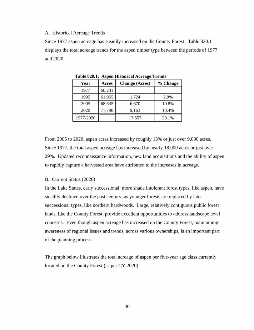
A. Historical Acreage Trends
Since 1977 aspen acreage has steadily increased on the County Forest. Table 820.1
displays the total acreage trends for the aspen timber type between the periods of 1977
and 2020.
Table 820.1: Aspen Historical Acreage Trends
Year Acres Change (Acres) % Change
1977 60,241
1995 61,965 1,724 2.9%
2005 68,635 6,670 10.8%
2020 77,798 9,163 13.4%
1977-2020 17,557 29.1%
From 2005 to 2020, aspen acres increased by roughly 13% or just over 9,000 acres.
Since 1977, the total aspen acreage has increased by nearly 18,000 acres or just over
29%. Updated reconnaissance information, new land acquisitions and the ability of aspen
to rapidly capture a harvested area have attributed to the increases in acreage.
B. Current Status (2020)
In the Lake States, early successional, more shade intolerant forest types, like aspen, have
steadily declined over the past century, as younger forests are replaced by later
successional types, like northern hardwoods. Large, relatively contiguous public forest
lands, like the County Forest, provide excellent opportunities to address landscape level
concerns. Even though aspen acreage has increased on the County Forest, maintaining
awareness of regional issues and trends, across various ownerships, is an important part
of the planning process.
The graph below illustrates the total acreage of aspen per five-year age class currently
located on the County Forest (as per CY 2020).

31
Of the nearly 78,000 acres of aspen on the County Forest, roughly 72,000 acres (or about
92%) is considered manageable (or part of the suitable timber management base).
Roughly 8%, or about 6,000 acres, has been removed from the harvest schedule (and is
not part of the suitable timber management base). Stands are removed from timber
management consideration for a variety of reasons, some of which include: being located
on steep, inoperable slopes; included as part of a riparian management zone (RMZ); and
retained to satisfy green tree requirements. In general, these stands will not be considered
as part of the sustainable timber harvest process and will naturally convert to longer
lived, late successional species.
Aspen is fairly ubiquitous on the County Forest and can be found on every habitat type
and in every management unit (IRMU). It is most prevalent in IRMU’s 1 and 2 (located
on the clay plain in the Bayfield Peninsula) and on sites classified as mesic/wet mesic
(MWM, which generally includes the clay soils) and dry/dry-mesic (DDM). Aspen is
also common on sandy sites classified as very dry/dry (VDD). See the various cover
types maps located in the Appendix. Also see Chapter 3000 for information on the aspen
type in each IRMU.
C. Desired Future Condition
The goal is to maintain the total amount of aspen on the County Forest. Another primary

32
goal in the management of the aspen type is to achieve a regulated and balanced age-class
distribution. Regulation generally refers to developing a relatively equal proportion of
acreage per age class (or grouping of age classes).
For example, when considering the roughly 72,000 total acres of aspen that is currently
part of the suitable timber base (scheduled for future management), and then dividing that
number by the average rotation age (50 years), the target regulated sustainable harvest
goal would be roughly 1,440 acres per year (or per each one-year age class). The yellow
line on the graph above indicates the regulated goal or amount of acreage in each age-
class if the aspen type were already in a regulated condition.
However, as per the graph listed above, the current age class distribution for aspen is very
irregular (an S curve shape). The total amount of acres in the 25 to 44 year age class
categories is significantly higher than the regulated target. As a result, modifications to
the annual sustainable harvest goals will be required to achieve the desired future
condition.
Modifications to the sustainable harvest goal would most likely result in a slight increase
in acres scheduled for management over the next 15 year period (or harvest levels that are
slightly higher than the regulated target). This would be required to produce a more even
spread of an otherwise irregular age-class distribution in an attempt to begin the process
of regulation. In general, it may take several rotations before a more regulated age-class
distribution is achieved.
In addition, other potential management strategies i.e. carbon marketing (see section 810
for more information on carbon) could influence the timing of future aspen management
activities. See the Annual Workplan for more information regarding aspen management
on the County Forest, including adjustments, if any, made to the sustainable harvest goal.
D. Management
When managing the aspen type, the following criteria and/or management strategies will

33
apply:
1. Aspen will be regenerated naturally. Aspen is a shade intolerant, early
successional species that quickly and aggressively captures (re-sprouts) a site after
a timber harvest. The timing of harvest can influence the density and volume of
aspen sprouts (i.e. a winter harvest generally produces a higher density of sprouts
than a summer harvest) and should be considered if attempting to control or limit
the amount of aspen regeneration (i.e. if attempting to increase species diversity).
The retention of other tree species or placement of reserve (green) trees or patches
can also influence the level of aspen regeneration (see section 820.7 for more
information on Tree Retention). Otherwise, typically, no additional inputs from
the Department will be required to naturally regenerate aspen.
2. Even-aged management using the coppice method will be the primary
silvicultural treatment used to naturally regenerate aspen.
a. Underplanting or direct seeding with another native tree species (i.e. white
pine) may be considered if an objective is to increase diversity within a
stand of aspen. The timing of timber harvest, green tree retention, timber
sale design and other modifications can also be considered to influence or
encourage species diversity within a stand of aspen.
3. Other regeneration methods or intermediate treatments will be considered,
depending on the goals and objectives of the stand or (IRMU), as determined by
the Administrator.
In general, aspen sprouts prolifically and is able to fully capture a site shortly after a
regeneration harvest. Historically, there have rarely been issues regenerating a stand of
aspen on the County Forest. Employing FRM or similar regeneration survey methods is
generally not necessary on every new stand. However, there may be instances where
regeneration monitoring should be considered.
A new stand of aspen should be considered for regeneration monitoring if: it contained
high levels of Hypoxylon or other disease prior to harvest; is located on marginal sites;
contained lower levels of aspen density prior to harvest (and a fully stocked aspen stand

34
is the desired objective); or for any other reason where seedling counts are necessary, as
determined by the Department,
The Department may also consider establishing a regeneration monitoring program that
surveys a sub-set of stands on a routine and regular basis. The results of monitoring will
be used to determine if additional actions are required to achieve the desired results, or if
modifications and/or adjustments should be considered on future management
prescriptions and/or strategies.
Other silvicultural prescriptions, regeneration methods or intermediate treatments will be
considered, depending on the goals for the stand, best available science, responses to
previous management, landscape level (or IRMU) objectives or similar factors, as
determined by the Department.
See Section 810 and the DNR Silviculture Handbook for more information on FRM. See
the Workplan for more detailed information regarding regeneration monitoring on the
County Forest.
E. Sustainable Harvest Goals:
Short and long term harvest goals for the aspen type are generally calculated by dividing
the total acres in the suitable timber base by the average rotation age. Current age class
distributions, slight variations per IRMU, stand health and vigor, landscape
considerations, and other Department objectives may influence the actual harvest goal for
any given year.
Table 820.6 displays the total number of acres that are currently prescribed for
management in aspen stands on the County Forest:
Table 820.12: Acres of Aspen
System Manageable Removed Total
Even-Aged 71,673 6,125 77,798
Total 71,673 6,125 77,798

35
Achieving a more balanced age-class distribution is one of the primary targets for
managing the aspen type. Modifications to the annual sustainable harvest goals will be
required to achieve the desired future condition. The adjustments will vary on a
management unit level depending on many of the factors previously stated. This may
result in sustainable harvest goals that are slightly higher than the regulated target. As a
result, the harvest goals will be fairly dynamic and vary annually.
Refer to the Workplan for detailed information on the sustainable harvest goal for aspen
during any given year, including adjustments and/or modifications required to achieve
desired objectives. Also see the Accomplishment Report for a summary of previously
completed treatments. Table 820.2 lists the general rotation ages for aspen.
Table 820.2: Rotation Age (Age in Years)
RotationSite Quality
Low Avg. High
Early 35 35 35
Average 50 50 50
Extended 55 60 65
The average rotation age for aspen is 50 years, but harvest cycles may vary based on site
conditions, current age class distributions, landscape level considerations, objectives for a
particular stand and/or IRMU, product marketability, or other similar factors, as
determined by the Department.
F. Challenges
Numerous threats and challenges need to be considered when managing aspen forests.
Some of the more significant challenges, threats and/or issues regarding the management
of the aspen type include:
1. Hypoxylon Canker. The fungus that causes the hypoxylon canker is the most
significant disease that often results in aspen mortality in the Lake States.
Mortality is more common in younger stands. Trembling aspen is the most
susceptible native aspen type.
2. Forest Tent Caterpillar. See Chapter 600 for more information on insects and

36
disease.
3. Gypsy Moth. See Chapter 600 for more information on insects and disease.
4. Decrease of Early Successional Forests (landscape level). Large public land bases
provide some of the best opportunities to address landscape or regional level
concerns. The perpetuation of early successional forest types is a priority of the
Department and should be considered as part of short and long term planning
efforts.
5. Climate Change. Aspen, particularly Trembling (Quaking) aspen is predicted to
potentially decrease on the landscape, primarily due to increased susceptibility to
heat and drought.
The challenges, threats and/or concerns listed above have the potential to impact and/or
influence short and/or long term management objectives for any given stand, as
determined by the Department. The Department will continue to routinely and regularly
monitor the County Forest and modify goals and objectives accordingly.
See the DNR Silviculture Handbook for more detailed information on management
options for the aspen type. Also see the Workplan for more information regarding the
management of aspen on the County Forest.
The graphic below provides a general summary of the aspen type, including goals and
objectives, acreage per management unit (IRMU) and moisture group, rotations ages,
silvicultural treatments and challenges.

37
Current Status: the largest cover type (by acreage) on the Forest. Fairly evenly distributed throughout the
ownership. Irregular (imbalanced) age class distribution, heavily skewed to the 30-45 year old age bracket.
Future Goals: in general, maintain the cover type acreage. Accelerate harvests to develop a more
balanced age-class distribution. Explore opportunities to convert on poor sites or where otherwise more
susceptible to potential impacts of a changing climate.
ASPEN
0250050007500
100001250015000175002000022500
Acr
es
Age Class (years)
Aspen Age Class Distribution
Total Acres Scheduled Total Acres Removed
Rotation Age (Age in Years)
Low Avg. High
Early 35 35 35
Average 50 50 50
Extended 55 60 65
RotationSite Quality
Acres per IRMU
IRMU Acres % of Total
1 18,169 70%
2 13,597 72%
3 13,277 47%
4 8,890 55%
5 5,344 28%
6 3,890 20%
7 2,286 38%
8 11,664 50%
9 681 6%
10 0 0%
Total 77,798 45%
Acres per Moisture (Habitat) Group
Moisture Group Acres % of Total
MWM 35,296 76%
DDM 14,285 56%
VDD 11,454 26%
DM 9,631 40%
M 3,720 27%
Steep Slopes 3,183 63%
Wet 229 2%
Total 77,798 45%
System Method Applied
Clearcut (coppice) 1
Clearcut (seed/plant) na
Seed Tree 2
Shelterwood 3
Overstory Removal 3
Even-Aged Thinning na
Single Tree Selection (Gaps) na
Group Selection na
Patch Selection na
1 = preferred; 2 = acceptable; 3 = limited potential
Common Forest Management Practices
Even-Aged
All-Aged
Challenges (Threats) to Maintaining Cover Type
Category Challenge/Impact Threat Level
Deer Browse 3
Competition Control 3
Site Preparation 3
Seed Crop/Viability 3
Sprouting Intensity 2
Insects 3
Disease 2
Flooding/Drought 2
Climate Change 1
1 = high; 2 = moderate; 3 = low.
Regeneration/
Reforestation
Biotic and
Abiotic Impacts

38
820.2.2 Northern Hardwoods
Northern Hardwood is the third largest cover type (by acreage) on the County Forest. At
just over 17,000 acres, northern hardwoods comprise roughly 10% of the total area.
Sugar maple and basswood are the two most common species that make up a typical
stand of northern hardwood. Red maple, yellow birch, white ash, red oak and aspen are
frequent associates.
Northern hardwood is an association of various tree species that are, collectively,
generally considered to be shade tolerant. The northern hardwood type is also classified
as late successional and is typically longer lived.
A. Historical Acreage Trends
Between 1977 and 2005, northern hardwood acreage had generally increased. However,
over the past 15 years, northern hardwood acreage has decreased by nearly 5,000 acres
(or about 22%). The primary reasons for the decrease are generally two-fold: 1) stands
of red maple were originally included in the northern hardwood type. However, recently,
the Department made the decision to remove red maple from northern hardwood
calculations and treated it as an individual cover type. At roughly 2,700 acres total, the
removal of red maple accounts for over half of the decrease; and 2) the entire county
forest was re-inventoried over the past 18 years. Improved reconnaissance information
resulted in more accurate cover typing.
Table 820.3 displays the total acreage trends for the northern hardwood timber type
between the periods of 1977 and 2020:
Table 820.3: Northern Hardwood Historical Acreage Trends
Year Acres Change (Acres) % Change
1977 19,435
1995 22,948 3,513 18.1%
2005 22,290 -658 -2.9%
2020 17,314 -4,976 -22.3%
1977-2020 -2,121 -10.9%
As stands naturally succeed to more shade tolerant, longer lived species, and other, more

39
difficult to manage cover types (like red oak) are regenerated, the general expectation is
for a slight increase in northern hardwood acreage over the next 15 years.
B. Current Status (2020)
As of 2020, a total of 17,314 acres of the County Forest is typed as northern hardwood.
Of that total, 16,675 is manageable and considered part of the suitable timber base. The
remaining amount, roughly 640 acres, has been removed from the harvest schedule.
Northern hardwood is primarily located within two distinct areas of the County Forest:
1) IRMU 6, located in the SW portion of Bayfield County; and 2) IRMU 8, located in the
upland portions of the Bayfield Peninsula. IRMU 1, located in the clay plain generally
surrounding IRMU 8, also contains a fairly significant amount of northern hardwoods.
See the Appendix for maps indicating the location of the northern hardwood type on the
Bayfield County Forest. Also see Chapter 3000 for a summary of northern hardwoods
per IRMU.
C. Desired Future Condition
One goal for the northern hardwood type is to maintain to slightly increase the acreage
over the next 15 year period. Some stands will likely convert to northern hardwoods due
to the natural succession from shorter-lived, early successional species (like aspen and
paper birch) to longer-lived, late successional species. In addition, on richer sites that are
currently dominated by red oak, the conversion to northern hardwoods may occur
because of the inherent complexities involved in the regeneration of the oak type. In
contrast, poor quality stand of northern hardwood may be converted to another species
more suited for that particular site (like aspen, red oak and/or white pine).
D. Management
In general, one primary objective of northern hardwood management is to maximize the
quality of an individual tree on any given site. Most northern hardwood stands on the
County Forest are second growth, pole sized, relatively even-aged (between 85 to 100
years of age), and contain a fairly high proportion of poor quality and/or diseased trees.
Site potential, or the potential ability of a certain area to produce quality timber products

40
of a given species, will play a major role in determining how a particular stand of
northern hardwoods will be managed or if the site is better suited for an alternative
species. Habitat type (soil moisture group), soil characteristics, and site index are the
preferred indicators of site potential. These indicators, as well as an assessment of
current stand conditions, including responses to previous management, will be used to
determine which management options best meet long-term sustainable goals and
objectives.
The northern hardwood type is essentially located in two distinctly different regions of
the County Forest. Northern hardwood stands located in the southern region (IRMU 6)
are developing on mainly mesic (M) sites with good to excellent relative growth
potential. Soils for the area generally range from sandy loam to silt loam with ATM as
the most common habitat type (refer to the Appendix for more information on habitat
types). This area generally provides the greatest potential for high quality sawlog
development in shade tolerant species. However, the soils in this area are relatively
shallow and rocky, which creates an increased susceptibility to blowdown.
In the northern region (IRMUs 8 and 1), northern hardwood stands located in the
Bayfield Peninsula have typically developed on dry-mesic (DM) to mesic wet-mesic
(MWM) sites with fairly poor to good relative growth potential. Soils for the area are
generally sand to loamy sand and typically contain a component of clay. The terrain
tends to be rolling, with aspect contributing to the development of individual stands (in
this region, northern hardwoods tend to be better quality on north to northeastern facing
slopes). This area exhibits some potential for high quality sawlog development, however
relatively slow growth rates may influence or, in some cases, restrict management
options. (Refer to the DNR Silviculture Handbook for additional information on northern
hardwood management).
Northern hardwoods are ultimately managed with either even-aged or all-aged
silvicultural systems. Most previously unmanaged, second growth stands will benefit
from an initial improvement harvest. Migrating from a previously unmanaged even-aged
condition to an all-aged structure may also be another common scenario. Numerous

41
variables are considered before determining which silvicultural system will provide the
best results for any given stand of northern hardwoods. These variables include, but are
not limited to, site potential (habitat type, site index, soil characteristics), current stand
conditions (structure, quality, species composition), past management practices (and
responses to them), landscape/watershed protection, desired future condition, recreational
considerations and aesthetics. A description of various management systems is described
below:
1. Improvement Harvest: many northern hardwood stands on the County Forest are
previously unmanaged, second-growth, even-aged, and contain a large percentage
of small diameter trees. In addition, there is frequently a large portion of poor
quality and/or diseased trees, as well as many overmature, large diameter early
successional species (e.g. aspen, paper birch). The smaller diameter classes tend
to be overstocked, while trees that are currently in the larger size classes are
normally remnants of past management and are of relatively poor quality.
Improvement harvests focus on removing the trees that are the poorest quality,
have reached biological maturity, and are in overabundant size classes.
As part of an improvement harvest, target residual stocking or crown cover levels
are designated, however little attention is directed toward the development of a
balanced diameter distribution. Crop trees are identified and canopy gaps are
naturally created from the removal of large diameter (and large crowned)
overmature dominant trees. The initial improvement harvest, in most cases,
reduces the basal area to target levels before the need to consider other
parameters. The stand is re-evaluated in approximately 10 to 20 years to
determine whether even-aged or uneven-aged silvicultural practices will be used
for future management.
2. Uneven-aged (or All-aged) Management: all-aged management generally refers
to the removal of individual trees or small groups of trees with the goal of
increasing the growth and quality of the remaining better quality stems. In
addition, management addresses appropriate space and seedbed conditions for the
regeneration and recruitment of a new age class of desired tree species. This

42
method emulates stand composition and structure using gap-phase processes
(individual tree selection), maintains a continuous canopy cover with a permanent
seed source, and is well suited to the perpetuation of shade tolerant species (i.e.
sugar maple). Over the long term, stands managed with uneven-aged practices
provide sustained yields of quality timber products at relatively constant intervals
or cutting cycles. Stands are generally harvested every 10 to 30 years (cutting
cycle) contingent upon site quality, growth rates, intensity of previous harvest,
operational considerations, and other long-term goals or objectives.
Table 820.4 displays the general thinning intervals used when managing stands of
northern hardwoods with all-aged methods.
Table 820.4: Thinning Intervals Between Treatments (Years)
System GrowthSite Quality
Low Average High
All-Aged
Poor 30 25 20
Average 20 15 15
High 10 10 10
A variety of harvesting methods can be considered when prescribing an all-aged
management system. Some of the more common forms considered on the County
Forest include: single tree selection, group selection and patch selection.
Additionally, variables such as the determination of crop trees, creation of canopy
openings i.e. gaps, groups and patches (including the size and placement of the
canopy openings), and targeted stand structure and stocking are incorporated into
uneven-aged management systems. Stands are considered to have reached an all-
aged condition when three of or more distinct age classes can be recognized.
Below is a description of the basic harvesting methods, as well as other variables
used in uneven-aged management.
a. Single Tree Selection: single (or individual) tree selection is one of the
more common methods of uneven-aged harvesting practices used to
manage northern hardwoods on the County Forest. This method removes

43
individual trees to a specified stocking or crown cover level while
maintaining a fairly uniform and continuous canopy cover. Crop trees are
identified and, in most cases, released and canopy gaps (either randomly
or systematically) are intentionally created for the development and
recruitment of a new age class. Gaps are generally less than 0.1 acres in
size, cover about 5 to 30% of the stand area, and designed to develop a
new age class of desired tree species. When deciding which trees to
harvest, a designated order of removal is generally followed. Each harvest
targets the removal of trees in the overstocked size classes, as well as the
poorest quality trees throughout all size classes. Below is the general
order of removal:
i. High Risk/Cull
ii. Poor quality/Form
iii. Release crop trees
iv. Maximum tree size
v. Undesirable Species
vi. Improve Spacing
In understocked size classes, only high risk and cull trees, as well as
undesirable tree species and trees that have reached the designated
maximum size are typically removed. The order of removal is meant to be
a guide and may change as determined by the Department. Present stand
conditions can also be highly variable and may warrant slight deviations.
b. Group Selection: group selection is an all-aged management method that
creates larger openings in the canopy. Canopy openings created through
the group selection method generally range between 0.1 to 0.5 acres in
size. The larger openings encourage the establishment and recruitment of
more mid-tolerant tree species. Groups may be placed randomly or
systematically. A light thinning may also be prescribed in the remaining
stand utilizing the same principals outlined in the order of removal above.
Group selection is another common method used when managing northern
hardwood stands on the County Forest.

44
c. Patch Selection: patch selection is an all-aged management method that
incorporates larger, even-aged patches. Patch sizes generally range from
0.5 acres and less than two acres. This option may be selected when
managing northern hardwoods developing on poorer quality sites, those
with high levels of ironwood or other undesirable competition, or on
stands that did not respond to previous management actions, where a
degree of structural diversity is desired. A light thinning may also be
prescribed in the remaining stand utilizing the same principals outlined in
the order of removal above. Patch selection is not as common as the
single tree and group selection methods, but remains a viable option when
managing northern hardwoods on the County Forest.
See the DNR Silviculture Handbook for a more detail description of the
various uneven-aged management methods that can be prescribed on
stands of northern hardwood. Also see the Workplan for details on the
goals and objectives for managing northern hardwoods on the County
Forest.
Definitions and general parameters for some of the terms used to describe
all-aged management are as follows:
i. Crop Tree: any dominant or co-dominant, low risk, desirable tree
species, exhibiting good form and vigor that is capable of
producing a minimum of one, 8 foot log, grade 2 or better. In
general, uneven-aged management should be considered a viable
management option if there are at least 40 crop trees per acre.
However, all-aged management may be considered when a
potential for quality tree development exists even if the desired
level of crop trees are not present in the current stand.
ii. Canopy Openings: an opening in the forest canopy created by the
removal of large crowned trees or groups of trees. Under uneven-
aged management systems, canopy gaps are created at each entry
45
to regenerate and recruit a new age class of desired tree species. In
addition, gaps help to develop a layer of vertical structure that is
desired in an all-aged system. Typically, in the single tree method,
canopy gaps should range from 30 to 75 feet in diameter, while in
the group method, gap/group sizes should range from 75 to 167
feet in diameter. During each entry, a general target is to achieve a
total of 10 to 25% of the stand in some form of canopy opening,
more or less depending on the goals and objectives of the
prescription, as determined by the Department. All trees 1 to 2
inches dbh. and larger are removed within each gap. Smaller gaps
generally favor more shade tolerant species like sugar maple while
larger gaps, when combined with site preparation and, in some
situations, release, have the potential to regenerate less shade
tolerant species like yellow birch and white ash. Gaps may be
created randomly or in a systematic pattern. A systematic
structure has been the more common form of gap placement
utilized by the Department.
iii. Target Stand Structure (Size Class Distribution)/Stocking: one
goal of management in all-aged systems is to achieve a regulated
stand condition. In part, this is accomplished by encouraging a
certain number of trees to develop into various size (diameter)
classes. Target stand structure (or diameter distribution) refers to
the desired level of trees per acre in various individual size
(diameter) classes over a long-term period. Size class distributions
are guidelines only and are considered when stands are close to a
regulated condition. The purpose of developing this structure is to
ensure that there will be a sufficient number of trees continuously
growing into the next larger size class. One of the most common
variables used to calculate a targeted stand structure is expressed
as the “Q” value. The Q value is the quotient between the number
of trees in successively smaller diameter classes, resulting in a

46
reverse J-shaped curve. Other variables such as desired largest
tree diameter and targeted residual stocking level (target basal area
after harvest) are incorporated into the development of the guide.
Lower values of Q (1.2 to 1.4) will encourage the development of
larger sawlog material over a greater proportion of the stand.
Higher values of Q (1.5 to 1.7) will encourage a larger proportion
of pole timber and small sawlog. See the DNR Silviculture
Handbook for more information on Q values.
3. Even-aged Management: even-aged silvicultural systems are designed to
maintain and develop a single age class of trees. Stands are regenerated at a
selected rotation age. Intermediate treatments may be applied to develop growth
and quality on residual trees prior to the final rotation harvest. The length of
rotation may be defined by a variety of factors, including, but not limited to:
mean age, maximum tree size, mean annual increment (MAI), and economic or
biological maturity. Typical rotation ages for northern hardwood stands on the
County Forest range from 60 to 130 years.
Table 820.5 displays the general range of rotation ages for northern hardwoods.
Table 820.5: Rotation Age (Years)
System RotationSite Quality
Low Average High
Even-Aged
Early 60 60 70
Average 80 90 100
Extended 100 110 130
A variety of factors can influence the decision to manage a stand with even-aged
techniques, these include, but are not limited to, current stand conditions
(percentage of poor quality and/or diseased trees), site potential, past management
practices, and species composition. Even-aged management is normally
prescribed on sites where the potential for northern hardwood development is
poor to fair. Poor to fair sites generally have much slower growth rates, lower
quality potential, and higher rates of mortality when compared to better sites.

47
However, even-aged management practices can also be considered on northern
hardwood stands developing on good to excellent sites. Stands developing on
good to excellent sites that have not responded to previous treatments, have a high
percentage of poor quality and/or diseased trees, have a high percentage of
undesirable or intolerant species, have been impacted by windthrow or other
intense natural disturbance, or do not meet minimum requirements for uneven-
aged practices may be considered for even-aged management. In addition, these
stands have the potential to be converted to an uneven-aged condition over time.
Three forms of even-aged practices are commonly applied to manage northern
hardwood stands on the County Forest: shelterwood, seed tree and clearcutting.
Intermediate harvests (even-aged thinning) may also be applied to improve the
growth and quality of residual trees prior to rotation.
Refer to the DNR Silviculture Handbook for a detailed description of various
even-aged silvicultural methods used to manage stands of northern hardwoods.
Also refer to the Workplan for more information on the management of the
northern hardwood type on the County Forest.
A clearcut is generally the least desirable regeneration method when treating a
stand of northern hardwoods. Clearcutting to develop a new even-aged stand is
generally the least suited method to regenerate most species found in a typical
northern hardwood forest. However, if the majority of a stand is of poor quality
and/or form, contains a high percentage of disease or undesirable species, is in a
highly degraded condition, and/or contains at least 20 percent of the residual
stocking in aspen, clearcutting may be a viable option.
Other silvicultural prescriptions, regeneration methods or intermediate treatments will be
considered, depending on the goals for the stand, best available science, responses to
previous management, landscape level (or IRMU) objectives or similar factors, as
determined by the Department.

48
The northern hardwood type is regenerated naturally. Seedling counts will generally be
required on most stands of northern hardwoods that are being regenerated, especially
those that have exhibited issues or concerns previously (i.e. contained high levels of
undesirable species, received some level of site preparation, contained a presence of
insects and/or disease, high levels of deer browse were noted in the area, etc).
FRM will be utilized on all stands determined, by the Department, to require some form
of routine monitoring. The results of monitoring will be used to determine if additional
actions are required to achieve the desired results, or if modifications and/or adjustments
should be considered on future management prescriptions.
See Section 810 for more information on FRM. Also see the DNR Silviculture
Handbook for a more detailed description of FRM. See the Workplan for more detailed
information on regeneration monitoring on the County Forest.
E. Sustainable Harvest Goals
Table 820.6 displays the total number of acres that are currently prescribed for
management in northern hardwood stands on the County Forest:
Table 820.6: Acres per Management System
System Manageable Removed Total
All-Aged 9,966 112 10,078
Even-Aged 6,709 527 7,236
Total 16,675 639 17,314
Short and long term harvest goals are generated based on the prescription applied to each
stand. This includes goals established for each system (all-aged and even-aged). In
general, stands scheduled for all-aged management are treated every 10 to 30 years,
based on the factors already described above. While stands that are scheduled for even-
aged management may include one or many intermediate treatments prior to the final
regeneration harvest. As a result, the annual sustainable harvest goal can be highly
variable depending, in part, on site conditions, current age class distributions, landscape
level considerations, objectives for a particular stand and/or IRMU, or other similar

49
factors, as determined by the Department.
Refer to the Workplan for details on specific goals and objectives for the northern
hardwood type during any given year, including any modifications and/or adjustments
deemed necessary, by the Administrator, to achieve the desired objective. Refer to the
Accomplishment Report for a summary of previously completed treatments.
F. Challenges.
Numerous threats and challenges need to be considered when managing northern
hardwood forests. Some of the more significant challenges, threats and/or issues
regarding the management of the northern hardwood type include:
1. Deer Browse. Many species comprising a stand of northern hardwoods are
preferred by white-tailed deer. Excessive levels of deer browse has the potential
to significantly influence the regenerative capacity of a given stand. Repeated
instances of aggressive deer browsing can set back natural growth and
development of desired seedlings, thus giving more undesirable trees an
advantage. High levels of browse can also significant impact short and long term
management goals for a given stand (in part, by delaying future harvest cycles)
and may require additional inputs by the Department to achieve the desired level
of success.
2. Competition Control. Heavy components of ironwood and other undesirable
species can negatively influence the establishment and recruitment of desirable
northern hardwoods. Ironwood is not a preferred browse species and, when
combined with high levels of deer browse, can significantly impact regeneration
efforts by suppressing the growth and development of target tree seedlings.
3. Gypsy Moth. See Chapter 600 for more information on insects and disease.
4. Forest Tent Caterpillar. See Chapter 600 for more information on insects and
disease.
5. Windthrow. Especially a concern in IRMU 6, where the soils are relatively
shallow and rocky. Developing large diameter trees with expansive crowns will
create increased susceptibility to windthrow.

50
6. Climate Change. The northern hardwood type is generally considered to be
moderate in terms of impacts from a potentially changing climate. Sugar maple is
predicted to remain unchanged to experience a slight decrease in suitable habitat;
Basswood is predicted to potentially increase; yellow birch is predicted to
decrease and red oak is predicted to remain relatively unchanged.
The challenges, threats and/or concerns listed above have the potential to impact and/or
influence short and/or long term management objectives for any given stand, as
determined by the Department. The Department will continue to routinely and regularly
monitor the County Forest and modify goals and objectives accordingly.
The graphic below provides a general summary of the northern hardwood type, including
goals and objectives, acreage per management unit (IRMU) and moisture group, rotations
ages, silvicultural treatments and challenges.

51
Current Status: the third largest cover type (by acreage) on the County Forest. Primarily located in IRMU's 6 and 8.
Acreage has declined due to improved reconnaisance and establishment of the red maple type.
Future Goals: maintain to slightly increase cover type acreage. Increased use of even-aged management
techniques on poor sites, though continue to prioritize all-aged management. Also continue to use gap and group
selection harvests to develop new age classes and structure whenever feasible.
N o r t h e r n H a r d w o o d
Acres per IRMU
IRMU Acres % of Total
1 2,388 9%
2 49 0%
3 822 3%
4 68 0%
5 0 0%
6 8,470 43%
7 560 9%
8 4,957 21%
9 0 0%
10 0 0%
Total 17,314 10%
Acres per Moisture (Habitat) Group
Moisture Group Acres % of Total
M 8,151 59.1%
DM 4,829 20.2%
MWM 3,366 7.2%
Steep Slopes 463 9.2%
DDM 388 1.5%
VDD 111 0.2%
Wet 6 0.0%
Total 17,314 10.0%
Acres per Management System
System Manageable Removed Total
All-Aged 9,966 112 10,078
Even-Aged 6,709 527 7,236
Total 16,675 639 17,314
System Method Applied
Clearcut (coppice) 2
Clearcut (seed/plant) na
Seed Tree 2
Shelterwood 2
Overstory Removal 2
Even-Aged Thinning 2
Single Tree Selection (Gaps) 1
Group Selection 1
Patch Selection 2
1 = preferred; 2 = acceptable; 3 = optional
Common Forest Management Practices
Even-Aged
All-Aged
Challenges (Threats) to Maintaining Cover Type
Category Challenge/Impact Threat Level
Deer Browse 1
Competition Control 1
Site Preparation 2
Seed Crop/Viability 2
Sprouting Intensity 2
Insects 3
Disease 3
Flooding/Drought 2
Climate Change 2
1 = high; 2 = moderate; 3 = low.
Regeneration/
Reforestation
Biotic and
Abiotic
Impacts
Rotation Age (Years)
Low Average High
Early 60 60 70
Average 80 90 100
Extended 100 110 130
Thinning Intervals Between Treatments (Years)
Low Average High
Poor 30 25 20
Average 20 15 15
High 10 10 10
All-Aged
RotationSite Quality
GrowthSite Quality
System
System
Even-
Aged

52
820.2.3 Red Oak
Red oak is the fourth largest cover type (by acreage) on the County Forest. At roughly
14,500 acres, red oak comprises roughly 8% of the County Forest. Red oak is classified
as intermediate in shade tolerance, is typically longer lived and managed with even-aged
silvicultural methods.
A. Historical Acreage Trends
Table 820.7 displays the total acreage trends for the red oak timber type between the
periods of 1977 and 2020.
Table 820.7: Red Oak Historical Acreage Trends
Year Acres Change (Acres) % Change
1977 16,045
1995 16,291 246 1.5%
2005 17,702 1,411 8.7%
2020 14,533 -3,169 -17.9%
1977-2020 -1,512 -9.4%
Between 1977 and 2005, red oak acreage had steadily increased. However, from 2005
to 2020, there was a significant decrease in red oak acreage. The reason for the decrease
is generally two-fold: 1) Improved reconnaissance information collected over the past
18 years has led to more accurate cover typing; and 2) inherent challenges involved with
regenerating red oak has resulted in more young stands being dominated by red maple
(see the red maple section of this Chapter). Red oak is a notoriously difficult species to
regenerate naturally. As the abundance of mature red oak stands are managed on the
County Forest, the general expectation is for a slight decrease in total acreage over the
next 15 year period (and most likely an increase in red maple and northern hardwoods).
B. Current Status (2020)
As of 2020, a total of 14,533 acres of the County Forest is typed as red oak. Of that
total, 13,492 acres is manageable and considered part of the suitable timber base. The
remaining amount, roughly 1,040 acres (or about 7% of the total acreage), has been
removed from the harvest schedule.

53
The graph below illustrates the acreage of red oak per ten-year age class (as per CY
2020).
The vast majority of red oak acreage on the County Forest is considered mature. Nearly
80% of the total acreage base is greater than or equal to 80 years of age. A little over
70% is 90 years of age and older.
Red oak is located throughout nearly every IRMU on the County Forest. However, it is
most prevalent in IRMU’s 7 and 8. IRMU 7 is located in the southern most extent of the
County Forest (considered the Cable Block) and IRMU 8 is located near the center of the
Bayfield Peninsula. For a location of red oak on the County Forest, see the various cover
types maps located in the Appendix. Also see Chapter 3000 for information on the red
oak type in each IRMU.
C. Desired Future Condition
One primary goal of the Department is to maintain or slightly increase as much of the red
oak cover type as possible. However, there are many inherent challenges that have the
potential to significantly influence the success rates of various red oak regeneration
efforts. Some of which include: deer browse, site preparation, competition control, seed
crop, sprouting intensity, inability to replicate original landscape level disturbance

54
patterns (i.e. intense wildfire), and impacts from insects and/or disease.
Based on previous regeneration treatments in red oak on the County Forest, many of
these challenges have proven to be difficult to overcome, especially deer browse. In the
absence of successful deer herd control strategies and/or establishment methods, it is
highly likely that the total amount of red oak acreage on the County Forest (and in the
region) will continue to decline. A more realistic goal may be to maintain red oak as a
component in as many stands as possible on the County Forest.
D. Management
Red oak is considered intermediate in shade tolerance and is managed with even-aged
silvicultural methods. Most of the red oak located on the County Forest is considered
mature. As per the age-class distribution graph above, nearly 80% of the red oak is 80
years of age or older and 70% is 90 years old or older. The general average rotation age
for red oak is between 90 and 100 years old (see Table 820.8 below).
Table 820.8: Red Oak Rotation Age (Years)
RotationSite Quality
Low Avg. High
Early 70 80 80
Average 90 100 100
Extended 110 120 140
Another primary objective of red oak management is to develop a more regulated age-
class distribution. Due to the current exceptionally irregular age-class distribution,
achieving a regulated condition is not possible (at this time). However, an attempt will
be made to spread out the current irregular age-class distribution pattern as much as
feasible, as determined by the Department.
In part, this will be accomplished by making consistent adjustments to the annual
sustainable harvest goals. Rather than harvest each stand at rotation (which would
perpetuate the irregular distribution), the Department will develop a system to more
evenly distribute the current mature acreage base. It may take multiple rotations before a

55
regulated condition is realized. See the Workplan for more detailed information on red
oak sustainable harvest goals, as well as plans to address the irregular age-class
distribution.
Other objectives of red oak management are to increase quality on residual trees and
successfully perpetuate the cover type (through natural regeneration). The type and
intensity of harvest will vary based on, but not limited to: site conditions, species
composition, stand quality, stand age, insects and/or disease threats, potential deer
browse pressure, and results from previous management. All factors are considered
before deciding how and when a particular stand of red oak will be managed.
Below are the different silvicultural methods generally used to manage red oak on the
County Forest (refer to the DNR Silviculture Handbook for a detailed description of each
method):
1. Even-Aged Thinning. An even-aged thinning is generally considered on stands
developing on higher quality sites and have the potential to increase growth and
quality. If applicable, one or more intermediate treatments may be applied to a
stand prior to the regeneration harvest.
2. Seed-Tree Harvest.
3. Shelterwood Harvest.
4. Coppice (Clearcut).
5. Clearcut. This method differs from the coppice harvest in that it relies heavier on
natural seed or artificial reforestation efforts. In general, it is difficult to predict
when a stand of oak will produce a bumper crop of acorns. In addition, the
volume of seed produced, as well as acorn viability tends to decrease with age.
Clearcutting is not a preferred option to manage red oak, but may be considered in
degraded stands, those impacted by insects and disease, where supplemental
planting and/or seeding will be applied, or when otherwise deemed appropriate by
the Department.
6. Overstory Removal. An overstory removal is generally the last step in a seed tree
or shelterwood regeneration method. An overstory removal may not be

56
prescribed if the potential damage to the regenerating stand is considered too
significant.
7. Group Selection. Group selection is an all-aged management method, but it can,
in certain situations, be applied to red oak stands. This method is generally only
considered when attempting to maintain an oak component in a stand.
8. Patch Selection. Similar to group selection, this method is generally only
considered when attempting to maintain red oak as a component in a stand.
Other silvicultural prescriptions, regeneration methods or intermediate treatments will be
considered, depending on the goals for the stand, best available science, responses to
previous management, landscape level (or IRMU) objectives or similar factors, as
determined by the Department.
Refer to the DNR Silviculture Handbook for additional information on red oak
management. Refer to the Workplan for more detailed information on the goals and
objectives of managing red oak on the County Forest.
Red oak is generally regenerated naturally. Natural regeneration of red oak typically
requires additional inputs from the Department. The following variables must be
considered when attempting to regenerate a new stand of red oak:
1. Competition Control.
2. Soil Scarification.
3. Browse Pressure.
4. Seed Crop and Viability.
5. Site Potential.
6. Sprouting Potential.
7. Stand Age.
Additional inputs from the Department will generally be required to successfully
regenerate a new stand of red oak. Any or all of the variables listed above may need to
be addressed to establish and recruit a new stand of oak. However, adequately addressing
the areas of concern will not guarantee success. The ideal growing conditions for red oak
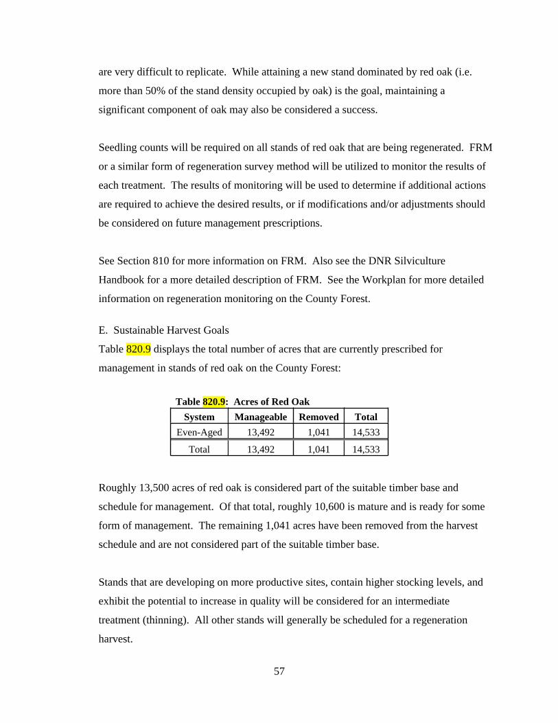
57
are very difficult to replicate. While attaining a new stand dominated by red oak (i.e.
more than 50% of the stand density occupied by oak) is the goal, maintaining a
significant component of oak may also be considered a success.
Seedling counts will be required on all stands of red oak that are being regenerated. FRM
or a similar form of regeneration survey method will be utilized to monitor the results of
each treatment. The results of monitoring will be used to determine if additional actions
are required to achieve the desired results, or if modifications and/or adjustments should
be considered on future management prescriptions.
See Section 810 for more information on FRM. Also see the DNR Silviculture
Handbook for a more detailed description of FRM. See the Workplan for more detailed
information on regeneration monitoring on the County Forest.
E. Sustainable Harvest Goals
Table 820.9 displays the total number of acres that are currently prescribed for
management in stands of red oak on the County Forest:
Table 820.9: Acres of Red Oak
System Manageable Removed Total
Even-Aged 13,492 1,041 14,533
Total 13,492 1,041 14,533
Roughly 13,500 acres of red oak is considered part of the suitable timber base and
schedule for management. Of that total, roughly 10,600 is mature and is ready for some
form of management. The remaining 1,041 acres have been removed from the harvest
schedule and are not considered part of the suitable timber base.
Stands that are developing on more productive sites, contain higher stocking levels, and
exhibit the potential to increase in quality will be considered for an intermediate
treatment (thinning). All other stands will generally be scheduled for a regeneration
harvest.

58
One major objective when developing short and long-term regeneration goals will be a
“smoothing” of the current irregular age-class distribution to attain a more balanced
condition. Reaching a more regulated state will take multiple entries and a considerable
amount of time (i.e. a few hundred years). Regeneration goals will vary based on such
factors as: stand age; health and vigor; presence of insects and/or disease; and age-class
variations per IRMU. Other variables may also impact the regeneration harvest goals
during any given year, as determined by the Department.
The annual sustainable harvest goal will include intermediate treatments, regeneration
harvests and overstory removals. Some treatments are only prescribed once a stand has
achieved a desired result (from previous management). Consequently, the harvest goal
for any given year will potentially be highly variable. Fluctuations in sustainable harvest
goals will also be dependent upon other variables such as site conditions, current age
class distributions, landscape level considerations, objectives for a particular stand and/or
IRMU, or other similar factors, as determined by the Department.
In 2018, oak wilt was first confirmed in Bayfield County (and on the County Forest).
Oak wilt is manageable, but has the ability to spread rapidly and quickly kill infected
trees and/or groups of trees. Depending on the extent of any given infection, oak wilt
may significantly impact the way some portions of the County Forest (that contain oak
trees) are managed. See the DNR website for more information on oak wilt.
Refer to the Workplan for details on specific goals and objectives for red oak, including
modifications required to address irregular age-class distributions and oak wilt. Also
refer to the Accomplishment Report for a summary of previously completed treatments.
F. Challenges.
Numerous threats and challenges need to be considered when managing red oak forests.
Some of the more significant challenges, threats and/or issues regarding the management
of the red oak type include:
1. Deer Browse. Red oak is a preferred browse source of white-tailed deer.

59
Excessive levels of deer browse has the potential to significantly influence the
regenerative capacity of a given stand. Repeated instances of aggressive deer
browsing can set back natural growth and development of desired seedlings, thus
giving more undesirable trees an advantage. High levels of browse can
significant impact short and long term management goals for a given stand and
may require additional inputs by the Department to achieve the desired level of
success.
2. Competition Control. Heavy components of red maple, sugar maple, ironwood
and other species can negatively influence the establishment and recruitment of
red oak seedlings. Some trees that are common components of red oak stands are
not a preferred browse species and, when combined with high levels of deer
herbivory, can significantly impact regeneration efforts.
3. Site Preparation. Natural regeneration is the preferred reforestation method in
stands of red oak. In addition to deer browse and competition control, adequate
site preparation is typically a significant part of the process. Site preparation
generally accomplishes two objectives: 1) it reduces a level of competing
vegetation and 2) it exposes bare mineral soil to create more favorable conditions
for germination. Mechanical methods like pre-sale site preparation with a dozer
and straight blade, salmon blade, or anchor chains have been used successfully in
the past. Prescribed fire and post-sale mechanical scarification methods can also
be considered.
4. Gypsy Moth. Red oak is one of the tree species targeted by Gypsy Moth.
Defoliation has the potential to increase vulnerability to other variables that can
negatively impact the health and vigor of a stand of oak. Combining a defoliation
event with a rapidly maturing red oak forest can create significant increases in
stress. Increased stress levels leave individual oak trees more vulnerable to
secondary stressors (i.e. drought, excess moisture and two-lined chestnut borer).
The extra stress can often lead to increases in mortality. See Chapter 600 and the
DNR website for more information on insects and disease.
5. Forest Tent Caterpillar. See Chapter 600 and the DNR website for more
information on insects and disease.

60
6. Two-Lined Chestnut Borer. Two-lined chestnut borer is naturally present in
stands of oak. They become a more significant issue when oak trees are under
stress and are less able to defend from an infestation. Two-lined chestnut borers
can kill branches or an entire tree. See Chapter 600 and the DNR website for
more information on insects and disease.
7. Oak Wilt. The fungus that causes oak wilt ultimately plugs an infected tree’s
vascular system, often resulting in death. Oak wilt is spread underground through
grafted root system and overland via a sap feeding beetle. When oak wilt has
been discovered in an area, numerous modifications to standard forest
management practices are adopted. These modifications are necessary to reduce
the potential spread of the fungus. The presence and severity of oak wilt in a
particular stand and/or area has the potential to significantly alter the way red oak
is managed. See Chapter 600 and the DNR website for more information on Oak
Wilt. See the Workplan for more detailed information oak wilt management
strategies.
8. Climate Change. The red oak type is not generally recognized as being negatively
impacted by a potentially changing climate. In most models, red oak is predicted
to either have little to no change, or an increase in the amount of suitable habitat.
The challenges, threats and/or concerns listed above have the potential to impact and/or
influence short and/or long-term management objectives for any given stand, as
determined by the Department. The Department will continue to routinely and regularly
monitor the County Forest and modify goals and objectives accordingly.
The graphic below provides a general summary of the red oak type, including goals and
objectives, acreage per management unit (IRMU) and moisture group, rotations ages,
silvicultural treatments and challenges.

61
Current Status: the fourth largest cover type (by acreage) on the County Forest. Fairly evenly distributed throughout
the ownership. Irregular (imbalanced) age class distribution, heavily skewed to the mature age brackets. Roughly
80% of total acreage is 80 years old or older.
Future Goals: maintain to slightly increase cover type acreage, though difficult to regenerate. Address irregular age
class distribution by spreading out regen harvests as much as feasible.
R E D O A K
System Method Applied
Clearcut (coppice) 2
Clearcut (seed/plant) 3
Seed Tree 1
Shelterwood 2
Overstory Removal 2
Even-Aged Thinning 2
Single Tree Selection (Gaps) na
Group Selection 3
Patch Selection 3
1 = preferred; 2 = acceptable; 3 = optional
Common Forest Management Practices
Even-Aged
All-Aged
Challenges (Threats) to Maintaining Cover Type
Category Challenge/Impact Threat Level
Deer Browse 1
Competition Control 1
Site Preparation 1
Seed Crop/Viability 1
Sprouting Intensity 1
Insects 2
Disease 2
Flooding/Drought 2
Climate Change 3
1 = high; 2 = moderate; 3 = low.
Regeneration/
Reforestation
Biotic and
Abiotic
Impacts
0750
1,5002,2503,0003,750
4,5005,2506,0006,750
Acr
es
Age Class (years)
Red Oak Age Class Distribution
Total Acres Scheduled Total Acres Removed
Acres per IRMU
IRMU Acres % of Total
1 1,946 7.5%
2 1,871 9.9%
3 2,556 9.1%
4 2,346 14.6%
5 0 0.0%
6 248 1.3%
7 1,600 26.5%
8 3,966 16.9%
9 0 0.0%
10 0 0.0%
Total 14,533 8.4%
Rotation Age (Age in Years)
Low Avg. High
Early 70 80 80
Average 90 100 100
Extended 110 120 140
RotationSite Quality
Acres per Moisture (Habitat) Group
Moisture Group Acres % of Total
DM 6,465 27.1%
DDM 4,210 16.4%
MWM 2,523 5.4%
VDD 952 2.1%
M 256 1.9%
Steep Slopes 127 2.5%
Wet 0 0.0%
Total 14,533 8.4%

62
820.2.4 Red Pine
Red pine is the second largest cover type (by acreage) on the County Forest. At nearly
18,300 acres, red pine comprises nearly 11% of the total area.
A. Historical Acreage Trends
Since 1977, the amount of red pine acreage on the County Forest has steadily increased.
Table 820.10 displays the total acreage trends for the red pine type between the periods of
1977 and 2020:
Table 820.10: Red Pine Historical Acreage Trends
Year Acres Change (Acres) % Change
1977 8,255
1995 11,018 2,763 33.5%
2005 14,130 3,112 28.2%
2020 18,272 4,142 29.3%
1977-2020 10,017 121.3%
There are numerous reasons for the increase: 1) between 1977 and 2005, many of the last
remaining “unproductive” sites were planted with red pine; 2) between 2005 and 2020, a
significant portion of the old fuel break was also planted with red pine; and 3) between
2016 and 2020 two large land acquisition projects added roughly 2,000 acres of red pine
plantations to the County Forest.
Barring additional land acquisition projects or other, larger scale planning efforts, the
general expectation is for red pine acreage to remain relatively constant over the next 15
years.
B. Current Status (2020)
As of 2020, a total of 18,272 acres of the County Forest is typed as red pine. Of that
total, 18,018 is manageable and considered part of the suitable timber base. The
remaining amount, roughly 250 acres, has been removed from the harvest schedule.
The graph below illustrates the acreage of red pine per ten-year age class (as per CY
2020).

63
Most of the red pine acreage located on the County Forest is in the form of a plantation.
However, some natural stands exist on the County Forest. In general, nearly every stand
80 years of age or younger has been planted. When considering that metric, roughly
16,500 acres (or about 90%) of the total red pine acreage is part of a plantation. The
remaining stands have generally regenerated naturally, are much older, contain higher
level of species diversity and varying levels of red pine stocking.
Red pine is primarily located in two different regions (and three IRMUs) of the County
Forest. The most prominent region is the outwash sands located south of Iron River and
north of Barnes (IRMU’s 5 and 9). Part of this area is located in the Barnes Barrens
Management Area (see Chapter 4000 for more information on the Barrens Management
Plan). The second region is located within the Bayfield Peninsula in IRMU 3. Both
regions are part of the NW Sands Ecological Landscape (IRMU 3 is on the very NE edge
of the landscape).
See the Appendix for maps indicating the location of the red pine type on the Bayfield
County Forest. Also see Chapter 3000 for a summary of red pine per IRMU.
C. Desired Future Condition
Some existing red pine stands located within the Barnes Barrens Management Area

64
(BBMA) will be converted to jack pine. While some jack pine stands located outside of
the BBMA will be converted to red pine. The general goal is to maintain the amount of
red pine acreage on the landscape over the next 15 year period. In addition, some of the
natural stands of red pine will be managed on extended rotations.
D. Management
Red pine is generally managed with even-aged silvicultural systems. The two primary
methods are even-aged thinning and clearcut. Red pine is typically reforested artificially,
primarily via planting. As previously stated, nearly all stands of red pine on the County
Forest are in the form of a plantation. A typical rotation of red pine is as follows:
1. Year 1: when a site is selected to be reforested to red pine, the area is typically
mechanically prepared. The type and intensity of mechanical preparation will
depend on existing site conditions and overall objectives. Disc trenching and fire
plowing are two common forms of site preparation for red pine plantations on the
County Forest.
2. Year 2: depending on the amount of competing vegetation, the site may be
chemically treated. If herbicide is not required, the site will be planted in year
two. If chemical is required, the herbicide is typically applied in year two and
then planted in year three.
3. Year 3: if herbicide was required, the site is planted. In general, sites are planted
with containerized stock, developed from regional seed sources. Bareroot stock
can also be used in plantations. Planting densities vary, but typically range from
700 to 900 seedlings per acre.
4. Year 4: seedling counts are completed the year after planting to monitor growth
and development. If an issue is detected, it is addressed as soon as possible.
5. Year 5: if an issue was detected during the first seedling count, another survey
may be conducted at year two.
6. Year 6: another seedling count is completed the third year after planting. If
undesirable species have significantly impacted or have the potential to impact the
plantation, a chemical release may be applied. However, treating the stand with
herbicide prior to planting typically reduces the need for an additional release.
7. Year 8: another seedling county is completed five years after planting.

65
8. Year 13: assuming all previous reforestation surveys detected no significant
issues, a final seedling count is completed at year ten. Typically, a total of four to
five seedling counts are conducted over the first ten years before a reforestation
activity is determined to be a success.
9. Between Age 28 to 30: even-aged thinning. The plantation is thinned for the first
time around 28 to 30 years of age (or longer depending on stand conditions). The
timing of the first thin is highly dependent on stand density and marketability.
Typically, roughly one third of the volume is removed during this entry. Though
the actual prescription is highly dependent on existing stand conditions.
10. Every 10 to 15 years after the first treatment, the plantation is thinned again.
Each entry removes a portion of the stand. The thinning intensity is highly
dependent on existing stand conditions, as well as growth and development since
the last treatment. The Department may modify or adjustment treatment
schedules based on a variety of factors, including, but not limited to: growth and
development since the previous treatment; stand quality; presence of insects
and/or disease issues; landscape or IRMU level goals and objectives; other
variables as determined by the Department.
11. Depending on the goals and objectives for a given stand, a plantation is thinned at
regular intervals up to the desired rotation age (see below), as determined by the
Department. Typically, a clearcut is prescribed as the final harvest and the
process is repeated.
Other silvicultural prescriptions, regeneration methods or intermediate treatments will be
considered, depending on the goals for the stand, best available science, responses to
previous management, landscape level (or IRMU) objectives or similar factors, as
determined by the Department.
See the DNR Silviculture Handbook for more detailed information on red pine treatment
methods.
Table 820.11 displays the general range of rotation ages for red pine on the County

66
Forest.
820.11: Red Pine Rotation Age (Years)
RotationObjective
Economic Biological Extended
Early 50 60 90
Average 60 80 120
Extended 70 100 150
Quality timber product development, economic potential, and landscape level objectives
will all play a major role in determining how a particular stand of red pine is treated and
when it will be rotated. Table 820.11 above displays average rotation ages based on the
primary objective (economic, biological and extended). The Department may consider
developing a red pine management program that establishes a framework to regenerate
red pine based, in part, on the various objectives. Any such framework will be addressed
in the Workplan.
E. Sustainable Harvest Goals
Table 820.12 displays the total number of acres that are currently prescribed for
management in stands of red pine on the County Forest:
Table 820.12: Acres of Red Pine
System Manageable Removed Total
Even-Aged 18,018 254 18,272
Total 18,018 254 18,272
Roughly 18,000 acres of red pine is considered part of the suitable timber base and
scheduled for management. The remaining roughly 250 acres have been removed from
the harvest schedule and are not considered part of the suitable timber base. Of the
suitable timber base, roughly 16,500 is in the form of a plantation.
Plantations are managed differently than stands of natural origin. Natural stands are often
considered for extended rotations and/or as candidates for removal from the suitable
timber base. Annual sustainable harvest goals are ultimately developed based on the
treatments scheduled for each stand. Thinning entries will vary based on many of the

67
factors previously listed.
Regeneration harvests will also vary based on overall objectives for the stand and/or
management unit, as determined by the Department. In addition, it may be necessary to
begin developing plans for achieving a regulated age-class distribution. This may require
an acceleration of regeneration harvests, which would also impact annual harvest goals.
Therefore, sustainable harvest goals tend to be fairly variable from year to year.
Fluctuations in sustainable harvest goals will also be dependent upon other variables such
as site conditions, current age class distributions, landscape level considerations,
objectives for a particular stand and/or IRMU, or other similar factors, as determined by
the Department.
Refer to the Workplan for detailed information on annual sustainable harvest goals for
red pine, including modifications and/or adjustments to address age-class distributions or
regeneration/rotation strategies. Refer to the Accomplishment Report for a summary of
previously completed treatments.
F. Challenges.
Numerous threats and challenges need to be considered when managing red pine forests.
Some of the more significant challenges, threats and/or issues regarding the management
of the red pine type include:
1. Deer Browse. While excessive deer browse is generally not a concern on red pine
plantations, significant browsing has been noted in some plantations. Deer
browse is one of the variables monitored as part of every regeneration survey.
High levels of browse related mortality may require supplemental planting.
2. Competition Control. Adequate site preparation is required to ensure a successful
plantation. Red pine is generally classified as shade intolerant, but can withstand
a minor level of competition. Nevertheless, undesirable competition should be
controlled to help achieve the desired objective.
3. Heterobasidion Root Disease (HRD). This disease was formerly known as

68
Annosum Root Rot and is considered one of the most destructive diseases of
conifers in the northern parts of the world. Though not yet located in Bayfield
County. See Chapter 600 and the DNR website for more information on insects
and disease.
4. Red Pine Pocket Mortality. This mortality is caused by a fungus that disrupts an
infected trees vascular and root system, thus impacting its ability to move water.
The fungus stresses the tree also leaving it vulnerable to other secondary attacks.
The fungus can spread to healthy trees through underground root grafts. As trees
die, it tends to create a more circular shaped pattern or pocket. See the DNR
website for more detailed information of red pine pocket mortality.
5. Diplodia Shoot Blight and Canker. Diplodia is another fungus that generally
attacks needles and young shoots. The fungus also attacks jack pine and white
pine and is one of the primary reasons why remnant or retention trees are not
retained when regenerating a new stand (as mature trees can serve as a source of
infection). See the DNR website and factsheet for more information about
Diplodia.
6. Climate Change. The red pine type is predicted is predicted to either have little to
no change, or a slight decrease in the amount of suitable habitat, primarily due to
a potential increase in susceptibility to insects and disease.
The challenges, threats and/or concerns listed above have the potential to impact and/or
influence short and/or long-term management objectives for any given stand, as
determined by the Department. The Department will continue to routinely and regularly
monitor the County Forest and modify goals and objectives accordingly.
The graphic below provides a general summary of the red pine type, including goals and
objectives, acreage per management unit (IRMU) and moisture group, rotations ages,
silvicultural treatments and challenges.

69
Current Status: the second largest cover type (by acreage) on the County Forest. Primarily located in the NW Sands
Ecological Landscape (IRMU's 3,5 & 9). Fairly even age-class distribution.
Future Goals: maintain cover type acreage. Continue converting most stands in the barrens to jack pine. Reforest
jack pine outside the barrens to red pine. Consider accelerating regen harvest to achieve a more regulated condition.
R E D P I N E
System Method Applied
Clearcut (coppice) na
Clearcut (seed/plant) 1
Seed Tree 3
Shelterwood na
Overstory Removal na
Even-Aged Thinning 1
Single Tree Selection (Gaps) na
Group Selection na
Patch Selection na
1 = preferred; 2 = acceptable; 3 = optional
Common Forest Management Practices
Even-Aged
All-Aged
Challenges (Threats) to Maintaining Cover Type
Category Challenge/Impact Threat Level
Deer Browse 3
Competition Control 2
Site Preparation 1
Seed Crop/Viability 3
Sprouting Intensity na
Insects 2
Disease 2
Flooding/Drought 3
Climate Change 3
1 = high; 2 = moderate; 3 = low.
Regeneration/
Reforestation
Biotic and
Abiotic
Impacts
0
500
1000
1500
2000
2500
3000
3500
4000
Acr
es
Age Class (years)
Red Pine Age Class Distribution
Total Acres Scheduled Total Acres Removed
Acres per IRMU
IRMU Acres % of Total
1 282 1.1%
2 545 2.9%
3 3,090 11.0%
4 1,125 7.0%
5 9,622 50.3%
6 79 0.4%
7 124 2.1%
8 274 1.2%
9 3,131 26.8%
10 0 0.0%
Total 18,272 10.6%
Red Pine Rotation Age (Years)
Economic Biological Extended
Early 50 60 90
Average 60 80 120
Extended 70 100 150
RotationObjective
Moisture Group (Acres)
Group Acres
VDD 14,922
DDM 1,942
MWM 653
DM 445
Steep Slopes 224
M 86
Wet 0
Total 18,272

70
820.2.5 Jack Pine
Jack pine is the fifth largest cover type (by acreage) on the County Forest. At over
11,600 acres, jack pine comprises nearly 7% of the total area.
A. Historical Acreage Trends
Since 1977, the amount of jack pine acreage on the County Forest has steadily decreased.
Table 820.13 displays the total acreage trends for the jack pine type between the periods
of 1977 and 2020:
Table 820.13: Jack Pine Historical Acreage Trends
Year Acres Change (Acres) % Change
1977 21,644
1995 16,923 -4,721 -21.8%
2005 13,994 -2,929 -17.3%
2020 11,637 -2,357 -16.8%
1977-2020 -10,007 -46.2%
There are numerous reasons for the decrease in jack pine: 1) between 1977 and 1995,
many stands were harvested and converted to fuel breaks and/or red pine; 2) also during
this same time period, many stands were damaged by the jack pine budworm and, when
reforested, were either converted to red pine or allowed to naturally regenerate to other
species i.e. aspen; 3) between 2005 and 2020, work commenced on the development of
the BBMA, which included the creation of a 1,000+ acre, permanently open, grass core.
Some of the jack pine stands in this core area were converted to an open condition; and 4)
jack pine in other areas (IRMU’s) were converted to red pine or allowed to regenerate to
other species.
With the development of various barrens management projects i.e. BBMA, that
emphasize the importance of the barrens landscape, the general expectation is for jack
pine acreage to remain constant or slightly increase over the next 15 year period.
B. Current Status (2020)
As of 2020, a total of 11,637 acres of the County Forest is typed as jack pine. Of that
total, nearly 11,500 acres is manageable and considered part of the suitable timber base.

71
The remaining amount, roughly 150 acres, has been removed from the harvest schedule.
The graph below illustrates the acreage of jack pine per ten-year age class (as per CY
2020).
All of the jack pine on the County Forest has been reforested artificially. Until recently,
most of the reforestation efforts were accomplished via planting. However, over the past
decade, a greater emphasis has been placed on direct seeding. Direct seeding has the
potential to regenerate a stand with more natural characteristics however, stocking levels
can be highly variable. See more on jack pine management in the section below.
Jack pine is primarily located in the same two regions as red pine. The most prominent
region is the outwash sands located south of Iron River and north of Barnes (IRMUs 5
and 9). IRMU 9 is the designation for the Barnes Barrens Management Area (see
Chapter 4000 for more information on the Barrens Management Plan). The second
region is within the Bayfield Peninsula in IRMU 3. Both regions are part of the NW
Sands Ecological Landscape (though IRMU 3 is on the very NE edge of the landscape).
See the Appendix for maps indicating the location of the jack pine type on the Bayfield
County Forest. Also see Chapter 3000 for a summary of jack pine per IRMU.

72
C. Desired Future Condition
Reforestation efforts located within the BBMA will emphasize jack pine. This will result
in a fairly significant increase in jack pine acreage located within IRMU 9. Some of the
jack pine stands located in IRMU 5 will be converted to red pine (to replace some of the
red pine stands that will be converted to jack pine within the BBMA). Jack pine acres
located within IRMU 3 will remain relatively constant. In summary, the amount of jack
pine acreage is expected to slightly increase within the next 15 year period.
D. Management
Jack pine is managed with even-aged silvicultural systems. The primary method of
management is a clearcut. In general, all stands are reforested artificially, either via
direct seeding or planting. A typical rotation of jack pine is as follows:
1. Year 1: when a site is selected to be reforested with jack pine, it is usually
mechanically prepared first. The type and intensity of mechanical preparation
will depend on existing site conditions, reforestation methods (i.e. planting or
seeding) and overall objectives. Disc trenching and fire plowing are two common
forms of site preparation for establishing jack pine on the County Forest.
2. Year 2: depending on the amount of competing vegetation, the site may be
chemically treated. If seeding, this additional step is typically a requirement, as
germination rates can be highly variable and young seedlings can quickly get
overtopped by competing vegetation. If chemical is required, the herbicide is
typically applied in year two and then seeded or planted in year three.
3. Year 3: if herbicide was required, the site is seeded or planted.
a. If seeded, the seed can be applied aerially or from the ground with
appropriate machinery. Seed is generally applied at the rate of 3 to 6
ounces per acre (the average is about 4 ounces per acre). Alternatively, a
site may be seeded at slightly lower rates over consecutive years, to ensure
adequate germination rates and achieve desired stocking levels. Seed is
generally purchased from the DNR Nursery and procured from
local/regional stock (to maintain local genetics).
i. Seeding usually occurs in late spring prior to snow melt. When

73
seed is applied in two consecutive years, the process generally
begins in year 2 (prior to herbicide treatment). With the second
seeding occurring in year 3.
b. If planted, sites are reforested with containerized stock, developed from
local/regional seed sources. Bareroot stock can also be used in
plantations. Planting densities vary, but typically range from 700 to 900
seedlings per acre.
4. Similar to red pine plantations, all jack pine reforestation sites are monitored
regularly over the first 10 years of development. The level of monitoring will
vary based on the reforestation method.
a. If seeded, a site is usually first surveyed (seedling counts) three to four
years after seeding. It generally takes a few years for seedlings to
germinate and develop. Typically, one to two more regeneration surveys
are conducted before a site is considered successful. If additional inputs
are required, they are addressed as soon as possible. A final seedling
count is typically conducted at year 10.
i. A seeded site is generally considered established when monitoring
results indicate at least 400 desirable tree seedlings per acre on at
least 60% of the survey plots (during the first seedling count). If
the minimum stocking levels are not achieved, the Department
may prescribe supplemental planting or seeding and/or additional
site preparation or a combination thereof. Additional reforestation
surveys may also be required to monitor results.
b. If planted, seedling counts are conducted on the same schedule as
described in the red pine section. Survival counts are typically prescribed
at one, two, three, five and ten years post planting. If additional inputs are
required, they are addressed as soon as possible.
i. Similar to the seeded sites, jack pine plantations are generally
considered successful when at least 400 desired seedlings per acre
are attained on 60% or more of the survey plots. Additional inputs
may be required, as determined by the Department, if minimum

74
stocking levels are not achieved.
ii. Nursery grown seedlings, especially containerized stock, are a
highly preferred source of food for white-tailed deer. High level of
browse can result in a complete failure of the reforestation activity.
As a result, most plantations will require some form of protection.
Bud capping has worked well in past and should be considered for
all jack pine plantations. Other forms of deer protection measures
can also be considered, where economically feasible.
5. Unlike red pine, jack pine stands are not thinned and are generally not treated
again until the desired rotation age, as determined by the Department. The
rotation age for each stand will generally be determined at the time of the
reforestation event. Each rotation will be dependent on the goals and objectives
of the stand, including landscape level considerations (i.e. BBMA).
Table 820.11 displays the general range of rotation ages for jack pine on the County
Forest.
Table 820.XX: Jack Pine Rotation Age
Rotation Age (Years)
Early 40
Average 50
Extended 60
See the DNR Silviculture Handbook for more detailed information on jack pine
management methods. Also see the Workplan for more detailed information of goals and
objectives for jack pine on the County Forest. See Chapter 4000 for more information on
the BBMA.
E. Sustainable Harvest Goals
Roughly 11,500 acres of jack pine is considered part of the suitable timber base and
scheduled for management. The remaining roughly 175 acres have been removed from
the harvest schedule and are not considered part of the suitable timber base. Of the
suitable timber base, nearly all has been reforested artificially.

75
Table 820.12 displays the total number of acres that are currently prescribed for
management in stands of jack pine on the County Forest:
Table 820.12: Acres of Jack Pine
System Manageable Removed Total
Even-Aged 11,461 176 11,637
Total 11,461 176 11,637
The timing of regeneration harvests will generally vary based on overall objectives for
the stand or IRMU, as determined by the Department. Also, additional measures may be
necessary to adjust harvest schedules (either to accelerate or delay harvests) based on
potential modifications to short and/or long-term objectives.
The average rotation age for jack pine is 50 years, but harvest cycles may vary based on
site conditions, current age class distributions, landscape level considerations, objectives
for a particular stand and/or IRMU, or other similar factors, as determined by the
Department. Therefore, actual sustainable harvest goals will be fairly variable from year
to year.
Refer to the Workplan for detailed information on annual sustainable harvest goals for
jack pine and the Accomplishment Report for a summary of previously completed
treatments.
F. Challenges.
Numerous threats and challenges need to be considered when managing jack pine forests.
Some of the more significant challenges, threats and/or issues regarding the management
of the jack pine type include:
1. Deer Browse. Jack pine is a preferred food source for white-tailed deer.
Excessive deer browse can be a limiting factor in many jack pine reforestation
activities. Repeated instances of excessive browsing can lead to a reforestation
failure. Plantations are especially vulnerable. When planting jack pine, it is
generally necessary to plan for some level of seedling protection. Bud capping

76
has been successful on the County Forest. Fencing could also be an option.
Traditionally, excessive browsing hasn’t been as significant on seeded sites, but a
regular monitoring schedule Seeded sites are generally not a concern on red pine
plantations, significant browsing has been noted in some plantations. Deer
browse is one of the variables monitored as part of every regeneration survey.
High levels of browse related mortality may require supplemental planting.
2. Competition Control. Jack pine is classified as shade intolerant. Even minor
levels of vegetative competition can significantly reduce growth and development
of new seedlings, and threaten the success of the reforestation effort. Adequate
site preparation is required to ensure a successful plantation. Site preparation is
typically required to help achieve the desired objective.
3. Jack Pine Budworm. Defoliation by jack pine budworm can cause significant
negative impacts on an individual tree as well as overall forest health. Repeated
instances of heavy defoliation can kill a tree and lead to massive rates of mortality
within stands of jack pine. Maintaining healthy and vigorous stands of jack pine
are one of the best ways to address potential threats posed by the budworm.
4. Heterobasidion Root Disease (HRD). This disease was formerly known as
Annosum Root Rot and is considered one of the most destructive diseases of
conifers in the northern parts of the world. This disease impacts jack pine as well.
Though not yet located in Bayfield County. See Chapter 600 and the DNR
website for more information on insects and disease.
5. Armillaria Root Disease. See the DNR website for more detailed information on
Armillaria.
6. Diplodia Shoot Blight and Canker. Diplodia is another fungus that generally
attacks needles and young shoots. The fungus also attacks red pine and white
pine and is one of the primary reasons why remnant or retention trees are not
retained when regenerating a new stand (as mature trees can serve as a source of
infection). See the DNR website and factsheet for more information about
Diplodia.
7. Climate Change. The jack pine type is predicted to slightly decrease in the face of
a potentially changing climate, primary due to increased susceptibility to insects

77
and disease, as well as drought.
The challenges, threats and/or concerns listed above have the potential to impact and/or
influence short and/or long-term management objectives for any given stand, as
determined by the Department. The Department will continue to routinely and regularly
monitor the County Forest and modify goals and objectives accordingly.
The graphic below provides a general summary of the jack pine type, including goals and
objectives, acreage per management unit (IRMU) and moisture group, rotations ages,
silvicultural treatments and challenges.

78
Current Status: the fifth largest cover type (by acreage) on the County Forest. Primarily located in the NW Sands
Ecological Landscape (IRMU's 3,5 & 9). Age distribution heavy skewed to younger classes.
Future Goals: maintain to slightly increase cover type acreage. Continue development of the Barnes Barrens
Management Area. Maintain jack pine in IRMU 3. Consider other opportunities to regenerate jack pine.
J A C K P I N E
0
500
1,000
1,500
2,000
2,500
3,000
3,500
4,000
Acr
es
Age Class (years)
Jack Pine Age Class Distribution
Total Acres Scheduled Total Acres Removed
Acres per IRMU
IRMU Acres % of Total
1 4 0%
2 0 0%
3 2,435 9%
4 167 1%
5 2,231 12%
6 0 0%
7 0 0%
8 0 0%
9 6,800 58%
10 0 0%
Total 11,637 7%
Acres per Moisture Group
Moisture Group Acres
VDD 10,673
DDM 956
DM 8
MWM 0
M 0
Steep Slopes 0
Wet 0
Total 11,637
Jack Pine Rotation Age
Rotation Age (Years)
Early 40
Average 50
Extended 60
System Method Applied
Clearcut (coppice) na
Clearcut (seed/plant) 1
Seed Tree 3
Shelterwood na
Overstory Removal na
Even-Aged Thinning na
Single Tree Selection (Gaps) na
Group Selection na
Patch Selection na
1 = preferred; 2 = acceptable; 3 = optional
Common Forest Management Practices
Even-Aged
All-Aged
Challenges (Threats) to Maintaining Cover Type
Category Challenge/Impact Threat Level
Deer Browse 1
Competition Control 1
Site Preparation 1
Seed Crop/Viability 2
Sprouting Intensity na
Insects 2
Disease 2
Flooding/Drought 3
Climate Change 2
1 = high; 2 = moderate; 3 = low.
Regeneration/
Reforestation
Biotic and
Abiotic
Impacts
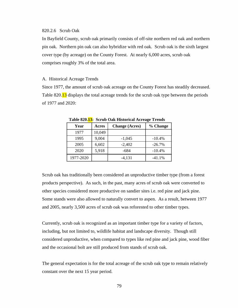
79
820.2.6 Scrub Oak
In Bayfield County, scrub oak primarily consists of off-site northern red oak and northern
pin oak. Northern pin oak can also hybridize with red oak. Scrub oak is the sixth largest
cover type (by acreage) on the County Forest. At nearly 6,000 acres, scrub oak
comprises roughly 3% of the total area.
A. Historical Acreage Trends
Since 1977, the amount of scrub oak acreage on the County Forest has steadily decreased.
Table 820.13 displays the total acreage trends for the scrub oak type between the periods
of 1977 and 2020:
Table 820.13: Scrub Oak Historical Acreage Trends
Year Acres Change (Acres) % Change
1977 10,049
1995 9,004 -1,045 -10.4%
2005 6,602 -2,402 -26.7%
2020 5,918 -684 -10.4%
1977-2020 -4,131 -41.1%
Scrub oak has traditionally been considered an unproductive timber type (from a forest
products perspective). As such, in the past, many acres of scrub oak were converted to
other species considered more productive on sandier sites i.e. red pine and jack pine.
Some stands were also allowed to naturally convert to aspen. As a result, between 1977
and 2005, nearly 3,500 acres of scrub oak was reforested to other timber types.
Currently, scrub oak is recognized as an important timber type for a variety of factors,
including, but not limited to, wildlife habitat and landscape diversity. Though still
considered unproductive, when compared to types like red pine and jack pine, wood fiber
and the occasional bolt are still produced from stands of scrub oak.
The general expectation is for the total acreage of the scrub oak type to remain relatively
constant over the next 15 year period.

80
B. Current Status (2020)
As of 2020, a total of 5,918 acres of the County Forest is typed as scrub oak. Of that
total, 5,451 acres is classified as manageable and considered part of the suitable timber
base. The remaining 467 acres has been removed from the harvest schedule.
The graph below illustrates the acreage of scrub oak per ten-year age class (as per CY
2020).
As per the graph above, the current age class distribution of scrub oak is heavily skewed
to mature stands. Over the past decade there has been a greater emphasis placed on
regenerating scrub oak. Nearly 1,300 acres (or roughly 21% of the total acreage) is less
than 10 years of age. Otherwise, roughly 67% of the scrub oak type is 70 years of age or
older.
Scrub oak is primarily located in the same two regions as red and jack pine, but with a
heavier emphasis in IRMU 3. The most prominent region for scrub oak on the County
Forest is the eastern edge of the NW Sands Ecological Landscape (IRMU 3). Roughly
65% of all scrub oak stands on the County Forest are located in IRMU 3.
See the Appendix for maps indicating the location of the scrub oak type on the Bayfield

81
County Forest. Also see Chapter 3000 for a summary of scrub oak per IRMU.
C. Desired Future Condition
Over the next 15 year period, a greater emphasis will be placed on the regeneration of the
scrub oak type. Some stands of scrub oak will be retained within the BBMA, but,
otherwise, the total acreage within IRMU 9 will decrease (see chapter 4000 for more
information on the BBMA). The goal is to maintain scrub oak, whenever possible,
throughout all other management units. In summary, the amount of scrub oak acreage is
expected to remain relatively constant within the next 15 year period.
D. Management
Scrub oak is managed with even-aged silvicultural systems and is regenerated naturally.
The primary method of management is a clearcut (coppice), but other even-aged methods
can be used depending on stand conditions and goals for the management unit.
Table 820.11 displays the general range of rotation ages for scrub oak on the County
Forest.
Table 820.XX: Scrub Oak Rotation Age (Years)
RotationSite Quality
Low Average High
Early 60 60 60
Average 80 80 90
Extended 100 110 120
Seedling counts will be required on most stands of scrub oak that are being regenerated.
FRM or a similar form of regeneration survey method will be utilized to monitor the
results of each treatment. The results of monitoring will be used to determine if
additional actions are required to achieve the desired results, or if modifications and/or
adjustments should be considered on future management prescriptions.
See Section 810 for more information on FRM. Also see the DNR Silviculture
Handbook for a more detailed description of FRM. See the Workplan for more detailed
information on regeneration monitoring on the County Forest.

82
See the DNR Silviculture Handbook for more detailed information on scrub oak
management methods. Also see the Workplan for more detailed information of goals and
objectives for scrub oak on the County Forest.
E. Sustainable Harvest Goals
Roughly 5,450 acres of scrub oak is considered part of the suitable timber base and
schedule for management. The remaining roughly 470 acres have been removed from the
harvest schedule and are not considered part of the suitable timber base.
Table 820.12 displays the total number of acres that are currently prescribed for
management in stands of scrub oak on the County Forest:
Table 820.12: Acres of Scrub Oak
System Manageable Removed Total
Even-Aged 5,451 467 5,918
Total 5,451 467 5,918
The timing of regeneration harvests will generally vary based on overall objectives for
the stand or IRMU, as determined by the Department. Also, additional measures may be
necessary to adjust harvest schedules (either to accelerate or delay harvests) based on
potential modifications to short and/or long-term objectives.
The average rotation age for scrub oak 80 years, but harvest cycles may vary based on
site conditions, current age class distributions, landscape level considerations, objectives
for a particular stand and/or IRMU, or other similar factors, as determined by the
Department. Therefore, actual sustainable harvest goals will be fairly variable from year
to year.
As with most timber types that are managed on an even-aged basis, one primary goal is to
achieve a regulated condition. However, the current age class distribution for scrub oak
is weighted heavily to mature stands. As a result, attempts to more evenly re-distribute
the mature age classes should be considered. This may result in a modification of

83
sustainable harvest goals in order to achieve the desired results. Any such modifications
to the scrub oak type will be addressed in the Workplan.
For example, currently, roughly 3,000 acres of scrub oak is at rotation (80 years) or older.
One goal of management will be to determine how to best spread out this overabundance
of mature acres over time. Stands that are more susceptible to mortality would be
managed first and those of lower risk would be carried longer. But it may be possible to
adjustment the timing of harvests on these stands to cover a 30 to 40 year period.
In 2018, oak wilt was first confirmed in Bayfield County (and on the County Forest).
Oak wilt is manageable, but has the ability to spread rapidly and quickly kill infected
trees and/or groups of trees. Oak wilt can spread even more rapidly on sandier soils,
which could have devastating negative impacts on stands of scrub oak. Depending on the
extent of any given infection, oak wilt may significantly impact the way some portions of
the County Forest (that contain oak trees) are managed. If oak wilt infects a stand of
scrub oak, to the point where normal treatment measures become unrealistic, conversion
to other timber types may be necessary. See the DNR website for more information on
oak wilt.
Refer to the Workplan for detailed information on annual sustainable harvest goals for
scrub oak, including modifications and/or adjustments to the age-class distributions.
Refer to the Accomplishment Report for a summary of previously completed treatments.
F. Challenges.
Numerous threats and challenges need to be considered when managing scrub oak forests
(primarily the same challenges as those presented in the red oak section). Some of the
more significant challenges, threats and/or issues regarding the management of the scrub
oak type include:
1. Deer Browse. Oak is a preferred browse source of white-tailed deer. Excessive
levels of deer browse has the potential to significantly influence the regenerative
capacity of a given stand. Repeated instances of aggressive deer browsing can set

84
back natural growth and development of desired seedlings, thus giving more
undesirable trees an advantage. High levels of browse can significant impact
short and long term management goals for a given stand and may require
additional inputs by the Department to achieve the desired level of success.
2. Gypsy Moth. Oak is one of the tree species targeted by Gypsy Moth. Defoliation
has the potential to increase vulnerability to other variables that can negatively
impact the health and vigor of a stand of oak. Combining a defoliation event with
a rapidly maturing scrub oak forest can create significant increases in stress.
Increased stress levels leave individual oak trees more vulnerable to secondary
stressors (i.e. drought, excess moisture and two-lined chestnut borer). The extra
stress can often lead to increases in mortality. See Chapter 600 and the DNR
website for more information on insects and disease.
3. Forest Tent Caterpillar. See Chapter 600 and the DNR website for more
information on insects and disease.
4. Two-Lined Chestnut Borer. Two-lined chestnut borer is naturally present in
stands of oak. They become a more significant issue when oak trees are under
stress and less able to defend from an infestation. Two-lined chestnut borers can
kill branches or an entire tree. See Chapter 600 and the DNR website for more
information on insects and disease.
5. Oak Wilt. The fungus that causes oak wilt ultimately plugs an infected tree’s
vascular system, often resulting in death. Oak wilt is spread underground through
grafted root system and overland via a sap feeding beetle. When oak wilt has
been discovered in an area, numerous modifications to standard forest
management practices are adopted. These modifications are necessary to reduce
the potential spread of the fungus. The presence and severity of oak wilt in a
particular stand and/or area has the potential to significantly alter the way scrub
oak is managed. On sandier sites, which is where the vast majority of scrub oak
stands are located, underground spread can be rapid. In some situations, control
of oak wilt may be impossible. If so, some stands of scrub oak may be converted
to other species that would not be impacted by the disease i.e. pine. See Chapter
600 and the DNR website for more information on Oak Wilt. See the Workplan

85
for more detailed information oak wilt management strategies.
6. Climate Change. The oak types are not generally recognized as being negatively
impacted by a potentially changing climate. In most models, red oak is predicted
to either have little to no change, or an increase in the amount of suitable habitat.
While the amount of suitable habitat for the northern pin oak type is actually
predicted to increase.
The challenges, threats and/or concerns listed above have the potential to impact and/or
influence short and/or long-term management objectives for any given stand, as
determined by the Department. The Department will continue to routinely and regularly
monitor the County Forest and modify goals and objectives accordingly.
The graphic below provides a general summary of the scrub oak type, including goals
and objectives, acreage per management unit (IRMU) and moisture group, rotations ages,
silvicultural treatments and challenges.

86
Current Status: the sixth largest cover type (by acreage) on the County Forest. Primarily located in IRMU 3 of
the NW Sands Ecological Landscape. Age distribution heavy skewed to mature classes.
Future Goals: maintain to slightly increase cover type acreage. Develop plan to spread out regeneration harvests to
better achieve a more regulated age-class distribution. Monitor for oak wilt and convert some stands if too aggressive.
S C R U B O A K
Acres per Moisture Group
Moisture Group Acres
VDD 3,913
DDM 1,821
DM 121
MWM 63
M 0
Steep Slopes 0
Wet 0
Total 5,918
Acres per IRMU
IRMU Acres % of Total
1 237 1%
2 542 3%
3 3,819 14%
4 579 4%
5 539 3%
6 0 0%
7 0 0%
8 27 0%
9 175 1%
10 0 0%
Total 5,918 3%
System Method Applied
Clearcut (coppice) 1
Clearcut (seed/plant) 2
Seed Tree 2
Shelterwood 2
Overstory Removal 2
Even-Aged Thinning 3
Single Tree Selection (Gaps) na
Group Selection na
Patch Selection na
1 = preferred; 2 = acceptable; 3 = optional
Common Forest Management Practices
Even-Aged
All-Aged
Challenges (Threats) to Maintaining Cover Type
Category Challenge/Impact Threat Level
Deer Browse 2
Competition Control 3
Site Preparation 3
Seed Crop/Viability 2
Sprouting Intensity 2
Insects 2
Disease 2
Flooding/Drought 3
Climate Change 3
1 = high; 2 = moderate; 3 = low.
Regeneration/
Reforestation
Biotic and
Abiotic
Impacts
Scrub Oak Rotation Age (Years)
Low Average High
Early 60 60 60
Average 80 80 90
Extended 100 110 120
RotationSite Quality
0
500
1,000
1,500
2,000
2,500
Acr
es
Age Class (years)
Scrub Oak Age Class Distribution
Total Acres Scheduled Total Acres Removed

87
820.2.7 Swamp Hardwoods
In Bayfield County, the swamp hardwood type is generally dominated by black ash. Red
maple, aspen, balsam fir, black spruce and tamarack are common associates. Aspen and
red maple generally increase in density in areas with better drainage (higher and drier),
while black spruce and tamarack are more prevalent in areas of poorer drainage (low and
wet). Yellow birch and sugar maple may also be present, but primarily in locations with
better drainage.
Swamp hardwood is the seventh largest cover type (by acreage) on the County Forest. At
nearly 3,200 acres, swamp hardwoods comprise nearly 2% of the total area.
A. Historical Acreage Trends
Since 1977, the amount of swamp hardwood acreage on the County Forest has steadily
increased. Table 820.13 displays the total acreage trends for the swamp hardwood type
between the periods of 1977 and 2020:
Table 820.13: Swamp Hardwoods Historical Acreage Trends
Year Acres Change (Acres) % Change
1977 1,650
1995 2,039 389 23.6%
2005 2,436 397 19.5%
2020 3,186 750 30.8%
1977-2020 1,536 93.1%
Improved reconnaissance information collected over the past 18 years is the primary
reason for the increase in acreage.
B. Current Status (2020)
As of 2020, a total of 3,186 acres of the County Forest is typed as swamp hardwood. Of
that total, 2,239 is classified as manageable and considered part of the suitable timber
base. The remaining 947 acres has been removed from the harvest schedule.
The graph below illustrates the acreage of swamp hardwoods per ten-year age class (as

88
per CY 2020).
As per the graph above, the current age class distribution of swamp hardwood is heavily
skewed to mature stands. Roughly 93% of the swamp hardwood acreage is 70 years of
age or older. One of the reasons for there being very little acreage between 10 and 70
years of age is due to the general lack of forest management that had traditionally
occurred in this timber type. Primarily due to difficult to access locations and poor
market conditions.
Over the past decade a greater emphasis has been placed on managing the more
accessible stands of swamp hardwood. Also, the looming threat posed by the Emerald
Ash Borer (EAB) has created a heightened sense of urgency to manage higher quality
stands before they are attacked and lost (see more on EAB below).
Swamp hardwoods are primarily located in the same two regions of the County Forest
(IRMU’s 1, 2, and 6). The most prominent region for swamp hardwood on the County
Forest is in the hardwood block located within the SW portion of the county (IRMU 6).
Nearly 60% of all swamp hardwood stands on the County Forest are located in IRMU 6.
See the Appendix for maps indicating the location of the swamp hardwood type on the

89
Bayfield County Forest. Also see Chapter 3000 for a summary of swamp hardwoods per
IRMU.
C. Desired Future Condition
Over the next 15 year period, it is highly likely that EAB will have infested most or all
stands of swamp hardwoods located on the County Forest. As a result, nearly all ash
trees (with black ash being the primary species of the swamp hardwood type) will most
likely be killed. This event will alter the composition of swamp hardwood stands for the
next century.
It is anticipated that all stands currently typed as swamp hardwood will convert or be
converted (either naturally or artificially) to a different cover type within the next 15 year
period. Red maple, swamp conifer species i.e. tamarack and black spruce, and aspen will
most likely replace many stands currently typed as swamp hardwoods. It is also likely
that some stands will be impacted by swamping or a rising of the water table and, as a
result, may convert to non-forested types.
D. Management
The presence of EAB has forced land managers to change the way they traditionally
approached the management of ash dominated stands. Once established in an area, EAB
has the potential to kill nearly every ash tree in a stand, all within a few short years (once
established).
In 2018, EAB was confirmed at two locations in northern Douglas County (to our west)
and one location in central Sawyer County (to our south). The natural rate of spread is
thought to be about ½ mile per year, but human assisted distribution (i.e. firewood,
vehicles, etc) will produce a more rapid and unpredictable rate of dispersal. The presence
of EAB on the County Forest is inevitable.
Depending on the density of ash in a stand and proximity to the closest known confirmed
location of EAB, there are some, albeit limited, management options available. The
DNR has developed general guidelines for managing ash dominated stands, where EAB

90
will eventually become a threat. Guidelines are generally divided into two categories: if
EAB is present (or in close proximity) or if not (as well as the amount of ash located
within a stand/area).
In general, the Department will refer to the DNR EAB guidelines when determining the
best options for a particular stand (see the Appendix for a link to the DNR EAB
guidelines). The objective of most prescriptions for swamp hardwood will be finding the
best ways to convert the existing stand to a desirable new cover type.
Table 820.11 displays the general range of rotation ages for swamp hardwoods on the
County Forest.
Table 820.XX: Swamp Hardwoods Rotation Age (Years)
RotationSite Quality
Low Average High
Early 70 80 80
Average 80 90 100
Extended 90 100 120
Seedling counts will be required on all stands of swamp hardwoods that are being
regenerated. FRM or a similar form of regeneration survey method will be utilized to
monitor the results of each treatment. The results of monitoring will be used to determine
if additional actions are required to achieve the desired results, or if modifications and/or
adjustments should be considered on future management prescriptions.
See Section 810 for more information on FRM. Also see the DNR Silviculture
Handbook for a more detailed description of FRM. See the Workplan for more detailed
information on regeneration monitoring on the County Forest.
See the DNR Silviculture Handbook for more detailed information on swamp hardwood
management methods. See the DNR website for more information on EAB guidelines.
Also see the Workplan for more detailed information of goals and objectives for swamp
hardwoods on the County Forest.

91
E. Sustainable Harvest Goals
In addition to determining which silvicultural prescription to apply on ash dominated
stands, there is also a need to address short and long term management strategies. As
previously stated, roughly 93% of current swamp hardwood stands are mature. When
considering just the mature stands that are part of the suitable timber base, a little over
2,000 acres are ready for some form of management.
Table 820.12 displays the total number of acres that are currently prescribed for
management in stands of swamp hardwoods on the County Forest:
Table 820.12: Acres of Swamp Hardwood
System Manageable Removed Total
Even-Aged 2,239 947 3,186
Total 2,239 947 3,186
As per the DNR EAB Silvicultural Guidelines, at a county level, a significant increase in
ash mortality can generally be expected to begin around 6 to 7 years after EAB is first
detected. Once ash mortality begins in a stand, it will continue until most ash trees are
killed. Studies have also found that, at the stand level, more than 99% of all ash trees
were killed within six years of the first observed infestation.
In response to the inevitable destruction that will soon be caused by EAB, the sustainable
harvest goals for the swamp hardwood type will be accelerated. Accelerating the
management of ash dominated stands as part of pre-salvage operations (before all of the
ash trees are dead) will provide a better foundation for achieving successful regeneration
and ensure the perpetuation of a productive stand of desirable tree species. It will also
reduce the potential for swamping, which could reduce the chances of successfully
regenerating the stand.
Accelerating management strategies sooner, rather than later, will also increase treatment
and reforestation options, maximize economic value, and reduce future EAB impacts.
Once the presence of EAB is confirmed, management options will become much more
limited. All stands will be managed with even-aged silvicultural systems.

92
The goal is to prioritize the timing of management in swamp hardwood stands, with an
emphasis on those that can be successfully regenerated to other desirable timber types
(i.e. stands with pockets of aspen will be encouraged to regenerate to aspen; stands with
more red maple will be encouraged to regenerate to maple; some stands may be planted
and/or seeded with swamp conifer species; etc.). Ash will also regenerate, but, with
EAB, will no longer be a primary component of the stand (nor a secondary component).
Refer to the Workplan for detailed information on annual sustainable harvest goals for
swamp hardwoods, including adjustments and/or modifications made due to the
confirmed presence of EAB. Also refer to the Accomplishment Report for a summary of
previously completed treatments.
F. Challenges.
The most significant threat that will impact ash dominated swamp hardwood stands is
EAB. Other challenges would normally also need to be considered, but all pale in
comparison to the shear destructive forces that will be inflicted by EAB. Refer to the
DNR website for more information on EAB. Refer to the Workplan for detailed goals
and objectives pertaining to the management of the swamp hardwood type on the County
Forest. See the Accomplishment Report of a summary of completed work.
Even though EAB has created an urgency to pre-salvage as many swamp hardwood
stands as possible, accessibility will still be a limiting factor. Most swamp hardwood
stands are developing on saturated soils. As such, most sites will require frozen ground
for accessibility and to support harvesting equipment. In addition, the market demand for
ash has traditionally been fairly low. Combine difficult accessibility, poor marketability,
and the fact that most surrounding agencies are also pre-salvaging as many ash stands as
possible (thus flooding the market), it will most likely be a significant challenge to
accomplish some swamp hardwood goals in the future (i.e. some ash sales may not sell).
The challenges, threats and/or concerns listed above have the potential to impact and/or
influence short and/or long-term management objectives for any given stand, as

93
determined by the Department. The Department will continue to routinely and regularly
monitor the County Forest and modify goals and objectives accordingly.
The graphic below provides a general summary of the swamp hardwood type, including
goals and objectives, acreage per management unit (IRMU) and moisture group, rotations
ages, silvicultural treatments and challenges.

94
Current Status: the seventh largest cover type (by acreage) on the County Forest. Primarily located in IRMU 6.
Age distribution is heavily skewed to mature classes. EAB infestation is inevitable.
Future Goals: accelerate harvests to regenerate (convert) to other desirable timber types prior to EAB infestation.
Continue to monitor for EAB and adjust management plans accordingly.
S W A M P H A R D W O O D
Acres per IRMU
IRMU Acres % of Total
1 659 3%
2 534 3%
3 79 0%
4 47 0%
5 0 0%
6 1,823 9%
7 0 0%
8 44 0%
9 0 0%
10 0 0%
Total 3,186 2%
Acres per Moisture Group
Moisture Group Acres
Wet 1,486
MWM 772
M 752
Steep Slopes 104
DDM 37
DM 35
VDD 0
Total 3,186
Swamp Hardwoods Rotation Age (Years)
Low Average High
Early 70 80 80
Average 80 90 100
Extended 90 100 120
RotationSite Quality
Challenges (Threats) to Maintaining Cover Type
Category Challenge/Impact Threat Level
Deer Browse 2
Competition Control 2
Site Preparation 2
Seed Crop/Viability 2
Sprouting Intensity 2
Insects 1*
Disease 3
Flooding/Drought 2
Climate Change 2
1 = high; 2 = moderate; 3 = low.* Emerald Ash Borer will eventually kill nearly all ash on the Forest
Regeneration/
Reforestation
Biotic and
Abiotic
Impacts
0
200
400
600
800
1,000
1,200
Acr
es
Age Class (years)
Swamp Hardwood Age Class Distribution
Total Acres Scheduled Total Acres Removed
System Method Applied
Clearcut (coppice) 2
Clearcut (seed/plant) 2
Seed Tree 2
Shelterwood 2*
Overstory Removal 2*
Even-Aged Thinning 3*
Single Tree Selection (Gaps) na
Group Selection na
Patch Selection 2
1 = preferred; 2 = acceptable; 3 = optional * generally an option, but no longer preferred due to threat of EAB.
Common Forest Management Practices
Even-Aged
All-Aged

95
820.2.8 Red Maple
Red maple is the eighth largest cover type (by acreage) on the County Forest. At over
2,700 acres, red maple comprises just under 2% of the total area.
A. Historical Acreage Trends
Traditionally, the red maple type was combined with northern hardwood. As a result,
accurate historical data does not exist for the red maple type. Since 2008, the amount of
red maple acreage on the County Forest has increased significantly. Table 820.13
displays the total acreage trends for the red maple type between the periods of 2008 and
2020:
Table 820.XX: Red Maple Historical Acreage Trends
Year Acres Change (Acres) % Change
2008 495
2015 920 425 85.9%
2020 2,741 1,821 197.9%
2008-2020 2,246 453.7%
Red maple also exists as a significant component in many stands of northern hardwood
and red oak (as well as some stands of aspen). Traditionally, red maple had been
absorbed within the northern hardwood cover type. As a result, in the past, very little
acreage was actually typed as red maple on the County Forest. However, recently, as part
of the complete re-inventory of the County Forest, there was an emphasis placed on
accurately typing the County Forest based on the dominant species in each stand. Red
maple was recognized as an individual cover type and separated from northern hardwood
whenever feasible.
The general expectation is for the total acreage of the red maple type to increase over the
next 15 year period.
B. Current Status (2020)
As of 2020, a total of 2,741 acres of the County Forest is typed as red maple. Of that
total, 2,642 acres is classified as manageable and considered part of the suitable timber
base. The remaining 99 acres has been removed from the harvest schedule.

96
The graph below illustrates the acreage of red maple per ten-year age class (as per CY
2020).
As per the graph above, the current age class distribution of red maple is heavily skewed
to young and more mature stands. Over the past decade many stands of red oak and
northern hardwood have regenerated more intensively to red maple (as a result of many
factors, including deer browse). Roughly 1,350 acres or nearly half of the total acreage
base of red maple is in the 0 to 9 year age class. Nearly 1,100 acres, or about 40% of the
total, is considered mature (60 years of age or older).
Red maple is fairly ubiquitous and distributed across the entire ownership. Though it is
less representative on very dry and very wet sites. The most prominent region for red
maple is in the Bayfield Peninsula (IRMU’s 1, 2, and 8).
See the Appendix for maps indicating the location of the red maple type on the Bayfield
County Forest. Also see Chapter 3000 for a summary of red maple per IRMU.
C. Desired Future Condition
Some stands of red oak and northern hardwood will likely convert to red maple due
impacts from deer browse and/or environmental factors that may otherwise affect the

97
development of those timber types. Also, some stands of swamp hardwood (that are lost
due to EAB) will most likely convert to red maple. As previously stated, the Department
has also placed an emphasis on identifying stands of red maple and separating them from
northern hardwoods. As a result, the total acreage of red maple on the County Forest is
expected to increase over the next 15 year period. However, the general goal is to
maintain current levels of red maple on the County Forest.
D. Management
Red maple is regenerated naturally, is typically managed with even-aged silvicultural
systems and is considered mid-tolerant of shade. However, all-aged systems are often
prescribed for stands that are developing on better quality sites, when higher densities of
desirable quality hardwood trees are present, or where structural diversity is considered a
higher priority. As a result, red maple can be naturally regenerated using a variety of
different methods, depending, in part, on stand conditions and goals for the management
unit.
Many of the same silvicultural methods previously described in the northern hardwood
and red oak sections can be applied to red maple. Some of the more common methods
prescribed when managing (regenerating) stands of red maple include:
Even-Aged Management:
Clearcut (coppice);
Shelterwood;
Overstory Removal.
All-Aged Management:
Patch Selection;
Group Selection.
Table 820.11 displays the general range of rotation ages for red maple on the County
Forest.

98
Table 820.XX: Red Maple Rotation Age (Years)
System RotationSite Quality
Low Average High
Even-Aged
Early 50 50 50
Average 65 75 85
Extended 80 100 110
Table 820.xx displays the general thinning intervals used when managing stands of red
maple with all-aged methods.
Table 820.xx: Thinning Intervals Between Treatments (Years)
System GrowthSite Quality
Low Average High
All-Aged
Poor 30 25 20
Average 20 15 15
High 10 10 10
Seedling counts will be required on most stands of red maple that are being regenerated.
FRM or a similar form of regeneration survey method will be utilized to monitor the
results of each treatment. The results of monitoring will be used to determine if
additional actions are required to achieve the desired results, or if modifications and/or
adjustments should be considered on future management prescriptions.
See Section 810 for more information on FRM. Also see the DNR Silviculture
Handbook for a more detailed description of FRM. See the Workplan for more detailed
information on regeneration monitoring on the County Forest.
See the DNR Silviculture Handbook for more detailed information on red maple
management methods. Also see the Workplan for more detailed information of goals and
objectives for red maple on the County Forest.
E. Sustainable Harvest Goals
A total of 2,624 acres of red maple is considered part of the suitable timber base and
schedule for management. The remaining 99 acres have been removed from the harvest

99
schedule and are not considered part of the suitable timber base.
Table 820.12 displays the total number of acres that are currently prescribed for
management in stands of red maple on the County Forest:
Table 820.xx: Acres of Red Maple
System Manageable Removed Total
All-Aged 305 11 316
Even-Aged 2,338 88 2,426
Total 2,642 99 2,741
The timing of regeneration harvests will generally vary based on overall objectives for
the stand or IRMU, as determined by the Department. Also, additional measures may be
necessary to adjust harvest schedules (either to accelerate or delay harvests) based on
potential modifications to short and/or long-term objectives.
The average rotation age for red maple is about 75 years, but harvest cycles may vary
based on site conditions, current age class distributions, landscape level considerations,
objectives for a particular stand and/or IRMU, or other similar factors, as determined by
the Department.
Also, a portion of the red maple type is scheduled to receive some form of all-aged
management treatment. Similar to even-aged management, the timing of harvest can be
somewhat inconsistent. Therefore, actual sustainable harvest goals will be fairly variable
from year to year.
As with most timber types that are managed on an even-aged basis, one primary goal is to
achieve a regulated condition. However, the current age class distribution for red maple
is weighted heavily to mature and very young stands. As a result, attempts to more
evenly re-distribute the mature age classes may not be practical at this time, though
should still be considered as part of a long-term management strategy.

100
Refer to the Workplan for detailed information on annual sustainable harvest goals for
red maple and the Accomplishment Report for a summary of previously completed
treatments.
F. Challenges.
Numerous threats and challenges need to be considered when managing red maple
forests. Some of the more significant challenges, threats and/or issues regarding the
management of the red maple type include:
1. Deer Browse. Red maple is often targeted by white-tailed deer. Excessive levels
of deer browse has the potential to significantly influence the regenerative
capacity of a given stand. Repeated instances of aggressive deer browsing can set
back natural growth and development of desired seedlings, thus giving more
undesirable trees an advantage. High levels of browse can significant impact
short and long term management goals for a given stand and may require
additional inputs by the Department to achieve the desired level of success.
2. Gypsy Moth. Maple is one of the tree species targeted by Gypsy Moth.
Defoliation has the potential to increase vulnerability to other variables that can
negatively impact the health and vigor of a stand of red maple. Increased stress
levels leave individual maple trees more vulnerable to secondary stressors (i.e.
drought, excess moisture). The extra stress can often lead to increases in
mortality. See Chapter 600 and the DNR website for more information on insects
and disease.
3. Climate Change. The red maple type is not generally recognized as being
negatively impacted by a potentially changing climate. In most models, red
maple is predicted to either have little to no change, or an increase in the amount
of suitable habitat.
The challenges, threats and/or concerns listed above have the potential to impact and/or
influence short and/or long-term management objectives for any given stand, as
determined by the Department. The Department will continue to routinely and regularly
monitor the County Forest and modify goals and objectives accordingly.

101
The graphic below provides a general summary of the red maple type, including goals
and objectives, acreage per management unit (IRMU) and moisture group, rotations ages,
silvicultural treatments and challenges.
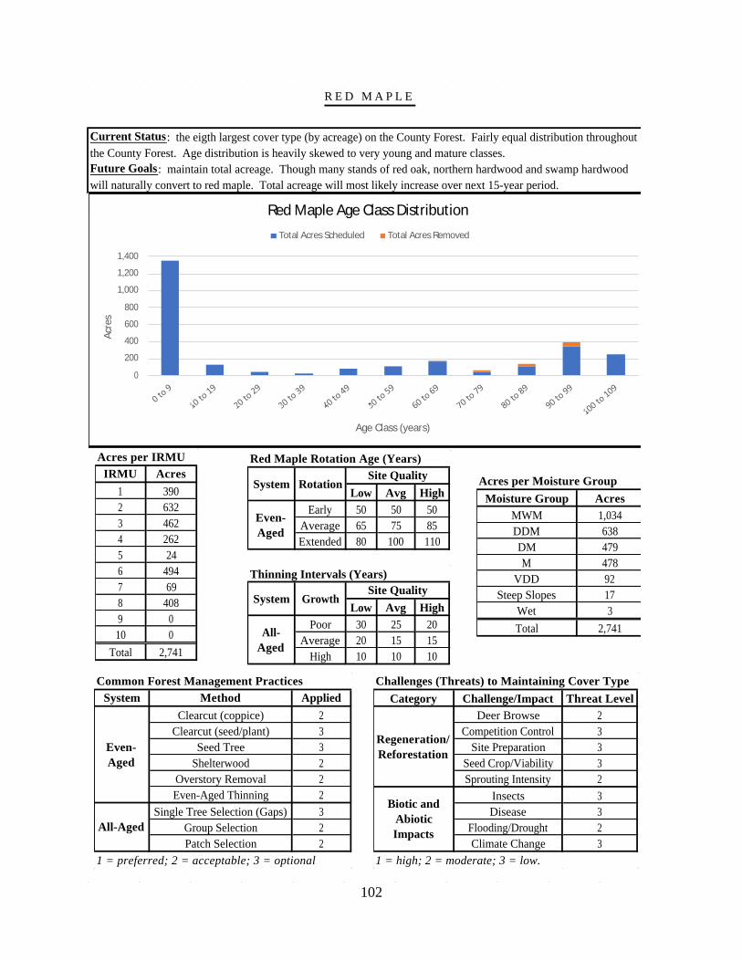
102
Current Status: the eigth largest cover type (by acreage) on the County Forest. Fairly equal distribution throughout
the County Forest. Age distribution is heavily skewed to very young and mature classes.
Future Goals: maintain total acreage. Though many stands of red oak, northern hardwood and swamp hardwood
will naturally convert to red maple. Total acreage will most likely increase over next 15-year period.
R E D M A P L E
Acres per IRMU
IRMU Acres
1 390
2 632
3 462
4 262
5 24
6 494
7 69
8 408
9 0
10 0
Total 2,741
Acres per Moisture Group
Moisture Group Acres
MWM 1,034
DDM 638
DM 479
M 478
VDD 92
Steep Slopes 17
Wet 3
Total 2,741
Red Maple Rotation Age (Years)
Low Avg High
Early 50 50 50
Average 65 75 85
Extended 80 100 110
Thinning Intervals (Years)
Low Avg High
Poor 30 25 20
Average 20 15 15
High 10 10 10
System RotationSite Quality
Even-
Aged
System GrowthSite Quality
All-
Aged
Challenges (Threats) to Maintaining Cover Type
Category Challenge/Impact Threat Level
Deer Browse 2
Competition Control 3
Site Preparation 3
Seed Crop/Viability 3
Sprouting Intensity 2
Insects 3
Disease 3
Flooding/Drought 2
Climate Change 3
1 = high; 2 = moderate; 3 = low.
Regeneration/
Reforestation
Biotic and
Abiotic
Impacts
System Method Applied
Clearcut (coppice) 2
Clearcut (seed/plant) 3
Seed Tree 3
Shelterwood 2
Overstory Removal 2
Even-Aged Thinning 2
Single Tree Selection (Gaps) 3
Group Selection 2
Patch Selection 2
1 = preferred; 2 = acceptable; 3 = optional
Common Forest Management Practices
Even-
Aged
All-Aged
0
200
400
600
800
1,000
1,200
1,400
Acr
es
Age Class (years)
Red Maple Age Class Distribution
Total Acres Scheduled Total Acres Removed

103
820.2.9 White Pine
White pine is the ninth largest cover type (by acreage) on the County Forest. At just over
2,600 acres, white pine comprises roughly 1.5% of the total area.
A. Historical Acreage Trends
Since 1977, the amount of white pine acreage on the County Forest has generally
remained steady, actually increasing by nearly 500 acres in the past 40+ years. Table
820.10 displays the total acreage trends for the white pine type between the periods of
1977 and 2020:
Table 820.xx: White Pine Historical Acreage Trends
Year Acres Change (Acres) % Change
1977 2,158
1995 2,307 149 6.9%
2005 2,376 69 3.0%
2020 2,639 263 11.1%
1977-2020 481 22.3%
The general expectation is for white pine acreage to remain relatively constant to slightly
increase over the next 15 years.
B. Current Status (2020)
As of 2020, a total of 2,639 acres of the County Forest is typed as white pine. Of that
total, 1,955 is manageable and considered part of the suitable timber base. The remaining
amount, 684 acres, has been removed from the harvest schedule.
The vast majority of white pine on the County Forest is of natural origin. Only a few
hundred acres have been reforested artificially (planted and/or seeded). Some stands of
red oak and poorer quality northern hardwood have been underplanted with white pine
seedlings in an attempt to increase species diversity. Most stands of white pine also
contain a diverse mix of red pine, red oak, red maple, aspen and paper birch.
The graph below illustrates the acreage of white pine per ten-year age class (as per CY

104
2020).
Similar to the red maple type, the age class distribution for white pine is weighted heavily
on both ends of the spectrum, young and mature. Nearly 2,000 acres (or almost 75%) of
the total white pine acreage is 80 years of age or older. While nearly 550 acres (or a little
over 20%) of the total acreage is 19 years of age or younger.
White pine is primarily located in three different regions (and three IRMUs) of the
County Forest. The most prominent region for white pine is the loamy sands located in
IRMU 7 (the Cable block). IRMU 5 (north of the Barnes Barrens) and IRMU 8 (in the
Bayfield Peninsula) also contain significant amounts of white pine.
See the Appendix for maps indicating the location of the white pine type on the Bayfield
County Forest. Also see Chapter 3000 for a summary of white pine per IRMU.
C. Desired Future Condition
The general goal is to maintain to slightly increase the amount of white pine acreage on
the landscape over the next 15 year period. This will be accomplished by maintaining
existing stands, while encouraging natural regeneration in others. Some stands of red oak
(that can’t be maintained as red oak) will be good candidates for planting, underplanting

105
or direct seeding of white pine. In addition, some of the natural stands of white pine will
be managed on extended rotations.
D. Management
White pine is generally managed with even-aged silvicultural systems and considered
intermediate with regards to shade tolerance. Some of the more common methods
prescribed when managing (regenerating) stands of white pine include:
Even-Aged Management:
Clearcut;
Seed Tree;
Shelterwood;
Overstory Removal;
Even-Aged Thinning (Intermediate Treatment).
All-Aged Management (when the objective is a mixed stand):
Patch Selection;
Group Selection.
White pine can be regenerated naturally or artificially, with the former being preferred.
Underplanting and direct seeding are two common methods used to artificially regenerate
white pine on the County Forest. Plantations can be considered as well, but white pine is
a preferred food source by white-tailed deer and tend receive higher levels of browsing.
Whenever planting white pine, additional protection measures should be considered (i.e.
bud capping) to discourage overbrowsing by white-tailed deer.
Other silvicultural prescriptions, regeneration methods or intermediate treatments will be
considered, depending on the goals for the stand, best available science, responses to
previous management, landscape level (or IRMU) objectives or similar factors, as
determined by the Department.
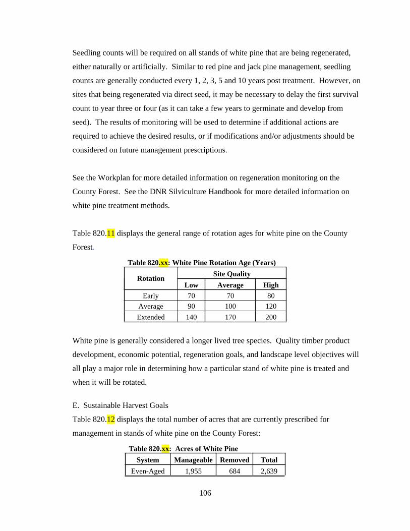
106
Seedling counts will be required on all stands of white pine that are being regenerated,
either naturally or artificially. Similar to red pine and jack pine management, seedling
counts are generally conducted every 1, 2, 3, 5 and 10 years post treatment. However, on
sites that being regenerated via direct seed, it may be necessary to delay the first survival
count to year three or four (as it can take a few years to germinate and develop from
seed). The results of monitoring will be used to determine if additional actions are
required to achieve the desired results, or if modifications and/or adjustments should be
considered on future management prescriptions.
See the Workplan for more detailed information on regeneration monitoring on the
County Forest. See the DNR Silviculture Handbook for more detailed information on
white pine treatment methods.
Table 820.11 displays the general range of rotation ages for white pine on the County
Forest.
Table 820.xx: White Pine Rotation Age (Years)
RotationSite Quality
Low Average High
Early 70 70 80
Average 90 100 120
Extended 140 170 200
White pine is generally considered a longer lived tree species. Quality timber product
development, economic potential, regeneration goals, and landscape level objectives will
all play a major role in determining how a particular stand of white pine is treated and
when it will be rotated.
E. Sustainable Harvest Goals
Table 820.12 displays the total number of acres that are currently prescribed for
management in stands of white pine on the County Forest:
Table 820.xx: Acres of White Pine
System Manageable Removed Total
Even-Aged 1,955 684 2,639

107
Total 1,955 684 2,639
A total of 1,955 acres of white pine is considered part of the suitable timber base and
scheduled for management. The remaining 684 acres have been removed from the
harvest schedule and are not considered part of the suitable timber base.
Plantations are managed differently than natural origin stands. Natural stands are often
considered for extended rotations and/or as candidates for removal from the suitable
timber base. Most stands of white pine have originated naturally. Annual sustainable
harvest goals are developed based on the treatments scheduled for each stand. Thinning
entries will vary based on many of the factors previously listed.
Regeneration harvests will also vary based on overall objectives for the stand, as
determined by the Department. In addition, it may be necessary to begin developing
plans for achieving a regulated age-class distribution. This may require modifications to
the regeneration harvest schedules, which would also impact annual harvest goals.
Therefore, sustainable harvest goals tend to be fairly variable from year to year.
Fluctuations in sustainable harvest goals will also be dependent upon other variables such
as site conditions, current age class distributions, landscape level considerations,
responses to insect and/or disease outbreaks, objectives for a particular stand and/or
IRMU, or other similar factors, as determined by the Department.
Refer to the Workplan for detailed information on annual sustainable harvest goals for
white pine and the Accomplishment Report for a summary of previously completed
treatments.
F. Challenges.
Numerous threats and challenges need to be considered when managing white pine
forests. Some of the more significant challenges, threats and/or issues regarding the
management of the white pine type include:
1. Deer Browse. White pine is a preferred food source of white-tailed deer.

108
Plantations or underplantings tend to be targeted more by deer. When planting
white pine, additional protection measures should always be considered (i.e. bud
capping). Excessive browsing has the potential to result in a complete failure of
the reforestation attempt. Deer browse is one of the variables monitored as part of
every regeneration survey. High levels of browse related mortality may require
supplemental planting or a selection of different species to regenerate.
2. Competition Control. Adequate site preparation is required to ensure a successful
plantation or where regeneration from natural seed is preferred. White pine is
generally classified as intermediate in terms of shade tolerance and can withstand
a minor level of competition. Nevertheless, undesirable competition should be
controlled to help achieve the desired objective.
3. White Pine Blister Rust. White pine blister rust is a significant disease that can
kill individual trees or stands of trees. White pine blister rust is a fungus that
causes cankers on white pine. These cankers can girdle and kill branches or the
main stem of the tree. See the Silviculture Handbook and DNR website for more
information on blister rust.
4. White Pine Tip Weevil. White pine tip weevils generally target the main terminal
leader of an individual trees. When attacked, the leader is usually killed. Side
lateral branches of the impacted tree then attempt to replace the killed terminal
leader. This action has the potential to cause crooks, forking, sweep and other
deformities which can impact the commercial value of an individual tree. See the
Silviculture Handbook and DNR website for more information on the tip weevil.
5. Heterobasidion Root Disease (HRD). This disease was formerly known as
Annosum Root Rot and is considered one of the most destructive diseases of
conifers in the northern parts of the world. Though not yet located in Bayfield
County. See Chapter 600 and the DNR website for more information on insects
and disease.
6. Armillaria Root Disease. See the DNR website for more detailed information on
Armillaria.
7. Climate Change. The white pine type is predicted to either have little to no
change, or a slight decrease in the amount of suitable habitat, primarily due to a

109
potential increase in susceptibility to insects and disease.
The challenges, threats and/or concerns listed above have the potential to impact and/or
influence short and/or long-term management objectives for any given stand, as
determined by the Department. The Department will continue to routinely and regularly
monitor the County Forest and modify goals and objectives accordingly.
The graphic below provides a general summary of the white pine type, including goals
and objectives, acreage per management unit (IRMU) and moisture group, rotations ages,
silvicultural treatments and challenges.

110
Current Status: the ninth largest cover type (by acreage) on the County Forest. Primarily located in IRMU's 5, 7 & 8.
Age distribution is heavily skewed to very young and mature classes.
Future Goals: maintain to slightly increase total acreage. Longer-lived species well suited for extended rotations.
Some stands of red oak will naturally convert to white pine.
W H I T E P I N E
0
100
200
300
400
500
600
Acr
es
Age Class (years)
White PineAge Class Distribution
Total Acres Scheduled Total Acres Removed
Acres per IRMU
IRMU Acres % of Total
1 113 0%
2 161 1%
3 196 1%
4 115 1%
5 435 2%
6 31 0%
7 851 14%
8 737 3%
9 0 0%
10 0 0%
Total 2,639 2%
Acres per Moisture Group
Moisture Group Acres
DM 897
Steep Slopes 648
VDD 519
MWM 372
DDM 203
M 0
Wet 0
Total 2,639
White Pine Rotation Age (Years)
Low Average High
Early 70 70 80
Average 90 100 120
Extended 140 170 200
RotationSite Quality
Challenges (Threats) to Maintaining Cover Type
Category Challenge/Impact Threat Level
Deer Browse 1
Competition Control 2
Site Preparation 2
Seed Crop/Viability 2
Sprouting Intensity na
Insects 2
Disease 2
Flooding/Drought 2
Climate Change 3
1 = high; 2 = moderate; 3 = low.
Regeneration/
Reforestation
Biotic and
Abiotic
Impacts
System Method Applied
Clearcut (coppice) na
Clearcut (seed/plant) 1
Seed Tree 1
Shelterwood 2
Overstory Removal 2
Even-Aged Thinning 1
Single Tree Selection (Gaps) na
Group Selection 3
Patch Selection 3
1 = preferred; 2 = acceptable; 3 = optional
Common Forest Management Practices
Even-
Aged
All-Aged

111
820.2.10 Swamp Conifer
Swamp conifer is a blend of three different cover types currently classified on the County
Forest: tamarack, black spruce and swamp conifer. Collectively, the swamp conifer
complex totals 2,670 acres and comprises roughly 1.5% of the total area. Of the total
swamp conifer acres, black spruce represents 1,527 acres, tamarack is 997 acres and
swamp conifer (an older, now obsolete cover type) is 146 acres.
A. Historical Acreage Trends
Since 1977, the amount of swamp conifer acreage on the County Forest has steadily
increased. Table 820.10 displays the total acreage trends for the swamp conifer type
between the periods of 1977 and 2020:
Table 820.XX: Swamp Conifer Historical Acreage Trends
Year Acres Change (Acres) % Change
1977 1,527
1995 1,655 128 8.4%
2005 2,130 475 28.7%
2020 2,670 540 25.4%
1977-2020 1,143 74.9%
Improvements in reconnaissance data is the general reason for the increase in swamp
conifer acres. The general expectation is for the swamp conifer type to remain relatively
constant to slightly increase over the next 15 years.
B. Current Status (2020)
As of 2020, a total of 2,670 acres of the County Forest is typed as swamp conifer. Table
820.XX summarizes the swamp conifer type on the County Forest.
Table 820.XX: Total Acreage per Swamp Conifer Type
Cover Type Manageable Removed Unproductive Total
Black Spruce 829 246 452 1,527
Tamarack 430 86 481 997
Swamp Conifer 114 0 32 146
Total 1,373 332 965 2,670
Of that total acreage of swamp conifer, 1,373 acres are considered manageable and are

112
part of the suitable timber base. A significant amount of the total acreage (965 acres) is
classified as unproductive (or developing on sites not capable of producing marketable
timber products). The remaining 332 acres has been removed from the harvest schedule.
In general, a little less than half of the total swamp conifer type is considered harvestable.
Most of the swamp conifer type on the County Forest is of natural origin and is mature.
However, a mixed tamarack and black spruce stand was planted in the Bayfield
Peninsula. Most swamp conifer stands contain a mix of tamarack and black spruce.
Cedar is present in some stands. White birch, aspen, red maple and black ash are present
on portions of stands with some component of high ground or those that are less saturated
with water.
The graph below illustrates the acreage of swamp conifer per ten-year age class (as per
CY 2020).
Nearly 95% of the swamp conifer type is 60 years of age or older.
Roughly 55% of the swamp conifer type is located in IRMU 6 (south Barnes). While
about 30% is located in IRMUs 3 and 4 (north and south of Iron River). Smaller
representations of swamp conifer can be found in virtually every IRMU on the County

113
Forest.
See the Appendix for maps indicating the location of the swamp conifer type on the
Bayfield County Forest. Also see Chapter 3000 for a summary of swamp conifer per
IRMU.
C. Desired Future Condition
The general goal is to maintain the amount of swamp conifer acreage on the landscape
over the next 15 year period. This will be accomplished by maintaining existing stands,
while encouraging natural regeneration in those that are suitable for management.
Tamarack and black spruce can also be considered as alternatives in swamp hardwood
stands that will eventually succumb to EAB.
It is anticipated that some stands of swamp hardwood will be converted to swamp
conifer. Tamarack and black spruce can be planted on wet soils, but can also add
diversity to upland sites.
D. Management
Swamp conifers are generally regenerated naturally. Even though it is common to find
black spruce and tamarack developing in the same stand, they are very different in terms
of shade tolerance. Black spruce is considered tolerant of shade and is a pioneer species
on filled-lake bogs and similar locations. While tamarack is considered very intolerant of
shade. Though it can tolerate a little shade during the first few years of life, it must
maintain dominance in order to survive.
Stands of swamp conifer are generally managed with even-aged silvicultural systems.
Some of the more common methods prescribed when managing (regenerating) stands of
swamp conifer include:
Even-Aged Management:
Clearcut (if adequate natural regeneration is present or if the site will be
seeded and/or planted);
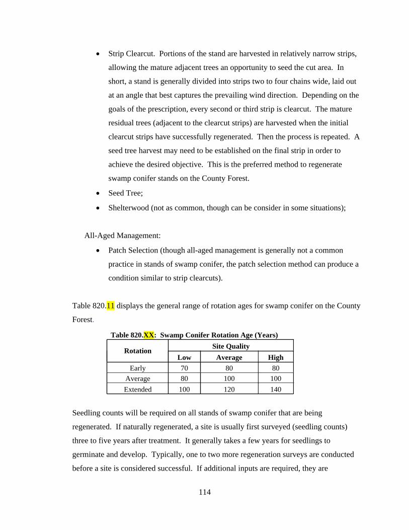
114
Strip Clearcut. Portions of the stand are harvested in relatively narrow strips,
allowing the mature adjacent trees an opportunity to seed the cut area. In
short, a stand is generally divided into strips two to four chains wide, laid out
at an angle that best captures the prevailing wind direction. Depending on the
goals of the prescription, every second or third strip is clearcut. The mature
residual trees (adjacent to the clearcut strips) are harvested when the initial
clearcut strips have successfully regenerated. Then the process is repeated. A
seed tree harvest may need to be established on the final strip in order to
achieve the desired objective. This is the preferred method to regenerate
swamp conifer stands on the County Forest.
Seed Tree;
Shelterwood (not as common, though can be consider in some situations);
All-Aged Management:
Patch Selection (though all-aged management is generally not a common
practice in stands of swamp conifer, the patch selection method can produce a
condition similar to strip clearcuts).
Table 820.11 displays the general range of rotation ages for swamp conifer on the County
Forest.
Table 820.XX: Swamp Conifer Rotation Age (Years)
RotationSite Quality
Low Average High
Early 70 80 80
Average 80 100 100
Extended 100 120 140
Seedling counts will be required on all stands of swamp conifer that are being
regenerated. If naturally regenerated, a site is usually first surveyed (seedling counts)
three to five years after treatment. It generally takes a few years for seedlings to
germinate and develop. Typically, one to two more regeneration surveys are conducted
before a site is considered successful. If additional inputs are required, they are

115
addressed as soon as possible. A final seedling count is typically conducted around year
10 (or later, depending on the development of the stand). See the Workplan for more
detailed information on regeneration monitoring on the County Forest.
E. Sustainable Harvest Goals
A total of 1,373 acres of swamp conifer is considered part of the suitable timber base and
schedule for management. Of the remaining acres, 332 have been removed from the
harvest schedule and 965 are not productive. Neither are considered part of the suitable
timber base.
Table 820.12 displays the total number of acres that are currently prescribed for
management in stands of swamp conifer on the County Forest:
Table 820.XX: Acres of Swamp Conifer
System Cover Type Manageable Removed Unproductive Total
Even-Aged
Black Spruce 829 246 452 1,527
Tamarack 430 86 481 997
Swamp Conifer 114 0 32 146
Total 1,373 332 965 2,670
The timing of regeneration harvests will generally vary based on overall objectives for
the stand or IRMU, as determined by the Department. Also, additional measures may be
necessary to adjust harvest schedules (either to accelerate or delay harvests) based on
potential modifications to short and/or long-term objectives.
The average rotation age for swamp conifer is about 100 years, but harvest cycles may
vary based on site/stand conditions, current age class distributions, landscape level
considerations, objectives for a particular stand and/or IRMU, or other similar factors, as
determined by the Department.
When prescribing the strip clearcut method to regenerate a stand, the timing of
subsequent harvests will be highly dependent on the development of the new seedlings.

116
Adjacent trees (strips) will be harvested after the initial treatment areas (strips) have
regenerated successfully. If regeneration is inadequate, supplemental planting and/or
seeding may be prescribed.
Also, swamp conifer stands are traditionally difficult to manage, due primarily to poor
accessibility (most stands are growing on wet sites that require frozen ground conditions
to harvest) and volatile markets. As a result, some stands may not be accessible or
marketable, which will impact annual goals. Therefore, actual sustainable harvest goals
will be fairly variable from year to year.
As with most timber types that are managed on an even-aged basis, one primary goal is to
achieve a regulated condition. However, the current age class distribution for swamp
conifer is weighted heavily to mature stands. As a result, attempts to more evenly re-
distribute the mature age classes may not be practical at this time, though should still be
considered as part of a long-term management strategy.
Refer to the Workplan for detailed information on annual sustainable harvest goals for
swamp conifer and the Accomplishment Report for a summary of previously completed
treatments.
F. Challenges.
Numerous threats and challenges need to be considered when managing swamp conifer
forests. Some of the more significant challenges, threats and/or issues regarding the
management of the swamp conifer type include:
1. Accessibility. Swamp conifer stands are primarily developing on saturated soils.
Accessibility to these sites can become a limiting factor. Most sites require frozen
ground for accessibility and to support harvesting operations. A potentially
changing climate may also impact traditional winter conditions, resulting in a
decrease in the number of days that would have been suitable for harvesting these
stands. Difficult accessibility, poor marketability and a glut of frozen ground only
timber sales may make it a challenge to manage swamp conifer stands in the

117
future.
2. Deer Browse. Black spruce generally is not a preferred source of food by white-
tailed deer. Tamarack is a little more palatable, but also generally not heavily
browsed. However, as with any reforestation activity, deer browse will be
monitored as part of the routine regeneration monitoring program. High levels of
browse that threatened the regeneration of a stand may require additional inputs
from the Department.
3. Changes in Water Table. In general, black spruce and tamarack are both adapted
to growing on saturated soils. However, significant changes/fluctuations in the
water table can negatively impact their ability to develop and survive. Road
construction and beaver activity can potentially block or otherwise alter natural
drainage patterns. Flooding or long term rising of the water table can kill
established mature stands. Increased stress levels, caused by a fluctuation in the
water table, can also leave individual trees more vulnerable to secondary
stressors. The extra stress can often lead to increases in mortality.
4. Windthrow. Black spruce and tamarack tend to be fairly shallow rooted (due to
the higher water tables). As a result, they are more susceptible to windthrow.
Maintaining healthy, vigorous stands and avoiding open grown conditions are
some of the best ways to mitigate the potential impacts from windthrow.
5. Larch Sawfly. While black spruce is generally not significantly impacted by
insects or disease, tamarack is more susceptible to periodic outbreaks.
Defoliation from the larch sawfly is one of the most significant pests. The sawfly
is often only periodically epidemic, but has the potential to defoliate tamarack
stands over large areas for several successive years. When infested, the growth
and development of the stand is greatly reduced and often results in significant
levels of mortality. See Chapter 600 and the DNR website for more information
on insects and disease.
6. Climate Change. Black spruce and tamarack are predicted to respond differently
to a potentially changing climate. In most models, black spruce is expected to
experience a decrease in the amount of suitable habitat. While tamarack is
expected to have little to no change.

118
The challenges, threats and/or concerns listed above have the potential to impact and/or
influence short and/or long-term management objectives for any given stand, as
determined by the Department. The Department will continue to routinely and regularly
monitor the County Forest and modify goals and objectives accordingly.
The graphic below provides a general summary of the swamp conifer type, including
goals and objectives, acreage per management unit (IRMU) and moisture group, rotations
ages, silvicultural treatments and challenges.

119
Current Status: a type generally comprised of black spruce and tamarack. Most prevalent in IRMU 6, but located
throughout the County Forest. Age distribution is heavily skewed to the mature classes. Many stands are unproductive.
Future Goals: maintain total acreage. Manage stands that are accessible. Swamp conifer acres will likely naturally
increase as stands of swamp hardwood are lost to EAB.
S W A M P C O N I F E R
Acres per IRMU
IRMU Acres % of Total
1 41 0%
2 12 0%
3 341 1%
4 478 3%
5 0 0%
6 1,417 7%
7 139 2%
8 242 1%
9 0 0%
10 0 0%
Total 2,670 2%
Acres per Moisture Group
Group Acres
Wet 2,478
DDM 52
DM 46
M 46
MWM 40
Steep Slopes 8
VDD 0
Total 2,670
Swamp Conifer Rotation Age (Years)
Low Avg High
Early 70 80 80
Average 80 100 100
Extended 100 120 140
RotationSite Quality
Challenges (Threats) to Maintaining Cover Type
Category Challenge/Impact Threat Level
Deer Browse 2
Competition Control 2
Site Preparation 2
Seed Crop/Viability 2
Sprouting Intensity na
Insects 2
Disease 2
Flooding/Drought 2
Climate Change 2
1 = high; 2 = moderate; 3 = low.
Regeneration/
Reforestation
Biotic and
Abiotic Impacts
0
100
200
300
400
500
600
700
Acr
es
Age Class (years)
Swamp Conifer Age Class Distribution
System Method Applied
Clearcut (coppice) na
Clearcut (strip) 1
Seed Tree 2
Shelterwood 3
Overstory Removal na
Even-Aged Thinning na
Single Tree Selection (Gaps) na
Group Selection na
Patch Selection 3
1 = preferred; 2 = acceptable; 3 = optional
Common Forest Management Practices
Even-
Aged
All-Aged

120
820.2.11 White (or Paper) Birch
White birch is the eleventh largest cover type (by acreage) on the County Forest. At just
over 900 acres, white birch comprises roughly 0.5% of the total area. The white birch
type is rarely found on the County Forest in pure form (at the stand level). It is
commonly mixed with other tree species like aspen, red maple, white pine and balsam fir.
A. Historical Acreage Trends
Since 1977, the amount of white birch acreage on the County Forest has decreased
significantly. Only a little more than 900 acres remain from the total of 7,000 acres that
was found on the County Forest in 1977. Table 820.10 displays the total acreage trends
for the white birch type between the periods of 1977 and 2020:
Table 820.6: White Birch Historical Acreage Trends
Year Acres Change (Acres) % Change
1977 7,000
1995 5,557 -1,443 -20.6%
2005 2,613 -2,944 -53.0%
2020 911 -1,702 -65.1%
1977-2020 -6,089 -87.0%
The overall decrease may be best explained by the natural progression from early
successional, shorter lived, shade intolerant species (like paper birch) to the later
successional, longer lived, more shade tolerant species (like maple).
Much of the birch that originated in the early 1900’s has died and been replaced by more
shade tolerant species or those that don’t have more intensive site preparation
requirements. Fire suppression, deer herbivory, aspen competition and improved
reconnaissance data (i.e. more accurate stand level typing) are other reasons for the
decrease in total birch acreage.
The general expectation is for white birch acreage to remain relatively constant to slightly
decrease over the next 15 years. Paper birch is a challenging tree species to naturally
regenerate. For many of the same reasons listed above, birch is one of the more difficult

121
cover types to perpetuate on the County Forest (at a stand level).
B. Current Status (2020)
As of 2020, a total of 911 acres of the County Forest is typed as white birch. Of that
total, 734 is manageable and considered part of the suitable timber base. The remaining
amount, 177 acres, has been removed from the harvest schedule.
At the landscape level, white birch dominated stands have significantly decreased
throughout the County Forest. However, individual birch trees or smaller areas
dominated by patches of birch are still common on the County Forest, especially in areas
along the Superior clay plain (IRMUs 1, 2 and 3).
White birch stands are often mixed with aspen, red oak, red maple, balsam fir and white
pine, as well as most other tree species present on the County Forest. Birch also shows
up as a component in nearly every forested cover type on the County Forest. It is also
common along road corridors or in just about any areas that have had a significant
amount of soil disturbance combined with increased levels of sunlight.
The graph below illustrates the acreage of white birch per ten-year age class (as per CY
2020).

122
The age class distribution for white birch is weighted heavily on both ends of the
spectrum, young and over mature. A majority of the younger acreage is currently
contained in the 20 to 29 year age class. While the vast majority of the older acreage is in
the 90 to 99 year age class. Once the older, over mature age classes have been addressed
(managed), there will most likely be a lull in white birch management (until the younger
age classes have reached maturity).
See the Appendix for maps indicating the location of the white birch type on the Bayfield
County Forest. Also see Chapter 3000 for a summary of white birch per IRMU.
C. Desired Future Condition
The general goal is to maintain the amount of white birch acreage on the landscape over
the next 15 year period. However, as previously stated, white birch has traditionally been
one of the more difficult timber types to regenerate on the County Forest (at a stand
level). As a result, the total amount of white birch acreage is expected to slightly
decrease over the next 15 years.
Maintaining white birch on county forest lands will be accomplished, in part, by
continuing to prescribe various site preparation activities in mature stands of birch that
are scheduled for management. And also by retaining individual birch trees or patches of
trees as seed sources in other stands that are in the process of being regenerated.
D. Management
White birch is an early successional species, is generally managed with even-aged
silvicultural systems and is considered intolerant to shade. Some of the more common
methods prescribed when managing (regenerating) stands of white birch include (refer to
the DNR Silviculture Handbook for a detailed description of each method):
Even-Aged Management:
Clearcut (with standards/reserves);
Seed Tree;
Shelterwood;

123
Overstory Removal.
White birch is regenerated naturally and, as such, typically requires additional inputs
from the Department to achieve the desired result (especially when a stand dominated by
white birch is the objective). The following variables must be considered when
attempting to regenerate a new stand of white birch:
1. Site Preparation/Soil Scarification.
2. Level of Competition.
3. Browse Pressure.
4. Seed Crop and Viability.
5. Sprouting Potential.
6. Stand Age.
Any or all of the variables listed above may need to be addressed to establish and recruit
a new stand of birch. However, adequately addressing the areas of concern will not
guarantee success. Similar to red oak, the ideal growing conditions for white birch are
very difficult to replicate and overbrowsing by white-tailed deer can be a limiting factor.
While attaining a new stand dominated by birch (i.e. more than 50% of the stand density
occupied by oak) is often the goal, maintaining a significant component of birch may also
be considered a success.
Seedling counts will be required on all stands of white birch that are being regenerated.
FRM or a similar form of regeneration survey method will be utilized to monitor the
results of each treatment. The results of monitoring will be used to determine if
additional actions are required to achieve the desired results, or if modifications and/or
adjustments should be considered on future management prescriptions.
See Section 810 for more information on FRM. Also see the DNR Silviculture
Handbook for a more detailed description of FRM. See the Workplan for more detailed
information on regeneration monitoring on the County Forest.
Other silvicultural prescriptions, regeneration methods or intermediate treatments will be

124
considered, depending on the goals for the stand, best available science, responses to
previous management, landscape level (or IRMU) objectives or similar factors, as
determined by the Department.
See the DNR Silviculture Handbook for more detailed information on white birch
treatment and regeneration methods.
Table 820.11 displays the general range of rotation ages for white birch on the County
Forest.
Table 820.2: White Birch Rotation Age (Years)
RotationSite Quality
Low Avg. High
Early 45 45 45
Average 55 60 65
Extended 70 75 80
White birch is an early successional species, but generally considered longer lived than
other similar types (i.e. aspen). Quality timber product development, economic potential,
regeneration goals, and landscape level objectives will all play a major role in
determining how a particular stand of birch is treated and when it will be rotated.
E. Sustainable Harvest Goals
Table 820.12 displays the total number of acres that are currently prescribed for
management in stands of white birch on the County Forest:
Table 820.9: Acres of White Birch
System Manageable Removed Total
Even-Aged 734 177 911
Total 734 177 911
A total of 734 acres of white birch is considered part of the suitable timber base and
schedule for management. The remaining 177 acres have been removed from the harvest
schedule and are not considered part of the suitable timber base.
125
Of the acreage that is part of the suitable timber base, roughly 33% is considered mature
(or over mature) and ready for some form of management. Since many of the older
stands are over mature and already exhibiting signs of decline (i.e. crown die back, large
diameter stem breakage and individual tree mortality), attempts to regulate age-classes or
extend rotations will not be considered feasible. An acceleration of treatments may be
required if existing stands begin to show signs of rapid decline, especially if regenerating
a new stand of birch is the objective.
Annual sustainable harvest goals for white birch will be variable over the next 15 year
period. A variety of factors will influence the harvest goals for any given year, including,
but not limited to: stand health and site conditions; landscape level considerations;
responses to insect and/or disease outbreaks or other natural event; relatively low total
acreage base either currently mature or approaching maturing; low levels of total acreage
between 40 and 60 years of age; objectives for a particular stand and/or IRMU, or other
similar factors, as determined by the Department.
Refer to the Workplan for detailed information on annual sustainable harvest goals for
white birch and the Accomplishment Report for a summary of previously completed
treatments.
F. Challenges.
Numerous threats and challenges need to be considered when managing white birch
forests. Some of the more significant challenges, threats and/or issues regarding the
management of the white birch type include:
1. Deer Browse. White birch is a preferred browse source of white-tailed deer.
Excessive levels of deer browse has the potential to significantly influence the
regenerative capacity of a given stand. Repeated instances of deer browsing can
kill individual birch trees or set back natural growth and development of desired
seedlings, thus giving more undesirable trees an advantage and significantly
reduce the density of desired species. High levels of browse (either experienced
or anticipated) can significantly impact short and long term management goals for

126
a given stand and may require additional inputs by the Department to achieve the
desired level of success. High levels of browse related mortality (either
experienced or anticipated) may require supplemental planting or targeting a
different suite of species to regenerate.
2. Competition Control. Heavy components of aspen, red maple, sugar maple,
ironwood and other species can negatively influence the establishment and
recruitment of white birch seedlings. Some trees that are common components of
white birch stands either sprout prolifically (i.e. aspen), can withstand higher
levels of shade or are not a preferred browse species. When combined with high
levels of deer herbivory, these factors can significantly impact regeneration
efforts. Timber sale design, harvest restrictions and/or the strategic placement of
reserve trees or islands may also increase potential rates of natural birch
regeneration.
3. Site Preparation. Natural regeneration is the preferred reforestation method in
stands of white birch. Birch produce prolific amounts of seed. But the delicate
nature of the seed often requires additional site preparation measures to improve
the rates of regeneration success. In addition to deer browse and competition
control, adequate site preparation is typically a significant part of the process.
Site preparation generally accomplishes two objectives: 1) it reduces a level of
competing vegetation and 2) it exposes bare mineral soil to create more favorable
conditions for germination. Mechanical methods like pre-sale site preparation
with a dozer and straight blade, salmon blade, or anchor chains have been used
successfully in the past. Prescribed fire and post-sale mechanical scarification
methods can also be considered.
4. Gypsy Moth. Birch is one of the tree species targeted by Gypsy Moth.
Defoliation has the potential to increase vulnerability to other variables that can
negatively impact the health and vigor of a stand of white birch. Combining a
defoliation event with a rapidly maturing birch forest can create significant
increases in stress. Increased stress levels leave individual oak trees more
vulnerable to secondary stressors (i.e. drought, excess moisture and bronze birch
borer). The extra stress can often lead to increases in mortality. See Chapter

127
600 and the DNR website for more information on insects and disease.
5. Forest Tent Caterpillar. See Chapter 600 and the DNR website for more
information on insects and disease.
6. Bronze Birch Borer. As per the DNR Silviculture Handbook: “larvae damage
trees by feeding on the phloem and cambium, disrupting the flow of water and
nutrients. Trees stressed by drought or defoliation are more likely to become
infested and sustain dieback or die.” See Chapter 600 and the DNR website for
more information on insects and disease.
7. Climate Change. The white birch type is predicted is predicted to experience a
decrease in the amount of suitable habitat, primarily due to a potential increase in
susceptibility to insects and disease, as well as drought.
The challenges, threats and/or concerns listed above have the potential to impact and/or
influence short and/or long-term management objectives for any given stand, as
determined by the Department. The Department will continue to routinely and regularly
monitor the County Forest and modify goals and objectives accordingly.
The graphic below provides a general summary of the white birch type, including goals
and objectives, acreage per management unit (IRMU) and moisture group, rotations ages,
silvicultural treatments and challenges.

128
Current Status: white birch has declined (total acres) significantly throughout the County Forest. Difficult to
regenerate at the stand level, but still a common component of many even-aged stands.
Future Goals: maintain total acreage. Increase where feasible. Birch will most likely continue to decline as older
stands succeed to more shade tolerant species.
W H I T E B I R C H
Acres per Moisture Group
Moisture Group Acres
MWM 348
DM 290
DDM 205
VDD 40
M 15
Steep Slopes 13
Wet 0
Total 911
Challenges (Threats) to Maintaining Cover Type
Category Challenge/Impact Threat Level
Deer Browse 1
Competition Control 1
Site Preparation 1
Seed Crop/Viability 1
Sprouting Intensity 2
Insects 2
Disease 2
Flooding/Drought 2
Climate Change 1
1 = high; 2 = moderate; 3 = low.
Regeneration/
Reforestation
Biotic and
Abiotic
Impacts
System Method Applied
Clearcut (w/Reserves) 1
Clearcut (seed/plant) na
Seed Tree 2
Shelterwood 2
Overstory Removal 2
Even-Aged Thinning na
Single Tree Selection (Gaps) na
Group Selection na
Patch Selection na
1 = preferred; 2 = acceptable; 3 = limited potential
Common Forest Management Practices
Even-Aged
All-Aged
Acres per IRMU
IRMU Acres
1 427
2 238
3 35
4 67
5 20
6 15
7 0
8 109
9 0
10 0
Total 911
White Birch Rotation Age (Years)
Low Avg. High
Early 45 45 45
Average 55 60 65
Extended 70 75 80
RotationSite Quality
0
50
100
150
200
250
300
350
400
Acr
es
Age Class (years)
White Birch Age Class Distribution
Total Acres Scheduled Total Acres Removed

129
820.3 LOCALLY UNCOMMON TREES / FOREST TYPES
The presence or lack of a particular tree species is dependent on numerous factors,
including, but not limited to, suitable habitat, climate, range, natural or human
disturbance, impacts of herbivory, and many other factors. The following trees and/or
cover types are considered uncommon on the County Forest and likely across the general
region. In general, these trees may be left as reserves in even aged management
prescriptions or in thinnings and may also be retained in all aged regeneration harvests.
The following tree species are considered uncommon on the County Forest: American
elm, Eastern hemlock, white cedar, black cherry, white oak and white ash
820.3.1 American Elm
American elm is rare on the County Forest primarily due to the mortality caused by the
Dutch elm disease. Where found, elm will normally be left uncut in hopes that it may
continue on the landscape and provide seed for the future.
820.3.2 Eastern Hemlock
On the County Forest, Eastern hemlock is generally found in relatively small patches or
as isolated individual trees, most commonly mixed within stands of northern hardwood.
Hemlock is generally not harvested on the County Forest. Natural regeneration of
hemlock on the County Forest is difficult (primarily due to high levels of browse
pressure) and remnant stands will be retained to provide habitat diversity and seed
sources for future management activities. The overall goal is to maintain current levels
of hemlock on the County Forest and consider options and/or opportunities to encourage
more development when possible.
820.3.3 White Cedar
White cedar is found on the County Forest in relatively small isolated pockets. Because
cedar is uncommon on the County Forest it generally is not harvested. However, if
opportunities exist to encourage the natural regeneration of cedar, some stands may be
considered for management. Additionally, many stands of cedar also contain

130
components of ash. As previously stated, EAB infestation is generally considered
inevitable and will likely quickly eliminate most ash trees from the landscape. Some
stands of cedar may be managed to pre-salvage ash trees and encourage the natural (or
artificial) regeneration of desired tree species. Cedar also plays an important role for
wildlife, especially white-tailed deer, primarily as cover and an important food source in
the winter. Consequently, the natural regeneration of cedar is difficult, primarily because
of the palatability and nutritional value it has for deer.
820.3.4 Black Cherry
Black cherry is relatively rare on the County Forest and generally only occasionally
found in stands of northern hardwoods. Bayfield County is the northern most edge of its
range. As a result, when located, black cherry is generally found as an individual tree
and typically of poor quality. Whenever possible, this species will be retained for
diversity.
820.3.5 White Oak
Similar to black cherry, white oak is also relatively rare on the County Forest. When
present, it is generally found as an individual tree and occasionally in small groups, often
near old homesteads or fields. Bayfield County is also on the edge of its northern most
range. White oak is a highly preferred food source by white-tailed deer and other
animals. While generally not feasible to manage in terms of traditional forest practices,
whenever possible, white oak will be retained for diversity and various wildlife benefits.
820.3.6 White Ash
Though not as rare as white oak and black cherry, white ash is relatively uncommon on
the County Forest, and typically only occasionally found in stands of northern hardwood.
When present, it is generally only a very minor component. In the past, when present,
white ash was typically retained for diversity and other wildlife benefits. However, the
impending arrival of EAB will have a devastating impact on all ash within the region. As
a result, most ash has or will be targeted for removal as part of various forest
management activities. Post EAB infestation, it is predicted that some examples of white

131
ash may remain on the County Forest, though the extent of which is an unknown.
820.4 FOREST TYPES REQUIRING INTENSIVE EFFORT TO REGENERATE
Certain forest types have traditionally been more difficult to regenerate than others.
Whenever possible, the natural regeneration of tree species is the preferred method of
reforestation on the County Forest. However, there are many factors that can influence
the natural regeneration capacities of tree species, including, but not limited to, excessive
deer herbivory, the exclusion of intensive fires from the landscape, high levels of
competition from undesirable vegetation, lack of suitable/effective site preparation,
insects and/or disease outbreaks, and various abiotic factors (or various combination of
the above). Additionally, some timber types are easier to regenerate via artificial
methods i.e. planting or seeding, though still require additional inputs from the
Department to produce the desired results.
Regeneration concerns and/or challenges are addressed in each major cover type listed in
section 820 of this Chapter. In general, the following timber types require more intensive
inputs from the Department to better achieve the desired level of regeneration (either
natural or artificial): red oak, white birch, jack pine, white pine and red pine. Stands of
northern hardwood can also be difficult to regenerate depending on existing levels of
undesirable vegetative competition and deer browse. See the Workplan for additional
information regarding natural and artificial reforestation efforts on the County Forest.
820.5 INVASIVE PLANT SPECIES OF CONCERN
Invasive plants can cause significant damage to the County Forest. Invasive species have
the potential to displace native plants and hinder various forest regeneration efforts.
Preventing the establishment and expansion of invasive species is critical to the long-term
health and natural function of the County Forest.
There are numerous native and non-native invasive plant species in varying densities on
the County Forest. Some of the more common invasive plant species on the County
Forest include, but are not limited to: spotted knapweed; common buckthorn; black

132
locust; and multi-flora rose.
Some invasive species require immediate action and continual treatment efforts, while
others may be allowed to temporarily persist due to a limited extent, minimal potential
impact to the surrounding County Forest and/or financial constraints.
The Department will continue to train staff in invasive species identification and control
methods, as well as attempt to secure funding sources for eradication and/or control, to
the extent practical, as determined by the Administrator. All known areas of invasive
species will be monitored on a routine and regular basis to determine the type and timing
of future treatments.
See Chapter 600 for more information on invasive species and associated control
measures. See the Workplan for details regarding goals and objectives for invasive
species management on the County Forest.
820.6 LEGALLY PROTECTED AND SPECIAL CONCERN PLANT SPECIES
Some plants in Wisconsin are protected under the Federal Endangered Species Act, the
State Endangered Species Law, or both. On County Forest, it is illegal to cut, root up,
sever, injure, destroy, remove, transport or carry away a listed plant without a valid
endangered or threatened species permit. There is an exemption on public lands for
forestry, agriculture and utility activities under state law. The County will, however,
make reasonable efforts to minimize impacts to endangered or threatened plants as part of
forestry related activities (typically identified in the timber sale narrative).
The DNR Bureau of Natural Heritage Conservation tracks information on legally
protected plants as part of the Natural Heritage Inventory (NHI) program. The NHI
program also tracks Species of Special Concern (SSC), which are those for which some
problem of abundance or distribution is suspected, but not yet confirmed. One of the
primary goals of identifying SSC’s is to focus attention on, or bring awareness to, certain
at risk species before they become threatened or endangered.

133
The Department has access to this data under a license agreement and is committed to
reviewing this database for endangered resources that may occur within proposed land
disturbing project areas.
820.7 TREE RETENTION GUIDELINES
As part of the timber sale process, a representative portion of most stands are purposely
left unmanaged. This is commonly referred to as green tree retention (though other
names such as legacy tree and reserve tree have also be used to define a level of
retention). Individual trees, small patches (remnants) of the previous stand or a
combination thereof can be prescribed to achieve the desired level of green tree retention.
Green tree retention goals can also be satisfied as part of other reasons to remove certain
portions of a stand from harvest considerations i.e. BMP’s for water quality (or RMZ’s),
unique/special features or aesthetic concerns.
On the County Forest, the general goal for green tree retention is to reserve a
minimum of roughly 3 to 10%, of the original stand area, as unmanaged,
scattered individual trees or remnant small patches, on each timber sale or as
otherwise indicated in the Department’s Green Tree Retention Guidelines (see
the Appendix to review the Green Tree Retention Guidelines).
In some instances, especially in stands with a heavy component of riparian management
zones, the total level of retention will far exceed 10%. However, due to the nature of
some stands or forested communities, green tree retention is not always considered or
feasible. Green tree retention is typically not considered whenever threats to young
regenerating stands exist (primarily the pine species) or when the regeneration of target
species would otherwise be compromised.
The retention of reserve trees (or green tree) can provide numerous benefits, all of which
ultimately contribute to the conservation of biological diversity. Among other benefits,
these structures facilitate the perpetuation of some biota (plant and animal species and
genotypes) on site. They can maintain landscape connectivity by enabling the movement

134
of some organisms. Reserve trees also influence reorganization and recovery processes
after a timber sale, as well as help to sustain functional roles and modify the post
disturbance environment.
Green tree retention generally only applies to stands that are managed with even aged
practices i.e. clearcutting, seed tree harvesting, etc. Stands that are thinned or managed
with all-aged methods, already leave behind more trees than those that are harvested.
Refer to the Appendix to review the Department’s Green Tree Retention Guidelines.
Refer to the Workplan for more information on retention. Refer to the DNR Silviculture
Handbook for more information on retention systems and procedures.
820.8 BIOMASS HARVESTING GUIDELINES
Traditional timber harvests generally remove marketable forest products (typically at
least four inches in diameter and of merchantable length, or as otherwise directed in the
timber sale contract), with the smaller woody material left on site. Biomass harvesting
generally removes the entire above ground portion of a tree, including all or most of the
material that is usually left behind as part of traditional practices.
Biomass harvesting is a management option that can be considered on many stands
located on the County Forest. When biomass harvesting is considered, the Department
will refer to the Wisconsin’s Forestland Woody Biomass Harvesting Guidelines (BHG) as
part of the timber sale establishment process (see the Appendix for a link to the Biomass
Guidelines).
The BHG’s are designed to address potential impacts of increased biomass harvesting on
biodiversity, soil nutrients and physical properties, forest regeneration and water quality.
The harvest of fine woody material from the forest results in increased levels of nutrient
export, which could negatively impact the future potential of a site, especially if repeated
over time.

135
The BHG’s were developed to address the potential impacts of woody biomass
harvesting on: a) biodiversity, b) soil nutrient depletion, c) the physical properties of soil,
and d) water quality. The biomass harvesting guidelines may be modified for specific
site conditions, for specific operational issues or to meet specific management objectives,
as determined by the Administrator. The guidelines do not lessen the need for technical
skill, sound silvicultural judgment, and informed decision-making when selecting proper
management practices to achieve integrated resource management objectives.
825 ANIMAL SPECIES MANAGEMENT
The County Forest provides a wide range of wildlife habitats from open grasslands and
barrens to forests in various stages of development, including bogs and forested wetlands,
as well as ephemeral ponds, lakes and streams. A primary goal of wildlife management
on the County Forest is to provide a diversity of healthy ecosystems necessary to sustain
and enhance native wildlife populations.
As part of the routine management of the County Forest, a diversity of habitats will
naturally be provided for a suite of wildlife species. In general, the County Forest will
not be managed to focus on or target a specific wildlife species, with potential exceptions
made to those that are listed as threatened or endangered by either the state or federal
government.
825.1 TECHNICAL PLANNING
Management of wildlife populations on the County Forest falls under the jurisdiction of
the DNR. Planning may be a cooperative effort of the Department staff, DNR liaison
forester and DNR wildlife biologist in formulating management plans and utilizing forest
and wildlife management techniques to accomplish desired forest and wildlife
management goals.
825.2 GUIDELINES
DNR operational handbooks including the Public Forest Lands Handbook (2460.5),

136
manual codes and guidance documents are important references and guidelines to utilize
in fish and wildlife planning efforts.
All other available and relevant documents, guidelines, handbooks, research and/or
websites will be referenced and utilized when developing specific wildlife management
projects and/or incorporating wildlife objectives into standard timber sale procedures,
including, but not limited to:
Black Bear Management Plan;
Partners in Flight North American Land Bird Management Plan;
Ruffed-Grouse Management Plan;
Sharp-tailed Grouse Management Plan;
Golden-winged Warbler Best Management Practices;
American Woodcock Best Management Practices;
Wisconsin Bird Conservation Partnership;
Department staff will collaborate with DNR, Federal and Tribal wildlife biologists,
academic and other natural resource professionals as needed on various issues and
concerns pertaining to wildlife matters on the County Forest. Refer to the DNR website
for the most current management plans and guidelines for various wildlife species.
825.3 INVENTORY
Habitat needs will be determined, in part, by the analysis of forest reconnaissance
information. Wildlife population estimates will be conducted periodically by DNR
wildlife biologists, endangered resources personnel, and other trained cooperators.
Breeding bird surveys, mammal surveys and similar wildlife monitoring projects will also
be considered in the future to better understand how species are using the County Forest.
Currently, the following surveys are, or have been, conducted on or adjacent to the
County Forest:
Biotic inventories;
Summer deer observations;
137
Timber wolf monitoring and surveys;
Brood surveys;
Sharp-tailed grouse surveys;
Ruffed grouse drumming surveys;
Owl and nightjar surveys;
Bald eagle and osprey productivity survey;
Furbearer tracking;
Frog and toad surveys;
Bat monitoring;
Black bear bait surveys;
Breeding bird surveys;
Snapshot Wisconsin.
Refer to the Workplan for more detailed information regarding wildlife projects on the
County Forest. Refer to the Accomplishment Report for a summary of completed work.
825.4 RESOURCE MANAGEMENT CONSIDERATIONS FOR WILDLIFE
The following areas of focus are identified for achieving plan objects and for benefit of
wildlife.
825.4.1 General Management Policies
Forest management practices may be adjusted or modified to provide additional benefits
to wildlife and habitat diversity. The following factors will be considered when planning
for management activities:
1. Even-aged regeneration harvests (i.e. clearcuts) should vary in size and shape and
include retention considerations.
2. Maintain and/or develop a diversity of stand ages, size-classes and species
throughout all cover types.
3. Whenever practical or feasible, maintain mast-bearing trees and shrubs, cavity
trees, and an adequate number and variety of snags.

138
4. Consider maintaining cull trees (future snag or den trees) not interfering with
specific silvicultural goals and objectives for the stand.
5. Consider accessibility to the forest and how road infrastructure and additional
public use/access may impact wildlife patterns.
6. Incorporate all recommended best management practices for water quality
(BMP’s).
7. The creation and retention of grouse drumming logs.
8. The maintenance of early successional forests such as aspen, jack pine, and scrub
oak will be a priority due to their importance for a wide variety of songbirds,
small mammals, deer, grouse, woodcock, and snowshoe hare.
a. Aspen should be considered as one of the most important early
successional forest types that has and will continue to experience losses in
acreage, due primarily to natural succession to more shade tolerant forests
and public misconceptions about the impacts of clearcuts in Wisconsin.
9. Young Forest Initiative. Young or early successional forests provide important
habitat for a variety of wildlife species. The Young Forest Project is a national
initiative that, in part, aims to promote the importance of young forests on the
landscape. Through the initiative, landowners are informed of the numerous
benefits of early successional types and encouraged to develop a management
program that prioritizes the routine and regular establishment of young forests on
the landscape. The Department will continue to prioritize the establishment and
maintenance of young forests on the County Forest. See the Appendix for a link
to the Young Forest Project webpage, as well as various documents pertaining to
the Wisconsin Young Forest Partnership.
10. Management activities will also emphasis the maintenance of representative areas
of mid to late successional forest types for wildlife and habitats that require
these forest stages.
825.5 IMPORTANCE OF HABITATS
Important habitat types are those cover types known to be of importance to certain native
wildlife and whose absence could make that wildlife significantly less abundant. These

139
shortages may be on a local or broader scale. The following habitat types can be
considered important:
825.5.1 Non-Forested Wetlands
The County Forest contains a little over 8,000 acres of non-forested wetland types
providing a variety of habitats for common, rare and endangered species. Emergent
wetland, sedge meadow, muskeg bog and deep marsh provide habitat for species such as
wood turtle, black tern, American bittern, and numerous other species.
825.5.2 Aquatic Habitats
The County Forest includes over 1,000 acres of lakes, rivers, streams, ponds and other
aquatic habitats. Open water provides habitat for species such as wood duck, boreal
chorus frog, water shrew and many other species reliant on water related resources.
825.5.3 Riparian and Other Non-Managed Areas
Undisturbed shoreline and riparian areas present on the forest and provide habitat for
species such as red shouldered hawk, green frog, and woodland jumping mouse.
825.5.4 Early Successional Forests
Many early successional forest types are experiencing a decrease on a broader regional
scale. The management of aspen, white birch, jack pine and other shade intolerant timber
types creates habitat for a large suite of wildlife species that benefit from early
successional forests. On the County Forest there is currently over 105,000 acres (or more
than 60% of the total acreage base) of forest types classified as early successional. This
is a key habitat used for recreational hunting activities, providing conditions favorable for
American woodcock, ruffed grouse, white-tailed deer and non-game species such as
golden-winged warbler, Kirkland’s warbler and black-billed cuckoo.
825.5.5 Conifers
Conifers, whether jack pine, white pine, red pine, spruce, fir or other types are also an
important habitat for a number of wildlife species. The County Forest currently has

140
roughly 37,000 acres of coniferous habitat (or approximately 21% of the total acreage
base). Connecticut warbler, red crossbill, northern flying squirrel, and many others
utilize conifer types. Jack pine can also be managed to produce a barrens community
providing habitat for Kirtland’s warbler and other barrens related species (see Chapter
4000 for more information on barrens management on the County Forest).
825.5.6 Oak Management
Oak is an important mast producing food source on the forest, providing acorns for a
wide variety of game and non-game species. The County Forest has roughly 20,000
acres of oak habitat, including the red and scrub types. In addition, oak is a significant
component in numerous other timber types, including aspen, northern hardwoods and
white pine (generally those stands of natural origin). It is considered a critical resource to
retain on the landscape for both its timber and wildlife value, providing habitat for
species such as scarlet tanager, wood thrush, red headed woodpecker, and black bear.
825.5.7 Uneven/All-Aged Management
Management of uneven-aged stands provides for multi-storied canopies, diverse age-class
structure and potentially older forest characteristics. All-aged management is most
common in the northern hardwood cover type. The County Forest has roughly 10,000
acres being managed under an all aged management system, primarily in the northern
hardwood type. Species such as Canada warbler, little brown bat, black throated blue
warbler and many others benefit from these forest type. In addition, numerous amphibian
and reptiles utilize these forest types.
825.5.8 Large Contiguous Forest Blocks
Large, contiguous blocks of County Forest provide habitat for numerous interior species.
Gray wolf, black throated blue warbler, Canada warbler and least flycatcher are a few
examples of animals that rely on these large blocks. In addition, the County Forest shares
common boundaries with other large public land holdings, including, the Chequamegon-
Nicolet National Forest. Collectively, roughly 51% of Bayfield County is in public

141
ownership, providing for some of the most expansive areas of contiguous, unbroken
forest blocks in the region.
825.5.9 Grasslands, Openings, and Upland Brush
Wildlife openings, grass rights-of-way, natural openings, upland brush and other upland
open habitats provide for diversity and unique habitats benefitting pollinators, numerous
species including upland plover and whip-poor-will. The County Forest currently has
roughly 4,000 acres identified as open grassland or upland brush habitat.
825.5.10 Barrens Management
Pine barrens are considered imperiled, both globally, as well as within the state of
Wisconsin. Within the NW Sands Ecological Landscape, an opportunity exists to
develop and maintain pine barrens on the County Forest. The Department will consider
opportunities to develop and maintain barrens on a landscape level.
Detailed accounts of the BBMA and potential surrogate barrens (or stepping stones) can
be found in Chapter 4000. Also refer to the jack pine section of this Chapter for more
information on barrens management. Refer to the Appendix for links to the DNR website
with more information on the importance of barrens and barrens management.
825.5.11 Forest Non-Game Species Habitats
In addition to habitat created and maintained for the abundance of game species, the
County Forest provides valuable habitat for a variety on non-game wildlife species.
825.5.11.1 Neotropical Migrant Birds
Neotropical migrant birds (NTMB) are songbirds that breed in North America and
winter in Central and South America. There are over 120 species of NTMBs that
spend a portion of each year in Wisconsin. NTMBs utilize a wide variety of habitats
including forests, shrubs, grasslands and wetlands. Warblers, tanagers, vireos,
thrushes, swallows, and hummingbirds are just some examples of NTMBs. In
addition, these species play an important role in forest health by consuming large
amounts of insects, including forest pest species such as gypsy moths and forest tent

142
caterpillars.
Neotropical migrants utilize a wide variety of habitats and successional stages,
making it difficult generalize the impacts of forest management on the health of
certain bird populations. Species such as golden-winger warbler, Kirtland’s warbler,
Connecticut warbler, chestnut-sided warbler and mourning warbler benefit from early
successional tree species produced by even-aged management methods such as
clearcutting. In contrast, species that rely on more mature forests or interior forests
may be negatively impacted by more intensive forest management practices. To
assure a rich diversity of NTMBs in Wisconsin’s forests, emphasis will be placed on
forest management activities that promote a wide diversity of habitat for NTMBs.
As habitat is lost and fragmented by development on private lands, Wisconsin’s
County Forests continue to provide increasingly important habitat to numerous
NTMB species that occur in a wide variety of forest types and age classes.
In coordination with the DNR, the Department will continue to consider efforts to
inventory existing breeding bird populations, identify needs, and maintain valuable
habitat types. Refer to the Workplan for details regarding wildlife related projects.
825.6 WILDLIFE MANAGEMENT PROJECTS
825.6.1 Wisconsin Wildlife Action Plan / Species of Greatest Conservation Need
(SGCN)
In addition to species listed as endangered, threatened or special concern within the NHI
database, the DNR also maintains a statewide list of species of greatest conservation
need.
This list includes species that have low or declining populations and may be in need of
conservation action. The list includes birds, fish, mammals, reptiles, amphibians and
insects that are:

143
Already listed as threatened or endangered;
At risk due to threats;
Rare due to small or declining populations;
Showing declining trends in habitat or populations.
The WWAP working list can provide information on how management activities may
impact, or in many cases benefit species of greatest conservation need. More information
is available on the WWAP website. See the Appendix for a link to the website.
825.6.2 Future Wildlife Projects
The Department will consider the development of future wildlife projects on the County
Forest. One of the primary goals of any such project would be to better understand how
wildlife species, collectively, are using the County Forest, as well as surrounding
habitats. Information obtained from these wildlife projects could potentially be used to
adjust and/or modify current forest management practices to create and/or maintain more
productive habitats on the County Forest. If a wildlife project is developed in the future,
it will be addressed and outlined in the Workplan.
825.7 FISH AND WATERS MANAGEMENT
Public waters shall be managed to provide for optimum natural fish production, an
opportunity for quality recreation, and a healthy balanced aquatic ecosystem. Emphasis
will also be placed on land-use practices that benefit the aquatic community.
Management of County Forest lands will attempt to preserve and/or improve fish habitat
and water quality.
825.7.1 Technical Planning and Surveys
Management of all waters within the County Forest is the responsibility of the DNR.
Technical assistance will be provided by the local fisheries biologist. Studies and
management will be conducted in the manner described in DNR Fish Management
Handbook 3605.9. Water and Population Surveys fall under the jurisdiction of the
Department and will be conducted as needed by fisheries biologists.

144
825.7.2 Special Projects
Currently, there are no fishery related projects on the County Forest. If/when projects are
developed, they will be addressed in this section and/or outlined in the Workplan.
825.7.3 Shoreland Zoning
Refer to the Bayfield County Comprehensive Land Use Plan for more information on
shoreland zoning (see the Appendix for a link to the Plan).
825.7.4 Access and Development
Access to and development of County Forest waters will be limited to those activities
consistent with the above water management policies. See Chapter 740 also for further
information on water access. See the Workplan for details of specific projects aimed at
improving access to County Forest waters.
825.7.5 Important Water Resources
See Chapter 300 for a listing of important and exceptional water resources located in
Bayfield County.
830 EXCEPTIONAL RESOURCES, UNIQUE AREAS
830.1 High Conservation Value Forests (HCVFs) For FSC and Dual Certified Counties
The DNR established criteria for establishing HCVFs on state lands (see below).
For the purpose of this Plan, the County recognizes this criterion for identifying HCVFs
on county land. This does not preclude the County from identifying other unique areas
that do not meet the definition of HCVFs. See the Appendix for the HCVF selection
criteria.
HIGH CONSERVATION AREAS
Forest areas containing globally, regionally or nationally significant
concentrations of biodiversity values including rare, threatened or endangered
species.

145
Forest areas containing globally, regionally or nationally significant large
landscape level forests, contained within, or containing the management unit,
where viable populations of most if not all naturally occurring species exist in
natural patterns of distribution and abundance.
Forest areas that are in or contain rare, threatened or endangered ecosystems.
Forest areas that provide basic services of nature in critical situations (e.g.,
watershed protection). Wisconsin does not have known locations meeting this
criterion.
Forest areas fundamental to meeting basic needs of local communities (e.g.
subsistence, health of indigenous communities). Wisconsin does not have known
locations meeting this criterion.
Forest areas critical to local communities’ traditional cultural identity (e.g. areas
of cultural, ecological, economic or religious significance identified in
cooperation with such local communities).
Currently, there are no areas designated as HCVFs on the County Forest.
However, numerous Special Management Areas (SMA) have been established. See
below for more information on SMAs. If any HCVFs are designated in the future, they
will be summarized in this section and/or outlined in the Workplan.
830.2 AREAS RECOGNIZED BY STATE OR FEDERAL GOVERNMENT
830.2.1 State Natural Areas
As per the DNR website: “The DNR's state natural areas program is comprised of lands
owned by the state, private conservation organizations, municipalities, other
governmental agencies, educational institutions and private individuals. While the
majority of SNAs are open to the public, access may vary according to individual
ownership policies. Public use restrictions may apply due to public safety, or to protect
endangered or threatened species or unique natural features. Lands may be temporarily
closed due to specific management activities. Users are encouraged to contact the
landowner for more specific details.”

146
Below is a listing of state natural areas located within Bayfield County:
Apostle Islands Yew Forest
Bark Bay Slough
Barksdale Ponds
Bearsdale Creek and Hyatt Springs
Bibon Swamp
Big Rock Pines
Camp Nine Pines
Drummond Woods
Eighteen Mile Creek
Fairyland
Houghton Falls
Inch Lake
Jones Lake
Lake Owen Hardwoods
Lake Two Pines
Lost Creek Bog
Moquah Barrens
Namekagon Fen
North Country Trail Hardwoods
North Pikes Creek Boreal Forest
Northeast Lake
Nourse Sugarbush
Mountain Lake
Port Wing Boreal Forest
Rock Lake
Sajdak Springs
White River Breaks
Wilson Lake
Refer to the DNR website for more detailed information on the State Natural Area
program, including a summary of each area listed above.
830.2.2 Federal Areas
830.2.2.1 National Forest (U.S. Forest Service).
The Washburn Ranger District of the Chequamegon-Nicolet National Forest
totals approximately 270,000 acres within Bayfield County. Much of the
property is managed with silvicultural goals and objectives very similar to that
of the County Forest. However, numerous stands and/or areas have been
designated for purposes other than active, traditional forest management.
Table 830.1 summarizes the total acres of the Chequamegon-Nicolet National

147
Forest, within the Washburn Ranger District, that have been designated as
Wilderness, Special Management or other similar areas.
Table 830.1: Chequamegon-Nicolet National Forest (Washburn Ranger District)
Wilderness and Other Special Management Areas
Designation Acres
Special Management Areas 11,340
Wilderness Area 10,974
Wilderness Study Areas 7,330
Old Growth and Natural Features Complex 4,861
Research Natural Areas 2,637
Wild, Scenic and Rec Riverways 576
Total 37,717
Total Acreage - Washburn Ranger District 270,258
% of Total 14.0%
830.2.2.2 National Park (National Parks Service).
The Apostle Islands National Lakeshore totals a little over 42,000 acres and
contains about 155 miles of shoreline in Bayfield and Ashland counties. Most
of the acreage is located within the 21 islands that are part of the National
Lakeshore.
However, nearly 2,600 acres is located on the mainland within Bayfield County.
In general, this land is passively managed to maintain current natural and
cultural resource conditions and visitor experience opportunities to the extent
possible.
830.2.3 Tribal Areas
Recently, the Red Cliff Band of Lake Superior Chippewa established the Frog Bay Tribal
National Park (FBTNP). As per Red Cliff’s website, “FBTNP sits within the larger Frog
Creek Conservation Management Area (CMA). This CMA was formally adopted by the
Red Cliff Tribal Council in 2017 and serves to protect the headwaters of the Frog Creek
Watershed and to preserve the historic and cultural use of this place. While FBTNP is
open to the public, the CMA is only open to tribal members.

148
Through acquiring the land parcels adjacent to the park which now make up the CMA,
the lower estuary and mouth of Frog Creek are also permanently protected. The creation
of this CMA is also part of a larger and ongoing effort to restore original reservation
lands back to tribal ownership. In total, the CMA protects almost 300 acres of land
around Frog Bay. This area includes over a mile of riparian corridor, nearly 120 acres of
wetland and freshwater estuary habitat, and .75 mile of undeveloped Lake Superior sand
beach.”
830.3 AREAS RECOGNIZED BY COUNTY OR LOCALLY
Bayfield County may contain areas that are locally considered exceptional or unique.
Some areas may be recognized by other agencies, while others may be designated only
within this Plan. These resources may include wild rivers, lakes, unique natural areas,
geological features, historical/archeological sites and/or other similar areas.
830.3.1 Forests with Old Growth Characteristics
As per the DNR Silvicultural Handbook, an old growth forest is defined as: forests
which are relatively old and relatively undisturbed by humans. The forest is biologically
old, containing some trees which are nearing or beyond their average expected lifespan.
The original even-aged overstory, established following a catastrophic disturbance, is
becoming senescent, is senescing, or has senesced.
Similarly, an old forest is defined as: one that is older than the typical managed forest
(beyond traditional rotation age), but are not biologically old. They are beyond economic
maturity, but are not senescent.
As per the USFS, an old growth forest is defined as: a community with dominant trees at
or near biological maturity. The age and structure of an old-growth community varies
with species and site. Old growth stands are sometimes characterized by a multi-layered,
uneven age and size class structure; a high degree of compositional and structural
patchiness and heterogeneity; and significant amounts of woody debris and tip-up

149
mounds.
In the Dictionary of Forestry, the Society of American Foresters (SAF) defines an old
growth forest as: “the (usually) late successional stage of forest development.” The
definition also includes a series of notes, which serve to expand upon the description,
including:
Note 1: old growth forests are defined in many ways; generally, structural
characteristics used to describe old growth forests include a) live trees; number and
minimum size of both seral and climax dominants, b) canopy conditions; commonly
including multilayering, c) snags; minimum number of specific size, and d) down logs
and coarse woody debris; minimum tonnage and numbers of pieces of specific size.
Note 2: old growth forests generally contain trees that are large for their species
and site and sometimes decadent (overmature) with broken tops, often a variety of tree
sizes, large snags and logs, and a developed and often patchy understory.
Note 3: stand age, although a useful indicator of old growth, is often considered
less important than structure because a) the rate of stand development depends more on
environment and stand history than age alone, and b) dominants are often multi-aged.
Note 4: due to large differences in forest types, climate, site quality and natural
disturbance history, old growth forests vary extensively in tree size, age classes, presence
and abundance of structural elements, stability, and presence of understory.
Note 5: the minimum area needed for an old growth forest to be a functional
ecological unit depends on the nature and management of surrounding areas; small areas
often do not contain old growth elements.
Note 6: an old growth forest is commonly perceived as an uncut, virgin forest
with very little human caused disturbance; some believe that the time taken for stands to
develop old growth structure can be shortened by silvicultural treatments aimed at
producing the above characteristics.
In general, every agency has a slightly different definition for old growth. The DNR
definition for old growth (as per the Silviculture Handbook) will be referenced by the
Department. As such, the following stands and/or scenarios will be considered when

150
classifying and/or managing for old growth conditions on the County Forest, or as
otherwise determined by the Administrator:
1. Extended Rotations: as per the DNR Silviculture Handbook, extended rotations
represent mature forests which are dominated by trees older than their traditional
rotation age, yet younger than their biological rotation age (average life
expectancy), and are managed for both commodity production and the
development of some ecological and social benefits associated with older forests.
In general, thinning can occur in these areas, but rotation is delayed beyond what
is typically applied to most stands on the County Forest. Extended rotations can
be applied to a variety of different timber types, including, but not limited to:
northern hardwood, red oak, white pine and red pine, or any other species that has
the potential to develop old growth conditions. Though any stand could be
considered for an extended rotation. If considered by the Department, stands with
extended rotations will be managed within the WisFIRS database and tracked
accordingly. A summary of stands with extended rotations will be addressed in
the Workplan.
2. Riparian Management Zones (RMZ): RMZs are areas of the County Forest that
have been established to protect water quality (as per Wisconsin BMP’s). Forests
that are located adjacent to rivers, streams, seasonal drainages, lakes, ponds, kegs
and other water sources are often left unmanaged and removed from future
harvest considerations. On the County Forest, these stands provide the best
opportunities to naturally evolve through the various successional stages and
develop old growth characteristics. Currently, over 12,000 acres have been
removed from future management consideration (generally with a Z prefix), most
of which as part of an RMZ.
a. In addition to RMZs, other areas of the County Forest are occasionally
removed from harvest considerations (generally labeled with a Z and/or S
prefix in the database), including, but not limited to: stands growing on
highly erodible soils, stands located within SMAs (see below) and areas
with high recreational and/or aesthetic value. See table 820.1 for

151
information on stands that have been removed from the harvest schedule.
3. Special Management Areas (SMA): SMAs are described in greater detail in the
section below. In some SMAs, all stands have been removed from future harvest
considerations. Similar to RMZs, if the stand was removed from the harvest
schedule it would be managed passively (not harvested) and provide additional
opportunities to naturally evolve through the various successional stages and
develop old growth characteristics.
4. Forested Stands: on the County Forest, some timber types provide better
opportunities to develop old growth characteristics. These stands include, but are
not limited to: hemlock, cedar, natural origin white pine (generally greater than
90) years old and natural origin red pine greater than 90 years old. Some
individual stands in these types have already been removed from the harvest
schedule, while others can be considered in the future. Many can also be
considered for extended rotations (as described above).
5. Other Public Properties: when determining old growth development strategies on
the County Forest, it is important to consider the policies and protocols developed
by other public land management agencies within the county, particularly on state
and federal properties.
As previously stated, Bayfield County has the largest amount of public land, by
total area, of any county in the state of Wisconsin. As such, the management
strategies of other public agencies can supplement and/or compliment those of
another. As per Table 830.1 above, over 37,000 acres of the Chequamegon-
Nicolet National Forest (within the Washburn Ranger District) have been
classified as wilderness, special management areas or old growth/natural features
complex. In essence, these stands either currently contain old growth
characteristics or are being managed to encourage the develop of old growth
conditions.
Similarly, table 830.2 below summarizes the various state owned properties
located within Bayfield County:

152
Table 830.2: State Properties in Bayfield County (acres)
Property TypeForested
Non-Forested
TotalScheduled
Not-Scheduled
State Natural Areas 123 1,306 1,067 2,496
Bibon Swamp Natural Area 1,699 3,881 3,990 9,570
Scattered Forest Lands 56 358 114 528
South Shore Lake Superior Fishery Area 1,699 4,593 1,592 7,884
White River Fishery Area 2,180 1,255 678 4,113
State Owned Islands 0 50 0 50
Totagatic Lake Wildlife Area 560 285 128 973
Total 6,317 11,728 7,569 25,614
As per table 830.2, of the nearly 26,000 acres of state owned lands, roughly
12,000 acres are not scheduled for future management. Assuming these stands
will continue to be managed passively, over time they could also produce old
growth characteristics.
As per section 830.2, approximately 2,600 acres of the Apostle Islands National
Lakeshore is located in Bayfield County. In general, these lands will most likely
continue to be managed passively and, as such, have the potential to produce old
growth characteristics in the future.
Collectively, when considering the National Forest, National Parks and state
owned properties, a total of roughly 52,000 acres of public land located in
Bayfield County, not including the County Forest, either currently contain or
could potentially develop old growth characteristics.
830.3.2 Special Management Areas (SMA).
Numerous areas of the County Forest have been identified as containing unique natural
resources and/or characteristics. When identified, as determined by the Administrator
and/or Committee, in consultation with the DNR, if necessary, these areas will be tracked

153
as part of WisFIRS and/or similar internal database managed by the Department. Some
areas will be managed passively (i.e. not part of the suitable timber base), while others
will require more intensive and/or traditional forest management practices in order to
create and/or perpetuate the desired characteristics.
Below are SMAs currently identified on the County Forest:
1. Glacial Kettles Geological Area:
Description: This geological area is located in IRMU 3, on the NE most edge of the NW
Sands Ecological landscape and totals roughly 480 acres (on the County Forest). The
area is defined by a unique concentration of glacial kettles and knobs. The various kettles
and similar meltwater-deposited landforms in this area were formed when ice blocks,
stranded during glacial retreat, melted and left a depression in the surface. Many of the
kettles exhibit 150 to 200 feet of topographical relief. See the DNR NW Sands
Ecological Landscape summary document for more information on the geological
features and landforms associated with this unique glacial area.
Most of this SMA is dominated by poorer quality scrub oak with a mixture of jack pine,
aspen, red pine, and white pine. In general, most trees are approximately 80 to 100 years
of age. Much of the area is exhibiting a natural succession to white pine, red pine, and
red maple. Ground flora is relatively diverse throughout, especially in relation to the
positioning on or within the individual kettles. The presence of old charred stumps
indicates that there has been a history of fire.
Management: Management of this area will generally be passive in nature and focus on
the encouragement of longer-lived tree species, the protection of individual kettles, and
aesthetics. All stands located within the Glacial Kettles SMA will be removed from the
harvest schedule and will not be part of the suitable timber base. However, the presence
of disease (i.e. oak wilt), excessive mortality due to insect infestations, or other natural
events (i.e. storm damage) may result in some levels of active timber management, as
determined by the Administrator.

154
Steep slopes and the concentrated nature of the glacial kettles make accessibility very
difficult. This, in addition to the sensitive features of the kettles, will limit the potential
use of the area. This SMA will also be managed as a Low Motorized Area, meaning
most of the county forest land located within the area will be closed to public vehicular
and OHV access (see Chapter 700 for more information on access management). Non-
motorized recreational access will be allowed. A large grass opening (old sand pit)
located in the northeast corner of the area, may be used for parking and/or may be
developed, by the Department, to accommodate future public use. The Department may
also explore other opportunities to establish additional ways to increase public
recreational use of this area, as determined by the Administrator. If pursued, a summary
of future activities will be addressed in the Workplan. See the Appendix for a map of the
Glacial Kettles SMA.
2. Lost Creek Falls Scenic Management Area:
Description: The Lost Creek Falls SMA comprises a total of roughly 420 acres and is
located in IRMU 2. Lost Creek Falls is one of only four waterfalls located in Bayfield
County. Lost Creek Falls is actually a series of waterfalls (on Lost Creek Number One),
with the largest being roughly 15 feet tall. The Department has made significant
improvements to the roughly 1.25 mile long hiking trail that provides access to the
waterfalls, including numerous boardwalks, foot bridges and graveled surfaces. A
trailhead/parking area and informational kiosk is also maintained by the Department.
The area is characterized by large pines and the steep V-shaped drainages of Lost Creek
Number One, some of which cut to depths of 25-75 feet. The three to four waterfalls
(depending on the water levels) are the primary attractions to this area, which was made
far more accessible with improvements to the aforementioned non-motorized hiking trail.
Past forest management practices have created two major timber types. One is dominated
by large diameter, natural origin white and red pine, the other by aspen of various age
classes.

155
Management: Future management of the Lost Creek Falls SMA will be passive in nature
to encourage the development of late successional species, as well as old growth structure
and characteristics. All stands located within this SMA will be removed from the harvest
schedule and not considered part of the suitable timber base. However, the presence of
disease, excessive mortality due to insect infestations, or other natural events (i.e. storm
damage) may result in some levels of active timber management, as determined by the
Administrator.
This SMA will also be managed as part of a Low Motorized Area (see Chapter 700 for
more information regarding access management). Non-motorized access will be allowed
and encouraged. A trailhead/parking area will continue to be maintained off Trail Drive.
Additional improvements to this trailhead may be required based on the intensity of
public use. See the Appendix for a map of the Lost Creek Falls SMA.
3. Sultz Swamp:
Description: The Sultz Swamp SMA is located in IRMU 8 and totals roughly 240 acres.
This conifer swamp near the crest of the Bayfield peninsula has portions dominated by
black spruce and other portions characterized by open bog. Other species found in the
area include; tamarack, northern white cedar, black ash, tag alder, and sphagnum moss.
There are very old charred stumps scattered throughout as well, indicating a presence of
historical patterns of fire. This SMA is also classified as a Wetland Gem by the
Wisconsin Wetlands Association. For a more detailed description of the Sultz Swamp,
please refer to the Wetland Gem document located in the Appendix.
Management: The Sultz Swamp SMA will be managed to protect the unique biological
diversity and rare landscape level characteristics of this wetland community. As such, all
stands located within the Sultz Swamp SMA will be removed from the harvest schedule
and will not be considered part of the suitable timber base. Management activities on the
County Forest adjacent to this SMA may require special mitigation measures to protect
the character of this wetland community. There are no roads within the Sultz Swamp
SMA, naturally making it a Low Motorized Area. See the Appendix for a map of the

156
Sultz Swamp SMA.
4. Barnes Barrens Management Area:
The Barnes Barrens Management Area (BBMA) is located in IRMU 9 and comprises a
total of roughly 11,700 acres. Pine barrens are classified as globally (G2) and state (S2)
imperiled and, therefore, are extremely rare in Wisconsin. A comprehensive
management plan has been developed for the BBMA and is located in Chapter 4000.
Also see the barrens management plan for maps of the BBMA.
5. Bibon Swamp:
Description: The Bibon Swamp SMA is a recent addition to the County Forest (added in
2019) and is classified as County Forest Special Use. The Bibon Swamp SMA is located
in IRMU 10 and comprises a total of about 2,955 acres. Roughly two miles of the White
River, a Class I, cold water trout stream, is located within this SMA. This SMA is also
surrounded by the Bibon Swamp State Natural Area (which totals nearly 10,000 acres).
Collectively, the Bibon Swamp is the largest wetland complex in Bayfield County. The
Bibon Swamp SMA contains a diversity of cover types, including, alder thickets, lowland
shrubs, open bogs, coniferous bogs, coniferous swamps, and lowland hardwood swamps.
Areas of higher ground located within the SMA also include some examples of
hardwoods including aspen and red maple. This SMA is also classified as a Wetland
Gem by the Wisconsin Wetlands Association. For a more detailed description of the
Bibon Swamp, please refer to the Wetland Gem document located in the Appendix.
Management: The Bibon Swamp SMA will be managed to protect the unique biological
diversity and rare landscape level characteristics of this wetland community. As such,
most stands located within the Bibon Swamp SMA will be removed from the harvest
schedule and will not be considered part of the suitable timber base. There may be some
limited timber management opportunities on hardwood stands that are developing on
higher ground. In general, roughly 200 to 300 acres of upland hardwood stands may be
considered for timber management, as determined by the Administrator. However,

157
accessibility to these stands may be a limiting factor.
Access to the Bibon Swamp is relatively difficult, due to high water tables and significant
level of wetland components. As a result, the area contains very few roads and is
classified as a Low Motorized Area. The roads that do exist are generally seasonal in
nature and are intended to provide non-motorized access into the area. If a timber sale is
established within the Bibon Swamp SMA, access would generally be under frozen
ground conditions only and the road closed upon completion.
Table 830.X summarizes the total acreage and general management objectives of all
designated SMAs on the County Forest:
Table 830.X: Special Management Areas (acres)
Special ManagementArea
ManagementObjective Total Acres
Active Passive
Barnes Barrens 11,705 0 11,705
Bibon Swamp 200 2,755 2,955
Glacial Kettles 0 480 480
Lost Creek Falls 0 420 420
Sultz Swamp 0 240 240
Total 11,905 3,895 15,800
Routine and regular reconnaissance, similar to that prescribed on all other portions of the
County Forest will also be required in Special Management Areas. Stand level data, road
and trail conditions, general property inspections and similar information will be
collected within each SMA. In addition, permanent CFI plots may also be established
within each area. Scheduled activities for each SMA will be addressed in the Workplan.
Refer to the Workplan, annual Accomplishment report and Chapter 3000 for more
information on Special Management Areas.
830.4 CULTURALLY SIGNIFICANT SITES
The Department will continue to work with the DNR, Wisconsin Historical Society

158
(WHS) and similar agencies whenever culturally significant, or potentially significant,
sites are discovered on the County Forest. Additional measures of protection, which
could include no-harvest zones, will be considered based, in part, on the significance of
the cultural resources and recommendations from the DNR and WHS.
835 AESTHETICS
835.1 AESTHETIC MANAGEMENT
Aesthetic management strategies may be applied in areas of high visibility or high public
use. Altered management, visual screens, slash disposal, conversion to other species, no
cut zones or other methods may be employed, depending on the circumstances of the
specific site. See Chapter 700 for more information on aesthetic management.
835.2 AESTHETIC MANAGEMENT ZONES
In general, the entire County Forest can be categorized by Aesthetic Management Zone
(AMZ). Aesthetic Management Zones generally include areas that may contain higher
levels of public use or where special and/or unique features may be enhanced by
alternative forest management practices. The County Forest is generally categorized into
four different AMZs: Zone A, B, C or D.
835.2.1 Aesthetic Management Zone A
Zone A represents areas on the County Forest that experience the highest
levels of designated recreational use. All Special Management Areas (SMA) for
Recreation are classified as AMZ A. All parks that exist on County Forest lands will also
be classified as AMZ A. See Chapter 700 for details regarding AMZ A and Special
Management Areas for Recreation.
835.2.2 Aesthetic Management Zone B
Zone B represents areas on the County Forest that also experience high
levels of recreational use or contain features with greater scenic value, not already
classified as SMAs for Recreation. All designated motorized and non-motorized trails,

159
all county, state and federal highways, some town roads, and areas that contain prominent
and visible elevations, as determined by the Administrator, are classified as AMZ B.
River and lake corridors that support high levels of recreational use will also be classified
as AMZ B. Refer to Chapter 700 for details regarding AMZ B, as well as designated
recreation on the County Forest.
835.2.3 Aesthetic Management Zone C
Zone C represents areas on the County Forest that have been classified as
High Conservation Value Forests (HCVF) or Special Management Areas (SMA’s), not
already designated for recreation. Below are the SMAs currently recognized on the
County Forest:
1. Sultz Swamp;
2. Lost Creek Falls Scenic Management Area;
3. Glacial Kettles Geological Area;
4. Barnes Barrens Management Area;
5. Bibon Swamp.
See section 830 of this Chapter for more information on HCVFs and SMAs, including
goals and objectives for management.
835.2.4 Aesthetic Management Zone D
Zone D represents all other areas of the County Forest not already designated as Zone A,
B or C. Zone D is, by far, the largest AMZ on the County Forest. In general, no
additional aesthetic considerations will be applied to stands managed within Zone D,
unless deemed appropriate by the Administrator or as otherwise addressed below.
835.2.5 Aesthetic Management Prescriptions/Options
When planning forest management activities within Aesthetic Management Zones, the
Department will consider the following guidelines and actions, whenever deemed
practical and feasible, as determined by the Administrator:
160
835.2.5.1 Zone A
Refer to Chapter 700 for details regarding management options to consider when
establishing timber sales within AMZ A.
835.2.5.2 Zone B
Refer to Chapter 700 for details regarding management options to consider when
establishing timber sales within AMZ B.
835.2.5.3 Zone C
Aesthetic considerations in AMZ C will be highly dependent on the overall goals
and objectives for each HCVF or SMA. Refer to section 830 for more
information regarding each portion of the County Forest designated as a HCVF or
SMA.
835.2.5.4 Zone D
In general, forest management activities located within AMZ D emphasize
optimizing timber production while incorporating the various sound, sustainable
natural resource management practices as described throughout this Plan.
Opportunities to develop and/or enhance aesthetic qualities in stands located with
AMZ D will be weighed. Some modifications to standard timber sale
establishment practices can be considered, including, but not limited to:
Adjustment in the timing of timber harvesting;
Slash restrictions/requirements;
Stump height restrictions/requirements;
Seasonal restrictions to avoid higher public use times of year;
Staggered harvests;
Visual breaks or screens, preferably with a focus on the strategic
placement of retention trees or patches (islands) to maximize aesthetic
considerations;
Targeted natural conversion to longer lived species, where practical;
Irregular harvest lines that establish interrupted sight distances.
161
835.2.3 Regulated Aesthetic Management Zone Areas
Currently, the county does not have regulated aesthetic management zones on the County
Forest (i.e. mandated through ordinance or other regulation). If/when specific areas are
developed, they will be addressed in this section and/or outlined in the Workplan.
840 LANDSCAPE MANAGEMENT
The County will make efforts to evaluate surrounding landscapes while managing the
County Forest. The County will strive to incorporate forest management strategies that
compliment and/or enhance the adjacent landscape, while also considering resources or
forest types that are lacking, declining and/or at risk within the region.
840.1 CONSERVATION OF BIOLOGICAL DIVERSITY
For the purposes of this Plan, biological diversity will be interpreted to reference the
variety and abundance of species, their genetic composition, and the communities,
ecosystems, and landscapes in which they occur. Forest management activities on the
County Forest enhance biological diversity by managing for a wide variety of cover types
and age-class structures over an abundance of different habitats, in addition to attempting
to perpetuate and protect declining and/or at risk forest types.
840.2 HABITAT FRAGMENTATION
For the purposes of this Plan, habitat fragmentation is interpreted as conversion of forests
to land uses other than forestry. Lands enrolled in County Forest Law help protect
against habitat fragmentation. A continued program of encouraging land acquisition
within the Blocking is, in part, intended to decrease the conversion of forest land to other
uses and maintain the natural functions of a contiguous, unfragmented forested
ecosystem.
845 INTEGRATED RESOURCE MANAGEMENT UNITS
845.1 OBJECTIVE

162
Previous chapters have outlined the planning objectives, decision guides and management
considerations for administering the County Forest as a whole. An opportunity exists to
categorize the County Forest into more condensed groups or units. Nuances in
management objectives, if any, as well as unique resources located within or uses of the
area can be highlighted and/or summarized within each unit.
Integrated Resource Management Units (IRMU) will be established throughout the entire
County Forest. A primary objective of establishing IRMUs is to document the different
physical characteristics of individual units on the County Forest, as well as any unique
management and/or recreational considerations. Resource managers can refer to these
narratives as a tool to help guide management and to communicate management goals and
resource needs to other foresters and resource managers.
845.2 UNIT NARRATIVES
Each IRMU section will contain information describing the area, including, but not
limited to:contains a general resource map, as well as maps of forest types and soil types
as well as summaries of the following information:
IRMU name and/or number;
General resource map, including cover types;
Forest reconnaissance information, including compartments and acreage;
Summary of predominant cover types (and changes over time if available);
Management goals and objectives, including modifications and/or adjustments
required to address concerns and/or issues unique to each IRMU;
Ecological landscapes and/or land type associations;
General description of soils and any pertinent landforms or geology, including
associated maps;
General description of soil moisture groups and/or habitat classifications;
General description of wildlife habitat projects or similar developments, if
applicable;
Listing of water resources (lakes, rivers, streams), including associated maps;

163
Recreational uses, with a primary emphasis on designated trails and/or areas,
including associated maps;
Access management, including a summary of roads and trails located within each
IRMU and associated maps;
Listing of HCVFs, SMAs, or other unique resources location within each IRMU;
A summary of historical, cultural, and/or archeological sites, if applicable
(generalized);
Surrounding land use, especially as it pertains to other public lands, including
associated maps;
Resource protection needs, if applicable;
Other, as determined by the Administrator.
In addition, the IRMU Chapter will contain forest management goals and guidelines that
will help guide foresters in making management decisions within each unit.
Additionally, site specific management opportunities are included that itemize unique
forestry opportunities as well as recommendations for recreational development, land
acquisition, access, law enforcement, and others.
IRMUs are compiled in Chapter 3000 of this Plan. Additional information regarding
forest management goals and objectives for each unit can be found in the Workplan.