8 Sci LM U2- M2
17
8 Science Science Learner’s Module Unit 2 – Module 2 Department of Education Republic of the Philippines This instructional material was collaboratively developed and reviewed by educators from public and private schools, colleges, and/or universities. We encourage teachers and other education stakeholders to email their feedback, comments, and recommendations to the Department of Education at [email protected] . We value your feedback and recommendations.
-
Upload
jerome-menale -
Category
Documents
-
view
223 -
download
1
Transcript of 8 Sci LM U2- M2

7/21/2019 8 Sci LM U2- M2
http://slidepdf.com/reader/full/8-sci-lm-u2-m2 1/17
8
ScienceScienceLearner’s Module
Unit 2 – Module 2
Department of EducationRepublic of the Philippines
This instructional material was collaborativelydeveloped and reviewed by educators from public and privateschools, colleges, and/or universities. We encourage teachers
and other education stakeholders to email their feedback,comments, and recommendations to the Department ofEducation at [email protected].
We value your feedback and recommendations.

7/21/2019 8 Sci LM U2- M2
http://slidepdf.com/reader/full/8-sci-lm-u2-m2 2/17
Science – Grade 8Learner’s ModuleFirst dition! 2"#$%S&'( )*8+)*#+)))"+*2+*
,e-ublic ct 82)$! section #*/ states that !o copyright shall subsist in anywork of the "overnment of the #hilippines. $owever, prior approval of thegovernment agency or office wherein the work is created shall be necessary for e%ploitation of such work for profit. &uch agency or office may, among other things,impose as a condition the payment of royalties.
'orrowed materials (i.e., songs, stories, poems, pictures, photos, brandnames, trademarks, etc.) included in this book are owned by their respectivecopyright holders. Every effort has been e%erted to locate and seek permission touse these materials from their respective copyright owners. The publisher andauthors do not represent nor claim ownership over them.
#ublished by the Department of Education&ecretary 'r. *rmin *. +uistro &-ndersecretary olanda &. 0ui1ano, #h.D.
0evelo-ment 1eam of te Learner’s Module
utors( #ia -. -ampo, 2ay 3. -have4, 2aria $elen D.$. -atalan, #h.D.,+eticia 5. -atris, #h.D., 2arlene '. erido, #h.D., 6an 7endrich -. ontanilla,#h.D., 8ac9ueline 3ose 2. "utierre4, &hirley 3. 8usayan, 2ichael *nthony '.
2antala, -erilina 2. 2aramag, 2arie #a4 E. 2orales, #h.D., Eligio -. :bille,8r., Digna #aningbatan, "enevieve aye #asamonte, 2a. Dulcelina :.&ebastian, 3olando 2. Tan, and 3odolfo &. Treyes, #h.D.
,evie3ers( Ernelea #. -ao, #h.D., 8osefina +l. #abellon, #h.D., 2a. -ristinaD. #adolina, #h.D., 3isa +. 3eyes, #h.D., and 2erle -. Tan, #h.D.
%llustrators *lvin 8. Encarnacion, 2a. +aura 5. "inoy, 3i4aldo 3amoncito &.&aliva, and *ndrew . Torres
Layout rtist -ecile !. &ales
0e-artment of ducation+%nstructional Materials 4ouncil Secretariat 50e-d+%M4S6
:ffice *ddress ;nd loor Dorm ", #hilsports -omple%2eralco *venue, #asig -ity#hilippines <=>>
Telefa% (>;) =?A<>B or =?A<>C;
EAmail *ddress [email protected]

7/21/2019 8 Sci LM U2- M2
http://slidepdf.com/reader/full/8-sci-lm-u2-m2 3/17
TABLE OF CONTENTS
nit !" Earth and Space
Page
#odule !$ nderstandin% T&phoons . . . . . . . . . . . . . . . . . . . . . .. . . . . . . . . . . 1
What is a Typhoon? . . . . . . . . . . . . . . . . . . . . . . . . . . . . . . . . . . . .. . . . . . . . 1
Philippine Area of Responsibility . . . . . . . . . . . . . . . . . . . . . . . . . .. . . . . . . . 3
Activity 1: Plotting thePAR. . . . . . . . . . . . . . . . . . . . . . . . . . . . . . . . . 3
Under What Conditions o Tropical Cyclones !or"?. . . . . . . . . . . . . . . . . #
Activity $: Trac%ing a tropical cyclone . . . . . . . . . . . . . . . . .. . . . . . . &
'nside Tropical Cyclones . . . . . . . . . . . . . . . . . . . . . . . . . . . . . . .. . . . . . . . . (
Activity 3: issecting a typhoon . . . . . . . . . . . . . . . . . . . . . .. . . . . . . )
Are *o+ Prepared? . . . . . . . . . . . . . . . . . . . . . . . . . . . . . . . . . . . . .. . . . . . . . 1,

7/21/2019 8 Sci LM U2- M2
http://slidepdf.com/reader/full/8-sci-lm-u2-m2 4/17
UNIT 2
Earth and Space
Module 2
Understanding Typhoons
NASA Earth Obser'ator&NASA Earth Obser'ator&

7/21/2019 8 Sci LM U2- M2
http://slidepdf.com/reader/full/8-sci-lm-u2-m2 5/17
Unit 2
MODULE
UNDERSTANDING
TYPHOONS
Overview
Every year the #hilippines is hit by typhoons. !o part of the country is spared.
*ll provinces have been visited by a typhoon at one time or another. 6n recent years,
the #hilippines had been overwhelmed by powerful tropical cyclones.
Who could forget the terrible flood brought by Tropical &torm :ndoy in ;>>
:r the people swept out to sea during Tropical &torm &endong in ;><< :r the poor
community of !ew 'ataan buried in mud spawned by Typhoon #ablo in ;><;
*ccording to the #hilippine *tmospheric, "eophysical, and *stronomical
&ervices *dministration (#*"*&*), about ;> tropical cyclones enter the #hilippine
*rea of 3esponsibility each year. We have to be knowledgeable about tropical
cyclones if we want to prevent the loss of more lives.
What is a Typhoon?
We all know what a typhoon is. :r more accurately, we know what to e%pectwhen a typhoon comes. We get a lot of rain and strong winds. !ow, you may nothave noticed it but the winds in a typhoon move in a certain direction. They goaround a central area. Take a look at igure <.
1
Su77ested time allotment( ) ours
Why is the #hilippines prone to typhoons
What conditions favor the formation of typhoons

7/21/2019 8 Sci LM U2- M2
http://slidepdf.com/reader/full/8-sci-lm-u2-m2 6/17
The picture shows a supertyphoon as viewed from up above the Earth. *
typhoon looks the same, only smaller. &ee the clouds in a spiral arrangement They
are being blown by winds in a counterAclockwise direction. 6n a supertyphoon, the
wind speed is greater than ;>> kilometers per hour (kph).
6f the wind speed is less, from << to ;>> kph, then it is called a typhoon. 6f
the wind speed is between =B and <<F kph, it is called a tropical storm. *nd when the
wind speed is between ?B to = kph, it is a tropical depression.
Tropical depression, tropical storm, typhoon, and supertyphoon are
categories of tropical cyclones (Table <). 6n simple terms, a tropical cyclone is a
system of thunderstorms that are moving around a center. *s the winds intensify or
weaken, the category is upgraded or downgraded accordingly.
Table <. Tropical -yclone -ategories
4ate7oryMaimum Wind S-eed
kilometers -er our 5k-6
Tropical Depression =
Tropical &torm <<F
Typhoon ;>>
&upertyphoon greater than ;>>
$
Figure 1. A supertyphoon as seen from high above the
Earth; at the center is the “eye” of the supertyphoon.
Image by NASA Earth Observatory
7/21/2019 8 Sci LM U2- M2
http://slidepdf.com/reader/full/8-sci-lm-u2-m2 7/17
The term typhoon is used only in the northwestern part of the #acific :cean.
6n the northeastern part of the #acific :cean and in the northern part of the *tlantic
:cean, the e9uivalent term is hurricane. Thus, a hurricane on one side of the #acific
:cean will be called a typhoon if it crosses into the other side.
6n the #hilippines, we use the same word for all categories of tropicalcyclones. We call it bagyo whether it is a tropical depression, a tropical storm or a
typhoon.
(*t this point, your teacher will give a demonstration.)
9ili--ine rea of ,es-onsibility
When a weather disturbance enters the #hilippine *rea of 3esponsibility(#*3), the weather bureau begins to monitor it. Do you know where the #*3 is Do
the following activity to find out.
Activity 1
Plotting the PAR
Objectives:
*fter performing this activity, you should be able to
<. read map,
;. given the latitude and longitude of a tropical cyclone, tell if it has enteredthe #hilippine *rea of 3esponsibility, and
?. e%plain what is meant when a typhoon has entered the #hilippine *reaof 3esponsibility.
Materials Needed:
map of the #hilippines and vicinitypencil
3

7/21/2019 8 Sci LM U2- M2
http://slidepdf.com/reader/full/8-sci-lm-u2-m2 8/17
Procedure:<. #lot the following points on the map below (igure ;).
9oints Latitude! Lon7itude
a. BG!, <<BGE
b. <BG!, <<BGE
c. ;<G!, <;>GE
d. ;BG!, <;>GE
e. ;BG!, <?BGE
f. BG!, <?BGE
Figure 2. Map of the Philippines and vicinity
-
2ainland -hina
Taiwan
orneo
PACIFIC OCEAN
115° 116° 117° 118° 119° 120° 121° 122° 123° 124° 125° 126° 127° 128° 129° 130° 131° 132° 133° 134° 135°
28°
27°
26°
25°
24°
23°
22°
21°
20°
19°
18°
17°
16°
15°
14°
13°
12°
11°
10°
9°
8°
7°
6°
5°
4°

7/21/2019 8 Sci LM U2- M2
http://slidepdf.com/reader/full/8-sci-lm-u2-m2 9/17
;. -onnect the plotted points. The region within is the #hilippine *rea of 3esponsibility or #*3. 6t is the 1ob of #*"*&* to monitor all tropical cyclonesthat enter this area.
0<. 6f a typhoon is located at <BG!, <?FGE, is it within the #*3
0;. $ow about if the typhoon is at <G!, <<CGE, is it inside the #*3
Under Wat 4onditions do 1ro-ical 4yclones Form:
&hown below are the tracks (paths) of four tropical cyclones that entered the
#*3 in the past years. The tracks were plotted by #*"*&*. &tudy the maps and
answer the following 9uestions.
#

7/21/2019 8 Sci LM U2- M2
http://slidepdf.com/reader/full/8-sci-lm-u2-m2 10/17
Figure 3. Tracks (paths) of selected tropical cyclones
Where did the tropical cyclones form? On land or in the ocean?
What can you say about the temperature of the bodies of water in the vicinity
of the Philippines? Is the water warm or cold?
In what direction did the tropical cyclones move?
Which part of the Philippines was hit by the four tropical cyclones?
In the case of Agaton, Yoyong, and uaning, where did they die out? !ear
land or in the middle of the ocean?
Tropical cyclones need water vapor in order to form. Which is a better sourceof water vapor, landmasses or oceans The answer is obvious. 'ut not all parts of
the ocean can provide water vapor. Where do you think would evaporation be
greatest, near the e9uator or away from the e9uator
Thus, tropical cyclones re9uire warm ocean waters to be able to develop.
*ccording to scientists, the temperature of ocean water must be ;=.BG- or greater.
"iven this information, do you think typhoons can form in latitudes away from the
e9uator Why or why not
rom the maps, you can see that tropical cyclones generally move in anorthwest direction. The reason is because there are largeAscale winds that push the
tropical cyclones in that direction. This is similar to the way a whirlpool is carried
along by a flowing stream.
*s you can observe, all four tropical cyclones struck the northern part of the
#hilippines. !ow you know why the southern part of the #hilippines is often
untouched by tropical cyclones. Where do you think should a tropical cyclone form so
it would hit the 2indanao area
Three of the tropical cyclones mentioned above weakened and died out near
land. *gaton dissipated in +u4on, oyong in Taiwan, and $uaning near 2ainland
-hina. This means that when tropical cyclones reach land, they die out because they
are cut off from the warm ocean waters that keep them going.
!ow you know where tropical cyclones start to form, why they form there, and
in what direction they generally move. -an you now e%plain why the #hilippines is
prone to typhoons
6n the following activity, you will try your hand in tracking a tropical cyclone as
it enters and leaves the #*3.
/

7/21/2019 8 Sci LM U2- M2
http://slidepdf.com/reader/full/8-sci-lm-u2-m2 11/17
Activity 2
Tracking a tropical cyclone
Objectives:
*fter performing this activity, you should be able to
<. determine if your location is in the path of a tropical cyclone, given thelatitude and longitude position and
;. e%plain why #*"*&* regularly monitors when a tropical cyclone iswithin #*3.
Materials Needed:
map with the #*3 (from *ctivity <)tracking datapencil
Procedure:
<. se the latitude and longitude (latAlong) in the table below to track the location
of &endong. #lot each latAlong pair on the map with the #*3.
Date <?A< DE- ;><<Tropical &torm &endong (6nternational name Washi)
Mont;0ay;1ime Latitude 5<'6 Lon7itude 5<6
<;/<?/>= =.>> <B.<>
<;/<?/<; =.> <?.?>
<;/</<F =.>> <<.C>
<;/</>> B.> <>.=>
<;/</>= =.;> <?.>>
<;/</<; =.C> <?C.C>
<;/</<F C.>> <?=.?><;/<B/>> C.;> <?.?>
<;/<B/>= C.=> <?;.?>
<;/<B/<; C.C> <?>.F>
<;/<B/<F C.B> <;.<>
<;/<=/>> C.> <;F.<>
<;/<=/>= F.>> <;=.F>
<;/<=/<; F.> <;B.B>
<;/<=/<F F.B> <;?.F>
<;/<C/>> .<> <;;.>
<;/<C/>= .;> <;<.B>
<;/<C/<; .=> <;>.>
<;/<C/<F <>.;> <<.>><;/<F/>> <>.> <<C.=>
&

7/21/2019 8 Sci LM U2- M2
http://slidepdf.com/reader/full/8-sci-lm-u2-m2 12/17
Mont;0ay;1ime Latitude 5<'6 Lon7itude 5<6
<;/<F/>= <>.?> <<B.C>
<;/<F/<; .> <<.=>
<;/<F/<F .=> <<?.>
<;/</>> .<> <<;.>
<;/</>= .C> <<<.><;/</<; <>.B> <<>.C>
0?. Where did &endong form
0. When did &endong enter the #*3
0B. When did &endong leave the #*3
0=. 6n what direction did &endong move
&endong started out in the #acific as an area of low pressure. 'ecause it was
1ust a lowApressure area, it was not given a name. Then it intensified into a tropical
depression. *gain it was not yet given a name because it was still outside the #*3.
When it finally entered the #*3, it had already strengthened into a tropical
storm. &ince it was within the #*3 by then, #*"*&* gave it a nameH&endongH
from its prepared list. 6nternationally, the tropical storm was called Washi.
&endong brought hours of torrential rains to 2indanao. &ome places received
more than ;>> mm of rain. 'ecause of the e%cess rain, flash floods and landslides
took place. !early a thousand people were killed, many in the cities of -agayan de
:ro and 6ligan. Damage to houses, roads, and bridges reached up to ; billion pesos.
*fter the &endong disaster, who would have thought that another tropical
cyclone would again hit 2indanao the following year. Tropical cyclone #ablo
(international name, 'opha) was so strong it was categori4ed as a supertyphoon.
-learly, we need to learn about tropical cyclones in order to survive.
Inside Tropical Cyclones
:ne thing about tropical cyclones that we should watch out for are the strong
winds. +et us now take a peek inside a tropical cyclone and find out in which part
would we e%perience strong winds.
Activity 3
Dissecting a tropical cyclone
(
Tracking data are fromhttp//weather.unisys.com/hurricane/wIpacific/;><<$/inde%.php
7/21/2019 8 Sci LM U2- M2
http://slidepdf.com/reader/full/8-sci-lm-u2-m2 13/17
Objectives:
*fter performing this activity, you should be able to
<. e%plain what two weather factors tell weathermen that a certain locationis at the eye of a tropical cycloneJ and
;. put in simple words the statement Kcalm before the storm.L
Materials Needed:
weather data (air pressure and wind speed)
Procedure:
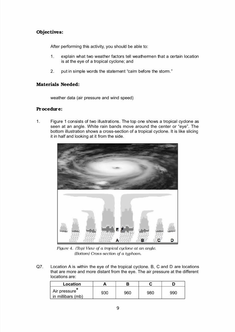
<. igure < consists of two illustrations. The top one shows a tropical cyclone asseen at an angle. White rain bands move around the center or KeyeL. Thebottom illustration shows a crossAsection of a tropical cyclone. 6t is like slicingit in half and looking at it from the side.
0C. +ocation * is within the eye of the tropical cyclone. ', - and D are locationsthat are more and more distant from the eye. The air pressure at the differentlocations are
Location & 4 0
*ir pressureM in millibars (mb)
?> => F> >
)
Figure 4. (Top) View of a tropical cyclone at an angle.
(Bottom) Cross-section of a typhoon.

7/21/2019 8 Sci LM U2- M2
http://slidepdf.com/reader/full/8-sci-lm-u2-m2 14/17
M*ir pressure refers to the weight of air over a certain area.
-ompare the air pressures at *, ', - and D. What do you notice
0F. +ocation E is within the eye of the tropical cyclone. +ocation is within the
clouds surrounding the eye. The clouds at make up the eyewall. The windspeed at the two locations are
Location F
Wind speed (km/hour) <> ;>>
-ompare the wind speed within the eye and at the eyewall. What can yousay
*s you have learned from the activity, the lowest air pressure is at the eye of
a tropical cyclone. 6n fact, all tropical cyclones have low air pressure at the center.
This is the reason why the air in the surroundings move toward the eye. 3ecall in
"rade C that air moves toward lowApressure areas.
ou also learned that at the eye of a tropical cyclone, wind speed is low. 'ut
in the dense clouds surrounding the eye, at the eyewall itself, the wind speed is
great. When newspapers report that a tropical cyclone has sustained winds of ;>>
km/hour, for instance, they are referring to the winds at the eyewall.
When the eye of a tropical cyclone passes over a certain place, it is the winds
at the eyewall that wreak a lot of damage. *s it approaches, one side of the eyewall
brings strong winds blowing in one direction. Then comes the eye with its somewhat
calm weather. *s it leaves, the other side of the eyewall brings strong winds again,
but this time in the opposite direction.
Are You Prepared?
When a tropical cyclone enters the #*3 and it is on its way toward land,
warning signals are issued. The following signals are used by #*"*&* to warn
people about the approaching weather disturbance. Do you know what the signals
mean
1,

7/21/2019 8 Sci LM U2- M2
http://slidepdf.com/reader/full/8-sci-lm-u2-m2 15/17
9U&L%4 S1=,M W,'%'G S%G'LS 59SWS6
9SWS > #
Wat it means
* tropical cyclone will affect the localityWinds of ?>A=> kph may be e%pected in at least ?= hours or
irregular rains may be e%pected within ?= hours
1e follo3in7 may a--en
Twigs and branches of small trees are broken
&ome banana plants are tilted or downed
&ome houses of very light materials partially unroofed
3ice crops suffer significant damage in its flowering stage
Wat to doWatch out for big waves
+isten to severe weather bulletin issued by #*"*&*
9SWS > 2
Wat it means
* tropical cyclone will affect the locality
Winds of greater than => kph up to <>> kph may be e%pected in at least ;
hours
1e follo3in7 may a--en
+arge number of nipa and cogon houses may be partially or totally unroofed
&ome old galvani4ed iron roof may be peeled off
Winds may bring light to moderate damage to e%posed communities
&ome coconut trees may be tilted while few are broken
ew big trees may be uprooted
2any banana plants may be downed
3ice and corn may be adversely affected
Wat to do
*void riding in small seacraftThose who travel by sea and air should avoid unnecessary risks
#ostpone outdoor activities of children
9SWS > $
Wat it means
* tropical cyclone will affect locality
Winds of greater than <>> kph to <FB kph may be e%pected in at least <F
hours
11

7/21/2019 8 Sci LM U2- M2
http://slidepdf.com/reader/full/8-sci-lm-u2-m2 16/17
1e follo3in7 may a--en
2any coconut trees broken or destroyed
*lmost all banana plants downed and a large number of trees uprooted
3ice and corn crops suffer heavy losses
2a1ority of all nipa and cogon houses uprooted or destroyedJ considerable
damage to structures of light to medium constructionWidespread disruption of electrical power and communication services
2oderate to heavy damage e%perienced in agricultural and industrial sectors
Wat to do
*void riding in any seacraft
&eek shelter in strong buildings
Evacuate from lowAlying areas
&tay away from coasts and river banks
9SWS > ?Wat it means
* very intense typhoon will affect locality
very strong winds of more than <FB kph maybe e%pected in at least <; hours
1e follo3in7 may a--en
-oconut plantation may suffer e%tensive damage
2any large trees maybe uprooted
3ice and corn plantation may suffer severe losses
2ost residential and institutional buildings of mi%ed construction maybe
severely damagedElectrical power distribution and communication services maybe severely
disrupted
Damage to affected communities can be very heavy
Wat to do
*ll travels and outdoor activities should be cancelled
Evacuation to safer shelters should have been completed by now
The locality is very likely to be hit directly by the eye of the typhoon.
To be fully prepared for tropical cyclones, you should also put together an
emergency kit which includes the following drinking water, canned goods, can
opener, radio, flashlight, e%tra batteries, clothes, blanket, and first aid kit. ou never
know when you will need it. ou must learn how to rely on yourself. 6n times of
disaster, it may take a while before help arrives.
1$

7/21/2019 8 Sci LM U2- M2
http://slidepdf.com/reader/full/8-sci-lm-u2-m2 17/17
3eferences and +inks
Tarbuck, E.8., N +utgens, .7. (;>>). "arth #cience (<>th ed.). irst +ok ang 3oad,&ingapore #earson Education (*sia) #te +td.
$TT#//WWW.#*"*&*.D:&T.":5.#$/
$TT#//WWW.3E*D.":5/$336-*!E&
$TT#//WWW.!:**W*T-$.":5/T$E2E&/T3:#6-*+.#$#
$TT#//WE*T$E3.!6&&.-:2/$336-*!E/WI#*-66-/;><<$/6!DEO.#$#
$TT#//E!.W676#ED6*.:3"/W676/T3:#6-*+I&T:32IW*&$6
$TT#//#E:#+E.-*&.&-.ED/-*3':!E/2:D+E&/2:D&-*3/T3:#--+/6!DEO.$T2+
13


![gdpp.gov.khgdpp.gov.kh/contents/uploads/2016/03/06-04-2016... · ~ ~t1mrnl . m QJ" UL]ufiYfilfljlmtrfH\nugG) 9QJg9QJh~mBflt:n . Ul8LUt?lm tu U2 mUlTI L~Jthblnm lliI1mtrnmr9QJ9BQJh~mH](https://static.fdocuments.net/doc/165x107/5f475a98f5d53a01536285f5/gdppgov-t1mrnl-m-qj-ulufiyfilfljlmtrfhnugg-9qjg9qjhmbfltn-ul8lutlm.jpg)