620 Westcott Road, Duxbury VT - Amazon S3 Information... · 620 Westcott Road , Duxbury VT 2004 ......
20
620 Westcott Road, Duxbury VT 2004 Williston Road, South Burlington VT 05403 | www.preferredpropertiesvt.com | Phone: (802) 862-9106 | Fax: (802) 862-6266 Curtis Trousdale, Owner, Broker, Realtor Cell: 802-233-5589 [email protected]
Transcript of 620 Westcott Road, Duxbury VT - Amazon S3 Information... · 620 Westcott Road , Duxbury VT 2004 ......
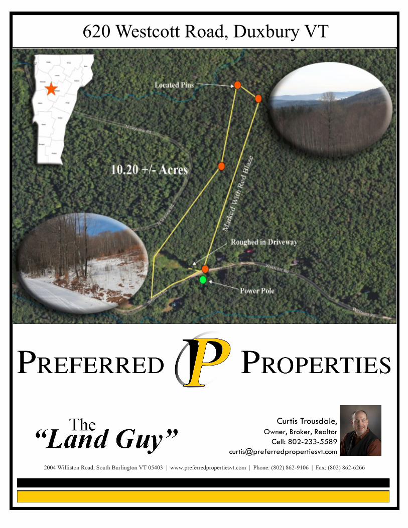
620 Westcott Road, Duxbury VT
2004 Williston Road, South Burlington VT 05403 | www.preferredpropertiesvt.com | Phone: (802) 862-9106 | Fax: (802) 862-6266
Curtis Trousdale,
Owner, Broker, Realtor
Cell: 802-233-5589
Utility & Property Info:
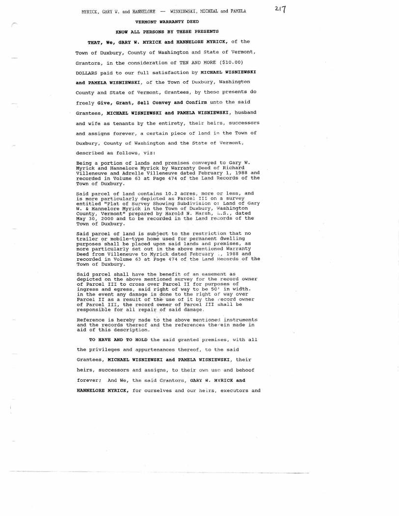
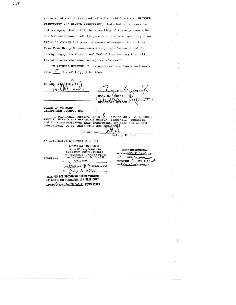
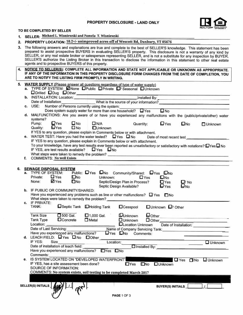
Taxes: Town of Duxbury — $1,198.08 (2016 Non-homestead rate).
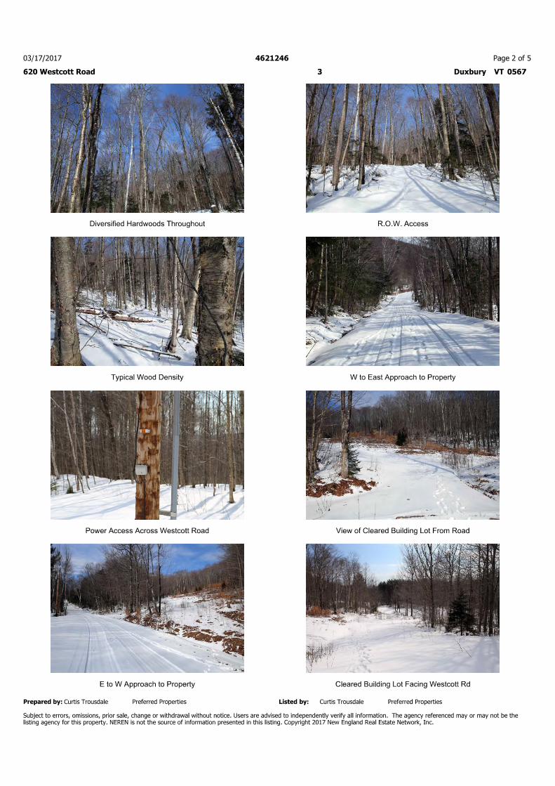
Power: Power has not been brought to the property at this time. A pole that may service this lot is located directly across from the driveway on the other side of Westcott Road. Provider is Washington Electric Co-op. WEC
Pole #12. There are two empty conduits on the existing pole but sellers have indicated that they do not have any information on them. WEC stated that they can conduct a survey regarding bringing power to the property. Potential purchasers are encouraged to contact WEC’s engineering department at 802-223-5245
for specific information on connecting to power.
Phone/Internet: Fairpoint Communications has confirmed that they provide Direct-TV cable, phone and DSL internet
to the area. Potential purchasers are encouraged to contact them directly at 866-984-2001
Septic: Preliminary soil tests have been completed by Gunnar Olson of Horizons Engineering. Field results indicate
the likelihood of a residential conventional mound septic system. Number of bedrooms will be based on size of mound selected. Letter with specific details will be available soon. Test pit locations were marked by site
tech with stakes and pink flagging. General location is to the bottom eastern corner of the lot.
Water: A drilled well would be common for the area. There is no formal drinking water source at this time. The State ANR systems indicates that the well at the residence across the street has a drilled well 255’ deep
with 15 GPM, Tag Number 18379. Well depths can and do vary greatly and all potential purchasers are
encourage to contact a professional well drilling company for consultation.
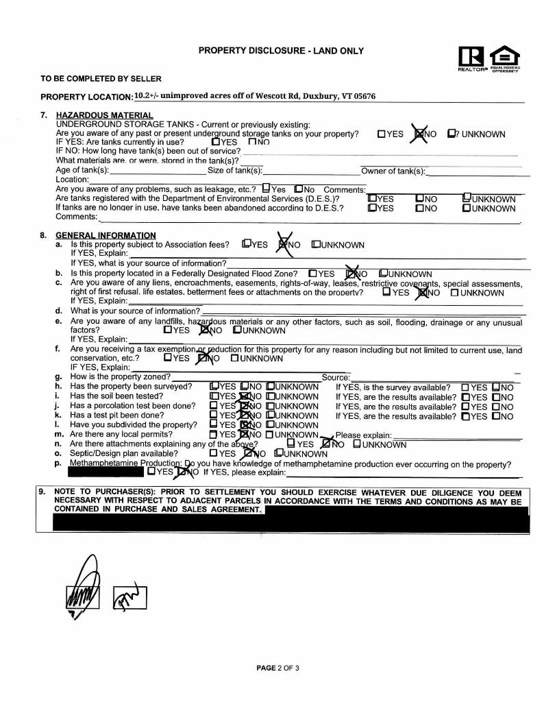
Zoning: Northern portion of lot is within timber management zone. Southern portion is within Forest Rec. Please see attached zoning map and partial zoning information on these districts. Potential purchasers are encouraged to contact the Duxbury zoning officials for a complete set of zoning documentation and specific
questions. Contact is Al Quesnel at 802-244-7363
Curb Cut: No formal curb cut at this time—Potential purchaser should contact the Duxbury Town Office to discuss the
required process to obtain an official curb cut. Contact is Maureen Harvey at 802-244-6660.
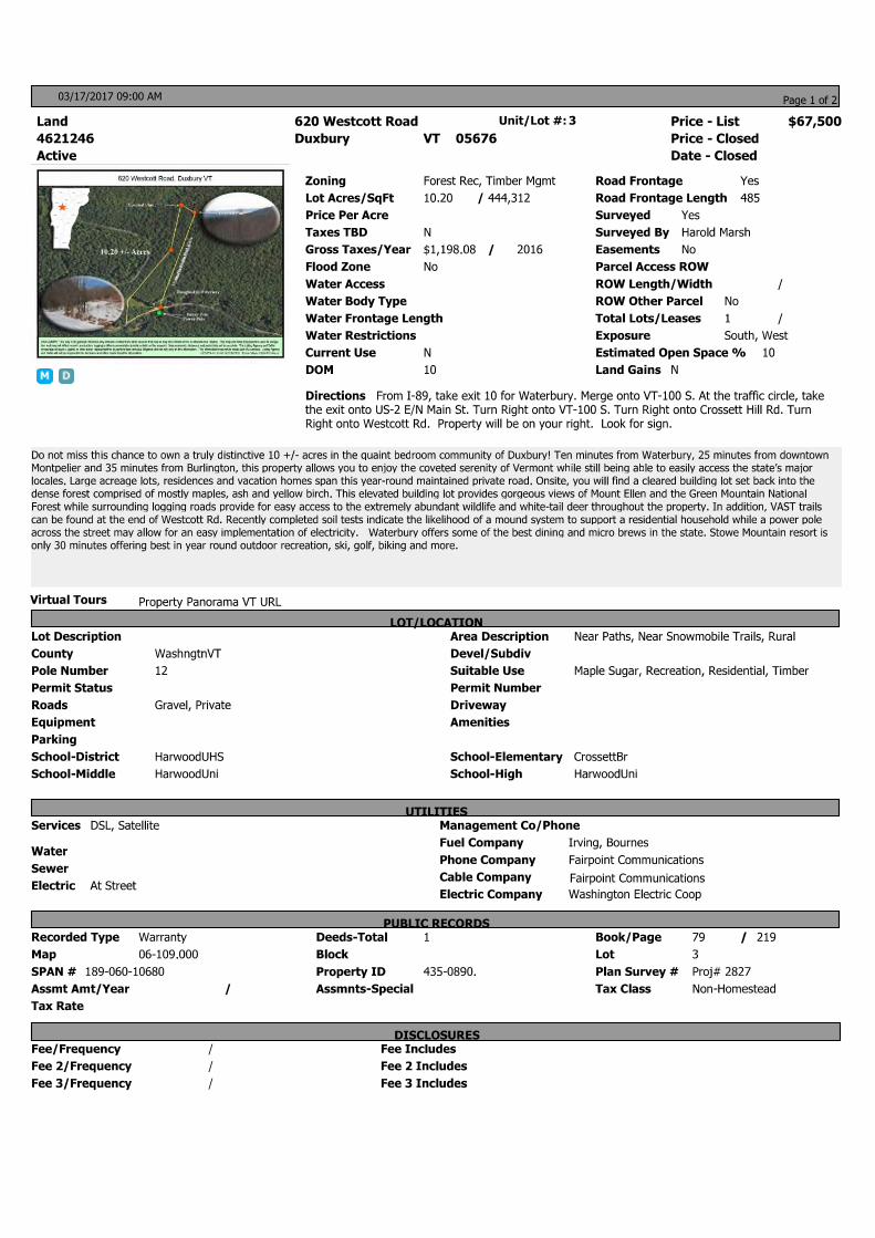
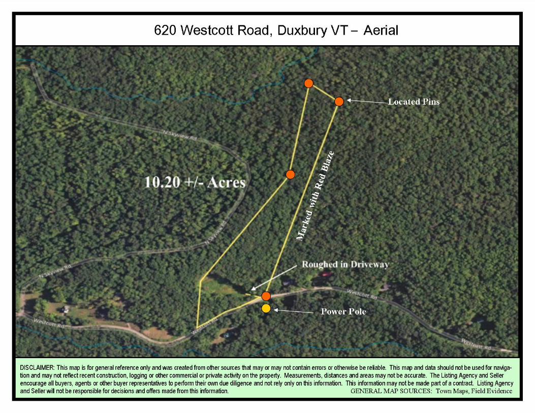
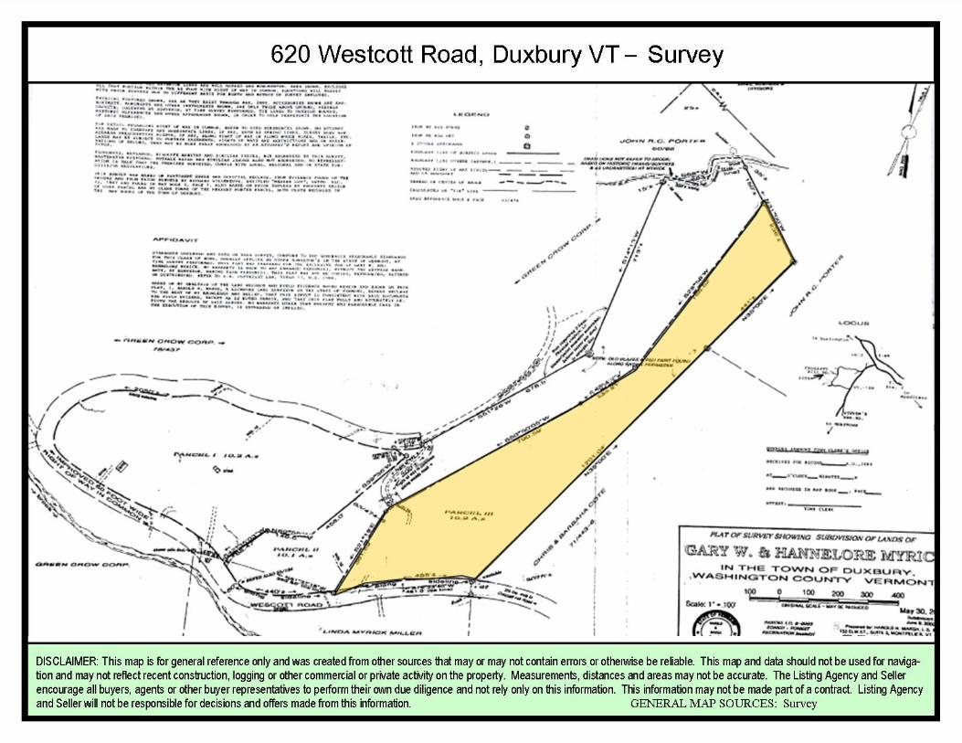
Boundaries: Property is formally surveyed and includes 485’ of road frontage. The majority of corner pins have been
located and the property appears to be well bounded by a mixture of red blazes, flagging and road frontage. The western boundary between this property and a 10 acre lot to the west is not well marked and one pin
could not be located due to snow. Please see the survey and aerial map for general boundary locations.
Road: Westcott Rd is a year-round maintained private road. See road association documentation, coming soon.
Address: The properties address has been created for GPS purposes only. A formal 911 address will be issued by the
town if the property is developed.
Additional Property Information
620 Westcott Rd, Duxbury VT 05676
Utility & Property Info:
Logging: Sellers indicated that the property was logged at an unknown time before their purchase in 2000. Woods appears to be mature with saw log quality trees consisting mainly of Maple, Ash and Yellow Birch with other
hardwood species. This is not a typical heavily cut over property.
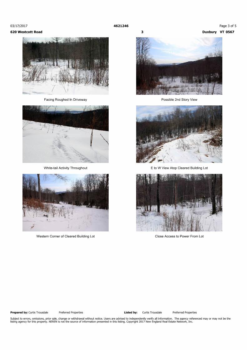
House Site: The house site is only suggested by the seller based on the potential for views from the clearing. The seller cleared the spot several years ago and had the stumps moved to the eastern border of the property. There
is a rough driveway to the site. This site appears to be on ledge but no exploration has been completed.
VAST: It appears that VAST Corridor trail 100 is at the end of the road approximately 1500 feet from this lot.
ROW: Although the seller has put in a rough driveway from Westcott Road, the survey indicated a ROW exists to access the property from N Skyview Rd. The deed states the following (where this property is Parcel 3) - “Said parcel shall have the benefit of an easement as depicted on the above mentioned survey for the
record owner of parcel 3 to ross over Parcel 2 for purposes of ingress and egress, said right of way to be 50’ in width. In the event any damage is done to the right of way over Parcel 2 as a result of the use of it by the record owner of Parcel 3, the record owner or Parcel 3 shall be responsible for all repair of said
damage.”
Road Association Documentation: Coming soon.
Deed Restrictions: No trailers or mobile homes to be placed on lot.
Additional Property Information
620 Westcott Rd, Duxbury VT 05676
Duxbury, VT A quaint New England town, Duxbuy is
located in central Vermont along the Winooski River. Surrounded by the scenic Vermont Route 100 and
Camels Hump, it is known as a place of hiking, skiing, hunting, fishing and biking. Close to many of central
Vermont’s largest businesses, Duxbury is often considered a beautiful bedroom town with easy
access to Vermont’s major roadways. Those who enjoy winter sports find the location convenient to
the states most well-known mountain resorts such
as Stowe, Sugarbush, and Mad River Glen.
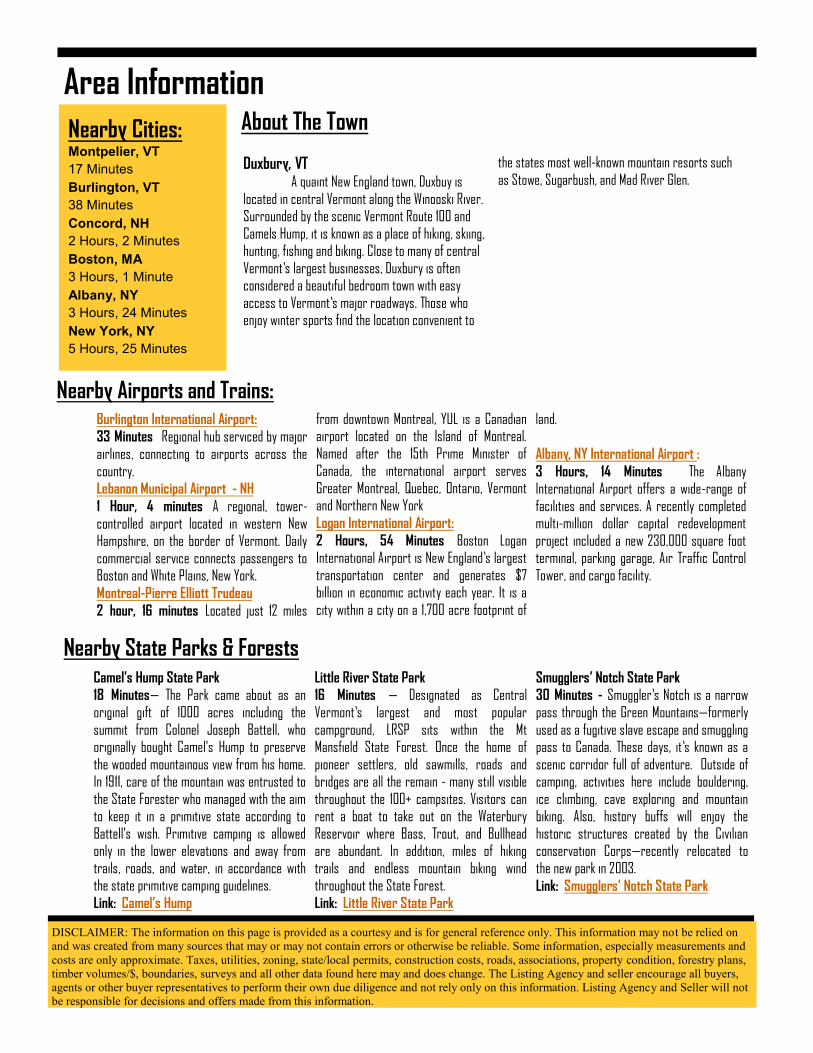
Area Information
Nearby Cities: Montpelier, VT
17 Minutes
Burlington, VT
38 Minutes
Concord, NH
2 Hours, 2 Minutes
Boston, MA
3 Hours, 1 Minute
Albany, NY
3 Hours, 24 Minutes
New York, NY
5 Hours, 25 Minutes
Camel’s Hump State Park
18 Minutes— The Park came about as an
original gift of 1000 acres including the
summit from Colonel Joseph Battell, who originally bought Camel's Hump to preserve
the wooded mountainous view from his home. In 1911, care of the mountain was entrusted to
the State Forester who managed with the aim to keep it in a primitive state according to
Battell's wish. Primitive camping is allowed only in the lower elevations and away from
trails, roads, and water, in accordance with the state primitive camping guidelines.
Link: Camel’s Hump
Little River State Park
16 Minutes — Designated as Central
Vermont’s largest and most popular
campground, LRSP sits within the Mt Mansfield State Forest. Once the home of
pioneer settlers, old sawmills, roads and bridges are all the remain - many still visible
throughout the 100+ campsites. Visitors can rent a boat to take out on the Waterbury
Reservoir where Bass, Trout, and Bullhead are abundant. In addition, miles of hiking
trails and endless mountain biking wind throughout the State Forest.
Link: Little River State Park
Smugglers’ Notch State Park
30 Minutes - Smuggler’s Notch is a narrow
pass through the Green Mountains—formerly
used as a fugitive slave escape and smuggling pass to Canada. These days, it’s known as a
scenic corridor full of adventure. Outside of camping, activities here include bouldering,
ice climbing, cave exploring and mountain biking. Also, history buffs will enjoy the
historic structures created by the Civilian conservation Corps—recently relocated to
the new park in 2003.
Link: Smugglers’ Notch State Park
Burlington International Airport:
33 Minutes Regional hub serviced by major
airlines, connecting to airports across the
country.
Lebanon Municipal Airport - NH
1 Hour, 4 minutes A regional, tower-
controlled airport located in western New Hampshire, on the border of Vermont. Daily
commercial service connects passengers to Boston and White Plains, New York.
Montreal-Pierre Elliott Trudeau
2 hour, 16 minutes Located just 12 miles
from downtown Montreal, YUL is a Canadian airport located on the Island of Montreal.
Named after the 15th Prime Minister of Canada, the international airport serves
Greater Montreal, Quebec, Ontario, Vermont and Northern New York
Logan International Airport:
2 Hours, 54 Minutes Boston Logan International Airport is New England’s largest
transportation center and generates $7 billion in economic activity each year. It is a
city within a city on a 1,700 acre footprint of
land.
Albany, NY International Airport :
3 Hours, 14 Minutes The Albany International Airport offers a wide-range of
facilities and services. A recently completed multi-million dollar capital redevelopment
project included a new 230,000 square foot terminal, parking garage, Air Traffic Control
Tower, and cargo facility.
Nearby Airports and Trains:
Nearby State Parks & Forests
About The Town
DISCLAIMER: The information on this page is provided as a courtesy and is for general reference only. This information may not be relied on
and was created from many sources that may or may not contain errors or otherwise be reliable. Some information, especially measurements and
costs are only approximate. Taxes, utilities, zoning, state/local permits, construction costs, roads, associations, property condition, forestry plans,
timber volumes/$, boundaries, surveys and all other data found here may and does change. The Listing Agency and seller encourage all buyers,
agents or other buyer representatives to perform their own due diligence and not rely only on this information. Listing Agency and Seller will not
be responsible for decisions and offers made from this information.
Rivers and Lakes
Page 2 Area Information
Skiing, Snowmobiling, Snowshoeing
Bolton Valley
19 Minutes—Bolton Valley sits high in
the Green Mountains of Vermont. It is
a unique, high mountain alpine village
surrounded by over 5,000 pristine
acres . At Bolton Valley, the
recreational opportunities are as
numerous as the views are
spectacular.
Link: Bolton Valley
Sugarbush
31 Minutes—Six distinct peaks of
unleashed potential. Two uncrowded
mountain areas. 2,000 acres of
backcountry in the Slide Brook Basin.
It’s no surprise Sugarbush was
recently named “Best Ski Town in the
East” by Outside Magazine.
Link: Sugarbush
Stowe
32 Minutes—In a place where the
history, community and landscape are
legendary for hospitality and
adventure, Stowe Mountain Resort in
Stowe Vermont has reinforced its
internationally respected brand with
world-class improvements both on
and off the mountain. Link: Stowe
Winooski River One of Vermont’s largest rivers, which
formed a major valley way from Lake Champlain through the Green Mountains
toward the Connecticut River valley.
Waterbury Reservoir
The Reservoir is the ninth largest body of water in the state of Vermont and
was created in the 1930's by the CCC as a flood control project to protect towns
and villages along the Winooski River Valley. From late spring to early fall, the
Reservoir is maintained to a surface
area of 850 acres and has a maximum depth of 100 feet.
Baker Pond Largemouth Bass and Pumpkinseed
Sunfish are abundant in this pond. The pond is also stocked with Brook Trout,
but your best chances of catching them will be in the spring before the water
gets too warm.
Lake Champlain
Lake Champlain is located in the Champlain valley between the Green
Mountains and Adirondack Mountains. It is approximately 490 square miles in
area—125 miles long and 14 miles across at its widest point. The maximum
depth is approximately 400 feet. It contains roughly 80 islands and is home
to some of the best swimming, boating and fishing in Vermont. (It is considered
a world-class fishery for Salmonid species and bass.)
Mad River Glen
26 Minutes—Ski it if you can! Mad
River Glen is located in Fayston,
Vermont and is known as the most challenging terrain on the East coast.
It averages over 150 inches of snow a
year and maintains the traditional
New England ski values of narrow trails with little grooming. In addition,
it has one of only two single chairlifts
left in the country and snowboarding
is not allowed.
Link: Mad River Glen
VAST Trails
Holding responsibility of maintaining
and grooming over 5,000 miles of trails , VAST is a non-prof it
organization that includes 128
statewide groups with over 24,000
members. With Trail 100 running
through Duxbury, this town is a
perfect central point of the Vermont
trail system, allowing easy access
throughout the town.
Link: VAST
Link: Trail Map
DISCLAIMER: The information on this page is provided as a courtesy and is for general reference only. This information may not be relied on and
was created from many sources that may or may not contain errors or otherwise be reliable. Some information, especially measurements and costs
are only approximate. Taxes, utilities, zoning, state/local permits, construction costs, roads, associations, property condition, forestry plans, timber
volumes/$, boundaries, surveys and all other data found here may and does change. The Listing Agency and seller encourage all buyers, agents or
other buyer representatives to perform their own due diligence and not rely only on this information. Listing Agency and Seller will not be respon-
sible for decisions and offers made from this information.
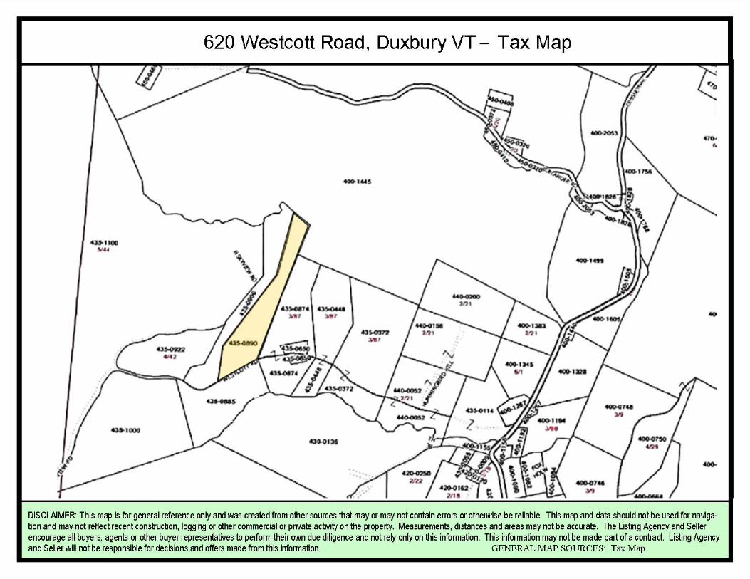
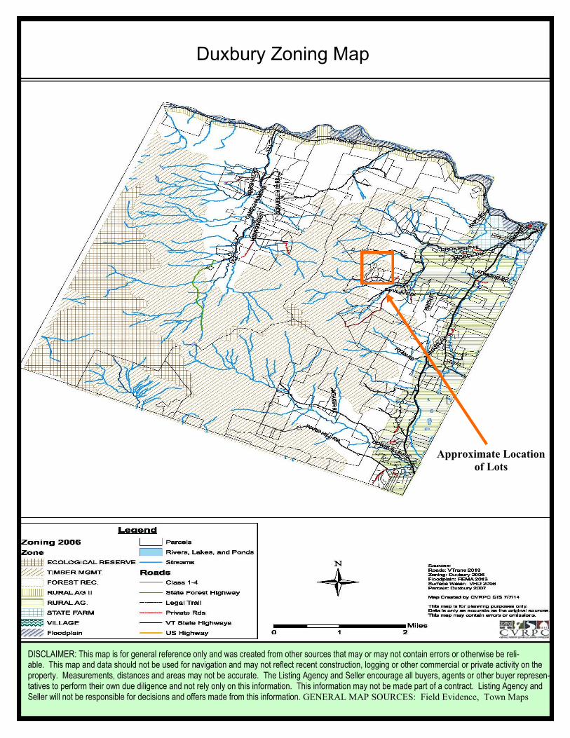
Duxbury Zoning Map
Approximate Location
of Lots
DISCLAIMER: This map is for general reference only and was created from other sources that may or may not contain errors or otherwise be reli-able. This map and data should not be used for navigation and may not reflect recent construction, logging or other commercial or private activity on the property. Measurements, distances and areas may not be accurate. The Listing Agency and Seller encourage all buyers, agents or other buyer represen-tatives to perform their own due diligence and not rely only on this information. This information may not be made part of a contract. Listing Agency and Seller will not be responsible for decisions and offers made from this information. GENERAL MAP SOURCES: Field Evidence, Town Maps