GIASIPartnership Gateway: Invasive Alien Species Information Service

Environmental Impact Assessment for the Mzimvubu Water Project
Floral Impact Assessment
DIRECTORATE OPTIONS ANALYSIS January 2015 5-48
5.7 ALIEN AND INVASIVE PLANT SPECIES
Alien invaders are plants that are of exotic origin and are invading previously pristine areas
or ecological niches (Bromilow, 2001). Not all weeds are exotic in origin but, as these
exotic plant species have very limited natural “check” mechanisms within the natural
environment, they are often the most opportunistic and aggressively growing species
within the ecosystem. Therefore, they are often the most dominant and noticeable within
an area. Disturbance of soil through trampling, excavations or landscaping often lead to
the dominance of exotic pioneer species that rapidly dominate the area. Under natural
conditions, these pioneer species are overtaken by sub-climax and climax species through
natural veld succession. This process, however, takes many years to occur, with the
natural vegetation never reaching the balanced, pristine species composition prior to the
disturbance. There are many species of indigenous pioneer plants, but very few
indigenous species can out-compete their more aggressively growing exotic counterparts.
Alien vegetation invasion causes degradation of the ecological integrity of an area,
causing (Bromilow, 2001):
A decline in species diversity;
Local extinction of indigenous species;
Ecological imbalance;
Decreased productivity of grazing pastures and
Increased agricultural input costs.
During the floral study of the study area, all alien and weed species were identified and are
listed in Table 18.
Table 18: Dominant alien vegetation species identified during the general site assessment.
Species English name Origin Category*CARA
Trees/ shrubs Acacia mearnsii Black wattle Australia 2 Acacia dealbata Silver wattle Australia 1 Acacia baileyana Bailey’s wattle Australia 3 Eucalyptus camaldulensis Saligna India 3 Eucalyptus grandis Saligna gum Australia 2 Melia azedarach Syringa India 3 Nicotiana glauca Wild tobacco Argentina 1 Opuntia ficus indica Prickly pear Mexico 1 Ricinus communis var. communis
Castor-oil plant Africa 2
Salix babylonica Weeping willow Northern China 2
Forbs/ Grasses Bidens pilosa Common blackjack South America N/A Cosmostomium natlanse Wild Pentas N/A Cynodon dactylon Couch grass Tropical Africa / Asia X2 Pennisetum clandestinum Kikuyu East Africa N/A Plantago lanceolata Buckhorn plantain Europe N/A
Environmental Impact Assessment for the Mzimvubu Water Project
Floral Impact Assessment
DIRECTORATE OPTIONS ANALYSIS January 2015 5-49
Species English name Origin Category*CARA
Tagetes minuta Tall khakiweed South America N/A Taraxacum officinale Common dandelion Europe N/A
Category 1 – Declared weeds. Prohibited plants, which must be controlled or eradicated. Category 2 – Declared invader plants with a value. “Invaders” with certain useful qualities (i.e. commercial). Only allowed in controlled, demarcated areas. Category 3 – Mostly ornamental plants. Alien plants presently growing in, or having escaped from, areas such as gardens, but are proven invaders. No further planting or trade in propagative material is allowed (Bromilow, 2001).
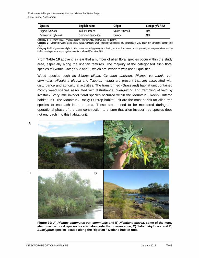
From Table 18 above it is clear that a number of alien floral species occur within the study
area, especially along the riparian features. The majority of the categorised alien floral
species fall within Category 2 and 3, which are invaders with useful qualities.
Weed species such as Bidens pilosa, Cynodon dactylon, Ricinus communis var.
communis, Nicotiana glauca and Tagetes minuta are present that are associated with
disturbance and agricultural activities. The transformed (Grassland) habitat unit contained
mostly weed species associated with disturbance, overgrazing and trampling of veld by
livestock. Very little invader floral species occurred within the Mountain / Rocky Outcrop
habitat unit. The Mountain / Rocky Outcrop habitat unit are the most at risk for alien tree
species to encroach into the area. These areas need to be monitored during the
operational phase of the dam construction to ensure that alien invader tree species does
not encroach into this habitat unit.
Figure 39: A) Ricinus communis var. communis and B) Nicotiana glauca, some of the many alien invader floral species located alongside the riparian zone, C) Salix babylonica and D) Eucalyptus species located along the Riparian / Wetland habitat unit.
A B
C D
Environmental Impact Assessment for the Mzimvubu Water Project
Floral Impact Assessment
DIRECTORATE OPTIONS ANALYSIS January 2015 5-50
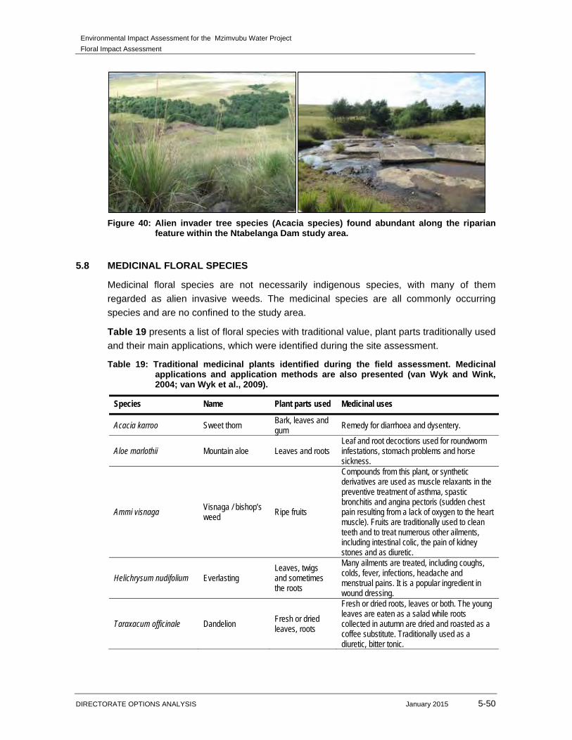
Figure 40: Alien invader tree species (Acacia species) found abundant along the riparian feature within the Ntabelanga Dam study area.
5.8 MEDICINAL FLORAL SPECIES
Medicinal floral species are not necessarily indigenous species, with many of them
regarded as alien invasive weeds. The medicinal species are all commonly occurring
species and are no confined to the study area.
Table 19 presents a list of floral species with traditional value, plant parts traditionally used
and their main applications, which were identified during the site assessment.
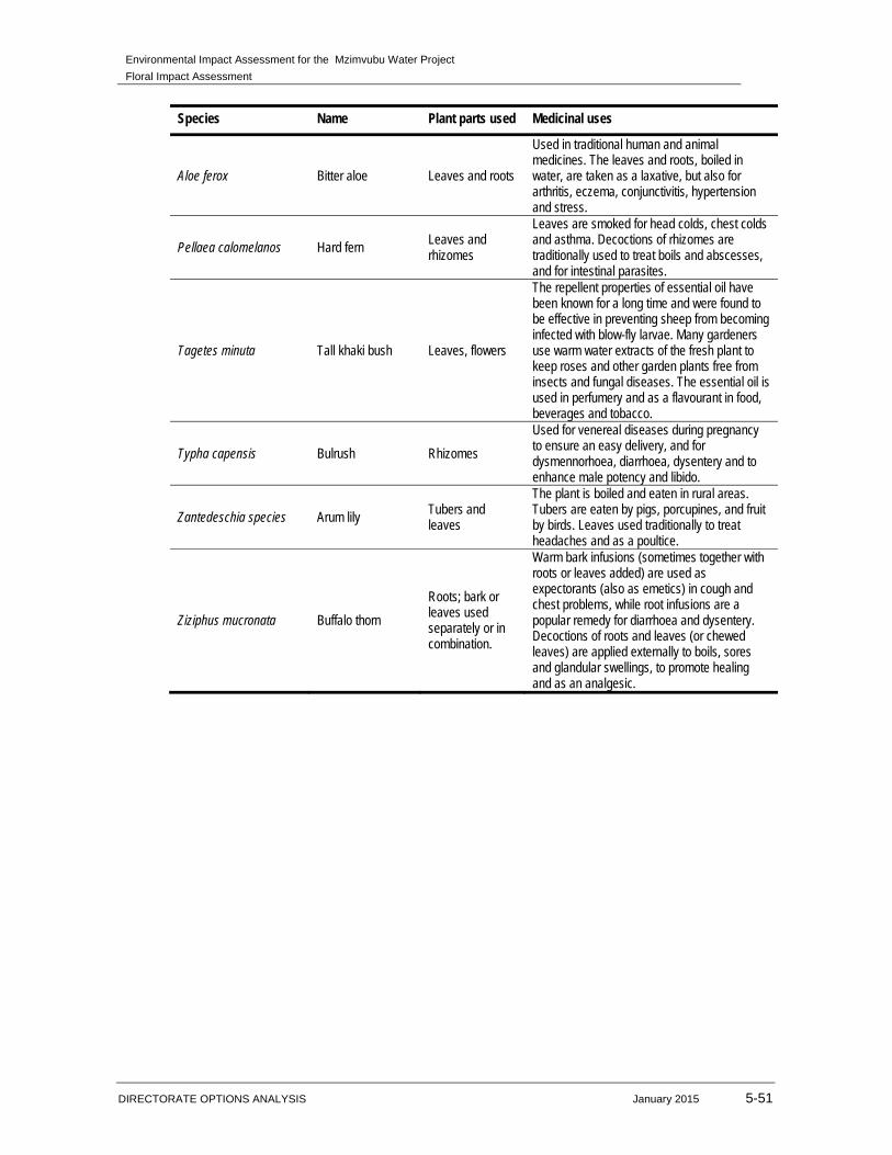
Table 19: Traditional medicinal plants identified during the field assessment. Medicinal applications and application methods are also presented (van Wyk and Wink, 2004; van Wyk et al., 2009).
Species Name Plant parts used Medicinal uses
Acacia karroo Sweet thorn Bark, leaves and gum Remedy for diarrhoea and dysentery.
Aloe marlothii Mountain aloe Leaves and roots Leaf and root decoctions used for roundworm infestations, stomach problems and horse sickness.
Ammi visnaga Visnaga / bishop’s weed
Ripe fruits
Compounds from this plant, or synthetic derivatives are used as muscle relaxants in the preventive treatment of asthma, spastic bronchitis and angina pectoris (sudden chest pain resulting from a lack of oxygen to the heart muscle). Fruits are traditionally used to clean teeth and to treat numerous other ailments, including intestinal colic, the pain of kidney stones and as diuretic.
Helichrysum nudifolium Everlasting Leaves, twigs and sometimes the roots
Many ailments are treated, including coughs, colds, fever, infections, headache and menstrual pains. It is a popular ingredient in wound dressing.
Taraxacum officinale Dandelion Fresh or dried leaves, roots
Fresh or dried roots, leaves or both. The young leaves are eaten as a salad while roots collected in autumn are dried and roasted as a coffee substitute. Traditionally used as a diuretic, bitter tonic.
Environmental Impact Assessment for the Mzimvubu Water Project
Floral Impact Assessment
DIRECTORATE OPTIONS ANALYSIS January 2015 5-51
Species Name Plant parts used Medicinal uses
Aloe ferox Bitter aloe Leaves and roots
Used in traditional human and animal medicines. The leaves and roots, boiled in water, are taken as a laxative, but also for arthritis, eczema, conjunctivitis, hypertension and stress.
Pellaea calomelanos Hard fern Leaves and rhizomes
Leaves are smoked for head colds, chest colds and asthma. Decoctions of rhizomes are traditionally used to treat boils and abscesses, and for intestinal parasites.
Tagetes minuta Tall khaki bush Leaves, flowers
The repellent properties of essential oil have been known for a long time and were found to be effective in preventing sheep from becoming infected with blow-fly larvae. Many gardeners use warm water extracts of the fresh plant to keep roses and other garden plants free from insects and fungal diseases. The essential oil is used in perfumery and as a flavourant in food, beverages and tobacco.
Typha capensis Bulrush Rhizomes
Used for venereal diseases during pregnancy to ensure an easy delivery, and for dysmennorhoea, diarrhoea, dysentery and to enhance male potency and libido.
Zantedeschia species Arum lily Tubers and leaves
The plant is boiled and eaten in rural areas. Tubers are eaten by pigs, porcupines, and fruit by birds. Leaves used traditionally to treat headaches and as a poultice.
Ziziphus mucronata Buffalo thorn
Roots; bark or leaves used separately or in combination.
Warm bark infusions (sometimes together with roots or leaves added) are used as expectorants (also as emetics) in cough and chest problems, while root infusions are a popular remedy for diarrhoea and dysentery. Decoctions of roots and leaves (or chewed leaves) are applied externally to boils, sores and glandular swellings, to promote healing and as an analgesic.
Environmental Impact Assessment for the Mzimvubu Water Project
Floral Impact Assessment
DIRECTORATE OPTIONS ANALYSIS January 2015 5-52
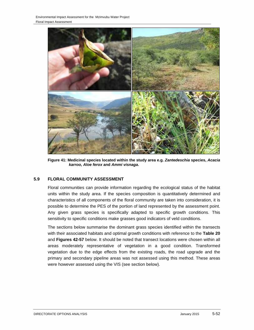
Figure 41: Medicinal species located within the study area e.g. Zantedeschia species, Acacia karroo, Aloe ferox and Ammi visnaga.
5.9 FLORAL COMMUNITY ASSESSMENT
Floral communities can provide information regarding the ecological status of the habitat
units within the study area. If the species composition is quantitatively determined and
characteristics of all components of the floral community are taken into consideration, it is
possible to determine the PES of the portion of land represented by the assessment point.
Any given grass species is specifically adapted to specific growth conditions. This
sensitivity to specific conditions make grasses good indicators of veld conditions.
The sections below summarise the dominant grass species identified within the transects
with their associated habitats and optimal growth conditions with reference to the Table 20
and Figures 42-57 below. It should be noted that transect locations were chosen within all
areas moderately representative of vegetation in a good condition. Transformed
vegetation due to the edge effects from the existing roads, the road upgrade and the
primary and secondary pipeline areas was not assessed using this method. These areas
were however assessed using the VIS (see section below).
Environmental Impact Assessment for the Mzimvubu Water Project
Floral Impact Assessment
DIRECTORATE OPTIONS ANALYSIS January 2015 5-53
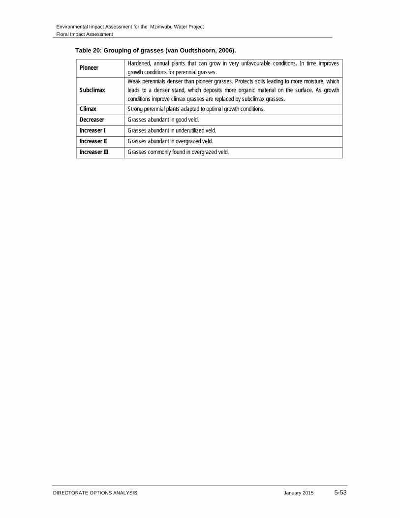
Table 20: Grouping of grasses (van Oudtshoorn, 2006).
Pioneer Hardened, annual plants that can grow in very unfavourable conditions. In time improves growth conditions for perennial grasses.
Subclimax Weak perennials denser than pioneer grasses. Protects soils leading to more moisture, which leads to a denser stand, which deposits more organic material on the surface. As growth conditions improve climax grasses are replaced by subclimax grasses.
Climax Strong perennial plants adapted to optimal growth conditions.
Decreaser Grasses abundant in good veld.
Increaser I Grasses abundant in underutilized veld.
Increaser II Grasses abundant in overgrazed veld.
Increaser III Grasses commonly found in overgrazed veld.

Environmental Impact Assessment for the Mzimvubu Water Project
Floral Impact Assessment
DIRECTORATE OPTIONS ANALYSIS January 2015 5-54
Figure 42: Digital satellite image depicting the location of transects within the Ntabelanga Dam study area.
Environmental Impact Assessment for the Mzimvubu Water Project
Floral Impact Assessment
DIRECTORATE OPTIONS ANALYSIS January 2015 5-55
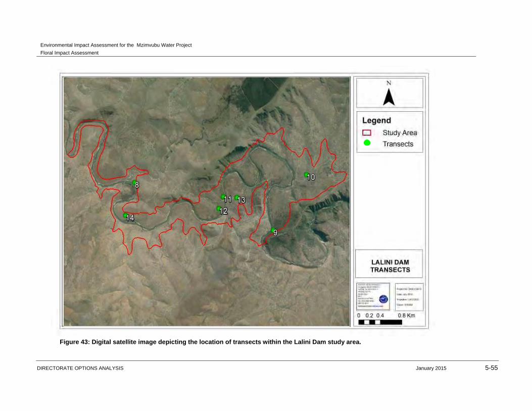
Figure 43: Digital satellite image depicting the location of transects within the Lalini Dam study area.
Environmental Impact Assessment for the Mzimvubu Water Project
Floral Impact Assessment
DIRECTORATE OPTIONS ANALYSIS January 2015 5-56
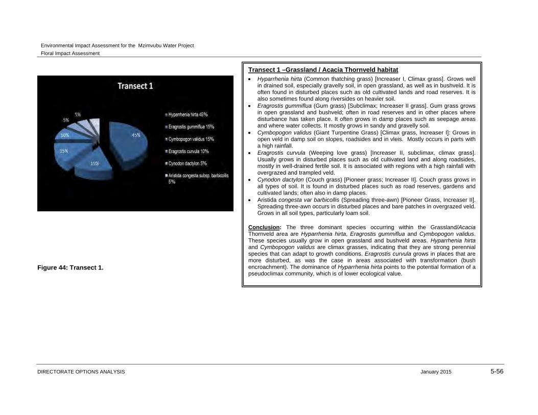
Figure 44: Transect 1.
Transect 1 –Grassland / Acacia Thornveld habitat
Hyparrhenia hirta (Common thatching grass) [Increaser I, Climax grass]. Grows well in drained soil, especially gravelly soil, in open grassland, as well as in bushveld. It is often found in disturbed places such as old cultivated lands and road reserves. It is also sometimes found along riversides on heavier soil.
Eragrostis gummiflua (Gum grass) [Subclimax; Increaser II grass]. Gum grass grows in open grassland and bushveld; often in road reserves and in other places where disturbance has taken place. It often grows in damp places such as seepage areas and where water collects. It mostly grows in sandy and gravelly soil.
Cymbopogon validus (Giant Turpentine Grass) [Climax grass, Increaser I]: Grows in open veld in damp soil on slopes, roadsides and in vleis. Mostly occurs in parts with a high rainfall.
Eragrostis curvula (Weeping love grass) [Increaser II, subclimax, climax grass]. Usually grows in disturbed places such as old cultivated land and along roadsides, mostly in well-drained fertile soil. It is associated with regions with a high rainfall with overgrazed and trampled veld.
Cynodon dactylon (Couch grass) [Pioneer grass; Increaser II]. Couch grass grows in all types of soil. It is found in disturbed places such as road reserves, gardens and cultivated lands; often also in damp places.
Aristida congesta var barbicollis (Spreading three-awn) [Pioneer Grass, Increaser II]. Spreading three-awn occurs in disturbed places and bare patches in overgrazed veld. Grows in all soil types, particularly loam soil.
Conclusion: The three dominant species occurring within the Grassland/Acacia Thornveld area are Hyparrhenia hirta, Eragrostis gummiflua and Cymbopogon validus. These species usually grow in open grassland and bushveld areas. Hyparrhenia hirta and Cymbopogon validus are climax grasses, indicating that they are strong perennial species that can adapt to growth conditions. Eragrostis curvula grows in places that are more disturbed, as was the case in areas associated with transformation (bush encroachment). The dominance of Hyparrhenia hirta points to the potential formation of a pseudoclimax community, which is of lower ecological value.
Environmental Impact Assessment for the Mzimvubu Water Project
Floral Impact Assessment
DIRECTORATE OPTIONS ANALYSIS January 2015 5-57
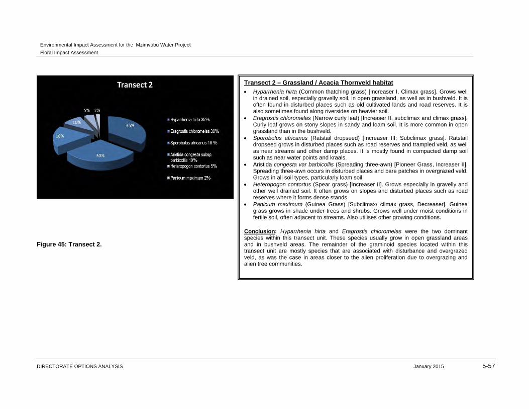
Figure 45: Transect 2.
Transect 2 – Grassland / Acacia Thornveld habitat Hyparrhenia hirta (Common thatching grass) [Increaser I, Climax grass]. Grows well
in drained soil, especially gravelly soil, in open grassland, as well as in bushveld. It is often found in disturbed places such as old cultivated lands and road reserves. It is also sometimes found along riversides on heavier soil.
Eragrostis chloromelas (Narrow curly leaf) [Increaser II, subclimax and climax grass]. Curly leaf grows on stony slopes in sandy and loam soil. It is more common in open grassland than in the bushveld.
Sporobolus africanus (Ratstail dropseed) [Increaser III; Subclimax grass]. Ratstail dropseed grows in disturbed places such as road reserves and trampled veld, as well as near streams and other damp places. It is mostly found in compacted damp soil such as near water points and kraals.
Aristida congesta var barbicollis (Spreading three-awn) [Pioneer Grass, Increaser II]. Spreading three-awn occurs in disturbed places and bare patches in overgrazed veld. Grows in all soil types, particularly loam soil.
Heteropogon contortus (Spear grass) [Increaser II]. Grows especially in gravelly and other well drained soil. It often grows on slopes and disturbed places such as road reserves where it forms dense stands.
Panicum maximum (Guinea Grass) [Subclimax/ climax grass, Decreaser]. Guinea grass grows in shade under trees and shrubs. Grows well under moist conditions in fertile soil, often adjacent to streams. Also utilises other growing conditions.
Conclusion: Hyparrhenia hirta and Eragrostis chloromelas were the two dominant species within this transect unit. These species usually grow in open grassland areas and in bushveld areas. The remainder of the graminoid species located within this transect unit are mostly species that are associated with disturbance and overgrazed veld, as was the case in areas closer to the alien proliferation due to overgrazing and alien tree communities.
Environmental Impact Assessment for the Mzimvubu Water Project
Floral Impact Assessment
DIRECTORATE OPTIONS ANALYSIS January 2015 5-58
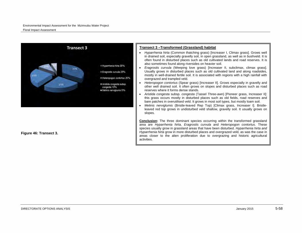
Figure 46: Transect 3.
Transect 3 –Transformed (Grassland) habitat
Hyparrhenia hirta (Common thatching grass) [Increaser I, Climax grass]. Grows well in drained soil, especially gravelly soil, in open grassland, as well as in bushveld. It is often found in disturbed places such as old cultivated lands and road reserves. It is also sometimes found along riversides on heavier soil.
Eragrostis curvula (Weeping love grass) [Increaser II, subclimax, climax grass]. Usually grows in disturbed places such as old cultivated land and along roadsides, mostly in well-drained fertile soil. It is associated with regions with a high rainfall with overgrazed and trampled veld.
Heteropogon contortus (Spear grass) [Increaser II]. Grows especially in gravelly and other well drained soil. It often grows on slopes and disturbed places such as road reserves where it forms dense stands.
Aristida congesta subsp. congesta (Tassel Three-awn) [Pioneer grass, Increaser II]: this grass occurs mostly in disturbed places such as old fields, road reserves and bare patches in overutilised veld. It grows in most soil types, but mostly loam soil.
Melinis nerviglumis (Bristle-leaved Rep Top) [Climax grass, Increaser I]. Bristle-leaved red top grows in undisturbed veld shallow, gravelly soil. It usually grows on slopes.
Conclusion: The three dominant species occurring within the transformed grassland area are Hyparrhenia hirta, Eragrostis curvula and Heteropogon contortus. These species usually grow in grassland areas that have been disturbed. Hyparrhenia hirta and Hyparrhenia hirta grow in more disturbed places and overgrazed veld, as was the case in areas closer to the alien proliferation due to overgrazing and historic agricultural activities.
Environmental Impact Assessment for the Mzimvubu Water Project
Floral Impact Assessment
DIRECTORATE OPTIONS ANALYSIS January 2015 5-59
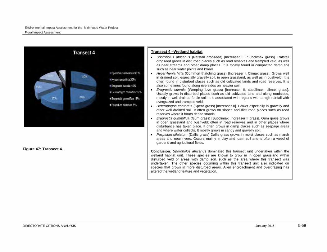
Figure 47: Transect 4.
Transect 4 –Wetland habitat Sporobolus africanus (Ratstail dropseed) [Increaser III; Subclimax grass]. Ratstail
dropseed grows in disturbed places such as road reserves and trampled veld, as well as near streams and other damp places. It is mostly found in compacted damp soil such as near water points and kraals
Hyparrhenia hirta (Common thatching grass) [Increaser I, Climax grass]. Grows well in drained soil, especially gravelly soil, in open grassland, as well as in bushveld. It is often found in disturbed places such as old cultivated lands and road reserves. It is also sometimes found along riversides on heavier soil.
Eragrostis curvula (Weeping love grass) [Increaser II, subclimax, climax grass]. Usually grows in disturbed places such as old cultivated land and along roadsides, mostly in well-drained fertile soil. It is associated with regions with a high rainfall with overgrazed and trampled veld.
Heteropogon contortus (Spear grass) [Increaser II]. Grows especially in gravelly and other well drained soil. It often grows on slopes and disturbed places such as road reserves where it forms dense stands.
Eragrostis gummiflua (Gum grass) [Subclimax; Increaser II grass]. Gum grass grows in open grassland and bushveld; often in road reserves and in other places where disturbance has taken place. It often grows in damp places such as seepage areas and where water collects. It mostly grows in sandy and gravelly soil.
Paspalum dilatatum (Dallis grass) Dallis grass grows in moist places such as marsh areas and near rivers. Occurs mainly in clay and loam soil and is often a weed of gardens and agricultural fields.
Conclusion: Sporobolus africanus dominated this transect unit undertaken within the wetland habitat unit. These species are known to grow in in open grassland within disturbed veld or areas with damp soil, such as the area where this transect was undertaken. The other species occurring within this transect unit also indicated on species that grows in more disturbed areas. Alien encroachment and overgrazing has altered the wetland feature and vegetation.
Environmental Impact Assessment for the Mzimvubu Water Project
Floral Impact Assessment
DIRECTORATE OPTIONS ANALYSIS January 2015 5-60
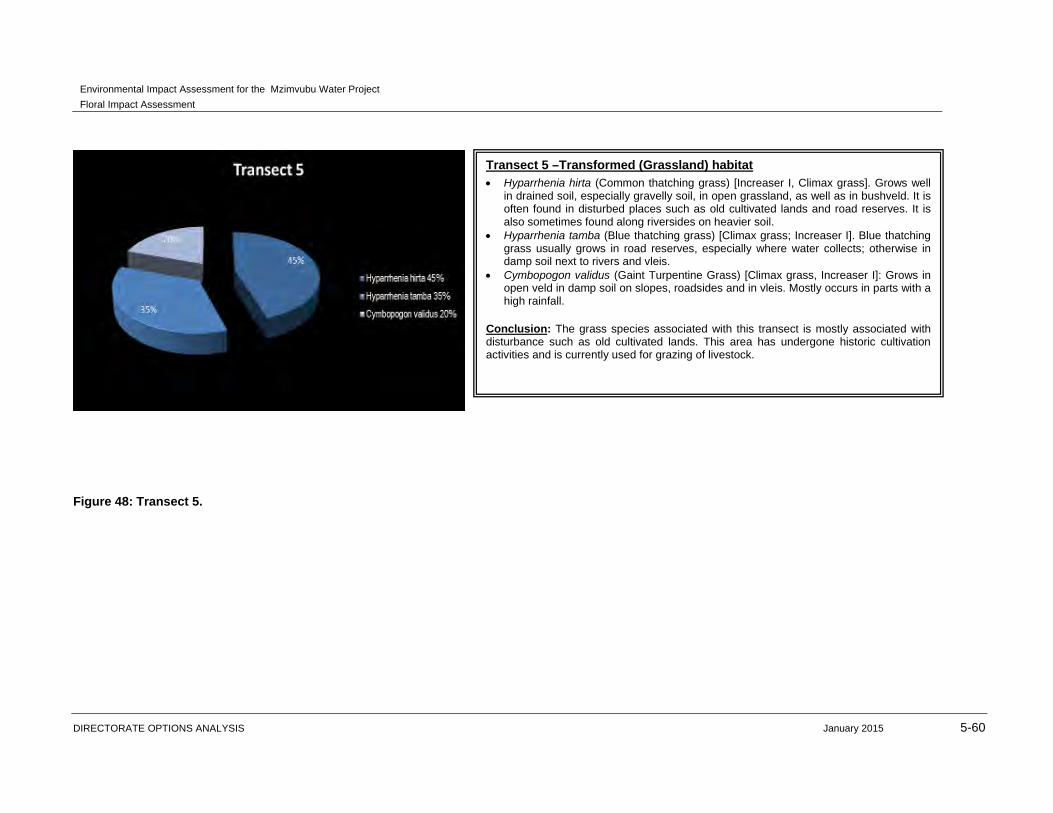
Figure 48: Transect 5.
Transect 5 –Transformed (Grassland) habitat Hyparrhenia hirta (Common thatching grass) [Increaser I, Climax grass]. Grows well
in drained soil, especially gravelly soil, in open grassland, as well as in bushveld. It is often found in disturbed places such as old cultivated lands and road reserves. It is also sometimes found along riversides on heavier soil.
Hyparrhenia tamba (Blue thatching grass) [Climax grass; Increaser I]. Blue thatching grass usually grows in road reserves, especially where water collects; otherwise in damp soil next to rivers and vleis.
Cymbopogon validus (Gaint Turpentine Grass) [Climax grass, Increaser I]: Grows in open veld in damp soil on slopes, roadsides and in vleis. Mostly occurs in parts with a high rainfall.
Conclusion: The grass species associated with this transect is mostly associated with disturbance such as old cultivated lands. This area has undergone historic cultivation activities and is currently used for grazing of livestock.
Environmental Impact Assessment for the Mzimvubu Water Project
Floral Impact Assessment
DIRECTORATE OPTIONS ANALYSIS January 2015 5-61
Figure 49: Transect 6.
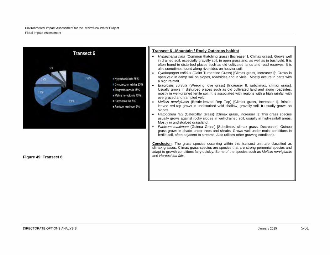
Transect 6 –Mountain / Rocly Outcrops habitat
Hyparrhenia hirta (Common thatching grass) [Increaser I, Climax grass]. Grows well in drained soil, especially gravelly soil, in open grassland, as well as in bushveld. It is often found in disturbed places such as old cultivated lands and road reserves. It is also sometimes found along riversides on heavier soil.
Cymbopogon validus (Gaint Turpentine Grass) [Climax grass, Increaser I]: Grows in open veld in damp soil on slopes, roadsides and in vleis. Mostly occurs in parts with a high rainfall.
Eragrostis curvula (Weeping love grass) [Increaser II, subclimax, climax grass]. Usually grows in disturbed places such as old cultivated land and along roadsides, mostly in well-drained fertile soil. It is associated with regions with a high rainfall with overgrazed and trampled veld.
Melinis nerviglumis (Bristle-leaved Rep Top) [Climax grass, Increaser I]. Bristle-leaved red top grows in undisturbed veld shallow, gravelly soil. It usually grows on slopes.
Harpochloa falx (Caterpillar Grass) [Climax grass, Increaser I]: This grass species usually grows against rocky slopes in well-drained soil, usually in high-rainfall areas. Mostly in undisturbed grassland.
Panicum maximum (Guinea Grass) [Subclimax/ climax grass, Decreaser]. Guinea grass grows in shade under trees and shrubs. Grows well under moist conditions in fertile soil, often adjacent to streams. Also utilises other growing conditions.
Conclusion: The grass species occurring within this transect unit are classified as climax grasses. Climax grass species are species that are strong perennial species and adapt to growth conditions fairy quickly. Some of the species such as Melinis nerviglumis and Harpochloa falx.
Environmental Impact Assessment for the Mzimvubu Water Project
Floral Impact Assessment
DIRECTORATE OPTIONS ANALYSIS January 2015 5-62
Figure 50: Transect 7.
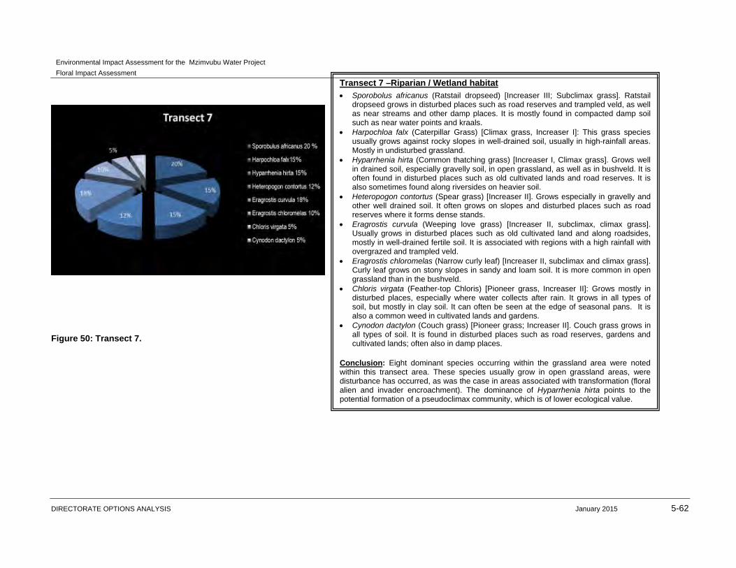
Transect 7 –Riparian / Wetland habitat
Sporobolus africanus (Ratstail dropseed) [Increaser III; Subclimax grass]. Ratstail dropseed grows in disturbed places such as road reserves and trampled veld, as well as near streams and other damp places. It is mostly found in compacted damp soil such as near water points and kraals.
Harpochloa falx (Caterpillar Grass) [Climax grass, Increaser I]: This grass species usually grows against rocky slopes in well-drained soil, usually in high-rainfall areas. Mostly in undisturbed grassland.
Hyparrhenia hirta (Common thatching grass) [Increaser I, Climax grass]. Grows well in drained soil, especially gravelly soil, in open grassland, as well as in bushveld. It is often found in disturbed places such as old cultivated lands and road reserves. It is also sometimes found along riversides on heavier soil.
Heteropogon contortus (Spear grass) [Increaser II]. Grows especially in gravelly and other well drained soil. It often grows on slopes and disturbed places such as road reserves where it forms dense stands.
Eragrostis curvula (Weeping love grass) [Increaser II, subclimax, climax grass]. Usually grows in disturbed places such as old cultivated land and along roadsides, mostly in well-drained fertile soil. It is associated with regions with a high rainfall with overgrazed and trampled veld.
Eragrostis chloromelas (Narrow curly leaf) [Increaser II, subclimax and climax grass]. Curly leaf grows on stony slopes in sandy and loam soil. It is more common in open grassland than in the bushveld.
Chloris virgata (Feather-top Chloris) [Pioneer grass, Increaser II]: Grows mostly in disturbed places, especially where water collects after rain. It grows in all types of soil, but mostly in clay soil. It can often be seen at the edge of seasonal pans. It is also a common weed in cultivated lands and gardens.
Cynodon dactylon (Couch grass) [Pioneer grass; Increaser II]. Couch grass grows in all types of soil. It is found in disturbed places such as road reserves, gardens and cultivated lands; often also in damp places.
Conclusion: Eight dominant species occurring within the grassland area were noted within this transect area. These species usually grow in open grassland areas, were disturbance has occurred, as was the case in areas associated with transformation (floral alien and invader encroachment). The dominance of Hyparrhenia hirta points to the potential formation of a pseudoclimax community, which is of lower ecological value.
Environmental Impact Assessment for the Mzimvubu Water Project
Floral Impact Assessment
DIRECTORATE OPTIONS ANALYSIS January 2015 5-63
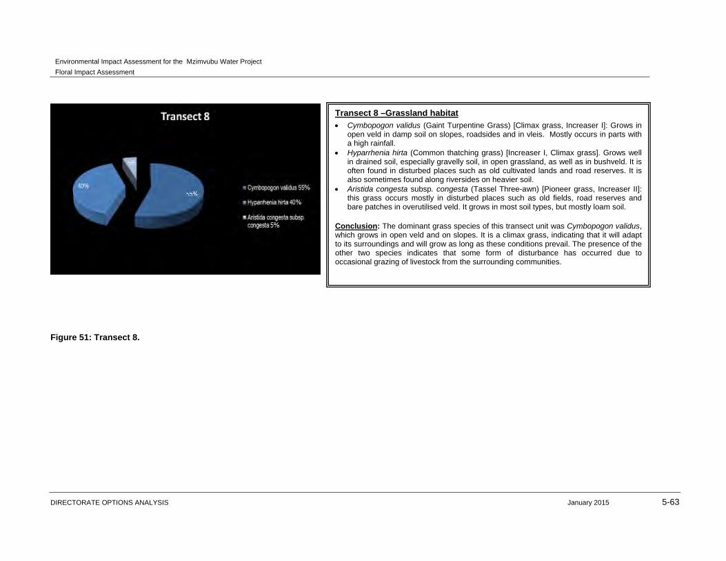
Figure 51: Transect 8.
Transect 8 –Grassland habitat Cymbopogon validus (Gaint Turpentine Grass) [Climax grass, Increaser I]: Grows in
open veld in damp soil on slopes, roadsides and in vleis. Mostly occurs in parts with a high rainfall.
Hyparrhenia hirta (Common thatching grass) [Increaser I, Climax grass]. Grows well in drained soil, especially gravelly soil, in open grassland, as well as in bushveld. It is often found in disturbed places such as old cultivated lands and road reserves. It is also sometimes found along riversides on heavier soil.
Aristida congesta subsp. congesta (Tassel Three-awn) [Pioneer grass, Increaser II]: this grass occurs mostly in disturbed places such as old fields, road reserves and bare patches in overutilised veld. It grows in most soil types, but mostly loam soil.
Conclusion: The dominant grass species of this transect unit was Cymbopogon validus, which grows in open veld and on slopes. It is a climax grass, indicating that it will adapt to its surroundings and will grow as long as these conditions prevail. The presence of the other two species indicates that some form of disturbance has occurred due to occasional grazing of livestock from the surrounding communities.
Environmental Impact Assessment for the Mzimvubu Water Project
Floral Impact Assessment
DIRECTORATE OPTIONS ANALYSIS January 2015 5-64
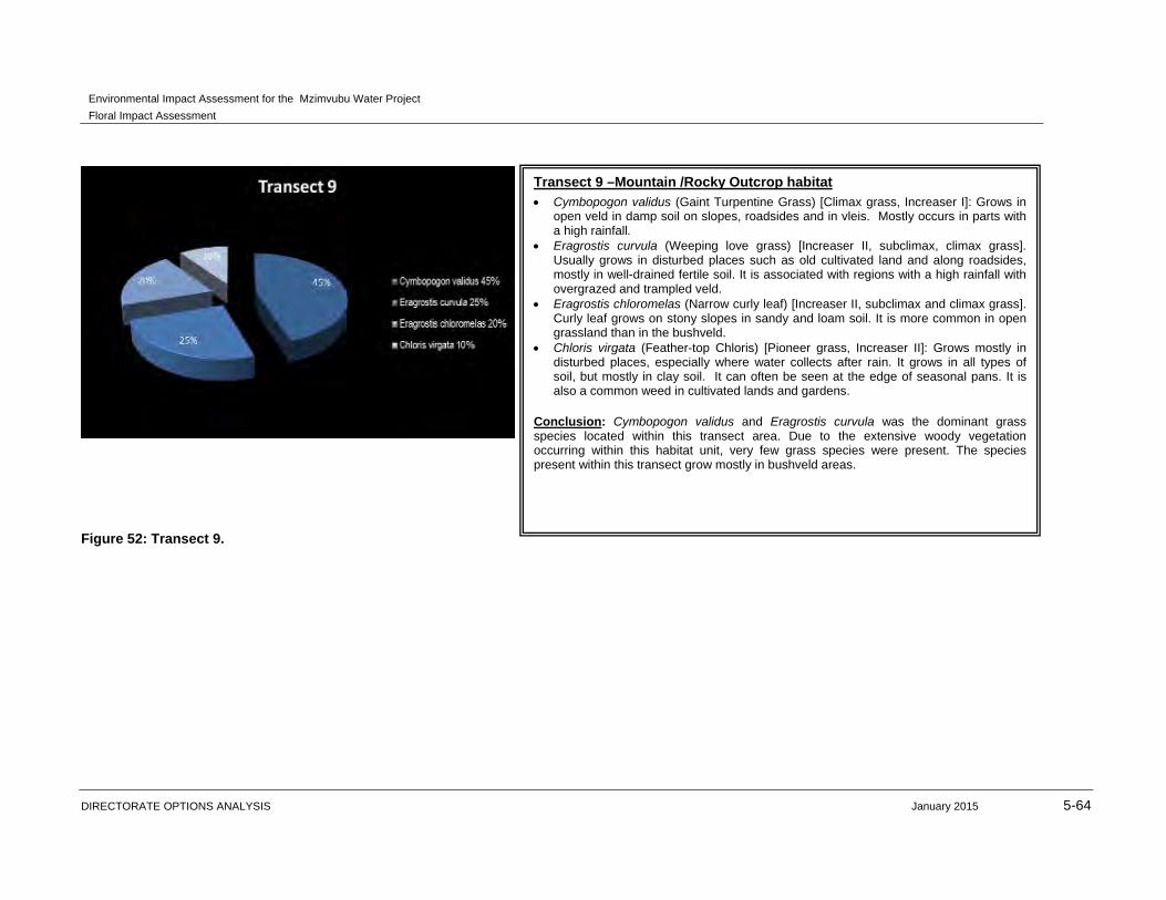
Figure 52: Transect 9.
Transect 9 –Mountain /Rocky Outcrop habitat
Cymbopogon validus (Gaint Turpentine Grass) [Climax grass, Increaser I]: Grows in open veld in damp soil on slopes, roadsides and in vleis. Mostly occurs in parts with a high rainfall.
Eragrostis curvula (Weeping love grass) [Increaser II, subclimax, climax grass]. Usually grows in disturbed places such as old cultivated land and along roadsides, mostly in well-drained fertile soil. It is associated with regions with a high rainfall with overgrazed and trampled veld.
Eragrostis chloromelas (Narrow curly leaf) [Increaser II, subclimax and climax grass]. Curly leaf grows on stony slopes in sandy and loam soil. It is more common in open grassland than in the bushveld.
Chloris virgata (Feather-top Chloris) [Pioneer grass, Increaser II]: Grows mostly in disturbed places, especially where water collects after rain. It grows in all types of soil, but mostly in clay soil. It can often be seen at the edge of seasonal pans. It is also a common weed in cultivated lands and gardens.
Conclusion: Cymbopogon validus and Eragrostis curvula was the dominant grass species located within this transect area. Due to the extensive woody vegetation occurring within this habitat unit, very few grass species were present. The species present within this transect grow mostly in bushveld areas.
Environmental Impact Assessment for the Mzimvubu Water Project
Floral Impact Assessment
DIRECTORATE OPTIONS ANALYSIS January 2015 5-65
Figure 53: Transect 10.
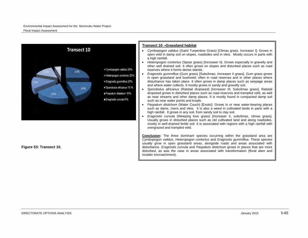
Transect 10 –Grassland habitat
Cymbopogon validus (Gaint Turpentine Grass) [Climax grass, Increaser I]: Grows in open veld in damp soil on slopes, roadsides and in vleis. Mostly occurs in parts with a high rainfall.
Heteropogon contortus (Spear grass) [Increaser II]. Grows especially in gravelly and other well drained soil. It often grows on slopes and disturbed places such as road reserves where it forms dense stands.
Eragrostis gummiflua (Gum grass) [Subclimax; Increaser II grass]. Gum grass grows in open grassland and bushveld; often in road reserves and in other places where disturbance has taken place. It often grows in damp places such as seepage areas and where water collects. It mostly grows in sandy and gravelly soil.
Sporobolus africanus (Ratstail dropseed) [Increaser III; Subclimax grass]. Ratstail dropseed grows in disturbed places such as road reserves and trampled veld, as well as near streams and other damp places. It is mostly found in compacted damp soil such as near water points and kraals.
Paspalum distichum (Water Couch) [Exotic]: Grows in or near water-bearing places such as dams, rivers and vleis. It is also a weed in cultivated lands in parts with a high rainfall. It grows in any soil, from sandy soil to clay soil.
Eragrostis curvula (Weeping love grass) [Increaser II, subclimax, climax grass]. Usually grows in disturbed places such as old cultivated land and along roadsides, mostly in well-drained fertile soil. It is associated with regions with a high rainfall with overgrazed and trampled veld.
Conclusion: The three dominant species occurring within the grassland area are Cymbopogon validus, Heteropogon contortus and Eragrostis gummiflua. These species usually grow in open grassland areas, alongside roads and areas associated with disturbance. Eragrostis curvula and Paspalum distichum grows in places that are more disturbed, as was the case in areas associated with transformation (floral alien and invader encroachment).
Environmental Impact Assessment for the Mzimvubu Water Project
Floral Impact Assessment
DIRECTORATE OPTIONS ANALYSIS January 2015 5-66
Figure 54: Transect 11.
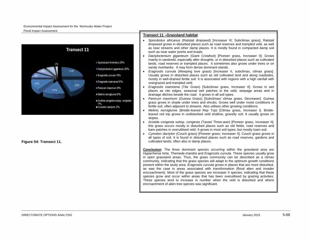
Transect 11 –Grassland habitat
Sporobolus africanus (Ratstail dropseed) [Increaser III; Subclimax grass]. Ratstail dropseed grows in disturbed places such as road reserves and trampled veld, as well as near streams and other damp places. It is mostly found in compacted damp soil such as near water points and kraals.
Dactyloctenium giganteum (Giant Crowfoot) [Pioneer grass, Increaser II]: Grows mainly in sandveld, especially after droughts, or in disturbed places such as cultivated lands, road reserves or trampled places. It sometimes also grows under trees or on sandy riverbanks. It may form dense dominant stands.
Eragrostis curvula (Weeping love grass) [Increaser II, subclimax, climax grass]. Usually grows in disturbed places such as old cultivated land and along roadsides, mostly in well-drained fertile soil. It is associated with regions with a high rainfall with overgrazed and trampled veld.
Eragrostis inamoena (Tite Grass) [Subclimax grass, Increaser II]: Grows in wet places as vlei edges, seasonal wet patches in the veld, seepage areas and in drainage ditches beside the road. It grows in all soil types.
Panicum maximum (Guinea Grass) [Subclimax/ climax grass, Decreaser]. Guinea grass grows in shade under trees and shrubs. Grows well under moist conditions in fertile soil, often adjacent to streams. Also utilises other growing conditions.
Melinis nerviglumis (Bristle-leaved Rep Top) [Climax grass, Increaser I]. Bristle-leaved red top grows in undisturbed veld shallow, gravelly soil. It usually grows on slopes.
Aristida congesta subsp. congesta (Tassel Three-awn) [Pioneer grass, Increaser II]: this grass occurs mostly in disturbed places such as old fields, road reserves and bare patches in overutilised veld. It grows in most soil types, but mostly loam soil.
Cynodon dactylon (Couch grass) [Pioneer grass; Increaser II]. Couch grass grows in all types of soil. It is found in disturbed places such as road reserves, gardens and cultivated lands; often also in damp places.
Conclusion: The three dominant species occurring within the grassland area are Hyparrhenia hirta, Themeda triandra and Eragrostis curvula. These species usually grow in open grassland areas. Thus, the grass community can be described as a climax community, indicating that the grass species will adapt to the optimum growth conditions present within the study area. Eragrostis curvula grows in places that are more disturbed, as was the case in areas associated with transformation (floral alien and invader encroachment). Most of the grass species are increaser II species, indicating that these species grow and occur within areas that has been overutilised by grazing activities. These species tend to increase in number when the veld is disturbed and where encroachment of alien tree species was significant.
Environmental Impact Assessment for the Mzimvubu Water Project
Floral Impact Assessment
DIRECTORATE OPTIONS ANALYSIS January 2015 5-67
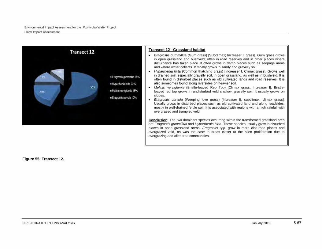
Figure 55: Transect 12.
Transect 12 –Grassland habitat
Eragrostis gummiflua (Gum grass) [Subclimax; Increaser II grass]. Gum grass grows in open grassland and bushveld; often in road reserves and in other places where disturbance has taken place. It often grows in damp places such as seepage areas and where water collects. It mostly grows in sandy and gravelly soil.
Hyparrhenia hirta (Common thatching grass) [Increaser I, Climax grass]. Grows well in drained soil, especially gravelly soil, in open grassland, as well as in bushveld. It is often found in disturbed places such as old cultivated lands and road reserves. It is also sometimes found along riversides on heavier soil.
Melinis nerviglumis (Bristle-leaved Rep Top) [Climax grass, Increaser I]. Bristle-leaved red top grows in undisturbed veld shallow, gravelly soil. It usually grows on slopes.
Eragrostis curvula (Weeping love grass) [Increaser II, subclimax, climax grass]. Usually grows in disturbed places such as old cultivated land and along roadsides, mostly in well-drained fertile soil. It is associated with regions with a high rainfall with overgrazed and trampled veld.
Conclusion: The two dominant species occurring within the transformed grassland area are Eragrostis gummiflua and Hyparrhenia hirta. These species usually grow in disturbed places in open grassland areas. Eragrostis spp. grow in more disturbed places and overgrazed veld, as was the case in areas closer to the alien proliferation due to overgrazing and alien tree communities.

Environmental Impact Assessment for the Mzimvubu Water Project
Floral Impact Assessment
DIRECTORATE OPTIONS ANALYSIS January 2015 5-68
Figure 56: Transect 13.
Transect 13 –Grassland habitat
Hyparrhenia hirta (Common thatching grass) [Increaser I, Climax grass]. Grows well in drained soil, especially gravelly soil, in open grassland, as well as in bushveld. It is often found in disturbed places such as old cultivated lands and road reserves. It is also sometimes found along riversides on heavier soil.
Melinis nerviglumis (Bristle-leaved Rep Top) [Climax grass, Increaser I]. Bristle-leaved red top grows in undisturbed veld shallow, gravelly soil. It usually grows on slopes.
Eragrostis curvula (Weeping love grass) [Increaser II, subclimax, climax grass]. Usually grows in disturbed places such as old cultivated land and along roadsides, mostly in well-drained fertile soil. It is associated with regions with a high rainfall with overgrazed and trampled veld.
Melinis repens (Natal Red top) [Subclimax grass, Increaser II]. Natal red top grows in disturbed places such as roadsides and old cultivated lands (subsp. repens) or in sunny dry places (subsp. grandiflora), in all soil types, but especially in well drained soil.
Cymbopogon validus (Gaint Turpentine Grass) [Climax grass, Increaser I]: Grows in open veld in damp soil on slopes, roadsides and in vleis. Mostly occurs in parts with a high rainfall.
Sporobolus africanus (Ratstail dropseed) [Increaser III; Subclimax grass]. Ratstail dropseed grows in disturbed places such as road reserves and trampled veld, as well as near streams and other damp places. It is mostly found in compacted damp soil such as near water points and kraals.
Conclusion: The dominant grass species of this transect unit was Hyparrhenia hirta, which grows in open veld. It is a climax grass, indicating that it will adapt to its surroundings and will grow as long as these conditions prevail. The presence of the other two species indicates that some form of disturbance has occurred due to occasional grazing of livestock from the surrounding communities.

Environmental Impact Assessment for the Mzimvubu Water Project
Floral Impact Assessment
DIRECTORATE OPTIONS ANALYSIS January 2015 5-69
Figure 57: Transect 14.
Transect 14 –Central Grassland habitat
Cymbopogon excavatus (Broad-leaved turpentine grass) [Climax grass; Increaser I]. Broad-leaved turpentine grass grows in most soil types, but especially in sandy and gravelly soil in disturbed as well as undisturbed veld. It often also grows along roadsides.
Hyparrhenia hirta (Common thatching grass) [Increaser I, Climax grass]. Grows well in drained soil, especially gravelly soil, in open grassland, as well as in bushveld. It is often found in disturbed places such as old cultivated lands and road reserves. It is also sometimes found along riversides on heavier soil.
Eragrostis curvula (Weeping love grass) [Increaser II, subclimax, climax grass]. Usually grows in disturbed places such as old cultivated land and along roadsides, mostly in well-drained fertile soil. It is associated with regions with a high rainfall with overgrazed and trampled veld.
Aristida congesta subsp. congesta (Tassel Three-awn) [Pioneer grass, Increaser II]: this grass occurs mostly in disturbed places such as old fields, road reserves and bare patches in overutilised veld. It grows in most soil types, but mostly loam soil.
Eragrostis gummiflua (Gum grass) [Subclimax; Increaser II grass]. Gum grass grows in open grassland and bushveld; often in road reserves and in other places where disturbance has taken place. It often grows in damp places such as seepage areas and where water collects. It mostly grows in sandy and gravelly soil.
Conclusion: The two dominant species occurring within the grassland area are Cymbopogon excavatus and Hyparrhenia hirta. These species usually grow in open grassland areas in disturbed and undisturbed veld. This area has seen some disturbance due to grazing activities but is less than other grassland areas closer to communities and villages. The climax and increaser I grass contributes towards the increase in climax grass species when conditions improve and less grazing takes place.
Environmental Impact Assessment for the Mzimvubu Water Project
Floral Impact Assessment
DIRECTORATE OPTIONS ANALYSIS January 2015 5-70
The dominant species within transects were Cymbopogon validus, Eragrostis curvula, E.
chloromelas and Hyparrhenia hirta. These species usually grow in open grassland areas.
The majority of the grass community is in a combination of sub-climax or climax condition.
The proposed construction of the dams, road upgrades and pipelines does not pose a
threat to grassland conservation due to the footprint of the proposed project being largely
situated in the transformed areas.
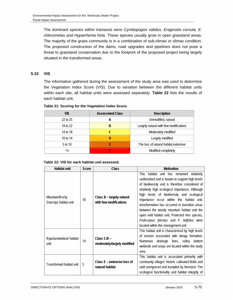
5.10 VIS
The information gathered during the assessment of the study area was used to determine
the Vegetation Index Score (VIS). Due to variation between the different habitat units
within each site, all habitat units were assessed separately. Table 22 lists the results of
each habitat unit.
Table 21: Scoring for the Vegetation Index Score.
VIS Assessment Class Description
22 to 25 A Unmodified, natural
18 to 22 B Largely natural with few modifications
14 to 18 C Moderately modified
10 to 14 D Largely modified
5 to 10 E The loss of natural habitat extensive
<5 F Modified completely
Table 22: VIS for each habitat unit assessed.
Habitat unit Score Class Motivation
Mountain/Rocky Outcrops habitat unit
18 Class B – largely natural with few modifications
This habitat unit has remained relatively undisturbed and is known to support high levels of biodiversity and is therefore considered of relatively high ecological importance. Although high levels of biodiversity and ecological importance occur within this habitat unit, transformation has occurred in transition areas between the woody mountain habitat and the open veld habitat unit. Protected tree species, Podocarpus falcatus and P. latifolius were
located within this management unit
Riparian/wetland habitat
unit 14
Class C/D –
moderately/largely modified
This habitat unit is characterised by high levels of erosion associated with donga formation. Numerous drainage lines, valley bottom wetlands and seeps are located within the study area.
Transformed habitat unit 5 Class E – extensive loss of natural habitat
This habitat unit is associated primarily with community villages’ historic cultivated fields and veld overgrazed and trampled by livestock. The ecological functionality and habitat integrity of
Environmental Impact Assessment for the Mzimvubu Water Project
Floral Impact Assessment
DIRECTORATE OPTIONS ANALYSIS January 2015 5-71
Habitat unit Score Class Motivation
the Transformed Habitat Unit is regarded as being extremely limited.
Transformed(Grassland) habitat unit
10 Class D/E – largely modified/Extensive loss of natural habitat
This habitat unit has undergone transformation due to overutilisation of veld by cattle grazing and bush encroachment by Acacia karroo.
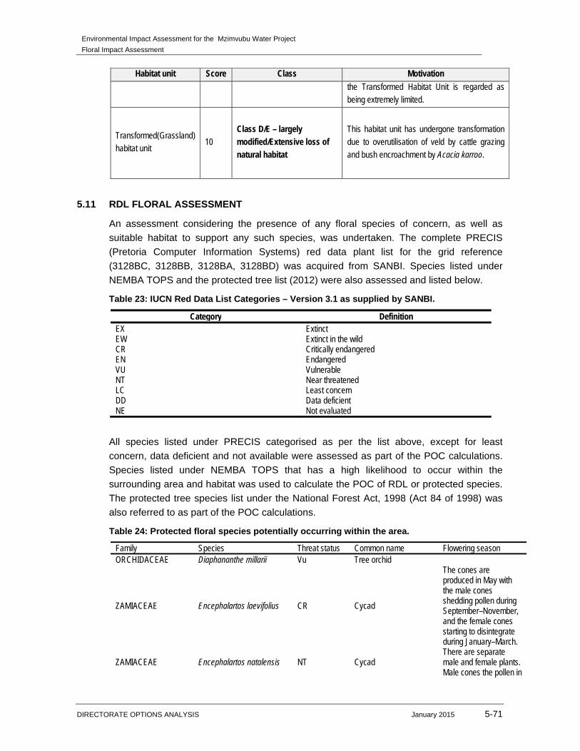
5.11 RDL FLORAL ASSESSMENT
An assessment considering the presence of any floral species of concern, as well as
suitable habitat to support any such species, was undertaken. The complete PRECIS
(Pretoria Computer Information Systems) red data plant list for the grid reference
(3128BC, 3128BB, 3128BA, 3128BD) was acquired from SANBI. Species listed under
NEMBA TOPS and the protected tree list (2012) were also assessed and listed below.
Table 23: IUCN Red Data List Categories – Version 3.1 as supplied by SANBI.
Category Definition EX Extinct EW Extinct in the wild CR Critically endangered EN Endangered VU Vulnerable NT Near threatened LC Least concern DD Data deficient NE Not evaluated
All species listed under PRECIS categorised as per the list above, except for least
concern, data deficient and not available were assessed as part of the POC calculations.
Species listed under NEMBA TOPS that has a high likelihood to occur within the
surrounding area and habitat was used to calculate the POC of RDL or protected species.
The protected tree species list under the National Forest Act, 1998 (Act 84 of 1998) was
also referred to as part of the POC calculations.
Table 24: Protected floral species potentially occurring within the area.
Family Species Threat status Common name Flowering season ORCHIDACEAE Diaphananthe millarii Vu Tree orchid
ZAMIACEAE Encephalartos laevifolius CR Cycad
The cones are produced in May with the male cones shedding pollen during September–November, and the female cones starting to disintegrate during January–March.
ZAMIACEAE Encephalartos natalensis NT Cycad There are separate male and female plants. Male cones the pollen in
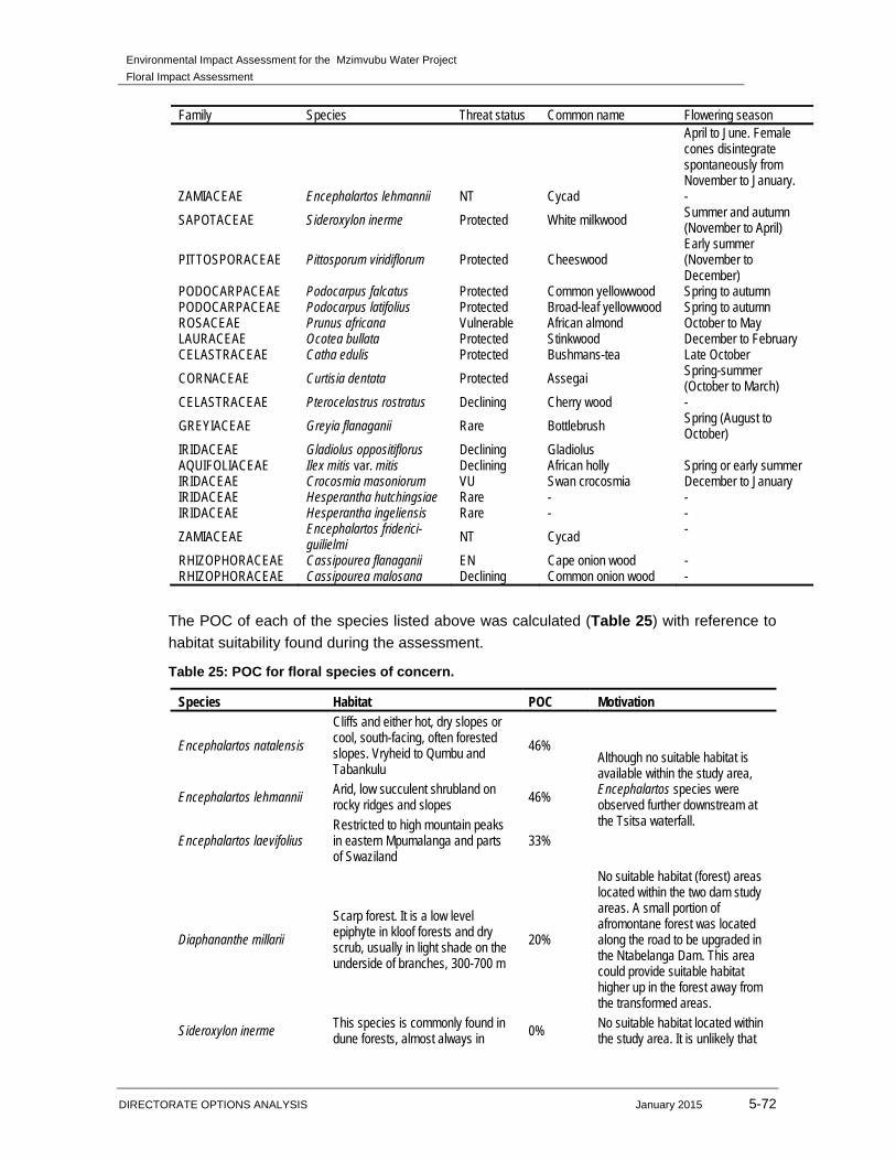
Environmental Impact Assessment for the Mzimvubu Water Project
Floral Impact Assessment
DIRECTORATE OPTIONS ANALYSIS January 2015 5-72
Family Species Threat status Common name Flowering season April to June. Female cones disintegrate spontaneously from November to January.
ZAMIACEAE Encephalartos lehmannii NT Cycad -
SAPOTACEAE Sideroxylon inerme Protected White milkwood Summer and autumn (November to April)
PITTOSPORACEAE Pittosporum viridiflorum Protected Cheeswood Early summer (November to December)
PODOCARPACEAE Podocarpus falcatus Protected Common yellowwood Spring to autumn PODOCARPACEAE Podocarpus latifolius Protected Broad-leaf yellowwood Spring to autumn ROSACEAE Prunus africana Vulnerable African almond October to May LAURACEAE Ocotea bullata Protected Stinkwood December to February CELASTRACEAE Catha edulis Protected Bushmans-tea Late October
CORNACEAE Curtisia dentata Protected Assegai Spring-summer (October to March)
CELASTRACEAE Pterocelastrus rostratus Declining Cherry wood -
GREYIACEAE Greyia flanaganii Rare Bottlebrush Spring (August to October)
IRIDACEAE Gladiolus oppositiflorus Declining Gladiolus AQUIFOLIACEAE Ilex mitis var. mitis Declining African holly Spring or early summer IRIDACEAE Crocosmia masoniorum VU Swan crocosmia December to January IRIDACEAE Hesperantha hutchingsiae Rare - - IRIDACEAE Hesperantha ingeliensis Rare - -
ZAMIACEAE Encephalartos friderici-guilielmi NT Cycad -
RHIZOPHORACEAE Cassipourea flanaganii EN Cape onion wood - RHIZOPHORACEAE Cassipourea malosana Declining Common onion wood -
The POC of each of the species listed above was calculated (Table 25) with reference to
habitat suitability found during the assessment.
Table 25: POC for floral species of concern.
Species Habitat POC Motivation
Encephalartos natalensis
Cliffs and either hot, dry slopes or cool, south-facing, often forested slopes. Vryheid to Qumbu and Tabankulu
46% Although no suitable habitat is available within the study area, Encephalartos species were observed further downstream at the Tsitsa waterfall.
Encephalartos lehmannii Arid, low succulent shrubland on rocky ridges and slopes 46%
Encephalartos laevifolius Restricted to high mountain peaks in eastern Mpumalanga and parts of Swaziland
33%
Diaphananthe millarii
Scarp forest. It is a low level epiphyte in kloof forests and dry scrub, usually in light shade on the underside of branches, 300-700 m
20%
No suitable habitat (forest) areas located within the two dam study areas. A small portion of afromontane forest was located along the road to be upgraded in the Ntabelanga Dam. This area could provide suitable habitat higher up in the forest away from the transformed areas.
Sideroxylon inerme This species is commonly found in dune forests, almost always in 0% No suitable habitat located within
the study area. It is unlikely that
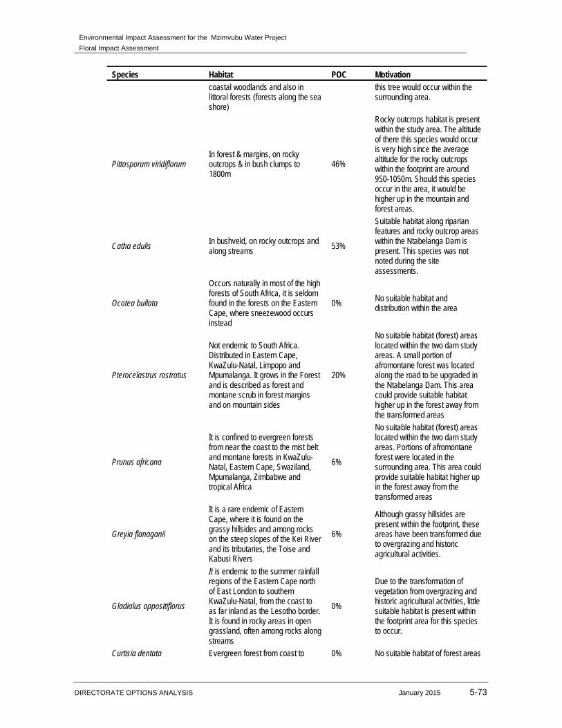
Environmental Impact Assessment for the Mzimvubu Water Project
Floral Impact Assessment
DIRECTORATE OPTIONS ANALYSIS January 2015 5-73
Species Habitat POC Motivation coastal woodlands and also in littoral forests (forests along the sea shore)
this tree would occur within the surrounding area.
Pittosporum viridiflorum In forest & margins, on rocky outcrops & in bush clumps to 1800m
46%
Rocky outcrops habitat is present within the study area. The altitude of there this species would occur is very high since the average altitude for the rocky outcrops within the footprint are around 950-1050m. Should this species occur in the area, it would be higher up in the mountain and forest areas.
Catha edulis In bushveld, on rocky outcrops and along streams 53%
Suitable habitat along riparian features and rocky outcrop areas within the Ntabelanga Dam is present. This species was not noted during the site assessments.
Ocotea bullata
Occurs naturally in most of the high forests of South Africa, it is seldom found in the forests on the Eastern Cape, where sneezewood occurs instead
0% No suitable habitat and distribution within the area
Pterocelastrus rostratus
Not endemic to South Africa. Distributed in Eastern Cape, KwaZulu-Natal, Limpopo and Mpumalanga. It grows in the Forest and is described as forest and montane scrub in forest margins and on mountain sides
20%
No suitable habitat (forest) areas located within the two dam study areas. A small portion of afromontane forest was located along the road to be upgraded in the Ntabelanga Dam. This area could provide suitable habitat higher up in the forest away from the transformed areas
Prunus africana
It is confined to evergreen forests from near the coast to the mist belt and montane forests in KwaZulu-Natal, Eastern Cape, Swaziland, Mpumalanga, Zimbabwe and tropical Africa
6%
No suitable habitat (forest) areas located within the two dam study areas. Portions of afromontane forest were located in the surrounding area. This area could provide suitable habitat higher up in the forest away from the transformed areas
Greyia flanaganii
It is a rare endemic of Eastern Cape, where it is found on the grassy hillsides and among rocks on the steep slopes of the Kei River and its tributaries, the Toise and Kabusi Rivers
6%
Although grassy hillsides are present within the footprint, these areas have been transformed due to overgrazing and historic agricultural activities.
Gladiolus oppositiflorus
It is endemic to the summer rainfall regions of the Eastern Cape north of East London to southern KwaZulu-Natal, from the coast to as far inland as the Lesotho border. It is found in rocky areas in open grassland, often among rocks along streams
0%
Due to the transformation of vegetation from overgrazing and historic agricultural activities, little suitable habitat is present within the footprint area for this species to occur.
Curtisia dentata Evergreen forest from coast to 0% No suitable habitat of forest areas
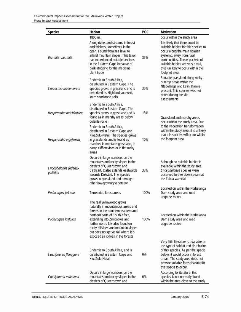
Environmental Impact Assessment for the Mzimvubu Water Project
Floral Impact Assessment
DIRECTORATE OPTIONS ANALYSIS January 2015 5-74
Species Habitat POC Motivation 1800 m. occur within the study area
Ilex mitis var. mitis
Along rivers and streams in forest and thickets, sometimes in the open. Found from sea level to inland mountain slopes. This taxon has experienced notable declines in the Eastern Cape because of bark-stripping for the medicinal plant trade
33%
It is likely that there could be suitable habitat for this species to occur along the main riparian systems, away from rural communities. These pockets of suitable habitat are very small, thus unlikely to occur within the footprint area.
Crocosmia masoniorum
Endemic to South Africa, distributed in Eastern Cape. The species grows in grassland and is described as Highland sourveld, loam sandstone soils
35%
Suitable grassland along rocky outcrop areas within the Ntabelanga and Lalini Dam is present. This species was not noted during the site assessments
Hesperantha hutchingsiae
Endemic to South Africa, distributed in Eastern Cape. The species grows in grassland and is found as in marshy areas below dolerite rocks.
15% Grassland and marshy areas occur within the study area. Due to the vegetation transformation within the study area, it is unlikely that this species will occur within the footprint area. Hesperantha ingeliensis
Endemic to South Africa, distributed in Eastern Cape and KwaZulu-Natal. The species grows in grasslands and is found as marches in montane grassland, in damp cliff crevices or in flat rocky areas
10%
Encephalartos friderici-guilielmi
Occurs in large numbers on the mountains and rocky slopes in the districts of Queenstown and Cathcart. It also extends eastwards towards Kokstad. The species grows in grassland and amongst other low-growing vegetation
33%
Although no suitable habitat is available within the study area, Encephalartos species were observed further downstream at the Tsitsa waterfall
Podocarpus falcatus Terrestrial, forest areas 100% Located on within the Ntabelanga Dam study area and road upgrade routes
Podocarpus latifolius
The real yellowwood grows naturally in mountainous areas and forests in the southern, eastern and northern parts of South Africa, extending into Zimbabwe and further north. It is also found on rocky hillsides and mountain slopes but does not get as tall where it is exposed as it does in the forests
100% Located on within the Ntabelanga Dam study area and road upgrade routes
Cassipourea flanaganii Endemic to South Africa, and is distributed in Eastern Cape and KwaZulu-Natal.
0%
Very little literature is available on the type of habitat and distribution of this species. As per the specie below, it would occur in forest areas. The study area does not provide suitable forest habitat for this specie to occur.
Cassipourea malosana Occurs in large numbers on the mountains and rocky slopes in the districts of Queenstown and
0% According to literature, this species is not normally found within the area close to the study
Environmental Impact Assessment for the Mzimvubu Water Project
Floral Impact Assessment
DIRECTORATE OPTIONS ANALYSIS January 2015 5-75
Species Habitat POC Motivation Cathcart. It also extends eastwards towards Kokstad. The species grows in grassland and amongst other low-growing vegetation
area but more in forests towards the Transkei. The study area does not provide forest habitat for this species to occur. All forest areas are located outside of the footprint area.
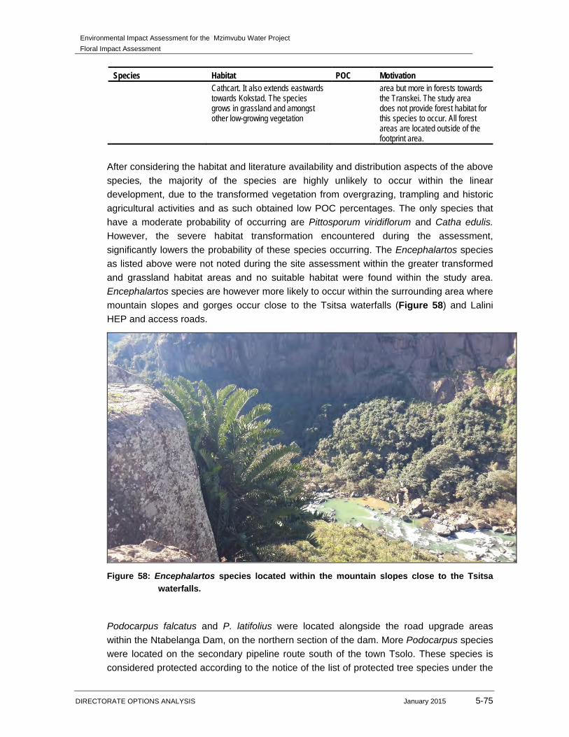
After considering the habitat and literature availability and distribution aspects of the above
species, the majority of the species are highly unlikely to occur within the linear
development, due to the transformed vegetation from overgrazing, trampling and historic
agricultural activities and as such obtained low POC percentages. The only species that
have a moderate probability of occurring are Pittosporum viridiflorum and Catha edulis.
However, the severe habitat transformation encountered during the assessment,
significantly lowers the probability of these species occurring. The Encephalartos species
as listed above were not noted during the site assessment within the greater transformed
and grassland habitat areas and no suitable habitat were found within the study area.
Encephalartos species are however more likely to occur within the surrounding area where
mountain slopes and gorges occur close to the Tsitsa waterfalls (Figure 58) and Lalini
HEP and access roads.
Figure 58: Encephalartos species located within the mountain slopes close to the Tsitsa
waterfalls.
Podocarpus falcatus and P. latifolius were located alongside the road upgrade areas
within the Ntabelanga Dam, on the northern section of the dam. More Podocarpus species
were located on the secondary pipeline route south of the town Tsolo. These species is
considered protected according to the notice of the list of protected tree species under the

Environmental Impact Assessment for the Mzimvubu Water Project
Floral Impact Assessment
DIRECTORATE OPTIONS ANALYSIS January 2015 5-76
National Forests Act, 1998 (Act No. 84 of 1998). Possible mitigation measure would be to
re-align the roads to avoid the trees from being removed or permits for the removal of
these protected tree species (should it occur within the construction footprint area) need to
be obtained at the relevant authorities before any construction activities occur within this
area.
5.12 SENSITIVITY
The three focus study areas, namely the Ntabelanga Dam, Lalini Dam and the
infrastructure (road upgrades and primary and secondary pipelines) has undergone
vegetation transformation due to historic agricultural activities, overgrazed and tramples
veld from livestock from the local communities, alien proliferation along the riparian
features and bush encroachment due to poor management measures. The Figures 59-64
below illustrate the sensitivity of the study area.
The following conclusion were made for the management units
The ecological function and habitat of the Mountain / Rocky Outcrops habitat unit is
considered to be moderate to high due to the few disturbances from agricultural
activities, overgrazing and alien floral encroachment. In terms of conservation value,
the moderate to high ecological functionality, good habitat integrity, the low incidence
of bush or alien floral encroachment, combine to increase the ecological sensitivity of
this habitat unit.
A decrease in floral diversity has occurred as a result of the edge effects from
ploughing and crop cultivation, overgrazing, trampling by livestock and vegetation
clearance causing severe soil erosion. The Grassland / Acacia Thornveld habitat unit
is considered to have a low ecological sensitivity and low conservation value due to
the change in floral species composition and vegetation structure as a result of the
above mentioned impacts. This habitat unit is furthermore well represented within the
region, and loss thereof as a result of the dam construction will not significantly affect
the floral conservation in the region
The Riparian / Wetland habitat unit is considered to be of high ecological sensitivity
due to the contribution of the various wetland and riparian systems to faunal migratory
connectivity, wetland ecoservices provision and the habitat provided for floral species.
Although large sections along the riparian system are dominated by alien invader
floral species, pockets of indigenous tree species exist along the Tsitsa River. Several
wetland and riparian features traverse the infrastructure development. Mitigation
measures must be implemented best as possible along the construction of the road
upgrades and pipelines to erosion, sedimentation and further deterioration of wetland
and riparian systems.
The Transformed (Grassland) habitat unit includes areas where vegetation has been
completely transformed by historic and on-going small scale agricultural activities and
overgrazing of livestock causing erosion and a decrease in vegetation in these areas.
Environmental Impact Assessment for the Mzimvubu Water Project
Floral Impact Assessment
DIRECTORATE OPTIONS ANALYSIS January 2015 5-77
Where vegetation has recovered from historic transformation, very little floral diversity
occurs. This habitat unit is not well represented within the region, and loss thereof as
a result of the dam construction will not significantly affect the floral conservation in
the region.
Podocarpus falcatus and P. latifolius were located alongside the road upgrade areas
within the Ntabelanga Dam, on the northern section of the dam. More Podocarpus species
were located on the secondary pipeline route south of the town Tsolo. These species is
considered protected according to the notice of the list of protected tree species under the
National Forests Act, 1998 (Act No. 84 of 1998). Possible mitigation measure would be to
re-align the roads to avoid the trees from being removed or permits for the removal of
these protected tree species (should it occur within the construction footprint area) need to
be obtained at the relevant authorities before any construction activities occur within this
area (Figure 65).
Should any RDL or other protected tree species floral species be located along study area
during the construction phase, permit for the species must be obtain at the relevant
authorities and it should be relocated to habitat areas (where possible) outside of the
footprint are with similar characteristics.
Areas of the road upgrade within the Ntabelanga Dam and Lalini Dam are located within
the higher altitude areas. Indigenous species such as Aloe marlothii, Aloe ferox and Aloe
aborescence occurred alongside the current road. These and other indigenous species
could be relocated should they occur within the road upgrade (new access roads) footprint
area.
New access roads are proposed within the Lalini Dam area. The habitat area (Mountain /
Rocky Outcrops) where the proposed access roads will be situated is considered sensitive
due to the higher floral species diversity and possible suitable habitat for protected
species. It is suggested that a walk down be done for the Lalini HEP and access roads
prior to the construction phase to identify any important Red Data Listed (RDL), medicinal
or protected species. Should any RDL or protected species be located during the walk
down, the necessary authorisation should be obtained to remove, relocate or cut and
destroy these floral species.
Sections of the power line closer to the Tsitsa River will traverse more sensitive habitat
associated with mountain and rocky outcrop habitat. These areas are more sensitive in
terms of less vegetation disturbance, increased floral diversity and suitable habitat for
important and protected species such as Podocarpus and Encephalartos species. It is
suggested that a walk down be done for the section of the power line closer to the Tsitsa
River and Mountain / Rocky Outcrops prior to the construction phase to identify any
important Red Data Listed (RDL), medicinal or protected species. Should any RDL or
protected species be located during the walk down, the necessary authorisation should be
obtained to remove, relocate or cut and destroy these floral species.
Environmental Impact Assessment for the Mzimvubu Water Project
Floral Impact Assessment
DIRECTORATE OPTIONS ANALYSIS January 2015 5-78
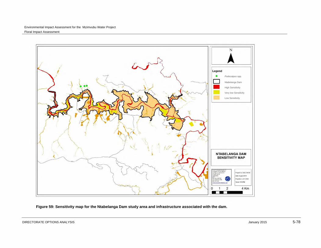
Figure 59: Sensitivity map for the Ntabelanga Dam study area and infrastructure associated with the dam.
Podocatpus spp.
Ntabelanga Dam
High Sensitivity
Very low Sensitivity
Low Sensitivity
Environmental Impact Assessment for the Mzimvubu Water Project
Floral Impact Assessment
DIRECTORATE OPTIONS ANALYSIS January 2015 5-79
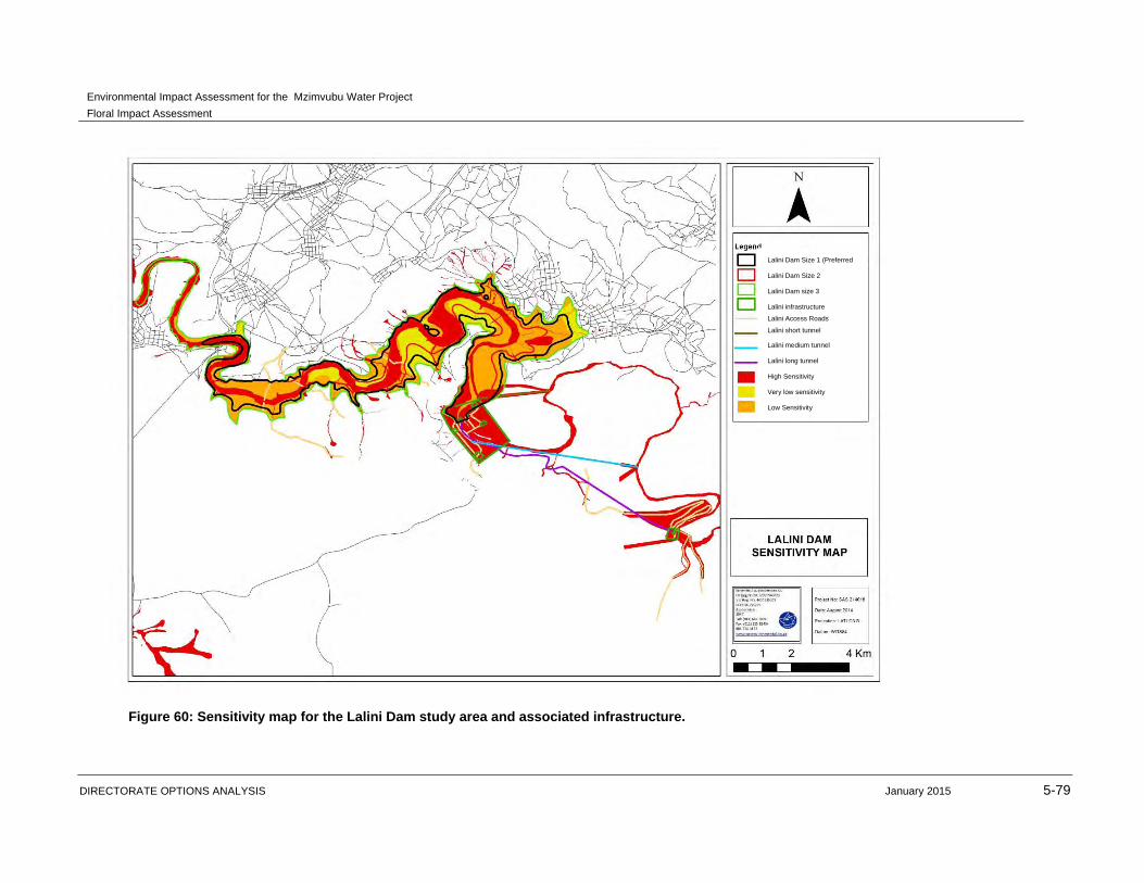
Figure 60: Sensitivity map for the Lalini Dam study area and associated infrastructure.
Lalini Dam Size 1 (Preferred
Lalini Dam Size 2
Lalini Dam size 3
Lalini infrastructure
Lalini Access Roads
Lalini short tunnel
Lalini medium tunnel
Lalini long tunnel
High Sensitivity
Very low sensitivity
Low Sensitivity
Environmental Impact Assessment for the Mzimvubu Water Project
Floral Impact Assessment
DIRECTORATE OPTIONS ANALYSIS January 2015 5-80
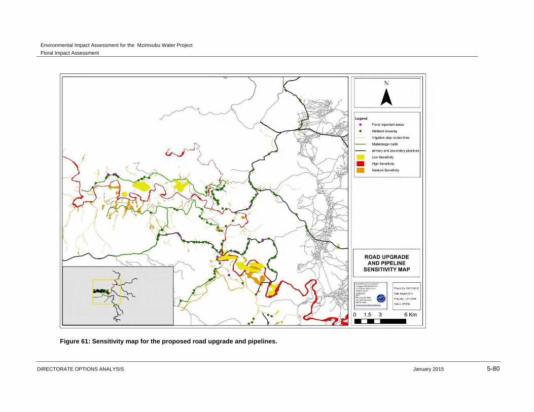
Figure 61: Sensitivity map for the proposed road upgrade and pipelines.
Environmental Impact Assessment for the Mzimvubu Water Project
Floral Impact Assessment
DIRECTORATE OPTIONS ANALYSIS January 2015 5-81
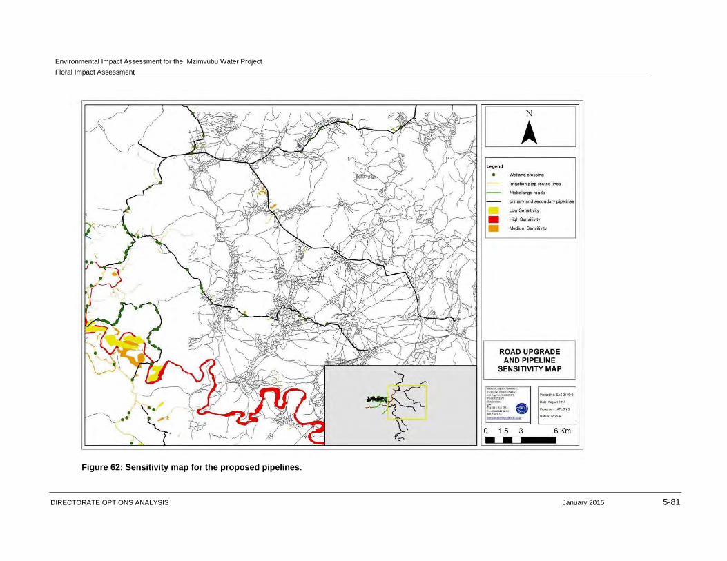
Figure 62: Sensitivity map for the proposed pipelines.
Environmental Impact Assessment for the Mzimvubu Water Project
Floral Impact Assessment
DIRECTORATE OPTIONS ANALYSIS January 2015 5-82
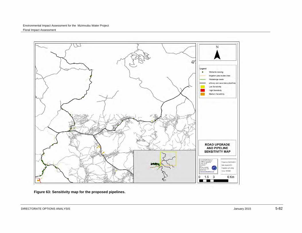
Figure 63: Sensitivity map for the proposed pipelines.
Environmental Impact Assessment for the Mzimvubu Water Project
Floral Impact Assessment
DIRECTORATE OPTIONS ANALYSIS January 2015 5-83
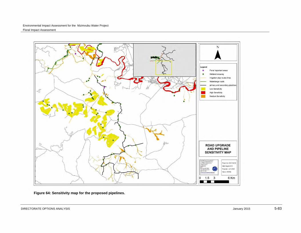
Figure 64: Sensitivity map for the proposed pipelines.
Environmental Impact Assessment for the Mzimvubu Water Project
Floral Impact Assessment
DIRECTORATE OPTIONS ANALYSIS January 2015 5-84
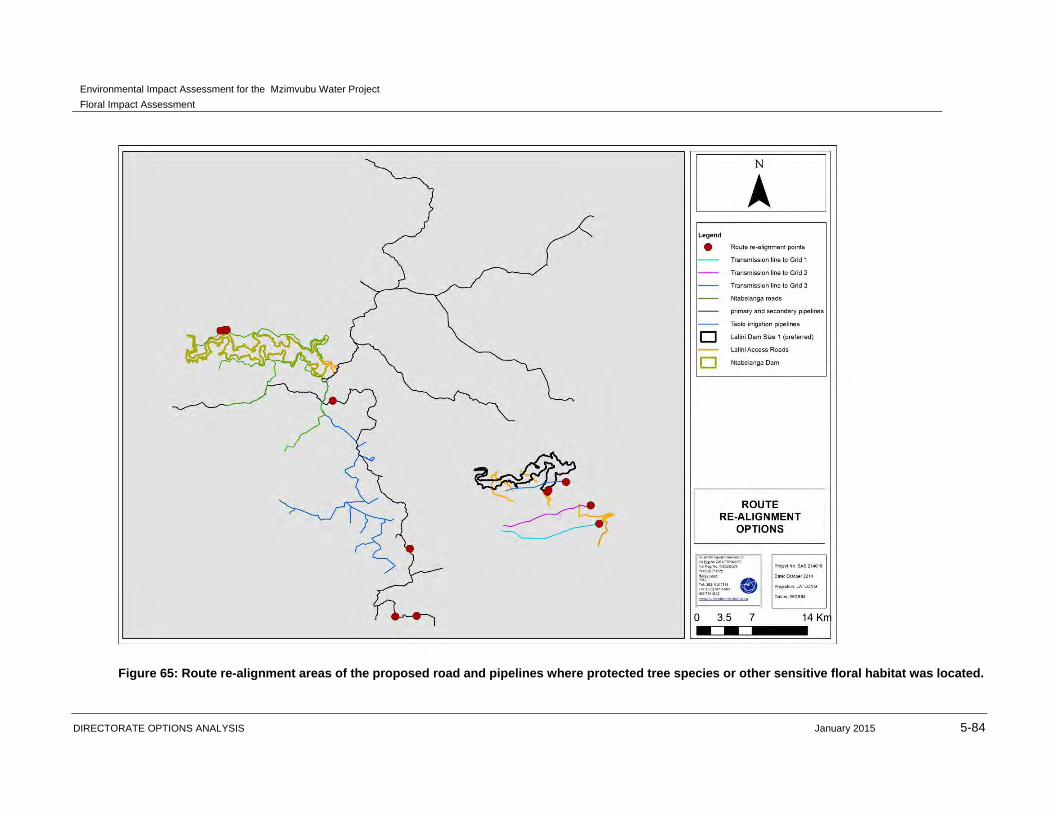
Figure 65: Route re-alignment areas of the proposed road and pipelines where protected tree species or other sensitive floral habitat was located.
Environmental Impact Assessment for the Mzimvubu Water Project
Floral Impact Assessment
DIRECTORATE OPTIONS ANALYSIS January 2015 6-1
6 GENERAL MANAGEMENT AND GOOD HOUSEKEEPING PRACTICES
Latent and general impacts which may impact on the floral ecosystem will include any
activities which take place within the study area that may impact on the receiving
environment. General impact minimisation measures are highlighted below and are
relevant for all sensitive floral related areas identified in this report:
No fires whatsoever should be allowed within the study area during the construction
phase.
Appropriate sanitary facilities must be provided and all waste removed to an
appropriate waste facility.
No vehicles should be allowed to drive through designated sensitive wetland areas
during the eradication of alien and weed species.
Restrict vehicles to travelling only on designated roadways to limit the ecological
footprint of the proposed development activities.
In the event of a breakdown, maintenance of vehicles must take place with care and
the recollection of spillage should be practiced to prevent the ingress of hydrocarbons
into the topsoil.
It must be ensured that all roads and construction areas are regularly sprayed with
water in order to curb dust generation. This is particularly necessary during the dry
season when increased levels of dust generation can be expected. These areas
should not be over-sprayed causing water run-off and subsequent sediment loss in
the vicinity of the subject property.
Ensure that all hazardous storage containers and storage areas comply with the
relevant SABS standards to prevent leakage. Regularly inspect all vehicles for leaks.
Re-fuelling must take place on a sealed surface area to prevent ingress of
hydrocarbons into topsoil.
Storage of construction material used during the road upgrade should be localised
within designated or selected areas, if possible, to ensure the minimisation of the
ecological footprint area and prevent loss of natural habitat along the road.
All soils compacted as a result of construction activities at the dam walls should be
ripped and profiled. Special attention should be paid to alien and invasive control
within these areas. Alien and invasive vegetation control should take place to prevent
loss of floral habitat.
No dumping of waste should take place. If any spills occur, they should be
immediately cleaned up.
Prohibit the collection of plant material, outside of the proposed dam basins for
medicinal or fire wood use during the construction phase.
Environmental Impact Assessment for the Mzimvubu Water Project
Floral Impact Assessment
DIRECTORATE OPTIONS ANALYSIS January 2015 7-1
7 IMPACT ASSESSMENT FOR DAMS AND ASSOCIATED WATER
INFRASTRUCTURE
This Chapter presents the findings of the environmental impact assessment for the dams
and associated activities (DEA Ref no. 14/12/16/3/3/2/677).
The activities assessed under this chapter are listed below:
The Ntabelanga and Lalini Dams;
Five flow gauging weirs;
Primary and secondary bulk potable water infrastructure:
o Primary infrastructure: main water treatment works, including four major treated
water pumping stations and three minor treated water pumping stations, main bulk
treated water rising mains, and eight Command Reservoirs that will supply the
whole region;
o Secondary distribution lines: conveying bulk treated water from Command
Reservoirs to existing and new District Reservoirs;
Bulk raw water conveyance infrastructure (abstraction, pipelines, one raw water
pumping station, one reservoir and two booster pumps) for irrigated agriculture (raw
water supply up to field edge);
Impact of commercial agriculture in earmarked irrigation areas;
WWTWs at the Ntabelanga and Lalini Dam sites;
Accommodation for operational staff at the Ntabelanga and Lalini Dam sites;
Ten construction materials quarries and borrow pits;
River intake structures and associated works;
Information centres at the two dam sites; and
Miscellaneous construction of camps, lay down areas, and storage sites.
7.1 CONSTRUCTION AND FIRST FILLING PHASES
7.1.1 Impact on habitat for floral species
7.1.1.1 Ntabelanga Dam and associated infrastructure
Construction of the Ntabelanga Dam entails the construction of the dam wall, associated
infrastructures such as the camp sites, quarries and burrow pits, accommodation for
operational staff, WWTW’s, information centre and the first filling. The areas associated
with these infrastructures are considered of low sensitivity. It must be ensured that only
the areas designated for the specific activity are cleared, therefore minimising the overall
footprint area of these infrastructures. Where possible, avoid placing any associated
infrastructure within the Mountain Rocky Outcrop or Wetland Habitat Units.
Construction of the dam wall would entail the clearance of vegetation, movement of
construction vehicles and storage of construction material, leading to the decrease in
floral habitat. Infrastructure related to the construction of the dam wall should take place
Environmental Impact Assessment for the Mzimvubu Water Project
Floral Impact Assessment
DIRECTORATE OPTIONS ANALYSIS January 2015 7-2
within areas that has undergone historic transformation or with a lower ecological value
and function.
Vegetation surrounding the Ntabelanga Dam wall consists of rocky ridge vegetation,
mostly indigenous to the area. Little transformation has occurred within this area. Thus it
is recommended that as much indigenous vegetation (e.g. young seedlings, Aloe
species, Euphorbia species, and Cussonia species) should be relocated, where
possible, and as much possible before the construction phase commences. Community
members could be involved in this specific phase of the project. During the first filling
vegetation located within the footprint area of the full supply level will be submerged
under water. Habitat for indigenous floral vegetation along the riparian / wetland areas
and the mountain / rocky outcrop areas will be lost.
The impact significance associated with the loss of species habitat is considered to be
medium-high prior to implementation of mitigation measures.
7.1.1.2 Lalini Dam and associated infrastructure
The Lalini Dam consists mainly of transformed vegetation due to the surrounding rural
communities clearing vegetation for small scale agricultural activities. Thus large
sections of the Lalini Dam have undergone vegetation transformation, also caused by
overgrazing and trampling of veld by livestock.
More sensitive habitat consisting of a rocky ridge and riparian zone complex, including
the Euphorbia forest located closer to the dam wall will be affected by the construction of
the dam wall and the first filling phase. Vegetation habitat for numerous and sensitive
indigenous vegetation will be lost. Infrastructure related to the construction of the dam
wall should take place within areas that has undergone historic transformation or with a
lower ecological value and function.
Borrow pits / Material sources for the construction of the dam wall must take place within
areas that have been historically disturbed in order to ensure that more sensitive or
natural vegetation habitat is not lost.
The impact significance associated with the loss of species habitat is considered to be
high prior to implementation of mitigation measures.
Another aspect that should be considered is the type of vegetation and the growth of
specific floral species such as cremnophytes. These areas floral species, mostly
succulents that are associated with cliffs but have distributions that extent to non-cliff
habitats. Some species include Crassula cultrate, C. perforate, C. rupestris,
Haemanthus albiflos and Portulacaria afra. Water-holding capacity is important as it
directly relates to cliff vegetation. Mostly obligate succulent cremnophytes have a
relatively shallow root system and on cliffs that dry out rapidly (van Jaarsveld, 2011).
Thus, the aspect of a lower overall flow rate at the Tsitsa waterfall, thus decreasing the
amount of mist spray and water availability to the surrounding vegetation on the cliffs or
within the gorge needs to be taken into account. It is proposed that a detailed baseline
Environmental Impact Assessment for the Mzimvubu Water Project
Floral Impact Assessment
DIRECTORATE OPTIONS ANALYSIS January 2015 7-3
study be conducted to determine the sensitivity of this area before any construction
activities commence. Should any medicinal important or RDL species be located within
this area during the site assessment, it is recommended that these species identified be
rescues and relocated to similar habitat e.g. the upstream waterfall area. Where
applicable, permit applications should be obtained from the relevant authority to rescue
and relocate these species.
7.1.1.3 Primary, Secondary Pipelines and Irrigation Pipelines and associated infrastructure
The primary and secondary pipeline will be constructed close to main or existing roads.
According to the National List of Threatened Terrestrial Ecosystems (2011) sections of
the proposed road upgrades, southern section of the pipelines and small portions of the
Lalini Dam fall into a vulnerable ecosystem in terms of the original and remaining extent
of the associated vegetation types. Rocky outcrop areas also occurred within these
sections.
In terms of vegetation habitat, the edge effects of the existing roads, overgrazed veld
and surrounding community villages has transformed the vegetation to the extent that
only grass species such as Eragrostis curvula, E. chloromelas, Hyparrhenia hirta,
Sporobulus africanus and Cynodon dactylon, which are associated with more disturbed
areas, occur alongside the current access roads. In areas that are associated with
disturbance and vegetation clearance, the impact on further transformation of floral
habitat of the pipelines will be low, should all possible mitigation measures be
implemented.
Infrastructure associated with dams such as the reservoirs, gauging weirs and any bulk
raw water conveyance infrastructure must be places within areas that has undergone
historic or current floral disturbance. Where possible, avoid placing any associated
infrastructure within the Mountain Rocky Outcrop or Wetland Habitat Units.
These irrigation pipelines are mostly situated south of the township of Tsolo. The
majority of the sections for the proposed pipelines will be along existing dirt roads. Other
vegetation habitat units that the pipelines traverse have been transformed due to historic
and on-going small scale agricultural activities, wetland habitat and rocky areas. The
northern section of the irrigation pipeline traverses a woody vegetation habitat area that
most likely has been dominated by Acacia species so some extent that bush
encroachment has occurred.
Recommended mitigation (Also refer to general management and good housekeeping
practices):
As far as possible avoid disturbance of Mountain Rocky Outcrops and avoid
disturbance of protected floral species when construction activities of the
associated dam infrastructure takes place. Should it be evident that protected
species within the Mountain Rocky Outcrops will be disturbed permits to cut or
destroy these trees must be obtained prior to construction taking place or
alternatively, route re-alignment should be considered.
Environmental Impact Assessment for the Mzimvubu Water Project
Floral Impact Assessment
DIRECTORATE OPTIONS ANALYSIS January 2015 7-4
It is suggested that a walk down be done for the section of the power line closer to
the Tsitsa River and Mountain / Rocky Outcrops prior to the construction phase to
identify any important Red Data Listed (RDL), medicinal or protected species.
Should any RDL or protected species be located during the walk down, the
necessary authorisation should be obtained to remove, relocate or cut and destroy
these floral species.
For the Lalini Dam construction, three alternatives were given. The alternatives
covering the least amount of floral and especially sensitive floral vegetation and
habitat should be considered. Therefore Alternative 2 would be the more preferred
alternative.
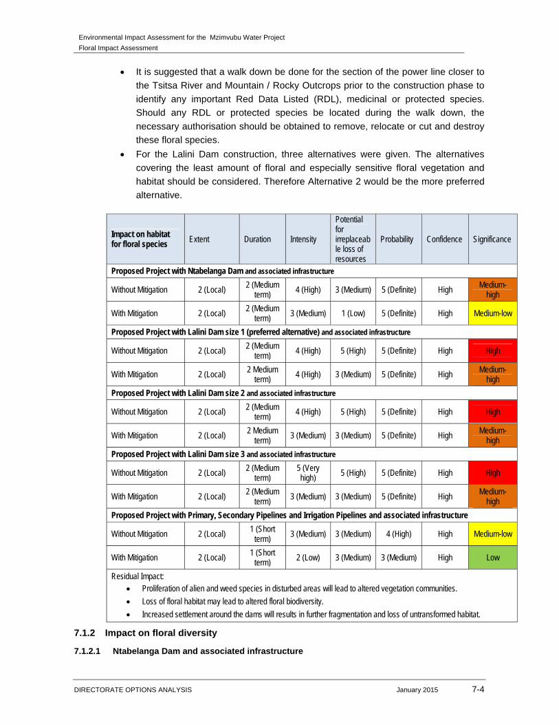
Impact on habitat for floral species Extent Duration Intensity
Potential for irreplaceable loss of resources
Probability Confidence Significance
Proposed Project with Ntabelanga Dam and associated infrastructure
Without Mitigation 2 (Local) 2 (Medium term) 4 (High) 3 (Medium) 5 (Definite) High Medium-
high
With Mitigation 2 (Local) 2 (Medium term) 3 (Medium) 1 (Low) 5 (Definite) High Medium-low
Proposed Project with Lalini Dam size 1 (preferred alternative) and associated infrastructure
Without Mitigation 2 (Local) 2 (Medium term) 4 (High) 5 (High) 5 (Definite) High High
With Mitigation 2 (Local) 2 Medium term) 4 (High) 3 (Medium) 5 (Definite) High Medium-
high
Proposed Project with Lalini Dam size 2 and associated infrastructure
Without Mitigation 2 (Local) 2 (Medium term) 4 (High) 5 (High) 5 (Definite) High High
With Mitigation 2 (Local) 2 Medium term) 3 (Medium) 3 (Medium) 5 (Definite) High Medium-
high
Proposed Project with Lalini Dam size 3 and associated infrastructure
Without Mitigation 2 (Local) 2 (Medium term)
5 (Very high)
5 (High) 5 (Definite) High High
With Mitigation 2 (Local) 2 (Medium term) 3 (Medium) 3 (Medium) 5 (Definite) High Medium-
high
Proposed Project with Primary, Secondary Pipelines and Irrigation Pipelines and associated infrastructure
Without Mitigation 2 (Local) 1 (Short term)
3 (Medium) 3 (Medium) 4 (High) High Medium-low
With Mitigation 2 (Local) 1 (Short term)
2 (Low) 3 (Medium) 3 (Medium) High Low
Residual Impact: Proliferation of alien and weed species in disturbed areas will lead to altered vegetation communities.
Loss of floral habitat may lead to altered floral biodiversity.
Increased settlement around the dams will results in further fragmentation and loss of untransformed habitat.
7.1.2 Impact on floral diversity
7.1.2.1 Ntabelanga Dam and associated infrastructure
Environmental Impact Assessment for the Mzimvubu Water Project
Floral Impact Assessment
DIRECTORATE OPTIONS ANALYSIS January 2015 7-5
The only areas of high floral diversity are within the mountain / rocky outcrop habitat unit.
Vegetation clearance for the construction of the dam wall and first filling will decrease
the floral diversity within the immediate area. The duration of this impact will be
permanent. Due to the permanent duration within the full supply level, it is proposed that
indigenous species be relocated and established in a holding nursery to use as part of
rehabilitation around the dam information centres or accommodation areas for the
operational staff.
The areas associated with infrastructures (camp sites, quarries and burrow pits,
accommodation for operational staff, WWTW’s and information centre) are considered of
low sensitivity. It must be ensured that only the areas designated for the specific activity
are cleared, therefore minimising the overall footprint area of these infrastructures.
Where possible, avoid placing any associated infrastructure within the Mountain Rocky
Outcrop or Wetland Habitat Units.
The impact significance associated with the loss of species habitat is considered to be
high prior to implementation of mitigation measures.
7.1.2.2 Lalini Dam and associated infrastructure
The floral diversity within the Lalini dam, especially around the dam wall, is very high
with numerous indigenous woody species. Although during the site assessments, no
protected or important floral species were recorded, the habitat is suitable for protected
woody vegetation to occur. Construction of the dam wall would entail the clearance of
vegetation, movement of construction vehicles and storage of construction material,
leading to the decrease in floral diversity.
Borrow pits / Material sources for the construction of the dam wall must take place within
areas that have been historically disturbed in order to ensure that more sensitive or
natural vegetation habitat is not lost
The impact significance associated with the loss of species diversity is considered to be
high prior to implementation of mitigation measures for alternative 1, 2 and alternative 3.
7.1.2.3 Primary, Secondary Pipelines and Irrigation Pipelines and associated infrastructure
The primary and secondary pipeline will be constructed close to main or existing roads.
According to the National List of Threatened Terrestrial Ecosystems (2011) sections of
the proposed road upgrades, southern section of the pipelines and small portions of the
Lalini Dam fall into a vulnerable ecosystem in terms of the original and remaining extent
of the associated vegetation types. Rocky outcrop areas also occurred within these
sections.
In terms of vegetation habitat, the edge effects of the existing roads, overgrazed veld
and surrounding community villages has transformed the vegetation to the extent that
only grass species such as Eragrostis curvula, E. chloromelas, Hyparrhenia hirta,
Sporobulus africanus and Cynodon dactylon, which are associated with more disturbed
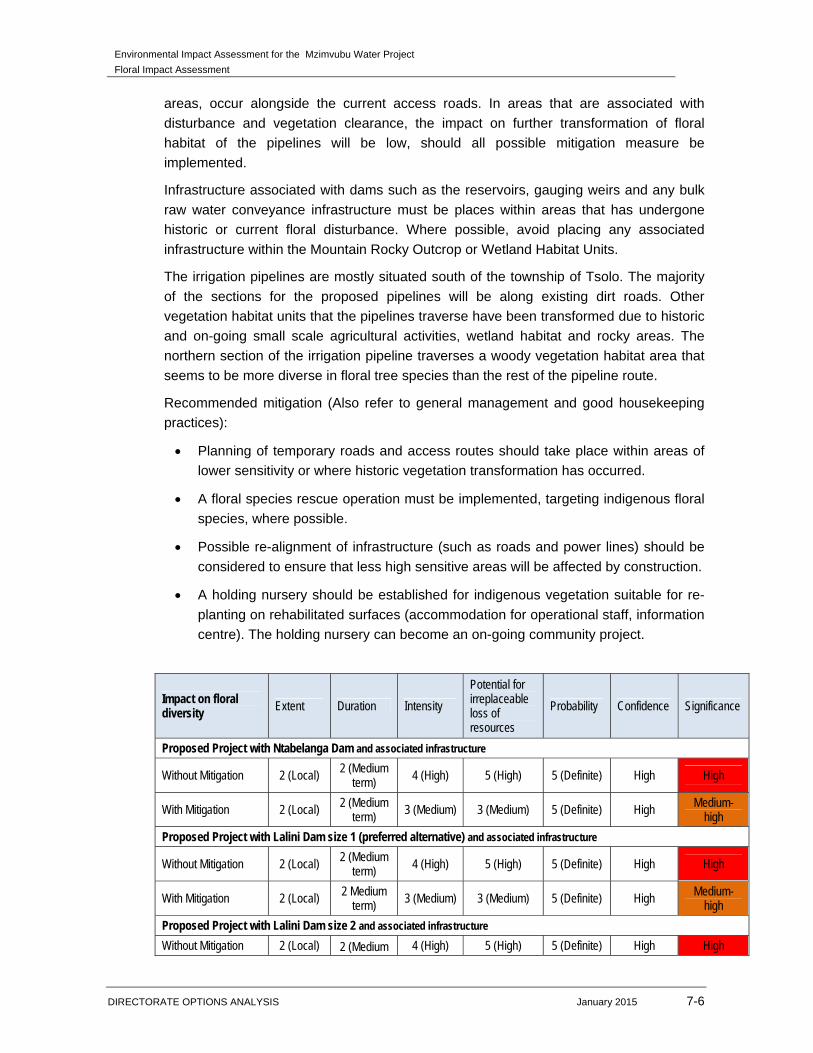
Environmental Impact Assessment for the Mzimvubu Water Project
Floral Impact Assessment
DIRECTORATE OPTIONS ANALYSIS January 2015 7-6
areas, occur alongside the current access roads. In areas that are associated with
disturbance and vegetation clearance, the impact on further transformation of floral
habitat of the pipelines will be low, should all possible mitigation measure be
implemented.
Infrastructure associated with dams such as the reservoirs, gauging weirs and any bulk
raw water conveyance infrastructure must be places within areas that has undergone
historic or current floral disturbance. Where possible, avoid placing any associated
infrastructure within the Mountain Rocky Outcrop or Wetland Habitat Units.
The irrigation pipelines are mostly situated south of the township of Tsolo. The majority
of the sections for the proposed pipelines will be along existing dirt roads. Other
vegetation habitat units that the pipelines traverse have been transformed due to historic
and on-going small scale agricultural activities, wetland habitat and rocky areas. The
northern section of the irrigation pipeline traverses a woody vegetation habitat area that
seems to be more diverse in floral tree species than the rest of the pipeline route.
Recommended mitigation (Also refer to general management and good housekeeping
practices):
Planning of temporary roads and access routes should take place within areas of
lower sensitivity or where historic vegetation transformation has occurred.
A floral species rescue operation must be implemented, targeting indigenous floral
species, where possible.
Possible re-alignment of infrastructure (such as roads and power lines) should be
considered to ensure that less high sensitive areas will be affected by construction.
A holding nursery should be established for indigenous vegetation suitable for re-
planting on rehabilitated surfaces (accommodation for operational staff, information
centre). The holding nursery can become an on-going community project.
Impact on floral diversity Extent Duration Intensity
Potential for irreplaceable loss of resources
Probability Confidence Significance
Proposed Project with Ntabelanga Dam and associated infrastructure
Without Mitigation 2 (Local) 2 (Medium term)
4 (High) 5 (High) 5 (Definite) High High
With Mitigation 2 (Local) 2 (Medium term)
3 (Medium) 3 (Medium) 5 (Definite) High Medium-high
Proposed Project with Lalini Dam size 1 (preferred alternative) and associated infrastructure
Without Mitigation 2 (Local) 2 (Medium term)
4 (High) 5 (High) 5 (Definite) High High
With Mitigation 2 (Local) 2 Medium term)
3 (Medium) 3 (Medium) 5 (Definite) High Medium-high
Proposed Project with Lalini Dam size 2 and associated infrastructure
Without Mitigation 2 (Local) 2 (Medium 4 (High) 5 (High) 5 (Definite) High High

Environmental Impact Assessment for the Mzimvubu Water Project
Floral Impact Assessment
DIRECTORATE OPTIONS ANALYSIS January 2015 7-7
term)
With Mitigation 2 (Local) 2 Medium
term) 3 (Medium) 3 (Medium) 5 (Definite) High Medium-
high
Proposed Project with Lalini Dam size 3 and associated infrastructure
Without Mitigation 2 (Local) 2 (Medium term)
5 (Very high) 5 (High) 5 (Definite) High High
With Mitigation 2 (Local) 2 (Medium term) 4 (High) 3 (Medium) 5 (Definite) High Medium-
high
Proposed Project with Primary, Secondary Pipelines and Irrigation Pipelines and associated infrastructure
Without Mitigation 2 (Local) 1 (Short term) 3 (Medium) 3 (Medium) 4 (High) High Medium-low
With Mitigation 2 (Local) 1 (Short term) 2 (Low) 3 (Medium) 3 (Medium) High Low
Residual Impact: Decrease in floral species diversity may occur due to habitat transformation as a result of construction activities. Ineffective rehabilitation within the primary and secondary pipelines may lead to permanent transformation of floral
habitat. Proliferation of alien and weed species in disturbed areas will lead to lowered vegetation biodiversity along the
pipeline routes.
7.1.3 Impact on important and protected floral species
7.1.3.1 Ntabelanga Dam and associated infrastructure
The Mountain / Rocky Outcrop habitat located within the Ntabelanga Dam contain
numerous indigenous woody vegetation. Although no protected tree species were noted
during the site assessments, the probability of occurrence is high, therefore impacting on
the important and protected floral communities. It is recommended that indigenous
vegetation within the mountain/rocky ridges must be rescued and relocated to similar
habitat areas falling outside of the project footprint. No important or protected species
were located within transformed vegetation habitat due to overgraze and tramples veld.
The areas associated with infrastructures (camp sites, quarries and burrow pits,
accommodation for operational staff, WWTW’s and information centre) are considered of
low sensitivity. No protected or important floral species were noted during the site
assessment. Should any of the protected species listed within this report be located
within the specific area designated for these infrastructure, applicable permit approval
documents must be required before any other activities takes place.
The duration of this impact will be permanent for the areas affected by the construction
of the dam wall and the first filling. The impact significance associated with the loss of
species habitat is considered to be medium-high prior to implementation of mitigation
measures.
7.1.3.2 Lalini Dam
The ecological function and habitat of the Mountain / Rocky Outcrops habitat unit is
considered to be moderate to high due to the few disturbances from agricultural
activities, overgrazing and alien floral encroachment. In terms of conservation value, the
Environmental Impact Assessment for the Mzimvubu Water Project
Floral Impact Assessment
DIRECTORATE OPTIONS ANALYSIS January 2015 7-8
moderate to high ecological functionality, good habitat integrity, the low incidence of
bush or alien floral encroachment, combine to increase the ecological sensitivity of this
habitat unit.
No protected or RDL floral or tree species were located during the time of the site
assessment but there is a high probability that such species could be present within this
habitat unit. The impacts of the loss of protected species will be medium-high to high
due to the suitable habitat available for protected woody species to occur.
7.1.3.3 Primary, secondary and irrigation pipelines
Pockets of rocky outcrops or where the pipeline traverses mountain areas were located.
These areas were mapped on a desktop level to indicate where vegetation has changed.
Although not all areas of the rocky outcrops contained indigenous floral vegetation,
these areas are still considered different to the remainder of the habitat units. Mitigation
measures when construction of the pipeline takes places should considered these rocky
areas and mountain passes and minimise the impacts within these areas.
Due to the severe vegetation transformation within most of the areas along the primary
and secondary pipeline route, the low ecological function and state and the low diversity
in floral species, the areas set out for the construction of the primary and secondary
pipeline route is not considered sensitive. Since the impact of the construction will be of
a shorter duration and rehabilitation will be done, the severity of the impact will be lower.
Podocarpus species were located on the secondary pipeline route south of the town
Tsolo. These species is considered protected according to the notice of the list of
protected tree species under the National Forests Act, 1998 (Act No. 84 of 1998).
Permits for the removal of these protected tree species (should it occur within the
construction footprint area) need to be obtained at the relevant authorities before any
construction activities occur within this area.
The northern section of the irrigation pipeline traverses a woody vegetation habitat area
that seems to be more diverse in floral tree species than the rest of the pipeline route. It
is possible that protected tree species, favouring afromontane habitat, could occur along
the pipeline route or in the surrounding area.
Infrastructure associated with dams such as the reservoirs, gauging weirs and any bulk
raw water conveyance infrastructure must be places within areas that has undergone
historic or current floral disturbance. Where possible, avoid placing any associated
infrastructure within the Mountain Rocky Outcrop or Wetland Habitat Units.
Recommended mitigation (Also refer to general management and good housekeeping
practices):
Re-alignment of infrastructure to avoid protected trees.
Environmental Impact Assessment for the Mzimvubu Water Project
Floral Impact Assessment
DIRECTORATE OPTIONS ANALYSIS January 2015 7-9
Permits for the removal or destruction of protected tree species (should it occur
within the construction footprint area) need to be obtained at the relevant
authorities before any construction activities occur within this area.
A floral species rescue operation should be implemented, targeting indigenous
floral species (bulbs and succulent species).
A holding nursery should be established for indigenous vegetation suitable for re-
planting on rehabilitated surfaces (accommodation for operational staff, information
centre).
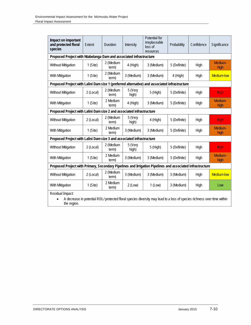
Environmental Impact Assessment for the Mzimvubu Water Project
Floral Impact Assessment
DIRECTORATE OPTIONS ANALYSIS January 2015 7-10
Impact on important and protected floral species
Extent Duration Intensity
Potential for irreplaceable loss of resources
Probability Confidence Significance
Proposed Project with Ntabelanga Dam and associated infrastructure
Without Mitigation 1 (Site) 2 (Medium term)
4 (High) 3 (Medium) 5 (Definite) High Medium-high
With Mitigation 1 (Site) 2 (Medium term)
3 (Medium) 3 (Medium) 4 (High) High Medium-low
Proposed Project with Lalini Dam size 1 (preferred alternative) and associated infrastructure
Without Mitigation 2 (Local) 2 (Medium term)
5 (Very high) 5 (High) 5 (Definite) High High
With Mitigation 1 (Site) 2 Medium term)
4 (High) 3 (Medium) 5 (Definite) High Medium-high
Proposed Project with Lalini Dam size 2 and associated infrastructure
Without Mitigation 2 (Local) 2 (Medium
term) 5 (Very high) 4 (High) 5 (Definite) High High
With Mitigation 1 (Site) 2 Medium term) 3 (Medium) 3 (Medium) 5 (Definite) High Medium-
high
Proposed Project with Lalini Dam size 3 and associated infrastructure
Without Mitigation 2 (Local) 2 (Medium
term) 5 (Very high) 5 (High) 5 (Definite) High High
With Mitigation 1 (Site) 2 Medium term) 3 (Medium) 3 (Medium) 5 (Definite) High Medium-
high
Proposed Project with Primary, Secondary Pipelines and Irrigation Pipelines and associated infrastructure
Without Mitigation 2 (Local) 2 (Medium term) 3 (Medium) 3 (Medium) 3 (Medium) High Medium-low
With Mitigation 1 (Site) 2 Medium
term) 2 (Low) 1 (Low) 3 (Medium) High Low
Residual Impact: A decrease in potential RDL/ protected floral species diversity may lead to a loss of species richness over time within
the region.

Environmental Impact Assessment for the Mzimvubu Water Project
Floral Impact Assessment
DIRECTORATE OPTIONS ANALYSIS January 2015 7-11
Figure 66: Possible areas identified along the pipeline routes that require search and rescue before construction activities commence.
Environmental Impact Assessment for the Mzimvubu Water Project
Floral Impact Assessment
DIRECTORATE OPTIONS ANALYSIS January 2015 7-12
7.2 OPERATION PHASE
7.2.1 Impact on habitat for floral species
7.2.1.1 Ntabelanga and Lalini Dam
During the operation phase, impacts from the first filling would already have taken place,
thus clearing vegetation within the full supply level. During the operation phase water
from the dams will be used to generate electricity and base flow and peak flow. Water
levels will fluctuate during different times of the year and depending on the demand.
The Ntabelanga Dam levels will most likely vary during the year. Therefore the duration
of the impacts will be permanent; the intensity is low due to the impact that has already
occurred.
The Lalini Dam water levels will fluctuate, which will slightly impact on the floral habitat.
During certain periods, vegetation will be exposed but the duration will not be enough to
recover. It is expected that an increase in sedimentation will occur along the banks of the
dam.
7.2.1.2 Primary, secondary and irrigation pipelines
During the operational phase no major impacts area expected, should rehabilitation of
the affected areas been implemented. It must be ensured that alien proliferation is
controlled during the operation phase to ensure that indigenous floral habitat is not lost.
During the maintenance of the pipelines, all vehicles should travel on the designated
road to limit the ecological footprint and reduce further degradation or loss of floral
habitat.
Recommended mitigation (Also refer to general management and good housekeeping
practices):
Ensure that operational related activities are kept strictly within the development
footprint.
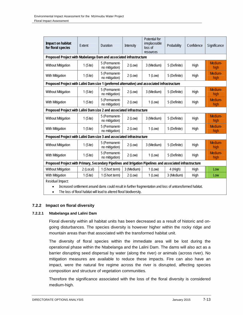
Environmental Impact Assessment for the Mzimvubu Water Project
Floral Impact Assessment
DIRECTORATE OPTIONS ANALYSIS January 2015 7-13
Impact on habitat for floral species Extent Duration Intensity
Potential for irreplaceable loss of resources
Probability Confidence Significance
Proposed Project with Ntabelanga Dam and associated infrastructure
Without Mitigation 1 (Site) 5 (Permanent-no mitigation) 2 (Low) 3 (Medium) 5 (Definite) High Medium-
high
With Mitigation 1 (Site) 5 (Permanent-no mitigation)
2 (Low) 1 (Low) 5 (Definite) High Medium-high
Proposed Project with Lalini Dam size 1 (preferred alternative) and associated infrastructure
Without Mitigation 1 (Site) 5 (Permanent-no mitigation) 2 (Low) 3 (Medium) 5 (Definite) High Medium-
high
With Mitigation 1 (Site) 5 (Permanent-no mitigation) 2 (Low) 1 (Low) 5 (Definite) High
Medium-high
Proposed Project with Lalini Dam size 2 and associated infrastructure
Without Mitigation 1 (Site) 5 (Permanent-no mitigation) 2 (Low) 3 (Medium) 5 (Definite) High
Medium-high
With Mitigation 1 (Site) 5 (Permanent-no mitigation) 2 (Low) 1 (Low) 5 (Definite) High Medium-
high
Proposed Project with Lalini Dam size 3 and associated infrastructure
Without Mitigation 1 (Site) 5 (Permanent-no mitigation) 2 (Low) 3 (Medium) 5 (Definite) High Medium-
high
With Mitigation 1 (Site) 5 (Permanent-no mitigation) 2 (Low) 1 (Low) 5 (Definite) High Medium-
high
Proposed Project with Primary, Secondary Pipelines and Irrigation Pipelines and associated infrastructure
Without Mitigation 2 (Local) 1 (Short term) 3 (Medium) 1 (Low) 4 (High) High Low
With Mitigation 1 (Site) 1 (Short term) 2 (Low) 1 (Low) 3 (Medium) High Low
Residual Impact: Increased settlement around dams could result in further fragmentation and loss of untransformed habitat. The loss of floral habitat will lead to altered floral biodiversity.
7.2.2 Impact on floral diversity
7.2.2.1 Ntabelanga and Lalini Dam
Floral diversity within all habitat units has been decreased as a result of historic and on-
going disturbances. The species diversity is however higher within the rocky ridge and
mountain areas than that associated with the transformed habitat unit.
The diversity of floral species within the immediate area will be lost during the
operational phase within the Ntabelanga and the Lalini Dam. The dams will also act as a
barrier disrupting seed dispersal by water (along the river) or animals (across river). No
mitigation measures are available to reduce these impacts. Fire can also have an
impact, were the natural fire regime across the river is disrupted, affecting species
composition and structure of vegetation communities.
Therefore the significance associated with the loss of the floral diversity is considered
medium-high.
Environmental Impact Assessment for the Mzimvubu Water Project
Floral Impact Assessment
DIRECTORATE OPTIONS ANALYSIS January 2015 7-14
7.2.2.2 Primary, secondary and irrigation pipelines
The impact significance associated with the loss of species diversity is considered to be
low prior to the implementation of mitigation measures. It must be ensured that alien
proliferation is controlled during the operation phase to ensure that indigenous floral
habitat and diversity is not lost. During the maintenance of the pipelines, all vehicles
should travel on the designated road to limit the ecological footprint, reducing the loss of
floral habitat and in turn the diversity of species in the area.
Recommended mitigation (Also refer to general management and good housekeeping
practices):
Removal of the alien and weed species encountered within the footprint area must
take place in order to comply with existing legislation. An annual monitoring of
levels of infestation of the dams by alien floral species must take place.
Restrict vehicles to travelling only on designated roadways to limit the ecological
footprint of the proposed development activities.
To prevent the erosion of top soils, management measures may include berms,
soil traps, hessian curtains and storm water diversion away from areas susceptible
to erosion. It must be ensured that topsoil stockpiles are located outside of any
wetland areas susceptible to erosion.
Maintain holding nursery of local indigenous floral species suitable for re-planting
during the operational phase.
Ensure that areas on all sides of the dam are burnt with equal frequency and
timing.
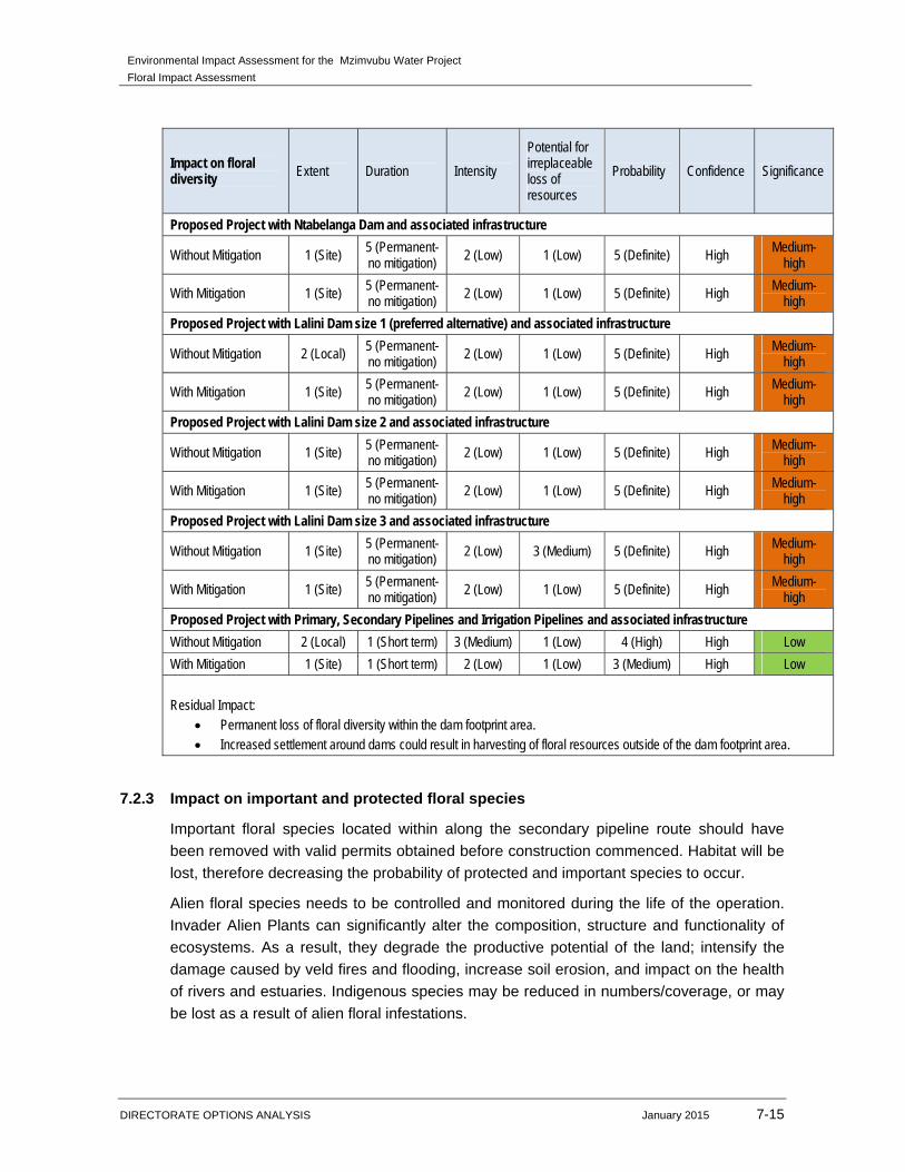
Environmental Impact Assessment for the Mzimvubu Water Project
Floral Impact Assessment
DIRECTORATE OPTIONS ANALYSIS January 2015 7-15
Impact on floral diversity Extent Duration Intensity
Potential for irreplaceable loss of resources
Probability Confidence Significance
Proposed Project with Ntabelanga Dam and associated infrastructure
Without Mitigation 1 (Site) 5 (Permanent-no mitigation) 2 (Low) 1 (Low) 5 (Definite) High
Medium-high
With Mitigation 1 (Site) 5 (Permanent-no mitigation) 2 (Low) 1 (Low) 5 (Definite) High Medium-
high
Proposed Project with Lalini Dam size 1 (preferred alternative) and associated infrastructure
Without Mitigation 2 (Local) 5 (Permanent-no mitigation) 2 (Low) 1 (Low) 5 (Definite) High Medium-
high
With Mitigation 1 (Site) 5 (Permanent-no mitigation) 2 (Low) 1 (Low) 5 (Definite) High Medium-
high
Proposed Project with Lalini Dam size 2 and associated infrastructure
Without Mitigation 1 (Site) 5 (Permanent-no mitigation) 2 (Low) 1 (Low) 5 (Definite) High Medium-
high
With Mitigation 1 (Site) 5 (Permanent-no mitigation) 2 (Low) 1 (Low) 5 (Definite) High Medium-
high
Proposed Project with Lalini Dam size 3 and associated infrastructure
Without Mitigation 1 (Site) 5 (Permanent-no mitigation) 2 (Low) 3 (Medium) 5 (Definite) High Medium-
high
With Mitigation 1 (Site) 5 (Permanent-no mitigation) 2 (Low) 1 (Low) 5 (Definite) High Medium-
high
Proposed Project with Primary, Secondary Pipelines and Irrigation Pipelines and associated infrastructure
Without Mitigation 2 (Local) 1 (Short term) 3 (Medium) 1 (Low) 4 (High) High Low
With Mitigation 1 (Site) 1 (Short term) 2 (Low) 1 (Low) 3 (Medium) High Low
Residual Impact:
Permanent loss of floral diversity within the dam footprint area. Increased settlement around dams could result in harvesting of floral resources outside of the dam footprint area.
7.2.3 Impact on important and protected floral species
Important floral species located within along the secondary pipeline route should have
been removed with valid permits obtained before construction commenced. Habitat will be
lost, therefore decreasing the probability of protected and important species to occur.
Alien floral species needs to be controlled and monitored during the life of the operation.
Invader Alien Plants can significantly alter the composition, structure and functionality of
ecosystems. As a result, they degrade the productive potential of the land; intensify the
damage caused by veld fires and flooding, increase soil erosion, and impact on the health
of rivers and estuaries. Indigenous species may be reduced in numbers/coverage, or may
be lost as a result of alien floral infestations.
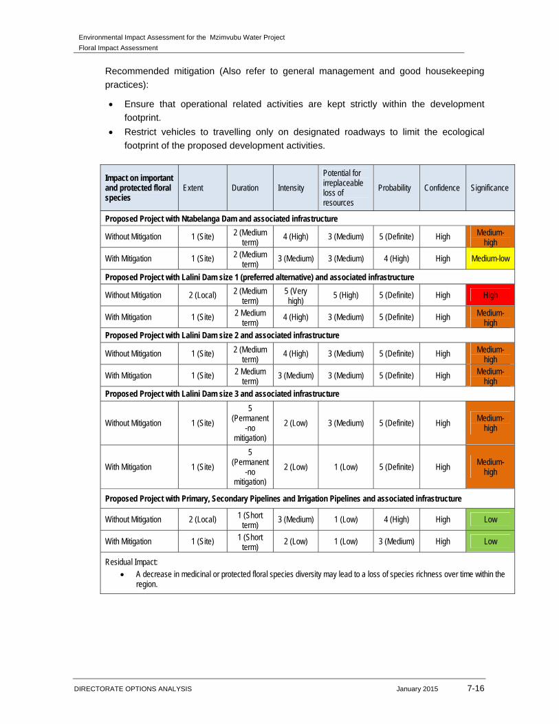
Environmental Impact Assessment for the Mzimvubu Water Project
Floral Impact Assessment
DIRECTORATE OPTIONS ANALYSIS January 2015 7-16
Recommended mitigation (Also refer to general management and good housekeeping
practices):
Ensure that operational related activities are kept strictly within the development
footprint.
Restrict vehicles to travelling only on designated roadways to limit the ecological
footprint of the proposed development activities.
Impact on important and protected floral species
Extent Duration Intensity
Potential for irreplaceable loss of resources
Probability Confidence Significance
Proposed Project with Ntabelanga Dam and associated infrastructure
Without Mitigation 1 (Site) 2 (Medium term)
4 (High) 3 (Medium) 5 (Definite) High Medium-high
With Mitigation 1 (Site) 2 (Medium term)
3 (Medium) 3 (Medium) 4 (High) High Medium-low
Proposed Project with Lalini Dam size 1 (preferred alternative) and associated infrastructure
Without Mitigation 2 (Local) 2 (Medium term)
5 (Very high)
5 (High) 5 (Definite) High High
With Mitigation 1 (Site) 2 Medium term)
4 (High) 3 (Medium) 5 (Definite) High Medium-high
Proposed Project with Lalini Dam size 2 and associated infrastructure
Without Mitigation 1 (Site) 2 (Medium term)
4 (High) 3 (Medium) 5 (Definite) High Medium-high
With Mitigation 1 (Site) 2 Medium term)
3 (Medium) 3 (Medium) 5 (Definite) High Medium-high
Proposed Project with Lalini Dam size 3 and associated infrastructure
Without Mitigation 1 (Site)
5 (Permanent
-no mitigation)
2 (Low) 3 (Medium) 5 (Definite) High Medium-
high
With Mitigation 1 (Site)
5 (Permanent
-no mitigation)
2 (Low) 1 (Low) 5 (Definite) High Medium-
high
Proposed Project with Primary, Secondary Pipelines and Irrigation Pipelines and associated infrastructure
Without Mitigation 2 (Local) 1 (Short term)
3 (Medium) 1 (Low) 4 (High) High Low
With Mitigation 1 (Site) 1 (Short term)
2 (Low) 1 (Low) 3 (Medium) High Low
Residual Impact: A decrease in medicinal or protected floral species diversity may lead to a loss of species richness over time within the
region.
Environmental Impact Assessment for the Mzimvubu Water Project
Floral Impact Assessment
DIRECTORATE OPTIONS ANALYSIS January 2015 8-1
8 IMPACT ASSESSMENT FOR ELECTRICITY GENERATION AND
DISTRIBUTION INFRASTRUCTURE
This Chapter presents the findings of the environmental impact assessment for the
electricity generation and distribution related activities (DEA Ref no. 14/12/16/3/3/2/678).
The activities assessed under this chapter are listed below:
Pipeline and Tunnel (including tunnel alternatives) at the proposed Lalini Dam;
Generation of hydro power and feeding of this power into the existing grid; and
18.5km power line from the Lalini Dam tunnel,
8.1 CONSTRUCTION PHASE
8.1.1 Impact on habitat for floral species
The majority of the power lines of all three alternatives will traverse transformed
(grassland) habitat units, where grasslands and mostly Acacia karroo and Acacia caffra
occurs. The transformed habitat unit has been significantly disturbed as a result of historic
and on-going agricultural activities and overgrazing of veld. The floral habitat within this
habitat unit is therefore largely transformed and placement of infrastructure within this
habitat unit will most likely have low impact significance.
All three sections of the power line alternatives, closer to the Tsitsa River will traverse
more sensitive habitat associated with mountain / afromontane forests and rocky outcrop
habitat. Due to the sensitive habitat and diversity of species occurring within these
sections, placement of support towers will need to be considered, as indigenous and
possible important / protected floral vegetation will be affected. According to the impact
assessment results, the power line alternative 1 and 3 will have a much higher impact,
even if mitigated due to the power lines crossing larger sections of indigenous and
possible protected trees and other floral species. The more preferred power line
alternative would be alternative 2 due to a lower impact on the receiving environment. The
majority of the power line traverses areas that have undergone vegetation transformation
(Figure 67).
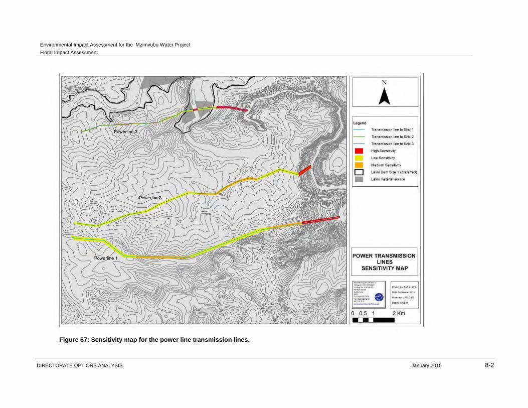
Environmental Impact Assessment for the Mzimvubu Water Project
Floral Impact Assessment
DIRECTORATE OPTIONS ANALYSIS January 2015 8-2
Figure 67: Sensitivity map for the power line transmission lines.
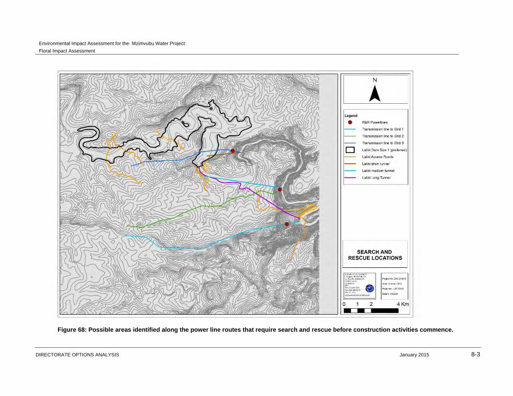
Environmental Impact Assessment for the Mzimvubu Water Project
Floral Impact Assessment
DIRECTORATE OPTIONS ANALYSIS January 2015 8-3
Figure 68: Possible areas identified along the power line routes that require search and rescue before construction activities commence.

Environmental Impact Assessment for the Mzimvubu Water Project
Floral Impact Assessment
DIRECTORATE OPTIONS ANALYSIS January 2015 8-4
Recommended mitigation (Also refer to general management and good housekeeping
practices):
Planning the placement of the support towers should be kept within the low sensitivity
areas as far as possible. It is recommended that alternative 2 of the power lines be
considered as the more preferred option.
If possible, avoid placement of infrastructure within rocky outcrop or
mountain/afromontane forest habitat units.
Placement of support towers should remain as small as possible.
Restrict vehicles as far as possible to travel on designated roadways to limit the
ecological footprint of the infrastructure.
Edge effects of all construction activities, such as erosion and alien plant species
proliferation, which may affect floral habitat, need to be strictly managed.
It must be ensured that construction related waste or spillage and effluent do not
affect the immediate and surrounding habitat boundaries.
In the event of a vehicle breakdown, maintenance of vehicles must take place with
care and the recollection of spillage should be practiced near the surface to prevent
ingress of hydrocarbons into topsoil and subsequent habitat loss.
Impact on habitat for floral species Extent Duration Intensity
Potential for irreplaceable loss of resources
Probability Confidence Significance
Power generation with hydropower short tunnel and power line alternative 1
Without Mitigation 2 (Local) 2 (Medium
term) 5 (Very high) 5 (High) 5 (Definite) High High
With Mitigation 2 (Local) 2 (Medium
term) 3 (Medium) 5 (High) 4 (High) High Medium-
high
Power generation with hydropower medium tunnel and Power line alternative 2
Without Mitigation 2 (Local) 2 (Medium term) 4 (High) 5 (High) 5 (Definite) High High
With Mitigation 1 (Site) 2 (Medium
term) 3 (Medium) 5 (High) 4 (High) High Medium-low
Power generation with hydropower long tunnel and Power line alternative 3
Without Mitigation 2 (Local) 2 (Medium term)
5 (Very high) 5 (High) 5 (Definite) High High
With Mitigation 2 (Local) 2 (Medium
term) 4 (High) 5 (High) 4 (High) High
Medium-high
Residual Impact: Loss of floral habitat will lead to altered floral biodiversity within the project footprint areas.
8.1.2 Impact on floral diversity
The floral diversity throughout most of the power line routes has been decreased as a
result of historic and on-going disturbances. The species diversity is however higher within
the Mountain / afromontane forest closer to the Tsitsa River. The impact significance
Environmental Impact Assessment for the Mzimvubu Water Project
Floral Impact Assessment
DIRECTORATE OPTIONS ANALYSIS January 2015 8-5
associated with the loss of species diversity is considered to be higher for alternatives 1
and 3 prior to implementation of mitigation measures. The impact of loss of species
diversity within the transformed habitat unit is expected to be of low significance.
With the implementation of mitigation measures the impact of alternative 2 can be
decreased to medium-low significance and alternative 1 and 3 to medium-high
significance. The loss of indigenous and possible protected and important tree and other
floral species will be very high should the preferred power line route be alternative 1 and 3.
Recommended mitigation (Also refer to general management and good housekeeping
practices):
Planning the placement of the support towers should be kept within the low sensitivity
areas as far as possible. It is recommended that alternative 2 of the power lines be
considered as the more preferred option.
Permits for the removal or destruction of protected tree species (should it occur within
the construction footprint area) need to be obtained at the relevant authorities before
any construction activities occur within the power line route.
If possible, avoid placement of infrastructure within rocky outcrop or
mountain/afromontane forest habitat units.
Placement of infrastructure should remain as small as possible.
Restrict vehicles as far as possible to travel on designated roadways to limit the
ecological footprint of the infrastructure.
Edge effects of all construction activities, such as erosion and alien plant species
proliferation, which may affect floral habitat, need to be strictly managed.
It must be ensured that construction related waste or spillage and effluent do not
affect the immediate and surrounding habitat boundaries.
In the event of a vehicle breakdown, maintenance of vehicles must take place with
care and the recollection of spillage should be practiced near the surface to prevent
ingress of hydrocarbons into topsoil and subsequent habitat loss.
All areas affected by the construction of infrastructure related to the power line should
be rehabilitated where possible.

Environmental Impact Assessment for the Mzimvubu Water Project
Floral Impact Assessment
DIRECTORATE OPTIONS ANALYSIS January 2015 8-6
Impact on floral diversity Extent Duration Intensity
Potential for irreplaceable loss of resources
Probability Confidence Significance
Peak power generation with hydropower short tunnel and power line alternative 1
Without Mitigation 2 (Local) 2 (Medium term)
4 (High) 5 (High) 5 (Definite) High High
With Mitigation 2 (Local) 2 (Medium term)
3 (Medium) 5 (High) 4 (High) High Medium-high
Peak power generation with hydropower medium tunnel and Power line alternative 2
Without Mitigation 2 (Local) 2 (Medium term) 4 (High) 5 (High) 5 (Definite) High High
With Mitigation 1 (Site) 2 (Medium term)
3 (Medium) 5 (High) 4 (High) High Medium-low
Peak power generation with hydropower long tunnel and Power line alternative 3
Without Mitigation 2 (Local) 2 (Medium
term) 5 (Very high) 5 (High) 5 (Definite) High High
With Mitigation 2 (Local) 2 (Medium term) 4 (High) 5 (High) 4 (High) High Medium-
high
Residual Impact: Permanent loss of floral diversity within areas where construction has taken place. Alien and invasive species proliferation and bush encroachment into disturbed areas. Ineffective rehabilitation may lead to permanent loss of floral biodiversity
8.1.3 Impact on important and protected floral species
Sections of the power line routes traverse mountain and afromontane forest habitat. These
areas are more sensitive in terms of less vegetation disturbance, great floral diversity and
suitable habitat for important and protected species such as Podocarpus and
Encephalartos species. Vegetation clearance within this sensitive habitat will take place,
resulting in the removal of protected and important species. Permit applications for the
removal of protected and important species will be required.
The impact associated with important and protected floral species will be high to very high
for all three alternative power lines, especially within the mountain /afromontane forest
areas prior to mitigation measures being implemented. The significance rating for
alternative 2 could be decreased to a slightly lower level should mitigation measures be
implemented.
Recommended mitigation (Also refer to general management and good housekeeping
practices):
The proposed power line footprint area should be kept as small as possible and
confined to areas presently / historically transformed and which are of a lower
ecological importance (Figure 67).
Planning the placement of the support towers should be kept within the low sensitivity
areas as far as possible. It is recommended that alternative 2 of the power lines be
considered as the more preferred option
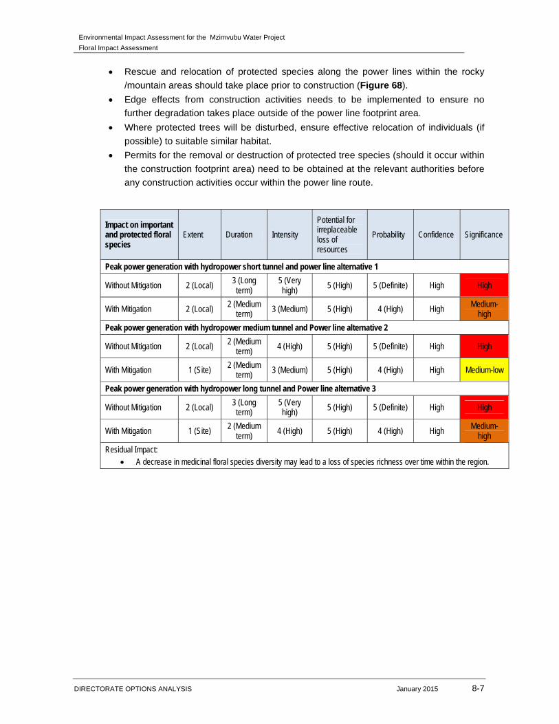
Environmental Impact Assessment for the Mzimvubu Water Project
Floral Impact Assessment
DIRECTORATE OPTIONS ANALYSIS January 2015 8-7
Rescue and relocation of protected species along the power lines within the rocky
/mountain areas should take place prior to construction (Figure 68).
Edge effects from construction activities needs to be implemented to ensure no
further degradation takes place outside of the power line footprint area.
Where protected trees will be disturbed, ensure effective relocation of individuals (if
possible) to suitable similar habitat.
Permits for the removal or destruction of protected tree species (should it occur within
the construction footprint area) need to be obtained at the relevant authorities before
any construction activities occur within the power line route.
Impact on important and protected floral species
Extent Duration Intensity
Potential for irreplaceable loss of resources
Probability Confidence Significance
Peak power generation with hydropower short tunnel and power line alternative 1
Without Mitigation 2 (Local) 3 (Long term)
5 (Very high)
5 (High) 5 (Definite) High High
With Mitigation 2 (Local) 2 (Medium term) 3 (Medium) 5 (High) 4 (High) High Medium-
high
Peak power generation with hydropower medium tunnel and Power line alternative 2
Without Mitigation 2 (Local) 2 (Medium term)
4 (High) 5 (High) 5 (Definite) High High
With Mitigation 1 (Site) 2 (Medium term)
3 (Medium) 5 (High) 4 (High) High Medium-low
Peak power generation with hydropower long tunnel and Power line alternative 3
Without Mitigation 2 (Local) 3 (Long term)
5 (Very high) 5 (High) 5 (Definite) High High
With Mitigation 1 (Site) 2 (Medium term)
4 (High) 5 (High) 4 (High) High Medium-high
Residual Impact: A decrease in medicinal floral species diversity may lead to a loss of species richness over time within the region.
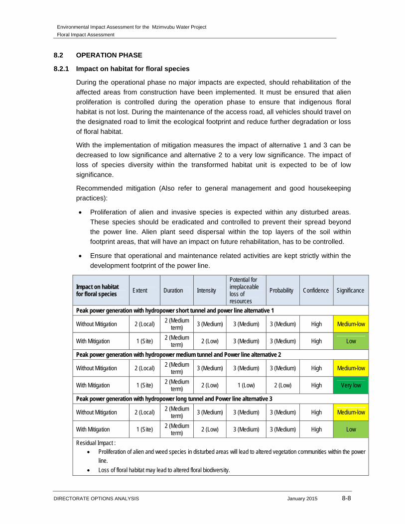
Environmental Impact Assessment for the Mzimvubu Water Project
Floral Impact Assessment
DIRECTORATE OPTIONS ANALYSIS January 2015 8-8
8.2 OPERATION PHASE
8.2.1 Impact on habitat for floral species
During the operational phase no major impacts are expected, should rehabilitation of the
affected areas from construction have been implemented. It must be ensured that alien
proliferation is controlled during the operation phase to ensure that indigenous floral
habitat is not lost. During the maintenance of the access road, all vehicles should travel on
the designated road to limit the ecological footprint and reduce further degradation or loss
of floral habitat.
With the implementation of mitigation measures the impact of alternative 1 and 3 can be
decreased to low significance and alternative 2 to a very low significance. The impact of
loss of species diversity within the transformed habitat unit is expected to be of low
significance.
Recommended mitigation (Also refer to general management and good housekeeping
practices):
Proliferation of alien and invasive species is expected within any disturbed areas.
These species should be eradicated and controlled to prevent their spread beyond
the power line. Alien plant seed dispersal within the top layers of the soil within
footprint areas, that will have an impact on future rehabilitation, has to be controlled.
Ensure that operational and maintenance related activities are kept strictly within the
development footprint of the power line.
Impact on habitat for floral species
Extent Duration Intensity
Potential for irreplaceable loss of resources
Probability Confidence Significance
Peak power generation with hydropower short tunnel and power line alternative 1
Without Mitigation 2 (Local) 2 (Medium term) 3 (Medium) 3 (Medium) 3 (Medium) High Medium-low
With Mitigation 1 (Site) 2 (Medium term)
2 (Low) 3 (Medium) 3 (Medium) High Low
Peak power generation with hydropower medium tunnel and Power line alternative 2
Without Mitigation 2 (Local) 2 (Medium term)
3 (Medium) 3 (Medium) 3 (Medium) High Medium-low
With Mitigation 1 (Site) 2 (Medium term)
2 (Low) 1 (Low) 2 (Low) High Very low
Peak power generation with hydropower long tunnel and Power line alternative 3
Without Mitigation 2 (Local) 2 (Medium term)
3 (Medium) 3 (Medium) 3 (Medium) High Medium-low
With Mitigation 1 (Site) 2 (Medium term)
2 (Low) 3 (Medium) 3 (Medium) High Low
Residual Impact : Proliferation of alien and weed species in disturbed areas will lead to altered vegetation communities within the power
line.
Loss of floral habitat may lead to altered floral biodiversity.

Environmental Impact Assessment for the Mzimvubu Water Project
Floral Impact Assessment
DIRECTORATE OPTIONS ANALYSIS January 2015 8-9
Ineffective rehabilitation may lead to permanent transformation of floral habitat.
8.2.2 Impact on floral diversity
During the operational phase, the power line maintenance and servicing will take place. To
ensure that the ecological footprint does not further decrease, personnel and vehicles
should stay on designed roads. Alien invader proliferation and bush encroachment should
take place to ensure that alien floral species do not encroach into the surrounding natural
areas, specifically the areas associated with a higher floral diversity and sensitivity.
With the implementation of mitigation measures the impact of alternative 1 and 3 can be
decreased to low significance and alternative 2 to very-low significance. The impact of loss
of species diversity within the transformed habitat unit is expected to be of low
significance.
Recommended mitigation (Also refer to general management and good housekeeping
practices):
Proliferation of alien and invasive species is expected within any disturbed areas.
These species should be eradicated and controlled to prevent their spread beyond
the power and pipeline. Alien plant seed dispersal within the top layers of the soil
within footprint areas, that will have an impact on future rehabilitation, has to be
controlled.
Ensure that operational related activities are kept strictly within the development
footprint.
Impact on floral diversity Extent Duration Intensity
Potential for irreplaceable loss of resources
Probability Confidence Significance
Peak power generation with hydropower short tunnel and power line alternative 1
Without Mitigation 2 (Local) 2 (Medium term) 3 (Medium) 3 (Medium) 3 (Medium) High Medium-low
With Mitigation 1 (Site) 2 (Medium
term) 2 (Low) 3 (Medium) 3 (Medium) High Low
Peak power generation with hydropower medium tunnel and Power line alternative 2
Without Mitigation 2 (Local) 2 (Medium
term) 3 (Medium) 3 (Medium) 3 (Medium) High Medium-low
With Mitigation 1 (Site) 2 (Medium term) 2 (Low) 1 (Low) 2 (Low) High Very low
Peak power generation with hydropower long tunnel and Power line alternative 3
Without Mitigation 2 (Local) 2 (Medium
term) 3 (Medium) 3 (Medium) 3 (Medium) High Medium-low
With Mitigation 1 (Site) 2 (Medium term) 2 (Low) 3 (Medium) 3 (Medium) High Low
Residual Impact: Permanent loss of floral diversity within areas where construction has taken place. Alien and invasive species proliferation and bush encroachment into disturbed areas.
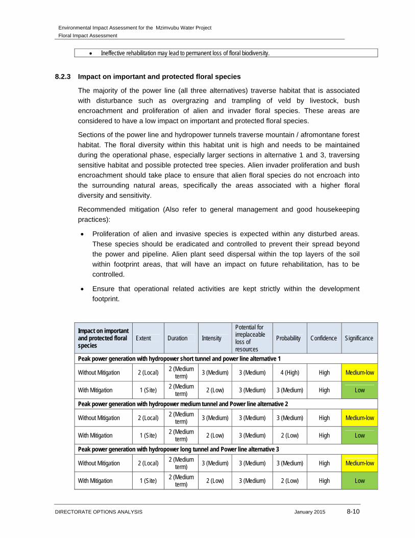
Environmental Impact Assessment for the Mzimvubu Water Project
Floral Impact Assessment
DIRECTORATE OPTIONS ANALYSIS January 2015 8-10
Ineffective rehabilitation may lead to permanent loss of floral biodiversity.
8.2.3 Impact on important and protected floral species
The majority of the power line (all three alternatives) traverse habitat that is associated
with disturbance such as overgrazing and trampling of veld by livestock, bush
encroachment and proliferation of alien and invader floral species. These areas are
considered to have a low impact on important and protected floral species.
Sections of the power line and hydropower tunnels traverse mountain / afromontane forest
habitat. The floral diversity within this habitat unit is high and needs to be maintained
during the operational phase, especially larger sections in alternative 1 and 3, traversing
sensitive habitat and possible protected tree species. Alien invader proliferation and bush
encroachment should take place to ensure that alien floral species do not encroach into
the surrounding natural areas, specifically the areas associated with a higher floral
diversity and sensitivity.
Recommended mitigation (Also refer to general management and good housekeeping
practices):
Proliferation of alien and invasive species is expected within any disturbed areas.
These species should be eradicated and controlled to prevent their spread beyond
the power and pipeline. Alien plant seed dispersal within the top layers of the soil
within footprint areas, that will have an impact on future rehabilitation, has to be
controlled.
Ensure that operational related activities are kept strictly within the development
footprint.
Impact on important and protected floral species
Extent Duration Intensity
Potential for irreplaceable loss of resources
Probability Confidence Significance
Peak power generation with hydropower short tunnel and power line alternative 1
Without Mitigation 2 (Local) 2 (Medium term) 3 (Medium) 3 (Medium) 4 (High) High Medium-low
With Mitigation 1 (Site) 2 (Medium
term) 2 (Low) 3 (Medium) 3 (Medium) High Low
Peak power generation with hydropower medium tunnel and Power line alternative 2
Without Mitigation 2 (Local) 2 (Medium term) 3 (Medium) 3 (Medium) 3 (Medium) High Medium-low
With Mitigation 1 (Site) 2 (Medium term)
2 (Low) 3 (Medium) 2 (Low) High Low
Peak power generation with hydropower long tunnel and Power line alternative 3
Without Mitigation 2 (Local) 2 (Medium term) 3 (Medium) 3 (Medium) 3 (Medium) High Medium-low
With Mitigation 1 (Site) 2 (Medium term) 2 (Low) 3 (Medium) 2 (Low) High Low

Environmental Impact Assessment for the Mzimvubu Water Project
Floral Impact Assessment
DIRECTORATE OPTIONS ANALYSIS January 2015 8-11
Residual Impact: A decrease in medicinal or protected and important floral species diversity may lead to a loss of species richness over
time within the region.
Environmental Impact Assessment for the Mzimvubu Water Project
Floral Impact Assessment
DIRECTORATE OPTIONS ANALYSIS January 2015 9-1
9 IMPACT ASSESSMENT FOR ROADS INFRASTRUCTURE
This Chapter presents the findings of the environmental impact assessment for the road
infrastructure (DEA Ref no. 14/12/16/3/3/1/1169).
The activities included under this chapter are listed below:
Upgrading and relocation of roads and bridges within the Ntabelanga and Lalini Dam;
and
The access road to the long tunnel associated with power line alternative 3.
9.1 CONSTRUCTION AND REHABILITATION PHASES
9.1.1 Impact on habitat for floral species
The roads to be upgraded are existing roads that will serve as access roads to the dams.
The road upgrades are mostly in the Ntabelanga Dam study area. In terms of vegetation
habitat, the edge effects of the existing roads, overgrazed veld and surrounding
community villages has transformed the vegetation to the extent that only grass species
such as Eragrostis curvula, E. chloromelas, Hyparrhenia hirta, Sporobulus africanus and
Cynodon dactylon, which are associated with more disturbed areas, occur alongside the
current access roads. In areas that are associated with disturbance and vegetation
clearance, the impact on further transformation of floral habitat of the road upgrade will be
very low, should all possible mitigation measure be implemented.
Other areas of the road upgrade are located within the higher altitude areas. Indigenous
species such as Aloe marlothii, Aloe ferox and Aloe aborescence occurred alongside the
current road. These areas are more sensitive that the transformed vegetation areas.
Therefore mitigation measure must be implemented to ensure that the footprint area is
kept as small as possible.
Wetland crossings occur alongside the proposed road upgrades. Erosion control measure
such as berms and gabion structures should be implemented to ensure that soil erosion
and sedimentation due to the rod construction does not further decrease the wetland
habitat and function.
New access roads will be constructed in the Lalini Dam area. The majority of the newly
proposed access roads traverse transformed vegetation types. These areas will not be
highly impacted upon since vegetation transformation has already occurred. Access roads
close to the Lalini Dam will have a very high impact on the overall loss of floral habitat,
since these mountain areas provide suitable habitat for numerous indigenous and possible
protected floral species.
Although most of the vegetation where the road upgrades or new roads will be constructed
within the Lalini Dam has been transformed, it is possible that Podocarpus species,
Encephalartos species and other protected and RDL floral species could occur along the
proposed road upgrade and new roads located within the Lalini Dam area, especially in
Environmental Impact Assessment for the Mzimvubu Water Project
Floral Impact Assessment
DIRECTORATE OPTIONS ANALYSIS January 2015 9-2
the Mountain / afromontane forest sections close to the dam wall. Thus the impact of the
road construction will be very high and is not recommended. Alternative routes should be
considered.
New access roads are proposed within the Lalini Dam area. The habitat area (Mountain /
Rocky Outcrops) where the proposed access roads will be situated is considered sensitive
due to the higher floral species diversity and possible suitable habitat for protected
species. It is suggested that a walk down be done for the Lalini HEP and access roads
prior to the construction phase to identify any important Red Data Listed (RDL), medicinal
or protected species. Should any RDL or protected species be located during the walk
down, the necessary authorisation should be obtained to remove, relocate or cut and
destroy these floral species.
It is also proposed that a road will be constructed to access the long hydropower tunnel
and alternative power line 1. This road will be constructed within a highly sensitive habitat
area, containing a high diversity of floral species. Most of the floral species are indigenous
to the area and also provide suitable habitat for protected tree species and other important
and RDL floral species such as Encephalartos species. This increases the diversity and
overall sensitivity of the area. Should the construction of this road continue a large portion
of floral habitat and diversity will be lost. Thus the impact on the immediate and
surrounding area will be very high. This route is thus not recommended due to the high
impacts and loss of floral habitat and diversity.
Recommended mitigation (Also refer to general management and good housekeeping
practices):
Edge effects of all construction activities, such as erosion and alien plant species
proliferation, which may affect floral habitat, need to be strictly managed.
Areas falling outside of the footprint area of the road upgrade should be rehabilitated
with indigenous grass species. Eroded areas, especially in around the wetland
crossings should also be addressed, as per the wetland assessment mitigation
measures.
It is suggested that a walk down be done for the Lalini HEP and access roads prior to
the construction phase to identify any important Red Data Listed (RDL), medicinal or
protected species. Should any RDL or protected species be located during the walk
down, the necessary authorisation should be obtained to remove, relocate or cut and
destroy these floral species.
Permits for the removal or destruction of protected tree species (should it occur within
the construction footprint area) need to be obtained at the relevant authorities before
any construction activities occur.
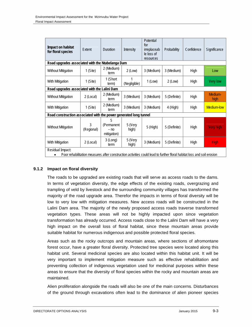
Environmental Impact Assessment for the Mzimvubu Water Project
Floral Impact Assessment
DIRECTORATE OPTIONS ANALYSIS January 2015 9-3
Impact on habitat for floral species Extent Duration Intensity
Potential for irreplaceable loss of resources
Probability Confidence Significance
Road upgrades associated with the Ntabelanga Dam
Without Mitigation 1 (Site) 2 (Medium) term 2 (Low) 3 (Medium) 3 (Medium) High Low
With Mitigation 1 (Site) 1 (Short term)
1 (Negligible) 1 (Low) 2 (Low) High Very low
Road upgrades associated with the Lalini Dam
Without Mitigation 2 (Local) 2 (Medium) term
3 (Medium) 3 (Medium) 5 (Definite) High Medium-high
With Mitigation 1 (Site) 2 (Medium) term 3 (Medium) 3 (Medium) 4 (High) High Medium-low
Road construction associated with the power generated long tunnel
Without Mitigation 3 (Regional)
5 (Permanent
– no mitigation)
5 (Very high) 5 (High) 5 (Definite) High Very high
With Mitigation 2 (Local) 3 (Long)
term 5 (Very high) 3 (Medium) 5 (Definite) High High
Residual Impact: Poor rehabilitation measures after construction activities could lead to further floral habitat loss and soil erosion
9.1.2 Impact on floral diversity
The roads to be upgraded are existing roads that will serve as access roads to the dams.
In terms of vegetation diversity, the edge effects of the existing roads, overgrazing and
trampling of veld by livestock and the surrounding community villages has transformed the
majority of the road upgrade area. Therefor the impacts in terms of floral diversity will be
low to very low with mitigation measures. New access roads will be constructed in the
Lalini Dam area. The majority of the newly proposed access roads traverse transformed
vegetation types. These areas will not be highly impacted upon since vegetation
transformation has already occurred. Access roads close to the Lalini Dam will have a very
high impact on the overall loss of floral habitat, since these mountain areas provide
suitable habitat for numerous indigenous and possible protected floral species.
Areas such as the rocky outcrops and mountain areas, where sections of afromontane
forest occur, have a greater floral diversity. Protected tree species were located along this
habitat unit. Several medicinal species are also located within this habitat unit. It will be
very important to implement mitigation measure such as effective rehabilitation and
preventing collection of indigenous vegetation used for medicinal purposes within these
areas to ensure that the diversity of floral species within the rocky and mountain areas are
maintained.
Alien proliferation alongside the roads will also be one of the main concerns. Disturbances
of the ground through excavations often lead to the dominance of alien pioneer species
Environmental Impact Assessment for the Mzimvubu Water Project
Floral Impact Assessment
DIRECTORATE OPTIONS ANALYSIS January 2015 9-4
that rapidly dominate the area. Invader alien plants can significantly alter the composition,
structure and functionality of ecosystems. As a result, they degrade the productive
potential of the land; intensify the damage caused by veld fires and flooding, increase soil
erosion, and impact on the health of rivers and estuaries. Indigenous species may be
reduced in numbers/coverage, or may be lost as a result of alien plant infestation.
It is also proposed that a road will be constructed to access the long hydropower tunnel
and alternative power line 1. This road will be constructed within a highly sensitive habitat
area, containing a high diversity of floral species. Most of the floral species are indigenous
to the area and also provide suitable habitat for protected tree species and other important
and RDL floral species such as Encephalartos species. This increases the diversity and
overall sensitivity of the area. Should the construction of this road continue a large portion
of floral habitat and diversity will be lost. Thus the impact on the immediate and
surrounding area will be very high. This route is thus not recommended due to the high
impacts and loss of floral habitat and diversity.
Recommended mitigation (Also refer to general management and good housekeeping
practices):
Proliferation of alien and invasive species is expected within any disturbed areas.
These species should be eradicated and controlled to prevent their spread beyond
the road upgrade footprint.
Alien plant seed dispersal within the top layers of the soil within footprint areas, that
will have an impact on future rehabilitation, has to be controlled.
All areas affected by construction should be rehabilitated upon decommissioning of
the construction phase. Areas should be reseeded with indigenous grasses as
required. All rehabilitated areas should be rehabilitated to a point where natural
processes will allow the pre-development ecological functioning and biodiversity of
the area to be re-instated.
Permits for the removal or destruction of protected tree species (should it occur within
the construction footprint area) need to be obtained at the relevant authorities before
any construction activities occur.
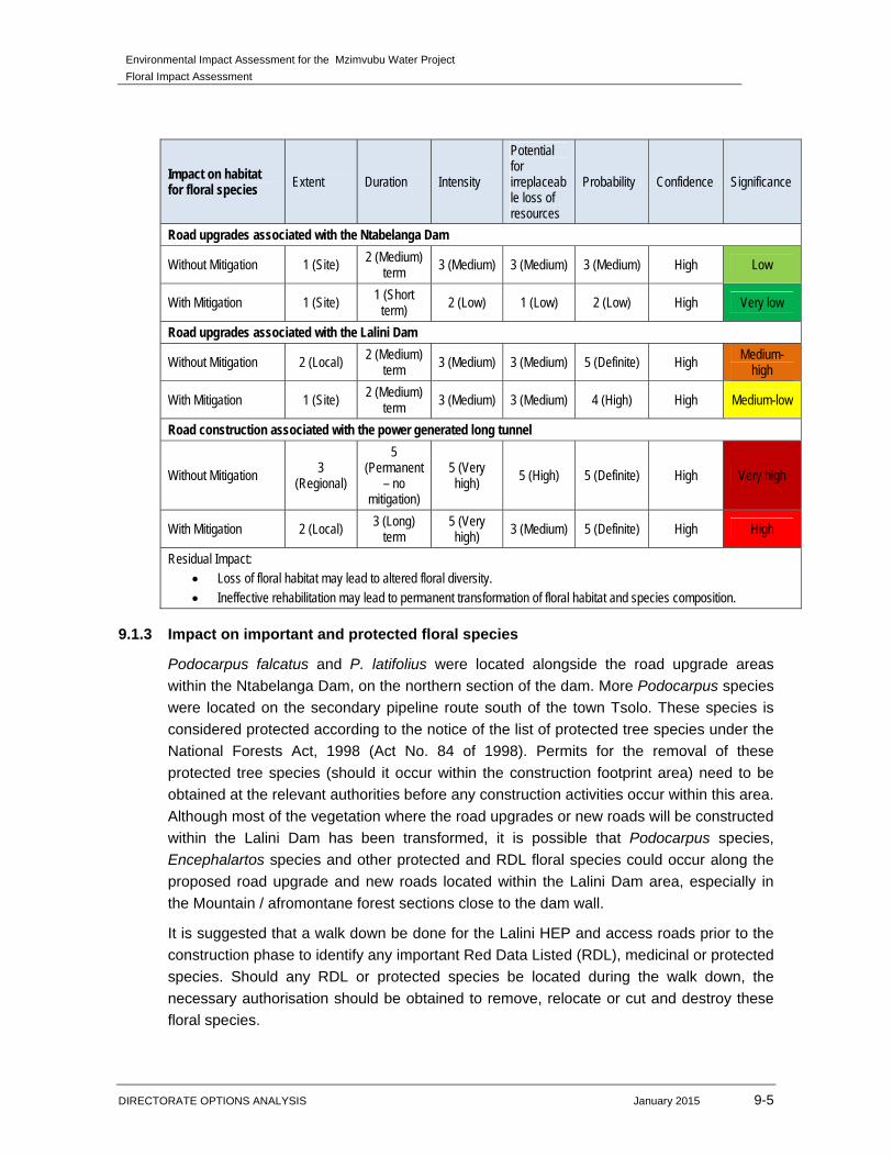
Environmental Impact Assessment for the Mzimvubu Water Project
Floral Impact Assessment
DIRECTORATE OPTIONS ANALYSIS January 2015 9-5
Impact on habitat for floral species Extent Duration Intensity
Potential for irreplaceable loss of resources
Probability Confidence Significance
Road upgrades associated with the Ntabelanga Dam
Without Mitigation 1 (Site) 2 (Medium) term
3 (Medium) 3 (Medium) 3 (Medium) High Low
With Mitigation 1 (Site) 1 (Short term)
2 (Low) 1 (Low) 2 (Low) High Very low
Road upgrades associated with the Lalini Dam
Without Mitigation 2 (Local) 2 (Medium) term 3 (Medium) 3 (Medium) 5 (Definite) High Medium-
high
With Mitigation 1 (Site) 2 (Medium)
term 3 (Medium) 3 (Medium) 4 (High) High Medium-low
Road construction associated with the power generated long tunnel
Without Mitigation 3 (Regional)
5 (Permanent
– no mitigation)
5 (Very high)
5 (High) 5 (Definite) High Very high
With Mitigation 2 (Local) 3 (Long) term
5 (Very high) 3 (Medium) 5 (Definite) High High
Residual Impact: Loss of floral habitat may lead to altered floral diversity. Ineffective rehabilitation may lead to permanent transformation of floral habitat and species composition.
9.1.3 Impact on important and protected floral species
Podocarpus falcatus and P. latifolius were located alongside the road upgrade areas
within the Ntabelanga Dam, on the northern section of the dam. More Podocarpus species
were located on the secondary pipeline route south of the town Tsolo. These species is
considered protected according to the notice of the list of protected tree species under the
National Forests Act, 1998 (Act No. 84 of 1998). Permits for the removal of these
protected tree species (should it occur within the construction footprint area) need to be
obtained at the relevant authorities before any construction activities occur within this area.
Although most of the vegetation where the road upgrades or new roads will be constructed
within the Lalini Dam has been transformed, it is possible that Podocarpus species,
Encephalartos species and other protected and RDL floral species could occur along the
proposed road upgrade and new roads located within the Lalini Dam area, especially in
the Mountain / afromontane forest sections close to the dam wall.
It is suggested that a walk down be done for the Lalini HEP and access roads prior to the
construction phase to identify any important Red Data Listed (RDL), medicinal or protected
species. Should any RDL or protected species be located during the walk down, the
necessary authorisation should be obtained to remove, relocate or cut and destroy these
floral species.
Environmental Impact Assessment for the Mzimvubu Water Project
Floral Impact Assessment
DIRECTORATE OPTIONS ANALYSIS January 2015 9-6
It is also proposed that a road will be constructed to access the long hydropower tunnel
and alternative power line 1. This road will be constructed within a highly sensitive habitat
area, containing a high diversity of floral species. Most of the floral species are indigenous
to the area and also provide suitable habitat for protected tree species and other important
and RDL floral species such as Encephalartos species. This increases the diversity and
overall sensitivity of the area. Should the construction of this road continue a large portion
of floral habitat and diversity will be lost. Thus the impact on the immediate and
surrounding area will be very high. This route is thus not recommended due to the high
impacts and loss of floral habitat and diversity
Other medicinal species such as Aloe species were located along the road upgrade route.
These species and other species should be relocated, if possible, should they occur within
the footprint area of the road upgrade. During construction, collection of these important
species should be prevented to ensure that the diversity of the species within the area is
still maintained. Vehicles used during the construction should also be prevented to drive
through areas outside of the footprint area. This will decrease floral habitat, therefore
suitable habitat for important species to occur. The impact associated with the loss of the
species is considered to be of medium-low significance prior to the implementation of
mitigation measures.
Recommended mitigation (Also refer to general management and good housekeeping
practices):
Protected tree species Podocarpus fulcatus and P. latifolius were located along the
sections scheduled for road upgrades. The following must be ensured:
o Where protected trees will be disturbed, ensure effective relocation of individuals (if
possible) to suitable similar habitat.
o Permit applications must be obtained from relevant authorities.
o Possible re-alignment of the roads where protected tree species were found, in
order to avoid cutting and destroying the trees (Figure 69)
It is suggested that a walk down be done for the Lalini HEP and access roads prior to
the construction phase to identify any important Red Data Listed (RDL), medicinal or
protected species. Should any RDL or protected species be located during the walk
down, the necessary authorisation should be obtained to remove, relocate or cut and
destroy these floral species.
Prohibit the collection of plant material for firewood or for medicinal purposes during
the construction phase.
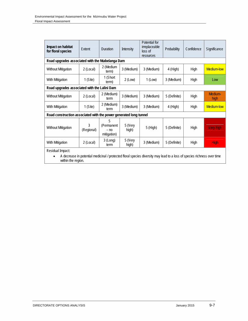
Environmental Impact Assessment for the Mzimvubu Water Project
Floral Impact Assessment
DIRECTORATE OPTIONS ANALYSIS January 2015 9-7
Impact on habitat for floral species Extent Duration Intensity
Potential for irreplaceable loss of resources
Probability Confidence Significance
Road upgrades associated with the Ntabelanga Dam
Without Mitigation 2 (Local) 2 (Medium term) 3 (Medium) 3 (Medium) 4 (High) High Medium-low
With Mitigation 1 (Site) 1 (Short
term) 2 (Low) 1 (Low) 3 (Medium) High Low
Road upgrades associated with the Lalini Dam
Without Mitigation 2 (Local) 2 (Medium) term 3 (Medium) 3 (Medium) 5 (Definite) High Medium-
high
With Mitigation 1 (Site) 2 (Medium)
term 3 (Medium) 3 (Medium) 4 (High) High Medium-low
Road construction associated with the power generated long tunnel
Without Mitigation 3
(Regional)
5 (Permanent
– no mitigation)
5 (Very high) 5 (High) 5 (Definite) High Very high
With Mitigation 2 (Local) 3 (Long) term
5 (Very high)
3 (Medium) 5 (Definite) High High
Residual Impact: A decrease in potential medicinal / protected floral species diversity may lead to a loss of species richness over time
within the region.
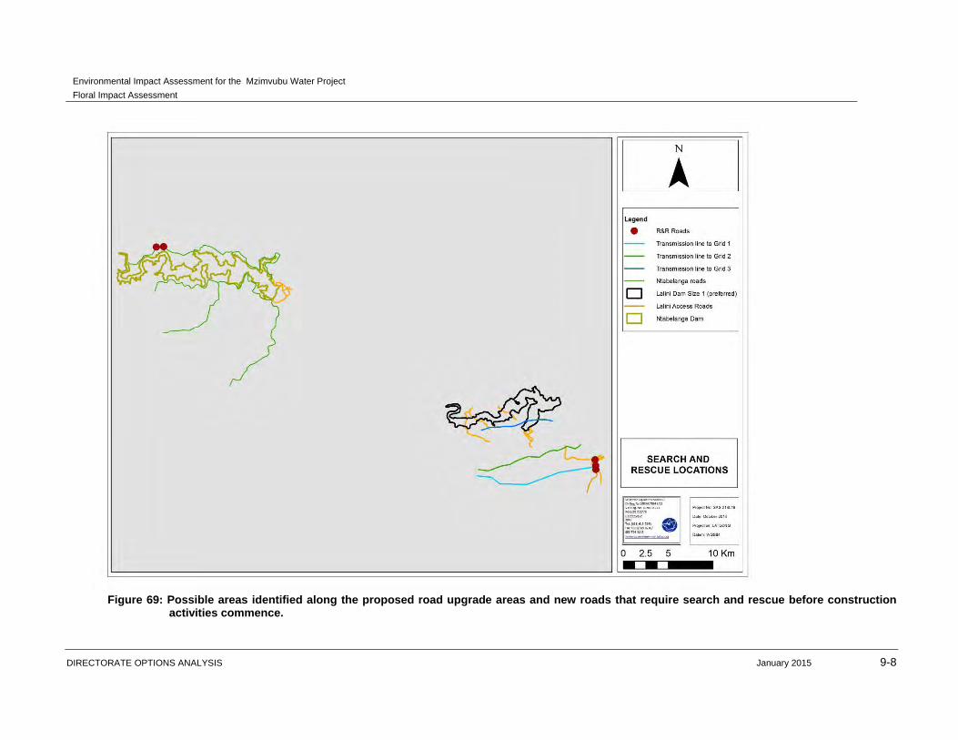
Environmental Impact Assessment for the Mzimvubu Water Project
Floral Impact Assessment
DIRECTORATE OPTIONS ANALYSIS January 2015 9-8
Figure 69: Possible areas identified along the proposed road upgrade areas and new roads that require search and rescue before construction
activities commence.
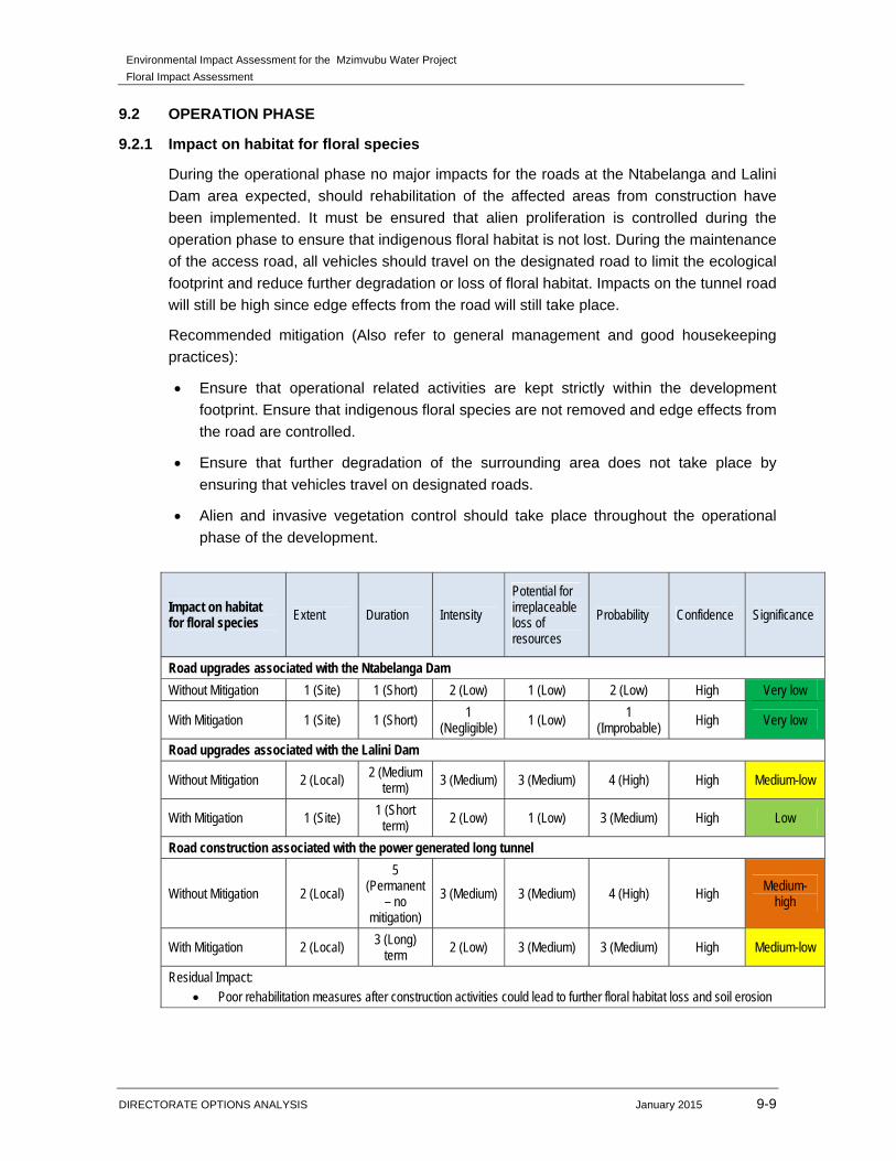
Environmental Impact Assessment for the Mzimvubu Water Project
Floral Impact Assessment
DIRECTORATE OPTIONS ANALYSIS January 2015 9-9
9.2 OPERATION PHASE
9.2.1 Impact on habitat for floral species
During the operational phase no major impacts for the roads at the Ntabelanga and Lalini
Dam area expected, should rehabilitation of the affected areas from construction have
been implemented. It must be ensured that alien proliferation is controlled during the
operation phase to ensure that indigenous floral habitat is not lost. During the maintenance
of the access road, all vehicles should travel on the designated road to limit the ecological
footprint and reduce further degradation or loss of floral habitat. Impacts on the tunnel road
will still be high since edge effects from the road will still take place.
Recommended mitigation (Also refer to general management and good housekeeping
practices):
Ensure that operational related activities are kept strictly within the development
footprint. Ensure that indigenous floral species are not removed and edge effects from
the road are controlled.
Ensure that further degradation of the surrounding area does not take place by
ensuring that vehicles travel on designated roads.
Alien and invasive vegetation control should take place throughout the operational
phase of the development.
Impact on habitat for floral species Extent Duration Intensity
Potential for irreplaceable loss of resources
Probability Confidence Significance
Road upgrades associated with the Ntabelanga Dam
Without Mitigation 1 (Site) 1 (Short) 2 (Low) 1 (Low) 2 (Low) High Very low
With Mitigation 1 (Site) 1 (Short) 1 (Negligible) 1 (Low) 1
(Improbable) High Very low
Road upgrades associated with the Lalini Dam
Without Mitigation 2 (Local) 2 (Medium term) 3 (Medium) 3 (Medium) 4 (High) High Medium-low
With Mitigation 1 (Site) 1 (Short
term) 2 (Low) 1 (Low) 3 (Medium) High Low
Road construction associated with the power generated long tunnel
Without Mitigation 2 (Local)
5 (Permanent
– no mitigation)
3 (Medium) 3 (Medium) 4 (High) High Medium-
high
With Mitigation 2 (Local) 3 (Long) term
2 (Low) 3 (Medium) 3 (Medium) High Medium-low
Residual Impact: Poor rehabilitation measures after construction activities could lead to further floral habitat loss and soil erosion
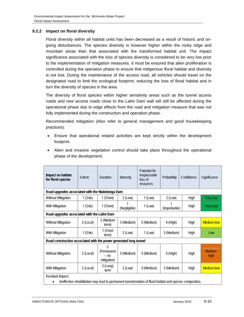
Environmental Impact Assessment for the Mzimvubu Water Project
Floral Impact Assessment
DIRECTORATE OPTIONS ANALYSIS January 2015 9-10
9.2.2 Impact on floral diversity
Floral diversity within all habitat units has been decreased as a result of historic and on-
going disturbances. The species diversity is however higher within the rocky ridge and
mountain areas than that associated with the transformed habitat unit. The impact
significance associated with the loss of species diversity is considered to be very low prior
to the implementation of mitigation measures. It must be ensured that alien proliferation is
controlled during the operation phase to ensure that indigenous floral habitat and diversity
is not lost. During the maintenance of the access road, all vehicles should travel on the
designated road to limit the ecological footprint, reducing the loss of floral habitat and in
turn the diversity of species in the area.
The diversity of floral species within higher sensitivity areas such as the tunnel access
roads and new access roads close to the Lalini Dam wall will still be affected during the
operational phase due to edge effects from the road and mitigation measure that was not
fully implemented during the construction and operation phase.
Recommended mitigation (Also refer to general management and good housekeeping
practices):
Ensure that operational related activities are kept strictly within the development
footprint.
Alien and invasive vegetation control should take place throughout the operational
phase of the development.
Impact on habitat for floral species Extent Duration Intensity
Potential for irreplaceable loss of resources
Probability Confidence Significance
Road upgrades associated with the Ntabelanga Dam
Without Mitigation 1 (Site) 1 (Short) 2 (Low) 1 (Low) 2 (Low) High Very low
With Mitigation 1 (Site) 1 (Short) 1 (Negligible) 1 (Low) 1
(Improbable) High Very low)
Road upgrades associated with the Lalini Dam
Without Mitigation 2 (Local) 2 (Medium
term) 3 (Medium) 3 (Medium) 4 (High) High Medium-low
With Mitigation 1 (Site) 1 (Short term)
2 (Low) 1 (Low) 3 (Medium) High Low
Road construction associated with the power generated long tunnel
Without Mitigation 2 (Local)
5 (Permanent
– no mitigation)
3 (Medium) 3 (Medium) 4 (High) High Medium-high
With Mitigation 2 (Local) 3 (Long)
term 2 (Low) 3 (Medium) 3 (Medium) High Medium-low
Residual Impact: Ineffective rehabilitation may lead to permanent transformation of floral habitat and species composition.
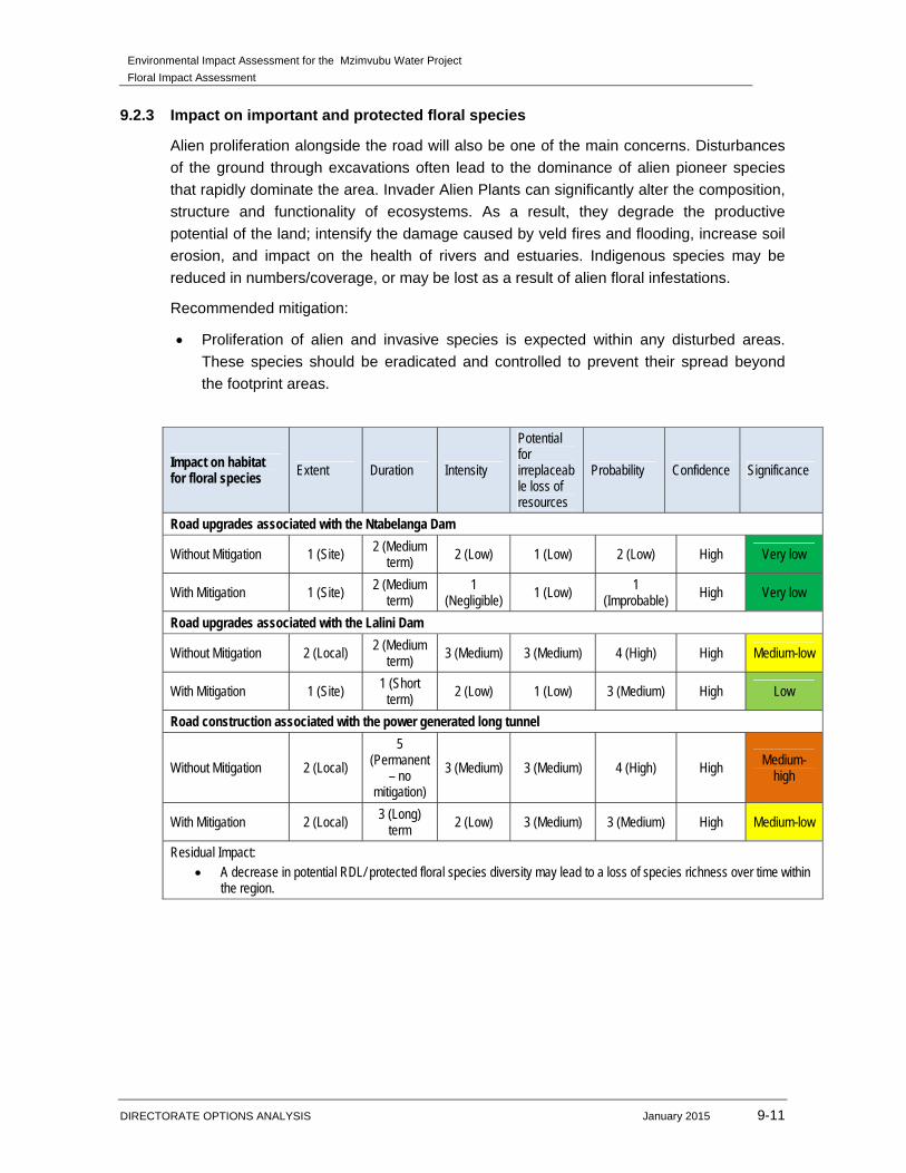
Environmental Impact Assessment for the Mzimvubu Water Project
Floral Impact Assessment
DIRECTORATE OPTIONS ANALYSIS January 2015 9-11
9.2.3 Impact on important and protected floral species
Alien proliferation alongside the road will also be one of the main concerns. Disturbances
of the ground through excavations often lead to the dominance of alien pioneer species
that rapidly dominate the area. Invader Alien Plants can significantly alter the composition,
structure and functionality of ecosystems. As a result, they degrade the productive
potential of the land; intensify the damage caused by veld fires and flooding, increase soil
erosion, and impact on the health of rivers and estuaries. Indigenous species may be
reduced in numbers/coverage, or may be lost as a result of alien floral infestations.
Recommended mitigation:
Proliferation of alien and invasive species is expected within any disturbed areas.
These species should be eradicated and controlled to prevent their spread beyond
the footprint areas.
Impact on habitat for floral species Extent Duration Intensity
Potential for irreplaceable loss of resources
Probability Confidence Significance
Road upgrades associated with the Ntabelanga Dam
Without Mitigation 1 (Site) 2 (Medium term)
2 (Low) 1 (Low) 2 (Low) High Very low
With Mitigation 1 (Site) 2 (Medium term)
1 (Negligible)
1 (Low) 1 (Improbable)
High Very low
Road upgrades associated with the Lalini Dam
Without Mitigation 2 (Local) 2 (Medium term)
3 (Medium) 3 (Medium) 4 (High) High Medium-low
With Mitigation 1 (Site) 1 (Short term)
2 (Low) 1 (Low) 3 (Medium) High Low
Road construction associated with the power generated long tunnel
Without Mitigation 2 (Local)
5 (Permanent
– no mitigation)
3 (Medium) 3 (Medium) 4 (High) High Medium-
high
With Mitigation 2 (Local) 3 (Long)
term 2 (Low) 3 (Medium) 3 (Medium) High Medium-low
Residual Impact: A decrease in potential RDL/ protected floral species diversity may lead to a loss of species richness over time within
the region.
Environmental Impact Assessment for the Mzimvubu Water Project
Floral Impact Assessment
DIRECTORATE OPTIONS ANALYSIS January 2015 10-1
10 IMPACT ASSESSMENT FOR THE NO PROJECT ALTERNATIVE
This Chapter presents the findings of the environmental impact assessment for the no-
project alternative. The no-project alternative includes no construction of the dams or
related infrastructure. This would mean that
No sensitive and indigenous floral species will be lost;
No permit application would be required for the removal of protected tree species
located along the road upgrade section in Ntabelanga Dam or along the secondary
pipeline routes, south of Tsolo;
No floral habitat (riparian, wetland or indigenous woody species habitat) will be lost;
The diversity of floral species will not decrease;
The current impacts such as overgrazed veld and alien proliferation along the riparian
features will continue. Thus the ecological state of these areas will not improve if the
no project alternative is implemented.
Environmental Impact Assessment for the Mzimvubu Water Project
Floral Impact Assessment
DIRECTORATE OPTIONS ANALYSIS January 2015 11-1
11 MITIGATION HIERARCHY AND OFFSET DISCUSSION
‘Mitigation’ is a broad term that covers all components of the ‘mitigation hierarchy’ defined
hereunder. It involves selecting and implementing measures – amongst others – to
conserve biodiversity and to protect, the users of biodiversity and other affected
stakeholders from potentially adverse impacts as a result of development. The aim is to
prevent adverse impacts from occurring or, where this is unavoidable, to limit their
significance to an acceptable level. Offsetting of impacts is considered to be the last option
in the mitigation hierarchy for any project.
The mitigation hierarchy in general consists of the following in order of which impacts
should be mitigated (DEA at al. 2013):
1. Avoid/prevent impact: can be done through utilising alternative sites, technology and
scale of projects to prevent impacts. In some cases if impacts are expected to be too
high the “no project” option should also be considered, especially where it is expected
that the lower levels of mitigation will not be adequate to limit environmental damage
and eco-service provision to suitable levels;
2. Minimise impact: can be done through utilisation of alternatives that will ensure that
impacts on biodiversity and ecoservices provision are reduced. Impact minimisation is
considered an essential part of any development project;
3. Rehabilitate impact is applicable to areas where impact avoidance and minimisation
are unavoidable where an attempt to re-instate impacted areas and return them to
conditions which are ecologically similar to the pre-project condition or an agreed post
project land use, for example arable land. Rehabilitation often only restores ecological
function to some degree to avoid ongoing negative impacts and to minimise aesthetic
damage to the setting of a project.
4. Offset impact: refers to compensating for latent or unavoidable negative impacts on
biodiversity. Offsetting should take place to address any impacts deemed to be
unacceptable which cannot be mitigated through the other mechanisms in the
mitigation hierarchy. The objective of biodiversity offsets should be to ensure no net
loss of biodiversity. Biodiversity offsets can be considered to be a last resort to
compensate for residual negative impacts on biodiversity.
Following the assessment of the resources within the study area, impacts associated with
the project, with specific mention of the construction of the Ntabelanga and Lalini Dams
and their associated infrastructure, are deemed high, largely due to the impact
assessment method. Nevertheless, the impacts are considered acceptable when taking
into account the socio-economic value of the dams compared to the residual impacts on
floral biodiversity. Whilst sections of floral habitat within the study area are considered to
be ecologically important and sensitive on a localised and provincial scale, these habitats
have already undergone varying degrees of transformation due to ongoing anthropogenic
activities within the area, thus the integrity and overall value of these areas has been
compromised to some extent. Residual impacts such as the locality of protected trees and
cremnophyte habitats are deemed unlikely to be mitigated by offsetting these habitats thus
Environmental Impact Assessment for the Mzimvubu Water Project
Floral Impact Assessment
DIRECTORATE OPTIONS ANALYSIS January 2015 11-2
limiting the significance of an offset programme. The mitigation hierarchy as defined above
should nonetheless be implemented accordingly in order to minimise the significance of
the impact of the proposed development to ensure that regional conservation targets and
objectives are met while still ensuring sustainable development. Although our opinion that
a formal offset is not required, “green” initiatives could possibly contribute to the overall
success and value to the project.
Environmental Impact Assessment for the Mzimvubu Water Project
Floral Impact Assessment
DIRECTORATE OPTIONS ANALYSIS January 2015 12-1
12 CONSULTATION PROCESS
12.1 CONSULTATION PROCESS FOLLOWED
PUBLIC PARTICIPATION
Engagement with Interested and Affected Parties (I&APs) forms an integral component of the
EIA process. I&APs have an opportunity at various stages throughout the EIA process to gain
more knowledge about the proposed project, to provide input into the process and to verify that
their issues and concerns have been addressed.
The proposed project was announced in April 2014 to elicit comment from and register I&APs
from as broad a spectrum of public as possible. The announcement was done by the following
means:
The distribution of Background Information Documents (BIDs) in English and IsiXhosa;
Placement of site notices in the project area and Municipal offices (Tsolo and Qumbu);
Placement of advertisements in one regional (The Herald) and two local (Daily Dispatch and
the Mthatha Fever) newspapers; and
Publication of all available information on the DWS web site (www.dwa.gov.za/mzimvubu).
The Draft Scoping Report (DSR) was made available for a 30 day public comment period in May
2014. All documents were uploaded to the web, notification letters were sent out, the summary of
the DSR was translated into isiXhosa, distributed to all registered stakeholders and hardcopies
of the full report and translated summary report were available at public places. Additionally,
three public meetings were held in the affected areas, Siqhungqwini, Tsolo and Lalini
respectively. An Authorities Forum Meeting with all relevant authorities was held in the Eastern
Cape on the 28 May 2014. This was to assist the authorities with commenting on the relevant
documentation.
Comments received from stakeholders were captured in the Issues and Response Report (IRR)
which formed part of the Final Scoping Report (FSR). The FSR was made available to the public
for a 21 day comment period on 13 June 2014 and was submitted to the Department of
Environmental Affairs (DEA). Comments received during the Final Scoping public comment
period were compiled and an updated IRR was submitted to DEA on 8 July 204 and uploaded to
the website. The FSR was accepted by DEA with certain conditions on 15 July 2014. Following
this, a newsletter was compiled and translated to isiXhosa, explaining everything that has
happened to date as well as what is to come. Both the English and isiXhosa versions were
electronically distributed to all registered stakeholders and hardcopies were distributed by the
local facilitators in the affected areas.
The Draft Environmental Impact Assessment Report (DEIR), its summary (translated into
isiXhosa), the various specialist studies, the Environmental Management Programmes (one for
the construction and operation of the project, and one for the borrow areas and quarries) as well
as the Water Use Licence Application will be made available for a period of thirty (30 days) for
stakeholders to comment. Hardcopies will be made available at the same venues as the DSR
and all documents will be uploaded to the website. The availability of these documents as well as
the announcement of the upcoming public meetings in Siqhungqwini, Tsolo and Lalini will be
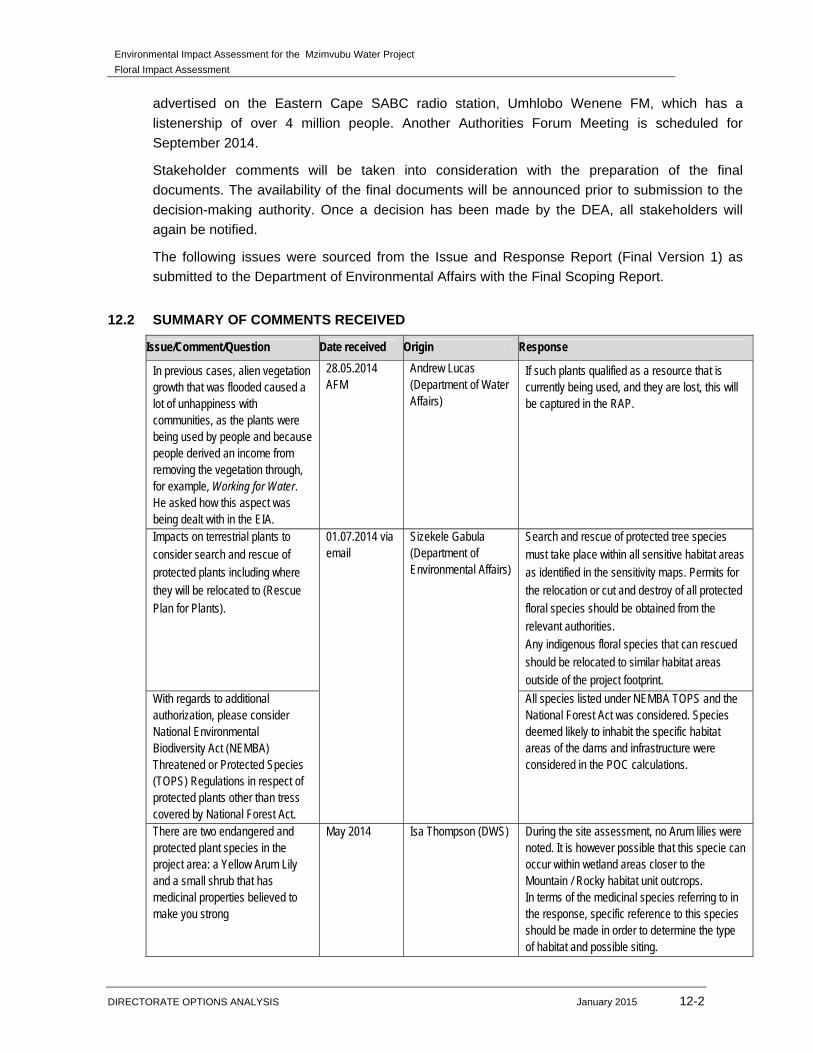
Environmental Impact Assessment for the Mzimvubu Water Project
Floral Impact Assessment
DIRECTORATE OPTIONS ANALYSIS January 2015 12-2
advertised on the Eastern Cape SABC radio station, Umhlobo Wenene FM, which has a
listenership of over 4 million people. Another Authorities Forum Meeting is scheduled for
September 2014.
Stakeholder comments will be taken into consideration with the preparation of the final
documents. The availability of the final documents will be announced prior to submission to the
decision-making authority. Once a decision has been made by the DEA, all stakeholders will
again be notified.
The following issues were sourced from the Issue and Response Report (Final Version 1) as
submitted to the Department of Environmental Affairs with the Final Scoping Report.
12.2 SUMMARY OF COMMENTS RECEIVED
Issue/Comment/Question Date received Origin Response
In previous cases, alien vegetation growth that was flooded caused a lot of unhappiness with communities, as the plants were being used by people and because people derived an income from removing the vegetation through, for example, Working for Water. He asked how this aspect was being dealt with in the EIA.
28.05.2014 AFM
Andrew Lucas (Department of Water Affairs)
If such plants qualified as a resource that is currently being used, and they are lost, this will be captured in the RAP.
Impacts on terrestrial plants to consider search and rescue of protected plants including where they will be relocated to (Rescue Plan for Plants).
01.07.2014 via email
Sizekele Gabula (Department of Environmental Affairs)
Search and rescue of protected tree species must take place within all sensitive habitat areas as identified in the sensitivity maps. Permits for the relocation or cut and destroy of all protected floral species should be obtained from the relevant authorities. Any indigenous floral species that can rescued should be relocated to similar habitat areas outside of the project footprint.
With regards to additional authorization, please consider National Environmental Biodiversity Act (NEMBA) Threatened or Protected Species (TOPS) Regulations in respect of protected plants other than tress covered by National Forest Act.
All species listed under NEMBA TOPS and the National Forest Act was considered. Species deemed likely to inhabit the specific habitat areas of the dams and infrastructure were considered in the POC calculations.
There are two endangered and protected plant species in the project area: a Yellow Arum Lily and a small shrub that has medicinal properties believed to make you strong
May 2014 Isa Thompson (DWS) During the site assessment, no Arum lilies were noted. It is however possible that this specie can occur within wetland areas closer to the Mountain / Rocky habitat unit outcrops. In terms of the medicinal species referring to in the response, specific reference to this species should be made in order to determine the type of habitat and possible siting.

Environmental Impact Assessment for the Mzimvubu Water Project
Floral Impact Assessment
DIRECTORATE OPTIONS ANALYSIS January 2015 12-3
Environmental Impact Assessment for the Mzimvubu Water Project
Floral Impact Assessment
DIRECTORATE OPTIONS ANALYSIS January 2015 13-1
13 OTHER INFORMATION REQUESTED BY THE AUTHORITY
DEA requested that a map of vegetation types in the study area be provided. This is
included in Figures 13 to 15.
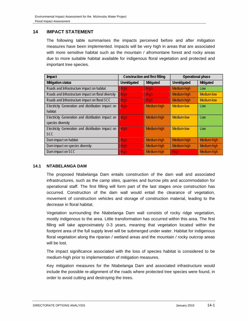
Environmental Impact Assessment for the Mzimvubu Water Project
Floral Impact Assessment
DIRECTORATE OPTIONS ANALYSIS January 2015 14-1
14 IMPACT STATEMENT
The following table summarises the impacts perceived before and after mitigation
measures have been implemented. Impacts will be very high in areas that are associated
with more sensitive habitat such as the mountain / afromontane forest and rocky areas
due to more suitable habitat available for indigenous floral vegetation and protected and
important tree species.
Impact Construction and first filling Operational phase
Mitigation status Unmitigated Mitigated Unmitigated Mitigated
Roads and Infrastructure impact on habitat High High Medium-high Low
Roads and Infrastructure impact on floral diversity High High Medium-high Medium-low
Roads and Infrastructure impact on floral SCC High High Medium-high Medium-low
Electricity Generation and distribution impact on habitat
High Medium-high Medium-low Low
Electricity Generation and distribution impact on species diversity
High Medium-high Medium-low Low
Electricity Generation and distribution impact on SCC
High Medium-high Medium-low Low
Dam impact on habitat High Medium-high Medium-high Medium-high
Dam impact on species diversity High Medium-high Medium-high Medium-high
Dam impact on SCC High Medium-high High Medium-high
14.1 NTABELANGA DAM
The proposed Ntabelanga Dam entails construction of the dam wall and associated
infrastructures, such as the camp sites, quarries and burrow pits and accommodation for
operational staff. The first filling will form part of the last stages once construction has
occurred. Construction of the dam wall would entail the clearance of vegetation,
movement of construction vehicles and storage of construction material, leading to the
decrease in floral habitat.
Vegetation surrounding the Ntabelanga Dam wall consists of rocky ridge vegetation,
mostly indigenous to the area. Little transformation has occurred within this area. The first
filling will take approximately 0-3 years, meaning that vegetation located within the
footprint area of the full supply level will be submerged under water. Habitat for indigenous
floral vegetation along the riparian / wetland areas and the mountain / rocky outcrop areas
will be lost.
The impact significance associated with the loss of species habitat is considered to be
medium-high prior to implementation of mitigation measures.
Key mitigation measures for the Ntabelanga Dam and associated infrastructure would
include the possible re-alignment of the roads where protected tree species were found, in
order to avoid cutting and destroying the trees.
Environmental Impact Assessment for the Mzimvubu Water Project
Floral Impact Assessment
DIRECTORATE OPTIONS ANALYSIS January 2015 14-2
14.2 LALINI DAM
The Lalini Dam footprint consists mainly of transformed vegetation due to the surrounding
rural communities clearing vegetation for small scale agricultural activities. Thus large
sections of the Lalini Dam basin have undergone vegetation transformation, also caused
by overgrazing and trampling of veld by livestock.
More sensitive habitat (Euphorbia forest) located closer to the dam wall will be affected by
the construction of the dam wall and the first filling phase. Vegetation habitat for numerous
and sensitive indigenous vegetation will be lost. No protected or RDL floral or tree species
were located during the time of the site assessment, but there is a high probability that
such species could be present within this habitat unit. The impacts of the loss of protected
species will be medium-high to high due to the suitable habitat available for protected
woody species to occur.
The impact significance associated with the loss of species habitat is considered to be
high prior to implementation of mitigation measures. Rescue and relocation measures can
be implemented in more sensitive areas such as the mountain/rocky ridge habitat before
construction commences. Floral species need to be relocated to similar habitat types,
outside of infrastructure footprint areas.
For the Lalini Dam construction, three alternatives were given. The alternatives covering
the least amount of floral and especially sensitive floral vegetation and habitat should be
considered. Therefore Alternative 2 would be the more preferred alternative.
Another aspect that should be considered is the type of vegetation and the growth of
specific floral species such as cremnophytes. The cremnophytes are floral species, mostly
succulents that are associated with cliffs but have distributions that extent to non-cliff
habitats. Some species include Crassula cultrate, C. perforate, C. rupestris, Haemanthus
albiflos and Portulacaria afra. Water-holding capacity is important as it directly relates to
cliff vegetation. Mostly obligate succulent cremnophytes have a relatively shallow root
system and are found on cliffs that dry out rapidly (van Jaarsveld, 2011). Thus, the aspect
of a lower overall flow rate at the Tsitsa waterfall, thus decreasing the amount of mist
spray and water availability to the surrounding vegetation on the cliffs or within the gorge,
needs to be taken into account. It is proposed that a detailed baseline study be conducted
to determine the sensitivity of this area before any construction activities commence.
Should any medicinal important or RDL species be located within this area during the site
assessment, it is recommended that these species identified be rescues and relocated to
similar habitat e.g. the upstream waterfall area. Where applicable, permit applications
should be obtained from the relevant authority to rescue and relocate these species.
14.3 PRIMARY AND SECONDARY PIPELINES AND IRRIGATION PIPELINES
The primary and secondary pipeline will be constructed close to main or existing roads.
Protected tree species located along the secondary pipeline route will be lost should re-
alignment of these road not be considered. In terms of vegetation habitat, the edge effects
of the existing roads, overgrazed veld and surrounding community villages have
Environmental Impact Assessment for the Mzimvubu Water Project
Floral Impact Assessment
DIRECTORATE OPTIONS ANALYSIS January 2015 14-3
transformed the vegetation to the extent that only grass species, which are associated with
more disturbed areas, occur alongside the current access roads. In areas that are
associated with disturbance and vegetation clearance, the impact on further
transformation of floral habitat of the pipelines will be low, should all possible mitigation
measure be implemented.
The irrigation pipelines are mostly situated south of the township of Tsolo. The majority of
the sections for the proposed pipelines will be along existing dirt roads. Other vegetation
habitat units that the pipelines traverse which have been transformed due to historic and
on-going small scale agricultural activities include wetland habitat and rocky areas. The
northern section of the irrigation pipeline traverses a woody vegetation habitat area that
seems to be more diverse in floral tree species than the rest of the pipeline route. It is
possible that protected tree species, favouring afromontane habitat, could occur along the
pipeline route or in the surrounding area.
14.4 ROAD UPGRADES
The roads to be upgraded are existing roads that will serve as access roads to the dams.
In terms of vegetation diversity, the edge effects of the existing roads, overgrazing and
trampling of veld by livestock and the surrounding community villages, have transformed
the majority of the road upgrade areas. Alien proliferation alongside the road will also be
one of the main concerns. Protected tree species located along the road upgrade area
within the Ntabelanga Dam, will be lost.
New access roads will be constructed in the Lalini Dam area. The majority of the newly
proposed access roads traverse transformed vegetation types. These areas will not be
highly impacted upon since vegetation transformation has already occurred. Access roads
close to the Lalini Dam wall will have a very high impact on the overall loss of floral habitat,
since these mountain areas provide suitable habitat for numerous indigenous and possible
protected floral species.
It is also proposed that a road will be constructed to access the long hydropower tunnel
and corresponding alternative power line. This road will be constructed within a highly
sensitive habitat area, containing a high diversity of floral species. Most of the floral
species are indigenous to the area and also provide suitable habitat for protected tree
species and other important and RDL floral species such as Encephalartos species. This
increases the diversity and overall sensitivity of the area. Should the construction of this
road continue a large portion of floral habitat and diversity will be lost. Thus the impact on
the immediate and surrounding area will be very high. This route is thus not recommended
due to the high impacts and loss of floral habitat and diversity.
Key mitigation measures would include planning of routes within low sensitivity areas,
edge effects from the construction activity must be kept to a minimum and permit
applications for protected tree species Podocarpus fulcatus and P. latifolius located along
the sections scheduled for road upgrades.
Environmental Impact Assessment for the Mzimvubu Water Project
Floral Impact Assessment
DIRECTORATE OPTIONS ANALYSIS January 2015 14-4
14.5 POWER GENERATION WITH HYDROPOWER TUNNELS AND POWER LINE
ALTERNATIVES
The majority of the power lines will traverse transformed (grassland) habitat units, where
grasslands and mostly Acacia karroo and Acacia caffra occur. The transformed habitat
unit has been significantly disturbed as a result of historic and on-going agricultural
activities and overgrazing of veld. The floral habitat within this habitat unit is therefore
largely transformed and placement of infrastructure within this habitat unit will most likely
have low impact significance.
Sections of the power line closer to the Tsitsa River will traverse more sensitive habitat
associated with mountain / afromontane forests and rocky outcrop habitat. These areas
are more sensitive in terms of less vegetation disturbance, great floral diversity and
suitable habitat for important and protected species such as Podocarpus and
Encephalartos species. Vegetation clearance within this sensitive habitat will take place,
resulting in the removal of protected and important species.
All three sections of the power line alternatives, closer to the Tsitsa River will traverse
more sensitive habitat associated with Mountain Rocky Outcrop habitat. Due to the
sensitive habitat and diversity of species occurring within these sections, placement of
support towers will need to be considered, as indigenous and possible important /
protected floral vegetation will be affected. According to the impact assessment results,
the power line alternative 1 and 3 will have a much higher impact, even if mitigated due to
the power lines crossing larger sections of indigenous and possible protected trees and
other floral species. The more preferred power line alternative would be alternative 2 due
to a lower impact on the receiving environment. Key mitigation measures include rescue
and relocation of protected tree species in high sensitive areas as per the sensitivity map
(Figure 64). Permits for the removal of these protected tree species (should it occur within
the construction footprint area) need to be obtained at the relevant authorities before any
construction activities occur within this area.
14.6 KEY MITIGATION MEASURES
Proliferation of alien and invasive species is expected within any disturbed areas.
These species should be eradicated and controlled to prevent their spread beyond
the footprint areas.
Protected tree species Podocarpus fulcatus and P. latifolius were located along the
sections scheduled for road upgrades. The following must be ensured:
o Where protected trees will be disturbed, ensure effective relocation of individuals (if
possible) to suitable similar habitat.
o Permit applications must be obtained from relevant authorities.
o Possible re-alignment of the roads where protected tree species were found, in
order to avoid cutting and destroying the trees.
It is suggested that a walk down be done (according to the flowering seasons for
identification of species) for the Lalini HEP and access roads prior to the construction
Environmental Impact Assessment for the Mzimvubu Water Project
Floral Impact Assessment
DIRECTORATE OPTIONS ANALYSIS January 2015 14-5
phase to identify any important Red Data Listed (RDL), medicinal or protected
species. Should any RDL or protected species be located during the walk down, the
necessary authorisation should be obtained to remove, relocate or cut and destroy
these floral species.
Prohibit the collection of plant material, outside of the proposed dam basins, for
firewood or for medicinal purposes during the construction phase by construction
staff.
Restrict vehicles as far as possible to travel on designated roadways to limit the
ecological footprint.
Environmental Impact Assessment for the Mzimvubu Water Project
Floral Impact Assessment
DIRECTORATE OPTIONS ANALYSIS January 2015 15-1
15 CONCLUSION AND RECOMMENDATIONS
The ecology in the vicinity of the three focal points of the study, namely the Ntabelanga
Dam, Lalini Dam and the associated infrastructure (road upgrades / roads to be re-
surfaced or new roads and primary and secondary pipelines and sections of the power
lines and tunnels) has undergone vegetation transformation due to historic agricultural
activities, overgrazing and trampled veld from livestock from the local communities, alien
proliferation along the riparian features and bush encroachment due to poor management
measures. Other areas where less vegetation transformation has occurred and more
natural and indigenous vegetation is still present includes section of the power lines, Lalini
Dam wall and associated new roads and portions within the Ntabelanga Dam basin and
associated road upgrades.
The following conclusions were made based on the assessment of the various habitat
units:
The ecological function and habitat of the Mountain / Rocky Outcrops habitat unit is
considered to be moderate to high due to the few disturbances from agricultural
activities, overgrazing and alien floral encroachment. In terms of conservation value,
the moderate to high ecological functionality, good habitat integrity, the low incidence
of bush or alien floral encroachment, combine to increase the ecological sensitivity of
this habitat unit. No protected or RDL floral or tree species were located during the
time of the site assessment but there is a high probability that such species could be
present within this habitat unit;
A decrease in floral diversity has occurred as a result of the edge effects from
ploughing and crop cultivation, overgrazing, trampling by livestock and vegetation
clearance causing severe soil erosion. The Grassland / Acacia Thornveld habitat unit
is considered to have a low ecological sensitivity and low conservation value due to
the change in floral species composition and vegetation structure as a result of the
above mentioned impacts. This habitat unit is furthermore well represented within the
region, and loss thereof as a result of the dam construction and drowning of the valley
will not significantly affect the floral conservation in the region;
The Riparian / Wetland habitat unit is considered to be of high ecological sensitivity
due to the contribution of the various wetland and riparian systems to wetland
ecoservices provision and the habitat provided for floral species. Although large
sections along the riparian system are dominated by alien invader floral species,
pockets of indigenous tree species exist along the Tsitsa River. Wetlands (and
riparian areas) contribute to the maintenance of biodiversity through the provision of
habitat and maintenance of natural processes. The integrity of a wetland or riparian
feature contributes strongly to the capacity of such a feature to provide this benefit, in
addition to specific attributes such as the presence of threatened faunal or floral
species; and
The Transformed (Grassland) habitat unit includes areas where vegetation has been
completely transformed by historic and on-going small scale agricultural activities and
overgrazing of livestock causing erosion and a decrease in vegetation diversity in
Environmental Impact Assessment for the Mzimvubu Water Project
Floral Impact Assessment
DIRECTORATE OPTIONS ANALYSIS January 2015 15-2
these areas with reduced numbers of sensitive species present. Where vegetation
has recovered from historic transformation, very little floral diversity occurs. This
habitat unit is not under threat within the region, and loss thereof as a result of the
proposed dam construction and associated flooding of the vegetation type will not
significantly affect the floral conservation in the region.
The roads to be upgraded consist of either new access roads or re-alignment of roads
that will be inundated, thus providing access to the dams during both the construction
and operation of the dam and its facilities. In addition to this, some existing roads will
be upgraded by resurfacing and improving river crossings etc. The road upgrades are
mostly in the vicinity of the Ntabelanga and Lalini Dam. In terms of vegetation
diversity, the edge effects of the existing roads have transformed the vegetation to the
extent that only grass species such as Eragrostis curvula, E. chloromelas,
Hyparrhenia hirta, Sporobulus africanus and Cynodon dactylon, which are associated
with more disturbed areas, occur alongside the current roads. Other areas of the road
upgrade (roads to be resurfaced) are located within the higher altitude areas.
Indigenous species such as Aloe marlothii, Aloe ferox and Aloe aborescence occur
alongside the current road. These and other indigenous species could be relocated
should they occur within the road upgrade (roads to be resurfaced) footprint area.
New access roads are proposed within the Lalini Dam area. The habitat area
(Mountain / Rocky Outcrops) where the proposed access roads will be situated is
considered sensitive due to the higher floral species diversity and possible suitable
habitat for protected species. It is suggested that a walk down be done for the Lalini
HEP and access roads prior to the construction phase to identify any important Red
Data Listed (RDL), medicinal or protected species. Should any RDL or protected
species be located during the walk down, the necessary authorisation should be
obtained to remove, relocate or cut and destroy these floral species.
The proposed pipeline routes will be located along several riparian and wetland
features, containing mostly alien invader floral species such as Acacia mearnsii, A.
dealbata, Eucalyptus grandis, E. camaldulensis, Melia azedarach and Solanum
mauritianum. The gramanoid assemblage is of increased diversity within the wetland
and riparian areas when compared to the surrounding terrestrial areas which have
been more affected by historical agricultural activities. Due to the severe vegetation
transformation within most of the areas along the primary and secondary pipeline
route, the low ecological function and state and the low diversity in floral species, the
areas set out for the construction of the primary and secondary pipeline route are not
considered sensitive. Since the impact of the construction will be of a shorter duration
and rehabilitation will be undertaken, the severity of the impact on the floral ecology of
the area can be significantly reduced.
The irrigation pipelines are mostly situated south of the village of Tsolo. The majority
of the sections for the proposed pipelines will be along existing dirt roads. Other
vegetation habitat units that the pipelines traverse, which have been transformed due
to historic and on-going small scale agricultural activities, include wetland habitat and
rocky areas. The northern section of the irrigation pipeline traverses a woody
Environmental Impact Assessment for the Mzimvubu Water Project
Floral Impact Assessment
DIRECTORATE OPTIONS ANALYSIS January 2015 15-3
vegetation habitat area that most likely has been dominated by Acacia species Thus;
it is possible that some extent that bush encroachment has occurred. Some small
scale plantation areas also occur within the woody habitat. It is possible that protected
tree species, favouring afromontane habitat, could occur along the irrigation pipeline
route or in the surrounding area.
The irrigation fields were briefly assessed and selected areas were investigated as
examples of the condition of these areas. The proposed agricultural fields are located
within old farming lands. Field assessments indicated that these fields have been
uniformly heavily disturbed due to prior farming activities, and as such provide very
limited habitat to floral species within the area and region. The decommissioning of
these areas as irrigated croplands is considered an insignificant impact to the regional
floral ecology.
The majority of the power lines will traverse transformed (grassland) habitat units,
where grasslands and mostly Acacia karroo and Acacia caffra occur. The transformed
habitat unit has been significantly disturbed as a result of historic and on-going
agricultural activities and overgrazing of veld. The floral habitat within this habitat unit
is therefore largely transformed and placement of infrastructure within this habitat unit
will most likely have low impact significance. Sections of the power line closer to the
Tsitsa River will traverse more sensitive habitat associated with mountain and rocky
outcrop habitat. These areas are more sensitive in terms of less vegetation
disturbance, increased floral diversity and suitable habitat for important and protected
species such as Podocarpus and Encephalartos species. Vegetation clearance within
this sensitive habitat will take place, most likely resulting in the removal of protected
and important species.
Podocarpus falcatus and P. latifolius were identified in low abundance alongside the
road upgrade (roads to be resurfaced) areas within the Ntabelanga Dam basin, on the
northern section of the dam. More Podocarpus species were located on the
secondary pipeline route south of the town Tsolo. These species are protected
according to the notice of the list of protected tree species under the National Forests
Act, 1998 (Act No. 84 of 1998) Possible mitigation measure would be to re-align the
roads to avoid the trees from being removed or permits for the removal of these
protected tree species (should it occur within the construction footprint area) need to
be obtained at the relevant authorities before any construction activities occur within
this area.
Although most of the vegetation where the road upgrades or new roads will be
constructed within the Lalini Dam has been transformed, it is possible that
Podocarpus species, Encephalartos species and other protected and RDL floral
species could occur along the proposed new Lalini Dam roads and the power line 1,
in the vicinity of the Tsitsa Falls. Another aspect that should be considered is the type
of vegetation and the growth of specific floral species such as cremnophytes. The
cremnophytes are floral species, mostly succulents that are associated with cliffs but
have distributions that extend to non-cliff habitats. Some species include Crassula
cultrate, C. perforate, C. rupestris, Haemanthus albiflos and Portulacaria afra. Water-
Environmental Impact Assessment for the Mzimvubu Water Project
Floral Impact Assessment
DIRECTORATE OPTIONS ANALYSIS January 2015 15-4
holding capacity is important as it directly relates to cliff vegetation. Mostly obligate
succulent cremnophytes have a relatively shallow root system and are found on cliffs
that dry out rapidly (van Jaarsveld, 2011). Thus, the aspect of a lower overall flow rate
at the Tsitsa waterfall, thus decreasing the amount of mist spray and water availability
to the surrounding vegetation on the cliffs or within the gorge, needs to be taken into
account. It is proposed that a detailed baseline study be conducted to determine the
sensitivity of this area before any construction activities commence. Should any
medicinal important or RDL species be located within this area during the site
assessment, it is recommended that these species identified be rescues and
relocated to similar habitat e.g. the upstream waterfall area. Where applicable, permit
applications should be obtained from the relevant authority to rescue and relocate
these species.
Environmental Impact Assessment for the Mzimvubu Water Project
Floral Impact Assessment
DIRECTORATE OPTIONS ANALYSIS January 2015 16-1
16 REFERENCES
Boon, R. (2010). Pooley’s trees of the Eastern South Africa – A complete guide, Second
edition. Flora and Faunal Publications Trust.
Bromilow, C. 2001. Revised Edition, First Impression. Problem Plants of South Africa.
Briza Publications, Pretoria, RSA.
Department of Environmental Affairs, Department of Mineral Resources, Chamber of
Mines, South African Mining and Biodiversity Forum, and South African National
Biodiversity Institute. 2013. Mining and Biodiversity Guideline: Mainstreaming biodiversity
into the mining sector. Pretoria.
Environmental Conservation Act (Act No. 73 of 1989)
Henderson, L. 2001. Alien Weeds and Invasive Plants. Agricultural Research Council,
RSA.
ILISO Consulting (2014). Environmental Impact Assessment for the Mzimvubu Water
Project draft Scoping report. Report reference 1300113.
Kotze, DC.; Marneweck, GC.; Batchelor, AL.; Lindley, DS. & Collins, NB. 2009. WET-
EcoServices – A technique for rapidly assessing ecosystem services supplied by wetlands
(WRC Report TT 340/08).
National Environmental Management Act (NEMA) (Act No. 107 of 1998)
National Environmental Management: Biodiversity Act (NEMBA) (Act No. 10 of 2004)
– Publication of list of critically endangered, endangered, vulnerable and protected species
(2007).
National Forest Act (Act No. 84 of 1998) – List of protected tree species (2012).
Mucina, L. & Rutherford, MC. (Eds). 2006. The Vegetation of South Africa, Lesotho and
Swaziland. Strelitzia 19. South African National Biodiversity Institute, Pretoria, RSA.
Pooley, E. (2003). Mountain Flowers – A field Guide to the Floral of the Drakensberg and
Lesotho. The Flora Publication Trust.
Pooley, E. (2005). A field Guide to Wild flowers Kwazulu-Natal and the Eastern Region,
second impression. Natal Floral Publication trust.
Protected Areas Act (Act No. 57 of 2003)
Rutherford, MC. & Westfall, RH. 1994. Biomes of Southern Africa: An objective
categorization. National Botanical Institute, Pretoria, RSA
Rutherford, MC. 1997. Categorization of biomes. In: Cowling RM, Richardson DM, Pierce
SM (eds.) Vegetation of Southern Africa. Cambridge University Press, Cambridge, pp. 91-
98 ISBN 0-521-57142-1
SANBI (2007) The South African National Biodiversity Institute is thanked for the use of
data from the National Herbarium, Pretoria (PRE) Computerised Information System
(PRECIS).
Environmental Impact Assessment for the Mzimvubu Water Project
Floral Impact Assessment
DIRECTORATE OPTIONS ANALYSIS January 2015 16-2
SANBI - Biodiversity GIS (BGIS) [online]. URL: http://bgis.sanbi.org as retrieved on
15/07/2014
Thomas, V. & Grant, R. (2004). Sappi Tree Spotting – Kwazulu-Natal and Eastern Cape.
Jacana Media.
Threatened Species Programme (2005) Red Data List of South African Plant Species.
Available online: http://www.redlist.org.
Van Jaarsveld, EJ. (2011). Cremnophilous succulents of the southern Africa: diversity,
structure and adaptations. PhD Thesis, University of Pretoria.
Van Oudtshoorn, F. 2004. Second Edition, Third Print. Guide to Grasses of South Africa.
Briza Publications, Pretoria, RSA.
Van Wyk, BE. & Wink, M. (2004).Medicinal Plants of the World. Timber Press
Van Wyk, BE.; van Oudtshoorn, B.; Gericke, N. (2009). Medicinal plants of South
Africa, Second Edition. Briza Publications.
Environmental Impact Assessment for the Mzimvubu Water Project
Floral Impact Assessment
DIRECTORATE OPTIONS ANALYSIS January 2015 16-3
APPENDIX A
VEGETATION INDEX SCORE (VIS)
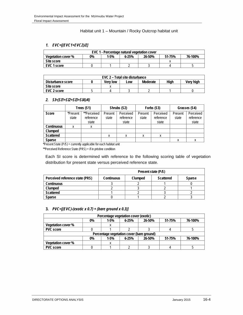
Environmental Impact Assessment for the Mzimvubu Water Project
Floral Impact Assessment
DIRECTORATE OPTIONS ANALYSIS January 2015 16-4
Habitat unit 1 – Mountain / Rocky Outcrop habitat unit
1. EVC=[(EVC1+EVC2)/2]
EVC 1 - Percentage natural vegetation cover Vegetation cover % 0% 1-5% 6-25% 26-50% 51-75% 76-100% Site score x EVC 1 score 0 1 2 3 4 5
EVC 2 – Total site disturbance Disturbance score 0 Very low Low Moderate High Very high Site score x EVC 2 score 5 4 3 2 1 0
2. SI=(SI1+SI2+SI3+SI4)/4)
Trees (S1) Shrubs (S2) Forbs (S3) Grasses (S4)
Score *Present state
**Perceived reference
state
Present state
Perceived reference
state
Present state
Perceived reference
state
Present state
Perceived reference
state Continuous x x Clumped Scattered x x x x Sparse x x
*Present State (P/S) = currently applicable for each habitat unit **Perceived Reference State (PRS) = if in pristine condition
Each SI score is determined with reference to the following scoring table of vegetation
distribution for present state versus perceived reference state.
Present state (P/S)
Perceived reference state (PRS) Continuous Clumped Scattered Sparse
Continuous 3 2 1 0 Clumped 2 3 2 1 Scattered 1 2 3 2 Sparse 0 1 2 3
3. PVC=[(EVC)-(exotic x 0.7) + (bare ground x 0.3)]
Percentage vegetation cover (exotic) 0% 1-5% 6-25% 26-50% 51-75% 76-100% Vegetation cover % x PVC score 0 1 2 3 4 5
Percentage vegetation cover (bare ground) 0% 1-5% 6-25% 26-50% 51-75% 76-100% Vegetation cover % x PVC score 0 1 2 3 4 5
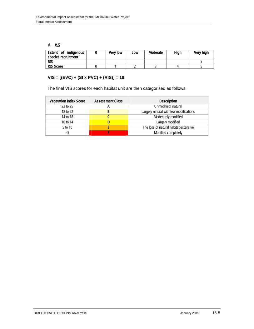
Environmental Impact Assessment for the Mzimvubu Water Project
Floral Impact Assessment
DIRECTORATE OPTIONS ANALYSIS January 2015 16-5
4. RIS
Extent of indigenous species recruitment
0 Very low Low Moderate High Very high
RIS x RIS Score 0 1 2 3 4 5
VIS = [(EVC) + (SI x PVC) + (RIS)] = 18
The final VIS scores for each habitat unit are then categorised as follows:
Vegetation Index Score Assessment Class Description
22 to 25 A Unmodified, natural 18 to 22 B Largely natural with few modifications 14 to 18 C Moderately modified 10 to 14 D Largely modified 5 to 10 E The loss of natural habitat extensive
<5 F Modified completely

Environmental Impact Assessment for the Mzimvubu Water Project
Floral Impact Assessment
DIRECTORATE OPTIONS ANALYSIS January 2015 16-6
Habitat unit 2 – Riparian / Wetland habitat unit
1. EVC=[(EVC1+EVC2)/2]
EVC 1 - Percentage natural vegetation cover Vegetation cover % 0% 1-5% 6-25% 26-50% 51-75% 76-100% Site score x EVC 1 score 0 1 2 3 4 5
EVC 2 – Total site disturbance Disturbance score 0 Very low Low Moderate High Very high Site score x EVC 2 score 5 4 3 2 1 0
2. SI=(SI1+SI2+SI3+SI4)/4)
Trees (S1) Shrubs (S2) Forbs (S3) Grasses (S4)
Score *Present state
**Perceived reference
state
Present state
Perceived reference
state
Present state
Perceived reference
state
Present state
Perceived reference
state Continuous x x Clumped Scattered x x x Sparse x x x
*Present State (P/S) = currently applicable for each habitat unit **Perceived Reference State (PRS) = if in pristine condition
Each SI score is determined with reference to the following scoring table of vegetation
distribution for present state versus perceived reference state.
Present state (P/S)
Perceived reference state (PRS) Continuous Clumped Scattered Sparse
Continuous 3 2 1 0 Clumped 2 3 2 1 Scattered 1 2 3 2 Sparse 0 1 2 3
3. PVC=[(EVC)-(exotic x 0.7) + (bare ground x 0.3)]
Percentage vegetation cover (exotic) 0% 1-5% 6-25% 26-50% 51-75% 76-100% Vegetation cover % x PVC score 0 1 2 3 4 5
Percentage vegetation cover (bare ground) 0% 1-5% 6-25% 26-50% 51-75% 76-100% Vegetation cover % x PVC score 0 1 2 3 4 5
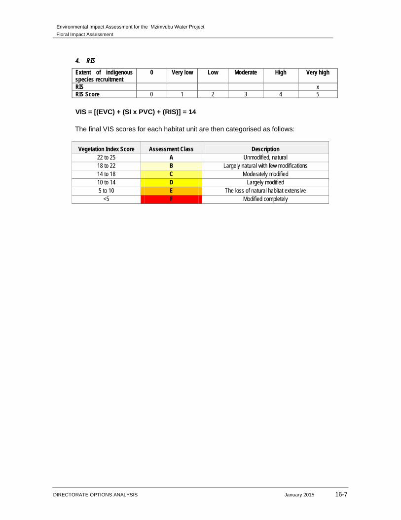
Environmental Impact Assessment for the Mzimvubu Water Project
Floral Impact Assessment
DIRECTORATE OPTIONS ANALYSIS January 2015 16-7
4. RIS
Extent of indigenous species recruitment
0 Very low Low Moderate High Very high
RIS x RIS Score 0 1 2 3 4 5
VIS = [(EVC) + (SI x PVC) + (RIS)] = 14
The final VIS scores for each habitat unit are then categorised as follows:
Vegetation Index Score Assessment Class Description
22 to 25 A Unmodified, natural 18 to 22 B Largely natural with few modifications 14 to 18 C Moderately modified 10 to 14 D Largely modified 5 to 10 E The loss of natural habitat extensive
<5 F Modified completely

Environmental Impact Assessment for the Mzimvubu Water Project
Floral Impact Assessment
DIRECTORATE OPTIONS ANALYSIS January 2015 16-8
Habitat unit 3 – Transformed (grassland) habitat unit
1. EVC=[(EVC1+EVC2)/2]
EVC 1 - Percentage natural vegetation cover Vegetation cover % 0% 1-5% 6-25% 26-50% 51-75% 76-100% Site score x EVC 1 score 0 1 2 3 4 5
EVC 2 – Total site disturbance Disturbance score 0 Very low Low Moderate High Very high Site score x EVC 2 score 5 4 3 2 1 0
2. SI=(SI1+SI2+SI3+SI4)/4)
Trees (S1) Shrubs (S2) Forbs (S3) Grasses (S4)
Score *Present state
**Perceived reference
state
Present state
Perceived reference
state
Present state
Perceived reference
state
Present state
Perceived reference
state Continuous x x x Clumped x Scattered x x x Sparse x
*Present State (P/S) = currently applicable for each habitat unit **Perceived Reference State (PRS) = if in pristine condition
Each SI score is determined with reference to the following scoring table of vegetation
distribution for present state versus perceived reference state.
Present state (P/S)
Perceived reference state (PRS) Continuous Clumped Scattered Sparse
Continuous 3 2 1 0 Clumped 2 3 2 1 Scattered 1 2 3 2 Sparse 0 1 2 3
3. PVC=[(EVC)-(exotic x 0.7) + (bare ground x 0.3)]
Percentage vegetation cover (exotic) 0% 1-5% 6-25% 26-50% 51-75% 76-100% Vegetation cover % x PVC score 0 1 2 3 4 5
Percentage vegetation cover (bare ground) 0% 1-5% 6-25% 26-50% 51-75% 76-100% Vegetation cover % x PVC score 0 1 2 3 4 5

Environmental Impact Assessment for the Mzimvubu Water Project
Floral Impact Assessment
DIRECTORATE OPTIONS ANALYSIS January 2015 16-9
4. RIS
Extent of indigenous species recruitment
0 Very low Low Moderate High Very high
RIS x RIS Score 0 1 2 3 4 5
VIS = [(EVC) + (SI x PVC) + (RIS)] = 10
The final VIS scores for each habitat unit are then categorised as follows:
Vegetation Index Score Assessment Class Description
22 to 25 A Unmodified, natural 18 to 22 B Largely natural with few modifications 14 to 18 C Moderately modified 10 to 14 D Largely modified 5 to 10 E The loss of natural habitat extensive
<5 F Modified completely
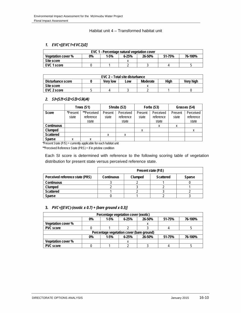
Environmental Impact Assessment for the Mzimvubu Water Project
Floral Impact Assessment
DIRECTORATE OPTIONS ANALYSIS January 2015 16-10
Habitat unit 4 – Transformed habitat unit
1. EVC=[(EVC1+EVC2)/2]
EVC 1 - Percentage natural vegetation cover Vegetation cover % 0% 1-5% 6-25% 26-50% 51-75% 76-100% Site score x EVC 1 score 0 1 2 3 4 5
EVC 2 – Total site disturbance Disturbance score 0 Very low Low Moderate High Very high Site score x EVC 2 score 5 4 3 2 1 0
2. SI=(SI1+SI2+SI3+SI4)/4)
Trees (S1) Shrubs (S2) Forbs (S3) Grasses (S4)
Score *Present state
**Perceived reference
state
Present state
Perceived reference
state
Present state
Perceived reference
state
Present state
Perceived reference
state Continuous x x Clumped x x Scattered x x Sparse x x
*Present State (P/S) = currently applicable for each habitat unit **Perceived Reference State (PRS) = if in pristine condition
Each SI score is determined with reference to the following scoring table of vegetation
distribution for present state versus perceived reference state.
Present state (P/S)
Perceived reference state (PRS) Continuous Clumped Scattered Sparse
Continuous 3 2 1 0 Clumped 2 3 2 1 Scattered 1 2 3 2 Sparse 0 1 2 3
3. PVC=[(EVC)-(exotic x 0.7) + (bare ground x 0.3)]
Percentage vegetation cover (exotic) 0% 1-5% 6-25% 26-50% 51-75% 76-100% Vegetation cover % x PVC score 0 1 2 3 4 5
Percentage vegetation cover (bare ground) 0% 1-5% 6-25% 26-50% 51-75% 76-100% Vegetation cover % x PVC score 0 1 2 3 4 5

Environmental Impact Assessment for the Mzimvubu Water Project
Floral Impact Assessment
DIRECTORATE OPTIONS ANALYSIS January 2015 16-11
4. RIS
Extent of indigenous species recruitment
0 Very low Low Moderate High Very high
RIS x RIS Score 0 1 2 3 4 5
VIS = [(EVC) + (SI x PVC) + (RIS)] = 5
The final VIS scores for each habitat unit are then categorised as follows:
Vegetation Index Score Assessment Class Description
22 to 25 A Unmodified, natural 18 to 22 B Largely natural with few modifications 14 to 18 C Moderately modified 10 to 14 D Largely modified 5 to 10 E The loss of natural habitat extensive
<5 F Modified completely