Morphology What is morphology? Finite State Transducers Two Level Morphology.
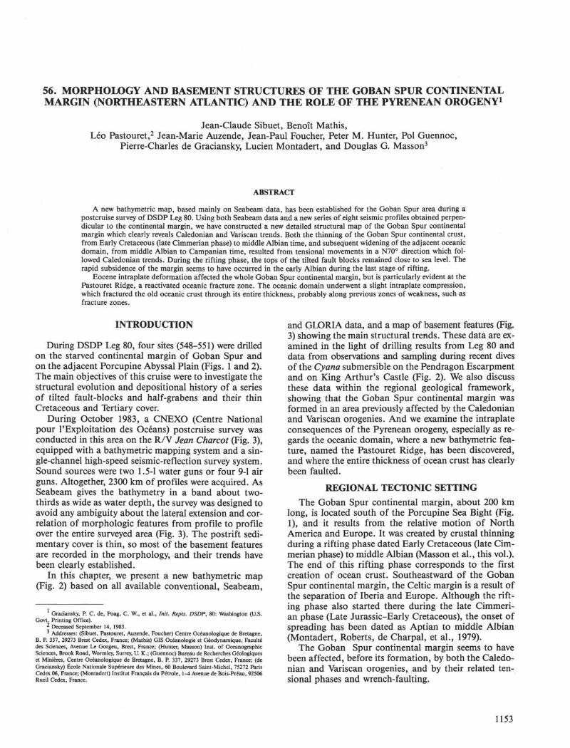
56. MORPHOLOGY AND BASEMENT STRUCTURES OF THE GOBAN SPUR CONTINENTALMARGIN (NORTHEASTERN ATLANTIC) AND THE ROLE OF THE PYRENEAN OROGENY1
Jean-Claude Sibuet, Benoit Mathis,Léo Pastouret,2 Jean-Marie Auzende, Jean-Paul Foucher, Peter M. Hunter, Pol Guennoc,
Pierre-Charles de Graciansky, Lucien Montadert, and Douglas G. Masson3
ABSTRACT
A new bathymetric map, based mainly on Seabeam data, has been established for the Goban Spur area during apostcruise survey of DSDP Leg 80. Using both Seabeam data and a new series of eight seismic profiles obtained perpen-dicular to the continental margin, we have constructed a new detailed structural map of the Goban Spur continentalmargin which clearly reveals Caledonian and Variscan trends. Both the thinning of the Goban Spur continental crust,from Early Cretaceous (late Cimmerian phase) to middle Albian time, and subsequent widening of the adjacent oceanicdomain, from middle Albian to Campanian time, resulted from tensional movements in a N70° direction which fol-lowed Caledonian trends. During the rifting phase, the tops of the tilted fault blocks remained close to sea level. Therapid subsidence of the margin seems to have occurred in the early Albian during the last stage of rifting.
Eocene intraplate deformation affected the whole Goban Spur continental margin, but is particularly evident at thePastouret Ridge, a reactivated oceanic fracture zone. The oceanic domain underwent a slight intraplate compression,which fractured the old oceanic crust through its entire thickness, probably along previous zones of weakness, such asfracture zones.
INTRODUCTION
During DSDP Leg 80, four sites (548-551) were drilledon the starved continental margin of Goban Spur andon the adjacent Porcupine Abyssal Plain (Figs. 1 and 2).The main objectives of this cruise were to investigate thestructural evolution and depositional history of a seriesof tilted fault-blocks and half-grabens and their thinCretaceous and Tertiary cover.
During October 1983, a CNEXO (Centre Nationalpour F Exploitation des Oceans) postcruise survey wasconducted in this area on the R/V Jean Charcot (Fig. 3),equipped with a bathymetric mapping system and a sin-gle-channel high-speed seismic-reflection survey system.Sound sources were two 1.5-1 water guns or four 9-1 airguns. Altogether, 2300 km of profiles were acquired. AsSeabeam gives the bathymetry in a band about two-thirds as wide as water depth, the survey was designed toavoid any ambiguity about the lateral extension and cor-relation of morphologic features from profile to profileover the entire surveyed area (Fig. 3). The postrift sedi-mentary cover is thin, so most of the basement featuresare recorded in the morphology, and their trends havebeen clearly established.
In this chapter, we present a new bathymetric map(Fig. 2) based on all available conventional, Seabeam,
Graciansky, P. C. de, Poag, C. W., et al., Init. Repts. DSDP, 80: Washington (U.S.Govt. Printing Office).
2 Deceased September 14, 1983.3 Addresses: (Sibuet, Pastouret, Auzende, Foucher) Centre Océanologique de Bretagne,
B. P. 337, 29273 Brest Cedex, France; (Mathis) GIS Océanologie et Géodynamique, Facultédes Sciences, Avenue Le Gorgeu, Brest, France; (Hunter, Masson) Inst. of OceanographicSciences, Brook Road, Wormley, Surrey, U. K.; (Guennoc) Bureau de Recherches Géologiqueset Minières, Centre Océanologique de Bretagne, B. P. 337, 29273 Brest Cedex, France; (deGraciansky) Ecole Nationale Supérieure des Mines, 60 Boulevard Saint-Michel, 75272 ParisCedex 06, France; (Montadert) Institut Français du Pétrole, 1-4 Avenue de Bois-Préau, 92506Rueil Cedex, France.
and GLORIA data, and a map of basement features (Fig.3) showing the main structural trends. These data are ex-amined in the light of drilling results from Leg 80 anddata from observations and sampling during recent divesof the Cyana submersible on the Pendragon Escarpmentand on King Arthur's Castle (Fig. 2). We also discussthese data within the regional geological framework,showing that the Goban Spur continental margin wasformed in an area previously affected by the Caledonianand Variscan orogenies. And we examine the intraplateconsequences of the Pyrenean orogeny, especially as re-gards the oceanic domain, where a new bathymetric fea-ture, named the Pastouret Ridge, has been discovered,and where the entire thickness of ocean crust has clearlybeen faulted.
REGIONAL TECTONIC SETTING
The Goban Spur continental margin, about 200 kmlong, is located south of the Porcupine Sea Bight (Fig.1), and it results from the relative motion of NorthAmerica and Europe. It was created by crustal thinningduring a rifting phase dated Early Cretaceous (late Cim-merian phase) to middle Albian (Masson et al., this vol.).The end of this rifting phase corresponds to the firstcreation of ocean crust. Southeastward of the GobanSpur continental margin, the Celtic margin is a result ofthe separation of Iberia and Europe. Although the rift-ing phase also started there during the late Cimmeri-an phase (Late Jurassic-Early Cretaceous), the onset ofspreading has been dated as Aptian to middle Albian(Montadert, Roberts, de Charpal, et al., 1979).
The Goban Spur continental margin seems to havebeen affected, before its formation, by both the Caledo-nian and Variscan orogenies, and by their related ten-sional phases and wrench-faulting.
1153

J. C. SIBUET ET AL.
Figure 1. Generalized sketch of southwestern Europe, indicating the location of the Goban Spur survey done with the Jean Charcot during theNorestlante I cruise. (Bathymetry in meters.) Key to symbols (upper left corner): 1 = Faults in Ireland (from Max et al. [1983]; in Great Britainand in the Celtic Sea, Pegrum and Mounteney [1978]; on the continental margins, Montadert, Roberts, de Charpal, et al. [1979] and this study).2 = Variscan front from Gardiner and Sheridan (1981). 3 = Normal or listric faults. 4 = Location of the seismic profile shown in Figure 9. 5 =Theoretical directions of the initial opening of the North Atlantic Ocean (Olivet et al., in press). 6 = Continent-ocean boundary (Montadert,Roberts, de Charpal, et al., 1979, and Masson et al., this vol.). 7 = DSDP sites drilled during Legs 48 and 80. 8 = Approximate present limit ofJurassic sediments (Pegrum and Mounteney, 1978). 9 = Triassic basins.
Chronology and Nature of Paleozoic Deformations
The Caledonides resulted from the collision of conti-nents that closed the Iapetus Ocean between the middleSilurian (420 m.y. ago; Paleozoic ages from Van Eysinga[1975] geological timetable; Mesozoic and Cenozoic agesfrom Odin [1982]) and the early Devonian (380 m.y.ago). The Iapetus Suture, located along the SouthernUplands Fault (Fig. 1), follows the general NE-SW ori-entation of the Caledonides fold belt (Leggett et al.,1983), and lies in the direct prolongation of the north-western border of the Porcupine Sea Bight.
Between mid-Devonian and early Carboniferous time(365-335 m.y. ago), a large sediment basin, the Cor-nish-Rhenish Basin (Ziegler, 1978, 1981) developed un-der a tensional setting in an area stretching from Ger-many to the Celtic shelf. The position of the northernboundary of the Cornish-Rhenish basin is at presentpoorly documented. Between the late early Carbonifer-ous (late Visean, 325 m.y. ago) and the middle late Car-boniferous (late Westphalian, 295 m.y. ago), the Cor-nish-Rhenish Basin was incorporated into the Variscandeformation belt. Because the Variscan facies patternsand deformation trends were controlled primarily by the
1154
MORPHOLOGY AND BASEMENT STRUCTURES
morphology of the southern margins of the Celtic Sea-Wales and Brabant massifs, Gardiner and Sheridan (1981)hypothesized that the Variscan front, previously locatedin southern Ireland, should follow the arcuate BristolChannel lineament, which flanks the Celtic Sea-WalesMassif (Fig. 1). If their hypothesis is correct, the Vari-scan front could be coincident with the Goban Fault(Fig. 2), which lies immediately north of DSDP Sites549 and 551 (Fig. 1) (Gardiner and Sheridan, 1981; Din-gle and Scrutton, 1979). This new definition of the Vari-scan front may explain why there is no evidence ofWNW-ESE Variscan structural influence in the CelticSea (as in Brittany), and why basement reactivation dur-ing the Mesozoic occurred mainly along the ENE-WSWand NE-SW Caledonian structural trends. Therefore,the previous location of the Variscan front in southernIreland is not rejected, because this feature is associat-ed there with clear strike-slip faulting (Lefort, this vol.)and affects the whole continental crust (SWAT profile,Matthews, pers. comm.).
Granite intrusions of Cornwall and of the CornubianRidge, marked by negative gravity anomalies (Sibuet 1972,1973), and granites dredged just south of Goban Spur(Pautot et al., 1976) are presumed to be of Variscan ori-gin, and are aligned on a trend parallel to and 100 kmsoutheast of the Variscan front. Northwest of the front,Variscan deformations seem only to reflect localizedbasement movements allied with lithological variationsin a series of disconnected basins (Gardiner and Sheri-dan, 1981).
Late Variscan wrench-faulting, dated late Carbonifer-ous to early Permian (Stephanian, 285 m.y. ago, to Autu-nian, 270 m.y. ago) occurred along the previous NE-SWCaledonian and Variscan trends, but also along the con-jugate directions, and is considered to have been a tran-sitional stage between the closing of the Paleozoic oceansand the opening of the Mesozoic ones (e.g., Arthaudand Matte, 1977; Russell and Smythe, 1983).
In the middle Permian, a general period of extensionbegan, marked by subsidence in the Celtic Sea, the Bris-tol Channel, the Western Approaches Basin, and the areasof the future plate margins. These features continued tosubside during the Triassic (204-245 m.y. ago), whenclear graben features appeared (Kent, 1978). The overallTriassic extension heralded the breakup of Pangaea. Bylate Triassic time, the Variscan fold belt expressed onlydisjointed low relief within the monotonous flat plain ofnorthwestern Europe (Ziegler, 1978). But until the EarlyCretaceous crustal separation was achieved in the Bay ofBiscay and the North Atlantic, most of northwesternEurope was subjected to regional extension, especiallyin the Porcupine Sea Bight, Celtic Sea, Bristol Channel,and Western Approaches Basin, where thick sedimenta-ry strata accumulated (Fig. 1).
In conclusion, the geological development of the Go-ban Spur area seems to have been largely controlled bystructural and physiographic features created during theCaledonian orogeny. The Variscan orogeny also affectedthis area, since the Variscan front seems to be locatedsoutheast of the Porcupine Sea Bight. Older NE-SWCaledonian features were probably reactivated during the
Variscan orogeny. During the late Variscan strike-slipfaulting, the conjugate NW-SE trends appeared for thefirst time. Then, during the Permian to Triassic tension-al phase, both conjugate trends were occupied by nor-mal and shear faults.
MORPHOLOGY OF THE GOBAN SPURCONTINENTAL MARGIN
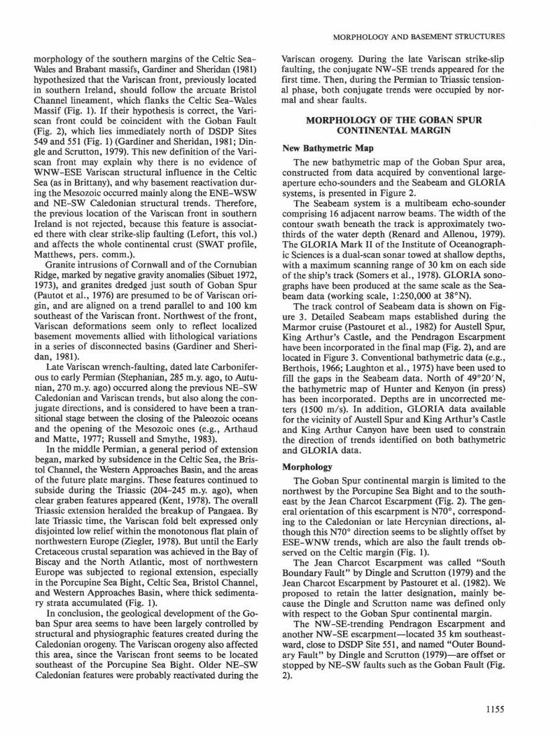
New Bathymetric Map
The new bathymetric map of the Goban Spur area,constructed from data acquired by conventional large-aperture echo-sounders and the Seabeam and GLORIAsystems, is presented in Figure 2.
The Seabeam system is a multibeam echo-soundercomprising 16 adjacent narrow beams. The width of thecontour swath beneath the track is approximately two-thirds of the water depth (Renard and Allenou, 1979).The GLORIA Mark II of the Institute of Oceanograph-ic Sciences is a dual-scan sonar towed at shallow depths,with a maximum scanning range of 30 km on each sideof the ship's track (Somers et al., 1978). GLORIA sono-graphs have been produced at the same scale as the Sea-beam data (working scale, 1:250,000 at 38°N).
The track control of Seabeam data is shown on Fig-ure 3. Detailed Seabeam maps established during theMarmor cruise (Pastouret et al., 1982) for Austell Spur,King Arthur's Castle, and the Pendragon Escarpmenthave been incorporated in the final map (Fig. 2), and arelocated in Figure 3. Conventional bathymetric data (e.g.,Berthois, 1966; Laughton et al., 1975) have been used tofill the gaps in the Seabeam data. North of 49°20'N,the bathymetric map of Hunter and Kenyon (in press)has been incorporated. Depths are in uncorrected me-ters (1500 m/s). In addition, GLORIA data availablefor the vicinity of Austell Spur and King Arthur's Castleand King Arthur Canyon have been used to constrainthe direction of trends identified on both bathymetricand GLORIA data.
Morphology
The Goban Spur continental margin is limited to thenorthwest by the Porcupine Sea Bight and to the south-east by the Jean Charcot Escarpment (Fig. 2). The gen-eral orientation of this escarpment is N70°, correspond-ing to the Caledonian or late Hercynian directions, al-though this N70° direction seems to be slightly offset byESE-WNW trends, which are also the fault trends ob-served on the Celtic margin (Fig. 1).
The Jean Charcot Escarpment was called "SouthBoundary Fault" by Dingle and Scrutton (1979) and theJean Charcot Escarpment by Pastouret et al. (1982). Weproposed to retain the latter designation, mainly be-cause the Dingle and Scrutton name was defined onlywith respect to the Goban Spur continental margin.
The NW-SE-trending Pendragon Escarpment andanother NW-SE escarpment—located 35 km southeast-ward, close to DSDP Site 551, and named "Outer Bound-ary Fault" by Dingle and Scrutton (1979)—are offset orstopped by NE-SW faults such as the Goban Fault (Fig.2).
1155
J. C. SIBUET ET AL.
14° W
Figure 2. Bathymetric map, in Mercator projection, of the Goban Spur continental margin, established from Seabeam data (locations of tracks andlocal surveys [Pastouret et al., 1982] in Figure 3), conventional data (Berthois, 1966; Laughton et al., 1975; Hunter and Kenyon, in press), andunpublished GLORIA data from IOS. Depths are in uncorrected meters (1500 m/s). Contour spacing every 100 meters. Locations of DSDP sitesdrilled during Leg 80 are shown. The Pastouret Ridge is a newly named bathymetric feature.
On the Porcupine Abyssal Plain, 4500 m deep, a newbathymetric feature, oriented roughly N70°, about 50 kmlong and 300 m high, was discovered during the Norest-lante cruise. We propose to name this feature "PastouretRidge," in memory of Léo Pastouret, who was particu-larly involved in the geological investigations of the Cel-tic and Goban Spur continental margins.
North of the Jean Charcot Escarpment, the bathym-etry of the Goban Spur continental margin is compli-cated by the presence of several NNW-SSE-trending can-yons, such as King Arthur Canyon. South of the JeanCharcot Escarpment, the average water depth over thecontinental margin is more than 1000 m greater thannorth of the escarpment. This portion of the continen-tal margin, at the intersection of the Goban Spur andCeltic continental margins, has probably been affectedby the interaction of tectonic movements linked to the
formation of both margins during the Early Cretaceous.Nevertheless, the main structural trends of this area,such as Granite Cliff, Menez Bihan (Pautot et al., 1976),Menez Braz, and the Pendragon Escarpment, are orient-ed N330°.
We infer from the directions of morphologic trendsthat the formation and evolution of this portion of theNorth Atlantic continental margin have been controlledmainly by the previous Caledonian and late Variscan oro-genic trends, as previously indicated by continental geo-logical evidence.
STRUCTURE AND GEOLOGICAL EVOLUTIONOF THE GOBAN SPUR CONTINENTAL MARGIN
During the Norestlante cruise, 2300 km of single-chan-nel seismic reflection profiles were collected in the area
1156

MORPHOLOGY AND BASEMENT STRUCTURES
14°W
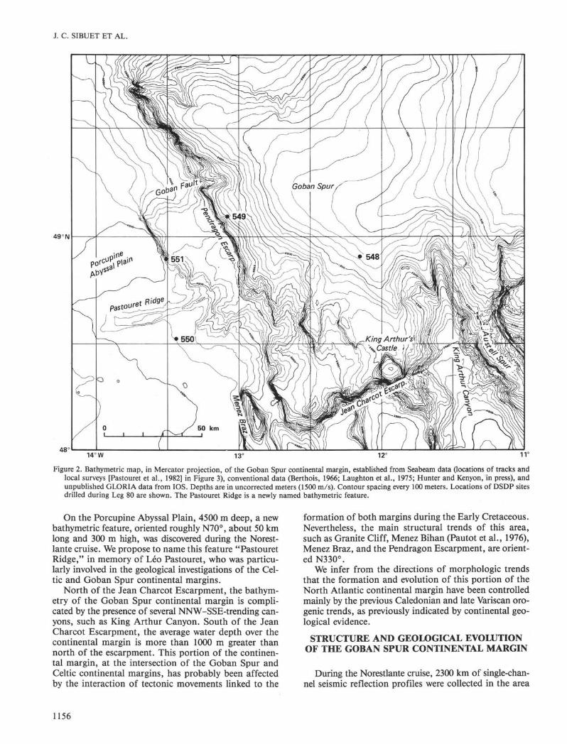
Figure 3. Structural map of the Goban Spur continental margin, established using seismic and Seabeam data from the Jean Charcot Norest-lante I cruise. Simplified bathymetry from Figure 2. Boxes A, B, and C are previous Seabeam detailed surveys done in 1979 during theJean Charcot Marmor cruise (Pastouret, et al., 1982). Shaded areas correspond to the eroded surfaces of tilted blocks. Key to symbols (up-per left corner): 1 = Axis of highs. 2 = Axis of depressions. 3 = Possible faults. 4 = Theoretical directions of the initial opening of theNorth Atlantic Ocean (Olivet et al., in press). 5, thin lines = Locations of seismic and Seabeam profiles used in this study; thick lines =Location of seismic profiles a to e shown in Figs. 4 to 6 and 8.6 = Complementary Seabeam tracks used to establish the bathymetric mapof Figure 2. 7 = DSDP sites drilled during Leg 80. 8 = Dredgings (Auffret et al., 1979; Dingle and Scrutton, 1979). 9 = Locations ofCyana dives. 10 = Continent-ocean boundary.
of Goban Spur (Fig. 3). Two types of seismic sourceswere used: two 1.5-1 water guns towed at 10 knots witha shot spacing of 10 s; and four 9-1 air guns towed at6 knots with a shot spacing of 30 s (in order to have bet-ter penetration and to deploy sonobuoy refraction ex-periments).
Eight parallel profiles with 8-mile spacing were col-lected in the region of Leg 80 sites, from the continentalshelf to the typical oceanic domain (Fig. 3). Their ENE-WSW orientation is perpendicular to the direction ofthe continental margin. Because Seabeam data are avail-able in real time, it was possible to identify the geometryof all features marked by topographic expression and tofollow their lateral extension and orientation, and con-sequently to correlate them from profile to profile. A
few complementary short profiles were implemented tofollow structures or to specify the termination of struc-tures.
Basement Structures of the Goban Spur ContinentalMargin
The starved Goban Spur continental margin is char-acterized by a series of tilted fault-blocks, horsts, andgrabens trending roughly parallel to the NW-SE direc-tion of the continental slope (Montadert, Roberts, deCharpal, et al., 1979; Dingle and Scrutton, 1979; Mas-son et al., this vol.). The position of the continent-oceanboundary (Figs. 1 and 3) has been located on the basisof magnetic, seismic, and drilling data (Montadert, deCharpal, et al., 1979; Masson et al., this vol.).
1157
J. C. SIBUET ET AL.
Using both Seabeam and seismic data, the positionsof depressions and highs within the rift system have beeninferred over the whole area (Fig. 3). These structurestrend N-S or NNW-SSE. North of the surveyed area,the NNW-SSE features are interrupted by the GobanFault, oriented N70°, as shown on the bathymetric map(Fig. 2) and known from the previous work of Dingleand Scrutton (1979). Near 48.5°N, 13°W, three tectoniclines of discontinuity, oriented N45°, are visible. Also inthis area, N-S trends are recognized. On the basis ofthis detailed survey, we infer an abrupt change in thetrends of structures or a juxtaposition of different struc-tural provinces, rather than a progressive bending ofstructures from N335° to N36O0, as suggested by Mas-son et al. (this vol.). The three tectonic lines of discon-tinuity just mentioned follow the previous Caledonianand Variscan trends, and delimit different structural prov-inces. Horizontal movements of unknown limited extentcould have taken place along these lines during the rift-ing phase.
In the oceanic domain, the sediments of the Porcu-pine Abyssal Plain bury the basement features, exceptfor the topographically high Pastouret Ridge (Figs. 2-5). The southern flank of the Pastouret Ridge is a faulttrending N71°, which is almost exactly the direction ofthe Goban Fault, of the Jean Charcot Escarpment, andof the theoretical directions of the early opening of theNorth Atlantic Ocean in this region (Le Pichon et al.,1977; Olivet et al., in press; Figs. 1 and 3). This sug-gests that the Pastouret Ridge is an oceanic fracture zonewhich has been subsequently reactivated.
Consequently, the formation both of the Goban Spurcontinental margin, from the Early Cretaceous (130 m.y.ago) to the middle Albian (100 m.y. ago), and then ofthe adjacent oceanic domain, from the middle Albian(100 m.y. ago) to the Campanian (Anomaly 33, 80 m.y.ago), resulted from N70° tensional movements whichwere parallel to the Caledonian trends. This is becauseinitial plate motions are severely constrained by previousstructural features of the continents, which become linesof weakness that guide early motions of plates (e.g., Si-buet and Mascle, 1978; Olivet et al., in press). In thecase of the North America-Eurasian continent (Pan-gaea), the ENE-WSW Caledonian and Hercynian direc-tions preferentially controlled the initial motion of con-tinents along the oldest direction of the Charlie-GibbsFracture Zone (e.g., Olivet et al., 1974), which also cor-responds to the orientation of the northern border ofPorcupine Bank and of the southern Rockall Bank.
Nature and Significance of Pre-Rift BasementStructures
The seismic profile of Figure 6 shows that the pre-riftbasement is not homogeneous but consists of alternateopaque and layered sequences. The inclined layered se-quences (e.g., between 4.30 and 5.00 on Fig. 6) are pre-rift sedimentary sequences, older than Late Jurassic,which tilted during rifting. The progressive tilting andthe contemporaneous sedimentation are evidenced hereby the convergence of syn-rift reflectors toward theocean (Fig. 6 between 5.00 and 5.20). The continental
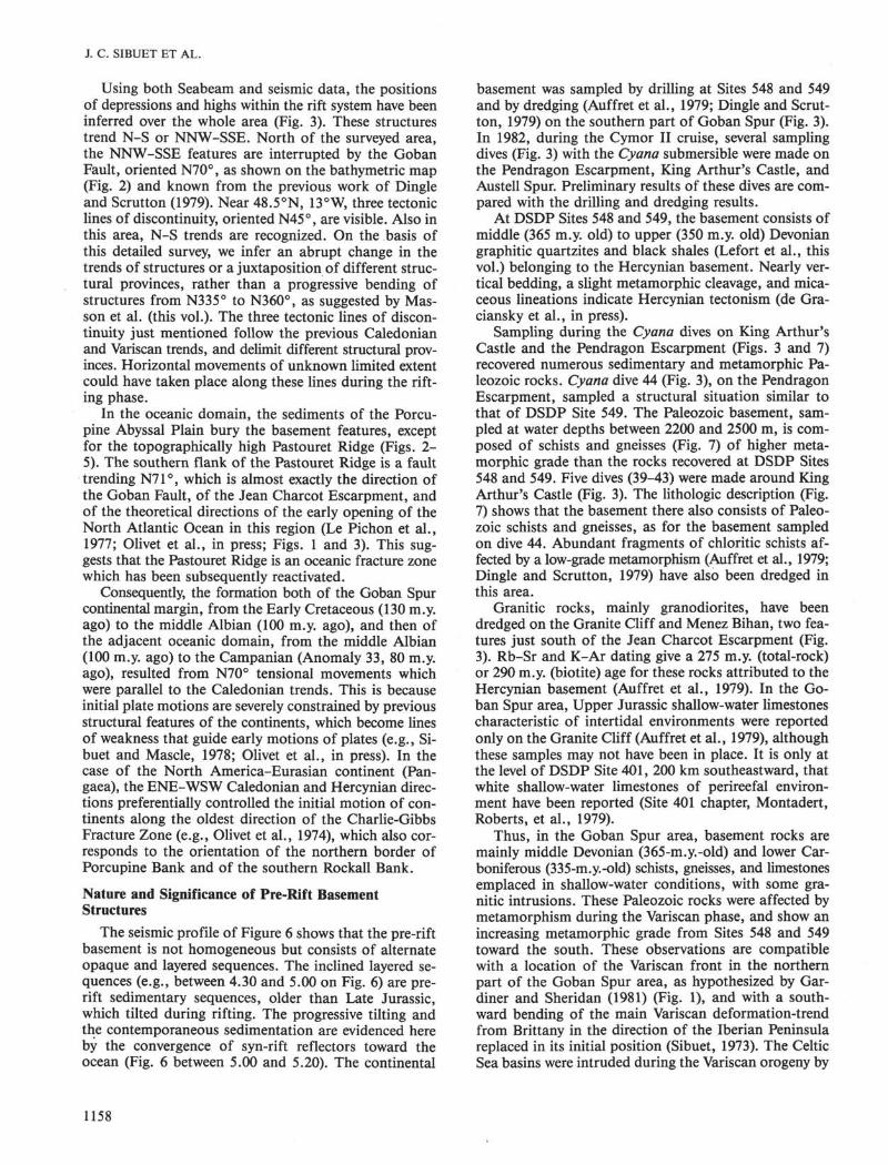
basement was sampled by drilling at Sites 548 and 549and by dredging (Auffret et al., 1979; Dingle and Scrut-ton, 1979) on the southern part of Goban Spur (Fig. 3).In 1982, during the Cymor II cruise, several samplingdives (Fig. 3) with the Cyana submersible were made onthe Pendragon Escarpment, King Arthur's Castle, andAustell Spur. Preliminary results of these dives are com-pared with the drilling and dredging results.
At DSDP Sites 548 and 549, the basement consists ofmiddle (365 m.y. old) to upper (350 m.y. old) Devoniangraphitic quartzites and black shales (Lefort et al., thisvol.) belonging to the Hercynian basement. Nearly ver-tical bedding, a slight metamorphic cleavage, and mica-ceous lineations indicate Hercynian tectonism (de Gra-ciansky et al., in press).
Sampling during the Cyana dives on King ArthursCastle and the Pendragon Escarpment (Figs. 3 and 7)recovered numerous sedimentary and metamorphic Pa-leozoic rocks. Cyana dive 44 (Fig. 3), on the PendragonEscarpment, sampled a structural situation similar tothat of DSDP Site 549. The Paleozoic basement, sam-pled at water depths between 2200 and 2500 m, is com-posed of schists and gneisses (Fig. 7) of higher meta-morphic grade than the rocks recovered at DSDP Sites548 and 549. Five dives (39-43) were made around KingArthur's Castle (Fig. 3). The lithologic description (Fig.7) shows that the basement there also consists of Paleo-zoic schists and gneisses, as for the basement sampledon dive 44. Abundant fragments of chloritic schists af-fected by a low-grade metamorphism (Auffret et al., 1979;Dingle and Scrutton, 1979) have also been dredged inthis area.
Granitic rocks, mainly granodiorites, have beendredged on the Granite Cliff and Menez Bihan, two fea-tures just south of the Jean Charcot Escarpment (Fig.3). Rb-Sr and K-Ar dating give a 275 m.y. (total-rock)or 290 m.y. (biotite) age for these rocks attributed to theHercynian basement (Auffret et al., 1979). In the Go-ban Spur area, Upper Jurassic shallow-water limestonescharacteristic of intertidal environments were reportedonly on the Granite Cliff (Auffret et al., 1979), althoughthese samples may not have been in place. It is only atthe level of DSDP Site 401, 200 km southeastward, thatwhite shallow-water limestones of perireefal environ-ment have been reported (Site 401 chapter, Montadert,Roberts, et al., 1979).
Thus, in the Goban Spur area, basement rocks aremainly middle Devonian (365-m.y.-old) and lower Car-boniferous (335-m.y.-old) schists, gneisses, and limestonesemplaced in shallow-water conditions, with some gra-nitic intrusions. These Paleozoic rocks were affected bymetamorphism during the Variscan phase, and show anincreasing metamorphic grade from Sites 548 and 549toward the south. These observations are compatiblewith a location of the Variscan front in the northernpart of the Goban Spur area, as hypothesized by Gar-diner and Sheridan (1981) (Fig. 1), and with a south-ward bending of the main Variscan deformation-trendfrom Brittany in the direction of the Iberian Peninsulareplaced in its initial position (Sibuet, 1973). The CelticSea basins were intruded during the Variscan orogeny by
1158
N
14.00 10 Oct. 83 14.30 15.00
5 km
SE NW
10 Oct. 83 16.01 16.32 17.00
. •• . • • . • • . . •
- yΦmt
6 α>E"ö>>2<β
5
oaoo
>σCO>C Λ
5 km
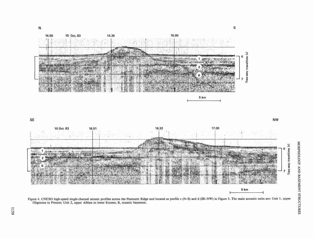
Figure 4. CNEXO high-speed single-channel seismic profiles across the Pastouret Ridge and located as profile c (N-S) and d (SE-NW) in Figure 3. The main acoustic units are: Unit 1, upperOligocene to Present; Unit 2, upper Albian to lower Eocene; B, oceanic basement.
3400 3200 3000 2800 2600
NW 5 km
7 ~
8 n
o
10
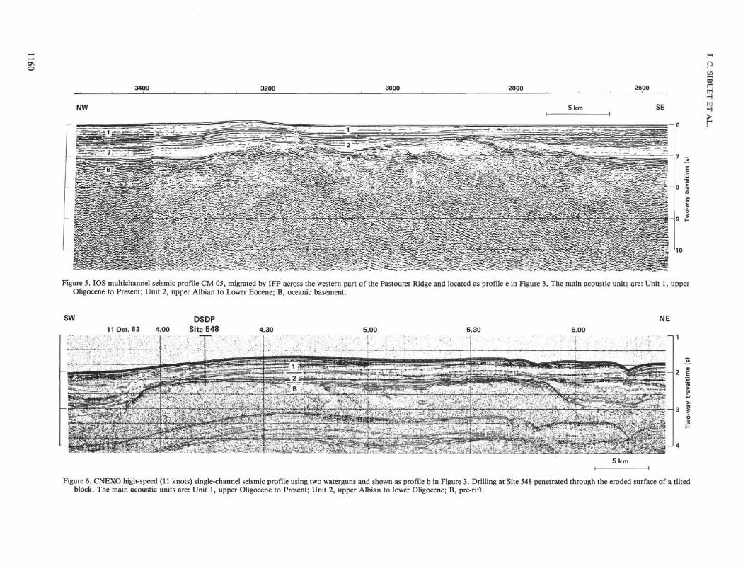
Figure 5. IOS multichannel seismic profile CM 05, migrated by IFP across the western part of the Pastouret Ridge and located as profile e in Figure 3. The main acoustic units are: Unit 1, upperOligocene to Present; Unit 2, upper Albian to Lower Eocene; B, oceanic basement.
SW11 Oct. 83 4.00
DSDPSite 548
NE4.30 5.00 5.30 6.00
,. y \ . . *:*
~l 1
2 E
5 km
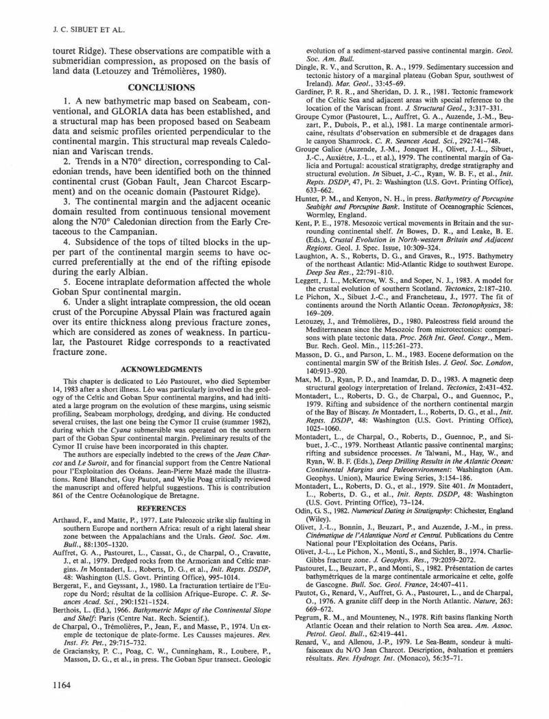
Figure 6. CNEXO high-speed (11 knots) single-channel seismic profile using two waterguns and shown as profile b in Figure 3. Drilling at Site 548 penetrated through the eroded surface of a tiltedblock. The main acoustic units are: Unit 1, upper Oligocene to Present; Unit 2, upper Albian to lower Oligocene; B, pre-rift.

MORPHOLOGY AND BASEMENT STRUCTURES
Pendragon EscarpmentCyana dive 44
Goban SpurDSDP Site 548
2000
2500
-
0 0 0 o 0
0
0
0
0
0
o
0
0
<Xf <Xr *\.
0
o
c.<S5 c
1300-
1800-
King Arthur's CastleCyana dives 39 to 43
2000
2600 η
_
-
3000-
3 4 0 0 -
Goban SpurDSDP Site 549
1 ' 11 / i
1 s 11 1 '
\ ' '
. . f . . |• l • 1 •
• l • •
. 1 . . 1 .
1 1
. . . |. . . |. i. . . i. .
1 11 1
| /1
• I• • 1
l
i
. . .|.. i...
11 //
1
l•
—
1.
1
c o Oozes, clays,g E chalks, and
,S2 turbiditic
Eo mudstoneso
m. Eocene to "u. Oligocene
lower Eocene
Maestrichtian .
Devonian |
Hardground
Upper λ fCretaceous J g
•B. Calcareous< siltstones
~ Dolosparite
£ Calcareous£ mudstones^ and% grainstones
Devonian
sandstones
3000
Figure 7. Lithostratigraphic comparisons between Sites 548 and 549,drilled on the tilted fault blocks, and Cyαnα dives on the Pendrag-on Escarpment and the flanks of King Arthur's Castle. Locationsof DSDP sites and Cyαnα dives in Figure 3. Depths are in metersbelow sea level.
granites belonging to the batholithic axis (Sibuet, 1972,1973), which can be followed straight from Cornwall tothe foot of the continental margin on Granite Cliff,south of the Jean Charcot Escarpment (Fig. 1).
Nature and Significance of Syn-Rift Deposits
In the Goban Spur area, a rifting phase began in theEarly Cretaceous and ended in the latest early Albian(Masson et al., this vol.). At Site 549, the oldest syn-riftsediments are shallow-water interbedded calcareous andnoncalcareous sandy mudstones and mudstones (Barre-mian, 113 m.y. old) (Site 549 chapter, this vol.). Thesesediments are overlain by a thin dolosparitic bed (Fig.7), possibly an Aptian remnant, which in turn is over-lain by a series of uppermost lower and middle Albian(98-102-m.y.-old) calcareous siltstones deposited in abathyal environment. If the presence of this unconform-ity was associated with a major sea-level drop in themiddle Aptian (110 m.y. ago; Vail et al., 1977), the
change from a shallow-water to a bathyal environmentcorresponds to a post-Aptian deepening of the margin.
At Site 550, situated about 15 km west of the conti-nent-ocean boundary, the oldest sediments on the oceancrust are early late Albian (98 m.y. old; Müller, this vol.;Sigal and Magniez, this vol.). Coupling the dating of theoldest syn-rift and the youngest post-rift sediments atSite 549 and the dating of the oldest sediments abovethe ocean crust at Site 550, Masson et al. (this vol.) pro-pose to date the transition from rifting to spreading be-tween latest early Albian and middle Albian (98-102m.y. ago).
On the Pendragon Escarpment, at 2200 m water depth,Cyαnα dive 44 (Figs. 3 and 7) showed that an erosionalunconformity exists between the Paleozoic basementand the overlying sedimentary sequence, composed ofalternating conglomerates and massive limestones of theUrgonian facies. Similarly, Cyαnα dives 39 to 43, on theflanks of King Arthur's Castle, (Figs. 3 and 7) showedthat above the erosional unconformity there exists an al-ternation of conglomerates, breccias, and massive lime-stone layers of the Urgonian facies, deposited in the ear-ly Albian and more than 1000 m thick. These detriticscontain reworked fragments from both the Paleozoicbasement and the interbedded Urgonian limestones.This shows that, simultaneously with the building of acarbonate platform during early Albian times, majorfaults were active on the continental margin. In con-trast, on the eastern flank of King Arthur's Castle, Up-per Cretaceous chalk (200 m thick) was deposited in adeeper environment.
Along the Meriadzek Escarpment and Shamrock Can-yon, located on the Armorican continental margin inthe vicinity of DSDP Leg 48 sites, observations from asubmersible also suggest an important phase of faultingdated early Albian or just after, also linked to the onsetof spreading in the Bay of Biscay (Groupe Cymor, 1981).
Interpretation in Terms of Rifting Processes
During the rifting phase, in which tilted fault-blocksdeveloped and rotated, it seems that the tops of the tilt-ed blocks remained close to sea level, as shown by theobservations at Site 549, on the Pendragon Escarpment,and on King Arthur's Castle. This could have resultedfrom the relative uplift of the oceanward parts of theblocks during rotation along their longitudinal axes, whichwould have compensated for the regional subsidence dueto stretching.
During the early Albian, there was a distinct increaseof subsidence, probably because most of the tilting ofthe deeper blocks had occurred during the beginning ofthe rifting phase, so the degree of subsidence should bedirectly linked to the increase of the stretching factor inthe upper part of the continental margin.
Finally, in the middle Albian, the post-rift phase be-gan, and the whole margin thermally subsided.
Eocene Deformations
The relative northward motion of Africa with respectto Eurasia, deduced from the kinematic evolution of thecentral and North Atlantic oceans, started in the Late Cre-
1161

J. C. SIBUET ET AL.
taceous. The convergence rate was maximum from theLate Cretaceous to the late Eocene (34 m.y.), and then de-creased slightly (e.g., Olivet et al., in press; Savostin et al.,in press). The consequence on the Iberian Plate was anorthwestward motion with respect to Europe, around apole located southwest of Iberia. The Pyrenees and theNorth Spanish marginal trough resulted from this com-pressional phase. The plate motion lasted from the LateCretaceous to the late Eocene, with maximum activityduring the Eocene.
Linked to the relative convergent motion of Iberiaand Eurasia, intraplate tectonics developed on both theIberian Plate (e.g., Groupe Galice, 1979) and the Eur-asian Plate (e.g., Montadert, de Charpal, et al., 1979;Masson and Parson, 1983). On land, numerous studiesshow that the deformation occurred in France, GreatBritain, and Germany, and was created by compressionalong a 10-20°N direction (de Charpal et al., 1974;Bergerat and Geyssant, 1980; Letouzey and Trémolières,1980). Following the orientations of pre-existing struc-tures, this compression phase created strike-slip faults,reverse faults, folds, and uplifts.
On the north Biscay margin, the faulting caused theuplift and creation of the Trevelyan Escarpment; but thistectonized E-W-trending belt disappears toward the north-west. There it merges into a single strike-slip fault sys-tem, oriented NW-SE, which can be followed as far asthe southern edge of Goban Spur (Montadert, de Char-pal, et al., 1979). Other effects of the late Eocene defor-mation include elongated folds oriented broadly E-Won the Meriadzek and Trevelyan escarpments, rejuve-nated rift-faults, reverse faults, and even some thrustsalong pre-existing E-W discontinuities in the basement.When the basement discontinuities are oriented roughlyNW-SE, as on the Armorican margin and the Gasconyridge, the N-S Eocene compression is marked essential-ly by faults with a strike-slip component (Montadert, deCharpal, et al., 1979).
On the Goban Spur continental margin, all the Norest-lante seismic profiles (Fig. 3) show evidence of this lateEocene tectonic phase. As an example, the two seismicprofiles of Figures 6 and 8, which include DSDP Sites548 and 550, show a slight but very clear unconformityat the limit between acoustic Units 1 and 2. This seismicunconformity, characterized by onlapping reflectors inthe overlying sediments, is a consequence of a tectonicdeformation. It can be traced over the whole area.
Using velocities measured on samples from Sites 548and 550 (site chapters, Sites 548 and 550, this vol.), identi-fication of the main stratigraphic gaps leads us to a cor-relation between the acoustic stratigraphy and the litho-stratigraphy slightly different from the one proposed inthe site chapters. The discontinuity between acoustic Units1 and 2 is correlated with the lower Oligocene-upperOligocene hiatus identified at 348 m sub-bottom at Site548, and with the lower Eocene-upper Oligocene hiatusidentified at 312 m sub-bottom at Site 550.
The Pastouret Ridge is the most striking Eocene struc-tural feature of the Goban Spur area. Illustrated by thethree seismic profiles of Figures 4 and 5, the deforma-tion there affects both the ocean crust and the overlying
sediments. On the migrated section of Figure 5 (betweenshot-points 3100 and 3400, in the western part of thePastouret Ridge (Fig. 3), the deformed sediments corre-spond to a faulted monocline and consequently to a mo-tion with a compressional component. Faint evidence offracturing within the ocean crust is provided by the pres-ence of features dipping on the outside of the PastouretRidge near shot-point 3200. In the central part of thePastouret Ridge, where its topographic relief is about300 m, the deformation always seems to occur along afault oriented N70° and situated on the southern flankof the ridge. The direct correlation of the seismic unitswith the Site 550 lithostratigraphy allows us to establishthat the end of the deformation occurred at the bound-ary of acoustic Units 1 and 2 and belongs to the Eocenedeformation pattern. Since the orientation of the ridgecoincides with the directions of the oceanic flow-lines,we conclude that the Pastouret Ridge is an Eocene reju-venated oceanic fracture zone.
Another example of Eocene deformation is shown inFigure 9 (shot-point 1000). Reverse faulting affects boththe ocean crust and the sediment layers older than Oli-gocene. During the Norestlante II cruise (Le Suroit,March 1984), we have demonstrated that this Eocenefeature is oriented N70°, as is the Pastouret Ridge.
The Eocene deformation observed in the PorcupineAbyssal Plain affected preferentially the previous ocean-ic fracture zones. Consequently, under a slight intraplatecompressional component, the old ocean crust of thePorcupine Abyssal Plain has been fractured along pre-existing fracture zones. This example could represent theearly stage of overthrusting within the ocean crust.
Another very important point is that the features with-in the ocean crust can be followed down to 8.5 s (two-way traveltime), which is 1.5 to 2.0 s (two-way travel-time) below the top of the ocean crust, with a dippingangle about 25 to 35° and a spacing between faultsabout 10 to 15 km (Fig. 9). If the velocity within theocean crust is about 6 km/s, these features affect 4.5 to6 km of ocean crust, which corresponds roughly to the 5km expected thickness of a 100-m.y.-old normal oceancrust. The Moho discontinuity is not visible on the pro-file, but it seems that the faulting affects the wholethickness of the ocean crust. Because the seismic line isoriented very near to the strike direction of the oceancrust, Masson et al. (this vol.) interpret these features asoblique crossings of normal faults of the type formed atmid-ocean ridges. We have established that parts ofthese features were reactivated during the Eocene com-pression and belong to the fracture-zone pattern.
On the northern Bay of Biscay and Goban Spur con-tinental margins and in the adjacent oceanic domain ofthe Bay of Biscay and Porcupine Abyssal Plain, the Eo-cene intraplate deformation affects both the crust andthe overlying sediments. Typical compressive structures(folds and reverse faults) seem to be more frequent alongE-W trends (e.g., Cantabria, Trevelyan, Porcupine Abyss-al Plain), and strike-slip faulting (with a compressivecomponent) more frequently trends NW-SE or NE-SW(e.g., Gascony Ridge, NW-SE trend along the Armori-can margin, southern part of Porcupine Sea Bight, Pas-
1162

6 I
-1 8
5 km
Figure 8. CNEXO high-speed single-channel seismic profile shown as profile a in Figure 3. Drilling at Site 550 penetrated the oceanic basement. The main acoustic units are: Unit 1, upper Oligocene toPresent; Unit 2, upper Albian to lower Eocene; B, oceanic basement.
1200 1000 800 600 400
NW 5 km
--|6
7 3α>
8
10
Figure 9. IOS multichannel seismic profile CM 05, migrated by IFP and located in the Porcupine Abyssal Plain as profile f in Figure 1. The main acoustic units are: Unit 1, upper Oligocene to Pres-ent; Unit 2, upper Albian to lower Eocene; B, oceanic basement.
O\
J. C. SIBUET ET AL.
touret Ridge). These observations are compatible with asubmeridian compression, as proposed on the basis ofland data (Letouzey and Trémolières, 1980).
CONCLUSIONS1. A new bathymetric map based on Seabeam, con-
ventional, and GLORIA data has been established, anda structural map has been proposed based on Seabeamdata and seismic profiles oriented perpendicular to thecontinental margin. This structural map reveals Caledo-nian and Variscan trends.
2. Trends in a N70° direction, corresponding to Cal-edonian trends, have been identified both on the thinnedcontinental crust (Goban Fault, Jean Charcot Escarp-ment) and on the oceanic domain (Pastouret Ridge).
3. The continental margin and the adjacent oceanicdomain resulted from continuous tensional movementalong the N70° Caledonian direction from the Early Cre-taceous to the Campanian.
4. Subsidence of the tops of tilted blocks in the up-per part of the continental margin seems to have oc-curred preferentially at the end of the rifting episodeduring the early Albian.
5. Eocene intraplate deformation affected the wholeGoban Spur continental margin.
6. Under a slight intraplate compression, the old oceancrust of the Porcupine Abyssal Plain was fractured againover its entire thickness along previous fracture zones,which are considered as zones of weakness. In particu-lar, the Pastouret Ridge corresponds to a reactivatedfracture zone.
ACKNOWLEDGMENTSThis chapter is dedicated to Léo Pastouret, who died September
14, 1983 after a short illness. Léo was particularly involved in the geol-ogy of the Celtic and Goban Spur continental margins, and had initi-ated a large program on the evolution of these margins, using seismicprofiling, Seabeam morphology, dredging, and diving. He conductedseveral cruises, the last one being the Cymor II cruise (summer 1982),during which the Cyana submersible was operated on the southernpart of the Goban Spur continental margin. Preliminary results of theCymor II cruise have been incorporated in this chapter.
The authors are especially indebted to the crews of the Jean Char-cot and Le Suroit, and for financial support from the Centre Nationalpour 1'Exploitation des Oceans. Jean-Pierre Maze made the illustra-tions. Rene Blanchet, Guy Pautot, and Wylie Poag critically reviewedthe manuscript and offered helpful suggestions. This is contribution861 of the Centre Océanologique de Bretagne.
REFERENCESArthaud, R, and Matte, P., 1977. Late Paleozoic strike slip faulting in
southern Europe and northern Africa: result of a right lateral shearzone between the Appalachians and the Urals. Geol. Soc. Am.Bull., 88:1305-1320.
Auffret, G. A., Pastouret, L., Cassat, G., de Charpal, O., Cravatte,J., et al., 1979. Dredged rocks from the Armorican and Celtic mar-gins. In Montadert, L., Roberts, D. G., et al., Init. Repts. DSDP,48: Washington (U.S. Govt. Printing Office), 995-1014.
Bergerat, R, and Geyssant, J., 1980. La fracturation tertiaire de l'Eu-rope du Nord; résultat de la collision Afrique-Europe. C. R. Se-ances Acad. Sci., 290:1521-1524.
Berthois, L. (Ed.), 1966. Bathymetric Maps of the Continental Slopeand Shelf: Paris (Centre Nat. Rech. Scientif.).
de Charpal, O., Trémolières, P., Jean, K, and Masse, P., 1974. Un ex-emple de tectonique de plate-forme. Les Causses majeures. Rev.Inst. Fr. Pet., 29:715-732.
de Graciansky, P. C , Poag, C. W, Cunningham, R., Loubere, P.,Masson, D. G., et al., in press. The Goban Spur transect. Geologic
evolution of a sediment-starved passive continental margin. Geol.Soc. Am. Bull.
Dingle, R. V., and Scrutton, R. A., 1979. Sedimentary succession andtectonic history of a marginal plateau (Goban Spur, southwest ofIreland). Mar. Geol., 33:45-69.
Gardiner, P. R. R., and Sheridan, D. J. R., 1981. Tectonic frameworkof the Celtic Sea and adjacent areas with special reference to thelocation of the Variscan front. J. Structural Geol., 3:317-331.
Groupe Cymor (Pastouret, L., Auffret, G. A., Auzende, J.-M., Beu-zart, P., Dubois, P., et al.), 1981. La marge continentale armori-caine, résultats d'observation en submersible et de dragages dansle canyon Shamrock. C. R. Seances Acad. Sci., 292:741-748.
Groupe Galice (Auzende, J.-M., Jonquet H., Olivet, J.-L., Sibuet,J.-C, Auxiétre, J.-L., et al.), 1979. The continental margin of Ga-licia and Portugal: acoustical stratigraphy, dredge stratigraphy andstructural evolution. In Sibuet, J.-C, Ryan, W. B. R, et al., Init.Repts. DSDP, 47, Pt. 2: Washington (U.S. Govt. Printing Office),633-662.
Hunter, P. M., and Kenyon, N. H., in press. Bathymetry of PorcupineSeabight and Porcupine Bank. Institute of Oceanographic Sciences,Wormley, England.
Kent, P. E., 1978. Mesozoic vertical movements in Britain and the sur-rounding continental shelf. In Bowes, D. R., and Leake, B. E.(Eds.), Crustal Evolution in North-western Britain and AdjacentRegions. Geol. J. Spec. Issue, 10:309-324.
Laughton, A. S., Roberts, D. G., and Graves, R., 1975. Bathymetryof the northeast Atlantic: Mid-Atlantic Ridge to southwest Europe.Deep Sea Res., 22:791-810.
Leggett, J. L., McKerrow, W. S., and Soper, N. J., 1983. A model forthe crustal evolution of southern Scotland. Tectonics, 2:187-210.
Le Pichon, X., Sibuet J.-C, and Prancheteau, J., 1977. The fit ofcontinents around the North Atlantic Ocean. Tectonophysics, 38:169-209.
Letouzey, J., and Trémolières, D., 1980. Paleostress field around theMediterranean since the Mesozoic from microtectonics: compari-sons with plate tectonic data. Proc. 26th Int. Geol. Congr., Mem.Bur. Rech. Geol. Min., 115:261-273.
Masson, D. G., and Parson, L. M., 1983. Eocene deformation on thecontinental margin SW of the British Isles. J. Geol. Soc. London,140:913-920.
Max, M. D., Ryan, P. D., and Inamdar, D. D., 1983. A magnetic deepstructural geology interpretation of Ireland. Tectonics, 2:431-452.
Montadert, L., Roberts, D. G., de Charpal, O., and Guennoc, P.,1979. Rifting and subsidence of the northern continental marginof the Bay of Biscay. In Montadert, L., Roberts, D. G., et al., Init.Repts. DSDP, 48: Washington (U.S. Govt. Printing Office),1025-1060.
Montadert, L., de Charpal, O., Roberts, D., Guennoc, P., and Si-buet, J.-C, 1979. Northeast Atlantic passive continental margins;rifting and subsidence processes. In Talwani, M., Hay, W., andRyan, W. B. P. (Eds.), Deep Drilling Results in the Atlantic Ocean:Continental Margins and Paleoenvironment: Washington (Am.Geophys. Union), Maurice Ewing Series, 3:154-186.
Montadert, L., Roberts, D. G., et al., 1979. Site 401. In Montadert,L., Roberts, D. G., et al., Init. Repts. DSDP, 48: Washington(U.S. Govt. Printing Office), 73-124.
Odin, G. S., 1982. Numerical Dating in Stratigraphy: Chichester, England(Wiley).
Olivet, J.-L., Bonnin, J., Beuzart, P., and Auzende, J.-M., in press.Cinématique de VAtlantique Nord et Central. Publications du CentreNational pour 1'Exploitation des Oceans, Paris.
Olivet, J.-L., Le Pichon, X., Monti, S., and Sichler, B., 1974. Charlie-Gibbs fracture zone. J. Geophys. Res., 79:2059-2072.
Pastouret, L., Beuzart, P., and Monti, S., 1982. Presentation de cartesbathymétriques de la marge continentale armoricaine et celte, golfede Gascogne. Bull. Soc. Geol. France, 24:407-411.
Pautot, G., Renard, V., Auffret, G. A., Pastouret, L., and de Charpal,O., 1976. A granite cliff deep in the North Atlantic. Nature, 263:669-672.
Pegrum, R. M., and Mounteney, N., 1978. Rift basins flanking NorthAtlantic Ocean and their relation to North Sea area. Am. Assoc.Petrol. Geol. Bull., 62:419-441.
Renard, V., and Allenou, J.-P., 1979. Le Sea-Beam, sondeur à multi-faisceaux du N/O Jean Charcot. Description, evaluation et premiersrésultats. Rev. Hydrogr. Int. (Monaco), 56:35-71.
1164

MORPHOLOGY AND BASEMENT STRUCTURES
Russell, M. J., and Smythe, D. K., 1983. Origin of the Oslo graben inrelation to the Hercynian-Alleghenian orogeny and lithosphericrifting in the North Atlantic. Tβctonophysics, 94:457-472.
Savostin, L. A., Sibuet, J.-C, Zonenshain, L. P., and LePichon, X.,in press. Kinematic evolution of Tethys. Tectonophysics.
Sibuet, J.-C, 1972. Contribution de la gravimétrie à Pétude de la Bre-tagne et du plateau continental adjacent. Compt. Rend. Soc. Geol.France, 3:124-128.
, 1973. South Armorican shear zone and continental fit be-fore the opening of the Bay of Biscay. Earth. Planet. Sci. Lett., 18:153-157.
Sibuet, J. C , and Mascle, J., 1978. Plate kinematic implications ofAtlantic equatorial fracture zone trends. J. Geophys. Res., 44:601-624.
Somers, M. L., Carson, R. M., Revie, J. A., Edge, R. H., Barrow, B.J., et al., 1978. GLORIA II: an improved long-range sidescan so-
nar. Oceanology International: London (B. P. S., Exhibitions,Ltd.), pp. 16-24.
Vail, P. R., Mitchum, R. M., and Thompson, S., III. 1977. Seismicstratigraphy and global changes of sea level, part 3: relative chang-es of sea level coastal onlaps. Mem. Am. Assoc. Petrol. Geol., 26:63-81.
Van Eysinga, F. W. B., 1975. Geological Time Table (3rd ed.): Amster-dam (Elsevier).
Ziegler, P. A., 1978. Northwestern Europe: tectonics and basin devel-opment. Geol. Mijnbouw, 57:589-626.
, 1981. Evolution of sedimentary basins in north-west Eu-rope. In Illing, L. V., and Hobson, G. D. (Eds.), Petroleum Geolo-gy of the Continental Shelf of North-West Europe: London (Insti-tute of Petroleum), pp. 9-36.
Date of Initial Receipt: February 15, 1984Date of Acceptance: April 5, 1984
1165