%$55,2 $/(*5( - Human ecologyMonica Ramirez Southwest Corner at Florin Road . . . . 2.26 Monica...
96
Transcript of %$55,2 $/(*5( - Human ecologyMonica Ramirez Southwest Corner at Florin Road . . . . 2.26 Monica...

c u l t u r e
e c o n o m y
h i s t o r y
m i g r a t i o n
h e r i t a g e
i d e n t i t y
D I A S P O R A L A N D S C A P E
BARRIO ALEGRE
S t e p h e n R a m i r e zU C D a v i s
U R B A N D E S I G N S T U D Y

D I A S P O R A L A N D S C A P E
B A R R I O A L E G R E
A Senior Project presented to the faculty of the Landscape
Architecture program of the University of California, Davis. In
fulfillment of the requirement for the degree of Bachelors of
Science of Landscape Architecture.
ACCEPTED AND APPROVED BY:
________________________________________________
Michael Rios, Faculty Committee Member
________________________________________________
David Kyle, Committee Member
________________________________________________
Kathy Tescher, Committee Member
S t e p h e n R a m I r e z , J u n e 1 2th 2 0 0 9

D I A S P O R A L A N D S C A P E | B A R R I O A L E G R E
A B S T R A C T
Diaspora Landscape addresses the need for
cultural expression in the built environment and
economic revitalization of the evolving Mexican
American commercial district of Barrio Alegre in
south Sacramento.
This project explores the history and development
of the barrio and identifies underutilized public
space that could potentially be used to
simultaneously convey the Mexican American
heritage of its inhabitants while also stimulating
economic rejuvenation.
Public workshops, surveys, behavior mapping,
suitability research, and historic information will
all assist in developing design solutions for the
1,443 acre site.

D I A S P O R A L A N D S C A P E | B A R R I O A L E G R E i
D E D I C A T I O N
To my wife Monica, thank you for your love and
support throughout my academic endeavors.
Creating our future together is what motivates me
to continue. I love you.
To my parents Rebecca and Jeff, thank you for
instilling within me the tools necessary to succeed.
It is your guidance that has brought me to this
point in my life. I love you.
To my grandma Maria, my sisters Jessica and
Sarah, and friends and family, thank you for
everything.
This project represents the end of seven years of
schooling. It is now time to focus on all those to
whom this project is dedicated to.

D I A S P O R A L A N D S C A P E | B A R R I O A L E G R E ii
A C K N O W L E D G E M E N T S
Thank you to my senior project committee Mark
Francis, Michael Rios, David Kyle, and Kathy
Tescher.
Thanks to my classmate, Gwen Xu, for helping
start this project.
Thanks for all the research assistance from
Patricia Johnson and Rebecca Crowther at the
Sacramento Archives and Museum Collection
Center.
Thank you to Carly Huston and the Sacramento
Housing and Redevelopment Agency.
Thanks to Pro. Jason Newman, Pro. Miroslava
Chavez-Garcia, and all those who helped
educate me about my Mexican heritage.
I would also like to thank all the faculty and staff
of Landscape Architecture program at U.C.
Davis. You have made this an enjoyable
academic experience.
D I A S P O R A L A N D S C A P E | B A R R I O A L E G R E iii
T A B L E O F C O N T E N T S
ABSTRACT
DEDICATION . . . . . . . . i
ACKNOWLEDGEMENTS. . . . . . . ii
TABLE OF CONTENTS . . . . . . . iii
LIST OF ILLUSTRATIONS . . . . . . . iv
INTRODUCTION
Executive Summary . . . . . . 1
Sacramento . . . . . . . 3
Diaspora . . . . . . . . 4
History of Franklin Boulevard . . . . . 5
Sacramento Barrios . . . . . . 9
Migration . . . . . . . . 17
Culture . . . . . . . . 24
ANALYSIS
Study Area Conditions . . . . . . 34
SHRA Public Workshop . . . . . . 41
Behavior Mapping . . . . . . 43
Interview Questions . . . . . . 58
DESIGN
Vision Statement . . . . . . . 65
Design Goals . . . . . . . 68
Illustrative Designs . . . . . . 70
REFERENCES . . . . . . . . 79
APPENDIX . . . . . . . . . 82

D I A S P O R A L A N D S C A P E | B A R R I O A L E G R E iv
L I S T O F I L L U S T R A T I O N S All photos by Stephen Ramirez unless noted otherwise
COVER
Conceptual Ethnographic Site Map
DEDICATION
Monica Ramirez
INTRODUCTION
Model of Site . . . . . . . 1.00
Welcoming Sign . . . . . . . 1.01
Image From: http://image62.webshots.com/162/6/16/92/
2817616920038958984FzgcRQ_fs.jpg
Sacramento Capital Building. . . . . . 1.02
http://www.sacbee.com/static/weblogs/the_state_worker/
sacramento_capitol.jpg
2003 US Map of Hispanic Residents . . . . 1.03
http://www.ilw.com/articles/friedman1.jpg
Map of South Sacramento in 1908 . . . . 1.04
From California State Library
Franklin Boulevard 1985 . . . . . . 1.05
Sacramento Housing and Redevelopment Agency
Franklin Boulevard 1997 . . . . . . 1.06
Sacramento Housing and Redevelopment Agency
Campbell Soup Factory . . . . . . 1.07
Sacramento Housing and Redevelopment Agency
Franklin Boulevard Revitalization Site . . . . 1.08
Sacramento Housing and Redevelopment Agency
Recent Improvements along Franklin . . . . 1.09
Improvements toward southern end… . . . . 1.10
Sacramento County Mexican Dot Density Map . . . 1.11
Michael Rios, 2000 US Census Bureau
The Robert Emmertt Callahan Memorial in South Side Park . 1.12
Sacramento Archives and Museum Collection Center
La Iglesia de Nuestra Senora La Virgen… . . . 1.13
Gwen Xu
Dancing in South Side Park for Cinco de Mayo . . 1.14
Sacramento Archives and Museum Collection Center
Jalisco Market in old Alkali Flats Barrio . . . . 1.15

D I A S P O R A L A N D S C A P E | B A R R I O A L E G R E v
Sacramento Archives and Museum Collection Center
Cannery Workers Union Handbook . . . . 1.16
Sacramento Archives and Museum Collection Center
La Superior Market in Garden Land Barrio . . . 1.17
Gwen Xu
El Novillero in Barrio Alegre . . . . . 1.18
Monica Ramirez
La Hacienda Market in Barrio Alegre . . . . 1.19
Monica Ramirez
Barrio Alegre . . . . . . . 1.20
Monica Ramirez
Mexican Diaspora Evolution of Sacramento . . . 1.21
The US and Mexican Flags . . . . . 1.22
http://www.electronicretailermag.com/uploadImages/
pl07_industry_image2.jpg
State Remittances of Mexico . . . . . 1.23
http://www.theatlantic.com/images/issues/200704/mexico-map.gif
The Juarez Murders . . . . . . 1.24
http://www.albionmonitor.com/bestof/juarez.gif
Mexico City Air Pollution . . . . . . 1.25
http://www.eia.doe.gov/emeu/cabs/images/
mexico%20city%20pollution.jpg
Mexican Migrants . . . . . . 1.26
http://cache.daylife.com/imageserve/04ub8Zt3C8dlx/340x.jpg
Sacramento Celebration . . . . . . 1.27
http://www.twinsoup.com/uploaded_images/12410018318931-
743057.jpg
La Iglesia de Nuestra Senora La Virgen… . . . 1.28
Gwen Xu
Popular Spanish Speaking Television Network . . . 1.29
http://www.museum.tv/archives/etv/T/htmlT/telemundo/
telemundoIMAGE/telemundo.jpg
Mexican Education . . . . . . 1.30
http://www.unicef.org/infobycountry/images/ibc_mexico_nina.jpg
ANALYSIS
Model of Site . . . . . . . 2.00
Franklin Boulevard Redevelopment Study Area. . . 2.01
Sacramento Housing and Redevelopment Agency
Study Area Conditions . . . . . . 2.02
Sacramento Housing and Redevelopment Agency

D I A S P O R A L A N D S C A P E | B A R R I O A L E G R E vi
Redevelopment Study Area . . . . . 2.03
Land Use Percentage along Franklin Boulevard . . 2.04
Existing Land Use . . . . . . . 2.05
Franklin Bike Lanes . . . . . . 2.06
Sacramento Light Rail Station . . . . . 2.07
http://marcel-marchon.com/img--443267385--Sacramento-RTD-
Sacramento-Valley-Light-Rail-Station--m.jpg
Bus Stop . . . . . . . . 2.08
http://www.citrusheights.net/images/104961482008rt_bus.jpg
Existing Circulation . . . . . . 2.09
SHRA Public Workshops . . . . . . 2.10
Sacramento Housing and Redevelopment Agency
SHRA Public Workshop . . . . . . 2.11
Sacramento Housing and Redevelopment Agency
Behavior Mapping Locations . . . . . 2.12
12th Avenue and Franklin Boulevard Intersection . . 2.13
Google Earth
Northeast Corner . . . . . . . 2.14
Southeast Corner . . . . . . . 2.15
21st Avenue and Franklin Boulevard . . . . 2.16
Google Earth
Southwest Corner . . . . . . . 2.17
Southeast Corner-Future Location of Cultural Plaza . . 2.18
Fruitridge Road and Franklin Boulevard . . . 2.19
Google Earth
Fruitridge and Franklin Intersection from Southeast Corner . 2.20
47th Avenue and Franklin Intersection . . . . 2.21
Google Earth
Southwest Corner at 47th Avenue . . . . 2.22
Monica Ramirez
Northwest Corner at 47th Avenue . . . . 2.23
Monica Ramirez
Florin Road and Franklin Boulevard Intersection . . 2.24
Google Earth
Southeast Corner at Florin Road . . . . . 2.25
Monica Ramirez
Southwest Corner at Florin Road . . . . 2.26
Monica Ramirez
Franklin Boulevard Behavior Mapping . . . . 2.27
The Southwest Corner of Fruitridge Road . . . 2.28

D I A S P O R A L A N D S C A P E | B A R R I O A L E G R E vii
Sacramento Housing and Redevelopment Agency
Behavior Mapping Chart 1 . . . . . 2.29
Behavior Mapping Chart 2 . . . . . 2.30
Behavior Mapping Chart 3 . . . . . 2.31
Behavior Mapping Collage . . . . . 2.32
Question One . . . . . . . 2.33
Question Two . . . . . . . 2.34
Question Three . . . . . . . 2.35
Question Four . . . . . . . 2.36
Question Five . . . . . . . 2.37
Question Six . . . . . . . 2.38
Question Seven . . . . . . . 2.39
Question Eight . . . . . . . 2.40
Survey Question Results . . . . . . 2.41
DESIGN
Model of Site . . . . . . . 3.00
Design Process . . . . . . . 3.01
Opportunities and Constraints . . . . . 3.02
Improvements Locations . . . . . . 3.03
21st Avenue Cultural Plaza . . . . . 3.04
21st Avenue Performance Stage . . . . . 3.05
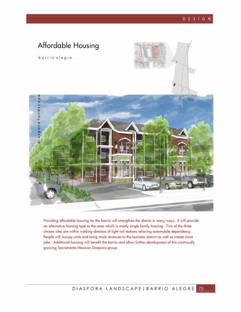
Affordable Housing . . . . . . 3.06
Franklin Boulevard Park . . . . . . 3.07
Commercial Improvements . . . . . 3.08
Streetscape Enhancements . . . . . 3.09
Highway 99 Mexican Art . . . . . 3.10
REFERENCES
Model of Site . . . . . . . 4.00
APPENDIX
Model of Site . . . . . . . 5.00
Sample Questionnaire 1 . . . . . . 5.01
Sample Questionnaire 2 . . . . . . 5.02
Sample Questionnaire 3 . . . . . . 5.03
Sample Questionnaire 4 . . . . . . 5.04

I N T R O D U C T I O N

I N T R O D U C T I O N
D I A S P O R A L A N D S C A P E | B A R R I O A L E G R E 1
I N T R O D U C T I O N
EXECUTIVE SUMMARY
Since its conception in the 1950’s, Barrio Alegre
has been the most prominent Mexican American
commercial district in Sacramento. Despite
political, physical, and economic obstacles Barrio
Alegre continues to be home to the majority of
Sacramento’s Mexican immigrants. With the
current downfall of the US economy, Barrio
Alegre’s commercial district has suffered its most
challenging economic situation yet.
The City and County of Sacramento have teamed
up with the North Franklin Business District
Association and the Sacramento Housing and
Redevelopment Agency to devise an urban
renewal plan to rejuvenate the economy of Barrio
Alegre. These agencies are in the process of
developing design solutions for the four-mile
commercial district along the barrio’s main
corridor Franklin Boulevard.

I N T R O D U C T I O N
D I A S P O R A L A N D S C A P E | B A R R I O A L E G R E 2
As a landscape architect student and former
resident of Barrio Alegre it is my desire to
develop an alternative urban renewal plan that
will not only spark economic revitalization but
also reflect the history and culture of the barrio.
With guidance from professors and site data from
willing agencies extensive research, mapping,
and community outreach have generated the
following proposed designs.
I N T R O D U C T I O N
D I A S P O R A L A N D S C A P E | B A R R I O A L E G R E 3
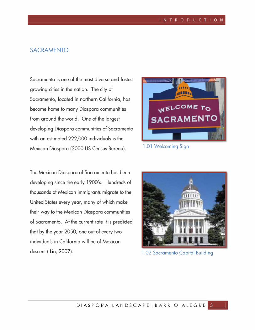
SACRAMENTO
Sacramento is one of the most diverse and fastest
growing cities in the nation. The city of
Sacramento, located in northern California, has
become home to many Diaspora communities
from around the world. One of the largest
developing Diaspora communities of Sacramento
with an estimated 222,000 individuals is the
Mexican Diaspora (2000 US Census Bureau).
The Mexican Diaspora of Sacramento has been
developing since the early 1900’s. Hundreds of
thousands of Mexican immigrants migrate to the
United States every year, many of which make
their way to the Mexican Diaspora communities
of Sacramento. At the current rate it is predicted
that by the year 2050, one out of every two
individuals in California will be of Mexican
descent ( Lin, 2007).
1.02 Sacramento Capital Building
1.01 Welcoming Sign
I N T R O D U C T I O N
D I A S P O R A L A N D S C A P E | B A R R I O A L E G R E 4
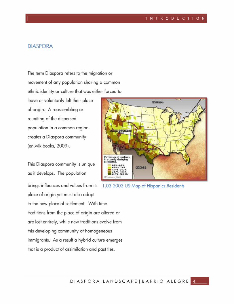
DIASPORA
The term Diaspora refers to the migration or
movement of any population sharing a common
ethnic identity or culture that was either forced to
leave or voluntarily left their place
of origin. A reassembling or
reuniting of the dispersed
population in a common region
creates a Diaspora community
(en.wikibooks, 2009).
This Diaspora community is unique
as it develops. The population
brings influences and values from its
place of origin yet must also adapt
to the new place of settlement. With time
traditions from the place of origin are altered or
are lost entirely, while new traditions evolve from
this developing community of homogeneous
immigrants. As a result a hybrid culture emerges
that is a product of assimilation and past ties.
1.03 2003 US Map of Hispanics Residents

I N T R O D U C T I O N
D I A S P O R A L A N D S C A P E | B A R R I O A L E G R E 5
HISTORY OF FRANKLIN BOULEVARD
The following information has been provided by
the Franklin Boulevard Urban Design Master Plan
assembled by the Sacramento Housing
and Redevelopment Agency and Carter
& Burgess in January of 2001.
Franklin Boulevard has existed since the
pre-nineteenth century. It can be found
on historic maps as a wagon trail called
Lower Stockton Road connecting
Sacramento to the southern town of
Franklin.
The construction of Highway 99,
located just east of Franklin Boulevard,
was completed in 1961. Although the
highway would promote mobility and
growth within the barrio, it had a
profoundly negative impact on Franklin
Boulevard’s commercial district.
Franklin Boulevard had served as a
north/south thoroughfare from
Sacramento to towns toward the south. The
highway diverted the traffic flow that many
1.04 Map of South Sacramento in 1908
I N T R O D U C T I O N
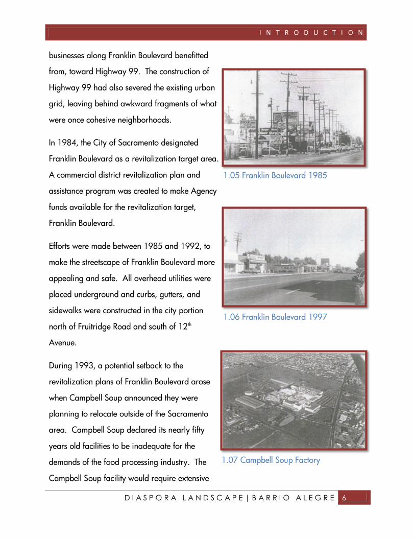
D I A S P O R A L A N D S C A P E | B A R R I O A L E G R E 6
businesses along Franklin Boulevard benefitted
from, toward Highway 99. The construction of
Highway 99 had also severed the existing urban
grid, leaving behind awkward fragments of what
were once cohesive neighborhoods.
In 1984, the City of Sacramento designated
Franklin Boulevard as a revitalization target area.
A commercial district revitalization plan and
assistance program was created to make Agency
funds available for the revitalization target,
Franklin Boulevard.
Efforts were made between 1985 and 1992, to
make the streetscape of Franklin Boulevard more
appealing and safe. All overhead utilities were
placed underground and curbs, gutters, and
sidewalks were constructed in the city portion
north of Fruitridge Road and south of 12th
Avenue.
During 1993, a potential setback to the
revitalization plans of Franklin Boulevard arose
when Campbell Soup announced they were
planning to relocate outside of the Sacramento
area. Campbell Soup declared its nearly fifty
years old facilities to be inadequate for the
demands of the food processing industry. The
Campbell Soup facility would require extensive
1.05 Franklin Boulevard 1985
1.06 Franklin Boulevard 1997
1.07 Campbell Soup Factory

I N T R O D U C T I O N
D I A S P O R A L A N D S C A P E | B A R R I O A L E G R E 7
reconstruction in order to stay located in
Sacramento. This reconstruction would not be
economically feasible without some sort
redevelopment assistance. In order to retain this
large employer, governing
bodies negotiated with Campbell
Soup and offered redevelopment
assistance package that included
a redevelopment plan with a tax
increment rebate contingent
upon reinvestment in the facility.
The Franklin Boulevard Project
Area was established in
December of 1993. Since then
the Agency has worked on a
number of revitalization projects.
The revitalization projects include
commercial façade improvement
rebates, neighborhood cleanup
projects, code enforcement and
the development and
preservation of single and multi-family housing.
In 2001, the Franklin Boulevard Urban Design
Plan was constructed by the Sacramento Housing
and Redevelopment Agency (SHRA) to further
1.08 Franklin Boulevard revitalization site

I N T R O D U C T I O N
D I A S P O R A L A N D S C A P E | B A R R I O A L E G R E 8
improve the districts vitality. The plan serves as a
blueprint for which improvements will be made.
The Agency was awarded approximately $3
million in federal funds to design and construct
streetscape improvements in the southern county
section along Franklin in 2002. Sidewalk
improvements, landscape planters, street lights,
and street trees would be included in the
improvements.
In 2007, the first phases of improvement plan
along Franklin Boulevard were completed.
Improvements were made at Fruitridge Road,
near 47th Avenue and Martin Luther King Jr.
Boulevard.
1.09 Recent improvements along
Franklin
1.10 Improvements toward southern
end of redevelopment site

I N T R O D U C T I O N
D I A S P O R A L A N D S C A P E | B A R R I O A L E G R E 9
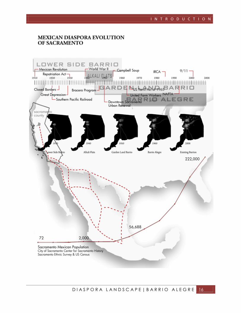
SACRAMENTO BARRIOS
The following information has been assembled
from the Sacramento Archives and Museum
Collection Center from the Sacramento Ethnic
Survey of 1983.
Within Sacramento County
there is estimated to be
222,000 people of
Mexican descent (2000 US
Census Bureau). As
Mexicans migrate to
Sacramento, many are
drawn to areas that better
identify with their
Hispanic/Latino culture.
The gathering of Mexican
immigrants and families to a common location
creates Mexican communities, known as
“Barrios”. The Sacramento area has seen the
development of four major barrios in its time
span. These four barrios have been known as the
Lower Side Barrio (South Side Barrio), the Alkali
1.11 Sacramento County Mexican Dot Density Map

I N T R O D U C T I O N
D I A S P O R A L A N D S C A P E | B A R R I O A L E G R E 10
Flats Barrio, the Garden Land Barrio, and the
largest, Barrio Alegre also known as the Franklin
Barrio.
SOUTH SIDE BARRIO
The first recognized Mexican immigrant
community in Sacramento formulated during
1910, just to the north of Franklin Boulevard.
Due to the barrios location in south Sacramento,
the barrio took on the name Lower Side Barrio or
the South Side Barrio. South Side Barrio
developed as a direct result of the Mexican
revolution. Mexican immigrants from various
regions of Mexico fled seeking economic
opportunities and escape from the revolution
which claimed one out of every eight lives in
Mexico.
Ernesto Galarza and his family were among
those who sought refuge in Sacramento’s South
Side Barrio during the Mexican revolution. South
Side Barrio provided not only escape for families
such as Ernesto’s, but also economic opportunities
in the transcontinental railroad, food packaging,
mining, and agricultural industries. Ernesto
1.12 The Robert Emmertt Callahan
Memorial in South Side Park
1.13 La Iglesia de Nuestra Senora La
Virgen de Guadalupe on 711 T Street in
South Side Barrio

I N T R O D U C T I O N
D I A S P O R A L A N D S C A P E | B A R R I O A L E G R E 11
Galarza’s personal diary records the barrio as
the following:
For Mexicans the barrio was a colony of
refugees. We came to know families from
Chihuahua, Sonora, Jalisco and Durango.
Some had come to the United States even
before the (Mexican) revolution, living in
Texas before migrating to California. Like
ourselves, our Mexican neighbors had come
this far moving step by step, working and
waiting, as if they were feeling their way up a
ladder…The colonia was like a sponge that
was beginning to leak along the edges,
squeezed between the levee, the railroad
tracks, and the river front. But it wasn’t
squeezed dry, because it kept filling with
newcomers who took in boarders…Crowded
as it was, the colonia found a place for these
Chicanos, the name by which we called an
unskilled worker born in Mexico and just
arrived in the U.S. The Chicanos were fond
of identifying themselves by saying they had
just arrived from “el mazico”, by which they
meant the homeland, the good, native earth.
Although they spoke of “el mazico” as a
homesick person, they didn’t go back.
1.14 Dancing in South Side Park for
Cinco de Mayo
I N T R O D U C T I O N
D I A S P O R A L A N D S C A P E | B A R R I O A L E G R E 12
The Mexican Revolution came to an end during
the 1920’s, however South Side Barrio continued
to expand its borders as more immigrants arrived
seeking economic opportunities in this thriving
barrio.
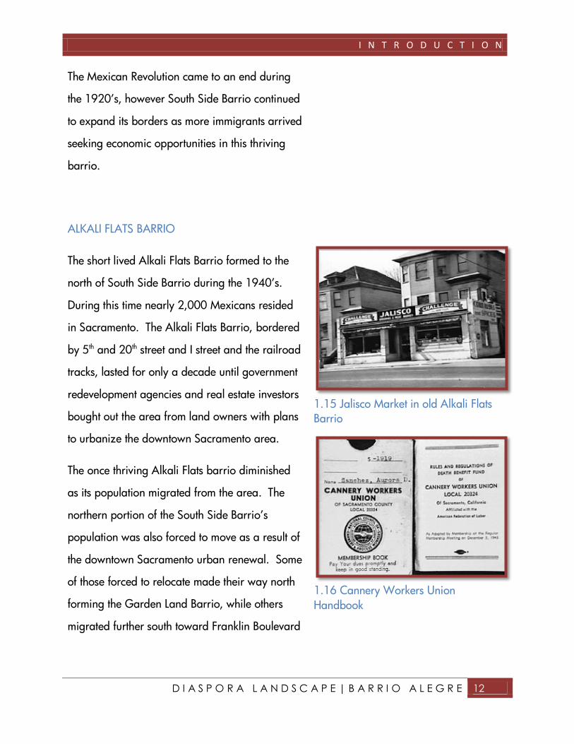
ALKALI FLATS BARRIO
The short lived Alkali Flats Barrio formed to the
north of South Side Barrio during the 1940’s.
During this time nearly 2,000 Mexicans resided
in Sacramento. The Alkali Flats Barrio, bordered
by 5th and 20th street and I street and the railroad
tracks, lasted for only a decade until government
redevelopment agencies and real estate investors
bought out the area from land owners with plans
to urbanize the downtown Sacramento area.
The once thriving Alkali Flats barrio diminished
as its population migrated from the area. The
northern portion of the South Side Barrio’s
population was also forced to move as a result of
the downtown Sacramento urban renewal. Some
of those forced to relocate made their way north
forming the Garden Land Barrio, while others
migrated further south toward Franklin Boulevard
1.15 Jalisco Market in old Alkali Flats
Barrio
1.16 Cannery Workers Union
Handbook

I N T R O D U C T I O N
D I A S P O R A L A N D S C A P E | B A R R I O A L E G R E 13
creating Barrio Alegre, known today as the
Franklin Barrio.
GARDEN LAND BARRIO
Garden Land formed in the North Sacramento off
of Northgate Boulevard. Like Alkali Flats,
Garden Land Barrio also developed in the
1940’s, with the wave of Mexicans seeking
employment opportunities along the river front,
canneries, lumberyards and rice mills. With the
loss of Alkali Flats in the 1950’s, Garden Land
Barrio grew and developed stronger in the North
Sacramento region. Northern, outlying Mexican
communities also contributed to the growth of
Garden Land Barrio. Mexicans from Lincoln,
Roseville, Woodland, and other northern
surrounding areas migrated to the Garden Land
Barrio for better employment prospects. These
northern barrios socialized and worked closely
with the Garden Land Barrio through employment
with the Southern Pacific Railroad and the
Roseville Ice Plant.
1.17 La Superior Market in Garden
Land Barrio
I N T R O D U C T I O N
D I A S P O R A L A N D S C A P E | B A R R I O A L E G R E 14
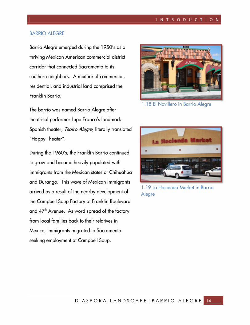
BARRIO ALEGRE
Barrio Alegre emerged during the 1950’s as a
thriving Mexican American commercial district
corridor that connected Sacramento to its
southern neighbors. A mixture of commercial,
residential, and industrial land comprised the
Franklin Barrio.
The barrio was named Barrio Alegre after
theatrical performer Lupe Franco’s landmark
Spanish theater, Teatro Alegre, literally translated
“Happy Theater”.
During the 1960’s, the Franklin Barrio continued
to grow and became heavily populated with
immigrants from the Mexican states of Chihuahua
and Durango. This wave of Mexican immigrants
arrived as a result of the nearby development of
the Campbell Soup Factory at Franklin Boulevard
and 47th Avenue. As word spread of the factory
from local families back to their relatives in
Mexico, immigrants migrated to Sacramento
seeking employment at Campbell Soup.
1.18 El Novillero in Barrio Alegre
1.19 La Hacienda Market in Barrio
Alegre
I N T R O D U C T I O N
D I A S P O R A L A N D S C A P E | B A R R I O A L E G R E 15
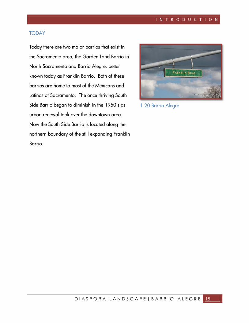
TODAY
Today there are two major barrios that exist in
the Sacramento area, the Garden Land Barrio in
North Sacramento and Barrio Alegre, better
known today as Franklin Barrio. Both of these
barrios are home to most of the Mexicans and
Latinos of Sacramento. The once thriving South
Side Barrio began to diminish in the 1950’s as
urban renewal took over the downtown area.
Now the South Side Barrio is located along the
northern boundary of the still expanding Franklin
Barrio.
1.20 Barrio Alegre
I N T R O D U C T I O N
D I A S P O R A L A N D S C A P E | B A R R I O A L E G R E 16

I N T R O D U C T I O N
D I A S P O R A L A N D S C A P E | B A R R I O A L E G R E 17
MIGRATION
Hundreds of thousands of Mexicans migrate each
year to the United States. There are several
factors involved in this desire to migrate to the
United States that include economic, cultural,
political, physical, and environmental reasons.
These factors have developed waves of migration
over time that create both a desire to obtain the
benefits of living in the United States and leave
behind the life that is presented in the nation of
Mexico.
ECONOMIC
Job opportunities, higher wages, and greater
monetary value of currency are just a few
elements that make the economy of the United
States preferable over that of Mexico. As the
United States thrived in the early twentieth
century, the people of Mexico sought after a
portion of this success. The Mexican economy
crumbled during the early 1900’s and
unemployment rose as a result of the Mexican
1.22 The US and Mexican Flags
I N T R O D U C T I O N
D I A S P O R A L A N D S C A P E | B A R R I O A L E G R E 18
revolution. In the early 1900’s, jobs for farming,
mining, and railroad constructing were in high
demand in the U.S. With open borders prior to
1924, all Mexican immigrants had to do to seize
these opportunities was simply walk across. The
states of California and Texas attracted many
Mexican immigrants.
California was the
largest producer of fruits
and vegetables in the
nation during the
1920’s, and Texas was
known as “Cotton King”
for its incredible
productions of cotton.
Job recruiters from the
United States began
seeking cheap labor
near the borders of
Mexico, encouraging
migration for
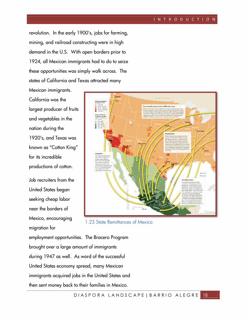
employment opportunities. The Bracero Program
brought over a large amount of immigrants
during 1947 as well. As word of the successful
United States economy spread, many Mexican
immigrants acquired jobs in the United States and
then sent money back to their families in Mexico.
1.23 State Remittances of Mexico

I N T R O D U C T I O N
D I A S P O R A L A N D S C A P E | B A R R I O A L E G R E 19
As this practice became more and more common,
Mexico’s economy became more and more
dependent on that of the United States. When the
Great Depression struck in the U.S. in 1929, and
recession in the 1970’s, the Mexican economy
was struck even worse, sending more immigrants
heading toward the U.S. both legally and
illegally. The phrases was made “When the U.S.
(economy) sneezed, Mexico caught a cold.”
Remittances make up nearly three percent of the
gross domestic product of Mexico.
Approximately eight hundred eighty six billion
dollars were received by Mexico in 2006. Eight
hundred forty two billion dollars, or ninety five
percent of the total remittances, come directly
from the U.S. Due to unbroken, historical ties, the
central Mexican states of Guanajuato, Jalisco,
Michoacán, Zacatecas, and San Luis Potosi
acquire forty four percent of all the remittances.
CULTURAL
Culturally Mexicans relate greatly to the areas
they are seen migrating to. These regions of
migration were at one time parts of Mexico. The
Annexation of Texas in 1845, the Treaty of
Guadalupe Hidalgo in 1848, and the Gadsen

I N T R O D U C T I O N
D I A S P O R A L A N D S C A P E | B A R R I O A L E G R E 20
Purchase of 1853, all took portions of California,
Arizona, New Mexico, Colorado, Utah, Nevada,
and Texas from the nation of Mexico. Although
the land was no longer Mexico, the people who
resided there still considered themselves Mexican
and maintained their Mexican cultural identity.
As immigrants made their way to these parts of
the U.S., it was as if they had never left Mexico
(Truett, 2004).
POLITICAL
Political issues in Mexico contribute greatly as
well to the desire to migrate. Drug trafficking,
human enslavement and smuggling, the Juarez
murders, and views of corruption within the
government and authorities are just some political
issues that Mexico faces. The United States
consumes more than 60% of illegal drugs in the
world and the majority of those drugs are
transported through Mexico. As South America
produces drugs and North America consumes
them, Mexico finds itself caught in the world of
drug trafficking bringing massive amounts of
corruption with it. Not only are drugs smuggled
into the U.S. by land, sea, air from Mexico, so
are people. Mexicans trying to enter the United
1.24 The Juarez Murders

I N T R O D U C T I O N
D I A S P O R A L A N D S C A P E | B A R R I O A L E G R E 21
States illegally will often hire experienced guides
known as “Coyotes“, to guide them safely across
the border. These guides however, occasionally
take advantage of unsuspecting immigrants and
may rob, rape, murder, or sell into prostitution or
slavery these immigrants that have hired them. In
Juarez, young women are murder regularly. The
women in this area go missing, and are later
found raped, murdered, and left dead in the
desert of Juarez. The murders have not been
identified despite the efforts of Juarez authorities,
however many assume this is because the
authorities are involved in the murders as well.
This lack of trust towards the government,
frequent murders, and smuggling of all types
make Mexico a potentially dangerous place and
spark ideas of migration in many citizens.
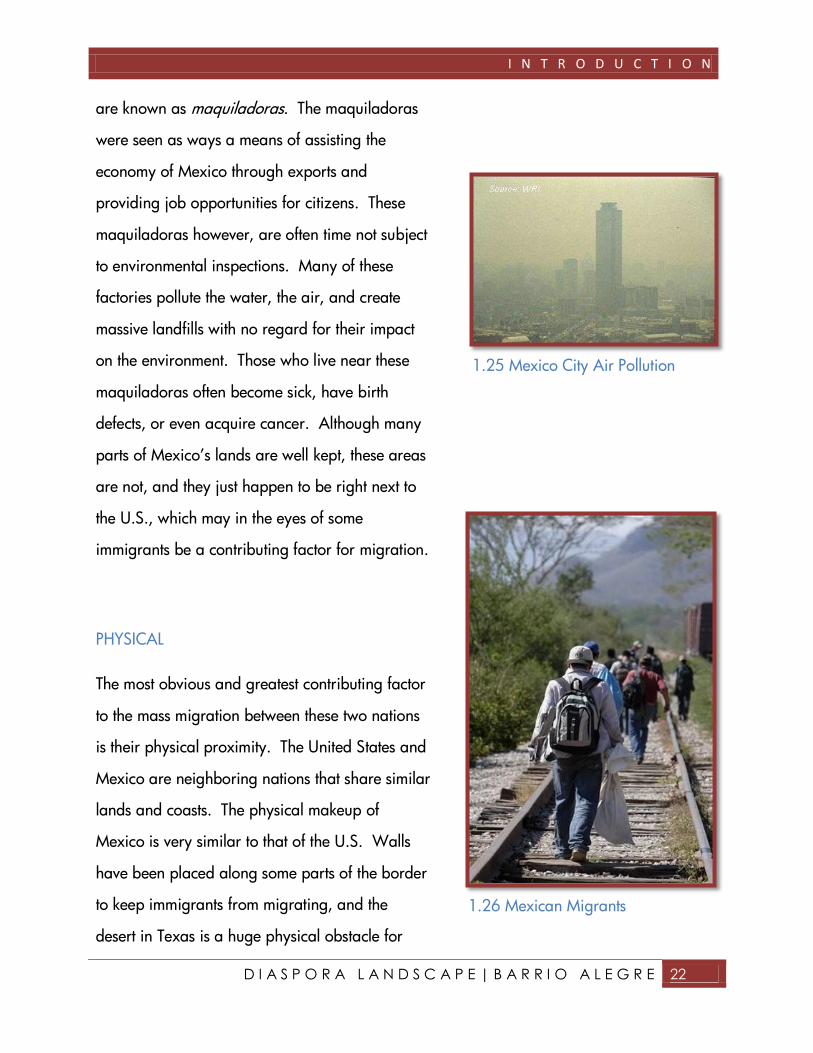
ENVIRONMENTAL
Environmental problems within Mexico may also
contribute to a longing to migrate. The
environment along the Mexican and U.S. border
are extremely polluted. As N.A.F.T.A., and the
U.S. Tariff Law of 1965, came into play, large
corporations began creating factories and
assembly shops along the border. These shops
I N T R O D U C T I O N
D I A S P O R A L A N D S C A P E | B A R R I O A L E G R E 22
are known as maquiladoras. The maquiladoras
were seen as ways a means of assisting the
economy of Mexico through exports and
providing job opportunities for citizens. These
maquiladoras however, are often time not subject
to environmental inspections. Many of these
factories pollute the water, the air, and create
massive landfills with no regard for their impact
on the environment. Those who live near these
maquiladoras often become sick, have birth
defects, or even acquire cancer. Although many
parts of Mexico’s lands are well kept, these areas
are not, and they just happen to be right next to
the U.S., which may in the eyes of some
immigrants be a contributing factor for migration.
PHYSICAL
The most obvious and greatest contributing factor
to the mass migration between these two nations
is their physical proximity. The United States and
Mexico are neighboring nations that share similar
lands and coasts. The physical makeup of
Mexico is very similar to that of the U.S. Walls
have been placed along some parts of the border
to keep immigrants from migrating, and the
desert in Texas is a huge physical obstacle for
1.25 Mexico City Air Pollution
1.26 Mexican Migrants

I N T R O D U C T I O N
D I A S P O R A L A N D S C A P E | B A R R I O A L E G R E 23
migration. Although these physical obstacles
create problems for Mexican immigrants, these
obstacles are not nearly as challenging as the
obstacle that other immigrant groups face in
crossing the ocean. It is the physical factor of
proximity that makes Mexican immigrants able to
easily access the United States.

I N T R O D U C T I O N
D I A S P O R A L A N D S C A P E | B A R R I O A L E G R E 24
CULTURE
HOLIDAYS
Mexican Americans throughout Sacramento
celebrate many different holidays; however there
are two major events most all Mexicans in the
U.S. celebrate. Cinco de Mayo (May 5th) is a
well known holiday commemorating the Mexican
victory over the French army in 1862 at Puebla
de Los Angeles. The second, Grito de Dolores, or
Mexican Independence Day (September 16th)
commemorates Mexican independence from
Spain, led by Miguel Hidalgo.
In Sacramento, these holidays are celebrated by
the Mexican communities typically in parks near
Hispanic communities. South Side Park,
Discovery Park, and William Land Park are
popular locations for these celebrations.
Other holidays include Dia de la Bandera
(February 24th), Dia de la Virgen de Guadelupe
(December 12th), Dia de las Madres (May 12th),
and Dia de los Muertos (November 12th).
1.27 Sacramento Celebration

I N T R O D U C T I O N
D I A S P O R A L A N D S C A P E | B A R R I O A L E G R E 25
RELIGION
Catholicism is the dominant religion among
Mexican immigrants. Mexicans originally
entered Catholic faith by means of the Spaniards,
who taught it to the indigenous people of Mexico.
In recent years the percentage of Mexicans who
practice Catholicism have began to decrease.
Despite this decline, Catholicism still remains the
dominant religion of the Mexican culture. In
1958, the Mexican immigrants of Sacramento
constructed a great, religious cathedral at 3rd and
O Street. Later the location of this main church
was moved to the intersection of 7th and T Street.
This church was known as La Iglesia de Nuestra
Senora la Virgen de Guadalupe. This church
brought Mexicans and Mexican-Americans of
different areas together by means of the Catholic
religion. Despite the incredible size of this
Catholic Church, seating over seven hundred and
fifty members, the large congregation overflowed
the church structure. Members of the overflowing
church, who were predominately Mexican, would
on some occasions be forced to stand on
sidewalks and spill into the streets just to here the
1.28 La Iglesia de Nuestra Senora La
Virgen de Guadalupe on 711 T Street
I N T R O D U C T I O N
D I A S P O R A L A N D S C A P E | B A R R I O A L E G R E 26
speaker of this popular Catholic Church (Sac.
Ethnic Survey, 1983).
SOCIAL ORGANIZATION
Social organization, identification, and
classification of individual Mexicans and the
Mexican community as a whole within American
cities are complex issues. As generations from
Mexican immigrants assimilate into the U.S.
culture at what point do they begin to identify
themselves as no longer Mexicans, but Mexican-
Americans?
When Mexican immigrants or individuals of
Mexican descent were asked whether they
classify themselves as Hispanic or Latino, often
they could not distinguish between the two.
According to Dr. Jason Newman, a history
professor at Cosumnes River College, the terms
“Hispanic” and “Latino”, are two means of
identification within this culture. The term
“Hispanic”, historically originated as a reference
to the people from the Roman province Hispania,
or today’s modern day Spain and Portugal. The
term “Hispanic” today, refers to those who trace
their ancestry back to Spanish speaking America,

I N T R O D U C T I O N
D I A S P O R A L A N D S C A P E | B A R R I O A L E G R E 27
and Spain. The term “Hispanic”, is known to
better define those who have a mixture of
Spanish and Indigenous heritage. “Latino”, used
interchangeably with “Hispanic”, is defined by
some as a shortened term for “Latin America” or
“Latin”. It is believed that this term “Latino”, more
specifically identifies with the indigenous people
of Latin American areas. Those who identify
themselves as “Latinos” acknowledge their
heritage with indigenous groups more so then
with the Spaniards or people of Spanish speaking
regions.
As Mexicans continue to migrate to the U.S. their
social organization also continues to grow more
sophisticated. In 1928, the first Mexican social
organization, “Madres Cristianas”, was formed
in Sacramento. It was later changed to
Guadalupamas. The group developed from
Mexico’s indigenous people and Spanish culture.
There are several groups such as Guadalupamas;
one well remembered was Centro Mexicano.
Centro Mexicano provided many Spanish
speaking teachers for children to learn their
native language, while also providing English
teachers for adult migrants. The Centro
Mexicano group contributed greatly to the
Mexican community of the area in many other

I N T R O D U C T I O N
D I A S P O R A L A N D S C A P E | B A R R I O A L E G R E 28
ways as well. They constructed a library and
cultural arts center, a social club, and a center for
meetings. Mexican immigrants in Sacramento
also developed their own business organizations.
The Hispanic Chamber of commerce is the largest
and most prominent business organization in the
Sacramento area. The Hispanic Chamber of
commerce donates million of dollars to a variety
of community events and campaign fundraisers
for local Chicano politicians.
In the 1940’s, there emerged the United Cannery,
Agriculture, Packing and Allied Workers of
America or UCAPAWA group supporting the
cannery workers of Sacramento. Some groups in
the 1960’s included Concilio, which provided
health care and elderly services and the
Sacramento Lower Rider Association, the
Mexican American Education Association or
MECHA, and the United Farm Workers. The
1970’s and 1980’s brought the United Cannery
Workers group and the Chicano Organization of
Political Action or COPA which provided fair and
equal housing, and medical care and the Latin
Association of Spanish Speaking American
Journalists (Sac. Ethnic Survey 1983).

I N T R O D U C T I O N
D I A S P O R A L A N D S C A P E | B A R R I O A L E G R E 29
LANGUAGE
The Spanish language is one of the significantly
distinguishing features of the Mexican culture.
The indigenous people of Mexico, who were
taught Spanish by the Spaniards, have continued
to use Spanish both in the home and public areas
of the United States. From 1940 to 1950, a new
form of language, “Calo” or “Spanglish”, which
is composed of both the Spanish and English
language, is popularly used by teenagers (Sac.
Ethnic Survey, 1983).
MEDIA
Media organizations, such as newspapers, radio
stations, and television programs greatly
contribute to the Mexican-American culture.
Spanish newspapers were published in the
Sacramento community in early 20th century. El
Noticiero del Norte was the first Spanish and
English language Newspaper in the Sacramento
region. El Noticiero del Norte was distributed
monthly in Sacramento and was started by Lupe
Franco. Since the 1960’s, a full time Spanish
speaking station in the Sacramento area known

I N T R O D U C T I O N
D I A S P O R A L A N D S C A P E | B A R R I O A L E G R E 30
as KPIP or “Radio Capital”, stationed out of
Roseville, has graced the air waves. This popular
station has added to enrich the Mexican culture in
northern California with its many Mexican Disc
Jockeys. In 1971, Marty Mercado and John
Villarreal co-founded the bilingual news and
entertainment program called “Progreso.”
Another prominent Latino, North American new
service is ALPHHA, who has existed since 1983.
Music and Dance are also very important
elements of Mexican culture. Santo Nombre was
the first local Mexican marching band in
Sacramento during the 1930’s. Bellet del Sol was
the primary Hispanic Dance group in Sacramento
during 1973. A group known as the Centro de
Artistas or The center of Arts was a very active art
group in the Sacramento community during the
1960’s. Centro de Artistas sought to collect and
preserve exquisite art pieces depicting the proud
Mexican horseman from early times.
Sacramento’s Mexican media has grown and
now has several Spanish media outlets. Some of
these outlets include: KUVS Univision 19, KCSO
Telemundo 33, five local Spanish language radio
stations, and one popular Spanish language
newspaper, known as “El Hispano”. Musical
bands, dance groups, and Centro de Artistas are
1.29 Popular Spanish Speaking
Television Network

I N T R O D U C T I O N
D I A S P O R A L A N D S C A P E | B A R R I O A L E G R E 31
definitely elements that make up Mexican
immigrant community of Sacramento (Sac. Ethnic
Survey, 1983).
EDUCATION
According to the 2000, U.S. Census, the average
household income for Latinos in the United States
during 1999, was only $33,676 annually. The
average household income for non-
Mexican/White households was $44,687. And
the national average income for the entire United
States was $41,994.
These numbers presented may be a direct result
of the lack of education that many Mexicans in
the United States acquire due to their difficulty to
assimilate into American culture and English
language. The Mexican immigrants of the United
States as a whole often acquire much less
schooling then that of other migrant groups in the
United States. Obtaining higher levels of
education is vital to the economic success of any
migrant group.
Studies have shown that Mexican youth who
immigrate to the U.S. between the age of 15 and
21 have high school completion rates of only 28
1.30 Mexican Education

I N T R O D U C T I O N
D I A S P O R A L A N D S C A P E | B A R R I O A L E G R E 32
percent. Those youth who arrive in the United
States between the ages of 5 and 15 have a
slightly better success rate at 40 percent. And
children who arrive to the United States before
the age of 5 as “near-native” students do much
better with a 78 percent of completing high
school. This study verifies that higher level of
academic achievement is necessary to improve
the economic status of Mexican Americans and
assimilate them into the economic mainstream of
the United States. Further studies reveal that the
long-term economic prospects for people of
Mexican descent is considerably brighter that of
foreign-born immigrants. Second and Third
generation Mexican Americans have a greater
chance of being successful in the future.

A N A L Y S I S

A N A L Y S I S
D I A S P O R A L A N D S C A P E | B A R R I O A L E G R E 34
A N A L Y S I S
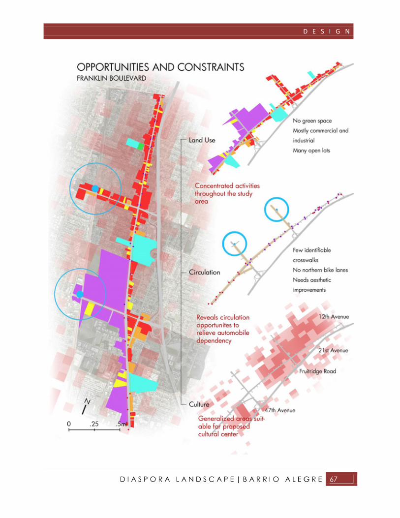
STUDY AREA CONDITIONS
To develop the most effective design
solution for the study area,
evaluations of the existing conditions
were performed. The evaluation
included land use and circulation
throughout the study area.
Observations of these conditions
along with historical research and
public participation provide suitable
criteria for design development.
The northern portion of the study
area is located within the City of
Sacramento boundaries, while the
southern portion is a part of
Sacramento County. Though this boundary line
bisects the site into two parts, implementation of
such a design plan would need to consider these
jurisdictions as a joint district.
2.01 Franklin Boulevard Redevelopment Study Area
A N A L Y S I S
D I A S P O R A L A N D S C A P E | B A R R I O A L E G R E 35
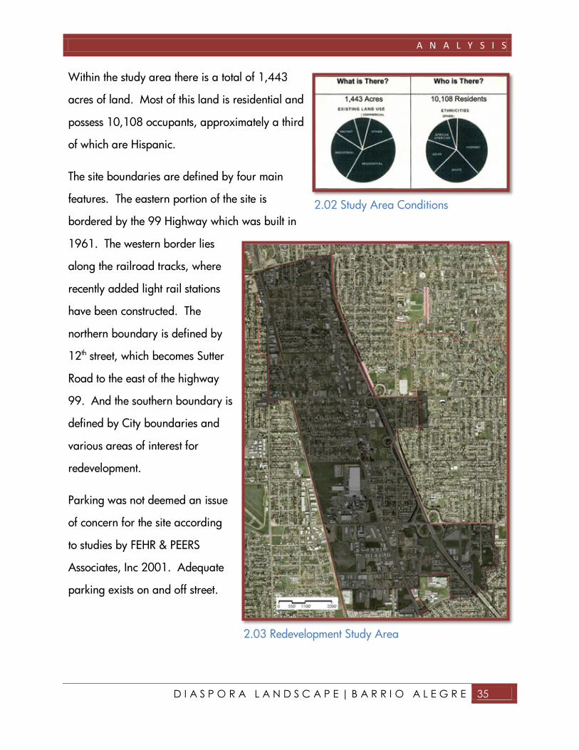
Within the study area there is a total of 1,443
acres of land. Most of this land is residential and
possess 10,108 occupants, approximately a third
of which are Hispanic.
The site boundaries are defined by four main
features. The eastern portion of the site is
bordered by the 99 Highway which was built in
1961. The western border lies
along the railroad tracks, where
recently added light rail stations
have been constructed. The
northern boundary is defined by
12th street, which becomes Sutter
Road to the east of the highway
99. And the southern boundary is
defined by City boundaries and
various areas of interest for
redevelopment.
Parking was not deemed an issue
of concern for the site according
to studies by FEHR & PEERS
Associates, Inc 2001. Adequate
parking exists on and off street.
2.02 Study Area Conditions
2.03 Redevelopment Study Area
A N A L Y S I S
D I A S P O R A L A N D S C A P E | B A R R I O A L E G R E 36
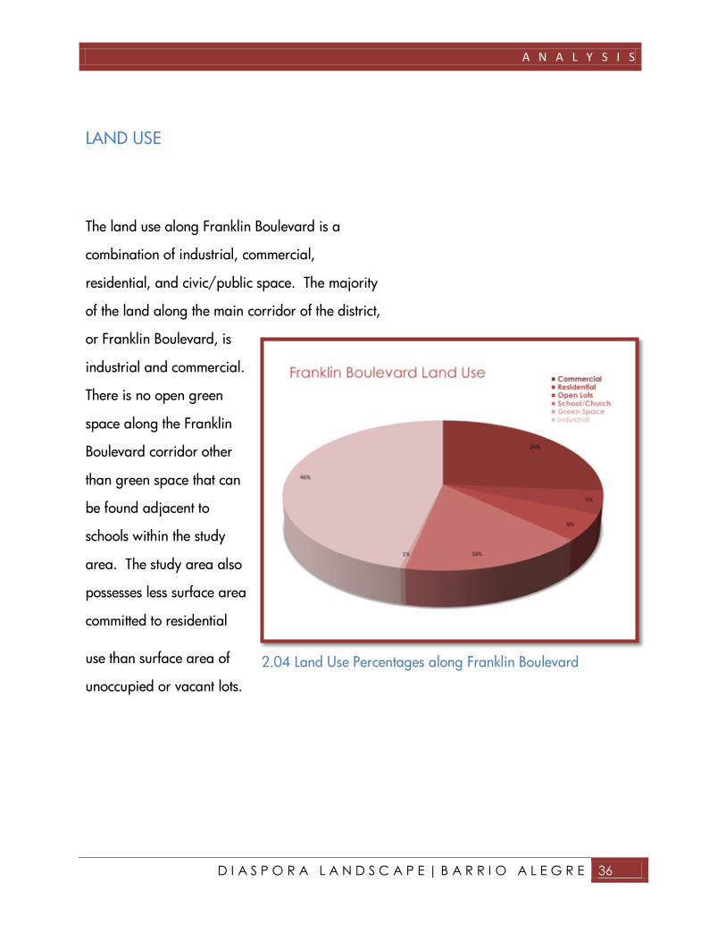
LAND USE
The land use along Franklin Boulevard is a
combination of industrial, commercial,
residential, and civic/public space. The majority
of the land along the main corridor of the district,
or Franklin Boulevard, is
industrial and commercial.
There is no open green
space along the Franklin
Boulevard corridor other
than green space that can
be found adjacent to
schools within the study
area. The study area also
possesses less surface area
committed to residential
use than surface area of
unoccupied or vacant lots.
2.04 Land Use Percentages along Franklin Boulevard

A N A L Y S I S
D I A S P O R A L A N D S C A P E | B A R R I O A L E G R E 37

A N A L Y S I S
D I A S P O R A L A N D S C A P E | B A R R I O A L E G R E 38
CIRCULATION
There are four modes of transportation along
Franklin Boulevard: pedestrian, bicycle,
automobile, and light rail. All modes of
transportation should be taken into consideration
within the design.
Traffic congestion is a concern along Franklin
Boulevard during peak traffic hours. There are
many areas that also do not have appropriate
curbs, gutters, or sidewalks along the four lane
arterial road. Providing alternatives means of
transportation will help relieve congestion and
move the district away from automobile
dependency. Beautification of roads and definite
curbs and gutters are needed.
There are bike lanes along both sides of Franklin
Boulevard south of Fruitridge Road. There are
also bike lanes along Fruitridge Road and 47th
Avenue on both sides from the light rail station to
Franklin Boulevard. However north of Fruitridge
Road there are no bike lanes at all.
2.06 Franklin Bike Lanes

A N A L Y S I S
D I A S P O R A L A N D S C A P E | B A R R I O A L E G R E 39
Pedestrian traffic exists along Franklin Boulevard;
however there are minimal features that support
this mode of transportation. Throughout the study
area there are no cross walks other than at main
intersections. There are also several locations
that do not have defined pedestrian paths or
sidewalks.
There are two light rail stations within the study
area. They are both located west of the site
along main roads leading to Franklin Boulevard.
These light rail stations provide an alternative
means of transportation for commuters.
Residential housing would be ideal within a
quarter mile radius of stations. A quarter mile
radius would make walking to and from the
station very simple, and would again promote
transportation other than automobile use.
Bus routes 63 and 67 run along Franklin
Boulevard. Route 63 runs along the northern and
southern portions of the study area and has
twenty one stops along the corridor. Route 67
has 22 stops along Franklin all north of 47th
Avenue will the exception of the southernmost
stop which is just south of 47th Avenue.
2.07 Sacramento Light Rail Station
2.08 Bus Stop

A N A L Y S I S
D I A S P O R A L A N D S C A P E | B A R R I O A L E G R E 40

A N A L Y S I S
D I A S P O R A L A N D S C A P E | B A R R I O A L E G R E 41
SHRA PUBLIC WORKSHOP
Working with the community to develop the best
design solutions for the area is a vital part of the
design process. The Sacramento
Housing and Redevelopment Agency
assembled two public workshops to
gather input from the community in
the beginning phases of improvement
planning along Franklin Boulevard.
The public workshops were held at St.
Rose and St. Patrick Social Halls.
Both Halls are located just south of
Fruitridge Road along Franklin
Boulevard.
PUBLIC WORKSHOP #1 – September 13th, 2000
During the workshop participants were able to
voice their opinions, concerns, and visions for the
future of Franklin Boulevard. Project sponsors,
consultant teams, and subcommittee volunteers
had an opportunity to give brief introductions
regarding the existing conditions of the corridor,
which was followed by a group discussion. After
2.10 SHRA Public Workshops

A N A L Y S I S
D I A S P O R A L A N D S C A P E | B A R R I O A L E G R E 42
the discussion, the participants broke out
into smaller focus groups, facilitated by
professionals to explore different aspects
of improvements. At the conclusion,
participants regrouped to report their key
issues and observations.
PUBLIC WORKSHOP #2 – November 8th
2000
The second workshop was comprised of a brief
overview of the first workshop and then
presentation and discussion of a proposed draft
for the study area. Some of the major design
concepts included: creating three major districts
along the study area, creating of a village center,
introducing streetscape furnishing, creation of
new parks, and streetscape redevelopment.
Following the presentation, the community was
able to give feedback about the plans. An in-
depth discussion was held regarding prioritizing
improvements to be made.
2.11 SHRA Public Workshop

A N A L Y S I S
D I A S P O R A L A N D S C A P E | B A R R I O A L E G R E 43
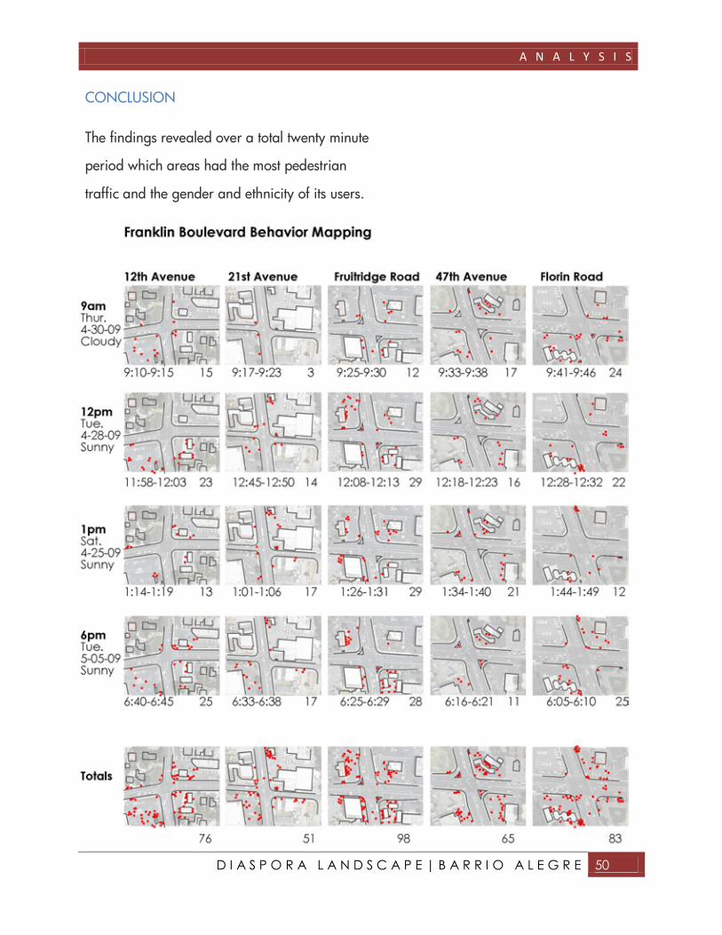
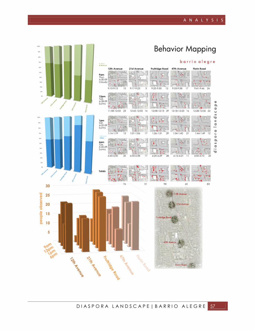
BEHAVIOR MAPPING
Behavior mapping was conducted along the
major intersections of the Franklin Boulevard
Corridor. The behavior mappings would allow
insight into the true heart of the barrio and
where activity occurred throughout the day.
The behavior mapping was conducted at five
different locations along the four mile Franklin
Boulevard corridor. The cross streets were
(from north to south): 12th Avenue, 21st
Avenue, Fruitridge Road, 47th Avenue, and
Florin Road. The intersections included in the
behavior mapping were major intersections
that were near Highway 99 onramps to the
east, with the exception of 21st street which is
the chosen location for the civic plaza.
The behavior mapping recorded a five minute
period at each intersection. The mapping
recorded different random time frames of the day
at random days of the week. Behavior mapping
was conducted a total of twenty minutes at each
intersection. Any viewable foot traffic that took
place during the observation time frame was
2.12 Behavior Mapping Locations

A N A L Y S I S
D I A S P O R A L A N D S C A P E | B A R R I O A L E G R E 44
recorded and mapped, along with the assumed
ethnicity and gender of the individual being
recorded.
Identifying areas with high levels of foot traffic
will help indicate which intersections are of high
interest and importance to the community.
Recording the pedestrian foot traffic at different
hours of the day will help display at what times
particular areas are in use or not in use.
Recording the assumed ethnicities of individuals
will help to identify the location of social central
areas along Franklin Boulevard. Finally
recording the gender of individuals will help to
show whether particular areas are catered
toward males or females, for whatever reason.
Also recording the gender may indicate issues of
safety. Areas that may be under used by women
could be locations where women feel unsafe,
which indicates possible security problems with
the location.
A N A L Y S I S
D I A S P O R A L A N D S C A P E | B A R R I O A L E G R E 45
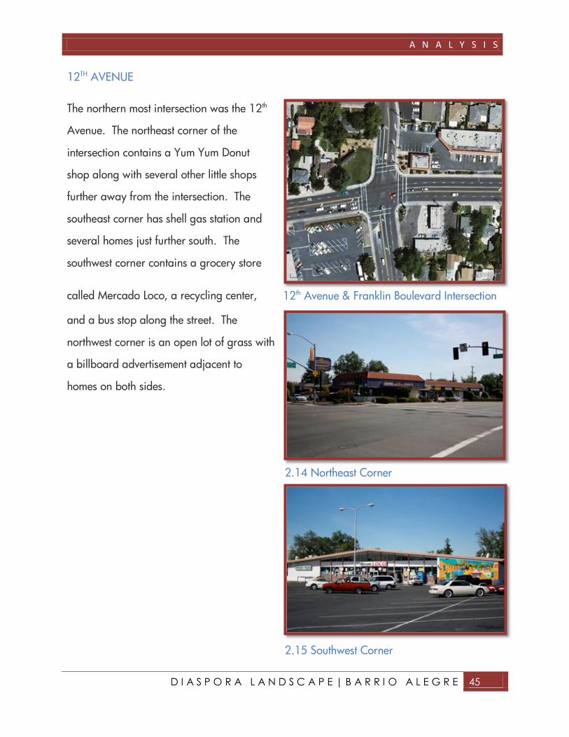
12TH AVENUE
The northern most intersection was the 12th
Avenue. The northeast corner of the
intersection contains a Yum Yum Donut
shop along with several other little shops
further away from the intersection. The
southeast corner has shell gas station and
several homes just further south. The
southwest corner contains a grocery store
called Mercado Loco, a recycling center,
and a bus stop along the street. The
northwest corner is an open lot of grass with
a billboard advertisement adjacent to
homes on both sides.
12th Avenue & Franklin Boulevard Intersection
2.14 Northeast Corner
2.15 Southwest Corner

A N A L Y S I S
D I A S P O R A L A N D S C A P E | B A R R I O A L E G R E 46
21st AVENUE
21st Avenue located along Franklin
Boulevard is the site for the proposed civic
plaza. It is the only intersection that was
observed that does not connect to the
freeway. However, it is one of the few
streets without a freeway connection that
connects to the adjacent Oak Park
community. This makes it an important
connection point and is heavily traveled by
parents and children of Oak Park to reach
the Ethel Philips School to the west of the
intersection. The northeast corner has a bus
stop and a bike shop, as well as two new
shops, a bridal dress shop and a salon. The
southeast corner contains abandoned
buildings that would be the location of the
civic plaza. To the southwest there are a few
shops that include Mora’s Boots
and La Hacienda Market. Red
Plumbing is located on the
northwest corner. Just behind
Mora’s Boots and La Hacienda
Market is the Ethel Philips School
which contains the only green space along the
entire four mile corridor.
2.16 21ST Avenue & Franklin Boulevard
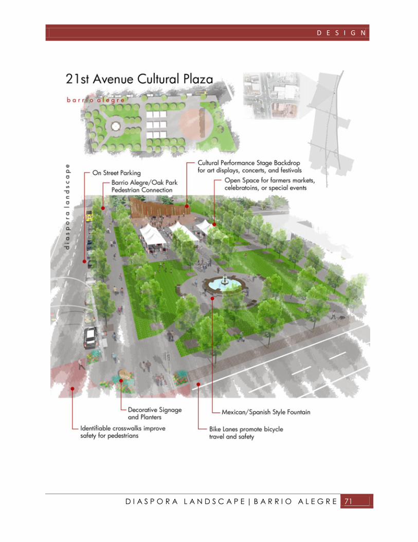
2.17 Southwest Corner
2.18 Southeast Corner - Future Location of Cultural Plaza
A N A L Y S I S
D I A S P O R A L A N D S C A P E | B A R R I O A L E G R E 47
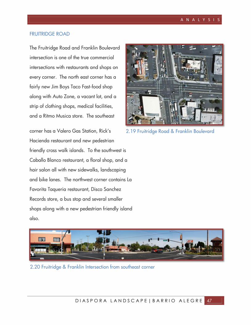
FRUITRIDGE ROAD
The Fruitridge Road and Franklin Boulevard
intersection is one of the true commercial
intersections with restaurants and shops on
every corner. The north east corner has a
fairly new Jim Boys Taco Fast-food shop
along with Auto Zone, a vacant lot, and a
strip of clothing shops, medical facilities,
and a Ritmo Musica store. The southeast
corner has a Valero Gas Station, Rick’s
Hacienda restaurant and new pedestrian
friendly cross walk islands. To the southwest is
Caballo Blanco restaurant, a floral shop, and a
hair salon all with new sidewalks, landscaping
and bike lanes. The northwest corner contains La
Favorita Taqueria restaurant, Disco Sanchez
Records store, a bus stop and several smaller
shops along with a new pedestrian friendly island
also.
2.19 Fruitridge Road & Franklin Boulevard
2.20 Fruitridge & Franklin Intersection from southeast corner

A N A L Y S I S
D I A S P O R A L A N D S C A P E | B A R R I O A L E G R E 48
47th AVENUE
47th Avenue is the location of the Campbell
Soup Factory on the northwest corner,
which helped spark growth of the Mexican
community in the area. The northeast
corner has a gas station and liquor shop
with an adjacent empty lot. The southeast
corner has a NAPA Auto Parts Shop that
takes up most of the corner. To the
southwest there is a vacant lot with a
billboard and a USA Wheels and Tires
Store and several other auto repair shops.
All four corners have sidewalks and bike
lanes.
2.21 47th Avenue & Franklin Intersection
2.22 Southwest corner at 47th Avenue
2.23 Northwest Corner at 47th Avenue

A N A L Y S I S
D I A S P O R A L A N D S C A P E | B A R R I O A L E G R E 49
FLORIN ROAD
A main intersection just south of the study
site was Florin Road. Although the
intersection is not included in the study area,
behavior mapping was conducted to see if
there were any connections or noticeable
difference from the intersections within the
study area boundaries. To the northeast
corner is a Carl’s Jr., a Pizza Hut and a bus
stop. To the southeast a bus stop and a
parking lot to the Southgate Plaza shopping
area. To the southwest a Shell Gas station
and a bus stop. The northwest corner is
vacant parking lot that was once a car
dealership.
Florin Road & Franklin Boulevard Intersection
2.25 Southeast Corner at Florin Road
2.26 Southwest Corner at Florin Road
A N A L Y S I S
D I A S P O R A L A N D S C A P E | B A R R I O A L E G R E 50
CONCLUSION
The findings revealed over a total twenty minute
period which areas had the most pedestrian
traffic and the gender and ethnicity of its users.

A N A L Y S I S
D I A S P O R A L A N D S C A P E | B A R R I O A L E G R E 51
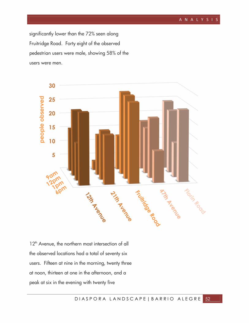
The most heavily used intersection by
pedestrians was Fruitridge Road with
ninety eight total recorded users in twenty
minutes. Twelve pedestrians were recorded
at nine in the morning twenty nine users at
noon, twenty nine at one in the afternoon,
and twenty eight at six in the evening. Of
the ninety eight pedestrian recorded seventy
one were assumed to be of Mexican
descent, indicating approximately 72% of its
users throughout the day to be Mexican. Sixty
four of the ninety eight individuals were male, or
65% of the pedestrians along Franklin and
Fruitridge throughout the day were men.
The second most frequently used intersection was
Florin Road with eighty three users in a twenty
minute period. Despite a shopping center and
three bus stops, this location still did not achieve
higher numbers than Fruitridge Road. There
were twenty four users at nine in the morning,
twenty two users at noon, twelve users at one in
the afternoon, and twenty five users at six in the
evening. Thirty four of the users observed were
assumed to be of Mexican descent, indicating
only 40% of the daily users to be of Mexican
descent. Although 40% is nearly half, it is
2.28 The southwest corner of Fruitridge Road
A N A L Y S I S
D I A S P O R A L A N D S C A P E | B A R R I O A L E G R E 52
significantly lower than the 72% seen along
Fruitridge Road. Forty eight of the observed
pedestrian users were male, showing 58% of the
users were men.
12th Avenue, the northern most intersection of all
the observed locations had a total of seventy six
users. Fifteen at nine in the morning, twenty three
at noon, thirteen at one in the afternoon, and a
peak at six in the evening with twenty five

A N A L Y S I S
D I A S P O R A L A N D S C A P E | B A R R I O A L E G R E 53
recorded pedestrian users. Fifty two were
assumed to be of Mexican descent, indicating
68% of the users to be Mexican. Forty four of the
seventy six were male and thirty two were female,
showing 58% of the users during the recorded
time were men.
The main intersection with the least activity was

A N A L Y S I S
D I A S P O R A L A N D S C A P E | B A R R I O A L E G R E 54
47th Avenue. 47th Avenue had a total of sixty five
users over a twenty minute period. Seventeen
users at nine in the morning, sixteen users at
noon, twenty one users at one in the afternoon,
and only eleven pedestrian users were observed

A N A L Y S I S
D I A S P O R A L A N D S C A P E | B A R R I O A L E G R E 55
at six in the evening. Thirty one of the sixty five
observed pedestrians were assumed to be
Mexican, which indicates 47% of all users to be
Mexican. Out of the sixty five total observed
individuals, only ten were women and fifty five
were men. These numbers indicate that
throughout the day nearly 85% of the users along
47th Avenue are men. Like Florin, 47th Avenue
was the only other major intersection to have
fewer than 50% of its users assumed Mexican.
These numbers would imply that the Mexican
community begins to diminish as you move
toward the southern portion of the Franklin
corridor.
The proposed site for the civic plaza, 21st
Avenue, had a total of fifty one recorded users.
Only three pedestrians were recorded at nine in
the morning, fourteen at noon, seventeen at one
in the afternoon, and seventeen at six in the
evening. Although fifty one is the lowest
recorded number, no observations were
performed at eight in the morning or at three in
the afternoon which are peak pedestrian traffic
hours for the Ethel Philips School, due to an
inability to record during these hours. 21st
Avenue is also the only location which was not
considered a major intersection with freeway

A N A L Y S I S
D I A S P O R A L A N D S C A P E | B A R R I O A L E G R E 56
access. Taking the following into consideration,
the numbers for 21st Avenue displayed significant
use. Thirty four of the fifty one observed
individuals were assumed to be Mexican, which
is 67%. Thirty of the observed individuals were
men and twenty one were women, establishing
58% of the users during the recorded time to
men.
Overall the heart of the Mexican community is
revealed between 12th Avenue and Fruitridge
Boulevard. All three observed locations within
the area had over 65% of pedestrian users
assumed to be of Mexican descent. The numbers
decline the further south you move along the
corridor from Fruitridge Road.
Areas with denser commercial use, such as 12th
Avenue, Fruitridge Road, and Florin Road,
appeared to have more pedestrian activity.
All locations observed had a little over 50% of the
users as men, with the exception of 47th Avenue
with 85%. Regarding safety and security along
the corridor, this may indicate that there are
areas that need improvement. Areas that
become deserted at night such as 47th Avenue
could further emphasize this need.
A N A L Y S I S
D I A S P O R A L A N D S C A P E | B A R R I O A L E G R E 57

A N A L Y S I S
D I A S P O R A L A N D S C A P E | B A R R I O A L E G R E 58
INTERVIEW QUESTIONS
Interviews were conducted along Franklin
Boulevard Friday, May 15, 2009. One on one
interaction with individuals who live and
experience Franklin Boulevard and its barrio
every day can provide insight to the needs of the
community. The objective of the interview was to
identify the greatest areas of concern to the
community, and to better understand the origins
of the Diaspora community and how it may or
may not identify itself as a whole.
Eight questions were developed. The questions
attempted to remain open ended to allow those
interviewed to express an uninfluenced response
to the questioned posed. The first four questions
addressed the interviewee’s opinion toward
Franklin Boulevard as well as identifying the
amount of interaction with the study area.
The last four questions addressed cultural
identification of the individuals. It would
determine how the interviewee identified
themselves and their culture.

A N A L Y S I S
D I A S P O R A L A N D S C A P E | B A R R I O A L E G R E 59
Twenty five individuals were interviewed along
Franklin Boulevard between 11am and 2pm on
May 22, 2009. Fifteen of the interviews were
conducted in Spanish, and ten were in English.
Every person involved in the interview process
either worked or lived along Franklin and
interacted with the barrio on a daily basis. Many
of those interviewed did not complete the entire
survey, explaining they could not think of answers
for particular questions. Therefore the results were
developed with fewer responses in some
instances.
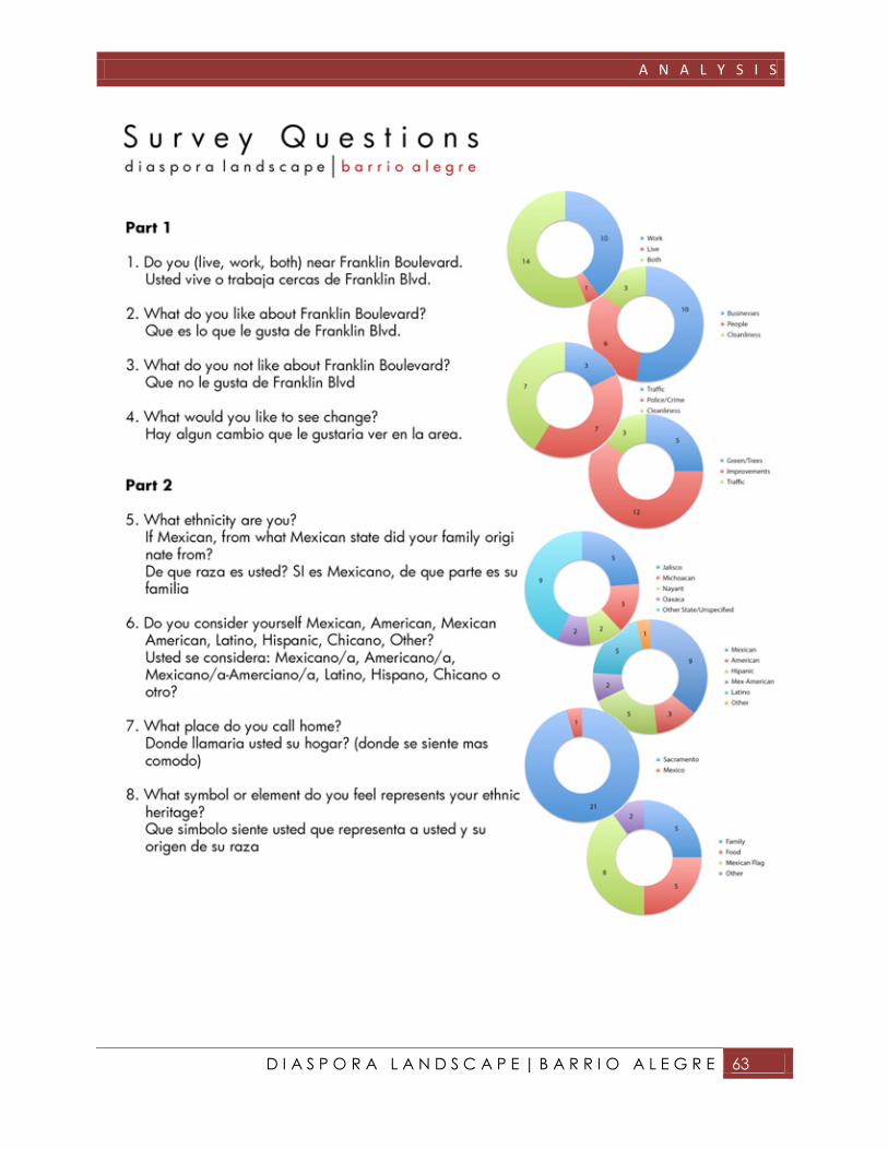
Question one was answered by every individual
that participated in the interviews. Fourteen
people worked along Franklin Boulevard, but did
not live there. Ten people both lived and worked
along Franklin, and only one individual lived
along Franklin Boulevard, but did not work there.
This identified the credibility of those interviewed.
The second question had three main responses
among those interviewed. Ten of those
interviewed said that they enjoyed the businesses
that existed along the corridor, six mentioned
their like for the people that were there, and three
mentioned that they enjoyed the cleanliness and
aesthetics of Franklin.
2.33 Question One
2.34 Question Two

A N A L Y S I S
D I A S P O R A L A N D S C A P E | B A R R I O A L E G R E 60
Question three had even fewer responses. Three
people said they did not enjoy traffic congestion
that occurs on Franklin during peak traffic hours.
Seven people complained about crime, robbery,
police harassment, and the general security of the
barrio. Lastly seven individuals said they did not
enjoy the conditions and aesthetics of Franklin
Boulevard.
Question four, which addressed desired changes
along Franklin, received a total of twenty
responses. Of the twenty, twelve individuals said
they would like to see general improvements and
modernization occur along Franklin Boulevard,
particularly those that would draw more visitors
to the businesses and shops. Five individuals said
they would like to see more trees and green
space along Franklin Boulevard, and three said
they would like to see improvements that would
address Franklin’s traffic congestion.
Question five, addressed the origin of Mexican
individuals who lived along the corridor. The
responses revealed a mixture of states that people
came from in Mexico. The most popular among
those interviewed was the state of Jalisco. Three
people mentioned their families came from
Michoacán. Two people said their family came
2.35 Question Three
2.36 Question Four
2.37 Question Five
A N A L Y S I S
D I A S P O R A L A N D S C A P E | B A R R I O A L E G R E 61
from Nayarit, and two others said Oaxaca.
There were nine other responses from individuals
who said they were of Mexican origin that either
did not specify their state of origin, or were the
only one in the interview process from a
particular state.
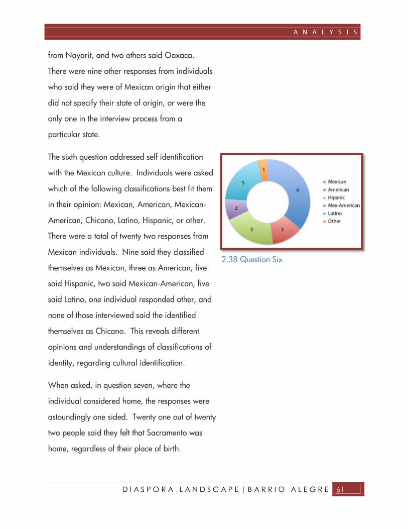
The sixth question addressed self identification
with the Mexican culture. Individuals were asked
which of the following classifications best fit them
in their opinion: Mexican, American, Mexican-
American, Chicano, Latino, Hispanic, or other.
There were a total of twenty two responses from
Mexican individuals. Nine said they classified
themselves as Mexican, three as American, five
said Hispanic, two said Mexican-American, five
said Latino, one individual responded other, and
none of those interviewed said the identified
themselves as Chicano. This reveals different
opinions and understandings of classifications of
identity, regarding cultural identification.
When asked, in question seven, where the
individual considered home, the responses were
astoundingly one sided. Twenty one out of twenty
two people said they felt that Sacramento was
home, regardless of their place of birth.
2.38 Question Six

A N A L Y S I S
D I A S P O R A L A N D S C A P E | B A R R I O A L E G R E 62
Only one individual said they still considered
Mexico home. This may reveal acceptance and
identity with the barrio. As these individuals
identify Sacramento as their home, it reveals a
sense of belonging. This sense of belonging to
place is an element that can be harnessed to
positively affect and improve a community.
The final question asked what symbol or element
did the interviewer associate with their Mexican
culture. Five individuals said tight-knit Mexican
families, five people said Mexican food, and
eight individuals said the eagle on the Mexican
flag. Two responses were different, but were very
valid answers. One person said the Catholic
Church, which is the dominant religion in the
Mexican culture. Another individual replied
“California, California is Mexico, and California
was Mexico”. This was a very fascinating
response. Whether meant politically, or
culturally, the individual felt such a great sense of
ownership to California that they went so far as to
identify their Mexican-American heritage with the
North American state of California.
2.40 Question Eight
2.39 Question Seven
A N A L Y S I S
D I A S P O R A L A N D S C A P E | B A R R I O A L E G R E 63

D E S I G N

D E S I G N
D I A S P O R A L A N D S C A P E | B A R R I O A L E G R E 65
D E S I G N
VISION STATEMENT
The Barrio Alegre urban design plan is intended
to guide growth and public improvements along
Franklin Boulevard and throughout the study
area.
The design plan recognizes the importance of the
Mexican based culture in the Diaspora
community and provides a culturally based
strategy that promotes economic growth,
transportation choices, streetscape improvements
and green space for the Barrio Alegre area.
The research collected reveals the needs of the
community within the study area. The opportunity
and constraints data provides possible locations
in which to implement design solutions. The
design solutions will enhance the quality of life for
the inhabitants of Barrio Alegre.

D E S I G N
D I A S P O R A L A N D S C A P E | B A R R I O A L E G R E 66
D E S I G N
D I A S P O R A L A N D S C A P E | B A R R I O A L E G R E 67

D E S I G N
D I A S P O R A L A N D S C A P E | B A R R I O A L E G R E 68
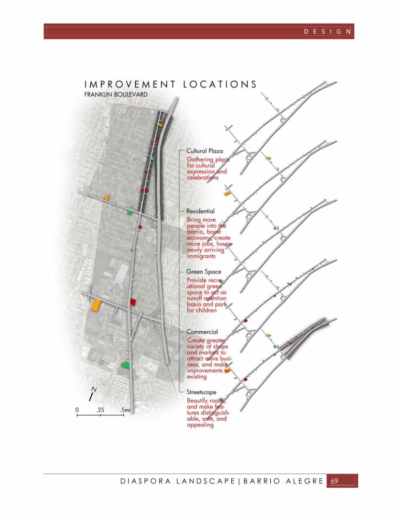
DESIGN GOALS
1. Identify and portray the barrio’s historic
Mexican Diaspora culture in the built
environment by means of landscape
architecture and design.
2. Promote economic growth through green
space development, architectural improvements
and affordable housing on unoccupied lots
and existing buildings.
3. Reduce automobile dependency by ensuring
safe, convenient and aesthetically pleasing
bicycle and pedestrian access throughout the
site.
D E S I G N
D I A S P O R A L A N D S C A P E | B A R R I O A L E G R E 69

D E S I G N
D I A S P O R A L A N D S C A P E | B A R R I O A L E G R E 70
ILLUSTRATIVE DESIGNS
The final designs have been chosen from all
research and analysis performed on the Barrio
Alegre site. They will meet the design goals and
align with the vision for the site.
1. 21st Avenue Cultural Plaza – includes artistic
cultural performance backdrop representing
the Mexican Diaspora growth of Sacramento,
open space for farmers market and special
events, Mexican/Spanish fountain, and street
improvements.
2. Affordable Housing – promotes population
growth; stimulate economy, strategically
located to relieve automobile dependency.
3. Parks – available retention basin for runoff
water, allows recreational space and play
areas for children.
4. Commercial Improvements – creates appealing
building facades and retail shop variety.
5. Streetscape – provides clean well distinguished
bike lanes, parking, signage as well as
integrating cultural values into designs.
D E S I G N
D I A S P O R A L A N D S C A P E | B A R R I O A L E G R E 71

D E S I G N
D I A S P O R A L A N D S C A P E | B A R R I O A L E G R E 72
D E S I G N
D I A S P O R A L A N D S C A P E | B A R R I O A L E G R E 73

D E S I G N
D I A S P O R A L A N D S C A P E | B A R R I O A L E G R E 74

D E S I G N
D I A S P O R A L A N D S C A P E | B A R R I O A L E G R E 75

D E S I G N
D I A S P O R A L A N D S C A P E | B A R R I O A L E G R E 76

D E S I G N
D I A S P O R A L A N D S C A P E | B A R R I O A L E G R E 77
R E F E R E N C E S

R E F E R E N C E S
D I A S P O R A L A N D S C A P E | B A R R I O A L E G R E 79
R E F E R E N C E S
WRITTEN SOURES
Barry, Tom. Crossing the Line: Immigrants, Economic Integration, and Drug Enforcement on
the U.S.-Mexico Border. Resource Center Press. New Mexico. 1994.
Gardiner, Sean and Geoffrey Mohan. Smuggled for Sex: The Sex Slaves From Mexico.
2001. LexisNexis Academic, Newsday Inc. New York. 2001.
Grogger, Jeffrey and Stephen J. Trejo. Falling Behind or Moving Up? The Intergenerational
Progress of Mexican Americans. Public Policy Institute of California. San Francisco,
Ca. 2002.
Jacobs, Jane. The Death and Life of Great American Cities. The Modern Library. NY. 1961.
Lin, Judy. Latinos Will Be Majority in California by 2042. Sacramento Bee. 2007.
Lynch, Kevin. The Image of the City. The MIT Press. London, England. 1960
Lorey, David E. The U.S.-Mexican Border in the Twentieth Century: A History of Economic
and Social Transformation. Scholarly Resources Inc. Wilmington, Delaware. 1999.
Madrid, Rosana M. Narrative History of Mexican/Chicano Communities of Sacramento.
July 1984.
Nathan, Debbie. Death Comes to the Maquiladora: A Border History. UC 856 Information
Access. Expanded Academic ASAP. Jan, 1997.
Newman, Dr. Jason. Hispanic vs. Latino. Personal lecture notes.

R E F E R E N C E S
D I A S P O R A L A N D S C A P E | B A R R I O A L E G R E 80
Perderzini, Carla and Jeffrey Passel. The Demography of Mexico/U.S. Migration. Institute
for the Study of International Migration. Walsh School of Foreign Service.
Georgetown University.
Sanoff, Henry. Community Participation Methods in Design and Planning. John Wiley and
Sons Inc. New York, New York. 200.
Truett, Daniel and Elliot Young. Continental Crossroads: Remapping U.S.-Mexico
Borderlands History. Duke University Press. London. 2004.
Zeisel, John. Inquiry by Design. W.W. Norton and Company. New York, NY. 2006.
INTERNET RESOURCES
http://www.city-data.com/county/Sacramento_County-CA.html
http://media.www.statehornet.com/media/storage/paper1146/news/2001/09/01/News
/Mural.Gets.New.Life-2419545.shtml
http://www.socialpc.com/SocialIssues/Gangs.html

A P P E N D I X

A P P E N D I X
D I A S P O R A L A N D S C A P E | B A R R I O A L E G R E 82
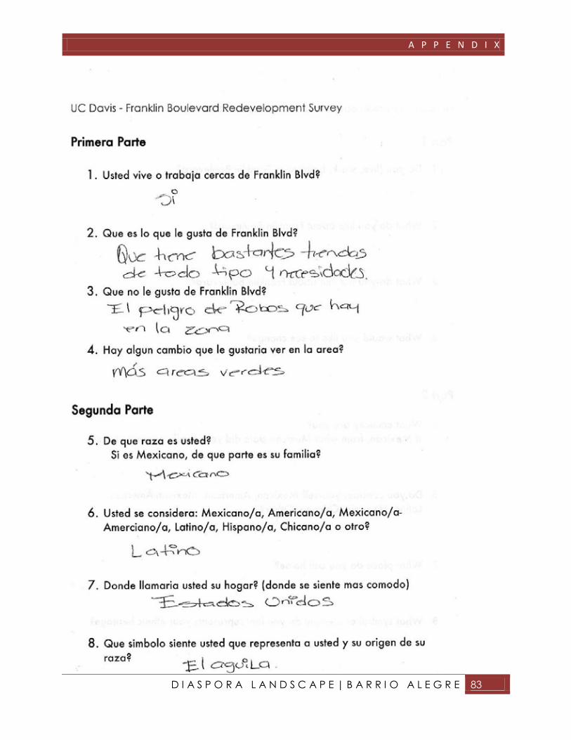
A P P E N D I X
D I A S P O R A L A N D S C A P E | B A R R I O A L E G R E 83

A P P E N D I X
D I A S P O R A L A N D S C A P E | B A R R I O A L E G R E 84

A P P E N D I X
D I A S P O R A L A N D S C A P E | B A R R I O A L E G R E 85