5.3 Cultural Resources - California Energy Commission · traditional/cultural importance to various...
21
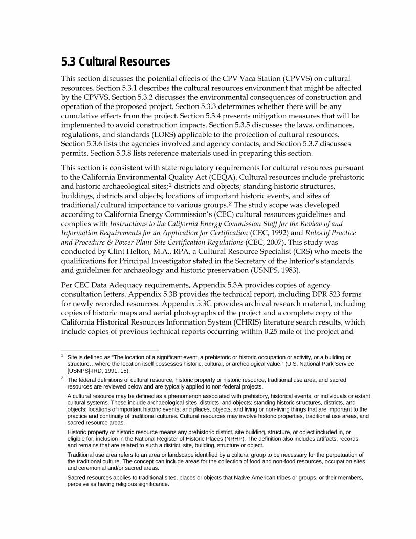
5.3 Cultural Resources This section discusses the potential effects of the CPV Vaca Station (CPVVS) on cultural resources. Section 5.3.1 describes the cultural resources environment that might be affected by the CPVVS. Section 5.3.2 discusses the environmental consequences of construction and operation of the proposed project. Section 5.3.3 determines whether there will be any cumulative effects from the project. Section 5.3.4 presents mitigation measures that will be implemented to avoid construction impacts. Section 5.3.5 discusses the laws, ordinances, regulations, and standards (LORS) applicable to the protection of cultural resources. Section 5.3.6 lists the agencies involved and agency contacts, and Section 5.3.7 discusses permits. Section 5.3.8 lists reference materials used in preparing this section. This section is consistent with state regulatory requirements for cultural resources pursuant to the California Environmental Quality Act (CEQA). Cultural resources include prehistoric and historic archaeological sites; 1 districts and objects; standing historic structures, buildings, districts and objects; locations of important historic events, and sites of traditional/cultural importance to various groups. 2 The study scope was developed according to California Energy Commission’s (CEC) cultural resources guidelines and complies with Instructions to the California Energy Commission Staff for the Review of and Information Requirements for an Application for Certification (CEC, 1992) and Rules of Practice and Procedure & Power Plant Site Certification Regulations (CEC, 2007). This study was conducted by Clint Helton, M.A., RPA, a Cultural Resource Specialist (CRS) who meets the qualifications for Principal Investigator stated in the Secretary of the Interior’s standards and guidelines for archaeology and historic preservation (USNPS, 1983). Per CEC Data Adequacy requirements, Appendix 5.3A provides copies of agency consultation letters. Appendix 5.3B provides the technical report, including DPR 523 forms for newly recorded resources. Appendix 5.3C provides archival research material, including copies of historic maps and aerial photographs of the project and a complete copy of the California Historical Resources Information System (CHRIS) literature search results, which include copies of previous technical reports occurring within 0.25 mile of the project and 1 Site is defined as “The location of a significant event, a prehistoric or historic occupation or activity, or a building or structure…where the location itself possesses historic, cultural, or archeological value.” (U.S. National Park Service [USNPS]-IRD, 1991: 15). 2 The federal definitions of cultural resource, historic property or historic resource, traditional use area, and sacred resources are reviewed below and are typically applied to non-federal projects. A cultural resource may be defined as a phenomenon associated with prehistory, historical events, or individuals or extant cultural systems. These include archaeological sites, districts, and objects; standing historic structures, districts, and objects; locations of important historic events; and places, objects, and living or non-living things that are important to the practice and continuity of traditional cultures. Cultural resources may involve historic properties, traditional use areas, and sacred resource areas. Historic property or historic resource means any prehistoric district, site building, structure, or object included in, or eligible for, inclusion in the National Register of Historic Places (NRHP). The definition also includes artifacts, records and remains that are related to such a district, site, building, structure or object. Traditional use area refers to an area or landscape identified by a cultural group to be necessary for the perpetuation of the traditional culture. The concept can include areas for the collection of food and non-food resources, occupation sites and ceremonial and/or sacred areas. Sacred resources applies to traditional sites, places or objects that Native American tribes or groups, or their members, perceive as having religious significance.
Transcript of 5.3 Cultural Resources - California Energy Commission · traditional/cultural importance to various...
5.3 Cultural Resources This section discusses the potential effects of the CPV Vaca Station (CPVVS) on cultural resources. Section 5.3.1 describes the cultural resources environment that might be affected by the CPVVS. Section 5.3.2 discusses the environmental consequences of construction and operation of the proposed project. Section 5.3.3 determines whether there will be any cumulative effects from the project. Section 5.3.4 presents mitigation measures that will be implemented to avoid construction impacts. Section 5.3.5 discusses the laws, ordinances, regulations, and standards (LORS) applicable to the protection of cultural resources. Section 5.3.6 lists the agencies involved and agency contacts, and Section 5.3.7 discusses permits. Section 5.3.8 lists reference materials used in preparing this section.
This section is consistent with state regulatory requirements for cultural resources pursuant to the California Environmental Quality Act (CEQA). Cultural resources include prehistoric and historic archaeological sites;1 districts and objects; standing historic structures, buildings, districts and objects; locations of important historic events, and sites of traditional/cultural importance to various groups.2 The study scope was developed according to California Energy Commission’s (CEC) cultural resources guidelines and complies with Instructions to the California Energy Commission Staff for the Review of and Information Requirements for an Application for Certification (CEC, 1992) and Rules of Practice and Procedure & Power Plant Site Certification Regulations (CEC, 2007). This study was conducted by Clint Helton, M.A., RPA, a Cultural Resource Specialist (CRS) who meets the qualifications for Principal Investigator stated in the Secretary of the Interior’s standards and guidelines for archaeology and historic preservation (USNPS, 1983).
Per CEC Data Adequacy requirements, Appendix 5.3A provides copies of agency consultation letters. Appendix 5.3B provides the technical report, including DPR 523 forms for newly recorded resources. Appendix 5.3C provides archival research material, including copies of historic maps and aerial photographs of the project and a complete copy of the California Historical Resources Information System (CHRIS) literature search results, which include copies of previous technical reports occurring within 0.25 mile of the project and
1 Site is defined as “The location of a significant event, a prehistoric or historic occupation or activity, or a building or
structure…where the location itself possesses historic, cultural, or archeological value.” (U.S. National Park Service [USNPS]-IRD, 1991: 15).
2 The federal definitions of cultural resource, historic property or historic resource, traditional use area, and sacred resources are reviewed below and are typically applied to non-federal projects.
A cultural resource may be defined as a phenomenon associated with prehistory, historical events, or individuals or extant cultural systems. These include archaeological sites, districts, and objects; standing historic structures, districts, and objects; locations of important historic events; and places, objects, and living or non-living things that are important to the practice and continuity of traditional cultures. Cultural resources may involve historic properties, traditional use areas, and sacred resource areas.
Historic property or historic resource means any prehistoric district, site building, structure, or object included in, or eligible for, inclusion in the National Register of Historic Places (NRHP). The definition also includes artifacts, records and remains that are related to such a district, site, building, structure or object.
Traditional use area refers to an area or landscape identified by a cultural group to be necessary for the perpetuation of the traditional culture. The concept can include areas for the collection of food and non-food resources, occupation sites and ceremonial and/or sacred areas.
Sacred resources applies to traditional sites, places or objects that Native American tribes or groups, or their members, perceive as having religious significance.
SAC/370668/081760003 (CPVVS_5.3_CULTURAL.DOC) 5.3-1
5.3 CULTURAL RESOURCES
DPR 523 forms for previously recorded resources occurring within 1 mile of the project and 0.25 mile of linear facilities (Appendix 5.3C will be submitted separately to the CEC under a request for confidentiality). Appendix 5.3D provides names and qualifications of personnel who contributed to this study.
The project does not require review under federal regulations such as the National Historic Preservation Act (NHPA) and the Archaeological and Historic Preservation Act of 1974 (16 U.S. Code 469), among others, because it is not a federal undertaking (federally permitted or funded).
5.3.1 Affected Environment In California, cultural resources extend historically at least 11,500 years. Written historical sources tell the story of the past 200 years. Archaeologists have reconstructed general trends of prehistory in California. The following discussion focuses on the archaeology of the area and provides a brief summary of the area’s cultural history.
Much of the following is synthesized from general descriptions of prehistoric habitation characteristics in the region provided by Wickstrom (1997) and Wohlgemuth, Rosenthal, and Maniery (2003) in addition to detailed overview by Moratto (1984).
5.3.1.1 Regional Setting The proposed CPVVS is located in a rural area in Solano County, about 0.8 mile southeast of the small town of Elmira, and about 1.8 miles east of the present limits of development of the City of Vacaville. It lies on the broad alluvial plain extending southeast from the southern terminus of the North Coast Ranges in this area.
5.3.1.2 Paleo-Indian Period (10,000 B.C. to 6000 B.C.) The general trend throughout California prehistory was an increase in population density over time, coupled with greater sedentism and the use of a greater diversity of food resources. There is abundant evidence that humans were present in the New World for at least the past 11,500 years. There is also fragmentary, but growing, evidence that humans were present long before that date. Linguistic and genetic studies suggest that a date of 20,000 to 40,000 years ago for the human colonization of the New World may be possible. The evidence of this earlier occupation is not yet conclusive, but it is beginning to be accepted by archaeologists. For instance, the Meadowcroft Rockshelter in Pennsylvania and Monte Verde in Chile are two early sites that have produced apparently reliable dates as early as 12,500 years before present. These earliest known remains indicate very small, mobile populations apparently dependent on hunting large game as the primary subsistence strategy.
5.3.1.2.1 Lower Archaic Period (6000 B.C. to 3000 B.C.) The start of this period coincides with middle Holocene climatic change. Conditions changed from wetter to drier, reflecting the drying of pluvial lakes. Settlement appears semi-sedentary with little emphasis on wealth. Subsistence appears to be focused on plant foods over hunting. Artifact types that characterize the period include large dart points and milling slab and handstone.
5.3-2 SAC/370668/081760003 (CPVVS_5.3_CULTURAL.DOC)
5.3 CULTURAL RESOURCES
5.3.1.2.2 Middle Archaic Period (3000 B.C. to 1000 B.C.) The Middle Archaic begins at the end of the mid-Holocene climatic conditions, when climate became similar to present-day conditions. In response to environmental technological factors, economies became more diversified, hunting became a more important subsistence strategy, and sedentism developed further while population growth and expansion occurred. Artifacts that characterize the period include the bowl mortar and pestle and the continued use of large dart points.
5.3.1.2.3 Upper Archaic Period (1000 B.C. to A.D. 500) This period is characterized by the growth of sociopolitical complexity and the development of status distinctions based upon wealth. Group-oriented religions emerge. Exchange systems between groups appear more frequent and sustained, as evidenced for example by the significance of traded shell beads, possible indicators of social status. Artifacts characterizing the period include the bowl mortar and pestle and the continued use of large dart points, though in an increased diversity of styles.
5.3.1.2.4 Emergent Period (500 A.D. to A.D. 1800) The advent of several technologies, including the bow and arrow, characterize this period. Distinctions in social status are linked to acquired wealth, the exchange of goods between groups becoming common with more material entering into exchange networks, and territorial boundaries between groups becoming well established. The clam disk bead becomes a monetary unit for exchange, and trade increases dramatically in the latter part of this period (1500 A.D. to 1800).
5.3.1.3 Ethnographic Setting The CPVVS project area lies within the ethnographic territory of the Patwin, a series of linguistically and culturally related tribelets that occupied a portion of the lower Sacramento Valley west of the Sacramento River and north of Suisun Bay.
Several ethnohistorical and ethnographic accounts provide descriptions of the southern Sacramento Valley’s native inhabitants. When Europeans first entered central California, the area west of the Sacramento River and north of Suisun Bay (including the entire valley as far north as Princeton, Colusa County) was occupied by a series of linguistically and culturally related tribelets. These groups had no common name, collective identity, or political unity, but did speak dialects of the same historically related language. This linguistic similarity led Powers (1877) to call the groups “Patwin,” a term each group used in reference to itself. The Patwin are Wintuan speakers, along with their neighbors, the Nomlaki and Wintu. The Wintuan language is part of the larger Penutian language family, which also includes Miwok, Maidu, Coastanoan, and Yokuts.
The word “Patwin” literally means “the people” in the native tongue. Major sources of information on these groups include the works of Bennyhoff (1977), Johnson (1978), Kroeber (1925), McKern (1922 and 1923), Powers (1877), and Work (1945).
The Patwin were politically organized into tribelets that consisted of one primary and several satellite villages. Each tribelet maintained its own autonomy and sense of territoriality. In general, the Patwin territory was well watered, supporting a wide variety of animal life available for hunters including tule elk, deer, antelope, bear, and various species of duck, geese, turtles, and other small animals. While hunting and fishing were clearly
SAC/370668/081760003 (CPVVS_5.3_CULTURAL.DOC) 5.3-3
5.3 CULTURAL RESOURCES
important subsistence activities among the Patwin, as with many Native American groups throughout the region, their primary staple food was the valley oak (Quercus lobata) acorn.
5.3.1.4 Historic Setting Members of the Pedro Fages expedition of 1772 were the first people of European descent to reach the Carquinez Strait. Four years later, the de Anza expedition also reached the strait while looking for a land route to Point Reyes. Although native people regularly crossed the strait in tule boats, these reed crafts were not suitable for transporting the Europeans’ horses. Europeans did not cross the strait until 1810, when Gabriel Moraga led a raid against the Suisun tribe on the strait’s north shore.
In the late 1840s and 1850s, former gold seekers and pioneers began settling Solano County, where they raised livestock and cultivated fruit orchards, vineyards, wheat, barley, and oats. Produce and livestock were transported overland by wagons to the many sloughs throughout the county, and then were shipped by water to waiting markets.
Jose Francisco Armijo petitioned for 3 square leagues of land in 1839 and received a grant to Rancho Tolenas from Governor Alvarado a year later. Captain R. H. Waterman, from Fairfield, Connecticut, acquired land in the Armijo Grant. Following the acquisition, Waterman offered Solano County 16 acres of land to use for the county seat, which was then located in Benicia. Wishing to move the seat to a more centralized location within the county, voters approved the move, making Fairfield the new seat by 1858. Solano was one of California’s original 27 counties and has retained its original boundaries.
Twelve townships were established in Solano County between 1850 and 1871. Although the largest towns were adjacent to San Pablo and Suisun Bays, the majority of towns were situated at the ends of sloughs or channels that primarily ran through the eastern portion of the county. In 1868, the completion of the California Pacific Railroad through Solano County allowed goods shipment to East Coast markets, significantly bolstering economic development, agricultural production, and population growth. In 1913, the Oakland, Antioch, and Eastern Railway, a high-speed electric interurban railway, opened its 93-mile route from San Francisco to Sacramento through largely unpopulated parts of Solano County (Bay Area Electric Railroad Association, 2006). In 1928, the Sacramento Northern Railway purchased the railway, but the Depression and the popularity of the automobile contributed to the end of passenger service in 1940; by 1987, the railway had been abandoned (Robertson, 1998).
Currently, Solano County’s most prevalent economic activities continue to be agriculture and livestock. A wide variety of vegetables, fruit, and nuts are grown, with walnuts the most recent crop gaining favor. The county is in the top five California producers of corn, lamb, sheep, and Sudan grass hay. In 2000, Solano County celebrated its 150th anniversary (Solano County, 2006b).
5.3.1.4.1 City of Vacaville The fruit industry around Vacaville began as early as the late 1850s, when Ansel W. Putnam and John Dolan, local nursery owners, along with William and Simpson Thomas, constructed a road from Pleasants Valley to Suisun City. This roadway, which later became known as Pleasants Valley Road, provided for the shipment of fragile fruit from the Vaca, Pleasant, and Laguna Valleys to major markets. This key transportation route spurred the
5.3-4 SAC/370668/081760003 (CPVVS_5.3_CULTURAL.DOC)
5.3 CULTURAL RESOURCES
purchase of land in the area for commercial fruit and vegetable farming. The construction of two major rail lines by 1870 broadened the market even further by allowing shipment of fruit and vegetables across the United States. By the 1890s, Vaca Valley and the foothills of the Vaca Mountains were covered with orchards encompassing almost all of the available nonirrigated land (Limbaugh and Payne, 1978).
Local farmers discovered early that fruit grown on hillsides ripened earlier than that on the valley floor. This allowed the region to market seasonal fruit much earlier and longer than other fruit districts in California. This factor, together with the influx of inexpensive labor from Chinese immigrants and an ample water supply, made the Vacaville fruit district successful from the start. Peaches, apricots, table grapes, and cherries became the most important and popular crops of the district (Limbaugh and Payne, 1978; Wickson, 1888).
5.3.1.4.2 City of Elmira Stephen Hoyt laid out a 40-acre town, Vaca Station, prior to the 1868 completion of the California Pacific Railroad. The town was just east of Vacaville, hence the name. However, having two train stops with similar names, Vaca and Vacaville, became problematic. Town members met and decided to rename Vaca Station as Elmira, after the New York town that was the birthplace of a respected local lawyer and teacher. Elmira quickly became the transport center for the Vaca and Pleasants Valleys’ fruits and vegetable crops and was one of the original townships of Solano County. The original Elmira downtown was approximately 1 mile south of its current location. After the railroad was constructed, the downtown moved north, adjacent to the railroad. Due to a series of fires, few buildings dating to the nineteenth century remain in Elmira, though Elmira's Four Square Church, more than 100 years old, is still standing. After major roads and highways, such as Interstate 80, bypassed the area, Elmira’s growth has been slow, and it has remained a small town (Bowen, 2001).
5.3.1.5 Resources Inventory All project components of the CPVVS were subject to cultural resources inventory. This inventory includes archival research, reconnaissance, and surface pedestrian survey. The area of potential effect (APE) for the project was determined in accordance with the latest CEC Rules of Practice and Procedure & Power Plant Site Certification Regulations (CEC, 2007) for assessing potential impacts to archaeological and architectural resources. The results of the resource inventory are presented in the following sections. Figure 5.3-1 shows the areas covered by previous archaeological surveys within a mile of the project site and also the area covered in pedestrian archaeological surveys of the CPVVS site, construction laydown area, and linear appurtenances.
5.3.1.5.1 Archival Research Staff of the CHRIS Northwest Information Center conducted a search of their archaeological and historic site files for the area within a 1-mile radius of the project site and a 0.25-mile radius around the project linear facilities.
According to information available in the CHRIS files, at least 10 previous cultural resource studies have been prepared within 1 mile of the project area (Table 5.3-1). Copies of reports numbered S-30763, S-20257, S-5207, S-22617, S-23920, and S-20034 are provided in
SAC/370668/081760003 (CPVVS_5.3_CULTURAL.DOC) 5.3-5
5.3 CULTURAL RESOURCES
5.3-6 SAC/370668/081760003 (CPVVS_5.3_CULTURAL.DOC)
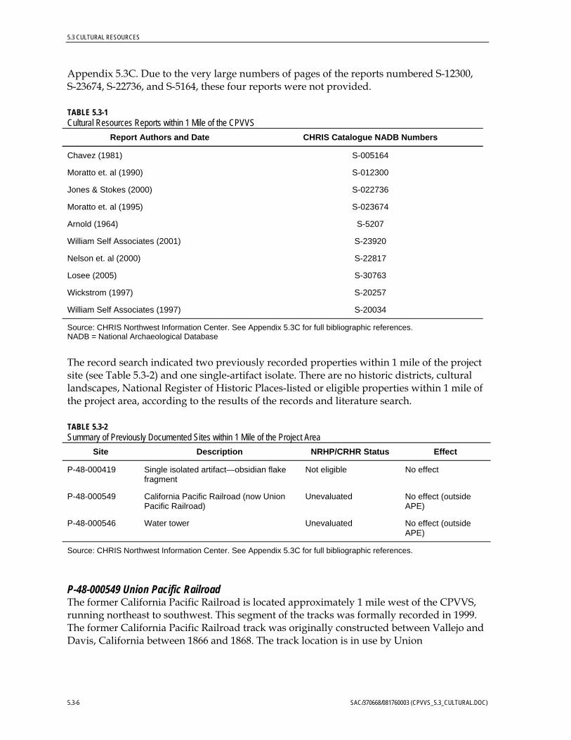
Appendix 5.3C. Due to the very large numbers of pages of the reports numbered S-12300, S-23674, S-22736, and S-5164, these four reports were not provided.
TABLE 5.3-1 Cultural Resources Reports within 1 Mile of the CPVVS
Report Authors and Date CHRIS Catalogue NADB Numbers
Chavez (1981) S-005164
Moratto et. al (1990) S-012300
Jones & Stokes (2000) S-022736
Moratto et. al (1995) S-023674
Arnold (1964) S-5207
William Self Associates (2001) S-23920
Nelson et. al (2000) S-22817
Losee (2005) S-30763
Wickstrom (1997) S-20257
William Self Associates (1997) S-20034
Source: CHRIS Northwest Information Center. See Appendix 5.3C for full bibliographic references. NADB = National Archaeological Database
The record search indicated two previously recorded properties within 1 mile of the project site (see Table 5.3-2) and one single-artifact isolate. There are no historic districts, cultural landscapes, National Register of Historic Places-listed or eligible properties within 1 mile of the project area, according to the results of the records and literature search.
TABLE 5.3-2 Summary of Previously Documented Sites within 1 Mile of the Project Area
Site Description NRHP/CRHR Status Effect
P-48-000419 Single isolated artifact—obsidian flake fragment
Not eligible No effect
P-48-000549 California Pacific Railroad (now Union Pacific Railroad)
Unevaluated No effect (outside APE)
P-48-000546 Water tower Unevaluated No effect (outside APE)
Source: CHRIS Northwest Information Center. See Appendix 5.3C for full bibliographic references.
P-48-000549 Union Pacific Railroad The former California Pacific Railroad is located approximately 1 mile west of the CPVVS, running northeast to southwest. This segment of the tracks was formally recorded in 1999. The former California Pacific Railroad track was originally constructed between Vallejo and Davis, California between 1866 and 1868. The track location is in use by Union
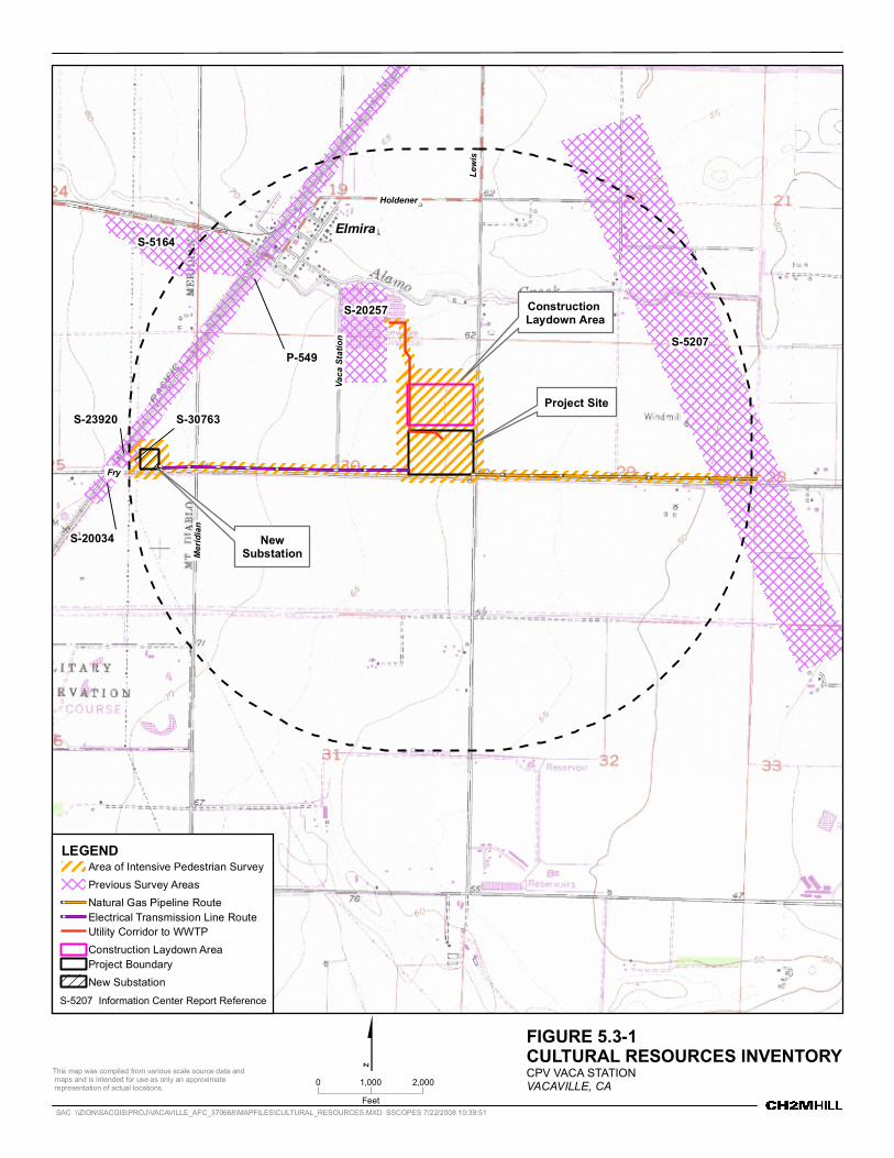
Construction Laydown Area
NewSubstation
Project SiteS-30763
S-20034
Elmira
FryLe
wis
Merid
ianHoldener
Vaca
Stati
on S-5207
S-5164
P-549
S-20257
S-23920
LEGENDArea of Intensive Pedestrian SurveyPrevious Survey AreasNatural Gas Pipeline RouteElectrical Transmission Line RouteUtility Corridor to WWTPConstruction Laydown AreaProject BoundaryNew Substation
$ FIGURE 5.3-1CULTURAL RESOURCES INVENTORYCPV VACA STATIONVACAVILLE, CA
This map was compiled from various scale source data and maps and is intended for use as only an approximate representation of actual locations. 0 2,0001,000
FeetSAC \\ZION\SACGIS\PROJ\VACAVILLE_AFC_370668\MAPFILES\CULTURAL_RESOURCES.MXD SSCOPES 7/22/2008 10:39:51
S-5207 Information Center Report Reference
5.3 CULTURAL RESOURCES
Pacific Railroad and is the route of the California Capitol Corridor passenger service and other passenger and freight service. Modern improvements to the track and the crushed rock ballast upon which the tracks sit have been made as the railroad has been in continuous use and has seen regular maintenance and upgrading since construction. No historic features are visible at the location where the tracks cross Fry Road. As a working component of modern transportation infrastructure, the line at this location does not appear to retain integrity as a representative of a historic railroad. The tracks in this location and other physical features associated with the railroad appear to be of modern origin. The railroad track, in addition, lies outside of the CPVVS area of direct effects and its associated facilities, including the route of the electrical transmission line and location of the proposed new substation. Construction of the CPVVS will not affect the Union Pacific line.
P-48-000546 Water Tower This site was formally recorded in 2000 as a steel water tower situated adjacent to the Union Pacific Railroad within the small community of Elmira. The site record does not date the structure. The tower is located approximately 0.75 mile from the CPVVS. The tower is well outside the CPVVS’s APE and will not be impacted.
As part of the CHRIS literature search, information was gathered from twentieth century U.S. Geological Survey (USGS) topographic maps and historic aerial photography to assess the potential for historic buildings and structures to be present within 0.5 mile of the CPVVS project site and the aboveground linear appurtenances. Aerial photographs dated 1937, 1957, 1965, and 1970 (EDR, 2008a) and topographic maps dated 1908, 1917, 1953, 1968, 1973, and 1980 (EDR, 2008b) were examined. These maps are provided as part of the literature search information in Appendix 5.3C. The maps and photographs provide historic information on the location of possible structures, foundation remains, or other historic resources within the project area. All buildings and structures possibly older than 45 years that are within 0.5 mile of the power plant site and electrical transmission line were field-checked and photographed.
5.3.1.5.2 Archaeological Field Survey A cultural resources survey of the proposed CPVVS site was conducted on May 22, 2008, by Clint Helton, M.A., RPA, a CRS who meets the qualifications for Principal Investigator stated in the Secretary of the Interior’s standards and guidelines for archaeology and historic preservation (USNPS, 1983). This field survey included the CPVVS site and construction laydown area and the area that encompasses the rights-of-way for the gas transmission pipeline extending approximately 1 mile east along Fry Road, the electrical transmission line extending approximately 1 mile west on Fry Road, the proposed new electrical substation just west of the intersection of Meridian and Fry Road, and the utility corridor extending between the CPVVS site and the Easterly Wastewater Treatment Plant.
As per the latest CEC Rules of Practice and Procedure & Power Plant Site Certification Regulations (CEC, 2007), in addition to the plant site, construction laydown area, and electrical station, a 200-foot minimum buffer was also surveyed for cultural resources around these facilities. Additionally, the surveys of the linear facility routes for the CPVVS’s gas line and electrical transmission lines included a 50-foot buffer on either side of the centerline of the gas line and transmission line. The resulting survey area corridor was 100 feet wide. Both routes run in the agricultural fields adjacent to and north of Fry Road.
SAC/370668/081760003 (CPVVS_5.3_CULTURAL.DOC) 5.3-9
5.3 CULTURAL RESOURCES
Ground visibility was very poor for most of the survey due to dense vegetation at the project site and in some of the agricultural fields along the natural gas pipeline and electrical transmission line rights-of-way. Some agricultural fields afforded good ground visibility. The survey used linear pedestrian transects spaced at 15 meters, opportunistic examination of exposed soils, and a series of randomly placed shovel probes to examine the survey areas to determine whether archaeological deposits might be present. Exposed soils, consisting mainly of previously disturbed agricultural sediments and road bed material, were inspected carefully, and no evidence of cultural materials was noted.
Nearby road construction and agricultural activities, especially mechanical cultivation from many decades of agricultural activity within and near the CPVVS boundaries, have left varying depths or disturbed soil in the project area. In addition, the project site was subject to some artificial filling by the spreading of biosolids on the site in the 1990s. Previously disturbed sediment and artificial fill would not have cultural material in context. Most cultural material would be destroyed by the mechanical equipment used in excavation, mixing, and spreading within the plow zone. However, intact cultural deposits could be present below the plow zone.
Given the local topography, distance to major stream drainages or other archaeologically sensitive features, and the scale and scope of previous ground disturbance in the area, archaeological sensitivity of the surface soils of the CPVVS site and appurtenant proposed facilities is considered low. The sensitivity of the underlying soils is considered moderate to low, given that the possibility exists for intact cultural deposits to be present beneath the plow zone. The archaeological sensitivity is moderate to low because the site is relatively near a drainage, Alamo Creek, situated 0.5 to 1.0 mile from the CPVVS facilities, and also because of the relatively low density of previous finds in this general area, despite several previous surveys. Only a single prehistoric artifact has been previously documented within 1 mile of the project site.
5.3.1.5.3 Architectural Survey The field survey also included an architectural reconnaissance to determine whether potentially historic buildings and structures (more that 45 years old) are located within 0.5 mile of the project site and aboveground linear facilities, in this case the transmission line. This survey was guided in part by an analysis of historical USGS topographic maps described previously. Small rectangles on these maps indicate the locations of homes, barns, and other structures that stood when the map was prepared. Examination of the maps showed that buildings or structures were located more than 45 years ago in three distinct zones within the survey area 0.5 mile from the project site. These areas are west of the CPVVS along Fry Road, north along Lewis Road, and east along Fry Road.
The 1908 and all subsequent USGS topographic maps show a single structure on the south side of Fry Road approximately 1.2 miles west of the CPVVS facility site and 900 feet west of the transmission line terminus and new substation. The 1973 map shows the addition of two more structures to the south, and the 1980 map shows one additional structure to the south. Field inventory shows, however, that the early structure must have been demolished. In this location currently are a modern style ranch house and two metal prefabricated buildings.
The 1908 map shows two structures within 0.5 mile north of the CPVVS site along Lewis Road. One of these is east of Alamo Creek and is 0.45 mile north of the northern boundary
5.3-10 SAC/370668/081760003 (CPVVS_5.3_CULTURAL.DOC)
5.3 CULTURAL RESOURCES
of the CPVVS facility, next to Alamo Creek. This structure is also shown on the 1917 map. On the 1953 map, an additional structure is shown to the west, apparently a barn, because it is shown on the maps as an open rectangle. Both structures are shown on subsequent maps. Examination of contemporary aerial photography shows a structure at the location of the house site, but that the barn is no longer present. The area surrounding the house is used for farm equipment storage. Field inventory shows that the remaining structure is a small, rectangular cottage with a hip roof and a small, covered front porch extending forward from the front (short) end of the structure. The house has wooden shingle roofing, clapboard siding and aluminum frame windows, apparently a recent addition. There is a lawn in front, and some ornamental trees between the house and Lewis Road. Very large eucalyptus trees are located behind the house in the former barnyard.
Another structure appears on the 1908 map, located north of the CPVVS site and approximately 0.41 mile from the northern boundary of the CPVVS facility and about 250 feet south of Alamo Creek. This structure is also shown in the 1917 USGS map. In the 1953 map, four additional structures appear: one north of the original structure and three to the south, forming a farmstead complex. The 1968 map shows that three additional structures have been added to the farmstead complex along Lewis Road. Examination of contemporary aerial photographs shows a farmstead complex consisting of a residence and several utilitarian outbuildings.
Field inventory shows that the northernmost structure, 6021 Lewis Road, is a small, rectangular cottage with a side-gable roof and gable-roofed porch on the side. There appears to have been some remodeling and window replacement.
The residential structure to the south, 6014 Lewis Road, is a farmstead complex consisting of a house, shed, large barn, wooden water tower, large concrete silo, and three other utility sheds or barns. The house is rectangular with a side-gable roof and an attic window in the gable that may represent a second story room, if not a full second story. The house has a low gable-roofed addition at the rear. The windows appear to be the original 1-over-1 casement windows grouped in pairs and triplets, and the clapboard or metal siding appears to be more recent than the original building. A lawn and landscape trees surround the house. The adjacent shed, barn, and wooden water tower are somewhat dilapidated.
Because the project would have no direct effect on these properties, the properties’ distance from the CPVVS site, the low potential for indirect project effects, and the fact that these properties are relatively ordinary structures lacking architectural distinction and historical integrity, it was deemed unnecessary to record the properties on DPR-523 forms or conduct background research to establish a context for further evaluation.
5.3.1.5.4 Native American Consultation CH2M HILL contacted the Native American Heritage Commission (NAHC) by letter on May 20, 2008, to request information about traditional cultural properties such as cemeteries and sacred places in the project area. The NAHC responded on May 21, 2008 with a list of Native Americans interested in consulting on development projects. Each of these individuals/groups was contacted by letter on May 29, 2008. As of the time of printing this document no responses have been received. Copies of the letters sent (and responses received) are provided in Appendix 5.3A. Also, a detailed summary table of the results of
SAC/370668/081760003 (CPVVS_5.3_CULTURAL.DOC) 5.3-11
5.3 CULTURAL RESOURCES
consultations with the individual Native American organizations on the NAHC contact list is included in Appendix 5.3A.
The NAHC record search of the Sacred Lands file did not indicate the presence of Native American cultural resources in the immediate project area. The record search conducted at the CHRIS Northwest Information Center also did not indicate the presence of Native American traditional cultural properties.
5.3.1.5.5 Local Historical Societies The local Vacaville Heritage Council (also housing the Solano County Historical Society) and Vacaville Museum were contacted on May 28, 2008. No additional historical resources were identified by these groups. A summary of these contacts is provided as part of Appendix 5.3A.
5.3.2 Environmental Analysis This section describes the environmental impacts of CPVVS construction and operation. CH2M HILL conducted a complete survey of the project area and associated linear facilities.
5.3.2.1 Significance Criteria Appendix G, Environmental Checklist Form of the CEQA guidelines, addresses significance criteria with respect to cultural resources (Public Resources Code Sections 21000 et seq.). Appendix G (V)(a, b, d) indicates that an impact would be significant if the project will have the following affects:
• Cause a substantial adverse change in the significance of a historical resource • Cause a substantial adverse change in the significance of an archaeological resource • Disturb any human remains, including those interred outside of formal cemeteries
Project investigations included archival research; review of all cultural resource investigation reports within the CPVVS; contacts with all other interested agencies, Native American groups, and historic societies; and a complete field survey. These studies indicated no significant prehistoric or historic archaeological remains, or traditional cultural properties in the CPVVS APE. Therefore, no impacts to cultural resources are expected.
5.3.2.2 Construction Impacts The literature search and pedestrian inventories did not locate any significant prehistoric or historic sites within the CPVVS site and linear facilities.
The previously recorded Union Pacific Railroad lies outside the CPVVS’s APE, the natural gas pipeline, and proposed substation, and will not be impacted from construction or operation of these facilities, so it need not be considered further.
The literature search and pedestrian inventory have shown no significant prehistoric or historic sites located within the CPVVS site or linear facilities areas of potential effect. Therefore, the project is unlikely to have an adverse effect on significant historical or archaeological sites (that are eligible for listing in the CRHR). In addition, there are no known cemeteries in the project area or linear facilities that project construction might disturb.
5.3-12 SAC/370668/081760003 (CPVVS_5.3_CULTURAL.DOC)
5.3 CULTURAL RESOURCES
It is unlikely, due to the extensive disturbance by decades of cultivation, that the project would encounter buried intact cultural resources that have not previously been disturbed or destroyed in sediments near the ground surface. However, some potential does exist for intact cultural resources to be discovered in soils below the plow zone. With the incorporation of mitigation described in Section 5.3.4, construction impacts to cultural resources will be less than significant.
5.3.2.3 Operation Impacts No ground disturbance would be required during project operation; therefore, impacts to cultural resources are not anticipated during CPVVS operation. Maintenance of project facilities will not cause any effects outside of the initial construction area of impact. No significant impacts to cultural resources will result from operations.
5.3.3 Cumulative Effects A cumulative impact refers to a proposed project’s incremental effect together with other closely related past, present, and reasonably foreseeable future projects whose impacts may compound or increase the incremental effect of the proposed project (Pub. Resources Code Section 21083; California Code of Regulations., Title 14, Sections 15064(h), 15065(c), 15130, and 15355). Cumulative projects are described in more detail in Section 5.6.1.5. Although environmental analyses for most of these projects have not been completed at the time this Application for Certification (AFC) was prepared, standard mitigation measures exist to reduce impacts to cultural resources to a less-than-significant level, and it is anticipated that impacts to cultural resources from the cumulative projects, if any, would be mitigated to a less-than-significant level. The project is unlikely, therefore, to have impacts that would combine cumulatively with other closely related past, present, and reasonably foreseeable future projects. With the incorporation of mitigation described in Section 5.3.4, the project will not contribute to a cumulatively considerable impact to cultural resources.
5.3.4 Mitigation Measures Although significant archaeological and historical sites were not found during the survey for the CPVVS, it is possible that subsurface construction could encounter buried archaeological remains. For this reason, the CPVVS will include measures to mitigate any potential adverse impacts that could occur if there were an inadvertent discovery of buried cultural resources. These measures include: (1) designation of an on-call CRS to investigate any cultural resources finds made during construction, (2) implementation of a construction worker training program, (3) monitoring during initial clearing of the power plant site and excavation at the plant site, (4) procedures for halting construction in the event that there is an inadvertent discovery of archaeological deposits or human remains, (5) procedures for evaluating an inadvertent archaeological discovery, and (6) procedures to mitigate adverse impacts on any inadvertent archaeological discovery determined significant.
5.3.4.1 Designated Cultural Resources Specialist The Applicant will retain a designated CRS who will be available during the earth-disturbing portion of the CPVVS construction periods to inspect and evaluate any finds of buried archaeological resources that might occur during the construction phase. If there is a discovery of archaeological remains during construction, the CRS, in conjunction with the
SAC/370668/081760003 (CPVVS_5.3_CULTURAL.DOC) 5.3-13
5.3 CULTURAL RESOURCES
construction superintendent and environmental compliance manager, will make certain that construction activity stops in the immediate vicinity of the find until the find can be evaluated. The CRS will inspect the find and evaluate its potential significance in consultation with CEC staff and the CEC compliance project manager (CPM). The CRS will make a recommendation as to the significance of the find and any measures that would mitigate adverse impacts of construction on a significant find.
The CRS will meet the minimum qualifications for Principal Investigator on federal projects under the Secretary of the Interior’s Standards and Guidelines for Archaeology and Historic Preservation. The CRS will be qualified, in addition to site detection, to evaluate the significance of the deposits, consult with regulatory agencies, and plan site evaluation and mitigation activities.
5.3.4.2 Construction Worker Training The Applicant will prepare a construction worker sensitivity training program to ensure implementation of procedures to follow in the event that cultural resources are discovered during construction. This training will be provided to each construction worker as part of their environmental, health, and safety training. The training will include photographs of various types of historic and prehistoric artifacts and will describe the specific steps that will be taken in the event of an unanticipated discovery of cultural material, including human remains. It will explain the importance of, and legal basis for, the protection of significant archaeological resources. The training will also be presented in the form of a written brochure.
5.3.4.3 Monitoring The Applicant will retain a qualified archaeologist to monitor excavations during the project’s construction phase, including geotechnical testing activities prior to construction that have the potential to impact previously undisturbed soils that may be sensitive for cultural resources. If archaeological material is observed by the monitoring archaeologist, ground-disturbing activity will be halted in the vicinity of the find so that its significance (CRHR eligibility) can be determined. If evaluated as significant, mitigation measures (avoidance or data recovery) will be developed in consultation with the CEC.
5.3.4.4 Emergency Discovery If the archaeological monitor, construction staff, or others identify archaeological resources during construction, they will immediately notify the CRS and the site superintendent, who will halt construction in the immediate vicinity of the find, if necessary. The archaeological monitor or CRS will use flagging tape, rope, or some other means as necessary to delineate the area of the find within which construction will halt. This area will include the excavation trench from which the archaeological finds came and any piles of dirt or rock spoil from that area. Construction will not occur within the delineated find area until the CRS, in consultation with the CEC staff and CEC CPM, can inspect and evaluate the find.
5.3.4.5 Site Recording and Evaluation The CRS will follow accepted professional standards in recording any find and will submit the standard Department of Parks and Recreation historic site form (Form DPR 523) and location information to the CHRIS Northwest Information Center.
5.3-14 SAC/370668/081760003 (CPVVS_5.3_CULTURAL.DOC)
5.3 CULTURAL RESOURCES
If the CRS determines that the find is not significant and the CEC CPM concurs, construction will proceed without further delay. If the CRS determines that further information is needed to determine whether the find is significant, the designated CRS will, in consultation with the CEC, prepare a plan and a timetable for evaluating the find.
5.3.4.6 Mitigation Planning If the CRS, CEC staff, and CPM determine that the find is significant, the CRS will prepare and conduct a mitigation plan in accordance with state guidelines. This plan will emphasize the avoidance, if possible, of significant archaeological resources. If avoidance is not possible, recovery of a sample of the deposit from which archaeologists can define scientific data to address archaeological research questions will be considered an effective mitigation measure for damage to or destruction of the deposit.
The mitigation program, if necessary, will be carried out as soon as possible to avoid construction delays. Construction will resume at the site as soon as the field data collection phase of any data recovery efforts is completed. The CRS will verify the completion of field data collection by letter to the project owner and the CPM so that they can authorize construction to resume.
5.3.4.7 Curation The CRS will arrange for curation of archaeological materials collected during an archaeological data recovery mitigation program. Curation will be performed at a qualified curation facility meeting the standards of the California Office of Historic Preservation. The CRS will submit field notes, stratigraphic drawings, and other materials developed as part of the data recovery/mitigation program to the curation facility along with the archaeological collection, in accordance with the mitigation plan.
5.3.4.8 Report of Findings If a data recovery program is planned and implemented during construction as a mitigation measure, the CRS will prepare a detailed scientific report summarizing results of the excavations to recover data from an archaeological site. This report will describe the site soils and stratigraphy, describe and analyze artifacts and other materials recovered, and draw scientific conclusions regarding the results of the excavations. This report will be submitted to the curation facility with the collection.
5.3.4.9 Inadvertent Discovery of Human Burials If human remains are found during construction, project officials are required by the California Health and Safety Code (Section 7050.5) to contact the Solano County Coroner. If the Coroner determines that the find is Native American, he or she must contact the NAHC. The NAHC, as required by the Public Resources Code (Section 5097.98) determines and notifies the Most Likely Descendant with a request to inspect the burial and make recommendations for treatment or disposal.
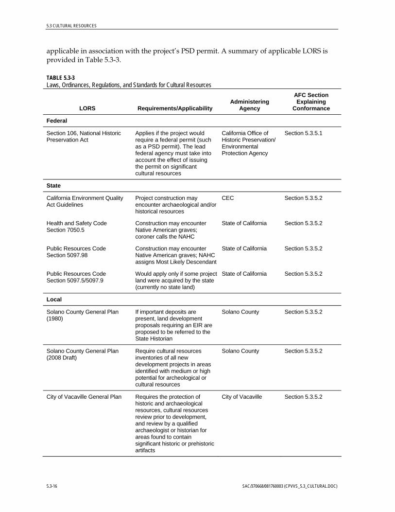
5.3.5 Laws, Ordinances, Regulations and Standards Among the local LORS discussed in this section are certain ordinances, plans, or policies of the City of Vacaville, Solano County, and the State of California. Federal LORS may be
SAC/370668/081760003 (CPVVS_5.3_CULTURAL.DOC) 5.3-15
5.3 CULTURAL RESOURCES
applicable in association with the project’s PSD permit. A summary of applicable LORS is provided in Table 5.3-3.
TABLE 5.3-3 Laws, Ordinances, Regulations, and Standards for Cultural Resources
LORS Requirements/ Applicability Administering
Agency
AFC Section Explaining
Conformance
Federal
Section 106, National Historic Preservation Act
Applies if the project would require a federal permit (such as a PSD permit). The lead federal agency must take into account the effect of issuing the permit on significant cultural resources
California Office of Historic Preservation/ Environmental Protection Agency
Section 5.3.5.1
State
California Environment Quality Act Guidelines
Project construction may encounter archaeological and/or historical resources
CEC Section 5.3.5.2
Health and Safety Code Section 7050.5
Construction may encounter Native American graves; coroner calls the NAHC
State of California Section 5.3.5.2
Public Resources Code Section 5097.98
Construction may encounter Native American graves; NAHC assigns Most Likely Descendant
State of California Section 5.3.5.2
Public Resources Code Section 5097.5/5097.9
Would apply only if some project land were acquired by the state (currently no state land)
State of California Section 5.3.5.2
Local
Solano County General Plan (1980)
If important deposits are present, land development proposals requiring an EIR are proposed to be referred to the State Historian
Solano County Section 5.3.5.2
Solano County General Plan (2008 Draft)
Require cultural resources inventories of all new development projects in areas identified with medium or high potential for archeological or cultural resources
Solano County Section 5.3.5.2
City of Vacaville General Plan Requires the protection of historic and archaeological resources, cultural resources review prior to development, and review by a qualified archaeologist or historian for areas found to contain significant historic or prehistoric artifacts
City of Vacaville Section 5.3.5.2
5.3-16 SAC/370668/081760003 (CPVVS_5.3_CULTURAL.DOC)
5.3 CULTURAL RESOURCES
5.3.5.1 Federal LORS Federal protection for significant archaeological resources would apply to the CPVVS if any construction or other related project impacts take place on federally managed lands, or if certain federal entitlements were required. Because the project is likely to require a PSD permit under the federal Clean Air Act, the project would be considered a federal undertaking.
The NHPA requires federal agencies to take into consideration the effects of their undertakings on historic properties, defined as properties (buildings, districts, sites, structures, objects) that meet the criteria for listing in the National Register of Historic Places, found at 36 CRF Part 60. The agencies’ responsibilities under the NHPA are described in Section 106 of the Act and in federal regulations at 36 CFR Par 800. Federal agencies are enjoined to (1) determine an undertaking’s area of potential effects on historic properties, (2) inventory potential historic properties within the area of potential effects, (3) evaluate properties identified to determine their eligibility for listing in the National Register, (4) assess the potential effects of the undertaking on properties determined to meet National Register criteria, and (5) if the effects would be adverse, avoid or mitigate those effects. In this case, the U.S. Environmental Protection Agency (USEPA) would likely be the federal agency with Section 106 compliance responsibilities. As the lead federal agency, it is the responsibility of the EPA to conduct the SHPO consultation regarding the permit undertaking’s effects on historic properties.
5.3.5.2 State LORS CEQA requires review to determine if a project will have a significant effect on archaeological sites or a property of historic or cultural significance to a community or ethnic group eligible for inclusion in the CRHR (CEQA Guidelines). CEQA equates a substantial adverse change in the significance of a historical resource with a significant effect on the environment (Section 21084.1 of the Public Resources Code) and defines substantial adverse change as demolition, destruction, relocation, or alteration that would impair historical significance (Section 5020.1). Section 21084.1 stipulates that any resource listed in, or eligible for listing in, the CRHR3 is presumed to be historically or culturally significant.4
Resources listed in a local historic register or deemed significant in a historical resource survey (as provided under Section 5024.1g) are presumed historically or culturally significant unless the preponderance of evidence demonstrates they are not.
3 The CRHR is a listing of “…those properties which are to be protected from substantial adverse change.” Any resource
eligible for listing in the California Register is also to be considered under CEQA. 4 A historical resource may be listed in the CRHR if it meets one or more of the following criteria: “(1) is associated with
events that have made a significant contribution to the broad patterns of local or regional history, or the cultural heritage of California or the United States; (2) is associated with the lives of persons important to local, California or national history; (3) embodies the distinctive characteristics of a type, period, region, or method of construction, or represents the work of a master or possesses high artistic values; or (4) has yielded or has the potential to yield information important in prehistory or history (…of the local area, California or the nation)” (Public Resources Code §5024.1, Title 14 CCR, Section 4852). Automatic CRHR listings include National Register of Historic Places (NRHP)-listed and determined eligible historic properties (either by the Keeper of the NRHP or through a consensus determination on a project review), State Historical Landmarks from number 770 onward, and Points of Historical Interest nominated from January 1998 onward. Landmarks prior to 770 and Points of Historical Interest may be listed through an action of the State Historical Resources Commission.
SAC/370668/081760003 (CPVVS_5.3_CULTURAL.DOC) 5.3-17
5.3 CULTURAL RESOURCES
A resource that is not listed in or determined to be eligible for listing in the CRHR, is not included in a local register of historic resources, nor deemed significant in a historical resource survey, may nonetheless be historically significant (Section 21084.1; see Section 21098.1).
CEQA requires a Lead Agency to identify and examine environmental effects that may result in significant adverse effects. Where a project may adversely affect a unique archaeological resource,5 Section 21083.2 requires the Lead Agency to treat that effect as a significant environmental effect and prepare an Environmental Impact Report. When an archaeological resource is listed in or is eligible to be listed in the CRHR, Section 21084.1 requires that any substantial adverse effect to that resource be considered a significant environmental effect. Sections 21083.2 and 21084.1 operate independently to ensure that potential effects on archaeological resources are considered as part of a project’s environmental analysis. Either of these benchmarks may indicate that a project may have a potential adverse effect on archaeological resources.
Other state-level requirements for cultural resources management appear in the California Public Resources Code Chapter 1.7, Section 5097.5 (Archaeological, Paleontological, and Historical Sites), and Chapter 1.75, beginning at Section 5097.9 (Native American Historical, Cultural, and Sacred Sites) for lands owned by the state or a state agency.
The disposition of Native American burials is governed by Section 7050.5 of the California Health and Safety Code and Sections 5097.94 and 5097.98 of the Public Resources Code, and falls within the jurisdiction of the NAHC.
If human remains are discovered, the County Coroner must be notified within 48 hours and there should be no further disturbance to the site where the remains were found. If the coroner determines the remains to be Native American, the coroner is responsible for contacting the NAHC within 24 hours. The NAHC, pursuant to Section 5097.98, will immediately notify those persons it believes to be most likely descended from the deceased Native American so they can inspect the burial site and make recommendations for treatment or disposal. The project will comply with these requirements related to cultural resources through the implementation of the Mitigation Measures described previously in Section 5.3.4.
5.3.5.3 Local LORS Solano County’s 1980 General Plan (Solano County, 1980) contains a brief discussion of “Historical Features.” This section of the plan states that if important deposits are present, land development proposals requiring an Environmental Impact Report (EIR) are proposed to be referred to the State Historian.
Solano County recently updated its general plan and as part of this process has issued the Draft Environmental Impact Report Solano County 2008 Draft General Plan (DEIR) for public
5 Public Resources Code 21083.2 (g) defines a unique archaeological resource to be: An archaeological artifact, object,
or site, about which it can be clearly demonstrated that, without merely adding to the current body of knowledge, there is a high probability that it meets any of the following criteria: (1) contains information needed to answer important scientific research questions and there is a demonstrable public interest in that information; (2) has a special and particular quality such as being the oldest of its type or the best available example of its type; or (3) is directly associated with a scientifically recognized important prehistoric or historic event or person.
5.3-18 SAC/370668/081760003 (CPVVS_5.3_CULTURAL.DOC)
5.3 CULTURAL RESOURCES
comment (Solano County, 2008a). Components of the 2008 Draft General Plan (Solano County, 2008b) relevant to cultural resources include the Cultural and Paleontological Resources Background Report (Solano County, 2006b).
The 2008 Draft General Plan contains goals, policies, and implementation programs that provide for the identification and preservation of significant buildings and structures. Specifically, Program RS.I-29 requires the development of “historic preservation programs and development guidelines to prevent the loss of significant historic buildings and structures.”
The 2008 Draft General Plan contains goals, policies, and implementation programs that address archaeological deposits. Program RS.I-25, the implementation program that is most pertinent to archaeological deposits, contains the following requirements:
• Require cultural resources inventories of all new development projects in areas identified with medium or high potential for archeological or cultural resources. Where a preliminary site survey finds medium to high potential for substantial archaeological remains, the County shall require a mitigation plan to protect the resource before issuance of permits. Mitigation may include: − having a qualified archaeologist present during initial grading or trenching
(monitoring),
− redesign of the project to avoid archaeological resources (this is considered the strongest tool for preserving archaeological resources),
− capping the site with a layer of fill, and/or
− excavation and removal of the archaeological resources and curation in an appropriate facility under the direction of a qualified archaeologist.
• Alert applicants for permits within early settlement areas to the potential sensitivity. If significant archaeological resources are discovered during construction or grading activities, such activities shall cease in the immediate area of the find until a qualified archaeologist can determine the significance of the resource and recommend alternative mitigation.
The City of Vacaville General Plan (2007) includes Policies 5.2-I6 and 5.2-G3, stating that the City will “provide historic preservation by delineating historic preservation districts and requiring design review of proposals affecting historic buildings” and “Preserve and enhance the City's historic resources.” In addition, Policies 8.5-G1, 8.5-I1, and 8.5-I2 relate to the preservation and protection of historic archaeological resources. These policies require the protection of historic and archaeological resources, cultural resources review prior to development, and review by a qualified archaeologist or historian for areas found to contain significant historic or prehistoric artifacts. The project will comply with these requirements related to cultural resources through the implementation of the Mitigation Measures previously described in Section 5.3.4.
SAC/370668/081760003 (CPVVS_5.3_CULTURAL.DOC) 5.3-19
5.3 CULTURAL RESOURCES
5.3.6 Agencies and Agency Contacts Table 5.3-4 lists the state agencies involved in cultural resources management for the project and a contact person at each agency. These agencies include the NAHC and, for federal undertakings, the California Office of Historic Preservation.
TABLE 5.3-4 Agency Contacts for Cultural Resources
Issue Agency Contact
Native American traditional cultural properties
Native American Heritage Commission Dave Singleton Associate Governmental Program Analyst Native American Heritage Commission 915 Capitol Mall, Room 364 Sacramento, CA 95814 (916) 653-4082
Federal agency NHPA Section 106 compliance
California Department of Parks and Recreation Office of Historic Preservation
Milford Wayne Donaldson State Historic Preservation Officer 1416 9th Street, Room 1442, Sacramento, CA 95814 (916) 653-6624
5.3.7 Permits and Permit Schedule Other than certification by the CEC, no state, federal, or local permits are required by the project for the management of cultural resources. Consultation with the State Historic Preservation Officer may be required under Section 106 of the National Historic Preservation Act if, in conjunction with the project’s PSD permit.
5.3.8 References Cited or Consulted Bay Area Electric Railroad Association. 2006. History of the Sacramento Northern Railway. Available: http://www.wrm.org/about/sacramento_northern.htm.
Bennyhoff, J.A. 1977. Ethnogeography of the Plains Miwok. Center for Archaeological Research at Davis Publication 5.
Bowen, J. 2001. “Elmira Sits on the Edge of History.” Solano, The Way It Was (column). Historical Articles of Solano County Online Database. November. Available: http://www.solanoarticles.com/history/index.php/weblog/more/ elmira_sits_on_the_edge_of_history/
City of Vacaville. 2007. City of Vacaville General Plan. http://www.cityofvacaville.com/departments/community_development/ general_plan.php. December.
California Energy Commission (CEC). 2007. Rules of Practice and Procedure & Power Plant Site Certification. Sacramento: California Energy Commission.
California Energy Commission (CEC). 1992. Instructions to the California Energy Commission Staff for the Review of and Information Requirements for an Application for Certification. Sacramento: California Energy Commission.
5.3-20 SAC/370668/081760003 (CPVVS_5.3_CULTURAL.DOC)
5.3 CULTURAL RESOURCES
Environmental Data Resources, Inc. (EDR). 2008a. EDR Aerial Photography Package, Vacaville Energy Center, Lewis Road/Fry Road, Vacaville, CA. April 11.
Environmental Data Resources, Inc. (EDR). 2008b. EDR Historical Topographic Map Report, Vacaville Energy Center, Lewis Road/Fry Road, Vacaville, CA. April 11.
Johnson, P.J. 1978. “Patwin In California.” Edited by R.F. Heizer, pp. 350-360. Handbook of North American Indians, vol. 8, W.C. Sturtevant, general editor. Washington, D.C.: Smithsonian Institution.
Kroeber, A.L. 1925. Handbook of the Indians of California. Smithsonian Institution, Bureau of American Ethnology Bulletin 78. Washington, D.C.
Limbaugh, R. H., and W. A. Payne. 1978. Vacaville: The Heritage of a California Community. Vacaville, CA: Vacaville City Council.
McKern, W. K. 1922. “Functional Families of the Patwin.” University of California Publications in American Archaeology and Ethnology. 13 (7) 235-258. Berkeley, CA.
McKern, W. K. 1923. “Patwin Houses.” University of California Publications in American Archaeology and Ethnology. 20 (10) 159-171. Berkeley, CA.
Moratto, M.J. 1984. California Archaeology. New York: Academic Press.
National Park Service. 1983. Archaeology and Historic Preservation: Secretary of the Interior’s Standards and Guidelines. Washington, DC.
Powers, S. 1877. “Tribes of California.” Contributions to North American Ethnology 3. U.S. Geographical and Geological Survey of the Rocky Mountain Region, Washington.
Robertson, D. B. 1998. Encyclopedia of Western Railroad History. Volume IV: California. Caldwell, ID: Caxton Press.
Solano County. 1980. Solano County General Plan, including the Land Use and Circulation Element (amended through June 15, 2001).
Solano County. 2006a. Solano County Facts and Figures. Available: http://www.co.solano.ca.us/SubSection/SubSection.asp?NavID=729
Solano County, 2006b. Cultural and Paleontological Resources Background Report, Solano County General Plan Update. Fairfield, CA. http://www.solanocountygeneralplan.net/EIR_04-18-08/ 16_Section%204.10%20-%20Cultural%20Resources.pdf
Solano County, 2008a. Draft Environmental Impact Report Solano County 2008 Draft General Plan. Fairfield, CA. http://www.solanocountygeneralplan.net/EIR_04-18-08/.pdf
Solano County, 2008b. Solano County 2008 Draft General Plan. Fairfield, CA. http://www.solanocountygeneralplan.net/documents.htm#2008DGP
Solano County. 1999. Exploring Solano County, 2000. Fairfield, CA.
Wickson, E. J. 1888. The Vacaville Early Fruit District of California, California Illustrated, No. 1. California View Publishing Company. San Francisco, CA.
SAC/370668/081760003 (CPVVS_5.3_CULTURAL.DOC) 5.3-21
5.3 CULTURAL RESOURCES
5.3-22 SAC/370668/081760003 (CPVVS_5.3_CULTURAL.DOC)
Wickstrom, Brian. 1997. Cultural Resource Survey for the Easterly Wastewater Treatment Plant Expansion, Solano County, California.
Wohlgemuth, E., J. Rosenthal, and M. Maniery. 2003. Archaeological Survey for the Lower Lagoon Valley Project Vacaville, Solano County, California. Far Western Anthropological Research Group, Inc. Davis, CA.
Work, J. 1945. Fur Brigade to the Bonaventura: John Work’s California Expedition of the 1832-33, for the Hudson’s Bay Company. California Historical Society.