5.15 Water Resources - California Energy Commission · 5.15 Water Resources ... (City) will be...
18
5.15 Water Resources This section provides a discussion of the existing water resources near the Chula Vista Energy Upgrade Project (CVEUP) site and assesses the potential effects of project construction and operations on water resources. Specifically, this chapter discusses the CVEUP and its potential effects in the following areas: • Water supply and quality • Disposal of waste water • Compliance with state water policies • Stormwater discharge • Flooding Section 5.15.1 discusses the existing hydrologic environment. Potential environmental effects of the CVEUP construction and operation on water resources are assessed in Section 5.15.2. A discussion of cumulative project impacts is presented in Section 5.15.3. Section 5.15.4 discusses proposed mitigation measures that will prevent significant impacts. Section 5.15.5 presents applicable laws, ordinances, regulations and standards (LORS) related to water resources. Section 5.15.6 describes permits that relate to water resources, lists contacts with relevant regulatory agencies, and presents a schedule for obtaining permits. References cited are listed in Section 5.15.7. 5.15.1 Affected Environment 5.15.1.1 Water Features, Rainfall, and Drainage Several surface water bodies are present within two miles of the CVEUP site. Surface water bodies include the Otay River, San Diego Bay, Telegraph Canyon Creek, and the Tijuana River (Figure 5.15-1). The Otay River Valley is located directly adjacent to the southern boundary of the existing site, and site drainage flows into the Otay River drainage, which flows mainly to the west and discharges into San Diego Bay. Flow in the lower Otay River is controlled by releases from the Lower Otay Reservoir. Water quality data from the Otay River are extremely limited. At one time, there was an Otay monitoring station located on the southeast side of Beyer Way, just past the south end of the Otay River Bridge. There were no data collected at the Otay station due to vandalism of the monitoring equipment and the subsequent decision not to replace it (WURMP, 2003). San Diego Bay is located to the west of the project site. It is a natural bay approximately 14 miles long and varying in width from 0.5 mile to about 2.5 miles. The depth varies from 30 to 40 feet in the north part of the bay and only about 2 or 3 feet below mean lower low water in the south part of the bay. The waters of the bay and adjacent marshlands are generally saline. Specific areas of San Diego Bay are considered to be impaired water bodies as defined by Section 303(d) of the Clean Water Act. Impairments include bacteria, benthic impacts, sediment toxicity, copper, zinc, polycyclic aromatic hydrocarbons, chlordane, mercury, polychlorinated biphenyl, and lindane (USEPA, 2002).
Transcript of 5.15 Water Resources - California Energy Commission · 5.15 Water Resources ... (City) will be...

5.15 Water Resources This section provides a discussion of the existing water resources near the Chula Vista Energy Upgrade Project (CVEUP) site and assesses the potential effects of project construction and operations on water resources. Specifically, this chapter discusses the CVEUP and its potential effects in the following areas:
• Water supply and quality • Disposal of waste water • Compliance with state water policies • Stormwater discharge • Flooding
Section 5.15.1 discusses the existing hydrologic environment. Potential environmental effects of the CVEUP construction and operation on water resources are assessed in Section 5.15.2. A discussion of cumulative project impacts is presented in Section 5.15.3. Section 5.15.4 discusses proposed mitigation measures that will prevent significant impacts. Section 5.15.5 presents applicable laws, ordinances, regulations and standards (LORS) related to water resources. Section 5.15.6 describes permits that relate to water resources, lists contacts with relevant regulatory agencies, and presents a schedule for obtaining permits. References cited are listed in Section 5.15.7.
5.15.1 Affected Environment 5.15.1.1 Water Features, Rainfall, and Drainage Several surface water bodies are present within two miles of the CVEUP site. Surface water bodies include the Otay River, San Diego Bay, Telegraph Canyon Creek, and the Tijuana River (Figure 5.15-1).
The Otay River Valley is located directly adjacent to the southern boundary of the existing site, and site drainage flows into the Otay River drainage, which flows mainly to the west and discharges into San Diego Bay. Flow in the lower Otay River is controlled by releases from the Lower Otay Reservoir. Water quality data from the Otay River are extremely limited. At one time, there was an Otay monitoring station located on the southeast side of Beyer Way, just past the south end of the Otay River Bridge. There were no data collected at the Otay station due to vandalism of the monitoring equipment and the subsequent decision not to replace it (WURMP, 2003).
San Diego Bay is located to the west of the project site. It is a natural bay approximately 14 miles long and varying in width from 0.5 mile to about 2.5 miles. The depth varies from 30 to 40 feet in the north part of the bay and only about 2 or 3 feet below mean lower low water in the south part of the bay. The waters of the bay and adjacent marshlands are generally saline. Specific areas of San Diego Bay are considered to be impaired water bodies as defined by Section 303(d) of the Clean Water Act. Impairments include bacteria, benthic impacts, sediment toxicity, copper, zinc, polycyclic aromatic hydrocarbons, chlordane, mercury, polychlorinated biphenyl, and lindane (USEPA, 2002).
ES062007014SAC/360346/072140007(CVEUP_005.15_WATER RESOURCES.DOC) 5.15-1

5.15 WATER RESOURCES
5.15-2 ES062007014SAC/360346/072140007(CVEUP_005.15_WATER RESOURCES.DOC)
Telegraph Canyon Creek originates in the hills east of Chula Vista and flows northwesterly across the project site through a lined channel north of the site before discharging into San Diego Bay. No water quality data are available for Telegraph Canyon Creek.
The Tijuana River watershed is a binational watershed on the westernmost portion of the U.S.-Mexico border. The basin contains three surface water reservoirs, various flood control works, and a National Estuarine Sanctuary. The major drainages include the Cottonwood and Campo creeks in the U.S., and the Rio Las Palmos system in Mexico. There are three dams in the watershed controlling 78 percent of the area. Although discharges from the Tijuana River account for only a small percentage of total gauged runoff to the Southern California coastal ocean, it contains the highest concentrations of suspended solids and cadmium, copper, nickel, lead, and zinc among the eight largest creeks and rivers in Southern California. Surface water quality has been affected by runoff from Mexico while groundwater contamination has occurred as a result of seawater intrusion and waste discharges. Many of the water quality problems are due to diffuse non-point sources of pollution due to industrial development and population growth in Tijuana, and due to lack of water quality regulation in Mexico. In addition, the current Mexican infrastructure is insufficient for collection, treatment, and disposal of sewage originating in Tijuana (WRP, 2002).
Precipitation in San Diego County is infrequent and highly variable. Most precipitation occurs between the months of October and April. Precipitation data are available from the climatological station at the San Diego International Airport. The precipitation station and the project site are similar in elevation and coastal climatological setting. These similarities and the proximity of the precipitation station to the site suggest that the San Diego International Airport precipitation records provide a reasonable estimate of precipitation conditions at the project site.
Table 5.15-1 provides average historical rainfall from the meteorological station at the San Diego International Airport.
TABLE 5.15-1 Rainfall near the Proposed Project Site (1914-2005)
Precipitation Annual Oct Nov Dec Jan Feb Mar Apr May Jun Jul Aug Sep
Average 10.22 0.5 .95 1.76 2.06 2.00 1.70 0.79 0.21 0.06 0.02 0.06 0.18
Maximum 24.93 4.98 5.82 9.26 9.09 7.65 6.96 5.37 2.54 0.87 0.24 2.13 3.14
Source: WRCC, 2005.
The mean annual precipitation (January 1914 to December 2005) is 10.22 inches per year. The minimum and maximum annual precipitation for the period of record is 3.41 inches and 24.93 inches, respectively.

LAYDOWN AREA
LAYDOWN AREA(COORS AREA)
SWEETWATER RIVERSAN DIEGO RIVER
TELEGRAPH CANYON
TIJUANA RIVER
OTAY RIVER
LAS CHOLLAS
DULZURA
ENCANTO
SWEETWATER RIVER
Chollas Reservoir
Sweetwater Reservoir
Upper Otay Reservoir
Lower Otay Reservoir
CVEUP SITE
0 2Miles
LEGENDMajor RiversLakes/ReservoirsCVEUP Project SiteLaydown Area
FIGURE 5.15-1SURFACE WATERS NEAR PROJECT SITECHULA VISTA ENERGY UPGRADE PROJECTCHULA VISTA, CALIFORNIA
P A C I F I C O C E A N
S AN D I E G
O B
A YSource: San Diego County GIS Dept. (SanGIS). 2004.
1:126,720
SAC\\GLACIER\\360346_MMC\MAPFILES\SURFACEWATER.MXD 7/27/2007

5.15: WATER RESOURCES
5.15.1.2 Groundwater The CVEUP site is within the Sweetwater Valley Groundwater Basin (Figure 5.15-2). The Sweetwater Valley Groundwater Basin underlies an alluvial valley that empties into San Diego Bay. The basin is bordered by San Diego Bay on the west, Pliocene to Pleistocene semi-permeable terrestrial deposits on the north and south, and impermeable Santiago Peak volcanic rocks on the east. Quaternary alluvium and the San Diego Formation are the two major waterbearing formations in the basin. Groundwater in the Quaternary alluvium deposits is unconfined and wells produce an average yield of about 300 gallons per minute (gpm). Production well yields from the San Diego Formation, measured at the National City well field, are about 1,500 gpm and average well yield is 500 gpm (DWR, 2004).
Groundwater in the alluvium is of a sodium-calcium character, with a total dissolved solids concentration ranging from 300 to over 50,000 parts per million (ppm). The groundwater in the San Diego Formation is of a sodium chloride character with a total dissolved solids concentration ranging from 600 to 1,600 milligrams per liter (mg/L). Total dissolved solids, chloride, and sodium content generally exceed recommended drinking water limits (DWR, 2004).
5.15.1.3 Flooding Potential A portion of the existing plant site is mapped as being within the 100-year flood plain (Zone A) as defined by the Federal Emergency Management Agency (Figure 5.15-3) (FEMA, 1997). The actual 3.80-acre project site, however, is located on artificial fill, which has raised the site above the 100-year floodplain. The site is within areas of the 500-year floodplain or areas that may be subject to shallow flooding from a 100-year flood (shaded Zone X).
5.15.2 Environmental Consequences Project effects on water resources can be evaluated relative to significance criteria derived from the California Environmental Quality Act (CEQA) Appendix G checklist. Under CEQA, the project is considered to have a potentially significant effect on water resources if it would:
• Substantially alter the existing drainage pattern of the site or area, including the alteration of the course of a stream or river, in a manner which will result in substantial erosion or siltation on- or offsite, or in flooding on- or offsite.
• Create or contribute runoff water which will exceed the capacity of existing or planned stormwater drainage systems, or provide substantial additional sources of polluted runoff.
• Violate any water quality standards or waste discharge requirements, or otherwise substantially degrade water quality.
• Substantially deplete groundwater supplies or interfere substantially with groundwater recharge such that there will be a net deficit in aquifer volume or a lowering of the local groundwater table level (e.g., the production rate of pre-existing nearby wells will drop to a level which will not support existing land uses or planned uses for which permits have been granted).
ES062007014SAC/360346/072140007(CVEUP_005.15_WATER RESOURCES.DOC) 5.15-5

5.15 WATER RESOURCES
5.15-6 ES062007014SAC/360346/072140007(CVEUP_005.15_WATER RESOURCES.DOC)
• Place within a 100-year flood hazard area structures that will impede or redirect flood flows.
• Cause inundation by seiche, tsunami, or mudflow.
5.15.2.1 Water Supply This section describes the quantity of water required, the sources of the water supply, and water treatment requirements.
5.15.2.1.1 Process Water The CVEUP will use the existing 4-inch water supply pipeline that serves the site for process water that will consist of both domestic/sanitary and service water. Service water will also be divided into treated and untreated supplies. Part of the incoming water from Chula Vista (City) will be treated by a truck-mounted demineralizer and then stored in a deminerlized water storage tank. This water will be used for turbine water wash, water injection (nitrogen oxide [NOx] control) and combustion turbine inlet air cooling. Untreated service water will be used for general (nonpotable) needs such as landscaping, hose bibs (equipment and surface washdown), etc.
Demineralized water shall be required for Sprint water injection, fogger inlet cooling, water wash of the combustion turbine compressor section, and, potentially, water injection for NOx control. Rental demineralizer equipment such as trailers or portable demineralizer skids would be used to supply demineralized water for the plant. The equipment would include a number of cation, anion, and mixed bed ion exchanger vessels. The demineralizer equipment would not include reverse osmosis units, and all demineralizer equipment would have offsite regeneration, therefore, there would be no demineralizer waste stream. The system feedwater would be provided by municipal water.
As described in Section 2.0, the CVEUP could use a maximum of 28 million gallons per year of water for plant processes, assuming 4,000 hours per year of operation. At a more realistic operating scenario of 600 hours per year, the CVEUP would use about 4.2 million gallons per year. A will-serve letter from the Sweetwater Authority indicating that this amount will be available to the project is included in Appendix 2A.
MMC Energy has elected to use potable water for the project for two reasons: (1) reclaimed water is not available from the Sweetwater Authority or any other source that is near enough to the project that constructing a pipeline to serve the project would be economical (it would not be feasible or economical to construct a tertiary treatment facility either on the site or at the nearest wastewater treatment facility); (2) as a simple-cycle power plant, the project’s water use will be relatively modest compared with a large combined-cycle project. In addition, as a peaking power plant, the project will operate only a small percentage of the time, and water use will, therefore, be modest compared with a baseload facility.
Water balance diagrams representing two operating conditions are included in Section 2.0 as Figures 2.1-6a and 2.1-6b. These diagrams represent: (1) annual average operation at 75 degrees Fahrenheit with two combustion turbine generators (CTGs) operating at 100 percent load and CTG inlet fogging, and (2) summer peak operation with two CTGs operating at 100 percent load and CTG inlet fogging.

Laydown Area
Laydown Area(Coors Area)CVEUP SITE
OTAY VALLEY
LOWER SWEETWATER
TIJUANA VALLEY0 5,000
Feet
LEGENDRiversCVEUP Project SiteLaydown Area
GROUNDWATER BASINSOTAY VALLEYPUEBLO SAN DIEGOLOWER SWEETWATERTIJUANA VALLEY
FIGURE 5.15-2GROUNDWATER BASINSCHULA VISTA ENERGY UPGRADE PROJECTCHULA VISTA, CALIFORNIA
Source: San Diego County GIS Dept. (SanGIS). 2004.
S AN D I E G
O B
A Y
SAC\\glacier\\360346_MMC\MapFiles\GWBasin.mxd 7/27/2007
1:60,000

Laydown Area
Laydown Area (Coors Area)
CVEUP Site
0 2,000Feet
LEGENDCEVUP Project SiteLaydown Area1 Mile Buffer
FloodPlain100-Year FEMA Zone (Zone A)500-Year FEMA Zone (Zone X) FIGURE 5.15-3
FEMA FLOODPLAIN MAPCHULA VISTA ENERGY UPGRADE PROJECTCHULA VISTA, CALIFORNIA
Source: San Diego County GIS Dept. (SanGIS), 2004.SAC\\GLACIER\\360346_MMC\MAPFILES\HYDRO\FEMA.MXD 7/27/2007
1:24,000

5.15 WATER RESOURCES
Demineralized water quality will meet the water purity requirements shown in Table 5.15-2.
TABLE 5.15-2 Demineralized Water Quality Requirements
Parameter Units Value Total dissolved solids ppm 5 Silica as SiO2 ppm 0.1 Conductivity micromho/cm <0.1 at 25 degrees Celsius pH SU 6.0-8.0 Sodium + potassium max ppm TBD Chlorides max mg/L .5 Sulfates max mg/L .5
The product water from the demineralizer system would be stored in a bolted, carbon steel, field-erected, factory-epoxy-coated, demineralized water tank. The tank would be sized for 100,000 gallons, which is nominally 12 hours of plant demineralized water usage.
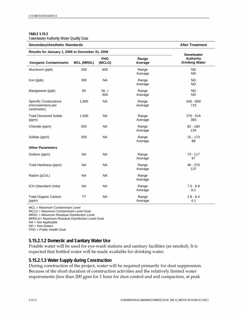
Table 5.5-3 shows the water quality of the Sweetwater Authority’s domestic water, after treatment. Quality of the discharge would be similar, as this simple-cycle project would not involve water cycling.
TABLE 5.15-3 Sweetwater Authority Water Quality Data
Primary Standards After Treatment
Mandatory Health Related Standards Results for January 1, 2006 to December 31, 2006
Inorganic Contaminants MCL (MRDL) PHG (MCLG)
(MRDLG) Range
Average
Sweetwater Authority
Drinking Water
Water Distribution Regulatory Compliance Lead and Copper Rule 50% of samples below
Lead (ppb) AL = 15 2 0 sites above AL out of 50 sites sampled
6.52
Copper (ppb) AL = 1,300 170 0 sites above AL out of 50 sites sampled
3702
Microbiological (c) Highest Monthly Percentage
Total Coliform Bacteria Fecal Coliform Bacteria
5.0%
(c)
(0)
(0)
# of positive samples taken this year = 2
# of positive samples taken this year = 1
0.7
0.7
Cryptosporidium (Oocysts/10L)
TT (0) Range Average
ES062007014SAC/360346/072140007(CVEUP_005.15_WATER RESOURCES.DOC) 5.15-11
5.15 WATER RESOURCES
TABLE 5.15-3 Sweetwater Authority Water Quality Data
Secondary/Aesthetic Standards After Treatment
Results for January 1, 2006 to December 31, 2006
Inorganic Contaminants MCL (MRDL) PHG
(MCLG) Range
Average
Sweetwater Authority
Drinking Water
Aluminum (ppb) 200 600 Range Average
ND ND
Iron (ppb) 300 NA Range Average
ND ND
Manganese (ppb) 50 NL = 500
Range Average
ND ND
Specific Conductance (microsiemens per centimeter)
1,600 NA Range Average
645 - 859 715
Total Dissolved Solids (ppm)
1,000 NA Range Average
270 - 516 383
Chloride (ppm) 500 NA Range Average
82 - 180 134
Sulfate (ppm) 500 NA Range Average
15 - 173 88
Other Parameters
Sodium (ppm) NA NA Range Average
73 - 117 97
Total Hardness (ppm) NA NA Range Average
46 - 270 137
Radon (pCi/L) NA NA Range Average
ICH (Standard Units) NA NA Range Average
7.5 - 8.9 8.1
Total Organic Carbon (ppm)
TT NA Range Average
1.8 - 6.4 4.1
MCL = Maximum Contaminant Level MCLG = Maximum Contaminant Level Goal MRDL = Maximum Residual Disinfection Level MRDLG= Maximum Residual Disinfection Level Goal NA = Not Applicable ND = Non-Detect PHG = Public Health Goal
5.15.2.1.2 Domestic and Sanitary Water Use Potable water will be used for eye-wash stations and sanitary facilities (as needed). It is expected that bottled water will be made available for drinking water.
5.15.2.1.3 Water Supply during Construction During construction of the project, water will be required primarily for dust suppression. Because of the short duration of construction activities and the relatively limited water requirements (less than 200 gpm for 1 hour for dust control and soil compaction, at peak
5.15-12 ES062007014SAC/360346/072140007(CVEUP_005.15_WATER RESOURCES.DOC)

5.15 WATER RESOURCES
use) of the construction phase of the project, no significant adverse impacts to water supply are expected to result.
5.15.2.2 Wastewater Collection, Treatment, Discharge and Disposal This subsection describes the quantity of water required, the sources of the water supply, water treatment requirements, and discharge.
The primary wastewater collection system will collect process wastewater and stormwater runoff from all of the plant equipment and route it to the existing retention basin for testing before discharge to the sanitary wastewater system. The second wastewater collection system will collect sanitary wastewater from sinks, toilets, showers, and other sanitary facilities, and discharge it via Chula Vista’s sanitary sewer system.
Service water includes all water uses at the plant except for the demineralized water used for evaporative cooling and turbine washes. Potable water supplied by the Sweetwater Authority and protected by a reduced pressure backflow prevention device or air gap will be used for service water, domestic and sanitary water, and for fire protection. No additional treatment of this water is required for use as service water (Sweetwater Authority, 2006).
General plant drains will collect containment area washdown, sample drains, and drainage from facility equipment drains. Water from these areas will be collected in a system of floor drains, hub drains, sumps, and piping and routed to the wastewater collection system. Drains that potentially could contain oil or grease will first be routed through an oil/water separator. Water from the plant wastewater collection system will be discharged to the sanitary sewer. Wastewater from combustion turbine water washes will be collected in holding tanks or sumps and will be trucked offsite for disposal at an approved wastewater disposal facility.
Due to the relatively modest quantities of wastewater that will be discharged from the project (see Section 2.1.7.1), it would not be economically feasible or environmentally preferable to use zero liquid discharge technology for the CVEUP’s process water discharges. The expense of such a system would not be justified for a simple-cycle peaking power plant such as the CVEUP. The City of Chula Vista has agreed to accept the project’s discharge. A will-serve letter from the City indicating their willingness to accept the project’s discharge will be provided to CEC Staff when as soon as it is available from Sweetwater Authority.
5.15.2.3 Stormwater Runoff and Drainage The existing site was designed with a slope of 0.5 to 1.0 percent. The proposed site will be graded such that flows to existing discharge points are unchanged or only minimally affected. The majority of the site runoff leaves the site through two discharge points; one in the southwest area (Area A) and one in the southeast corner of the site (Area B). These discharge points will be reused for the CVEUP. A minimal amount of runoff leaves a third point, which is not affected by development and was not used in any calculations. Stormwater discharged from the site will ultimately be discharged into the Otay River Valley as it has been discharged in the predevelopment condition.
ES062007014SAC/360346/072140007(CVEUP_005.15_WATER RESOURCES.DOC) 5.15-13

5.15 WATER RESOURCES
Tables 5.15-4 and 5.15-5 present the pre-development and post-development runoff volumes for the site, respectively.
TABLE 5.15-4 Pre-development Runoff for the CVEUP Site
Area Return Period (years) Runoff Peak (cfs) Runoff Volume (ft3)
A 2 0.83 2,570
A 10 2.10 3,640
B 2 4.77 6,970
B 10 11.13 9,800
cfs cubic feet per second ft3 cubic feet
TABLE 5.15-5 Post-development Runoff for the CVEUP Site
Area Return Period (years) Runoff Peak (cfs) Runoff Volume (ft3)
A 2 1.72 2,875
A 10 4.09 4,075
B 2 5.52 8,015
B 10 12.88 11,325
The peak runoff for the two- and ten-year storm events for the site in the pre- and post-development condition was determined and compared. Runoff increased for both points of interest, due to the proposed asphalt paving of the facility roads. However, paving will improve both the air and water quality due to the minimization of dust during the dry season and sedimentation of runoff during rain events.
The grading and drainage of the proposed plant was designed in accordance with the City of Chula Vista’s stormwater quality requirements manual, Development and Redevelopment Projects Storm Water Management Standards Requirements. The manual requires that the County of San Diego Hydrology Manual be used for rainfall data and hydrological information for calculations. Appendix 5.15A contains the Preliminary Stormwater Management Design for the project, which includes stormwater calculations and the pre- and post-development drainage plans.
5.15.2.4 Construction Effects on Water Quality Potential water supply impacts due to construction will be limited to surface water runoff during excavation and construction. Such construction impacts are small and can be controlled through implementing a Stormwater Pollution Prevention Plan (SWPPP) and associated best management practices (BMPs), and practicing proper housekeeping at the construction site.
The site grading and drainage will be designed to comply with all applicable LORS. The general site grading will establish a working surface for construction and plant operating
5.15-14 ES062007014SAC/360346/072140007(CVEUP_005.15_WATER RESOURCES.DOC)

5.15 WATER RESOURCES
areas, and will provide positive drainage from buildings and structures, as well as adequate ground coverage for subsurface utilities.
During construction, approximately 3.80 acres of land associated with the plant will be disturbed. Surface water impacts are anticipated to be related primarily to short-term construction activity and would consist of increased turbidity due to erosion of newly excavated or placed soils. Activities such as grading can potentially destroy habitat and increase rates of erosion during construction. In addition, construction materials could contaminate runoff or groundwater if not properly stored and used. Compliance with engineering and construction specifications, following approved grading and drainage plans, and adhering to proper material handling procedures will ensure effective mitigation of these short-term impacts. BMPs for erosion control will be implemented. Additionally, erosion and sediment controls, surface water pollution prevention measures, and other BMPs will be developed and implemented for both construction and operational phases. These plans will be prepared in accordance with local agency requirements and the National Pollutant Discharge Elimination System (NPDES) construction permit issued by the State Water Resources Control Board (SWRCB).
Two alternative construction laydown areas for construction material storage and construction worker parking have been proposed for the site. One site is located adjacent to the project site and is a vacant, former pallet-storage yard, and the other site is located approximately three miles from CVEUP. Refer to Figure 2.1-7 for locations of the alternative laydown areas.
To qualify for the NPDES statewide General Permit for Storm Water Discharges Associated with Construction Activity (General Construction Permit), prior to construction CVEUP will be required to develop a SWPPP to prevent the offsite migration of sediment and other pollutants, and to reduce the effects of runoff from the construction site to offsite areas. Successful implementation of the SWPPP will ensure that construction impacts to water resources are mitigated to a less-than-significant level. SWPPP procedures include submitting a Notice of Intent (NOI) to the San Diego Regional Water and Quality Control Board (RWQCB) and developing the SWPPP prior to the start of construction activities.
Water used for dust control and soil compaction during construction will not result in discharge. During the construction period, sanitary waste will be collected in portable toilets (no discharge) supplied by a licensed contractor for collection and disposal at an appropriate receiving facility. Equipment wash water will be collected and disposed of offsite.
5.15.2.5 Groundwater The CVEUP would make no direct use of groundwater resources and would have no effect on groundwater quantity or quality.
5.15.3 Cumulative Effects A cumulative impact refers to a proposed project’s incremental effect together with other closely related past, present, and reasonably foreseeable future projects whose impacts may compound or increase the incremental effect of the proposed project (Pub. Resources Code § 21083; Cal. Code Regs., tit. 14, §§ 15064(h), 15065(c), 15130, and 15355).
ES062007014SAC/360346/072140007(CVEUP_005.15_WATER RESOURCES.DOC) 5.15-15

5.15 WATER RESOURCES
Applications for 26 proposed projects have been filed in the City of Chula Vista. These are mostly residential development projects, with some commercial developments, and one warehouse development and one manufacturing development. One of these projects, a proposed sewing manufacturing and wholesale sales business, is located within 1,000 feet of the CVEUP.
As described above, the CVEUP will not cause any adverse impacts to biological resources, fill any wetlands, or consume biological resources habitat. The potential impact to nesting birds in the adjacent Preserve will be fully mitigated by pre-construction surveys, noise attenuation measures, and a sound wall. Existing projects have been considered as part of the project’s ambient noise monitoring. New projects in this area are unlikely to be important sources of noise that could disturb wildlife in the Preserve. As these projects are subjected to CEQA review, furthermore, any potentially significant adverse impacts to biological resources are considered and mitigated, if necessary. For these reasons, the CVEUP will not cause any adverse cumulative impacts to biological resources.
5.15.4 Proposed Mitigation Measures This section presents mitigation measures proposed to reduce impacts to water resources in areas affected by the project.
• Implement BMPs designed to minimize soil erosion and sediment transport during construction of the plant site. Design appropriate erosion and sediment controls for slopes, catch basins, culverts, stream channels, and other areas prone to erosion.
• Conduct operations at the plant site in accordance with the USEPA’s Storm Water Phase I Final Rule (for construction activities disturbing 1 acre or more). Design and implement the BMPs to prevent or control pollutants potentially associated with the operation of the plant from entering stormwater sewers.
• Perform refueling and maintenance of mobile construction equipment only in designated lined and/or bermed areas located away from stream channels. Prepare and implement spill contingency plans in areas where they are appropriate.
• Prepare and submit a SWPPP to ensure quality of discharged stormwater. Obtain concurrence with the San Diego RWQCB for the SWPPP.
The mitigation measures proposed are prescribed by stormwater and erosion control management programs mandated under the NPDES permitting system. These programs have been in place for a number of years and the prescribed measures have proven effective. Under the General NPDES Permit for Construction, for example, various specific measures are prescribed, and a program of monitoring is required. The programs are at least 90 percent effective, have been in place for a number of years, as mandated by the CWA, and have proven effective.
5.15.5 Applicable Laws, Ordinances, Regulations, and Standards Federal, state, and local LORS applicable to water resources and anticipated compliance are discussed in this section and summarized in Table 5.15-6 (at the end of this section).
5.15-16 ES062007014SAC/360346/072140007(CVEUP_005.15_WATER RESOURCES.DOC)

5.15 WATER RESOURCES
5.15.5.1 Federal LORS In California, discharges of wastewater and stormwater into surface waters are regulated by the SWRCB and RWQCBs under the Clean Water Act and the Porter-Cologne Water Quality Control Act. CVEUP will discharge wastewater into the City of Chula Vista’s sanitary sewer system; CVEUP will be subject to the Industrial Wastewater Permit (2466 § 7, 1991) from the City of Chula Vista. Permit details are discussed below under local regulations. Relevant NPDES permits for stormwater quality management are discussed below under state and local LORS.
5.15.5.2 State LORS 5.15.5.2.1 Municipal Stormwater NPDES Permit Pursuant to the Clean Water Act, a Municipal Stormwater NPDES Permit (Order No. 2001-01, NPDES No. CAS0108758) was issued to San Diego County, the San Diego Unified Port District, and 18 cities (including Chula Vista) by the San Diego RWQCB on February 21, 2001. This Municipal Permit was issued pursuant to the USEPA’s Phase I Municipal Program and requires the development and implementation of a program addressing stormwater runoff pollution issues in development planning for public and private projects. Because the municipal stormwater standards would be enforced by the San Diego Unified Port District, they are discussed below under local regulations.
5.15.5.2.2 Industrial Stormwater NPDES Permit The SWRCB implements regulations under the federal Clean Water Act requiring that point source discharges of stormwater (which is a flow of rainfall runoff in some kind of discrete conveyance such as a pipe, ditch, channel, or swale) associated with industrial activity that discharges either directly to surface waters or indirectly through municipal separate storm sewers must be regulated by an NPDES permit (SWRCB, 1997). The SWRCB has issued Waste Discharge Requirements (WDRs) for discharges of stormwater associated with industrial activities (SWRCB Order 97-03-DWQ), excluding construction activities. The project will require a SWPPP that would specify management measures and meet WDRs to ensure receiving water quality. The San Diego RWQCB requires a NOI to be filed prior to any stormwater discharge from industrial activities, and that the SWPPP be implemented and maintained onsite.
5.15.5.2.3 Construction Stormwater NPDES Permit The federal Clean Water Act effectively prohibits discharges of stormwater from construction sites unless the discharge is in compliance with an NPDES permit. The SWRCB is the permitting authority in California and has adopted a statewide General Permit for Stormwater Discharges Associated with Construction Activity (SWRCB Water Quality Order No. 99-08-DWQ; SWRCB, 1999) that applies to projects resulting in one or more acres of soil disturbance. The proposed project would result in disturbance of more than one acre of soil. Therefore, the project will require the preparation of a construction SWPPP that would specify site management activities to be implemented during site development. These management activities will include construction stormwater BMPs, dewatering runoff controls, and construction equipment decontamination. The San Diego RWQCB requires a NOI to be filed prior to prior to any stormwater discharge from construction activities, and that the SWPPP be implemented and maintained onsite. A Construction Drainage Erosion
ES062007014SAC/360346/072140007(CVEUP_005.15_WATER RESOURCES.DOC) 5.15-17

5.15 WATER RESOURCES
5.15-18 ES062007014SAC/360346/072140007(CVEUP_005.15_WATER RESOURCES.DOC)
and Sediment Control Plan/SWPPP will be completed prior to the beginning of construction activities.
5.15.5.3 Local LORS 5.15.5.3.1 Wastewater Ordinance 2466 The Clean Water Act requires that publicly owned treatment works regulate the discharge of industrial wastes into a sewer system that is subject to an NPDES permit. Accordingly, the City of Chula Vista has adopted detailed permit requirements for industrial dischargers. The discharge of any wastewater to the City’s sewer system would be subject to the requirements of the City’s Wastewater Ordinance (Ordinance 2466), which regulates the quantity and quality of discharges. In accordance with the Wastewater Ordinance, CVEUP would be required to obtain an Industrial Wastewater Discharge Permit, which would specify the detailed project-specific requirements applicable to the CVEUP including pretreatment standards; flow restrictions; and sampling, monitoring, and reporting requirements. The permit would be issued for a fixed period, not to exceed 5 years. Detailed plans, compliance schedules, and operating procedures shall be submitted before construction of the facility.
Because the Chula Vista sewer system discharges into the City of San Diego’s Metropolitan Sewerage System, all dischargers of industrial wastewater also are required to obtain an Industrial User Discharge Permit from the City of San Diego. An industrial waste inspection is conducted before the permit is issued. This permit from the City of San Diego is issued in conjunction with the City of Chula Vista, under the same permit number.
5.15.5.3.2 Standard Urban Stormwater Mitigation Plan The City of Chula Visa’s Standard Urban Stormwater Mitigation Plan is implemented through the City’s Development and Redevelopment Projects Storm Water Management Standards Requirements Manual. The City uses the Manual to implement section 14.20.120.A of the Chula Vista Municipal Code, which requires all projects to comply with BMPs and pollution control requirements established by the City or other responsible agency to eliminate or reduce pollutants entering the City’s stormwater conveyance systems.
This site is not a “priority site” and not subject to Standard Urban Stormwater Mitigation Plan requirements per form 5500. The project is subject to “Permanent Standard Storm Water BMPs per Form 5501, Section 2, subsections A.1-A.3, B-1-B.B3, C.1-C-3, C.6, C.8, C.10, C.11. The City’s SUSMP was used as criteria to identify conditions of concern including a drainage study for pre-development and post-development conditions at 2-year and 10-year frequencies. A Type 1, 6-hour duration storm was analyzed and impacts to downstream conditions were evaluated.

5.15 WATER RESOURCES
TABLE 5.15-6 Laws, Ordinances, Regulations, and Standards Applicable to CVEUP Water Resources
LORS Applicability How Conformance Is Achieved Agency/Contact
Federal
Clean Water Act/Water Pollution Control Act. P.L. 92-500, 1972; amended by Water Quality Act of 1987, P.L. 100-4 (33 USC 466 et seq.); NPDES (CWA, Section 402)
Prohibits discharge of pollutants to receiving waters unless the discharge is in compliance with an NPDES permit. Applies to all point-source discharges, including stormwater runoff from construction (including demolition). Applies to non-point sources through municipal NPDES permits.
Compliance with existing statewide NPDES permit for construction and industrial stormwater. Compliance with existing municipal NPDES permit implemented by the Port of San Diego (Section 5.15.5.1).
See below under State and Local
State
Federal Clean Water Act (implemented by State of California)
Implements and enforces the federal NPDES permit program.
NPDES permits for construction (including demolition) and industrial stormwater prior to construction and plant operation (Section 5.15.5.2).
San Diego RWQCB 9174 Sky Park Court, Suite 100 San Diego, CA. 92123-4340 (858) 467-2952
Porter-Cologne Water Quality Control Act
Controls discharge of wastewater to the surface and ground waters of California.
CVEUP will discharge industrial and sanitary wastewater to the City of Chula Vista’s sanitary sewer (Sections 5.15.2.2, 5.15.5.2.2).
San Diego RWQCB 9174 Sky Park Court, Suite 100 San Diego, CA. 92123-4340 (858) 467-2952
Local
City of Chula Vista, Wastewater Ordinance, (2466 § 7, 1991)
Regulates connections to the City’s sewer system.
The project will comply for all discharges to the sewer system and will obtain a Permit for Industrial Wastewater Discharge. This permit is issued in conjunction with a discharge permit from the City of San Diego (Section 5.15.2.2).
City of Chula Vista 1800 Maxwell Rd., Chula Vista, CA 91911 (619) 391-6000 Metropolitan Industrial Waste Program 9192 Topaz Way San Diego, CA 92123 (619) 654-4110
ES062007014SAC/360346/072140007(CVEUP_005.15_WATER RESOURCES.DOC) 5.15-19
5.15 WATER RESOURCES
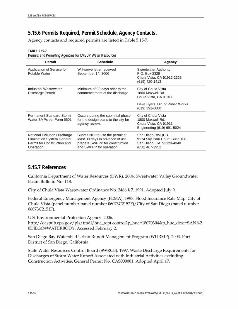
5.15.6 Permits Required, Permit Schedule, Agency Contacts. Agency contacts and required permits are listed in Table 5.15-7.
TABLE 5.15-7 Permits and Permitting Agencies for CVEUP Water Resources
Permit Schedule Agency
Application of Service for Potable Water
Will-serve letter received September 14, 2006
Sweetwater Authority P.O. Box 2328 Chula Vista, CA 91912-2328 (619) 420-1413
Industrial Wastewater Discharge Permit
Minimum of 90 days prior to the commencement of the discharge
City of Chula Vista 1800 Maxwell Rd. Chula Vista, CA 91911
Dave Byers, Dir. of Public Works (619) 391-6000
Permanent Standard Storm Water BMPs per Form 5501
Occurs during the submittal phase for the design plans to the city for agency review.
City of Chula Vista 1800 Maxwell Rd. Chula Vista, CA 91911 Engineering (619) 691-5024
National Pollution Discharge Elimination System General Permit for Construction and Operation
Submit NOI to use the permit at least 30 days in advance of use, prepare SWPPP for construction and SWPPP for operation.
San Diego RWQCB 9174 Sky Park Court, Suite 100 San Diego, CA. 92123-4340 (858) 467-2952
5.15.7 References California Department of Water Resources (DWR). 2004. Sweetwater Valley Groundwater Basin. Bulletin No. 118.
City of Chula Vista Wastewater Ordinance No. 2466 § 7. 1991. Adopted July 9.
Federal Emergency Management Agency (FEMA). 1997. Flood Insurance Rate Map: City of Chula Vista (panel number panel number 06073C2152F)/City of San Diego (panel number 06073C2151F).
U.S. Environmental Protection Agency. 2006. http://oaspub.epa.gov/pls/tmdl/huc_rept.control?p_huc=18070304&p_huc_desc=SAN%20DIEGO#WATERBODY. Accessed February 2.
San Diego Bay Watershed Urban Runoff Management Program (WURMP). 2003. Port District of San Diego, California.
State Water Resources Control Board (SWRCB). 1997. Waste Discharge Requirements for Discharges of Storm Water Runoff Associated with Industrial Activities excluding Construction Activities, General Permit No. CAS000001. Adopted April 17.
5.15-20 ES062007014SAC/360346/072140007(CVEUP_005.15_WATER RESOURCES.DOC)

5.15 WATER RESOURCES
ES062007014SAC/360346/072140007(CVEUP_005.15_WATER RESOURCES.DOC) 5.15-21
State Water Resources Control Board (SWRCB). 1999. Waste Discharge Requirements for Discharges of Storm Water Runoff Associated with Construction Activity, General Permit No. CAS000002. Adopted August 19.
Sweetwater Authority. 2006. Water Supply. Online Information: http://www.sweetwater.org/our_water/water_supply.html Accessed: February 2, 2006.
U.S. Environmental Protection Agency (USEPA). 2002. Section 303(d) List Fact Sheet for Watershed: San Diego.
Western Regional Climate Center (WRCC). 2005. San Diego WSO Airport, California. Online Information: http://www.wrcc.dri.edu/cgi-bin/cliMONtpre.pl?casand. Accessed: January 23, 2006.


![Suri500 Instalador 5.15[1]](https://static.fdocuments.net/doc/165x107/5571fbea4979599169961865/suri500-instalador-5151.jpg)