510 SWAN STREET, RICHMOND - Planning · Street tree on the corner of Stawell Street and Swan Street...
16
510 SWAN STREET, RICHMOND URBAN CONTEXT ANALYSIS Prepared for Department of Education and Training 15 September 2016
Transcript of 510 SWAN STREET, RICHMOND - Planning · Street tree on the corner of Stawell Street and Swan Street...

510 SWAN STREET, RICHMONDURBAN CONTEXT ANALYSISPrepared for Department of Education and Training15 September 2016

© Urbis 2016
This publication is subject to copyright. Except as permitted under the Copyright Act 1968, no part of it may in any form or by any means (electronic, mechanical, photocopying, recording or otherwise) be reproduced, stored in a retrieval system or transmitted without prior written permission. Enquiries should be addressed to the publishers.
URBIS.COM.AU

CONTENTS
1.0 INTRODUCTION 3
2.0 URBAN ANALYSIS 42.1 Site Context 42.1.1 Site and Context Photographs 4
2.2 Connectivity & Public Transport 62.3 Land Use & Built Form 72.4 Open space & Vegetation 82.5 Tree Analysis
9
3.0 SWAN STREET STRUCTURE PLAN 10
3.1 Swan Street Structure Plan Principles 11
4.0 BUILT FORM MASSING 12
5.0 SHADOW STUDY 145.1 Equinox Shadow Study 145.2 Solstice Shadow Study 15
1.0 INTRODUCTION
The following Urban Context Analysis has been prepared in review of the potential future urban development opportunities of the land at 510 Swan Street, Richmond. It has been developed further to the initial planning and site overview produced by Urbis in August 2016. The analysis has been prepared with consideration of the Swan Street Structure Plan prepared in January 2014.
The report contains a collection of site and surrounding context photos, analysis mapping, 3D massing studies and shadow diagrams to test and understand an appropriate response for the site. The report considers the surrounding land use, open space provision, public and active transport and the built form and streetscape outcomes to contemplate an appropriate response for the site.
The Department of Education and Training do not intend to develop the site at 510 Swan Street, Richmond. This document has been prepared for information purposes only to provide background to the analysis undertaken to inform the proposed rezoning and future controls for the site.

7
510 Swan Street, Richmond
AUGUST 2016
LOCATION OF AMENITIES IN THE SURROUNDING AREA Figure 1 Location of amenities in the surrounding area plan (extract from Urbis planning report)
Figure 2 Location of context photos surrounding the site
1:2500 @ A3
1 5
2
43
7 8
6
2.0 URBAN ANALYSIS
2.1 SITE CONTEXTThe site is located along the Swan Street activity corridor, to the immediate west of the Burnley Rail Station. The local context includes a mix of commercial development, primarily concentrated along Swan Street, and mixed density residential to the north and south with a band of open space including active and passive recreation facilities surrounding to the east and south.
2.1.1 Site and Context PhotographsThe following photographs illustrate the site and immediate context.
4 510 Swan Street, Richmond Urban Context Report

1- Commercial use opposite site - Swan Street
6- Site interface with Stawell Street, looking north towards Swan Street
3-Stawell Street south interface with site 5- Low density residential opposite site - Swan Street4- Opposite site- Stawell Street
7- Corner of site -Stawell Street, view from Swan Street 8- Interface with subject site and neighbouring site - Swan Street
2- Golden Square Bicentennial Park south of Burnley station
SWAN STREET
RAIL LINE
510 SWAN STREET
STAW
ELL
STRE
ET
BURN
LEY
STRE
ET
BURNLEY RAIL STATION
NTS
Figure 3 Public Transport Plan
Swan Street Activity Centre
Melbourne CBD
MCG
Melbourne and Olympic Parks Sports Precinct
11 mins
Hawthorn
University of Melbourne - Burnley Campus
Figure 4 Connectivity to surrounding landmark destinations via public transport
1:7500 @ A3
Legend
Site
400m & 800m catchment
Yarra river
Train station
Train line
Tram stop
Tram route
Bus stop
Bus routeHigh pedestrian movement Designated bike laneBike friendly path Bike trail
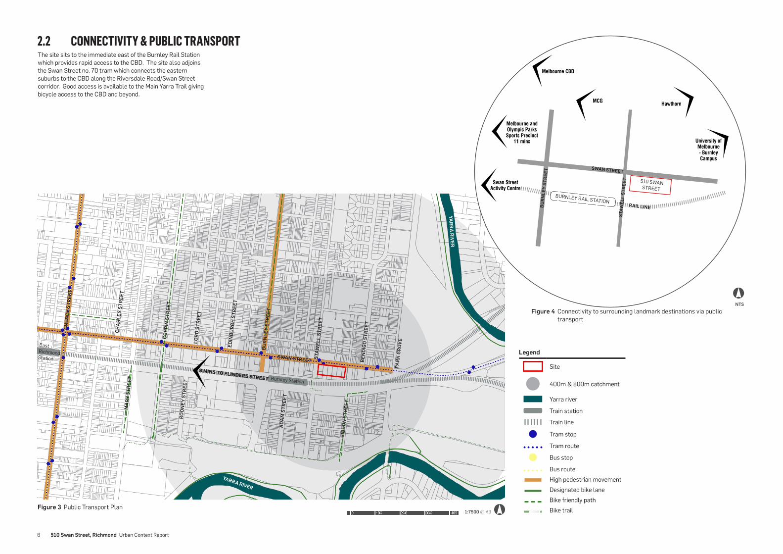
2.2 CONNECTIVITY & PUBLIC TRANSPORT
SWAN STREET
YARRA RIVER
BURN
LEY
STRE
ET
EDIN
BURG
H ST
REET
LORD
STR
EET
COPP
IN S
TREE
T
CHAR
LES
STRE
ET
CHUR
CH S
TREE
T
BEN
DIGO
STR
EET
PARK
GRO
VE
STAW
ELL
STRE
ET
ADAM
STR
EET
GIBD
ON S
TREE
T
ROON
EY S
TREE
T
MAR
Y ST
REET Burnley Station
East Richmond Station
8 MINS TO FLINDERS STREET
The site sits to the immediate east of the Burnley Rail Station which provides rapid access to the CBD. The site also adjoins the Swan Street no. 70 tram which connects the eastern suburbs to the CBD along the Riversdale Road/Swan Street corridor. Good access is available to the Main Yarra Trail giving bicycle access to the CBD and beyond.
YARRA RIVER
6 510 Swan Street, Richmond Urban Context Report

Bicentenial Park
Barkly Gardens
Swan Street Redevelopment Zone
Low density residential - unlikely to change
Low density residential - unlikely to change
Alan Bain Reserve
Figure 5 Land Use Plan 1:7500 @ A3
2.3 LAND USE & BUILT FORM
NTS
SWAN STREET
CITY LINK
BURN
LEY
STRE
ET
EDIN
BURG
H ST
REET
LORD
STR
EET
COPP
IN S
TREE
T
CHAR
LES
STRE
ET BEN
DIGO
STR
EET
PARK
GRO
VE
STAW
ELL
STRE
ET
ADAM
STR
EET
ROON
EY S
TREE
T
MAR
Y ST
REET
SWAN STREET
Figure 6 Existing uses surrounding the site along Swan Street
Tran
spor
t hea
lth in
sura
nce
Radi
o br
oadc
astin
g st
atio
n
Car p
ark
Cafe
Car m
echa
nic
and
serv
icing
Ligh
t ind
ustr
y an
d sh
owro
oms
Ligh
t ind
ustr
y an
d sh
owro
oms
Low
den
sity
resid
entia
l
Low
den
sity
resid
entia
l
Burnley Park
Burnley Golf Club
KCX
Inte
rnat
iona
l
Mixe
d us
e re
tail
Swan
str
eet V
et
Seid
o Ka
rate
Cafe
Low
den
sity
resid
entia
l
Low
den
sity
resid
entia
l
Serv
ice
stat
ion
Legend
Site
Yarra river
Commercial
Residential
Open space
Industrial
Transport
Heritage overly
Redevelopment opportunity
The Swan Street corridor represents a major activated spine that is earmarked for redevelopment within the Swan Street Structure Plan. Swan Street is currently primarily commercial with some residential uses to the north and north east of the site. Residential precincts exist to the north and south of the Swan Street corridor which are primarily low density, with some areas included in a heritage overlay.
There are some pockets of existing higher density residential development in the area. A number of redevelopment opportunity sites exist in the area, in particular along Swan Street.
The Burnley City Link Exhaust Stack is located within proximity to the site. In accordance with Design and Development Overlay 5 ‘City Link Exhaust Stack’ development must not adversely affect the operation of the stack.
YARRA RIVER
YARRA RIVER
Prepared by Urbis for Department of Education and Training 7

Figure 7 Open Space Plan 1:7500 @ A3
Legend
Site
400m & 800m catchment
Yarra river
Open Space
Train station Train lineDesignated bike laneBike friendly path Bike trail
1 Golden Square Bicentennial Park
2 Burnley Golf Club3 Burnley Park4 Barkly Gardens5 Alan Bain Reserve6 Athol J Brown Reserve7 Twickenham Crescent
8 Dame Nellie Melba Memorial Park
9 Gahans Reserve
8
9
2.4 OPEN SPACE & VEGETATION The Golden Square Bicentennial Park (1) is located to the south of the site on the other side of the Rail Line. This parkland provides play equipment, seating, BBQ’s and a dog off leash area. In addition to this park, there is a band of open space that edges the Yarra River and provides a range of active and passive recreation facilities.
SWAN STREET
RAIL LINE
BURN
LEY
STRE
ET
BURN
LEY
STRE
ET
EDIN
BURG
H ST
REET
LORD
STR
EET
COPP
IN S
TREE
T
CHAR
LES
STRE
ET
BEN
DIGO
STR
EET
PARK
GRO
VE
STAW
ELL
STRE
ET
ADAM
STR
EET
GIBD
ON S
TREE
T
ROON
EY S
TREE
T
MAR
Y ST
REET
41
5
3
2
7
6
Burnley Station
Passive Open Space ▪ Bicentennial Park/Golden Square is approximately 80m to
the south of the site, and contains playgrounds, seating, BBQs and a dog off-leash area.
▪ Loys Paddock Reserve, approximately 460m to the south, contains a dog off-leash area and access to the main Yarra Trail and other parks and reserves.
▪ Athol J Brown Reserve is located approximately 200m to the west and contains vegetated areas of trees and grassed areas.
▪ Barkly Gardens is located approximately 650m to the west of the site. The Gardens are highly landscaped and include play equipment, public toilets shelter, seating and dog off-leash areas.
Recreation ▪ Allan Bain Reserve is located south of Barkly Gardens,
approximately 710m to the southwest of the site and contains a sporting ground with infrastructure for both soccer and cricket.
▪ Burnley Park provides both passive and recreational open space for the immediate and wider Richmond area. The 6 hectare park is located approximately 200m to the east of the site and contains BBQ facilities, dog off-leash area together with formal recreational infrastructure including a basketball court and sporting grounds used for football, cricket, and soccer.
▪ The Burnley Public Golf Course is located approximately 200m to the east of the site, south of Swan Street. The 18- hole course includes practice putting and chipping greens and nets.
Other open space ▪ Twickenham Crescent is approximately 240m to the south
of the site and contains two areas of open space occupied with grassed areas and scattered canopy trees. These areas are zoned General Residential but are identified within the City of Yarra’s Open Space Strategy.
8 510 Swan Street, Richmond Urban Context Report

Legend
Site
Arborist tree rating - low
Arborist tree rating- medium
Open Space
Existing street trees 1:2000 @ A3
SWAN STREET
BEN
DIGO
STR
EET
STAW
ELL
STRE
ET
Figure 8 Arborist classification for vegetation on site
Large tree towards the centre of the site
Existing street trees and vegetation along Swan Street
Street tree on the corner of Stawell Street and Swan Street
2.5 TREE ANALYSIS
The frontage to both Swan and Stawell Streets contain vegetation including canopy trees together with garden beds of shrubbery and ground cover planting. An arboricultural assessment was undertaken by Tree Logic (29 June 2016) to assess the health and significance of the existing trees on site and trees immediately adjacent to the site. The assessment identified six (6) trees on the site, and none were identified as being indigenous or on the City of Yarra Significant Tree Register.
Three (3) trees on site were identified as being ‘significant’ due to their size, and it is anticipated that at least one of these trees (located in the centre of the property immediately to the south of the pavilion building) would require removal as part of the site’s future development.
The Swan Street Structure Plan identifies a need for “new/enhanced street trees” along Swan Street.
Prepared by Urbis for Department of Education and Training 9
3.0 SWAN STREET STRUCTURE PLAN
Existing Structure Plan Proposed Structure Plan
The following plans demonstrate the proposed structure plan with consideration of the redevelopment opportunity of the subject land. The potential outcome on the site has been derived with reference to the Swan Street Structure Plan on surrounding sites and having regard to the particular of this large parcel with key street frontages and limited sensitivities.
The diagrams on the adjacent page demonstrate the key principles that the proposed outcome on the site achieve.
Figure 9 Proposed structure plan (extract from Swan Street Structure Plan)
10 510 Swan Street, Richmond Urban Context Report

1. Transition in height to surrounding low density areas
4. Visually recessive upper levels (6m setback on south side of Swan Street)
2. Transition in height from the strategic redevelopment site on the corner of Burnley Street and Swan Street
5. Activate public realm and improve amenity and safety of pedestrians
3. Consistent street wall and framing of Swan Street
6. Solar access to public realm not impacted
3.1 SWAN STREET STRUCTURE PLAN PRINCIPLES
NTS
LH
L
H
L
H
Prepared by Urbis for Department of Education and Training 11

4.0 BUILT FORM MASSING
10-12 storeys
HEIGHT TRANSITION
4 storeys
SITE
Assumptions:
The massing diagrams provide a high level, indicative representation of a potential built form outcome with regard to the overall principles set out within the Swan Street Structure Plan and this document.
Assumptions have been made with regard to site amalgamation to enable a more intense development outcome in accordance with the Structure Plan intent.
Indicative tower forms have been included on surrounding land based on the setbacks and built form identified in the Structure Plan.
Indicative development has been shown on the site to test the potential development outcomes resulting from the Structure Plan, this analysis and the opportunities of the site.
The following 3D massing diagrams demonstrate the potential impact of future higher scale development on the site in the immediate context as contemplated by the Structure Plan.
Burnley Station
Figure 10 Elevation view of the site from north of Swan Street
12 510 Swan Street, Richmond Urban Context Report

10-12 storeys
HEIGHT TRANSITION
BURNLEY STREET SWAN STREET
4 storeys
Burnley Station
Figure 11 Axonometric aerial view of the site from north of Swan Street
Prepared by Urbis for Department of Education and Training 13

5.0 SHADOW STUDYThe following shadow study examines the shadow impact of the indicative modelled forms in section 4.0. This test indicates that the modelled forms do no impact Golden Square / Bicentennial Park or surrounding residential areas at key times at the equinox and June solstice.
5.1 EQUINOX SHADOW STUDY20th March 11am 22nd September 11am
20th March 2pm 22nd September 2pm
Golden Square Bicentennial Park
SWAN STREET
MADDEN GROVE
RAIL LINE
BURNLEY RAIL STATION
BURN
LEY
STRE
ET
STAW
ELL
STRE
ET
Golden Square Bicentennial Park
SWAN STREET
MADDEN GROVE
RAIL LINE
BURNLEY RAIL STATION
BURN
LEY
STRE
ET
STAW
ELL
STRE
ET
Golden Square Bicentennial Park
SWAN STREET
MADDEN GROVE
RAIL LINE
BURNLEY RAIL STATION
BURN
LEY
STRE
ET
STAW
ELL
STRE
ET
Golden Square Bicentennial Park
SWAN STREET
MADDEN GROVE
RAIL LINE
BURNLEY RAIL STATION
BURN
LEY
STRE
ET
STAW
ELL
STRE
ET
14 510 Swan Street, Richmond Urban Context Report

5.2 SOLSTICE SHADOW STUDY
20th June 11am
20th June 2pm
Golden Square Bicentennial Park
SWAN STREET
MADDEN GROVE
RAIL LINE
BURNLEY RAIL STATION
BURN
LEY
STRE
ET
STAW
ELL
STRE
ET
Golden Square Bicentennial Park
SWAN STREET
MADDEN GROVE
RAIL LINE
BURNLEY RAIL STATION
BURN
LEY
STRE
ET
STAW
ELL
STRE
ET
Prepared by Urbis for Department of Education and Training 15