“Developing Indigenous Resources: Building Indigenous Economies”

5.0 Indigenous heritage – archaeological context5.1 Regional reviewThe New South Wales South Coast and its hinterlands have been the subject of extensivearchaeological research and impact assessments over the last thirty years, much of it concentratedalong the coastline and estuaries. This work includes excavations of sites, mainly shell middens androck shelters, and systematic surveys conducted within a variety of geographic scales and samplingstrategies. The majority of archaeological sites located in this region date from the last 6,000 years,following the stabilisation of the sea level to approximately the present level (the Holocene Stillstand).
Stable sea levels promoted the formation of estuaries, mangrove flats and coastal sand barriers whichin turn increased the biomass, ecological diversity, and resource predictability for the Aboriginalresidents of the coast and hinterland. It is likely that this evolution of coastal environments promotedhigher population densities and more intensive exploitation patterns. In contrast, occupation in thesame areas during the late Pleistocene, that is prior to 10,000 years BP (before present), may havebeen sporadic and the Aboriginal population relatively small. However, Boot suggests that coastalhinterland sites older than 6000 years BP are more common than previously suggested, and thatPleistocene occupation may not have been as sporadic as previously thought (Boot 1996a).
Sites older than 6,000 years are rarely detected by archaeologists and are mostly limited to deepdeposits surviving either in rock shelters or stable aggrading landforms. Occupation in these timesmay similarly have focused on the coast, which was then lower and situated further east. Sitesrelating to this occupation have now either been destroyed by rising seas, or are now submerged. Todate, two coastal sites, Bass Point (Bowdler 1976) and Burrill Lake (Lampert 1971), provide evidenceof Pleistocene Aboriginal occupation of the South Coast dating to 17,000 and 20,000 years BP (beforepresent) respectively. Prior to the rise in sea levels these sites would have been located some 14 kminland. Excavation of rockshelters near Currarong provided potential occupation to 7,000 BP (Lampert1971).
Many Aboriginal sites have been located in the course of archaeological surveys on the NSW SouthCoast and its immediate hinterland. Site types recorded in this region include rock shelters with artand/or cultural deposit, grinding grooves, artefact scatters, scarred trees, coastal and estuarinemiddens and burials.
Shell middens are the most commonly recorded Aboriginal site type along the coast. These sites aregenerally located on rocky headlands, on coastal sand dunes adjacent to rock platforms, or creek andestuary entrances. Navin has noted that coastal sand dune middens contain comparatively largeamounts of stone in a variety of raw materials (Navin 1987:50). Further inland the most frequentlyencountered site types are small surface scatters of stone artefacts, referred to sometimes as 'opencamp sites' and more recently as surface artefact occurrences. A growing corpus of evidence fromarchaeological test excavations indicates that most surface scatters are indicative of larger subsurfaceartefact occurrences. Both surface and subsurface artefact occurrences are closely related to locallyelevated, well-drained and low gradient ground adjacent to freshwater sources. Based on presentevidence, the most common lithic materials utilised by the Aborigines of the southern Illawarra andShoalhaven districts were chert, quartz, silcrete, silicified wood and ‘indurated mudstone’ (the latterrock type has often been miss-identified in the past and most recordings are probably a form of tuff).
Investigations into the occupation of the hinterland have been undertaken with major studies such asthose by Bindon (1976), Poiner (1976), Byrne (1983), Sefton (1984), Boot (1993, 1994, 1996a, 1996b)and Knight (1996). Boot (1994) concluded that all areas of the hinterland were accessed, but that themajor river valleys were favoured over other environments. Major ridgelines were also the focus ofactivity. He argues that the character of this early inland occupation on the NSW South Coast wasbased on long-term residence rather than “fleeting forays” from the coast.
60021933 - Gerringong to Bomaderry Princes highway UpgradePreliminary Indigenous and Non-Indigenous Assessment – November 2007
Page 35
Navin Officer

The stone technologies used by Aborigines on the NSW South Coast have not remained static and asequence of broad-scale changes through time has been identified. This has been known as theEastern Regional Sequence and can be applied, with various degrees of success and allowances forregional differences, to sites throughout the eastern seaboard of Australia.
The sequence can be characterised using the following terminology and phases (based on McDonald1994):
The Capertian: Artefacts from this period consist mostly of large heavy artefacts includingunifacial pebble tools, scrapers, core tools, denticulate saws andhammerstones. Some bipolar tools and burins also occur. The Capertian ispresent up to around 5000 years BP.
The Early Bondaian: Within this phase characteristics of the Capertian continue but tools on smallerblades are introduced and become predominant. Blades which are backed(one edge blunted by fine trimming) and ground edge implements are notableintroductions. There is a major shift in the type of rocks used for toolmanufacture to fine-grained siliceous materials (such as silcrete, chert andtuff/indurated mudstone). The Early Bondaian has been identified in depositsdating between around 5000 and around 3000 years BP.
The Middle Bondaian: In this phase the percentage of Bondi points (a type of backed blade)increases and remains greater than the percentage of bipolar artefacts. Edgeground artefacts are present in higher proportions, as are quartz artefacts.This phase dates from around 3000 to as late as 1000 years BP.
The Late Bondaian: This phase is characterised by quartz either becoming the predominant rocktype used or markedly increasing in proportion. Bondi points and most typesof backed blades become rare or are no longer found. Eloueras, bipolarartefacts and edge ground hatchets are the predominant tool types. Bone andshell implements including fishhooks appear in this phase, particularly in somecoastal sites. This phase dates from around 1600 (Attenbrow 1987), or 1000years BP (McDonald 1994), to the cessation of stone working followingcontact with European Society.
McDonald notes that the introduction of ground implements around 4000 years BP and shell fishhooksin the last 1,000 years were major technological innovations (McDonald 1994:69). The significanceand possible reasons for the technological changes in the Eastern Regional Sequence has been thesubject of considerable research and debate since their identification. Contemporary theoriespostulate various changes in social behaviour, group interactions, and population dynamics either ascontributing causes or as consequences of these technology changes.
Recent reviews of this sequence have called into question the accuracy of the divisions, pointing outthat many of the diagnostic elements, such as bipolar flaking and microlith production, cross thetemporal boundaries and vary across regions (Mulvaney and Kamminga 1999). As an alternative, thebroad technological changes which were associated with the introduction of a microblade basedtechnology and a smaller tool kit are identified as the ‘Late Phase’ or the Australian Small Tool Phase,which began around 5-6000 years ago.
This phase was characterised by the successive introduction of different technological innovationswhich spread or appeared in differing parts of the continent at different times. Tools with a groundedge such as stone hatchets first appear at least 4300 years ago. The occurrence of microblades andretouched microliths dates to about 3-4000 years ago in the NSW South Coast.
60021933 - Gerringong to Bomaderry Princes Highway UpgradePreliminary Indigenous and Non-Indigenous Assessment – November 2007
Page 36
Navin Officer

From about 2000 years ago bipolar flaking of quartz begins to increase within southeastern Australiansites, and intensifies over the last 1000 years. A corresponding trend is the disappearance ofmicroblade technologies over this time, however both trends are uneven and are not consistent acrossand within regions. The Elouera, a thick-backed blade, resembling an orange segment appearedaround about 1600 years ago. Shell fish hooks used for line fishing first appeared before 700 yearsago, and possibly as early as 1100 years (Mulvaney and Kamminga 1999).
5.2 The local areaA range of archaeological investigations have been conducted within the Southern Illawarra coastalplain. These include studies conducted within an academic research framework, recordings byinterested amateurs and surveys and assessments of areas under consideration for development.The results of these surveys vary according to macro and micro topographic and environmentalfactors, ground surface visibility and the degree of previous landscape disturbance.
To date seventy four Aboriginal sites have been recorded in area 26 x 19 km around and including theGerringong to Bomaderry Upgrade study area. Sites comprise thirty two artefact scatters, nineteenshell middens, seven isolated finds, seven rock shelters with art and/or deposit and/or rockengravings, one natural mythological site, one bora/ceremonial site, one midden/artefact scatter, onepotential archaeological deposit (PAD), four axe grinding groove sites, and one Aboriginal Place atFoxground.
A review of previous studies, organised by local areas, is provided below.
5.2.1 Kiama
A number of small scale systematic archaeological surveys have been undertaken in the area aroundKiama. None of the studies relate directly to the south Kiama area.
Assessments have been conducted of the banks of the Minnamurra estuary either side of the PrincesHighway (Kamminga 1985), of an alternative route for the Princes Highway from Willow Gully(northwest of Kiama) north to the intersection of the Highway and Swamp Road (Koettig 1988), andthe North Kiama Bypass between Dunmore and Bombo (Silcox 1990).
In 1995, a Local Environmental Study (LES) was prepared for an area of land at West Kiama. Thereis no 'stand alone' archaeology report for the study and no documentation about a field surveyconducted for the LES. Consequently it is not known how much of the West Kiama LES area wassubject to inspection for Aboriginal sites.
An archaeological survey was conducted of an approximately 15 ha of land located approximately oneand a half kilometres inland from the coastline at Kiama in 1998 (Navin 1998). The area was situatedon the foothills of the Illawarra Range, on a southwest-northeast orientated descending ridgeline fromSaddleback Mountain which formed the watershed between Spring Creek and the coastal catchmentof the immediate Kiama hinterland. Gradients within the study area are relatively low, being situatedon spur and ridgeline crests, and upper slopes. Field survey resulted in the location of one isolatedfind (a single stone artefact) and one area of archaeological potential.
An archaeological survey of the approximately four kilometre long 33kV Feeder 7007 which runs fromKiama Zone Substation to the Jerrara Switching Station was conducted in 2007 (Navin OfficerHeritage Consultants 2007). No Aboriginal sites were identified in the course of the survey of the line,which mostly traversed low gradient grazing land.
60021933 - Gerringong to Bomaderry Princes Highway UpgradePreliminary Indigenous and Non-Indigenous Assessment – November 2007
Page 37
Navin Officer

5.2.2 Foxground, Gerringong and Gerroa
Further south, Caryll Sefton carried out an archaeological survey for a proposed extension to a gravelquarry at Foxground located eight kilometres inland from the coast (Sefton 1988). No archaeologicalsites were identified in Sefton’s survey.
Officer (1991a) conducted a detailed recording of the Foxground engraving site.Investigations in the Gerringong and Gerroa areas have included assessments for recreational andresidential developments, road improvements, sewerage schemes, and sand mining at the ClearyBrothers property at Gerroa.
In 1987 Dallas conducted an investigation of a midden and a camp site at Werri Beach at Gerringong.Both sites were located during construction of a water pipeline and were severely disturbed.
Human skeletal remains were encountered in Gerringong in 1991 during construction of a carparknext to tennis courts at the southern end of Werri Beach (Feary 1992). It appeared that the burial hadbeen placed within previously excavated shell midden (NPWS Site # 52-5-215). Due to the extent ofdisturbance to the site and the fragmented nature of the remains it was not possible to collect anyinformation about the context or the nature of the burial. The remains were handed back to theAboriginal community for reburial in December 1991 (Feary 1992).
The resource use and occupation of Seven Mile Beach was the subject of an honours thesis by EmmaLee in 1996. Analysis was carried out on excavated material and she concluded that the beachrepresented an important ceremonial and resource gathering area.
In 1999 Feary conducted an archaeological survey of the existing Gerroa Camping Ground prior to itsredevelopment by the NPWS into a day use area. No sites were located by Feary.
In 2000 Navin Officer Heritage Consultants (2000a) conducted a survey for a proposed subdivision,the Elambra Estate, located just south of Gerringong. Two isolated finds were located in the course ofthe survey.
In 1999 McDonald conducted a cultural heritage assessment for the proposed Gerroa Gerringongsewerage scheme. Twelve sites comprising shell middens, artefact scatters and scarred trees (laterdiscounted) were identified in the course of the study (McDonald 1999). She recommended thatfurther archaeological assessment, specifically subsurface testing, be conducted at the SewerageTreatment Plant (STP) and the five Sewerage Pump Station (SPS) sites.
In 2000 Navin Officer Heritage Consultants (2000b) conducted a program of subsurfacearchaeological testing for the Gerroa Gerringong sewerage scheme. Sixty one test pits wereexcavated and 2601 lithic artefacts were recovered from forty two pits. A program of archaeologicalsalvage was then conducted in 2001 for the Gerroa Gerringong Sewerage Scheme. Six areas wereexcavated during the salvage program, five of these areas were located in the STP area and one waslocated in the area of an SPS. Eight pits were excavated in the STP area and one pit was excavatedat SPS 682. A total of 2100 artefacts were identified from all of the excavated pits in the salvagedGerroa stone artefact assemblage. Midden shell was identified in each of the nine salvage excavationpits and a total of 7.9 kg of midden shell was recovered from the excavations (Navin Officer HeritageConsultants 2001).
An archaeological survey of a parcel of land in East Gerringong was conducted in February 2002 andone Aboriginal site, East Gerringong 1 (EG1), and one potential archaeological deposit (PAD1) wererecorded within the study area (Navin Officer Heritage Consultants 2002). Subsequently a program ofsubsurface testing was conducted at East Gerringong and twenty seven lithic items were recoveredfrom eight of the sixteen test pits. Eight test pits had no lithic items (Navin Officer HeritageConsultants 2003).
60021933 - Gerringong to Bomaderry Princes Highway UpgradePreliminary Indigenous and Non-Indigenous Assessment – November 2007
Page 38
Navin Officer

The majority of archaeological investigation work conducted in the Gerringong/Gerroa area has takenplace within the Cleary Brothers Blue Angle Creek property and relates to sand mining in the area.The area has a long and complicated history of archaeological survey and assessment carried outover a period of nineteen years. This work has been summarised elsewhere and the reader isreferred to reports by Navin (1992) and Navin Officer Heritage Consultants (2000b) for a detailedsummary of investigations in the Cleary Brothers’ Blue Angle Creek property.
More recently assessments have been conducted for the upgrade of the intersection of Beach Roadand Gerroa Road (Navin Officer Heritage Consultants 2004), a proposed golf course at Gerroa (NavinOfficer Heritage Consultant 2005) and archaeological test excavations were carried out for a proposedexpansion to the Gerroa sand quarry (Navin Officer Heritage Consultants 2006).
5.2.3 Berry
Four archaeological sites were recorded by Corkill in the vicinity of Berry during fieldwork associatedwith her thesis on the lower Shoalhaven Valley (Corkill 1986). Three were situated in the area ofMoeyan Hill and consisted of an artefact scatter of ten small flakes, a grinding groove and a scarredtree. Another site was identified approximately one kilometre north of the town on Connolly’s Creek.This was described as an open camp site consisting of five flakes found in disturbed contexts on a sitemeasuring 100 m x30 m.
In 1991 Donlon conducted a preliminary archaeological survey of the proposed routes for theupgrading of the Princes Highway between Gerringong and Berry (Donlon 1991a). Targeted surveywas conducted along portions of the route options considered to be archaeologically sensitive. Onesite, an isolated find (a hammerstone) was identified in an upper gully on Toolijooa ridge.
An isolated find was recorded by Kuskie (1998) during the survey of a proposed subdivision on thesouthwestern margin of Berry. The find was located on a spoil heap adjacent to a channelised andunnamed ephemeral watercourse.
Paton carried out an archaeological study for the Berry sewerage overflow development in 1999. Nosites were located during the study.
Surveys for the Environmental Impact Statement (EIS) for the Eastern Gas Pipeline were conducted tothe north and west of Berry in 1995 (Kuskie, Navin & Officer 1995). An artefact scatter, NPWS site#52-2-308, was recorded near Connollys Creek in the course of the survey.
Subsequent works relating to the Eastern Gas Pipeline were conducted by Australian ArchaeologicalSurvey Consultants (AASC). These included extensive archaeological survey, subsurface testing andsalvage. However little or no information is available documenting these works and the Department ofEnvironment and Conservation (DECC) states that final reports for the subsurface investigation andsalvage programs for the EGP have not been provided.
In 1998 ERM Mitchell McCotter prepared an EIS for a North Berry Bypass (1998 draft). Anarchaeological survey was conducted for the study, however no Aboriginal sites were identified andthis was considered to be a product of poor ground surface visibility. It was concluded that there wasmoderate to high potential for Aboriginal sites to remain undetected in the study area.
In 2000 Navin Officer Heritage Consultants undertook a survey of Woodside Park, a dairy farm of120 ha located to the east of the township of Berry. One Aboriginal site, a very low density scatter ofstone artefacts (referred to as 'Woodside Park 1'), was located in the course of the survey. Theartefacts were visible on an unformed farm track on the upper slopes and crest of a major spurline.
No Aboriginal sites were identified in the course of an archaeological survey for the proposed upgradeof the intersection of the Princes Highway and Tindalls Lane, just north of Berry (Navin OfficerHeritage Consultants 2006c).
60021933 - Gerringong to Bomaderry Princes Highway UpgradePreliminary Indigenous and Non-Indigenous Assessment – November 2007
Page 39
Navin Officer
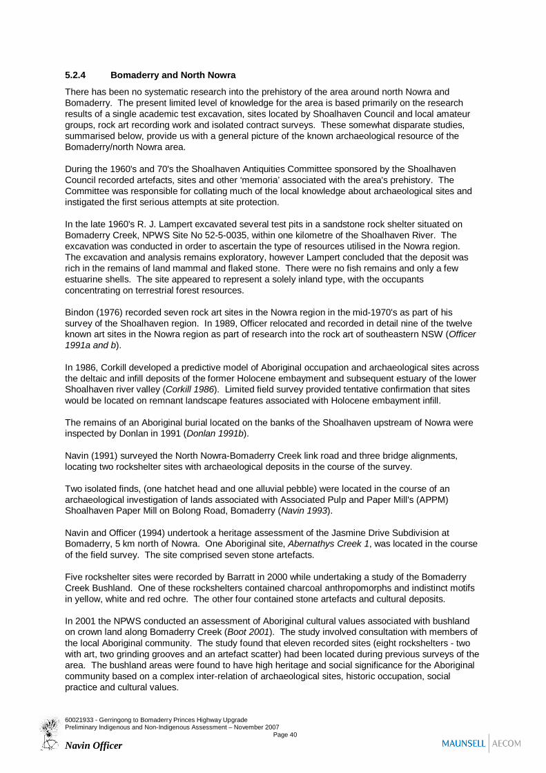
5.2.4 Bomaderry and North Nowra
There has been no systematic research into the prehistory of the area around north Nowra andBomaderry. The present limited level of knowledge for the area is based primarily on the researchresults of a single academic test excavation, sites located by Shoalhaven Council and local amateurgroups, rock art recording work and isolated contract surveys. These somewhat disparate studies,summarised below, provide us with a general picture of the known archaeological resource of theBomaderry/north Nowra area.
During the 1960's and 70's the Shoalhaven Antiquities Committee sponsored by the ShoalhavenCouncil recorded artefacts, sites and other ‘memoria’ associated with the area's prehistory. TheCommittee was responsible for collating much of the local knowledge about archaeological sites andinstigated the first serious attempts at site protection.
In the late 1960's R. J. Lampert excavated several test pits in a sandstone rock shelter situated onBomaderry Creek, NPWS Site No 52-5-0035, within one kilometre of the Shoalhaven River. Theexcavation was conducted in order to ascertain the type of resources utilised in the Nowra region.The excavation and analysis remains exploratory, however Lampert concluded that the deposit wasrich in the remains of land mammal and flaked stone. There were no fish remains and only a fewestuarine shells. The site appeared to represent a solely inland type, with the occupantsconcentrating on terrestrial forest resources.
Bindon (1976) recorded seven rock art sites in the Nowra region in the mid-1970's as part of hissurvey of the Shoalhaven region. In 1989, Officer relocated and recorded in detail nine of the twelveknown art sites in the Nowra region as part of research into the rock art of southeastern NSW (Officer1991a and b).
In 1986, Corkill developed a predictive model of Aboriginal occupation and archaeological sites acrossthe deltaic and infill deposits of the former Holocene embayment and subsequent estuary of the lowerShoalhaven river valley (Corkill 1986). Limited field survey provided tentative confirmation that siteswould be located on remnant landscape features associated with Holocene embayment infill.
The remains of an Aboriginal burial located on the banks of the Shoalhaven upstream of Nowra wereinspected by Donlan in 1991 (Donlan 1991b).
Navin (1991) surveyed the North Nowra-Bomaderry Creek link road and three bridge alignments,locating two rockshelter sites with archaeological deposits in the course of the survey.
Two isolated finds, (one hatchet head and one alluvial pebble) were located in the course of anarchaeological investigation of lands associated with Associated Pulp and Paper Mill's (APPM)Shoalhaven Paper Mill on Bolong Road, Bomaderry (Navin 1993).
Navin and Officer (1994) undertook a heritage assessment of the Jasmine Drive Subdivision atBomaderry, 5 km north of Nowra. One Aboriginal site, Abernathys Creek 1, was located in the courseof the field survey. The site comprised seven stone artefacts.
Five rockshelter sites were recorded by Barratt in 2000 while undertaking a study of the BomaderryCreek Bushland. One of these rockshelters contained charcoal anthropomorphs and indistinct motifsin yellow, white and red ochre. The other four contained stone artefacts and cultural deposits.
In 2001 the NPWS conducted an assessment of Aboriginal cultural values associated with bushlandon crown land along Bomaderry Creek (Boot 2001). The study involved consultation with members ofthe local Aboriginal community. The study found that eleven recorded sites (eight rockshelters - twowith art, two grinding grooves and an artefact scatter) had been located during previous surveys of thearea. The bushland areas were found to have high heritage and social significance for the Aboriginalcommunity based on a complex inter-relation of archaeological sites, historic occupation, socialpractice and cultural values.
60021933 - Gerringong to Bomaderry Princes Highway UpgradePreliminary Indigenous and Non-Indigenous Assessment – November 2007
Page 40
Navin Officer

Navin Officer Heritage Consultants completed a survey of a proposed residential subdivision atJamison Road, North Nowra in 2006. Five Aboriginal sites were recorded during this investigation.The sites comprised a rock shelter with remnant Aboriginal art and potential archaeological deposit(JR1), (a European gunflint was also found in this shelter); a rock shelter with an artefact scatter,Aboriginal art, and potential archaeological deposit (JR2); a previously recorded group of grindinggrooves (JR3, DEC site no. 52-5-84); and two isolated artefacts (JR4 and JR5).
Both shelters contained surface artefacts and deposits with archaeological potential for subsurfaceand in situ material. In JR1 the deposit was limited in size and had low to moderate in situ potential.The deposits in JR2 were substantial in area and had moderate to high in situ potential. It wasconcluded that the scientific value of JR1 was moderate within a local context, and JR2 was moderateto high within a local context.
The grinding groove site displayed characteristics that provided for a high assessment of scientificvalue and this site was considered to have high significance within a local context. Its rare anduncommon characteristics also had regional significance, supporting a moderate level of significancewithin a regional context.
Four rock shelters with potential Aboriginal archaeological deposit were also identified in the JamisonRoad study area.
5.3 The Princes Highway study areaA number of archaeological surveys and investigations have been previously conducted within theGerringong to Bomaderry Princes Highway Upgrade study area. These include Corkill 1986, Donlan1991a, Navin & Officer 1994, Kuskie, Navin & Officer 1995, Kuskie 1998, ERM Mitchell McCotter1998, Paton 1999, Navin Officer Heritage Consultants 2000 and Navin Officer Heritage Consultants2006.
5.3.1 Recorded Aboriginal archaeological sites
There are nineteen (19) previously recorded Aboriginal archaeological sites within the Gerringong toBomaderry Princes Highway Upgrade study area, eighteen of which are recorded on the DECAboriginal Heritage Information Management System (AHIMS). (Figure 5.1).
Five sites are the result of separate development-related impact assessments. Fourteen recordingshave resulted from investigations related to the Eastern Gas Pipeline, however data for the latter sitesis available only from site cards, interim reports and DEC consent or permit documentation. Thus ittends to be cursory, preliminary in nature, and inconsistent in the variables reported.
Table 5.1 tabulates the data which was available to the consultants. From this tabulation the followingpoints can be concluded
a) Of the eight subsurface testing locations within the study area, all but two returned subsurfaceartefacts. Test sites consisted almost exclusively of locally elevated topographies adjacent tomajor creeklines. A test excavation was also conducted on the Toolijooa ridge crest;
b) The test locations which did not reveal artefacts were located on the bank of Ooaree Creek onOmega Flat, and the bank of Broughton Creek near Broughton Village;
c) Only two sites were known from surface artefacts prior to construction within the study area;d) The absence of surface artefacts recorded during surface survey did not reflect the nature of the
subsurface archaeological resource. Only one of the test locations (on a small spurline crestadjacent to Broughton Creek) included visible artefacts prior to the conduct of test pitting orsubsequent construction works;
60021933 - Gerringong to Bomaderry Princes Highway UpgradePreliminary Indigenous and Non-Indigenous Assessment – November 2007
Page 41
Navin Officer

e) Six additional subsurface artefact occurrences were revealed following the conduct of trenching;and
f) Most of the archaeological deposits encountered appeared to consist of very low to low densitydistributions of stone artefacts, situated within or near riparian corridors. Low density artefactoccurrences were also revealed on major ridge crests, such as Toolijooa ridge.
In addition, a number of reported, but as yet unconfirmed, archaeological sites have been recordedfrom local oral sources (refer Section 6.3.3).
5.3.2 Reported Aboriginal archaeological sites
Information collected from a local community questionnaire for a previous highway upgrade optionanalysis (Donlon 1991:12-13) revealed the following unconfirmed reports of archaeological finds:
a) Aboriginal artefacts have been observed and collected along the banks of Broughton Creek in thevicinity of ‘Brookside’, Broughton Village;
b) A stone arrangement and bora ring is reportedly located in a ‘fairly open area associated with LilliPilli trees on Toolijooa Hill;
c) Aboriginal stone artefacts have been found by locals on the north saddle of the Toolijooa ridge,[close to the cattle trail on the crest];
d) Stone artefacts have been observed along the railway corridor about 10 m west of the rail lineand 350 m north of ‘Valley View’ homestead; and
e) Stone artefacts and a possible midden have been observed in the region where Toolijooa Roadmeets the railway.
60021933 - Gerringong to Bomaderry Princes Highway UpgradePreliminary Indigenous and Non-Indigenous Assessment – November 2007
Page 42
Navin Officer

Figure 5.1: Previously recorded Aboriginal archaeological sites (Western study area)
60021933 - Gerringong to Bomaderry Princes Highway UpgradePreliminary Indigenous and Non-Indigenous Assessment – November 2007
Page 43
Navin Officer
Figure 5.1 cont’d. Previously recorded Aboriginal archaeological sites (Eastern study area)
60021933 - Gerringong to Bomaderry Princes Highway UpgradePreliminary Indigenous and Non-Indigenous Assessment – November 2007
Page 44Navin Officer

Table 5.1: Information relating to Aboriginal sites and archaeological subsurface investigations recorded within the study area
DEC siteno.
Site name Site type AMG reference(AGD)
No. ofsurfaceartefacts pre-construction
No. of testpitsconducted
No. of artefactsrecovered fromtest pits(permit/consentdocuments)
No. ofrecoveredartefacts(DEC sitecard)
Comments(Some comments not includedbecause of data base licensingrestrictions)
DECpermit/consentID
Recordings made during survey and salvage programs for the Eastern Gas Pipeline52-5-0308 EGP 3-29,
ConnollysCreek
surfaceartefactoccurrence
5
52-5-0399 TPA9[ToolijooaRidge]
subsurfaceartefactoccurrence
18 0(but see sitecard note)
site cardstates lowdensitysubsurfacematerialpresent
This is the spurline betweenToolijooa and Harley Hills
SZCHU0037
52-5-0395 TPA7,Duke 8[Gembrook]
surface andsubsurfaceartefactoccurrence
8 39 1 Adjacent to Broughton Creek SZCHU0039
52-5-0401 TPA10[Crooked R]
subsurfaceartefactoccurrence
24 1 site cardstates verylow densitysubsurfacematerialpresent
DEC site card states ‘artefactswere recovered from the raisedriver bank
SZCHU0040
52-5-0410 TPA6[Broughton MillCreek]
subsurfaceartefactoccurrence
12 6 Site content information on DECsite card has been lost
SZCHU0041
No DEC siteno.
TPA8[BroughtonCreek]
not a site 6 0 A test pitting location on the westof Broughton Creek nearBroughton Village
SZCHU0043
No DEC siteno.
TPA11[OoareeCreek]
not a site
Not included dueto sensitive nature
of site
12 0 A test pitting location on thesouthern bank of Ooaree Creek onOmega Flat
SZCHU0044
60021933 - Gerringong to Bomaderry Princes Highway UpgradePreliminary Indigenous and Non-Indigenous Assessment – November 2007
Page 45Navin Officer

DEC siteno.
Site name Site type AMG reference(AGD)
No. ofsurfaceartefacts pre-construction
No. of testpitsconducted
No. of artefactsrecovered fromtest pits(permit/consentdocuments)
No. ofrecoveredartefacts(DEC sitecard)
Comments(Some comments not includedbecause of data base licensingrestrictions)
DECpermit/consentID
Recordings made during survey and salvage programs for the Eastern Gas Pipeline52-5-0396 TPA4
[BundewallahCreek]
subsurfaceartefactoccurrence
pits onbothbanks ofcreek
10 DEC site card states pits dug onthe north and south banks ofBundewallah Creek
52-5-0370 TPA3[Flying FoxCreek]
subsurfaceartefactoccurrence
pits on Wand S sideof creek
4 ‘a number ofartefacts’recoveredsubsurface;
2 artefactssalvagedfrom surfaceafterpipelinetrenching
site card states artefactsrecovered from test pits on the Wand S side of an ephemeral [FlyingFox] Creek
SZCHU0035
? 1 SZCHU0036
52-5-0419 NO.LC6[Jaspers Creektributary]
subsurfaceartefactoccurrence
Not included dueto sensitive nature
of site
25 salvagedfrom surfaceafterpipelinetrenching
site situated between two minorcreeklines
60021933 - Gerringong to Bomaderry Princes Highway UpgradePreliminary Indigenous and Non-Indigenous Assessment – November 2007
Page 46Navin Officer
DEC siteno.
Site name Site type AMG reference(AGD)
No. ofsurfaceartefacts pre-construction
No. of testpitsconducted
No. of artefactsrecovered fromtest pits(permit/consentdocuments)
No. ofrecoveredartefacts(DEC sitecard)
Comments DECpermit/consentID
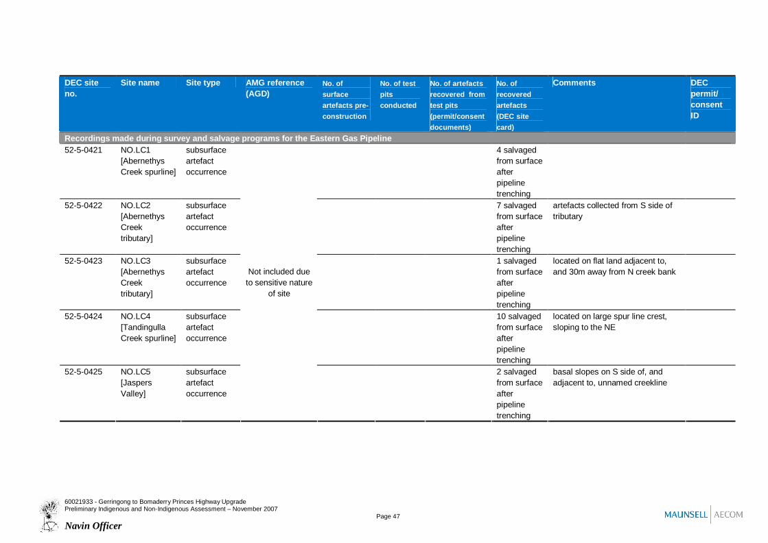
Recordings made during survey and salvage programs for the Eastern Gas Pipeline52-5-0421 NO.LC1
[AbernethysCreek spurline]
subsurfaceartefactoccurrence
4 salvagedfrom surfaceafterpipelinetrenching
52-5-0422 NO.LC2[AbernethysCreektributary]
subsurfaceartefactoccurrence
7 salvagedfrom surfaceafterpipelinetrenching
artefacts collected from S side oftributary
52-5-0423 NO.LC3[AbernethysCreektributary]
subsurfaceartefactoccurrence
1 salvagedfrom surfaceafterpipelinetrenching
located on flat land adjacent to,and 30m away from N creek bank
52-5-0424 NO.LC4[TandingullaCreek spurline]
subsurfaceartefactoccurrence
10 salvagedfrom surfaceafterpipelinetrenching
located on large spur line crest,sloping to the NE
52-5-0425 NO.LC5[JaspersValley]
subsurfaceartefactoccurrence
Not included dueto sensitive nature
of site
2 salvagedfrom surfaceafterpipelinetrenching
basal slopes on S side of, andadjacent to, unnamed creekline
60021933 - Gerringong to Bomaderry Princes Highway UpgradePreliminary Indigenous and Non-Indigenous Assessment – November 2007
Page 47Navin Officer

DEC siteno.
Site name Site type AMG reference(AGD)
No. ofsurfaceartefacts pre-construction
No. of testpitsconducted
No. of artefactsrecovered fromtest pits(permit/consentdocuments)
No. ofrecoveredartefacts(DEC sitecard)
Comments DECpermit/consentID
Recordings made during survey and salvage programs for the Eastern Gas Pipeline52-5-0426 Test Pitting
Area 9 (TPA9),northernsection[ToolijooaRidge]
subsurfaceartefactoccurrence Not included due
to sensitive natureof site
6 salvagedfrom surfaceafterpipelinetrenching
Recordings made during other investigations52-5-0287 Abernethys
Creek 1surfaceartefactoccurrence
7 on low gradient slopes adjacent totributary stream
52-5-0351 Berry 1 surfaceisolated find
1 located on spoil heap adjacent toexcavated creek channel
52-5-0380 WoodsidePark 1
surfaceartefactoccurrence
6 located on spurline crest to east ofBroughton Creek, Berry
52-5-0382 SPS 685,Werri Creek
subsurfaceartefactoccurrence
2 3 Site situated on eastern bank ofWerri Creek estuary, Werri Beach;Investigation conducted forGerringong sewerage scheme
no DEC siteno.
Isolated Find[ToolijooaRidge]
surfaceisolated find
Not included dueto sensitive nature
of site
1 a hammerstone located on aneroded bank above a dry gully, onthe west side of Toolijooa ridge;Information from Donlon (1991)
60021933 - Gerringong to Bomaderry Princes Highway UpgradePreliminary Indigenous and Non-Indigenous Assessment – November 2007
Page 48Navin Officer

5.4 Predictive model for Aboriginal archaeological sitesBased on the results of previous archaeological investigations within the study area, the broaderregion and comparable landforms elsewhere on the NSW South Coast, a set of predictive statementscan be made about the nature and incidence of the Aboriginal archaeological resource within theproject study area.
5.4.1 Predicted site types, locations and distribution patterns
Micro-topographic variables
Aboriginal archaeological material is likely to be present in varying densities across all broadtopographic zones. This material commonly consists of surface or subsurface stone artefacts, butmay also include other occupational remains, such as shell midden or hearth material. Sites wherecamping or food and other resource processing occurred are often characterised by higher densitiesof archaeological material and the location of these sites can be predicted by the presence andcombination of specific micro-topographic traits. These may include:
a) Low gradient or relatively level ground;b) A sheltered context from prevailing harsh weather conditions, such as wind or heat;c) The absence of significant surface rock or gravels;d) Proximity to a freshwater source;e) Proximity to resource zones (such as a littoral or freshwater shoreline); andf) A well drained and locally elevated context.
The following landforms are consistent with some or all of these traits and can be classed asarchaeologically sensitive:
g) Low gradient basal slopes (including colluvial deposits and alluvial fans) adjacent to the valleyfloor;
h) The lower elevation or terminal section of major spurs and ridgelines where they adjoin ortraverse the valley floor;
i) Level or low gradient ground on the crests of spurs and ridgelines;j) The downslope margin of alluvial terraces;k) The banks of rivers and creeks where they are locally elevated and well drained;l) The locally elevated margins of wetland basins; andm) Locally elevated sand bodies outside of coastal barrier or dune systems, such as fossil beach
ridges on the margins and flats of infilled estuaries, and source bordering dunes.
5.4.1.1 General site location trends and patterns
Due to dense grass cover and low ground surface visibility, most archaeological deposits presentwithin the project study area will not be evidenced by visible surface artefacts.
Most Aboriginal archaeological sites tend to be situated at or close to ecotones – the boundarieswhere different environmental zones meet. This probably relates to the need to find amenablecampsites with access to water, and to minimise distances to exploitable resources.
Ridges and spurlines which due to their length, elevation, gradient and alignment, provide effectivethrough-access corridors within and across the coastal plain, are likely to have been used aspathways by travelling Aboriginal people.
60021933 - Gerringong to Bomaderry Princes Highway UpgradePreliminary Indigenous and Non-Indigenous Assessment –October 2007
Page 49Navin Officer

As a consequence of transit and interim camping activity, level ground on the crests of these spursand ridges are likely to include low to moderate density artefact occurrences. The larger and moredominant ridgelines (such as watersheds) are likely to contain more continuous and higher densityartefactual material compared to lesser landform corridors. The incidence and density ofarchaeological material on ridge and spurline crests may increase with proximity to freshwater and thecoastal plain.
The crests of ridgeline saddles are likely to contain artefact occurrences, especially where a saddleprovides an efficient cross-country travel route due either to its low elevation, or strategic positionrelative to ridgelines.
The crests and basal slopes of low relief spurs which extend into and across the flood and wetlandbasins of the lower Shoalhaven valley were likely to have been a focus for Aboriginal occupation. Thisis due to their well drained and elevated context in close proximity to a range of resource zones andwater sources. Sites most likely to occur in these contexts consist of stone artefact occurrences.
Older archaeological deposits including middens and artefact occurrences may occur subsurface onremnant or aggrading landforms such as dunes, fossil beach ridges and shoreline features, alluvialterraces and fans, colluvial slope deposits, and source bordering dunes. Where these deposits occuron or near the boundary between the valley floor and the adjacent bedrock slopes there is potential forarchaeological deposits to date from the period when this boundary marked a coastal and thenestuarine shoreline following the sea level rise between 6 and 5000 years ago.
5.4.1.2 Artefact occurrences
Artefact occurrences may consist of a surface and/or subsurface distribution of artefacts, which innearly all cases are limited to stone artefacts. In exceptional cases, (such as in swamp deposits)artefacts made of organic materials such as wood or bone may be present. Subsurface artefacts maybe associated with features such as hearth remains. Surface artefact occurrences may be furthercategorised as isolated finds, or artefact scatters. Subsurface distributions of artefacts, by definitioncomprise an archaeological deposit. Artefact occurrences outside of rock shelters are sometimesreferred to as open camp sites.
Artefact occurrences may occur almost anywhere that Aboriginal people have travelled and may beassociated with hunting and gathering activities, domestic camps, or the manufacture andmaintenance of stone tools. The density of artefacts represented in these scatters can veryconsiderably between and across individual sites.
Artefact occurrences, detectable as isolated finds, scatters of surface artefacts, or subsurfacedistributions (archaeological deposits), are likely to be the most common site type within the projectstudy area.
Artefact occurrences are most likely to occur on level and well drained ground, and situated adjacentto a source of freshwater (such as a river, creek or wetland), to a resource zone such as a marine orestuary shoreline, or along the crests of spurs and ridgelines.
Isolated finds can occur anywhere in the landscape and may represent the random loss or deliberatediscard of artefacts, or the remains of dispersed artefact scatters. Given the low levels of groundsurface visibility in the project study area, an isolated surface find may be indicative of a larger andsubsurface distribution within the underlying soil profile.
60021933 - Gerringong to Bomaderry Princes Highway UpgradePreliminary Indigenous and Non-Indigenous Assessment – October 2007
Page 50Navin Officer
5.4.1.3 Coastal middens
Coastal middens are defined as a concentration of artefactual debris that includes a substantialproportion of marine shellfish species. They are usually the result of interim or base camp activity andare normally located close to the littoral environment. Midden deposits may also include a wide rangeof other food and cooking remains such as fish, bird and mammal bone, charcoal and crustaceanremains. Middens are typically dominated by shell species collected from nearby environments suchas rocky or sandy shorelines. Estuarine species may also be included. Where middens are locatedadjacent to a sandy shore environment, they may be dominated or exclusively made up of bivalvespecies such as pipi.
Coastal middens are dominated by shell species from rocky and/or sandy shorelines and are mostlikely to occur on locally elevated, well drained and low gradient, ground which was formerly, or iscurrently situated close to a marine shoreline. Typically, coastal middens are situated on headlands,adjacent to the mouths of creeks and estuaries, and within fore and hind dune deposits. They aregenerally present close to the environment from which the shellfish were collected, namely rockplatforms or extensive sandy beaches.
A high proportion of coastal midden deposits on the NSW South Coast include stone artefacts.Midden deposits may also be associated with a subsurface distribution of stone artefacts situatedadjacent to and on the inland margin of the midden concentration.
5.4.1.4 Estuarine middens
Estuarine middens are defined as a concentration of artefactual debris that includes a substantialproportion of estuarine shell species. They are located mostly in close proximity to estuarineenvironments. These middens generally contain a restricted range of shell species and limited stoneand faunal material (Navin 1987).
Estuarine middens are most likely to occur on locally elevated, well drained and low gradient, groundwhich was formerly, or is currently situated close to an estuarine shoreline, especially when inproximity to a freshwater source.
5.4.1.5 Burials
Burials consist of buried human skeletal remains. They may occur singly or in groups and may displaya range of body arrangements, grave goods or associated features such as earth mounding or stonecairns. Some burials of high status individuals were associated with the creation of carved trees andparticular grave goods.
Burials of Aboriginal people in the historical period may be associated with encampments, fringesettlements, and mission or reserve lands. European cultural influences may be seen in burialorientation, arrangement, and surface features such as marker stones and ground borders.
The remains of prehistoric burials are most likely to be found in locally elevated landforms with arelatively deep profile of soft sediments such as aeolian dunes, beach ridges, and alluvial depositssuch as levees, terraces and creek or river flats. Burials may also occur in association with midden orrockshelter deposits and are mentioned in historic accounts as being placed in hollow trees. Burialsare frequently encountered on the South Coast in sand deposits near the entrance to major estuaries.
60021933 - Gerringong to Bomaderry Princes Highway UpgradePreliminary Indigenous and Non-Indigenous Assessment – October 2007
Page 51Navin Officer

5.4.1.6 Scarred trees
Scarred trees are the result of the Aboriginal removal of bark (and possibly also wood) from a livingtree. Bark was used in the manufacture of various structures, implements and materials such as livingshelters, shields, canoes, coolamons, sculptures and twine. Scars may also be the result of makingfootholds in a tree to collect food or facilitate the removal of bark. This site type occurred whereversuitable trees within the region's extensive prehistoric forests were exploited by Aboriginal people.
Some scarred trees may date to the historic period when bark was removed by Aborigines for boththeir own purposes and for roofing and cladding material on early European houses. Consequentlythe distinction between European and Aboriginal scarred trees is sometimes blurred.
Extensive vegetation clearance for agriculture, and logging in the remaining forest areas hassubstantially reduced the potential occurrence of this site type across the project study area.Aboriginal scarred trees are a diminishing component of the archaeological resource and survivingexamples are limited to suitable tree species of mature age
Scarred trees may occur in all topographies where old growth trees survive, either as isolated trees oras part of remnant or continuous forest. Potential locations include road reserves, remnant riparian orsteep slope vegetation on farmlands, forests in crown reserved lands, and isolated or scattered treeswithin pasture grasslands. In particular areas, such as around historic encampments, fringe campsand travel routes, the removal of bark by Aborigines probably continued into the early twentiethcentury. Given the high number of causes for tree scarring, including both natural and man-derived,scarred tree recordings with a high confidence interpretation of an Aboriginal origin are likely to berare.
5.4.1.7 Rock shelters and art sites
Rock shelter sites consist of rock overhangs which contain evidence of Aboriginal occupation.Evidence of occupation may be in the form of an archaeological deposit, grinding grooves, otherground or pecked features, and pigment or engraved art. Some shelter deposits have been found tocontain burials. Rock shelters may occur wherever the suitable bedrock and weathering conditionsexist to support rock overhangs. Within the project study area, rock shelters may be present in highgradient slopes formed on sandstone or conglomerate, and rarely in volcanic rocks such as latite.
Rock shelters are most likely to contain evidence of Aboriginal occupation if they are relatively dry,have a level floor with a significant proportion of sediment rather than rock, are at least 1 m high, andare close to a water source or major ridgeline. Shelters with larger internal spaces which comply withthese criteria are more likely to have occupation evidence, than smaller shelters. In topographieswhere rock overhangs are rare, even small sheltered spaces may have been occupied.
Engraved (carved) art motifs are a rare artefact type in the Southern Illawarra. Engravings in opencontexts (i.e. not in a rock shelter) are even rarer than those within rock shelters. Open contextengravings become more frequent to the north of Helensburgh where they typically occur on relativelylevel sandstone platforms, situated either on crests or on streambed rock exposures. Rock typeswhich weather to form a smooth and even surface are favoured for engravings.
60021933 - Gerringong to Bomaderry Princes Highway UpgradePreliminary Indigenous and Non-Indigenous Assessment – October 2007
Page 52Navin Officer

5.4.1.8 Grinding grooves
Grinding groove sites consist of single or grouped occurrences of abraded grooves which have beencreated through the manufacture of ground edges on tools such as stone hatchets. Water is adesirable part of an efficient grinding method and most grooves are found in close proximity to, orwithin a local water source such as a streamline or pothole. Sandstone is almost exclusively the onlyrock type utilised for grinding and only fine grained and even-surfaced platforms are used. Grindinggrooves may also occur in close association with rock shelters with occupation deposit. Grindinggrooves typically occur in upper or mid-catchment contexts where streamlines or soaks crosssandstone benches and platforms. In topographies where sandstone is scarce, any suitable surfaceexposure may be utilised, regardless of its proximity to water.
5.4.1.9 Stone quarry or procurement sites
Quarry or stone procurement sites are places where stone has been procured for the making of stonetools. Sites of this type are uncommon and likely to be found wherever surface outcrops or cobbleand gravels beds of suitable rock types occur. Rock types known to be used within the study areainclude chert, silcrete, quartz, quartzite, silicified wood, and rhyolite. Exposures of conglomerate orlatite, tertiary gravel deposits, fluvial channel gravels and high energy shoreline cobbles are the mostlikely stone sources exploited within the project study area.
5.4.1.10 Stone arrangements and ceremonial grounds
This site type includes the grounds and remains of ceremonial activities, an example being the bunan,a male initiation ceremony (Mathews 1896). This ceremony included the construction of two earthenring mounds separated by a pathway, along which carved trees and ground sculptures wereconstructed to instruct the initiates.
The potential archaeological remains from an Aboriginal ceremony may consist of hearths, a lowincidence of discarded stone artefacts or ochre, arrangements of stones, low-relief ground featuressuch as ditches, earthen mounds or rings, and scarred or carved trees. All but the stone artefacts arefragile in nature and highly vulnerable to natural processes of erosion, fire, and to gross disturbancefrom European landuse practices such as logging, vegetation clearance, ploughing, fencing, and theclearing of surface rock from paddocks. All of these factors have resulted in the archaeologicalmanifestation of these sites being very rare.
It is more common on the NSW South Coast for ceremonial sites to be known and identified from oralhistory or documentary accounts, than from archaeological evidence. If evidence of a ceremonialground were to survive to the present day it may take the form of an arrangement of stones (but onlywhere that land had not been subject to vegetation clearance, ploughing, cropping or other than lowintensity stock grazing), or traces of former ground relief features (such as ring mounds, either asground relief or a subsurface feature manifest as a crop or pasture mark).
Based on ethnohistoric accounts and oral tradition, ceremonial grounds in the Southern Illawarra andShoalhaven regions were situated on a variety of landform types, including coastal dunes, river flats,sandstone rock platforms, spurlines at the base of hills and ranges, and the tops of mountains.
60021933 - Gerringong to Bomaderry Princes Highway UpgradePreliminary Indigenous and Non-Indigenous Assessment – October 2007
Page 53Navin Officer
5.4.1.11 Historical occupation sites
These sites contain evidence of Aboriginal occupation since the time of European occupation and aretypically manifest by the presence of camping and occupation debris in industrial materials such asmetal, ceramic, and glass. Many of these sites would be indistinguishable from European sites in theabsence of oral or documentary evidence.
Sites dating from the late eighteenth to early nineteenth century are sometimes called ‘contact’ sites.This term refers to the short period when traditional Aboriginal society encountered and interacted withthe European community and responded with changes in social, economic and occupational patterns.This response included the use and adaptation of new materials, reacting to the loss of territory,resources, and population loss. Evidence from this period could potentially include Aboriginal flakingof glass, art motifs depicting European people or objects, burials with historic grave goods or markers,and debris from 'fringe camps'.
Historical occupation sites typically consist of the remains of encampments, some of which werelocated adjacent to early European towns or homesteads. Sometimes referred to as fringe camps,these settlements were generally sited adjacent to a fresh water source such as a creekline, andadjacent but separate
5.4.2 Predictive mapping of archaeological sensitivity
Following on from this model, various landforms and combined topographic characteristics can bemapped according to varying archaeological sensitivity and the predicted resource. This mapping,and an interpretive key in table form is presented below in Figure 5.2 and Table 5.2.
60021933 - Gerringong to Bomaderry Princes Highway UpgradePreliminary Indigenous and Non-Indigenous Assessment – October 2007
Page 54Navin Officer
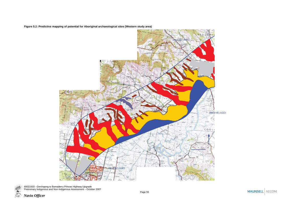
Figure 5.2: Predictive mapping of potential for Aboriginal archaeological sites (Western study area)
60021933 - Gerringong to Bomaderry Princes Highway UpgradePreliminary Indigenous and Non-Indigenous Assessment – October 2007
Page 55Navin Officer

Figure 5.2 Cont’d. Predictive mapping of potential for Aboriginal archaeological sites (Eastern study area)
60021933 - Gerringong to Bomaderry Princes Highway UpgradePreliminary Indigenous and Non-Indigenous Assessment – October 2007
Page 56Navin Officer

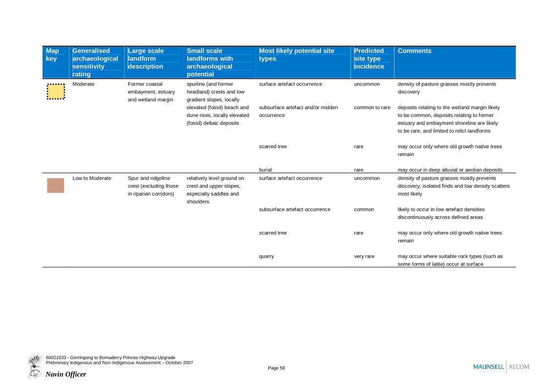
Table 5.2: Predictive model for potential Aboriginal archaeological resource
Mapkey
Generalisedarchaeologicalsensitivityrating
Large scalelandformdescription
Small scalelandforms witharchaeologicalpotential
Most likely potential sitetypes
Predictedsite typeincidence
Comments
Low Urban landscape open space reserves withrelatively low levels oflandsurface disturbance
surface artefact occurrence
subsurface artefact occurrence
uncommon
uncommon
likely to be in a disturbed condition
likely to be in a disturbed conditionLow Former (now drained)
wetland basin (infilledestuary basin)
locally elevated featuressuch as levee deposits andsand bodies
surface artefact occurrence
subsurface artefact occurrence
scarred tree
rare
rare
rare
most likely to be isolated finds
likely to occur only on existing, or now buried butformerly, locally elevated topography
may occur only where old growth native treesremain
High Riparian corridor locally elevated river, creek,estuary, lake and billabongbanks, levee deposits,alluvial terraces, andbenches, locally elevatedsand bodies, spurline crestsand low gradient slopes,
surface artefact occurrence
subsurface artefact occurrence
scarred tree
grinding grooves
burial
uncommon
common
rare
rare touncommon
rare
density of pasture grasses mostly preventsdiscovery
likely to occur in varying artefact densitiesdiscontinuously across defined corridor, higherdensities most likely in relative proximity to water
may occur only where old growth native treesremain
may occur only where suitable surface outcropsof sandstone occur (esp. in ck bed)
may occur in deep alluvial or aeolian deposits
60021933 - Gerringong to Bomaderry Princes Highway UpgradePreliminary Indigenous and Non-Indigenous Assessment – October 2007
Page 57Navin Officer
Mapkey
Generalisedarchaeologicalsensitivityrating
Large scalelandformdescription
Small scalelandforms witharchaeologicalpotential
Most likely potential sitetypes
Predictedsite typeincidence
Comments
Moderate Former coastalembayment, estuaryand wetland margin
spurline (and formerheadland) crests and lowgradient slopes, locallyelevated (fossil) beach anddune rises, locally elevated(fossil) deltaic deposits
surface artefact occurrence
subsurface artefact and/or middenoccurrence
scarred tree
burial
uncommon
common to rare
rare
rare
density of pasture grasses mostly preventsdiscovery
deposits relating to the wetland margin likelyto be common, deposits relating to formerestuary and embayment shoreline are likelyto be rare, and limited to relict landforms
may occur only where old growth native treesremain
may occur in deep alluvial or aeolian depositsLow to Moderate Spur and ridgeline
crest (excluding thosein riparian corridors)
relatively level ground oncrest and upper slopes,especially saddles andshoulders
surface artefact occurrence
subsurface artefact occurrence
scarred tree
quarry
uncommon
common
rare
very rare
density of pasture grasses mostly preventsdiscovery, isolated finds and low density scattersmost likely
likely to occur in low artefact densitiesdiscontinuously across defined areas
may occur only where old growth native treesremain
may occur where suitable rock types (such assome forms of latite) occur at surface
60021933 - Gerringong to Bomaderry Princes Highway UpgradePreliminary Indigenous and Non-Indigenous Assessment – October 2007
Page 58Navin Officer
Mapkey
Generalisedarchaeologicalsensitivityrating
Large scalelandformdescription
Small scalelandforms witharchaeologicalpotential
Most likely potential sitetypes
Predictedsite typeincidence
Comments
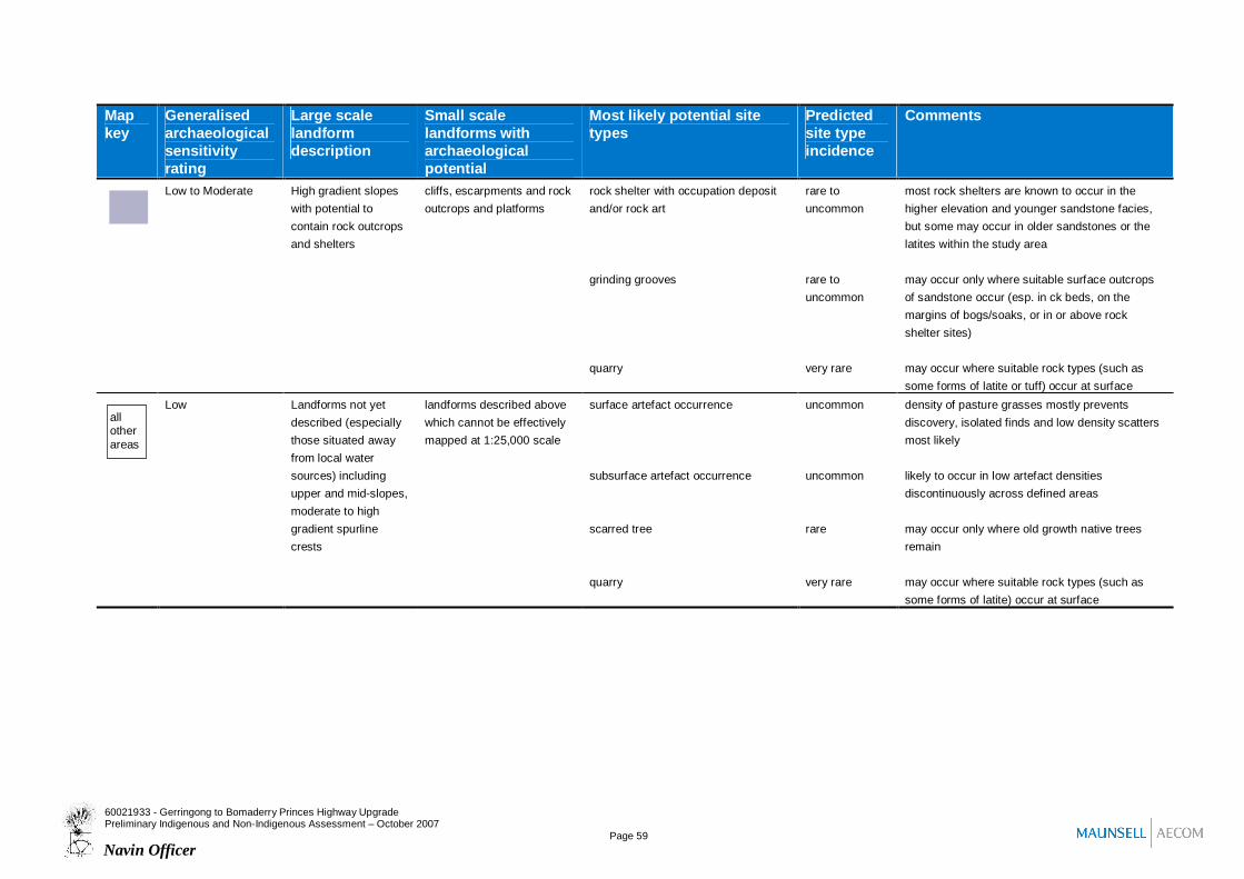
Low to Moderate High gradient slopeswith potential tocontain rock outcropsand shelters
cliffs, escarpments and rockoutcrops and platforms
rock shelter with occupation depositand/or rock art
grinding grooves
quarry
rare touncommon
rare touncommon
very rare
most rock shelters are known to occur in thehigher elevation and younger sandstone facies,but some may occur in older sandstones or thelatites within the study area
may occur only where suitable surface outcropsof sandstone occur (esp. in ck beds, on themargins of bogs/soaks, or in or above rockshelter sites)
may occur where suitable rock types (such assome forms of latite or tuff) occur at surface
Low Landforms not yetdescribed (especiallythose situated awayfrom local watersources) includingupper and mid-slopes,moderate to highgradient spurlinecrests
landforms described abovewhich cannot be effectivelymapped at 1:25,000 scale
surface artefact occurrence
subsurface artefact occurrence
scarred tree
quarry
uncommon
uncommon
rare
very rare
density of pasture grasses mostly preventsdiscovery, isolated finds and low density scattersmost likely
likely to occur in low artefact densitiesdiscontinuously across defined areas
may occur only where old growth native treesremain
may occur where suitable rock types (such assome forms of latite) occur at surface
allotherareas
60021933 - Gerringong to Bomaderry Princes Highway UpgradePreliminary Indigenous and Non-Indigenous Assessment – October 2007
Page 59Navin Officer