5 DISTRICT, NORWAY - Foreninger ved UiOforeninger.uio.no/ngf/ngt/pdfs/NGT_55_3_243-275.pdf · 5 in...
33
THE STRATIGRAPH Y OF THE UPPER ORDOVICIA N STA GE 5 IN THE OSLO-ASKER DISTRICT, NORWAY PATRICK J. BRENCHLEY & GEOFFREY NEWALL Brenchley, P. J. & Newall, G.: e stratigraphy of the Upper Ordovician Stage 5 in the Oslo-Asker district, Norway. Norsk Geologisk Tidsskrift, Vol. 55, pp. 243-275. Oslo 1975. The stratigraphy of Stage 5 (Upper Ashgillian) in the OslAsker district is dcribed. Thr new formations are proposed: the Husbergøya Shales, the Langøyene Sandstones and the Langåra LimestonShale Formation. A type section for Stag 5a and 5b is designated. 5a is shown to be relatively con- sistent in thickness and stratigraphy throughout the area, but 5b is a regressive sequence chacterised by rapid vertical and lateral facies changes and marked thickness variations reflecting Upper Ordovician diastrophism. The local palaeogeography of Stage 5b is interpreted as an offshore sand bar migrating northwards giving predominantly clastic successions in the Oslo area, while to the north a deeper water, lower energy environment prevailed giving rise to an interbedded limestonshale succession. e end of the re- grsion is marked by a widespread ꝏlite. Cutting the sequence are deeply incised channels of 5b age, many of which can be shown to cut lithified oolite at the top of the sequence. P. l. Brenchley & G. Newall, Department of Geology, Brownlow Street, P.O. Box 147, Liverpool L69 3BX, England. The Lower Palaeozoic of the Oslo area is one small part of a platform sequence which formerly covered several thousand square kilometres of the Baltic Shield and is now represented by residual patches in southern Norway, Sweden and Estonia. The total thickness of the Lower Palaeozoic in the Oslo area is approξmat ely 1550 m of which about 470 m belongs to the Ordo- vician. The Ordovician sediments generally belong to a fairly restricted range of facies, varying mainly from shales to shales with nodular limestones. Thin sandstones occur at many levels within the sequence and continuous beds of thin limestone are also common. Only in the upper part of the Ordovician do coarse clastics form an important part of the sequence and it is the strati- graphy of these beds which is described here. Detailed study of the Ordovician of the Oslo Region dates back more than 150 years and an account of the history of Lower Palaeozoic research is given in Størmer (1953). During the last twenty years there has been a concerted study of the Middle Ordovician of the Oslo Region and the stratigraphy and the palaeontology in particular are described in many papers. The Upper Ordovician in contrast has received very little attention since the classic studies of Kiær (1897, 1902). The boundary between the Ordovician and the Silurian has been discussed by Spjeldnæs (1957) and detailed sections for a part of Asker have been descbed by Lervik (1969) in an unpublished thesis.
Transcript of 5 DISTRICT, NORWAY - Foreninger ved UiOforeninger.uio.no/ngf/ngt/pdfs/NGT_55_3_243-275.pdf · 5 in...
THE STRATIGRAPHY OF THE UPPER
ORDOVICIAN STAGE 5 IN THE OSLO-ASKER
DISTRICT, NORWAY
PATRICK J. BRENCHLEY & GEOFFREY NEWALL
Brenchley, P. J. & Newall, G.: The stratigraphy of the Upper Ordovician Stage 5 in the Oslo-Asker district, Norway. Norsk Geologisk Tidsskrift, Vol. 55, pp. 243-275. Oslo 1975.
The stratigraphy of Stage 5 (Upper Ashgillian) in the Oslo-Asker district is described. Three new formations are proposed: the Husbergøya Shales, the Langøyene Sandstones and the Langåra Limestone-Shale Formation. A type section for Stages 5a and 5b is designated. 5a is shown to be relatively consistent in thickness and stratigraphy throughout the area, but 5b is a regressive sequence characterised by rapid vertical and lateral facies changes and marked thickness variations reflecting Upper Ordovician diastrophism.
The local palaeogeography of Stage 5b is interpreted as an offshore sand bar migrating northwards giving predominantly clastic successions in the Oslo area, while to the north a deeper water, lower energy environment prevailed giving rise to an interbedded limestone-shale succession. The end of the regression is marked by a widespread oolite. Cutting the sequence are deeply incised channels of 5b age, many of which can be shown to cut lithified oolite at the top of the sequence.
P. l. Brenchley & G. Newall, Department of Geology, Brownlow Street, P.O. Box 147, Liverpool L69 3BX, England.
The Lower Palaeozoic of the Oslo area is one small part of a platform sequence which formerly covered several thousand square kilometres of the
Baltic Shield and is now represented by residual patches in southern Norway,
Sweden and Estonia. The total thickness of the Lower Palaeozoic in the Oslo area is approximately 1550 m of which about 470 m belongs to the Ordo
vician. The Ordovician sediments generally belong to a fairly restricted range of facies, varying mainly from shales to shales with nodular limestones. Thin sandstones occur at many levels within the sequence and continuous beds of thin limestone are also common. Only in the upper part of the Ordovician do coarse clastics form an important part of the sequence and it is the stratigraphy of these beds which is described here.
Detailed study of the Ordovician of the Oslo Region dates back more than
150 years and an account of the history of Lower Palaeozoic research is given in Størmer (1953). During the last twenty years there has been a concerted study of the Middle Ordovician of the Oslo Region and the stratigraphy and
the palaeontology in particular are described in many papers. The Upper Ordovician in contrast has received very little attention since the classic studies of Kiær (1897, 1902). The boundary between the Ordovician and the Silurian has been discussed by Spjeldnæs (1957) and detailed sections for a part of Asker have been described by Lervik (1969) in an unpublished thesis.

244 P. J. BRENCHLEY & G. NEWALL
Fig. l. Map showing the location of the 29 measured sections described in the text and shown in Figs. 4-9.
\-' • Langåra Limestone
[/%d Langøyene Sandstone
o
""'��§ • Husbergøya Shale
( Type section
m 500
Fig. 2. Map showing the location of the type section of Stage 5 on HovedØya, and the
location of the stratotypes of the three new formations.

STRATIGRAPHY OF STAGE 5 IN OSLO-ASKER DISTRICT 245
Høyer holmen t
Fig. 3. Diagram illustrating the relationship between the stage boundaries and the
formation boundaries.
Otherwise references to the Upper Ordovician have occurred in more general
accounts of the Lower Palaeozoic of the Oslo area and notable amongst these
is the facies analysis of the Lower Palaeozoic by Seilacher & Meischner
(1965) and the accounts of the mineralogy and geochemistry by Bjørlykke
(1974a, 1974b). Important discussions on Upper Ordovician sedimentation
outside the imrnediate ::.rea are to be found in Major (1946) and in an un
published thesis by Hanken (1974). Palaeontological studies pertinent to
these rocks include those of Kiær (1899), Wedekind (1927), Spjeldnæs
(1964), and Neuman (1969) for corals, Strand (1934) for cephalopods, Henningsmoen (1954) for ostracods, Størmer (1930) for trilobites, and Kiær
(1902) for brachiopods. This account is concerned with only part of the Upper Ordovician, namely
Stage 5 which represents about 35 m to 85 m at the tap of the Ordovician. Throughout this text we have attempted to produce a consistent spelling
for place names, and places referred to can be found on Cappelens bykart, Stor Oslo (1:30,000).
We frequently refer to measured sections located on Fig. l and shown in
Figs. 4 to 9. Numbers given in brackets after place names refer to sections
shown in these figures. We have based the stratigraphic account largely on
the data from 29 measured sections; many others have been visited but have
not been included because they are very incomplete or are tectonically
disturbed. Interesting sections on Ormøya and Malmøya fall in the latter
category. The section on Bleikøya has been measured and included in Fig. 5 but we believe the sequence is probably thickened by strike faulting and hence
we have not included it when discussing the thickness of the sequences.

246 P. J. BRENCHLEY & G. NEWALL
90
80
70
60 3 Husbergøya
2 Skjærholmen
50
�o
30
20
10
o
4 90
Langøyene S.W. 5
Langøyene S.E.
80
6 70
60
50
40
30
20
10
o
Fig. 4. Measured sections in the southern islands of Bunnefjorden (see Fig. l for loca
tion). Key to Figs. 4-9 is on p. 252.
Definition of Stage 5
DISCUSSION OF THE PROBLEM
Stage 5 has embraced a variable range of strata since Kjerulf introduced the
term in 1857. Subsequent usage has greatly modified the stage so that the
upper part of Kjerulf's Stage 5 is now usually included in Stage 6a. A defini
tion of Stage 5 much doser to modem usage was made by both Dahll (1857)
70
50
gJ .::: AO ., E
30
20
10
o
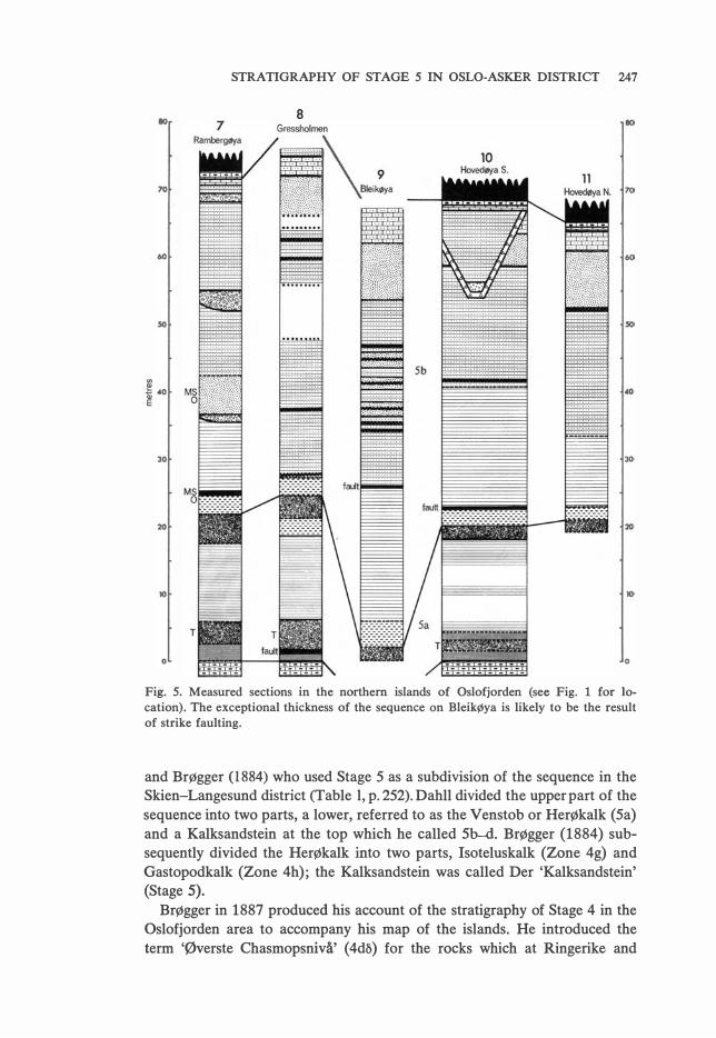
STRATIGRAPHY OF STAGE 5 IN OSLO-ASKER DISTRICT 247
8
Fig. 5. Measured sections in the northem islands of Oslofjorden (see Fig. l for Io
cation). The exceptional thickness of the sequence on BleikØya is likely to be the result
of strike faulting.
and Brøgger (1884) who used Stage 5 as a subdivision of the sequence in the Skien-Langesund district (Ta ble l, p. 252). Dahll divided the upper part of the
sequence into two parts, a lower, referred to as the Venstob or Herøkalk (Sa)
and a Kalksandstein at the top which he called 5b-d. Brøgger (1884) subsequently divided the Herøkalk into two parts, Isoteluskalk (Zone 4g) and
Gastopodkalk (Zone 4h); the Kalksandstein was called Der 'Kalksandstein' (Stage 5).
BrØgger in 1887 produced his account of the stratigraphy of Stage 4 in the Oslofjorden area to accompany his map of the islands. He introduced the
term 'Øverste Chasmopsnivå' (4db) for the rocks which at Ringerike and
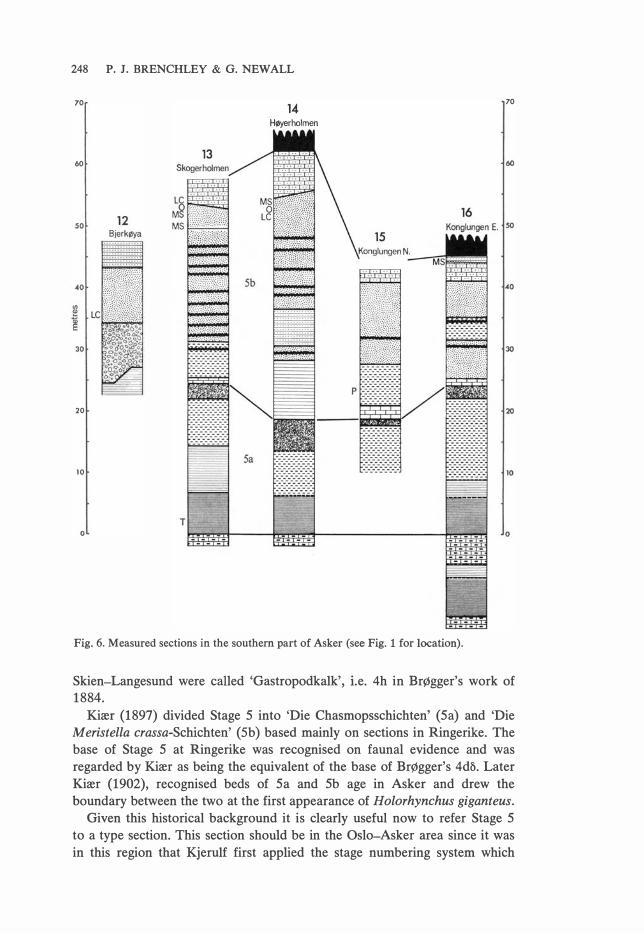
248 P. J. BRENCHLEY & G. NEWALL
70
14 HØyerholmen
60
20
10
o
Fig. 6. Measured sections in the southem part of Asker (see Fig. 1 for location).
70
Skien-Langesund were called 'Gastropodkalk', i.e. 4h in Brøgger's work of 1884.
Kiær (1897) divided Stage S into 'Die Chasmopsschichten' (Sa) and 'Die
M eristella crassa-Schichten' ( Sb) ba sed mainly on sections in Ringerike. The
base of Stage S at Ringerike was recognised on fauna! evidence and was
regarded by Kiær as being the equivalent of the base of BrØgger's 4da. Later
Kiær (1902), recognised beds of Sa and Sb age in Asker and drew the
boundary between the two at the first appearance of Holorhynchus giganteus. Given this historical background it is clearly useful now to refer Stage S
to a type section. This section should be in the Oslo-Asker area since it was
in this region that Kjerulf first applied the stage numbering system which
50
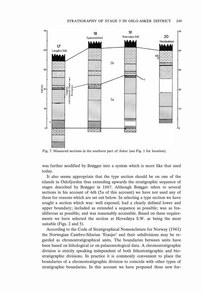
STRATIGRAPHY OF STAGE 5 IN OSLO-ASKER DISTRICT 249
18 19 50
Spannslokket BrønnøyaSW. 20
40
30
20
lO
o
Fig. 7. Measured sections in the southem part of Asker (see Fig. l for location).
was further modified by Brøgger into a system which is more like that used today.
It also seems appropriate that the type section should be on one of the islands in Oslofjorden thus extending upwards the stratigraphic sequence of stages described by BrØgger in 1887. Although Brøgger refers to several sections in his account of 4d� (Sa of this account) we have not used any of these for reasons which are set out below. In selecting a type section we have sought a section which was: well exposed; had a clearly defined lower and upper boundary; included as extended a sequence as possible; was as fossiliferous as possible; and was reasonably accessible. Based on these requirements we have selected the section at Hovedøya S.W. as being the most suitable (Figs. 2 and 5).
According to the Code of Stratigraphical Nomenclature for Norway (1961) the Norwegian Cambro-Silurian 'Etasjer' and their subdivisions may be regarded as chronostratigraphical units. The boundaries between units have
been based on lithological or on palaeontological data. A chronostratigraphic division is strictly speaking independent of both lithostratigraphic and biostratigraphic divisions. In practice it is commonly convenient to place the
boundaries of a chronostratigraphic division to coincide with other types of stratigraphic boundaries. In this account we have proposed three new for-

250 P. J. BRENCHLEY & G. NEWALL
so so
23 24 25
Brønnøya NW. Brønnøya E. OstøyaW.
-21 22 �o �o
30
20
10
o
Fig. 8. Measured sections in the southem part of Asker (see Fig. 1 for location).
mations. Two of these formations (the Husbergøya Shale Formation and Langøyene Sandstone Formation) are included within Stage S in the Oslofjorden area, but a third (the Langåra Limestone-Shale Formation) is interposed between the two when the succession is followed westward into the Asker district. We have proposed that the base of Stage S be taken at the base of the first formation and the top of Stage S be taken at the base of the beds (6a) overlying the second formation. The contact between two of the formations is used to define the Stage Sa/5b boundary.
Stage Sa as it is here defined embraces 4dll of BrØgger (1887), the 'Oberste Chasmopschichten' (Sa) of Kiær (1897) and also the Gastropodkalk (Sa) of Kiær (1902).
The base of Stage S falls at a well defined and laterally continuous lithological boundary. The rocks across this boundary are reasonably fossiliferous
and it should be possible to recognise the chronostratigraphic boundary elsewhere on a biostratigraphic basis.
The top of Stage S is defined by the base of Stage 6. There is no doubt
that Kiær (1908) placed the base of Stage 6 at the base of the 0.6 m thick nodular limestone which precedes shales and thin sandstones generally characteristic of the lower part of Stage 6 (Kiær 1908: 13S and fig. 27). The nodular limestone is well developed in the type section of Stage S at Hoved
Øya. Consequently the Stage S/6 boundary as here defined conforms to that of Kiær.

10
70
60
50
10
o
26 Holmen
road section
STRATIGRAPHY OF STAGE 5 IN OSLO-ASKER DISTRICI
5b
29 Sandvika
Fig. 9. Measured sections in central Asker (see Fig. l for location).
251
10
70
50
�o
30
20
10
o
The proposed Stage 5a/5b boundary differs from previous usage (Kiær
1897, 1902) in that it is a chronostratigraphic boundary related to a litho
stratigraphic boundary rather than a biostratigraphic boundary. The bio
stratigraphical unit Die Meristella Crassa-Schichten with Holorhynchus gi
ganteus which Kiær (1897, 1902) regarded as characterising the base of Stage
Sb in Ringerike and Asker cannot be recognised in the islands of Oslofjorden
where the faunas are generally sparser. The Stage 5a/5b boundary was con
sequently designated at a lower level than that of Kiær, where there is a litho
logical horizon at the top of the Husbergøya Shale Formation which shows
reasonable lateral continuity and can be identified throughout the islands of Oslofjorden and the more southerly part of Asker/Bærum. The beds at this

252 P. J. BRENCHLEY & G. NEW ALL
. Silurian
� Millet seed sandstone �
--- Slumped and contorted horizons --- Erosional facies boundary --- Sharp facies boundary ---------- Gradational boundary
o Ooids
Key to Figs. 4-9.
Skien
Langesund
(Dahll 1857)
Skien
Langesund
(Brøgger 1884)
Oslofjorden
(Brøgger 1887)
l U l Thin bedded sandstone
Bioturbated fine sandstone
����11t� Shales and limestones
� Shales and sandstones
Shales with thin sandstones and
Shale
H H H Hl Nodular limestone
limestones
MS Millet seed quartz grains LC Li mestone conglomerate T "7dchophycus" P Palaeoporella H Holorhynchus giganteus
Ringerike
(Kiærl897)
Oslofjorden
Asker, Bærum (Brenchley-Newall
(Kiær 1902) this paper)
Table 1. Summary of historical development of Stage 5.
level are fossiliferous and contain a fauna including Tretaspis and cystoids
at the top of Sa, and a brachiopod-bryozoa fauna at the base of 5b, so hope
fully the boundary might be correlated on a biostratigraphic basis. If the
5a/5b boundary is placed any higher in the sequence it would fall within a
complex and varied regime of sedimentary facies with accompanying lateral

STRATIGRAPHY OF STAGE 5 IN OSLO-ASKER DISTRICT 253
changes of biofacies. An example of such local biofacies development appears
to be that of Holorhynchus giganteus which Kiær (1902) regarded as diagnostic of Sb in Asker, but which is only patchily represented in the upper part of same sections.
The lithological horizon we have selected at the tap of the HusbergØya Shale can be recognised throughout the islands in Oslofjorden and can be identified in the more southerly of islands of the Asker/Bærum district. Above the HusbergØya Shale the facies of the Langøyene Sandstone Formation become so varied that it is commonly not possible to make detailed lithological correlations even between nearby sections (Figs. 4-9). Furthermore, the tap of the Husbergøya Shale and basal part of the Langøyene Sandstone are the highest beds in the sequence in Oslofjorden which regularly contain fossils. The beds contain a fauna including Tretaspis sp., bryozoa, brachiopods, gastropods and cystoids and should be identifiable on a bio
stratigraphic basis.
The Stage Sa/Sb boundary as here proposed is a little lower than that chosen by BrØgger (1884: 191) for the tap of 4db. BrØgger apparently extended 4db up to the first development of flaggy fine sandstones (see the facies cross sections in Figs. 4-9), which is usually a well defined lithological horizon. This horizon occurs at a level from ane to ten metres above the Stage Sa/Sb boundary as defined here and we believe it represents a diachronous influx of sand into the area. Furthermore, with influx· of coarser clastics fossils become infrequent. We believe therefore that by choosing the horizon a little lower than did BrØgger there are hetter lithological and biostratigraphical criteria for correlation of the Stage Sa/Sb boundary.
Spjeldnæs (19S7) proposed a further division, Stage Se, for beds which Iie on an erosional surface above the oolitic limestone near the tap of Sb, and below 6a of the Silurian. Spjeldnæs regarded the Se beds as post-dating an
episode of falding and believed they lay with unconformity or disconformity on the underlying beds. We, however, do not recognise the unconformity and regard the 'Se' beds as being channel fill sediments which are characteristic of most of Stage Sb. We have therefore not used the term Se in this account.
PROPOSED STAGE BOUNDARIES
Stage 5. Type section HovedøyaS. W. (Figs. 2 and S) The base of Stage S is defined as the base of the Husbergøya Shales at the N.W. end of section on Hovedøya (Fig. 2). The boundary is very sharp and has well developed nodular limestones ( 4dy) below and dark grey shales
above. Details of the type section are shown in Fig. S. The tap of Stage S is defined by the base of a distinct bed (0.6 m thick) of nodular Iimestone - the
Iowest bed of Stage 6a. Stage S therefore includes all the beds below the
nodular Iimestone (Kiær 1908: fig. 27).
Stage 5a/5b boundary
The boundary is chosen at the contact between the Husbergøya Shales and

254 P. J. BRENCHLEY & G. NEWALL
North 29
80 Sandvika
70
60
50
·30
20
lO
o
• •
Facies boundary
+ Formation boundary
Stage boundary
A 4dp- Sa
B Sa - Sb
C Sb- 6
Sandstones
� Shales with sandstones
Langåra Limestone- Shale
Formation
Shales
Other symbols as fig.4
24
14
Fig. 10. Stratigraphic north/south profile, across Bunnefjorden with facies generalised
to emphasise the Sb sandstone development in the south. A marks the base of Sa; B
marks the 5a/5b boundary; C marks the top of Sb.
A broken line denotes a stage boundary; diamonds denote a formation boundary and
a solid line shows the facies boundaries where they do not coincide with formation
boundaries.
the Langøyene Sandstone in the Hovedøya section. The boundary occurs
21 m above the base of Stage 5 and is clearly recognisable at the top of the
brown weathering bioturbated sandstone (about 2 m thick), this being the
topmost bed of the Husbergøya Shales in this section. The boundary is over
lain by silty shales with thin discontinuous limestones, these being the base
of the Langøyene Sandstone Formation in this section.

STRATIGRAPHY OF STAGE 5 IN OSLO-ASKER DISTRICT 255
5 South
8 Langtlyene S.E. 80
Fig. 11. Stratigraphic north/south profile across the Asker district. (Key as in Fig. 10).
PROPOSED NEW FORMATIONS
The three lithostratigraphic units here proposed are the Husbergøya Shale
Forrnation, the Langøyene Sandstone Formation and the Langåra Lime
stone-Shale Formation. It would have been convenient to have chosen the
stratotypes of two of the formations on Hovedøya in the type section of
Stage 5, but here the Husbergøya Shales are not fully exposed and the Langøyene Sandstone Forrnation lacks its full variety of facies. We therefore
selected the stratotypes on Husbergøya, Langøyene and Langåra (Fig. 2),

256 P. J. BRENCHLEY & G. NEWALL
where the formations are well exposed and there is a characteristic development of the representative facies.
The HusbergØya Shale Formation (type section N.W. Husbergøya) (Figs. 2 and 4, 18.5 m thick) The base is defined by the sharp contact between nodular limestones below (4dy) and shales above. The sequence, bottom to top, is as follows: 2.1 m shales with thin laminated sandstones, l.S m shales with sandstones reworked by 'Tricophycus', 10.9 m shales and calcareous shales with an increasing proportion of sandstone, 2.0 m shales and calcareous shales and 2.0 m fine, brown weathering bioturbated sandstone.
The top is defined as the contact between the brown weathering sandstone and the overlying shales with laminated calcareous sandstone. Details of the sequence are described on p. 157 (Husbergøya Shale Formation), as the geographic extent of the formation.
The Langøyene Sandstone Formation (type section Langøyene S.E .. ) Figs. 2 and 4, 51 m thick) The base is defined by the contact between brown weathering bioturbated sandstone (Husbergøya Shales) and overlying shales with buff laminated sandstones, and thin limestones. Slumped and contorted beds and oolitic limestone beds with well rounded, sub-spherical (millet seed) quartz grains occur within a few metres of the base. The sequence continues upwards with thin bedded sandstones, more massive sandstones, 'millet seed' sandstones and limestone conglomerates (Fig. 4). The top is defined by the contact between dark grey silty shales of 6a and an underlying sandy bioclastic 1imestone.
This distinctive coarse clastic facies of the Langøyene Sandstone Formation can be traced throughout the islands of Bunnefjorden and occurs on the southem islands in Asker. In other parts of Asker the formation is much thinner (as little as 8 m on Langåra, and at Sandvika it is represented by only a metre of brecciated oolite (Fig. 11)).
The Langåra Limestone-Shale Formation (type section Langåra) (Figs 2 and 7, 13m thick) At Langåra, beds of the Husbergøya Shale become more calcareous upwards as they pass gradationally into the Langåra Limestone-Shale Formation. We have chosen a rather arbitrary lower boundary to the formation in this gradational sequence at the uppermost distinct sandstone bed in the Husbergøya Shales which are here 12 m thick.
The top of the formation is clearly defined at the boundary between massive laminated quartz sandstones of the Langøyene Sandstone above and the Limestone and Shales below.
The 13 m of the formation so defined consist of silty grey shales with fine grained, irregular and sometimes discontinuous limestone beds a few centi-

STRATIGRAPHY OF STAGE 5 IN OSLO-ASKER DISTRICT 257
metres thick. A few thin bioclastic limestones occur and there is one thicker bed of limestone (0.8 m thick) high in the formation.
The formation thickens northwards (26 m at Sandvika) and becomes more varied in its facies to include a Palaeoporella-coral facies, a Holorhynchus
facies and a coral conglomerate facies (see Langåra Limestone-Shale Formation, p. 266).
The Stratigraphy HUSBERGØYA SHALE FORMATION
This formation consists of a sequence of shales with increasing thin, interbedded calcareous beds and thin sandstones in the upper part, and topped by a bed of massive bioturbated fine sandstone. The lowerrnost shales succeed nodular limestones and this contact can be traced throughout the area. The upper part of the sequence becomes more calcareous when traced northwards and passes laterally into the Langåra Limestone-Shale Formation in Asker (Fig. 3). The thickness of the Husbergøya Shales is relatively constant (17-25 m) in Bunnefjorden but is generally thinner in Asker where it may be as thin as 10 m though it thickens to 35 m further north at Sandvika (Figs. 3 and l 0).
Shale facies
Husbergøya section. - The shales at the base of the section overlie nodular limestones of stage 4dy with a sharp contact and are only 2.5 m thick. They are grey, silty and have a crude fissility probably as a result of extensive bioturbation by Chondrites. Thin interbeds of larninated sandstone (1-4 cm thick) with some small scale ripple drift and extensively bioturbated upper and lower surfaces recur approximately every 20-30 cm. The fauna in the shales is sparse. The shales pass upwards into a more sandy horizon characterised by large trace fossils in the form of spreite which Seilacher & Meischner (1965) referred to the genus Tricophycus. We have retained the name Tricophycus in this account though it is likely that these fossils will prove distinct from this ichnogenus. The shale bed with the associated trace fossil horizon is widely recognisable. 'Tricophycus' has been recognised at this level in all the sections in Bunnefjorden and most sections in Asker, though the trace fossils become sparser when these beds are traced northwards and we cannot identify a 'Tricophycus' horizon at Holmen and Sandvika.
At most localities the spreite are confined to more sandy beds but they may penetrate down into the underlying shales; occasional burrows are found �holly within the shales, though these burrows themselves are sand filled. The spreite may be disturbed by later branching burrows of the Chondrites
type. There is usually a fauna associated with the sandy beds, particularly com
mon being Tretaspis sp. and small orthoids, but calymenids, odontopleurids and graptolites have been found in the sections on the islands of Bunne-

258 P. J. BRENCHLEY & G. NEW ALL
fjorden. The sandy infills of the 'Tricophycus' burrows also contain fossils and fragments of Tretaspis and graptolites were found. The beds are more fossiliferous generally in the Asker area and a rich and varied fauna can be seen at, for example, Brønnøya N.E. (24).
Shales with sandstones and limestones
Husbergøya section. - On Husbergøya the beds with 'Tricophycus' pass gradationally upwards into silty shales again. Interbedded with this shale group are calcareous siltstone beds, commonly discontinuous, with indistinct upper and lower surfaces and little or no intemal structure. Lithologically these beds appear similar to the silty shales with which they are interbedded except for a greater amount of carbonate: they would, therefore, seem to be essentially diagenetic in origin. Certainly they have the same Chondrites
fauna as the adjacent shales. Passing up the sequence thin laminated sandstones become more frequent.
These beds are usually less than 4 cm thick and recur approximately every 15-50 cm. Fossils within this part of the sequence are sparse, being mainly trilobites, including Tretaspis sp. and isotelinids.
In the top 2 m of this facies, the interbedded sandstones are absent and calcareous beds predominate in the sequence. Tretaspis latilimba is common here and Echinosphaerites sp. and gastropods are frequent.
Comparison with other sections. - A similar sequence to that described for Husbergøya can be seen in most sections in Bunnefjorden though the uppermost calcareous beds are not always so well developed.
A generally similar facies is also found in most sections in Asker. At Høyerholmen (14), for example, the sequence is closely comparable with that on Husbergøya except that the calcareous beds are hetter differentiated and the sandstone beds less frequent. The upper part of this facies passes northwards into a more calcareous development and as such becomes included in the Langåra LimestontWihale Formation. A fauna similar to that on Husbergøya is found everywhere, being more populous as the facies becomes more calcareous.
Brown bioturbated sandstone
Husbergøya section. - This unit of grey bioturbated fine sandstone, weathering huff to brown proves a useful marker for the top of Stage Sa. On Husbergøya the bed is 2 m thick massively bedded in units 10-40 cm thick, with rare thin silty shale partings. The fine sandstone bed passes both upwards and downwards gradationally into more calcareous siltstones. The unlaminated character of the bed appears to be the result of extensive bioturbation which might suggest a pause in sedimentation allowing the extensive reworking of the sediment. The main part of the bed is sparsely fossiliferous but the calcareous siltstones immediately above are richly fossiliferous and have been included in the succeeding Langøyene Sandstone Formation.

STRATIGRAPHY OF STAGE 5 IN OSLO-ASKER DISTRICT 259
Comparison with other sections. - In some other sections of Bunnefjorden
the brown sandstone may reach a thickness of nearly 5 m. Calcareous sand
stone beds with parallel lamination may be interbedded within the brown
sandstone or may sharply demarcate the top. In some sections fossils occur
within the sandstone, notable being Echinosphaerites sp., Tretaspis sp. and
bryozoa.
The bioturbated brown sandstones with cystoids can be recognised on
Høyerholmen, Skogerholmen and Torbjømsøya within the Langåra Lime
stone-Shale Formation but further north there is a progressive change in
character and this useful marker horizon loses its distinctive character.
Relationship of HusbergØya Shales to Stage boundaries
The base of the HusbergØya Shales is marked by a sharp contact between
nodular limestones below and shales above in sections throughout Bunne
fjorden and Asker. Only in the Sandvika section (29) where exposure is
poor we have not been able to identify the base to the Husbergøya Shales
with confidence, however the lower part of the section exposed on Ringeriks
veien is shaly and we believe is close to the base of the formation. This conclusion is confirmed by the nearly parallel section along Jongsåsveien
which shows shale in contact with the underlying nodular limestone.
The base of the Husbergøya Shales coincides with the Stage 4dy-Stage 5
boundary in the type section on Hovedøya. We regard the sharp lithological
change at the base of Husbergøya Shales as probably synchronous through
out the area and we therefore believe that the base of Stage 5 can be
correlated on lithological criteria throughout the OslO-Asker region.
The top of the Husbergøya Shales coincides with the Stage 5a-5b boundary
in the type section at Hovedøya. The brown bioturbated sandstone usually
bearing cystoids which marks the top of the Husbergøya Shales can be iden
tified throughout the islands of Bunnefjorden (Figs. 4, 5) and allows the correlation of the top of Stage Sa. The same brown sandstone horizon can be identified on Høyerholmen and Skogerholmen (Fig. 6) but it is here included within the Langåra Limestone-Shale Formation because the associated beds have become more calcareous. This lithological marker horizon nevertheless provides an essential link between the Bunnefjorden and Asker sections.
LANGØYENE SANDSTONE FORMATION
Before describing the facies in detail we have made some generalisations
about the distribution of the facies and have grouped the successions ac
cordingly.
This formation is characteristically developed in the sections of Bunne
fjorden but is generally thinner in Asker where its thickness decreases north
westwards to as little as 1 m at Sandvika. The more southerly sections are
characterised by a thick development of sandstone, they have slumps and
other sedimentary disturbances and the formation has a large total thickness
(53 m). These sandy sequences are cut by channels which are commonly

260 P. J. BRENCHLEY & G. NEWALL
filled by limestone conglomerates or 'millet seed' sandstones (Fig. 4). lncluded in this group are localities 1-7 in Bunnefjorden and Høyerholmen, Skogerholmen and Bjerkøya in Asker.
Further north (Gressholmen, Bleikøya and Hovedøya) the Formation is still mainly sandstone but includes more interbedded shale and the most northerly sections (Hovedøya) show little of the otherwise prevalent sedimentary disturbances. Limestone conglomerates are mainly lacking in these sections (Fig. 5). The succession is topped by a distinctive oolitic limestone bed.
A relatively thin group of sequences, in a central belt in Asker is characterised by laminated quartz sandstones topped by oolitic limestone. The main variation among these successions is in the thickness of the quartz sandstones (Figs. 7-8 and 11). Included in this group of sections are those on Langåra, Brønnøya, Ostøya, Torbjørnsøya, Spanslokket and at Hvalsbakken (17-25).
Of the northernmost group of sections (Kalvøya, Holmen and Sandvika) only Sandvika contains this formation, represented by a brecciated oolitic limestone bed less than 2 m thick.
Limestone and shale facies
LangØyene. - The section at Langøyene S.E. commences with about 2 m of shales with thin impure limestones lying with a gradational contact on the bioturbated brown sandstone of the underlying Husbergøya Shales. The limestones are not obviously bioclastic in type and commonly the upper and lower boundaries of each bed are not sharply defined and same beds are discontinuous. Interbedded with the shales and limestones are a few fine calcareous sandstones which have slightly erosional bases, and generally same ripple drift.
Comparison with other sections. -The thin basal limestone-shale facies, 3-4
m thick, is typical of all the islands in Bunnefjorden. Sandstones are present in variable amounts in all sections but are particularly common at Husbergøya where they obscure the calcareous nature of these lower horizons.
The fauna within this group of beds is generally rich, being characteristically composed of a variety of bryozoa, articulated entelletacean brachiopods and gastropods, while Chondrites is abundant throughout. In southern Asker at Høyerholmen and Skogerholmen the beds of these facies are rather more calcareous but yield a similar fauna to that found in Bunnefjorden. At nearby Skogerholmen beds of the same horizon include well developed limestones and have been included in the Langåra Limestone-Shale Formation.
Shales and sandstones facies
LangØyene S.E. - The lowest calcareous facies passes up transitionally into shales and sandstones (6.5 m thick) which are frequently slumped and contorted, marking the anset of an instability which was to affect many of the

STRATIGRAPHY OF STAGE 5 IN OSLO-ASKER DISTRICI 261
sediments of Langøyene Sandstones in the southem sections. The fine cal
careous sandstones in this facies are in beds usually less than 15 cm thick
and resemble those in the facies below. A particularly characteristic element
of the facies is beds of oolitic bioclastic limestone containing 'millet seed'
quartz grains. The oolitic beds are massive and generally unlaminated (or
they may be laminated towards the top) and may be clearly graded. The beds
vary in thickness from a few centimetres to nearly 1 m. These beds were
apparently deposited very rapidly and frequently show sedimentary deforma
tion structures where the oolitic beds have sagged into the underlying shale
producing a range of forms of contorted bedding; blocks of limestone are
commonly detached and surrounded by shale, which itself injects upwards
into the limestone. The deformation appears to have occurred with little or
no lateral translation and is probably related to the reversed density gradient
created by the dumping of ooidal sediment on a mud surface. Very similar
structures, though of smaller scale, have been created experimentally by
Anketell et al. (1968, 1970).
The shales which are interbedded within this facies are also extensively
folded but these folds appear to be translational slumps. The shales and thin
interbedded laminated siltstones are deformed into isoclinal recumbent folds
ranging in size from a few centimetres to about 2 m across the fold limbs.
Some fold cores have become detached from their limbs, and there is
evidence of considerable mobility of mud layers. One bed must have become
effectively a mud flow and has preserved only whisps and fragments of the
original bedding.
Comparison with other sections. - The shales and sandstones with oolitic
limestone beds are present in all the southem sections of Bunnefjorden (2-7)
except Søndre Skjærholmen (1) where the whole facies is replaced by thin
bedded sandstones (Fig. 4). In the more northerly sections (Gressholmen, Bleikøya, Hovedøya) the sandstone and shale beds are present but the oolitic limestones and slumped beds are absent.
Thin bedded sandstone facies
LangØyene S.E. - Shales are subordinate in this facies which consists of thin sandstones, irregularly fissile siltstones and occasional thicker sandstones.
The limits to this facies are arbitrarily assigned, for it passes up into pro
gressively more thickly bedded sandstones and down into shales and sand
stones. In the lower 8 m of this facies in Langøyene, the sandstone beds are
generally less than 10 cm thick, and are fine calcareous sandstones. Some
have no visible lamination, others have a slight grading and some are clearly
parallel laminated or show ripple drift. The interbeds are siltstones which
may be laminated and are sometimes contorted on a small scale, or are
irregularly fissile.
Upwards in the sequence the sandstone beds are generally thicker and the
interbedded siltstone becomes subordinate: contorted beds, however, remain

262 P. I. BRENCHLEY & G. NEWALL
quite common in the siltstones. The thicker sandstones have a planar horizontal stratification or commonly show ripple drift which may be in multiple sets.
Comparison with other sections. - A thin bedded sandstone facies occurs quite low in the formation in most other sections in Bunnefjorden but may recur at higher levels in the sequence. The facies as broadly defined includes a variety of bedded sandstones which may represent slightly different sedimentary environments.
Thin bedded sandstones comparable with those described from the lower part of the Langøyene sequence occur at a similar horizon on HusbergØya, BleikØya and Gressholmen: further northwards more shale is interbedded with the sandstones.
The facies is developed higher up in the sequence on Rambergøya, Gressholmen, Langøyene S.W., Bleikøya and Hovedøya where it usually weathers a distinctive rusty or pinkish colour. The sandstone beds have trace fossils of the Skolithos type and the upper surfaces show Monocraterion and Diplocraterion.
Fossils are very scarce in all varieties of the thin bedded sandstone facies and consist of occasional rugose corals, tabulate corals, bryozoa and small orthoid brachiopods. Trace fossils, however, are very common, particularly the vertical burrows, Skolithos and Monocraterion, but also Helminthoides,
gastropod tracks and Planolites.
Thick bedded sandstones
LangØyene S.E. - The thick bedded sandstones facies at LangØyene S.E. consists of beds of fine to medium sandstone varying in thickness from a few centimetres to more than a metre. There is subordinate interbedded fissile siltstone. The thicker beds may be massive or have a horizontal lamination or a very low angle cross stratification which appears to be related to shallow intrabed channels. Channelling at the top of and within beds is frequent. Ripple drift is common in thickly bedded units and may occur in multiple sets particularly towards the top of a bed. The ripple drift may be in the form of trough cross-lamination reflecting the presence of linguoid ripples which can occasionally be seen on the surface of the beds.
In the Langøyene section the thick bedded sandstone facies occurs for about 12 m above a large channel, at least 7 m deep. The facies has also filled the channel but has slumped down the steep side to give a variety of sedimentary folds and contorted sediments.
Comparison with other sections. - A similar facies to that on Langøyene is found low in the sequence on Søndre Skjærholmen and Rambergøya and sporadically in the middle part of other sequences on Langøyene. The thick bedded sandstone facies is particularly characteristic of the middle part of the sequences on Høyer holmen and Skogerholmen. In these sections the sand-

STRATIGRAPHY OF STAGE 5 IN OSLO-ASKER DISTRICT 263
stones are extensively deformed into ball and pillow structures. Slump balls (pseudonodules of some authors) are well displayed on Skogerholmen and one bed has become so intemally disrupted that much of the lamination has been largely destroyed.
A thick bedded light grey quartz sandstone facies is commonly developed near the top of many successions in Bunnefjorden. The sandstone is well sorted and forms thick planar laminated and cross-stratified beds with no intervening shale or siltstone beds. This development is usually less than 5 m thick and underlies the uppermost oolitic limestone facies (Hovedøya, Gressholmen, Bleikøya and Skogerholmen). On Langøyene N. similar quartz sand .. stones are overlain by limestone conglomerates. A rather sirnilar sandstone facies commonly Iies below the oolitic limestone in the Asker area. At Langåra there are 3 m of quartz sandstones with parallel lamination and crossstratification overlying the Langåra Limestone-Shale Formation. This facies is unusually thin on Langåra but it ranges up to 10 m thick at Brønnøya E. (24) and 12 m at Konglungen N. (15). Much of the thickness variation of the Langøyene Sandstone Formation in this central part of Asker can be attributed to variation in the amount of this thick bedded sandstone facies in the sequenc�. Throughout the facies, parallel lamination is prevalent but shallow scours with low angle cross-stratification fill is quite common and a few beds have large scale cross-stratification.
'Millet seed' sandstone facies
LangØyene S.E. - Sandstones of this type succeed the thick bedded sandstones with sharp erosional contact at Langøyene S.E. The sandstone is bimodal in its grain size distribution having a coarse fraction of near spherical 'rnillet seed' grains and a finer fraction of angular quartz. There are occasionally ooids in the sandstone. The 6 m unit of sandstone has irregular trough cross bedding suggesting repeated episodes of scour and channel fill.
Comparison with other sections.- Similar 'rnillet seed' sandstones are found generally high in the sequence in the more southerly sections in Bunnefjorden (Fig. 4) but are virtually absent elsewhere. Fossils are uncommon but where present are usually transported fragments, particularly of tabulate corals. Quite common also are rounded limestone clasts. The facies is particularly well developed on Langøyene S.W. where at one horizon in fills a channel at least 6 m deep, has repeated cut and fill, and contains common siltstone clasts and 'favositid' fragments which commonly lie on the erosional surfaces.
Bioclastic limestone jacies
Beds of recognisable biosparite are rare in this formation, and indeed within Stage 5 as a whole.
Langøyene S.E. and other sections.- The top of the sequence at Langøyene S.E. is marked by a rusty weathering sandy bioclastic limestone, 0.75 m thick. In some sections a bioclastic limestone of this type is overlain by less than

264 P. J. BRENCHLEY & G. NEW ALL
a metre of nodular limestone, which marks the base of Stage 6a. This couplet
of beds is found at the Stage 5/6 boundary at Langøyene S.W. (4), Rambergøya (7) and Hovedøya (10, 11). A distinctive shelly biosparite is found
near the top of the sequence at Hvalsbakken where it includes same ooids
and abundant articulated valves of Barrandella. This facies appears to be a
local development covered with the oolites described in the later section
(Oolitic limestone facies).
Limestone conglomerate facies
LangØyene S.E. - For several metres just below Stage 6a (Silurian) in Lang
Øyene S.E. limestone conglomerates are interbedded with thick bedded sandstones which are highly contorted into non-translational sedimentary folds.
The conglomerates consist of rounded limestone clasts, usually calcisiltites,
corals and coral fragments in a matrix of 'millet seed' sand, finer quartz sand
and occasional ooids. The conglomerates here are wackstones in the sense
that the limestone clasts do not form a framework to the conglomerate but
lie in the sand matrix.
The conglomerates lie on erosional surfaces which cut well down into the
underlying sandstone, suggesting that the conglomerates are channel fill
sediments. It can commonly be demonstrated that the conglomerates do fill
channels but this cannot always be proved.
Comparison with other sections. - Limestone conglomerates are typical of
most southerly sections in Bunnefjorden (2, 3, 4, 5, 6, 7) and are also present
on Malmøya and Ormøya. They are present as a thin horizon in the bottom
of the Hovedøya channel (10). In Asker they are generally less common but very similar conglomerates form a thick unit on the southernmost section (Bjerkøya 12). Limestone conglomerates of a similar type are also present in the Langåra Limestone-Shale Formation, described later.
Generally the conglomerates occur high in the sequence as on Langøyene but a thin development occurs on Rambergøya at a particularly low level, only 14 m above the base of Stage Sb and there is another thicker develop
ment 15 m higher up.
The clasts in the conglomerates are most commonly fine bioclastic lime
stone calcisiltites and calcareous siltstones. Crinoidal limestone and coarse
bioclastic limestone are occasionally found as well as rare clasts of oolitic
limestone. The clasts appear to have three origins: lithified limestone, unlithified siltstone and limestone, and coral debris. The unlithified nature of
same limestones and siltstones is suggested by an interesting occurrence of
armoured siltstone and limestone clasts on Bjerkøya.
Corals may be found within limestone clasts or free of any surrounding
carbonate matrix. There is a considerable variety of rugose corals and par
ticularly of tabulate corals which include favositid, halysitid and heliolitid
types plus 'Syringopora', Sarcinula as well as stromatoporoids and calcareous
algae.

STRATIGRAPHY OF STAGE 5 IN OSLO-ASKER DISTRICT 265
The conglomerates commonly show large scale cross-stratification, with sets over 2 m thick, of both planar and an irregular trough type. A common feature of the conglomerates is very well developed imbrication; the clasts may be stacked with a steep inclination or may be stacked nearly horizontally against steeply dipping foreset slopes (about 30° dip at Langøyene N.E.). At several localities the limestone conglomerates are seen to pass laterally into 'millet seed' sandstones (e.g. Langøyene N.E. and S.W.). Clearly the two facies are closely related, and it seems implicit that where the currents were not competent to carry the larger clasts only 'millet seed' sand and finer sand was deposited.
Oolitic limestone facies
This facies is absent in the type section at Langøyene S.E. but it is seen at Gressholmen and sections further north in Bunnefjorden and most of the sections in Asker (Figs. 4-9). This facies occurs as a distinctive unit of light grey or huff oolitic limestone between 3 and 8 m thick. lntermixed with the ooids are 'millet seed' grains which sometimes have become concentrated along well developed stylolites (these having both parallel and perpendicular attitudes to the bedding). The oolites are cross-stratified, mainly with trough beds having a set thickness of 50 cm or less. In Asker the limestone can be broadly divided into two parts; the lower part having large scale cross-stratification with set thicknesses up to 2 m (e.g. Høyerholmen) and the upper with horizontally stratified beds or with small scale cross-stratification. Fossils are sparse in the oolite and are mainly transported rugose corals.
The relationship of the LangØyene Sandstone Formation to the stage
boundaries
The base of the Langøyene Sandstone Formation is believed to be synchronous throughout the islands of Bunnefjorden and to coincide with the Stage 5a/5b boundary. The base of formation is believed to be at the same level at Høyerholmen but elsewhere in Asker the base of the formation is diachronous, and becomes generally younger towards the north, while the Stage 5a/5b boundary lies within the Langåra Limestone-Shale Formation (Fig. 3).
The top of the Langøyene Sandstone everywhere coincides with the Stage 5b/6a boundary. The top of the formation is developed in a variety of facies but most commonly the uppermost beds are oolitic limestone which may be capped by less than a metre of sandy bioclastic limestone.
The lowest bed of Stage 6a is a nodular limestone (c. 1 m) in parts of Bunnefjorden but at many localities the stage starts with silty dark grey shales.
LANGARA LIMESTONE-sHALE FORMATION
The formation is only present in Asker and is absent in Bunnefjorden. The formation thickens northwards in Asker from about 6.5 m on Skogerholmen to about 35 m at Sandvika, and is represented by 13 m in the type section
266 P. J. BRENCHLEY & G. NEWALL
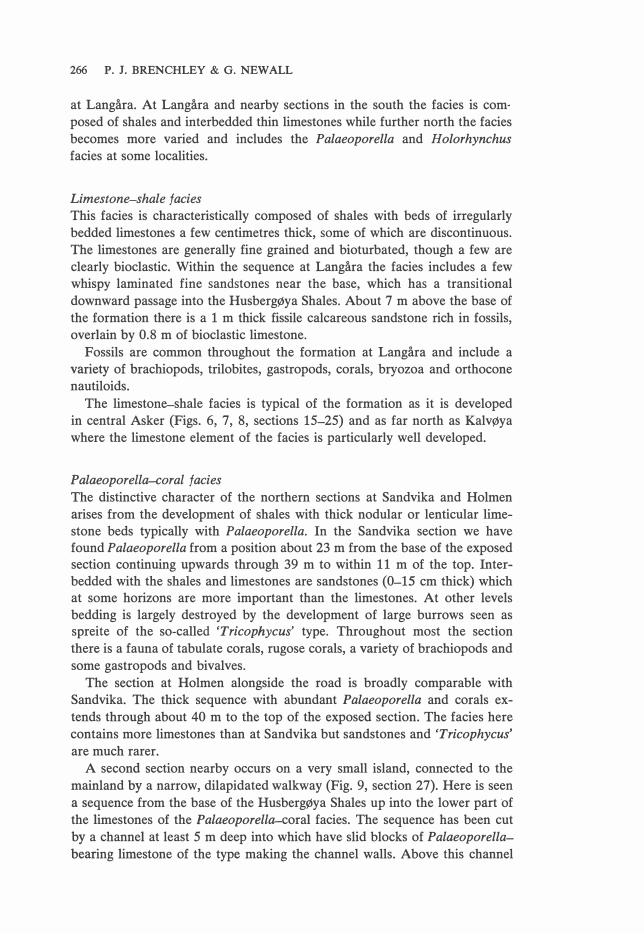
at Langåra. At Langåra and nearby sections in the south the facies is com·
posed of shales and interbedded thin limestones while further north the facies
becomes more varied and includes the Palaeoporella and Holorhynchus
facies at same localities.
Limestone-shale facies
This facies is characteristically composed of shales with beds of irregularly
bedded limestones a few centimetres thick, same of which are discontinuous.
The limestones are generally fine grained and bioturbated, though a few are
clearly bioclastic. Within the sequence at Langåra the facies includes a few whispy laminated fine sandstones near the base, which has a transitional
downward passage into the Husbergøya Shales. About 7 m above the base of
the formation there is a 1 m thick fissile calcareous sandstone rich in fossils,
overlain by 0.8 m of bioclastic limestone.
Fossils are common throughout the formation at Langåra and include a
variety of brachiopods, trilobites, gastropods, corals, bryozoa and orthocone
nautiloids.
The limestone-shale facies is typical of the formation as it is developed
in central Asker (Figs. 6, 7, 8, sections 15-25) and as far north as Kalvøya
where the limestone element of the facies is particularly well developed.
Palaeoporella-eoral facies
The distinctive character of the northern sections at Sandvika and Holmen
arises from the development of shales with thick nodular or lenticular limestone beds typically with Palaeoporella. In the Sandvika section we have found Palaeoporella from a position about 23 m from the base of the exposed section continuing upwards through 39 m to within 11 m of the top. Interbedded with the shales and limestones are sandstones (0-15 cm thick) which at same horizons are more important than the limestones. At other levels
bedding is largely destroyed by the development of large burrows seen as spreite of the so-called 'Tricophycus' type. Throughout most the section
there is a fauna of tabulate corals, rugose corals, a variety of brachiopods and
some gastropods and bivalves.
The section at Holmen alongside the road is broadly comparable with
Sandvika. The thick sequence with abundant Palaeoporella and corals ex
tends through about 40 m to the top of the exposed section. The facies here
contains more limestones than at Sandvika but sandstones and 'Tricophycus'
are much rarer.
A second section nearby occurs on a very small island, connected to the
mainland by a narrow, dilapidated walkway (Fig. 9, section 27). Here is seen
a sequence from the base of the HusbergØya Shales up into the lower part of
the limestones of the Palaeoporella-coral facies. The sequence has been cut
by a channel at least 5 m deep into which have slid blocks of Palaeoporella
bearing limestone of the type making the channel walls. Above this channel

STRATIGRAPHY OF STAGE 5 IN OSLO-ASKER DISTRICf 267
is a bed about 1-3 metres thick consisting of nodular limestones with Palaeo
porella occurring in rolled limestone clasts and this bed is cut by another channel infilled with a conglomerate of limestone clasts in an ooidal matrix (Fig. 9, section 27).
Holorhynchus facies
The presence of the large pentameroid Holorhynchus giganteus in large numbers at a few horizons is a distinctive aspect of the upper part of some sections of Asker. In the area dealt with here it is however only present in two sections, namely Sandvika and at one locality at Holmen. At Sandvika the horizons at which Holorhynchus is common are typically irregularly fissile silty shales, with some irregular limestone beds and are extensively bioturbated by 'Tricophycus'. The facies occurs for 8 m at a level 12 m from the top to a level 4 m from the top.
In both the sections at Holmen, which are shown in Fig. 9, Holorhynchus
has not been found but the top of Stage 5 is unexposed. However, immediately to the east of Section 26, on a small island, about 2 m of siltstones with Holorhynchus are seen succeeding the Palaeoporella-coral facies. The sequence at this locality is folded and faulted and details of the succession are rather obscure but it appears likely that the facies represents a leve! high in the sequence as at Sandvika. A further occurrence of Holorhynchus is found if the sequence seen in the road section (26) is traced westwards along strike until it outcrops on Slemmestadveien. Here the Holorhynchus facies is again seen to succeed the Palaeoporella-coral facies high in the sequence.
Limestone conglomerate facies
Limestone conglomerates occur as a channel fill within the Langåra Limestone--Shale Formation at Kalvøya and Holmen (28, 27). The conglomerates in the two sections have many differences, however. At Kalvøya the conglomerate fills a broad, relatively shallow scour at a rather low level in the limestones and shales. The limestone conglomerate has clasts of bioclastic limestone, laminated siltstone, oolitic limestone, rugose corals, the tabulate corals Sarcinula and Halysites plus stromatoporoids and Palaeoporella. The matrix contains 'millet seed' quartz sand grains and occasional ooids.
At Holmen (27) the lower limestone conglomerate consists of a disrupted nodular Palaeoporella bearing limestone which has slid into a channel, probably with no further transport (see previous section, Palaeoporella-eorai
facies). A second limestone conglomerate about 1 m thick contains clasts of Iimestone with Palaeoporella and some oolitic clasts while the uppermost limestone conglomerate has limestone clasts in bioclastic and oolitic matrix.
Although limestone conglomerates are infrequent in the Langåra Limestone--Shale Formation of the area studied they are recorded by Kiær from Alfheim and Holterbråten and Lervik (1969) notes their occurrence in the Gjønnes and Østerås areas. It appears likely that they are commonly asso-

268 P. J. BRENCHLEY & G. NEWALL
ciated with erosion deep into the Stage 5 sequence, and that the composition
of the conglomerates sometimes reflects the character of the beds being
eroded.
Relationship of the Langåra Limestone-Shale Formation to the Stage
boundaries
Neither the upper nor lower boundary of the formation coincides with the
Stage boundary and both boundaries are almost certainly diachronous (Figs.
3 and 10). The lower boundary is everywhere gradational and the level at
which limestones become a major element of the sequence varies from section
to section within Asker. The upper boundary of the formation is usually
sharply defined by the overlying massive sandstones of the LangØyene Sandstone Formation which may well have been deposited at different times at
different localities.
The Stage 5a/5b boundary lies within the Langåra Limestone--Shale Formation. The Stage boundary can be traced with reasonable confidence, using
the bioturbated brown sandstone at the tap of the Husbergøya Shales as a marker horizon, from Bunnefjorden to Høyerholmen. Further north, where
the boundary lies within the Langåra Limestone-Shale Formation it can only be traced with difficulty in Asker using lithological evidence. It does, how
ever, appear possible to correlate this horizon through many sections by
reference to the sequence at Skogerholmen, where the brown sandstone is
still recognisable and is overlain by a metre of bedded fine grained limestone
with a rich gastropod fauna. In most of the sections on Brønnøya, Ostøya,
Konglungen, and Langåra, we believe we can identify this limestone which
is underlain by bioturbated calcareous sandstones: we also tentatively identify the same horizon on Kalvøya and Nesøya. In all these sections it is the limestone rather than the sandstone which is distinctive. We have shown the correlation of this horizon in Figs. 4-9 and 11. In the most northerly sections (Holmen and Sandvika) we cannot identify the Stage 5a/5b boundary on the same lithological criteria as elsewhere.
EFFECT OF CHANNELLING ON THE STRATIGRAPHY
Channels have cut into the sequence at different times and have a wide
variety of channel fill. The channelling causes the sequence to vary laterally
in short distances and contributes greatly to the rapid lateral facies changes.
The character of the facies filling the channels depends partly on the nature
of the beds being chanelled and partlyon their palaeogeographic situation. The
more southerly channels which cut into the Langøyene Sandstone sequence
may be filled with sandstone similar to the channelled beds (i.e. LangØyene,
section 5) but are more commonly filled with 'millet seed' sand, limestone
conglomerate, ooids and fine sand in variable proportions. The more norther
ly sections (in Asker) have channels cutting into the limestone shale facies,
with a varied fill; the channel cutting low into the sequence at Holmen is
filled with slumped and disrupted beds of Palaeoporella limestone of the

STRATIGRAPHY OF STAGE 5 IN OSLO-ASKER DISTRICT 269
same type as the channel walls while a slightly higher channel is filled with
an ooidal limestone conglomerate. An ooidal fill is found at Nesøya, while at
Kalvøya there is a thin 'millet seed' limestone conglomerate fill. A difficulty sometimes arises in determining the age of the channelling and
the time of the fill. Same channels are clearly cut, filled and covered and lie within the Stage 5 succession, while others appear to have been downcut
from the tap of Stage 5 and after being filled with late Stage 5 sediments are covered by shales belonging to Stage 6a.
The channels which occur within Stage 5b are seen in the southem sections of Bunnefjorden notably on LangØyene and RambergØya where they cut into the varied facies of the Langøyene Sandstone Formation and are usually filled with limestone conglomerate. These channels appear to be tidal channels cutting through the offshore sand bar.
The late episode of channelling which cuts down from the tap of Stage 5b and postdates the deposition of the oolitic limestone is important throughout the area. There is same evidence for a general pause in sedimentation after
the deposition of the oolitic limestone since at several localities it occurs as a breccia in channels which cut the limestone (Hovedøya S.W., 10; Hovedøya S.E., and at Alnabru (Spjeldnæs 1957) Ostøya W, 25; Torbjømsøya, 21;
Sandvika, 29 and others not covered in this account). The oolitic limestone was clearly sufficiently lithified to form angular blocks and steep margins to the channels. Although channels cut into the underlying sandstone, blocks of sandstone are much less common in the channels and sand beds are seen slumped in the Hovedøya channel (10). It appears probable that the sandstones underlying the limestone had only a weak coherence at the time of channelling while the oolitic limestone was partly cemented. After deposition of the oolitic limestone and befare the deposition of the Silurian, sedimenta
tion was confined to channels except for a widespread thin sandy bioclastic limestone bed. In the Hovedøya channel approximately a metre of limestone conglomerate overlies the oolitic breccia and then 10m of thin bedded sandstones, with beds rich in corals and same brachiopods near the tap, complete the channel fill. A thin sandy bioclastic limestone coupled with a thin nodular limestone caps the succession and can be traced outside the channel where less than 100 m along the strike no sediment was preserved in the interval between the oolitic limestone and the capping of the bioclastic limestone -nodular limestone couplet. At a locality 250 m northeast of the channel the oolitic limestone is again channelled but is only cut down locally for about 2 m. The bioclastic limestone-nodular limestone couplet is irregularly deve
loped and appears to lie on the eroded surface with no intervening clastic sediments. A similar situation apparently occurs at TorbjØmsøya (21 and 22)
where the Silurian appears to lie directly on the irregular surface of the oolitic limestone blocks lining the channel.
It appears that although the Silurian generally lies on a planar surface, at same places there was insufficient deposition of sediment after the last
episode of channel formation to fill in the channels. The shales and mud-

270 P. J. BRENCHLEY & G. NEWALL
stones of the Silurian then drape the irregular unfilled channels. At Torbjømsøya downcutting is on a scale comparable with that at Hovedøya and
the channel is lined with large blocks of oolitic limestone, together with slabs of quartz sandstone which are seen to have slipped and moved some way down the channel sides. In that part of the channel seen at the eastem end of the island there is about a metre of limestone conglomerate overlying the breccia. Elsewhere there is no evidence of current deposited channel fill before the Silurian. Apparently most of the channel remained unfilled until the Silurian shales were deposited so that they drape over the channel topography.
At some localities in Asker erosion has cut down low into the Stage S succession (Holmen, Kalvøya, Nesøya). It cannot always be demonstrated that the erosion extends down from the top of Stage S but the evidence from nearby sections at Holmen (26, 27) suggests that the channelling shown in section 27 has probably cut down through the beds with Holorhynchus into the Palaeoporella facies, implying that the erosion is of late Sb age. It is possible that all the channels in Asker belong to one late erosional phase which postdates the deposition of the oolitic limestone, and that there was a late Stage Sb episode of deposition confined to the channels.
The limestone breccias and overlying sediments were designated as Stage Se by Spjeldnæs (19S7), who believed that there was an episode of folding between the deposition of the oolite and the formation of the breccias. We do not find any evidence for folding, but believe that the linear outcrop of
facies represents the original facies beits and the episode of erosion forming
the breccias was the result of channelling rather than uplift. Although we ac
cept that there may have been a hiatus in sedimentation after the deposition of the oolitic limestone it seems unnecessary to have a separate substage for the subsequent channel fill sediments, unless these can be shown to be of a significantly younger age.
STAGES 5a AND 5b IN THE OSLO-ASKER DISTRICT
Using the three lithostratigraphic boundaries described in previous sections it appears to be possible to correlate the lower and upper Stage S boundaries thoughout the whole of the Oslo-Asker district and to correlate the Sa/Sb
boundary over a substantial part of the area (Figs. 10 and 11). We believe the
lithological boundaries to be synchronous, but we hope that it will be possible
in the future to confirm the synchroneity of the boundaries using palaeontological data.
The thickness of Stage Sa varies from 23.S m at Skjærholmen and Skogerholmen S. to 18 m at Husbergøya, Høyerholmen and TorbjØmsøya. At
Brønnøya E. it may be as thin as 16 m but the section here may be affected by strike faulting. There is no apparent trend to the thickness variation of
Stage Sa but the amount of variation is less than in Stage Sb. The facies in Stage Sa are developed in a regular sequence throughout
Bunnefjorden, and in this area, Stage Sa coincides with the limits of the Hus-

8>
50
LJ<50
8>20
Q
10-2
0 EJ
0-1
0 79'
/
illiiiJ >
50
m4o
-so
�30
-40
E3 2
0-30
Q 1
0-20
,
Fig
. 12
. G
ener
alis
ed m
aps
sbo
win
g t
he
dis
trib
uti
on
and
th
ick
nes
ses o
f v
ario
us
faci
es.
(No
p
alin
spas
tic
adju
stm
ent
faci
es n
ot
form
atio
ns)
. a.
T
ota
l th
ick
nes
s o
f S
tag
e 5.
b
. Th
ick
nes
s o
f sa
nd
fac
ies.
c.
T
hic
kn
ess
of
calc
areo
us
faci
es.
d.
Th
ick
nes
s o
f sh
ale
faci
es.
� � o
�
'"C
�
o
'Tl � o
tr1
VI z o
en
t-<
o
�
gj
:;.:l
t:1 � � � .....

272 P. J. BRENCHLEY & G. NEWALL
bergøya Shales. Passing north into Asker the upper part of Stage Sa becomes
more calcareous and is included within the Langåra Limeston�hale Formation.
Considerable variations in the thickness of Stage Sb apparently mark the onset of an episode of Upper Ashgillian instability. Stage Sb is generally
thick in the south (Bunnefjorden and south Asker, Fig. 11) where it is between 40 m and 60 m thick. It is generally thin in a central belt in Asker (12 m to 18 m) and thickens again to the north where it is possibly about 40-50 m thick at Sandvika.
Stage Sb is predominantly composed of coarse clastics rocks in the south which pass northwards into limestone-shales facies. The coarse clastics of the Langøyene Sandstone characterise all sections in Bunnefjorden and the southemmost isiands of Asker (Bjerkøya, Høyerholmen and Skogerholmen). Northwards from Skogerholmen the facies transition into limestones and shales occurs in less than l km and is accompanied by a sharp reduction in
the thickness of the stage. Throughout the central belt of Asker coarse clastics are only developed at the top of Stage 5 and further north they are further reduced until at Sandvika the limestone-shale facies occupies nearly the whole of Stage Sb. The distribution of the facies as developed in Stage 5 as a whole is illustrated in Fig. 12 which confirms the presence of N.E./S.W. linear facies beits as described by Kiær (1902).
Interpretation of the facies distribution
The development of the complex stratigraphy can best be discussed in the framework of a regressive cycle and the onset of diastrophism.
l. The lower part of the sequence is a relatively simple development from shale to calcareous shales with sandstones passing upwards into a bioturbated sandstone which possibly represents a pause in sedimentation. This part of the sequence is relatively uniform throughout all the islands but there appears to be a thinner development of it in parts of the Asker area (e.g. BrønnØya E, 24).
2. Above the brown bioturbated sandstone there is the onset of clastic deposition and differential subsidence gave rise to differences of up to 20 m
in the thicknesses of even nearby sections. In spite of the complexity of the
facies distributions certain generalisations can be made.
Thin or thick bedded sandstones representing a marked shoaling of the environment appear early in the most southerly sections (Søndre Skjærhol
men, l) and also in Gressholmen (8), but rather later in the northem sections of Hovedøya (10 and 11).
3. The thick sand sequences of the southem sections are cut by channels up to about 10 m deep. These channels may be filled with fine sand, which may be slumped (Langøyene S.E., 5), but channels are most commonly filled with 'millet seed' sandstones and limestone conglomerates. The conglomerate

STRATIGRAPHY OF STAGE 5 IN OSLO-ASKER DISTRICT 273
filled channels do not extend into the thick sandstone sequences of Gress
holmen nor into the less sandy sequences of Hovedøya.
4. The sequences on Hovedøya lack a thick well-developed shallow water sandstone sequence. Although thin bedded sandstones are developed in the upper part of the section they have more interbedded silty shale and lack
the abundant vertical burrows of the more southerly sections. However, there is clearly an upwards increase in the amount of sandstone, and a shoaling of
the tap of the sequence is shown by the presence of thick bedded quartz sandstones and oolitic limestones.
The correlation of the oolitic limestones horizon with the clastic sequences to the south presents a difficult problem. Either the oolite was deposited over the whole area and has been eroded from the more southerly regions or the oolite was deposited as a shoreface shoal against a clastic barrier to the south, in which case the upper part of the clastic sequence with its limestone conglomerates is contemporaneous with the oolite.
5. The clastic sequence of Hovedøya and Gressholmen appears to be linked along the same facies belt with the sequences at Høyerholmen and
Skogerholmen.
6. North of these clastic sequences there is a central belt in Asker (sections 15-25) characterised by shales and limestones in mid-section and sand facies
only towards the tap (Figs. 3 and 11). We believe that shales and limestones
were initially forming north of the barrier bar sands represented by the more southerly sections, and that the shoal sands migrated diachronously north
over the shale carbonate facies.
7. Further to the north, represented by the Holmen and Sandvika sections, a shale/limestone sequence was developing with a characteristic Palaeoporella and coral fauna throughout much of the sequence, and H olorhynchus bearing beds at the tap. The coarser clastic sediments never reached this area.
8. A final shoaling over the whole area is represented by the oolitic limestone which caps most sections. It is possible that the oolites formed seaward of the sand bars which themselves never developed oolites (see sections 1-6).
9. There appears to be a pause in sedimentation after deposition of the oolitic limestone during which time the oolite was at least partially lithified: channelling occurred locally to a depth of 12 m and possibly considerably more. Sands filled same channels, others were filled with nodular limestone, limestone conglomerates and oolitic beds but others were left partially unfilled. The last episode of deposition is marked by the thin development of less than l m of sandy limestone commonly succeeded by a thin nodular
horizon which although not present in all sections is represented in both north and south areas, implying a uniformity of depositional environment
marking the base of Stage 6a. We should emphasise that we have arbitrarily accepted the facies change
from clastic and carbonate sediments to mainly shale and siltstone sediments
as the Ordovician-Silurian boundary. According to Spjeldnæs (1957) this boundary must be close to the Ordovician-Silurian boundary because the

274 P. J. BRENCHLEY & G. NEWALL
lowest variety of Climacograptus scalaris normalis has been found in the
lowest part of 6a on Ormøya (it is now thought, however, that this graptolite
has a more extended range) . Whether this facies change really does mark the
system boundary everywhere could only be substantiated by a detailed fauna!
investigation.
Acknowledgements. - We would like to thank the staff of the Paleontologisk Museum, Oslo for the continuing assistance with the work. Particularly, we should like to thank Professor Gunnar Henningsmoen for his advice and encouragement and Dr. David L.
Bruton and J. Fredrik Bockelie for their help with the historical review of Stage 5. J. F. Bockelie kindly read the manuscript and made many helpful comments.
Finally, we gratefully acknowledge the information given to us by Jan Stanistreet on sections in parts of Asker not covered in this paper.
November 1974
REFERENCES
Anketell, J. M. & Dzulynski, S. 1968: Patterns of density controlled convolutions involving statistically homogeneous and heterogeneous layers. Ann. geol. Soc. Poland 38, 401--409.
Anketell, J. M., Cegla, J. & Dzulynski, S. 1970: On the deformational structures in systems with reversed density gradients. Ann. geol. Soc. Poland 40, 3-30.
Bjørlykke, K. 1974a: Geochemical and mineralogical influence of Ordovician Island Arcs on epicontinental clastic sedimentation. A study of Lower Palaeozoic sedimentation in the Oslo Region, Norway. Sedimentology 21, 251-272.
Bjørlykke, K. 1974b: Depositional history and geochemical composition of Lower Palaeozoic epicontinental sediments from the Oslo region. Nor. Geol. Unders. 305, 1-81.
Brøgger, W. C. 1884: Spaltungsverwerfungen in der Gegend Langesund-skien. Nyt. Mag. f. Naturvid. 28.
Brøgger, W. C. 1887: Geologisk kart over øerne ved Kristiania. Nyt. Mag. f. Naturvid. 31. Code of stratigraphic nomenclature for Norway, 1961: Nor. Geol. Unders. 213, 229-233. Dahll, T. 1857: Profile durch die Gegend von Skien, Porsgrund und Langesund. In: Th.
Kjerulf: ()ber die Geologie des Sudlichen Norwegens. Kristiania 1857. Hanken, N.-M. 1974: En undersøkelse av 5b sedimentene på Ullerntangen, Ringerike.
Unpublished cand. real. thesis, Universitetet i Oslo. 131 pp. Hayes, M. O. 1967: Hurricanes as geological agents. Bull. Am. Assoc. Petro/. geol. 51,
937-942. Henningsmoen, G. 1954: Upper Ordovician Ostracods from the Oslo Region, Norway.
Nor. Geol. Tidsskr. 33, 69-109. Kiær, J. 1897: Faunistische Uebersicht der Etage 5 des norwegischen Silursystems. Kri
stiania Videnskab. Selsk. Skr. Mat.-Naturvid. Kl., no. 3, 1-76. Kiær, J. 1899: Die Korallenfauna der Etage 5 des norwegischen Silursystems. Palaeonto
graphica 46, 1--60. Kiær, J. 1902: Etage 5 i Asker ved Kristiania (English Summary). Nor. Geol. Unders.
Skr. 34(1), 1-112. Kiær, J. 1908: Das Obersilur im Kristianiagebiete, Eine stratigraphisch-faunistische Un
tersuchung. Skr. Vidensk. Akad. Oslo, Mat.-Naturvid. Kl., 1906, 595 pp. Kjerulf, T. 1857: Ueber die Geologie des Siidlichen Norwegens. Nyt. Mag. Naturvid. 9,
193-333.
Lervik, A. 1969: En stratigrafisk undersøkelse av etasje 5 i Bærum. Unpublished cand. real. thesis, Universitetet i Oslo.
Major, H. 1946: Noen profiler fra eldste silur i Oslofeltets nordlige deler. Nor. Geol. Tidsskr. 26, 59-142.
Neuman, B. 1969: Upper Ordovician Streptelasmid corals from Scandinavia. Bull. geol. inst. Univ. Uppsala, N.S.1, 1-73.
Reineck, H.-E. & Singh, l. B. 1971: Genesis of laminated sand and graded rhythmites in storm-sand 1ayers of shelf mud. Sedimentology 18, 123-128.

STRATIGRAPHY OF STAGE 5 IN OSLO-ASKER DISTRICT 275
Seilacher, A. & Meischner, K. D. 1965: Fazies-Analyse im Palaozoikum des Oslo-Gebietes. Geol. Rdsch. 54, 596-619.
Spjeldnæs, N. 1957: The Silurian/Ordovician border in the Oslo District. Nor. Geol.
Tidsskr. 37, 355-371. Spjeldnæs, N. 1964: Two compound corals from the Tretaspis Beds of the Oslo-Asker
district. Nor. Geol. Tidsskr. 44, 1-10. Strand, T. 1934: The Upper Ordovician cephalopods of the Oslo area. Nor. Geol. Tids
skr. 14, 1-118. Størmer, L. 1930: Scandinavian Trinucleidae. Skr. Nor. Vidensk. Akad. i Oslo, Mat.
Naturvid. Kl., 1930, No. l, 111 pp. Størmer, L. 1953: The Middle Ordovician of the Oslo Region, Norway. l. lntroduction
to stratigraphy. Nor. Geol. Tidsskr. 31, 37-41. Wedekind, R. 1927: Die Zoantharia Rugose von Gotland (bes. Nordgotland). Sver. Geol.
Unders. Ser. Ca 19.