4.8 THREATENED AND ENDANGERED SPECIES AND SPECIES OF CONCERN
58
Final Supplemental Environmental Impact Statement Chapter 4 Keystone XL Project Environmental Consequences 4.8-1 4.8 THREATENED AND ENDANGERED SPECIES AND SPECIES OF CONSERVATION CONCERN 4.8.1 Introduction This section discusses federal threatened, endangered, proposed and candidate species, Bureau of Land Management (BLM) sensitive species, state threatened and endangered species, and species of conservation concern in the proposed Project area. The description of these species is based on information provided in the 2011 Final Environmental Impact Statement (Final EIS) as well as new circumstances or information relevant to environmental concerns that have become available since the publication of the Final EIS, including the proposed reroute in Nebraska. The information that is provided here builds on the information provided in the Final EIS as well as the 2013 Draft Supplemental EIS and, in many instances, replicates that information with relatively minor changes and updates; other information is entirely new or substantially altered. Specifically, the following information, data, methods, and/or analyses have been substantially updated in this section from the 2011 document: • Federal endangered, threatened, proposed, or candidate species, in addition to species under consideration; • State endangered or threatened species; • Federally designated critical habitat; • BLM sensitive species; and • Species of conservation concern. The following information, data, methods, and/or analyses have been substantially updated from the 2013 Draft Supplemental EIS: • A summary section has been added; • Federal endangered, threatened, proposed, or candidate species, in addition to species under consideration; • Conservation measures have been revised to reflect the continued coordination between the various state and federal agencies, as well as coordination with various power providers for electrical distribution lines; and • In response to public and agency comments, text has been revised throughout the section as appropriate. Assessments for species of conservation concern include those species that have been specifically identified in Montana, North Dakota, South Dakota, Nebraska, and Kansas as sensitive or species of conservation concern. Summary Potential impacts to federal threatened, endangered, proposed and candidate species, BLM sensitive species, state threatened and endangered species, and species of conservation concern could occur during construction and operation of the proposed Project through habitat loss, direct
Transcript of 4.8 THREATENED AND ENDANGERED SPECIES AND SPECIES OF CONCERN

Final Supplemental Environmental Impact Statement Chapter 4 Keystone XL Project Environmental Consequences
4.8-1
4.8 THREATENED AND ENDANGERED SPECIES AND SPECIES OF CONSERVATION CONCERN
4.8.1 Introduction This section discusses federal threatened, endangered, proposed and candidate species, Bureau of Land Management (BLM) sensitive species, state threatened and endangered species, and species of conservation concern in the proposed Project area. The description of these species is based on information provided in the 2011 Final Environmental Impact Statement (Final EIS) as well as new circumstances or information relevant to environmental concerns that have become available since the publication of the Final EIS, including the proposed reroute in Nebraska. The information that is provided here builds on the information provided in the Final EIS as well as the 2013 Draft Supplemental EIS and, in many instances, replicates that information with relatively minor changes and updates; other information is entirely new or substantially altered.
Specifically, the following information, data, methods, and/or analyses have been substantially updated in this section from the 2011 document:
• Federal endangered, threatened, proposed, or candidate species, in addition to species under consideration;
• State endangered or threatened species;
• Federally designated critical habitat;
• BLM sensitive species; and
• Species of conservation concern. The following information, data, methods, and/or analyses have been substantially updated from the 2013 Draft Supplemental EIS:
• A summary section has been added;
• Federal endangered, threatened, proposed, or candidate species, in addition to species under consideration;
• Conservation measures have been revised to reflect the continued coordination between the various state and federal agencies, as well as coordination with various power providers for electrical distribution lines; and
• In response to public and agency comments, text has been revised throughout the section as appropriate.
Assessments for species of conservation concern include those species that have been specifically identified in Montana, North Dakota, South Dakota, Nebraska, and Kansas as sensitive or species of conservation concern.
Summary Potential impacts to federal threatened, endangered, proposed and candidate species, BLM sensitive species, state threatened and endangered species, and species of conservation concern could occur during construction and operation of the proposed Project through habitat loss, direct
Final Supplemental Environmental Impact Statement Chapter 4 Keystone XL Project Environmental Consequences
4.8-2
mortality, indirect mortality, reduced breeding success or survival, loss of individuals and habitat due to spills, increased predation, or collision with power lines. During the scoping process for this Final Supplemental EIS, the U.S. Department of State (the Department) received input on the potential impacts to federal threatened, endangered, proposed and candidate species, BLM sensitive species, state threatened and endangered species, and species of conservation concern from the public and federal and state agencies. The Department has consulted with the U.S. Fish and Wildlife Service (USFWS) and other agencies to identify federal threatened, endangered, proposed and candidate species, BLM sensitive species, state threatened and endangered species, and species of conservation concern and to develop measures to avoid or minimize potential impacts of the proposed Project. Additional public comments received on this topic from the Draft Supplemental EIS were also incorporated into this Final Supplemental EIS. A total of 14 federally protected, proposed, and candidate species and several state-listed species in the proposed Project area are addressed in this section. Impacts may occur from both construction and operation phases of the proposed Project. The Department has coordinated with state and federal agencies to ensure that TransCanada Keystone Pipeline, LP (Keystone) avoids or minimizes impacts to the extent practicable during the construction and operation of the proposed Project. Of the 14 federally protected, proposed, or candidate species addressed in this section (see also the accompanying 2012 Biological Assessment [BA] located in Appendix H, 2012 BA, 2013 USFWS Biological Opinion, and Associated Documents), the American burying beetle (Nicrophorus americanus) is the only species that is likely to be adversely affected by the proposed Project. The proposed pipeline avoids the Nebraska Department of Environmental Quality-identified Sand Hills Region in Nebraska, and thereby reduces the potential impacts to several biological resources including the American burying beetle. Among the other species included in this section are the federally endangered whooping crane (Grus americana), the federally endangered pallid sturgeon (Scaphirhynchus albus), the federal candidate greater sage-grouse (Centrocercus urophasianus), and the federally threatened western prairie fringed orchid (Platanthera praeclara). Conservation measures are proposed for each of these species to mitigate potential impacts of the proposed Project and contribute to species conservation.
4.8.2 Impact Assessment and Methodology The impacts of the proposed Project on federal threatened, endangered, proposed and candidate species, BLM sensitive species, state threatened and endangered species, and species of conservation concern have been evaluated using a qualitative evaluation of the potential direct and indirect impacts to species and their habitats resulting from the Project’s construction and operation activities. In addition to information provided by Keystone, information was provided by the USFWS; BLM; Montana Fish, Wildlife & Parks (MFWP); South Dakota Game, Fish, and Parks (SDGFP); North Dakota Game and Fish Department; Nebraska Game and Parks Commission (NGPC); and Kansas Department of Wildlife, Parks, and Tourism.
4.8.3 Potential Impacts Types of potential impacts to federal threatened, endangered, proposed and candidate species, BLM sensitive species, state threatened and endangered species, and species of conservation concern are similar to those described for vegetation in Section 4.5 and wildlife in Section 4.6. The following list describes ways in which the proposed Project could impact species:

Final Supplemental Environmental Impact Statement Chapter 4 Keystone XL Project Environmental Consequences
4.8-3
• Habitat loss, alteration, and fragmentation;
• Direct mortality during construction and operation;
• Indirect mortality because of stress or avoidance of feeding due to exposure to construction and operations noise, and from increased human activity;
• Reduced breeding success from exposure to construction and operations noise, and/or from increased human activity;
• Reduced survival or reproduction due to decreased abundance of food species or reduced cover;
• Loss of individuals and habitats due to exposure to toxic materials or releases (addressed in Section 4.13, Potential Releases);
• Increased mortality due to increased access by predators to prey; and
• Direct mortality due to collision with or electrocution by power lines associated with pump stations.
Habitat loss or alteration from construction of the proposed Project is described in Section 4.6, Wildlife. Construction of the proposed pipeline and the associated access roads would increase habitat fragmentation by reducing the size of contiguous patches of habitat and through loss of habitat or changes in habitat structure. Construction of the proposed pipeline right-of-way (ROW) through native grassland, shrub, and forest communities would remove vegetation, resulting in temporary unvegetated areas over the pipeline trench and adjacent construction areas. Management actions on the ROW include removal of trees and some shrubs. Loss of shrublands and wooded habitats would be long term (5 to 20 years) in restored areas of the construction ROW. Restoration of construction areas would include revegetation of the ROW using seed mixes specified by the landowner, land management agency, or U.S. Department of Agriculture Natural Resources Conservation Service recommendations as described in Appendix G, the Construction, Mitigation, and Reclamation Plan (CMRP).
In addition to these general impacts, specific impacts and conservation measures that have been identified for federal threatened, endangered, proposed and candidate species, BLM sensitive species, state threatened and endangered species, and species of conservation concern are described in the following sections. Where applicable, specific impacts to these species that would result from construction and operation of the proposed Project connected actions (electrical transmission and distribution lines) are also identified.
4.8.3.1 Endangered Species Act Federally Protected, Proposed, and Candidate Species The USFWS is responsible for ensuring compliance with the Endangered Species Act (ESA) for species under their jurisdictions. The Department, as the lead federal agency, is also the lead agency consulting with the USFWS consistent with Section 7 of the ESA to determine the likelihood of effects on federally protected species. For the proposed Project, the Department, the USFWS, and Keystone worked to identify the potential occurrence of federally protected, proposed, and candidate species along the proposed pipeline route.

Final Supplemental Environmental Impact Statement Chapter 4 Keystone XL Project Environmental Consequences
4.8-4
Fourteen federally protected, proposed, or candidate species under the USFWS jurisdiction were initially identified as being potentially affected by the proposed Project, nine of which were determined to require further analysis. Table 4.8-1 provides a summary of these 14 species.
Table 4.8-1 Summary of ESA Federally Protected, Proposed, and Candidate Species Potentially Occurring along the Proposed Project Route
Common Name Federal Status
Conservation Measures Developed
Preliminary Findings Summarya
Mammals Black-footed ferret (Mustela nigripes) Endangered/Experimental Yes NLAA/NLAA Gray wolf (Canis lupus) Endangered/Experimental No No Effect/No Effect Northern long-eared bat (Myotis septentrionalis) Proposed No Coordinating with USFWS Birds Eskimo curlew (Numenius borealis) Endangered No No Effect Greater sage-grouse (Centrocercus urophasianus) Candidate Yes NLAA Interior least tern (Sternula antillarum) Endangered Yes NLAA Piping plover (Charadrius melodus) Threatened Yes NLAA Sprague’s pipit (Anthus spragueii) Candidate Yes NLAA Whooping crane (Grus americana) Endangered Yes NLAA Invertebrates American burying beetle (Nicrophorus americanus) Endangered Yes MALAA Fish Pallid sturgeon (Scaphirhynchus albus) Endangered Yes NLAA Topeka shiner (Notropis topeka) Endangered No No Effect Plants Blowout penstemon (Penstemon haydenii) Endangered No No Effect Western prairie fringed orchid (Platanthera praeclara) Threatened Yes NLAA
a NLAA = may affect, but not likely to adversely affect; MALAA = may affect, and likely to adversely affect
This section describes distribution of the 14 federally protected, proposed, and candidate species potentially occurring in the proposed Project area, reasons for their decline, potential impact summary, proposed mitigation, and effect determinations. The northern long-eared bat (Myotis septentrionalis) is also discussed below. The northern long-eared bat was recently proposed by the USFWS for listing under the ESA.

Final Supplemental Environmental Impact Statement Chapter 4 Keystone XL Project Environmental Consequences
4.8-5
Working closely with USFWS, the Department developed a 2012 BA (see Appendix H, 2012 BA and Associated Documents), which includes assessments of potential impacts of the proposed Project to federally protected and candidate species, recommended conservation measures, and effect determinations. Additional information requests and conservation measures were developed during consultation meetings.
The USFWS provided input relative to the ESA, the Fish and Wildlife Coordination Act, the Migratory Bird Treaty Act (MBTA), the Bald and Golden Eagle Protection Act (BGEPA), and the National Environmental Policy Act. USFWS-approved surveys were initiated in the summer and fall of 2008, spring through fall 2009, and spring and summer 2010. Supplemental filing data from July 2009 and June 2010 included survey reports for piping plover (Charadrius melodus), interior least tern (Sternula antillarum), American burying beetle, and western prairie fringed orchid. Additional surveys for various species were conducted in 2011 and 2012, including surveys for the American burying beetle in the summer of 2012 for the proposed reroute in Nebraska (Hoback 2012). Additional surveys were conducted along the proposed Project route for special-status plant species and special-status fish species during the summer of 2013. Potential impacts and mitigation measures that were identified during these surveys and through consultations with federal and state agencies are discussed below.
The USFWS issued a Biological Opinion (see Appendix H, 2012 BA and Associated Documents) in May 2013 regarding potential impacts of the proposed Project to seven federally protected species and included conservation measures for two federal candidate species. The American burying beetle was the only species likely to be adversely affected by the proposed Project. However, the USFWS has determined that the proposed Project is not likely to jeopardize the continued existence of the American burying beetle. The USFWS concurred with and acknowledged the effect determinations presented in the 2012 BA (Appendix H, 2012 BA and Associated Documents). Section 7 formal consultation with the USFWS has been completed for the proposed Project.
The Department, the USFWS, and Keystone in coordination with other federal and state agencies developed avoidance and conservation measures as well as compensatory mitigation for species included in the 2013 USFWS Biological Opinion. Four implementing agreements (appendices to the 2013 USFWS Biological Opinion) would go into effect if and only if the Department determines to issue a permit for the proposed Project. These implementing agreements concern: 1) an American burying beetle habitat conservation trust, 2) a compliance monitoring program for the American burying beetle, 3) an American burying beetle habitat reclamation performance bond, and 4) a western prairie fringed orchid habitat conservation trust.
Federally Protected Mammals Preliminary evaluations identified only one federally protected mammal, the black-footed ferret (Mustela nigripes), which could potentially occur within the proposed Project area (Table 4.8-1). The gray wolf (Canis lupus) was eliminated from further analysis because there are no populations of gray wolves in South Dakota or Nebraska and the species is no longer listed in Montana. The northern long-eared bat, which was recently proposed by the USFWS for listing under the ESA, was also identified as occurring within the proposed Project area.

Final Supplemental Environmental Impact Statement Chapter 4 Keystone XL Project Environmental Consequences
4.8-6
Black-Footed Ferret—Endangered/Experimental Populations The primary threat to the black-footed ferret (Mustela nigripes) is loss of habitat via conversion of grasslands to agricultural uses. Also, widespread prairie dog eradication programs have reduced black-footed ferret habitat to less than 2 percent of what once existed. Prairie dogs are an important resource for black-footed ferrets.
The proposed route would cross one county in Montana and four counties in South Dakota with black-tailed prairie dog colonies. Previously suitable black-footed ferret habitat may occur where there are black-tailed prairie dog colonies within the proposed Project ROW. If black-footed ferrets are present in prairie dog colonies along the proposed Project route, direct impacts could include increased habitat loss and fragmentation from the disturbance of prairie dog colonies or complexes. Construction and operation activities associated with the proposed Project could cause direct mortality resulting from collisions with construction equipment and vehicles. Indirect impacts could include habitat alteration due to fragmentation, dust deposition, spread of noxious and invasive plants, and disturbance due to noise and human presence. Indirect impacts could also include a reduced number of prairie dog colonies or individuals because black-footed ferrets feed on prairie dogs. Prairie dogs could decline from the spread of infectious diseases such as canine distemper and sylvatic plague diseases (which could be spread from domestic animals if these are allowed to come into contact with prairie dog populations).
As discussed in Section 3.8, Threatened and Endangered Species and Species of Conservation Concern, and detailed in the 2012 BA (see Appendix H, 2012 BA and Associated Documents), surveys were conducted from 2008 to 2012 for active prairie dog towns that could support black-footed ferrets.
In South Dakota and Nebraska, no black-footed ferrets or active prairie dog towns suitable for supporting black-footed ferrets were identified in the proposed Project ROW, and black footed ferret surveys are no longer recommended by the USFWS in prairie dog towns in South Dakota and Nebraska. Prairie dog colonies found in South Dakota and Nebraska would not require conservation measures or additional consultation under the ESA because any black-footed ferrets potentially associated with these prairie dog colonies are reintroduced and designated as non-essential experimental populations. Although the USFWS is not requiring additional surveys in South Dakota, pre-construction surveys would be conducted to determine the presence of black-footed ferrets in this habitat before any construction activity occurs, at the request of the SDGFP.
In Montana, one prairie dog town was identified near the proposed Project; however, this town was determined to be too small to support black-footed ferrets and would not be impacted by construction. In Montana, surveys are still required and mitigation measures would be adopted and implemented by Keystone to prevent potential direct or indirect impacts to the black-footed ferret population in Montana from construction activities should they occur close enough to the proposed Project to be potentially impacted. The following mitigation measures are listed below:
• Provide the USFWS with the results of Montana prairie dog colony surveys, and continue coordination with Montana USFWS Ecological Services Office to determine the need for black-footed ferret surveys in accordance with the Black-footed Ferret Survey Guidelines (USFWS 1989).

Final Supplemental Environmental Impact Statement Chapter 4 Keystone XL Project Environmental Consequences
4.8-7
• Complete surveys to identify prairie dog colonies in Fallon County, Montana, consistent with the Final EIS to determine if any Category 3 colonies or complexes occur and could be avoided.
• Prohibit workers from keeping domestic pets in construction camps and/or worksites.
• Educate workers how canine distemper and sylvatic plague diseases are spread (domestic pets and fleas).
• Prohibit workers from feeding wildlife.
• Report concentrations of dead and/or apparently diseased animals (prairie dogs, ground squirrels, others) to the appropriate state and federal agencies.
The proposed Project may affect, but is not likely to adversely affect, wild or reintroduced non-
essential experimental populations of the black-footed ferret. This determination is based on agency provided information, the lack of potential for occurrence of wild populations of black-footed ferrets within the proposed Project area, and the commitment to follow recommended conservation measures described above. No prairie dog towns meeting the criteria for suitable habitat for black-footed ferret would be crossed or impacted by the proposed Project.
Northern Long-eared Bat—Proposed The northern long-eared bat (Myotis septentrionalis), previously a species under consideration, was recently proposed for ESA listing by USFWS. The northern long-eared bat occurs throughout North Dakota, South Dakota, and parts of Nebraska, Kansas, and Montana, even though many species range maps do not include Montana as part of their range (Bat Conservation International 2012; Montana Natural Heritage Program [MNHP] and MFWP 2012d). Although northern long-eared bats were once common across the eastern United States, their population has recently seen a sharp decline in numbers. This decline is largely due to the rise of the fungal disease known as white-nose syndrome (WNS). Of the 39 states where the northern long-eared bat is known to exist, 22 of them have observed WNS cases (Alabama, Connecticut, Delaware, Georgia, Illinois, Indiana, Kentucky, Maine, Maryland, Massachusetts, Missouri, New Hampshire, New Jersey, New York, North Carolina, Ohio, Pennsylvania, South Carolina, Tennessee, Vermont, Virginia, and West Virginia). WNS has not been documented in the states crossed by the proposed project (Pennsylvania Game Commission 2013), although the disease is expected to spread to all states. The northern long-eared bat has small populations, and their tendency to hibernate in groups causes them to be very susceptible to this spreading disease. Other potential threats to northern long-eared bats include development of wind power, collision hazards with power lines, habitat destruction and fragmentation, hibernacula and roost disturbance, environmental contaminants, predation, other diseases such as rabies and encephalitis, and logging. These threats, paired with the species low birth rate, could have detrimental effects on northern long-eared bats.
On October 2, 2013, the USFWS issued a 12-month finding and proposed listing the northern long-eared bat as an endangered species because the USFWS determined that the northern long-eared bat is in danger of extinction, predominantly due to the threat of WNS. However, other threats (the present or threatened destruction, modification, or curtailment of its habitat or range; overutilization for commercial, recreational, scientific, or educational purposes; and other natural

Final Supplemental Environmental Impact Statement Chapter 4 Keystone XL Project Environmental Consequences
4.8-8
or manmade factors affecting its continued existence) when combined with WNS heighten the level of risk to the species (USFWS 2013).
The Federal Register regarding the proposed listing for this species provides updated species information (USFWS 2013). The northern long-eared bat may be impacted by proposed Project construction or operations. Summer or winter roosts may occur in the proposed Project area. Bats flying over the pipeline route are expected to avoid the ground-based construction and operation activities. Keystone would use the horizontal directional drill (HDD) method to cross major and sensitive rivers, thereby avoiding most riparian vegetation used by the northern long-eared bat. In addition, the USFWS has determined that critical habitat for the northern long-eared bat is not determinable at this time, so no impacts to critical habitat for the northern long-eared bat would occur (USFWS 2013). The Department has contacted the USFWS regarding the recent proposed listing of the northern long-eared bat and will coordinate with the USFWS on whether the proposed Project could have impacts on the species.
Federally Protected and Candidate Birds Preliminary evaluations identified four federally protected birds and two candidate birds that could potentially occur within the proposed Project area (Table 4.8-1). In addition to federal ESA protections, all of the birds listed in this section are also protected under the MBTA, except for the greater sage-grouse. Bald eagles are protected under the BGEPA and are no longer listed or protected under ESA. Additional protections under the MBTA and the BGEPA are discussed in Section 3.8.3, Federally Protected, Proposed, and Candidate Species. The Eskimo curlew (Numenius borealis) was eliminated from further analysis because this species has not been found in Nebraska since 1926, in Kansas since 1940, or in South Dakota since 1963. The Eskimo curlew does not occur in Montana.
Greater Sage-Grouse—Candidate Populations of greater sage-grouse (Centrocercus urophasianus), which depend on large areas of contiguous sagebrush, have continued to decline during the last century primarily due to habitat loss and alteration, and they now occupy about 56 percent of their original range (USFWS 2010a). Primary threats to greater sage-grouse include sage brush habitat loss and fragmentation resulting from wildfire, energy development, urbanization, agricultural conversion, and infrastructure development (USFWS 2010a).
As discussed in Section 3.8, Threatened and Endangered Species and Species of Conservation Concern, surveys of greater sage-grouse along the proposed Project route have been conducted annually since 2010, and MFWP and SDGFP consider 28 leks along the proposed Project route to be active in any given year. Details of these surveys, including survey results, are provided in Appendix H, 2012 BA and Associated Documents.
Approximately 210 miles of the proposed pipeline route extend through areas with greater sage-grouse habitat in Montana (MFWP 2001). Of this distance, 96 miles are classified as adequate habitat for greater sage-grouse with limited sagebrush cover but adequate understory to meet sage-grouse needs; 109 miles are classified as habitat with limited sagebrush cover and understory; and 5 miles are classified as fragmented and variable (MFWP 2001). Ground-verification surveys of habitats found that the proposed pipeline route would cross only 35.9 miles of suitable habitat, half of which was considered high-quality habitat. Modifications of the previously proposed route have been made in Montana and South Dakota to create the current

Final Supplemental Environmental Impact Statement Chapter 4 Keystone XL Project Environmental Consequences
4.8-9
proposed Project route; these modifications fall within the corridor surveyed since 2010 and would not result in any additional effects on greater sage-grouse habitat.
MFWP (2009) has mapped core greater sage-grouse habitat in Montana, which includes habitats associated with: 1) Montana’s highest densities of greater sage-grouse (25 percent quartile) based on male counts; and/or 2) greater sage-grouse lek complexes and associated habitat important to greater sage-grouse distribution. The proposed route would pass through approximately 20 miles of core greater sage-grouse habitat in Montana. One approximately 3-mile-long permanent access road and one pump station would also occur within core greater sage-grouse habitat in Montana.
Based on a 3-mile buffer centered on each confirmed active lek, each unconfirmed active lek with recent greater sage-grouse observations, or each priority lek the proposed Project route would impact, there would be a total of about 86 miles of the proposed Project route overlapping a greater sage-grouse lek buffer (including 29 separate greater sage-grouse lek locations) in Montana and South Dakota (see Appendix H, 2012 BA and Associated Documents, for more information on greater sage-grouse lek buffer zones crossed by the proposed Project route).1
1 Confirmed active lek—MFWP considered leks to be confirmed active if there is a minimum of 2 years of observation with two or more males displaying on the site, or if a single year’s observation with two or more males displaying on the site was followed with evidence of lekking behavior (vegetation trampling, feathers, and droppings) during the subsequent year. Unconfirmed lek—MFWP considered leks to be unconfirmed if either the lek had not been surveyed in recent years, or if males were observed but there was insufficient information to confirm lek activity.
Studies of the effects of energy development on greater sage-grouse indicate a variety of adverse impacts to sage-grouse from sources of disturbance such as construction and operation of facilities, road construction, and use and development of transmission lines (Naugle et al. 2009). However, many studies evaluated impacts resulting from different and higher-density types of disturbance and development than would be associated with the proposed Project (i.e., a single pipeline as compared to oil and gas field developments). Although similar types of impacts would be expected to result from construction of the proposed Project, the magnitudes would be expected to be different.
Greater sage-grouse would be especially vulnerable to pipeline construction activities in spring, when birds are concentrated on leks and where the pipeline and access roads are constructed through sagebrush communities with leks and nesting greater sage-grouse. While surveys in 2009 and 2010 verified activity at nine leks within 4 miles of the proposed Project route in Montana and South Dakota, an estimated 40 recently active lek sites within 4 miles of the proposed Project could potentially be occupied by greater sage-grouse (WESTECH 2010a). Additional greater sage-grouse surveys were conducted in 2012 (WESTECH 2012a). Construction near active leks could displace breeding birds from leks or disturb nests, resulting in a decrease in local reproduction. Traffic on roads near active leks could cause vehicle collision and/or mortality.
Disruption of courtship and breeding behavior would be reduced by scheduling construction after 10 a.m. if greater sage-grouse are observed and after mating season (usually by mid-May). Mortality to greater sage-grouse and loss of nests, eggs, and young could be avoided by scheduling construction through occupied sagebrush steppe habitats after young greater sage-grouse have become mobile and are able to fly (usually by mid-August). Greater sage-grouse

Final Supplemental Environmental Impact Statement Chapter 4 Keystone XL Project Environmental Consequences
4.8-10
chicks are precocious and are capable of leaving the nest shortly after hatching, but they may not be sufficiently mobile to avoid construction-related impacts until after they could fly.
After construction, re-establishment of sagebrush to pre-disturbance cover levels on the ROW may take 15 to 20 or more years depending on the type of sagebrush, subsequent soil moisture, extent of invasion by cheatgrass (Bromus tectorum), and other factors (MNHP and MFWP 2010). Sagebrush in the permanent easement would not be regularly mowed and would also be allowed to revegetate with sagebrush. As some minimal maintenance would be necessary in this portion of the ROW, the sagebrush may require more time (20 to 50 years) to re-establish. During this period, vegetation on reclaimed areas would likely be dominated by grasses with low densities of native forbs and shrubs. Typically, communities of big sagebrush have proven difficult to re-establish on reclaimed mining lands (Schuman and Booth 1998, Vicklund et al. 2004), and restoration may not always be possible (USFWS 2010a). Growth of big sagebrush on reclaimed mining land has been shown to benefit from the application of mulch, compacting soil after seeding, and reduced competition with herbaceous species (lower seeding rate of grasses and forbs) (Schuman and Booth 1998).
New permanent access roads would be constructed in Montana and in South Dakota. One new access road in Montana would be within 4 miles of a confirmed active sage-grouse lek. A new access road in South Dakota would be within 4 miles of a lek located in Montana where greater sage-grouse were observed in 2010. The cleared ROW and the new permanent access roads in Montana and South Dakota may encourage recreational use of the ROW. Recreational use (e.g., motorized vehicles, wildlife viewing) of the area during the breeding season could have an adverse effect on greater sage-grouse reproduction.
Three of the six proposed pump stations in Montana (PS-10, PS-11, and PS-14) would be constructed within 4 miles of confirmed active leks. PS-10 is approximately 3.4 miles from Lek 744 and is not visible from the lek. PS-11 is approximately 2.9 miles from Lek 619, a confirmed active lek in the agency database, but one which has not been surveyed by agencies since 1996 and where Keystone has not observed greater sage-grouse for 3 consecutive years. PS-11 is also within 3.7 miles of Lek 1738, a lek of unconfirmed activity status where Keystone has not observed greater sage-grouse in 3 consecutive years. The pump station is not visible from either of these lek sites.
PS-14 is approximately 2.7 miles from confirmed active leks 1805 and 1430, but is not visible from either lek. PS-14 is also within 2.4 miles of Lek 1725, which has unconfirmed activity. Keystone surveys have not observed any greater sage-grouse at Lek 1725 for 3 consecutive years, and agency surveys at this lek did not observe greater sage-grouse in 2011.
One new pump station in South Dakota (PS-15) would be constructed within 3.2 miles of Lek 1437, a confirmed active lek in Montana. The pump station is not visible from Lek 1437 because of terrain. A second pump station in South Dakota (PS-16) would be constructed within 1.3 miles of the active Squaw Creek Lek.
The pipe yard 12 in South Dakota is 1 mile away from the KXL-195 Hoover lek where greater sage-grouse have been observed for 3 consecutive years. This pipe yard is dominated by grasses and is not high-quality greater sage-grouse habitat. Pipe yards are cleared of vegetation and are used to store and retrieve pipes for pipeline construction.

Final Supplemental Environmental Impact Statement Chapter 4 Keystone XL Project Environmental Consequences
4.8-11
Based on preliminary estimates, noise from the pump stations would attenuate to approximately 55 A-weighted decibels during a 24-hour period at 0.5 mile from the proposed pump stations and would not be expected to cause disturbance to greater sage-grouse leks (Blickley and Patricelli 2012). Keystone would observe the U.S. Environmental Protection Agency standard of 55 decibels on the A-weighted scale day-night sound level measured at the nearest sensitive receptor (see Section 4.12, Air Quality and Noise, for additional discussion of noise impacts and mitigation). Communication towers associated with the proposed pump stations could lead to increased collision hazard and increased predation by raptors by providing vantage perches.
Several conservation measures, such as limiting construction in active lek areas to periods outside the breeding season, were designed to avoid, minimize, and compensate for impacts to the sage-grouse. Many of these measures were described in An Approach for Implementing Mitigation Measures to Minimize the Effects of Construction and Operations of the Keystone XL Pipeline Project on Greater Sage-Grouse (WESTECH 2010b) and An Approach for Implementing Mitigation Measures to Minimize the Effects of Construction and Operation of the Keystone XL Pipeline Project on Greater Sage-Grouse in South Dakota (WESTECH 2011b), which are appendices to Appendix H, 2012 BA and Associated Documents. In South Dakota, Keystone worked with SDGFP to develop supplemental compensatory mitigation, which was finalized in 2013. These measures, as well as measures identified in Appendix H, 2012 BA and Associated Documents, include the following:
• Conduct surveys of greater sage-grouse leks prior to construction using approved methods to determine lek locations and peak number of males in attendance within 3 miles of the facility, unless the facility is screened by topography; also survey leks identified by MFWP, BLM, and SDGFP more than 3 miles from the facility for use as a baseline to determine construction effects on sage-grouse abundance.
• Implement a conservation plan developed in consultation with MFWP, SDGFP, USFWS, and BLM to address impacts to greater sage-grouse, including construction timing restrictions, habitat enhancement, and any mitigation measures that would be necessary to maintain the integrity of Core Areas or Preliminary Priority Habitat/Protection Priority Areas (USFWS 2012), which encompasses lek habitats as well as other important habitat necessary for greater sage-grouse to meet life requisites.
• Follow all protection and mitigation efforts as identified by USFWS, MFWP, and SDGFP including identify all greater sage-grouse leks within the buffer distances from the construction ROW set forth for the greater sage-grouse by USFWS, and avoid or restrict construction activities as specified by USFWS within buffer zones between March 1 and June 15, unless the facility is screened by topography.
• Prohibit construction during March 1 to June 15 within 3 miles of active greater sage-grouse leks in suitable nesting habitat not screened by topography, with an allowance made for one-time equipment movement during midday hours through ROW areas with a timing restriction that does not require grading for equipment passage to lessen disturbance to greater sage-grouse leks.
• Prohibit construction within 2 miles of active greater sage-grouse leks on federal land during March 1 to June 15.

Final Supplemental Environmental Impact Statement Chapter 4 Keystone XL Project Environmental Consequences
4.8-12
• Reduce the mound left over the trench in areas where settling would not present a path for funneling runoff down slopes in sagebrush habitat; additional measures would be taken to compact backfilled spoils to reduce settling.
• Establish a compensatory mitigation fund for use by the Montana Department of Environmental Quality (MDEQ), MFWP, and BLM to enhance and preserve sagebrush communities for greater sage-grouse and other sagebrush-obligate species in eastern Montana (size of the fund to be based on both acreage of silver sagebrush and Wyoming big sagebrush habitat disturbed during pipeline construction within sage-grouse core habitat mapped by MFWP as well as important habitat between approximate Mileposts 97 to 123).
• Limit inspection over-flights to afternoons from March 1 to June 15 during operations as practicable in sagebrush habitat designated by MFWP.
• Fund a 4-year study under the direction of MDEQ, MFWP, and BLM that would show whether the presence of the facility has affected greater sage-grouse numbers based on the peak number of male sage-grouse in attendance at leks.
• Implement restoration measures (i.e., application of mulch or compaction of soil after broadcast seeding, and reduced seeding rates for non-native grasses and forbs) that favor the establishment of silver sagebrush and big sagebrush in disturbed areas where compatible with the surrounding land use and habitats unless otherwise requested by the affected landowner.
• Prior to construction, conduct studies along the route to identify areas that support stands of silver sagebrush and big sagebrush and incorporate these data into restoration activities to prioritize reestablishment of sagebrush communities.
• Monitor and report on establishment of sagebrush on reclaimed areas, unless otherwise requested by the landowner, annually for at least 4 years to ensure that sagebrush plants become established at densities similar to densities in adjacent sagebrush communities, and implement additional sagebrush seeding or planting if necessary.
• Establish criteria in conjunction with MDEQ, MFWP, and BLM to determine when restoration of sagebrush communities has been successful based on pre- and post-construction studies in addition to revegetation standards.
• Use locally adapted sagebrush seed collected within 100 miles of the areas to be reclaimed, unless otherwise requested by the affected landowner (seed would be collected as close to the proposed Project as practicable as determined by regional seed production and availability).
• Monitor cover and densities of native forbs and perennial grasses exclusive of noxious weeds on reclaimed areas and reseed with native forbs and grasses where densities are not comparable to adjacent communities.
• Work in conjunction with the landowner to appropriately manage livestock grazing of reclaimed areas until successful restoration of sagebrush communities has been achieved (livestock grazing in restored sagebrush communities may promote establishment of sagebrush).
• Implement measures to reduce or eliminate colonization of reclaimed areas by noxious weeds and invasive annual grasses such as cheatgrass to the extent that these plants do not exist in undisturbed areas adjacent to the ROW (noxious weed management plans would be

Final Supplemental Environmental Impact Statement Chapter 4 Keystone XL Project Environmental Consequences
4.8-13
developed and reviewed by appropriate county weed specialists and land management agencies for each state crossed by the proposed Project).
• Establish a compensatory mitigation fund in consultation with SDGFP, managed by a third party, for temporary and permanent impacts to greater sage-grouse habitat. The fund would be used by SDGFP to enhance and preserve sagebrush communities within the sagebrush ecosystem in South Dakota, which is found within the following counties: Butte, Custer, Fall River, Harding, Perkins, and Meade counties.
• As part of the compensatory mitigation fund, implement a research fund in consultation with SDGFP, which would be managed by a third party to evaluate the effects of pipeline construction on greater sage-grouse.
• Monitor leks that are within 3 miles of the proposed Project footprint in South Dakota and are within the viewshed of the construction ROW if construction were to take place between March 1 and June 15.
• In consultation with SDGFP, implement a modified 3-mile buffer between March 1 and June 15 around active greater sage-grouse leks. The buffer would be modified on a lek-by-lek basis to account for differences in topography, habitat, existing land uses, proximity of the proposed Project to the lek, and line-of-sight between the proposed Project and each lek.
• Restrict construction equipment activity in South Dakota to occur only between 10 a.m. and 2 p.m. to avoid impacts to breeding greater sage-grouse from March 1 through June 15 in areas where a lek is either within 3 miles of the ROW and visible from the ROW or within 1 mile of the ROW.
The proposed Project would not be likely to adversely affect, the greater sage-grouse. No direct impacts are expected to result from construction. Indirect impacts from disturbance to sage-grouse during proposed Project construction and operation are expected to be short-term, temporary, or minimal with incorporation of the proposed Project CMRP (Appendix G); power providers implementation of avoidance and conservation measures developed in coordination with the USFWS regarding ways to minimize or mitigate impacts to the greater sage-grouse and threatened and endangered species for new distribution lines to the pump stations; and Keystone’s commitment to implement several avoidance and conservation measures described above, including providing compensation for impacts to greater sage-grouse habitat in Montana and South Dakota. The USFWS concluded in the 2013 USFWS Biological Opinion (see Appendix H, 2012 BA and Associated Documents) that implementation of several measures by Keystone for the greater sage-grouse would contribute to the species conservation.
Interior Least Tern—Endangered Primary threats to the interior least tern (Sternula antillarum) are channelization of river systems and construction of dams that alter the natural flow regimes of rivers. This could cause water levels to remain high during the nesting season, eliminating nesting areas and forcing the birds to choose less ideal nest sites. Flood control has also caused nesting habitat to decline due to vegetation encroachment on river banks. River recreation has increased in recent decades, causing more disturbances to prime nesting habitats by boaters, fishers, campers, and all-terrain vehicles. Excessive human disturbance has been shown to decrease nesting success and

Final Supplemental Environmental Impact Statement Chapter 4 Keystone XL Project Environmental Consequences
4.8-14
productivity, and this remains a threat to the interior least tern population throughout its range (NGPC 2012).
The proposed Project route would cross several rivers at which suitable feeding and nesting habitat exists for the interior least tern. These areas include the Yellowstone River and the Missouri River below the Fort Peck Dam in Montana; the Cheyenne River in South Dakota; and the Platte River, Loup River, and Niobrara River in Nebraska. As noted in Section 3.8, Threatened and Endangered Species and Species of Conservation Concern, recent surveys for this species identified least terns along the Niobrara River in Keya Paha and Rock counties, and along the Loup River in Nance County. However, additional surveys are needed along the Missouri, Yellowstone, and Cheyenne rivers in Montana and South Dakota to verify presence/absence because previously conducted surveys along these rivers occurred during a flood event when no habitat was available for this species.
Potential impacts from construction of the proposed Project could include disturbance to interior least tern habitat. The rivers listed above that are associated with interior least tern habitat would all be crossed using the HDD method to reduce disturbance to nesting and feeding habitats. However, proposed Project construction near these rivers could potentially cause temporary impacts to breeding and nesting interior least terns. Nest abandonment or predation could occur if construction is scheduled during the breeding season (April 15 through August 15); although construction is expected to be complete prior to active nesting. Limited clearing of vegetation and limited human access would be required within the riparian areas of these rivers for the TruTracker® System (a wire used to guide the HDD). A maximum 3-foot-wide hand-cleared path would be used for this purpose during HDD.
Indirect construction impacts could result from the withdrawal of water for hydrostatic testing (pressure testing of the new pipeline) from each of the rivers used as a water source. Fish, which are food for the interior least tern, could be reduced. Predators that prey on interior least terns may have easier access to interior least tern nests. The project would cross the central Platte River using the HDD method at Milepost 775. Activities associated with the proposed Project in that area include temporary water withdrawals for drilling fluids and hydrostatic testing. Platte River Basin water depletions in Nebraska could affect habitat for the endangered interior least tern, whooping crane, and pallid sturgeon, as well as the threatened piping plover by reducing the amount of water available in the lower Platte River Basin. The state of Nebraska in cooperation with the USFWS has developed plans to manage water depletions in conjunction with Section 7 Endangered Species Act consultations known as the Platte River Recovery Implementation Program.2
2 The Platte River Recovery Implementation Program (http://platteriverprogram.org) is a basin-wide effort undertaken by the U.S. Department of the Interior and the States of Colorado, Nebraska, and Wyoming to provide benefits for the endangered interior least tern, whooping crane, and pallid sturgeon as well as the threatened piping plover (http://dnr.ne.gov/PRRIP/docs/PRRIP_handout_2010.pdf). See also the Platte River Recovery Implementation Program - Endangered Species Act Consultations with the U.S. Fish & Wildlife Service (http://www.fws.gov/platteriver/index.htm).
For the proposed Project, temporary water withdrawals during hydrostatic testing in the Platte River Basin would avoid impacts to species including interior least terns since the volume of water needed would be returned to its source within a 30-day period. Temporary water withdrawals are considered to have no effect, as described by the USFWS Platte River species de minimus depletions threshold: “temporary withdrawals of water (e.g., for hydrostatic pipeline testing) that return all the water to the same drainage basin within 30 days' time are considered to

Final Supplemental Environmental Impact Statement Chapter 4 Keystone XL Project Environmental Consequences
4.8-15
have no effect, and do not require consultation” (USFWS 2009b). The one-time water use for hydrostatic testing, the low volume of water used (compared to daily flows in the river basin), and the return of water to its source would not be expected to impact least tern nesting or feeding habitats.
The following USFWS conservation measures would apply if construction-related activities, including HDD and hydrostatic testing, were to occur during the interior least tern nesting season (May 1 to September 1):
• Conduct pre-construction surveys within one-quarter mile of suitable breeding habitat at the Platte, Loup, and Niobrara rivers in Nebraska; the Cheyenne River in South Dakota; and the Yellowstone River in Montana during the nesting season (May 1 to September 1) to ensure that there are no nesting terns within one-quarter mile of the construction area. Daily surveys for nesting terns would be conducted during the nesting season when construction activities occur within one-quarter mile of potential nesting habitat.
• Cross major rivers that contain interior least tern habitat including the Platte, Loup, and Niobrara rivers in Nebraska; Cheyenne River in South Dakota; and Yellowstone and Missouri rivers in Montana, using the HDD method.
• Use HDD boring under the Platte, Loup, and Niobrara rivers in Nebraska; Cheyenne River in South Dakota; and Yellowstone River in Montana with a pipeline burial depth of 25 feet or greater below the river bed.
• If interior least tern nests are found at the crossings, then Keystone would: 1) adhere to the quarter-mile buffer of no pipeline construction activity and 2) continue to monitor nests if any are within one-quarter mile of the construction footprint until young have fledged.
• Keystone commits to making minor adjustments to the pipeline corridor to avoid impacts to nesting interior least terns in coordination with USFWS. This may involve shifting the pipeline corridor away from nests to avoid disturbances to interior least tern nests or other modifications depending on the circumstances.
• Down-shield lights should HDD occur at night if the HDD site lacks vegetative screening, and an active interior least tern nest is located within one-quarter mile from the HDD site.
• Perform all equipment maintenance and repairs in upland locations at least 100 feet from waterbodies and wetlands.
• Park all equipment overnight at least 100 feet from a watercourse or wetland.
• Keystone would not wash equipment in streams or wetlands.
• Conduct construction and restoration activities to allow for prompt and effective cleanup of spills of fuel and other hazardous materials.
• Keystone would verify that each construction crew and cleanup crew would have on-hand sufficient tools and materials to stop leaks, including supplies of absorbent and barrier materials that would allow for rapid containment and recovery of spilled materials.
• Keystone would refuel and lubricate construction equipment in upland areas at least 100 feet away from streams and wetlands.

Final Supplemental Environmental Impact Statement Chapter 4 Keystone XL Project Environmental Consequences
4.8-16
• Keystone would mark and maintain a 100-foot area from river crossings, free from hazardous materials, fuel storage, and vehicle fuel transfers. These buffers would be maintained during construction except when fueling and refueling the water pump near a river edge that is required for the HDD crossing and hydrostatic test water withdrawal. Water pump fueling would be completed by trained personnel using secondary containment, and a spill kit would be onsite.
The proposed Project may affect, but is not likely to adversely affect, interior least terns based on the use of the HDD crossing method at the proposed Missouri River, Yellowstone River, Cheyenne River, Niobrara River, Platte River, and Loup River crossings; power providers implementation of avoidance and conservation measures developed in coordination with the USFWS regarding ways to minimize or mitigate impacts to interior least terns and other threatened and endangered species for new distribution lines to the pump stations; and based on implementation of conservation measures identified by the USFWS in Appendix H, 2012 BA and Associated Documents.
Piping Plover—Threatened As discussed in Section 3.8, Threatened and Endangered Species and Species of Conservation Concern, potential habitat for piping plover (Charadrius melodus) is present in the proposed Project ROW along the Niobrara, Loup, and Platte rivers in Nebraska. Keystone surveyed for piping plovers at the proposed crossings of the Missouri, Platte, Loup, and Niobrara rivers in July 2008, June 2011, and June and July 2012. No nesting piping plovers were identified within sight of the proposed crossings of any of these rivers. Surveys would be repeated at these river crossings prior to construction in order to ensure that no nests have been built within one-quarter mile of the ROW centerline or any areas that would be affected by construction activities.
No direct impacts to piping plover breeding habitats would occur in Nebraska at the Niobrara, Loup, or Platte rivers because pipeline construction across these rivers would be completed using the HDD method. Construction is expected to be complete before the time of year when nests would potentially be active. Limited clearing of vegetation and limited human access would be required within the riparian areas of these rivers for the TruTracker® System (a 3-foot hand cleared path would be created) used during HDD and to access these rivers to withdraw water for hydrostatic testing.
Indirect impacts to breeding habitats could result from increased noise and human presence at work sites if breeding piping plovers occur within one-quarter mile of these sites.
The project would cross the central Platte River using the HDD method; activities associated with the proposed Project in that area include temporary water withdrawals for drilling fluids and hydrostatic testing. As discussed above in the section regarding interior least terns, temporary water withdrawals during hydrostatic testing in the Lower Platte River Basin would avoid impacts to species including the piping plover since the volume of water needed would be returned to its source within a 30-day period.
The following conservation measures were developed in consultation with the USFWS, and would apply if construction-related activities including HDD and hydrostatic testing were to occur in suitable habitat during the piping plover nesting season (April 15 through September 1):

Final Supplemental Environmental Impact Statement Chapter 4 Keystone XL Project Environmental Consequences
4.8-17
• If construction were to occur during the piping plover nesting season, Keystone would conduct pre-construction surveys within one-quarter mile of suitable nesting habitat at the Platte, Loup, and Niobrara rivers in Nebraska to ensure that there are no nesting pairs within one-quarter mile of the construction area. Daily surveys for nesting piping plovers would be conducted when construction activities occur within one-quarter mile of potential nesting habitat during the nesting season.
• If a piping plover nest(s) is found at the crossings, Keystone would: 1) adhere to the one-quarter-mile buffer of no construction activity and 2) continue to monitor the nest(s) if it is within quarter-mile of the construction footprint until the young have fledged.
• Keystone commits to making minor adjustments to the pipeline corridor to avoid impacts to nesting piping plovers in coordination with the USFWS. This may involve shifting the pipeline corridor away from nests to avoid disturbances to piping plover nests or other modifications depending on the circumstances.
• If an active piping plover nest is located within one-quarter mile of an HDD site, down-shielding of lights would be used during nighttime activities if the HDD site lacks vegetative screening.
The proposed Project may affect, but is not likely to adversely affect, the piping plover. This determination is based on the lack of habitat present in the proposed Project area and the lack of potential reintroduction sites present in Montana, South Dakota, Nebraska, and Kansas; power providers implementation of avoidance and conservation measures developed in coordination with the USFWS regarding ways to minimize or mitigate impacts to the piping plover and other threatened and endangered species for new distribution lines to the pump stations; and based on recommended avoidance and conservation measures of the USFWS.
Sprague’s Pipit—Candidate As of 2010, there were an estimated 870,000 Sprague’s pipits (Anthus spragueii) in North America, with populations declining approximately 3 percent per year since 1980 in the United States (Jones 2010). The species decline is primarily attributable to agriculture and subsequent habitat loss, degradation, and fragmentation through conversion to seeded pasture, hayfields, and croplands, as well as overgrazing by livestock (Jones 2010). Sprague’s pipits are also threatened by habitat loss and degradation from overgrazing, mowing, and reduced fire frequency; energy development; introduced and invasive plants; and drought (Jones 2010).
As discussed in Section 3.8, Threatened and Endangered Species and Species of Conservation Concern, Sprague’s pipits are known to occur in the proposed Project area based on relative density and recent observations contained in the Montana Field Guide (MNHP and MFWP 2012b). Data indicate that the highest likelihood of Sprague’s pipit in the proposed Project area is in native grasslands north of the Missouri River (MNHP and MFWP 2012b), although the species is also known to occur in native grasslands in eastern Montana and northwestern South Dakota..
Construction through native prairie habitats could affect nesting for Sprague’s pipit if they are present and if construction occurs during the nesting season. Nests, eggs, and young could be lost during construction. Disturbance could lead to nest abandonment, resulting in loss of eggs or young. Construction would also create temporarily unsuitable habitat for the species until revegetation successfully establishes medium height, native grassland cover.
Final Supplemental Environmental Impact Statement Chapter 4 Keystone XL Project Environmental Consequences
4.8-18
Operations of the proposed Project are expected to have little effect on the species. Travel to and from pump stations or valves would be along established roads that do not support habitat for Sprague’s pipit. Overflights would be at an elevation that would not negatively affect the species.
To reduce impacts to native grasslands and wildlife, the following measures would be implemented:
• Seed disturbance areas in native range with native seed mix after topsoil replacement.
• Monitor the ROW to determine the success of revegetation after the first growing season and, for areas in which vegetation has not been successfully re-established, reseed the area.
• Control unauthorized off-road vehicle access to the construction ROW through the use of signs; fences with locking gates; slash and timber barriers, pipe barriers, or boulders lined across the construction ROW; or plant conifers or other appropriate trees or shrubs in accordance with landowner or manager request.
• Develop and implement a migratory bird conservation plan in consultation with the U.S. Fish and Wildlife Service, consistent with the MBTA and the BGEPA and consistent with provisions of Executive Order 13186. The conservation plan would include avoidance and mitigation measures for migratory birds and bald and golden eagles and their habitats within the states where the proposed Project would be constructed, operated, and maintained.
• If construction would occur during the April 15 to July 15 grassland ground-nesting bird nesting season, complete nest-drag surveys to determine the presence or absence of nests on federal land in eastern Montana.
• Delay construction activity from April 15 to July 15 within 330 feet of discovered active nests in eastern Montana (MDEQ and MFWP).
The proposed Project would not be likely to adversely affect Sprague’s pipit. No direct impacts are expected to result from construction. Indirect impacts from disturbance to Sprague’s pipit during proposed Project construction and operation are expected to be short-term, temporary, or minimal with incorporation of the proposed Project CMRP (see Appendix G); Keystone’s commitment to implement several avoidance and conservation measures described above; and power providers implementation of avoidance and conservation measures developed in coordination with the USFWS regarding ways to minimize or mitigate impacts to Sprague’s pipit and threatened and endangered species for new distribution lines to the pump stations. The USFWS concluded in the 2013 USFWS Biological Opinion (see Appendix H, 2012 BA and Associated Documents) that implementation of several measures by Keystone for Sprague’s pipit would contribute to the species conservation.
Whooping Crane—Endangered Power lines associated with the proposed Project are collision hazards to migrant whooping cranes (Grus americana). Recent studies conducted by the USFWS in conjunction with University of Nebraska researchers have documented migratory bird mortalities, including cranes, from collisions with two existing 69-kilovolt (kV) transmissions lines that cross the Platte River (Murphy et al. 2009; USFWS 2009a; Wright et al. 2009). One study conducted during the spring whooping crane migration in 2007 estimated that 165 to 210 sandhill cranes (Grus canadensis) did not survive collisions with two power lines (Wright et al. 2009). No evidence of

Final Supplemental Environmental Impact Statement Chapter 4 Keystone XL Project Environmental Consequences
4.8-19
whooping crane mortality was observed during that study. Bird diverter devices (such as FireFly™ bird diverters) may reduce crane collisions and mortality from power lines by alerting cranes to the presence of power lines in their flight path (Murphy et al. 2009). Primary threats to the whooping crane are habitat loss and alteration. Habitat alteration through water diversion is a major threat along the Platte River and other large riverine migration stopover habitats.
As discussed in Section 3.8, Threatened and Endangered Species and Species of Conservation Concern, the proposed Project in South Dakota would cross through both the 75 percent (60-mile-wide corridor) and 90 percent (170-mile-wide corridor) central flyway whooping crane migration corridor, and most of the proposed Project route in Nebraska would be within the 90 percent central flyway whooping crane migration corridor. The proposed Project route in Montana is west of the central flyway whooping crane migration corridor. Migrating whooping cranes could roost or feed in suitable habitat within the proposed Project area.
Temporary displacement of migrating whooping cranes from construction noise could occur if construction occurred near migratory stopover habitats. The use of the HDD method at major river crossings would prevent potential roosting and feeding habitat loss or alteration. In other areas along the proposed Project route, revegetation (particularly within riparian zones and in wetland habitats) would reduce habitat impacts. The project would cross the central Platte River using the HDD method, and activities associated with the proposed Project in that area include temporary water withdrawals for drilling fluids and hydrostatic testing. As discussed above in the section regarding interior least terns, temporary water withdrawals during hydrostatic testing in the lower Platte River Basin would avoid impacts to species including whooping cranes since the volume of water needed would be returned to its source within a 30-day period. The following conservation measures, developed in consultation with USFWS, would apply if pipeline construction-related activities were to occur in close proximity to migrating whooping cranes:
• During spring and fall whooping crane migration periods, environmental monitors would complete a brief survey of any wetland or riverine habitat areas potentially used by whooping cranes in the morning before starting equipment and following the Whooping Crane Survey Protocol previously developed by the USFWS and NGPC (USFWS 2012). If whooping cranes were sighted during the morning survey or at any time of the day, the environmental monitor would immediately contact the USFWS and respective state agency in Nebraska, South Dakota, North Dakota, and/or Montana for further instruction and require that all human activity and equipment start-up be delayed or immediately cease. Work could proceed if whooping crane(s) leave the area. The environmental monitor would record the sighting, bird departure time, and work start time on the survey form. The USFWS would notify the environmental compliance manager of whooping crane migration locations during the spring and fall migrations through information gathered from the whooping crane tracking program.
• Lights would be down-shielded should HDD occur at night during the spring and fall whooping crane migrations in areas that provide suitable habitat.
The proposed Project may affect, but is not likely to adversely affect, the whooping crane. This determination is based on the rarity of the species; its status as a migrant through the proposed Project area; Keystone’s commitment to follow recommended conservation measures identified by the USFWS; power providers implementation of avoidance and conservation measures developed in coordination with the USFWS regarding ways to minimize or mitigate impacts to the whooping crane and other threatened and endangered species for new distribution lines to the

Final Supplemental Environmental Impact Statement Chapter 4 Keystone XL Project Environmental Consequences
4.8-20
pump stations; and power providers following recommended avoidance and conservation measures of the USFWS.
Federally Protected Reptiles There are no federally protected reptiles associated with the areas that would be crossed by the proposed Project route.
Federally Protected and Candidate Fish Preliminary evaluations identified one federally protected fish (i.e., the pallid sturgeon) that could potentially occur within the proposed Project area (Table 4.8-1). Another species, the Topeka shiner (Notropis topeka), was eliminated from further analysis because the proposed Project does not cross any streams where Topeka shiners have been found based on extensive survey work conducted for this and other native fish species.
Pallid Sturgeon—Endangered Current distribution of the pallid sturgeon (Scaphirhynchus albus) includes the upper and lower Missouri River drainage, the lower Yellowstone River drainage, the upper and lower Mississippi River drainages, and the lower Ohio River drainage (NatureServe 2009). The pallid sturgeon is one of the rarest fish of the Missouri and Mississippi rivers. This sturgeon is adapted to habitat conditions that existed in these large rivers prior to their wide-scale modification by dams, diversions, and flood control structures.
As discussed in Section 3.8, Threatened and Endangered Species and Species of Conservation Concern, the pallid sturgeon occurs within the proposed Project area at the proposed crossing of the Missouri River below (east of) Fort Peck Dam, the proposed crossing of the Milk River in Valley County, Montana, and the proposed crossing of the Yellowstone River downstream of Fallon, Montana (MNHP and MFWP 2012a). Pallid sturgeon also occur in the lower Platte River downstream from the proposed Project crossing in Nebraska (NGPC 2011).
Potential impacts to pallid sturgeon would be reduced as a result of using the HDD crossing method at the Milk, Missouri, and Yellowstone rivers. The proposed minimum depth for HDD pipeline sections is 25 feet below the streambed, which would provide a substantial margin of safety during potential river scour during peak flood events. The HDD method avoids direct disturbance to the river, channel bed, or banks. While the HDD method poses a small risk of frac-out (i.e., release of bentonite-based drilling fluids), potential releases would be contained by best management practices that would be described within the HDD Contingency Plans required for drilled crossings. Most leaks of HDD fluids occur near the entry, exit locations for the drill, and are quickly contained and cleaned up. Frac-outs that may release drilling fluids into aquatic environments are difficult to contain primarily because bentonite readily disperses in flowing water and quickly settles in standing water. Should this type of release occur, bentonite is non-toxic but in sufficient concentration may physically inhibit respiration of adult fish and eggs.
The Platte, Missouri, and Yellowstone rivers have been identified as potential water sources for hydrostatic testing. Surface water depletions associated with the Platte River Basin in Nebraska may affect pallid sturgeon habitats by reducing the amount of water available for this species in the lower Platte River. The project would cross the central Platte River using the HDD method, and activities associated with the proposed Project in that area include temporary water

Final Supplemental Environmental Impact Statement Chapter 4 Keystone XL Project Environmental Consequences
4.8-21
withdrawals for drilling fluids and hydrostatic testing. As discussed above in the section regarding interior least terns, temporary water withdrawals during hydrostatic testing in the Platte River Basin would avoid impacts to species including the pallid sturgeon since the volume of water needed would be returned to its source within a 30-day period. Larval life stages could be entrained (captured in the pumps) through water withdrawals for both HDD and hydrostatic testing in the Missouri and Yellowstone rivers, and would not likely survive. Newly emerged pallid sturgeon larvae drift with currents for many days and over large distances before they achieve any volitional movements (Braaten et al. 2008).
The following conservation measures would avoid or minimize potential impacts to the pallid sturgeon:
• Keystone would use HDD to cross the Missouri, Yellowstone, and Milk rivers where pallid sturgeons are known to occur.
• Keystone would ensure that HDD boring would result in a burial depth of 25 feet or greater below the river bed in the Missouri, Yellowstone, and Milk rivers.
• Keystone would ensure that the intake end of the pump would be screened to prevent entrainment of larval fish or debris, and the intake screens would be periodically checked for fish entrainment when pumping from the Missouri, Yellowstone, and Milk rivers in Montana. Mesh size of the screen will be 0.125-inch and have an intake velocity of less than 0.5 foot/second to avoid larval entrainment and juvenile fish impingement and entrapment. Should a sturgeon become entrained, impinged, or entrapped, all pumping operations would immediately cease and the environmental compliance manager for Keystone would immediately contact the USFWS to determine if additional protection measures would be required. The conservation measure is in effect for pumping operations, including HDD and hydrostatic testing.
• Keystone would maintain at least a 100-foot setback from the water’s edge for the HDD drill pads at the HDD crossings on the Yellowstone, Missouri, and Milk rivers in Montana.
The proposed Project may affect, but is not likely to adversely affect, the pallid sturgeon. This determination is based on implementation of the HDD crossing method at the Milk, Missouri, and Yellowstone rivers; the screening of water pump intakes to prevent entrainment of larval fish or debris; and implementation of USFWS recommended conservation measures. The connected actions would not likely coincide with the distribution of the pallid sturgeon in Montana and North Dakota and would likely have no effect on the pallid sturgeon, although full environmental review of these actions would be conducted separately during the permitting process for these actions.
Federally Protected Invertebrates Preliminary evaluations identified one federally protected invertebrate, the American burying beetle, that could potentially occur within the proposed Project area (Table 4.8-1).
American Burying Beetle—Endangered The American burying beetle (Nicrophorus americanus) is known to exist in isolated colonies in at least six states, among them South Dakota, Nebraska, and Kansas (Backlund and Marrone 1997; Bedick et al. 1999). American burying beetles have disappeared from over 90 percent of

Final Supplemental Environmental Impact Statement Chapter 4 Keystone XL Project Environmental Consequences
4.8-22
their historical range even though they are considered feeding habitat generalists. The decline of the American burying beetle has been attributed to habitat loss, alteration, and degradation. Developed land and land that has been converted from agricultural, grazing, and other uses often favor scavenging mammals and birds that compete with carrion beetles for carrion. Additionally, these types of habitat alterations have generally led to declines in ground nesting birds, which probably historically provided a large portion of the carrion available.
Fire suppression in prairie habitats allows the encroachment of woody plant species, particularly the eastern red cedar (Juniperus virginiana), which is thought to degrade habitat for burying beetles by limiting their range to forage for carrion. The red-imported fire ant (Solenopsis invicta), which has extended its range in the southeastern and south central United States and is most numerous in open, disturbed habitat, has also been identified as a cause for the decline of the American burying beetle (USFWS 2008) due to its ability to outcompete for resources and can feed on the larvae of beetles (Panella 2013). Surveys for the American burying beetle occurred in suitable habitat (rangeland, hay meadows) in Antelope, Holt, Keya Paha, and Boyd counties in Nebraska during the summer of 2012 (see Appendix H, 2012 BA and Associated Documents, for detailed information on these surveys). As discussed in Section 3.8, Threatened and Endangered Species and Species of Conservation Concern, these surveys identified low numbers of American burying beetles in Holt and Keya Paha counties of Nebraska, and none in Antelope and Boyd counties. The proposed Project would cross approximately 47 miles of habitat where American burying beetles may occur in Nebraska (see Figure 4.8.3-1, below).
American burying beetle surveys were not conducted in South Dakota specifically for this proposed Project, but surveys in 2005 for this species identified a relatively high concentration of American burying beetles in southern Tripp County, which the Project route would cross. The proposed Project route would cross through approximately 35 miles of habitat where American burying beetles may occur in South Dakota (see Figure 4.8.3-1, below).
The proposed Project would temporarily impact approximately 526 acres of habitat and permanently impact approximately 103 acres of habitat in South Dakota, and would temporarily impact approximately 967 acres and permanently impact approximately 172 acres of habitat in Nebraska (1,768 acres total). The total acreage impacts include habitat rated as poor for the American burying beetle. In Nebraska, after habitat is rated and mapped with windshield surveys (see Figure 4.8.3-1, below), areas ranked 4 (good habitat) or 5 (prime habitat) were surveyed using baited pitfall traps (Hoback 2011a). Excellent habitat does not always support American burying beetles. The species has not been captured in traps placed in habitats rated 1 (poor) or 2 (marginal) and only very rarely have they been captured in habitats rated 3 (fair). In Nebraska, areas that are rated as 3 or less are considered unsuitable to sustain American burying beetles. Habitats rated 3 have caught American burying beetles in traps in less than 1 percent of samples. Because of American burying beetle dispersal abilities with typical flights of more than 1 mile per night (and up to 7 miles), capture rates in marginal habitats are potentially the result of attraction of beetles to unsuitable habitats.

Final Supplemental Environmental Impact Statement Chapter 4 Keystone XL Project Environmental Consequences
4.8-23
Source: Esri 2013
Figure 4.8.3-1 American Burying Beetle Habitat Ratings in South Dakota and Nebraska

Final Supplemental Environmental Impact Statement Chapter 4 Keystone XL Project Environmental Consequences
4.8-24
-Page Intentionally Left Blank-

Final Supplemental Environmental Impact Statement Chapter 4 Keystone XL Project Environmental Consequences
4.8-25
Direct impacts to American burying beetles could occur as a result of proposed Project construction during vegetation clearing, site grading, and trench excavation, which could result in temporary habitat loss, potential alteration of suitable habitat to unsuitable habitat, temporary habitat fragmentation where the pipeline is not already located next to other utilities, and potential mortality to eggs, larvae, and adults through construction vehicle traffic and exposure during excavation. In addition, artificial lighting has the potential to disrupt American burying beetle feeding behavior and increase mortality through predation. Most normal construction would take place during daylight hours, and construction areas would use artificial lighting infrequently. Activities that could potentially require artificial lighting include critical pipeline tie-ins, HDD crossings, and certain work required after sunset due to weather, safety, or other requirements. HDD crossings may require 24-hour operation until the crossing is completed.
Burying beetles, including the American burying beetle, are sensitive to soil moisture and die quickly when desiccated (Bedick et al. 2006). During construction, soil moisture may be reduced across the ROW as the site is prepared by removing topsoil and grading. Equipment operations within the ROW could compact the substrate. During reclamation, subsoil and topsoil would be de-compacted and vegetation cover would be re-established within both the temporary and permanent ROW. Subsoil and topsoil compaction would be relieved by discing, or chiseling using a disc or harrow pulled by a tractor. A seed mix that corresponds to the appropriate Construction/Reclamation unit for that property would be used unless otherwise directed by landowners, land managers, or regulatory agencies with jurisdiction. These actions would prevent compaction of the soil and would allow vegetation types beneficial to the beetle to establish.
The activity period for the American burying beetle across its range is generally late April through September (USFWS 1991) and is associated with air temperature. Peak activity occurs when temperatures are 60 degrees Fahrenheit (°F) or greater at midnight. The American burying beetle overwinters as an adult by burrowing in soil (Schnell et al. 2008). Schnell et al. (2008) found that in Arkansas, surviving American burying beetles overwintered at an average depth of 6 centimeters (2.4 inches) with some as deep as 20 centimeters (6 inches). Thermal models indicate that heat generated by the proposed Project pipeline could warm soil surface temperatures by as much as 10°F in northern regions (South Dakota and Nebraska) during January to April (see Appendix S, Pipeline Temperature Effects Study). The thermal models indicate that heat dissipation effects would occur primarily within approximately 3.5 feet of the pipeline compared to background temperatures (see Appendix S, Pipeline Temperature Effects Study). Soil heating associated with proposed Project operation could increase American burying beetle mortality by triggering early emergence at a time when prey are scarce and cold air temperatures cause emergent adult mortality; elevated temperatures could also increase metabolic rates such that overwintering beetles starve prior to emergence, and they could also cause drying of soils, causing beetles to desiccate (Bedick et al. 1999).
During operations, lights associated with aboveground facilities may attract American burying beetles, particularly if the lights emit wave lengths in the ultraviolet spectrum. Keystone has committed to use sodium vapor lighting and/or down shielding at pump stations located in American burying beetle habitat. Facilities in American burying beetle habitat would use a single light above pump station doors as well as a single low output light at the main entrance gate for public safety. At all pump stations, station access gates and equipment shelters would incorporate a single photocell controlled light, which provides for safe access by operating

Final Supplemental Environmental Impact Statement Chapter 4 Keystone XL Project Environmental Consequences
4.8-26
personnel during hours of darkness. One pump station in Holt County, Nebraska occurs in habitat within the known or suspected range of the American burying beetle. Use of sodium vapor-type lights and down-shielding lessens the likelihood that American burying beetles would be attracted to lights. It is likely that all direct impacts to the American burying beetle may not be avoided during construction activities. In consultation with the USFWS, Keystone has committed to provide monetary compensation that would be used by a third-party non-profit organization for habitat acquisition or other conservation measures as part of a habitat conservation trust.
General conservation measures developed during consultation between USFWS, the Department, state agencies, and Keystone that would avoid or minimize potential impacts to the American burying beetle include:
• Build the construction camp near Winner, South Dakota, on agricultural land in coordination with USFWS.
• Place two pipe yards planned for Tripp County on agricultural land in coordination with USFWS.
• When working in suitable American burying beetle habitat in Tripp, Keya Paha, and Holt counties, pre-locate all parking and staging areas within the approved construction footprint.
• Confine vehicle traffic used in support of preconstruction activities to approved access roads.
• Use construction methods involving sequential replacement of topsoil and re-establishment of natural vegetation to restore natural soil hydrology within the construction ROW and avoid long-term impacts to American burying beetle habitat.
• Prior to construction disturbance and grading for the ROW, implement trapping and relocating of American burying beetles only in Nebraska where access is available to remove adult beetles from the construction ROW in accordance with the Nebraska American Burying Beetle Trapping Protocol (USFWS and NGPC 2008). Trapping and relocating American burying beetles is not authorized in South Dakota.
• Implement protective measures at the relocation site such as creating a tunnel in moist soil for each released American burying beetle with a light cover (e.g., a leaf), and not releasing more than 50 American burying beetles at any one site to increase the survivability of relocated American burying beetles.
• Conduct mowing and windrowing of vegetation during the trap and relocate period to temporarily reduce habitat suitability by drying out the soil surface. Mowing would be done so that vegetation is at most 8 inches in height. Windrowing would be done to remove vegetation residue. Mowing and windrowing would be implemented only in Nebraska. Mowing and windrowing cannot be used in South Dakota as an avoidance and minimization measure.
• In Nebraska, after the trap and relocate efforts are completed, disturb (grade) the ROW prior to the next June American burying beetle active period (e.g., trap and relocate efforts take place during the August active period, and the ROW disturbance would take place prior to the following June active period). June and August active periods are times when American burying beetles are active and above ground. Adult, reproductive American burying beetles

Final Supplemental Environmental Impact Statement Chapter 4 Keystone XL Project Environmental Consequences
4.8-27
are active and above ground in June; adult and offspring American burying beetles are active and above ground in August.
• In areas in Nebraska where the ROW could not be disturbed (graded) before the next active period, repeat trap and relocate efforts (e.g., trap and relocate efforts would be repeated during the June active period, and the ROW would be disturbed in August before the following active period).
• After trap and relocate efforts are completed in Nebraska, a biologist would travel the ROW every couple of days during the American burying beetle active period (June through September) to remove any carcasses that may be present within the ROW.
• Keystone would train all workers operating in American burying beetle habitat and would include discussion of American burying beetle habitat, biology, reasons for their decline, and responsibilities of all workers for the protection of the American burying beetle (including removing food wastes from the ROW each day, reporting any American burying beetle sightings to an environmental inspector, and avoiding bringing dogs and cats to the ROW). Keystone would produce a full color Endangered Species Card with a picture of the American burying beetle and all of this information summarized on the card. The card would be handed out to all construction workers operating in American burying beetle habitat.
• Post signs at all access points to the ROW highlighting the areas as American burying beetle habitat and reminding workers to follow special restrictions in the area.
• Keystone would down-shield lighting and install sodium vapor-type lights or equivalent in coordination with USFWS in instances when construction activities would occur in suitable habitat areas in Keya Paha, Holt, and Tripp counties to avoid attracting the species to the construction site. Keystone would down-shield lighting and install sodium vapor-type lights or equivalent in coordination with USFWS at ancillary facilities within areas occupied by the American burying beetle.
• Keystone would provide compensation for temporary construction and permanent operations impacts to the American burying beetle as part of a habitat conservation trust in areas where the species is likely to be impacted, including: southwest of Highway 18 in Tripp County, South Dakota, and west of Highway 281 in Keya Paha and Holt counties in Nebraska. The trust would be managed by a nongovernment organization experienced in the management of funds for habitat projects. Funds would be used to acquire land though purchase by fee title or through perpetual conservation easements. Funds could also be used for habitat restoration projects. Compensation would be based on total acres impacted where American burying beetle presence was confirmed in Nebraska. Compensation would be calculated based on total acres impacted and would be modified by habitat quality rating multipliers with prime habitat compensation at three times the total impact acres; good habitat at two times the total impact acres; fair habitat at one times the total impact acres; and marginal habitat at 0.5 times the total impact acres. No compensation would be provided for poor habitat. In Nebraska only, no compensation would be provided for habitat where American burying beetles have not been found.
• In South Dakota, provide compensation based only on habitat quality rating multipliers and not American burying beetle survey information. Temporary habitat impacts would be scaled for the period of time anticipated for recovery of vegetation cover at 4 years over the 50-year

Final Supplemental Environmental Impact Statement Chapter 4 Keystone XL Project Environmental Consequences
4.8-28
life of the proposed Project or 8 percent of total calculated impacts. All compensation would be based on habitat ratings and compliant with agreements between the Department, USFWS, and Keystone.
• Keystone would provide funding for compliance monitoring if the Department were to issue a Presidential Permit and prior to initiating proposed Project construction in South Dakota and Nebraska. The Department would designate a third-party contractor that would monitor American burying beetle habitat restoration efforts, as agreed between the Department, USFWS, and Keystone, or as a possible wider project-level monitoring program.
• Keystone would reseed disturbed areas in prime, good, fair, and marginal American burying beetle habitats with a seed mix that corresponds to the appropriate Construction/Reclamation unit for that property. Reclamation measures and seed mixes for each Construction/Reclamation are provided in Appendix R, Construction/Reclamation Plans and Documentation. Should a landowner-directed seed mix be determined to not result in full restoration as stipulated in the reclamation performance bond, then the subject acreage amount reseeded would be removed from temporary American burying beetle habitat impacts and added to permanent American burying beetle habitat impacts, and the total amount of the American burying beetle trust would be recalculated.
• Keystone would set aside funds for a reclamation performance bond. The bond would be applied to supplemental vegetation restoration that could be necessary if restoration for American burying beetle habitat failed and Keystone fails to take corrective action, as agreed during consultation between the Department, USFWS, and Keystone.
In Nebraska, state statutes do not provide for the incidental take of state-protected endangered species. The combined guidance plan of the NGPC and the USFWS Grand Island Field Office requires the implementation of two conservation measures: a measure entitled Capture and Relocation Conservation Measures and a measure entitled Maintaining Clear Activities (USFWS and NGPC 2008). These measures would be implemented prior to construction through areas occupied by the American burying beetle as directed to reduce the incidental take of the species in Nebraska. In addition, to offset unavoidable impacts to American burying beetles, compensatory mitigation for species take would be provided.
The proposed Project may affect, and is likely to adversely affect, the American burying beetle. This determination is based on the location of the proposed Project within the known range and habitat of the American burying beetle and the results from surveys. The proposed Project could result in the incidental take of American burying beetles during trap and relocate efforts, construction, or operation of the proposed Project. The USFWS has determined that the proposed project is likely to adversely affect the American burying beetle (see the 2013 USFWS Biological Opinion in Appendix H, 2012 BA and Associated Documents). However, the USFWS has determined that the proposed Project is not likely to jeopardize the continued existence of this species.
Federally Protected Plants Information on federally protected plants potentially found along the proposed Project route was provided by the USFWS, the various state Natural Heritage Programs, state agencies, and field surveys. The Natural Heritage Programs provided information on the status of plant populations within individual states and, in some cases, surveys were completed along the proposed Project

Final Supplemental Environmental Impact Statement Chapter 4 Keystone XL Project Environmental Consequences
4.8-29
route. Potential occurrence within the ROW was evaluated for each plant based on its known distribution and habitat requirements. One federally protected plant is expected to potentially occur within the proposed Project area—the western prairie fringed orchid. The blowout penstemon (Penstemon haydenii) was eliminated from further analysis because of the lack of suitable habitat for the species along the proposed Project route.
Western Prairie Fringed Orchid—Threatened The western prairie fringed orchid (Platanthera praeclara) is presently known to occur in six states (Iowa, Kansas, Minnesota, Missouri, Nebraska, and North Dakota), and appears to be extirpated from South Dakota (U.S. Geologic Survey [USGS] 2006b, USFWS 1996). Most remaining populations are found in North Dakota and Minnesota, with about 3 percent of the populations found in the southern portion of its historical range (USFWS 1996). The spread of invasive plants into prairie swales has had a negative effect on western prairie fringed orchid populations (USFWS 2007). Invasive plants that may displace the western prairie fringed orchid through competition include: leafy spurge (Euphorbia esula), Kentucky bluegrass (Poa pratensis), and Canada thistle (Cirsium arvense) (USFWS 2007). Other threats to the long-term survival of western prairie fringed orchid include the use of herbicides, heavy livestock grazing, early haying, habitat fragmentation, river channelization, river siltation, and road and bridge construction (USGS 2006b).
As discussed in Section 3.8, Threatened and Endangered Species and Species of Conservation Concern, no western prairie fringed orchids were located along the proposed Project route in Nebraska in 2012, although suitable habitat was present in several areas, while other areas of potentially suitable habitat were not surveyed due to access denial. The western prairie fringed orchid would be assumed to be present if suitable habitat is present but access to survey for the species was denied.
Pipeline construction could potentially disturb western prairie fringed orchids when vegetation is cleared and graded. Construction of permanent ancillary facilities could displace plant communities for the lifetime of the proposed Project. Revegetation of the proposed pipeline ROW could introduce or expand invasive species, especially leafy spurge, Kentucky bluegrass, and Canada thistle into the proposed Project area, potentially contributing to the decline of western prairie fringed orchid. Weed and vegetation monitoring plans would be implemented to prevent the spread of invasive species as a consequence of proposed Project construction and operation (see Appendix G, CMRP).
The species could be impacted through disturbance to its habitat. This plant may also be impacted by alterations to the hydrology of sub-irrigated wetland habitat areas along the Platte River resulting from depletions to the Platte River system. Operation of the proposed Project would not be expected to result in impacts to the western prairie fringed orchid. Clearing of trees and some shrubs in the permanent ROW may be required for operational monitoring. However, since this species inhabits open native prairie, no tree or shrub clearing would occur within habitat suitable for the species. If herbicides must be used for noxious weed control, application would be conducted by spot spraying. Populations of western prairie fringed orchid would be identified prior to herbicide application, and herbicides would not be used in these areas.
According to a Pipeline Temperature Effects Study (see Appendix S), the pipeline would have some effect on surrounding soil temperatures, primarily at pipeline depth, in an area surrounding
Final Supplemental Environmental Impact Statement Chapter 4 Keystone XL Project Environmental Consequences
4.8-30
the pipe. Effects of pipeline-elevated soil temperatures vary seasonally. Heat effects in soil near the surface, where most plant root systems are located, would be less pronounced than near soil around the pipe. Surficial soil temperatures relevant to vegetation would be impacted mainly by climate (such as air temperature and plant water availability) with negligible effect attributed to the operating pipeline. This is because the largest increase in temperature, in the summer months, would be found within 24 inches of the pipeline. In addition, a minimum of 4 feet of cover over the top of the pipeline would result in minimal impacts to vegetation. Therefore, there would be no effects of heat dissipation from the pipeline for the western prairie fringed orchid.
The following mitigation measures would be implemented where suitable western prairie fringed orchid habitat is present in the proposed Project area:
• Complete habitat suitability surveys prior to construction. Survey results would be submitted to the USFWS for review.
• Keystone would re-route the pipeline around individual plants or populations within the proposed Project footprint to the extent practicable and/or allowed by the landowner. Compensation through a habitat conservation trust would be provided in areas that cannot be avoided.
• Keystone would transplant individual plants that would be affected by construction activities to other locations where suitable habitat is available, when feasible and/or when approved by the land owner if on private land. This action would be done in coordination with USFWS.
• Keystone would reduce the width of the construction ROW (i.e., the amount of reduction dependent on the circumstances) in areas where orchid populations have been identified. This would be done in coordination with USFWS.
• Keystone would salvage and segregate topsoil appropriately where populations have been identified to preserve native seed sources in the soil for use in revegetation efforts in the ROW.
• Keystone would provide compensation for suitable western prairie fringed orchid habitat in a habitat conservation trust. Areas along the proposed Project where the species is likely to occur include: southwest of Highway 18 in Tripp County, South Dakota, and Keya Paha, Holt, Rock, Antelope, and Boone counties in Nebraska. The trust would be managed by a nongovernment organization experienced in the management of funds for habitat projects. Funds would be used to acquire land though purchase by fee title or through perpetual conservation easements. Funds could also be used for habitat restoration projects. Compensation would be based on total acres impacted where suitable western prairie fringed orchid habitat is present regardless of presence/absence survey results. Habitat surveys would be used to evaluate western prairie fringed orchid habitat. Compensation would be calculated based on total acres impacted multiplied by 31 percent, which is the probability of encountering a western prairie fringed orchid during the course of survey work. A 3:1 habitat mitigation ratio would be applied to the habitat expected to contain western prairie fringed orchid to offset temporal loss of habitat from between the time construction began to the time orchid habitat is fully restored and that figure would be multiplied by the value of an acre of land.

Final Supplemental Environmental Impact Statement Chapter 4 Keystone XL Project Environmental Consequences
4.8-31
• Keystone would restore and monitor construction-related impacts to wet meadow habitats identified as suitable for the western prairie fringed orchid consistent with U.S. Army Corps of Engineers guidelines as follows. The disturbed areas shall be reseeded concurrent with the proposed Project or immediately upon completion. Revegetation would be acceptable when ground cover of desirable species reaches 75 percent. If this seeding cannot be accomplished by September 15 the year of proposed Project completion, then an erosion blanket would be placed on the disturbed areas. The erosion blanket would remain in place until ground cover of desirable species reaches 75 percent. If the seeding can be accomplished by September 15, all seeded areas would be properly mulched to prevent additional erosion.
The proposed Project may affect, but is not likely to adversely affect the western prairie fringed orchid. This determination is based on the route’s proximity to the western prairie fringed orchid range; the presence of an identified and avoided population; the presence of suitable habitat within the proposed Project area; Keystone’s commitment to implement avoidance and conservation measures that include providing compensation for impacts to the western prairie fringed orchid where suitable habitat is present; and power providers implementation of avoidance and conservation measures developed in coordination with the USFWS regarding ways to minimize or mitigate impacts to the western prairie fringed orchid and other threatened and endangered species for new distribution lines to the pump stations.
4.8.3.2 Bureau of Land Management Sensitive Animals and Plant Species BLM has responsibility for the designation and protection of sensitive species on federal lands that require special management consideration to promote their conservation and reduce the likelihood and need for future listing under the ESA. The proposed Project route would cross federal lands in Montana. BLM Montana offices evaluate potential impacts of the proposed Project on BLM sensitive species, which include species that have been determined in coordination with the MNHP, MFWP, and the U.S. Forest Service to be recommended for sensitive designation. BLM also evaluates federally designated candidate species and proposed species, and federally delisted species within 5 years of delisting. Federal candidate and proposed species are addressed in Section 4.8.3.1, Endangered Species Act Federally Protected, Proposed, and Candidate Species, and the federally delisted bald eagle and peregrine falcon are discussed in more detail in Section 4.8.3.3, State-Protected Animals and Plants. The proposed Project route would cross about 44.8 miles of federal land in Montana. All BLM designated sensitive animals and plants in Montana are also Montana-designated species of concern. Analyses and discussions of state protected species, some of which are also BLM sensitive species, are presented in Section 4.8.3.3, State-Protected Animals and Plants. The BLM sensitive species that have the potential to occur within the proposed Project area include eight mammals, 29 birds, five reptiles, three amphibians, five fish (including one hybrid fish), and four plants. These species are discussed in detail in Section 3.8, Threatened and Endangered Species and Species of Conservation Concern.
Of these BLM sensitive species discussed in Section 3.8, conservation measures were developed for three of them: the greater sage-grouse, the swift fox (Vulpes velox), and mountain plover (Charadrius montanus). Proposed Project-related impacts and conservation measures developed in conjunction with the MDEQ, MFWP, and USFWS specific to the greater sage-grouse, and sagebrush habitats, are described in Section 4.8.3.1, Endangered Species Act Federally Protected, Proposed, and Candidate Species. Proposed Project-related impacts and conservation

Final Supplemental Environmental Impact Statement Chapter 4 Keystone XL Project Environmental Consequences
4.8-32
measures developed in conjunction with the MDEQ and MFWP, specific to the swift fox, are described in Section 4.8.3.3, State-Protected Animals and Plants. Proposed Project-related impacts and conservation measures developed for the mountain plover are described below.
Mountain plovers are not expected to occur in the proposed Project area in South Dakota, Kansas, or Nebraska. This species occurs west of the proposed Project area during nesting, migration, or wintering in Kansas and Nebraska (Andres and Stone 2009).
In Montana, the proposed Project route would cross habitats that may support nesting mountain plovers such as prairie dog towns or areas of bare soil and/or fine gravel. Mountain plovers also are known to occur in flat barren areas that are underlain with bentonite in Valley County, Montana, but the proposed Project route would not cross through bentonite fields in Valley County. Most mountain plover nesting in Montana is concentrated south of the proposed Project route in southern Phillips and Valley counties (Childers and Dinsmore 2008, Andres and Stone 2009). Construction through prairie dog towns or other suitable breeding and nesting habitats in Montana could affect nesting mountain plovers if they are present and if construction occurs during the nesting season. Nests, eggs, and young could be lost during construction; disturbance could lead to nest abandonment resulting in loss of eggs or young. In Montana, mountain plover surveys are recommended within suitable habitats in Valley and Fallon counties during the May 1 to June 15 breeding season.
To avoid impacts to mountain plovers, the following measures would be implemented on BLM-managed lands:
• Prohibit construction, reclamation, and other ground disturbing activities from April 10 to July 10 to minimize destruction of nests and disturbance of breeding mountain plovers unless surveys consistent with the Plover Guidelines or other methods approved by the USFWS find that no plovers are nesting in the area. Potential mountain plover habitat must be surveyed three times between April 10 and July 10, with each survey separated by at least 14 days. The earlier date will facilitate detection of early-breeding plovers.
• Schedule routine maintenance activities outside the April 10 to July 10 period in mountain plover nesting habitat unless surveys were conducted that indicate that no plovers were nesting in the area and that flightless chicks were not present.
• Delay construction activities within one-quarter mile of active nests for 37 days (i.e., the typical incubation and fledging duration) or until fledging, whichever is sooner.
• Delay construction activities in the vicinity of a brood of flightless chicks for at least 7 days or until fledging, whichever is sooner.
The proposed Project may affect, but is not likely to adversely affect, mountain plovers based on implementation of the recommended conservation measures identified by the BLM.
4.8.3.3 State-Protected Animals and Plants All states crossed by the proposed Project, except Montana and North Dakota, maintain listings of endangered and threatened species and afford protections to these species. Montana maintains a listing of species of concern; those species that are only listed in Montana are discussed in Appendix N, Supplemental Information for Compliance with MEPA. Those species that are

Final Supplemental Environmental Impact Statement Chapter 4 Keystone XL Project Environmental Consequences
4.8-33
listed in Montana and are also state-protected in other states are presented here. The protections afforded animals and plants on these lists are established within the statutes for each state. Further, each state that would be crossed by the proposed Project route maintains a comprehensive wildlife conservation strategy (including a state wildlife action plan), as charged by Congress. These wildlife action plans identify the condition of each state’s wildlife and habitats (including low and declining populations) and identify the challenges to these resources and long-term conservation strategies. Table 4.8-2 lists state endangered and threatened species that have been identified through consultations with state resource agencies as potentially occurring along the proposed Project route. North Dakota does not have a state endangered or threatened species list. Only those species listed by the Endangered Species Act of 1973 are considered threatened or endangered in North Dakota.
Table 4.8-2 State-Listed Animals and Plants Potentially Occurring along the Proposed Project Route
Species
Federal and BLM Statusa
State Status and Occurrence
Comments MT
SD
NE
KS
ND
Mammals Gray wolf (Canis lupus)
E E Western Great Lakes, Wyoming, Northern Rocky Mountains.
Black-footed ferret (Mustela nigripes)
E SC E E E E Inhabits prairie dog towns of the Central Plains grassland habitat, and feeds primarily on prairie dogs.
River otter (Lontra canadensis)
T T North America, uses aquatic and riparian habitats, burrows along shorelines, eats fish.
Swift fox (Vulpes velox)
BLM-S SC T E Central Plains, uses habitats with high densities of small mammal prey, uses dens year-round.
Northern long-eared bat (Myotis septentrionalis)
BLM-S SC Summer roosts are typically under tree bark and in buildings and winter hibernacula typically include moist caves and abandoned mines.
Birds Bald eagle (Haliaeetus leucocephalus)
DL BLM-S
SC T T North America, breeds and winters in areas near water, eats fish and waterfowl; resident and migrant populations.
Eskimo curlew (Numenius borealis)
E E E E Inhabit grasslands of North America (summer) and South America (winter).
Interior least tern (Sternula antillarum)
E SC E E E E Inhabit barren to sparsely vegetated sandbars along rivers, sand and gravel pits, or lake and reservoir shorelines.
Peregrine falcon (Falco peregrinus)
DL BLM-S
SC E North America, nests on ledges, cliffs; eats birds, winters coastal proposed Project area, resident and migrant.

Final Supplemental Environmental Impact Statement Chapter 4 Keystone XL Project Environmental Consequences
Species
Federal and BLM Statusa
State Status and Occurrence
MT
SD
NE
KS
ND
Comments
4.8-34
Piping plover (Charadrius melodus)
T SC T T T T Central Plains, inhabits sand and gravel bars and beaches along major rivers and around lakes, reservoirs, ponds, and alkali wetlands.
Whooping crane (Grus americana)
E SC E E E E Central United States and Canada, use a variety of habitats during migration, including a variety of croplands for feeding, and wetlands that are generally 10 acres or less for roosting. Breed in isolated marshes.
Reptiles Massasauga (Sistrurus catenatus)
T Central United States, Great Lakes region; wet prairies, marshes, uplands; uses burrows, eats animals, short migrations.
Fish Blacknose shiner (Notropis heterolepis)
E E Northern United States; Keya Paha, Niobrara rivers and tributaries, Spring Creek, SD, NE; weedy lakes streams; eats insects.
Blackside darter (Percina maculata)
T Central United States; clear gravel or sand bottom streams, eats insects.
Finescale dace (Phoxinus neogaeus)
E T North United States; Keya Paha, Niobrara, Main Stem Elkhorn river, Spring Creek, SD, NE; bogs, creeks, rivers, eats invertebrates.
Northern redbelly dace (Phoxinus eos)
SC T T North United States; Upper Missouri River and tributaries, Frenchman’s Creek, Yellowstone River and tributaries east of the Powder River, MT; Keya Paha, Niobrara rivers and tributaries, Spring Creek, SD, NE; boggy lakes, streams; herbaceous.
Northern redbelly dace xb Finescale dace hybrid (Phoxinus eos x Phoxinus neogaeus hybrid)
BLM-S SC North United States; Upper Missouri River and tributaries, Frenchman’s Creek, Yellowstone River and tributaries east of the Powder River, MT; boggy lakes, streams; herbaceous.
Pallid sturgeon (Scaphirhynchus albus)
E SC E E E E Inhabit large, free-flowing, warm-water stream systems, where they live close to the bottom of the rivers, where there are sand and gravel bars.
Pearl dace (Margariscus margarita)
BLM-S SC T North United States; Missouri River, Milk River, Rock Creek, Willow Creek, and Frenchman’s Creek, MT; Keya Paha tributaries, SD; bogs, clear streams, spawns on sand-gravel; omnivorous.
Sicklefin chub (Macrhybopsis meeki)
SC E E Missouri River, MT, SD, NE, KS; Yellowstone, Milk rivers, MT; large warm rivers with gravel, sand; bottom feeder.

Final Supplemental Environmental Impact Statement Chapter 4 Keystone XL Project Environmental Consequences
Species
Federal and BLM Statusa
State Status and Occurrence
MT
SD
NE
KS
ND
Comments
4.8-35
Sturgeon chub (Macrhybopsis gelida)
BLM-S SC T E T Missouri River; Yellowstone and Powder Rivers, MT; Cheyenne and White rivers SD; large turbid rivers; bottom feeder.
Topeka shiner (Notropis topeka)
E E T Occurs in portions of South Dakota, Minnesota, Kansas, Iowa, Missouri, and Nebraska, primarily in small prairie (or former prairie) streams in pools containing clear, clean water. Topeka shiner streams generally have clean gravel, rock, or sand bottoms.
Invertebrates American burying beetle (Nicrophorus americanus)
E E E Inhabits grassland prairie, forest edge, and scrubland, in Arkansas, Kansas, Nebraska, Oklahoma, South Dakota, and Rhode Island.
Plants Small white lady’s slipper (Cypripedium candidum)
T North Central, Northeast United States; perennial orchid, mesic-to-wet native prairie, flowers May to June.
Western prairie fringed orchid (Platanthera praeclara)
T T T Occurs in six states (Iowa, Kansas, Minnesota, Missouri, Nebraska, and North Dakota), and may be locally extinct (extirpated) from South Dakota in tallgrass calcareous (chalky) silt loam or sub-irrigated sand prairies and may occur along ditches or roadsides, flowers May to August
a DL = Federally Delisted; BLM-S = BLM Sensitive; E = Endangered; T = Threatened; SC = Species of Concern. b Produced by breeding two animals of different species; a hybrid.
State-protected animals and plants that are also federally protected or candidates for federal protection are discussed in Section 4.8.3.1, Endangered Species Act Federally Protected, Proposed, and Candidate Species. State-protected species (not including species designated solely as Montana species of concern) potentially occurring along the proposed Project route include five mammals, six birds, one reptile, ten fish, one invertebrate, and two plants. Potential proposed Project-related impacts to state-protected animals and plants, in addition to the proposed conservation measures, would be similar to impacts and mitigation discussed in Section 4.6, Wildlife, and Section 4.5, Terrestrial Vegetation. Additional occurrence information, impact discussions, and conservation measures for state-listed species are presented in the following sections.

Final Supplemental Environmental Impact Statement Chapter 4 Keystone XL Project Environmental Consequences
4.8-36
State-Protected Mammals
River Otter River otters (Lontra canadensis) are adaptable and use a variety of habitat types, but require aquatic habitats. Although they frequent lakes and ponds, river otters typically live in marshes and along wooded rivers and streams with sloughs and backwater areas. Otters use dens in the ground that were previously built by beavers or other animals. Denning occurs during March to September. Most river otter mortality is related to human activity. In Nebraska, accidental trapping has been the largest known mortality factor for reintroduced animals. Habitat destruction, pesticide use, and pollutants also affect the species (NGPC 2009). River otters are likely to occur throughout the proposed Project area along large rivers. To reduce impacts to river otters, the following measures would be implemented:
• Conduct river otter surveys prior to proposed Project construction along the Bad River, the White River, and the Cheyenne River in South Dakota and along the Niobrara River, the Loup River, the main stem of the Elkhorn River, and the Platte River in Nebraska (if suitable den habitat occurs near the river crossings and if construction would occur during the denning period).
• Restrict construction activities within one-quarter mile of active natal dens.
• Use the HDD method to cross under all of the rivers identified as potentially supporting river otters. This would avoid impacts to shoreline habitats that could potentially be used by denning river otters.
Swift Fox Swift foxes (Vulpes velox) are declining due to habitat loss, alteration, and fragmentation due to agriculture and mineral extraction as well as collision with automobiles (NatureServe 2009).
As discussed in Section 3.8, Threatened and Endangered Species and Species of Conservation Concern, the proposed Project occurs within swift fox range in eastern Montana and western South Dakota, and there are several records of this species occurring within the last 5 years in northern Phillips and Valley counties (MNHP and MFWP 2012c). The proposed Project route would not cross the known distribution of the swift fox in Nebraska.
Potential impacts to swift foxes occurring along the proposed Project route include a temporary loss of feeding and/or denning habitat. Adult foxes could be disturbed by increased human presence and associated construction activities (noise, dust); however, because they are mobile, displacement would likely be temporary, and foxes would likely return to the proposed Project area after construction is completed.
If occupied swift fox dens occur within the proposed Project construction ROW, construction could result in a loss of individual animals and young. It is assumed that both adults and young would not avoid construction activities and would remain in or near natal den sites that could be directly removed by trenching activities or collapsed due to vehicle operation. Construction activities prior to March would avoid direct effects to pups, if present. Loss of individual animals would result in an incremental reduction in the local population; however, no significant population effects are anticipated. If construction activity would occur in suitable habitat in the

Final Supplemental Environmental Impact Statement Chapter 4 Keystone XL Project Environmental Consequences
4.8-37
counties mentioned above during the breeding season (spring/summer), where dens are present, restrictions on construction activities would be required.
To reduce impacts to swift foxes, the following measures would be implemented:
• Revegetate the ROW to support small mammal and insect prey.
• Conduct surveys of potential den sites on federal land and within suitable habitat in the proposed Project footprint in South Dakota.
• Restrict construction activities within one-quarter mile of active natal dens between April 1 and August 31.
Additional mitigation measures recommended by Montana state agencies include:
• Conduct surveys of potential den sites between February 15 and July 31 in suitable habitat in the proposed Project footprint Phillips, Valley, Prairie, Dawson, and Fallon counties in Montana (MDEQ and MFWP).
• Restrict construction activities within 0.31 mile of active dens from February 15 to July 31 in Montana on state or federal land (MDEQ and MFWP).
State-Protected Birds Two state-protected birds that are not federally listed could occur in the proposed Project area: peregrine falcon (Falco peregrinus) and bald eagle (Haliaeetus leucocephalus). Occurrence information, impact discussions, and conservation measure descriptions are presented in the following section. Both species are considered migratory and are protected under the MBTA. In addition, bald eagles are also protected under the BGEPA. A migratory bird conservation plan is being developed, in consultation with the USFWS, consistent with the MBTA and the BGEPA and consistent with provisions of Executive Order 13186. The conservation plan would include avoidance and mitigation measures for migratory birds and bald and golden eagles and their habitats within the states where the proposed Project would be constructed, operated, and maintained.
Peregrine Falcon The peregrine falcon (Falco peregrinus) is a non-breeding resident, breeding resident, permanent resident, or migrant throughout the United States, primarily west of the proposed Project area; non-breeding residents are found throughout the east and Gulf of Mexico coasts. Two of the three recognized subspecies could occur within the proposed Project area: the American peregrine falcon (Falco peregrinus anatum) and the Arctic peregrine falcon (F.p. tundrius). Both subspecies were previously federally protected as endangered under the ESA but have been delisted.
Raptor surveys conducted in 2010, 2011, and 2012 along the proposed Project route did not identify any nesting peregrine falcon nests, and no breeding records of peregrine falcons exist along the proposed Project route; therefore, the proposed Project is not likely to affect nesting peregrine falcons.

Final Supplemental Environmental Impact Statement Chapter 4 Keystone XL Project Environmental Consequences
4.8-38
Bald Eagle Bald eagles (Haliaeetus leucocephalus) occur throughout the United States and the proposed Project area. Four active bald eagle nests were documented during raptor nest surveys for the previously proposed Project during April 2009: two in Montana and two in Nebraska. Five active bald eagle nests were documented during raptor nest surveys during April 2010.
Twelve bald eagle winter roost sites were identified during surveys during February 2009, including three at proposed river crossings in Montana (Yellowstone River, Missouri River, and Frenchman Reservoir); three at proposed river crossings in South Dakota (White River, Cheyenne River, South Fork Moreau River); and six at proposed river crossings in Nebraska (Platte River, Loup River, Cedar River, Dry Creek, Niobrara River, Keya Paha River). Note that the two eagle nests and six winter roost sites in Nebraska were along the previously proposed route, not the currently proposed Project route.
To reduce impacts to bald eagles, the following measures would be implemented:
• Conduct additional nest/roost surveys within 1 mile of the ROW prior to construction. Aerial surveys (preferably by helicopter) would be conducted between March 1 and May 15, before tree leaf-out to ensure nests are more visible. These aerial surveys would use helicopters instead of fixed-wing aircraft when possible because helicopters have the ability to hover and facilitate ground observations.
• Regardless of aircraft, whenever possible, two observers would conduct the surveys. Experienced observers may only find 50 percent of nests on a flight; therefore, two flights would be performed prior to any on-the-ground activities of the proposed Project, including other biological surveys.
• Record observations of any eagles and/or nest sites using geographic positioning system equipment. The date, location, nest condition, activity status, raptor species, and habitat would be recorded for each sighting.
• Submit the biologist(s) qualifications, survey methods, and survey results to the USFWS.
• Report the location of any active bald eagle nests identified during nest/roost surveys to the USFWS and appropriate state agencies; if possible, reroute the pipeline to avoid any nests that occur within 600 feet of the proposed ROW.
• Maintain a no-disturbance buffer of at least 600 feet around active nests during the nesting season (January 1 through August 15).
• Consult with USFWS under the BGEPA regarding required buffers and construction activities within 600 feet of active winter roost sites during the winter roosting season (November 1 through April 1) and the ability to conduct construction activities within 600 feet of active winter roosts between 10 a.m. and 3 p.m.
The above measures would be implemented on a site-specific basis in consultation with the USFWS and states that list bald eagles as threatened, including South Dakota and Kansas. BLM would be consulted for any bald eagle nest or roost sites that occur within 0.5 mile of the proposed Project route on federal lands in Montana. Additional mitigation measures in Montana recommended by MFWP include:

Final Supplemental Environmental Impact Statement Chapter 4 Keystone XL Project Environmental Consequences
4.8-39
• Implement measures in the Montana Bald Eagle Management Plan if applicable, or apply current guidance from the USFWS.
• Restrict construction activities within 0.62 mile of all active territories from March 15 to July 15, including documented sites within 0.5 mile of the proposed Project route on the Missouri River in Montana.
State-Protected Reptiles
Massasauga The massasauga (Sistrurus catenatus), or pygmy rattlesnake, has suitable habitat known to occur along the proposed Project route within Jefferson County, Nebraska, along waterbody shorelines. To reduce impacts to the massasauga in Nebraska, the following measures would be implemented:
• Complete surveys of suitable habitats to identify areas potentially containing the massasauga along the proposed Project route in Jefferson County, Nebraska, to clear the area for the massasauga prior to construction.
• Continue consultations with the NGPC.
• Locate the power line to Pump Station 26 in Jefferson County, Nebraska next to a road.
State-Protected Fish There are seven species of state-protected fish that are not federally listed species potentially occurring within the proposed Project area. These species are within two fish families: minnows and sturgeon. Additional occurrence information, impact discussions, and conservation measure descriptions are presented in the following section.
Minnows Six state-protected minnows potentially occur in waters crossed by the proposed Project including: one shiner, two chubs, and three dace. General conservation measures for all six minnows are discussed following species specific descriptions.
Blacknose Shiner
The blacknose shiner (Notropis heterolepis) potentially occurs within suitable habitat in waterbodies crossed by the proposed Project route in South Dakota and Nebraska. There are five known populations in Nebraska. Occurrence and habitat surveys completed in 2009 identified four previously proposed stream crossings containing marginally suitable habitat, one currently proposed stream crossing with good habitat in Nebraska, and two proposed stream crossings containing suitable habitat in South Dakota. In May and June 2013, surveys were conducted along the proposed Project route in Nebraska and southern South Dakota. These studies were conducted in four streams that were selected for their potential to contain suitable habitat for the blacknose shiner as well as the finescale dace (Phoxinus neogaeus), northern redbelly dace (Phoxinus eos), and pearl dace (Margariscus margarita), and no species or suitable habitat was identified. Three additional streams in Nebraska—selected due to their potential for suitable habitat—will be surveyed once access is granted. In addition, pre-construction surveys for this

Final Supplemental Environmental Impact Statement Chapter 4 Keystone XL Project Environmental Consequences
4.8-40
will be conducted in Nebraska per the request of the Nebraska Department of Environmental Quality (NDEQ).
Finescale Dace
Populations of the finescale dace in South Dakota and Nebraska occur as small, disjunct populations that have been declining steadily since European settlement of this region over 100 years ago. Primary threats to finescale dace include habitat alteration and the introduction of non-native fishes. Finescale dace occur in small, confined habitats with permanent spring seeps, usually at the headwaters of small streams. In accordance with recommendations by the SDGFP and NGPC, field surveys of waterbodies identified as potentially containing finescale dace or habitat suitable for this minnow were conducted. No finescale dace were found during fall 2009 field surveys, although two locations contained habitat suitable for this species in South Dakota. Surveys did not identify suitable habitat for this species along the previously proposed Project route in Nebraska. As discussed in the above section regarding the blacknose shiner, additional surveys were conducted in May and June 2013 for this species along the proposed Project route in Nebraska and southern South Dakota and no finescale dace were observed. Additional surveys in Nebraska will be conducted once access is granted. In addition, pre-construction surveys for this species will be conducted in Nebraska per the request of NDEQ.
Northern Redbelly Dace
The northern redbelly dace has suffered population declines as a result of habitat alteration and the introduction of non-native fishes. In some parts of the northern United States and Canada, the northern redbelly dace hybridizes with its close relative, the finescale dace (northern redbelly dace x3
3 Produced by breeding two animals of different species; a hybrid.
finescale dace hybrid [Phoxinus eos x Phoxinus neogaeus hybrid]). The resulting hybrids are all females and produce female clones as offspring.
The northern redbelly dace potentially occurs in the following locations:
• The Upper Missouri River and tributaries, including Frenchman’s Creek, and the Yellowstone River and tributaries east of the Powder River, Montana;
• Tributaries of the Keya Paha River in South Dakota; and
• Tributaries of the Niobrara River and main stem of the Elkhorn River in Nebraska. Surveys of stream crossings identified as potentially containing the northern redbelly dace or its habitat, as identified by the SDGFP and NGPC, did not find this minnow, although two stream crossings contained suitable habitat in South Dakota. In Nebraska, surveys along the previously proposed Project route did not identify suitable habitat for this species. As discussed in the above section regarding the blacknose shiner, additional surveys were conducted in May and June 2013 for this species along the proposed Project route in Nebraska and southern South Dakota and no northern redbelly dace were observed. Additional surveys in Nebraska will be conducted once access is granted. In addition, pre-construction surveys for this species will be conducted in Nebraska per the request of NDEQ.

Final Supplemental Environmental Impact Statement Chapter 4 Keystone XL Project Environmental Consequences
4.8-41
Pearl Dace
The pearl dace potentially occurs in suitable habitat in the proposed Project area in the Missouri River, Milk River, Frenchman’s Creek, Rock Creek, and Willow Creek in Montana, and tributaries to the Keya Paha River in South Dakota.
Surveys of waterbodies identified as potentially containing pearl dace or their habitat were conducted in 2009 and found no pearl dace, although two proposed stream crossings in South Dakota contained suitable habitat. In Nebraska, surveys along the previously proposed route did not identify suitable habitat for this species. As discussed in the above section regarding the blacknose shiner, additional surveys were conducted in May and June 2013 for this species along the proposed Project route in Nebraska and southern South Dakota and no pearl dace were observed. Additional surveys in Nebraska will be conducted once access is granted. In addition, pre-construction surveys for this species will be conducted in Nebraska per the request of NDEQ.
Sicklefin Chub
The sicklefin chub (Macrhybopsis meeki) potentially occurs in the Missouri, Milk, and Yellowstone rivers in Montana, and in the Cheyenne and White rivers in South Dakota. This species is not expected to occur in South Dakota along the proposed Project route (USGS 2006a).
Sturgeon Chub
The sturgeon chub (Macrhybopsis gelida) occurs in the Yellowstone, Powder, and Missouri rivers and some of their tributaries in Montana, the Cheyenne and White rivers in South Dakota, and the Platte River in Nebraska. Pre-construction surveys for this species will be conducted in Nebraska per the request of NDEQ.
General Minnow Conservation Measures
For the six minnows listed above, construction through streams during spawning periods could result in disruption of spawning and loss of eggs and young. Additionally, construction methods that lead to increased siltation and turbidity (cloudiness in the water) could temporarily displace these fish. Construction conservation measures to reduce fine sediment would minimize displacement of feeding minnows. Water withdrawals for use in the HDD crossing method or for hydrostatic test purposes could lead to fish entrainment. Water withdrawal would be performed consistent with permit requirements, and intake hoses would be screened to prevent entrainment of fish. Protections for aquatic life during water withdrawal for HDD and hydrostatic testing would be implemented for all proposed water sources. Construction timing considerations and best management practices for maintaining water quality and flow would reduce potential impacts on state-protected minnows.
Mitigation measures for these fish may vary from state to state. In South Dakota, the following conservation measures would apply:
• Suitable habitat determinations along the route would be made by SDGFP.
• Conduct presence/absence surveys if suitable habitat is present.

Final Supplemental Environmental Impact Statement Chapter 4 Keystone XL Project Environmental Consequences
4.8-42
• If surveys results are negative for these minnows, no further conservation measures would be required.
• If survey results are positive for these minnows, exclude construction activities during the spawning period (to be provided by SDGFP), and/or salvage and relocate the minnows.
In addition to the mitigation measures detailed above, surveys have been recommended in South Dakota for the blacknose shiner, northern redbelly dace, and pearl dace in tributaries of the Keya Paha River that would be crossed by the proposed Project route in South Dakota. In response to these survey recommendations by the SDGFP, presence/absence and habitat surveys were completed in tributaries to the Keya Paha River for blacknose shiner, northern redbelly dace, finescale dace, and pearl dace. As described above, none of these minnows were found during the survey, but two proposed stream crossings in South Dakota (i.e., Lute Creek and Buffalo Creek in Tripp County) contained habitat suitable for blacknose shiner, northern redbelly dace, and pearl dace.
In Nebraska, NGPC recommended surveys for the blacknose shiner, northern redbelly dace, and finescale dace in tributaries of the Niobrara and main stem Elkhorn rivers that would be crossed by the proposed Project route. NGPC has requested that Keystone re-consult to identify additional conservation measures if any of these species are found within any streams surveyed for the proposed Project. In accordance with NGPC’s recommendation, presence/absence and habitat surveys for these species were conducted in 2009 at several previously proposed Project waterbody crossings. These species were not identified in any of the surveyed streams, but potential habitat for the blacknose shiner was identified at five proposed waterbody crossings along the previously proposed Project route. As discussed in the above discussion regarding the blacknose shiner, surveys were conducted in 2013 along the proposed Project route in Nebraska and southern South Dakota. Additional surveys in Nebraska will be conducted once access is granted.
Pipeline crossing method selection for non HDD streams would be based on site-specific fish surveys during the year of construction, as it is difficult to predict future stream flow conditions and appropriate construction techniques.
The use of HDD stream crossing technology would avoid impacts to these minnows and their habitats. Most large rivers along the pipeline corridor would be crossed using HDD technology. In Nebraska, NGPC has recommended HDD methods for any stream crossings occupied by these minnows, as open-cut crossings typically cause effects from increased turbidity and suspended sediment (such as avoidance and gill irritation). However, following completion of field surveys, Keystone would continue to coordinate with NGPC and may use alternative crossing methods if site conditions warrant alternative crossing methods.
State-Protected Invertebrates There are no state-protected invertebrate species in Montana, South Dakota, or Nebraska that are potentially present along the proposed Project route.
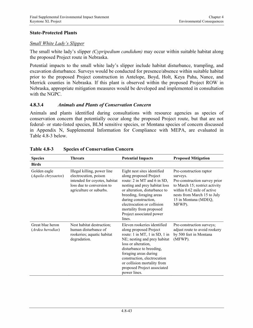
Final Supplemental Environmental Impact Statement Chapter 4 Keystone XL Project Environmental Consequences
4.8-43
State-Protected Plants
Small White Lady’s Slipper The small white lady’s slipper (Cypripedium candidum) may occur within suitable habitat along the proposed Project route in Nebraska.
Potential impacts to the small white lady’s slipper include habitat disturbance, trampling, and excavation disturbance. Surveys would be conducted for presence/absence within suitable habitat prior to the proposed Project construction in Antelope, Boyd, Holt, Keya Paha, Nance, and Merrick counties in Nebraska. If this plant is observed within the proposed Project ROW in Nebraska, appropriate mitigation measures would be developed and implemented in consultation with the NGPC.
4.8.3.4 Animals and Plants of Conservation Concern Animals and plants identified during consultations with resource agencies as species of conservation concern that potentially occur along the proposed Project route, but that are not federal- or state-listed species, BLM sensitive species, or Montana species of concern discussed in Appendix N, Supplemental Information for Compliance with MEPA, are evaluated in Table 4.8-3 below.
Table 4.8-3 Species of Conservation Concern
Species Threats Potential Impacts Proposed Mitigation Birds Golden eagle (Aquila chrysaetos)
Illegal killing, power line electrocution, poison intended for coyotes, habitat loss due to conversion to agriculture or suburbs.
Eight nest sites identified along proposed Project route: 2 in MT and 6 in SD, nesting and prey habitat loss or alteration, disturbance to breeding, foraging areas during construction, electrocution or collision mortality from proposed Project associated power lines.
Pre-construction raptor surveys. Pre-construction survey prior to March 15; restrict activity within 0.62 mile of active nests from March 15 to July 15 in Montana (MDEQ, MFWP).
Great blue heron (Ardea herodias)
Nest habitat destruction; human disturbance of rookeries; aquatic habitat degradation.
Eleven rookeries identified along proposed Project route: 1 in MT, 1 in SD, 1 in NE; nesting and prey habitat loss or alteration, disturbance to breeding, foraging areas during construction, electrocution or collision mortality from proposed Project associated power lines.
Pre-construction surveys; adjust route to avoid rookery by 500 feet in Montana (MFWP).

Final Supplemental Environmental Impact Statement Chapter 4 Keystone XL Project Environmental Consequences
4.8-44
Species Threats Potential Impacts Proposed Mitigation Raptor nests (except eagles)
Nest habitat destruction; human disturbance; prey habitat loss or alteration.
~230 nest structures, 38% active along proposed Project route; nesting and prey habitat loss or alteration, disturbance to breeding and foraging areas during construction; electrocution or collision mortality from proposed Project associated power lines.
Pre-construction surveys. Restrict activity with 0.62 mile from active nests during March 15 to July 15 in Montana (MFWP).
Fish Plains topminnow (Fundulus sciadicus)
Impoundment, channelization, agricultural runoff, dewaters, siltation, introduction and competition from western mosquitofish (Gambusia affinis).
Concern in northwestern two-thirds of Nebraska; dewatering of habitat, mortality during construction, spread of mosquitofish.
Pre-construction surveys completed. Occurrence at one crossing location in SD. Surveys for plains topminnows and other fish species are planned for 2013, to determine if this species occurs in suitable habitat along the proposed Project route in Nebraska.
4.8.4 Additional Mitigation No additional mitigation measures have been required by regulatory agencies to date. However, additional mitigation measures may be identified and required by regulatory agencies during the permitting process.
4.8.5 Connected Actions4
4 Connected actions are those that 1) automatically trigger other actions which may require environmental impact statements, 2) cannot or will not proceed unless other actions are taken previously or simultaneously, 3) are interdependent parts of a larger action and depend on the larger action for their justification.
4.8.5.1 Bakken Marketlink Project The Bakken Marketlink Project would consist of piping, booster pumps, meter manifolds, and two 250,000-barrel tanks that would be used to store crude from connecting third-party pipelines and terminals. The Bakken Marketlink Project facilities would also include a 16-inch pipeline approximately 5 miles in length, originating south of pump station 14 at a third-party tank farm in Fallon County, and extending to the two storage tanks adjacent to the proposed pump station 14. The potential impacts associated with the Bakken Marketlink Project facilities would likely be similar to those described above for the proposed Project pump station, tank farm, and pipeline ROW in those areas.
Federal and state permit applications for the Bakken Marketlink Project would be reviewed and acted on by other agencies. Those agencies would conduct more detailed environmental reviews of the Bakken Marketlink Project. Preliminary assessments of select species are provided below.

Final Supplemental Environmental Impact Statement Chapter 4 Keystone XL Project Environmental Consequences
4.8-45
Greater Sage-grouse—Candidate The Bakken Marketlink Project facilities near Baker would be constructed near known greater sage-grouse leks and therefore, construction could affect greater sage-grouse or their habitat.
Interior Least Tern—Endangered The Bakken Marketlink Project facilities near Baker are not likely to impact the interior least tern, as these facilities would not be located within areas used by this species.
Piping Plover—Threatened The Bakken Marketlink Project facilities near Baker would not be likely to affect the piping plover, as this region is used only during migration (Atkinson and Dood 2006).
Sprague’s Pipit—Candidate The Bakken Marketlink Project facilities near Baker would be located within a region used by Sprague’s pipit; therefore, construction and operation of these facilities could affect this species.
Whooping Crane—Endangered The Bakken Marketlink facilities near Baker would not likely affect the whooping crane, as this region is not within the central flyway whooping crane migration corridor.
4.8.5.2 Big Bend to Witten 230-kV Transmission Line Upgrades to the power grid in South Dakota to support power requirements for pump stations would include construction of a new 230- kV transmission line and a new substation. Federal and state permit applications for this project would be reviewed and acted on by other agencies, including the Rural Utilities Service. Those agencies would conduct more detailed environmental reviews of the Big Bend to Witten Transmission Line Project. Preliminary assessments of select species are provided below.
Greater Sage-grouse—Candidate The proposed alternative corridors for the 230-kV transmission line in southern South Dakota are generally outside of the range of breeding greater sage-grouse (USFWS 2010a), and construction of a transmission line would be unlikely to affect the greater sage-grouse.
Interior Least Tern—Endangered Construction of the proposed 230-kV transmission line in southern South Dakota during the breeding season could potentially disturb nesting and brood-rearing interior least terns. Operation of the line would increase the collision and predation hazards for feeding and nesting interior least terns in the proposed Project area.
Whooping Crane—Endangered Operation of the proposed 230-kV transmission line in southern South Dakota may increase the collision hazards for migrating whooping cranes, which could affect this species.

Final Supplemental Environmental Impact Statement Chapter 4 Keystone XL Project Environmental Consequences
4.8-46
4.8.5.3 Electrical Distribution Lines and Substations Electrical power for the proposed Project would be obtained from local power providers. These power providers would construct the necessary substations and transformers, and would either use existing service lines or construct new service lines to deliver electrical power to the specified point of use. The electrical power providers are responsible for obtaining the necessary permits, approvals, or authorizations from federal, state, and local governments to construct new power lines necessary to operate the proposed Project. Additional facilities such as power lines required for the pump stations, remotely operated valves, and densitometers would require permits from appropriate agencies and would be installed and operated by local power providers. Keystone would not construct or operate these electrical distribution lines, but have informed electrical power providers of the requirement to consult with USFWS on threatened and endangered species for the electrical infrastructure components constructed for the proposed Project. Power providers have committed to avoidance and conservation measures, in coordination with the USFWS, for species that may be affected by service lines and/or pump stations (see the 2013 USFWS Biological Opinion in Appendix H, 2012 BA and Associated Documents).
Most of the proposed new electrical distribution lines to service pump stations would be 115-kV lines strung on a single-pole and/or H-frame wood poles. The poles would typically be about 60-to 80-feet-high with wire span distances of about 250 to 400 feet. Communication towers at pump stations would generally be approximately 33 feet in height. However, antenna height at select pump stations, as determined upon completion of a detailed engineering study, may be taller, but in no event would exceed a maximum height of 190 feet. Communication towers would be constructed without guy wires. The pipe entering and exiting the pump station sites would be located below grade. The pipe manifolding connected with the pump stations would be above ground.
Black-footed ferret—Endangered/Experimental Populations Power line routes associated with the proposed Project are likely to attract raptors, known to be predators of the black-footed ferret and their primary prey, prairie dogs. As part of that authorization process, the proposed transmission line route locations in Montana would be analyzed for any active prairie dog towns. Protection measures could then be implemented by electrical service providers to minimize raptor perching in accordance with the Avian Power Line Interaction Committee (APLIC), Suggested Practices for Avian Protection on Power Lines (APLIC 1996).
Greater Sage-grouse—Candidate The construction of electrical distribution lines to pump stations in Montana and South Dakota would incrementally increase habitat alteration and predation hazards for feeding and nesting greater sage-grouse in the proposed Project area. Construction of these distribution lines during the breeding season could also potentially disturb breeding, nesting, and brood-rearing birds. Based on a 4-mile buffer centered on each confirmed active lek, each unconfirmed active lek with greater sage-grouse observations, or each priority lek, the proposed power distribution lines would cross approximately 41 miles of lek buffers (including buffers for nine separate leks).
In coordination with the USFWS, power providers have committed to conservation measures based on specific pump station locations, which include the following measures:

Final Supplemental Environmental Impact Statement Chapter 4 Keystone XL Project Environmental Consequences
4.8-47
• Pump Station 9 (Montana): Big Flat Electric Cooperative would implement mitigation measures in accordance with APLIC standards (APLIC 2012) and in coordination with the USFWS, BLM, and MFWP to avoid and minimize impacts to the greater sage-grouse. Construction of the power line would be avoided from March 1 through June 15 to avoid impacts to greater sage-grouse leks that are near the power line.
Big Flat Electric Cooperative would also require its contractors to install a pole top raptor guard on 68 poles identified to be close enough to a lek to provide a perch and visibility of the lek for birds of prey. Pole top raptor guards would also be installed on 24 existing distribution poles to protect a long-established lek located near the new transmission line project to provide service to pump station 9. Additional pole top raptor guards may be installed pending further field assessments completed during construction.
Big Flat Electric Cooperative would ensure reclamation of disturbed areas that favors establishment of silver sagebrush (big sagebrush is not located north of the Milk River) and other species that encourage development of suitable greater sage-grouse habitat. Only BLM-approved seed sources would be used in reclamation efforts on federal land.
• Pump Station 13 (Montana): Tongue River Electric Cooperative has sited the 15.3-mile long power line so that it is located in developed areas near the transportation infrastructure or agricultural land thereby avoiding areas of potential habitat.
• Pump Station 14 (Montana): Montana Dakota Utilities would reroute a portion of the transmission line serving pump station 14 to avoid two greater sage-grouse leks and install raptor perch guards at structures previously identified by the MFWP.
Montana Dakota Utilities would work with Keystone to avoid any construction of the transmission line from March 1 through June 15, if possible. If not possible, Montana Dakota Utilities would minimize disturbance to lekking greater sage-grouse by avoiding construction within 1 mile of leks from 8 p.m. until 2 hours after sunrise the following day and monitor active leks (displaying males) within 3 miles of the proposed Project during construction from March 1 through June 15. Montana Dakota Utilities would contact the USFWS to obtain additional guidance if construction-related disturbance of lekking greater sage-grouse is noted.
• Pump Stations 15, 16, and 17 (South Dakota): Grand Electric Cooperative would install raptor perch deterrents (cones or spike type deterrent devices) at any power pole that is located 1 mile or less from a greater sage-grouse lek for the power line alignments to pump stations 15, 16, and 17. Selection of poles to be equipped with perch deterrent devices would be done in coordination with the USFWS.
Additional mitigation measures recommended by the MDEQ to protect greater sage-grouse leks from power distribution lines to pump stations and remote valve locations in Montana, which may be required if the distribution line is considered an associated facility covered by the Major Facilities Siting Act, could include:
• Review all power distribution line routes to pump stations and remote valve locations for proximity to active greater sage-grouse leks, and develop alternative routing or other mitigation to avoid placement of perches for predators near active greater sage-grouse leks.

Final Supplemental Environmental Impact Statement Chapter 4 Keystone XL Project Environmental Consequences
4.8-48
Interior Least Tern—Endangered The construction of a new electrical power line segment across the Yellowstone River in Montana and the Platte River in Nebraska would incrementally increase the collision and predation potential for foraging and nesting interior least terns in the proposed Project area. Construction of these power line segments during the nesting season would also potentially disturb nesting and brood-rearing birds. Based on habitat and occurrence surveys for this species at the Platte River crossing, nesting habitat quality within line of sight of the proposed Project centerline was considered to be of good quality. Additionally, correspondence with MFWP (AECOM 2008) and results of biological surveys to delineate wetlands and waterbodies identified good quality breeding habitat at the Yellowstone River crossing.
Protection measures would be implemented by electrical service providers to minimize or prevent construction disturbance, collision risk, and predation risk to foraging interior least terns at the Platte River and Yellowstone River crossings with the use of standard measures as outlined in Mitigating Bird Collision with Power Lines (APLIC 1994).
In coordination with the USFWS, power providers have committed to avoidance and conservation measures to prevent impacts to foraging interior least terns for electrical infrastructure components based on specific pump station locations; these include the following measures:
• Pump Station 24 (Nebraska): The Nebraska Public Power District agrees to complete nest surveys for interior least terns within an area a quarter of a mile upstream and downstream of the proposed river crossing location if construction is expected to take place during the nesting period. Construction would halt if active nests are identified within one-quarter mile of the Platte River crossing area until such time that chicks and adults leave the nest area and nesting is concluded.
• The Nebraska Public Power District would install spiral bird flight diverters on the shield wire on the line span between the banks at the Platte River crossing and one span on each side of the crossing.
Piping Plover—Threatened The construction of new power lines to support the proposed Project would add to the incremental collision mortality of migrant piping plovers, especially where these power lines are located near migration staging, nesting, or foraging habitats. Piping plovers are susceptible to collisions with power lines. Construction of new power line segments across nesting and foraging habitats, including rivers, gravel pits, alkali lakes, and lake shorelines would also potentially increase predation from raptors by creating perches. Based on the habitat and occurrence surveys for this species at the Platte River crossing, breeding habitat quality within line of sight of the proposed Project centerline was considered to be of good quality.
Avoidance and minimization measures would be implemented by electrical service providers to minimize or prevent collision risk to foraging interior piping plovers at the Platte River crossing with the use of standard measures as outlined in Mitigating Bird Collision with Power Lines (APLIC 1994). The following recommended conservation measure to reduce current and future potential for injury or mortality to piping plovers would apply to power distribution lines that would serve proposed pump stations and that would cross rivers with good breeding habitat

Final Supplemental Environmental Impact Statement Chapter 4 Keystone XL Project Environmental Consequences
4.8-49
(within one-quarter mile of each side of the proposed distribution lines) or that would cross between rivers and sand and gravel mining areas:
• Mark distribution lines supplying power to pump stations with bird deflectors where they cross rivers and within one-quarter mile of each side, as well as between rivers, sand, and gravel mining areas to reduce potential injury or mortality to piping plovers.
Additional conservation measures to avoid or minimize adverse impacts to piping plovers from new power lines would vary depending on the circumstances, but may also include the following measures:
• Re-route power lines to avoid construction within 0.5 mile of piping plover nesting areas in alkali wetlands in Montana.
• Mark new power lines with bird flight diverters (preferably Swan Spiral diverters- visible plastic spirals or Firefly diverters-bird flapper device) within one-quarter mile of piping plover nesting sites on river systems and commercial sandpit areas.
• If power line construction occurs during the piping plover nesting season, survey potential riverine or sand pit piping plover nesting areas within one-quarter mile of new power lines and within 2 weeks of construction to determine presence of nesting piping plovers if power line construction occurs during the piping plover breeding season. If nesting piping plovers are present, cease construction until all chicks fledge from the site.
In coordination with the USFWS, power providers have committed to avoidance and conservation measures to prevent impacts to piping plovers for electrical infrastructure components based on specific pump station locations; these include the following measures:
• Pump Station 9 (Montana): Big Flat Electric Cooperative designed and located the power line to this pump station so that it is 3 miles east of any piping plover nesting or habitat areas. If nesting piping plovers are found to be present based on surveys for the species, all construction would cease until piping plover chicks fledge from the site.
• Pump Station 10 (Montana): NorVal Electric Cooperative would install bird flight diverters in all locations where the power line comes within one-quarter mile on either side of the Milk River. Additionally, bird flight diverters would be installed for one-quarter mile on either side of two unnamed reservoirs crossed by the proposed power line.
• Pump Station 24 (Nebraska): The Nebraska Public Power District agrees to complete nest surveys for piping plovers within an area of one-quarter mile upstream and downstream of the proposed river crossing location if construction is expected to take place during the nesting period. Construction would halt if active nests are identified within one-quarter mile of the Platte River crossing area until such time that chicks and adults leave the nest area.
Sprague’s Pipit—Candidate The construction of electrical distribution lines would incrementally increase the collision and predation hazards for breeding Sprague’s pipits in the proposed Project area. The power distribution line to proposed Pump Station 10 would cross 18.6 miles of the North Valley Grasslands important bird area (IBA) and may impact survival and reproduction for ground nesting grassland birds; the same line would cross 2.1 miles of the Charles M. Russell National Wildlife Refuge IBA, which supports 15 birds of global conservation concern

Final Supplemental Environmental Impact Statement Chapter 4 Keystone XL Project Environmental Consequences
4.8-50
(Montana Audubon 2012). Both of these IBAs support breeding Sprague’s pipits. Construction of these distribution lines during the breeding season could potentially disturb nesting and brood-rearing birds. Power lines across native grassland habitats may contribute to fragmentation.
In coordination with the USFWS, power providers have committed to avoidance and conservation measures to prevent impacts to nesting and migrant Sprague’s pipits for electrical infrastructure components based on specific pump station locations; these include the following measures:
• Pump Station 9 (Montana): Big Flat Electric Cooperative would implement mitigation measures in coordination with the USFWS, BLM, and MFWP to avoid and minimize impacts to the Sprague’s pipit. Preconstruction surveys for the species would be coordinated with the USFWS. Unauthorized vehicle access would be restricted by Big Flat Electric Cooperative during the course of proposed Project construction to avoid impacts to nesting birds. Big Flat Electric Cooperative would ensure that disturbed areas would be reseeded to encourage redevelopment of native range using a BLM-approved seed mix.
• Pump Station 12 (Montana): McCone Electric Cooperative would site the power line to avoid and minimize encroachment on native prairie habitats. Construction activities would occur outside of the April 15 through July 15 nesting season, if possible. If Sprague’s pipit nests are discovered, construction activity would be delayed within 330 feet of the nest, until the young have fledged. McCone Electric Cooperative would ensure all areas disturbed during the course of power line construction are reseeded with a native seed mix after topsoil replacement. Access to the power line ROW would be controlled via fences with locking gates, signs, and fences to avoid disturbance to nesting areas.
• Pump Station 14 (Montana): Montana Dakota Utilities would mow the ROW, unless the landowner does not approve mowing. Any mowing would be done in the fall, prior to construction, to discourage bird nesting. Montana Dakota Utilities may decide not to mow the ROW if construction is projected to commence after July 15. Sagebrush would not be mowed.
Montana Dakota Utilities would work with Keystone to avoid construction of the transmission line from April 15 through July 15, if possible. If construction is projected to occur in native prairie habitat during the period from April 15 through July 15, Montana Dakota Utilities would mow the ROW unless the landowner does not approve mowing. Any mowing would be done in the fall, prior to construction, to discourage bird nesting. Montana Dakota Utilities may decide not to mow the ROW if construction is projected to commence after July 15. Sagebrush would not be mowed.
Whooping Crane—Endangered Power lines associated with the proposed Project are collision hazards to migrant whooping cranes. Recent studies conducted by the USFWS in conjunction with University of Nebraska researchers have documented migratory bird mortalities, including cranes, from collisions with two existing 69-kV transmissions lines that cross the Platte River (Murphy et al. 2009; USFWS 2009a; Wright et al. 2009). One study conducted during the spring whooping crane migration in 2007 estimated that between 165 and 210 sandhill cranes did not survive collisions with the two power lines (Wright et al. 2009). No evidence of whooping crane mortality was observed during that study. Bird diverter devices (such as FireFly™ bird diverters) may reduce crane collisions
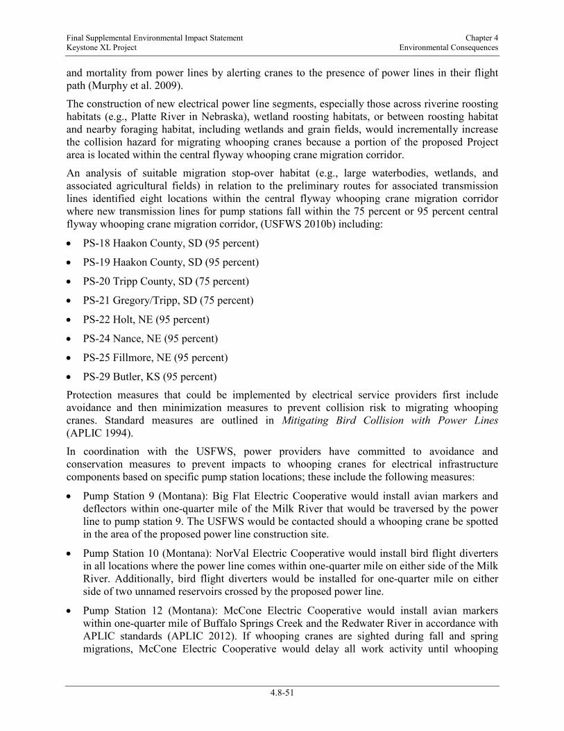
Final Supplemental Environmental Impact Statement Chapter 4 Keystone XL Project Environmental Consequences
4.8-51
and mortality from power lines by alerting cranes to the presence of power lines in their flight path (Murphy et al. 2009).
The construction of new electrical power line segments, especially those across riverine roosting habitats (e.g., Platte River in Nebraska), wetland roosting habitats, or between roosting habitat and nearby foraging habitat, including wetlands and grain fields, would incrementally increase the collision hazard for migrating whooping cranes because a portion of the proposed Project area is located within the central flyway whooping crane migration corridor.
An analysis of suitable migration stop-over habitat (e.g., large waterbodies, wetlands, and associated agricultural fields) in relation to the preliminary routes for associated transmission lines identified eight locations within the central flyway whooping crane migration corridor where new transmission lines for pump stations fall within the 75 percent or 95 percent central flyway whooping crane migration corridor, (USFWS 2010b) including:
• PS-18 Haakon County, SD (95 percent)
• PS-19 Haakon County, SD (95 percent)
• PS-20 Tripp County, SD (75 percent)
• PS-21 Gregory/Tripp, SD (75 percent)
• PS-22 Holt, NE (95 percent)
• PS-24 Nance, NE (95 percent)
• PS-25 Fillmore, NE (95 percent)
• PS-29 Butler, KS (95 percent) Protection measures that could be implemented by electrical service providers first include avoidance and then minimization measures to prevent collision risk to migrating whooping cranes. Standard measures are outlined in Mitigating Bird Collision with Power Lines (APLIC 1994).
In coordination with the USFWS, power providers have committed to avoidance and conservation measures to prevent impacts to whooping cranes for electrical infrastructure components based on specific pump station locations; these include the following measures:
• Pump Station 9 (Montana): Big Flat Electric Cooperative would install avian markers and deflectors within one-quarter mile of the Milk River that would be traversed by the power line to pump station 9. The USFWS would be contacted should a whooping crane be spotted in the area of the proposed power line construction site.
• Pump Station 10 (Montana): NorVal Electric Cooperative would install bird flight diverters in all locations where the power line comes within one-quarter mile on either side of the Milk River. Additionally, bird flight diverters would be installed for one-quarter mile on either side of two unnamed reservoirs crossed by the proposed power line.
• Pump Station 12 (Montana): McCone Electric Cooperative would install avian markers within one-quarter mile of Buffalo Springs Creek and the Redwater River in accordance with APLIC standards (APLIC 2012). If whooping cranes are sighted during fall and spring migrations, McCone Electric Cooperative would delay all work activity until whooping

Final Supplemental Environmental Impact Statement Chapter 4 Keystone XL Project Environmental Consequences
4.8-52
cranes have left the area and immediately contact the USFWS and MFWP for further instruction.
• Pump Station 14 (Montana): Montana Dakota Utilities would install bird flight diverters on the static line at 50-foot spacing within one-quarter mile of Pennel Creek and within one-quarter mile of a pond located in the northwest corner of section 35, T9 North, Range 58 East. If a whooping crane is sighted on the ground within the transmission line project area during construction, Montana Dakota Utilities would cease construction and contact the USFWS.
• Pump Station 20 (South Dakota): A total of 636 bird flight diverters would be installed by Rosebud Electric Cooperative Inc. at three wetland areas located along the proposed power line alignment to avoid and minimize risk of collision by whooping cranes near wetland foraging and roosting habitats. Installation of bird flight diverters would be done in accordance with specific marking locations as previously recommended by the USFWS at these three wetland areas located at Township 101 North, Range 77 West, Section 17 and the SE ¼ Section 32, and Township 100 N Range 78 West, Section 10, NW1/4 Section 15.
• Pump Station 21 (South Dakota): A total of 557 bird flight diverters would be installed by Rosebud Electric Cooperative Inc. to avoid and minimize risk of collision by whooping cranes near wetland foraging and roosting habitats. Installation of bird flight diverters would be done in accordance with specific marking locations as previously recommended by the USFWS at these wetland areas located at Township 97 North, Range 73 West SW ¼ of Section 25 and Township 95 North, Range 73 West, Sections 16 and 17.
• Pump Station 22, 23, 24, and 26 (Nebraska): The Nebraska Public Power District would complete a field review with USFWS and NGPC to determine if any areas are present with a higher probability of whooping crane use (i.e., wetlands or large ponded areas (stock ponds), meadows, and obvious flight corridors to and from such areas to feeding habitats). Spiral bird flight diverters would be installed, consistent with APLIC standards (APLIC 2012), in appropriate areas as identified in the field review.
• The Nebraska Public Power District would complete daily presence/absence whooping crane surveys according to protocol (USFWS 2012) if construction occurs during the spring and fall migration periods in areas where such surveys are agreed to be appropriate and necessary to avoid disturbance. Should a whooping crane(s) be sighted within 0.5-mile of a work area, all work would cease until the whooping crane(s) leaves that immediate area. The USFWS and NGPC would be contacted immediately and notified of the presence of whooping crane(s).
• Pump Station 27 (Kansas): Westar Energy would install bird flight diverters to prevent avian collisions where the power line crosses the Republican River even though an evaluation of whooping crane use indicated that it was unlikely that the species would be found in this area.
The following conservation measures would also apply to power distribution lines that would serve proposed Project pump stations within the whooping crane migration route:
• Avoid overhead power line construction within 5.0 miles of designated critical habitat and documented high use areas (locations may be obtained from local USFWS Ecological Services field office).
Final Supplemental Environmental Impact Statement Chapter 4 Keystone XL Project Environmental Consequences
4.8-53
• To the extent practicable, bury all new power lines, especially those within 1.0 mile of potentially suitable migration stopover habitat.
If it is not economically or technically feasible to bury the power distribution lines, conservation measures to minimize or avoid impacts to migrating whooping cranes would vary depending on the circumstances, but may include the following:
• Within the 95 percent central flyway whooping crane migration corridor, mark new lines within 1.0 mile of potentially suitable habitat and an equal amount of existing line within 1.0 mile of potentially suitable habitat within the identified central flyway whooping crane migration corridor (at a minimum within the 75 percent corridor, preferably within the 95 percent corridor).
• Within the 95 percent central flyway whooping crane migration corridor, install bird flight diverters to minimize the risk of collision.
• Outside the 95 percent central flyway whooping crane migration corridor, mark new lines within 1.0 mile of potentially suitable habitat at the discretion of the local USFWS Ecological Services field office, based on the biological needs of the whooping crane.
• Develop a compliance monitoring plan that requires written confirmation that the power lines have been marked, and that the markers are maintained in working condition.
American Burying Beetle—Endangered Construction and maintenance of power lines to pump stations could affect the American burying beetle. Only two of the 20 planned power line routes to pump stations would occur within the current occupied range of the American burying beetle: power lines to pump stations 21 and 22. The USFWS has determined that the alignment of the power line to pump station 21 is unlikely to have an effect on the American burying beetle given the lack of suitable habitat and anticipated minimal disturbance associated with the proposed power line project. Pump station 22 habitat is considered marginal because it is partially overgrazed, drought-affected, and several center pivots are present to irrigate row crops.
In coordination with the USFWS, power providers have committed to avoidance and conservation measures to prevent impacts to American burying beetles for electrical infrastructure components based on specific pump station locations; these include the following measure:
• Pump Station 22 (Nebraska): The Nebraska Public Power District would schedule line construction activities for this line segment to occur during the American burying beetle dormant or inactive time in the winter when soil would be frozen to avoid soil compaction (September 15 to April 1). The Nebraska Public Power District would coordinate with USFWS and NGPC to determine appropriate measures to minimize potential impacts if such scheduling cannot be accomplished due to unexpected circumstances, including weather delays.

Final Supplemental Environmental Impact Statement Chapter 4 Keystone XL Project Environmental Consequences
4.8-54
Western Prairie Fringed Orchid—Threatened Construction and operation of the new electrical power lines could impact the western prairie fringed orchid if power line ROWs were to disturb suitable habitat for this plant. Power providers have committed to consult with the USFWS and to follow recommended avoidance and conservation measures of the USFWS.
In coordination with the USFWS, power providers have committed to avoidance and conservation measures to prevent impacts to the western prairie fringed orchid for electrical infrastructure components based on specific pump station locations; these include the following measure:
• Pump Station 22, 23, 24 (Nebraska): The Nebraska Public Power District would complete field surveys for the western prairie fringed orchid during the appropriate bloom periods only in areas along the final line routes that are considered suitable. The Nebraska Public Power District would delineate and mark areas where western prairie fringed orchid habitat is present as avoidance areas where placement of structures and construction traffic would not occur
4.8.6 References AECOM. 2008. TransCanada Keystone XL Project - USFWS/MFWP Meeting Notes. Helena,
Montana. May 8, 2008.
Andres, B.A., and K.L. Stone. 2009. Conservation Plan for the Mountain Plover (Charadrius montanus), Version 1.0. Manomet Center for Conservation Sciences, Manomet, Massachusetts.
APLIC. See Avian Power Line Interaction Committee.
Avian Power Line Interaction Committee (APLIC). 1994. Mitigating Bird Collision with Power Lines: The State of the Art in 1994. Edison Electrical Institute. Washington, D.C.
________. 1996. Suggested Practices for Raptor Protection on Power Lines. The State of the Art in 1996. Edison Electric Institute and the Raptor Research Foundation. Washington, D.C.
________. 2012. Reducing Avian Collisions with Power Lines: The State of the Art in 2012. Edison Electric Institute and APLIC. Washington, D.C.
Atkinson, S. J. and Dood, A. R. 2006. Montana Piping Plover Management Plan. Montana Department of Fish, Wildlife and Parks, Bozeman, Montana. 78 pp.
Backlund, D.C. and G.M. Marrone. 1997. New records of the endangered American burying beetle, Nicrophorus americanus Olivier, (Coleoptera: Silphidae) in South Dakota. The Coleopterists Bulletin 51(1):53-58.
Bat Conservation International. 2012. BCI Species Profiles –Myotis septentrionalis. Website: http://www.batcon.org/index.php/all-about-bats/species-profiles.html?task=detail&species=2306&country=43&state=57&family=all&limitstart=0. Accessed November 5, 2012.

Final Supplemental Environmental Impact Statement Chapter 4 Keystone XL Project Environmental Consequences
4.8-55
Bedick, J.C., B.C. Ratcliffe, W. Wyatt Hoback, and L.G. Higley. 1999. Distribution, ecology, and population dynamics of the American burying beetle, [Nicrophorus americanus Olivier (Coleoptera, Silphidae)] in south-central Nebraska, USA. Journal of Insect Conservation 3(3):171-181.
Bedick, J.C., W. W. Hoback, and M.C. Albrecht. 2006. High water-loss rates and rapid dehydration in the burying beetle, Nicrophorus marginatus. Physiological Entomology 31: 23-29.
Blickley, Jessica L. and Gail L. Patricelli. 2012. Potential Acoustic Masking of Greater Sage-grouse (Centrocercus urophasianus) Display Components by Chronic Industrial Noise. Ornithological Monographs, Volume (2012), No. 74, 23-25.
Braaten, P.J., D.B. Fuller, L.D. Holte, R.D. Lott, W. Viste, T.F. Brandt, and R.G. Legare. 2008. Drift dynamics of larval pallid sturgeon and shovelnose sturgeon in a side channel of the Upper Missouri River, Montana. North American Journal of Fisheries Management 28:3, 808-826.
Childers, T.M. and S.J. Dinsmore. 2008. Density and abundance of mountain plovers in northeastern Montana. The Wilson Journal of Ornithology 120(4):700-707.
Esri 2013. Reference: Esri. 2013. World Imagery (Aerial Photography), USA Topo Maps (Topographic Mapping), and World Street Map (Administrative and Political Boundaries and Transportation). Contributing Data Sources, World Imagery: DigitalGlobe, GeoEye, i-cubed, USDA, USGS, AEX, Getmapping, Aerogrid, IGN, IGP, swisstopo, and the GIS User Community. Contributing Data Sources, USA Topo Maps: DeLorme, Copyright © 2013 National Geographic Society, i-cubed, NAVTEQ, TomTom, Intermap, increment P Corp., GEBCO, USGS, FAO, NPS, NRCAN, GeoBase, IGN, Kadaster NL, Ordnance Survey, Esri Japan, METI, Esri China (Hong Kong), swisstopo, and the GIS User Community. Contributing Data Sources, World Street Map: DeLorme, NAVTEQ, USGS, Intermap, iPC, METI, NRCAN, Esri Japan, METI, Esri China (Hong Kong), Esri (Thailand), TomTom, 2013, Bing Maps.
Hoback. 2012. Hoback August Survey Report. Results of Survey for American Burying Beetle, Nicrophorus americanus, in Northern Keya Paha, Western Boyd, Eastern Holt, and Antelope Counties.
Jones, S.L. 2010. Sprague’s Pipit (Anthus spragueii) conservation plan. U.S. Department of Interior, Fish and Wildlife Service, Washington, D.C. Website: http://www.fws.gov/mountain-prairie/species/birds/spraguespipit/SpraguesJS2010r4.pdf. Accessed: December 2012.
MFWP. See Montana Fish, Wildlife & Parks.
MNHP. See Montana Natural Heritage Program.
Montana Audubon. 2012. Important Bird Areas. Helena, MT. Website: http://mtaudubon.org/birds/areas.html. Accessed December 2012.
Montana Fish, Wildlife & Parks (MFWP). 2001. Digital sage grouse habitat/current distribution and metadata. Montana Fish, Wildlife and Parks, Helena, MT. Website: http://fwp.mt.gov/gisData/metadata/distributionSageGrouse.htm. Accessed January 9, 2013.

Final Supplemental Environmental Impact Statement Chapter 4 Keystone XL Project Environmental Consequences
4.8-56
Montana Natural Heritage Program and Montana Department of Fish, Wildlife, and Parks (MNHP and MFWP). 2010. Big Sagebrush Steppe—Inter-Mountain Basins Big Sagebrush Steppe. Montana Field Guide. Website: http://fieldguide.mt.gov/displayES_Detail.aspx?ES=5454. Accessed December 2012.
__________. 2012a. Pallid Sturgeon — Scaphirhynchus albus. Montana Field Guide. Website: http://fieldguide.mt.gov/detail_AFCAA02010.aspx. Accessed October 31, 2012.
__________. 2012b. Sprague's Pipit — Anthus spragueii. Montana Field Guide. Website: http://fieldguide.mt.gov/detail_ABPBM02060.aspx. Site accessed December 12, 2012.
__________. 2012c. Swift Fox — Vulpes velox. Montana Field Guide. Website: http://FieldGuide.mt.gov/detail_AMAJA03030.aspx. Accessed on November 2, 2012.
__________. 2012d. Northern Myotis — Myotis septentrionalis. Website: http://FieldGuide.mt.gov/detail_AMACC01150.aspx. Accessed November 5, 2012.
Murphy, R.K., S.M. McPherron, G.D. Wright, and K.L. Serbousek. 2009. Effectiveness of avian collision averters in preventing migratory bird mortality from powerline strikes in the central Platte River, Nebraska 2008-2009 Final Report. Department of Biology, University of Nebraska-Kearney, Kearney, NE 68849. 34 pp.
NatureServe. 2009. NatureServe Explorer. Website: http://www.natureserve.org/explorer. Accessed December 2012.
Naugle, D.E., K.E. Doherty, B.L. Walker, Matthew, J. Holloran, and H.E. Copeland. 2009. Energy development and greater sage-grouse. Chapter 21, in C.D. Marti (editor) Ecology and conservation of greater sage-grouse: A landscape species and its habitats. Studies in Avian Biology, Cooper Ornithological Society. Pre-publication release available online at: http://sagemap.wr.usgs.gov. Accessed December 8, 2009.
Nebraska Game and Parks Commission (NGPC). 2011. Estimated Current Ranges of Threatened and Endangered Species: List of Species by County. Nebraska Natural Heritage Program and the Nebraska Game and Parks Commission, Lincoln, NE.
__________. 2012. Least Tern—An Endangered Species. Website: http://outdoornebraska.ne.gov/wildlife/wildlife_species_guide/ltern.asp. Accessed November 8, 2012.
NGPC. See Nebraska Game and Parks Commission.
Panella, M.J. (2013). American burying beetle: a species conservation assessment for the Nebraska natural legacy project. Nebraska Game and Parks Commission: Wildlife Division. Website: http://outdoornebraska.ne.gov/wildlife/programs/legacy/pdfs/assessments/ABB.pdf. Accessed July 17, 2013
Pennsylvania Game Commission. 2013. Bat White-Nose Syndrome (WNS) Occurrence by County/District. Website: http://www.portal.state.pa.us/portal/server.pt/gateway/PTARGS_0_416660_112129_9109_615025_43/http;/pubcontent.state.pa.us/publishedcontent/publish/marketingsites/game_commission/content/wildlife/wildlife_diseases/white_nose_syndrome/images/wnsmap.jpg. Accessed December 17, 2013.

Final Supplemental Environmental Impact Statement Chapter 4 Keystone XL Project Environmental Consequences
4.8-57
Schnell, G.D., A.E. Hiott, J.C. Creighton, V.L. Smyth, and A. Komendat. 2008. Factors affecting overwinter survival of the American burying beetle, Nicrophorus americanus (Coleoptera: Silphidae). Journal of Insect Conservation 12:483-492.
Schuman, G. and T. Booth. 1998. Strategies for establishment of big sagebrush (Artemisia tridentata ssp. wyomingensis) on Wyoming mined lands. Final Report. Abandoned Coal Mine Research Program. High Plains Grassland Research Service, Cheyenne, Wyoming.
USFWS. See U.S. Fish and Wildlife Service.
USFWS and NGPC. See U.S. Fish and Wildlife Service and Nebraska Game and Parks Commission.
USGS. See U.S. Geologic Survey.
U.S. Fish and Wildlife Service (USFWS). 1989. Black-footed Ferret Survey Guidelines for Compliance with the Endangered Species Act. Denver, Colorado, and Albuquerque, New Mexico. April 1989. 10 pp.
__________. 1991. American Burying Beetle (Nicrophorus americanus) recovery plan. Coordinated through U.S. Fish and Wildlife Service New England Field Office. 81p.
__________. 1996. Western Prairie Fringed Orchid Recovery Plan (Platanthera praeclara). USFWS. Fort Snelling, Minnesota. vi + 101 pp.
__________. 2007. Western Prairie Fringed Orchid Platanthera praeclara. USFWS Mountain-Prairie Region South Dakota Ecological Services Field Office. Website: http://www.fws.gov/southdakotafieldoffice/ORCHID.HTM. Accessed December 2012.
__________. 2008. American burying beetle (Nicrophorus americanus). 5-Year Review: Summary and Evaluation. U.S. Fish and Wildlife Service, Concord, New Hampshire. 53 pp.
__________. 2009a. Whooping cranes and wind development—an issue paper. U.S. Fish and Wildlife Service, Regions 2 and 6. 27 pp.
__________. 2009b. Endagnered Species Act Consultations with the U.S. Fish & Wildlife Service: How to Seek ESA Coverage for Water-Related Activities through the Platter River Recovery Implementation Program. Website: http://www.fws.gov/platteriver/index.htm. Accessed August 6, 2013.
__________. 2010a. Endangered and Threatened Wildlife and Plants; 12-Month Findings for Petitions to List the Greater Sage-Grouse (Centrocercus urophasianus) as Threatened or Endangered. Proposed Rule 50 CFR Part 17: 23 March 2010.
__________. 2010b. Region 6 Guidance for Minimizing Effects from Power Line projects within the Whooping Crane Migration Corridor. February 4, 2010. Assistant Regional Director, Ecological Services, Region 6, Mountain Prairie Region, Denver, Colorado.
__________. 2012. Technical Assistance, TransCanada Keystone XL Pipeline Project, Montana, South Dakota, and Nebraska, Presidential Permit Application. September 28, 2012.

Final Supplemental Environmental Impact Statement Chapter 4 Keystone XL Project Environmental Consequences
4.8-58
__________. 2013. Endangered and Threatened Wildlife and Plants; 12-Month Finding on a Petition To List the Eastern Small-Footed Bat and the Northern Long-Eared Bat as Endangered or Threatened Species; Listing the Northern Long-Eared Bat as an Endangered Species; Proposed Rule. Federal Register 78(191): 61045-61080.
U.S. Fish and Wildlife Service and Nebraska Game and Parks Commission (USFWS and NGPC). 2008. Conservation Measures for the American Burying Beetle (ABB). December 2008. Provided by the U.S. Fish and Wildlife Service, Nebraska Ecological Services Field Office and Nebraska Game and Parks Commission.
U.S. Geologic Survey (USGS). 2006a. Fragile Legacy, Endangered, Threatened & Rare Animals of South Dakota, Sicklefin Chub (Hybopsis meeki), August 3, 2006. Website: http://www.npwrc.usgs.gov/resource/wildlife/sdrare/species/hybomeek.htm. Accessed December 2012.
__________. 2006b. North Dakota’s Endangered and Threatened Species Western Prairie Fringed Orchid (Platanthera praeclara). USGS Northern Prairie Wildlife Research Center. Website: http://www.npwrc.usgs.gov/resource/wildlife/endanger/platprae.htm. Accessed November 9, 2012.
Vicklund, L., G. Shuman, and A. Hild. 2004. Influence of sagebrush and grass seeding rates on sagebrush density and plant size. USDA Forest Service Proceedings RMRS-P-31.
WESTECH. See WESTECH Environmental Services, Inc.
WESTECH Environmental Services, Inc. 2010a. Summary of April 2010 aerial searches for greater sage-grouse leks, Keystone XL Pipeline Project, Steele City Segment (Montana and South Dakota). May 2010. Prepared for Trow Engineering consultants, Inc. by WESTECH Environmental Services, Inc., Helena, Montana. 9 pg.
__________. 2010b. An Approach for Implementing Mitigation Measures to Minimize the Effects of Construction and Operation of the Keystone XL Pipeline Project on Greater Sage-Grouse. Report to Trow Engineering Consultants. Helena, Montana. 12 pp. + appendices and maps.
__________. 2012a. Summary of April 2012 Aerial Searches for Greater Sage-grouse Leks and Sharp-tailed Grouse Leks, Keystone XL Pipeline Project Steele City Segment (Montana and South Dakota). Tech. report for TransCanada Keystone Pipeline, LP.
__________. 2011b. An Approach for Implementing Mitigation Measures to Minimize the Effects of Construction and Operation of the Keystone XL Pipeline Project on Greater Sage-Grouse in South Dakota. Report to Trow Engineering Consultants. Helena, Montana. 13 pp. + appendices and maps.
Wright, G.D., T.J. Smith, R.K. Murphy, J.T. Runge, and R.R. Harms. 2009. Mortality of cranes (Gruidae) associated with powerlines over a major roost on the Platte River, Nebraska. The Prairie Naturalist 41(3/4):116-120.