4.7 HYDROLOGY AND WATER QUALITY - Capital Strategies · 4.7 HYDROLOGY AND WATER QUALITY 4.7-1 This...
38
4.7 HYDROLOGY AND WATER QUALITY 4.7-1 This chapter evaluates potential impacts associated with the development proposed un- der the 2020 LRDP and the Tien Center on drainage, flooding, and groundwater and surface water quality of the Campus Park, City Environs and the LRDP Housing Zone. Issues related to water supply and storm sewer capacity are addressed in Chapter 4.13, Utilities and Service Systems. During the scoping period for this EIR, several concerns related to hydrology and water quality were raised. Key issues raised included potential impacts of the 2020 LRDP to Strawberry Creek and other water courses, impacts associated with potential increases in impervious surfaces, and potential groundwater and surface water contamination. These issues are addressed in this chapter. 4.7.1 ANALYTICAL METHOD 2020 LRDP The description of existing conditions and the impact analysis derives from a review of background reports, including the City of Berkeley and the City of Oakland general plan documents, the UC Berkeley 1990 LRDP EIR, and online resources. The current and foreseeable regulatory environment was also reviewed. 2020 LRDP impacts and the adequacy of existing programs and proposed 2020 LRDP policies intended to reduce hydrological impacts were then evaluated. The hydrology and water quality impacts of projected cumulative growth were also analyzed. TIEN CENTER The impacts related to the Chang-Lin Tien Center for East Asian Studies were analyzed separately. The construction of both phases 1 and 2 of the Tien Center would result in an approximate net increase of 15,155 square feet of impervious area. This information, in conjunction with the proposed location on campus and the proximity to Strawberry Creek and North Fork Strawberry Creek, was considered in determining potential impacts. 4.7.2 REGULATORY FRAMEWORK Federal and State water quality regulations apply to development projects that may ad- versely affect the quality of surface waters or groundwater through the discharge of wastewater and storm water. Section 303 of the federal Clean Water Act and the State’s Porter-Cologne Water Quality Control Act establish water quality objectives for all wa- ters in the State. These objectives are implemented locally through Water Quality Con- trol Plans and the National Pollutant Discharge Elimination System, (NPDES) permit- ting program. UC Berkeley is currently required to adhere to requirements set forth in the Clean Water Act and San Francisco Bay Region Water Quality Control Plan (also called the Basin Plan) , has applied for a Phase II municipal separate storm sewer system (MS4) NPDES Permit, and is awaiting designation as a Phase II permittee by the San Francisco Bay Regional Water Quality Control Board (RWQCB). 1 The RWQCB views ephemeral drainages as creeks for CWA regulatory purposes. Be- cause hydrology is inextricably linked to ecosystem and wildlife health, the California
Transcript of 4.7 HYDROLOGY AND WATER QUALITY - Capital Strategies · 4.7 HYDROLOGY AND WATER QUALITY 4.7-1 This...
4.7 HYDROLOGY AND WATER QUALITY
4.7-1
This chapter evaluates potential impacts associated with the development proposed un-der the 2020 LRDP and the Tien Center on drainage, flooding, and groundwater and surface water quality of the Campus Park, City Environs and the LRDP Housing Zone. Issues related to water supply and storm sewer capacity are addressed in Chapter 4.13, Utilities and Service Systems. During the scoping period for this EIR, several concerns related to hydrology and water quality were raised. Key issues raised included potential impacts of the 2020 LRDP to Strawberry Creek and other water courses, impacts associated with potential increases in impervious surfaces, and potential groundwater and surface water contamination. These issues are addressed in this chapter. 4.7.1 ANALYTICAL METHOD 2020 LRDP
The description of existing conditions and the impact analysis derives from a review of background reports, including the City of Berkeley and the City of Oakland general plan documents, the UC Berkeley 1990 LRDP EIR, and online resources. The current and foreseeable regulatory environment was also reviewed. 2020 LRDP impacts and the adequacy of existing programs and proposed 2020 LRDP policies intended to reduce hydrological impacts were then evaluated. The hydrology and water quality impacts of projected cumulative growth were also analyzed. TIEN CENTER
The impacts related to the Chang-Lin Tien Center for East Asian Studies were analyzed separately. The construction of both phases 1 and 2 of the Tien Center would result in an approximate net increase of 15,155 square feet of impervious area. This information, in conjunction with the proposed location on campus and the proximity to Strawberry Creek and North Fork Strawberry Creek, was considered in determining potential impacts. 4.7.2 REGULATORY FRAMEWORK Federal and State water quality regulations apply to development projects that may ad-versely affect the quality of surface waters or groundwater through the discharge of wastewater and storm water. Section 303 of the federal Clean Water Act and the State’s Porter-Cologne Water Quality Control Act establish water quality objectives for all wa-ters in the State. These objectives are implemented locally through Water Quality Con-trol Plans and the National Pollutant Discharge Elimination System, (NPDES) permit-ting program. UC Berkeley is currently required to adhere to requirements set forth in the Clean Water Act and San Francisco Bay Region Water Quality Control Plan (also called the Basin Plan) , has applied for a Phase II municipal separate storm sewer system (MS4) NPDES Permit, and is awaiting designation as a Phase II permittee by the San Francisco Bay Regional Water Quality Control Board (RWQCB).1 The RWQCB views ephemeral drainages as creeks for CWA regulatory purposes. Be-cause hydrology is inextricably linked to ecosystem and wildlife health, the California
U N I V E R S I T Y O F C A L I F O R N I A , B E R K E L E Y 2 0 2 0 L R D P D R A F T E I R 4 . 7 H Y D R O L O G Y A N D W A T E R Q U A L I T Y
4.7-2
Department of Fish and Game (CDFG) also has regulatory oversight over projects in lakes, streambeds, and adjacent riparian zones. CDFG broadly defines “riparian zone” as limited only by the distance to the furthest riparian species of vegetation in the im-mediate drainage. UC Berkeley therefore reviews stream channel improvements, fire fuel mitigation efforts around creeks, and any other near-stream projects with the RWQCBCDFG, and the Army Corps of Engineers, which has regulatory oversight of fill and channel alterations to the high water line under Section 404 of the Clean Water Act and Section 10 of the Rivers and Harbors Act. Campus creeks have been, to varying degrees, historically subject to wildfires and the fire-associated changes in vegetation, food chains, and erosion.2 Over the past five years, UC Berkeley has received three Notices of Violation (NOVs) in the areas of surface water, ground water, and waste water: December 29, 1999 – UC Berkeley was issued a NOV by the Regional Water Qual-
ity Control Board expressing concerns that UC Berkeley may not have acted ade-quately to protect water quality in Strawberry Creek. Concerns included construc-tion site erosion and sediment control, sewage spill response, illicit discharges, em-ployee training, and proper spill reporting.
April 12, 2000 – UC Berkeley was issued a NOV by EBMUD for exceeding the wastewater concentration limit for chlorinated hydrocarbons.
February 9, 2001 – UC Berkeley was issued a NOV from the City of Berkeley for the discharge of hot steam condensate to the city storm drain system.
UC Berkeley responded to the NOVs in a prompt and thorough manner and all defi-ciencies noted in the NOVs have been corrected. SPILL PREVENTION CONTROL AND COUNTERMEASURE PLAN
In California owners and operators of aboveground petroleum storage tanks must com-ply with regulations of the Federal Oil Pollution Prevention Act and the State Above-ground Petroleum Storage Act. Federal regulations in Title 40 Code of Federal Regula-tions Part 112 et. seq. present requirements applying to owners and operators of above-ground petroleum storage tanks (ASTs) with a facility aggregate storage capacity in ex-cess of 1,320 gallons and includes the development of a Spill Prevention Control and Countermeasure Plan (SPCC Plan). UC Berkeley owns and operates around 45 ASTs with a total storage capacity of approximately 10,000 gallons and has prepared an SPCC Plan to meet regulatory requirements. The purpose of the SPCC Plan is to establish procedures, methods, equipment and other preventative measures to prevent the discharge of oil into or upon the navigable waters of the United States, or their tributaries, per 40 CFR Part 112. The SPCC Plan also addresses ways of minimizing environmental impacts if a spill does occur. WATER QUALITY CONTROL PLANS
The CWA and State Porter-Cologne Water Quality Control Act provide for the restora-tion and maintenance of the physical, chemical, and biological integrity of the nation’s waters. Discharges of wastewaters and stormwaters to Strawberry Creek and the San Francisco Bay are regulated by these laws under a number of programs administered by
U N I V E R S I T Y O F C A L I F O R N I A , B E R K E L E Y 2 0 2 0 L R D P D R A F T E I R
4 . 7 H Y D R O L O G Y A N D W A T E R Q U A L I T Y
4.7-3
the State Water Resources Control Board (SWRCB) via the San Francisco Regional Wa-ter Quality Control Board (Regional Board). To administer these programs, the Porter-Cologne Water Quality Control Act also requires each Regional Board to develop a Wa-ter Quality Control Plan, usually called a Basin Plan. The San Francisco Regional Board’s Basin Plan was approved in 1995. The Plan is the master policy document that contains descriptions of the legal, technical, and programmatic bases of water quality regulation in the San Francisco Bay region. It includes statements of beneficial water uses to be protected, water quality objectives and strategies and time schedules for achieving the water quality objectives. The beneficial uses associated with surface water and groundwater resources in East Bay watersheds are summarized in the 1995 San Francisco Bay Basin Water Quality Control Plan compiled by the San Francisco RWQCB. The beneficial uses for surface water, which serve as a basis for establishing water quality standards, include: Non-contact water recreation Cold freshwater habitat Warm freshwater habitat Fish spawning, reproduction, and/or early development. Wildlife habitat
The beneficial uses designated for groundwater in the East Bay Plain Basin include: Municipal and domestic water supply Industrial process and service water supply Agricultural water supply.
NATIONAL POLLUTANT DISCHARGE ELIMINATION SYSTEM
The National Pollutant Discharge Elimination System (NPDES) program was initially established to regulate the quality of effluent discharge from wastewater treatment plants. Through the NPDES Waste Discharge Requirements, the RWQCB sets limits on the levels of pollutants that may be discharged into navigable waters of the United States, which include the waters draining from Strawberry Creek into San Francisco Bay. The limits are designed to meet the water quality objectives established in the Basin Plan. The 1972 amendments to the CWA prohibit the discharge of pollutants to navigable waters from a point source (a discharge from a single conveyance such as a pipe) unless the discharge is authorized by an NPDES permit. In 1987, in recognition that diffuse, or non-point, sources were significantly impairing surface water quality, Congress amended the CWA to address non-point source stormwater runoff pollution in a phased program requiring NPDES permits for operators of municipal separate storm sewer systems (MS4s), construction projects and industrial facilities. Phase I, promulgated in 1990, re-quired permits for MS4s generally serving populations over 100,000, construction per-mits for projects five acres or greater and industrial permits for industries determined by Standard Industrial Classification (SIC) code. The Phase II program expands on the Phase I program by requiring additional opera-tors of small MS4s in urbanized areas and operators of small construction sites, through
U N I V E R S I T Y O F C A L I F O R N I A , B E R K E L E Y 2 0 2 0 L R D P D R A F T E I R 4 . 7 H Y D R O L O G Y A N D W A T E R Q U A L I T Y
4.7-4
the use of NPDES permits, to implement programs and practices to control polluted storm water runoff. Stormwater discharges from MS4s can contain a high concentration of pollutants if left uncontrolled. Uncontrolled runoff from construction sites can have negative effects such as increasing sedimentation on creeks and streams. Phase II is in-tended to reduce these adverse impacts to water quality and aquatic habitat by instituting the use of controls on the unregulated sources of storm water discharges.3 Under Phase II of the NPDES program, the State Water Resources Control Board has issued 2 general permits: 1) Municipal permits – required for operators of small MS4s, including universities, and 2) Construction permits – required for projects involving one acre or more of construction activity. The municipal permit requires development and implementation of a Stormwater Management Plan (SWMP). The purpose of the SWMP is: To identify pollutant sources potentially affecting the quality and quantity of
stormwater discharges, To provide Best Management Practices (BMPs) for municipal and small construc-
tion activities implemented by UC Berkeley staff and contractors, and To provide measurable goals for implementation of the SWMP to reduce discharge
of identified pollutants into the storm drain system and associated waterways. The goal of the SWMP is to reduce the discharge of pollutants to the Maximum Extent Practicable (MEP), as defined by the EPA, and to identify activities or structural im-provements that help reduce the quantity and improve the quality of the stormwater runoff. Best Management Practices (BMPs) are developed for EPA's identified Mini-mum Control Measures for the SWMP to reduce the discharge of pollutants to the storm drain system to the MEP. “Minimum Control Measures” is the term used by the EPA for the six MS4 program elements aimed at achieving improved water quality through NPDES Phase II requirements listed below: Public Education and Outreach on Stormwater Impacts Public Involvement / Participation Illicit Discharge Detection and Elimination Pollution Prevention / Good Housekeeping for Facilities Operation and Maintenance Construction Site Stormwater Runoff Control Post-construction Stormwater Management in New Development and Redevelopment
The construction permit requires projects that disturb more than one acre of soil to de-velop and implement a Stormwater Pollution Prevention Plan (SWPPP), identifying potential sources of pollution and describing runoff controls both during construction and after the building is complete. Discharges originating from UC Berkeley’s drainage area to surface waters are subject to the water quality objectives and discharge prohibi-tions stipulated in the Basin Plan, and are regulated by the San Francisco Bay Regional Board. Similarly, UC Berkeley has developed a specification which is included in con-struction projects of any size where soil is disturbed, including projects disturbing less than one acre of soil. This specification is consistent with the RWQCB’s General Con-struction Permit SWPPP requirements, but does not require filing a Notice of Intent with the RWQCB.
U N I V E R S I T Y O F C A L I F O R N I A , B E R K E L E Y 2 0 2 0 L R D P D R A F T E I R
4 . 7 H Y D R O L O G Y A N D W A T E R Q U A L I T Y
4.7-5
Each project developed under the 2020 LRDP would be required to comply with con-struction-site requirements outlined in the project-specific SWPPP. SWPPP require-ments for site description and control measures to prevent or minimize pollutants in stormwater and non-stormwater discharges are specified in bid documents and would be included in construction contracts. UC Berkeley is responsible for contractor over-sight and enforcement. UC Berkeley’s current construction specifications require each construction project, regardless of size, to be reviewed to verify that the project meets the SWPPP requirements. However, the specifications are currently being revised to specifically outline requirements for projects over one acre. Additional requirements will include submission of a Notice of Intent, as well as post-construction control requirements. Since the NPDES permit targets a diverse array of nonpoint source controls, the pro-gram is based on implementation of Best Management Practices (BMPs). Construction-related BMPs are a set of specific guidelines for reducing pollutants in stormwater dis-charges and runoff both during construction and post-construction. There are a number of resources for BMPs including: Erosion and Sediment Control Field Manual published by RWQCB Start at the Source: Design Guidance Manual for Stormwater Quality Protection published by
the Bay Area Stormwater Management Agencies Association. California Storm Water Best Management Practices Handbook published by the California
Stormwater Quality Task Force Manual of Standards for Erosion and Sediment Control published by ABAG.
4.7.3 LOCAL PLANS AND POLICIES Although the University is constitutionally exempt from local regulations when using its property in furtherance of the its educational purposes, it is University policy to evaluate proposed projects for consistency with local plans and policies. Therefore, this section outlines the plans and policy goals of the City of Berkeley and Oakland related to hy-drology and water quality. CITY OF BERKELEY
BERKELEY GENERAL PLAN The Berkeley General Plan contains a number of policies that encourage coordinated efforts to improve water quality in the San Francisco Bay; coordination of storm sewer improvements and creek restoration projects, public education regarding watershed health, reduction of flood hazards, creek daylighting, flood insurance and consideration of flood hazards in the development approval process.4 FINDINGS OF THE BERKELEY GENERAL PLAN EIR At the time of adoption the City of Berkeley General Plan EIR assumed: a net increase in Berkeley households of 3,176 (approximately 3,340 housing units); an increase in population of 6,955 people;5 an increase of 10,895 jobs6; and a city-wide increase in automobile trips of approximately 5.1 percent.7 The Berkeley General Plan EIR as-sumed an increase of 5,635 new jobs within the area bounded by Hearst, Shattuck, Dwight, and the eastern city limits.8
U N I V E R S I T Y O F C A L I F O R N I A , B E R K E L E Y 2 0 2 0 L R D P D R A F T E I R 4 . 7 H Y D R O L O G Y A N D W A T E R Q U A L I T Y
4.7-6
The EIR found that construction of new medium and high density housing, and addi-tional student housing at UC Berkeley, could result in localized flooding problems by increasing impervious surfaces. However, given that most development would occur on previously developed sites, and that City policies require planning to reduce runoff vol-umes, these impacts were determined to be less than significant.9 The EIR also found a potentially significant impact of increased flooding and erosion hazards due to the pos-sible removal of culverts and underground pipes in the course of creek restoration pro-jects, and prioritized implementation of policies to reduce flood hazards, ensure devel-opment review, and reduce the cost of flood insurance to reduce potential impacts. Fur-ther, a mitigation measure requiring the Department of Public Works to review and ap-prove the hydraulic design and proposed maintenance program of creek restoration pro-jects that include significant alterations to the stormwater conveyance system, reduces the potential impact to less than significant. As City releases combine with other cities that release stormwater runoff and treated wastewater into the San Francisco Bay, the EIR found a significant cumulative effect from the combination of the City’s release of stormwater runoff and treated wastewater, and the release from other cities, into San Francisco Bay. Implementation of city policies for the improvement of water quality contributes to the continuing mitigation and alle-viation of the cumulative water quality impact.10 CITY OF BERKELEY WATER COURSES ORDINANCE In 1989, the City of Berkeley passed the Preservation and Restoration of Natural Water-courses Ordinance. The purpose of this ordinance is to regulate any future culverting of or construction in open creeks, to encourage rehabilitation and restoration of natural waterways, and to promote responsible management of the watersheds.11 CITY OF OAKLAND
OAKLAND GENERAL PLAN The Oakland General Plan contains policies that reinforce protection of groundwater resources; support improvements to groundwater quality; control urban runoff; discour-age development in reservoir watersheds; protect creek ecology; implement public edu-cation programs on creek ecology; protect Bay and estuary waters; manage Oakland’s lakes to enhance recreational and ecological function; and restrict Bay fill.12 The Environmental Hazards and Safety Element of the Oakland General Plan also con-tains policies with respect to hydrology. These policies require the City to: support the Alameda County Flood Control District’s policy of balancing the costs of new projects against the potential damage from flooding; support the Flood Insurance Program; and create flood control designs that preserve the natural character of the creeks. The City also has a Creek Protection, Stormwater Management and Discharge Control Ordinance to reduce or eliminate non-storm water discharges and to direct development and con-struction projects taking place on a creekside property. 13 4.7.4 EXISTING SETTING This section describes hydrologic characteristics, drainage, runoff, flooding, and surface and groundwater quality in the Campus Park, the Hill Campus, and surrounding areas.
U N I V E R S I T Y O F C A L I F O R N I A , B E R K E L E Y 2 0 2 0 L R D P D R A F T E I R
4 . 7 H Y D R O L O G Y A N D W A T E R Q U A L I T Y
4.7-7
HYDROLOGY AND DRAINAGE
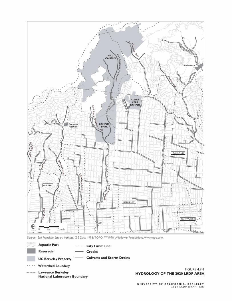
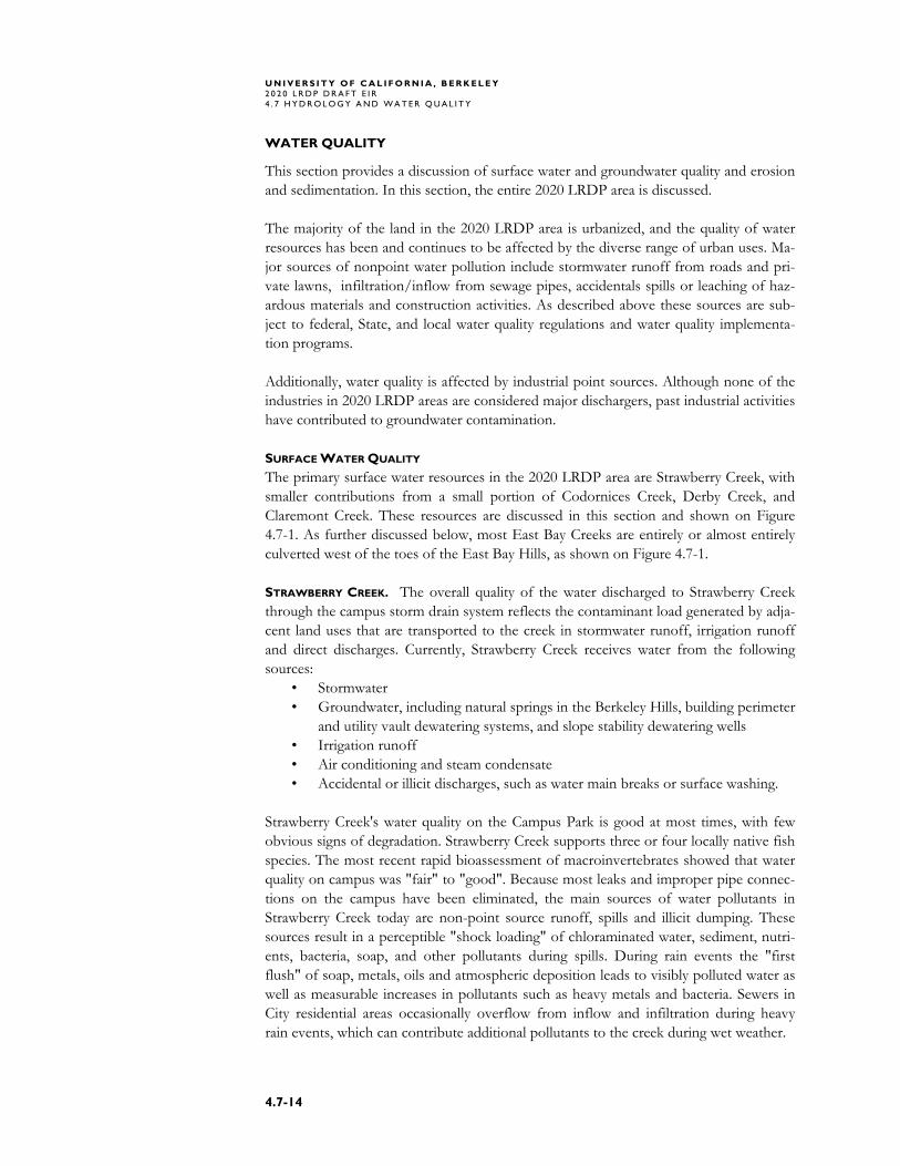
UC Berkeley is located at the edge of the Berkeley Hills, near the western edge of the Coast Range physiographic province. The hills are roughly parallel to the northwest-southeast trend of the major mountain ridges in the province with spur ridges and can-yons oriented perpendicular to main ridges. A ridge of relatively heavy rainfall -- up to 28 inches in an average year -- follows the trend of the hills along their north-south axis. In the local area, including the Campus Park, Hill Campus, Adjacent Blocks, and LRDP Housing Zone, rainfall is between 24 and 26 inches during an average year.14 In undeveloped, natural conditions (where human activity has a negligible effect on run-off), runoff quantities in the Berkeley vicinity tend to be relatively low (estimated to be between 4.5 and 5.5 inches per year or about 20 percent of the precipitation), despite the existence of some steep local topography. Runoff from a specific site is affected by slope gradient, soil depth and permeability, urbanization, impervious cover, land use, amount and type of vegetation and/or mulch, antecedent moisture conditions, and rainfall amount, intensity and duration. Intense and/or prolonged rainfall and steep slopes generally result in high runoff; an undis-turbed vegetative cover tends to capture and detain runoff, resulting in lower runoff volumes. Coarse-grained, sandy soils absorb more runoff than fine-grained silty or clayey soils. Deep soils generally have a greater retention capacity than shallow soils of similar composition. Runoff coefficients devised by the Natural Resources Conservation Service compare the estimated amounts of rainfall that become surface runoff. The higher the number, the greater the runoff for a given amount of rainfall. For undeveloped areas, runoff coeffi-cients commonly range from 0.10 to 0.40, depending on the relationship of the factors noted above. In developed suburban areas, runoff coefficients commonly range from 0.30 to 0.75 (single-family residential areas and multi-family areas). Industrial, commer-cial and urban residential areas have runoff coefficients ranging from 0.50 to 0.90.15 The following sections provide more detailed information on hydrology and drainage for the 2020 LRDP land use zones. CAMPUS PARK The Campus Park drains primarily into Strawberry Creek, which acts as both a stream and as part of the storm drain and flood control system for the Campus Park, Adjacent Blocks, Southside and most of the Hill Campus. Storm drains from Lawrence Berkeley National Laboratory (LBNL), the Campus Park and the City of Berkeley discharge into the creek.16 The drainage patterns on the Campus Park and entire LRDP area are shown in Figure 4.7-1. The Strawberry Creek watershed comprises approximately 1,163 acres. The most nota-ble drainage channels are the north and south forks of Strawberry Creek, which meet in the western portion of the Campus Park. The North Fork in the Hill Campus has also historically been known as Blackberry Creek, but because another historically-named Blackberry Creek runs through the North Berkeley portion of the LRDP Housing Zone, the North Fork Strawberry Creek will hereinafter be referred to only as the North Fork.
U N I V E R S I T Y O F C A L I F O R N I A , B E R K E L E Y 2 0 2 0 L R D P D R A F T E I R 4 . 7 H Y D R O L O G Y A N D W A T E R Q U A L I T Y
4.7-8
The runoff from the watershed reaches the City of Berkeley culvert at Oxford Street, and flows in an underground conduit along Allston and Center streets to Curtis Street before being diverted to University Avenue and west into San Francisco Bay.17 To ad-dress flooding concerns, bypass culverts have been installed on both the north and south forks of Strawberry Creek to carry extreme storm flows under developed areas. An earthen dam in the lower Hill Campus above and east of the Campus Park defines the South Fork earthen retention basin that controls downstream flooding. The reten-tion basin has a flood storage capacity of 1.5 million cubic feet (11 million gallons). The dam outlet – just west of the Lower Jordan Fire Trail access -- controls flow into the Big Inch and Little Inch bypass culverts by means of a 48-inch by 42-inch hydrauli-cally operated slide gate controlled from a station at the fire trail entrance. Gate opera-tion is supervised by UC Berkeley’s Facilities Services Utilities Manager.18 The Big Inch and Little Inch culverts pass under the Strawberry Canyon Recreation Area, California Memorial Stadium, Maxwell Family Field, Gayley Road, Girton Hall, and South Drive before the South Fork again daylights just north of the Women’s Faculty Club on the Campus Park. The City’s storm drain system at Oxford Street has been identified as deficient under existing conditions for a 25-year storm. The City of Berkeley reports that the capacity of the City storm drain at Oxford Street (where Strawberry Creek leaves the Campus) would be exceeded by 25 percent during a 25-year design storm event under existing conditions. Therefore, any new development on the Campus Park or Hill Campus that might increase stormwater runoff may cause flooding problems within the City’s drain system and along lower Campus Park elevations near the channel.19 Less than 60 percent of the Campus Park is impervious, including buildings, walkways, roads, and parking lots.20 This results in an existing runoff coefficient for the Campus Park of about 0.80, based on the degree of impervious surfaces, and the amount of vegetative ground cover. Most of the landscaped areas are auto-irrigated; one-third of the landscaped areas are monitored by a system that tracks soil moisture and weather to improve irrigation efficiency and decrease excess runoff.21
CodornicesCreek
VicenteCreek
North
Forkof Straw
berry
Creek
Claremont Creek
SchoolhouseCreek
Stra
wb
erry
Cree
k
Mar
in
Creek
Villa
geCr
eek
Sout
hFo
rkof
Stra
wbe
rry
Cree
k
BlackberryC
reek
Derby Creek
Lake Temescal
Berryman Reservoir
ALBANY
OAKLAND
EMERYVILLE
BERKELEY
CAMPUS PARK
CLARKKERR
CAMPUS
HILLCAMPUS
0 1/4 1/2 mileN O R T H
Creeks
Aquatic Park
Reservoir
City Limit Line
Source: San Francisco Estuary Institute, GIS Data, 1998; TOPO! ® ©1998 Wildflower Productions, www.topo.com.
UC Berkeley Property
Watershed Boundary
Culverts and Storm Drains
FIGURE 4.7-1
HYDROLOGY OF THE 2020 LRDP AREA
U N I V E R S I T Y O F C A L I F O R N I A , B E R K E L E Y
2 0 2 0 L R D P D R A F T E I R
Lawrence BerkeleyNational Laboratory Boundary
U N I V E R S I T Y O F C A L I F O R N I A , B E R K E L E Y 2 0 2 0 L R D P D R A F T E I R 4 . 7 H Y D R O L O G Y A N D W A T E R Q U A L I T Y
4.7-10
ADJACENT BLOCKS WEST AND NORTH The Adjacent Blocks West drains through culverts into lower Strawberry Creek in loca-tions west of the Campus Park. In this portion of the watershed, all overland flow is collected by curb-and-gutter systems and delivered through side inlets to the storm drainage culverts beneath local streets.22 The north fork of the creek is culverted in the Adjacent Blocks North, and daylights at the north campus edge. 23 ADJACENT BLOCKS SOUTH AND SOUTHSIDE The Southside drains to the Derby Creek watershed. Overland flow in this area is col-lected by curbs-and-gutters, side inlets and subsurface culverts for delivery to the San Francisco Bay.24 Derby Creek runs thru UC property at the north edge of the Smyth-Fernwald Housing. The creek then veers first northward, then southwesterly, running open and unculverted thru private backyards, then under a bridge on Hillside Avenue before dropping into a culvert inlet between Hillside and Prospect Avenues; the channel is culverted from there all the way to San Francisco Bay. In this area small parks interrupt the impervious surfaces of roads, walks, parking lots, playgrounds and structures, with the few exceptions being larger open space areas at Smyth-Fernwald, the Clark Kerr Campus, and Willard Junior High School. None of these contains daylit portions of Derby Creek.25 HILL CAMPUS The Hill Campus drains overland in natural drainage patterns along the western front of the Berkeley Hills. The eastern portions of the Hill Campus are characterized by numer-ous ephemeral channels. The western portions of the Hill Campus, like the Campus Park, contain both ephemeral tributaries and perennial streams flowing in well-defined, and – in some cases – partially improved channels such as the Hamilton and Chicken Creek tributaries to South Fork Strawberry Creek. Drainage from the northern part of the Hill Campus and LBNL is routed into both the north and south forks of Strawberry Creek, which lead eventually to the Oxford Street culvert.26 The southern part of the Hill Campus drains to Derby Creek, and also to Claremont Creek, sometimes known as North Fork Temescal Creek or Harwood Creek. 27 For the Hill Campus, the existing runoff coefficient is estimated to be about 0.60 due to steep slopes, relatively shallow soil cover and partially developed hillsides.28 LRDP HOUSING ZONE Generally, all of the 2020 LRDP Housing Zone is drained by a set of naturally occurring creeks flowing from the hills to the San Francisco Bay. Runoff is conveyed by street gutters to underground conduits, which drain into the creeks. Most of the creeks have been culverted; a few creek segments still flow above ground or have been daylit. BERKELEY. The portion of the 2020 LRDP Housing Zone located in Berkeley drains to Blackberry (aka Middle) Creek, Codornices Creek, Lincoln Creek, Schoolhouse Creek, Marin Creek, Strawberry Creek, Potter Creek and Derby Creek. West of the toe of East Bay Hills, Berkeley’s creeks are contained within underground drain culverts – with the exception of Blackberry Creek, Strawberry Creek and Codornices Creek, each of which has naturally open or daylit reaches. Open creek reaches are typically armored against course changes to protect adjacent development both on- and off-campus.
U N I V E R S I T Y O F C A L I F O R N I A , B E R K E L E Y 2 0 2 0 L R D P D R A F T E I R
4 . 7 H Y D R O L O G Y A N D W A T E R Q U A L I T Y
4.7-11
OAKLAND. Surface drainage in the Oakland portion of the 2020 LRDP Housing Zone is controlled by a combination of natural creeks and human-made stormwater drainage facilities. The portion of the 2020 LRDP Housing Zone located in Oakland drains to Claremont Creek and Temescal Creek. Temescal Creek, which is channelized and largely culverted, drains Lake Temescal in the Oakland foothills and flows to the San Francisco Bay. 29 FLOODING
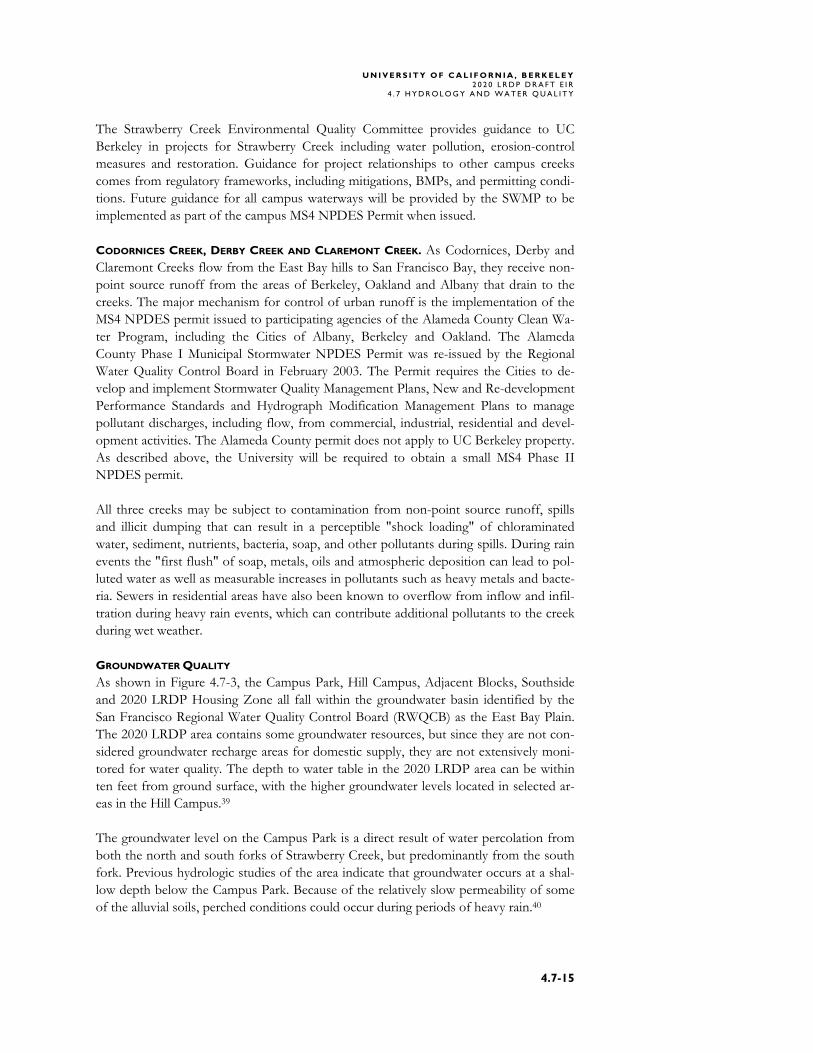
This section describes existing flooding potential in the Campus Park, Adjacent Blocks, Southside, Hill Campus and the 2020 LRDP Housing Zone. Figure 4.7-2 shows the areas which are subject to 100-year flood events according to the Federal Emergency Management Agency (FEMA). CAMPUS PARK According to the FEMA, most of the Campus Park lies within areas of minimal flood-ing potential. Areas lying within the 100-year flood zone are adjacent to Strawberry Creek, as shown in Figure 4.7-2. Higher peak flood stages are caused by an increase in impervious surface area, stormwater routing and channel confinement. Overtopping of confined creek banks normally occurs in several areas where low rock walls border curb areas. There is potential for this to occur in the areas near the Valley Life Sciences Build-ing, Life Sciences Addition, and Dwinelle Hall Annex.30 Strawberry Creek severely flooded in 1962, after which UC Berkeley implemented flood control measures. Since then, there has been little flooding on Strawberry Creek except in very high flow years. The creek reportedly did overtop its banks near the Oxford Street culvert in 1995, causing water to flow onto Oxford Street. The 1995 flooding event was caused by obstruction upstream, and was not directly related to the size of the Oxford Street culvert, but resulted from the creek overflowing its banks toward Oxford Street.31 ADJACENT BLOCKS, SOUTHSIDE AND HILL CAMPUS Neither the Adjacent Blocks, Southside, nor the Hill Campus are within any 100-year flood zone. However, in 1996, the earthen detention dam in Strawberry Canyon over-flowed, flooding Hearst Memorial Stadium and the Haas Clubhouse pool with mud. It is believed that this overflow could be attributed to a debris blockage in the dam outlet, rather than the dam being overwhelmed.32 LRDP HOUSING ZONE BERKELEY. Flooding hazards in the portion of the 2020 LRDP Housing Zone located in Berkeley are principally due to the potential for Strawberry Creek and Codornices Creek to overtop their banks, and to the potential failure of the Berryman and Summit Reser-voirs. Strawberry Creek poses a flood hazard for downtown Berkeley, immediately west of Oxford Street. In a heavy rainfall event, if runoff volumes cannot be adequately con-veyed by the existing storm drainage facilities, flooding may occur.33 Codornices Creek poses a flood hazard for North Berkeley along Hopkins Street, which is in the creek’s 100-year flood zone. Additionally, the areas west of the Berryman and Summit Reservoirs could be affected by inundation. The Summit Reservoir, located on the border of Kensington and Berke-
U N I V E R S I T Y O F C A L I F O R N I A , B E R K E L E Y 2 0 2 0 L R D P D R A F T E I R 4 . 7 H Y D R O L O G Y A N D W A T E R Q U A L I T Y
4.7-12
ley, would affect areas along Berkeley’s border between Grizzly Peak Boulevard and The Alameda. This includes a portion of the LRDP area. The Berryman Reservoir in eastern Berkeley could potentially inundate a large portion of Berkeley, including neighborhoods along Hopkins Street, in north Berkeley in an area which is located in the LRDP Hous-ing Zone. Rain overflow is not an issue at either the Berryman or Summit Reservoirs because rain does not enter reservoir since both have roofs.34 A seismic analysis of the Summit Reservoir performed by EBMUD in 1985, and ap-proved by the California Division of Safety of Dams, concludes that the dam will per-form satisfactorily in the event of a maximum credible earthquake on either the Hay-ward Fault (Magnitude 7.5) or the San Andreas Fault (Magnitude 8.5).35 The possibility of inundation from the Berryman Reservoir will be reduced by the ap-proved EBMUD project to replace the Berryman Reservoir with one 4.6 million gallon steel tank or alternatively two smaller tanks depending on geotechnical conditions en-countered once the reservoir is drained.36 EBMUD plans to start draining the reservoir in early 2004.37 OAKLAND. Flood hazards near the 2020 LRDP Housing Zone in Oakland are associated with overbank flooding of Temescal Creek. As shown in Figure 4.7-2, the LRDP Hous-ing Zone located in Oakland would not be subject to a 100-year flood hazard from Te-mescal Creek.38
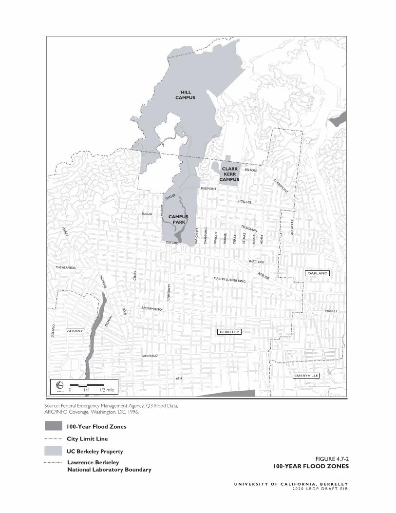
DW
IGH
T
PAR
KER
UN
IVER
SIT
Y
DER
BY
STU
ART
CH
AN
NIN
G
BA
NC
ROFT
HEA
RST
CED
AR
GIL
MA
N
SOLA
NO
HO
PKIN
S
RUSS
ELL
ASH
BY
THE ALAMEDA
6TH
COLLEGE
PIEDMONT
BELROSE
TELEGRAPH
SHATTUCK
MARKET
OXFORD
EUCLID
SACRAMENTO
SAN PABLO
MARTIN LUTHER KING
ADELINE
CLAREMONT
ALC
ATR
AZ
GAYLEY
ROSE
MA
RINALBANY
OAKLAND
EMERYVILLE
BERKELEY
0 1/4 1/2 mileN O R T H
100-Year Flood Zones
City Limit Line
CAMPUS PARK
CLARKKERR
CAMPUS
HILLCAMPUS
UC Berkeley Property
Source: Federal Emergency Management Agency, Q3 Flood Data, ARC/INFO Coverage, Washington, DC, 1996.
Lawrence BerkeleyNational Laboratory Boundary
FIGURE 4.7-2
100-YEAR FLOOD ZONES
U N I V E R S I T Y O F C A L I F O R N I A , B E R K E L E Y
2 0 2 0 L R D P D R A F T E I R
U N I V E R S I T Y O F C A L I F O R N I A , B E R K E L E Y 2 0 2 0 L R D P D R A F T E I R 4 . 7 H Y D R O L O G Y A N D W A T E R Q U A L I T Y
4.7-14
WATER QUALITY
This section provides a discussion of surface water and groundwater quality and erosion and sedimentation. In this section, the entire 2020 LRDP area is discussed. The majority of the land in the 2020 LRDP area is urbanized, and the quality of water resources has been and continues to be affected by the diverse range of urban uses. Ma-jor sources of nonpoint water pollution include stormwater runoff from roads and pri-vate lawns, infiltration/inflow from sewage pipes, accidentals spills or leaching of haz-ardous materials and construction activities. As described above these sources are sub-ject to federal, State, and local water quality regulations and water quality implementa-tion programs. Additionally, water quality is affected by industrial point sources. Although none of the industries in 2020 LRDP areas are considered major dischargers, past industrial activities have contributed to groundwater contamination. SURFACE WATER QUALITY The primary surface water resources in the 2020 LRDP area are Strawberry Creek, with smaller contributions from a small portion of Codornices Creek, Derby Creek, and Claremont Creek. These resources are discussed in this section and shown on Figure 4.7-1. As further discussed below, most East Bay Creeks are entirely or almost entirely culverted west of the toes of the East Bay Hills, as shown on Figure 4.7-1. STRAWBERRY CREEK. The overall quality of the water discharged to Strawberry Creek through the campus storm drain system reflects the contaminant load generated by adja-cent land uses that are transported to the creek in stormwater runoff, irrigation runoff and direct discharges. Currently, Strawberry Creek receives water from the following sources:
• Stormwater • Groundwater, including natural springs in the Berkeley Hills, building perimeter
and utility vault dewatering systems, and slope stability dewatering wells • Irrigation runoff • Air conditioning and steam condensate • Accidental or illicit discharges, such as water main breaks or surface washing.
Strawberry Creek's water quality on the Campus Park is good at most times, with few obvious signs of degradation. Strawberry Creek supports three or four locally native fish species. The most recent rapid bioassessment of macroinvertebrates showed that water quality on campus was "fair" to "good". Because most leaks and improper pipe connec-tions on the campus have been eliminated, the main sources of water pollutants in Strawberry Creek today are non-point source runoff, spills and illicit dumping. These sources result in a perceptible "shock loading" of chloraminated water, sediment, nutri-ents, bacteria, soap, and other pollutants during spills. During rain events the "first flush" of soap, metals, oils and atmospheric deposition leads to visibly polluted water as well as measurable increases in pollutants such as heavy metals and bacteria. Sewers in City residential areas occasionally overflow from inflow and infiltration during heavy rain events, which can contribute additional pollutants to the creek during wet weather.
U N I V E R S I T Y O F C A L I F O R N I A , B E R K E L E Y 2 0 2 0 L R D P D R A F T E I R
4 . 7 H Y D R O L O G Y A N D W A T E R Q U A L I T Y
4.7-15
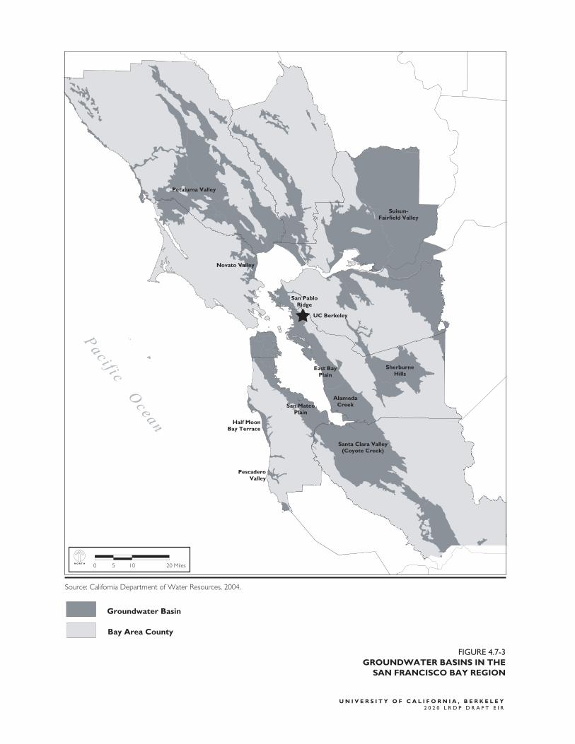
The Strawberry Creek Environmental Quality Committee provides guidance to UC Berkeley in projects for Strawberry Creek including water pollution, erosion-control measures and restoration. Guidance for project relationships to other campus creeks comes from regulatory frameworks, including mitigations, BMPs, and permitting condi-tions. Future guidance for all campus waterways will be provided by the SWMP to be implemented as part of the campus MS4 NPDES Permit when issued. CODORNICES CREEK, DERBY CREEK AND CLAREMONT CREEK. As Codornices, Derby and Claremont Creeks flow from the East Bay hills to San Francisco Bay, they receive non-point source runoff from the areas of Berkeley, Oakland and Albany that drain to the creeks. The major mechanism for control of urban runoff is the implementation of the MS4 NPDES permit issued to participating agencies of the Alameda County Clean Wa-ter Program, including the Cities of Albany, Berkeley and Oakland. The Alameda County Phase I Municipal Stormwater NPDES Permit was re-issued by the Regional Water Quality Control Board in February 2003. The Permit requires the Cities to de-velop and implement Stormwater Quality Management Plans, New and Re-development Performance Standards and Hydrograph Modification Management Plans to manage pollutant discharges, including flow, from commercial, industrial, residential and devel-opment activities. The Alameda County permit does not apply to UC Berkeley property. As described above, the University will be required to obtain a small MS4 Phase II NPDES permit. All three creeks may be subject to contamination from non-point source runoff, spills and illicit dumping that can result in a perceptible "shock loading" of chloraminated water, sediment, nutrients, bacteria, soap, and other pollutants during spills. During rain events the "first flush" of soap, metals, oils and atmospheric deposition can lead to pol-luted water as well as measurable increases in pollutants such as heavy metals and bacte-ria. Sewers in residential areas have also been known to overflow from inflow and infil-tration during heavy rain events, which can contribute additional pollutants to the creek during wet weather. GROUNDWATER QUALITY As shown in Figure 4.7-3, the Campus Park, Hill Campus, Adjacent Blocks, Southside and 2020 LRDP Housing Zone all fall within the groundwater basin identified by the San Francisco Regional Water Quality Control Board (RWQCB) as the East Bay Plain. The 2020 LRDP area contains some groundwater resources, but since they are not con-sidered groundwater recharge areas for domestic supply, they are not extensively moni-tored for water quality. The depth to water table in the 2020 LRDP area can be within ten feet from ground surface, with the higher groundwater levels located in selected ar-eas in the Hill Campus.39 The groundwater level on the Campus Park is a direct result of water percolation from both the north and south forks of Strawberry Creek, but predominantly from the south fork. Previous hydrologic studies of the area indicate that groundwater occurs at a shal-low depth below the Campus Park. Because of the relatively slow permeability of some of the alluvial soils, perched conditions could occur during periods of heavy rain.40
U N I V E R S I T Y O F C A L I F O R N I A , B E R K E L E Y 2 0 2 0 L R D P D R A F T E I R 4 . 7 H Y D R O L O G Y A N D W A T E R Q U A L I T Y
4.7-16
Abundant amounts of groundwater occur on the Hill Campus because of the Hayward fault, which acts as a dam between the Hill Campus hydrologic systems and the Campus Park and the Hill Campus. However, movement along the Hayward fault has cut off westward percolation of the groundwater. Groundwater depths vary and are influenced by time of the year and geologic factors such as seepage barriers, faults, and formational contacts previously mentioned. Spring is generally a time when groundwater levels are high in the shallow, “perched” aquifers, whereas the water table is lower in summer and autumn.41 One portion of interconnected groundwater sources beneath the East Bay plain is known to underlay the northwestern Hill Campus.42 The Hill Campus lenses of Moraga soils do not absorb water loading well, and tend towards instability when overly wet. Such instabilities were first noted in the late 1960s. In 1975, the Campus installed Shively Well #1 and a pump near the Silver Space Sciences Lab. Moisture overburden-ing of the soils can result in soil movements, leading in turn to increased sediment con-tamination of surface waters.43 MONITORING CONTAMINANTS IN CAMPUS GROUNDWATER. The Office of Environment, Health and Safety (EH&S) is the campus administrative unit responsible for coordinat-ing monitoring and remediation of contaminants in soil and groundwater. Known or suspect areas of soil and groundwater contamination are sampled by hand-auger or drill-rig drilled borings. Where necessary, groundwater monitoring wells are installed to monitor the stability of any groundwater contamination over time. Currently, three campus locations have monitoring wells installed: 1952-1990 Oxford Street, 2000 Carleton, and the former Canyon Chemical Facility (currently the Plant Conservation Research Center). In addition, groundwater containing low-level tritium contamination may be migrating from within the LBNL site through some groundwater lenses and in some cases discharging into local surface waters. Results of supplemental surface water sampling performed by LBNL for tritium in 2001 and 2002 found that tritium was well below the drinking water maximum contaminant level (MCL) for trit-ium which is 740 Bq/L (20,000 pCi/L). Tritium was found above the reporting limit of 7.4 Bq/Liter (L) (200 pCi/L) in most of the surface water samples collected from upper and lower Chicken Creek and in three monthly samples collected from the North Fork of Strawberry Creek between October 2001 and April 2002. Tritium was below the reporting limit at all other surface water sampling locations, in-cluding the two background locations; Strawberry Creek on the UC Berkeley campus; and the outfall of Strawberry Creek to San Francisco Bay. Following the completion of the supplemental sampling, the US/EPA announced in July 2002 that the environmental sampling at the Berkeley Lab found tritium levels well below federal health standards, and it decided that no further action was required under the Superfund program44. The most recent sampling of groundwater from the CCF site found no chemical contamina-tion and tritium at background levels. Residual petroleum contamination is present at 1952-1990 Oxford St. and 2000 Carleton, both former petroleum fueling locations. A request for no further action has been approved by the Regional Board for UC Berke-ley’s 2000 Carleton Facility and is currently under regulatory review for 1952-1990 Ox-ford Street.
U N I V E R S I T Y O F C A L I F O R N I A , B E R K E L E Y 2 0 2 0 L R D P D R A F T E I R
4 . 7 H Y D R O L O G Y A N D W A T E R Q U A L I T Y
4.7-17
EROSION AND SEDIMENTATION Erosion and sedimentation occur naturally or have been exacerbated by near-by devel-opment along non-culverted sections of creeks in the 2020 LRDP area, including Codornices, Strawberry, Derby, and Claremont Creeks and their tributaries. There is limited or no data on the effects of erosion in Codornices, Derby, and Claremont Creeks, particularly in the LRDP area, but there is extensive data on erosion issues for Strawberry Creek, which is described below. Erosion has been a problem for Strawberry Creek due to extensive undercutting of streambanks at the footings for bridges, utility overcrossings, and retaining walls. This erosion threatens bank collapse and possible structural failure. The undercutting and erosion of streambanks led to efforts to channelize and confine Strawberry Creek. The increase in impervious surface area associated with urbanization resulted in increased storm runoff and shorter time of concentration for peak flows. Lag times between pre-cipitation and runoff are estimated to have been reduced by half over natural conditions, while peak runoff has increased significantly. These changes resulted in significant chan-nel downcutting (vertical erosion) by the early 1900s. In response, in order to stop downcutting, small reaches of the creek were lined with concrete as long ago as 1907, and various channel stabilization/alteration projects con-tinued into the 1960s, with repairs continuing to the present.45 The check dams have been effective in preventing major channel incision, and without the check dams the unstable channels would rapidly deepen. Repairs of these erosion control structures are reviewed by the Strawberry Creek Environmental Quality Committee which continues to implement water quality, restoration, and improvement programs through the Straw-berry Creek Management Plan in order to address the erosion and bank stabilization issue of the creek. The Strawberry Creek Management Plan is discussed in more detail later in this chapter. WASTEWATER DISCHARGE As discussed in the Utilities section of this document, campus wastewater (i.e. sanitary sewer flows) is treated by EBMUD’s wastewater treatment plant in Oakland. Treated effluent from this plant is discharged one mile off the East Bay shoreline through a deepwater outfall in the San Francisco Bay. Limitations on the wastewater discharges are regulated under EBMUD’s Ordinance 311 and the campus wastewater discharge permit. UC Berkeley has implemented a number of programs to assure compliance with waste-water discharge requirements, including a coordinated response to sanitary sewer spills, inspecting chemical use areas, drain disposal guidelines and training for photo and re-search laboratories, shops, physical plant maintenance and construction activities. EB-MUD regularly samples wastewater for metals and volatile chemical analysis.
Santa Clara Valley(Coyote Creek)
San MateoPlain
AlamedaCreek
Half MoonBay Terrace
East BayPlain
PescaderoValley
SherburneHills
San PabloRidge
Suisun-Fairfield Valley
Novato Valley
Petaluma Valley
0 10 205 MilesN O R T H
Pacif ic O
cean
UC Berkeley
Groundwater Basin
Bay Area County
Source: California Department of Water Resources, 2004.
FIGURE 4.7-3
GROUNDWATER BASINS IN THESAN FRANCISCO BAY REGION
U N I V E R S I T Y O F C A L I F O R N I A , B E R K E L E Y2 0 2 0 L R D P D R A F T E I R
U N I V E R S I T Y O F C A L I F O R N I A , B E R K E L E Y 2 0 2 0 L R D P D R A F T E I R
4 . 7 H Y D R O L O G Y A N D W A T E R Q U A L I T Y
4.7-19
UC BERKELEY POLLUTION PREVENTION RECORD. EBMUD samples effluent flows and inspects research and photo laboratories. There have been no violations found by EB-MUD at UC Berkeley since 2000. Prior to that time, campus wastewater occasionally had chlorinated hydrocarbon concentrations that were over the effluent limits for total identifiable chlorinated hydrocarbons, but these discharges have been significantly re-duced and now fall well below the limit. In 2004 UC Berkeley received a “Certificate of Merit for Outstanding Achievement” from the California Water Environment Associa-tion for its efforts to protect water quality. 46 In 2003, the campus was one of two honorees to be awarded EBMUD’s Pollution Prevention Award for “exemplary performance in com-plying with discharge requirements.”47 HYDROLOGIC SETTING OF THE TIEN CENTER SITE The proposed Tien Center would be located on a moderately sloped portion of the Campus Park uphill east of the Campus Park’s unculverted North Fork reaches. At its closest point, the Tien Center’s Phase 1 structure would be approximately 200 feet from the creek bank. The closest corner of the proposed Phase 2 structure would be ap-proximately 100 feet from the nearest creek point. Both buildings would be sufficiently upslope to be well out of the North Fork floodplain; no historical record exists of flood-ing in the Northside area. Runoff in the site area is typical of Campus developed sites, and the site is accordingly generally well-served by extant storm drainage systems. 4.7.5 STANDARDS OF SIGNIFICANCE The significance of the potential impacts of the 2020 LRDP and Tien Center on hydrol-ogy and water quality was determined based on the following standards: Standard: Would the project violate any water quality standards or waste discharge
requirements? Standard: Would the project create or contribute runoff water which would exceed
the capacity of existing or planned stormwater drainage systems or pro-vide substantial additional sources of polluted runoff?
Standard: Would the project substantially deplete groundwater supplies or quality,
or interfere substantially with groundwater recharge such that there would be a net deficit in aquifer volume or a lowering of the local groundwater table level (e.g. the production rate of pre-existing nearby wells would drop to a level which would not support existing land uses or planned uses for which permits have been granted)?
Standard: Would the project substantially alter existing drainage patterns of the
site or area, including through the alteration of the course of a stream or river, or substantially increase the rate or amount of surface runoff in a manner which would result in substantial erosion, siltation or flooding on- or off- site?
Standard: Would the project otherwise substantially degrade water quality?
U N I V E R S I T Y O F C A L I F O R N I A , B E R K E L E Y 2 0 2 0 L R D P D R A F T E I R 4 . 7 H Y D R O L O G Y A N D W A T E R Q U A L I T Y
4.7-20
Standard: Would the project place housing within a 100-year flood hazard area as mapped on a federal Flood Hazard Boundary or Flood Insurance Rate Map or other flood hazard delineation map?
Standard: Would the project place within a 100-year flood hazard area structures
which would impede or redirect flood flows? Standard: Would the project expose people or structures to a significant risk of
loss, injury or death involving flooding, including flooding as a result of the failure of a levee or dam?
Standard: Would the project create development subject to inundations by sei-
ches, tsunamis, or mudflows? 4.7.6 POLICIES AND PROCEDURES GUIDING FUTURE PROJECTS This section describes existing policies and procedures that would help to minimize hy-drology impacts of development under the 2020 LRDP. It discusses both the policies in the 2020 LRDP itself and other University policies and practices relevant to hydrology. 2020 LRDP
Hydrology and water quality impacts of projects proposed under the 2020 LRDP would be reduced by policies guiding the location, scale, form and design of new University projects. While several of the LRDP Objectives described in Chapter 3.1 bear directly or indirectly on hydrology and water quality, three are particularly relevant. Plan every new project to serve as a model of resource conservation and envi-
ronmental stewardship. Maintain and enhance the image and experience of the campus, and pre-
serve our historic legacy of landscape and architecture. Maintain the Hill Campus as a natural resource for research, education, and
recreation, with focused development on suitable sites. The 2020 LRDP includes a number of policies and procedures for individual project review to support these Objectives. For each new project to serve as a model of re-source conservation and environmental stewardship, the 2020 LRDP envisions develop-ing a campus standard for sustainable design specific to its site, climate, and facility in-ventory. The Campus Park Framework and Guidelines in the 2020 LRDP include poli-cies to preserve and protect significant Campus Park natural areas and open spaces, in-cluding the riparian habitats along Strawberry Creek. To maintain the Hill Campus as a natural resource, the 2020 LRDP envisions: establish-ing a management authority for the Ecological Study Area; ensuring the future manage-ment of, and investments in, the Ecological Study Area and the Botanical Garden are integrated and synergetic; maintaining the visual primacy of the natural landscape in the Hill Campus; and managing the Hill Campus landscape to reduce fire risk and restore native vegetation patterns.
U N I V E R S I T Y O F C A L I F O R N I A , B E R K E L E Y 2 0 2 0 L R D P D R A F T E I R
4 . 7 H Y D R O L O G Y A N D W A T E R Q U A L I T Y
4.7-21
STRAWBERRY CREEK MANAGEMENT PLAN
The Strawberry Creek Restoration Program began in 1987, in response to campus and community concerns over the deteriorated environmental quality of Strawberry Creek. The campus Office of Environmental Health and Safety (EH&S) sponsored a compre-hensive study of the creek with the results of the study, completed by Robert Charbon-neau, published in December 1987 as the "Strawberry Creek Management Plan" (SCMP). The SCMP study began as a water quality management plan but ultimately expanded into a comprehensive study of the watershed with a focus on overall urban creek and riparian habitat preservation and restoration.48 The Plan provides recommendations for implementation of management strategies for point and non-point source pollution con-trol, channel stabilization, aquatic and riparian habitat restoration and watershed man-agement. An advisory committee, the Strawberry Creek Environmental Quality Com-mittee (SCEQC), consisting of faculty, staff from campus planning and operations de-partments, and students, was created to help direct restoration activities including ero-sion control and bank stabilization, sanitary engineering and point source investigations, public outreach and other activities Implementation of the SCMP from 1987 through the present successfully led to sub-stantially improved overall water quality conditions, enhanced ecological integrity as measured by biological criteria (macroinvertebrates and fish), increased environmental education for students and the campus public, and stabilization of the most critical cen-tral campus and upper canyon erosion sites. Implementation of the SCMP continues and the SCEQC meets regularly. The SCMP is currently being updated to reflect substantial changes in water quality and changes in applicable regulatory law since 1987 and to revise restoration goals and objectives.. While the plan still specifically excludes other campus creeks (i.e., Derby and Clare-mont), it has been developed cooperatively with input from faculty, EH&S scientists, a fire management planner, an environmental planner, and a grounds maintenance supervisor to provide holistic and comprehensive approaches to creek and watershed management. The SCMP is being updated concurrent with the 2020 Hill Area Fire Fuel Management Plan (HAFFMP) and the 2020 LRDP to ensure a coordinated long-range approach to watershed management. Thus, all projects that may occur under the 2020 LRDP will be informed by three integrated policy and management tools to protect resources and beneficial uses, as well as by adjacent jurisdictions’ creek and watershed programs and codes. CAMPUS POLICIES AND PROCEDURES
STORMWATER BEST MANAGEMENT PRACTICES Although not yet regulated under NPDES Phase II requirements, UC Berkeley has im-plemented a number of practices to protect water quality, including many practices rec-ommended in the Strawberry Creek Management Plan. Waterways are regularly moni-tored, illicit discharges are rerouted to the sanitary sewer and a number of agency stan-dard and innovative BMPs for minimizing the amount of pollutants entering down-stream receiving waters have been implemented, such as training for maintenance and operations staff, development and implementation of the Sewage Spill Response Plan, point source investigation, regular street sweeping, 24-hour spill reporting hotline and a
U N I V E R S I T Y O F C A L I F O R N I A , B E R K E L E Y 2 0 2 0 L R D P D R A F T E I R 4 . 7 H Y D R O L O G Y A N D W A T E R Q U A L I T Y
4.7-22
prohibition of discharging wastewater from exterior building washing operations into the storm drain. In compliance with the recently implemented Clean Water Act National Pollutant Dis-charge Elimination System Phase II requirements, UC Berkeley developed a Stormwater Management Plan and submitted the requisite permit application for municipal separate storm sewer system (MS4) discharges but is awaiting designation as a permittee and ap-proval of the SWMP by the RWQCB. The SWMP was developed under the guidance of a SWMP committee which included members of the campus community, neighboring residents, and stormwater experts and outlines a 5-year plan to address water quality and water quantity issues from day to day operations as well as construction activities dis-turbing less than one acre of soil. EH&S also facilitates the Strawberry Creek Environmental Quality Committee, a for-mally-constituted and faculty-led multi-unit campus committee. Since 1987, the SCEQC has guided creek restoration efforts, graduate and undergraduate research activities as-sociated with the creek, and campus policy and program development in the interest of protecting Strawberry Creek’s beneficial uses and hydrologic and habitat viability. While this committee is focused solely on Strawberry Creek, its policies, recommendations, and data resources often inform campus practices regarding other campus hydrology. The many campus academic and administrative units represented on the SCEQC often cooperate to improve the resources upon which hydrologic policies and guidelines are based. A recent survey by three campus administrative units produced the first Campus Park riparian zone vegetation map in many decades; that map is now being imported into the Campus geographic information system (GIS) by faculty and students, to be available to the entire campus community as a reliable data source. The use of modern digital technology is an example of an innovative BMP, in that GIS reduces the time and labor costs of updating data and allows extensive or universal sharing to enhance and improve hydrologic management. Construction projects that disturb more than one acre of soil must comply with the General Construction Permit issued by the State Water Resources Control Board which requires the development and implementation of a site specific Stormwater Pollution Prevention Plan (SWPPP). To capture smaller project impacts, EH&S requires all con-struction projects that disturb less than one acre of soil but that have the potential to impact surface water quality to develop a site specific SWPPP. These SWPPPs contain BMPs to reduce or eliminate polluted discharges from the construction site such as fre-quent street sweeping, surface washing wastewater discharge prohibition, berm and sump systems to contain dirty wash-water and rainwater, and frequent inspections by EH&S to verify implementation of the SWPPP. UC Berkeley has created Stormwater Pollution Prevention Specification 02210, which includes by reference the federal Clean Water Act, the California Porter-Cologne Clean Water Act, the San Francisco Bay Basin (Region 2) Water Quality Control Plan 1995 Edition, the “Manual of Standards for Erosion and Sediment Control” of the Associa-tion of Bay Area Governments, and all other relevant regulatory codes. Section 02201 is typically included in all large or outdoor UC Berkeley construction contracts. Section 02210 requires that each such project develop a Stormwater Pollution Prevention Plan
U N I V E R S I T Y O F C A L I F O R N I A , B E R K E L E Y 2 0 2 0 L R D P D R A F T E I R
4 . 7 H Y D R O L O G Y A N D W A T E R Q U A L I T Y
4.7-23
(SWPPP).Small and interior projects are reviewed for their potential to discharge pollut-ants to surface water and only include Section 02210 in their contracts if the potential exists (such as exterior surface cleaning). UC Berkeley finds education to be a highly effective BMP. Under the leadership of EH&S, staff training, creek tours, creek clean-up volunteer events, similar events and tours of bay shorelines, and undergraduate seminars are offered both to students and to the general public. EH&S cooperates with local hydrology-focused non-governmental organizations (NGOs) in teaching, clean-up, and restoration efforts, working with those NGOs to secure grants and volunteer support for such efforts. PLAN CHECK REVIEW FOR WATER QUALITY PROTECTION UC Berkeley EH&S and Facilities Services consider a variety of potential impacts to surface water, groundwater, and wastewater as a standard part of its construction project development and plan check review process. As appropriate to the project, the review process may include checks on dewatering activities, possible project related pollutants, and general compliance with SWMP/SWPPP requirements. WASTEWATER DISCHARGES BEST PRACTICES In the early 1990s, the University of California, Berkeley established a Wastewater Qual-ity Program to manage discharges to the sanitary sewers using innovative educational outreach and waste minimization incentives that has served as a model for the Colleges and Universities Sector. In 1990 the Campus instituted the Drain Disposal Policy that prohibits use of the drains for disposal of hazardous chemicals. In support of the policy, the Campus Drain Disposal Guidelines were created by the Hazardous Waste Manage-ment Committee that included faculty experts in wastewater treatment, in consultation with EBMUD Source Control staff. The Guidelines provide campus researchers with a framework to design experiments to minimize the generation of hazardous wastes that need to be shipped off-site while at the same time presenting prohibitions for discharge of priority pollutants and information on environment fate and impacts of improper hazardous waste disposal. The Wastewater Quality Program also includes educational outreach to staff and stu-dents, labeling of sinks and has awarded waste minimization grants to support efforts of hazardous waste reduction and pollution prevention. The program’s success at prevent-ing pollution was recognized in 2003 when the campus was one of two honorees to be awarded EBMUD’s Pollution Prevention Award for “exemplary performance in com-plying with discharge requirements”. In order to eliminate mercury spills into sinks on campus, in 2003 UC Berkeley, in co-operation with EBMUD, developed the Mercury Free UCB program, a mercury reduc-tion pilot study for educational institutions, funded by a Pollution Prevention Grant from the US EPA. The program is designed to reduce the use of mercury containing devices on campus through the free exchange and disposal of mercury containing de-vices, as well as other outreach tools on mercury pollution prevention.
U N I V E R S I T Y O F C A L I F O R N I A , B E R K E L E Y 2 0 2 0 L R D P D R A F T E I R 4 . 7 H Y D R O L O G Y A N D W A T E R Q U A L I T Y
4.7-24
4.7.7 2020 LRDP IMPACTS This section describes the potential hydrologic and water quality impacts of the 2020 LRDP, based on the Standards of Significance, whether they are significant or less than significant, and whether any significant impacts can be mitigated to less than significant levels. EFFECTS FOUND NOT TO BE SIGNIFICANT
The Initial Study found the 2020 LRDP would have no significant impact in regard to the following thresholds: Would the project place housing within a 100-year flood hazard area as
mapped on a federal Flood Hazard Boundary or Flood Insurance Rate Map or other flood hazard delineation map?
Would the project expose people or structures to a significant risk of
loss, injury or death involving flooding, including flooding as a result of the failure of a levee or dam?
Would the project create development subject to inundations by sei-
ches, tsunamis, or mudflows? As described in the Initial Study and Notice of Preparation for the 2020 LRDP and Tien Center project, the 2020 LRDP would not construct housing within a 100- or 500- year flood zone. The Tien Center and the implementation area of the 2020 LRDP are outside the inundation hazard area for Berryman Reservoir and would thus not expose people or structures to risk of loss, injury or death involving failure of a levee or dam. Risk of inundation by seiches, tsunamis or mudflows was also found to be low, given the eleva-tion of the Campus Park and the Hill Campus. Therefore, these topics were found not to warrant additional analysis in this EIR.49 LESS THAN SIGNIFICANT IMPACTS
LRDP Impact HYD-1: Implementation of the 2020 LRDP would not violate existing water quality standards or wastewater discharge requirements, given the provisions of the 2020 LRDP and campus best practices.
Development proposed in the 2020 LRDP, including additional academic, research, support, and residential uses, will be similar to existing campus land uses. Therefore discharges associated with these land uses and the characterization of both stormwater and wastewater is not expected to change. UC Berkeley will continue to enforce the drain disposal guidelines and all NPDES regulations. The development proposed in the 2020 LRDP could increase the amount of wastewater generated by the campus. Since the campus does not directly discharge wastewater into a water body, it does not have an NPDES permit for wastewater discharge.. EBMUD regulates UC Berkeley’s wastewater discharge to their treatment plant through a source control program designed to insure compliance with their NPDES permit conditions. UC Berkeley is required to comply with conditions of EBMUD’s Ordinance 311 and the
U N I V E R S I T Y O F C A L I F O R N I A , B E R K E L E Y 2 0 2 0 L R D P D R A F T E I R
4 . 7 H Y D R O L O G Y A N D W A T E R Q U A L I T Y
4.7-25
Main Campus Wastewater Discharge Permit issued by EBMUD’s Source Control Divi-sion and applicable to all campus laboratory, construction and municipal operations. As mentioned above, UC Berkeley has submitted a draft Stormwater Management Plan (SWMP) to the RWQCB in compliance with the NPDES Phase II municipal permit requirements but is awaiting designation as a permittee and approval of the SWMP by the RWQCB. Given continuing campus compliance with all water quality and wastewa-ter discharge regulatory requirements, and given continuing implementation and im-provement of innovative campus programs to protect water quality, this would be a less than significant impact.
Continuing Best Practice HYD-1-a: During the plan check review proc-ess and construction phase monitoring, UC Berkeley (EH&S) will verify that the proposed project complies with all applicable requirements and BMPs. Continuing Best Practice HYD-1-b: UC Berkeley shall continue imple-menting an urban runoff management program containing BMPs as pub-lished in the Strawberry Creek Management Plan, 50 and as developed through the campus municipal Stormwater Management Plan completed for its pending Phase II MS4 NPDES permit. UC Berkeley will continue to comply with the NPDES stormwater permitting requirements by im-plementing construction and post construction control measures and BMPs required by project-specific SWPPPs and, upon its approval, by the Phase II SWMP to control pollution. Stormwater Pollution Prevention Plans would be prepared as required by the appropriate regulatory agencies including the Regional Water Quality Control Board and where applicable, according to the UC Berkeley Stormwater Pollution Prevention Specifica-tion to prevent discharge of pollutants and to minimize sedimentation re-sulting from construction and the transport of soils by construction vehicles. Continuing Best Practice HYD-1-c: UC Berkeley shall maintain a cam-pus-wide educational program regarding safe use and disposal of facilities maintenance chemicals and laboratory chemicals, to prevent discharge of these pollutants to Strawberry Creek and the campus storm drains.51 Continuing Best Practice HYD-1-d: UC Berkeley shall continue to im-plement the campus Drain Disposal Policy and Drain Disposal Guidelines which provide inspection, training, and oversight on use of the drains for chemical disposal for academic and research laboratories as well as shops and physical plant operations, to prevent harm to the sanitary sewer system.
LRDP Impact HYD-2: Implementation of the 2020 LRDP, including associated con-struction activities, would not contribute substantial sedimentation or other pollutants in stormwater runoff that could cause sedimentation in local storm drains, and degrade the quality of receiving waters, given continuing campus best practices.
U N I V E R S I T Y O F C A L I F O R N I A , B E R K E L E Y 2 0 2 0 L R D P D R A F T E I R 4 . 7 H Y D R O L O G Y A N D W A T E R Q U A L I T Y
4.7-26
Development under the 2020 LRDP would require a variety of construction activities such as grading and excavation, which could potentially cause temporary increases in erosion during storm events. As required by the State General Construction Stormwater Permit, each development of one acre or more will be required to submit a Notice of Intent to be covered under the permit and have a Stormwater Pollution Prevention Plan completed prior to project construction. Additionally, UC Berkeley will continue im-plementation of the Strawberry Creek Management Plan,52 which contains policies to reduce temporary water quality impacts due to construction. Furthermore, as previously described, UC Berkeley is currently implementing Stormwa-ter Management Plan Best Management Practices while the campus Phase II MS4 NPDES permit is pending: construction projects disturbing less than one acre of earth are generally covered under the UC Berkeley construction specification, which requires construction as well as operation-related BMPs to prevent pollution of storm water run-off. Included BMPs of the Construction Activity Best Management Practice Handbook (California Stormwater Quality Task Force (SQTF, 2003)), address good housekeeping during construction, waste containment, minimizing disturbed areas, stabilizing dis-turbed areas, protecting slopes and channels, controlling the site perimeter to divert runoff, and controlling internal erosion on the construction site. These measures enable the project to comply with NPDES requirements. All of these actions would ensure that the implementation of the 2020 LRDP would not substantially degrade water qual-ity. Thus the impacts would be less than significant.
Continuing Best Practice HYD-2-a: In addition to Hydrology Continu-ing Best Practices 1-a and 1-b above, UC Berkeley will continue to review each development project, to determine whether project runoff would in-crease pollutant loading. If it is determined that pollutant loading could lead to a violation of the Basin Plan, UC Berkeley would design and im-plement the necessary improvements to treat stormwater. Such improve-ments could include grassy swales, detention ponds, continuous centrifugal system units, catch basin oil filters, disconnected downspouts and storm-water planter boxes.53 Continuing Best Practice HYD-2-b: Where feasible, parking would be built in covered parking structures and not exposed to rain to address po-tential stormwater runoff pollutant loads. See also HYD-2-a. Continuing Best Practice HYD-2-c: Landscaped areas of development sites shall be designed to absorb runoff from rooftops and walkways. The Campus Landscape Architect shall ensure that open or porous paving sys-tems be included in project designs wherever feasible, to minimize imper-vious surfaces and absorb runoff.54
Continuing Best Practice HYD-2-d: UC Berkeley shall continue to de-velop and implement the recommendations of the Strawberry Creek Man-agement Plan and its updates, and construct improvements as appropriate. These recommendations include, but shall not be limited to, minimization of the amount of land exposed at any one time during construction as fea-sible; use of temporary vegetation or mulch to stabilize critical areas where
U N I V E R S I T Y O F C A L I F O R N I A , B E R K E L E Y 2 0 2 0 L R D P D R A F T E I R
4 . 7 H Y D R O L O G Y A N D W A T E R Q U A L I T Y
4.7-27
construction staging activities must be carried out prior to permanent cover of exposed lands; installation of permanent vegetation and erosion control structures as soon as practical; protection and retention of natural vegetation; and implementation of post-construction structural and non-structural water quality control techniques.55 56
LRDP Impact HYD-3: Implementation of the 2020 LRDP would not interfere with groundwater recharge or contribute to lowering of the local groundwater table, given the provisions of the 2020 LRDP and campus best practices.
As mentioned above, the Campus Park, Adjacent Blocks, Southside, Hill Campus, and the LRDP Housing Zone are located in the groundwater basin identified by the San Francisco Regional Water Quality Control Board (RWQCB) as the East Bay Plain. While the RWQCB identifies a beneficial use of the basin as municipal and domestic drinking water supply, the groundwater basin is not currently the local water supply and does not serve local or planned land uses. In addition, UC Berkeley does not draw upon groundwater resources and EBMUD does not currently draw upon local groundwater resources to supply water to customers in its service area.57 Due to limited natural re-charge, groundwater volumes are believed to be suitable for single family homes and small industrial uses, but there is no historical evidence to suggest that groundwater supplies may be sufficient for municipal use.58 Development of increased impervious surface areas in the watershed can reduce infiltra-tion of rainwater into the ground to recharge water levels and could lead to lowering of the baseflow of Strawberry Creek.59 However, most development under the 2020 LRDP would occur in areas that are currently mostly impervious, and implementation of SWMP post-construction design measures are expected to increase rainwater infiltra-tion. Therefore, development under the 2020 LRDP would not deplete groundwater supplies, or substantially interfere with groundwater recharge, nor substantially contribute to lowering of the local groundwater table. Thus the impact would be less than significant.
Continuing Best Practice HYD-3: In addition to Hydrology Continuing Best Practices 1-a, 1-b and 2-a and 2-c above, UC Berkeley will continue to review each development project, to determine whether rainwater infiltra-tion to groundwater is affected. If it is determined that existing infiltration rates would be adversely affected, UC Berkeley would design and imple-ment the necessary improvements to retain and infiltrate stormwater. Such improvements could include retention basins to collect and retain runoff, grassy swales, infiltration galleries, planter boxes, permeable pavement, or other retention methods. The goal of the improvement should be to en-sure that there is no net decrease in the amount of water recharged to groundwater that serves as freshwater replenishment to Strawberry Creek.60 The improvement should maintain the volume of flows and times of concentration from any given site at pre-development conditions.
U N I V E R S I T Y O F C A L I F O R N I A , B E R K E L E Y 2 0 2 0 L R D P D R A F T E I R 4 . 7 H Y D R O L O G Y A N D W A T E R Q U A L I T Y
4.7-28
LRDP Impact HYD-4: At all sites outside the Hill Campus, implementation of the 2020 LRDP could alter drainage patterns in the project area and increase impervious surfaces, but would not exceed the capacity of stormwater drainage systems, result in localized flooding, contribute to off-site flooding, nor result in substantial siltation or erosion, given the provisions of the 2020 LRDP and campus best practices.
The combined flows from the North and South Forks of Strawberry Creek enter the City of Berkeley’s storm drain system at Oxford Street near Allston Way. Flooding has been predicted to occur at this location following a 25-year design storm event under existing conditions. The storm drain culvert capacity is 426 cubic feet per second (cfs) and the projected 25-year flow is 534 cfs. 61 Therefore, any additional storm water dis-charge as a result of projects implementing the 2020 LRDP would be considered a sig-nificant adverse impact. For the most part, 2020 LRDP projects would occur on already urbanized lands, in-cludeing existing surface parking lots, and will not substantially reduce the area of pervi-ous surfaces.62 Therefore, development will not generate significant amounts of addi-tional runoff that would transport pollutants to local waterways. Furthermore, any addi-tional runoff from impervious surfaces would be offset through implementation of source controls to detain water in new development and redevelopment as required by the State General Construction Stormwater Permit or through new campus design stan-dards developed as part of the SWMP. The 2020 LRDP itself includes policies to minimize increased stormwater runoff through the selection of pervious paving materials (Campus Park Guidelines G.13) and through conscientious design (see Sustainable Campus policies). Therefore, develop-ment under the 2020 LRDP is not anticipated to substantially increase the rate or amount of surface runoff, and all of these actions would ensure that the implementation of the 2020 LRDP would not exceed stormwater drainage capacity and result in flood-ing or substantial siltation or erosion.
Continuing Best Practice HYD-4-a: In addition to Hydrology Continu-ing Best Practices 1-a, 1-b and 2-c, the campus storm drain system would be maintained and cleaned to accommodate existing runoff. 63 Continuing Best Practice HYD-4-b: For 2020 LRDP projects in the City Environs (excluding the Campus Park or Hill Campus) improvements would be coordinated with the City Public Works Department. 64 Continuing Best Practice HYD-4-c: Development that encroaches on creek channels and riparian zones would be prohibited. Creek channels would be preserved and enhanced, especially in the Campus Park area. An undisturbed buffer zone would be maintained between proposed 2020 LRDP projects and creek channels. 65 Continuing Best Practice HYD-4-d: UC Berkeley shall continue to de-velop and implement a maintenance program for Strawberry Creek, as de-scribed in the Strawberry Creek Management Plan and its updates. Actions shall include but not be limited to: clear trash racks, catch basins, channels,
U N I V E R S I T Y O F C A L I F O R N I A , B E R K E L E Y 2 0 2 0 L R D P D R A F T E I R
4 . 7 H Y D R O L O G Y A N D W A T E R Q U A L I T Y
4.7-29
ponds, bridges and over-crossing structures of debris that could block flows and increase flooding potential in all campus creeks. Cleaning of de-bris shall be done during storm events and prior to the start of the rainy season as part of routine campus grounds maintenance. 66 Continuing Best Practice HYD-4-e: UC Berkeley shall continue to manage runoff into storm drain systems such that the aggregate effect of projects implementing the 2020 LRDP is no net increase in runoff over ex-isting conditions.67
SIGNIFICANT IMPACTS AND MITIGATION MEASURES
LRDP Impact HYD-5: Projects implemented in the Hill Campus under the 2020 LRDP could alter drainage patterns and increase impervious surfaces, which could ex-ceed the capacity of stormwater drainage systems, result in localized flooding, contribute to off-site flooding, and result in substantial siltation or erosion, but the mitigation de-scribed below would ensure this impact is less than significant.
Given the steeper slopes and upstream position, projects in the Hill Campus that are substantial enough to alter drainage patterns would have an impact on the amount of runoff contributed to the storm drain system. For this reason, projects with potential to alter drainage patterns in this area would be accompanied by a hydrologic modification analysis, and would implement a plan to prevent increases of flow from the newly de-veloped site, preventing downstream flooding. In addition to Hydrology Continuing Best Practices 1-a, 1-b, 2-c, 4-a, 4-c and 4-e, the above actions would ensure the imple-mentation of the 2020 LRDP would not exceed stormwater drainage capacity and result in flooding or substantial siltation or erosion. Thus the impact would be reduced to less than significant.
LRDP Mitigation Measure HYD-5: In addition to Hydrology Continu-ing Best Practices 1-a, 1-b, 2-c, 4-a, 4-c and 4-e, projects proposed with po-tential to alter drainage patterns in the Hill Campus would be accompanied by a hydrologic modification analysis, and would incorporate a plan to pre-vent increases of flow from the newly developed site, preventing down-stream flooding and substantial siltation and erosion.
LRDP Impact HYD-6: Implementation of the 2020 LRDP could place structures which would impede or redirect flood flows within the 100-year flood hazard area, but the mitigation described below would ensure this impact is less than significant.
As shown in Figure 4.7-2, the areas adjacent to Strawberry Creek on the Campus Park are located in the 100-year flood zone. There are no 100-year flood zones located in the City Environs or in the portions of the LRDP Housing Zone in Oakland. If structures were placed in the 100-year flood zones, they could alter flood characteristics and im-pede or redirect flood flows. The exact locations of development to occur under the 2020 LRDP are not yet known, so it is not possible to know the extent to which this impact could occur. However, with implementation of the 2020 LRDP Mitigation Measures described below, this impact would be reduced to less than significant.
U N I V E R S I T Y O F C A L I F O R N I A , B E R K E L E Y 2 0 2 0 L R D P D R A F T E I R 4 . 7 H Y D R O L O G Y A N D W A T E R Q U A L I T Y
4.7-30
Development of the Hill Campus could possibly increase the amount of runoff down-stream to Strawberry Creek and North Fork Strawberry Creek. If the amount of runoff were to increase, the 100-year flood elevations could also be increased. Implementation of actions to detain and re-release runoff at less than or equal to current levels, and hydrologic modification analysis for any proposed projects for this area, would reduce this impact to less than significant.
LRDP Mitigation Measure HYD-6: In addition to implementation of LRDP Mitigation Measure HYD-5, prior to final design, UC Berkeley will review the plans for all structures to be constructed in the 100-year flood-plain for compliance with FEMA requirements for nonresidential struc-tures. This review will include a hydrologic study and recommendations to eliminate any potential impacts to the 100-year floodplain. For structures placed within the 100-year floodplain, flood control devices will be utilized in each development to direct flows toward areas where flood hazards will be minimal. These actions would ensure that the implementation of the 2020 LRDP would not impede or redirect flows in a manner that results in flooding.
4.7.8 TIEN CENTER IMPACTS This section specifically analyzes the Chang-Lin Tien Center for East Asian Studies pro-ject. The Initial Study found that the 2020 LRDP EIR should analyze impacts of the Chang-Lin Tien Center on hydrology with respect to the aforementioned standards of significance that were relevant to potential 2020 LRDP hydrology impacts. The proposed two-phase project will be built at the base of Observatory Hill facing the Central Glades and Haviland Hall, an area that is currently undeveloped. The center consists of two buildings, with the phase I building developing 67,500 GSF and the phase II building developing 43,000 GSF. The proposed Center would be located on a moderately sloped portion of the Campus Park uphill and variously east and south of the Campus Park’s unculverted North Fork reaches. At its closest point, the Tien Center’s Phase 1 structure would be approximately 200 feet from the closest creek bank; the closest corner of the proposed format for the Tien Center’s Phase 2 structure would be approximately 100 feet from the nearest creek point. Both buildings would be sufficiently upslope to be well out of the North Fork floodplain; no historical record exists of flooding in the Northside area. Runoff in the site area is typical of Campus developed sites, and the site is accordingly generally well-served by extant storm drainage systems.
U N I V E R S I T Y O F C A L I F O R N I A , B E R K E L E Y 2 0 2 0 L R D P D R A F T E I R
4 . 7 H Y D R O L O G Y A N D W A T E R Q U A L I T Y
4.7-31
LESS THAN SIGNIFICANT IMPACTS
Tien Center Impact HYD-1: Development of the Tien Center would not violate exist-ing surface water quality standards or wastewater discharge requirements.
Tien Center Impact HYD-2: Development of the Tien Center could increase imper-vious surfaces but would not provide additional sources of polluted stormwater runoff. Also, construction activities associated with development of the Tien Center would not substantially contribute sediments or other pollutants in stormwater runoff.
Tien Center Impact HYD-3: Development of the Tien Center would not interfere with groundwater recharge or contribute to lowering of the local groundwater table.
Tien Center Impact HYD-4: Development of the Tien Center could alter drainage patterns in the project area and increase impervious surfaces, but would not exceed the capacity of stormwater drainage systems and result in localized flooding, contribute to off-site flooding, nor result in substantial siltation or erosion.
Analysis of the entire 2020 LRDP program indicates no significant hydrology or water quality impacts would occur. As a project implementing the 2020 LRDP, the Tien Center project would be shaped by all the Hydrology Continuing Best Practices described above.
Tien Center Impact HYD-5: The Tien Center would not be constructed in a FEMA-designated flood zone.
The proposed Tien Center structures are near a FEMA-designated flood zone, but will not be in the flood zone. Therefore, the structures will have a less than significant im-pact on the flood zone and no mitigation efforts will be necessary. As a project under the 2020 LRDP, the Tien Center project would incorporate all the Hydrology Continu-ing Best Practices described above. 4.7.9 CUMULATIVE IMPACTS This section evaluates whether the 2020 LRDP, in combination with other UC Berkeley and non-UC Berkeley projects which are reasonably foreseeable, would result in �ignifycant cumulative impacts on hydrology or water quality. This analysis considers cumulative growth as represented by the implementation of mu-nicipal general plans, implementation of the proposed Lawrence Berkeley National Laboratory 2004 LRDP, the proposed redevelopment of University Village Albany, the draft Southside Plan, the AC Transit Major Investment Study, and implementation of the 2020 LRDP, as described in 4.0.5. The analysis also includes growth anticipated by the City of Berkeley General Plan EIR and by previously certified UC Berkeley EIRs, including the Northeast Quadrant Science and Safety Projects (SCH #2001022038), Seismic Replacement Building 1 (SCH #99122065), and the Underhill Area Projects (SCH #99042051).
U N I V E R S I T Y O F C A L I F O R N I A , B E R K E L E Y 2 0 2 0 L R D P D R A F T E I R 4 . 7 H Y D R O L O G Y A N D W A T E R Q U A L I T Y
4.7-32
The geographic context for the analysis of cumulative impacts on hydrology and water quality is the local watershed, which includes the City of Berkeley and the areas of the City of Oakland within the scope of the 2020 LRDP. All the projects implemented un-der the 2020 LRDP or the Lawrence Berkeley National Laboratory 2004 LRDP would be located within this area. The only effects that may occur outside these cities would result from residential or other projects indirectly induced by the aforementioned projects: for example, housing to accommodate new employees at UC Berkeley or Lawrence Berkeley National Labora-tory. However, any such projects would be governed by local codes and ordinances, which are presumed to preclude significant adverse impacts to hydrology or water quality. The significance of potential cumulative hydrology or water quality impacts was deter-mined based on the following standards: Standard: Would the project violate any water quality standards or waste discharge
requirements? Standard: Would the project substantially deplete groundwater supplies or quality,
or interfere substantially with groundwater recharge such that there would be a net deficit in aquifer volume or a lowering of the local groundwater table level?
Standard: Would the project substantially alter existing drainage patterns of the
site or area, including through the alteration of the course of a stream or river, or substantially increase the rate or amount of surface runoff in a manner which would result in substantial erosion, siltation or flooding on- or off- site?
Standard: Would the project create or contribute runoff water which would exceed
the capacity of existing or planned stormwater drainage systems or pro-vide substantial additional sources of polluted runoff?
Standard: Would the project otherwise substantially degrade water quality? Standard: Would the project place within a 100-year flood hazard area structures
which would impede or redirect flood flows? The other three standards listed in 4.7.5 are determined to be adequately mitigated by project-specific measures to avoid cumulatively considerable impacts, and are not con-sidered further in this section. The question posed in this section is twofold: Is the potential cumulative impact of the 2020 LRDP and other reasonably foresee-
able projects below these standards? Is the contribution of the 2020 LRDP to these impacts cumulatively considerable?

U N I V E R S I T Y O F C A L I F O R N I A , B E R K E L E Y 2 0 2 0 L R D P D R A F T E I R
4 . 7 H Y D R O L O G Y A N D W A T E R Q U A L I T Y
4.7-33
Cumulative Impact HYD-1: The 2020 LRDP would not contribute to a cumulative increase in surface runoff and wastewater discharges, in combination with other rea-sonably foreseeable projects, and would not violate existing surface water quality stan-dards or wastewater discharge requirements.
According to the City of Berkeley’s General Plan EIR, a significant cumulative effect occurs as cities release runoff into the San Francisco Bay. The City’s discharges into the Bay are regulated by RWQCB through an NPDES permit to ensure compliance with water quality standards. In addition, the City of Berkeley General Plan includes a num-ber of policies and programs designed to address these regional water quality issues, the implementation of which would mitigate the cumulative water quality impact.68 Simi-larly, campus programs and policies outlined above serve to continuously mitigate and alleviate any campus contribution to cumulative deterioration in water quality. Development in Oakland is regulated by RWQCB through the same Phase I NPDES permit as Berkeley, to ensure compliance with water quality standards.69 In addition, Oakland has a number of ordinances for future development with respect to erosion control and creek protection and stormwater management, the implementation of which would mitigate the cumulative water quality impact.70 AC Transit’s proposed BRT pro-gram would be developed in accordance with regulations protecting water quality. Other UC Berkeley projects would be developed in accordance with policies, proce-dures, mitigation measures and best practices outlined in this 2020 LRDP EIR and in previously certified documents completed in accordance with CEQA. No individual or cumulative hydrology or water quality impacts are anticipated in those documents. Development under the Lawrence Berkeley National Laboratory 2004 LRDP is pre-sumed to comply with regulatory requirements.
Cumulative Impact HYD-2: The 2020 LRDP, in combination with other reasonably foreseeable projects, could interfere with groundwater recharge or contribute to lower-ing of the local groundwater table, but would not be expected to have a substantial im-pact on these resources. As described above, implementation of the 2020 LRDP is not expected to lower, or interfere with recharge of, the local groundwater table. The groundwater table is not currently the local water supply and does not serve local or planned land uses. Post-construction design measures are expected to increase rainwater infiltration. Similarly, the City of Berkeley General Plan EIR found that most anticipated development would occur on previously developed sites, and include measures to reduce runoff volumes. Oakland General Plan policies reinforce protection of groundwater resources. Other UC Berkeley projects and development of AC Transit’s BRT would also largely occur on sites dominated by existing impervious surfaces.
U N I V E R S I T Y O F C A L I F O R N I A , B E R K E L E Y 2 0 2 0 L R D P D R A F T E I R 4 . 7 H Y D R O L O G Y A N D W A T E R Q U A L I T Y
4.7-34
Cumulative Impact HYD-3: The 2020 LRDP, in combination with other reasonably foreseeable projects, could increase impervious surfaces, contributing additional sources of polluted stormwater runoff; also, construction activities of combined projects could contribute sediments or other pollutants in stormwater runoff; however, these contribu-tions are not expected to be substantial. As analyzed above, implementation of the 2020 LRDP would include post-construction design measures that increase rainwater infiltration; flow prevention planning for sites in the Hill Campus that prevent downstream flooding and substantial siltation and erosion; and continuing implementation of best practices controlling stormwater flows, reducing possible sedimentation and pollutant loading in stormwater runoff. Similarly, the City of Berkeley General Plan EIR found that most anticipated development would occur on previously developed sites, and include measures to reduce runoff volumes. The Coun-tywide Phase I NPDES permit further regulates runoff flows. Other UC Berkeley pro-jects and development of AC Transit’s BRT would also largely occur on sites dominated by existing impervious surfaces.
Cumulative Impact HYD-4: The 2020 LRDP, in combination with other reasonably foreseeable projects, may alter drainage patterns and increase impervious surfaces to an extent that exceeds the capacity of stormwater drainage systems. However, the contribu-tion of the 2020 LRDP to these impacts is not anticipated to be cumulatively considerable.
Development in Berkeley has the potential to increase stormwater runoff volumes and overwhelm existing storm drainage components during peak events. However, existing City programs requiring drainage plans prior to project approval would adequately miti-gate this potential impact, and the City’s General Plan EIR finds that no impact would occur.71 The majority of development anticipated under the City of Berkeley General Plan and the Draft Southside Plan would occur in previously developed areas; similarly, other UC Berkeley projects, development under the City of Oakland General Plan, and development of AC Transit’s BRT would largely occur on sites dominated by existing impervious surfaces. Stormwater generated within the LBNL facility is currently managed in conformance with LBNL’s National Pollutant Discharge Elimination System (NPDES) General Per-mit for Storm Water Discharges Associated with Industrial Activity. Overall, 14 acres of impervious surfaces may be added to the LBNL site under the 2004 LBNL LRDP. 72 It is possible that, given an increase in impervious surfaces in the Hill Area due to Hill Campus development under the 2020 LRDP, combined with development under the LBNL 2004 LRDP, stormwater flows may exceed the capacity of stormwater drainage systems serving the Strawberry Creek watershed. However, if LBNL adopts measures similar to those described in CBPs HYD-1-b, 2-c, 4-c, 4-e and LRDP Mitigation Meas-ure HYD-5, above, significant impacts would not occur. As described in Section 4.7.8, above, development under the 2020 LRDP would not substantially reduce existing quantities of pervious surfaces in the Strawberry Creek wa-tershed, and implementation of SWMP post-construction design measures, as well as implementation of LRDP Mitigation Measure HYD-5, would increase rainwater infiltra-tion and ensure appropriate hydrologic controls are implemented for projects developed
U N I V E R S I T Y O F C A L I F O R N I A , B E R K E L E Y 2 0 2 0 L R D P D R A F T E I R
4 . 7 H Y D R O L O G Y A N D W A T E R Q U A L I T Y
4.7-35
under the 2020 LRDP. Continuing Best Practice HYD-4-e would ensure that there is no net increase in stormwater runoff from the campus resulting from implementation of the 2020 LRDP; therefore, the contribution of the 2020 LRDP under Cumulative Im-pact HYD-4 would not be cumulatively considerable. Cumulative Impact HYD-5: The 2020 LRDP could, in combination with other rea-sonably foreseeable projects, place structures which could impede or redirect flood flows within the 100-year flood hazard area. However, the contribution of the 2020 LRDP to this impact is not anticipated to be cumulatively considerable. Impacts of private sector development in the 100-year flood zone would be mitigated by the implementation of Berkeley General Plan policies that ensure that new development does not contribute to an increase in flood potential.73 The Berkeley General Plan does not propose development that would substantially alter a natural watercourse.74 Devel-opment in Oakland that occurs near the 100-year flood zones would be regulated by the City’s ordinances on watercourse protection such that flood flows within a 100-year flood hazard area would not be impeded.75 Stormwater generated within the LBNL facility is currently managed in conformance with LBNL’s National Pollutant Discharge Elimination System (NPDES) General Per-mit for Storm Water Discharges Associated with Industrial Activity. Overall, 14 acres of impervious surfaces may be added to the LBNL site under the 2004 LBNL LRDP.76 As described in Section 4.7.8, above, development under the 2020 LRDP would not substantially reduce existing quantities of pervious surfaces in the Strawberry Creek wa-tershed, and implementation of SWMP post-construction design measures, as well as implementation of LRDP Mitigation Measure HYD-5, would increase rainwater infiltra-tion and ensure appropriate hydrologic controls are implemented for projects developed under the 2020 LRDP. Since, with best practices and mitigation, the impacts of the 2020 LRDP are less than significant, the contribution of the 2020 LRDP under Cumulative Impact HYD-5 would not be cumulatively considerable. 4.7.10 REFERENCES 1 UC Berkeley, Northeast Quadrant Science and Safety Projects and 1990 Long Range Development Plan Amend-
ment Draft EIR, June 2001, pages 3.10-7 to 3.10-10 2 Safe Solutions Group, 2020 Hill Area Fire Fuel Management Program, prepared for the UC Berkeley Fire
Mitigation Committee, October 2003. 3 US Environmental Protection Agency, “Storm Water Phase II Final Rule” fact sheet,
http://www.epa.gov/npdes/pubs/fact1-0.pdf, retrieved January 27, 2004. 4 City of Berkeley, Planning Commission General Plan, April 2002, pages EM-14 to EM-16, and S-23 to S-24. 5 City of Berkeley Draft General Plan EIR, February 2001, page 34. 6 City of Berkeley Final General Plan EIR, June 2001, page 35. 7 City of Berkeley Draft General Plan EIR, February 2001, page 128. 8 City of Berkeley Final General Plan EIR, June 2001, pages 48-49. 9 City of Berkeley Draft General Plan EIR, February 2001, pages 224-225. 10 City of Berkeley Draft General Plan EIR, February 2001, page 313.
U N I V E R S I T Y O F C A L I F O R N I A , B E R K E L E Y 2 0 2 0 L R D P D R A F T E I R 4 . 7 H Y D R O L O G Y A N D W A T E R Q U A L I T Y
4.7-36
11 City of Berkeley, Planning Commission General Plan, April 2002, Environmental Management Element,
page EM-4. 12 City of Oakland, General Plan Land Use and Transportation Element Final Addendum to the Draft EIR,
1998, pages III.I-5 to III.I-7. 13 City of Oakland, http://www.oaklandpw.com/creeks/, retrieved July 18, 2003. 14 UC Berkeley, Long Range Development Plan Draft Environmental Impact Report, January 1990, page 4.8-1. 15 UC Berkeley, Long Range Development Plan Draft Environmental Impact Report, January 1990, page 4.8-2. 16 Strawberry Creek Management Plan Update; Draft EH&S Working Document, October 8, 2002, page 1 17 UC Berkeley Long Range Development Plan Draft Environmental Impact Report, January 1990, page 4.8-3. 18 Cody, Phil, Grounds Manager, UCB Facilities Services. Personal communication with David Mandel,
Associate Planner, UCB Facilities Services, October 14, 2003. 19 UC Berkeley, Northeast Quadrant Science and Safety Projects and 1990 Long Range Development Plan Amend-
ment Draft EIR, June 2001, pages 3.10-29. 20 GIS analysis completed by Janet Brewster, Planning Analyst, UCB Facilities Services, February 2004. 21 Romain, Billi, Associate Planner, UCB Facilities Services, April 24, 2003. 22 UC Berkeley, LRDP DEIR, January 1990, page 4.8-3. 23 Creek and Watershed Map of Oakland & Berkeley, 1993 revised 1995 & 2000, Oakland Museum of Cali-
fornia 24 UC Berkeley, Long LRDP DEIR, January 1990, page 4.8-3. 25 Creek and Watershed Map of Oakland & Berkeley, 1993 revised 1995 & 2000, Oakland Museum of Cali-
fornia 26 UC Berkeley, LRDP DEIR, January 1990, page 4.8-3. 27 Creek and Watershed Map of Oakland & Berkeley, 1993 revised 1995 & 2000, Oakland Museum of Cali-
fornia 28 UC Berkeley, Long Range Development Plan Draft Environmental Impact Report, January 1990, page 4.8-2. 29 Oakland General Plan, Land Use and Transportation Element, Draft Environmental Impact Report, October
1997, pages III.I-1 to III.I-2. 30 UC Berkeley, Long Range Development Plan Draft Environmental Impact Report, January 1990, page 4.8-7. 31 Strawberry Creek Management Plan Update; Draft EH&S Working Document, October 8, 2002, page 10 32 Strawberry Creek Management Plan Update; Draft EH&S Working Document, page 10; with some minor
edits. 33 City of Berkeley Draft General Plan EIR, February 2001 page 214. 34 City of Berkeley Draft General Plan EIR, February 2001 page 214. 35 City of Berkeley Draft General Plan EIR, February 2001 pages 214-215. 36 City of Berkeley Draft General Plan EIR, February 2001 page 218. 37 EBMUD Current Projects, Berryman Reservoir Replacement,
http://www.ebmud.com/water_&_environment/water_supply/current_projects/berryman_reservoir_replacement/default.htm, retrieved February 19, 2004.
38 Oakland General Plan, Land Use and Transportation Element, Draft EIR, October 1997, page III.D-13. 39 Hans, Karl UC Berkeley EH&S Specialist, January 20, 2004. 40 UC Berkeley, LRDP DEIR, January 1990, page 4.8-12. 41 UC Berkeley, LRDP DEIR, January 1990, page 4.8-12 42 Converse Consultants, Inc. Hill Area Dewatering and Stabilization Studies. UC Berkeley, October 1984. 43 Hans, Karl UC Berkeley EH&S Specialist, January 20, 2004. 44 Lawrence Berkeley National Laboratory (LBNL), Environment, Health & Safety Division, Summary
Report for Supplemental Tritium Monitoring, December 2002. 45 UC Berkeley, LRDP DEIR, January 1990, page 4.8-15. 46 UC Berkeley News, http://www.berkeley.edu/news/media/releases/2004/03/12_cwea.shtml.
U N I V E R S I T Y O F C A L I F O R N I A , B E R K E L E Y 2 0 2 0 L R D P D R A F T E I R
4 . 7 H Y D R O L O G Y A N D W A T E R Q U A L I T Y
4.7-37
47 UC Berkeley News, http://www.berkeley.edu/news/berkeleyan/2003/08/13_awar.shtml. 48 UC Berkeley, LRDP DEIR, January 1990, page 4.8-16. 49 UC Berkeley, Notice of Preparation: Environmental Impact Report for the 2020 LRDP and Chang-Lin Tien
Center for East Asian Studies, August 29, 2003. 50 UC Berkeley, LRDP DEIR, January 1990, Mitigation Measure 4.8-4(a), page 4.8-21. 51 UC Berkeley, LRDP DEIR, January 1990, Mitigation Measure 4.8-4(b), page 4.8-21. 52 Section 5 of the 1987 Strawberry Creek Management Plan contains a number of implementation actions
related to water quality. 53 UC Berkeley, LRDP DEIR, January 1990, Mitigation Measure 4.8-1(c), page 4.8-19. 54 UC Berkeley, LRDP DEIR, January 1990, Mitigation Measure 4.8-1(c), page 4.8-19. 55 UC Berkeley, LRDP DEIR, January 1990, Mitigation Measure 4.8-2(b), page 4.8-19. 56 UC Berkeley, LRDP DEIR, January 1990, Mitigation Measures 4.8-3(a) and 4.8-3(b), page 4.8-20. 57 EBMUD, Urban Water Management Plan 2000, page 1-1. 58 Norfleet Consultants for the Friends of the SF Estuary, Groundwater Study and Water Supply History of
the East Bay Plain, Alameda and Contra Costa Counties, CA, June 15, 1998, page 22. 59 Charbonneau, Robert, Strawberry Creek Management Plan, 1987, page 23. 60 UC Berkeley, LRDP DEIR, January 1990, Mitigation Measure 4.8-1(a), page 4.8-18. 61 CH2M HILL, City of Berkeley Storm Drainage Master Plan, July 1994, table 5-5. 62 GIS analysis prepared Janet Brewster, Planning Analyst, UCB Facilities Services, February 2004. 63 UC Berkeley, LRDP DEIR, January 1990, Mitigation Measure 4.8-1(a), page 4.8-18. 64 UC Berkeley, LRDP DEIR, January 1990, pages 4.13-21 to 4.13-22. 65 UC Berkeley, LRDP DEIR, January 1990, Mitigation Measures 4.8-1(c) and 4.8-1(d), page 4.8-19. 66 UC Berkeley, LRDP DEIR, January 1990, Mitigation Measure 4.8-2(a), page 4.8-19. 67 UC Berkeley, Northeast Quadrant Science and Safety Projects and 1990 Long Range Development Plan Amend-
ment Draft EIR, June 2001, pages 3.10-27. 68 City of Berkeley Draft General Plan EIR, February 2001, page 313. 69 A single Phase I Permit, known as the Alameda Countywide Clean Water Program, applies to Ala-
meda County and its larger municipalities. Alan Waltner, Office of General Counsel. Personal com-munication with Jennifer Lawrence, Facilities Services, March 2004.
70 Oakland General Plan, Land Use and Transportation Element Draft EIR, October 1997, pages III.I-8 and III.I-9.
71 City of Berkeley Draft General Plan EIR, February 2001, page 225. 72 Philliber, Jeff, Planner, Lawrence Berkeley National Laboratory. Personal communication with Jenni-
fer Lawrence, Facilities Services, March 2004. 73 City of Berkeley, Planning Commission General Plan, April 2002, Disaster Preparedness and Safety Ele-
ment, policy S-27, page S-24. 74 City of Berkeley Draft General Plan EIR, February 2001, page 224. 75 Oakland General Plan, Land Use and Transportation Element Draft EIR, October 1997, page III.D-16. 76 Philliber, Jeff, Planner, Lawrence Berkeley National Laboratory. Personal communication with Jenni-
fer Lawrence, Facilities Services, March 2004.

U N I V E R S I T Y O F C A L I F O R N I A , B E R K E L E Y 2 0 2 0 L R D P D R A F T E I R 4 . 7 H Y D R O L O G Y A N D W A T E R Q U A L I T Y
4.7-38