4.5 PgP Cover Sheet - CALFED Bay-Delta Program · 3443 Routier Road, Suite A, 3251 S Street...
47
4.5 PgP Cover Sheet tAnaeh to the front ofeaehproposal) Proposal Title: Applicant Name: G~assland Wae~r Dise~-~c= 22759 S. Hereey Springs Road, Los Banos ¢4 93635 Mailing Address: (209) 826-StgB - Telephone: [209) 826-4984 , Fax: Email: DKwasny@ao I. cow. Amount of funding requested: S (~1~ !~:~0 for 3 _years Indicate the Topic for which you are applying (check ctaly one box). n Fish Passage/Fish Screens [] Introduced Species r~ Habitat Restoration t~ Fish Management/Hatchery D Local Watershed Stewardship D Environmental Education ~df Water Quality Does the proposal address a spe~:ified Focused Action? gX yes __ rio What county or counties is the project located in? ~erced lndzcate the geographic area of your proposal Ich~ek only one box): [] SacramenloRiverMamstem ~ Ea~tSideTdb: ~ Sacramento Trib: c Suzsun Mm’sh and Bay ~ San Joaquin River Mmns~em t~ North Bay/South Bay: ~ San Joaquin Trib: t~ Landscape (entire Bay-Delta watershed) [] Other: ~ Delta: Indicate the primary speczes which the proposal addresses (check all that apply): [] San Joaquin and East-side Della tributaries fall-run chinook salmon 3 Wmter-run chinook salmon [] Spring-ran chinook salmon [] Late-fall run chinook salmon r- Fall-run chinook salmon c3 Delta smelt ~ Longfm smelt [] Spfi.ttafl [] Steelhead trout ~ Green sturgeon t~ Stnpad bass ~tz Migratory birds "~ All chinook species All anadromous salmonids [] Other; Spec fy the EILP strategic objective and target (s) that the project addresses. Include page numbers from January. 1999 version of ERP Volume [ and II: page 479. I --01 8367 1-018367
Transcript of 4.5 PgP Cover Sheet - CALFED Bay-Delta Program · 3443 Routier Road, Suite A, 3251 S Street...
4.5 PgP Cover Sheet tAnaeh to the front ofeaehproposal)
Proposal Title:Applicant Name: G~assland Wae~r Dise~-~c=
22759 S. Hereey Springs Road, Los Banos¢4 93635Mailing Address:
(209) 826-StgB -Telephone: [209) 826-4984 ,Fax:Email:
DKwasny@ao I. cow.
Amount of funding requested: S (~1~ !~:~0 for 3 _years
Indicate the Topic for which you are applying (check ctaly one box).
n Fish Passage/Fish Screens[] Introduced Species
r~ Habitat Restorationt~ Fish Management/Hatchery
D Local Watershed Stewardship D Environmental Education
~df Water Quality
Does the proposal address a spe~:ified Focused Action? gX yes __ rio
What county or counties is the project located in? ~erced
lndzcate the geographic area of your proposal Ich~ek only one box):[] SacramenloRiverMamstem ~ Ea~tSideTdb:
~ Sacramento Trib:c Suzsun Mm’sh and Bay
~ San Joaquin River Mmns~emt~ North Bay/South Bay:
~ San Joaquin Trib:t~ Landscape (entire Bay-Delta watershed)[] Other:~ Delta:
Indicate the primary speczes which the proposal addresses (check all that apply):[] San Joaquin and East-side Della tributaries fall-run chinook salmon3 Wmter-run chinook salmon
[] Spring-ran chinook salmon
[] Late-fall run chinook salmonr- Fall-run chinook salmon
c3 Delta smelt ~ Longfm smelt
[] Spfi.ttafl [] Steelhead trout
~ Green sturgeon t~ Stnpad bass
~tz Migratory birds "~ All chinook speciesAll anadromous salmonids
[] Other;
Spec fy the EILP strategic objective and target (s) that the project addresses. Include pagenumbers from January. 1999 version of ERP Volume [ and II:
page 479.
I --01 83671-018367
Indicate the type of applicant �check only one box):[] State agency :z Federal agencyr~ Public/Non-profit joint venture [] Non-profit
~: Local govemmenUdistrict ~ Private pony
[] University ~ Other:
lndicate the type of project (check only one box):D Planning r~ Implementation
[] Monitoring [] Education
x:I Research
By signing below, the applicant declares the following:
1.) The truthfulness of all representations in their proposal;
2.) The individual signing the form is entitled to submit the application on behalf of theapplicant (if the applicant is an entity or organization); and
3.) The person submitting the application has read and understood theeonflict of interest andconfidentialily discussion: in the PSP (Section 2.4) and waives any and all rights to privacyand confidentiality of the proposal on behalf of the applicant, to the extent as provided in theSection.
Grassland Water District by
P~nted name ofapplicant
Signature of applicant
43
I --0 1 8 3 6 81-018368
REAL-TIME WATER QUALITY MANAGEMENT
Adaptive real-time management of seasonal wetlands in theGrassland Water District to improve water
quality in the San Joaquin River
Submitted
Grassland Water Distriot (GWD)22759 Mereey Springs goad
Los Banos, CA 93635
In cooperation with:
Lawrence Berkeley National Laboratory (LBNL)Earth Soicnees Division
1 Cyclotron RoadBerkeley, CA 94720
California Regional Water Quality Control Board (CRWQCB)3443 gouticr Road, Suite A
Sacrame~o, CA 95827-3098
California Dcpatrmem of Wamr Resources (DWR)3251 S Street
Sacramento, CA 95816
US Bureau of Reclamation (USBR), GIS Center2800 Cottage Way, MP-450
Sacramento, CA 95825
April 1, 1999
I --0183691-018369
L TITLE PAGE
FOCUS AREA: REAL-TIME WATER QUALITY MANAGEMENT
(a) Proj oct Title Adaptive real-time management o~’seasonal wetlands in the Grassland WaterDistrict to improve water quality in the San Ioaquin River
(b) Names of Principal Inve~tigator~
Dean Kwasny: (209) 826-5188 Nigel Quinn: (510) 486-7056Grassland Water District Lawrence Berkeley National Laboratory22759 Mereey Springs Road 1 Cyclotron Road, 70A-3317KLos Banes, CA 93635 Berkeley, CA 94720
Los Grober: (916) 255-3105 F~rle Cunm3ings: (916) 227-7519Reg. Water Quality Control Board Department of Water Resources3443 Routier Road, Suite A, 3251 S StreetSacramento, CA 95827-3098 Sacramento, CA 95816
(�) Type of Organization and Tax Status Grassland Water District formed under theCalifornia Water Code
(d) Tnx Identification Number 94-2348958,
(e) Technical Contact Person
Dr. Nigel W.T. QuinnLawrence Berkeley National Laboratory, 70A-3317K1 Cyclotron Road, Berkeley, CA 94720(510) 486-7056 : [email protected]
(O Financial Contact Person
Ms Veronica WoodruffGrazaland Water District22759 Mercey Springs RoadLos Banes, CA 93635(209) 826-5188
(g) Parlicipant~JCollaborator~ in Implementation
GWD LBNL CRWQCB USBI~ (GIS)S¢ot~ Lower Nigel Quinn Los Grober Tom I-Ieinzer
Don MaroioohJVeronica Woodruff
Dean Kwasny
2
I --01 8370I-0’18370
IL EXECUTIVE SUM_MARY
Project Title Adaptive real-time management of seasonal wetlands in the Grassland WaterDtstrlet to improve water quality in the San Joaquin River
Name of Applicants
Dean Kwasny Wetland Biologist, Grassland Water District, (209) 826-5188,[email protected]
N~tgel Quinn Staff Geological Scientist, Lawlcnce Berkeley National Laboratory,(510) 486-7056, [email protected]
Los Grober Land and Water Use Analyst, Regional Watar Quality Control Boart,(916) 255-3105, [email protected]
Earle Cummings Wetlands Coordinator, Department of Water Resources, (916) [email protected],
Project DescriptionThe Grassland Water District, together with the adjacem State and Federal refuges, constitutes thelargest eontignous wetlaad ill the State of Califomia~ Inereanes in water supply allocations under theCentral Valley Project Improvement Act (CVPIA) are helping to improve the quality of wetlandhabRat in the Grassland Basin while increasing the quantity of water returned to the San JoaqninRiver during the spring months, when seasonal wetlands ere drained. Seasonal wetland drainagemay negatively impact agricultural operations in the South Delta during years when peak wetlandreturn flows coinelde with pro-irrigation of cropland beeanse of the potential for elevated salinity inthese return flows. This projeet proposes monitoring, modeling and adaptive management of tleldoperations, in cooperation with the currently funded CALFED San Joaquin River Real-Time WaterQuality Management Project, to coordinate seasonal wetland drainage with the assimilative ¢apadityof the San Ioaquin River.
Proposed Scope of work flasks)1. Design a monitoring system for measurement of wetland drainage flow and water quality
parameters of concern (flow, EC, temperatorel.(a) Survey Grassland Water DisUSet’s drainage system and document drainage hydrology(b) Design flow structures and seteet water quality monitoring sensors at key monitoring sites.(c) Coordinate monitoring with other CALFED programs and the San Joaquin River
Management Program (SI1LMP) Water Quality Subcommittee.
2. Develop a mulri-objective habitat evaluation and salinity management program to optimizewetland values and functions while minimizing water quality impacts on the San JoaquinRiver.(a) Establish study plots and describe wetland vegetation and traditional water requirements(b) Develop survey techniques to assess wildlife use and vegetation response to experime~al
drawdowns.(el Initiate experimental drawdowns and conduct field surveys of study plots
3 Install, maintain and operate real-time EC, fiow and temperature sensors in the project area.(a) Construct flow struomres where necessary and install flow, EC and temperardre sensors.(b) Implement a quality assurance/quality control and maintenance program
3
I --01 83711-018371
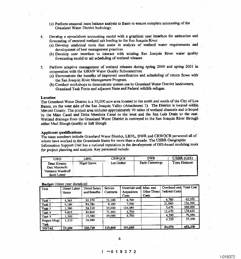
(c) Perform seasonal mass balance analysis in Basin to ensure complete accounting of theGrassland Wa~er District hydrology.
4. Develop a spreadsheet accounting model with a graphiod user itgerfaee for estimation andforecasting of seasonal wetland salt loading to the San/oaquin giver.(a) Develop analytical tools that assist in analysis of wetland water requirements and
development ofbe~t management practices.(b) Develop user interface to interact with existing San Joaquin River war~r quality
forecasting model to aid scheduling of wetland releases,
5, Perform adaptive management of wetland releasea during spring 2000 and spring 2001 incooperation with the SJRMP Water Quality Subconmfi~tee.(a) Demonstrate the benefits of improved coordination and scheduling of" return flows with
the San Joaquin River Management Program.(b) Conduct workshops to demonstrate system use to Grassland Water District landowners,
Grassland Task Force and adjacent State and Federal wildlife refuges.
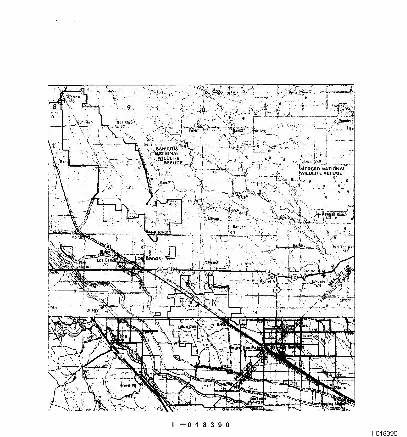
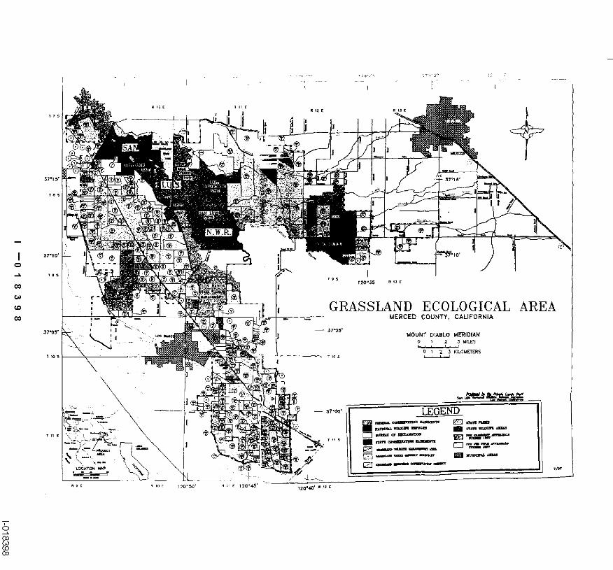
LocationThe G-rassland Water District is a 50,000 aore area located to the north and south of the City of LosBanes, on rite west side of the San ,loaquin Valley (Attaehmeat 1). The District is located withinMerced County. The project area inoludes approximately 90 miles of wetland channels and is barredby the Main Canal and Delta Mendota Canal to the west and the San Luis Drain xo the east,Wetland drainage fi’om the Grassland Water District is conveyed ~o the San Joaquin River througheither Mud Slough (north) or Salt Slough.
Applicant qualificationsThe team members include Grassland Water District, LBNL, DWR and CRWQCB personnd el! ofwhom have worked in the Grasslands Basin for more than a decade. The USBR GeographicInformation Support Unit has a national reputation in the developmem of GIS-based modeling toolsfor project planning and analysis, Key personnel include
GWD LBFIL CRWQCB DWR USBR (GIS)Deaa Kwasny Nigel Quitm Les Caobcr Earle Cummings Tom HeinzerDon Marciochi
Veronica WoodruffScott Lower
Bud~[et (th~ .~e ~rear duration)Task Dir¢~ Labor Direct Salad"
l-~urs andBencfits Contracts Aoquislhon OthecDirect Indir~etCostsCosts Costs
Task 1 1~365 20~370 32~100 6~700 4~780 63,950
Task 2 9r180 89~780 8~180 7,500 21,040 126,500Task 3 1_380 24~210 55~040 t24,080 5.6"/0 209r000
Task 4 4,805 49~800 71.460 6~700 11,670 139,630
Task ~ L360 19~580 49.080 6~700 4,590 79~950
Project Mngt. L110 26,980 6,39.0 33,300
TOTAL 19,200 23a~720
4
I --01 83721-018372
Monitoring and Data EvaluationThe monitoting and data gatheting required for successful completion of this project willcomplement existing compliance monitoring programs including; the Grassland Bypass Project,routine monitoring performed by the CRWQCB and Grassland Water District. and the CALFED-sponsored "Real-Time San .~oaquln River Water Quality Management" project, being undertaken bythe SJRMP Water Quality Subcommittee.
Local Support/Coordination with Other ProgramsThe proj~ will involve local landowners, duck club operators and managers of State and Federalrethgea in the Grassland Basin. Although this pilot project will concentrate on the 50,000 acresthat comprise the Grassland Water District, the goal of the project is to disseminate the findings ofthe project to the entire Grassland Ecological Area; a 160,000 aeres wetland complex Theproposed project has local support fi’om the County of Merced. Grassland Resource ConservationDistrict, San Joaquin River Exchange Contractors Water Authority, and Drainage Coordinator forGrassland Area Farmers (Attachment 2).
This proposed project is part of a comprehensive proposal to establish a real-~mv monitoring andwater quality forecasting system in the Son .Toaquin Basin including all the major east-sidetributaries, tha west-side agricultural water districts and the main stem of the San Joaquin River.The project will cuordinatc and supplament existing biological and water qualRy monitoringprosrams b~g conducted by the Grassland Water District to capitalize on increc~sed water supplymade available through the CVPIA
Compatibility with CALFED ObjectivesSalinity, selenium and ternperature have been identified by the SJKMF Executive Cotmcil as waterquality stressors of concern in the San Joaquin giver. Managernent of wetland draiaago dischargesthrough scheduling of" releases to coincide with periods of San Joaquin River assimilative capacitycan help to improve San Joaquin River water quality. However, these actions may necd to betempered with consideration of the biological impacts of changes to traditional wetlandmanagement practices. No systematic data collection program has bonn undertaken m date toevaluate the short and long-term consequences of real-time wetland drainage management. Such adata collection program would create the ~undation of an adaptive management strategy that coulddovetail with current SJRMP and CALFED-sponsored initiatives on real-time quality managementin the San Joaquin River and with the Vernalis Adaptive Manngerne~ Program (VAMP), a tntflti-agency experiment to improve the San Joaquin Ricer fishery through manipulation o£ tributaryflows and flow release sehadules.
I --018373I-0"18373
IlL PROJECT DESCRIPTION
BackgroundThe Grassland Water District, together with the adjacent State and Yederal re~ges, constitutes thelargest contiguous wetland in the State of’California (Attachment 3). Over 26,000 acres of prlvatelyowned wetlands e~st in the Grassland Water District alone. This figure does not include thenumerous seasonal wetlands owned by federal refi~ges, state wildlife areas, and private landownersoutside of the Grassland Water District that comprise the 160,000 acre Grassland Ecological Area.
Increases in water supply allocations under the Central Valley Project Improvement Act (CVPIA)are helping to improve the quality of" wetland habitat in the Grassland Basin while increasing thequantity of water returned to the San Joaqnin River during the spring months, when seasonalwetlands are drained. Seasonal wetland drainage may negatively impact agricultural operations inthe South Delta during years when peak wetland return flows coincide with pre-irrigation ofcropland because of the potential for devated salinity-in these return flows. The additional CVPIAwater allocations, while inorenffmg the flexibility of operation of seasonal wetlands and improvingthe quality of seasonal wetland habitat, potentially increases the salt load discharged to the SanJoaquin River. Hence, exploitation of opportunities to improve coordination of seasonal wetlanddrainage with the assinailative capaoity of the Saa Joaquin River for contaminants of concern are ofconsiderable importance in complying with water quality obj~tives.
The elevated temperature of westside discharges to the San Joaqnin River may affect the spawningsuccess of saimonids. Improved scheduling of these discharges to avoid critical time periods for fishrearing will also help to remove an important stressor and improve the San Joaquin saimon fishery.The biological impacts of changing the timing of the fill and r�lease cycles to correspond to periodsof �levated San Joaquln River assimilative capacity for salt and selenium have not been documented.The proposed initiative offers a unique opportunity to develop an adaptive wetland and salinitymanagement program in the upper watersheds of the western San Joaquin Basin that will direetlycomplement the erdsting Vemaiis Adaptive Management Program (VAMP). The goal of the VAMPis to monitor fishery impacts due to scheduled pulse flows and other east-side reservoir releases andto develop a long-term management plan for sustaining the San Joaquin River fishery.
We propose to implement a program of real-dine monitoring and water quality management in theGrassland Water District to improve the coordination of wetland return flows to the San JoaquinRiver. Real-time temperature data will be gathered concurrently with flow, salinity and sdeniumconcentration data from the Grassland Water District as input to the real-time water quality modelof the San Joaqnin River operated by the SJRM~ Water Quality Subcommittee. CALFED hasprovided two years of grant support to the SJRMP Water Qwdity SubcomrniRee to enhance thee~sting nclwork of real-tim,~ monRoring stations alert8 the main-stem of the San Joaquin River andto improve the coordination of agricultural return flows and scheduled east-side fish flows.Installation of flow and water quality monitoring equipment and cellular telemetry ¢qnipment at keylocations in the Grassland Water I)istric~ will help to provide wetland and refuge managers with thedata necessary to make scheduling decisions.
A program of’ wetland habitat assessment will proceed cenenrrantiy with the real-time monitoringand water qaality management program. Changing the scheduling of wetland drainage to the SanJoaquin River can atTeet the timing and rate of drawdown c~’ wetland ponds and hence the for~evalue of" the wetlands for migrating and wintering shorebirds and waterfowl. Wetland salinity
I --0’1 8374I-0’18374
management measures can also affent the produ~vity and diversity of vegetation that can be ~rownin the watershed The program would document the impacts of altering traditional wetlandmanagement practices and seek to develop guidelines for multi-objective wetland operations. Theeonenrrent program of habitat evaluation and salinity management would lead to optimization ofwildlife and environmental benefits to the Grassland Basin and San Ioaqnin River.
A GIS-based wetland habitat and salt aecounring model will be developed for seasonal wetlands inthe Grassland Water District to assist in the planning and scheduling of springtime drainage releaseswith weekly forecasts made by the SJRM~ Water Quality Subcommittee. This model willincorporate the weekly water use requirements of seasoaal wetlands in the Grassland Water Districtand the adjacent State and Federal refuges. Prdiminary mapping of the wetland Mbitat in some ofthese areas has already been accomplished end digitized within the US Bureau of geclamation’sGIS system The model will track salinity changes in each of’the weriands over the winter seasonand incorporate user-defined scbedules for wetland drawdown in the spring months. By runningseraglios of different monthly wetland fill and release,schedules and annual changes in vegetationWpe, managers will be able to plan operations to minimize water qnality impacts on the San ]’naquinRiver while attempting to maximize wildlife benefits. Once fully developed and tested by GrasslandWater District staff and project cooperators, this system of real-time monitoring stations and waterquality accounting software will be demonstrated to State and Federal refuges within the GrasslandsBasin in a number of’technical workshops.
Proposed S~:ope of Work (Tasks)The following tasks will be performed during the 3 year dictation of the project:
1. Design a monitoring system for measuremeat of wetland drainage flow and water quality,(a) Survey Grassland Water District’s drainage system and document drainage hydrology.(b) Design flow structures and select water quality monitoring sensors at key monitoring sites.(c) Coordinate monitoring with other CALFED programs and SJ1UM9 Water Quality
2. Develop a multi-objective habitat evaluation and salinity management program to optimizewetland values and functions while minimizing water quality impacts on the San JoaquinRiver.(a) Establish study plots and describe wetland vegetation and traditional water rcquiremems.(b) Develop survey techniques to assess wildlife use and vegetation response to ~xpedmental
drawdowns.(c) Initiate experimental drawdowns and conduct field surveys of study plots.
3. Install, maintain and operate real-time EC, flow and temperature sensors in the project area,(a) Construct flow structures where necessary and install flow, EC and temperature sensors.(b) Implement a quality assurance/quality control and maintenmace program.(d) Perform seasonal mass balance analysis in Basin to ensure complere accounting of the
Grassland Water District hydrology.
4. Develop a spreadsheet accounting model with a graphical user interface for estimation andforecasting of seasonal wetland salt loading to the San Joaquin River.(a) Develop analytical tools that assist in analysis of wetland water requirements and
development of best management practices.
7
I --01 83751-018375
(b) Develop user interface to interact with existing San Joaquin l{iver water qualityforecasting model to aid scheduling of wetland releases.
5. Perform adaptive managament of wetland releases during spring 2000 and spring 2001 incooperation with the SJRMP Water Quality Subcommittee.(a) Demonstrate the benefits of improved eoordinatiou and scheduling of return flows with
San 3oaquin River Managemant Program.(b) Conduct workshops to demonstrate system use to Grassland Water District landowners,
Grassland Task Force and adjacent State and Federal wildlitb refilgns.
Location of ProjectThe Grassland Water District is a 50,000 acre area to the north and south of the City of Los Banes,on the west side of the San Joaquin Valley (Attachment 1). The Grassland Water Diatdet is locatedwithin Mereed County. The project area includes approximately 90 miles of wetland channels and isbound by the Main Canal and Delta Mendota Canal to�he west and the San Luis Drain to the east.Wetland drainage from the Grassland Water District is conveyed to the San Joaquin giver througheither Mud Slough (notch) or Salt Slough.
IV. gCOLOGICALfBIOLOGICAL BENEIClTS
Seasonal wetlands in the Grassland Water District are flooded in the fall and drawn-down in thespring to provide habitat for migratory waterfowl, shorebirds, and other wetland-dependent wikllife.Due to alterations in natural hydrology, these wetlands are flooded with Ceutnd Valley Projectwater supplies delivered from GWD oanals. In the spring, during the months of Mareh-Ap~l,seasonal wetlands are drawn-down to mimic the natural dry cycle of a seasonal wetland. Wetlanddraw-downs are timed to make seed and invertebrate resources available during peak waterfowl andshorebkd migrations and to correspond with optimal germination conditions (primarily soiltemperature) to grow naturally occurring moist-soil plains. The seeds of moist-soil plants arerecognized as a critical waterfowl food source, providing essential nutrients and energy forwintering and migrating birds (Frcdriekson and Taylor 1982).
Spring releases ofwatar from seasonal wetlands are discharged into tributaries of the Lowar SanJoaquin River. These releases, in combination with agricultural drainage that flows through theGrassland Water District, contain varying amounts of total dissolved solids (TDS), boron, andselenium. These constituents have been identified as stressors that lead to frequent exeeedanee ofwater quality objectives established for the San Ioaquin River by state and federal aganoies.
Rnseareh conducted by Grober et al. (1995) suggests that wcdand drainage could be scheduled tocoincide with peak assimilative capacity in the San Joaquin River to help improve downstreamwater quality. In addifiorb increased water supply ailoeatinns under the Central Valley ProjectImprovemeat Act (CVPIA) have created opportunities to coordinate the release of seasonal wetlanddrainage with the assimilative capacity of the San Joaquin River. Coordinated releases will help toachieve salt and boron water quality objectives and improve fish habitat in the main stem of the SanJoaquin River and Sacramento - San Joaquin Delta. Improved scheduling of west-side dischargescan assfist in avoiding critical time periods for fish rearing and remove an important stressor leadingto improvements in the San J’oaquin salmon fishery. To date, however, no systematic data collectionprogram has been undertaken to evaluate the short and long-term eoesequences of" real-timewetland drainage management.
I --0183761-018376
Management of wetland drainage through scheduling or" releases to coincide with periods of SanJoaqain River assimilative capacity can help to improve San Jo~uni River water quality. However,these actions may need to be tempered with consideration o~ the biological impale of ehangos totraditional w~land management practices. Peak assimilative capacity typically occurs betwern themomhs of ~anuaP! and March. This time period is earlier than the traditional wetland draw-downperiod (March-April). In partiealar, the response of migratory waterfowl and shorebirds to an earlydraw-down regime needs to be assessed to determine potential impacts to foraging rates, habitatavailability, and species diversity and abundance. It is possible that early, experimantal drawdownmay make food sources available to wildlife without negatively affecting wetland vegetationcommunity and plant species diversity - hence benefiting both wildlife and the San Joaqnin giver.This project shonid have considerable technology transfer value to other agencies that manageseasonal wetlands and also discharge constituents of concern to the River.
LinkagesThe data collection suggested as part of this proposal is consistent with the current CALFED-sponsored initiative on real-time water quality management in "die San Joaqnin River and with theVemalis Adaptive Management Program. The linkage of this proposal and the CALFED focusaction tha~ concentrates on the main-stun of the San Joaquin River is shown in Attachment 4. Otherlinked projects are:
1. Coordinated Regional Management Program (CRMP). CRMP objectives are to reducecontaminant loading and sedimant erosion produced by ephemetal rainfall runoff evcuts in thePanoche Cre~k Watershed. Salt and salenktm generated by Panoche-Silver Creek ¢tffects theassimilative capacity nfthe San Joaqnin River for salt and selenium.
2. Grassland Bypass Project. This project limits monthly selenium loads from the Grasslandagricultural water districts and hence affects the assimilative capacity of the San Joaquin Riverfor salt, salanium and boron.
System Wide Ecosystem BenefitsThe proposed project will provide basic monitoring information and will develop decision supporttools to allow wetland managers in the Grassland Water District to respond to the long-rermchallenge of improving water quality while rnaximming wetland functions and habitat values.Information obtained through this project will be transferable and of significant value to all wetlandsin the Grassland Ecological Area including those managed by duck clnbs. California Department ofFish and Game, and U.S. Fish and Wildlife Service (USFWS). The successful implementation ofthis combined monitoring, experimentation, and evaluation program will provide the basis foradaptive management of wetland drainage throughout the Grasshnd Ecological Area: a 160,000acre wetland ecosystem officially recognized by the USFWS.
Compatibility with Non-geasystem ObjectivesThe proposed project is a key component of an expanded San Joaquin giver real-time forecastingproject, initially supported by the U.S. Bureau of Reclamation under a Challenge Grant and morerecently funded by CALFED The CALFED San loaquin River Real-Tim* Water OualityManagement Project uses telemetered stream stage and salinity data and computer models tosimulate and forecast water quality conditions along the lower SYR.. The dectsion support toolsbeing used in the existing CALFED project are applicable to the proposed projoet since the dataderived from wetland monitoring sites will feed directly into the existing SJRIODAY model to help
9
I --01 83771-018377
improve the a~euracy of west-aide water quality forecasts. At the present time the SJKiODAYforecasting model relies on historic patterns of wetland release in astimating Mud Slough flow,salirdty and boron loads.
The monitoring and data gathering required for ~Jeeessfut enmptetion of the propo$ed wetlandmanngemem project will also complement existing compliance monitoring program bein~undertaken by the enoperatlng agandes in the Grasslands Bypass Project and the routine monitoringperformed by the CRWQCB and Grassland Water District.
V, TECHNICAL FEASIBILITY AND T~’IING
An initial trial of the concept of real-time coordination of seasonal wetland releases with San1oaquin giver assimilative capacity, as proposed in this application, was performed during January1995 (Grober et al. 1995). The Grassland Water District, with the recent acquisition ofsupplemental water supplies under the Centra~ Valley th’oject Improvement ACt, sought to make anearly release of ponded water to reduce the likdihood of downstream salinity hnpacts and salinityobjective violations in the San Joaquin River later in the season. The Water Distrint requested thatthe SJRMI~-WQS provide a foreca.ct of’the most advantageous thue to make this release. A modelforecast, made on January 15, 1995 suggested that th~ combination of high fiver flows and animminent rainstorm might provide the necessary assimilative capacity. The peak wetland release wastimed so that it would coincide with the peak flow in the San Joaquin giver. Wetland flushing beganon January 18 mad ended on February 19, with the peak wetland discharge occurring on January 27.Assimilative capacity was pos’rfive in the River throughout the simulation period owing to the
"rainfall-runoff events in the upper watershed. No violations of the EC objective occurred during thetrial period and there were no EC violations in the San Joaquin giver during March and April, 1996.
The 1995 demonstration was performed without the benefit of the basic monitoring ioformmion anddecision support tools proposed in this application that will allow wetland managers to respond toSan J’oaquin giver discharge opportunities while maximizing wetland fi.mctions and habitat value.
VL MONITORING AND DATA COLLECTION ]~EgTIIODOLO~Y
Activities of these and other monitoring and adaptive management programs will be coordinatedthrough the San Joaquin giver Management Program, Data will be freely exchanged between theparticipating agencies, providing accurate and timely information for making forecasts of salinity onthe San Joaqu’m giver.
Biological/Ecological ObjectivesThe biological and eenlogical monitoring and data objectives of the project are as follows:
Document the effects of changing traditional flood-up and wetland drainage discharge patternson wetlargl vegetatiott and bird species.
2. Measure the impact of changes in wetland operations and timing on water quality in the Sanloaquin River. Rtm model simulations to compare with and without-action scelmrios.
3 Develop an adaptive management approach to optinfize wetland habitat and maximize waterquality benefits in the San/oaquin River.
10
I --0183781-018378
Monitoring Parameters and Data Collection Approach
Wetland Drainage AssessmentThe water quality parameters monitored in wetlands and wetland drainage channels include thefollowing:
salinity (EC) - continuousselenium, boron (monthly grab samples to supplement current sampling program)temperature
Flow sensors will be placed at comrol structures within the District and will measure stage usingeither pressure transducer technology. Each site will be rated using standard USGS flow ratingtechniques as described in the Quality Assurance Project Plan oftbe Grassland Bypass project(USB1L 1997) in order to compute discharge from stage, gecords will be kept of weir board heightso as to accoum f’or any changes in the station rating if,weir boards are removed for floodoperations or to deal witk some other emergency situation. A temperature~ompensated eieetricalconductivity sensor will be used to obtain regal-time sehnity and temperature data. Each of thesesites will have t¢leanetry equipment installed to allow data to be accessed and downloaded from theGrassland Water District office. Monthly servicing of the site will be performed, in accordance withthe Quality Assurance Plan to ensure da~a reliabiitty.
Wetland Vegetation cmd Waterbird Use AssessmentThe vegetation and waterbird use measuremants made in representative seasonal wetlands include:
Biological measnseme~ts will be taken on adjacent traditionally and non-traditionally drainedwetlands and will include: determinm" g waterfowi and shorebird (waterbird) abundance and diverairyusing scan-sampling methodology with a variable power spotting scope, determining time-aetiviv/budgets of watethirds through direct observation to assess foraging potantial, and determiningmoist-soil plant production by conducting vegetation surveys to assess plant biomass, cover, andspecies composition.
Wetland monitoring sites will be randomly chosen from evailahle seasonal wetlands within theGrassland Water District. These wetlands will correspondingly drain into locations where flow andEC monitoring sites are situated. At all wetland study plots, a paired study design ~ be used todirectly assess differences in 1raditionatly drained wetlands vs non-traditionally drained wetlands~
Data Evaluation ApproachData gathered following the manipniation of the timing of wetland Rood-up and release during eachyear of’the project will be analyzed and evaluated to determine the biological hnpacts to seasonalwetland habitat quality using vegetative p~oduction (food availability) and watethird use. Theseimpacts will be contrasted with the benefits to San Joaquin giver water quality achieved throughdischarging drainage from seasonai wetlands during periods of assimilative capacity for salt andtrace alements of concern such as boron and selcaiun~ The effect of experimental early drawdownsof wetlands on water qual~y the San Joaquin giver will be measured and compared by modeiing theeffects era no-action seeaatio. The SJRIODAY Model (the same model used by the SJRMP-WQSin the CALFED San Joaquin Water Quality Management Project) will used to estimate saiiaityimpacts on the river and the EC at Vernalis without the a~on. The S~dP-WQS has shown that
11
I --01 83791-018379
the model is a reliable predictive tool, when provided with appropriate west-side and cast sitetributary flows and loads at all monitoring locations.
Flow and water quality data from real-time monitoring stations within the Grassland Water Districtwill be compiled and daily mean values of flow and contaminant concentrations determined. Dailycontaminant loads will be calculated from the daily mean values and these numbers will becompared with daily assimilative capacity determinations, made using data available from themonitoring stations operated by the CALFED-sponsored Real-Time Water Quality ManagementProject on the main-stem of the San Joaquln River. wetland discharge opportunities will beevaluated w~kly by Quinn, Grober and Cummings of the Proj~ team. Coordination between theproposed project and the existing CALFED- fi~nded San Joaquin River Project is critical to thesuccess of this project. Quinn and Crrober are currently involved in the latter project end will ensux¢that this coordination takes place. Data collected at the Grassland Water District sites wilt besummarized and reported anmudly.
Representative w~tland study sites will be ohosen withJ~ the Grassland Water District to alter thescheduling of wetlend drainage to conform to project objectives. These same wetland areas will bepart of the adaptive management ¢x~periment for the duration of the project. Biological data wilt beentered into a spread-sheet program and analyzed using p.c. statistical soi~var0 such as SAS orNCSS. Null hypotheses of no net change to wetland habitat quality and function will be testedstatistically using a paired t-test analysis. Provided the statistical assumptions of the test are met,data will be combined for all years. If not, data will be analyzed on an annual basis.
Table 2. Monitoring and Data Collection Iuformatiou
Hypothesis!Question to be 1IV[onitoring Parameter(s) and ! ~)ata ]$valuation ApproachEvaluated ’, Data Coltaction Approach1. I-[ow much drainage flow, ~ollect infomlation on flow, efform seasonal mass balancesalinity (EC), selenium, and amperature, salinity (EC), ~malysis to determine the quantit)boron is being released to the;elanium, and boron using flow~ftims¢ constituents beingSan Joaquin River as a result ~nsors felensed into the San Joaquin
of wetland drainage ~dver.drawdown)?
2. Does altering the schedule ’~ollect data on flow, temp., ~omputation of daily mean flowof wetland drawdown, to allnity (EC), selenium, and md EC Coordination withcoincide with peak ~oron in wetland channels. EALFED San Joaquin Real-Timeassimilative capaoity, result in Eoordinate information withiVater Quality Managementa net improvement in wator sit )nitoring efforts of the Study to estimate Riverquality to the San Joaquin
~4CALFED San Joaquin Real-
tssimllative capacity andRiver7 Time Water Quality ~etermine opportunities for
anageraent Study to estimatewetland discharge.IRiver assimilative capacity and~letermin¢ water q~o!i~.,
12
I --01 83801-018380
3. Does altering the schedule of Collect data on waterbird use,~nalyze data using NCSS orwetland drawdown impact abundance and diversity onISAS statistical programs using awetland vegetation productionexperimental and control paired t-test design. Determine ifand habitat availability and usewetlands. Collect vegetation ~lterlng traditional drawdownby migratory watarbirds? data to determine moist-soil ~iming impacts the value of
plant production on ~easonal wetlands as habitat forexperimental and control migratory waterbirds.wetlands
VII. LOCAL INVOLVEMENT
The County of Merced has been notified (Attachment 5) and fitly supports the project’s effort toassess the coordination of wetland drainage to improve water quality in the San loaquin River(Attachment 2)~ In addition, the project has the support of the Grasshnd Kesource ConservationDistrict, San loaquin River Exchange Contractors Water Authority and the Drainage Coordinatorfor Grassland Area Farmers, all oftbese groups are actively involved and committed to theimprovement of water quality in the San Joaquin River (Attachment 2).
This project will involve local landowners, duck club operators and mamgcrs of State and Federalre’~ges in the Grassland Ecological Area. Although this pilot project will concentrate on the50,00o acres that comprise the Grassland Water District, the goal of the project is to disseminatethe timings to wetland managers in the entire 160,000 acre Grassland Ecological Area. Publicresource agencies, such as the California Department ofFish and Game and the U.S. Fish andWildlife Service ere awere of the project and are supportive ofthls research effort.
The Grassland Water District has a successful history of locel involvement through the Districtnewsletter, published monthly; as wall as, through annual District landowner meeCdngs and wetlandhabitat management workshops. Findings from this project will be disseminated to locallaMowners, duck club managers, state and federal resource agencies, and the County of Merced viathe newsletter and through these annual meetings. Futhermore, the results of this project will besubmitted to appropriate peer-review journals and information will be exchanged at annual wildlifeand water qtudity conference and workshops, such as those held by the grfldiife Society,
VIIL COSTS AND SCHEDULE TO I~MPLEMENT PROPOSED PROJE~F
The proposed project will have a three yeer duration with planning and installation of the flow andEC momtofin8 system occurring during yeer 1, the development of a wetland habitat water needsand salt accounting model during year 2, and the field coordination of wetland flows by the SJILMPWater Quality subcomrmttee in both years 1, 2 and 3 of the proposed project. Procedures for theevaluation oftbe effects of drainage scheduling on wetland vegetation and waterbird use will berefined during the first 6 months oftha project and will be implemented during the project’s threeyear term.
The work schedule is shown in the table below. Two progress reports and one final project reportwill be prepared summarizing the objectives accomplished during the year and results frommonitoring activities in the Water District. A number of workshops will be conducted to assistpotential users of the compnnter software developed as part of this proposed project in aenessiagdata from the monitoring system, determining habitat water requirements, planning drainage release
13
I --01 8:3811-018381
schedul©s and developing long-term best management practices for seasonal wetlands within theWater Di~ricL
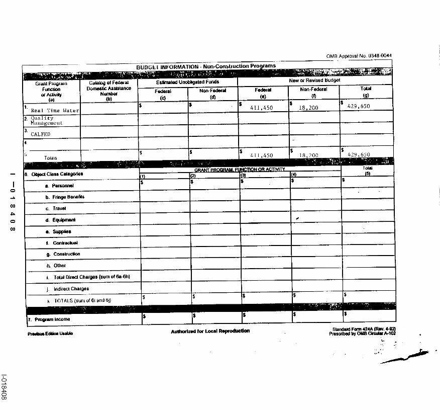
Table 3. Budget (Oct 1, 1999 - Sept 30, 2002)
Task Direct Labor Dir~ Salary Service Materials and Misc. and Overhead and Total CostHo~gs and Benefits Contn~ts Acquisition Other Dire~ Indirect Costs
Costs CostsTask I 1~365 20~370Task 2 9~ [80 89~7g0 8~ 180 7~500 21~040 126,500Task3 1~380 24~210 55~040 124~080 5~670 209,000Task4 4,805 49~800 71,460 6~700 11~670 139,630Task 5 1,360 19~5g0 49,080 6,700 4,590 79,950Project Mngt, 1,110 26,980 6,320 33,300TaskTOTAL 19~00 230~7~0 215,860 1S1~680 54,070 652~330
Table 4. Quarterly Budget
FY2000T~sk Oct=Dec 99 1an-Mar 00 Apr=Jun 00 Jul=Sep oo Oct-Dec 00 Total Bud~
Task 3 152~500 28.250 28~50 209,000Task 4 16~200 28~500 28~500 73~200Ta~k 5 81400 20~500 6~500 35~400
FY2001Task Ja~-Mar 01 Apr-Jun 01 Jul-Sep 01 Oct-Dec 01 Total BudgetTask 1Task 2 12~600 16~000 10,800 3~000 42~400Task 3Task 4 28.500 281500 91430 66!430Task 5 8~400 20~500 6~500 35~400Project MngL 7~300 1~800 [~800 1~800 12,700TOTAL S~800 66,s00 28~30 4~00 156t930
FY2002T~ Jan-Mar O2 Apr-Yun 02 Jul~Scp 02 Total ~ud~ctTask 1Task 2 1%600 161000 21000 301600Task 3Task 4
14
I --0183821-018382
Schedule
Oct 1 1999- Sept 30, 2000 Construction of flow monitoring stationsInstallation of sensors, telemetry equipmentWater quality data acquisition and entryGIS-based model development and te~ting
lan 1, 2000 - Jun 1,200~ Forecasting and management of first-year wetland drainageincluding the collection of water quality data and blotogical data
Jun 1, 2000 - Dec 30, 2000 Progress report and refinement of model
Jan 1, 2001 - Jun 1, 2001 Forecasting and rnanagemertt of second-year wetland drainageincluding the collection of water quality data and biological data
Jim 1, 2001 - Dee 30, 2001 Progress report and r~finement of modal
Jan 1, 2002 - Jun 1, 2002 Forecasting and management of third-year wetland drainageincluding the eolleetlon of water quality data and biological data
lun 1, 2002 - Sept 30, 2002 Final report, workshops and demonstrations of real-timemarmgement system to State and Federal Refuges.
IX. COST SBARING
A total of $10,000 (over the three year period) has been ¢ommi~ed from the U.S. Bureau ofReclamation Mid Pacific GIS Selvien group to survey and document the drainage hydrology andland use of the Grassland Water District. The USBR will be digitizing land use coverages withinthe project area oftha Sma Joaquin Basin Action Plan that will be used in the project for habitatdelineation and e~timation of water requirements and return flows in the proposed project.Delineation of areas outside the Grassland Resource Conservation Area but within the hydrologicbasin are important to separate flows and salt loads under direct control of the Grassland WaterDistrict from those flows and sa/t loads contributed by State and Federal wetlands. Mr. TomHeinzer from the MPGIS Service Center will be the USBR cooperator on this project. Mr Heinzerwill also assist in the linkage of ARCVIEW and the EXCEL-based water supply and drainage hUmS-balance model. Mr. Helnzer is a recognized expert on ARC-INFO modeling.
The Department of Water Resources has committed $54,600 (over the three year period) to assistin coordination of the proposed project with the CALFED-sponsored Ileal-Time Water QualityManagemant Project in the San Joaqtfin River. Mr. Earle Cummings (DWR) is the wetlandcoordinator for the Departmant of Water Ilesoarees, as well as, the chair of the San Joaquln RiverManagement Program Water Quality Subcommittee. As a wetland biologist and owner era privateduck dub in the Sacramento Valley, Earle Cummings will assist Dean Kwasny of the GrasslandWater District with wetland habitat management on the project and the interpretation of datarelated to the impacts of water and drainage management on wetland habitat quality.
15
I --01 83831-018383
X. APPLICANT QUALIFICATIONS
The team members include Grassland Water District staff, LBNL, DWR and CRWQCB personnel,all of whom have worked in the Grasslands Basin for more than a decade. Scott Lower and DonMarchioci understand the complex plumbing of the flow and drainage distribution system in theDistrict, knowledge that is essential For the development era monitoring plan and salinityaccounting model. Nigei Quinn and Les Grober both have extensive modeling backgrounds andhave been working together and independently on selenium fate and transport experiments in theDistrict for the past 5 years. Earle Cummings is Wetlands Coordinator for the Department of WaterResources and the owner era private duck club. The USBK Geographic In_formation Support Unithas a national reputation in the devdopment of GIS-based modeling tools for project planning andanalysis and has already developed many of the base coverages for the Grasslands basin that will beused in this project.
Don Marciochi (General Manager, Grassland Water District)
Don Marciochi has been employed by the Grassland Water District since October 1973 and hasserved as the District’s General Manager since 1983, He led the District’s efforts to secure a firmwater supply by active participation in the development of the refuge provisions of CVPIA andsimilarly was involved in bringing about the implementation of projects to remove seleniumcontaminated drainwater from the District’s water supply. Don has a degres in history fromCalifornia State University in Fresno.
Dean Kwasny (Wetland Biologist, Grassland Water District)
Graduated from Humbold State University with a BS and MS in wildii~e management. Worked forthe California Department ofFish and Game for five years managing wetland habitats and for DucksUnlimited as a waterfbwl and wetlands biologist. New with the Grassland Water District workingwith private landowners to enhance wetlands for the benefit of wildlife. Assistsing wetlandmanagers with water conservation practices, habitat management and project development.
Sentt Lower (Water Superintendent, Grassland Water District)
Scott Lower is the water master for the Grassland Water District where he has worked since 1983.Scott’s duties at the Water District involve managing the water distribution system within GrasslandWater District, accounting for water deliveries to Water District contractors and overseeing theDistrict’s monitoring program. He previously owned his own printing business for g years prior toworking for the Water District. Scott earned a BA degree in Graphic Arts from San Jose StateUniversity in San Jose, California and has an AA degree from Cabrillo Junior Cnilege.
Nigel Qu~n (Geological Scientist, Lawrence Berkeley National Laboratory)
Nigel Quinn received it BSc (Hens) in irrigation engineering and hydrology from the CrordieldInstitute of Technology in England and spent the early part of his career as an irrigation engineer forTate and Lyle Inc. designing and troubleshooting irrigation systems in England and in Aft-ion. Heloft England for Iowa in 1978 where he taught agricultural water management, rural water supplyengineering and surveying courses for three years, earning an MS in Agricultural and CivilEngineering and conducting research in soil erosion under crop canopy. In 1981 he took a position
I --0183841-018384
at Curneli University where he worked on various projects ranging from earthwormvermicomposting, pesticide model development and water supply and sanitation policy indeveloping counWies, co-taught classes in surveying and computer programming and earned a PhDin civil and enviromnental engineering ha 1987. He then joined the San Joaquha Valley DrainageProgram, retaining a faculty affiliation wi~h Comell. and took responsibility for development ofgroundwater and drainage models to support the Drainage Program’s planning effort. With thesunset of’the Drainage Program he has continued his work with the US Bureau of Reclamationdividing his time between monitoring efforts in support of the Grasslands Bypass projc¢%development of real-time forccastnig tools for the San Joaquin River and sdcnium fate andtransport research projects. He has been affiliated with Lawrence Berkeley National Laboratory forthe past 6 years. Nigel is the author nf over 50 publications and reports on various asImcts of waterresources and drainage engineering.
Leslie Grober (CRWQCB-CVR Associate Land and Water Use Analyst)
Leslie C.rcober’s duties and respons~ilities with. the CRWQCB are as follows : (1) run theforecasting model and review DWR.’s forecasting model results, (2) supervise staffeonducting waterquality sampling described under Task 3, (3) participate in workshops to solicit interest andparticipation by stakeholders in Program activities, and (4) assist in the documentation of Programactivities and accomplislmaents on the Iuteroct through the future SIRMP home page and througharmual hard-copy status reports to CALFED.
Leslie Grober has earned a B.S. in Geology, a M.S. in Hydrologic Science, and is currently pursuinga PhD. in Hydrologic Science from the University of CaiJfurnia, Davis He has extenmvebackground in hydrologlo, hydranlie, and water quality modeling. He currently provides flow madwater quality monitoring support for the CRWQCB program that monitors agricultural dischargesin the SJP, Bas’m, updates and nmintains the San loaquin River Input Output (SJRIO) water qualitymodel, and provides modeling support to state and local agencies to ovaiuate the impact ofmanagement strategies on SJ’R water quality (e.g., to the SJlV, MP Water Qtmlky subcommittee furthe SIR Real-time Water Quality Management Demonstra¢ion Project and to the SWRCB toevaluate programmatic alternatives in the SWRCB’s dra~ Environmental Impact Report toimplement requirements in the 1995 Bay-Delta Plan.)
Earle Cnmmings (Wetland Coordinator, Department of Water Resources)
Wetlands Coordinator, and Recreation and Wildlife Resources Advisor in the EnvironmentalServices Office for the Department of Water Resources since April 1997. Technical training inchemistry, biologieai sciences, hydrology and wildlife ecology. Employment in the chemicalindustry, non-profits, academia, local govea-nment and several State natural resource managementand regulatory agencies. Recent accomplishments include coordinating the Department of WaterResources’ Urban Streams Restoration Program and working as relief supervisor of the FloodInformation Center during the January 1997 floods. Responsible for selecting and administeringgram contracts leading to completion of over 150 stream restoration projects s¢atewide. Chairs theSan Joaquin River Management Program Action Team Water Quality Subcommittee. Co-instructsthe DWR training classes Employee Environmental Liability and EnvironmentalAwareness.
17
I --01 83851-018385
Tom Heinz~r (Consulting GIg Analyst, U.S. Bureau of Reclamation)
Tom Heinzer earned a B.S. Chemical Engineering from U.C. Berkeley in 1982 and has worked forUSBK in different capacities for 13 years. He transferred to the GIS project (MPGIS) in 1986,whets he was responsible for application development and analysis, and remains so to this day.During the last several years, Tom has worked extensively to develop techniques to interface GISsoftware to environmental models. Although most of his research has focused water modeling,specifically 1 and 2-D hydrodynamic models (DAMBRK, IGSM, MIKE21, others), and groundwater models (mainly MODFLOVO, he has also been invulved in other types of’modellng soeh asvisibility analysis, allocatiun, terrain and areheologieal site predietlon.
Veronica Woodruff (Executive Secretary / Office Matmger / Treasurer, Groa~land Water District)
Veronica Woodruff enrremly fills multiple roles in the Grassland Water District as ExecutiveSecretary, Of]flee Manager and Treasurer and has worked with the District since 1989. She attendedMereed Junior College and has gained the majority of her skills through on4he-job training togetherwith a number of computer training, software and progranuning courses. Veronica has a strongbackground in data processing.
18
I --01 83861-018386
Fredrickson, LH. and T.S. Taylor. 1982. Management of seasonally flooded impoundments forwildlife. Resource Publication 148. U.S. Dept. of the Imerior~ Fish and Wildlife Service,Washin~on, D.C
Grober. LF., J. Karkoski, and T, Poole. 199& Water quality impa~t ofwedands on San JoaquinRiver, California, paper no. 00149 In T.G. Cleveland led.I, Advances in the development anduse of models in water resources: Proceedings of the American Water Resources Assodafionheld in Houston, Texas, November 5-10, 1995 Dept. of Civil and Environmental En~neenng,University of Hoaston, Houston, TX
Karkoski J., N.W.T. Quinn, L.F.Grober, J.IL Chil¢ott, A. Varga& 1995. Selenium transport inthe Orasslands watershed Poster session. Selenium in the Environmer~: Essential Nutrient,Potential Toxicant. Cooperative Extension and U.C. Veterinary Medical Extension Confereno¢,lun¢ 1,2 199~, Sacramento.
Karkoski J., N.W.T. Quian, L.F. Grober. 1995. The potential for real-time water qualitymanagem0nt in the San Joaquin River Bagm of California. Advances in Model Use andDevelopment for Water Resources. AWRA Annual Conference and Symposium Proceedings,Houston, T~xas, July.
Quinn N.W.T., C.W. Chea. L.F. Grober, J. Kipps and E. Cummings. 1997. Computer modeltmproves real-time managem~ of water qualRy. Califorr6a A$riculture, Vol. 51, No. 5.
Quinn N.W,T. ~nd J, Karkoski. 1998. Potential for real tune management of water quali~y inthe San Joaquin Basin, California. American Water Resources Association, Vo134, No, 6.
Quinn N.W.T., and M.L. Delamore, [994. [sines of sustainable irrigated a~rioulture in the SanJoaqu’m Valley of California in a changing regulatory environment concern~g water quafi~y andprotection of wildllfe. International Symposium on W~ter l~.esources in a Chan~ng World,Karlsruhe, Germany, June 1994.
Quinn N.W.T, J.C. McGahan ~nd M.L. Delamure~ 1994. Innovative s~rategies reduce selenium inGrasslands drainage. Ca~fomia A~ficultare, Vol. 52, No. 5.
Quinn, N.W.T., T. Tokunaga, J. Clyde and R. Salve, 1994 Investigation of salenium losses incanals used for conveyance of sub-surfiw~e agri~ullural drainage in *.he western San JoaquinValley, California. Proce~dlngs ofthe International Conferance on Groundwater EcologyAtlanta, Georgia.
Williams, O.E. 1996. Waterbh’d respomes to late winter and early spring drawdowns of moil-sol1managed w~tlands in California’s San ]oaquin Valley. MS. [hesis, Humboldt State Univemi~y.136 pages
19
I --01 83871-018387
Attachment 1.
Grassland Water District Location Maps
I --01 83881-018388
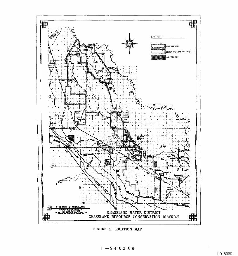
GRASSLAND WATER DISTRICTGRASSLAND RESOURCE CONSERVATION DISTRICT
FIGURE I. LOCATION MAP
I --01 8389I-0’18389
--0183901-018390
Attachment 2.
Letters of Support
I --01 83911-018391
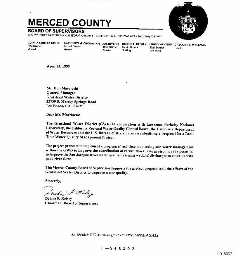
MERCED COUNTYBOARD OF SUPERVISORS2222 ’M’ STKEETe MERUED, CALIFORN’IA 95340 ¯ TELEPHONE (209) 385.7366 OFAX NO. (20~) 726-7977
CiLORIA CORTEZ KEENE KATELEEN NI. CROOKHAM JOE RIVERO DEIDRE F. KELSEy JERRY O’BA~NION GREGORY U. WELL,MAN
April 13, 1999
Mr. Don MarciochiGeneral ManagerGrassland Water District22759 S. MerctT Springs RoadLos Banos, CA 93635
Dear Mr. Marciochi:
The Grassland Water District (GWD) in cooperation with Lawrence Berkeley NationalLaboratory, the California Regional Water Quality Control Board, the California Departmentof Water Resources and the U.S. Bureau of Reclamation is submitting a proposal for a Real-Time Water Quality Management Project.
The project proposes to implement a program of real-time monitoring and water managementwithin the GWD to improve the coordination of return flows. The project has the potentialto improve the San Joaquin River water quality by timing wetland discharges to coincide withpeak river flows.
The Merced Couuty Board of Supervisors supports the project proposal and the efforts of theGrassland Water District to improve water qnality.
Sincerely,
Deidre F. KelseyChairman, Board of Supe~’isors
AN 8FF1RMA TIVE ACTION/EQUAL OPPOR TLWITF EMPLOYER
I --01 83921-018392
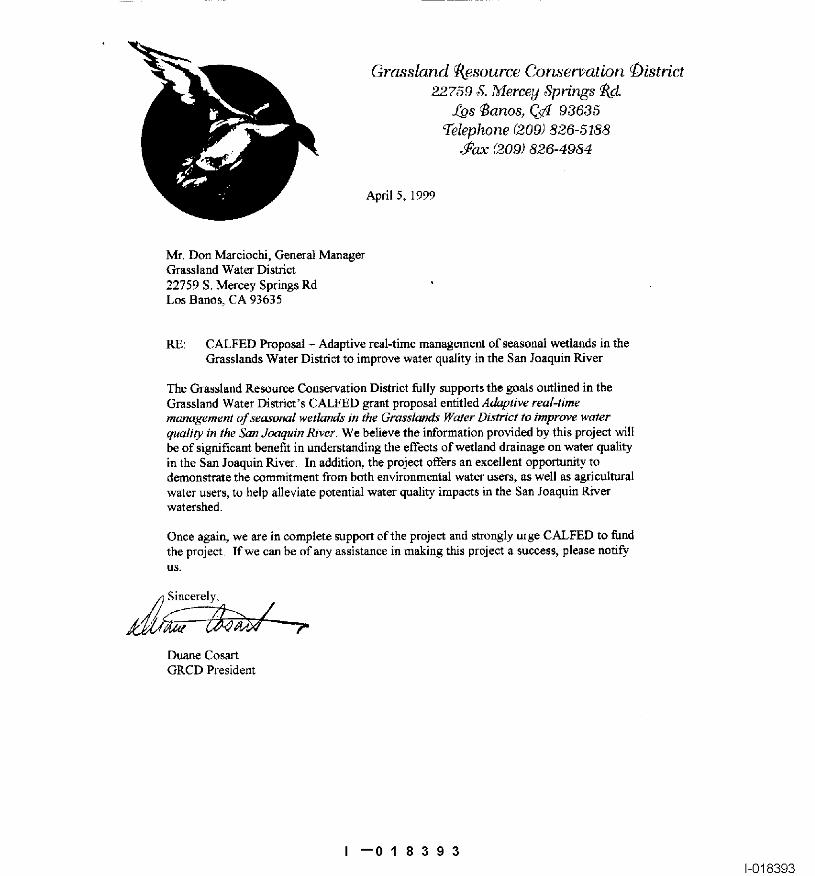
Grassland ~_esource Cor~er~ation ~istrict22759 8. ,~lercey 8prinKs ~ct
f_.os ~anos, C~ 93635Telephone (209) 826-5188
~ax (209) 826-4984
AprilS, 1999
Mr. Don Mareiochi, General ManagerGrassland Water District22759 S. Mercey Springs RdLos Banos, CA 93635
RE: CALFED Proposal - Adaptive real-time management of seasonal wetlands in theGrasslands Water District to improve waIer quality in the San Joaquin River
The Grassland Resource Conservation District tally supports the goals outlined in theGrassland Water District’s CALFED grant proposal entitled Adaptive real-timemanagement qf sea~’onal wetlattds in the Grasslands Water District to improve waterquality in the San .loacpdn River. We believe the information provided by this project willbe of significant benefit in understanding the effects of wetland drainage on water qualityin the San Joaquin River In addition, the project offers an excellent opportunity todemonstrate the commitment from both environmental water users, as well as agriculturalwater users, to help alleviate potential water quality impacts in the San Joaquin Riverwatershed.
Once again, we are in complete support of the project and strongly urge CALFED to fundthe project lfwe canbe of any assistance in making this project a success, please notify
Sincerely~
Duane CosanGRCD President
I --01 83931-018393
SAN JOAQUIN RIVEREXCHANGE CONTRACTORS WATER AUTHORITY
Consisting of 240,000 acres on the Westside of the San Joaquin Valley
OO.N S..R~TrON April 12, 1999
~t~ D~t= Mr. Don Marciochi, General ManagerJOE scorx Grassland Water District
~St~r F~$OUII~S S~@Cialist22759 S. Mercy Springs RoadSHEkkEY STAUFFER Los Banes, CA 93635
RE: Adaptive real-time management of seasonal wetlands in the GrasslandWater District to improve water qnality in the San ,loaqnin River
Irr~ano. O~tr~t De i:
P~m As you are aware, the San Joaquin River Exchange Contractors Water Authority.~KE Poarm (Authority) is a Joint Powers Authority that represents four member agencies: the
Central California Irrigation District, the Columbia Canal Company, the FirebaughSanLul~Can~lCompt.y Canal Water District and the San Luis Canal Company. The Authority consists of
ateK’m.~t~tt~ approximately 240,000 acres on the Westside of the San Joaquin Valley with annossar ~ c~o~H~.’r armual water supply of 840,000 acre-feet in which we produce over 75 different
crops with an estimated Farm level output of over $380 million annually.
Water District The Authority encompasses most of the Grassland Water District (GWD) and hasOOH~ n snrrre~ enjoyed an excellent long-standing working relationship with it. fhe Authority has
President received and reviewed the GWD’s Real-Time Water Quality Management proposala~,o~ M~r and we vigorously support it. Management of water quality in the San Joaquin
River has been and continues to be an issue of paramount importance. WaterComl~ny Quality is being closely monitored by the Sta~e Water Resources Control Board,
O~aRE~ w~c~r the Regional Water Qualily Control Board, the U. S. Bureau of Reclamation andp~,~de~t variotm local agencies including the Authority.
The GWD proposal includes most of the agencies mentioned above as co-participants and therefore has, in our opinion, the right agencies involved to makethis a viable project. The Authority is also a participant in the San Joaquin RiverAgreement (a.k.a. VAMP) and water quality and flow from the GWD and the local
P. o. 8o~ 2~ ~s reliiges was a concern throughout the negotiations. This proposal, if implemented,
Los llanos. Califomm would be a tremendous benefit to those involved in San Joaquin River Agreement93635 and its implementation.
(209) 827-8616Fax (209) 827-97~3
I --0183941-018394
Grassland Water DistrictApril 12. 1999Page 2
Again, the Authority is in full support of your Real Time Water Quality Managemant proposaland would like to assist you in any way possible.
Sincerely,
Steve ChedesterExecutive Director
ec: Member Agencies
--0183951-018395
April 6, 1999
Don MarciochiGrassland Water District22759 South Mercey Springs RoadLos Banos, CA 9:3635
SUBJECT: Adaptive Real-Time Management of Seasonal Wetlands in theGrassland Water District to Improve Water Quality in theSan Joaquin River
Dear Don:
We have reviewed your application dated April 1, 1999 for the Real-TimeWater Quality Management Project. We feel that this is a very necessarypiece in the puzzle to provide better management of water quality in the SanJoaquin River. It is an addition to the SJRMP Real-Time ManagementProgram and to the operation and monitoring of the Grassland Bypassproject. We would like to be kept up to date and coordinate with monitoringfor the Grassland Bypass Project to determine the most efficient use of thisreal-time information. We therefore support the granting of the funds fromthe CALFED Program for this Real-Time Water Quality Management Project.
Very truly yours,
C. McGahanDrainage Coordinator for the Grassland Area Farmers
JCM/p
I --01 83961-018396
Attachment 3.
Grassland Ecological Area Map
I --01 83971-018397
GRASSLAND ECOLOGICAL AREAMERCED COUNTY, CALIFORNIA
-- ~’°°’ i~
LEGEND
Attachment 4,
Linkage Map of Proposed Project with RelatedCALFED Projects
I --01 83991-018399
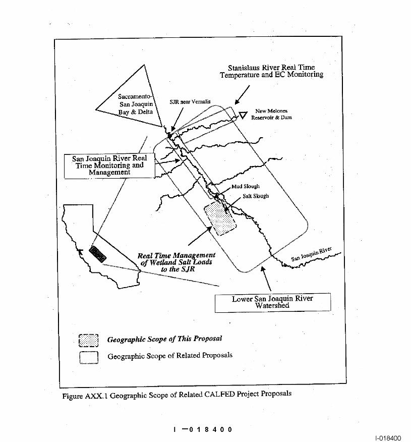
Stanislaus River Real TimeTemperature and EC Monitoring
SJR near Vernalis ~//�
lay & Delta New M~lonesReservoir & Da~
/
San Joaquin River RealTime Monitoring and
Management
, Mud Slough
.i
Real Time Managetnentof Wetland Salt SLoads \.
to the S JR
Lower San Joaquin RiverWatershed
Geographic Scope of This Proposal
Geographic Scope of Related Proposals
Figure AXX. 1 Geographic Scope of Related CALFED Project Proposals
I --0184001-018400
Attachment 5.
Project Notification Letter to the County of Merced
I --01 84011-018401
Grassland Water District22759 S. Mercey Springs Road
Los Banos, CA 93635Telephone (209) 826-5188
Fax (209) 826-4984
March 26, 1999
I --0184021-018402
U.5. Department of the Interior
Certifications Regarding Debarment, Suspension andOther Responsibtlib/ Matters, Drug-Free Workplace
Requirements and Lobbying
Persona signing this form sho~Jfd refer to the regulations Cert~catlon Regarding Debarment, Suspension, Ineligibilityreferenced below for complete Inslructions: and Volontaw Exclusion. Lower T~er Cove~d Transactions -
Cedification Regarding Debarment. Suspension, and Other (See A~pendix B of SubpartResponsibility Matters o Primal" Covered Transactions - The Ced~fk~dlon Regarding Dn~-F~ee Wod~t0lac~ Requirements -prospective pr(mary participant further agrees by AJtemate L ~Grantees Other Than Individuaixi and AJtemalesubmltldng this proposal that it will include the clause it. (Grantees Who are Ind’r~iduals) - (See Appendix C oftitled, "Certification Regarding Debarment, Suspension. Subpart D of 43 CFR Pad 12)anal Iglblllty and Voluntary Exclusion - Lower’liar CoveredTransacUon," provided by the department or agency Signature on INs form provides for compliance withentering Into . Sis covered transaction, without se~i,’ficatJon requirements under 43 CFR Parts 12 and 18. ThernodlflcaUon, In all towel tier covered tt~nsacgons and In certiflca~ons shall be Vested as a material representation cfall sollcltatior~ for lower tier covered t~ansactlons, See fact upon which reliance will be placed when the Departmentbelow for language to be used; use this forrn fo~ ce~lification of the Interior delarmine= to award Ihe co~ered transaction.and sign; or use Department of the Interior Form 1954 (DI- grant, cooperative agmentent or loan.t954). (See Appendix A of Sub;~a~ D of 43 CFR Pad 12.)
PART A: CerUflcatlon Regarding Debannont, 8uspermion, and Ob~er Responsibility Matlem -Primary Covered Transactions .
(1) The Wospecitve pdmaP/part~ipant certifies to the beat of its knowledge end belief, that it and its pdndpals:
(a) Are not presently debarred, susgende~, preposed for debeffnent, deda~d inel’~jible, or voluntarily excluded from�ove~d transactions by any Federal department or agency;,
I --01 84031-018403
PART C: Cer~[t~cation Regarding Orug-Ftge W(~rkplace Requirements
notice, including po~lJon ti~e, Io eveP/gra~lt ofl~c~ on whose grant ~
~e re.guireme.nt~ of ~na Rehabilita~on A=t of t973, as amended;
(b), (c), (d). (e) and (0.
PART D: Certificatlon Regarding Drug-Free W<~rk~lace Requirement~
I --01 84041-018404
The undersigned certit’=es, to the best of his or her knowledge and belief, that:
(1) No Federal appropriated funds have been paid or will be ~aid. by or on behalf of the undersigned, to any person forinfluencing o¢ atlempting to influence an officer or employee of a~ agency, a Member of Congress, and off~..er or employeeof Congress, or an employee of a Member of.Co~gress in connexion with the awarding of any Federal contract the makingof any Federal grant, t~e ma~ng o~ any Federal loan. the entedflg into of any �oopera~ve agreement, and the extension.continuation, renewal, ~mendment. or marlin:arian of any Federal contract, gr~nt, loan. or cooperative agreement.
(2) If any funds olher than Federal apP~0Wiated funds have beefl paid or wilt be palo to any persce for influendng o~ attempt~gto inlluence an oWmer o~ employee of any agency, a Member of Congress, an officer at employee of Congress, or anemployee of a Memhet of Congre~a in connection with this Federal conlract, grant, loan. or cooperative agreement, theundersigned shall complete and submit S~andard Fo~m.LLL "D sdosure Form to Re~ort Lobbying," in ac¢o~dence with itsins ~JC~:m=. " .
(3) The undersigned shall requite that the language of this certification be included in the award documents for all subaward=at all tiers (~ctuding subcontracts, sub~3rants‘ and contracts under grants, loans, end cooperative agreements} end ffial allsubracipients shall cert~y ac~oKlingly.
This cert~cation is a material representation of fact upon whish reliance was placed when this transaction was made or enteredlolo. SubolissJon of this cedificetlon is a prerequisite for meldng or entering into this transaction imposed by Section 1352.31, U.S. Code. Any person who fails to file Ihe raquire~ certification shall be subject to a dvil penal/of hal less than $10.000and hal more than $100.0(30 f~r each such failure.
OAT~ 4/[5/99
I --0 1 8 4 0 51-018405
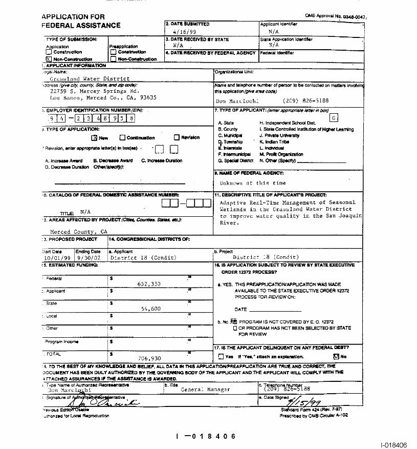
APPLICATION FORFEDERAL ASSISTANCE =. 0~.1~ SUIMITFED AppliCant
4/16/99 NIA
Don Ma~ciochi (2C19) 826-5188
i0/01/9~I 9/30/02 I District 18 (Cond~) District 18 (Condit)
706,930 ~ ~ ~ "V~’" ~ a~ ~x~Uo~i
I --01 84061-018406
~END IT TO THE ADDRESS PROVIDED BY THE SPONSORING AGENCY.
Distdct(s) affected ~y ~he program or pro~e~.
~e~ve blank, fundlng/oudget pedod by each c~n~butor. Vak~ of in-
which will ur~lrtake the a~l~tance aclMty, complete address of :. change to an e~Sling award, IndP_.am .g~, 81e amou~
S. Enter Employer Iden~..a~’on Number (EIN) a~ assigned by the For multJpk~ program fund~g, use totaJs and allow
I --01 84071-018407
OMB App{oval No 034B~)044
BUDGE I INI=OR
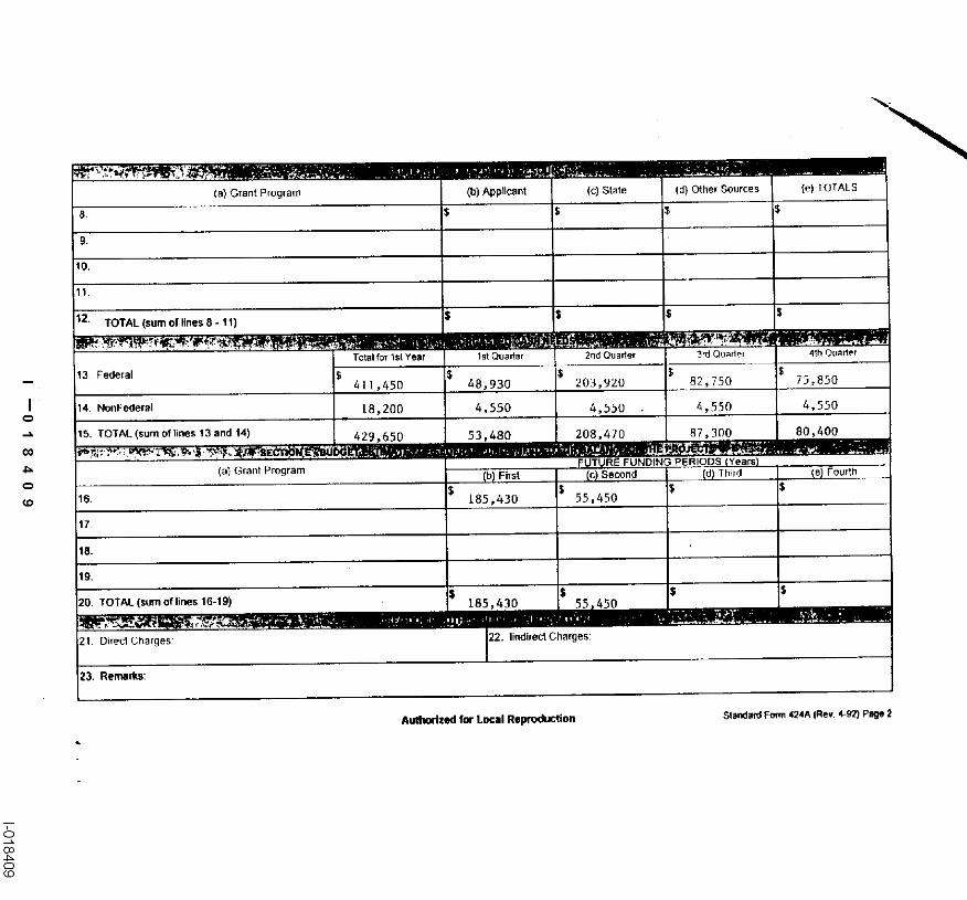
(a) Grant Program (t~) Applicant (c) State (d) Other Sources (e) TOTALS
8. $ $ $
9.
$12. TOTAL (sum of lines 8 - 11)
13 Federal $ $ $~11,450 48,930 203,920 82,750 73,850
dS. TOTAL (sum of li~s 13 and 14) 429,650 53,480 208,470 87,300 80,400
16 185,430 55,450
~7
Direct Charges: Z2. lir~dlrect Charges:
23. Remarks:
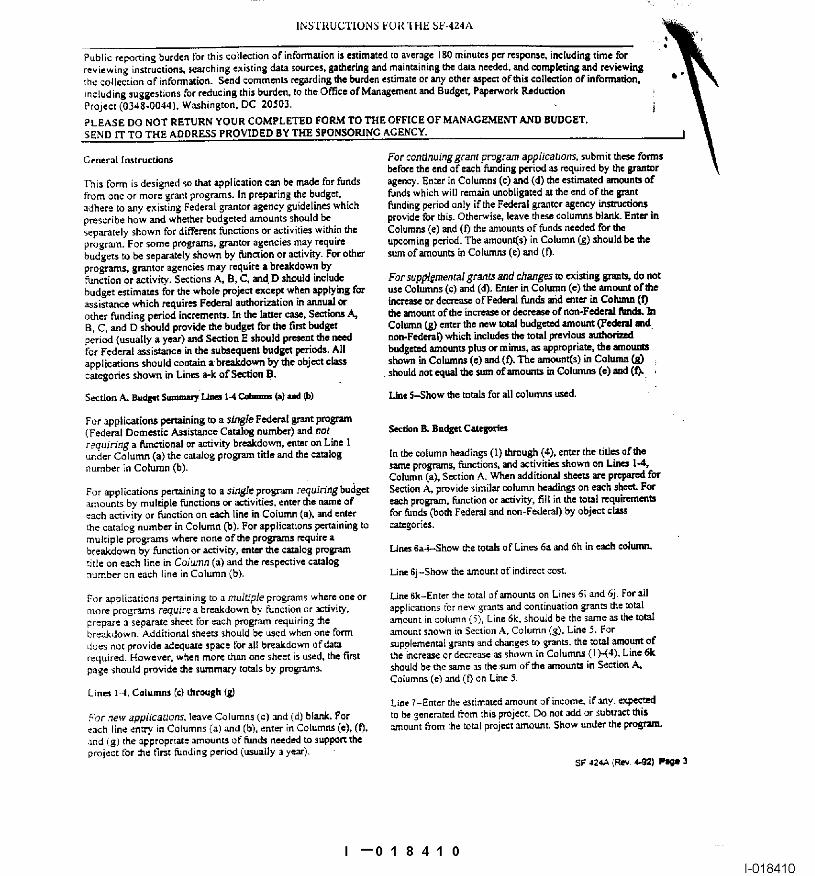
Ptoj¢¢l: (0348o0044), W~hinston, DC 20503, ¯i ~
sei-,atately shown for ciifferent ~n~ions or =~tivkies w~n ~e Colum~ (e) ~d (~ ~= ~oun~ of ~n~ ne~ for ~
~ction or ~tivi~. S~tio~ A, B, C, m~ D s~uld ~clu~ For suppl~ment~ gr~ ~d ~g~ ~ exi~in~ ~ do n~
~ce ~ich ~qui~ F~ ~o~ion ~ ~ ~ ~ or d~ ofF~ ~ md ~t~ ~ Col~ (0
I --0184101-018410
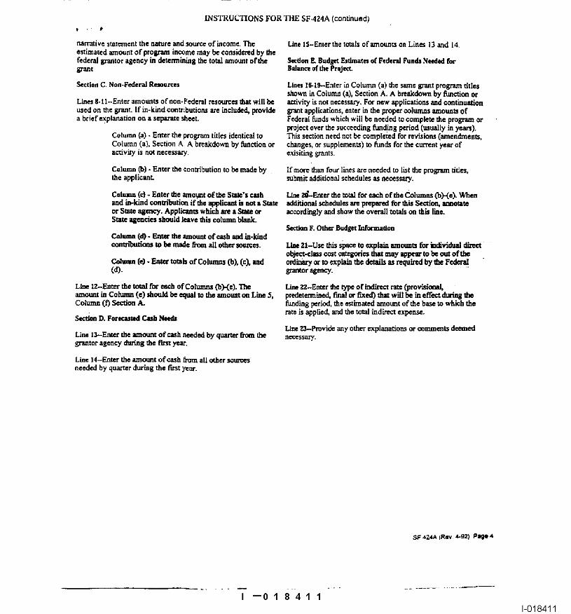
I --01 841 11-018411
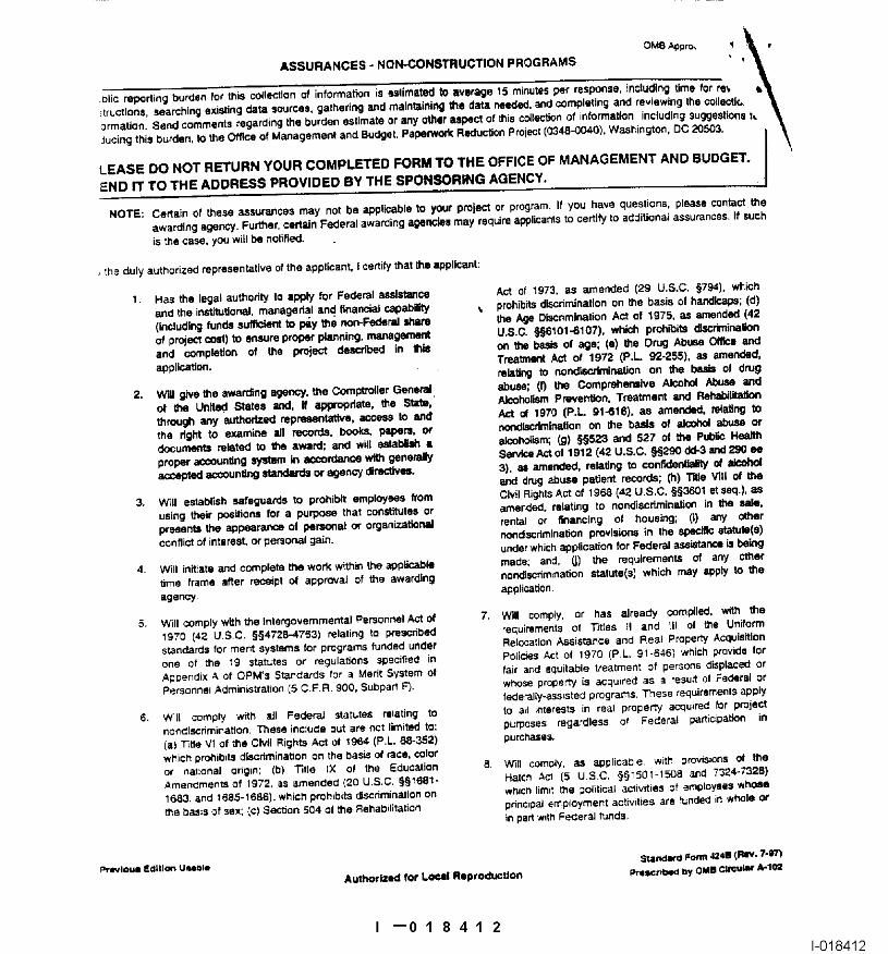
ASSURANCES - NON-CONSTRUCTION PROGRAMS OMB As)pro, ~ ~
END IT 1"O 1"ME ADDRESS PROVIDED BY THE SPONSORING AGENCY.
2. Will g~ve~he awarding agency, ~e Co~p~oiler General~ al~se; (f) li~e Comprehensive ~ Abuse and
proper accoun~ng system k~ accorda~e with genetaly 3), as amended, rotating ~ conflden~ality of ak:ohol
I --01 841 21-018412
I --01 841 31-018413