4 RADAR AND SATELLITE IMAGERY - Aircraft Spruce & Specialty Co
6
Aviation Weather Services, Advisory Circular 00-45G (February 2010) 4 RADAR AND SATELLITE IMAGERY 4.1 Radar 4.1.1 Description Radar images are graphical displays of precipitation and non-precipitation targets detected by weather radar. WSR-88D Doppler radar displays these targets on a variety of products which can be found on the internet on the National Weather Service (NWS) Doppler Radar Images web site at: http://radar.weather.gov/ridge/ 4.1.2 Modes of Operation The WSR-88D Doppler radar has two operational modes, Clear Air and Precipitation. 4.1.2.1 Clear Air Mode In Clear Air Mode, the radar is in its most sensitive operation. This mode has the slowest antenna rotation rate which permits the radar to sample the atmosphere longer. This slower sampling increases the radar's sensitivity and ability to detect smaller objects in the atmosphere. The term "clear air" does not imply "no-precipitation" mode. Even in Clear Air Mode, the WSR- 88D can detect light, stratiform precipitation (e.g., snow) due to the increased sensitivity. Many of the radar returns in Clear Air Mode are airborne dust and particulate matter. The WSR- 88D images are updated every 10 minutes when operating in this mode. 4.1.2.2 Precipitation Mode Precipitation targets typically provide stronger return signals to the radar than non-precipitation targets. Therefore, the WSR-88D is operated in Precipitation Mode when precipitation is present although some non-precipitation echoes can still be detected in this operating mode. The faster rotation of the WSR-88D in Precipitation Mode allows images to update at a faster rate approximately every 4 to 6 minutes. Section 4: Radar and Satellite Imagery Page 4-1 Airrcraft Technical Book Company
Transcript of 4 RADAR AND SATELLITE IMAGERY - Aircraft Spruce & Specialty Co

Aviation Weather Services, Advisory Circular 00-45G (February 2010)
4 RADAR AND SATELLITE IMAGERY
4.1 Radar
4.1.1 Description Radar images are graphical displays of precipitation and non-precipitation targets detected by weather radar. WSR-88D Doppler radar displays these targets on a variety of products which can be found on the internet on the National Weather Service (NWS) Doppler Radar Images web site at: http://radar.weather.gov/ridge/ 4.1.2 Modes of Operation The WSR-88D Doppler radar has two operational modes, Clear Air and Precipitation. 4.1.2.1 Clear Air Mode In Clear Air Mode, the radar is in its most sensitive operation. This mode has the slowest antenna rotation rate which permits the radar to sample the atmosphere longer. This slower sampling increases the radar's sensitivity and ability to detect smaller objects in the atmosphere. The term "clear air" does not imply "no-precipitation" mode. Even in Clear Air Mode, the WSR-88D can detect light, stratiform precipitation (e.g., snow) due to the increased sensitivity. Many of the radar returns in Clear Air Mode are airborne dust and particulate matter. The WSR-88D images are updated every 10 minutes when operating in this mode. 4.1.2.2 Precipitation Mode Precipitation targets typically provide stronger return signals to the radar than non-precipitation targets. Therefore, the WSR-88D is operated in Precipitation Mode when precipitation is present although some non-precipitation echoes can still be detected in this operating mode. The faster rotation of the WSR-88D in Precipitation Mode allows images to update at a faster rate approximately every 4 to 6 minutes.
Section 4: Radar and Satellite Imagery Page 4-1 Airrcraft Technical Book Company http://www.ACTechbooks.com (970) 887-2207 (800) 780-4115

Aviation Weather Services, Advisory Circular 00-45G (February 2010)
4.1.3 Echo Intensities
Figure 4-1. WSR-88D Weather Radar Echo Intensity Legend
The colors on radar images represent different echo reflectivities (intensities) measured in dBZ (decibels of Z). The dBZ values increase based on the strength of the return signal from targets in the atmosphere. Each reflectivity image includes a color scale that represents a correlation between reflectivity value and color on the radar image. Figure 4-1 depicts these correlations. The scale ranges from -30 to greater than 75 dBZ. The scale also include ND correlated to black which indicates no data was measured. Reflectivity is correlated to intensity of precipitation. For example, in Precipitation Mode, when the dBZ value reaches 15, light precipitation is present. The higher the indicated reflectivity value, the higher the rainfall rate. The interpretation of reflectivity values is the same for both Clear Air and Precipitation Modes. Reflectivity is also correlated with intensity terminology (phraseology) for air traffic control purposes. Table 4-1 defines this correlation.
Table 4-1. WSR-88D Weather Radar Precipitation Intensity Terminology
Reflectivity (dBZ) Ranges
Weather Radar Echo Intensity Terminology
<30 dBZ Light 30-40 dBZ Moderate
>40-50 dBZ Heavy 50+ dBZ Extreme
Values below 15 dBZ are typically associated with clouds. However, they may also be caused by atmospheric particulate matter such as dust, insects, pollen, or other phenomena. The scale
Page 4-2 Section 4: Radar and Satellite Imagery Airrcraft Technical Book Company http://www.ACTechbooks.com (970) 887-2207 (800) 780-4115

Aviation Weather Services, Advisory Circular 00-45G (February 2010)
cannot be used to determine the intensity of snowfall. However, snowfall rates generally increase with increasing reflectivity. 4.1.4 Products The NWS produces numerous radar products of interest to the aviation community. The next section will discuss Base Reflectivity and Composite Reflectivity both available through National Weather Service (NWS) Doppler Radar Images web site at: http://radar.weather.gov/ridge/ 4.1.4.1 Base Reflectivity Base Reflectivity is a display of both the location and intensity of reflectivity data. Base Reflectivity images encompass several different elevation angles (tilts) of the antenna. The Base Reflectivity image currently available on the ADDS website begins at the lowest tilt angle (0.5°), more specifically 0.5° above the horizon. Both a short range (Figure 4-2) and long range (Figure 4-3) image is available from the 0.5º Base Reflectivity product. The maximum range of the short range Base Reflectivity product is 124 NM from the radar location. This view will not display echoes farther than 124 NM from the radar site, although precipitation may be occurring at these greater distances. Other options to view precipitation beyond 124 NM from the radar site include selecting the long-range view which increases coverage out to 248 NM, selecting adjacent radars, or viewing a radar mosaic.
Figure 4-2. WSR-88D Weather Radar Short Range (124 NM) Base Reflectivity Product Example
Section 4: Radar and Satellite Imagery Page 4-3 Airrcraft Technical Book Company http://www.ACTechbooks.com (970) 887-2207 (800) 780-4115
Aviation Weather Services, Advisory Circular 00-45G (February 2010)
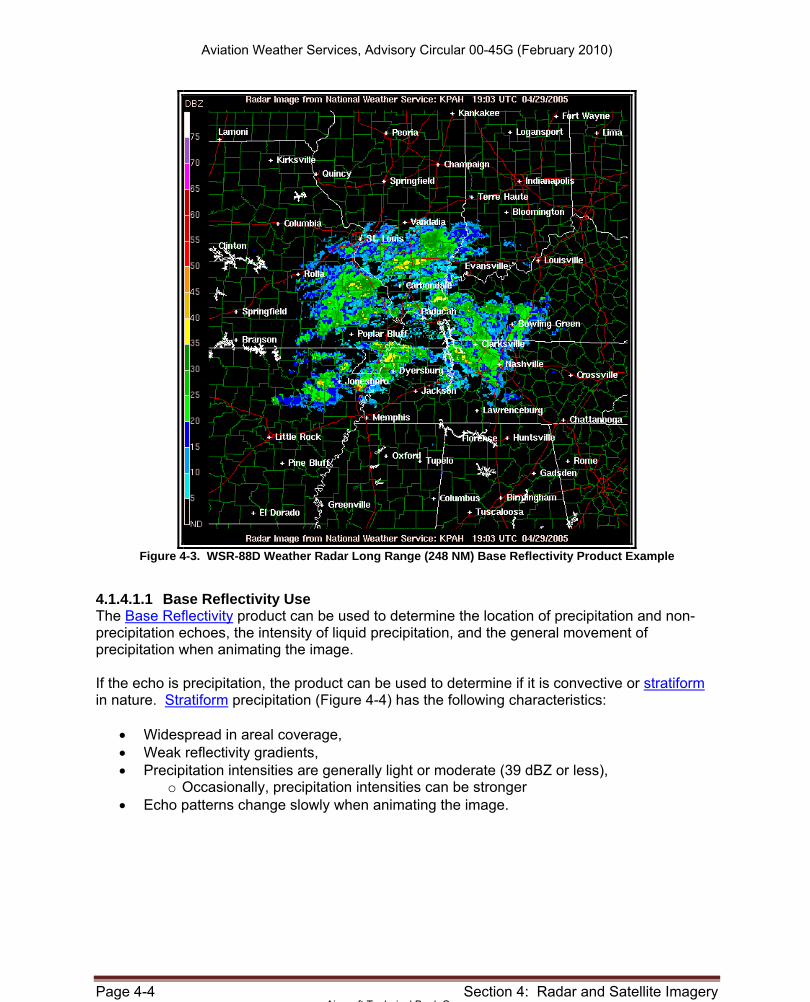
Figure 4-3. WSR-88D Weather Radar Long Range (248 NM) Base Reflectivity Product Example
4.1.4.1.1 Base Reflectivity Use The Base Reflectivity product can be used to determine the location of precipitation and non-precipitation echoes, the intensity of liquid precipitation, and the general movement of precipitation when animating the image. If the echo is precipitation, the product can be used to determine if it is convective or stratiform in nature. Stratiform precipitation (Figure 4-4) has the following characteristics:
• Widespread in areal coverage, • Weak reflectivity gradients, • Precipitation intensities are generally light or moderate (39 dBZ or less),
o Occasionally, precipitation intensities can be stronger • Echo patterns change slowly when animating the image.
Page 4-4 Section 4: Radar and Satellite Imagery Airrcraft Technical Book Company http://www.ACTechbooks.com (970) 887-2207 (800) 780-4115

Aviation Weather Services, Advisory Circular 00-45G (February 2010)
Figure 4-4. WSR-88D Weather Radar Stratiform Precipitation on the 0.5ºBase Reflectivity Product Example
Hazards associated with stratiform precipitation include possible widespread icing above the freezing level, low ceilings and reduced visibilities. Convective precipitation (Figure 4-5) can be described using the following characteristics:
Figure 4-5. WSR-88D Weather Radar Convective Precipitation on the 0.5ºBase Reflectivity Product Example
Echoes tend to form as lines or cells, Reflectivity gradients are strong,
Section 4: Radar and Satellite Imagery Page 4-5 Airrcraft Technical Book Company http://www.ACTechbooks.com (970) 887-2207 (800) 780-4115

Aviation Weather Services, Advisory Circular 00-45G (February 2010)
Precipitation intensities generally vary from moderate to extreme, − Occasionally precipitation intensities can be light
Echo patterns change rapidly when animating the image Numerous hazards are associated with convective precipitation. They include: turbulence, low-level wind shear, strong and gusty surface winds, icing above the freezing level, hail, lightning, tornadoes and localized IFR conditions with heavy precipitation. 4.1.4.1.2 Strengths of Base Reflectivity The strengths of the Base Reflectivity product include:
• The location of precipitation and non-precipitation echoes is depicted, and • The intensity and movement of precipitation is relatively easy and straight forward to
determine. 4.1.4.1.3 Limitations of Base Reflectivity Limitations associated with the Base Reflectivity product include:
• The radar beam may overshoot targets, and • The image may be contaminated by:
o Beam blockage o Ground clutter o Anomalous Propagation (AP) and o Ghosts.
4.1.4.1.3.1 Radar Beam Overshooting Radar beam overshooting may occur because the radar beam (typically the 0.5 degree slice) can be higher than the top of precipitation. This will most likely occur with stratiform precipitation and low-topped convection. For example, at a distance of 124 NM from the radar, the 0.5º Base Reflectivity radar beam is at an altitude of approximately 18,000 feet; at 248 NM the beam height is approximately 54,000 feet. Any precipitation with tops below these altitudes and distances will not be displayed on the image. Therefore, it is quite possible that precipitation may be occurring where none appears on the radar image. 4.1.4.1.3.2 Beam Blockage Beam blockage (Figure 4-6) occurs when the radar beam is blocked by terrain and is particularly predominant in mountainous terrain. This impacts both the Composite Reflectivity and Base Reflectivity images. Beam blockage is most easily seen on the 0.5º Base Reflectivity images where it appears as a pie-shaped area (or areas) perpetually void of echoes. When animating the imagery, the beam blockage area will remain clear of echoes even as precipitation and other targets pass through.
Page 4-6 Section 4: Radar and Satellite Imagery Airrcraft Technical Book Company http://www.ACTechbooks.com (970) 887-2207 (800) 780-4115