3G Construction Traffic Management Plan - National … · · 2016-08-083G Construction Traffic...
39
5.4.3G(A) August 2016 Application Ref: EN020017 DOCUMENT 3G Construction Traffic Management Plan National Grid (Richborough Connection Project) Order Regulation (5)(2)(a) of the Infrastructure Planning (Applications: Prescribed Forms and Procedure) Regulations 2009 and TEN-E Regulation EU347/2013
Transcript of 3G Construction Traffic Management Plan - National … · · 2016-08-083G Construction Traffic...

5.4.3 G (A)
August 2016Application Ref: EN020017
DO
CU
ME
NT
3G Construction Traffic Management PlanNational Grid (Richborough Connection Project) Order Regulation (5)(2)(a) of the Infrastructure Planning (Applications: Prescribed Forms and Procedure) Regulations 2009 and TEN-E Regulation EU347/2013

Purpose of this further update (August 2016)
a) This document (Doc. 5.4.3G(A)) is a further to the Construction Traffic Management Plan. The first version (Doc. 5.4.3G) was issued to the Examining Authority in January 2016.
b) This document has been updated as a result of clarifications to the Examining Authorities first written questions.
c) A schedule of the further amendments made to the Construction Traffic Management Plan is provided in the table below.
Table A - Amendments to January 2016 Version of Construction Traffic Management Plan.
Ref. Description of Amendment Reason
3.2.2 Clarification regarding locations of bellmouths on road network.
Error in original
Table 3G.3.2
Clarification of routes to be taken for access to and from strategic road network.
Minor revision arising from response to Written Questions (Doc 8.2) Q1.10.16
Table 3G.3.3
Clarification of routes to be taken for access to and from strategic road network.
Minor revision arising from response to Written Questions (Doc 8.2) Q1.10.16
Table 3G.3.4
Clarification of routes to be taken for access to and from strategic road network.
Minor revision arising from response to Written Questions (Doc 8.2) Q1.10.16
Table 3G.3.5
Clarification of routes to be taken for access to and from strategic road network.
Minor revision arising from response to Written Questions (Doc 8.2) Q1.10.16
Table 3G.3.6
Clarification of routes to be taken for access to and from strategic road network.
Minor revision arising from response to Written Questions (Doc 8.2) Q1.10.16
Table 3G.3.7
Clarification of routes to be taken for access to and from strategic road network.
Minor revision arising from response to Written Questions (Doc 8.2) Q1.10.16
Table 3G.3.8
Clarification of routes to be taken for access to and from strategic road network.
Minor revision arising from response to Written Questions (Doc 8.2) Q1.10.16
Table Clarification of routes to be taken for access to and from Minor revision arising

3G.3.9 strategic road network. from response to Written Questions (Doc 8.2) Q1.10.16
Table 3G.3.2 to 3G.3.9
Amendment to show route from the Strategic Road Network.
Clarification
5.14 Updated to reflect Article 12 (3) of the draft DCO (Doc 2.1(A).
Clarification
5.15.4 Clarification of what will be agreed with KCC Error in original
5.17.1 Addition of emergency procedures Response to written question 1.5.47
6.4.2 Clarification of enforcement measures Response to written question 1.10.16

Richborough Connection Project
Volume 5
5.4 Environmental Statement Appendices
5.4.3G(A) Construction Traffic Management Plan
National Grid National Grid House Warwick Technology Park Gallows Hill Warwick CV34 6DA Final August 2016

Page intentionally blank

Richborough Connection Project – Volume 5, Document 5.4, Appendix 3G
Final August 2016
Document Control
Document Properties
Organisation Mott Macdonald
Author T Gould
Approved by C Martin
Title Construction Traffic Management Plan
Document Reference Environmental Statement Appendix 5.4.3G(A)
Version History
Date Version Status Description/Changes
04/01/2016 1 Final First Issue
01/08/2016 2 Final Minor updates to references and additional clarifications. See summary of changes sheet

Richborough Connection Project – Volume 5, Document 5.4, Appendix 3G
Final August 2016
Page intentionally blank

Richborough Connection Project – Volume 5, Document 5.4, Appendix 3G
Final i August 2016
Table of Contents
LIST OF ACRONYMS AND ABBREVIATIONS III
1. INTRODUCTION 1
1.1 The applicant and an overview of the Richborough Connection project 1
1.2 Objectives 1
2. THE PROPOSED DEVELOPMENT 3
2.1 Overview 3
2.2 Development phases 3
2.3 Vehicle classification 3
2.4 LGV and HGV movements 4
2.5 Abnormal indivisible load movements 4
2.6 Project timescale 4
3. ACCESS & ROUTE STRATEGY 5
3.1 Introduction 5
3.2 Access points 5
3.3 Access roads 6
3.4 Local highway issues and constraints 6
3.5 Access points and routing 8
4. SIGNING STRATEGY & CORE WORKING HOURS FOR TRAFFIC MANAGEMENT DURING CONSTRUCTION & DECOMMISSIONING 19
4.1 Access route and point signing 19
4.2 Access road signing 19
4.3 Temporary diversion signing 19
4.4 Working hours 19
5. MITIGATION MEASURES 21
5.1 Introduction 21
5.2 HGV and LGV construction vehicle records 21
5.3 Prescribed HGV and LGV Construction Routes 21
5.4 HGV traffic movement restrictions 21
5.5 HGV emissions 22
5.6 Banksman or presence of qualified personnel at access 22
5.7 Timings of HGV movements 22
5.8 Monitoring of vehicle movements 22
5.9 HGV movements 22
5.10 Exceptional circumstances 22
5.11 Abnormal indivisible loads 23
5.12 PRoW management plan 23

Richborough Connection Project – Volume 5, Document 5.4, Appendix 3G
Final ii August 2016
5.13 Cleansing of vehicles 23
5.14 Highway condition surveys 24
5.15 Temporary traffic management (TTM) procedures 24
5.16 Delivery management systems (DMS) 24
5.17 Information packs and communications 25
5.18 Temporary repositioning of bus stops 25
5.19 Travel plan 26
6. MANAGEMENT STRUCTURE 27
6.1 Introduction 27
6.2 Monitoring and review 27
6.3 Compliance 27
6.4 Enforcement and corrective measures 28

Richborough Connection Project – Volume 5, Document 5.4, Appendix 3G
Final iii August 2016
LIST OF ACRONYMS AND ABBREVIATIONS
AIL Abnormal Indivisible Loads
Bellmouth An access point from the public highway for construction purposes
CTMP Construction Traffic Management Plan
DCO Development Consent Order
DMS Delivery Management System
ES Environmental Statement
ESDAL Electronic Service Delivery for Abnormal Load
HGV Heavy Goods Vehicle
KCC Kent County Council
kV Kilo Volts
LA Local Authority
LGV Light Goods Vehicle
LHA Local Highway Authority
LRN Local Road Network
MGV Medium Goods Vehicle
NSIP Nationally Significant Infrastructure Project
PRoW Public Right of Way (e.g. footpath, bridleway)
RAMS Risk Assessment Method Statement
SRN Strategic Road Network
TA Transport Assessment
TCO Transport Co-ordination Officer
TPC Travel Plan Co-ordinator
TRO Traffic Regulation Order
TS Transport Statement
TTM Temporary Traffic Management

Richborough Connection Project – Volume 5, Document 5.4, Appendix 3G
Final iv August 2016
Page intentionally blank

Richborough Connection Project – Volume 5, Document 5.4, Appendix 3G
Final 1 August 2016
1. INTRODUCTION
1.1 The applicant and an overview of the Richborough Connection project
1.1.1 One role of National Grid is to connect people to the energy they use, whether to heat and light homes, or to keep factories and offices running. As old power stations close new sources of energy need to be connected to our network, so that electricity continues to be available at the flick of a switch.
1.1.2 One of these new sources of energy is a proposed high-voltage electricity link between Belgium and Richborough near Sandwich in Kent, known as the Nemo Link®. In order to transport the energy from the Nemo Link around the country, National Grid need to connect it to the high-voltage electricity network.
1.1.3 There is no high-voltage electricity network in the Richborough area, so National Grid will need to build a new connection to join the Nemo Link from Richborough to their existing network approximately 20km away, near Canterbury. This new infrastructure project is known as the Richborough Connection project.
1.1.4 The proposed development consists of the following principle activities:
A new 400,000 volts (400kV) overhead line between Richborough and Canterbury North 400kV Substations (to be known as the PC route). This would be approximately 20km long and would be built using 45 standard lattice pylons and 15 low height lattice pylons (60 pylons in total).
A permanent diversion of an existing lower voltage (132kV) overhead line, known as the PY route, owned by UK Power Networks.
Three temporary diversions of another existing lower voltage 132kV overhead line, known as the PX route, owned by UK Power Networks.
The removal of 20.6km (79 pylons) of the existing lower voltage 132kV PX route overhead line.
Other works, for example, temporary access roads to reach pylon construction and demolition areas, bridge structures, highway works, construction compounds, protective scaffold structures, pylon work sites and ancillary works.
1.1.1 National Grid has prepared a series of plans and reports to explain our proposals to build a new 400kV overhead line between the existing 400kV substation at Canterbury and the proposed Richborough 400kV Substation. Our application has been submitted under the Planning Act 2008 (known as a Development Consent Order application) and the TEN-E Regulations (European Legislation) which has been submitted to the Planning Inspectorate for their review.
1.2 Objectives
1.2.1 This Construction Traffic Management Plan (CTMP) details the measures to be implemented to provide mitigation for the traffic generated during the construction of the proposed development. The CTMP has been prepared to ensure that the management and mitigation measures contained within this document minimise the impact on existing users of the public highway network. This CTMP accompanies

Richborough Connection Project – Volume 5, Document 5.4, Appendix 3G
Final 2 August 2016
the Construction Environmental Management Plan (CEMP) (Volume 5, Document 5.4, Appendix 3C(A)) prepared for the project.
1.2.2 This CTMP should be read alongside the Environmental Statement (ES) (Volume 5, Document 5.2) and Transport Assessment (TA) (Volume 5, Document 5.4, Appendix 10A(A)), which also support the draft DCO (Volume 2, Document 2.1(A)). The objectives of this CTMP are outlined in Table 3G.1.1 below:
Table 3G.1.1 – Objectives of the CTMP
Objective Description
A Ensure that movements of people and materials are achieved in a safe, efficient, timely and sustainable manner.
B Keep freight and construction traffic to a minimum during network peaks to reduce the impact on the highway network during busy periods.
C Ensure that the impact and disruption to the local communities and tourists is minimised.
D Minimise construction trips where possible.
E Ensure the continued monitoring, review and subsequent improvement of the CTMP and mitigation measures contained herein.
F Limit the impacts on the Strategic Road Network (SRN) and Local Road Network (LRN).
G Limit the impacts on the natural and built environment.
Richborough Connection Project – Volume 5, Document 5.4, Appendix 3G
Final 3 August 2016
2. THE PROPOSED DEVELOPMENT
2.1 Overview
2.1.1 The proposed development is in the south east of England in the administrative boundaries of the following authorities:
Kent County Council;
Canterbury City Council - Kent County Council as Highway Authority;
Dover District Council – Kent County Council as Highway Authority; and
Thanet District Council – Kent County Council as Highway Authority.
2.1.2 The Proposed Development has been split into four Sections (Sections A - D) as follows:
Section A – Stour Valley;
Section B – Sarre Penn Valley;
Section C – Chislet Marshes; and
Section D – Ash Level.
2.2 Development phases
2.2.1 The CTMP considers the construction phase of the proposed development only. During operation the proposed development will generate very few vehicle movements and, therefore, its operational traffic and transport effects will be negligible and has therefore been scoped out of this plan.
2.3 Vehicle classification
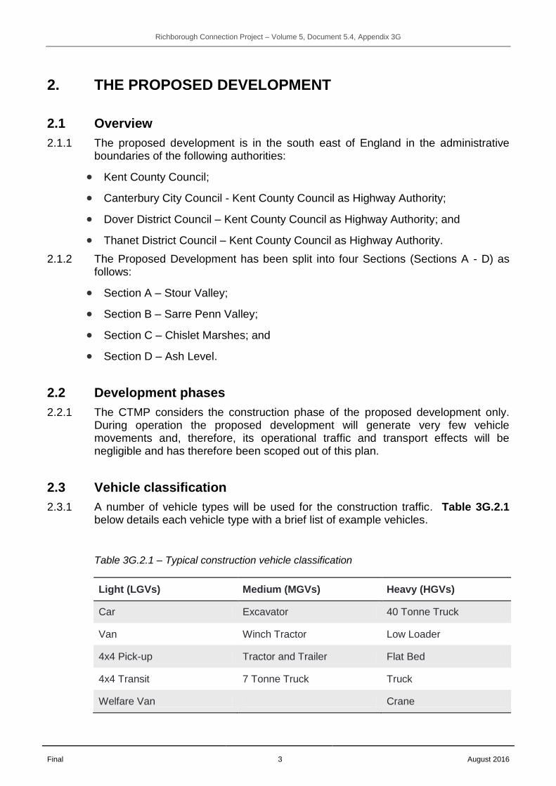
2.3.1 A number of vehicle types will be used for the construction traffic. Table 3G.2.1 below details each vehicle type with a brief list of example vehicles.
Table 3G.2.1 – Typical construction vehicle classification
Light (LGVs) Medium (MGVs) Heavy (HGVs)
Car Excavator 40 Tonne Truck
Van Winch Tractor Low Loader
4x4 Pick-up Tractor and Trailer Flat Bed
4x4 Transit 7 Tonne Truck Truck
Welfare Van Crane
Richborough Connection Project – Volume 5, Document 5.4, Appendix 3G
Final 4 August 2016
2.3.2 The vehicles and specifications provided above have been identified based on similar projects by scale and type.
2.3.3 Construction machinery and on-site plant, vehicles and generator fuel tanks will be re-fuelled on site.
2.4 LGV and HGV movements
2.4.1 Light Goods Vehicle (LGV) and Heavy Goods Vehicle (HGV) traffic movements have been assessed as part of the TA (Volume 5, Document 5.4, Appendix 10A(A)).
2.5 Abnormal indivisible load movements
2.5.1 The proposed development is not expected to require the movement of any abnormal indivisible loads (AILs) to transport plant to any of the relevant sites.
2.5.2 The Road Vehicles (Authorisation of Special Types) General Order 2003 sets out the categories of AILs with regard to weight, width and length. Depending on the size of the plant to be transported different arrangements may be required in terms of temporary traffic management and the management and timing of these movements. In the unlikely event that any movements of AILs will be required these will need to meet the standards and guidelines as set out in the Road Vehicles (Authorisation of Special Types) General Order 2003.
2.6 Project timescale
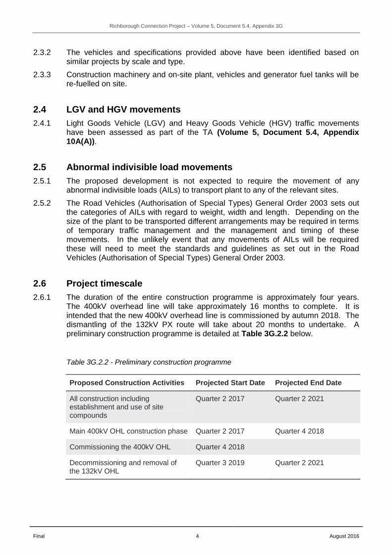
2.6.1 The duration of the entire construction programme is approximately four years. The 400kV overhead line will take approximately 16 months to complete. It is intended that the new 400kV overhead line is commissioned by autumn 2018. The dismantling of the 132kV PX route will take about 20 months to undertake. A preliminary construction programme is detailed at Table 3G.2.2 below.
Table 3G.2.2 - Preliminary construction programme
Proposed Construction Activities Projected Start Date Projected End Date
All construction including establishment and use of site compounds
Quarter 2 2017 Quarter 2 2021
Main 400kV OHL construction phase Quarter 2 2017 Quarter 4 2018
Commissioning the 400kV OHL Quarter 4 2018
Decommissioning and removal of the 132kV OHL
Quarter 3 2019 Quarter 2 2021

Richborough Connection Project – Volume 5, Document 5.4, Appendix 3G
Final 5 August 2016
3. ACCESS & ROUTE STRATEGY
3.1 Introduction
3.1.1 To provide access to the proposed development, there are three levels of access roads outlined in Figure 3G.3.1 below:
Figure 3G.3.1 - Construction access hierarchy
3.2 Access points
3.2.1 The proposed alignment of the overhead line has been divided into four sections (A – D). Each section of the overhead line will require access from the LRN. Construction routes have been identified and agreed in principle with KCC. These construction routes are set out within Table 3G.3.1 to Table 3G.3.8 of this document.
3.2.2 A total of 42 bellmouths are proposed on the local and primary road network.
Level 1: Strategic Road Network
Comprises the motorway and trunk road network, managed by Highways England, which provides
construction access from a wide catchment to the Primary and LRN
Level 2: Primary and Local Road Networks
Comprises the local roads, managed by Kent County Council, which provide construction access to much of
the proposed development.
Level 3: Access Roads
Will comprise of a temporary road network, managed by National Grid, which will link areas of the proposed
development to the LRN

Richborough Connection Project – Volume 5, Document 5.4, Appendix 3G
Final 6 August 2016
3.2.3 As part of the proposals and as a result of consultation with KCC, if an appropriate existing access is not available, bellmouths are to be designed for short term use and are going to be installed on a temporary basis, i.e. removed on completion.
3.3 Access roads
3.3.1 In cases where the proposed development cannot be accessed solely by the existing SRN/LRN road network and construction vehicles have to achieve access, temporary access roads will be constructed.
3.4 Local highway issues and constraints
Types of constraints/issues
3.4.1 Site visits along the proposed construction access routes were conducted and discussions held with KCC throughout the project development process. The issues and constraints have been identified through on-site inspection of these routes and include:
height restrictions;
weight restrictions;
road classification;
road layout;
existing crossing facilities;
existing traffic calming features;
sensitive receptors adjacent to the public highway;
visibility constraints;
restricted access;
speed limits and traffic speeds;
congestion;
large gradient changes;
Public Rights of Way (PRoW); and
other road users (pedestrians, cyclists and equestrians).
Issues/Constraints Identified
3.4.2 The study area encompasses all vehicular routes to be used between the proposed development’s sites, as defined by the Order limits, and the SRN. A number of common issues and constraints have been identified in regard to the study area. These are set out in Table 3G.3.9 below and many have been mitigated through the design development process.

Richborough Connection Project – Volume 5, Document 5.4, Appendix 3G
Final 7 August 2016
Table 3G.3.1 - Common issues and constraints
No. Issue/Constraint
Mitigated at Stage
Mitigation
1 Sensitive, built up areas (villages, towns) to be avoided by temporary construction traffic due to congestion, reduction of safety and air and noise pollution
Construction route planning stage
Final construction routeing and highway signage agreed with KCC routing
2 Avoidance, if possible of built up areas to remove conflicts with parking areas and local roads and streetscapes
Construction route planning stage
Final construction routeing and highway signage agreed with KCC
3 Avoidance of narrow rural roads Construction route planning stage
Final construction routeing agreed with KCC
4 Limited visibility at bellmouths Bellmouth selection and design stage
Bellmouth positions and designs to be agreed with KCC
5 Impacts on pedestrian (PRoW), cyclist (National Cycle Network, Sustrans and local routes) and equestrians (local routes)
Construction route planning and bellmouth design stages
Where pedestrian, cyclist and equestrian networks are likely to be impacted by bellmouth locations or access roads, diversions were identified as per Volume 2, Document 2.1(A), draft DCO Schedule 7, Part 1.
6 Construction traffic impacts on capacity of junctions and links on the construction routes (SRN and local highway network)
Transport and Construction route planning stage, ES Traffic Chapter capacity analysis, CTMP and mitigation
Capacity assessments undertaken and results included within the ES Traffic Chapter (Volume 5, Document 5.2, Chapter 10). Mitigation proposed where appropriate including vehicle movement restrictions addressed in this document.
7 Environmental interests in the local area, i.e. conservation areas, monuments, listed buildings and Sites of Specific Scientific Interest (SSSI)
Mitigation identified in the ES and ES supporting documents and implemented via the CEMP and accompanying documents.

Richborough Connection Project – Volume 5, Document 5.4, Appendix 3G
Final 8 August 2016
3.5 Access points and routing
3.5.1 As defined in Section 2.1.2 the study area has been broken into smaller areas to allow for a more transparent and practical assessment. The four smaller sections (A to D) have been identified as referenced below.
3.5.2 To provide safe and responsible construction vehicle access to various locations (bellmouths, compounds or substations) of the proposed development and to help achieve the objectives outlined in Table 3G.1.1, proposed construction traffic routes have been derived and proposed to KCC as the Highway Authority. These routes will be followed by both Light Goods Vehicles (LGVs) and Heavy Goods Vehicles (HGVs) during the construction and decommissioning phase of the proposed development. The primary considerations for each routeing strategy are as follows:
to use the shortest route from the location of bellmouths to the primary distributive network;
to try and avoid settlement and any other sensitive receptors and to reduce congestion and minimise effects in cities, towns and villages; and
to minimise travel on the LRN and use access roads where possible.
3.5.3 The prescribed route from each bellmouth to the nearest point on the SRN is detailed in Table 3G.3.1 to Table 3G.3.8 below. Bellmouths are shown on the Access, Rights of Way and Public Rights of Navigation Plans provided in Volume 4, Document 4.7.
3.5.4 General access from the west, London and Isle of Grain, will be via the M2, A299 Thanet Way, A291 Herne Bay Road and A28 Island Road. Access from the east, Ramsgate, will be via the A299 Canterbury Road West, A253 and A28 Island Road.
400kV Overhead Line Construction
3.5.5 Site entrances and routes for construction of the 400kV overhead line are currently proposed as follows:
Section A
Table 3G.3.2- Section A - indicative local access routes - 400kV construction
Bellmouth Reference
Indicative Access Point
Indicative Access Route from SRN
Pylon Reference (indicated by PC)
BM02 Broad Oak Road, via existing NG Canterbury North 400kV/132kV Substation Entrance
A299 Thanet Way, A291 Canterbury Road / Herne Bay Road, A28 Sturry Road, Vauxhall Road, Broad Oak Road
Canterbury Gantry

Richborough Connection Project – Volume 5, Document 5.4, Appendix 3G
Final 9 August 2016
Bellmouth Reference
Indicative Access Point
Indicative Access Route from SRN
Pylon Reference (indicated by PC)
BM03 Vauxhall Road via existing entrance adjacent to Canterbury Recycling Centre
A299 Thanet Way, A291 Canterbury Road / Herne Bay Road, A28 Sturry Road, Vauxhall Road
PC1
BM04 Vauxhall Road via improved existing field access on west side
A299 Thanet Way, A291 Canterbury Road / Herne Bay Road, A28 Sturry Road, Vauxhall
PC2
BM05 Broad Oak Road via improved existing field access on south side
A299 Thanet Way, A291 Canterbury Road / Herne Bay Road, A28 Sturry Road, Vauxhall Road, Broad Oak Road
PC3
BM08 Shalloak Road via existing field access on south east side
A299 Thanet Way, A291 Canterbury Road / Herne Bay Road, A28 Sturry Road, Vauxhall Road, Broad Oak Road
PC4
BM09 Shalloak Road via improved existing field access adjacent to a residential house on west side
A299 Thanet Way, A291 Canterbury Road / Herne Bay Road, A28 Sturry Road, Vauxhall Road, Broad Oak Road, Shalloak Road
PC5
BM11 Shalloak Road via improved access on west side
A299 Thanet Way, A291 Canterbury Road / Herne Bay Road, A28 Sturry Road, Vauxhall Road, Broad Oak Road, Shalloak Road
PC6 to PC8
BM13 Mayton Lane north of Heel Lane
A299 Thanet Way, A291 Canterbury Road / Herne Bay Road, Sweechgate
Scaffolding near PC9

Richborough Connection Project – Volume 5, Document 5.4, Appendix 3G
Final 10 August 2016
Bellmouth Reference
Indicative Access Point
Indicative Access Route from SRN
Pylon Reference (indicated by PC)
BM14 Barnet’s Lane, west side
A299 Thanet Way, A291 Canterbury Road / Herne Bay Road, via access road from BM21
PC9
BM15 Barnet’s Lane east side
A299 Thanet Way, A291 Canterbury Road / Herne Bay Road, via access road from BM21
PC9
BM21 A291 Herne Bay Road via improved existing entrance to track on west side
A299 Thanet Way, A291 Canterbury Road / Herne Bay Road
PC9 to PC10
BM19 A291 Herne Bay Road via improved existing entrance to track on east side
A299 Thanet Way, A291 Canterbury Road / Herne Bay Road
PC11
BM22 Hoath Road via improved existing field access west side
A299 Thanet Way, A291 Canterbury Road / Herne Bay Road, A28 Staines Hill, Babs Oak Hill, Hoath Road
PC12 to PC15
BM23 Bredlands Lane, west side
A299 Thanet Way, A291 Canterbury Road / Herne Bay Road, A28 Staines Hill, Babs Oak Hill, Hoath Road, Bredlands Lane
PC16
BM39 A28 Staines Hill close to Westbere
A299 Thanet Way, A291 Canterbury Road / Herne Bay Road, A28 Staines Hill
Westbere Compound
BM40 Vauxhall Road via existing entrance opposite BM03
A299 Thanet Way, A291 Canterbury Road / Herne Bay Road, A28 Sturry Road, Vauxhall Road
Clearance of vegetation
Richborough Connection Project – Volume 5, Document 5.4, Appendix 3G
Final 11 August 2016
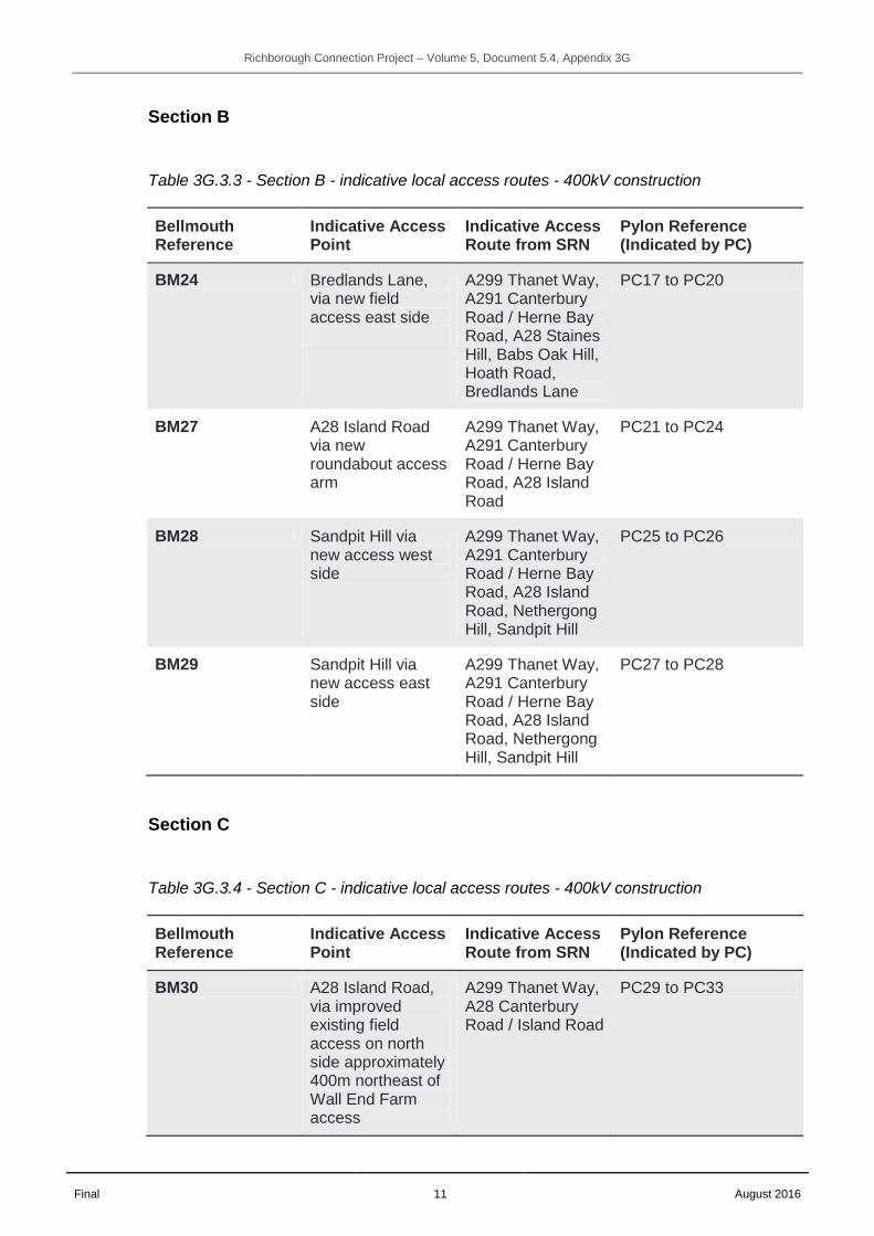
Section B
Table 3G.3.3 - Section B - indicative local access routes - 400kV construction
Bellmouth Reference
Indicative Access Point
Indicative Access Route from SRN
Pylon Reference (Indicated by PC)
BM24 Bredlands Lane, via new field access east side
A299 Thanet Way, A291 Canterbury Road / Herne Bay Road, A28 Staines Hill, Babs Oak Hill, Hoath Road, Bredlands Lane
PC17 to PC20
BM27 A28 Island Road via new roundabout access arm
A299 Thanet Way, A291 Canterbury Road / Herne Bay Road, A28 Island Road
PC21 to PC24
BM28 Sandpit Hill via new access west side
A299 Thanet Way, A291 Canterbury Road / Herne Bay Road, A28 Island Road, Nethergong Hill, Sandpit Hill
PC25 to PC26
BM29 Sandpit Hill via new access east side
A299 Thanet Way, A291 Canterbury Road / Herne Bay Road, A28 Island Road, Nethergong Hill, Sandpit Hill
PC27 to PC28
Section C
Table 3G.3.4 - Section C - indicative local access routes - 400kV construction
Bellmouth Reference
Indicative Access Point
Indicative Access Route from SRN
Pylon Reference (Indicated by PC)
BM30 A28 Island Road, via improved existing field access on north side approximately 400m northeast of Wall End Farm access
A299 Thanet Way, A28 Canterbury Road / Island Road
PC29 to PC33

Richborough Connection Project – Volume 5, Document 5.4, Appendix 3G
Final 12 August 2016
Bellmouth Reference
Indicative Access Point
Indicative Access Route from SRN
Pylon Reference (Indicated by PC)
BM31 Old Road, via improved existing field access west side
A299 Thanet Way, A28 Canterbury Road / Island Road, Old Road
PC34
BM32 A28 Island Road, via improved existing field access on east side adjacent to south side of River Wantsum
A299 Thanet Way, A28 Canterbury Road / Island Road
PC35
BM34 Gore Street, via new access on west side
A299 Thanet Way, A253 Ramsgate Road, Mile Road from BM33 and BM37, Gore Street
PC36 to PC40
BM35 Gore Street, via new access on east side
A299 Thanet Way, A253 Ramsgate Road, Mile Road from BM33 and BM37, Gore Street
PC41 to PC43
BM37 Gore Street, via new access on west side
A299 Thanet Way, A253 Ramsgate Road, Mile Road from BM33
PC36 to PC43
Section D
Table 3G.3.5 - Section D - indicative local access routes - 400kV construction
Bellmouth Reference
Indicative Access Point
Indicative Access Route from SRN
Pylon Reference (Indicated by PC)
BM35 Gore Street, via new access on east side
A299 Thanet Way, A253 Ramsgate Road, Mile Road from BM33 and BM37, Gore Street
PC44 to PC57
BM38 A256 Ramsgate Road via Waste Transfer Station entrance on west side
A256 Ramsgate Road
PC58 to PC60

Richborough Connection Project – Volume 5, Document 5.4, Appendix 3G
Final 13 August 2016
Bellmouth Reference
Indicative Access Point
Indicative Access Route from SRN
Pylon Reference (Indicated by PC)
BM41 A256 via Ash Road, Richborough Road and Whitehouse Drove
A256 Ramsgate Road, Ash Road, Richborough Road
Temporary bridge construction and removal
BM42 A256 Ramsgate Road via waste disposal site entrance
A256 Ramsgate Road
Temporary bridge construction and removal
132kV overhead line dismantling
3.5.6 Site entrances and routes for dismantling of the 132kV PX route overhead line are currently proposed as follows:
Section A
Table 3G.3.6 - Section A - indicative local access routes - 132kV dismantling
Bellmouth Reference
Indicative Access Point
Indicative Access Route from SRN
Pylon reference
BM01 Broad Oak Road A299 Thanet Way, A291 Canterbury Road / Herne Bay Road, A28 Sturry Road, Vauxhall Road, Broad Oak Road
PX01
Access from roadside
Farleigh Road A299 Thanet Way, A291 Canterbury Road / Herne Bay Road, A28 Sturry Road, Vauxhall Road, Broad Oak Road, Farleigh Road
PX02
Access from roadside
Ulcombe Road A299 Thanet Way, A291 Canterbury Road / Herne Bay Road, A28 Sturry Road, Vauxhall Road, Broad Oak Road, Farleigh Road, Headcorn Drive, Ulcombe Road
PX03
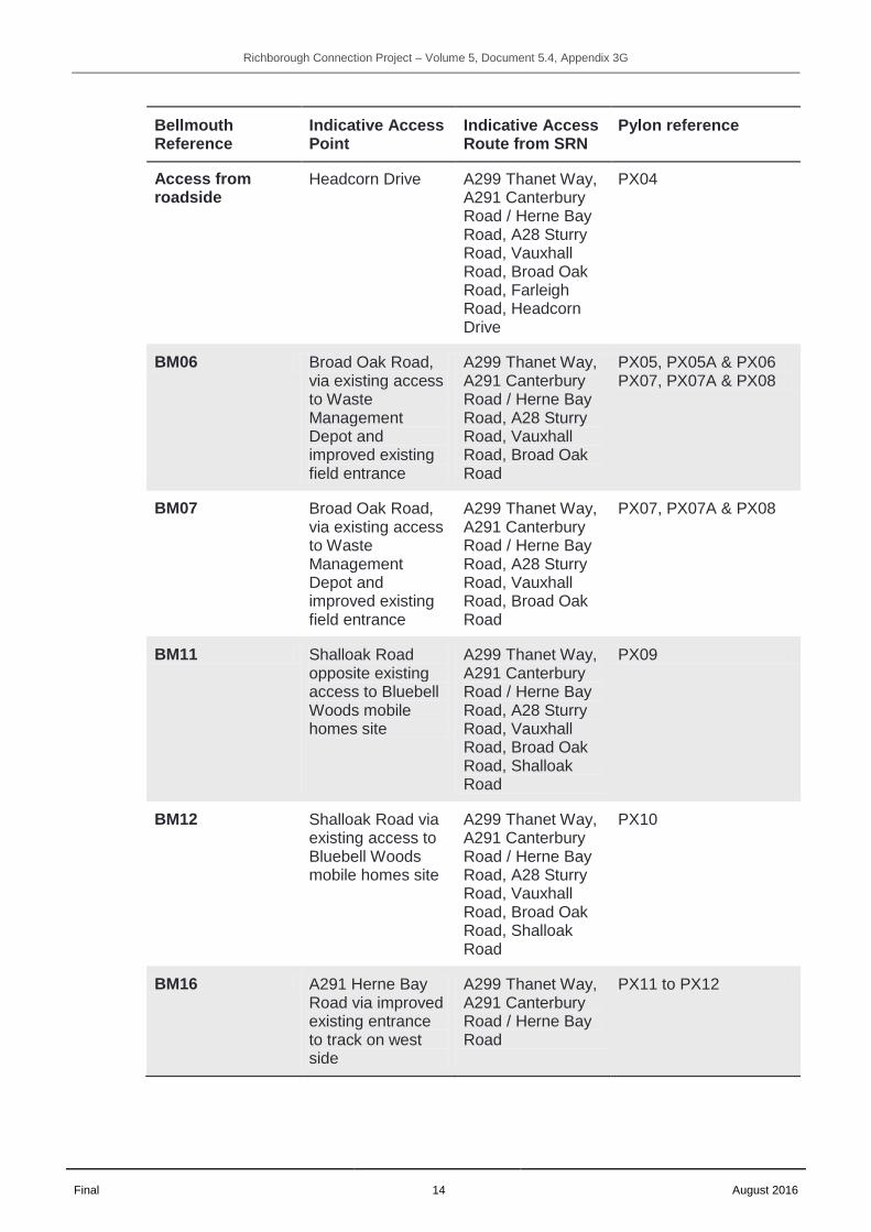
Richborough Connection Project – Volume 5, Document 5.4, Appendix 3G
Final 14 August 2016
Bellmouth Reference
Indicative Access Point
Indicative Access Route from SRN
Pylon reference
Access from roadside
Headcorn Drive A299 Thanet Way, A291 Canterbury Road / Herne Bay Road, A28 Sturry Road, Vauxhall Road, Broad Oak Road, Farleigh Road, Headcorn Drive
PX04
BM06 Broad Oak Road, via existing access to Waste Management Depot and improved existing field entrance
A299 Thanet Way, A291 Canterbury Road / Herne Bay Road, A28 Sturry Road, Vauxhall Road, Broad Oak Road
PX05, PX05A & PX06 PX07, PX07A & PX08
BM07 Broad Oak Road, via existing access to Waste Management Depot and improved existing field entrance
A299 Thanet Way, A291 Canterbury Road / Herne Bay Road, A28 Sturry Road, Vauxhall Road, Broad Oak Road
PX07, PX07A & PX08
BM11 Shalloak Road opposite existing access to Bluebell Woods mobile homes site
A299 Thanet Way, A291 Canterbury Road / Herne Bay Road, A28 Sturry Road, Vauxhall Road, Broad Oak Road, Shalloak Road
PX09
BM12 Shalloak Road via existing access to Bluebell Woods mobile homes site
A299 Thanet Way, A291 Canterbury Road / Herne Bay Road, A28 Sturry Road, Vauxhall Road, Broad Oak Road, Shalloak Road
PX10
BM16 A291 Herne Bay Road via improved existing entrance to track on west side
A299 Thanet Way, A291 Canterbury Road / Herne Bay Road
PX11 to PX12

Richborough Connection Project – Volume 5, Document 5.4, Appendix 3G
Final 15 August 2016
Bellmouth Reference
Indicative Access Point
Indicative Access Route from SRN
Pylon reference
BM18 A291 Herne Bay Road via new entrance to scrubland on east side
A299 Thanet Way, A291 Canterbury Road / Herne Bay Road
PX13 to PX14
BM22 Hoath Road via improved existing field access west side
A299 Thanet Way, A291 Canterbury Road / Herne Bay Road, A28 Staines Hill, Babs Oak Hill, Hoath Road
PX15 to PX19
BM23 Bredlands Lane, via improved existing field access west side
A299 Thanet Way, A291 Canterbury Road / Herne Bay Road, A28 Staines Hill, Babs Oak Hill, Hoath Road, Bredlands Lane
PX20
BM39 A28 Staines Hill close to Westbere
A299 Thanet Way, A291 Canterbury Road / Herne Bay Road, A28 Staines Hill
Westbere Compound
Section B
Table 3G.3.7 - Section B - indicative local access routes - 132kV dismantling
Bellmouth Reference
Indicative Access Point
Indicative Access Route from SRN
Pylon Reference
BM24 Bredlands Lane, via improved existing field access east side
A299 Thanet Way, A291 Canterbury Road / Herne Bay Road, A28 Staines Hill, Babs Oak Hill, Hoath Road, Bredlands Lane
PX21 to PX22
BM27 A28 Island Road via new access arm of Claremont Way roundabout
A299 Thanet Way, A291 Canterbury Road / Herne Bay Road, A28 Island Road
PX23 to PX34
BM30 A28 Island Road, A299 Thanet Way, PX35 to PX38

Richborough Connection Project – Volume 5, Document 5.4, Appendix 3G
Final 16 August 2016
Bellmouth Reference
Indicative Access Point
Indicative Access Route from SRN
Pylon Reference
via improved existing field access on north side approximately 400m northeast of Wall End Farm access
A28 Canterbury Road / Island Road
Section C
Table 3G.3.8 - Indicative local access routes - 132kV dismantling
Bellmouth Reference
Indicative Access Point
Indicative Access Route from SRN
Pylon Reference
BM30 A28 Island Road, via improved existing field access on north side approximately 400m northeast of Wall End Farm access
A299 Thanet Way, A28 Canterbury Road / Island Road
PX39 to PX43
BM31 Old Road, via improved existing field access on west site of road approximately 15m to the north of its junction with A28 Island Road
A299 Thanet Way, A28 Canterbury Road / Island Road, Old Road
PX44 to PX46
BM32 A28 Island Road, via improved existing field access on east side adjacent to south side of River Wantsum
A299 Thanet Way, A28 Canterbury Road / Island Road
PX47
BM33 A253 via improved existing field access (Mile Road) on south side
A299 Thanet Way, A253 Ramsgate Road
PX48 to PX53 and PX54 to PX57
BM35, BM36 and BM37
A253 via improved existing field access (Mile Road)
A299 Thanet Way, A253 Ramsgate Road, Mile Road
PX54 to PX55

Richborough Connection Project – Volume 5, Document 5.4, Appendix 3G
Final 17 August 2016
Bellmouth Reference
Indicative Access Point
Indicative Access Route from SRN
Pylon Reference
on south side and Gore Street, via new accesses on west and east side at northern end of industrial/gas site
from BM33 and BM37, then Gore Street
Section D
Table 3G.3.9 - Section D - indicative local access routes - 132kV dismantling
Bellmouth Reference
Indicative Access Point
Indicative Access Route from SRN
Pylon Reference
BM33, BM35 and BM37
A253 via improved existing field access (Mile Road) on south side and Gore Street, via new accesses on west and east side at northern end of industrial/gas site
A299 Thanet Way, A253 Ramsgate Road, Mile Road from BM33 and BM37, then Gore Street
PX56 to PX75
BM38 A256 Ramsgate Road via Waste Transfer Station entrance on west side
A256 Ramsgate Road
PX76 to PX77
BM41 A256 via Ash Road, Richborough Road and Whitehouse Drove
A256 Ramsgate Road, Ash Road, Richborough Road
Temporary bridge construction and removal
BM42 A256 Ramsgate Road via waste disposal site entrance
A256 Ramsgate Road
Temporary bridge construction and removal
3.5.7 To meet the objectives set out in Section 1.2 of this CTMP, the roads which make up the LRN included in Table 3G.3.1 to Table 3G.3.8 above will be subject to appropriate mitigation measures. These measures are detailed in Section 5 of this document.
3.5.8 All construction traffic must adhere to the prescribed routeing strategy which is set by this CTMP. As part of the CTMP control and monitoring measures, deviation from the approved routes will result in enforcement procedures and penalties. The

Richborough Connection Project – Volume 5, Document 5.4, Appendix 3G
Final 18 August 2016
mitigation, monitoring and enforcement are discussed in detail in Sections 5 and 6 of this CTMP.

Richborough Connection Project – Volume 5, Document 5.4, Appendix 3G
Final 19 August 2016
4. SIGNING STRATEGY & CORE WORKING HOURS FOR TRAFFIC MANAGEMENT DURING CONSTRUCTION & DECOMMISSIONING
4.1 Access route and point signing
4.1.1 Temporary signage will be erected along construction traffic routes on the LRN to provide access (directional) routeing information. These will be placed to ensure that construction vehicles are able to travel directly to site from the SRN.
4.1.2 This temporary signage will also be provided in the vicinity of each bellmouth and also will provide warning to other road users of the likely presence of construction vehicles.
4.2 Access road signing
4.2.1 Similar to the above access route, temporary signage will be erected along proposed construction access roads where necessary. The signage will provide drivers with information on distances to destination, and warning (hazard) information relating to potential vehicle conflict or pedestrian conflict areas (cross over points).
4.3 Temporary diversion signing
4.3.1 In the event that any diversions of traffic along the construction traffic routes are required, temporary signage will be installed by National Grid or the relevant LHA or both in accordance with relevant signage design guidance as is standard.
4.4 Working hours
Core Working Hours
4.4.1 Construction work will take place in accordance with the “Construction Hours” set out in Requirement 7 of Schedule 3 to the draft DCO (Volume 2, Document 2.1(A)).
4.4.2 Except in the case of emergency, any work required to be undertaken outside of core working hours (not including repairs or maintenance) will be agreed with the local authority prior to undertaking the works.
4.4.3 Any proposed changes to the core working hours set out above will be discussed and agreed with the relevant LHA.
Alternative Working Hours
4.4.4 Alternative working hours will be undertaken in accordance with Requirement 7 of Schedule 3 to the draft DCO (Volume 2, Document 2.1(A)).
4.4.5 The following operations may take place outside the core working hours:

Richborough Connection Project – Volume 5, Document 5.4, Appendix 3G
Final 20 August 2016
the installation and removal of conductors, pilot wires and associated protective netting across highways, railway lines or watercourses;
the completion of operations commenced during the core working hours which cannot safely be stopped;
highway works requested by the relevant highway authority to be undertaken on a Saturday or a Sunday or outside the core working hours;
security monitoring;
the testing or commissioning of any electrical plant installed as part of the authorised development.; and
the completion of works delayed or held up by severe weather conditions which disrupted or interrupted normal construction activities.

Richborough Connection Project – Volume 5, Document 5.4, Appendix 3G
Final 21 August 2016
5. MITIGATION MEASURES
5.1 Introduction
National Grid will implement a number of mitigation measures as set out below. This CTMP will be implemented under Requirement 5 of Schedule 3 to the DCO (Volume 2, Document 2.1(A)), securing the measures set out in this plan.
5.1.1 Each mitigation measure relating to the construction phase of the Proposed Development has been detailed in the following paragraphs.
5.2 HGV and LGV construction vehicle records
5.2.1 All HGV and LGV construction vehicle movements associated with the proposed development will be recorded and timed as they enter and leave all sites as part of a delivery management system (DMS). DMS records will be compiled and stored centrally. Any complaints, for example of construction vehicles following routes not identified in the TA or waiting in inappropriate or inconsiderate locations, can be cross-referenced against DMS records to determine if the vehicle was engaged on this project. Appropriate action can be taken to address poor driver behaviour by contractors engaged on this project.
5.3 Prescribed HGV and LGV Construction Routes
5.3.1 Only the construction traffic routes and access roads as set out in this CTMP will be used. The construction traffic routes and access roads are indicated in Table 3G.3.1 to Table 3G.3.8 of this document. The primary considerations for each routeing strategy are:
to use the shortest route from the location of bellmouths to the primary distributive network;
to avoid settlement and any other sensitive receptors to reduce congestion and minimise effects in cities, towns and villages; and
to minimise travel on the LRN.
5.4 HGV traffic movement restrictions
5.4.1 HGV movements associated with the proposed development will normally take place during the working hours in Section 4.4 of this Document. Vehicles finishing at the working area at the end of a working day shall be permitted to leave site (i.e. a one-way movement from the working area along the access road to the LRN or SRN).
5.4.2 Except for the movement from the working area identified above and in exceptional circumstances, movements will not be permitted on the construction access roads between the hours of 19:00 and 07:00 (Mondays to Fridays) and 17:00 to 08:00 on Saturdays and Sundays.

Richborough Connection Project – Volume 5, Document 5.4, Appendix 3G
Final 22 August 2016
5.5 HGV emissions
5.5.1 All vehicles used in the construction of the proposed development will be to Euro standard V class or better.
5.6 Banksman or presence of qualified personnel at access
5.6.1 Qualified personnel (Banksmen) will be in place at key locations when necessary during the construction of the proposed development. These are likely to be required in place at bellmouths for key deliveries or at PRoW crossing points during busy periods. Qualified personnel can be provided at other locations as required.
5.7 Timings of HGV movements
5.7.1 A booking system (Delivery Management System) will be used to ensure deliveries to the sites will be spread across the whole day where possible. This will minimise the impact of HGV traffic during the network peak periods. This booking schedule will also form part of and inform the monitoring process of the CTMP.
5.8 Monitoring of vehicle movements
5.8.1 Dedicated members of staff will travel on the construction routes and monitor LGV and HGV traffic using the routes associated with the proposed development.
5.8.2 Staff will be trained to conduct this monitoring process, collect and collate data and present the data for the Transport Co-ordination Officer (TCO).
5.9 HGV movements
5.9.1 The contractor will control the number of construction vehicle movements, as above. Adherence to these restrictions will be verified through the agreed monitoring process.
5.10 Exceptional circumstances
5.10.1 There may be exceptional circumstances when traffic movements on the SRN or LRN are compromised which will impact on construction vehicles being able to use the agreed construction traffic routes and access the necessary bellmouth. These exceptional circumstances are defined as one or more of the following:
a traffic or other similar incident on the highway network that disrupts the normal operation of the highway network or results in the closure of the highway network;
a breakdown of a HGV en-route to the authorised development;
work requested to be completed out of hours by the LHA / Highways England / Network Rail e.g. scaffold erection;
emergency health and safety requirement (incident); and
mitigation activities such as emergency flood prevention works.

Richborough Connection Project – Volume 5, Document 5.4, Appendix 3G
Final 23 August 2016
5.10.2 In the event of the exceptional circumstances detailed above which may result in construction vehicles, particularly HGVs not being able to arrive at or depart from a site, the following impacts need to be considered with regard to highways and construction of the proposed development:
incidents on the highway network of vehicles not being able to access the site resulting in stoppage (at agreed locations) or rescheduling of delivery;
incidents on the highway network causing delays, resulting in construction vehicles travelling outside of the agreed movement hours; and
impacts of delivery not being made with specific regard to construction works on site, specifically health and safety issue due to lack of equipment of material or stop to construction works and delays to construction programme.
5.11 Abnormal indivisible loads
5.11.1 It is not envisaged that there will be any abnormal loads required for this project. However, in the unlikely event that such a load were to be required then the Highways England’s Electronic Service Delivery for Abnormal Loads (ESDAL) system will be used to notify Highways England, LHAs and the Police of AIL movement details, times, types and route. The ESDAL system will be used to notify the aforementioned authorities prior to departure.
5.11.2 A full road condition survey of any proposed AIL delivery route will be undertaken both before and after delivery. The method of the surveys will be discussed and agreed with the relevant Local Authorities prior to being undertaken.
5.11.3 The movement of abnormal vehicles is controlled by The Motor Vehicles (Authorisation of Special Types) General Order 2003 and subject to management and prior agreement with the Police and Highways England.
5.11.4 Leaflet drops will be undertaken at key sections along the AIL delivery routes to inform local residents.
5.12 PRoW management plan
5.12.1 A PRoW Management Plan (Volume 5, Document 5.4.3H(A)) has been produced setting out how the closure of PRoWs will be managed during the construction of the proposed development.
5.12.2 The PRoW Management Plan highlights where potential PRoW closures and diversions are required and the extent of any reinstatement works required.
5.13 Cleansing of vehicles
5.13.1 All vehicles exiting from a bellmouth will be checked and cleaned manually (or if it is deemed necessary will pass over a wheel cleaning facility) prior to using the public highway. The cleansing of vehicles will ensure the removal of debris from all vehicles ahead of joining the road network. If required, a road sweeper will be utilised to further ensure that the LRN remains safe and clear of debris.

Richborough Connection Project – Volume 5, Document 5.4, Appendix 3G
Final 24 August 2016
5.14 Highway condition surveys
5.14.1 Each access point to any public vehicular highway by any access road or track used by the proposed development will be inspected. These inspections shall take place before first use, regularly during use and following final use, to ensure that the surface of the highway altered for the proposed development remains in good repair and safe for the public traffic using the highway. Any repairs that are required to maintain the altered highway throughout the construction period will be carried out in a timely manner.
5.14.2 At the end of the construction period, these highways alterations shall be returned to the condition they were before the construction began and a programme of these works will be agreed with KCC.
5.15 Temporary traffic management (TTM) procedures
5.15.1 Temporary traffic management will be used where required to enhance safety conditions on the LRN and mitigate potential impacts of the construction of the bellmouths and access roads. Consideration has been given to each bellmouth design and liaison with the LHAs has ensured that the design reflects the predicted traffic volumes and also the conditions and operation of the LRN within the vicinity of each bellmouth.
5.15.2 Temporary traffic management will be employed on the LRN during the construction of the bellmouths. Once the bellmouth works are completed, the TTM will be removed until the 400kV overhead line is commissioned and/or the 132kV overhead line is dismantled. TTM shall be employed while the bellmouth is removed and returned to its original condition.
5.15.3 Temporary traffic management will, where appropriate, either employ temporary traffic signals or manned stop and go boards or road narrowing or speed restrictions to facilitate the building of scaffolds, netting of scaffolds, dismantling of the 132kV overhead line and delivery of materials to the works areas.
5.15.4 Detailed, site specific plans will be produced at the detailed design stage for the bellmouths and TTM arrangements as required. These detailed plans and TTM implementation dates will be agreed with KCC.
5.16 Delivery management systems (DMS)
5.16.1 Records will be kept of project deliveries being made to site. Personnel will be located at key bellmouth locations. This will ensure the management of deliveries and allow the number of vehicles accessing/egressing to be recorded.
5.16.2 This information will be collated by the contractor and retained for reference.
5.16.3 The objectives of the DMS are:
to control the delivery of materials and equipment in line with the construction programme;
to minimise the number of construction vehicles on the road network (will be scheduled to meet/adhere to any agreed restrictions); and

Richborough Connection Project – Volume 5, Document 5.4, Appendix 3G
Final 25 August 2016
ensure construction vehicles do not exceed any agreed restrictions, i.e. peak period travel through certain junctions.
5.17 Information packs and communications
5.17.1 Information packs will be provided to all contractors which will form part of the contractual agreement between the contractors and National Grid. The information pack will contain the details of the following CTMP requirements:
HGV restrictions;
construction routes;
non-compliance guidance;
complaints procedure;
CTMP protocols and indications required for all contractors including a Code of Good Practice;
guidance on standard communication procedures between contractors and site;
emergency procedures relating to incidents with vehicles;
CTMP contacts (emergency and non-emergency); and
information packs and communications details will be shared with the LHAs ahead of any construction works.
5.18 Temporary repositioning of bus stops
5.18.1 Once the detailed temporary traffic management designs are finalised, works which may affect bus stops will be confirmed and there will be liaison with the relevant bus companies about any necessary temporary repositioning of bus stops.
5.18.2 This will be done to ensure that the least possible inconvenience is caused to all parties. Any temporary bus stop relocation(s) will be kept to the minimum distance possible from the existing stop to ensure safety for all users of the highway.
5.18.3 It is anticipated that three bus stops will need to be temporarily relocated:
5.18.4 The northbound and southbound bus stops on Shalloak Road in close vicinity to the Bluebell Woods mobile home site will need to be relocated during the entire works. There is opportunity for the southbound stop to be relocated in very close proximity, for example to the south, rather than the north, of the entrance to the Bluebell Woods estate, with negligible additional access distance for passengers. The northbound stop is on the only section of footway on the western side of the road, and in order to relocate the stop it will be necessary to construct an additional stretch of footway. A section in the Order limits of 10m in length has been identified, immediately north and following on from the existing footway. Again, this will give negligible additional access distances for passengers.
5.18.5 The northbound bus stop on Farleigh Road adjacent to pylon PX2 will need to be temporarily relocated when the pylon is being dismantled. The necessary relocation will be small, in the order of 30 to 40m, and so will have minimal impact on passengers.

Richborough Connection Project – Volume 5, Document 5.4, Appendix 3G
Final 26 August 2016
5.19 Travel plan
5.19.1 A Travel Plan will be implemented for the proposed development which sets out a number of travel planning initiatives including:
travel planning awareness;
welfare van provision for staff from external locations to site;
public transport;
car sharing;
construction traffic management;
modal shift monitoring; and
travel plan co-ordinator (TPC).
5.19.2 The Travel Plan will be produced by the contractor at detailed design stage and will form part of the evolution of this CTMP.

Richborough Connection Project – Volume 5, Document 5.4, Appendix 3G
Final 27 August 2016
6. MANAGEMENT STRUCTURE
6.1 Introduction
6.1.1 This section reviews the management structure that will oversee the CTMP. It is important that a strong management structure is in place to ensure the CTMP objectives are met, and that the continued monitoring and reviewing of the CTMP is maintained.
6.1.2 A Transport Co-ordination Officer (TCO) will be appointed by the Contractor to achieve this.
6.1.3 The TCO will be employed prior to commencement of works and will have the following transport-related responsibilities:
Monitor Contractor obligations with regard to the CTMP;
liaise with and report to KCC and Highways England about mitigation and any remedial measures if required;
update the CTMP as required; and
resolve issues and problems through the liaison with relevant stakeholders.
6.2 Monitoring and review
Monitoring Strategy
6.2.1 A TCO will be appointed prior to construction as part of the CTMP to oversee the implementation and monitoring of the CTMP.
6.2.2 The contractor will undertake monitoring as necessary to ensure compliance with the requirements of the CTMP and this will include the maintenance of records and traffic management measures.
6.2.3 The contractor will ensure that a suitable, qualified member of staff is employed to conduct surveys and monitor construction vehicle activity at specific locations on the construction route network to ensure adherence to the CTMP. This will include the monitoring of construction vehicles on the LRN and speed enforcement monitoring.
Review
6.2.4 The TCO will monitor and review the CTMP. These reviews are required to ensure that the CTMP delivers on the commitments and achieves the goals agreed as set out in the document.
6.3 Compliance
6.3.1 As part of the CTMP a series of mechanisms will be established to provide all parties with a clear understanding of the enforcement procedures that will be applied if the requirements contained within this CTMP are not achieved. It is

Richborough Connection Project – Volume 5, Document 5.4, Appendix 3G
Final 28 August 2016
anticipated that these mechanisms will be determined at a later stage and will include:
Risk Assessment Method Statement (RAMS) procedures – the contractor will implement the CTMP, adhere to the requirements and meet the goals through management practices. This will include site inductions for contractors, briefing on the obligations of National Grid standards, induction and adherence to RAMS procedures, DMS briefing, driver inductions and compliance guidance.
Contractual conditions – to be employed as part of this CTMP compliance methodology and will be built into the contractors contract, this will be subject to performance review by National Grid.
Actions – to be employed if the commitments of this CTMP are breached.
6.4 Enforcement and corrective measures
6.4.1 National Grid will ensure that appropriate measures are taken to ensure that contractor behaviour and performance is monitored and where appropriate corrective measures are taken to resolve, redress and enhance service performance which is in breach of the standards within the CTMP.
6.4.2 As part of the enforcement measures National Grid will ensure that the relevant contractor’s disciplinary procedures, including the measures within this CTMP, are carried out for a non-conformance. National Grid will also have the power to remove person(s) from the project should it be required and deemed appropriate.