3FS Pi Stairs 3FS Vent Riv erThams Stairs TheQuee Stairs ...
1
Charts: Lambeth & Kings Reaches 1 1 0 8 7 1 3 2 6 2 0 5 5 2 3 2 2 2 5 3 8 2 4 7 1.0 St. Katherine El Barco Latino (31) (34) (33) PLA 70 P LP LP P P omerset House 71a Temple Pier Dn T Dn 7 1 Temple Station UN DERGRO UND UN DERGRO UND 5 3 0 5 4 7 8 2 3 2 0 8 5 2 3 2 2 2 1 2 2 7 1 6 2 1 Issue:01 Date:18/10/13 Page 1 of 1 CCA No: 2020/16 The accompanying block correction shows Revised Mooring pontoon by Temple Pier & Revised depths through and approaching Westminster Bridge HYDROGRAPHIC SERVICE ISO FORM 425 For further information see the PLA hydrographic service website: h t t p : / / w w w . p l a . c o . u k / S a f e t y / P L A - H y d r o g r a p h i c - S e r v i c e - P u b l i s h e d - S u r v e y s 1 1 0 8 7 1 3 2 6 2 0 5 5 2 3 2 2 2 5 3 8 2 4 7 1.0 St. Katherine El Barco Latino (31) (34) (33) PLA 70 P LP LP P P omerset House 71a Temple Pier Dn T Dn 7 1 Temple Station UN DERGRO UND UN DERGRO UND 5 3 0 5 4 7 8 2 3 2 0 8 5 2 3 2 2 2 1 2 2 7 1 6 2 1 1 2 9 1 6 1 5 1 0 9 1 6 1 8 2 7 1 5 1 0 8 7 1 5 1 4 1 2 2 3 2 1 2 2 5 1 8 1 4 2 8 1 1 2 9 1 5 1 0 5 3 6 9 1 1 1 9 1 7 1 7 1 1 3 4 1 0 5 0 3 5 1 0 1 5 1 4 1 6 1 8 1 2 1 6 1 4 1 8 1 6 1 6 1 2 1 0 9 4 1 5 2 6 2 8 1 0 9 4 2 0 7 1 1 1 1 2 0 5 7 1 0 6 1 4 1 1 2 1 0 1 . 6 5s (131) (134) Collier (135) (150) (100) PLA PDC P i e r Bridge Headway Beacons 9 1 6 1 6 1 7 1 7 1 4 1 2 2 2 2 6 1 5 1 5 1 1 2 4 1 3 1 4 1 2 1 3 0 3 1 1 0 1 6 1 0 5 6 1 3 9 1 4 1 8 1 1 1 2 0 6 7 2 1 1 4 5 1 0 7 1 0 5 1 4 2 7 1 1 1 0 5 0 8 1 9 1 8 1 1 5 2 5 1 7 1 2 1 5 1 1 3 2 6 2 5 1 1 2 2 1 0 8 5 1 8 2 0 9 1 5 1 7 1 6 1 6 1 7 1 8 1 5 1 7 1 6 1 4 1 8 1 9 1 PLA 316 PLA 317 Port of London Authority Chart Correction Advice Date: 7th August. 2018 CCA No: 2020/16 PLA Chart No. 317 HO Ref No. 113-317-130 Previous Chart Correction: 2020/14 PLA Chart No. 316 HO Ref No. 113-316-178 Previous Chart Correction: 2020/14
Transcript of 3FS Pi Stairs 3FS Vent Riv erThams Stairs TheQuee Stairs ...
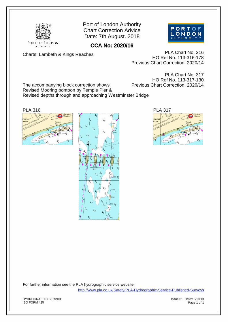
Charts: Lambeth & Kings Reaches
Edition Date: February 2016; Edition Version: (3); Corrections: (2016/19), (2016/31), (2017/4), (2017/19), (2017/22), (2018/15), (2019/1), (2019/12), (2020/5), (2020/9), (2020/14)
30.3
30.4
30.2
30.9
30.7
30.8
Wor
ks in
pro
gres
s - s
ee n
ote
02
23
01
12
30
09
05
62
91
1
11
91
71
71
06
08
13
05
02
71
41
51
09
01
51
41
06
22
61
2
81
92
04
61
61
71
41
51
81
1
61
61
71
91
21
12
42
02
62
41
32
41
22
52
22
62
81
09
30
42
31
23
53
07
72
1
36
11
71
12
05
3
92
52
46
06
54
71
23
82
37
14
3
22
72
1
11
21
07
06
21
0723
14
05
14
191
09
32
261
08
62
1907
61 04
2661
0451
19
62 1103
0027
30581 07
38
0143 0871 0202
03131251
1520211 34
81915412 71
18132
33 61133291
09025136
227232
32092
0632 61
3672
08
12071
5332
3107412
58
42
28
58
610332
32
6161
30
0402
2118 1
3104 51
1
08 22 191
04
31
61 71
08
1
22
5141
81
3191
71
32
02
61
42
62
05
52
181
61
11
32
14
22
21 1
91
53
82
08
12
47
12
91
12
61
08
71
05
02
22
61
51
2
52
92
07
91
14
22
32
81
08
07
71
0530
52
71
52
3141
04
04
2
07
81
22
52
71
05
30
2
32
21
21
01
12
01
08
15
61
2
30
34
81
11
53
1 .6
1.4
1.2
1.0
ThamesCruises
Ltd
Foul
P
Foul
P
(8)
(7)
(22)
(23)
(25)
(100)PLA
PDC
(139)
PLA
(140)
(141)
Waterloo Barge Tier
PLA
(35)
Crown River Cruises
(142)(143)
(138)
(27)
(36)
St. Katherine
(40)
El Barco
Latino
(31)
(41)
(34)
(33)
(28)
(29) (144) (136)
(26)
(137) (147)
Tatte
rsha
llCa
stle
Crown River CruisesRiverside Development
Wellington
PLA
WaterlooUpper
Hisp
anio
la
Cam
pion
Laun
ches
NORTHUMBERLAND AVENUE
WHITEHALL PLACE
Craven Street
- 2. 7
4 m
-
2.90
m
Richmond Terrace
WestminsterStation
TideGauge
V I
C T
O R
I A
P
FS
FS
Wes
t min
ster
Pie
r
P
63
PFS
A L
B E
R T
Stairs
54-5
Stairs
CountyHall
E M
B A
N K
M E
N T
Defenceof
Ministry
Horse Guards Avenue
WhitehallStairs
64
E
M B
A N
K M
E N
T
VictoriaEmbankment
Gardens
64a
Dn
65b Dn
Charing CrossRail Station
A2/19/2-3
66
Emba
nkm
ent P
ier
EmbankmentStation
67a
VictoriaEmbankment
Gardens
V I C
T O
R I
A
P
P
London Eye
56-75
NB
56a
FS
P
P
66a
Cleopatra'sNeedle
P
WoodsQuay
67
69
E M B
A N
K M
E N
T
P
56b
Footbridge
56
Jubilee Gardens
LAMBETH
Shell Centre
BELV
EDER
E RO
AD
CHARING CROSS RAIL BRIDGE
7 0
Dn
Footbridge
L.U.L
Dn
Stairs
65
ROYALFESTIVAL
HALL
SOUTHBANK
FestivalPier
56-75
Stairs
8 6
QueenElizabethHall
66
HaywardGallery
3FS
Shell Centre
A2/19/4
Upper Ground
Coin Street
NATIONALTHEATRE Upper Ground
Tower
TheLondonStudios
I.B.M.76-79 85-87 88
Stairs 3FS80-82
Vent
The Queen's Walk
Kent House
Prince'sWharf Gabriel's
Wharf
P
LifeboatPier
Stairs83
8 FS
FS
70
P LPLP
PP
SomersetHouse
KingsCollege
71a
TemplePier
Dn
Temple Place
Dn71bDn
71 DnP
Stairs PDn
71gDn
TempleStation 71h Chrysanthemum Pier
V I C T O R I A E M B A N K M E N T
Middle Temple Inner Temple
The TempleVictoria Embankment
Gardens
UNDERGROUND
UNDERGROUND
WATERLOO BRIDGE
UNDERGROUND
and Golden Jubilee Footbridges Upper & Lower
Stairs
UNDERGROUND
UNDERGROUND
Wat
erlo
o M
illenn
ium
Pie
r
NationalFilm Theatre
UNDERGROUND
51
09
62
1302 9112 41
81
30
31
23
1
71
53
52
06
36
46
82
54
72
37
23
3
33
32
3
91
62
61
43
12
32
13
61
51
72
81
11
52
71
04
13
04
12
02
32
51
03
26
08
05
00
1
81
19
61
01
02
72
22
11
07
03
27
91
71
2
38
02
12
81
51
34
1
61
54
02
32
09
09
36
32
0671
06 0332 3608
42 2 5301
6141 07
3061 31
32 10501
619128
31 5832 51 32
8102 58
8122 915102
81 3408
14 220330
1121
0491
0571
1551 09
2101
04 118201
81 0531 42 01
31 61 211108 03 01
5130
716121
12813191
05 222107
31
0214
9215305 47
92
32
71
22823208
52
5252
04
52322
22 2
22
221
52
2271 62
30
22
21
81
12
317122
01
9118
22
81
12
53
9111
15131
2212
2107 61128131 07
320861
08
0705
1111 14
078105
152 1471
1 1962
0912 2132
42 221 26
22 92 21 08
72 62
0719
3
61
08 92
02 61 32
62
220612
09 51
2171
22
4191
0671
7105
6171
04
81
42
30
51
1
7161
01
41
4181
02
91
0°7'W 0°6'W 0°6'W
0°7'W 0°6'W 0°6'W
51°30'N
51°31'N
30.5'N30.5'N30.5'N
Highest Recorded (1953)Highest Astronomical TideMean High Water SpringsMean High WaterMean High Water NeapsOrdnance Datum (Newlyn)Mean Low Water NeapsMean Low Water SpringsChart Datum
Tide Details, referred to levels atBlackfriars Bridge:
DEPTHSDepths are in metres and are reduced to Chart Datum being 2.90m, 3.05m & 3.20m below Ordnance Datum (Newlyn),which is approximately the level of Lowest Astronomical Tide. SOUNDINGSAll sub-tidal areas are surveyed by MBES giving 100% coverage to IHO S44 order 1A
HEIGHTSHeights are in metres. Underlined figures are drying heightsabove Chart Datum; all other heights are above MHWS. POSITIONSPositions are referred to the WGS84 compatible datum, European Terrestrial Reference System 1989 Datum.
VARIATIONMagnetic Variation is 0° 52' W (2015) decreasing 8' p.a..
AUTHORISED CHANNELThe pecked lines indicate the limits of the authorisedchannel.
DISTANCESDistances from London Bridge are shown along the N channeledge in Sea Miles and tenths against this symbol . ANCHORINGAnchoring is prohibited in the fairway and within 60 metresof any tunnel under the river, except in an emergency.
LADDERSPermanent ladders, the exact position or condition of which cannot be guaranteed, are shown thus .
SPEED LIMITA speed limit of 12knts exists for all power driven vesselsnavigating in this area of the Thames.See PLA General Direction No. 34.
7.1 6.9 6.8 6.7 6.6
30.6
Surveyed by the Port of London Authority Hydrographic Service
July 2015
KINGS REACHSCALE 1:5000 at A2
River Thames
DEPTHS in METRES
Issue:01 Date:18/10/13Page 1 of 1
CCA No: 2020/16
The accompanying block correction showsRevised Mooring pontoon by Temple Pier & Revised depths through and approaching Westminster Bridge
HYDROGRAPHIC SERVICEISO FORM 425
For further information see the PLA hydrographic service website:http://www.pla.co.uk/Safety/PLA-Hydrographic-Service-Published-Surveys
Edition Date: February 2016; Edition Version: (3); Corrections: (2016/19), (2016/31), (2017/4), (2017/19), (2017/22), (2018/15), (2019/1), (2019/12), (2020/5), (2020/9), (2020/14)
30.3
30.4
30.2
30.9
30.7
30.8
Works in progress - see note
06
54
71
23
82
37
14
3
22
72
1
11
21
07
06
21
0723
14
05
14
191
09
32
261
08
62
1907
61 04
2661
0451
19
62 1103
0027
30581 07
38
0143 0871 0202
03131251
1520211 34
81915412 71
18132
33 61133291
09025136
227232
32092
0632 61
3672
08
12071
5332
3107412
58
42
28
58
610332
32
6161
30
0402
2118 1
3104 51
1
08 22 191
04
31
61 71
08
1
22
5141
81
3191
71
32
02
61
42
62
05
52
181
61
11
32
14
22
21 1
91
53
82
08
12
47
12
91
12
61
08
71
05
02
22
61
51
2
52
92
07
91
14
22
32
81
08
07
71
0530
52
71
52
3141
04
04
2
07
81
22
52
71
05
30
2
32
21
21
01
12
01
08
15
61
2
30
34
81
11
53
31
2
72
02
02
12
59
41
02
15
51
03
52
3
54
12
04
51
09
42
22
62
06
2
04
07
21
52
32
4
12
61
1
81
42
45
91
81
02
12
51
44
05
17
2
51
04
32
22
42
06
15
51
1
01
24
08
2
81
12
02
58
31
32
17
12
13
31
56
05
1
6209
42
12
36
2
42
02
82
42
81
32
1
5
32
18
51
2
82
22
59
12
1
2
72
23
1.2
1.0
0.80.6
(100)PLA
PDC
(139)
PLA
(140)
(141)
Waterloo Barge Tier
PLA
(35)
Crown River Cruises
(142)(143)
(138)(146)
(27)
(36)
St. Katherine
(40)
El Barco
Latino
(31)
(41)
(34)
(33)
(28)
(29) (144) (136)
(26)
(137) (147)(148)
(58)
F.Bu
Crown River Cruises
PLA Coin Street Driftwood
Riverside Development
Cory Environmental
Wellington
Bankside 1st PLA
PLA
WaterlooUpper
Cam
pion
Laun
ches
A L
B E
R T
Stairs
54-5
Stairs
CountyHall
E M
B A
N K
M E
N T
Emba
nkm
ent P
ier
VictoriaEmbankment
Gardens
V I C
T O
R I
A
P
P
London Eye
56-75
NB
56a
FS
P
P
66a
Cleopatra'sNeedle
P
WoodsQuay
67
69
E M B
A N
K M
E N
T
P
56b
Footbridge
56
Jubilee Gardens
LAMBETH
Shell Centre
BELV
EDER
E RO
AD
CHARING CROSS RAIL BRIDGE
7 0
Dn
Footbridge
L.U.L
Dn
Stairs
65
ROYALFESTIVAL
HALL
SOUTHBANK
FestivalPier
56-75
Stairs
8 6
QueenElizabethHall
66
HaywardGallery
3FS
Shell Centre
A2/19/4
-2.90 m -3.05m
Upper Ground
SOUTHWARKA2/20/2
Coin Street
19 20
NATIONALTHEATRE
Duchy Street
Upper GroundA2/20/1
Holland Street
BroadwellTower
Cast le Y ard
TheLondonStudios
I.B.M.76-79 H
op to n St reet
85-87 88
Stairs 3FS80-82
Vent
The Queen's Walk
Kent House
Prince'sWharf
King'sReachTower
BLA
CK F
RI A
RS
RAI
LWA Y
BR
I DG
E
Rennie Court
Rennie Street
BLA C
KFR
IAR
S BR
IDG
E
Gabriel'sWharf
Gardens91
Upper Ground
P
LifeboatPier
89Stairs83 Old
BargehouseStairs
908 FS
FS
70
P LPLP
PP
SomersetHouse
KingsCollege
71a
TemplePier
Dn
Temple Place
Dn71bDn
71 DnP
Stairs PDn
71gDn
TempleStation 71h 71cChrysanthemum Pier
V I C T O R I A E M B A N K M E N T
Middle Temple Inner Temple
The TempleVictoria Embankment
Gardens
Oxo TowerWharf
91a
StamfordWharf
NB
Seacontainers House
L.U.L. 92-104
River Court
NB
Falcon Point
Doggetts C
oat &
Badge P
H
Daily Express
105Founders Arms PH
7 1Stairs
7 0
Stairs
Stairs
John Carpenter Street
Carm
elite Street
Unilever House
Temple Avenue
19 20
71L.U.L.
Stairs
Blackfriars Pier
MermaidTheatre
Pudd
le D
ock
Baynard HouseBlackfriarsRail
Station
80-84 85-101102
Pauls Walk
WATERLOO BRIDGE
UNDERGROUND
and Golden Jubilee Footbridges Upper & Lower
Stairs
Wat
erlo
o M
illenn
ium
Pie
r
NationalFilm Theatre
UNDERGROUND
36
46
82
54
72
37
23
3
33
32
3
91
62
61
43
12
32
13
61
51
72
81
11
52
71
04
13
04
12
02
32
51
03
26
08
05
00
1
81
19
61
01
02
72
22
11
07
03
27
91
71
2
38
02
12
81
51
34
1
61
54
02
32
09
09
36
32
0671
06 0332 3608
42 2 5301
6141 07
3061 31
32 10501
619128
31 5832 51 32
8102 58
8122 915102
81 3408
14 2203
5930
1121
0491
31 5405 42
7115
51 0921
01
04 1182401
81
45
05 15
31 42 01
31 61
4407
2104
1108 03 01
5110230
7161
02
211281
319105 2221
0731
03 06
0214
9215305 47
92
32
71
22823208
52
5252
04
52322
22 2
22
221
52
2271 62
30
22
21
81
12
317122
01
9118
22
81
12
53
9111
1
72
2
51
12
3122
41
12
02
5121
52
07
3
12
61
09
5112
22
62
71
8102
04
2
31
52
21
32
07
12
61
81
32
42
08
61
81
12
61
91
0941
17
0805
71
51
71
1
32
04
42
0909
12
06
61
51
1
12
08
01
24
120
81
17
58
32
02
31
13
12
31
52
56
23
1
81
81
42
12
36
07
02
42
82
42
32
81
18
1
32
265
2
82
51
22
12
59
23
1111 14
078105
114
71
1 19
0912 2132
42 221 26
92 21 08
72 62
0719
3
0°7'W 0°6'W 0°6'W 0°5'W
0°7'W 0°6'W 0°6'W 0°5'W
51°30'N
51°31'N
30.5'N30.5'N30.5'N
Highest Recorded (1953)Highest Astronomical TideMean High Water SpringsMean High WaterMean High Water NeapsOrdnance Datum (Newlyn)Mean Low Water NeapsMean Low Water SpringsChart Datum
Tide Details, referred to levels atBlackfriars Bridge:
DEPTHSDepths are in metres and are reduced to Chart Datum being 2.90m, 3.05m & 3.20m below Ordnance Datum (Newlyn),which is approximately the level of Lowest Astronomical Tide. SOUNDINGSAll sub-tidal areas are surveyed by MBES giving 100% coverage to IHO S44 order 1A
HEIGHTSHeights are in metres. Underlined figures are drying heightsabove Chart Datum; all other heights are above MHWS. POSITIONSPositions are referred to the WGS84 compatible datum, European Terrestrial Reference System 1989 Datum.
VARIATIONMagnetic Variation is 0° 52' W (2015) decreasing 8' p.a..
AUTHORISED CHANNELThe pecked lines indicate the limits of the authorisedchannel.
DISTANCESDistances from London Bridge are shown along the N channeledge in Sea Miles and tenths against this symbol . ANCHORINGAnchoring is prohibited in the fairway and within 60 metresof any tunnel under the river, except in an emergency.
LADDERSPermanent ladders, the exact position or condition of which cannot be guaranteed, are shown thus .
SPEED LIMITA speed limit of 12knts exists for all power driven vesselsnavigating in this area of the Thames.See PLA General Direction No. 34.
Ordnance Datum
5.41 8.46 4.45 7.50 3.96 7.01 3.34 6.39 2.73 5.78------- 3.05-1.66 1.39-2.53 0.52-3.05 -------
ChartDatum
BRIDGES - Headway at the centre span above MHWS:WATERLOO BRIDGE = 8.6mBLACKFRIARS ROAD BRIDGE = 7.0mBLACKFRIARS RAILWAY BRIDGE = 7.3mMILLENNIUM FOOTBRIDGE = 8.9mSOUTHWARK BRIDGE = 7.2mCANNON STREET RAILWAY BRIDGE = 7.2mLONDON BRIDGE = 8.7m
OLD LONDON BRIDGEFootings are shown as pecked lines.Building illumination booms extend up to 2 metres from the river wall between London bridge and London Bridge Hospital.
LIGHTS ON BRIDGESLight stars within a circle shown on bridges indicate a 2FY(hor) combined with Iso.W.4s(occas) / VQ traffic warning lights. White isophase light 4s shown from a bridge span warns of a reporting vessel navigating, or about to navigate, through the bridge. A very quick flashing light indicates two or more such vessels in the same vicinity. See PLA General Directions.
An arch marked at the centre by day or night by two horizontal orange (or amber) lights, denote that the archis one of the main working arches; these arches usuallylie in the Authorised Channel normally used by commercial vessels. Other arches are available fornavigation by vessels when height of tide, draft and air draft permit, unless marked as being closed for navigation.
WORKS IN PROGRESSConstruction works will be progressing in the areasindicated, various restrictions will be in place from time totime, see PLA Notices to Mariners for latest information.
LIGHTS ON JETTIESLight stars without legends represent two fixed lightsdisplayed vertically. They are seen as red to port and green to starboard when proceeding upriver.
TOPOGRAPHYThe shore features on this chart are based largelyon Ordnance Survey digital map data with thepermission of the Controller of Her Majesty's Stationery Office. © Crown Copyright 2016. All rightsreserved. Ordnance Survey Licence number 100022150.
MOORINGSMooring screws are shown in their true position thus andbuoys shown as symbols.Buoy numbers shown (32) are PLA references.
PLA REFERENCESThe numbers shown on the shore and in parenthesesin the river adjacent to moorings refer to PLA licences.
PLA PUBLICATIONSRefer to PLA Publications for further information:1. PLA River Byelaws2. General Directions for Navigation3. PLA Tide Tables & Port Information4. The River Thames Recreational Users Guide5. Mariner's Guide to Bridges on the Tidal Thames
PLA HYDROGRAPHIC SERVICE WEBSITEwww.pla.co.uk/hydrohomepage
7.1 6.9 6.8 6.7 6.6 6.5'W 6.4 6.3 6.2 6.1
30.6
Surveyed by the Port of London Authority Hydrographic Service
July 2015
KINGS REACHSCALE 1:5000 at A2
River Thames
DEPTHS in METRES
21
38
31
15
30
44
34
03
19
37
04
82
02
25
15
27
34
22
02
15
32
07
04
22
08
30
09
82
02
09
02
81
71
05
02
02
91
12
62
01
09
08
51
21
22
41
32
2
81
12
08
12
07
04
41
0
12
09
01
0
01
1
2161
1
04
21
0861
21
12
6252
21
05
81
61
31
71
0981
22
07
82
72 3182 02
61
41
03
412219
51
621291 04
2
119181
81
0681
42
81 12
52
9161 510491
52
61 827151 08
61
71
71 513041 22
32 12251
06
0481 42 810812
24915105
01
02
23
01
12
30
09
05
31
62
91
1
11
91
71
71
06
08
13
41
05
03
02
71
41
51
09
01
51
41
06
22
61
2
81
92
04
21
61
61
71
41
51
81
1
61
61
71
91
21
12
42
02
62
09
41
32
41
22
52
22
62
81
09
30
42
31
23
42
53
07
72
1
1
36
11
71
12
05
3
92
52
46
06
54
71
06
23
82
37
14
3
22
72
1
11
21
07
06
21
04
0723
14
05
14
191
09
32
261
08
62
1907
61 04
2661
0451
1962 11
0300
273
0581 07
380143 0871 02
02
03131251
1520211 34
81915412 71
181 3233 611332
91090251
3622
72323209
206
32 6136
7208
12071
5332
310741242
2861
033232
61 6130
0402
04 61 711 51
4181
319102
42181
1114
21 1
08
12
91
12
61
71
05
61
51
07
91 08
07
0530
3141
04
07
8132
34
Wor
ks in
pro
gres
s - s
ee n
ote
2.0
1.8
1 .6
1.4
1.2
(11)
MillbankBarge
MooringPLA
Y
Y
Fl.Y.2.5s
Y
Y
Fl.Y.2.5s
Fl.Y.2.5s
Y
(370)
PLA
Fl.Y.2.5s
Y
(380)
(390)
PLA
Fl.Y.2.5s
(400)
Y
Fl.Y.2.5s
Y
Y
Fl.Y.2.5s
Fl.Y.2.5s
Fl.Y.2.5s
ThamesCruises
Ltd
Foul
P
Foul
P
(8)
(7)
(22)
(23)
(25)
(Thames Marine Services0203 793 992507827 816004)
PLA
(121)
(122)
(125)
ThamesRefueler
(126)
PLA(123)
(124)
PLA
(131)
(134)
Collier
(135)
(150)
(100)PLA
PDC
(139)
PLA
(140)
(141)
Waterloo Barge Tier
PLA
(35)
Crown River Cruises
(142)(143)
(27)
(36)
(144)
(26)
Tatte
rsha
l lC
ast le
Crown River Cruises
(1)
(2)
(3)
(4)
(5)
(6)
(7)
(8)
(9)
WaterlooUpper
Hisp
anio
la
Cam
pion
Laun
c he s
Pipes
making London a safer cityLONDON FIRE BRIGADE
Lambeth Road
NORTHUMBERLAND AVENUE
WHITEHALL PLACE
Craven Street
WESTMINSTER
Thorney Street
ThamesHouse
MIL
LBAN
K
ThamesHouse
A2/18/2
I.C.House
Abin
gdon
Stre
et
60
Great Peter Street
F.S.
VictoriaTower
VictoriaTower Gardens
Memorial
59
StairsOutlet
Outlet
Stairs
HOUSESOF
PARLIAMENT
61
19
18ClockTower
A2/19/1
FS
LFB
Dn
Dn
Dn
FS
FS
50
LambethFirePier
Outlet
6 4
52Stairs
LambethPier
Outlet
51
Dn
Dn
InternationalMaritime
Organisation
LAMBETH BRIDGE
53
WestminsterTower
-2.5
9 m
-
2.74
m
Lambeth Palace
St. MaryChurch
LAM
BETH
PAL
ACE
RO
AD
Stairs
St. Thomas'Hospital
19
18
- 2. 7
4 m
-
2 .90
m5 4 WESTMINSTER BRIDGE
Richmond Terrace
WestminsterStation
TideGauge
V I
C T
O R
I A
P
FS
FS
Wes
tmi n
ster
Pi e
r
P
63
PFS
A L
B E
R T
Stairs
54-5
Stairs
CountyHall
E M
B A
N K
M E
N T
Defenceof
Ministry
Horse Guards Avenue
WhitehallStairs
64
E
M B
A N
K M
E N
T
VictoriaEmbankment
Gardens
64a
Dn
65b Dn
Charing CrossRail Station
A2/19/2-3
66
Emba
nkm
ent P
ier
EmbankmentStation
67a
VictoriaEmbankment
Gardens
V I C
T O
R I
A
P
P
London Eye
56-75
NB
56a
FS
P
P
66a
Cleopatra'sNeedle
P
56b
Footbridge
56
Jubilee Gardens
LAMBETH
Shell Centre
BELV
EDER
E RO
AD
CHARING CROSS RAIL BRIDGE
7 0
Dn
Footbridge
L.U.L
Dn
Stairs
65
ROYALFESTIVAL
HALL
SOUTHBANK
FestivalPier
56-75
Stairs
8 6
QueenElizabethHall
66
HaywardGallery
3FS
Shell Centre
A2/19/4
Upper Ground
NATIONALTHEATRE Upper Ground
Tower
TheLondonStudios
I.B.M.76-79
Stairs 3FS80-82
Vent
The Queen's Walk
Kent House
Prince'sWharf
838 FS
UNDERGROUND
UNDERGROUND
WATERLOO BRIDGE
LondonFire Brigade
Headquarters
and Golden Jubilee Footbridges Upper & Lower
UNDERGROUND
UNDERGROUND
Wat
erlo
o M
illenn
ium
Pie
r
NationalFilm Theatre
Bridge Headway Beacons
5232308227
02
2234
7202 8215
8122
22 7102
129108
218102
06
099161
086171
610571
4141 22
22 6101 51
51
0812 41
01 31412131
03
112301
610509
62
1302 9112 41
81
21
0921
01
0107
0 12
04
0
1 0408
4112
61 21
0861
62 0561
0981
07
3102
4119
6204
1191
22 7106
81 12
30
31
23
1
71
53
52
06
36
46
82
54
72
37
23
3
33
32
3
91
62
61
43
12
32
13
61
51
72
81
11
52
71
04
13
04
12
02
32
51
03
26
08
05
00
1
81
19
61
01
02
72
22
11
07
03
27
91
71
2
38
02
12
81
51
34
1
61
54
02
32
09
09
36
32
0671
06 0332 3608
42 2 5301
6141 07
3061 31
32 10501
619128
31 5832 51 32
81028122 9151
0281 34
08
14 220330
1121
0491
0571 51 09
2101
04 118201
81 0531
06
72
1
145107
2307
1 04
05
11
42
71
11 14
05
0781
24
05
91
81
152
51
1471
04
2151
132
1 1962
3051
0912 2132
08
42 22
51
1 26
82
22 92 21 08
04
72
91
62
0719
3
51
71
61
818230 2232 2
386203 412215
5202 217131
6104
8151 31244
15 07
12 5219 7109
5134
8102 4209
2512129104
37
08 92
02 61 32
62
220612
09 51
2171
22
4191
0671
7105
6171
04
81
42
30
51
1
7161
01
41
4181
02
91
29.6
29.7
29.8
29.9
30.3
30.2
30.1
30.4
0°8'W 0°7'W 0°7'W
51°29'N
51°30'N
51°30'N
0°8'W 0°7'W 0°7'W
51°29'N
51°30'N
51°30'N 30.5'N
LIGHTS ON BRIDGESLight stars within a circle shown on bridges indicate a 2FY(hor) combined with Iso.W.4s(occas) / VQ traffic warning lights. White isophase light 4s shown from a bridge span warns of a reporting vessel navigating, or about to navigate, through the bridge. A very quick flashing light indicates two or more such vessels in the same vicinity. See PLA General Direction No.28.
An arch marked at the centre by day or night by two horizontal orange (or amber) lights, denote that the archis one of the main working arches; these arches usuallylie in the Authorised Channel normally used by commercialvessels. Other arches are available for navigation by vessels when height of tide, draft and air draft permit,unless marked as being closed for navigation.
LIGHTS ON JETTIESLight stars without legends represent two fixed lightsdisplayed vertically. They are seen as red to portand green to starboard when proceeding upriver.
TOPOGRAPHYThe shore features on this chart are based largelyon Ordnance Survey digital map data with thepermission of the Controller of Her Majesty's Stationery Office. © Crown Copyright 2016. All rightsreserved. Ordnance Survey Licence number 100022150.
MOORINGSMooring screws are shown in their true position thus andbuoys shown as symbols.Buoy numbers shown (32) are PLA references.
SPEED LIMITA speed limit of 12knts exists for all power driven vesselsnavigating unless authorised by HM for high speed above Lambeth Bridge. See PLA General Direction No.34.
WORKS IN PROGRESSConstruction works will be progressing in the areasindicated, various restrictions will be in place from time totime, see PLA Notices to Mariners for latest information.
PLA REFERENCESThe numbers shown on the shore and in parentheses in theriver adjacent to moorings refer to PLA licences.
PLA PUBLICATIONSRefer to PLA Publications for further information:1. PLA River Byelaws2. General Directions for Navigation3. PLA Tide Tables & Port Information4. The River Thames Recreational Users Guide5. Mariner's Guide to Bridges on the Tidal Thames
PLA HYDROGRAPHIC SERVICE WEBSITEwww.pla.co.uk/hydrohomepage
PLA 316 PLA 317
Port of London AuthorityChart Correction AdviceDate: 7th August. 2018
CCA No: 2020/16
PLA Chart No. 317HO Ref No. 113-317-130
Previous Chart Correction: 2020/14
PLA Chart No. 316HO Ref No. 113-316-178
Previous Chart Correction: 2020/14


![BETWEEN STAIRS - Stairs | Staircase design · PDF fileHelical Stairs DBBW [NL] 18 ... EeStairs Design Competition 50 Straight Stairs 68 Floating Stairs 69 Helical Stairs 88 Spiral](https://static.fdocuments.net/doc/165x107/5abe57417f8b9ac0598d0063/between-stairs-stairs-staircase-design-stairs-dbbw-nl-18-eestairs-design.jpg)