3D Elevation Program (3DEP) - Gis-T Symposium · · 2015-04-22GIS-T Jim Langtry USGS National Map...
28
+ GIS-T Jim Langtry USGS National Map Liaison for Nebraska, Iowa, & Kansas April 20, 2015 3D Elevation Program (3DEP)
-
Upload
vuongduong -
Category
Documents
-
view
217 -
download
1
Transcript of 3D Elevation Program (3DEP) - Gis-T Symposium · · 2015-04-22GIS-T Jim Langtry USGS National Map...

+
GIS-TJim LangtryUSGS National Map Liaison for Nebraska, Iowa, & Kansas
April 20, 2015
3D Elevation Program (3DEP)

++ 2
■ 3D data include surface elevations and natural and constructed features
■ 3DEP increases the quality level of lidar being acquired to enable more accurate understanding, modeling, and prediction
■Goal to acquire national coverage in 8 years
Applies ground-breaking lidartechnology to acquire and distribute 3D data
Addresses a broad range of critical applications of national significance
3D Elevation Program (3DEP)

++ 3What is the 3D Elevation Program?
■ Address the mission-critical requirements of 34 Federal agencies, 50 states, and a sampling of local governments, tribes, private and not‐for profit organizations documented in the National Enhanced Elevation Assessment
■ Increase the overall investment in 3D data from about $45 M to $146 M annually to return more than $690 million annually in new benefits
■ Leverage collaboration among Federal, states, local and tribal partners to systematically complete national 3D data coverage in 8 years
■ Leverage the capability of private industry mapping firms, create jobs■ Achieve a 25% cost efficiency gain by collecting data in larger projects■ Completely refresh national elevation data holdings with new lidar and ifsar
elevation data products and services
3DEP is a call for community action to…
Natural Resource Conservation
Infrastructure Management
Flood Risk Mitigation Precision Farming Land Navigation and Safety
Geologic Resources and Hazards Mitigation

++ 43DEP 2012-2015READY for a national, 8-year programDeveloped 3DEP infrastructure■ Documented comprehensive requirements and
benefits in the National Enhanced Elevation Assessment (NEEA)
■ Designed 3DEP based on NEEA and to maximize return on investment
■ Developed the NEEA inventory into the annual U.S. Interagency Elevation Inventory in partnership with NOAA and others
■ Published plan for action based on extensive stakeholder input
■ Issued the first Broad Agency Announcement in 2014, with funding partnerships with FEMA and NRCS

++ 53DEP 2012-2015READY for a national, 8-year program
Developed 3DEP infrastructure■ Consolidated and modernized IT systems, ready
to initiate first phase of implementation
■ GPSC3 to be in place in FY15 to address increased data volume
■ Revised the base lidar specification to include 3DEP quality levels
■ New products and services being made available in 2015 from The National Map
Lidar Point Cloud1 meter DEMs5 meter Alaska DEMs Alaska Ifsar ORIs Alaska Ifsar DSMs

+ 6+ 6
3DEP Acquisition Strategy
Broad Agency Announcement (BAA) Competitive Offerors submit partnership proposals outlining a collaborative effort to acquire data and
requesting funds from the 3DEP program in partial support of the project Geospatial Products and Services Contracts (GPSC) services (money in, data out) Assistance Awards for Partner Acquisitions (money out, data in) Purchase Orders
Contributed Data Policy Vital Component of our program Federal agencies and States routinely make use of this opportunity to contribute data to
the program 3DEP call to action outlines the need for an overall increase to the national investment
in 3D Elevation data; not all of this will be funneled through the USGS; however for the greater good, the data should be placed into the public domain and ingested into the national dataset
Stakeholders make use of the GPSC services to contract for Lidar data and production of derivative products; provide copy of the data to the 3DEP program for integration into the national 3DEP holdings
Stakeholders contract directly for acquisition of lidar and production of derivative products and provide a copy to the USGS for integration into the 3DEP program
Increasing 3DEP data holdings

+ 7+ 7
Broad Agency Announcement (BAA)
Issued to facilitate the collection of lidar and derived elevation data for the 3D Elevation Program (3DEP)
Continues the USGS’s long standing approach to elevation data acquisition through combination of contracting through the USGS Geospatial Product and Services Contracts (GPSC) and assistance awards for partner acquisition.
Design a process and program to provide increased visibility and opportunity to the broadest stakeholder community possible (fedBizOpps.gov, grants.gov)
Establish a standard, fair and equitable competitive process that can easily be expanded to account for future growth in the 3D Elevation Program
A means to recognize, aggregate and inspire collaborative funding partnerships in support of multi-agency lidar data acquisition requirements
Acknowledgement of Purpose; Why this process?

++ 8
Broad Agency Announcement (BAA)
■ 72 pre-proposals submitted, identified requirements for $103M worth of data; requested funds over $56M
■ Invited 33 to submit full proposals; 31 full proposals were received, identified requirements for $68M; requested funds over $30M, with 29* funded
■ *Note that many of the 29 were re-scoped (reduced) due to availability of funds
■ Early estimates (to be refined via the IGCE and final GPSC negotiated costs):GPSC: ~62,212 sq. mi., ~$6.3M 3DEP funds, ~$17M total valueOther: ~31,903 sq.mi, ~ $3.2M 3DEP funds, ~$9.6M total value
■ Total estimated funds being committed is $9.5M (burdened), with a total estimated value of $26.6M (estimates will be refined via the IGCE and final negotiated costs)
■ The $9.5M is comprised of NGP, FEMA and NRCS funds
■ The average 3DEP cost share is 36% (offerors are covering an average of 64%)
■ Total square miles is estimated at 94,115; average project size of 3,245 sq mi
■ Projects will collect lidar in the following states: AK, AL, AR, AZ, CA, CO, FL, KS, LA, MA, ME, MI, MO, MS, NE, NH, NM, NY, OR, PA, PR, TN, VA, VT, WI
■ Additional funding and/or rounds will follow with remaining funding as project estimates are refined and FY15 funding is clarified
Summary of FY15 Results

+ 9+ 9
FY15 BAA Awards Proposed* body of work resulting from FY15 BAA submissions(*offerors notified, authoritative paperwork in progress)

+ 10+ 10
FY15 BAA AwardsAlignment with Federal Priorities

+ 11+ 11
FY15 BAA AwardsAlignment with Federal Priorities

+ 12+ 12
FY15 BAA AwardsPosting of awards – 3DEP Web site; Geospatial Platform
Will follow presentation style similar toformer CAP Grants; approved publicnotification
+ 13+ 13
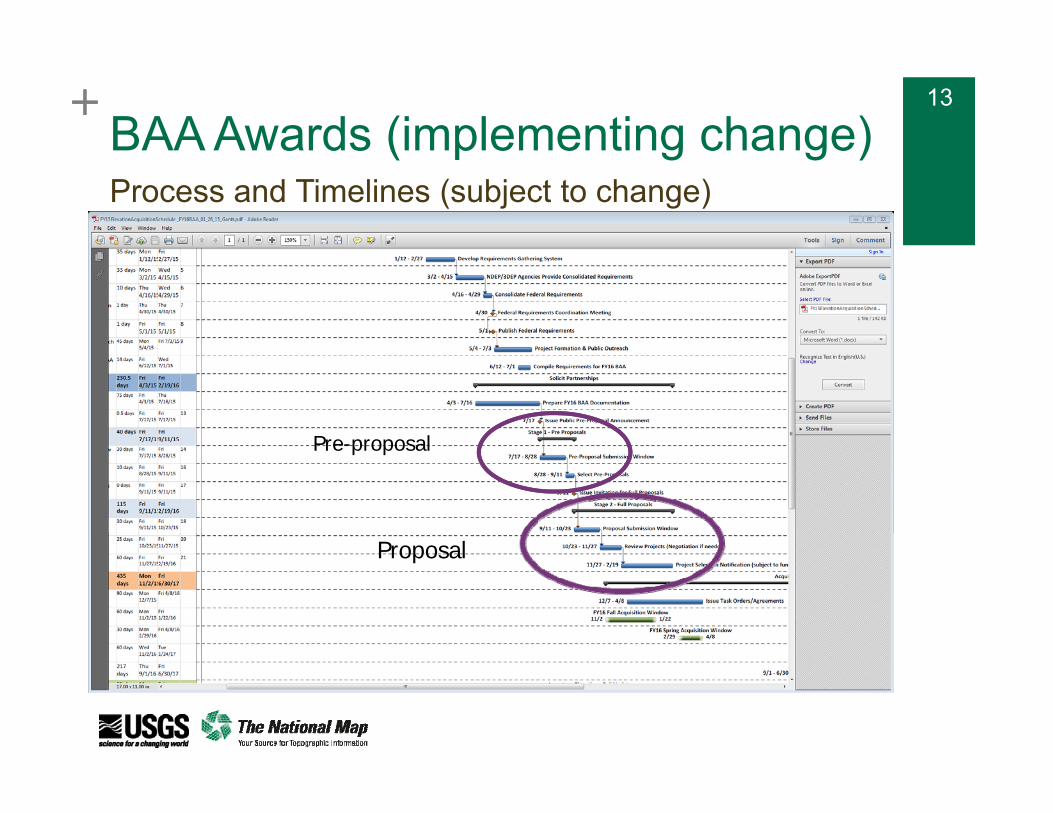
BAA Awards (implementing change)Process and Timelines (subject to change)
Pre-proposal
Proposal

++ 14
BAA Awards (implementing change)
Pre-proposal Proposed submission window 7/17/2015 – 8/28/2015 Review and evaluation 8/28/2015 – 9/11/2015 Provide additional time for NGP review and response Provide enhanced “generic” feedback
Proposal Proposed due date 10/23/2015 Review and evaluation 10/23/2015 – 11/27/2015 Provide additional time for NGP review and response Extend the period for project negotiations
Project award dates affected by federal budget cycle Continuing resolutions (CR) influence ability to make awards
Process and Timelines

++ 15
Initial BAA Awards
Guaranteed Matching Funds / Cost Share Obligated vs Requested Acknowledge the value of “seed money” Timing – do we need fall and spring BAA review cycles to accommodate
state and municipality budget cycles? Large cost shares increase the total investment in 3DEP
3DEP funding supports QL2 projects Upgrades to QL1 allowed Offeror responsible for cost of upgrade Provide standard method for offeror to present upgrade costs
Project supports multiple stakeholders Contributions from multiple funding partners Federal requirements State plans
Characteristics of a Successful Proposal

+ 16+ 16
BAA Strategic Challenges
Equitable cost share for acquisition of federal lands within States
Current funding levels limit ability to take advantage of economic efficiencies of large scale data acquisitions
Moving from opportunistic to strategic acquisition; empowers funding requisitions; advance planning for research and applications
Single year federal funding problematic for states with multi-year acquisition plans
Data Acquisition

+
3DEP Planning for FY16 BAA Awards
+ 18
Key Goals for Next BAAExpand awareness of 3DEP program
Support the formation of potential 3DEP projects nationwide
Increase participation from non-traditional elevation users
Enable USGS Liaisons role as the user engagement lead in the states
Enhance coordination with Federal agencies at the state and local level regarding 3DEP projects
+ 19
Enabling Project Formation
Publish Federal and state priorities along with potential 3DEP projects in a open requirements system Web-based map interface Federal priority alignment is an evaluation factor Sharing state priorities helps leverage ongoing state coordination
efforts
Hold public meetings to facilitate discussions about potential projects
Create public forums for coordination

+ 20+ 20
Coordination Prior to BAA Announcement Mar / Apr – Publish BAA process information on
GeoPlatform Elevation Community
April – National webinar(s) on 3DEP BAA process
May 1 - Launch requirements coordination system Publish coordinated Federal requirements Seeking approach to include state plans / current year
priorities in requirements system
May / Jun – State / regional public meetings / workshops
July – National webinar(s) on BAA requirements
July – BAA announcement

+ 21Next 3DEP BAA Cycle
Geospatial Platform as “Homebase” for Data Acquisition via the Elevation Community
BAA process and timelines
Publish requirements, allow ongoing updates
Access to US Interagency Elevation Inventory
Improve Public Information
Requirements Portal
Inventory
BAA Info
Geospatial Platform Elevation Community “Mock Up”

+ 22
3DEP Workshops USGS and stakeholders coordinate public meetings
to discuss potential partnerships
Meetings will be in-person with remote participation available
Details on who would organize these meetings, how many there would be, etc. are under development
Key goal is to create an open forum for project discussions at the meeting

+ 23
Sample Agenda
10 minutes - Welcome / logistics / meeting objective 15 minutes - USGS Overview of 3DEP and BAA Process 10 -15 minutes - State Overview of State Geospatial Data
Coordination and State Lidar Plan / Program (repeat for each state involved in meeting)
60 - 90 minutes - Summary of proposed projects 5-15 minutes for each project sponsor to speak about their project,
depending on number of projects (each must be given the same maximum amount of time)
Project sponsors would need to register their project in advance to be guaranteed an opportunity to present, and some amount of time will be reserved for walk-ons
Participants will have the opportunity to register their interest in a project
30 minutes - Open discussion TOTAL run time = about 2-3 hours
Times will vary based on needs in each state or region

+ 24+ 24
Requirements Tracker National Digital Elevation Program (NDEP) and Interagency
Working Group on Ocean and Coastal Mapping (IWG-OCM) have agreed to a joint system for tracking elevation projects, similar to old NDEP tracker
Build on NDEP/IWG-OCM tracker as tool for sharing potential projects
Require projects to be in the requirements system prior to public meetings
Viewed through NOAA’s SeaSketch initially
Working with GeoPlatform on future integration

+ 25
+ 26+ 26
Requirements Categories 3DEP BAA
Federal proposed projects (Input to BAA) By agency Consolidated
Near term state priorities from state plans Potential 3DEP projects (Possible BAA proposals)
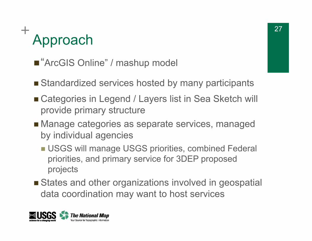
+ 27+ 27
Approach“ArcGIS Online” / mashup model
Standardized services hosted by many participantsCategories in Legend / Layers list in Sea Sketch will
provide primary structureManage categories as separate services, managed
by individual agencies USGS will manage USGS priorities, combined Federal
priorities, and primary service for 3DEP proposed projects
States and other organizations involved in geospatial data coordination may want to host services