3.8 Agricultural Lands - State of California · 3.8 Agricultural Lands ... agricultural lands....
18
U.S. Department of Transportation Federal Railroad Administration Page 3.8-1 3.8 Agricultural Lands This section describes the agricultural lands in the San Francisco Bay Area to Central Valley study area and identifies the potential for impacts on agricultural lands that would be caused by the various HST Alignment Alternatives 1 . This programmatic evaluation focuses on the potential direct conversion of agricultural lands to nonagricultural uses from the HST Alignment Alternatives and the potential for the indirect conversion of agricultural lands to nonagricultural uses as a result of segmentation of agricultural lands or severing of access to agricultural lands so that the remaining parcels are not economically suitable for farmland use. The potential for conflicts with federal, state, and local programs and policies related to farmland preservation, beyond the impacts of conversion, requires a level of detail beyond that available for this program-level analysis; this detailed analysis will be conducted in project-level environmental documents. The potential for impacts on agricultural land as a result of growth is discussed in Chapter 5, “Economic Growth and Related Impacts.” 3.8.1 Regulatory Requirements and Methods of Evaluation A. REGULATORY REQUIREMENTS Many regulatory and nonregulatory strategies are used to discourage and prevent farmland conversion (i.e., the conversion of land in agricultural use to nonagricultural use). Federal Farmland Protection Policy Act The U.S. Department of Agriculture’s (USDA’s) Natural Resources Conservation Service (NRCS) oversees the Farmland Protection Policy Act (FPPA) (7 U.S. Code [USC] § 4201 et seq.; see also 7 Code of Federal Regulations [CFR] 658). The FPPA (a subtitle of the 1981 Farm Bill) is national legislation designed to protect farmland. The FPPA states its purpose is to “minimize the extent to which federal programs contribute to the unnecessary conversion of farmland to nonagricultural uses.” The FPPA applies to projects and programs that are sponsored or financed in whole or in part by the federal government. The FPPA does not apply to private construction projects subject to federal permitting and licensing, projects planned and completed without assistance from a federal agency, federal projects related to national defense during a national emergency, or projects proposed on land already committed to urban development. The FPPA spells out requirements to ensure federal programs to the extent practical are compatible with state, local, and private programs and policies to protect farmland and calls for the use of the Land Evaluation and Site Assessment (LESA) system to aid in analysis. Because the Authority may ultimately seek some federal funding, the FPPA is considered in this document. Williamson Act and Farmland Security Zone Contracts The California Land Conservation Act (Government Code §51200 et seq.) of 1965, commonly known as the Williamson Act, provides a tax incentive for the voluntary enrollment of agricultural and open space lands in contracts between local government and landowners. The contract enforceably restricts the land to agricultural and open space uses and compatible uses defined in state law and local ordinances. An agricultural preserve, which is established by local government, defines the boundary of an area within which a city or county will enter into contracts with landowners. Local governments calculate the property tax assessment based on the actual use of the land instead of the potential land value assuming full development. Williamson Act contracts are for 10 years and longer. The contract is automatically renewed each year, maintaining a constant, 10-year contract, unless the landowner or local government files to 1 See Section 3.0, Introduction, for an explanation of how this section fits together with the HST Network Alternatives presented in Chapter 7, as well as for an overview of the information presented in the other chapters.
Transcript of 3.8 Agricultural Lands - State of California · 3.8 Agricultural Lands ... agricultural lands....
U.S. Department of Transportation Federal Railroad Administration
Page 3.8-1
3.8 Agricultural Lands
This section describes the agricultural lands in the San Francisco Bay Area to Central Valley study area and identifies the potential for impacts on agricultural lands that would be caused by the various HST Alignment Alternatives1. This programmatic evaluation focuses on the potential direct conversion of agricultural lands to nonagricultural uses from the HST Alignment Alternatives and the potential for the indirect conversion of agricultural lands to nonagricultural uses as a result of segmentation of agricultural lands or severing of access to agricultural lands so that the remaining parcels are not economically suitable for farmland use. The potential for conflicts with federal, state, and local programs and policies related to farmland preservation, beyond the impacts of conversion, requires a level of detail beyond that available for this program-level analysis; this detailed analysis will be conducted in project-level environmental documents. The potential for impacts on agricultural land as a result of growth is discussed in Chapter 5, “Economic Growth and Related Impacts.”
3.8.1 Regulatory Requirements and Methods of Evaluation
A. REGULATORY REQUIREMENTS
Many regulatory and nonregulatory strategies are used to discourage and prevent farmland conversion (i.e., the conversion of land in agricultural use to nonagricultural use).
Federal Farmland Protection Policy Act
The U.S. Department of Agriculture’s (USDA’s) Natural Resources Conservation Service (NRCS) oversees the Farmland Protection Policy Act (FPPA) (7 U.S. Code [USC] § 4201 et seq.; see also 7 Code of Federal Regulations [CFR] 658). The FPPA (a subtitle of the 1981 Farm Bill) is national legislation designed to protect farmland. The FPPA states its purpose is to “minimize the extent to which federal programs contribute to the unnecessary conversion of farmland to nonagricultural uses.” The FPPA applies to projects and programs that are sponsored or financed in whole or in part by the federal government. The FPPA does not apply to private construction projects subject to federal permitting and licensing, projects planned and completed without assistance from a federal agency, federal projects related to national defense during a national emergency, or projects proposed on land already committed to urban development. The FPPA spells out requirements to ensure federal programs to the extent practical are compatible with state, local, and private programs and policies to protect farmland and calls for the use of the Land Evaluation and Site Assessment (LESA) system to aid in analysis. Because the Authority may ultimately seek some federal funding, the FPPA is considered in this document.
Williamson Act and Farmland Security Zone Contracts
The California Land Conservation Act (Government Code §51200 et seq.) of 1965, commonly known as the Williamson Act, provides a tax incentive for the voluntary enrollment of agricultural and open space lands in contracts between local government and landowners. The contract enforceably restricts the land to agricultural and open space uses and compatible uses defined in state law and local ordinances. An agricultural preserve, which is established by local government, defines the boundary of an area within which a city or county will enter into contracts with landowners. Local governments calculate the property tax assessment based on the actual use of the land instead of the potential land value assuming full development.
Williamson Act contracts are for 10 years and longer. The contract is automatically renewed each year, maintaining a constant, 10-year contract, unless the landowner or local government files to
1 See Section 3.0, Introduction, for an explanation of how this section fits together with the HST Network Alternatives presented in Chapter 7, as well as for an overview of the information presented in the other chapters.

Bay Area to Central Valley HST Final Program EIR/EIS 3.8 Agricultural Lands
U.S. Department of Transportation Federal Railroad Administration
Page 3.8-2
initiate nonrenewal. Should that occur, the Williamson Act would terminate 10 years after the filing of a notice of nonrenewal. Only a landowner can petition for a contract cancellation. Tentative contract cancellations can be approved only after a local government makes specific findings and determines the cancellation fee to be paid by the landowner.
The State of California has the following policies regarding public acquisition of and locating public improvements on lands in agricultural preserves and on lands under Williamson Act contracts (Government Code §51290–51295):
• State policy is to avoid locating federal, state, or local public improvements and improvements of public utilities, and the acquisition of land, in agricultural preserves.
• State policy is to locate public improvements that are in agricultural preserves on land other than land under Williamson Act contract.
• State policy is that any agency or entity proposing to locate such an improvement, in considering the relative costs of parcels of land and the development of improvements, give consideration to the value to the public of land, particularly prime agricultural land, in an agricultural preserve.
Since 1998, another option in the Williamson Act Program has been established with the creation of Farmland Security Zone contracts. A Farmland Security Zone is an area created within an agricultural preserve by a board of supervisors upon the request of a landowner or group of landowners. Farmland Security Zone contracts offer landowners greater property tax reduction and have a minimum initial term of 20 years. Like Williamson Act contracts, Farmland Security Zone contracts renew annually unless a notice of nonrenewal is filed.
Potential cancellation of Williamson Act and Farmland Security Zone contracts would be addressed in subsequent project-level documents.
Farmland Mapping and Monitoring Program
The Farmland Mapping and Monitoring Program (FMMP) is the only statewide land use inventory conducted on a regular basis. The California Department of Conservation administers the FMMP, under which it maintains an automated map and database system to record changes in the use of agricultural lands. Farmland under the FMMP is listed by category—Prime Farmland, Farmland of Statewide Importance, Unique Farmland, and Farmland of Local Importance. Information regarding locations of farmland by category is readily available, and the potential conversion of FMMP lands is addressed in this document. The farmland categories listed under the FMMP are described below. The categories are defined pursuant to USDA land inventory and monitoring criteria, as modified for California.
Prime Farmland Prime Farmland is land with the best combination of physical and chemical features to sustain long-term production of agricultural crops. These lands have the soil quality, growing season, and moisture supply necessary to produce sustained high yields. Soil must meet the physical and chemical criteria determined by the NCRS. Prime Farmland must have been used for production of irrigated crops at some time during the 4 years prior to the mapping date by the FMMP.
Farmland of Statewide Importance Farmland of Statewide Importance is similar to Prime Farmland but with minor differences, such as greater slopes or a lesser ability of the soil to store moisture. Farmland of Statewide Importance must have been used for production of irrigated crops at some time during the 4 years prior to the mapping date.
Bay Area to Central Valley HST Final Program EIR/EIS 3.8 Agricultural Lands
U.S. Department of Transportation Federal Railroad Administration
Page 3.8-3
Unique Farmland Unique Farmland has lesser quality soils than Prime Farmland or Farmland of Statewide Importance. Unique Farmland is used for the production of the state’s leading agricultural crops. These lands are usually irrigated but may include nonirrigated orchards or vineyards found in some climatic zones in California. Unique Farmland must have been used for crops at some time during the 4 years prior to the mapping date.
Farmland of Local Importance Farmland of Local Importance is farmland that is important to the local agricultural community as determined by each county’s board of supervisors and local advisory committees.
California Conservation Easements
Conservation easements are voluntarily established restrictions that are permanently attached to property deeds, with the general purpose of retaining land in its natural, open-space, agricultural, or other condition while preventing uses that are deemed inconsistent with the specific conservation purposes expressed in the easements. Agricultural conservation easements define conservation purposes that are tied to keeping land available for continued use as farmland. Such farmlands remain in private ownership, and the landowner retains all farmland use authority, but the farmland is restricted in its ability to be subdivided or used for nonagricultural purposes, such as urban uses. The California Farmland Conservancy Program (Public Resources Code §10200 et seq.) supports the voluntary granting of agricultural conservation easements from landowners to qualified nonprofit organizations, such as land trusts, as well as local governments. Potential impacts on conservation easements would be addressed in subsequent project-level documents.
Local Policies and Regulations
Local jurisdictions (cities and counties) also have policies and regulations that protect agricultural resources or regulate farmland. These may include establishment of agricultural preserves or agricultural districts, policies protecting identified farmland, and agricultural zoning. Specific local policies are not addressed in this program-level analysis. Project-level farmland policy analysis would be addressed in subsequent project-level documents.
B. METHOD OF EVALUATION OF IMPACTS
Method of Determining Study Areas
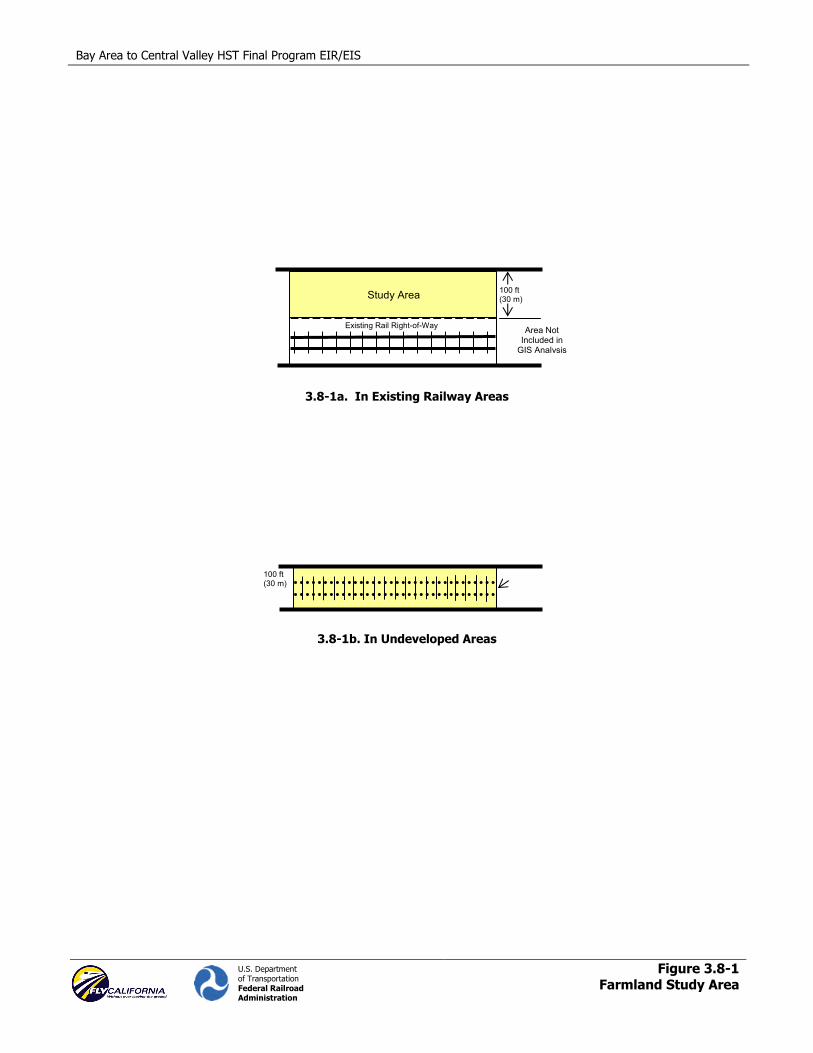
The study area for the proposed HST Alignment Alternatives was developed to address two different potential improvement scenarios. The first scenario was for potential alignment alternatives adjacent to existing rail corridors. In these cases, the study area extended 100 ft (30 m) from the rail right-of-way on the side that was selected for study based on conceptual engineering studies. The same method would also be used for alignments adjacent to existing highway corridors. This method allows the development of an estimate of the area that could be needed for a proposed HST system and an estimate within that area of the land now in agricultural use that would potentially be affected. This approach is illustrated below in Figure 3.8-1a.
The case shown in Figure 3.8-1a represents a conservative approach to quantifying potential impacts because it would be possible to fit the HST within a 50-foot (15-meter) right-of-way in areas of high agricultural impact. Moreover, it may be possible to fit the entire HST line into existing rail corridors, given agreements with private rail operators. To the extent this could be done, it would reduce the potential impacts of the proposed alternatives to a nearly negligible level of impact on agricultural lands in existing railway areas.
The second scenario was developed for new alignments in undeveloped areas (i.e., areas outside the urban/metropolitan area that do not have existing rail rights-of-way) that are separate from existing

Bay Area to Central Valley HST Final Program EIR/EIS 3.8 Agricultural Lands
U.S. Department of Transportation Federal Railroad Administration
Page 3.8-4
rail/highway corridors. In this scenario, the study area would extend 50 ft (15 m) on both sides of the proposed rail centerline, for a total width of 100 ft (30 m). This method is a conservative approach because it would be possible to fit the HST line within a 50-foot (15-meter) right-of-way in constrained areas. This approach is illustrated in Figure 3.8-1b.
Construction practices for the HST have not been determined at this program level, so a detailed analysis of construction-related impacts on agricultural lands cannot be addressed until the project-level documents. However, for this program document, it is assumed that construction impacts generally would be within the 100-foot buffer identified for the long-term operational impacts. To ascertain the possible extent of potential farmland impacts, the study areas for the proposed alignment alternatives were overlaid atop the FMMP farmland GIS data (California Division of Land Resource Protection 2006). GIS was used to calculate the acreage of farmland that potentially would be converted for the proposed alignment alternatives and improvements in the study area for each FMMP category. This analysis was used to calculate potential impacts on farmlands and accounts for proposed improvements that would expand existing transportation corridors, potential alignments that would be adjacent to existing transportation corridors, and potential alignments that would traverse undeveloped areas. The station facilities that would be included in the proposed alignment alternatives are assumed to be located primarily in the study areas considered. HST Alignment Alternatives have been ranked as having the least potential impacts on agricultural land (LPI) or the greatest potential impacts on agricultural land (GPI). Alignment alternatives other than the LPI and GPI would be expected to have levels of impact between those of the LPI and GPI.
For purposes of this discussion, farmland severance is defined as the division of one farmland parcel into two or more areas of farmland operation by the placement of a barrier (in this case rail line) through the parcel. Potential severance locations are discussed qualitatively, not quantitatively, in this program-level document. A qualitative discussion of farmland severance was based on aerial photographs to provide a general assessment of the level of potential farmland severance for the various alignments. Because quantification estimates from aerial photographs may lead to misleading results, the qualitative assessment of farmland severance was conducted. Parcel-specific information is not considered in this program-level analysis. Project-level farmland conversion and severance impacts that are determined to be significant adverse impacts would be addressed in subsequent project-level documents.
C. CEQA SIGNIFICANCE CRITERIA
Under CEQA, impacts on agricultural resources are considered significant if the project would:
• Convert Prime Farmland, Farmland of Statewide Importance, or Unique Farmland, as shown on the maps prepared pursuant to the FMMP of the California Resources Agency, to nonagricultural use.
• Sever farmland by the placement of barriers in a manner that impedes access to that land and could result in conversion of farmland to a nonagricultural use.
3.8.2 Affected Environment
A. STUDY AREA DEFINED
The study area for the proposed HST Alignment Alternatives is the 100-foot (30-meter) corridor, as described above in Methods of Evaluation of Impacts.
B. GENERAL DISCUSSION OF AGRICULTURAL LANDS
California is the leading agricultural producer and exporter in the United States. In 2004, California’s agricultural production reached $31.8 billion, accounting for approximately 13% of the nation’s gross cash receipts. The most recent statistics (2004) indicate that California has approximately
Bay Area to Central Valley HST Final Program EIR/EIS
U.S. Department of Transportation Federal Railroad Administration
Figure 3.8-1Farmland Study Area
100 ft (30 m)
3.8-1a. In Existing Railway Areas
3.8-1b. In Undeveloped Areas
100 ft (30 m)Study Area
Existing Rail Right-of-Way Area Not Included in
GIS Analysis


Bay Area to Central Valley HST Final Program EIR/EIS 3.8 Agricultural Lands
U.S. Department of Transportation Federal Railroad Administration
Page 3.8-5
26.7 million ac (10.8 hectares [ha]) of land in farms, has approximately 77,000 farms (less than 4% of the nation’s total), and produces more than 350 different crop types. Although California has many areas of farmland production, its largest area of agricultural production is the Central Valley. Six of the top ten California agricultural counties in 2001 were located in the Central Valley. (California Department of Food and Agriculture 2005.)
Urban growth frequently results in the conversion of agricultural land to nonagricultural uses. According to an estimate in a May 2001 report by the University of California Agricultural Issues Center, California lost approximately 497,000 ac (201,000 ha) of farmland to urbanization in the decade between 1988 and 1998, a loss rate of approximately 49,700 ac (20,100 ha) per year (Kuminoff et al. 2001).
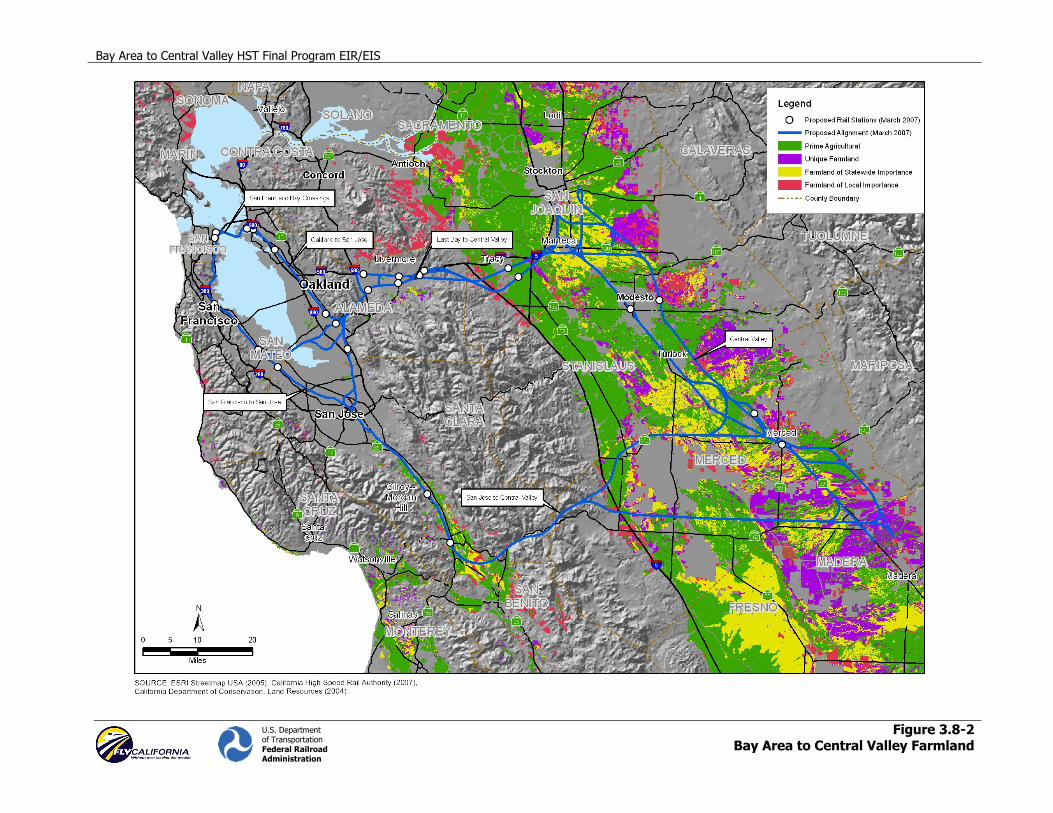
C. AGRICULTURAL RESOURCES IN THE BAY AREA TO CENTRAL VALLEY REGION
Land identified as Prime Farmland, Farmland of Statewide Importance, Unique Farmland, and Farmland of Local Importance occurs throughout the study area except in the heavily urbanized areas and the mountainous areas. The largest amount of agricultural land occurs in the Central Valley. The amount of farmland in each alignment alternative is identified below.
3.8.3 Environmental Consequences
A. NO PROJECT ALTERNATIVE
The No Project Alternative assumes that, in addition to existing conditions, additional transportation improvements would be developed and operational by 2030. The transportation improvements include projects that are programmed or funded to 2030 (Chapter 2).
It was not possible as part of this study to identify or quantify the amount of farmland that might be affected by the transportation improvements in the No Project Alternative. For existing transportation facilities, it is assumed that conversion of agricultural lands was previously addressed in the environmental documents for those projects, and only small additional or increased impacts are expected from the future transportation improvement included in the No Project Alternative. Thus, no additional impacts, beyond existing conditions are quantified under the No Project Alternative. In some cases, widening of existing corridors or similar improvements could convert additional farmland or could affect access to farmland.
B. HIGH-SPEED TRAIN ALIGNMENT ALTERNATIVES
Potential Conversion of Agricultural Land
Table 3.8-1 lists the amount of identified farmland for each HST corridor by alignment alternative and station location. This represents the potential for direct conversion of agricultural land to nonfarming uses (i.e., transportation uses). Figure 3.8-2 illustrates the farmland in relation to each alignment alternative.
Bay Area to Central Valley HST Final Program EIR/EIS 3.8 Agricultural Lands
U.S. Department of Transportation Federal Railroad Administration
Page 3.8-6
Table 3.8-1. Farmland Summary Data Table for Alignment Alternatives and Station Location Option Comparisons
Corridor Pos
sibl
e A
lign
men
t Se
gmen
ts
Alignment
Prime Farmland (acres)
Farmland of Statewide
Importance (acres)
Unique Farmland (acres)
Farmland of Local
Importance (acres)
San Francisco to San Jose: Caltrain
1 of 1 San Francisco to Dumbarton
0 0 0 0
1 of 1 Dumbarton to San Jose
0 0 0 0
Station Location Options
Transbay Transit Center 0 0 0 0
4th and King (Caltrain) 0 0 0 0
Millbrae/SFO 0 0 0 0
Redwood City (Caltrain) 0 0 0 0
Palo Alto (Caltrain) 0 0 0 0
Oakland to San Jose: Niles/I-880
1 of 2 West Oakland to Niles Junction
0 0 0 0
12th Street/City Center to Niles Junction
0 0 0 0
1 of 2 Niles Junction to San Jose via Trimble
6.4 0 0 0
Niles Junction to San Jose via I-880
6.4 0 0 0
Station Location Options
West Oakland/7th Street 0 0 0 0
12th Street/City Center 0 0 0 0
Coliseum/Airport 0 0 0 0
Union City (BART) 0 0 0 0
Fremont (Warm Springs) 0 0 0 0
San Jose to Central Valley: Pacheco Pass
1 of 1 Pacheco 176.0 56.2 0 8.8
1 of 3 Henry Miller (UPRR Connection)
128.3 75.6 39.5 22.0
Henry Miller (BNSF Connection)
129.6 58.1 77.6 29.2
GEA North 136.8 105.6 12.2 16.3
Bay Area to Central Valley HST Final Program EIR/EIS
U.S. Department of Transportation Federal Railroad Administration
Figure 3.8-2Bay Area to Central Valley Farmland


Bay Area to Central Valley HST Final Program EIR/EIS 3.8 Agricultural Lands
U.S. Department of Transportation Federal Railroad Administration
Page 3.8-7
Corridor Pos
sibl
e A
lign
men
t Se
gmen
ts
Alignment
Prime Farmland (acres)
Farmland of Statewide
Importance (acres)
Unique Farmland (acres)
Farmland of Local
Importance (acres)
Station Location Options
San Jose (Diridon) 0 0 0 0
Morgan Hill (Caltrain) 0 0 0 0
Gilroy (Caltrain) 0 0 0 0
East Bay to Central Valley: Altamont Pass
1 of 4 I-680/ 580/UPRR
11.7 1.9 0 0
I-580/ UPRR 12.1 0 0 0
Patterson Pass/UPRR
7.1 0 0 2.5
UPRR 7.1 0 0 0
1 of 4 Tracy Downtown (BNSF Connection)
203.7 199.8 25.3 17.1
Tracy ACE Station (BNSF Connection)
162.1 206.8 17.2 55.5
Tracy ACE Station (UPRR Connection)
87.1 59.5 0 35.2
Tracy Downtown (UPRR Connection)
151.7 68.1 8.1 14.7
1 of 1 East Bay Connections
0 0 0 0
Station Location Options
Pleasanton (I-680/Bernal Rd) 0 0 0 0
Pleasanton (BART) 0 0 0 0
Livermore (Downtown) 0 0 0 0
Livermore (I-580) 0 0 0 0
Livermore (Greenville Road/UPRR) 0 0 0 0
Livermore (Greenville Road/I-580) 0 0 0 0
Tracy (Downtown) 0 0 0 0
Tracy (ACE) 0 0 0 0
San Francisco Bay Crossings
1 of 2 Trans Bay Crossing—Transbay Transit Center
0 0 0 0
Trans Bay Crossing—4th & King
0 0 0 0

Bay Area to Central Valley HST Final Program EIR/EIS 3.8 Agricultural Lands
U.S. Department of Transportation Federal Railroad Administration
Page 3.8-8
Corridor Pos
sibl
e A
lign
men
t Se
gmen
ts
Alignment
Prime Farmland (acres)
Farmland of Statewide
Importance (acres)
Unique Farmland (acres)
Farmland of Local
Importance (acres)
1 of 6
Dumbarton (High Bridge)
2.3 0 0 0
Dumbarton (Low Bridge)
2.3 0 0 0
Dumbarton (Tube)
2.3 0 0 0
Fremont Central Park (High Bridge)
0 0 0 0
Fremont Central Park (Low Bridge)
0 0 0 0
Fremont Central Park (Tube)
0 0 0 0
Station Location Options
Union City (Shinn) 0 0 0 0
Central Valley
1 of 6
BNSF—UPRR 326.0 192.7 113.9 143.4
BNSF 407.3 164.0 101.6 165.0
UPRR N/S 268.9 161.0 67.3 37.4
BNSF Castle 385.7 149.2 140.7 141.7
UPRR—BNSF Castle
331.4 117.3 91.9 81.5
UPRR—BNSF 318.2 160.8 67.3 64.0
Station Location Options
Modesto (Downtown) 0 0 0 0
Briggsmore (Amtrak) 0 0 0 0
Merced (Downtown) 0 0 0 0
Castle AFB 12.0 0 0 0
The key findings of the farmland analysis by corridor and alignment alternatives are summarized below. For a complete summary of all potential agricultural land conversions by segment see Table 3.8-A-1 in Appendix 3.8-A.
San Francisco to San Jose Corridor: Caltrain • No potential impacts on farmland in any of the four farmland categories were identified because
the area is already urbanized.
− Station Location Options: No potential impacts on farmland at any of the station location options were identified in this corridor.

Bay Area to Central Valley HST Final Program EIR/EIS 3.8 Agricultural Lands
U.S. Department of Transportation Federal Railroad Administration
Page 3.8-9
Oakland to San Jose Corridor: Niles/I-880 • Niles/I-880 (West Oakland to Niles Junction) and Niles/I-880 (12th Street/City Center to Niles
Junction): No potential impacts on farmland in any of the four farmland categories were identified for either alignment alternative because the area is already urbanized.
• Niles/I-880 (Niles Junction to San Jose via Trimble) and Niles/I-880 (Niles Junction to San Jose via I-880): A total of 6.4 ac (2.60 ha) of Prime Farmland potentially would be converted under either alignment alternative.
− Station Location Options: No potential impacts on farmland at any of the station location options were identified in this corridor.
San Jose to Central Valley Corridor: Pacheco Pass • Pacheco: A combined total of 240.99 ac (97.53 ha) of Prime Farmland, Farmland of Statewide
Importance, and Farmland of Local Importance potentially would be converted.
• Henry Miller and GEA North (Western Valley to BNSF/UPRR): The Henry Miller (BNSF Connection) Alignment Alternative is the GPI compared to the GEA North or Henry Miller (UPRR Connection) alignment alternatives. A combined total of 294.6 ac (119.21 ha) of farmland in all four farmland categories potentially would be converted with the Henry Miller (BNSF Connection) Alignment Alternative. The GEA North Alignment Alternative would have a combined total of 270.9 ac (109.64 ha) of farmland in all four farmland categories that potentially would be converted and would have the most prime farmland potentially converted at approximately 137 ac (55.38 ha) (by only a small amount). The Henry Miller (UPRR Connection) is the LPI and would have slightly less impact on farmlands, with a combined total of 265.3 ac (107.35 ha) in all four categories.
− Station Location Options: No potential impacts on farmland at any of the station location options were identified in this corridor.
East Bay to Central Valley Corridor: Altamont Pass • Niles to Altamont: GPI is I-680/580/UPRR. LPI is UPRR. Small amount of farmland potentially
would be converted for Altamont Pass between Niles and Altamont because of terrain (13.6 ac [5.49 ha] of Prime Farmland and Farmland of Statewide Importance for I-680/580/UPRR, 12.1 ac [4.91 ha] of Prime Farmland for I-580/UPRR, 9.5 ac [3.85 ha] of Prime Farmland and Farmland of Local Importance for Patterson Pass/UPRR, or 7.1 ac [2.85 ha] of Prime Farmland for UPRR).
• Tracy Downtown and ACE Station: GPI is the Tracy Downtown (BNSF Connection) Alignment Alternative with minimally greater impacts than the Tracy ACE Station (BNSF Connection) Alignment Alternative. A combined total of 445.9 ac (180.45 ha) of farmland in all four farmland categories potentially would be converted and of that, approximately 204 ac (82.56 ha) would be prime farmland, the highest of the alignment alternatives within this corridor. The Tracy ACE Station (BNSF) Connect would have just slightly less farmland potentially converted at 441.5 ac (178.69 ha). The Tracy ACE Station (UPRR Connection) Alignment Alternative is the LPI with 181.7 ac (73.53 ha) (in all four categories) potentially converted, and the Tracy Downtown (UPRR Connection) Alignment Alternative would be just slightly higher with a potential to convert 242.5 ac (98.16 ha) of farmland.
• East Bay Connections: Neither of the East Bay Connection alignment alternatives would result in conversion of farmland.
− Station Location Options: No potential impacts on farmland at any of the station location options in this corridor were identified.
San Francisco Bay Crossings Corridor • Trans Bay Crossings: No potential impacts on farmland in any of the four farmland categories
were identified because of the location (in a tunnel under the bay and in urbanized areas).

Bay Area to Central Valley HST Final Program EIR/EIS 3.8 Agricultural Lands
U.S. Department of Transportation Federal Railroad Administration
Page 3.8-10
• Dumbarton (High Bridge, Low Bridge, or Tube): GPI (with minimally greater impacts) (no differences between optional vertical alignments). A total of only 2.3 ac (0.94 ha) of Prime Farmland potentially would be converted with any alignment alternative because the area is already urbanized.
• Fremont Central Park (High Bridge, Low Bridge, or Tube): LPI (with minimally fewer impacts) (no differences between optional vertical alignments). No potential impacts on farmland in any of the four farmland categories were identified because the area is already urbanized.
− Station Location Options: No potential impacts on farmland at the station location option in this corridor were identified.
Central Valley Corridor • BNSF—UPRR: A combined total of 775.9 ac (314.01 ha) of farmland in all four farmland
categories potentially would be converted.
• BNSF: GPI. A combined total of 837.8 ac (339.05 ha) of farmland in all four farmland categories potentially would be converted.
• UPRR N/S: LPI. A combined total of 534.6 ac (216.35 ha) of farmland in all four farmland categories potentially would be converted.
• BNSF Castle: A combined total of 817.3 ac (330.75 ha) of farmland in all four farmland categories potentially would be converted.
• UPRR—BNSF Castle: A combined total of 622.1 ac (251.74 ha) of farmland in all four farmland categories would potentially be converted.
• UPRR—-BNSF: A combined total of 610.3 ac (246.99 ha) of farmland in all four farmland categories potentially would be converted.
− Station Location Options: The station location option at Castle AFB (associated with the BNSF Castle and UPRR—BNSF Castle Alignments) has the potential to affect 12.0 ac (4.85 ha) of Prime Farmland. The other station location options in this corridor would not result in any impacts on farmland.
Potential Farmland Severance
Farmland severance, or the division of one farmland parcel into two or more areas of operation by the placement of a barrier (in this case rail line) through the parcel, would potentially occur with the project in some locations. Potential severance locations would be limited, however, because most of the alignment alternatives follow existing transportation corridors. The East Bay to Central Valley alignment alternatives, including the Tracy Downtown (BNSF Connection), Tracy ACE Station (BNSF Connection), Tracy Downtown (UPRR Connection), and Tracy ACE Station (UPRR Connection) alignment alternatives, each would have some potential for farmland severance impacts, particularly where these alignment alternatives connect to the Central Valley alignment alternatives near Lathrop and Manteca. The San Jose to Central Valley alignment alternatives, including the Pacheco and GEA North alignment alternatives, each of which includes significant amounts of agricultural lands, generally would not follow existing railroads or roadway rights-of-way, so the potential for severance impacts is greatest for these alignments. The Henry Miller alignment alternatives are generally adjacent to Henry Miller Road but would still have the potential for farmland severance on the western and eastern ends of the alignments. For other alignment alternatives, the addition of an alignment alternative in or adjacent to existing rail or roadway corridors still could lead to limited severance of farmland as a result of greater restrictions on crossing of the corridor.
Parcel-specific information was not considered in this program-level analysis. Project-level farmland severance impacts would be addressed in subsequent project-level documents.

Bay Area to Central Valley HST Final Program EIR/EIS 3.8 Agricultural Lands
U.S. Department of Transportation Federal Railroad Administration
Page 3.8-11
Potential Conflict with Farmland Programs and Policies
The level of detail required for the LESA evaluation under the federal FPPA is beyond that available for this program-level analysis. This assessment will be required during preparation of project-level environmental documents. The parcel-level detail required to assess the conflict of alignments with lands covered by Williamson Act or Farmland Security Zone contracts is also beyond that available for this program-level analysis. Normally, converting land covered by these contracts would result in tax penalties. However, because the land would be converted to a public use, the penalties would not be applicable. Project-level environmental documents would examine whether cancellation of any such contracts, which were developed to protect farmland from conversion, has the potential to lead to further conversion of farmland to nonagricultural use. Project-level environmental documents also would examine any conflicts that alignments may have with local government policies that protect agricultural resources or regulate farmland.
3.8.4 Role of Design Practices in Avoiding and Minimizing Effects
The strategy beginning early in the conceptual design stage of the HST system was to avoid farmland wherever feasible. Throughout the initial screening of alternatives, a number of potential alignments were eliminated because of the high potential for farmland impacts, as well as other impacts (e.g., potential new alignments in the foothills of the Central Valley). Where potential impacts on farmland would occur, the effort would focus on reducing the potential impact. Potential systemwide impacts on farmland have been reduced by sharing existing rail rights-of-way wherever feasible or by placing the alignment immediately adjacent to them. The Authority is committed to using existing transportation corridors and rail lines in the proposed HST system to minimize the need to encroach on agricultural lands.
Portions of some of the HST Alignment Alternatives would be either within or adjacent to a major existing transportation corridor (existing railroad or highway right-of-way). These existing transportation corridors, along which the HST system would be placed, already have divided properties and agricultural lands. Moreover, portions of the alignment would be on an aerial structure or in a tunnel, allowing for vehicular or pedestrian access across the alignment. Some portions of the HST alignment alternatives would be in new at-grade rail corridors (not on an aerial structure and not in a tunnel) and not within or adjacent to an existing transportation right-of way, where there would be the potential to divide or sever properties. For the HST system, underpasses or overpasses would be constructed at reasonable intervals to provide property access, and/or appropriate severance payments would be made to the property owners whose land is severed. The Authority would work directly with landowners during the final design of the system regarding the location(s) for access passages (overpasses or underpasses) to allow adequate property access.
To minimize the potential impact on agricultural lands, the HST right-of-way width potentially could be reduced to 50 ft (15 m) in constrained areas. In addition, the Authority is committed to pursuing agreements with existing owners/rail operators to place the HST alignment within existing rail rights-of-way, which would avoid or minimize potential impacts on agricultural resources.
3.8.5 Mitigation Strategies and CEQA Significance Conclusions
Based on the analysis above, and considering the design practices described in Section 3.8.4, each of the HST Alignment Alternatives would have a significant impact on agricultural lands. Some direct conversion of agricultural lands to transportation uses would be expected. This impact would not occur or would be very small in the urbanized corridors and would be greatest in the Central Valley corridor. The only station location option that would result in the conversion of agricultural land is the Castle AFB site. The HST Alignment Alternatives also may result in severance of agricultural parcels, which could indirectly contribute to agricultural land conversion. At this programmatic level of analysis, it is not possible to know precisely the location, extent, or particular characteristics of agricultural lands that would be

Bay Area to Central Valley HST Final Program EIR/EIS 3.8 Agricultural Lands
U.S. Department of Transportation Federal Railroad Administration
Page 3.8-12
involved or the precise impacts on those lands. The impact is therefore considered significant overall for each HST Alignment Alternative.
Mitigation strategies, as well as the design practices discussed above, can be refined and applied at the project level to reduce this impact. In the decision documents for this program process, the Authority is expected to make a commitment to the acquisition of easements to protect prime farmland. For the direct conversion of agricultural land, these strategies would include consideration of the following:
• Avoid farmland whenever feasible during the conceptual design stage of the project.
• Reduce the potential for impacts by sharing existing rail rights-of-way where feasible or by aligning HST features immediately adjacent to existing rail rights-of-way.
• Reduce the potential for impacts by reducing the HST right-of-way width to 50 ft in constrained areas.
• Increase protection of existing important farmland by securing easements or participating in mitigation banks where appropriate.
• Coordinate with and provide financial support to the California Farmland Conservancy Program to secure appropriate conservation easements on prime farmland. For those communities with HST stations, focus this financial support in proximity to areas where farmland conversion impacts are expected and where threats of farmland conversion are greatest.
• Coordinate with private agricultural land trusts, local programs, mitigation banks, and Resource Conservation Districts to identify additional measures that are appropriate and feasible to limit important farmland conversion or provide further protection to existing important farmland.
For the indirect conversion of agricultural land that may result from farmland severance, these strategies would include consideration of the following:
• Avoid farmland whenever feasible during the conceptual design stage of the project.
• Minimize severance of agricultural land by constructing underpasses and overpasses at reasonable intervals to provide property access.
• Work with landowners during final design of the system to allow adequate property access.
• Provide appropriate severance payments to landowners.
The Authority would coordinate farmland mitigation efforts at the project level with other mitigation initiatives, such as the California Farmland Conservancy Program (California Public Resources Code section 10222 et seq.), which is managed by the California Department of Conservation. This program provides grant funding for the purchase of agricultural easements and grants for farmland policy and planning projects. The Authority would review what this program is doing and the areas in which it has identified needs for farmland preservation. During project-level review, where the co-lead agencies determine that farmland mitigation will be needed to address site-specific impacts from the HST system, one strategy may be to provide financial support for easements that further this existing conservation program.
The feasibility of mitigation strategies would be evaluated further at the project-specific level and would depend on factors such as an assessment of the land under the state LESA model or other significance criteria, the number of voluntary participants in local or regional programs, and the cost of acquiring easements or other mitigation. Possible mitigation strategies for severance impacts could include alternative access, HST realignment, or over-crossings at select locations.

Bay Area to Central Valley HST Final Program EIR/EIS 3.8 Agricultural Lands
U.S. Department of Transportation Federal Railroad Administration
Page 3.8-13
The Authority has established policies regarding the use of smart growth and transit-oriented development strategies for station areas (Chapter 6), which will help to avoid secondary growth impacts on agricultural lands.
The above mitigation strategies are expected to substantially lessen or avoid impacts on agricultural lands in many circumstances. Sufficient information is not available at this programmatic level, however, to conclude with certainty that the above mitigation strategies will reduce impacts on agricultural lands to a less-than-significant level in all circumstances. This document therefore concludes that impacts on agricultural lands would remain significant, even with the application of mitigation strategies. Additional environmental assessment would allow a more precise evaluation in the second-tier project-level analysis.
3.8.6 Subsequent Analysis
As indicated earlier, the above analysis does not provide a parcel-specific potential impact analysis for farmland. Subsequent project-level analysis will address local issues once the potential alignment alternatives are defined in more detail. Subsequent project-level environmental documentation would include more detailed information on potential severance impacts and potential impacts on FMMP-listed farmland, farmland under Williamson Act contracts, and farmland easements.


![Enhancing biodiversity on working agricultural lands ...2015] BIODIVERSITY ON WORKING AGRICULTURAL LANDS 5 important source of biological diversity.13 Across Australia, approximately](https://static.fdocuments.net/doc/165x107/5f025ccf7e708231d403e600/enhancing-biodiversity-on-working-agricultural-lands-2015-biodiversity-on-working.jpg)