3.4. soil systempptx Ajay Sharma IB DP/IGCSE ESS/Geo
36
Topic 3.4 Introduction to Soil System
-
Upload
divya-sharma -
Category
Education
-
view
296 -
download
5
Transcript of 3.4. soil systempptx Ajay Sharma IB DP/IGCSE ESS/Geo

Topic 3.4
Introduction to Soil System

• SIGNIFICANT IDEAS
– The soil system is a dynamic ecosystem that has inputs, outputs, storages and flows
– The quality of soil influences the primary productivity of an area.

• KNOWLEDGE & UNDERSTANDING
– Soil profile, a layered structure (horizons)
– Inputs:
• Organic matter– Leaf litter &
• inorganic matter from parental material
• Precipitation• Energy
– Storages:• organic matter• Organisms• Nutrients• Minerals• Air & water
– Flows: transfers of material within the soil• Biological mixing & leaching
– Contribute to the organization of the soil
– Outputs • Uptake by plants• Soil erosion
– Transformation:• decomposition, weathering &
nutrient cycling
– Structure & Properties• Sand, Clay & Loam
– Mineral content– Drainage– Water logging capacity– Air, biota & organic matter– Primary productivity
– Soil Texture triangle

• APPLICATION & SKILLS– Outline:
• of transfers, transformations, inputs, outputs, flows & storages within SS.
– Explanation:• Soil can be viewed as an ecosystem.
• GUIDANCE/NOTE• Studies of specific soil profiles viz podsol, not required• Familiarity with the soil texture triangle diagram used for soil
classification on the % of sand, silt & clay in soil is required.
• INTERNATIONAL-MINDENESS• Significant differences exist in arable soil availability around the world.• These differences have socio-political, economic & economic
influences
• TOK– The SS may be represented by a soil profile- since a model is,
strictly speaking, not real, – How can it lead to knowledge?

Soils• Naturally occurring unconsolidated material on surface of Earth, influenced by
– parent material from rock below– Climate, macro/micro organisms & relief.
• The interface between:– Atmosphere– Lithosphere– Biosphere– Hydrosphere
• Comprised of:– Regolith (weathered bedrock)– Organic matter (living and non-living)– Air– Water
• Exist in all 3 states– Solid (organic and inorganic matter)– Liquid (water from precipitation, seepage and groundwater)– Gas (volatiles in atmosphere and within pores)
• Soils take so long to develop that they are generally considered to be a non-renewable resource

– Extra:• Inorganic: minerals ex P & K
– Lithosphere: solid, rocky
– InoTopography
• Organic: minerals ex N & S– Death & decay of flora & fauna
• Shape of landscape– Considerable effect
» Amt of soil present in an area
» Ex steep slopes, struggle to hold soil.
• Soil: wide range of animal life, top 30 cm, 1 ha, 25 tonnes of soil org– 10 tonnes of bacteria
– 10 tonnes of fungi
– 4 tonnes of earthworms
– 1 tonnes- spring tails, mites, isopods, spiders, snails, mice etc
» Earthworms: 50-60% of total wt of fauna

Soil ProfilesHorizon Characteristics
Organic horizon (O) undecomposed litter partly decomposed litterwell-decomposed humus
Mixed mineral-organic horizon (A)
humusploughedgleyed or waterlogged
Eluvial or leached horizon (E)
strongly leachedweakly leached
Illuvial or deposited horizon (B)
iron depositsclay depositshumus deposits
Bedrock or parent material (C/R)
rockunconsolidated loose deposits
The boundaries between horizons are often blurred due to earthworm activity
soil horizons

How Are Soils Formed?• They are considered to be open systems in steady-state
equilibrium• The main processes of formation are:
– Weathering– Translocation (movement of substances) *– Organic changes (largely near the surface)– Gleying (waterlogging)
• At the surface, humus is created (humification) and eventually decomposed completely (mineralisation) – they always occur together – Humus: a dark crumbly substance, very fertile for plant growth. Avg
soil is approx half mineral & half water and air.
• Human activity is having severe effects on soil formation* Translocation usually occurs downwards due to the movement of water and dissolved substances. However in arid environments movement is upwards due to evaporation
soil formation animation

Using Soils
• The main human use of soils is for cultivation (also peat extraction to a lesser extent)
• For cultivation, the ideal soil has a good balance between water-retention and drainage (porosity) and aeration
• These properties are based on soil texture
• Texture depends on the proportions of different sized particles (sand/silt/clay)
• The ideal balance of particle size is achieved in loamy soils


Porosity vs Surface Area
• Pore size determines the rate of drainage of water and how easily it is aerated
• Particle size/ surface area determines how easily water and dissolved nutrients are retained (against gravity)– Light soils (> 80% sand) – coarse texture, easily
drained; low primary productivity – Heavy soils (> 25% clay) – fine texture, small pores (<
0.001mm), water and nutrient retentive, chemically active, not easily worked (ploughed)*; low primary productivity
– Medium soils – somewhere in between (loam); high primary productivity


CLAY: <0.002 mmSILT: 0.002 – 0.05 mmV. FINE SAND: 0.05 – 0.10 mmFINE SAND: 0.10 – 0.25 mmMEDIUM SAND: 0.25 – 0.50 mmCOARSE SAND: 0.50 – 1.00 mmV. COARSE SAND: 1.00 – 2.00 mm

The best soil type: loam

Porosity vs Surface Area
• A variety of pore sizes is required to allow root growth, water drainage, aeration and water storage– Pores > 0.1 mm are needed for root growth
– Pores < 0.05 mm are needed for good water storage
• Overall soil structure depends on:– Soil texture (see the triangle)
– Amount of dead organic matter
– Earthworm activity

Ch: 3.4
SOIL DEGRADATION AND CONSERVATION

Soil Degradation
• Reduction in quantity and quality of soil
• It may be caused by:
– Erosion (by wind and water)
– Biological degradation (loss of humus and living material)
– Physical degradation (loss of structure and accompanying changes in porosity)
– Chemical degradation (acidification, loss of nutrients, changes in pH, changes in salinity (salinisation)

Human Activity• Removal of woodland or pasture
– loss of root systems which bind soil together increase erosion rates
• Cultivation– Bare soil is exposed after harvesting and before planting. Cultivation of
slopes causes rills and gullies. Irrigation in arid areas leads to salinisation
• Grazing– Reduces vegetation cover leading to increased erosion, animals also
trample existing vegetation and waste causes eutrophication
• Road building– Reduced infiltration causes rills and gullies
• Mining– Exposure of bare soil– The effects are often most severe in LEDCs which are highly dependent
on agriculture– 15% of the world’s soil is thought to be degraded


Soil degradation
• Water erosion makes 60% of soil degradationErosion
• Overgrazing, overcropping, increasing erosionOveruse
• Slash and burn techniques leave nutrient poor soils unproductive after several crop cycles, increasing erosionDeforestation
• Also called toxification, releases toxic metalsAcidification
• Minerals in the water concentrate in the soil in dry or coastal areasSalinization
• Spreading of desert into once productive areasDesertification
• Increasing all the above problems due to change in land use and hydrologyClimate change

Interaction of soil and water systems

Salinization

Erosion

Soil conservation
Reduce water flow
• Contour ploughing
• Terracing
• Gullies and ravines fenced and planted with trees
Erosion control after harvest
• Keep crop cover as long as possible
• Keep stubble and root structure after harvest
• Plant a grass crop or crop rotation
Long term
• Smaller fields
• Grow a tree crop
• Wind barriers
• Stop use of marginal lands
• Use of lime or organic material to improve soil condition
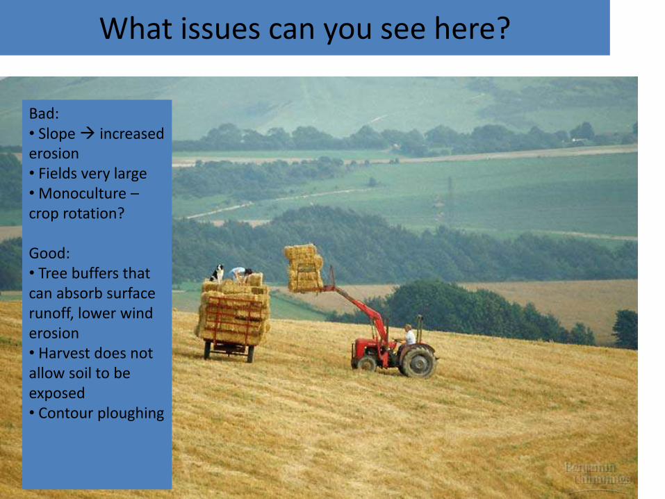
What issues can you see here?
Bad:• Slope increased erosion• Fields very large• Monoculture –crop rotation?
Good:• Tree buffers that can absorb surface runoff, lower wind erosion• Harvest does not allow soil to be exposed• Contour ploughing

Soil management
Subsistence farm• Only enough food for family or small community
• Labor intensive
• Linked with poverty
• Good for the environment
• no GMOs, polyculture, limited selective breeding

Soil management
Commercial farm• High technological input
• Low labour
• High yields
• Bad for the environment
• GMOs, monoculture, selective breeding

Another way to describe farming:
Extensive farming – Farms that are large in comparison to the money and labour put into them eg. large cattle ranches
Intensive farming – Farms that are small but have high output (due to capital and labour) eg. feed lots for cattle

Soil Conservation
• Prevention of salinisation
– Regular flushing soil to wash away salts
– Application of chemicals to remove sodium salts
– Reduction of evaporation losses to prevent capillary action

Questions
1. Create a flow diagram of the soil system. Try to show links with the lithosphere, atmosphere, hydrosphere and biosphere
2. Compare and contrast the structure and primary productivity of sandy, clayey and loamy soils
3. Outline the processes and effects of soil degradation
4. Evaluate a number of soil conservation measures


The Universal Soil Loss Equation (USLE)
Factor Description
R Total rainfall, intensity and seasonal distribution. Maximum for regular, high intensity storms. Greatest if rain occurs on newly ploughed soil.Lower for gentle rain, if crop is established or soil is frozen
K Depends on infiltration capacity, structural stability and ability to withstand rain splash
L and S Affect the movement and speed of water flow and its ability to transport particles. Linked to erodibility (K)
C Crops, grass and forest cover provide protection against erosion. This is greatest for plants with extensive root systems and greatest foliage. Fallow land or exposed cropland provide little protection
E Soil conservation measures such as terracing can reduce erosion and slow runoff

The Universal Soil Loss Equation (USLE)
• A = predicted soil loss• R = erosivity index• K = soil erodibility• L = slope length• S = slope gradient• C = cover and management• P = erosion control practice
A = R K L S C P