3.3 Biological Resources
102
Environmental Impact Report/Environmental Impact Statement Mitsubishi Cement Corporation South Quarry Project DRAFT December 2016 3.3-1 3.3 Biological Resources ____________________________________ 3.3.1 Introduction The effects on biological resources from the implementation of the Project are discussed in this section. This evaluation is based in part on the Biological Assessment/Biological Evaluation/Wildlife and Botany Report/Non-Native Species Risk Assessment (BA/BE), prepared for the Project by the Forest Service (USDA Forest Service 2016; Appendix C), a jurisdictional delineation prepared for the Project (GLA 2012; Appendix D) and an analysis of the potential connectivity between the existing MCC wells and Cushenbury Springs (Golder Associates 2013; Appendix E). Data and records from numerous biological resources surveys that have been conducted in and near the Project area have also been reviewed and incorporated to prepare these analyses. These included numerous focused rare plant surveys, bighorn sheep studies conducted by the California Department of Fish and Wildlife (CDFW), bat surveys, and cliff-nesting raptor surveys, among others (USDA Forest Service 2016). 3.3.2 Applicable Laws, Regulations, and Standards 3.3.2.1 Federal Endangered Species Act Pursuant to Section 7 of the federal Endangered Species Act (ESA), any federal agency undertaking a federal action that may affect a species listed or proposed as threatened or endangered under the ESA must consult with the U.S. Fish and Wildlife Service (USFWS). In addition, any federal agency undertaking a federal action that may affect Critical Habitat for a federally listed species must consult with USFWS. The ESA contains protection for all species federally listed as endangered or threatened. Under the ESA, federal agencies seek to conserve endangered species and threatened species and, in consultation with USFWS, further the purposes of the ESA by carrying out programs for the conservation of endangered and threatened species. Migratory Bird Treaty Act and Bald and Golden Eagle Protection Acts and Related Strategic Plans and Executive Orders Migratory Bird Treaty Act The Migratory Bird Treaty Act (MBTA) of 1918 (50 CFR. Section 10.13) and the Bald and Golden Eagle Protection Act of 1940 (16 USC 668-668d) implement treaties between the United States and other nations to protect migratory birds. The MBTA prohibits activities such as hunting, pursuing, capturing, killing, selling and shipping of the birds, any of their parts, eggs, and nests unless expressly authorized in the regulation or by permit. Bald and Golden Eagle Protection Act The Bald and Golden Eagle Protection Act (16 USC 668-668c), enacted in 1940, and amended several times since then, prohibits anyone, without a permit issued by the Secretary of the Interior, from “taking” bald eagles, including their parts, nests, or eggs. The Act provides criminal and civil penalties for persons who “take, possess, sell, purchase, barter, offer to sell,
Transcript of 3.3 Biological Resources

Environmental Impact Report/Environmental Impact Statement Mitsubishi Cement Corporation South Quarry Project DRAFT
December 2016 3.3-1
3.3 Biological Resources ____________________________________
3.3.1 Introduction
The effects on biological resources from the implementation of the Project are discussed in this section. This evaluation is based in part on the Biological Assessment/Biological Evaluation/Wildlife and Botany Report/Non-Native Species Risk Assessment (BA/BE), prepared for the Project by the Forest Service (USDA Forest Service 2016; Appendix C), a jurisdictional delineation prepared for the Project (GLA 2012; Appendix D) and an analysis of the potential connectivity between the existing MCC wells and Cushenbury Springs (Golder Associates 2013; Appendix E). Data and records from numerous biological resources surveys that have been conducted in and near the Project area have also been reviewed and incorporated to prepare these analyses. These included numerous focused rare plant surveys, bighorn sheep studies conducted by the California Department of Fish and Wildlife (CDFW), bat surveys, and cliff-nesting raptor surveys, among others (USDA Forest Service 2016).
3.3.2 Applicable Laws, Regulations, and Standards
3.3.2.1 Federal
Endangered Species Act Pursuant to Section 7 of the federal Endangered Species Act (ESA), any federal agency undertaking a federal action that may affect a species listed or proposed as threatened or endangered under the ESA must consult with the U.S. Fish and Wildlife Service (USFWS). In addition, any federal agency undertaking a federal action that may affect Critical Habitat for a federally listed species must consult with USFWS.
The ESA contains protection for all species federally listed as endangered or threatened.
Under the ESA, federal agencies seek to conserve endangered species and threatened species and, in consultation with USFWS, further the purposes of the ESA by carrying out programs for the conservation of endangered and threatened species.
Migratory Bird Treaty Act and Bald and Golden Eagle Protection Acts and Related Strategic Plans and Executive Orders
Migratory Bird Treaty Act The Migratory Bird Treaty Act (MBTA) of 1918 (50 CFR. Section 10.13) and the Bald and Golden Eagle Protection Act of 1940 (16 USC 668-668d) implement treaties between the United States and other nations to protect migratory birds. The MBTA prohibits activities such as hunting, pursuing, capturing, killing, selling and shipping of the birds, any of their parts, eggs, and nests unless expressly authorized in the regulation or by permit.
Bald and Golden Eagle Protection Act The Bald and Golden Eagle Protection Act (16 USC 668-668c), enacted in 1940, and amended several times since then, prohibits anyone, without a permit issued by the Secretary of the Interior, from “taking” bald eagles, including their parts, nests, or eggs. The Act provides criminal and civil penalties for persons who “take, possess, sell, purchase, barter, offer to sell,

Environmental Impact Report/Environmental Impact Statement Mitsubishi Cement Corporation South Quarry Project DRAFT
3.3-2 December 2016
purchase or barter, transport, export or import, at any time or any manner, any bald eagle ... [or any golden eagle], alive or dead, or any part, nest, or egg thereof.” The Act defines “take” as “pursue, shoot, shoot at, poison, wound, kill, capture, trap, collect, molest or disturb.”
“Disturb” is defined as “to agitate or bother a bald or golden eagle to a degree that causes, or is likely to cause, based on the best scientific information available, 1) injury to an eagle, 2) a decrease in its productivity, by substantially interfering with normal breeding, feeding, or sheltering behavior, or 3) nest abandonment, by substantially interfering with normal breeding, feeding, or sheltering behavior."
In addition to immediate effects, this definition also covers effects that result from human-induced alterations initiated around a previously used nest site during a time when eagles are not present, if, upon the eagle’s return, such alterations agitate or bother an eagle to a degree that injures an eagle or substantially interferes with normal breeding, feeding, or sheltering habits and causes, or is likely to cause, a loss of productivity or nest abandonment.
After the de-listing of bald eagles, USFWS finalized permit regulations to authorize limited take of bald eagles in 2009 (FR74, 175) under the Bald and Golden Eagle Protection Act.
Related Guidance and Executive Orders In late 2008, the Memorandum of Understanding between the USDA Forest Service and the US Fish and Wildlife Service to Promote the Conservation of Migratory Birds (MOU) was signed, with an addendum in June 2014. The intent of the MOU is to strengthen migratory bird conservation through enhanced collaboration and cooperation between the Forest Service and the USFWS as well as other federal, state, tribal and local governments. Within the National Forests, conservation of migratory birds focuses on providing a diversity of habitat conditions at multiple spatial scales and ensuring that bird conservation is addressed when planning for land management activities. The MOU covers implementation of the MBTA and the Bald and Golden Eagle Protection Act.
Under the National Forest Management Act (NFMA), the Forest Service is directed to “provide for diversity of plant and animal communities based on the suitability and capability of the specific land area in order to meet overall multiple-use objectives.” (P.L. 94-588, Sec 6 (g) (3) (B)). The January 2000 USDA Forest Service Landbird Conservation Strategic Plan, followed by Executive Order 13186 in 2001, in addition to the Partners in Flight Specific Habitat Conservation Plans for birds and the January 2004 Partners in Flight North American Landbird Conservation Plan all reference goals and objectives for integrating bird conservation into forest management and planning.
The Migratory Bird Executive Order (Jan, 11, 2001) and the 2008 MOU between the Forest Service and USFWS provide further direction, as follows:
Within the NEPA process, the Forest Service will evaluate the effects of agency actions on migratory birds, focusing first on species management concern along with their priority habitats and key risk factors. To the extent practicable:
a) Evaluate and balance long-term benefits of projects against any short- or long-term adverse effects when analyzing, disclosing, and mitigating the effects of actions.
b) Pursue opportunities to restore or enhance the composition, structure, and juxtaposition of migratory bird habitats in the project area.

Environmental Impact Report/Environmental Impact Statement Mitsubishi Cement Corporation South Quarry Project DRAFT
December 2016 3.3-3
c) Consider approaches, to the extent practicable, for identifying and minimizing take that is incidental to otherwise lawful activities, including such approaches as:
Altering the season of activities to minimize disturbances during the breeding season;
Retaining snags for nesting structures where snags are under-represented;
Retaining the integrity of breeding sites, especially those with long histories of use; and,
Giving due consideration to key wintering areas, migration routes, and stop-overs.
Recommendations in the California Partners in Flight Bird Conservation Plans for habitat types present in the analysis area (coniferous forest, desert, and riparian) were incorporated into the Project where feasible to minimize effects to important bird habitats.
Clean Water Act Pursuant to Section 404 of the Clean Water Act, the Army Corps of Engineers (ACOE) regulates the discharge of dredged and/or fill material into Waters of the United States. The term Waters of the United States is defined at 33 CFR Part 328 and includes (1) all navigable waters (including all waters subject to the ebb and flow of the tide), (2) all interstate waters and wetlands, (3) all impoundments of waters mentioned above, (4) all relatively permanent tributaries to waters mentioned above, (5) the territorial seas, and (6) all wetlands adjacent to waters mentioned above.
Wetlands are defined at 33 CFR 328.3(b) as "those areas that are inundated or saturated by surface or ground water at a frequency and duration sufficient to support...a prevalence of vegetation typically adapted for life in saturated soil conditions." A U.S. Supreme Court decision in 2001 determined that ACOE jurisdiction may not necessarily extend to intrastate waters and wetlands where the only federal nexus is potential use by migratory birds. On June 29, 2015, the U.S. Environmental Protection Agency and the ACOE published their Final Rule on the definition of Waters of the United States (80FR 124: 37054-37127). The Final Rule replaces all prior rules and guidance on the definition as used in implementing the Clean Water Act and became effective on August 28, 2015. However, on October 9, 2015 the U.S. Court of Appeals for the Sixth Circuit issued a nationwide stay of the Final Rule.
Issuance of a Section 404 Permit to discharge dredged or fill material into jurisdictional waters is considered a federal action and cannot be undertaken by the ACOE if the permitted actions could adversely affect federally listed (or proposed) endangered or threatened species.
National Forest Management Act The NFMA of 1976 and its implementing regulations (CFR 219) state that “fish and wildlife habitat shall be managed to maintain viable populations of existing native and desired nonnative vertebrate species in the planning area (Sec 219.19).” In addition, the Secretary of Agriculture's policy on fish and wildlife (Department Regulation 9500-4) directs the Forest Service to avoid actions “which may cause a species to become threatened or endangered.”
Forest Service Manual 2900 – Invasive Species Management Forest Service Manual 2900 sets forth National Forest System policy, responsibilities, and direction for the prevention, detection, control, and restoration of effects from aquatic and terrestrial invasive species (including vertebrates, invertebrates, plants, and pathogens).

Environmental Impact Report/Environmental Impact Statement Mitsubishi Cement Corporation South Quarry Project DRAFT
3.3-4 December 2016
San Bernardino National Forest Land Management Plan
Forest Goals and Desired Conditions The San Bernardino National Forest (SBNF) Land Management Plan (LMP) includes forest goals and desired conditions for resources, strategic management direction, and standard design features that provide guidance for designing actions and activities during Project planning. The LMP includes several goals applicable to this Project:
Goal 4.1a - Administer Minerals and Energy Resource Development while protecting ecosystem health (LMP, Part 1, page 38). The desired condition is that approved minerals and energy developments are managed to facilitate production of mineral and energy resources while minimizing adverse effects to surface and groundwater resources and protecting or enhancing ecosystem health and scenic values.
Goal 5.1 - Improve watershed conditions through cooperative management. The desired condition is that national forest watersheds are healthy, dynamic and resilient, and are capable of responding to natural and human caused disturbances while maintaining the integrity of their biological and physical processes.
Watersheds, streams, groundwater recharge areas, springs, wetlands, and aquifers are managed to assure the sustainability of high quantity and quality water. Where new or re-authorized water extraction or diversion is allowed, those facilities should be located to avoid long-term adverse effects to National Forest water and riparian resources. The Forest Service has acquired and maintains water rights where necessary to support resource management and healthy forest conditions. Forest management activities are planned and implemented in a manner that minimizes the risk to forest ecosystems from hazardous materials.
Additional desired conditions are that geologic resources are managed to protect, preserve and interpret unique resources and values, and to improve management of activities that affect watershed condition and ecosystem health. Geologic hazards are identified, analyzed and managed to reduce risks and impacts where there is a threat to human life, natural resources, or financial investment.
Goal 6.2 - Provide ecological conditions to sustain viable populations of native and desired nonnative species. The desired condition is that habitats for federally listed species are conserved, and listed species are recovered or are moving toward recovery. Habitats for sensitive species and other species of concern are managed to prevent downward trends in populations or habitat capability, and to prevent federal listing. Flow regimes in streams that provide habitat for threatened, endangered, proposed, candidate, and/or sensitive aquatic and riparian-dependent species are sufficient to allow the species to persist and complete all phases of their life cycles.
Habitat conditions sustain healthy populations of native and desired nonnative fish and game species. Wildlife habitat functions are maintained or improved, including primary feeding areas, winter ranges, breeding areas, birthing areas, rearing areas, migration corridors, and landscape linkages.
Forest Service California Spotted Owl Management Policies Forest Service Pacific Southwest Region policy is to protect all identified spotted owl territories (the area within a 1.5-mile radius of each nest). The current direction for managing California spotted owls (Strix occidentalis occidentalis) on the SBNF is contained in the Conservation Strategy for California Spotted Owls, as incorporated by reference in the SBNF LMP (USDA

Environmental Impact Report/Environmental Impact Statement Mitsubishi Cement Corporation South Quarry Project DRAFT
December 2016 3.3-5
Forest Service 2006). The Conservation Strategy established guidelines for spotted owl habitat protection within territories, calling for establishment of owl management areas within a 1.5-mile radius of nest sites for each pair on the Forest. These areas are broken down into a 300-acre protected activity centers that encompass nesting/roosting habitat, and an additional 300-acre area home range core that primarily contains foraging habitat.
The owl-nesting season is normally from February 1 to August 15. The Conservation Strategy provides for avoidance of disturbance to nesting owls by using a Limited Operating Period for management activities that would be disruptive to spotted owls within 0.25 mile of nests. Disruptive activities within 0.25 mile of nest trees will be avoided or, with authorization, restricted to daylight hours. The Conservation Strategy also contains specific guidelines for vegetation and fuels management efforts within nest stands (30 to 60 acres around the nest trees), protected activity centers, and home range cores.
Carbonate Habitat Management Strategy In 2003, the Carbonate Habitat Management Strategy (CHMS) was developed by the USFS and U.S. Bureau of Land Management (BLM) in collaboration with a working group consisting of mining interests, private landowners, and conservation groups to address effects to five federally listed plants associated with carbonate habitats. The CHMS, which covers about 160,000 acres (called the Carbonate Habitat Management Area), has three main objectives:
1. Economic: regulatory certainty for mining activities, protection of the viability of mining, and streamlining and cost reduction of the permitting process
2. Conservation: maintenance and management of geomorphic and ecological processes of the landscape and placement of habitat blocks to maintain the carbonate plants, to avoid jeopardy (per Section 7 of the federal ESA) and adverse modification or destruction of critical habitat, to contribute to recovery, and to avoid future listings
3. Regulatory: streamlining of permitting, California Environmental Quality Act (CEQA) review, and County of San Bernardino implementation of the California Surface Mining Reclamation Act, as well as allowing BLM and USFS to comply with certain court-ordered stipulations stemming from lawsuits.
The CHMS includes delineation of an initial habitat reserve, designation of conservation units within the Carbonate Habitat Management Area whereby loss and conservation of habitat values can be objectively measured, and contribution by federal agencies and mining interests to reserve assembly through various mechanisms (e.g., dedication of existing unclaimed federal land, purchase of private land or land with mining claims, land exchanges, or conservation banking). Implementation of the CHMS has been incorporated by the Forest Service into the SBNF LMP. The Forest Service and BLM prepared a Biological Assessment for the CHMS, which analyzed the effects of implementing the CHMS. Subsequently, the USFWS issued a Biological Opinion concluding that implementation of the CHMS would not jeopardize the listed species or adversely modify designated Critical Habitat.
Raptor Conservation Strategy The SBNF is in the process of developing a final Raptor Conservation Strategy (RCS) for the San Bernardino Mountains North Slope in coordination with three North Slope Mining Companies (MCC, Omya, and Specialty Minerals), the USFWS, and the CDFW. The SBNF and mining companies are cooperatively participating in the monitoring of nesting special-status

Environmental Impact Report/Environmental Impact Statement Mitsubishi Cement Corporation South Quarry Project DRAFT
3.3-6 December 2016
raptors on the North Slope. The objective of the RCS is to provide consistent management actions, processes, and management tools across the affected mining companies on the North Slope. The RCS is expected to be a dynamic document, which will be updated as new species information becomes available through the monitoring efforts. The intent of the RCS is to ensure compliance with Federal and State laws, provide guidelines for reducing the likelihood of “take” of a Federally- or State-protected species, provide direction for incidental take authorization, and describe an adaptive management approach that provides protection of nests while continuing the mining operations and other activities.
Bighorn Sheep Management Plan A North Slope Bighorn Sheep Management Plan is being developed by the CDFW and the Forest Service in coordination with three North Slope mining companies (MCC, Omya, and Specialty Minerals). The conservation strategy will include the following:
• Guidelines/thresholds for population status that would trigger augmentation of the herd;
• A strategy/guidelines for developing water sources to respond to drought years;
• Herd monitoring methodology and objectives;
• Avoidance measures to minimize effects on bighorn sheep;
• A requirement that participating mining companies will be a partner in the Bighorn Sheep Management Plan and will help support the long-term management goals of maintaining a sustainable population of bighorn sheep on the North Slope; and
• An endowment supported by the participating mining companies to finance the conservation strategy.
3.3.2.2 State
California Fish and Game Code Pursuant to Section 2080 et seq. of the Fish and Game Code, a California ESA (CESA) permit must be obtained to authorize incidental “take” of plants or animals listed under CESA. The California Fish and Game Code also includes the category of fully-protected species, which may not be taken or possessed at any time and no licenses or permits may be issued for their take except for collecting these species for necessary scientific research and relocation of the bird species for the protection of livestock, or through the Natural Community Conservation Plan process. Revisions to the Fish and Game Code, effective January 1998, may require that the CDFW issue a separate CEQA document for the issuance of an incidental take permit under Section 2081 of CESA (2081permit) unless the project CEQA document addresses all project impacts to listed species and specifies a mitigation monitoring and reporting program that will meet the requirements of a 2081 permit.
Sections 3503, 3503.5 and 3513 of the California Fish and Game Code prohibit take of all active bird nests or eggs, raptors and other migratory non-game birds (as listed under the federal MBTA).
Pursuant to Section 1600 et seq. of the Fish and Game Code, the CDFW may require a Lake or Streambed Alteration Agreement prior to any activity that will substantially divert or obstruct the natural flow or substantially change the bed, channel, or bank of a river, stream or lake, or use

Environmental Impact Report/Environmental Impact Statement Mitsubishi Cement Corporation South Quarry Project DRAFT
December 2016 3.3-7
material from a streambed. CDFW defines a "stream" (including creeks and rivers) as "a body of water that flows at least periodically or intermittently through a bed or channel having banks and supports fish or other aquatic life. This includes watercourses having surface or subsurface flow that supports or has supported riparian vegetation." CDFW's definition of "lake" includes "natural lakes or man-made reservoirs."
In addition to the bed and banks of a stream, CDFW jurisdiction includes riparian or wetland vegetation associated with a stream. CDFW’s issuance of a Lake or Streambed Alteration Agreement for a project that is subject to CEQA will require CEQA compliance actions by CDFW as a responsible agency. CDFW as a responsible agency under CEQA may consider the lead agency’s Negative Declaration or Environmental Impact Report for the project.
The Native Plant Protection Act (Fish and Game Code Sections 1900-1913) prohibits the taking, possessing, or sale within the State of any plants with a State designation of rare, threatened, or endangered (as defined by the CDFW). An exception in the act allows landowners, under specified circumstances, to take listed plant species, provided that the landowner first notifies the CDFW and give the agency at least 10 days to retrieve the plants before they are plowed under or otherwise destroyed. Project impacts to these species are generally not considered significant unless the species are known to have a high potential to occur within the area of disturbance associated with the ground-disturbing activity.
California Native Plant Society Rare Plant Inventory The California Native Plant Society (CNPS) is a statewide nonprofit organization that has developed and managed the CNPS Rare Plant Program (Program) since 1968. The purpose of the Program is to develop current, accurate information on the distribution, ecology, and conservation status of California's rare and endangered plants, and to use this information to promote science-based plant conservation in California. The CNPS maintains the Inventory of Rare and Endangered Plants in California, which tracks the conservation status of hundreds of plant species. The Program operates under a MOU with the CDFW. The MOU outlines broad cooperation in rare plant assessment and protection, and formalizes cooperative ventures such as data sharing and production of complementary information sources for rare plants. As part of the Program, CNPS has developed the Rare Plant Ranking System, with six Rare Plant Ranks and three Threat Ranks. The Rare Plant Ranks include:
• California Rare Plant Rank 1A: Plants Presumed Extirpated in California and Either Rare or Extinct Elsewhere. All of the plants constituting California Rare Plant Rank 1A meet the definitions of Sections 2062 and 2067 (California ESA) of the California Department of Fish and Game Code, and are eligible for state listing. Should these taxa be rediscovered, they must be fully considered during preparation of environmental documents relating to CEQA;
• California Rare Plant Rank 1B: Plants Rare, Threatened, or Endangered in California and Elsewhere. Plants with a California Rare Plant Rank of 1B are rare throughout their range with the majority of them endemic to California. Rare Plant Rank 1B plants constitute the majority of taxa in the CNPS Inventory, with more than 1,000 plants assigned to this category of rarity. All of the plants constituting California Rare Plant Rank 1B meet the definitions of Sections 2062 and 2067 (California ESA) of the California Department of Fish and Game Code, and are eligible for state listing. They must be fully considered during preparation of environmental documents relating to CEQA.

Environmental Impact Report/Environmental Impact Statement Mitsubishi Cement Corporation South Quarry Project DRAFT
3.3-8 December 2016
• California Rare Plant Rank 2A: Plants Presumed Extirpated in California, But More Common Elsewhere. The plant taxa of California Rare Plant Rank 2A are presumed extirpated because they have not been observed or documented in California for many years. This list includes only those plant taxa that are presumed extirpated in California, but more common elsewhere in their range. All of the plants on List 2A meet the definitions of Sections 2062 and 2067 (California ESA) of the California Department of Fish and Game Code, and are eligible for state listing. Should these taxa be rediscovered, they must be fully considered during preparation of environmental documents relating to CEQA.
• California Rare Plant Rank 2B: Plants Rare, Threatened, or Endangered in California, But More Common Elsewhere. Except for being common beyond the boundaries of California, plants with a California Rare Plant Rank of 2B would have been ranked 1B. From the federal perspective, plants common in other states or countries are not eligible for consideration under the provisions of the ESA. All of the plants constituting California Rare Plant Rank 2B meet the definitions of Sections 2062 and 2067 (California ESA) of the California Department of Fish and Game Code, and are eligible for state listing. They must be fully considered during preparation of environmental documents relating to CEQA.
• California Rare Plant Rank 3: Plants About Which More Information is Needed - A Review List. The plants that comprise California Rare Plant Rank 3 lack the necessary information to assign them to one of the other ranks or to reject them. All of the plants constituting California Rare Plant Rank 3 meet the definitions of Sections 2062 and 2067 (California ESA) of the California Department of Fish and Game Code, and are eligible for state listing. Impacts to these species or their habitat must be analyzed during preparation of environmental documents relating to CEQA, or those considered to be functionally equivalent to CEQA, as they meet the definition of Rare or Endangered under CEQA Guidelines §15125 (c) and/or §15380.California Rare Plant Rank 4: Plants of Limited Distribution - A Watch List. The plants in this category are of limited distribution or infrequent throughout a broader area in California. While these plants are not "rare" from a statewide perspective, they are uncommon enough that their status should be monitored regularly. Some of the plants constituting California Rare Plant Rank 4 meet the definitions of Sections 2062 and 2067 (California ESA) of the California Department of Fish and Game Code, but few, if any, are eligible for state listing. Nevertheless, many of them are significant locally, and CNPS strongly recommends that California Rare Plant Rank 4 plants be evaluated for consideration during preparation of environmental documents relating to CEQA.
The CNPS Threat Rank is an extension added onto the California Rare Plant Rank and designates the level of threats by a 1 to 3 ranking with 1 being the most threatened and 3 being the least threatened. A Threat Rank is present for all California Rare Plant Rank 1B, 2B, 4, and the majority of California Rare Plant Rank 3 species. California Rare Plant Rank 4 plants are seldom assigned a Threat Rank of 0.1, as they generally have large enough populations to not have significant threats to their continued existence in California; however, certain conditions exist to make the plant a species of concern and hence be assigned a California Rare Plant Rank. In addition, all California Rare Plant Rank 1A and 2A (presumed extirpated in California), and some California Rare Plant Rank 3 (need more information) plants, which lack threat information, do not have a Threat Rank extension. Threat ranks are as follows:

Environmental Impact Report/Environmental Impact Statement Mitsubishi Cement Corporation South Quarry Project DRAFT
December 2016 3.3-9
0.1 Seriously threatened in California (over 80 percent of occurrences threatened / high degree and immediacy of threat).
0.2 Moderately threatened in California (20 to 80 percent occurrences threatened / moderate degree and immediacy of threat).
0.3 Not very threatened in California (less than 20 percent of occurrences threatened / low degree and immediacy of threat or no current threats known).
3.3.2.3 Local
San Bernardino County General Plan Conservation Element The County of San Bernardino General Plan Conservation Element (County of San Bernardino 2007) establishes policies to conserve important natural resources. One role of the Conservation Element is to establish policies that reconcile conflicting demands on those resources.
The goals and policies of the Conservation Element that apply to biological resources are:
GOAL CO 2. The County will maintain and enhance biological diversity and healthy ecosystems throughout the County.
• POLICY CO 2.1 The County will coordinate with state and federal agencies and departments to ensure that their programs to preserve rare and endangered species and protect areas of special habitat value, as well as conserve populations and habitats of commonly occurring species, are reflected in reviews and approvals of development programs.
• POLICY CO 2.2 Provide a balanced approach to resource protection and recreational use of the natural environment.
• POLICY CO 2.3 In addition to conditions of approval that may be required for specific future development proposals, the County shall establish long-term comprehensive plans for the County’s role in the protection of native species because preservation and conservation of biological resources are statewide, Regional, and local issues that directly affect development rights. The conditions of approval of any land use application approved with the BR overlay district shall incorporate the mitigation measures identified in the report required by Section 82.13.030 (Application Requirements), to protect and preserve the habitats of the identified plants and/or animals.
• POLICY CO 2.4 All discretionary approvals requiring mitigation measures for impacts to biological resources will include the condition that the mitigation measures be monitored and modified, if necessary, unless a finding is made that such monitoring is not feasible.
San Bernardino County Desert Native Plant Protection Ordinance The San Bernardino Desert Native Plant Protection regulations restrict the removal or harvesting of specified desert native plants. The following desert native plants are included if they have stems two inches or greater in diameter or are six feet or greater in height or are of a size otherwise specified in the ordinance: smoketree (Dalea spinosa); all species of mesquites (Prosopis sp.); all species of the family Agavaceae including century plants, nolinas, yuccas;

Environmental Impact Report/Environmental Impact Statement Mitsubishi Cement Corporation South Quarry Project DRAFT
3.3-10 December 2016
creosote rings ten feet or greater in diameter; all Joshua trees; and any part (living or dead) of desert ironwood (Olneya tesota) or species of the genus Cercidium.
3.3.3 Affected Environment
3.3.3.1 Definitions of Areas of Analysis
The BA/BE defines several areas for Project analysis:
• The Project Area includes the footprint of ground that would be directly affected as a result of the Project activities. The Project Area is smaller than the Analysis Area. For this EIR/EIS, the Project Area is defined as the boundaries of the proposed South Quarry, the temporary construction road, and the proposed haul road.
• The Analysis Area, as evaluated under National Environmental Policy Act (NEPA) and CEQA, is the maximum expected reach of direct and indirect effects of the Project and includes the Project Area (defined above), any connected areas that may experience environmental effects of the Project, and the carbonate habitat reserve contributions being proposed as mitigation for the Project.
• The Federal Action Area, as defined by the ESA and associated regulations, applies only to the discussions of listed species and designated Critical Habitat under the federal ESA. For this Project, the Analysis Area is the same as the Federal Action Area.
• The North Slope is sometimes discussed to provide regional context to the information provided for the Analysis Area and Project Area. The North Slope is generally defined as the North Slope of the San Bernardino Mountains from White Mountain to Terrace Springs (Figure 3.3-1). It is a larger area than the Analysis Area and Project Area; both of these areas are located on the North Slope.
For the South Quarry Project, the Analysis Area and Federal Action Area include the Project Area (as described above) plus adjacent areas subject to increased noise, dust deposition, and roll-down of materials, and the downstream reaches of drainages within the reaches of effects. Cushenbury Springs, a small wetland/desert oasis with large cottonwood trees and other wetland associated vegetation, located approximately one mile north of the proposed South Quarry site. Cushenbury Springs supports wetland conditions and riparian vegetation. The Analysis Area/Federal Action Area includes Cushenbury Springs and associated wetlands, because the Project would increase water use from wells in the vicinity of Cushenbury


Environmental Impact Report/Environmental Impact Statement Mitsubishi Cement Corporation South Quarry Project DRAFT
3.3-12 December 2016
THIS PAGE INTENTIONALLY LEFT BLANK

Environmental Impact Report/Environmental Impact Statement Mitsubishi Cement Corporation South Quarry Project DRAFT
December 2016 3.3-13
Springs and would require maintenance of the monitoring wells, access road, and wells. Although all available data, including pump testing requested by Forest Service, demonstrate no connection between pumping water from the water wells and the water levels in the Cushenbury Springs (Golder Associates 2013), Cushenbury Springs has been included in the Analysis Area/Federal Action area in an abundance of caution due to the long life span of the project (up to 120 years for Alternative 1 - Proposed Action), and because effects to Cushenbury Springs were identified as an area of concern during the scoping period. The Analysis Area/Federal Action Area also includes the carbonate habitat reserve contributions.
Because there is no proposed expansion of MCC’s existing Cushenbury cement plant, which is located on private land, and the plant does not depend on this Project to continue operating, it is not included within the Project, Analysis, or Federal Action Areas.
3.3.3.2 Biological Resources Survey History
Pre-field survey reviews were conducted to determine which species are known from the Analysis Area or have suitable habitat present and could potentially occur. Data regarding biological resources on the Analysis Area were obtained through literature review, existing reports, and field investigations. Sources reviewed include California Natural Diversity Database (CNDDB), CNPS, California Consortium of Herbaria, San Bernardino County Museum records, SBNF and Natural Resource Information System occurrence database, results from previous species-specific surveys in the area, field guides and other Project-related analyses. Bird observations from E-Bird and Rare Bird Alerts were also incorporated (USDA Forest Service 2016).
In addition, data from Project-related surveys and analyses conducted in and near the Analysis Area in the past 10 to 15 years (e.g., exploratory drilling, fuels reduction projects, recreation residence tract surveys, mining claim surveys, restoration project surveys, engineering project surveys, small mammal and reptile studies) were also considered in this analysis. A detailed discussion of methods used to evaluate biological resources can be found in the BA/BE (USDA Forest Service 2016).
Botanical Surveys Field surveys for botanical resources were conducted during 2009, 2010 and 2011 by Forest Service, Lilburn Corporation, and Aspen Environmental Group botanists (USDA Forest Service 2016). Surveys covered all proposed ground disturbance areas within the Analysis Area and all carbonate habitat mitigation lands. Subsequent surveys were not conducted because 1) previous surveys adequately covered the Analysis Area and 2) subsequent years were drought years and survey results would have been inconclusive. Where slopes were too steep to safely traverse, areas were assessed for vegetation and habitat suitability from accessible vantage points. Botanical surveys were performed at times of year when most plant species would be detectable. The surveys conducted in 2009, 2010, and 2011 were fairly consistent in detecting and identifying plant types and densities. Due to the carbonate endemic nature of the threatened and endangered plant species, their location, distribution, and densities are fairly predictable from year to year. Species that could occur in the Analysis Area had moderate to high detectability during surveys, based on field checks of nearby reference populations. The likelihood of failing to detect these species in areas surveyed is considered low on accessible slopes, but moderate to high on steep and inaccessible slopes.

Environmental Impact Report/Environmental Impact Statement Mitsubishi Cement Corporation South Quarry Project DRAFT
3.3-14 December 2016
Wildlife Surveys A number of surveys were conducted in the Analysis Area by Forest Service and non-Forest Service biologists/botanists between 1992 and 2013. The survey efforts are summarized in the BA/BE (USDA Forest Service 2016).
The focus of the wildlife surveys was to identify habitat suitability for special status and common wildlife species within the Analysis Area in order to predict which species have a higher probability of occurrence in the Analysis Area. Suitable habitat is assumed occupied by the target species unless sufficient site-specific and species-specific surveys are conducted to assume absence. Surveys included identification of species through direct visual observation of the individuals, observations of evidence of their presence (e.g., burrows, tracks), and hearing their songs or other vocalizations.
3.3.3.3 Environmental Setting
The Project Area covers an area about one mile long (on a southeast to northwest axis) and 0.5 mile wide. The proposed South Quarry would be located on SBNF lands, and the proposed haul road would extend from SBNF land onto private land to the north. Existing associated processing and ancillary facilities are on private land and would not be modified as part of the Project. The Project Area is located north of Big Bear Lake and Burnt Flats, south of the existing MCC East Pit and Lucerne Valley, and west of State Highway 18 in San Bernardino County, California. Elevation ranges from about 5,000 feet above mean sea level (msl) at the lower end of the proposed new haul road to about 6,650 feet above msl at the southeast corner of the proposed South Quarry. Adjacent lands are generally open space accessible to the public and managed by the Forest Service.
Vegetation Communities The major plant community in the Project Area is pinyon/juniper woodlands. The haul road descends from pinyon/juniper woodlands at the proposed quarry site through desert transition chaparral, down to desert scrub at the proposed haul road’s intersection with the existing road leading to the existing Cushenbury Cement Plant (Figure 3.3-2). These vegetation communities are described below.
Pinyon Juniper Woodland (Pinus monophylla Woodland Alliance) The majority of the proposed South Quarry, berm, and haul road route would be located in pinyon-juniper woodlands. Pinyon-juniper woodlands occur on semi-arid desert-side slopes of southern California. Single-leaf pinyon pine (Pinus monophylla) generally dominates higher elevation slopes and extends into lower montane forests and woodlands, while juniper (Juniperus osteosperma and Juniperus californica) co-dominates.


Environmental Impact Report/Environmental Impact Statement Mitsubishi Cement Corporation South Quarry Project DRAFT
3.3-16 December 2016
THIS PAGE INTENTIONALLY LEFT BLANK

Environmental Impact Report/Environmental Impact Statement Mitsubishi Cement Corporation South Quarry Project DRAFT
December 2016 3.3-17
Pinyon-juniper woodlands are typically open-canopied with a sparse understory. In the Project Area, average overstory (tree canopy) cover is about 25 percent and average shrub cover is about 49 percent (Aspen 2010). The Analysis Area is characterized by having an abundance of rocky outcrops and steep cliff faces. The northern portion of the proposed South Quarry site has steep rugged slopes with rocky outcrops. The open understory and interspaces within and near the Project Area supports multiple rare plant species (USDA Forest Service 2016).
Desert Scrub The following vegetation types are related to desert scrub.
Desert Transition Chaparral (Sonora-Mojave-Baja Semi-Desert Chaparral) This vegetation type exists in portions of the proposed South Quarry and along the proposed haul road as it descends from the pinyon-juniper woodland habitat to lower elevations near the existing Cushenbury Cement Plant. Slopes below the pinyon-juniper woodlands support a desert transition chaparral with associated species including curl leaf mountain mahogany(Cercocarpus ledifolius), big berry manzanita (Arctostaphylos glauca), Muller’s oak (Quercus cornelius-mulleri), Tucker’s oak (Quercus john-tuckeri), narrowleaf goldenbush (Ericameria linearifolia), hollyleaf redberry (Rhamnus ilicifolia), Mormon tea (Ephedra viridis), and desert ceanothus (Ceanothus greggii). The vegetation structure is generally open.
Blackbrush Scrub (Coleogyne ramosissima shrubland alliance) The extreme lower portion of the haul road would be located on lower slopes generally below the transitional chaparral. The blackbrush scrub vegetation community is dominated by blackbrush (Coleogyne ramosissima). Joshua trees (Yucca brevifolia) are sub-dominant but visually-prominent in this vegetation. This habitat is generally open.
Mixed Chaparral The southeast portion of the proposed South Quarry is comprised of approximately 13 acres of mixed chaparral vegetation. This vegetative cover is characterized by its continuous and intermittent canopy of mixed shrubs with intermixed emergent tree species. In the project area, the slopes below the pinyon-juniper woodlands support mixed chaparral with associated species including mountain mahogany, big berry manzanita, Muller’s oak, Tucker’s oak, narrowleaf goldenbush, hollyleaf redberry, Mormon tea, and desert ceanothus.
Montane Hardwood-Conifer Forest The project area is composed of less than one acre of montane hardwood conifer forest, located just along the southeastern boundary of the proposed quarry site. This vegetation community is dominated by a mixture of hardwood (oak, etc.) and pine tree species with an understory of larger shrub species. Typical species within this community are black oak (Quercus kelloggii), Jeffrey pine (Pinus jeffreyi), and interior live oak (Quercus wislizenii).
Common Wildlife The BA/BE (USDA Forest Service 2016) contains a list of animal species that have been recorded during surveys on the North Slope, including in and near the Analysis Area and Project Area. The wildlife species recorded in the Analysis Area include many common animals that may occur in the habitats present for all or most of their life cycles and those that may use the habitats only for foraging or migration. The habitats in the Analysis Area are within a mountain

Environmental Impact Report/Environmental Impact Statement Mitsubishi Cement Corporation South Quarry Project DRAFT
3.3-18 December 2016
to desert transition zone and are expected to support a wide diversity of wildlife species from both biomes, including invertebrates, amphibians, reptiles, birds, and mammals. The following paragraphs provide brief discussion of common wildlife species that were either detected or would be expected to be present in the Analysis Area.
Invertebrates The Analysis Area supports common invertebrate fauna including butterflies, centipedes, millipedes, spiders, scorpions, and many insect orders (e.g., Order Hemiptera, Order Hymenoptera). The invertebrate fauna in the Analysis Area serves a vital role in providing a source of food, acting as decomposers of decaying biomass, and pollination of plant species. Some invertebrate species are highly restricted to a particular microhabitat, such as springsnails (Pyrgulopsis spp.) and simple hydroporus diving beetles (Hydroporus simplex) that may reside within Cushenbury Springs, which is outside of the Project Area but within the Analysis Area. The Project Area contains habitat for the desert monkey grasshopper (Psychomastax deserticola), San Bernardino Mountains silk moth (Coloradia velda), and Andrew’s marble butterfly (Euchloe hyantis andrewsi).
Amphibians Amphibians typically are associated with areas that support standing or running water for breeding but many species may also use drier areas during the hot summer months if they can find shelter in moist areas beneath leaf litter and fallen logs, under rock outcrops or in unoccupied mammal burrows. Some amphibians conserve moisture by excreting a gelatinous layer around their skin that retains moisture. Some species of amphibians will move far from water sources during certain times of year and only return during the active breeding season. Marble Canyon and Cushenbury Springs in the Analysis Area provide potential breeding habitat for amphibian species as well as potential year-round habitat for species that require permanent water. Most of the Project Area is not considered high quality habitat for amphibians because it is very steep and dry, and far from the nearest potential breeding habitats. The unnamed drainages in the Project Area are the most likely areas that may support amphibians, because they support the highest moisture levels. Common amphibians that are known from or have potential to occur in the Analysis Area include Pacific western toad (Bufo boreas), California treefrog (Hyla cadaverina), and Pacific treefrog (Hyla regilla).
Reptiles The many different types of habitats in the Analysis Area would be expected to support a high diversity of reptile species, with potential for snakes, lizards, and tortoises. Unlike amphibians, reptiles are not typically tied to areas with permanent water. Reptiles are found throughout drier habitat areas as well as riparian areas, and use many different types of substrates, including burrows, sandy or rocky areas, leaf litter, rotting logs, and even debris deposited by humans. The rock formations and rocky substrates in the Analysis Area and the Project Area provide excellent cover and foraging habitat for many species of reptiles. Common reptiles with potential to occur in the Analysis Area include side-blotched lizard (Uta stansburiana), western fence lizard (Sceloporus occidentalis), western skink (Eumeces skiltonianus), great basin whiptail (Aspidoscelis tigris tigris), yellow-backed spiny lizard (Sceloporus uniformis), long-nosed leopard lizard (Gambelia wislizenii), sagebrush lizard (Sceloporus graciosus), western banded gecko (Coleonyx variegatus), common kingsnake (Lampropeltis getula), striped racer (Masticophis lateralis), southern Pacific rattlesnake (Crotalus viridis), northern Mojave rattlesnake (Crotalus scutulatus scutulatus), and granite night lizard (Xantusia henshawi).

Environmental Impact Report/Environmental Impact Statement Mitsubishi Cement Corporation South Quarry Project DRAFT
December 2016 3.3-19
Birds The Analysis Area supports a high diversity of bird life, due the variety of habitats, presence of springs, and the transitional nature of the site’s position within the landscape. Many bird species would be expected to use the habitats in the Analysis Area as residents on a year-round basis, while others would be found only during migration or during the winter months. The Project Area is a transition zone between the mountains and deserts, and attracts bird species from each biome.
The springs and associated riparian habitats within the Analysis Area, especially Cushenbury Springs, attract migrating or wintering bird species as they travel through on their migrations between breeding and wintering grounds. There are no springs or riparian vegetation in the Project Area (GLA 2012). The variety of vegetation types and vegetation structure in the Analysis Area and on the North Slope in general provides many opportunities for foraging, nesting, perching, and sheltering. Common bird species that are expected to occur in the Analysis Area include: western scrub jay (Aphelocoma californica), common raven (Corvus corax), black-throated sparrow (Amphispiza bilineata), western wood pewee (Contopus sordidulus), western tanager (Piranga ludoviciana), phainopepla (Phainopepla nitens), brown-headed cowbird (Molothrus ater), Scott’s oriole (Icterus parisorum), red-tailed hawk (Buteo jamaicensis), and barn owl (Tyto alba).
The wide variety of vegetation types and vegetation structure in the Analysis Area and on the North Slope in general provides many opportunities for foraging, nesting, perching, and sheltering. There are also nesting opportunities on steeper slopes and cliff faces near the Project Area, where certain species of eagles or falcons may nest. Mountain species, such as dark-eyed junco (Junco hyemalis), mountain chickadee (Poecile gambeli), and western bluebird (Sialia mexicana), also likely move downslope to the Analysis Area during the cold winter months.
Mammals A wide variety of mammal species would be expected to use the habitats in the Analysis Area. Small mammals, such as mice, rats, squirrels, chipmunks, and rabbits are common residents that not only forage and raise their young in the habitats of the Analysis Area, but they are also an important food source for larger mammals and birds of prey. A number of small mammal species are expected to be found in rocky outcrop and rock pile habitats in the Analysis Area and Project Area. Common species of smaller mammals that are expected to occur in the Analysis Area include Merriam’s chipmunk (Tamias merriami), California ground squirrel (Spermophilus beecheyi), deer mouse (Peromyscus maniculatus), dusky-footed woodrat (Neotoma fuscipes), and desert cottontail (Sylvilagus audobonii). Larger mammals would be expected to use the habitats in the Analysis Area for foraging, shelter, and for movement corridors as they access portions of their territories located outside of the Analysis Area. Common large mammals that would be expected to occur in the Analysis Area include: black bear (Ursus americanus), raccoons (Procyon lotor), gray fox (Urocyon cinereoargenteus), desert kit fox (Vulpes macrotis arsipus), black-tailed jackrabbit (Lepus californicus), bobcat (Felis rufus), mule deer (Odocoileus hemionus), coyote (Canis latrans), mountain lion (Puma concolor), and Nelson’s bighorn sheep (Ovis canadensis nelsoni).
Sensitive Natural Communities Riparian Conservation Areas (RCAs) are areas defined in the SBNF LMP to provide for management of riparian resources. They are areas that consist of geographically distinct resource

Environmental Impact Report/Environmental Impact Statement Mitsubishi Cement Corporation South Quarry Project DRAFT
3.3-20 December 2016
values and characteristics, which are composed of aquatic and riparian resources, floodplains, and wetlands. They include, but are not limited to, meadows, all areas within a horizontal distance of 328 feet (100 meters) from the edge of perennial streams, and lakes/reservoirs or within approximately 98 feet (30 meters) of the edge of seasonally flowing/intermittent streams. There are several RCAs in the Analysis Area, and a very short segment of one RCA in the Project Area. The Jurisdictional Delineation Report (Glenn Lukos Associates [GLA] 2012) addresses five unnamed drainages (identified in the report as drainages A-E) and Marble Canyon in the Analysis Area. The report states that no riparian vegetation is present in any of the unnamed drainages or in Marble Canyon. In addition to Marble Canyon and the five unnamed drainages, the Analysis Area includes Cushenbury Springs, a small wetland/desert oasis with large cottonwood trees and other wetland associated vegetation. Cushenbury Springs supports wetland conditions and riparian vegetation.
Jurisdictional Waters The Clean Water Act regulates traditional navigable waters as well as relatively permanent, non-navigable tributaries to traditional navigable waters and certain associated wetlands. Relatively permanent tributaries are considered tributaries that typically flow year round or have continuous flow at least seasonally (typically three months). The jurisdictional delineation (GLA 2012) covered a 572-acre survey area that included the Project Area and a portion of the Analysis Area. The study identified five unnamed drainages (identified in the report as drainages A-E) and Marble Canyon Creek. Within the 572-acre survey area, the jurisdictional delineation did not identify any traditional navigable waters or relatively permanent tributaries to navigable waters. The jurisdictional delineation identified 2.39 acres of non-relatively permanent waters, none of which consisted of wetlands or riparian vegetation. Within the Project Area, less than 0.1 acre of CDFW and potential Regional Water Quality Control Board (RWQCB) jurisdiction is present.
While lower portions of the unnamed drainages are not in the Project Area (see GLA 2012), the upper portions of the drainages are in the footprint of the quarry haul road or development. In addition to Marble Canyon Creek and the five unnamed drainages, the Analysis Area, but not the Project Area, also encompasses Cushenbury Springs, a small wetland/desert oasis that supports riparian vegetation (large cottonwood trees and other wetland-associated vegetation) and wetland conditions.
Habitat Connectivity and Fragmentation Movement corridors are distinguished by “passage” species (large wide-ranging mammals) and “dweller” species (smaller animals with smaller ranges). Long-term impediments to movement or fragmentation of habitat can result in isolation of populations, making them more susceptible to localized extirpation due to random or unpredictable events or diminished resource availability.
Habitat continuity and connectivity on the North Slope has already been significantly affected as a result of mine development and the existence of Highway 18. The current condition in the Analysis Area and the North Slope already includes some impediments to wildlife movement, pollinators, and seed dispersal (large, deep quarries, haul roads with steep cuts, areas devoid of vegetative cover, etc.), affecting some animals, including deer and bighorn sheep.

Environmental Impact Report/Environmental Impact Statement Mitsubishi Cement Corporation South Quarry Project DRAFT
December 2016 3.3-21
Listed, Sensitive, and Other Rare Species
Threatened and Endangered Species Table 3.3-1 summarizes occurrence information for the federally-listed and state-listed threatened and endangered plant and animal species in the Analysis Area and Project Area. Additional information on these species follows the table and can also be found in the BA/BE (USDA Forest Service 2016). The entire list of threatened and endangered species that were evaluated, which includes species found not likely to occur in either the Analysis Area or Project Area, can be found in the BA/BE (USDA Forest Service 2016).
Table 3.3-1 Summary of Potential Occurrence for Federally-Listed and State-Listed Threatened and
Endangered Species In and Near the Analysis Area and Project Area
Scientific Name Common Name
(status)1
Occurrence Information2
Notes Project Area
Analysis Area
Threatened & Endangered Plants Acanthoscyphus parishii
var. goodmaniana Cushenbury puncturebract
(FE)
Y Y
In the Project Area, there are approximately 24 acres of occupied habitat, 43 acres of critical habitat, and 153.6 acres of suitable habitat (133.6 acres for Alternative 2)
Astragalus albens Cushenbury milk vetch
(FE) Y Y
In the Project Area, there are 0.001 acre of occupied habitat, no acres of critical habitat, and 153.6 acres of suitable habitat (133.6 acres for Alternative 2)
Erigeron parishii Parish’s daisy
(FT) Y Y
In the Project Area, there are 0.01 acre of occupied habitat, 2.5 acres of critical habitat and 153.6 acres of suitable habitat (133.6 acres for Alternative 2).
Eriogonum ovalifolium var. vineum
Cushenbury buckwheat (FE)
Y Y
In the Project Area, there are 33 acres of occupied habitat, 114.1 acres of critical habitat (105.2 acres for Alternative 2), and 153.6 acres of suitable habitat (133.6 acres for Alternative 2)
Threatened and Endangered Animals Gymnogyps californianus
California condor (FE, SE)
P P Potential foraging and nesting on North Slope, including Project Area
Charina bottae umbratica southern rubber boa
(FSS, ST) P P Low probability for occurrence in the
Analysis Area, including the Project Area.
Empidonax traillii extimus southwestern willow
flycatcher (FE, SE)
U P Potential for nesting at Cushenbury Springs
Vireo bellii pusillus least Bell’s vireo
(FE, SE) U Y Nesting documented at Cushenbury Springs

Environmental Impact Report/Environmental Impact Statement Mitsubishi Cement Corporation South Quarry Project DRAFT
3.3-22 December 2016
Scientific Name Common Name
(status)1
Occurrence Information2
Notes Project Area
Analysis Area
Buteo swainsoni Swainson’s hawk
(ST) P Y Potential for foraging in the Analysis Area,
including the Project Area.
Gopherus agassizii desert tortoise
(FT, ST) U Y
Known from areas around the Cushenbury Cement Plant and Cushenbury Springs, but not the Project Area
Spermophilus mohavensis Mohave ground squirrel
(ST) U P
The nearest known occurrence is near Rabbit Springs, about 6 miles north of the site, at about 2900 feet elevation. The Project Area is outside of the known range.
Notes: 1Status Codes:
FE = Federally endangered FSS= listed on the Region 5 Forest Service Sensitive species list FT = Federally threatened SE = State endangered ST = State threatened
2Occurrence Information Codes:
Y = Species is known to occur. P = Occurrence of the species is possible; suitable habitat exists and it is within the distribution of the species. U=Occurrence of the species is unlikely to occur in the Project Area for a variety of factors including: 1) the Project Area or Analysis Area is outside the currently-known distribution or range of the species; 2) the Project Area or Analysis Area does not support suitable habitat in general terms (e.g., vegetation types) or specifically (e.g., host plant, nesting substrate); 3) the nearest occurrences of the species are not connected and the species is not likely to be able to move into the Project Area or Analysis Area; and/or 4) the species is so rare and in such low densities that occurrence is very unlikely.
Threatened and Endangered Plants. Four federally listed plant species and their designated critical habitat occur within the Analysis Area and the Project Area: Cushenbury puncturebract (Acanthoscyphus parishii var. goodmaniana), Cushenbury milk vetch (Astragalus albens), Parish’s daisy (Erigeron parishii), and Cushenbury buckwheat (Eriogonum ovalifolium var. vineum) (Figures 3.3-3 and 3.3-4). All of these plant species are also listed in the California Native Plant Society’s (CNPS) Rare Plant Inventory with a ranking of 1B (rare throughout distribution) and a Threat Rank of 1 (seriously threatened in California), and impacts to these species may also be considered to be significant under CEQA. Specific information about each of these species is provided below.
Cushenbury Puncturebract. This federally endangered species is an annual that is a member of the buckwheat family. At the time of listing, Cushenbury puncturebract was recognized as Cushenbury oxytheca (Oxytheca parishii var. goodmaniana). However, later morphological studies identified that the species should be treated as distinct from the genus Oxytheca and are properly grouped in the genus Acanthoscyphus. The currently accepted name is Acanthoscyphus parishii var. goodmaniana. The change in name did not change its listing status or the management of the species. It is endemic to carbonate soils of the northeastern San Bernardino Mountains. In the Project Area, there are approximately 24 acres of occupied habitat, 43 acres of critical habitat, and 153.6 acres of suitable habitat (133.6 for Alternative 2 – Partial Implementation) for this species.

Environmental Impact Report/Environmental Impact Statement Mitsubishi Cement Corporation South Quarry Project DRAFT
December 2016 3.3-23
Cushenbury Milk Vetch. This federally endangered species is endemic to carbonate soils of the northeastern San Bernardino Mountains. In the Project Area, there are 0.01 acre of occupied habitat and 153.6 acres of suitable habitat (133.6 for Alternative 2 – Partial Implementation) for this species. Critical Habitat for this species is not present in the Project Area.
Parish’s Daisy. This federally threatened species is mostly endemic to carbonate soils of the northeastern San Bernardino Mountains, where it ranges from White Mountain on the west end of its distribution, to the eastern flanks of Mineral Mountain on the east end. In the Project Area, there are approximately 0.01 acre of occupied habitat, 2.5 acres of critical habitat, and 153.6 acres of suitable habitat (133.6 for Alternative 2 – Partial Implementation) for this species.
Cushenbury Buckwheat. This federally endangered plant is endemic to carbonate soils of the northeastern San Bernardino Mountains. In the Project Area, there are approximately 33 acres of occupied habitat, 114 acres of critical habitat (105.2 for Alternative 2 – Partial Implementation), and 153.6 acres of suitable habitat (133.6 for Alternative 2 – Partial Implementation) for this species.
Threatened and Endangered Wildlife. Seven wildlife species that are protected by the federal ESA and/or CESA are known to occur or may occur in the Analysis Area. These include California condor (Gymnogyps californianus) (state endangered and federally threatened), southern rubber boa (Charina bottae umbratica) (state threatened), southwestern willow flycatcher (Empidonax trailii extimus) (state endangered and federally threatened), least Bell’s vireo (Vireo bellii pusillus) (state endangered and federally endangered), Swainson’s hawk (Buteo swainsoni) (state threatened), desert tortoise (Gopherus agassizii) (state threatened and federally threatened), and Mohave ground squirrel (Spermophilus mohavensis) (state threatened). Of these species, only the California condor, Swainson’s hawk, and the southern rubber boa have the potential to occur in the Project Area. Desert tortoise and least Bell’s vireo are known to occur in the Analysis Area, but are not likely in the Project Area. Southwester willow flycatcher and Mohave ground squirrel have the potential to occur in the Analysis Area but not the Project Area. The Analysis Area does not fall within the boundaries of any designated Critical Habitat for any wildlife species. Specific information for each of the listed species of wildlife is provided below.
California Condor. The California condor is listed as endangered under both the federal ESA and CESA. Critical Habitat was designated in 1976, but none is present in Project Area. A Recovery Plan was issued in 1996. Currently, condors are known to infrequently forage over the San Bernardino Mountains and there are no known nesting locations

Environmental Impact Report/Environmental Impact Statement Mitsubishi Cement Corporation South Quarry Project DRAFT
3.3-24 December 2016
THIS PAGE INTENTIONALLY LEFT BLANK


Environmental Impact Report/Environmental Impact Statement Mitsubishi Cement Corporation South Quarry Project DRAFT
3.3-26 December 2016
THIS PAGE INTENTIONALLY LEFT BLANK

Environmental Impact Report/Environmental Impact Statement Mitsubishi Cement Corporation South Quarry Project DRAFT
December 2016 3.3-27
for the species on the North Slope, including the Analysis Area and the Project Area. The closest known nests are located approximately 120 miles away and the closest historic nest record was approximately 75 miles away (USDA Forest Service 2016). Foraging may increase in frequency as the population expands and if closer nest sites are established. Suitable nesting locations are present in the North Slope area of the San Bernardino Mountains, but the likelihood of this species nesting in the Analysis Area is very low due to a low number of cave-like features preferred for nesting.
Southern Rubber Boa. The southern rubber boa, which is a state-listed threatened species, is also a Forest Service Sensitive species. A habitat management guide has been prepared to address this species on the SBNF. In July 2012, the Center for Biological Diversity petitioned the USFWS to list this species under the federal ESA; however, the agency has yet to determine whether listing is warranted. Southern rubber boas are snakes that occur in a variety of montane forest habitats, but are usually underneath leaf litter, under rock outcroppings, or in burrows. While generally located outside of the known distribution for this species, the Analysis Area, particularly the drainages (including those that would be affected by the South Quarry and haul road) and Cushenbury Springs, have suitable habitat that could support this species. This species is very difficult to detect during surveys and the Analysis Area has not been well-surveyed due to ruggedness and inaccessibility. This species may occur within both the Project Area and Analysis Area.
Southwestern Willow Flycatcher. The southwestern willow flycatcher is listed as endangered under both the federal ESA and CESA. Critical Habitat has been designated, but none is located in the Analysis Area or the Project Area. Southwestern willow flycatcher is a migratory species that usually nests in riparian woodlands and dense willow thickets within meadows and streams. The Project Area does not support suitable nesting habitat for this species, so it would not be expected to occur in the Project Area. It has moderate potential to occur in the Analysis Area, at Cushenbury Springs, where suitable habitat exists.
Least Bell’s Vireo. Least Bell’s vireo is listed as endangered under both the ESA and CESA. Critical habitat has been designated for the least Bell’s vireo, but none is located in the Analysis Area or Project Area. This species is migratory and nests in riparian woodlands and thickets. Least Bell’s vireo is only known from four sites in the San Bernardino Mountains; one of these is Cushenbury Springs. Suitable habitat for this species is present in the Analysis Area but not in the Project Area.
Swainson’s Hawk. Swainson’s hawk is a CDFW Threatened species. This species is not a regular breeder in the San Bernardino Mountains. Swainson’s hawks have been detected at Cushenbury Springs and Blackhawk Mountain in the Analysis Area. Nesting in or near the Project Area is possible, but considered very unlikely. While the Project Area does not support preferred foraging habitat, Swainson’s hawks may fly over on an occasional basis.
Desert Tortoise. The desert tortoise is listed as threatened under both the federal ESA and CESA. A Recovery Plan is in place and Critical Habitat has been designated for this species. Designated or proposed Critical Habitat for desert tortoise does not occur on or near the Analysis Area. Suitable desert tortoise habitat occurs around MCC’s processing plant and Cushenbury Springs in the Analysis Area, but Project Area. This area is designated as Category 3 Desert Tortoise habitat in the Recovery Plan, meeting criteria such as “not essential to maintenance of

Environmental Impact Report/Environmental Impact Statement Mitsubishi Cement Corporation South Quarry Project DRAFT
3.3-28 December 2016
viable populations and having low to medium population density not contiguous with medium or high population density areas.” The Project Area does not support suitable habitat for desert tortoise due to elevation, steepness of slopes, presence of physical impediments to movement between the occupied areas and the Project Area, and generally unsuitable substrate for digging. Portions of the Analysis Area do contain suitable habitat and are assumed to be occupied in low densities by this species.
Mohave Ground Squirrel. The Mohave ground squirrel is a CDFW Threatened species. It has no Forest Service status because it is not thought to currently occur on NFS lands. The Analysis Area, including the Project Area, is several miles southeast of the Mohave ground squirrel’s known range. The nearest known occurrence is near Rabbit Springs, about 6 miles north of the proposed South Quarry site. This Rabbit Springs location is the easternmost occurrence in the southern part of the species range and the species is unlikely to occur in the Project Area.
California Fully Protected Species The classification of Fully Protected was the State's initial effort in the 1960s to identify and provide additional protection to those animals that were rare or faced possible extinction, prior to the enactment of CESA. Lists were created for fish, amphibians and reptiles, birds, and mammals. California Fully Protected species may not be taken or possessed at any time and no licenses or permits may be issued for their take except for collecting these species for necessary scientific research and relocation of the bird species for the protection of livestock. There are three Fully Protected Species that may occur in the Analysis Area and Project Area: golden eagle (Aquila chrysaetos), American peregrine falcon (Falco peregrinus anatum), and Nelson’s bighorn sheep. Table 3.3-2 summarizes the potential for occurrence for these species in the Project Area and Analysis Area.

Environmental Impact Report/Environmental Impact Statement Mitsubishi Cement Corporation South Quarry Project DRAFT
December 2016 3.3-29
Table 3.3-2 Summary of Potential Occurrence for California Fully Protected Species
In and Near the Analysis Area and Project Area1
Scientific Name Common Name
(status)2
Occurrence Information3
Notes Project Area
Analysis Area
Aquila chrysaetos golden eagle
(CFPS) (Other Status: SBNFW, CDFWW, SLVC, BCC)
Y Y Nesting and foraging habitat exists in the Project Area and the Analysis Area.
Falco peregrinus anatum American peregrine falcon
(CFPS) (Other Status: SBNFW, FSS,
BCC)
Y Y Nesting and foraging habitat exists in the Project Area and Analysis Area.
Ovis canadensis nelsoni Nelson's bighorn sheep
(CFPS) (Other Status: SBNFW)
Y Y The Cushenbury herd is known to use the Project Area and Analysis Area.
Notes: 1Species that have more than one status designation are listed on the table indicating the most sensitive designation. Other status designations are listed with the species to assist the reader. 2Status Codes:
FSS= listed on the Region 5 Forest Service Sensitive species list SBNFW = SBNF Watchlist CFPS = CDFW Fully Protected Species SLVC = Forest Service Species with Local Viability Concern BCC = USFWS Bird of Conservation Concern CDFWW=CDFW Watchlist Species
3Occurrence Information Codes: Y = Species is known to occur.
Golden Eagle. The golden eagle is a State of California Fully Protected Species. It is also a SBNF and CDFW Watchlist species. It is protected under the Bald and Golden Eagle Protection Act, the MBTA, Executive Order 13186, and the California Fish and Game Code. The primary nesting sites selected by golden eagles in southern California are cliffs but they have also been known to nest in trees or on electrical transmission towers. There are six territories within ten miles of the Project Area; four are within five miles. Each of these territories has several nest structures. Additional territories are known from farther than 10 miles to the southeast, west, and north. No nests, current or historic, are known within the Analysis Area or Project Area. There is some suitable nesting habitat in the Project Area (USDA Forest Service 2016).
The Analysis Area and the Project Area support suitable hunting habitat for golden eagles and this species has been observed flying over the area and using wildlife drinkers at the limestone mines on the North Slope. Thus, the Project Area and Analysis Area are considered to be occupied by this species.
American Peregrine Falcon. The American peregrine falcon is a State of California Fully Protected Species. It is also a Forest Service Sensitive species and a USFWS Bird of Conservation Concern. This species is no longer listed under the federal ESA or CESA.

Environmental Impact Report/Environmental Impact Statement Mitsubishi Cement Corporation South Quarry Project DRAFT
3.3-30 December 2016
Peregrine falcons nest almost exclusively on protected ledges of high cliffs, primarily in woodland, forest, and coastal habitats. They can also nest in urban areas on buildings and bridges. Peregrine falcons are not currently known to nest on the North Slope. However, the number of peregrine falcon nesting territories in and near the San Bernardino Mountains has increased over the last decade. The North Slope, including the Project Area, has an abundance of rocky outcrops and cliffs that are considered suitable peregrine falcon nesting sites. With successful nesting efforts elsewhere in the San Bernardino Mountains and increasing populations of peregrine falcons in the western U.S., it is possible that over the life of the Project, this species could nest on the North Slope of the San Bernardino Mountains, including in and near the Project Area and Analysis Area.
Nelson’s Bighorn Sheep. Nelson’s bighorn sheep is a State of California Fully Protected Species. Nelson’s bighorn sheep is also identified by the Forest Service as a local viability concern species, and is a SBNF Watchlist species. Nelson's bighorn sheep in the San Bernardino Mountains consist of two separate populations: the larger population (San Gorgonio Herd) occurs in the vicinity of Mount San Gorgonio in the San Gorgonio Wilderness; the other population (Cushenbury Herd) occurs on the northern edge of the range in desert-facing canyons (e.g., Furnace, Bousic, Arctic, and Marble Canyons), including the Analysis Area and the Project Area.
The Cushenbury bighorn sheep herd is currently believed to be about 15 individual animals, down from an estimated 40 to 50 in the 1990s. The Cushenbury bighorn sheep herd is likely limited by a carrying capacity of some 50 animals; the largest number thought to have been present at any one time. Upper elevations used by bighorn sheep in the Cushenbury herd are constrained by the transition to conifer forest, a cover type generally avoided by bighorn sheep, particularly females, on those north-facing slopes. Until the mid-1990s, there were no documented observations of bighorn sheep in the areas between the Cushenbury and San Gorgonio populations. In the past, all of the North Slope sightings were to the west of State Highway 18, although suitable habitat may exist to the east.
Researchers have not validated lambing areas for the Cushenbury herd. CDFW’s tracking studies of the Cushenbury herd have found high use of the area between the proposed South Quarry and the existing East Pit, and between the lower and upper slopes of Marble Canyon. The proposed haul road location bisects these two high-use areas.
CDFW tracking studies have also found statistically significant use patterns in areas selected by the Cushenbury herd of bighorn sheep within areas previously disturbed by mining (defined as roads, quarries, and waste dumps visible on aerial photos), but not currently active. Sheep selected mine revegetation sites for foraging twice as often as would be expected and selected inactive mine quarries more than would be expected. They avoided active mine quarries. Another CDFW analysis provided preliminary results indicating that the best predictor of habitat use by the Cushenbury herd is ruggedness of habitat. The analysis found that ewes generally avoid areas with trees, but rams will use those areas.
Since 1990, there have been at least two bighorn sheep killed by traffic on State Highway 18 in Cushenbury Canyon. There is some evidence that groups may be crossing State Highway 18 more frequently than in the past to forage in areas east of State Highway 18. The Cushenbury herd appears to be relatively isolated from other bighorn herds and is small in size. The Cushenbury bighorn population has a relatively low genetic diversity and was identified as

Environmental Impact Report/Environmental Impact Statement Mitsubishi Cement Corporation South Quarry Project DRAFT
December 2016 3.3-31
having experienced a bottleneck, with lower diversity than its presumed source, the San Gorgonio population (Epps et al. 2010).
Forest Service Sensitive Species and CDFW Species of Special Concern Under direction from the National Forest Management Act, the Forest Service maintains a list of sensitive species that are managed to maintain and improve their status on the National Forests and prevent a need to list them under the federal ESA. Forest Service Sensitive Species are designated by each Regional Forester because of a concern for viability within that Forest Service Region.
The CDFW maintains a list of Species of Special concern for wildlife within the state. A California Species of Special Concern (CSSC) is a species, subspecies, or distinct population of fish, amphibian, reptile, bird or mammal native to California that currently satisfies one or more of the following (not necessarily mutually exclusive) criteria:
• Is extirpated from the state or, in the case of birds, in its primary seasonal or breeding role;
• Is listed as federally, but not state- threatened or endangered
• Meets the state definition of threatened or endangered but has not formally been listed;
• Is experiencing, or formerly experienced, serious (noncyclical) population declines or range retractions (not reversed) that, if continued or resumed, could qualify it for state threatened or endangered status; and/or
• Has naturally small populations exhibiting high susceptibility to risk from any factor(s) that, if realized, could lead to declines that would qualify it for state threatened or endangered status.
CSSC is an administrative designation and carries no formal legal status. The intent of designating CSSCs is to focus attention on animals at conservation risk by CDFW and other agencies; stimulate research on poorly known species; and achieve conservation and recovery of these species before they meet California ESA criteria for listing as threatened or endangered.
The CNPS is a statewide nonprofit organization that has developed and managed the CNPS Rare Plant Program (Program) since 1968. The purpose of the Program is to develop current, accurate information on the distribution, ecology, and conservation status of California's rare and endangered plants, and to use this information to promote science-based plant conservation in California. The CNPS maintains the Inventory of Rare and Endangered Plants in California, which tracks the conservation status of hundreds of plant species. The Program operates under an MOU with CDFW, which outlines broad cooperation in rare plant assessment and protection, and formalizes cooperative ventures such as data sharing and production of complementary information sources for rare plants. As part of the Program, CNPS has developed the Rare Plant Ranking System, with six Rare Plant Ranks and three Threat Ranks, which are further described in Section 3.3.2.2.
Table 3.3-3 summarizes the potential for occurrence in the Project Area and Analysis Area for Forest Service Sensitive plant and wildlife species. CSSC as designated by CDFW and CNPS Rare Plant Rankings are also included in Table 3.3-3. In some cases, species may have different

Environmental Impact Report/Environmental Impact Statement Mitsubishi Cement Corporation South Quarry Project DRAFT
3.3-32 December 2016
status at a federal and/or state level (e.g., a CSSC may also be a SBNF Watchlist Species). In these cases all of the species’ status designations are provided.
Table 3.3-3 Summary of Potential Occurrence for Forest Service Sensitive Species and/or CDFW
Species of Special Concern In and Near the Analysis Area and Project Area1
Scientific Name Common Name
(status)2
Occurrence Information3
Notes Project Area
Analysis Area
Plants Abronia nana var. covillei
Coville’s dwarf abronia (FSS)
(Other Status: CNPS 4.2)
Y Y Sparsely scattered throughout the Project Area and associated carbonate habitat reserve lands.
Astragalus bernardinus San Bernardino milk vetch
(FSS) (Other Status: CNPS 1B.2)
P Y Not documented during surveys; Project Area contains suitable habitat.
Astragalus tidestromii Tidestrom’s milk vetch
(FSS) (Other Status: CNPS 2B.2)
P Y Not documented during surveys; Project Area contains suitable habitat.
Boechera shockleyi Shockley's rockcress
(FSS) (Other Status: CNPS 2B.2)
Y Y
Occurs in at least 20 small occurrences scattered across the Project Area, at least 300 to 500 individual plants at the time of surveys. All occurrences are in the proposed quarry area – none are along the proposed haul road.
Dudleya abramsii ssp. affinis San Bernardino Mountains
dudleya (FSS)
(Other Status: CNPS 1B.2)
Y Y
Recorded during surveys on the 6,403 feet above msl peak in the center of the proposed quarry and down the west flank of this peak to just west of the proposed quarry. Plants are widely-scattered, growing in and among large limestone outcrops. There are about 7 occurrence groups of plants recorded within the quarry footprint, supporting about 650 plants.
Saltugilia latimeri Latimer's woodland gilia
(FSS) (Other Status: CNPS 1B.2)
P Y Not found during project surveys. Records exist along Cushenbury Grade and just south of the White Knob Quarry haul road.
Linanthus killipii Baldwin Lake linanthus
(FSS) (Other Status: CNPS 1B.2)
P P Low possibility of occurrence in the Project Area and Analysis Area. Reported historically from near Cushenbury Springs (1901).
Atriplex parishii Parish’s brittlescale
(FSS) (Other Status: CNPS 1B.1)
N H Suitable habitat exists at Cushenbury Springs but not at the Project Area. Historical reports at Cushenbury Springs.

Environmental Impact Report/Environmental Impact Statement Mitsubishi Cement Corporation South Quarry Project DRAFT
December 2016 3.3-33
Scientific Name Common Name
(status)2
Occurrence Information3
Notes Project Area
Analysis Area
Calochortus striatus alkali mariposa lily
(FSS) (Other Status: CNPS 1B.2)
N Y Suitable habitat exists at Cushenbury Springs but not within the Project Area. Historical reports at Cushenbury Springs.
Symphyotrichum defoliatum San Bernardino aster
(FSS) (Other Status: CNPS 1B.2)
N H Suitable habitat exists at Cushenbury Springs but not within Project Area. Historical reports at Cushenbury Springs.
Wildlife
Pyrgulopsis sp. springsnails
(CSSC) (Other status: SBNFW)
U P
No surveys have been conducted for springsnails in the SBNF; however, there is a high probability that there are endemic springsnails in many of the springs and seeps in the San Bernardino Mountains. Suitable habitat likely exists at Cushenbury Springs and in parts of Marble Canyon.
Hydroporus simplex simple hydroporus diving
beetle (CSSC)
(Other status: SBNFW)
U P
Although little is known about this species, it has been recorded in the Holcomb Valley area south of the Analysis Area. Habitat is likely to occur at Cushenbury Springs.
Psychomastax deserticola desert monkey grasshopper
(CSSC) (Other status: FSC, SBNFW)
P Y
Desert monkey grasshoppers are known from the Cushenbury Springs and Cactus Flats areas and are likely to occur throughout the Analysis Area.
Euchloe hyantis andrewsi Andrew's marble butterfly
(CSSC) (Other status: FSC, SBNFW)
P P
Potential host plants occur both in the Analysis Area and the Project Area; therefore, it is possible for this species to occur within the Analysis Area.
Ensatina klauberi large-blotched ensatina
(FSS, CSSC)
P Y
Drainages in the Project Area are suitable habitat. Observed at Marble Canyon and Arctic Canyon in Analysis Area. Cushenbury Springs in Analysis Area has suitable habitat. Note: in the San Bernardino Mountains, the large-blotched ensatina intergrades with the yellow-blotched ensatina. The taxonomy/genetics are unresolved.
Ensatina eschscholtzii croceater
yellow-blotched ensatina (FSS, CSSC)
P Y Same as Ensatina klauberi. See note above regarding taxonomy/genetics.
Anniella stebbinsi California legless lizard
(FSS, CSSC) P P Low probability for occurrence in the Analysis
Area, including the Project Area.
Lichanura orcutti northern three-lined boa
(FSS) P P
Suitable habitat for this species occurs throughout the Analysis Area, including the Project Area, and it is likely to occur.

Environmental Impact Report/Environmental Impact Statement Mitsubishi Cement Corporation South Quarry Project DRAFT
3.3-34 December 2016
Scientific Name Common Name
(status)2
Occurrence Information3
Notes Project Area
Analysis Area
Diadophis punctatus modestus San Bernardino ring-necked
snake (FSS)
(Other Status: FSC)
P P Potential for occurrence in drainages in Project Area and in Marble Canyon and Cushenbury Springs in the Analysis Area.
Lampropeltis zonata parvirubra
San Bernardino mountain kingsnake
(FSS, CSSC)
P P Habitat exists in the Project Area and Analysis Area.
Salvadora hexalepis virgultea Coast patch-nosed snake
(CSSC) (Other Status: SBNFW, FSC)
P P May occur in the rocky outcrops in the Project Area and Analysis Area.
Thamnophis hammondii two-striped garter snake
(FSS, CSSC)
U P No suitable habitat in Project Area. Suitable habitat at Cushenbury Springs, Marble Canyon, and other parts of Analysis Area.
Phrynosoma coronatum blainvillii
San Diego coast horned lizard (CSSC)
P Y
Suitable habitat exists in the Project and Analysis Area. They have been recorded at Cactus Flats/ Lone Valley area and mitigation parcel 16a.
Circus cyaneus northern harrier
(CSSC) (Other status: SBNFW)
P P
This species has been observed at the North Slope. They are not known to nest in the Project or Analysis Area, but could potentially be found foraging.
Asio otus long-eared owl
(CSSC) (Other Status: SBNFW)
Y Y Nesting, roosting, and foraging habitat exists in the Project Area and Analysis Area.
Strix occidentalis occidentalis California spotted owl
(FSS) P Y
Foraging habitat exists in the Project Area. One spotted owl territory overlaps the Analysis Area, but not the Project Area.
Vireo vicinior gray vireo
(FSS, CSSC)
Y Y
Suitable nesting and foraging habitat exists in the Project Area and Analysis Area. They have been recorded in the Analysis Area at MCC’s West Pit.
Lanius ludovicianus loggerhead shrike
(CSSC) (Other Status: SBNFW)
P Y
This species has been recorded breeding in the Analysis Area at Cushenbury Springs and has potential to breed and forage in the Project Area. Suitable habitat is present.
Toxostoma bendirei Bendire’s thrasher
(CSSC) (Other Status: SBNFW)
P P Suitable nesting and foraging habitat exists in the Project Area and Analysis Area.

Environmental Impact Report/Environmental Impact Statement Mitsubishi Cement Corporation South Quarry Project DRAFT
December 2016 3.3-35
Scientific Name Common Name
(status)2
Occurrence Information3
Notes Project Area
Analysis Area
Toxostoma lecontei Le Conte’s thrasher
(CSSC) (Other Status: SBNFW)
P Y Suitable nesting and foraging habitat exists in the Project Area and Analysis Area.
Contopus cooperi olive-sided flycatcher
(CSSC) (Other Status: BCC)
P P Suitable nesting and foraging habitat exists in the Project Area and Analysis Area.
Empidonax traillii willow flycatcher
(FSS) U Y
Migrant willow flycatchers, including southwestern willow flycatchers, are known in the Analysis Area (Cushenbury Springs). Suitable habitat does not exist in the Project Area.
Agelaius tricolor tri-Colored Blackbird
(CSSC) (Other status: SBNFW, BCC)
U P
Suitable habitat occurs in the Analysis Area for nesting, foraging, and migratory stopovers. It is not likely this species would occur in the Project Area.
Xanthocephalus xanthocephalus
yellow-headed blackbird (CSSC)
P U Suitable nesting and foraging habitat exists at Cushenbury Springs, however, no suitable habitat exists in the Project Area.
Icteria virens yellow-breasted chat
(CSSC) (Other status: SBNFW)
U Y
This species has been recorded in the Analysis Area at Cushenbury Springs. While nesting and foraging in the Project Area is unlikely, suitable habitat is present in the Analysis Area in parts of Marble Canyon and at Cushenbury Springs.
Piranga rubra summer tanager
(CSSC) (Other status: SBNFW)
U Y
This species has been recorded in the Analysis Area at Cushenbury Springs. While nesting in the Project Area is unlikely, suitable habitat is present in the Analysis Area in parts of Marble Canyon and at Cushenbury Springs. Foraging may occur in the Project Area if nesting occurs nearby.
Dendroica petechial brewsteri yellow warbler
(CSSC) (Other Status: SBNFW)
U Y Known to nest in the Analysis Area at Cushenbury Springs. Suitable habitat does not exist in the Project Area.
Corynorhinus townsendii Townsend’s big-eared bat
(FSS, CC) (Other Status: Western Bat
Working Group high priority species)
P Y Suitable foraging habitat exists in Project Area and Analysis Area. Known at Cushenbury Springs in the Analysis Area.
Myotis yumanensis Yuma myotis
(CSSC) (Other status: SBNFW)
P Y This species has been detected in the Analysis Area at Cushenbury Springs. Suitable habitat occurs in the Project Area and Analysis Area.

Environmental Impact Report/Environmental Impact Statement Mitsubishi Cement Corporation South Quarry Project DRAFT
3.3-36 December 2016
Scientific Name Common Name
(status)2
Occurrence Information3
Notes Project Area
Analysis Area
Eumops perotis californicus western mastiff bat
(CSSC) (Other Status: SBNFW,
Western Bat Working Group High Priority species)
P Y
This species has been detected in the Analysis Area at Cactus Flats and Cushenbury Springs. Suitable habitat exists in the Project Area and Analysis Area.
Lasiurus blossevillii western red bat
(CSSC) (Other Status: Western Bat
Working Group high priority species)
P P Suitable habitat occurs in the Project Area and they are likely to occur.
Macrotus californicus California leaf-nosed bat
(CSSC) (Other Status: BLMS, Western
Bat Working Group high priority species)
U U
Records exist in similar habitat but the validity of the records are questionable. Because of the high elevation at the project site, it is unlikely they exist in the Project Area.
Myotis thysanodes fringed myotis
(FSS) (Other Status: Western Bat
Working Group high priority species)
P Y Same as Corynorthinus townsendii
Antrozous pallidus pallid bat
(FSS, CSSC) (Other Status: Western Bat
Working Group high priority species)
P Y Same as Corynorthinus townsendii
Euderma maculatum spotted bat
(CSSC) (Other Status: SBNFW,
Western Bat Working Group high priority species)
P Y This species has been detected in the Analysis Area at Cactus Flats. Suitable habitat occurs in the Project Area and Analysis Area.
Nyctinomops femorosaccus pocketed free-tailed bat
(CSSC) (Other Status: SBNFW,
Western Bat Working Group medium priority species)
P Y This species has been detected in the Analysis Area at Cushenbury Springs. Suitable habitat occurs in the Project Area and Analysis Area.
Onychomys torridus ramona southern grasshopper mouse
(CSSC) (Other status: SBNFW)
P Y This species has been recorded in the Analysis Area at Cushenbury Springs. Suitable habitat occurs in the Project Area and Analysis Area.

Environmental Impact Report/Environmental Impact Statement Mitsubishi Cement Corporation South Quarry Project DRAFT
December 2016 3.3-37
Scientific Name Common Name
(status)2
Occurrence Information3
Notes Project Area
Analysis Area
Chaetodipus fallax fallax San Diego pocket mouse
(CSSC) (Other Status: SBNFW)
P Y This species has been recorded in multiple locations of the Analysis are. Suitable habitat occurs in the Project Area and Analysis Area.
Neotoma lepida intermedia San Diego desert woodrat
(CSSC) (Other Status: SBNFW)
P P Suitable habitat occurs in the Project Area and Analysis Area. The Analysis Area is on the edge of the known range for this species.
Taxidea taxus American badger
(CSSC) (Other Status: SBNFW)
P P
No records of this species have occurred in the Analysis Area. Suitable habitat occurs in the Project Area and Analysis Area. The likelihood of occurrence is low due to the presence of carbonate rock substrate throughout most of the Project Area. However, there are some areas in the Project Area that would support soils suitable for digging.
Notes: 1Species that have more than one status designation are listed on the table indicating the most sensitive designation. Other status designations are listed with the species to assist the reader. 2Status Codes:
FSS= listed on the Region 5 Forest Service Sensitive species list SBNFW = SBNF Watchlist FSC= Federal Species of Concern BCC = USFWS Bird of Conservation Concern BLMS= BLM Sensitive Species CC = CDFW Candidate Species CSSC = CDFW Species of Special Concern CNPS 1B.1 = CNPS Rare Plant Rank 1B (rare throughout distribution) Threat Rank 1 (seriously threatened in California) CNPS 1B.2 = CNPS Rare Plant Rank 1B (rare throughout distribution) Threat Rank 2 (moderately threatened in California) CNPS 2B.2= CNPS Rare Plant Rank 2B (rare in California, more common elsewhere) Threat Rank 2 (moderately threatened in California) CNPS 4.2 = CNPS Rare Plant Rank 4 (Limited Distribution) Threat Rank 2 (moderately threatened in California)
3Occurrence Information Codes: Y = Species is known to occur. P = Occurrence of the species is possible; suitable habitat exists and it is within the distribution of the species. N = Outside known distribution/range of the species U=Occurrence of the species is unlikely to occur in the Project Area for a variety of factors including: 1) the Project Area or Analysis Area is outside the currently-known distribution or range of the species; 2) the Project Area or Analysis Area does not support suitable habitat in general terms (e.g., vegetation types) or specifically (e.g., host plant, nesting substrate); 3) the nearest occurrences of the species are not connected and the species is not likely to be able to move into the Project Area or Analysis Area; and/or 4) the species is so rare and in such low densities that occurrence is very unlikely.
Forest Service Sensitive Plant Species and CNPS Rare Plant Ranked Species. Ten Forest Service Sensitive plant species were identified as having a potential to occur in the Analysis Area (Table 3.3-3). All of these species have a CNPS Rare Plant Rank of 1B (rare throughout distribution), 2B (rare in California, more common elsewhere) or 4 (limited distribution), and so

Environmental Impact Report/Environmental Impact Statement Mitsubishi Cement Corporation South Quarry Project DRAFT
3.3-38 December 2016
are also sensitive under CEQA. Three of these species (Colville’s dwarf abronia [Abronia nana var. covillei], Shockley’s rock cress [Boechera shockleyi], and San Bernardino Mountains dudleya [Dudleya abramsii ssp. affinis]) were observed in the Project Area during project surveys. Habitat exists in the Project Area for San Bernardino milk vetch (Astragalus bernardinus), Tidestrom’s milk vetch (Astragalus tidestromii), Baldwin Lake linanthus (Linanthus killipii) and Latimer’s woodland gilia (Saltugilia latimeri). Suitable habitat for Parish’s brittlescale (Atriplex parishii), alkali mariposa lily (Calochortus striatus), and San Bernardino aster (Symphyotrichum defoliatum) exists at Cushenbury Springs in the Analysis Area, but not in the Project Area. Forest Service Sensitive Wildlife Species and CSSC. Forty Forest Service Sensitive and/or CSSC wildlife were determined to have a potential to occur in the Analysis Area (Table 3.3-3). Of these, 31 have the potential or are known to occur in the Project Area. Three of the Forest Service Sensitive wildlife species, golden eagle, American peregrine falcon, and Nelson’s bighorn sheep, are also CDFW Fully-Protected Species, and were addressed previously in this section (Table 3.3-2) and are not listed in Table 3.3-3.
SBNF and CDFW Watchlist Species SBNF Watchlist species are those that the local biologists and botanists have expressed concern about viability either because of apparent downward trends, apparent changes in habitat availability, vulnerability of associated habitats, or very narrow or localized distribution. One purpose of the SBNF Watchlist is to gather information to determine if a species should be listed on the Regional Forester’s sensitive species list.
CDFW has also established a Watchlist, consisting of species that were previously CSSCs but no longer merit CSSC status or which do not meet CSSC criteria but for which there is concern and a need for additional information to clarify status. SBNF and CDFW Watchlist species that also have more sensitive designations (e.g., Forest Service Sensitive, CSSC, etc.) are addressed in previous sections, above and are not addressed again in this section.
Table 3.3-4 Summary of Potential Occurrence for Watchlist Species In and Near the Analysis Area and
Project Area
Scientific Name Common Name
(status)1
Occurrence Information2
Notes Project Area
Analysis Area
Plants Allium parishii Parish’s onion
(SBNFW) (Other Status: CSSP,
CNPS 4.3)
Y Y Known to exist within the Project Area.
Astragalus leucolobus Bear Valley woollypod
(SBNFW) (Other status: CSSP, CNPS
1B.2)
Y Y Suitable habitat exists throughout the upper elevations of the proposed quarry.

Environmental Impact Report/Environmental Impact Statement Mitsubishi Cement Corporation South Quarry Project DRAFT
December 2016 3.3-39
Scientific Name Common Name
(status)1
Occurrence Information2
Notes Project Area
Analysis Area
Cordylanthus eremicus subsp. Eremicus
desert bird’s-beak (SBNFW)
(Other status: CSSP, CNPS 4.3)
P P
Suitable habitat exists throughout the Project Area. This species is small and highly variable in numbers from year to year. It is possible is occurs undiscovered within the Analysis Area.
Eriogonum microthecum var. corymbosoides
San Bernardino Mountains wild buckwheat
(SBNFW)
Y Y Known to exist within the Project Area and throughout the Analysis Area on carbonate slopes.
Hulsea vestita subsp. parryi Parry’s sunflower
(SBNFW) (Other status: CSSP, CNPS
4.3)
Y Y Known to exist within the Project Area and throughout the Analysis Area.
Muilla coronata crowned muilla
(SBNFW) (Other status: CSSP, CNPS
4.2)
P Y Suitable habitat exists within the Project Area.
Wildlife Coloradia velda
San Bernardino Mountains silk moth
(SBNFW) (Other Status: SLVC)
P Y This species is known to occur at Cactus Flats, and has a high likelihood to occur in the Project Area.
Ensatina eschscholtzii eschscholtzii
Monterey ensatina salamander (SBNFW)
(Other status: SLVC)
U P
This species is unlikely to occur within the footprint of the expansion area but may occur in other parts of the Analysis Area such as Marble Canyon and Cushenbury Springs.
Anaxyrus punctatus red spotted toad
(SBNFW) U P
This species is unlikely to occur within the footprint of the expansion area but may occur in other parts of the Analysis Area such as Marble Canyon and Cushenbury Springs.
Sauromalus obesus common chuckwalla
(SBNFW) Y Y This species is known to occur in the
Mitsubishi Cement Quarry area.
Xantusia vigilis desert night lizard
(SBNFW) P Y
This species is known to occur at Cushenbury springs and Cactus Flats. Suitable habitat is present in the Project Area and it likely occurs.
Crotaphytus bicinctores Mojave black-collared lizard
(SBNFW) P Y This species is known to occur in the Analysis
Area.

Environmental Impact Report/Environmental Impact Statement Mitsubishi Cement Corporation South Quarry Project DRAFT
3.3-40 December 2016
Scientific Name Common Name
(status)1
Occurrence Information2
Notes Project Area
Analysis Area
Callisaurus draconiodes rhodostictus
western zebra-tail lizard (SBNFW)
P P This species has been known to occur in the SBNF and likely occurs in the Analysis Area.
Thamnophis elegans elegans mountain garter snake
(SBNFW) (Other status: SLVC)
P P This species is likely to occur in the Analysis Area.
Crotalus mitchellii pyrrhus southwestern speckled
rattlesnake (SBNFW)
P Y This species has been recorded in the Analysis Area and is likely to occur in the Project Area.
Cathartes aura turkey vulture (breeding)
(SBNFW) P P
Turkey Vultures have been known to forage in the Analysis Area. Suitable nesting habitat is present and there is potential for breeding turkey vultures to occur over the course of the proposed project.
Accipiter striatus sharp-shinned hawk (breeding)
(SBNFW) (Other status: CDFWW)
P Y This species has been recorded in the Analysis Area and has potential to breed and forage in the Project Area and the Analysis Area.
Accipiter cooperii Cooper's hawk (breeding)
(SBNFW) (Other status: CDFWW)
P Y
This species has been recorded breeding in the Analysis Area and has potential to breed and forage in the Project Area. Suitable habitat is present.
Buteo regalis ferruginous hawk
(SBNFW) (Other status: CDFWW, BCC)
P P
Suitable foraging habitat for migration exists in the Project Area and Analysis Area; however, it is unlikely nesting habitat. This species does not regularly breed in the San Bernardino Mountains.
Falco mexicanus prairie falcon
(SBNFW) (Other status: CDFWW)
Y Y
This species has been recorded in the Analysis Area on the North Slope, and at Cushenbury Springs. It has also been recorded in the Project Area at the Mitsubishi mining area in 2008. Although nesting is suspected, it has not been confirmed in either the Project Area, or Analysis Area.
Otus kennicottii western screech owl
(SBNFW) (Other status: SLVC)
P Y
This species has been recorded breeding at Cushenbury Springs. Suitable nesting and foraging habitat exists in the Project Area and Analysis Area.
Glaucidium gnoma northern pygmy owl
(SBNFW) (Other status: SLVC)
P P Suitable nesting and foraging habitat exists in the Project Area and Analysis Area.

Environmental Impact Report/Environmental Impact Statement Mitsubishi Cement Corporation South Quarry Project DRAFT
December 2016 3.3-41
Scientific Name Common Name
(status)1
Occurrence Information2
Notes Project Area
Analysis Area
Aegolius acadicus northern saw-whet owl
(SBNFW) (Other status: SLVC)
P P Suitable nesting and foraging habitat exists in the Project Area and Analysis Area.
Chordeiles minor common nighthawk
(SBNFW) (Other status: SLVC)
P P Suitable nesting and foraging habitat exists in the Project Area and Analysis Area.
Caprimulgus arizonae Mexican whip-poor-will
(SBNFW) P P Suitable nesting and foraging habitat exists in
the Project Area and Analysis Area.
Stellula calliope calliope hummingbird
(SBNFW) (Other status: SLVC)
P P This species is a regular breeder in the SBNF and has potential to occur in the Analysis Area.
Picoides nuttallii Nuttall's woodpecker
(SBNFW) (Other status: BCC)
P Y
This species has been recorded breeding in the Analysis Area and has potential to breed and forage in the Project Area. Suitable habitat is present.
Empidonax wrightii gray flycatcher
(SBNFW) (Other status: SLVC)
P Y
This species has been recorded in the Analysis Area at Cushenbury Springs. Suitable nesting and foraging habitat exists in the Project Area and Analysis Area.
Polioptila melanura black-tailed gnatcatcher
(CDFWW) P Y
This species has been recorded breeding in the Analysis Area at Cushenbury Springs. Suitable habitat exists in lower elevations near the haul road.
Tachycineta bicolor tree swallow (SBNFW)
(Other status: SLVC)
P Y
This species has been recorded in the Analysis Area at Cushenbury Springs. The Project Area does not support nesting habitat but Cushenbury Springs and portions of Marble Canyon may. However, foraging habitat is present in both the Project and Analysis Area.
Gymnorhinus cyanocephalus pinyon jay (SBNFW)
(Other status: SLVC)
P Y The Project Area, Analysis Area and vicinity provide suitable nesting and foraging habitat for this species.
Eremophila alpestris actia California horned lark
(SBNFW) (Other status: CDFWW)
P Y
This species has been recorded in the Analysis Area at Cushenbury Springs and Dry Canyon. Suitable nesting and foraging habitat exists in the Project Area and Analysis Area.
Catharus ustulatus oedicus Swainson’s thrush
(SBNFW) U Y
This species has been recorded in the Analysis Area at Cushenbury Springs and Jacoby Canyon. Nesting and foraging in the project site is unlikely but may occur at Marble Canyon and Cushenbury Springs.

Environmental Impact Report/Environmental Impact Statement Mitsubishi Cement Corporation South Quarry Project DRAFT
3.3-42 December 2016
Scientific Name Common Name
(status)1
Occurrence Information2
Notes Project Area
Analysis Area
Catharus guttatus hermit thrush (breeding)
(SBNFW) (Other status: SLVC)
P Y
This species has been recorded in the Analysis Area at Cushenbury Springs. While nesting and foraging in the Project Area is unlikely, it may occur in Marble Canyon and Cushenbury Springs in the Analysis Area.
Vireo cassinii Cassin’s vireo
(SBNFW) (Other status: SLVC)
P P Suitable nesting and foraging habitat exists in the Project Area and Analysis Area.
Vireo plumbeous plumbeous vireo
(SBNFW) (Other status: SLVC)
P P Suitable nesting and foraging habitat exists in the Project Area and Analysis Area.
Vireo gilvus warbling vireo
(SBNFW) P Y Suitable nesting and foraging habitat exists in
the Project Area and Analysis Area.
Vermivora virginiae Virginia’s warbler (breeding)
(SBNFW) (Other status: CDFWW)
P P This species has been recorded in the Analysis Area at Jacoby Canyon. Suitable habitat exists in the Project Area and Analysis Area.
Oporornis tolmiei MacGillivray's warbler
(SBNFW) (Other status: SLVC)
U P
This species has been recorded in the Analysis Area at Jacoby Canyon. While nesting and foraging at the Project Area is unlikely, it may occur at the Marble Canyon Creek drainage and Cushenbury Springs in the Analysis Area.
Wilsonia pusilla Wilson's warbler
(SBNFW) P Y
This species has been recorded in the Analysis Area at Cushenbury Springs and Crystal Creek. While nesting at the Project Area is unlikely, foraging could still take place. Suitable habitat for nesting and foraging occurs at Cushenbury Springs and Marble Canyon in the Analysis Area.
Geothlypis trichas common yellowthroat
(SBNFW) (Other status: SLVC)
U Y
This species has been recorded in the Analysis Area at Cushenbury Springs. While nesting and foraging in the Project Area is unlikely, suitable habitat is present in the Analysis Area in parts of Marble Canyon and at Cushenbury Springs.
Piranga flava hepatic tanager
(SBNFW) (Other status: CDFWW)
P P Suitable nesting and foraging habitat exists in the Project Area and Analysis Area.
Spizella atrogularis black-chinned sparrow
(SBNFW) (Other status: BCC)
P Y
This species has been recorded in the Analysis Area at Crystal Creek, Dry Canyon, at Mitsubishi’s 16a mitigation parcel and in Jacoby Canyon. Suitable nesting and foraging habitat exists in the Project Area and Analysis Area.

Environmental Impact Report/Environmental Impact Statement Mitsubishi Cement Corporation South Quarry Project DRAFT
December 2016 3.3-43
Scientific Name Common Name
(status)1
Occurrence Information2
Notes Project Area
Analysis Area
Melospiza lincolnii Lincoln's sparrow
(SBNFW) (Other status: SLVC)
P P
Suitable nesting and foraging habitat exists in the Analysis Area. Nesting is unlikely in the Project Area but foraging may occur if nesting occurs nearby.
Carduelis lawrencei Lawrence's goldfinch
(SBNFW) (Other Status: BCC)
P P
This species has been recorded in the Analysis Area at Jacoby Canyon. Suitable nesting and foraging habitat exists in the Project Area and Analysis Area.
Myotis ciliolabrum western small-footed myotis
(SBNFW) P Y
This species has been detected in the Analysis Area at Cactus Flats, Jacoby Canyon, and near the Big Bear Landfill. Suitable habitat occurs in the Project Area and Analysis Area.
Myotis evotis long-eared myotis
(SBNFW) P Y
This species has been detected in the Analysis Area at Jacoby Canyon, and Wright Mine. Suitable habitat occurs in the Project Area and Analysis Area.
Myotis lucifugus little brown myotis
(SBNFW) P Y
This species has been detected in the Analysis Area at Cactus Flats, and Cushenbury Springs. Suitable habitat occurs in the Project Area and Analysis Area.
Myotis Volans long-legged myotis
(SBNFW) P Y
This species has been detected in the Analysis Area at Jacoby Canyon, and Cactus Flats. Suitable habitat occurs in the Project Area and Analysis Area.
Spermophilus lateralis bernardinus
golden-mantled ground squirrel (SBNFW)
P P This species is very likely to occur throughout the Analysis Area. Suitable habitat exists in the Project Area and Analysis Area.
Tamias speciosus speciosus lodgepole chipmunk
(SBNFW) P P
Suitable habitat in the Project Area is located at the northern end of this species distribution in this part of the San Bernardino Mountains. There is potential for this species to occur at this site of the Project Area.
Erethizon dorsatum porcupine (SBNFW)
(Other status: SLVC)
P P Suitable habitat occurs in the Project Area and Analysis Area.
Bassariscus astutus ringtail
(SBNFW) (Other status: SLVC)
P Y
This species has been recorded in the Analysis Area at Cushenbury Springs, Whiskey Springs, and at various wildlife water sources in the Mitsubishi quarry site. Suitable habitat occurs in the Project Area and Analysis Area.
Spilogale gracilis western spotted skunk
(SBNFW) P P Suitable habitat occurs in the Project Area and
Analysis Area.

Environmental Impact Report/Environmental Impact Statement Mitsubishi Cement Corporation South Quarry Project DRAFT
3.3-44 December 2016
Scientific Name Common Name
(status)1
Occurrence Information2
Notes Project Area
Analysis Area
Felis concolor mountain lion
(SBNFW) (Other status: CSP)
Y Y This species has been recorded in the Project Area and Analysis Area. Suitable habitat exists throughout both areas.
Notes: 1Status Codes:
SBNFW = SBNF Watchlist Species SLVC = Forest Service Species with Local Viability Concern BCC = USFWS Bird of Conservation Concern CDFWW = CDFW Watchlist Species CSP = California Specially Protected Species. This designation regulates the hunting and possession, transport, or import of mountain lions or mountain lion parts, and does not imply that they are rare, threatened or endangered. CSSP = CDFW Special Status Plant CNPS 1B.2 = CNPS Rare Plant Rank 1B (rare throughout distribution) Threat Rank 2 (moderately threatened in California) CNPS 4.2 = CNPS Rare Plant Rank 4 (Limited Distribution) Threat Rank 2 (moderately threatened in California) CNPS 4.3 = CNPS Rare Plant Rank 4 (Limited Distribution) Threat Rank 3 (not very threatened in California)
2Occurrence Information Codes: Y = Species is known to occur. P = Occurrence of the species is possible; suitable habitat exists and it is within the distribution of the species. U=Occurrence of the species is unlikely to occur in the Project Area for a variety of factors including: 1) the Project Area or Analysis Area is outside the currently-known distribution or range of the species; 2) the Project Area or Analysis Area does not support suitable habitat in general terms (e.g., vegetation types) or specifically (e.g., host plant, nesting substrate); 3) the nearest occurrences of the species are not connected and the species is not likely to be able to move into the Project Area or Analysis Area; and/or 4) the species is so rare and in such low densities that occurrence is very unlikely.
Watchlist Plant Species. Six SBNF Watchlist plant species are known to occur or are likely to occur in the Analysis Area. Four of these, Parish’s onion (Allium parishii), Bear Valley woollypod (Astragalus leucolobus), San Bernardino Mountains buckwheat (Eriogonum microthecum var. corymbosoides), and Parry’s sunflower (Hulsea vestia ssp. parryi), have been observed in the Project Area during previous surveys. Bear Valley woollypod has a CNPS Rare Plant Rank of 1B (rare throughout distribution). All of the plants constituting California Rare Plant Rank 1B meet the definitions of Secs. 2062 and 2067 (California ESA) of the California Department of Fish and Game Code, and are eligible for state listing. Parish’s onion and Parry’s sunflower have a CNPS Rare Plant Rank of 4 (limited distribution); therefore, impacts to these plants are also considered under CEQA. San Bernardino Mountains buckwheat was considered for inclusion in the CNPS rare plant inventory, but rejected as too common. Watchlist Wildlife Species. Forty-nine SBNF Watchlist species were determined to have potential to occur in the Analysis Area (Table 3.3-4). Many of these species are associated with riparian areas, such as Cushenbury Springs and Marble Canyon Creek. Of these, 44 have the potential to occur or are known to occur in the Project Area. Three SBNF Watchlist species, golden eagle, American peregrine falcon, and Nelson’s bighorn sheep, are also CDFW Fully-Protected Species, and are not included in this table but are listed in Table 3.3-2 and discussed in more detail after that table. Note that some SBNF Watchlist animals are listed on Table 3.3-3, because they have special status with the State of California.

Environmental Impact Report/Environmental Impact Statement Mitsubishi Cement Corporation South Quarry Project DRAFT
December 2016 3.3-45
3.3.4 Environmental Consequences
3.3.4.1 Analysis Approach
CEQA Significance Criteria Appendix G of the State CEQA Guidelines suggest that lead agencies evaluate the potential significance of biological resources impacts of a project by considering whether the project would:
• Have an adverse effect, either directly or through habitat modifications, on any species listed as endangered, threatened, or proposed or critical habitat for these species.
• Have a substantial adverse effect, either directly or through habitat modifications on any species identified as a candidate, sensitive, or special-status species in local or regional plans, policies, or regulations, or by CDFW (formerly CDFG) or USFWS.
• Have a substantial adverse effect on any riparian habitat or other sensitive natural community identified in local or regional plans, policies, or regulations or by the CDFW or USFWS.
• Have a substantial adverse effect on federally protected wetlands as defined by Section 404 of the Clean Water Act (including, but not limited to, marsh, vernal pool, coastal) through direct removal, filling, hydrological interruption, or other means.
• Interfere substantially with the movement of any native resident or migratory fish or wildlife species or with established native resident or migratory wildlife corridors, or impede the use of native wildlife nursery sites.
• Conflict with any local policies or ordinances protecting biological resources such as tree preservation policy or ordinances. The County of San Bernardino Desert Native Plant Protection ordinance (3341, re-adopted 1989) covers all Mojave yuccas with stems greater than 2 inches.
• Conflict with the provisions of an adopted Habitat Conservation Plan (HCP), Natural Community Conservation Plan, or other approved local, regional, or state HCP.
NEPA Analysis Approach The analysis of potential effects includes direct, indirect, and cumulative effects associated with the Project. The expected likelihood, extent, severity, and duration of effects are addressed in the analysis. The factors considered in each of level of analysis are explained below.
Direct Effects Direct effects are considered actions or activities that are immediate in space and/or time (e.g., physical damage to plants, death or injury of animals, destruction of eggs, disturbance that disrupts breeding behavior, habitat removal).
Indirect Effects Indirect effects are actions or activities that could result in effects to the species but are removed from the project activities in space and/or time (e.g., downstream sedimentation, changes to hydrological patterns, effects to pollinators, invasive species introductions).

Environmental Impact Report/Environmental Impact Statement Mitsubishi Cement Corporation South Quarry Project DRAFT
3.3-46 December 2016
Cumulative Effects/Impacts Two definitions of Cumulative Effects/Impacts are addressed in this analysis. Under NEPA, cumulative effects are those effects caused by past, present, and future federal, state, and private activities within or onto special-status species and their habitats. This definition applies to all rare species and habitats, even if they are not listed as threatened or endangered. Under the ESA, cumulative effects only consider future non-federal activities that are reasonably certain to occur. Future federal activities or activities permitted by federal agencies are not included under ESA cumulative effects because any proposed future federal activities or federally permitted activities must undergo future Section 7 consultation with the USFWS. This definition applies to the cumulative effects analysis for federally listed Threatened and Endangered species.
3.3.4.2 Alternative 1 – Proposed Action
Direct and Indirect Effects
General Biological Resources This is a discussion of general types of direct and indirect effects that may result from this Project for all animals and plants that are present in the Project Area and Analysis Area. Native species in the Project Area may be affected in two ways: 1) through habitat loss/degradation; and, 2) through direct and indirect effects to individual plants and animals. Some of the general discussion in this section also applies to special-status species addressed in later discussions. To avoid, minimize, reduce, rectify and/or compensate for direct and indirect effects related to Alternative 1 – Proposed Action, project-specific design features were developed. Some of these design features are also mitigation measures for the purposes of CEQA.
It should be noted that Design Feature CARB – 2 includes compensatory mitigation for listed plant species, which would also offset habitat loss and effects to common plant and wildlife species. MCC would convey ownership in fee of private land (Cushenbury 7P) to the federal government and it would become part of the SBNF. Other unpatented claim lands (Cushenbury 9, 15, and 16a) held by MCC would be relinquished following mineral withdrawal (see Figure 3.3-4 in Listed, Sensitive, and other Rare Species). All of those mitigation parcels would be unavailable for future mining. As a result, approximately 540 acres would become unavailable for future mining to mitigate for the development of 154 acres. The mitigation parcels support pinyon/juniper woodland and desert transition habitats with carbonate endemic plants.
With the inclusion of these design features and mitigation measures, effects from 153.6 acres of habitat loss and associated effects to individual, non-sensitive plants and animals are expected to be less than significant. These anticipated effects are discussed in greater detail below. Effects to individual species of listed, sensitive, and rare species of plants and wildlife are described after the discussion of effects to general biological resources.
Disturbance and Removal of Vegetation Communities. With Alternative 1 – Proposed Action, construction, operation, and maintenance activities would remove or disturb existing vegetation. Alternative 1 – Proposed Action would result in disturbance on approximately 154 acres for the South Quarry, haul road, landscape berm, and temporary construction road. Permanent, direct effects to approximately 84 acres of pinyon/juniper woodlands, 52 acres of desert scrub, 13 acres of mixed chaparral, and less than 1 acre of montane hardwood-conifer forest would occur with Alternative 1 – Proposed Action.

Environmental Impact Report/Environmental Impact Statement Mitsubishi Cement Corporation South Quarry Project DRAFT
December 2016 3.3-47
Vegetation communities would be disturbed by construction, operation, and maintenance activities that remove existing vegetation. The primary effect of Alternative 1 – Proposed Action to vegetation communities would be initial removal of the surface soils and all associated vegetation for the development of the proposed South Quarry and haul road. This would represent a permanent loss of this vegetation. Some vegetation would re-establish on the site over the long term through mine reclamation and natural revegetation, though for many decades following completion of mining, the density and diversity of this vegetation is expected to be lower than that of the pre-project vegetation. These vegetation communities also are the location of special-status plant species; effects to these species are discussed in subsequent sections.
Because vegetated areas are a critical component of wildlife foraging sites, food supplies, cover/shelter, and breeding sites, losses of or disturbance to native vegetation can affect habitat availability and quality for wildlife species. Alternative 1 – Proposed Action would result in effective loss of 154 acres of vegetated landscape that is currently available for wildlife foraging, sheltering, and breeding.
During the 120 years of the operation, the wildlife habitat value area encompassed by and near the quarry and haul road would be degraded. During the first phases of quarry development before the entire footprint has been disturbed, some vegetated areas within the Project Area may remain intact, but the amount of human activity, construction activity, and blasting would likely still reduce the wildlife use in these areas over current levels. Design Features/Mitigation Measures GEN-1 through GEN-14 have been developed to minimize these effects. Concurrent reclamation would result in reclamation and revegetation as soon as mining is completed in specific areas, reducing the temporal loss of habitat. Thus, some areas would be revegetated before mining is completed. Even so, due to the substantial alteration of the landscape and the challenges and length of time require for reestablishing vegetation, the habitat quality over much of the disturbed areas would be degraded for many decades after the end of mining operations on the site. Although Design Feature/Mitigation Measure GEN-4 is designed to minimize this effect, some species of terrestrial animals may not return in pre-project numbers to from some portions of the reclaimed Project Area due to steep terrain.
Design Feature/Mitigation Measure CARB – 2 includes mitigation for listed plant species, which would also offset the habitat losses. MCC would convey ownership in fee of private land (Cushenbury 7P) to the federal government and it would become part of the SBNF. Other unpatented claim lands (Cushenbury 9, 15, and 16a) held by MCC would be relinquished following mineral withdrawal (see Figure 3.3-4 in Listed, Sensitive, and other Rare Species). All of those mitigation parcels would be unavailable for future mining. As a result, approximately 540 acres would become unavailable for future mining to mitigate for the development of 154 acres. The mitigation parcels support pinyon/juniper woodland and desert transition habitats with carbonate endemic plants.
General Effects to Plants. Habitat loss from removal of the land surface due to mining and construction of the haul road would result in the permanent loss of occurrences of multiple species of plants. While it is expected that revegetation efforts conducted under the reclamation plan would re-introduce some of these species to the site in the future, as discussed above, these habitat effects are considered to be permanent due to the long life of Alternative 1 – Proposed Action. Individual plants in and near the disturbance area may also be affected by erosion, deposition, dust, and changes in microclimate due to the removal of vegetation. Erosion and deposition

Environmental Impact Report/Environmental Impact Statement Mitsubishi Cement Corporation South Quarry Project DRAFT
3.3-48 December 2016
could lead to loss of topsoil, including nutrients, native seedbanks, and beneficial microflora and microfauna. Deposition of dust near the quarry and haul road would affect plants by blocking stomata and stigmatic surfaces, and reducing photosynthesis. Dust in the 10-micron size range can be trapped in leaf stomata (the pores that allow plants to exchange gasses). This reduction in respiration interferes with the plant’s ability to make carbohydrates using sun (photosynthesis), leading to reduced growth and vigor and increased mortality. Dust accumulated on leaf surfaces can also effectively shade sunlight from leaves, also reducing photosynthesis. Dust accumulations on flower stigmas (the female part of flowers that receive pollen) can interfere with pollination and development of fertile seeds. Wind and water erosion are expected to be minimized through regular watering and other dust control measures as required by the Mojave Desert Air Quality Management District and the Best Management Practices required by the RWQCB. Design Features/Mitigation Measures GEN-1 and GEO-1would further reduce these indirect effects to plants and vegetation outside of the disturbance area.
Removal of adjacent vegetation may lead to local increases in temperature, incident sunlight, and surface wind speeds. All of these factors can reduce growth rates and reproductive success and increase mortality through stress associated with heat and drought.
Ground disturbance could lead to introduction of invasive species such as cheatgrass (Bromus tectorum) and red brome (Bromus rubens), which can outcompete native plants, forming a flashy and continuous fuelbed that can increase the likelihood of ignition and frequency of wildfire. Increased fire frequency can ultimately lead to conversion of native habitats. Additional information on nonnative species risk is provided in the section entitled Nonnative Invasive Species Risk Assessment, below.
The severity of these effects is proportional to duration. The effects of habitat removal, including the loss of individual plants, are discussed in the previous section, and are expected to be permanent. However, with inclusion of design features and mitigation measures, including the mineral withdrawal of mitigation parcels described in CARB-2, effects from the removal of 154 acres of vegetation habitat are expected to be less than significant. Indirect effects from erosion, deposition, and dust to vegetation of areas that are disturbed are limited to the time period from initial disturbance to when revegetation is successful. As mining is completed in each area of the quarry, revegetation would commence. Final revegetation would be completed in 125 years. This effect is considered to be long-term, but less than significant with the implementation of regular watering and other dust control measures as required by the Mojave Desert Air Quality Management District and the Best Management Practices required by the RWQCB. Design Features/Mitigation Measures GEN-1 and GEO-1would further reduce these indirect effects to plants and vegetation outside of the disturbance area. Effects of microclimate changes on adjacent habitats are considered to be long-term and are also tied to successful revegetation under the reclamation plan. Design Features/Mitigation Measures NNS-1 through NNS-3, which contain requirements to monitor and control nonnative invasive plants, would avoid or minimize effects of invasive species.
Disturbance/Displacement/Abandonment of Wildlife. With Alternative 1 – Proposed Action, mining would continue for 120 years after approval plus the reclamation period (approximately another five years). Use of heavy equipment, small machinery, haul trucks, blasting, and presence of crews would result in higher noise levels from existing conditions and would likely displace animals that are foraging, denning, nesting, or breeding in the area. These effects and displacement distance would vary by species. It is likely that some species would completely abandon the area around the proposed South Quarry and within some distance from the haul road

Environmental Impact Report/Environmental Impact Statement Mitsubishi Cement Corporation South Quarry Project DRAFT
December 2016 3.3-49
due to noise and human disturbance. Design features/mitigation measures that would avoid or minimize these effects include GEN-1, GEN-2, GEN-10, GEN-11, BHS-4, BHS-6, BHS-7, BIRD-1, BIRD-2, RAPTOR-1, RAPTOR-2, and RAPTOR-3. Potential disturbance effects include: alteration of habitat use (temporary or permanent avoidance or abandonment of an area), interruption of reproductive activities (courtship, mating, prenatal care, nesting), and increased predation (especially of abandoned nests). Being able to differentiate vocalizations of the same and different species from background noise is important for pair bonding, breeding displays, territory defense, and flock communications Continuous or frequent background noise may interfere with feeding, breeding, territory defense, and avoiding predators.
Temporal disturbance effects on wildlife species have been well-documented for a number of species including deer, small mammals, reptiles, and nesting and perching birds. Most species exhibit a flight response to disturbance resulting in temporary, or if disturbance is constant, permanent displacement. Flight responses and/or disturbances can negatively affect animal health by requiring increased energy expenditures, causing energy-dependent behaviors such as breeding to be potentially reduced.
Disturbance may also attract wildlife (curiosity, food-seeking) and place them in danger of humans and equipment. Animals that are most averse to disturbance would be expected to vacate the area permanently during the life of the Proposed Action. Animals that are more tolerant of disturbance, however, might be prone to periodic intervals of temporary displacement due to singular disturbances such as blasting. Stress requires energy expenditure. In some cases, stress may require more energy than an animal can take in, so they must use body energy reserves. Continuous stress may eventually cause illness or death. When disturbance occurs over a large region for many years, some animal populations may experience a suppression of breeding success or population recruitment.
The level of disturbance-related stress depends on the type of animal and type of disturbance. Larger disturbances that cause higher levels of noise are expected to be the most harmful. Normal day-to-day operations are expected to be more tolerated over time as animals become accustomed to it. Distance of displacement of animals depends on several factors: quality of vegetative and topographic cover (line-of-sight from disturbance points); amount and type of disturbance; timing of disturbance (e.g. noise during the day may not affect a nocturnal species, and animals may be more or less tolerant of disturbance during breeding season); and tolerance for disturbance (e.g. hunted populations are generally more likely to flee from disturbance than non-hunted/protected populations).
Mining activities at night may also disturb nocturnal species. Blasting would not be conducted at night (due to safety reasons) but night-time mining activities would involve lighting and noise, along with human activity. Noise from night-time mining activities may interfere with interspecific and intraspecific vocalizations/communications, territory establishment and defense, courtship, breeding, and foraging success. Nocturnal species, such as owls, are at most risk from nighttime work.
Animals in the areas around the active mining areas would be subjected to the greatest levels of disturbance-associated effects; effects would diminish with distance from the active mining areas. Disturbance-associated effects can be expected to last for the duration of the active mining and reclamation activities.

Environmental Impact Report/Environmental Impact Statement Mitsubishi Cement Corporation South Quarry Project DRAFT
3.3-50 December 2016
Death and Injury of Individual Animals. Some losses of individual animals are likely due to the various activities associated with Alternative 1 – Proposed Action. The potential for death or injury of animals depends on time of year, activity patterns of the individual species, and the activity taking place. One of the activities with a high risk of death/injury would be during the activities associated with initial ground clearing and construction of the roads, berms, and facilities. Animals nesting or denning in trees, shrubs, and under rocks may be injured or killed during ground clearing. Additional losses may occur during the blasting and moving of rock and overburden. Equipment use may result in losses of wildlife species that send much of their time in burrows or under fallen logs if burrows or rotting logs are crushed or moved. Birds may nest in stored equipment or stockpiled materials, and would be affected when the equipment is used or the materials are moved.
Because ground clearing, construction, and mining activities would occur year-round, the risk to wildlife would be year-round. During the nesting bird season (spring and summer, primarily) direct impacts to birds would include loss of nests, eggs, and chicks of ground and shrub nesting birds. Design Features/Mitigation Measures BIRD-1 and BIRD-2 include pre-clearance surveys for nesting birds and would minimize and avoid direct effects during that phase. Losses and injury to less mobile species, such as small mammals and snakes, would also be likely.
Death or injury of individual animals would also be possible during the lifespan of the mining operations. Blasting, digging, rock moving, and equipment use has the potential to kill or injure animals in several ways, including crushing and burying. Rock piles and rock outcrops that are left undisturbed for any period of time could become occupied by small mammals and reptiles; they would be at risk during blasting and mining operations. Small crevices in rock outcrops provide roosting, hibernating, and breeding habitat for several species of bats. They would also be at risk during mining operations.
Animal death or injury may also occur from collision with mining vehicles along the haul road to the South Quarry as well as along State Highway 18 and internal mine access routes. Fully loaded haul trucks, even when moving at slow speeds, have difficulty stopping quickly; thus, the risk of collisions with animals is higher for those vehicles. Small and medium-sized animals that are difficult to see are at the highest risk.
General Effects to Breeding Animals. With Alternative 1 – Proposed Action, disturbances prior to nesting/breeding season may result in reduction of available breeding areas (e.g., nests, lambing areas) and disruption of courtship behaviors resulting in failure to set up a breeding territory or reproduce. Disturbance after breeding has started may result in failure of breeding activities and losses of eggs, young, or juveniles. Nests in trees and shrubs may be destroyed during vegetation removal. Additionally, nests and burrows on the ground or in rock outcrops are also susceptible to destruction by ground-based equipment and mining operations. For birds, eggs and nestlings are at the highest risk. For mammals and smaller reptile species, those in burrows are the highest risk. Inclusion of the Design Features/Mitigation Measures GEN-1, GEN-2, GEN-6, GEN-10, GEN-11, BHS-2, BHS-4, BHS-6, BHS-7, BIRD-1, BIRD-2, RAPTOR-1, and RAPTOR-2 would minimize or avoid these effects.
General Effects to Cliff and Rock Outcrop Dwelling Animals. A number of animals use rock outcrops and cliffs for denning, foraging, escape terrain, and breeding sites (including bats, ringtails, ground squirrels, badgers, raccoons, bighorn sheep, mountain lions, swallows, golden eagles, ravens, hawks, wrens, owls, snakes, lizards, salamanders, and invertebrates). The

Environmental Impact Report/Environmental Impact Statement Mitsubishi Cement Corporation South Quarry Project DRAFT
December 2016 3.3-51
Analysis Area and the Project Area both contain steep slopes, upon which there are some rock outcrops and prominences that are potential bird nesting sites. Where those occur within the footprint of the proposed South Quarry or haul road, it would result in a permanent loss of those potential nest sites for these species. Alternative 1 – Proposed Action would result in recontouring of the existing cliff/rock outcrop habitat in the Project Area, thus reducing the availability of habitat for cliff/outcrop dependent species in the Analysis Area. Ultimately, after mining activities and reclamation activities cease on each quarry bench, some of the reclaimed quarry benches may become usable habitat again for nesting, denning, and escape terrain for some species. Because of the lack of topsoil currently in much of the Project Area and the difficulty in replacing top soil on quarry benches, revegetation is expected to be slow and habitat would be sparse and patchy while it grows back. As such, foraging habitat and cover on cliffs and rocky outcrops are expected to be limited for many years after reclamation.
General Effects to Log-Dependent, Burrowing, and Small Terrestrial Animals. Some animals such as salamanders, lizards, snakes, burrowing rodents, chipmunks, and badgers may be affected by the removal of downed logs and by equipment use during ground-clearing phases. Alternative 1 – Proposed Action would result in removal of all surface materials within the quarry and haul road footprints. Habitat for log-dependent species would be eliminated over 153.6 acres with Alternative 1 – Proposed Action. Project activities would likely result in some losses of soil nutrients and soil production, and increased levels of soil compaction due to the use of heavy equipment. Compaction of soils may result in some effects to burrowing species if compaction occurs when they are in their burrows. It may also prevent burrowing in compacted areas over the life of the Project. After ground-clearing phases have been completed, the potential for effects to burrowing and log-dependent species would be reduced.
General Effects to Migratory Birds. Implementation of Alternative 1 – Proposed Action may affect individual migratory birds through loss of habitat and increase in noise and other human disturbance. Alternative 1 – Proposed Action complies with the Migratory Bird Executive Order, because the analysis in the BA/BE (USDA Forest Service 2016) meets direction defined under the 2008 MOU between the Forest Service and USFWS.
Nonnative Species Risk Assessment. The presence of nonnative invasive plants or animals can result in substantial effects to native plants and animals as a result of competition for limited resources (e.g., water, space, pollinators, food), predation, and interference with important life cycles. For rare species or species with small distributions or very specialized needs, these effects can be significant.
An inventory for nonnative invasive species was performed concurrently with focused rare plant and animal surveys (USDA Forest Service 2016). As a result of soil disturbance associated with Alternative 1 – Proposed Action, there would be a risk of introduction of new species and spreading existing occurrences of nonnative plants. Soil disturbance associated with mining operations would likely lead to an increased prevalence of cheatgrass and other weeds, as well as a risk of new introductions and spread through the use of ground-based equipment adjacent to roads (where most infestations start) and continuing away from roads.
The risk from currently known nonnative plants, animals, and pathogens is expected to increase in the Analysis Area immediately adjacent to the Project Area. During mining of the South Quarry and use of the haul road over the 120-year life of Alternative 1 – Proposed Action, other nonnative plants, animals, and pathogens may be introduced into the area or region, and native

Environmental Impact Report/Environmental Impact Statement Mitsubishi Cement Corporation South Quarry Project DRAFT
3.3-52 December 2016
habitat areas surrounding the Project Area may have an increase in nonnative plant species. Design Features/Mitigation Measures NNS-1 through NNS-4 contain measures for avoidance, monitoring, and adaptive management of invasive plant species over the life of Alternative 1 – Proposed Action, and effects would be less than significant.
Sensitive Natural Communities and Jurisdictional Waters The Analysis Area includes several RCAs, including Cushenbury Springs. A short segment of one RCA extends into the Project Area. Alternative 1 – Proposed Action would result in continued extraction of water from wells between the Cushenbury Cement Plant and Cushenbury Springs and the backup wells in Lucerne Valley. Alternative 1 – Proposed Action would result in a 12.1 percent increase in water extractions from MCC’s wells near Cushenbury Springs (Golder Associates 2013). The hydrology report prepared for this Project (Golder Associates 2013) did not identify a direct connection between the wells and Cushenbury Springs; the aquifers are separated by faulting (Golder Associates 2013). Thus, no changes to Cushenbury Springs and its associated habitat are expected from the Alternative 1 – Proposed Action. However, because hydrogeological systems can change over time in response to climate and fault movements, a Design Feature (GEN-14) requires continued tracking of groundwater levels and action in the event it is determined that the Proposed Action has caused adverse changes that pose a substantial threat to water or wetland vegetation in Cushenbury Springs. No effects to Cushenbury Springs are expected, and if effects do occur, they would be identified and minimized through application of Design Feature GEN-14.
The outer 25 feet (8 meters) of the 100-meter buffer off a RCA affiliated with Drainage E, as identified in the Jurisdictional Delineation report, would be disturbed with Alternative 1 – Proposed Action (GLA 2012). Alternative 1 – Proposed Action would affect Marble Canyon and drainages A through E from the quarry, haul road development, and haul road use and maintenance. Alternative 1 – Proposed Action would permanently affect 0.08 acre of CDFW jurisdictional areas, none of which consist of vegetated riparian habitat, and 1,231 linear feet of un-vegetated streambed. Alternative 1 – Proposed Action would permanently affect 0.08 acre of potential RWQCB jurisdiction, none of which exhibits wetland characteristics, and 1,231 linear feet of un-vegetated streambed.
Although lower portions of the unnamed drainages are not expected to be affected (GLA 2012), the upper portions of the drainages are in the footprint of the quarry haul road or development. The effects to drainages A and B would be the greatest because the haul road and quarry would be in the drainages. The upper portions of drainages C, D, and E would be affected by quarry development; the bottom of those drainages may not be affected except by occasional roll-down of rock. The northern fork of drainage A would be bisected by a haul road switchback and there would be an additional bisection lower down. A small portion of upper part of drainage B would be affected by the haul road.
Alternative 1 – Proposed Action would not affect any waters of the United States, including traditional navigable waters, relatively permanent tributaries to navigable waters, or associated wetlands. Therefore, Alternative 1 – Proposed Action would not be subject to the jurisdiction of the ACOE, and therefore, would not require compliance with Section 404 of the Clean Water Act or a Section 401 certification from the RWQCB. However, Alternative 1 – Proposed Action would affect 0.08 acre and 1,231 linear feet of streambed under the jurisdiction of the CDFW, requiring a Lake or Streambed Alteration Agreement in compliance with Section 1602 of the

Environmental Impact Report/Environmental Impact Statement Mitsubishi Cement Corporation South Quarry Project DRAFT
December 2016 3.3-53
California Fish and Game Code. This effect would be less than significant with the implementation of Design Feature GEN-1k.
Habitat Connectivity and Fragmentation Alternative 1 –Proposed Action would substantially change the landscape in that area of the North Slope, resulting in reduced connectivity of habitat areas, increased fragmentation, and the potential for isolation of groups of animals due to inhospitable terrain and inability to move across the parts of the haul road where cut and fill slopes are steepest. The movement of both “dweller” and “passage” species may be affected by development of a large-scale quarry and haul road which would reduce their options for movement across the Analysis Area.
Alternative 1 – Proposed Action would result in these conditions being present for the long term (120 years, plus the reclamation period after completion of mining) after approval. The cleared haul road with tall steep cut slopes and use of the haul road would represent a challenge to animal movement, both in terms of finding feasible crossing sites and avoiding being hit by vehicles. While some of the existing haul roads provide some movement permeability for wildlife, the proposed haul road is qualitatively different from any other existing haul roads on the North Slope; the proposed road would traverse a steeper slope with a taller cut bank for a longer span than any other existing haul road. The proposed vertical cuts of up to 15 feet on portions of the haul road would effectively block movement by many terrestrial species. Design Feature GEN-5 includes movement pathways for wildlife at the haul road. However, the effectiveness of these crossings cannot be predicted.
Section 2.3.2.10 summarizes the Reclamation Plan, where the individual benches would be approximately 45 feet high and 25 feet wide. To allow wildlife movement within the reclaimed quarry, a ramp would be constructed every 500 feet to connect the benches.
Although data indicate that the 540 acres of mitigation parcels are not known movement corridors for Nelson’s bighorn sheep, they likely do provide movement corridors and are part of core habitat areas for other more common species in the region. The prohibition of future mining at those properties would prevent future fragmentation of the habitat in and across Cushenbury Canyon and preserve important sections of undeveloped land that may serve as movement corridors for many species.
Listed, Sensitive, and other Rare Species Threatened and Endangered Species. Effects to plant and wildlife species listed as threatened or endangered by the USFWS and/or the CDFW are discussed below. Table 3.3-5 summarizes the determination of effects for each of the federally-listed species in accordance with the requirements of the federal ESA.

Environmental Impact Report/Environmental Impact Statement Mitsubishi Cement Corporation South Quarry Project DRAFT
3.3-54 December 2016
Table 3.3-5 Summary of Effects Determinations for Federal Threatened and Endangered Species In
and Near the Analysis Area and Project Area Scientific Name Common Name
(status)1
Determination of Effects - Species
Determination of Effects – Critical Habitat
Acanthoscyphus parishii var.
goodmaniana Cushenbury puncturebract (FE)
May Affect May Affect
Astragalus albens Cushenbury milk vetch
(FE) May Affect May Affect
Erigeron parishii Parish’s daisy
(FT) May Affect May Affect
Eriogonum ovalifolium var. vineum Cushenbury buckwheat
(FE) May Affect May Affect
Gymnogyps californianus
California condor (FE, SE)
No Effect Not Applicable
Charina bottae umbratica southern rubber boa
(FSS, CT)
May Affect Individuals, but Not Likely To Lead to a Trend for
Federal Listing Not Applicable
Empidonax traillii extimus Southwestern willow flycatcher
(FE, SE) No Effect Not Applicable
Vireo bellii pusillus least Bell’s vireo
(FE, SE) No Effect Not Applicable
Gopherus agassizii desert tortoise
(FT, ST) No Effect Not Applicable
Notes: 1Status Codes:
CT = California ESA or NPPA listed, Threatened FE = Federally endangered FSS= listed on the Region 5 Forest Service Sensitive species list FT = Federally threatened SE = State endangered ST = State threatened
Threatened and Endangered Plant Species. Four federally listed plant species and their designated critical habitat occur within the Project Area: Cushenbury puncturebract, Cushenbury milk vetch, Parish’s daisy, and Cushenbury buckwheat. All of these species are also listed in the CNPS Rare Plant Inventory with a ranking of 1B (rare throughout distribution) and a Threat Rank of 1 (seriously threatened in California). This section discusses direct and indirect effects to the specific populations and critical habitat in the Project Area. Consistency with the CHMS is

Environmental Impact Report/Environmental Impact Statement Mitsubishi Cement Corporation South Quarry Project DRAFT
December 2016 3.3-55
discussed in a later section. Direct effects to these species include the complete and permanent removal of the soils, rocks, and vegetation on the land surface. While some revegetation would occur through mine reclamation, and some natural revegetation would occur over time, this is considered to be a permanent loss of habitat for these species. Design Feature CARB – 2 would mitigate these effects through conveyance of mitigation land at a 3:1 ratio. The amount of occupied habitat and Critical Habitat that would be directly affected by Alternative 1 – Proposed Action, including the proposed mitigation parcels, is summarized in Table 3.3-6 and shown in Figures 3.3-3 and 3.3-4.
Potential indirect effects to these plant species and their designated critical habitat would include dust deposition on plants adjacent to the proposed quarry and haul road, increased weed risk, and microclimate changes.
Table 3.3-6 Summary of Acres of Occupied Habitat and Critical Habitat for Threatened and Endangered Plant Species
Location
Acres of Habitat by Species1 ACPAG ASAL4 ERPA3 EROVV Occupied Habitat
Critical Habitat
Occupied Habitat
Critical Habitat
Occupied Habitat
Critical Habitat
Occupied Habitat
Critical Habitat
Proposed Action Project Area 24.5 43.0 0.01 0 0.01 2.5 32.8 114.1
Mitigation Parcels Cushenbury 7P
0.8 19.1 9.5 65.1 29.9 79.0 3.8 47.4 Cushenbury 9 5.2 67.5 26.7 82.6 5.5 64.7 42.4 120.5 Cushenbury 15 37.6 76.3 33.1 97.5 0 0 46.3 91.6 Cushenbury 16A 14.6 65.2 20.1 72.2 0 0 19.8 80.4 Totals2 58.1 227.9 89.5 317.5 35.4 143.7 112.2 340.0 Notes: 1USDA plant codes used in the table are Acanthoscyphus parishii var. goodmaniana (ACPAG), Astragalus albens (ASAL4), Erigeron parishii (ERPA3), and Eriogonum ovalifolium var. vineum (EROVV) 2 For instances where totals do not exactly match the sum of individual acreages displayed, totals are accurate and apparent discrepancies are due to rounding of values for individual parcels.
Alternative 1 – Proposed Action would result in direct and indirect effects to carbonate endemic plant species, resulting in a significant effect. In response, Design Features/Mitigation Measures CARB-1, CARB-2, and NNS-1 through 4 were developed. With the implementation of these design features/mitigation measures, Alternative 1 – Proposed Action would result in a less than significant effect to carbonate endemic plant species.
Alternative 1 – Proposed Action includes the relinquishment of 540 acres of mining claims (Table 3.3-6). Habitat loss for many of the endangered, threatened, other sensitive, Watchlist, and common plant species would be offset because those areas would be protected from future mining, providing habitat for those species into the future. The mitigation claims are located east of the proposed South Quarry site.

Environmental Impact Report/Environmental Impact Statement Mitsubishi Cement Corporation South Quarry Project DRAFT
3.3-56 December 2016
THIS PAGE INTENTIONALLY LEFT BLANK


Environmental Impact Report/Environmental Impact Statement Mitsubishi Cement Corporation South Quarry Project DRAFT
3.3-58 December 2016
THIS PAGE INTENTIONALLY LEFT BLANK

Environmental Impact Report/Environmental Impact Statement Mitsubishi Cement Corporation South Quarry Project DRAFT
December 2016 3.3-59
The proposed contributions of carbonate habitat land (CARB-1 and CARB-2) to the CHMS Habitat Reserve would provide an immediate and long-term beneficial effect to these species and Critical Habitat by removing the primary threat to the continued existence within the relinquished 540 acres (i.e., mining). The mechanism of this benefit is quit-claim or title conveyance (depending on the particular claim) in combination with a withdrawal from mineral location and entry under the Mining Laws of the United States. This would prevent future mining claims and associated mining activities on these lands for the life of the withdrawal.
Threatened and Endangered Wildlife Species. A No Effect (No Impact) determination was made for the four federally listed wildlife species (California condor, southwestern willow flycatcher, least Bell’s vireo, and desert tortoise) that are known from or have the potential to occur at within the Analysis Area. Alternative 1 – Proposed Action would also have less than significant effect to southern rubber boa, a Forest Service Sensitive Species and a state threatened species and the Swainson’s hawk and Mohave ground squirrel, both state threatened species. Design Features/Mitigation Measures DETO-1 and DETO-2, BIRD-1 and 2, RAPTOR-1 through 3, and GEN-2, 11, and 14 would further reduce effects to these species and their habitats. No designated Critical Habitat for these species or any other species is present or proposed in the Analysis Area, including the Project Area. Specific potential effects to these species are discussed below, and detailed in the BA/BE (USDA Forest Service 2016).
California Condor. While California condors are not currently frequent visitors to the North Slope, it is reasonable to assume that they could use the North Slope more over the life of Alternative 1 – Proposed Action, providing that the wild population continues on its path to recovery and the range expands. Condors are a wide ranging species that historically used large areas of land. Current studies of released condors have found that they will travel up to 250 miles from release sites. If condors do occur on the North Slope, the potential effects to California condors are expected to be habitat loss, disturbance and displacement, and mortality and injury of individuals, which are described below. These effects are expected to be minimized by the relatively small size of the Project Area compared with the amount of suitable habitat within the northern rage of the San Bernardino Mountains and surrounding desert. Design Features/Mitigation Measures RAPTOR-1 through RAPTOR-3 would limit the potential for these effects, and they are expected to be less than significant with their implementation. Alternative 1 – Proposed Action would result in 153.6 acres of ground disturbance, resulting in a landscape that is mostly unsuitable for prey species until reclamation is successful. Design Feature CARB-2 requires the relinquishment of 540 acres of claims and protection from future development. The mitigation parcels provide suitable foraging habitat for California condor on a ratio of 3.5 acres protected for each acre lost. The northern portion of the proposed South Quarry has steep rugged slopes with outcrops that may have suitable cave-like structures for nesting. Because of the reliance of cave-type structures for nesting, the reclaimed quarry benches are not expected to provide suitable nest sites for California condors at the completion of mining. If California condors became regular visitors to the North Slope over the life of the Project, the RCS (Design Feature RAPTOR-1) provides for adaptive management measures that could include the creation of cave-like structures on reclaimed quarry benches. Additionally, portions of the mitigation parcels support rock outcrops that may be suitable for condor nesting.
Disturbance effects may include changes in behavior that result from noise disturbance from regular blasting as well as heavy equipment and haul truck noise. Although California condors are not currently nesting near the Analysis Area, including the Project Area, if they nest close enough to be Project Area in the future they may be disturbed by the noise and vibration

Environmental Impact Report/Environmental Impact Statement Mitsubishi Cement Corporation South Quarry Project DRAFT
3.3-60 December 2016
associated with blasting and other mining activities. The highest potential for disturbance is during the two-year construction period of the haul road, which is the initial disturbance in the Project Area. Once the quarry and haul road are developed and the mine is in an operational phase, disturbance risks would be lower due to habituation. Design Features/Mitigation Measures RAPTOR-1 through RAPTOR-3 would limit the potential for disturbance of raptors as a result of mining activities. With the implementation of these design features/mitigation measures, effects would be less than significant.
Southern Rubber Boa. While the Project Area is outside of the known distribution for this species, drainages (including those in the Project Area and Analysis Area) and Cushenbury Springs (in the Analysis Area), have suitable habitat that could support this species. The SBNF has a habitat management guide for southern rubber boa on the SBNF (USDA Forest Service 2016). It is a very difficult species to detect during surveys and suitable habitat in the Project Area has not been well-surveyed due to ruggedness and inaccessibility. Alternative 1 – Proposed Action may affect individuals, but is not likely to result in a trend toward federal listing because the Project Area is located outside of the known range for the species and the population, if present, is expected to be low. The Project is not expected to interfere with maintaining viable, well-distributed populations of this species within its range. Southwestern Willow Flycatcher. Cushenbury Springs, in the Analysis Area, supports habitat that is suitable for this species. Habitat for southwestern willow flycatcher is not present in the Project Area, and no direct effects to habitat would be expected from development of the South Quarry or other components of Alternative 1 – Proposed Action. This alternative would result in a 12.1 percent increase in extraction of water from wells owned by MCC, mostly for dust suppression purposes. A hydrology study was prepared to determine if the MCC wells were hydrologically connected to Cushenbury Springs (Golder Associates 2013). Cushenbury Springs contains habitat for the southwestern willow flycatcher, and changes in the hydrology of Cushenbury Springs has the potential to affect this habitat. The hydrology evaluation consisted of well pump tests under different scenarios to determine if a conceptual site model prepared in 2012 as part of MCC’s existing semi-annual groundwater monitoring program was correct in stating that the wells were separated from Cushenbury Springs by faulting.
The hydraulic data collected during well pump tests under different scenarios (Golder Associates 2013) supported the conceptual site model’s determination that several east-west trending frontal faults act as boundaries between different hydraulic zones. During these pump tests, no responses were noted in the closer and shallower monitoring well MW-3 or in the temporary piezometers installed in Cushenbury Springs. The groundwater and limited chemical data suggest that water from MW-3 and Cushenbury Springs is similar, and that groundwater being withdrawn from the existing MCC wells that would be used for Alternative 1 – Proposed Project is not in good hydraulic communication with Cushenbury Springs. The analysis indicated that an increase in withdrawal from on-site wells during operation of the proposed South Quarry is not anticipated to significantly affect Cushenbury Springs. Therefore, no effects to the southwestern willow flycatcher are expected. Least Bell’s Vireo. Least Bell’s vireo nesting has been recorded in the riparian habitat at Cushenbury Springs, in the Analysis Area. Habitat for least Bell’s vireo is not present in the Project Area. As discussed above for southwestern willow flycatcher, Alternative 1 – Proposed Project would not affect the riparian habitat in the Analysis Area. No effects to least Bell’s vireo are anticipated.

Environmental Impact Report/Environmental Impact Statement Mitsubishi Cement Corporation South Quarry Project DRAFT
December 2016 3.3-61
Swainson’s Hawk. While the Project Area does not support preferred foraging habitat, Swainson’s hawks may fly over on an occasional basis. Over the extended life of the project, this species has a low potential to forage in the vicinity of the Analysis Area and Project Area. Under the Proposed Action, mining would continue for 120 years after approval plus the reclamation period. No substantial changes to habitat availability would result for Swainson’s hawk. No impacts to this species are expected.
Desert Tortoise. Desert tortoises are presumed to occur in the Analysis Area at very low densities around the existing Cushenbury Cement Plant, and there are records at Cushenbury Springs. Desert tortoise is not expected to occur in the Project Area due to its elevation and lack of habitat. Because the Project Area does not support desert tortoise habitat, no effects to this species are anticipated with Alternative 1 – Proposed Action. Design Features/Mitigation Measures DETO-1 and DETO-2 would minimize attraction of desert tortoise predators to the area. The implementation of these design features/mitigation measures would further reduce potential effects to tortoise in the Analysis Area.
Mohave Ground Squirrel. The Project Area and most of the Analysis Area is outside of the range of the Mohave ground squirrel. Even if the population of Mohave ground squirrels (Xerospermophilus mohavensis) expanded or was re-introduced into the Lucerne Valley area over the life of the project, this species would be unlikely to occupy the Project Area. No impacts to this species are expected. California Fully Protected Species. The primary effect to the three California Fully Protected Species is habitat loss through removal of the land surface and disturbance from increased human activity and noise. These effects are discussed in previous sections under General Effects. Direct and indirect effects would continue for the life of the alternative (120 years). However, Alternative 1 – Proposed Action is not expected to result in a significant effect for the golden eagle and American peregrine falcon with the implementation of Design Features/Mitigation Measured RAPTOR-1 through RAPTOR-3. Effects to the Cushenbury herd of Nelson’s bighorn sheep are expected to be significant even after the implementation of Design Features/Mitigation Measures BHS-1 through BHS-8.
Golden Eagle. The golden eagle is a CDFW Fully Protected Species. It is also a Forest Service Watchlist species. The entire Project Area is considered to be foraging habitat for the golden eagle. Additionally, the northern portion of the proposed South Quarry has steep rugged slopes that are suitable for nesting. Alternative 1 – Proposed Action would result in similar effects related to 153.6 acres of habitat loss, disturbance and displacement, and mortality and injury of individuals that are described for the California condor, above. The 540 acres required for mitigation of federally protected plants would also provide some mitigation for effects to golden eagle (Design Feature CARB-2). The mitigation parcels include suitable foraging habitat as well as suitable and occupied nesting habitat. Design Features/Mitigation Measure RAPTOR-1 and RAPTOR-2 would limit the potential for these effects, including the implementation of a RCS (Design Feature/Mitigation Measure RAPTOR-1), and these effects are expected to be less than significant with the implementation of these measures. Under the federal Bald and Golden Eagle Protection Act, “disturb” is defined as “to agitate or bother a bald or golden eagle to a degree that causes, or is likely to cause, based on the best scientific information available: (1) injury to an eagle, (2) a decrease in its productivity by substantially interfering with normal breeding, feeding, or sheltering behavior, or (3) nest abandonment, by substantially interfering with normal breeding, feeding or sheltering behavior.”
Environmental Impact Report/Environmental Impact Statement Mitsubishi Cement Corporation South Quarry Project DRAFT
3.3-62 December 2016
Disturbance effects may include changes in behavior due to increased noise from blasting and heavy equipment use, although effects at the beginning of the Project may be greater than through the life of the Project as habituation to noise occurs. With the implementation of Design Features/Mitigation Measures RAPTOR-1 and RAPTOR-2, Alternative 1 – Proposed Action is not expected to result in disturbance of golden eagles as defined under the federal Bald and Golden Eagle Protection Act.
Because there are currently no nests known in the immediate vicinity of the Project Area, take (under the State of California’s definition and under the federal Bald and Golden Eagle Protection Act) and disturbance to nesting golden eagles is not expected. The RCS contains provisions for annual surveys and nest monitoring and for actions if an active golden eagle nest was found in close proximity to the active mine site. If an active nest was found within close proximity, the Forest Service would work with the mining company, in this case MCC, and USFWS to determine whether incidental take authorization is needed at that time.
The BA/BE (USDA Forest Service 2016) has determined that Alternative 1 – Proposed Action has no threat to the viability of the golden eagle.
American Peregrine Falcon. Alternative 1 – Proposed Action would result in similar habitat loss, disturbance and displacement, and mortality and injury of individuals, with effects as those described for the California condor, above. After the implementation of Design Features/Mitigation Measures RAPTOR-1 and RAPTOR-2, effects would be less than significant. The BA/BE (USDA Forest Service 2016) has determined that Alternative 1 – Proposed Action has no threat to the viability of the American peregrine falcon. Nelson’s Bighorn Sheep. Although Alternative 1 – Proposed Action is not expected to affect the viability of Nelson’s bighorn sheep as a species on the SBNF, it may contribute to viability concerns for the Cushenbury herd of Nelson’s bighorn sheep. Potential effects to the Cushenbury sheep herd include loss of individuals, loss of habitat, further habitat fragmentation, additional disturbance, increased possibility of displacement, and stress. Alternative 1 – Proposed Action would affect 153.6 acres of habitat, some of which is suitable for foraging, resting, moving between use areas, and escape terrain for bighorn sheep. Some of the area, particularly the rugged area at the north margin of the proposed South Quarry is likely to provide lambing habitat; most of this area would become part of the South Quarry with Alternative 1 – Proposed Action. The proposed haul road would likely present an impediment to movement for bighorn sheep for much of the haul road length. While some of the existing haul roads do not pose an impediment to movement for bighorn sheep, the proposed haul road is qualitatively different from any existing haul road on the North Slope; the proposed haul road would traverse a steeper slope with taller cut banks for a longer span than any other existing haul road. The vertical cuts of up to 15 feet would effectively block movement by bighorn sheep. Design Feature GEN-5 would incorporate some haul road crossings. However, the effectiveness of those crossings cannot be predicted. With Alternative 1 – Proposed Action, the frequently-used habitat would be fragmented by unusable habitat.
Blasting during road construction and associated with pioneering of the previously undisturbed South Quarry site may displace animals to the east or west. Displacement eastward could result in an increased risk of vehicle strike on State Highway 18. The footprint of the South Quarry with Alternative 1 – Proposed Action and haul road is within preferred habitat for the herd. If abandonment of currently used habitat causes reduction in home range size or displacement to

Environmental Impact Report/Environmental Impact Statement Mitsubishi Cement Corporation South Quarry Project DRAFT
December 2016 3.3-63
lower quality habitat, the effects to the North Slope population could be significant. This is especially important for small, isolated populations such as the Cushenbury herd.
A population of fewer than 15 animals is especially susceptible to the effects of random or uncontrolled disturbances or changes in habitat areas for lambing. Over the life of Alternative 1 – Proposed Action, it could be determined that the herd will warrant augmentation (introducing additional individuals into the population) to achieve genetic stability of the Cushenbury herd.
If Alternative 1 – Proposed Action is implemented, concern for the long-term viability for the North Slope occurrence of this species would be addressed through an adaptive management approach in the North Slope Bighorn Sheep Management Plan (Design Features/Mitigation Measures BHS-6 and BHS-7). Design Features/Mitigation Measures BHS-1 through BHS-8 would reduce the likelihood of death or injury of bighorn sheep. Design Features/Mitigation Measures BHS-6 and BHS-7 require MCC participation in and funding for a North Slope Bighorn Sheep Conservation Strategy. The Strategy would include guidance for monitoring and herd augmentation.
The Design Features BHS-1 through BHS-8 includes measures to help reduce the likelihood of collision by mine vehicles or injury/death from blasting. Design Feature/Mitigation Measure BHS-5 also requires installation of signs on State Highway 18 to increase driver awareness and reduce the risk of collisions with wildlife. However, risk of death or injury of individual bighorn sheep over the life of Alternative 1 – Proposed Action (120 years) cannot be completely avoided or mitigated. Therefore, effects to the Cushenbury herd of bighorn sheep are expected to remain significant, even after implementation of Design Features/Mitigation Measures BHS-1 through BHS-8.
Forest Service Sensitive Species and California Species of Special Concern
Forest Service Sensitive Species and California Species of Special Concern. Forest Service Sensitive Plant Species and CNPS-Ranked Plants. Seven Forest Service Sensitive plant species have been observed or have the potential to occur in the Project Area. These species would be affected by ground-disturbing activities in the Project Area, as described under general effects earlier in this section. Alternative 1 – Proposed Action may affect individuals but is not likely to lead to a trend to federal listing of the sensitive species with potential to occur in the Project Area and would not threaten the viability of the populations. All of these species also have a CNPS Rare Plant Rank of 1B (rare throughout distribution), 2B (rare in California, more common elsewhere), or 4 (limited throughout distribution). Design Feature PLANT-2 would reduce effects to sensitive plants. Additionally, the mitigation areas set aside for the federally listed plants are very likely to also provide habitat for other sensitive plant species (CARB-1 and CARB-2). With implementation of these Design Features/Mitigation Measures, effects to these sensitive plants would be considered less than significant.
Forest Service Sensitive Wildlife Species and California Wildlife Species of Special Concern. The primary effect to Forest Service Sensitive and State Sensitive wildlife species is habitat loss through removal of the soil, rocks and vegetation on the land surface. Habitat loss through burial of the surface features would also occur, mainly associated with the haul road fill areas and the berm. Indirect effects would include the effects of dust, weeds, and hydrology, and would be expected to be localized and minimized through application of Design Features/Mitigation Measures GEN—1 through GEN-14. All of these effects are discussed in previous sections under General Effects. Direct and indirect effects would continue for the life of

Environmental Impact Report/Environmental Impact Statement Mitsubishi Cement Corporation South Quarry Project DRAFT
3.3-64 December 2016
the alternative (120 years). However, Alternative 1 – Proposed Action is not expected to result in a loss of viability for the majority of these wildlife species. As summarized in Table 3.3-7, effects are expected to be less than significant with the implementation of Design Features/Mitigation Measures GEN-1 through GEN-14.
Table 3.3-7 also provides the federal ESA determinations for these species (USDA Forest Service 2016). In some cases, species have different status at a federal and/or state level (e.g., a California Species of Special Concern may also be a SBNF Watchlist Species). In these cases, all of the species’ status designations are provided.
Table 3.3-7 Summary of Effects Determinations for Forest Service Sensitive and California Species of
Special Concern Scientific Name Common Name
(status)1 Effect Summary Effects
Determinations2
Plants
Abronia nana var. covillei Coville’s dwarf abronia
(FSS) (Other Status: CNPS 4.2)
The habitat loss of 153.6 acres of suitable habitat represents a small fraction of the approximately 10,000 acres of suitable carbonate habitat of the Furnace Unit (as defined under the CHMS), and approximately 20,000 acres of suitable carbonate habitat of the San Bernardino Mountains. This habitat loss would be offset by the proposed additions to the carbonate habitat reserve (Design Feature CARB-2). A few occurrences along the proposed haul road would be affected by dust deposition. This effect would be reduced by Design Features/Mitigation Measure AIR-2, GEN-1, and SCEN-14.
MAI; NTV
Astragalus bernardinus San Bernardino milk vetch
(FSS) (Other Status: CNPS 1B.2)
No effects are expected based on current information. However, if this species occurs undetected in the Project Area, its habitat would be permanently lost. This habitat loss would be offset by the proposed additions to the carbonate habitat reserve (Design Feature/Mitigation Measure CARB-2).
NE
Astragalus tidestromii Tidestrom’s milk vetch
(FSS) (Other Status: CNPS 2B.2)
No effects are expected based on current information. However, if this species occurs undetected in the Project Area, its habitat would be permanently lost. This habitat loss would be offset by the proposed additions to the carbonate habitat reserve (Design Feature CARB-2).
NE

Environmental Impact Report/Environmental Impact Statement Mitsubishi Cement Corporation South Quarry Project DRAFT
December 2016 3.3-65
Scientific Name Common Name
(status)1 Effect Summary Effects
Determinations2
Atriplex parishii Parish’s brittlescale
(FSS) (Other Status: CNPS 1B.1)
No direct effects are expected based on lack of suitable habitat in the project area. However, if this species has persisted at Cushenbury Springs, its habitat would only be affected by Alternative 1 – Proposed Action if associated water extraction has effects on the hydrology and vegetation of Cushenbury Springs. Current information suggests that such effects are not expected, and Design Feature GEN-14 would minimize such effects if they arise in the future.
NE
Boechera shockleyi Shockley's rockcress
(FSS) (Other Status: CNPS 2B.2)
The habitat loss of 153.6 acres of suitable habitat represents a small fraction of the approximately 10,000 acres of suitable carbonate habitat of the Furnace Unit (as defined under the CHMS), and approximately 20,000 acres of suitable carbonate habitat of the San Bernardino Mountains. This habitat loss would be offset by the proposed additions to the carbonate habitat reserve (Design Feature CARB-2).
MAI; NTV
Calochortus striatus alkali mariposa lily
(FSS) (Other Status: CNPS 1B.2)
No direct effects are expected based on lack of suitable habitat in the project area. However, if this species has persisted at Cushenbury Springs, its habitat would only be affected by Alternative 1 – Proposed Action if associated water extraction has effects on the hydrology and vegetation of Cushenbury Springs. Current information suggests that such effects are not expected, and Design Feature GEN-14 would minimize such effects if they arise in the future.
NE
Dudleya abramsii ssp. affinis San Bernardino Mountains
dudleya (FSS)
(Other Status: CNPS 1B.2)
The habitat loss of 153.6 acres would be offset by the proposed additions to the carbonate habitat reserve (Design Feature CARB-2).
MAI; NTV
Linanthus killipii
Baldwin Lake linanthus (FSS)
(Other Status: CNPS 1B.2)
No effects are expected based on current information. However, if this species occurs undetected in the Project Area, its habitat would be permanently lost. This habitat loss would be offset by the proposed additions to the carbonate habitat reserve (Design Feature CARB-2).
NE
Saltugilia latimeri Latimer's woodland gilia
(FSS) (Other Status: CNPS 1B.2)
No effects are expected based on current information. However, if this species occurs undetected in the Project Area, its habitat would be permanently lost. This habitat loss would be offset by the proposed additions to the carbonate habitat reserve (Design Feature CARB-2).
NE

Environmental Impact Report/Environmental Impact Statement Mitsubishi Cement Corporation South Quarry Project DRAFT
3.3-66 December 2016
Scientific Name Common Name
(status)1 Effect Summary Effects
Determinations2
Symphyotrichum defoliatum San Bernardino aster
(FSS) (Other Status: CNPS 1B.2)
No direct effects are expected based on lack of suitable habitat in the project area. However, if this species has persisted at Cushenbury Springs, its habitat would only be affected by Alternative 1 – Proposed Action if associated water extraction has effects on the hydrology and vegetation of Cushenbury Springs. Current information suggests that such effects are not expected, and Design Feature GEN-14 would minimize such effects if they arise in the future.
NE
Wildlife
Pyrgulopsis sp. springsnails
(CSSC, SBNFW)
No direct effects are expected based on lack of suitable habitat in the project area. However, if this species has persisted at Cushenbury Springs, its habitat would only be affected by Alternative 1 – Proposed Action if associated water extraction has effects on the hydrology and vegetation of Cushenbury Springs. Current information suggests that such effects are not expected, and Design Feature GEN-14 would minimize such effects if they arise in the future.
NTV
Hydroporus simplex simple hydroporus diving
beetle (CSSC, SBNFW)
No direct effects are expected based on lack of suitable habitat in the Project Area. However, if this species has persisted at Cushenbury Springs, its habitat would only be affected by Alternative 1 – Proposed Action if associated water extraction has effects on the hydrology and vegetation of Cushenbury Springs. Current information suggests that such effects are not expected, and Design Feature GEN-14 would minimize such effects if they arise in the future.
NTV
Psychomastax deserticola desert monkey grasshopper
(CSSC, FSC, SBNFW)
All of the suitable habitat for desert monkey grasshopper that occurs in the Project Area would be lost. The mitigation parcels have a high potential to be occupied by desert monkey grasshopper.
NTV
Euchloe hyantis andrewsi Andrew’s marble butterfly
(CSSC, FSC, SBNFW)
Host plant species for this species would be lost in the Project Area. However, the mitigation parcels occur in the mitigation parcels, and would be protected from future losses.
NTV

Environmental Impact Report/Environmental Impact Statement Mitsubishi Cement Corporation South Quarry Project DRAFT
December 2016 3.3-67
Scientific Name Common Name
(status)1 Effect Summary Effects
Determinations2
Ensatina klauberi large-blotched ensatina
(FSS, CSSC)
Mortality or injuries of ensatinas are likely during quarry and haul road development in the Project Area where drainages would be permanently affected. Habitat in those drainages would become permanently unsuitable for this species. Because ensatinas have short home ranges (greatest known distance 134 feet), there is potential for populations to become more isolated. Because of the small home ranges and discontinuity between suitable habitat on the North Slope, there is likely already a lack of intermixing of populations between the North Slope canyons. The withdrawal areas (Design Feature CARB-2) likely support this species in drainages and near springs. All of the withdrawal areas have some blue-line streams mapped on the topographic map, indicating that some suitable habitat may be present, offsetting the habitat loss in the Project Area.
MAI; NTV
Ensatina eschscholtzii croceater
yellow-blotched ensatina (FSS, CSSC)
Effects would be the same as described for large-blotched ensatina. MAI; NTV
Anniella stebbinsi California legless lizard
(FSS, CSSC)
The likelihood of this species to occur in the Project Area is relatively low. However, the species may be present and undetected due to the difficulty in surveying for this species and the low number of surveys along the North Slope due to accessibility and ruggedness. If this species occurs undetected in the Project Area, its habitat would be permanently lost. This habitat loss would be offset by the proposed additions to the carbonate habitat reserve (Design Feature CARB-2).
MAI; NTV

Environmental Impact Report/Environmental Impact Statement Mitsubishi Cement Corporation South Quarry Project DRAFT
3.3-68 December 2016
Scientific Name Common Name
(status)1 Effect Summary Effects
Determinations2
Lichanura orcutti northern three-lined boa
(FSS)
Approximately 153.6 acres of habitat would be permanently lost. Drainages on the north side of the proposed South Quarry footprint may support higher quality habitat. Approximately 540 acres would be withdrawn from mineral entry (Design Feature CARB-2), providing long-term protection of suitable habitat from mining operations. This species likes to burrow in soft dirt, under litter, rocks, and logs. If present, it is likely that individuals would be killed or injured during the development of the quarry and haul road, especially within north-facing drainages. Over the life of the project, individuals in the vicinity of active mining operations would continue to be at risk as a result of human activities and vehicles/equipment on the haul road and access roads. However, this loss of individuals is unlikely to affect the viability of the species.
MAI; NTV
Diadophis punctatus modestus San Bernardino ring-neck
snake (FSS) (Other Status: FSC)
Effects would be similar to those described for northern three-lined boa. The San Bernardino ring neck snake has a strong site tenacity, and loss of individuals may be important. However, Alternative 1 –Proposed Action is unlikely to affect the viability of the species.
MAI; NTV
Lampropeltis zonata parvirubra
San Bernardino mountain kingsnake
(FSS, CSSC)
Effects would be similar to those described for northern three-lined boa. MAI; NTV
Salvadora hexalepis virgultea coast patch-nosed snake
(CSSC) (Other Status: SBNFW, FSC)
Effects would be similar to those described for northern three-lined boa. NTV
Thamnophis hammondii two-striped garter snake
(FSS, CSSC)
Effects would be similar to those described for northern three-lined boa. MAI;NTV
Phrynosoma coronatum blainvillii
San Diego coast horned lizard (CSSC)
Mortality of individual animals may occur during the development of the project, and all of the habitat in the Project Area would be lost. The mitigation claims have a high likelihood to be occupied by San Diego coast horned lizard.
NVT

Environmental Impact Report/Environmental Impact Statement Mitsubishi Cement Corporation South Quarry Project DRAFT
December 2016 3.3-69
Scientific Name Common Name
(status)1 Effect Summary Effects
Determinations2
Rare Birds General Effects
There are three types of potential effects to birds that are using the Analysis Area and Project Area: Alternative 1and 2 would be expected to result in degradation or loss of habitat suitable for nesting , daytime roosting, foraging, sheltering, and migration stopovers due to the lack of preferred habitat conditions. Alternative 1 would affect more acres (~154) than Alternative 2 (~134). For both Alternatives, 540 acres of claims would be relinquished and set aside to provide habitat for birds in the future. Secondly, mining operations such as blasting activities could potentially disturb birds in and around the Analysis Area during the day. Mining operations would be limited to daytime activities. Alternative 1 has a longer mining duration than Alternative 2, and therefor mining operation disturbances would have a longer duration in Alternative 1. Lastly, death and/ or injury, while unlikely, is a possible effect to the birds living in or near the Project Area as a result of mining activities. Design Features/Mitigation Measures RAPTOR-1, RAPTOR-2, BIRD-1, and BIRD-2 would limit the potential for disturbance and/or losses of nesting birds and raptors. Measures include surveys that would be conducted prior to ground clearing activities to locate and avoid nesting birds, and participation in a RCS for the North Slope area that describes protective measures, inventories for nesting raptors, and monitors behavioral responses.
Not applicable
Circus cyaneus northern harrier
(CSSC, SBNFW)
Suitable foraging habitat occurs in the Project Area, but they are not known to nest in the San Bernardino Mountains. Effects would be the same as described for Rare Birds
NTV
Asio otus long-eared owl
(CSSC) (Other Status: SBNFW)
Suitable nesting and foraging habitat for the long-eared owl occurs in the proposed project site at Cushenbury Springs or in the Jeffrey pine forest or pinyon/juniper woodlands plant communities. Effects are described above under Rare Birds.
NTV

Environmental Impact Report/Environmental Impact Statement Mitsubishi Cement Corporation South Quarry Project DRAFT
3.3-70 December 2016
Scientific Name Common Name
(status)1 Effect Summary Effects
Determinations2
Strix occidentalis occidentalis California spotted owl
(FSS)
Alternative 1 – Proposed Action would be expected to result in degradation or loss of habitat suitable for nesting or daytime roosting due to the lack of preferred conditions (dense canopy closure, abundance of snags). The Project Area is outside of the 0.25 mile buffer that the Forest Service uses as a Limited Operating Period (LOP) area around nest sites, in accordance with the Forest Service’s Conservation Strategy for California Spotted Owls. If nesting were to occur at the historic nest site at Burnt Flat, it is unlikely that daily operations at the quarry haul road would cause abandonment of the nest site due to distance. However, if a nest were built in the Marble Canyon suitable habitat, it could be within 0.25 mile of mining activities and disturbance could result. The 0.25-mile buffer stated in the Conservation Strategy was developed for general activities and uses on NFS lands; it did not consider extremely loud noises and rumbling associated with blasting activities. It is possible that blasting and noise from mining operations could disturb daytime roosting California spotted owls using the habitat in Marble Canyon. Noise from night-time mining activities may interfere with communication, courtship, breeding, and foraging success. Because the blasting would not be conducted at night (due to safety reasons) even if operations were to include night-time work, effects to foraging spotted owls would be less likely. If spotted owls reoccupy the North Slope, they might avoid the area for nesting, roosting, and foraging. The likelihood if death or injury to California spotted owls is considered very low and is probably only has potential to occur if a nest were built close enough to the active mining sites that blasting during construction or mining startled nestlings or young owls so that they fell out of the nest.
MAI; NTV

Environmental Impact Report/Environmental Impact Statement Mitsubishi Cement Corporation South Quarry Project DRAFT
December 2016 3.3-71
Scientific Name Common Name
(status)1 Effect Summary Effects
Determinations2
Vireo vicinior gray vireo
(FSS, CSSC)
If gray vireos forage or nest near the quarry or haul road during mining operations, they would likely experience disturbance. The effects of that disturbance may be low because individual vireos that choose to nest close to active mining operations would likely be habituated to those disturbance levels. The proposed mitigation claims would also support suitable habitat that would be protected from future mining. Expected effects are described above under Rare Birds.
MAI; NTV
Lanius ludovicianus Loggerhead shrike (CSSC, SBNFW)
There is suitable nesting and foraging habitat in the Project Area. The proposed mitigation claims would also support suitable habitat that would be protected from future mining. Effects would be as described for Rare Birds, above.
NTV
Toxostoma bendirei Bendire’s thrasher
(CSSC) (Other Status: SBNFW)
There is suitable nesting and foraging habitat for Bendire’s thrashers in and near the proposed quarry and haul road areas. The proposed mitigation claims would also support suitable habitat that would be protected from future mining. Expected effects are described above under Rare Birds.
NTV
Toxostoma lecontei LeConte’s thrasher
(CSSC) (Other Status: SBNFW)
LeConte’s thrasher is known to breed at Cushenbury Springs and two other sites east of the proposed project site. There is suitable nesting and foraging habitat for LeConte’s thrashers in and near the proposed quarry and haul road areas. The proposed mitigation claims would support suitable habitat that would be protected from future mining. Expected effects are described above under Rare Birds.
NTV
Contopus cooperi olive-sided flycatcher
(CSSC, BCC)
Suitable nesting and foraging habitat exists in the Project Area. The proposed mitigation claims would also support suitable habitat that would be protected from future mining. Expected effects are described above under Rare Birds.
NTV

Environmental Impact Report/Environmental Impact Statement Mitsubishi Cement Corporation South Quarry Project DRAFT
3.3-72 December 2016
Scientific Name Common Name
(status)1 Effect Summary Effects
Determinations2
Empidonax traillii willow flycatcher
(FSS)
Suitable habitat for migrant willow flycatchers is present in the Analysis Area at Cushenbury Springs. The riparian habitat occupies about 30 acres and supports willows, overstory cottonwoods and sycamores, and dense grape vine thickets. The maintenance of the wells, pipeline, and road through Cushenbury Springs would occur regardless of this project; thus, potential effects from those actions are not considered part of this action, but rather considered the baseline condition. Because no project-related activities would occur in the Cushenbury Springs area, no disturbance would occur as a result of the proposed project.
MAI;NTV
Agelaius tricolor tri-colored blackbird
(CSSC, SBNFW, BCC)
While it is unlikely for this species to occur in the Project Area, suitable nesting and foraging habitat is present at Cushenbury Springs. Effects would be similar to those described for willow flycatcher.
NTV
Xanthocephalus xanthocephalus
yellow headed blackbird (CSSC)
While it is unlikely for this species to occur in the Project Area, suitable nesting and foraging habitat is present at Cushenbury Springs. Effects would be similar to those described for willow flycatcher.
NTV
Icteria virens yellow breasted chat
(CSSC, SBNFW)
While it is unlikely for this species to occur in the Project Area, suitable nesting and foraging habitat is present at Cushenbury Springs. Effects would be similar to those described for willow flycatcher.
NTV
Piranga rubra summer tanager
(CSSC, SBNFW)
While it is unlikely for this species to occur in the Project Area, suitable nesting and foraging habitat is present at Cushenbury Springs. Effects would be similar to those described for willow flycatcher.
NTV
Dendroica petechial brewsteri yellow warbler
(CSSC) (Other Status: SBNFW)
While it is unlikely for this species to occur in the Project Area, suitable nesting and foraging habitat is present at Cushenbury Springs. Effects would be similar to those described for willow flycatcher.
MAI; NTV

Environmental Impact Report/Environmental Impact Statement Mitsubishi Cement Corporation South Quarry Project DRAFT
December 2016 3.3-73
Scientific Name Common Name
(status)1 Effect Summary Effects
Determinations2
Corynorhinus townsendii Townsend’s big-eared bat
(FSS, CC)
Preferred habitat for the Townsend’s big-eared bat’s roosts, maternity, and hibernating sites generally consists of caves and mine shafts. They have also been known to sometimes roost in large hollow trees. There are no caves present on the North Slope of the project site, however, the Mohawk Mine shaft is very close (~500 feet) to the edge of the proposed quarry. Blasting would not be conducted at night (due to safety reasons) but night-time mining activities may occasionally occur during the first few years of mining. Noise from night-time mining activities may interfere with important vocalizations that are used for communicating between colony members and territorial disputes. Night-time noise could also interfere with courtship, breeding, and foraging success. It is also possible that a few potential roost trees would be lost during vegetation removal for the proposal. If bats are roosting in tree cavities during tree felling, death or injury could occur; however, it is more likely that they would be flushed during initial tree cutting activities. Tree density in the project area is low and it is likely that there are a relatively low number of trees that would be suitable for roosting. As such, the likelihood of death or injury of Townsend’s big-eared bats is considered very low. Under Alternative 1- Proposed Action, mining would continue for 120 years after approval (approximately 2134) plus the reclamation period. Under Alternative 2, mining would be permitted for 40 years (approximately 2054) plus the reclamation period. As such, the disturbance-associated effects would have a longer duration for the proposed action compared to Alternative 2. For both Alternatives, the mitigation package includes 540 acres being withdrawn from mineral entry, providing long-term protection of suitable habitat from future mining operations. The mitigation land supports habitat that would be suitable for foraging. In addition, some of the mitigation parcels appear to have old mine activities and may have shafts/adits that would be suitable for roost, maternity, and hibernation sites.
MAI; NTV
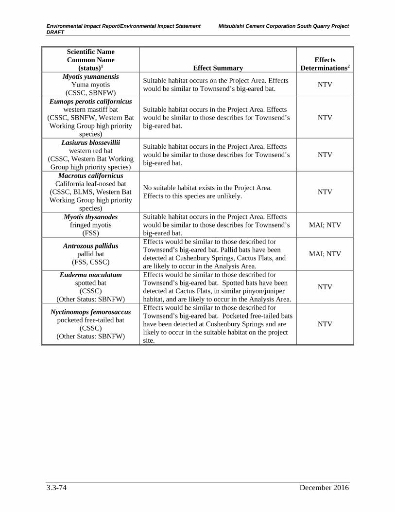
Environmental Impact Report/Environmental Impact Statement Mitsubishi Cement Corporation South Quarry Project DRAFT
3.3-74 December 2016
Scientific Name Common Name
(status)1 Effect Summary Effects
Determinations2
Myotis yumanensis Yuma myotis
(CSSC, SBNFW)
Suitable habitat occurs on the Project Area. Effects would be similar to Townsend’s big-eared bat. NTV
Eumops perotis californicus western mastiff bat
(CSSC, SBNFW, Western Bat Working Group high priority
species)
Suitable habitat occurs in the Project Area. Effects would be similar to those describes for Townsend’s big-eared bat.
NTV
Lasiurus blossevillii western red bat
(CSSC, Western Bat Working Group high priority species)
Suitable habitat occurs in the Project Area. Effects would be similar to those describes for Townsend’s big-eared bat.
NTV
Macrotus californicus California leaf-nosed bat
(CSSC, BLMS, Western Bat Working Group high priority
species)
No suitable habitat exists in the Project Area. Effects to this species are unlikely. NTV
Myotis thysanodes fringed myotis
(FSS)
Suitable habitat occurs in the Project Area. Effects would be similar to those describes for Townsend’s big-eared bat.
MAI; NTV
Antrozous pallidus pallid bat
(FSS, CSSC)
Effects would be similar to those described for Townsend’s big-eared bat. Pallid bats have been detected at Cushenbury Springs, Cactus Flats, and are likely to occur in the Analysis Area.
MAI; NTV
Euderma maculatum spotted bat
(CSSC) (Other Status: SBNFW)
Effects would be similar to those described for Townsend’s big-eared bat. Spotted bats have been detected at Cactus Flats, in similar pinyon/juniper habitat, and are likely to occur in the Analysis Area.
NTV
Nyctinomops femorosaccus pocketed free-tailed bat
(CSSC) (Other Status: SBNFW)
Effects would be similar to those described for Townsend’s big-eared bat. Pocketed free-tailed bats have been detected at Cushenbury Springs and are likely to occur in the suitable habitat on the project site.
NTV

Environmental Impact Report/Environmental Impact Statement Mitsubishi Cement Corporation South Quarry Project DRAFT
December 2016 3.3-75
Scientific Name Common Name
(status)1 Effect Summary Effects
Determinations2
Onychomys torridus ramona southern grasshopper mouse
(CSSC, SBNFW)
Southern grasshopper mouse have been found at Cushenbury Springs. It is likely they occur in the Project Area. Ground disturbance would likely affect the Southern grasshopper mouse. During the summer months, young may not be able to escape the dens, and during hibernation adults may not be able to escape the dens. Ground clearing during either of these times could potentially result in death or injury to individuals. Any suitable or occupied habitat that would become a haul road or part of the quarry would become unsuitable habitat. Over the life of the project 154 acres of habitat would become unsuitable, and the Southern grasshopper mouse would experience high levels of disturbance. This could potentially cause temporary or permanent displacement or behavioral changes. Under Alternative 1- Proposed Action, mining would continue for 120 years after approval (approximately 2134) plus the reclamation period. Under Alternative 2, mining would be permitted for 40 years (approximately 2054) plus the reclamation period. Therefore, the disturbance-associated effects would have a longer duration for Alternative 1 then for Alternative 2. For both Alternatives, the mitigation package includes 540 acres being withdrawn from mineral entry, providing some suitable habitat for this species into the future.
NTV
Chaetodipus fallax fallax San Diego pocket mouse
(CSSC) (Other Status: SBNFW)
San Diego pocket mice have been known to occur at the Cactus Flats/Lone Valley area in habitat that is similar to that found at the Analysis Area. They have also been found at Cushenbury Springs. It is likely they occur on the proposed project Site. Effects would be similar to those described for the southern grasshopper mouse
NTV
Neotoma lepida intermedia San Diego desert woodrat
(CSSC) (Other Status: SBNFW)
Records of the desert species, Neotoma lepida, have been found for the Mitsubishi West Quarry site, Cushenbury Springs and in lower Marble Canyon. The San Diego desert woodrat subspecies may occur in the Analysis Area due to an abundance of suitable habitat. Effects would be similar to those described for southern grasshopper mouse.
NTV

Environmental Impact Report/Environmental Impact Statement Mitsubishi Cement Corporation South Quarry Project DRAFT
3.3-76 December 2016
Scientific Name Common Name
(status)1 Effect Summary Effects
Determinations2
Taxidea taxus American badger
(CSSC) (Other Status: SBNFW)
No records of American badgers exist in the Analysis Area, however, suitable habitat exists and known occurrences have occurred within close proximity. While portions of the Analysis Area may support soils suitable for digging, much of the Analysis Area’s carbonate rock substrates would not. The likelihood of occurrence is low due to rocky soils and paucity of burrowing mammals for pretty. If present, effects would be similar to those described for southern grasshopper mouse.
NTV
Notes: 1Status Codes:
FSS= listed on the Region 5 Forest Service Sensitive species list SBNFW = SBNF Watchlist FSC= Federal Species of Concern CSSC = CDFW Species of Special Concern CNPS 1B.1 = CNPS Rare Plant Rank 1B (rare throughout distribution) Threat Rank 1 (seriously threatened in California) CNPS 1B.2 = CNPS Rare Plant Rank 1B (rare throughout distribution) Threat Rank 2 (moderately threatened in California) CNPS 2B.2= CNPS Rare Plant Rank 2B (rare in California, more common elsewhere) Threat Rank 2 (moderately threatened in California) CNPS 4.2 = CNPS Rare Plant Rank 4 (Limited Distribution) Threat Rank 2 (moderately threatened in California)
2Determination Codes NE=No Effect; MAI = may affect individuals but not likely to lead to a trend to federal listing for Sensitive species. NTV=No threat to viability
SBNF and CDFW Watchlist Species. Implementation of Alternative 1 – Proposed Action would eliminate or degrade habitat for the SBNFW animals discussed in Section 3.3.3. The primary effect to SBNF Watchlist species is habitat loss through removal of the land surface associated with development of the South Quarry and haul road. Indirect effects would include the effects of dust, weeds, and hydrology, and would be expected to be localized and minimized through application of Design Features/Mitigation Measures GEN-1 through GEN-14. This effect would continue for the life of the alternative (120 years). However, Alternative 1 – Proposed Action is not expected to result in a loss of viability for these wildlife species. Effects to Watchlist species are expected to be less than significant with the implementation of Design Features/Mitigation Measures.
Consistency with Local Policies or Ordinances Protecting Biological Resources San Bernardino County. The local government policies or ordinances regarding biological resources that are applicable to the project site include the San Bernardino County General Plan Conservation Element and the San Bernardino County Desert Native Plant Conservation Ordinance. Alternative 1 – Proposed Action would involve permanent, direct effects to approximately 84 acres of pinyon/juniper woodlands, 52 acres of desert scrub, 13 acres of mixed chaparral, and less than 1 acre of montane hardwood-conifer forest. The General Plan Conservation Element provides goals and policies that express the desire to maintain and enhance biological diversity and healthy ecosystems throughout the County. The design features/mitigation measures listed in the Design Features/Mitigation Measures section below

Environmental Impact Report/Environmental Impact Statement Mitsubishi Cement Corporation South Quarry Project DRAFT
December 2016 3.3-77
provide avoidance and compensation for biological resources. Additionally, Design Feature/Mitigation Measure PLANT-1 was developed to be consistent with the San Bernardino County Desert Native Plant Protection Ordinance. With implementation of these Design Features/Mitigation Measures, Alternative 1 – Proposed Action would not conflict with any local policies or ordinances protecting biological resources.
Consistency with Adopted Conservation Plans Carbonate Habitat Management Strategy (CHMS). Implementation of Alternative 1 – Proposed Action has been designed to be consistent with the provisions of the CHMS. With Design Feature CARB-2, the following claims would be added to the CHMS habitat reserve under Alternative 1 – Proposed Action: Cushenbury 7P (93.7 acres), Cushenbury #9 (173.5 acres), Cushenbury #15 (128.0 acres), and Cushenbury #16A (145.2 acres).
Alternative 1 – Proposed Action has followed the provisions of the CHMS for calculating the conservation value of habitat that would be lost to proposed mining projects, and the habitat reserve contributions required to offset those losses. Because the Furnace Unit of the Carbonate Habitat Management Area is not fully activated (i.e., the Stage 1 Priority Lands have not yet been sufficiently added to the Habitat Reserve), acres of occupied and critical habitat to be lost and conserved are evaluated by species.
The conservation value of habitat that would be lost with Alternative 1 – Proposed Action is 97 conservation units. The total conservation value of the proposed habitat reserve contributions is 359 conservation units. The habitat reserve contributions are mostly within the Furnace Unit of the Carbonate Habitat Management Area, and mostly within defined Stage 1 Priority Areas for establishment of habitat reserve. With the modifications described below, the contributions would be entirely within the Priority Habitat Reserve and the Furnace Unit. The reserve contributions would be made through donation of land in fee (Cushenbury 7P) and relinquishment of unpatented mining claims (Cushenbury 9, 16a, and 15). All of these contributions would be in conjunction (and contingent upon) a withdrawal from mineral location and entry under the mining laws of the United States. Based on all these considerations, the proposed action is consistent with the CHMS.
Two aspects of Alternative 1 – Proposed Action require modifications to the CHMS, and information addressed through the CHMS consultation under Section 7 of the federal ESA.
The first is that, under Alternative 1 – Proposed Action, approximately 16 acres of the proposed South Quarry encroaches on land identified under the CHMS as Stage 1 Priority Habitat Reserve and includes a proposal to remove these acres from the Stage 1 Priority Habitat Reserve designation under the CHMS. This 16-acre area includes 0.02 acre of designated critical habitat for Parish’s daisy, 1 acre of Cushenbury buckwheat occupied habitat, 15.4 acres of Cushenbury buckwheat designated critical habitat, 0.2 acre of Cushenbury puncturebract occupied habitat, and a total conservation value of 8.39 conservation units under the CHMS. The entire 16 acres is suitable habitat for each of the four listed plant species.
Alternative 1 – Proposed Action includes a proposal to add the remainder of the Habitat Reserve contributions from this Project that are not currently in the Priority Area to the Priority Area (Design Feature CARB-2). This would add about 85 acres to the Priority Area. This area includes about 4.5 acres of Cushenbury buckwheat occupied habitat and 19.4 acres of Cushenbury buckwheat critical habitat, 1.4 acres of Cushenbury puncturebract occupied habitat

Environmental Impact Report/Environmental Impact Statement Mitsubishi Cement Corporation South Quarry Project DRAFT
3.3-78 December 2016
and 2 acres of Cushenbury puncturebract critical habitat, 0.1 acre of Cushenbury milk vetch occupied and 18.5 acres of Cushenbury milk vetch critical habitat.
The second aspect of Alternative 1 – Proposed Action that requires modifications to the CHMS, and information addressed through the CHMS consultation under Section 7 of the ESA, is a shift of the boundary line between the Furnace and Helendale Units of the Carbonate Habitat Management Area. With the configuration of the reserve contributions and the associated proposed mineral withdrawal, the current Unit boundary would bisect parcels and public land survey sections in an unmanageable way. Alternative 1 – Proposed Action would shift the Unit boundary to follow the proposed withdrawal boundary. This would follow the southern section line of Section 24 (T3N, R1E) and tie into the southern and eastern section lines of Section 19 and the eastern section line of Section 18 (T3N, R2E), then back on its original boundary line. This action would shift about 572 acres in total from the Helendale Unit to the Furnace Unit. This modification would provide for consistent management of the Carbonate Habitat Management Area and would be consistent with the intent of the CHMS.
Other SBNF Conservation Strategies. Alternative 1 – Proposed Action is consistent with the Conservation Strategy for California Spotted Owls, Raptor Conservation Strategy, and Bighorn Sheep Management Plan, as described in Table 3.3-7 and the discussion in California Fully Protected Species, above.
Cumulative Effects
Past, Ongoing, and Reasonably Foreseeable Future Projects Past actions that have affected the same biological resources that would be expected to be affected by Alternative 1 – Proposed Action include existing and past mining operations from multiple operators, Bertha Peak communications site, and Lakeview tract recreation residences. Ongoing activities that affect biological resources include road use and maintenance, trail use and maintenance, recreational use of the SBNF, hazard tree removal along Southern California Edison (SCE) powerlines along and State/County roads, SCE’s periodic replacement of deteriorated poles, and use and maintenance of State Highway 18 on the SBNF. Past mining projects on private land have also created conservation areas on private land for carbonate habitats and bighorn sheep. These areas are accounted for in the baseline conditions. In terms of the species and habitats included in the Analysis Area and Project Area, the effects of past and ongoing activities are included in the discussion of the Affected Environment.
Several activities/actions are in the implementation phase. Current Forest Service projects (including Forest Service authorized actions) occurring on the North Slope include: Omya Sentinel Quarry; reclamation at Omya’s Cloudy and Claudia quarries and associated haul road; reclamation at SMI’s Furnace Canyon quarry and associated areas; and reclamation on MCC’s Cushenbury 17a and 17b claims. Non-federal activities that are currently being implemented and may contribute to the cumulative effects of this Project include SMI’s active mining operations on non-federal land; Mitsubishi’s Cushenbury East quarry and West quarry on non-federal land; Omya’s operations on non-federal land; sand and gravel operations on non-federal land; SCE transmission lines on non-federal land in Cushenbury Canyon, Furnace Canyon and Lucerne Valley; State Highway 18 use and maintenance; use and maintenance of the railway serving Omya, SMI and Mitsubishi processing plants; MCC’s maintenance of a road, wells, and pipeline in Cushenbury Springs; and rural development in Lucerne Valley.

Environmental Impact Report/Environmental Impact Statement Mitsubishi Cement Corporation South Quarry Project DRAFT
December 2016 3.3-79
A number of actions/activities are expected to occur in the foreseeable future. These are federal and non-federal projects that are in planning stages or will be soon but have not yet been approved. These include a proposal by Omya that entails development of a new limestone quarry and an expansion of the existing Sentinel Quarry several miles to the west of the Project Area. SCE has approached the Forest Service about removing and replacing utility poles on their Doble 33 kV electrical transmission line. That circuit runs from the Cushenbury substation north of Cushenbury Springs to Furnace Canyon on the North Slope where it turns south over the ridge to Holcomb Valley. From Holcomb Valley, the circuit travels east to the Doble substation. Many species and habitats in the Action Area are also found along the Doble Circuit.
The Forest Service’s North Big Bear Fuels Reduction project is in the analysis phase. The Baldwin Fuels Reduction project is approved and in the implementation phase. The Forest Service is working with Caltrans and the Federal Highway Administration to grant easements on NFS land to rights-of-way generally 100 feet on either side of the centerline of all State Highways on the SBNF. With this process, it is likely that ownership along State Highway 18, including the section that is near the existing Cushenbury Cement Plant will be evaluated for transfer of title within the next five years. As such, the Forest Service would likely lose some discretion over what occurs along State Highway 18, and therefore may not be able to provide Caltrans with project-level design features and/or mitigation measures to protect rare species and the habitats in that area when future projects are proposed.
Climate Change In 2008, the Forest Service Chief made climate change a national priority for the Forest Service and formalized a process and responsibilities for addressing climate change. The SBNF LMP (USDA Forest Service 2006) contains resource-specific discussions of the potential effects on climate change as part of the cumulative effects to those resources. In southern California, climate change is expected to result in the following changes: the average temperatures will rise; heat waves, droughts, and extreme precipitation events will become more frequent; snowpacks will decrease; and spring runoff and streamflow will occur earlier in the year. Climate warming associated with elevated greenhouse-gas concentrations may also create an atmospheric and fuel environment that is more conducive to large severe fires.
In January 2014, the Forest Service issued a summary of current and probable future trends for climate and climate-driven processes for the SBNF. The following paragraphs summarize this report.
Predictions are difficult due to the extent to which General Circulation Models (GCMs) that are used to simulate future climate scenarios disagree with respect to probable outcomes of climate change (e.g., trends in temperatures). However, there was a consensus in the GCMs in terms of predicting a warming temperature for California. Increasingly dry summers and wet winters were predicted by some models while the overall precipitation may not change. Even if precipitation levels do not change, increases in temperature lead to an increase in evapotranspiration and thus drier ecosystem conditions overall. With higher minimum nighttime temperatures and other changes, projected changes include replacement of conifer-dominated forests with broadleaf trees, expansion of shrub lands into conifer types, and expansion of grasslands.
The models indicate that endemic plants that specialize in uncommon or sparsely distributed habitat will have difficulty responding to changing climatic conditions by migrating. These species are at high risk of extirpation due to localized disturbances (e.g., fire, floods, and invasive species). An overall decrease in suitable habitat for some native animals, especially

Environmental Impact Report/Environmental Impact Statement Mitsubishi Cement Corporation South Quarry Project DRAFT
3.3-80 December 2016
currently-rare species and those with limited distributions or specialized habitat types, leads to potential changes in animal community composition in southern California’s National Forests. In addition, climate change may facilitate the spread of nonnative animals (e.g., Argentine ants) that are currently limited by nighttime minimum temperatures. Over the 120-year life of Alternative 1 – Proposed Action, climate change may result in substantial changes to local plant and animal population size, distribution, and status. Climate change would almost certainly result in changes to the distribution and status of plants and animals in and near the Analysis Area. The distribution of some of the desert species may extend higher in elevation in and around the Analysis Area. The vegetation community patterns may change over the landscape with the pinyon/juniper communities dying off at the northern/lower edges being replaced by desert transition vegetation.
General Cumulative Effects In general, the continued development of the North Slope is expected to result in fragmentation of habitat, barriers to movement, and loss of habitat. Continued development is also expected to result in further carbonate habitat reserve contributions under the CHMS, and management of these lands for carbonate species and the habitat upon which they depend. These reserve contributions are also expected to be habitat for many general and sensitive species that would be affected by cumulative effects. For the majority of species, Alternative 1 – Proposed Action is not expected to contribute considerably to a significant cumulative effect. The exception is potential effects to the Cushenbury herd of Nelson’s bighorn sheep. Effects to this species would be significant, even after implementation of Design Features/Mitigation Measures BHS-1 through BHS-8, on a Project level and would also be significant on a cumulative level.
The effects of climate change, discussed above, will likely result in changes to distribution and status of sensitive plant and animal species and vegetation patterns over the landscape of the Analysis Area. Species for which effects are evaluated may move out of the Analysis Area, and species that have not been evaluated may move in. Additional fragmentation of habitat and isolation of species may occur early in the development of this alternative. However, it is difficult to predict when, where, and to which species cumulative habitat changes will affect species populations, and to what degree. Plants and associated species (e.g., pollinators) would likely shift to higher elevations over time in response to changing temperature and precipitation patterns, and barriers to dispersal could lead to loss of populations. Plants and pollinators, among other mutualistic interactions, may become decoupled as a result of these shifts. How, when, and to what extent Alternative 1 – Proposed Action would ultimately contribute to effects to the vegetation and species in light of these concurrent changes is unknown. The Project-level and cumulative analysis describes the effects of habitat loss and fragmentation for the overall landscape and specific species to the extent known. However, it is difficult to predict when, where, and to which species habitat effects will occur. The adaptive management and other requirements of the Design Features/Mitigation Measures listed below would avoid or minimize Alternative 1 – Proposed Action’s contribution to cumulative effects.
Sensitive Natural Communities and Jurisdictional Waters No near-term effects to Cushenbury Springs are expected. Alternative 1 – Proposed Action’s contribution to potential cumulative effects associated with climate change would be avoided with application of Design Feature GEN-14; therefore, Alternative 1 – Proposed Action would not be expected to contribute to cumulative effects to this RCA. Regional project, including future mining projects, are likely to affect jurisdictional waters. Effects to 0.08 acre of streambed

Environmental Impact Report/Environmental Impact Statement Mitsubishi Cement Corporation South Quarry Project DRAFT
December 2016 3.3-81
under the jurisdiction of CDFW from Alternative 1 – Proposed Action is not anticipated to have a significant contribution to cumulative effects on jurisdictional waters from other projects in the region.
Habitat Connectivity and Fragmentation As described above in General Cumulative Effects, habitat connectivity is likely to continue to be affected by future mining. Omya’s proposed Butterfield-Sentinel quarry expansions and proposed White Knob expansion may further fragment habitat and pose movement impediments. The White Knob proposal is expected to affect 2.5 acres of ephemeral streams that function as wildlife corridors; Omya’s Butterfield-Sentinel quarry proposal would not affect any new drainages. Over the life of the project, it is reasonable to assume that other mining operations may further affect connectivity and movement through fragmentation and creation of impediments to movement.
For the majority of species, Alternative 1 – Proposed Action is not expected to contribute significantly to the cumulative effect. Alternative 1 – Proposed Action includes mitigation through relinquishment of 540 acres of mining claims. Although data indicate that the mitigation areas are not important movement corridors for Nelson’s bighorn sheep, they likely do provide movement corridors for other more common species. The prohibition of future mining at those claims combined with Omya’s mitigation claim for its proposed Butterfield-Sentinel quarry expansion would prevent future fragmentation of the habitat in and across Cushenbury Canyon and preserve the movement corridor for the majority of species. The exception is potential effects to the Cushenbury herd of Nelson’s bighorn sheep. Effects to this species would be significant, even after implementation of Design Features/Mitigation Measures BHS-1 through BHS-8, on a Project level and would also be significant on a cumulative level.
Listed, Sensitive, and Other Rare Species
Threatened and Endangered Species Threatened and Endangered Plant Species. Four federally listed plant species and their designated critical habitat occur within the Project Area: Cushenbury puncturebract, Cushenbury milk vetch, Parish’s daisy, and Cushenbury buckwheat (Table 3.3-6). All four species are also listed in the CNPS Rare Plant inventory with a ranking of 1B and a Threat Rank of 1. In addition to Alternative 1- Proposed Action, the following mining projects would result in permanent habitat loss for the four listed species: Specialty Minerals’ Arctic and Marble Canyon Quarries, and MCC’s West Quarry. The Omya White Knob Quarry does not support habitat for the Cushenbury milk vetch but would result in the loss of habitat for the other three listed species. Direct and indirect effects from these mining projects include the complete and permanent removal of the land surface resulting in permanent habitat loss for these species, dust deposition on plants adjacent to the quarries, increased weed risk, and microclimate changes.
Design Feature CARB-2 would mitigate the permanent habitat loss from Alternative 1- Proposed Action through conveyance of mitigation land at a 3:1 ratio. The CHMS addresses cumulative effects at by considering reserve design and the recovery needs of the species at the landscape scale. Directing project scale mitigation to CHMS priority areas, as Design Feature CARB-2 would do, contributes to the long-term survival and recovery of the subject species. The four mining projects that could contribute to a cumulative effect would also be or have been required to mitigate for effects to these plants through the CHMS. Therefore, Alternative 1- Proposed

Environmental Impact Report/Environmental Impact Statement Mitsubishi Cement Corporation South Quarry Project DRAFT
3.3-82 December 2016
Action’s contribution to a cumulative effect would not be considerable, and would be less than significant.
Threatened and Endangered Wildlife Species. Four federally and state-listed wildlife species are known to occur or have the potential to occur in the Project Area: desert tortoise, California condor, southwestern willow flycatcher, and least Bell’s vireo (Table 3.3-5). The southern rubber boa, a Forest Service Sensitive Species and state-listed species, has potential to occur in the Project Area. Two state-threatened species with no federal designation (Swainson’s hawk and Mohave ground squirrel) have the potential to occur in the Analysis Area.
California Condor. As discussed above, California condors do not currently frequent the North Slope. However, it is reasonably foreseeable that over the life of Alternative 1- Proposed Action, the California condor’s range could expand to include more frequent use of the Analysis Area. Potential effects from Alternative 1- Proposed Action could include habitat loss, disturbance and displacement, and mortality or injury of individuals.
In addition to potential effects from Alternative 1- Proposed Action, cumulative effects could occur when taking into consideration human population growth, expansion of renewable energy, and other existing, proposed, and future mining projects. Risks to condors from man-made factors (trash, toxins, shooting, electrocution, and collisions) will continue and may increase as human populations grow in southern California. Effects from the expansion of the renewable energy development, and other mining operations could result in habitat loss, disturbance and displacement, and mortality or injury of individuals. Over the long life of Alternative 1- Proposed Action, it is very likely that the cumulative effects will continue to pose losses of suitable foraging and nesting habitat. Because of the extreme longevity, there is a very high degree in uncertainty in predicting the types and levels of effects over 40-120 years. If nesting does occur in the North Slope over the life of Alternative 1- Proposed Action, potential risks to individuals could occur.
Design Feature CARB-2 requires the relinquishment of 540 acres of claims and protection from future development. The mitigation parcels provide suitable foraging habitat for California condors on a ratio of 3.5 acres of protected land for every acre of lost land. If California condors become regular visitors to the North Slope over the life of Alternative 1- Proposed Action, Design Feature RAPTOR-1 provides for adaptive management measures. These measures would reduce effects to California condors and their habitat. Other projects that could contribute to a cumulative effect would also be or have been required to mitigate for effects to California condors. Therefore, Alternative 1- Proposed Action’s contribution to a cumulative effect would not be considerable, and would be less than significant.
Southern Rubber Boa. It is unknown if this species occurs in the Project Area, but because of the suitable habitat it is possible the southern rubber boa occurs. The southern rubber boa is threatened by increased recreational use, private development, mining developments or expansions, fuels reduction projects, water diversion or extraction, and land use activities that destroy soil or surface cover. Alternative 1- Proposed Action could contribute to cumulative effects to a small fraction of the range and habitat of the southern rubber boa. However, it is not expected to contribute significantly to the cumulative loss of southern rubber boa habitat or to interfere with maintaining a viable well-distributed population.
Southwestern Willow Flycatcher. No effects to the southwestern willow flycatcher are expected to occur from Alternative 1- Proposed Action, therefore it would not contribute to cumulative effects.

Environmental Impact Report/Environmental Impact Statement Mitsubishi Cement Corporation South Quarry Project DRAFT
December 2016 3.3-83
Least Bell’s Vireo. No effects to the Least Bell’s vireo are expected to occur from Alternative 1- Proposed Action, therefore it would not contribute to cumulative effects.
Swainson’s Hawk. No effects to Swainson’s hawk are expected to occur from Alternative 1- Proposed Action, therefore it would not contribute to cumulative effects.
Desert Tortoise. No effects to the desert tortoise are expected to occur from Alternative 1- Proposed Action, therefore it would not contribute to cumulative effects.
Mohave ground squirrel. No effects to the Mohave ground squirrel are expected to occur from Alternative 1- Proposed Action, therefore it would not contribute to cumulative effects.
California Fully Protected Species Three CDFW Fully Protected Species are known to occur in the Project Area (Table 3.3-2). The primary effects to these species are habitat loss through removal of the land surface, disturbance from increased human activity and noise, and long-term disturbance.
Golden Eagle. Alternative 1- Proposed Action would result in habitat loss through removal of the land surface. Design Feature CARB-2, which sets aside protected land for federally protected plants, would also provide foraging habitat for the golden eagle. Additionally, Design Feature RAPTOR-1 includes the implementation of a Raptor Conservation Strategy, which would help limit effects to golden eagles through adaptive management.
Golden eagle populations are believed to have local declines in some areas of its range. Threats to golden eagles include power lines, contaminants, shooting and poaching, incidental trapping in furbearer traps, drowning in stock-tanks, vehicle collisions, habitat loss, disturbance, and large-scale renewable and non-renewable energy developments. High mortality rates through wind turbine collisions have been recorded. Large-scale solar developments have resulted in large acreages of lost foraging habitat. New renewable energy developments are expected to increase in the foreseeable future. This could contribute to the concern for habitat loss and disturbance for the existing golden eagle population. Wildfires could also threaten golden eagle habitat suitability for nesting and foraging. Climate change could increase the frequency and severity of wildfires.
Other existing, proposed, and future mining operations in the Analysis Area have the potential to affect the availability of foraging and nesting habitat for the golden eagle. Over the long life of Alternative 1- Proposed Action, it is likely that more high quality golden eagle habitat will be affected by mining operations on the North Slope. Lack of this species could cause displacement on some part of the North Slope. Other mining projects that could contribute to a cumulative effect would also be or have been required to mitigate for effects to golden eagles.
Given the current situation for golden eagles, there are concerns about effects to this species due to multiple threats throughout the species’ range. Because of the long life of Alternative 1- Proposed Action, the cumulative effects are expected to continue to threaten golden eagle habitat. However, with incorporation of Design Features/Mitigation Measures CARB-2 and RAPTOR-1, Alternative 1- Proposed Action is not expected to contribute significantly to the cumulative effects.
American Peregrine Falcon. Cumulative effects to American peregrine falcons and their habitat are similar to the effects described above for the golden eagle. Alternative 1- Proposed Action is not expected to contribute significantly to the cumulative effects.

Environmental Impact Report/Environmental Impact Statement Mitsubishi Cement Corporation South Quarry Project DRAFT
3.3-84 December 2016
Nelson’s Bighorn Sheep. Alternative 1- Proposed Action is not expected to affect the viability of Nelson’s bighorn sheep as a species; however, it may contribute to viability concerns for the Cushenbury herd of Nelson’s bighorn sheep. Potential effects to the Nelson’s bighorn sheep from Alternative 1- Proposed Action include habitat loss and fragmentation, displacement, mortality or injury, and disturbance. With the cumulative effects from past and ongoing activities on the North Slope, the sphere of habitat unaffected by disturbance is likely to see continued reduction. Past, proposed, and future mining operations on the North Slope could all contribute to the cumulative reduction of Nelson’s bighorn sheep habitat. Concern for the long-term viability for the North Slope occurrence of this species will be addressed through an adaptive management approach in the North Slope Bighorn Sheep Management Plan (Design Features/Mitigation Measures BHS-1 through BHS-8). However, cumulative effects to this species would be significant, even after implementation of Design Features/Mitigation Measures BHS-1 through BHS-8.
Forest Service Sensitive Species and California Species of Special Concern Table 3.3-3 lists the Forest Service Sensitive and CDFW Species of Special Concern that have potential to occur in the Analysis Area. Table 3.3-7 describes the expected effects for each species from implementation of Alternative 1 – Proposed Action. The primary effect to these species is habitat loss through removal of the land surface and disturbance from increased human activity and noise. Cumulative effects to Forest Service Sensitive and CDFW sensitive species are discussed below.
Forest Service Sensitive Plant Species and CNPS Rare Plant Ranked Species. Alternative 1- Proposed Action could result in cumulative effects to three Forest Service Sensitive plant species; Coville’s dwarf abronia, Shockley’s rockcress, and San Bernardino Mountains dudleya. All of these plant species have a CNPS Rare Plant Ranking of 1B (rare throughout distribution), 2B (rare in California, more common elsewhere), or 4 (limited distribution), and are also sensitive under CEQA. Omya’s Butterfield 3 quarry expansion would remove additional suitable habitat for these species. Mitsubishi’s Cushenbury West Quarry and Omya’s White Knob quarry would each result in over 80 acres of permanent suitable habitat loss for these species. Ongoing activities in the SBNF such as use and maintenance of roads and trails, use of unauthorized roads and trails, dispersed recreation, and non-recreation special uses could result in cumulative effects to these species. Cumulative effects could include minor habitat loss and degradation, and crushing or uprooting of individual plants. The portion of the Analysis Area that supports these species represents a small fraction of the species’ range in the San Bernardino Mountains. Although Alternative 1- Proposed Action could result in cumulative effects, it would not likely interfere with maintaining viable well-distributed populations of these three species.
Alternative 1- Proposed Action would not result in any cumulative effect to the remaining seven Forest Service Sensitive plant species that were identified as having a potential to occur in the Analysis Area because no effects are expected.
Forest Service Sensitive Wildlife Species and CDFW Species of Special Concern. Table 3.3-4 summarizes the potential for Forest Service Sensitive and/or CSSC wildlife to occur in the Project Area and/or in the Analysis Area. Potential effects for these species are summarized below and discussed in detail by species in the BA/BE (USDA Forest Service 2016).
Sensitive Invertebrates. Cushenbury Springs has good habitat for the springsnails, the simple hydroporus diving beetle, and the desert monkey grasshopper, but there is no habitat present for these sensitive invertebrates in the Project Area. Alternative 1- Proposed Action is not expected

Environmental Impact Report/Environmental Impact Statement Mitsubishi Cement Corporation South Quarry Project DRAFT
December 2016 3.3-85
to affect habitat at Cushenbury Springs; however, Design Feature GEN-14 would require MCC to monitor the groundwater effects to Cushenbury Springs over the life of the project. If future adverse effects were to occur, MCC would be responsible for minimizing the effects.
Sensitive Amphibians. Two Forest Service sensitive and CSSC amphibians are known to occur in the Analysis Area: large-blotched ensatina (Ensatina klauberi) and yellow-blotched ensatina (Ensatina eschscholtzii croceater). As noted in Table 3.3-3, in the San Bernardino Mountains, the large-blotched ensatina intergrades with the yellow-blotched ensatina to the point where the two species are difficult to distinguish. Table 3.3-7 summarizes the anticipated effects from Alternative 1 – Proposed Action to these species. In addition to project effects, public and private fuels reduction projects and mining development and expansion projects could contribute to a cumulative effect. Fuels reduction projects on public land have measures to limit effects to riparian habitats and other habitats suitable for ensatina. Mining developments or expansions in the Analysis Area would also be required to incorporate measures to limit effects to ensatina habitat. Design Feature CARB-2 sets aside protected land for plants. Some of the mitigation lands may also support ensatina habitat near drainages and springs. These reasonably foreseeable cumulative effects, together with the potential effects of Alternative 1 – Proposed Action, would affect a small fraction of the range and habitat of the large/yellow-blotched ensatina.
Sensitive Reptiles. Seven Forest Service sensitive and CSSC reptiles are known to occur in the Analysis Area: California legless lizard (Anniella stebbinsi), northern three-lined boa (Lichanura orcutti), San Bernardino ring-neck snake (Diadophis punctatus modestus), San Bernardino mountain kingsnake (Lampropeltis zonata parvirubra), coast patch-nosed snake (Salvadora hexalepis virgultea), and two-striped garter snake (Thamnophis hammondii). Effects to these species are summarized in Table 3.3-7. In addition to Alternative 1- Proposed Action, fuel reduction projects and mining development projects could potentially have a cumulative effect on the Forest Service Sensitive and CSSC reptiles in the Project Area. Fuel reduction projects on Forest Service land attempt to retain good quality reptile habitat. However, similar projects on private land may not provide the same level of protection for reptile habitat. Mitsubishi’s West Quarry Project and Omya’s proposed expansion projects at Butterfield/ Sentinel and at White Knob would all result in the loss of sensitive reptile habitat. These projects could possibly result in the mortality or injury of individual Forest Service Sensitive or CSSC reptiles. These reasonably foreseeable cumulative effects, together with the potential effects of Alternative 1 – Proposed Action, would affect a small fraction of the range and habitat for these species.
Sensitive Bird Species. Fourteen Forest Service Sensitive or CSSC birds are known to occur in the Analysis Area: northern harrier (Circus cyaneus), long-eared owl (Asio otus), California spotted owl, gray vireo (Vireo vicinior), loggerhead shrike (Lanius ludovicianus), Bendire’s thrasher(Toxostoma bendirei), LeConte’s thrasher (Toxostoma lecontei), olive-sided flycatcher (Contopus cooperi), willow flycatchers (Empidonax traillii), yellow warbler (Dendroica petechial brewsteri), tri-colored blackbird (Agelaius tricolor), yellow-headed blackbird (Xanthocephalus xanthocephalus), yellow-breasted chat (Icteria virens), summer tanager (Piranga rubra), and yellow warbler. Several fuel reduction projects on the SBNF would have direct and indirect effects on sensitive bird species, similar to Alternative 1 – Proposed Action. In addition, there are several more fuel reduction projects in the planning phase. Other mining projects such as Omya’s proposed expansion at Butterfield/Sentinel and at White Knob could contribute to effects on foraging habitat and may result in disturbance to nesting birds adjacent to the mine sites. In combination with the discussed fuel reduction projects and other mining projects, Alternative 1- Proposed Action could add to the cumulative effects to sensitive bird and

Environmental Impact Report/Environmental Impact Statement Mitsubishi Cement Corporation South Quarry Project DRAFT
3.3-86 December 2016
their habitat over the long lifespan of the project. Design Features/Mitigation Measures BIRD-1, BIRD-2, and RAPTOR-1 through RAPTOR-3 would minimize Alternative 1 – Proposed Action’s direct and indirect effects to sensitive birds. The reasonably foreseeable fuels reduction and mining projects will have similar design features and/or mitigation measures to reduce effects to sensitive birds and their habitats. Design Feature/Mitigation Measure CARB-2 would designate protected land in the SBNF that could be suitable habitat for spotted owls. Other fuel reduction projects and mining development or expansion projects would include similar design features and/or mitigation measures to reduce effects to spotted owls. With incorporation of these design features/mitigation measures, cumulative effects to sensitive birds would be less than significant.
Sensitive Mammals. Thirteen Forest Service Sensitive or CSSC mammals occur or have a high likelihood to occur in the Analysis Area; Townsend’s big-eared bat (Corynorhinus townsendii), Yuma myotis (Myotis yumanensis), western mastiff bat (Eumops perotis californicus), western red bat (Lasiurus blossevillii), California leaf-nosed bat (Macrotus californicus), fringed myotis (Myotis thysanodes), pallid bat (Antrozous pallidus), spotted bat (Euderma maculatum), pocketed free-tailed bat (Nyctinomops femorosaccus), southern grasshopper mouse (Onychomys torridus Ramona), San Diego pocket mouse (Chaetodipus fallax fallax), San Diego desert woodrat (Neotoma lepida intermedia), and American badger (Taxidea taxus).
Bats. Nine Forest Service Sensitive or CSSC bats are known to occur in the Analysis Area. Alternative 1- Proposed Action would have similar cumulative effects on these species, therefore effects are discussed together. Riparian habitat, where these species can be found, has been dramatically affected in California due to development, water extractions/diversions/ impoundment, drought, grazing, and recreational uses. Other proposed and approved North Slope mining projects such as Omya’s Butterfield/Sentinel, White Knob, and Mitsubishi’s West Quarry project would also result in the loss of habitat and could result in the loss of individuals over the lifespan of the projects. Effects from these mining projects would be similar to the effects from Alternative 1- Proposed Action (Table 3.3-7). The continued mining development on the North Slope is expected to affect roosting habitat for these bat species. The effects may be magnified over the long lifespan of the project due to climate change. Design Feature CARB-2 sets aside protected land, providing long-term protection of more suitable habitat acres than would be lost through Alternative 1- Proposed Action. Table 3.3-7 describes the anticipated effects of Alternative 1 – Proposed Action on these species. These effects, along with the effects from reasonably foreseeable cumulative projects, would affect a small fraction of the habitat for these species.
Other Sensitive Mammals. Other Forest Service Sensitive or CSSC mammals with potential to occur in the Analysis Area include southern grasshopper mouse, San Diego pocket mouse, San Diego desert woodrat, and American badger. Effects to these species are summarized in Table 3.3-7. In addition to Alternative 1- Proposed Action, fuel reduction projects and mining development projects could potentially have a cumulative effect on the Forest Service Sensitive and CSSC mammals in the Project Area. Fuel reduction projects on Forest Service land attempt to retain good quality habitat. However, similar projects on private land may not provide the same level of protection for mammal habitat. Mitsubishi’s West Quarry Project and Omya’s proposed expansion projects at Butterfield/ Sentinel and at White Knob would all result in the loss of sensitive mammal habitat. These projects could possibly result in the mortality or injury of individual Forest Service Sensitive or CSSC mammals. These reasonably foreseeable

Environmental Impact Report/Environmental Impact Statement Mitsubishi Cement Corporation South Quarry Project DRAFT
December 2016 3.3-87
cumulative effects, together with the potential effects of Alternative 1 – Proposed Action, would affect a small fraction of the range and habitat for these species.
SBNF and CDWF Watchlist Species Where there are similarities in species and effects for SBNF and CDFW Watchlist species, the cumulative effects are presented in groups. Table 3.3-4 lists the Forest Service and CDFW Watchlist species that have the potential to occur in the Analysis Area.
Watchlist Plants. Table 3.3-4 lists the Forest Service and CDFW Watchlist plant species that are known or have potential to occur in the Analysis Area. The cumulative effects for these plants would be similar to those described above for Forest Service Sensitive plants. Watchlist Invertebrates. Two SBNFW invertebrates are known to occur or have potential to occur in the Analysis Area: San Bernardino Mountains silk moth and Andrew’s marble butterfly (Table 3.3-4). The cumulative effects for these plants would be similar to those described above for Forest Service Sensitive and CSSC invertebrates... Watchlist Amphibians. Two Forest Service Watchlist species of amphibians are known to occur in the Analysis Area: the Monterey ensatina (Ensatina eschscholtzii eschscholtzii) and red-spotted toad (Bufo punctatus). Cumulative effects to these species would be similar to those described above for Forest Service Sensitive/CDFW Sensitive amphibians. Watchlist Reptiles. Table 3.3-4 lists the Forest Service and CDFW Watchlist species known or have the potential to occur in the Project Area and Analysis Area. Any suitable habitat for the Watchlist reptile species that is present in the Project Area would become unsuitable over the life of Alternative 1- Proposed Action. These species would experience high levels of disturbance and potentially mortality or injury. Other proposed, current, or future mining development projects in the Analysis Area would have similar effects on these species. Alternative 1 – Proposed Action, over the life of the project, may add incrementally to the reasonably foreseeable effects to these species in the San Bernardino Mountains. Cumulative effects would be similar to those described above for Forest Service Sensitive/CDFW Sensitive reptiles.
Watchlist Birds. Forest Service and CDFW Watchlist birds that have potential to occur in the Analysis Area are listed on Table 3.3-4. Alternative 1- Proposed Action could affect these birds through habitat loss. Effects would be minimized through Design Features/Mitigation Measures BIRD-1 and BIRD-2 and RAPTOR-1 through RAPTOR-3. Other mining and development projects proposed, scheduled, or currently taking place in the Analysis Area would have mitigation measures in place to reduce effects to Watchlist birds. Alternative 1 – Proposed Action, over the life of the project, may add incrementally to the reasonably foreseeable effects to these species in the San Bernardino Mountains. Cumulative effects would be similar to those described above for Forest Service Sensitive/CDFW Sensitive birds.
Watchlist Mammals. Forest Service and CDFW Watchlist mammals that have potential to occur in the Analysis Area are listed on Table 3.3-4. The primary effect to Forest Service and CDFW Watchlist mammals is habitat loss through removal of the land surface associated Alternative 1- Proposed Action. These effects would be minimized through the application of the Design Features/Mitigation Measures listed below. Design Feature CARB-2 would establish 540 acres of land protected from future mining claims. This land would include areas that are suitable habitat for the Watchlist mammal species. Alternative 1 – Proposed Action, over the life of the project, may add incrementally to the reasonably foreseeable effects to these species in the San

Environmental Impact Report/Environmental Impact Statement Mitsubishi Cement Corporation South Quarry Project DRAFT
3.3-88 December 2016
Bernardino Mountains. Cumulative effects would be similar to those described above for Forest Service Sensitive/CDFW Sensitive mammals.
Mitigation Measures The NEPA design features from Section 2.3.2.14 for biological resources are listed below for convenience. Design features indicated with an asterisk (*) are also CEQA Mitigation Measures that would avoid, minimize, rectify, reduce, and/or compensate for effects to biological resources anticipated with Alternative 1- Proposed Action.
General Biological Resources GEN-1*: MCC shall minimize disturbance or hazards to surrounding vegetation, habitat,
and wildlife, such as toxic substances, dust, noise, and lighting, as follows:
a. New lighting shall be established at the minimum necessary to meet safety requirements, and shall be shielded to avoid lighting the surrounding habitat and the night sky;
b. Except as necessary to survey or maintain the safety of the mine site, the Project’s disturbance footprint shall be limited to areas designated for mining and related activities;
c. Equipment staging areas and other construction or related habitat disturbance shall be limited to areas within the new or existing quarry footprint(s) and shall be designed and operated to the goal of minimizing impacts to adjacent habitat and sensitive biological resources;
d. Any soil bonding or wetting agents to be used for dust control on unpaved surfaces shall be non-toxic to wildlife and plants and non-attractants for wildlife. If wetting or soil bonding agents appear to be attracting wildlife to the roadways (e.g., by pooling or creating mineral licks), the mining operator will work with the Forest Service to develop remedies;
e. All vehicles and equipment shall be maintained in proper working condition to minimize the potential for spill of motor oil, antifreeze, hydraulic fluid, grease, or other hazardous materials. Spills will be cleaned up as quickly as possible;
f. All trash and food-related waste shall be secured in self-closing animal-proof containers and removed daily from the site;
g. Only authorized agency or security personnel (including the California Department of Fish and Wildlife [CDFW], USFWS, and Forest Service) shall bring firearms or weapons to the site.
h. No recreational target shooting will occur on Forest Service lands within the permit area.
i. Standard erosion control measures commensurate with those typically required in an Industrial Stormwater Pollution Prevention Plan for a limestone surface mining operation shall be implemented for all phases of construction and operation where sediment run-off from exposed slopes may enter native soils or habitat or jurisdictional streambeds;

Environmental Impact Report/Environmental Impact Statement Mitsubishi Cement Corporation South Quarry Project DRAFT
December 2016 3.3-89
j. Disturbed soils and roads within the project site shall be stabilized to reduce erosion potential; and
k. For drainages that cannot be avoided, MCC shall obtain a Streambed Alteration Agreement in compliance with Section 1602 of the California Fish and Game Code and an application for waste discharge requirements (WDRs) or a waiver of WDRs in compliance with Section 13260 of the California Water Code, as applicable.
GEN-2*: Employee Training: MCC shall conduct wildlife/plant awareness programs for employees (including new employee orientation and annual refresher trainings). The program will address bighorn sheep, desert tortoise, golden eagles, rare reptiles/amphibians, other animals of the area, and rare plants. This will include the importance of avoiding harassment/disturbance, adherence to speed limits, adherence to defined project boundaries, reporting guidelines, discouraging ravens and other scavengers, etc. Specific items as described in the employee education component of the North Slope Bighorn Conservation Strategy, Raptor Conservation Strategy, and the desert tortoise design features below will be included in the training. MCC will solicit input from CDFW and USFS in developing the training program.
GEN-3*: Fencing: MCC shall identify likely or potential wildlife movement routes across or around the site and then avoid or minimize potential impediments to wildlife movement by fencing only those areas where access must be restricted for safety or security reasons.
In the event fencing is necessary during construction and/or extraction activities, project personnel shall ensure that any such fence meets existing specifications that have been developed to preclude accidental entanglement of bighorn sheep, deer, and other animals. Biologists from the USFS and CDFW will be consulted for appropriate fence guidelines. Where this Design Feature conflicts with Mine Safety and Health Administration guidelines, attempts will be made to meet the intention of both. Where that is not possible, Mine Safety and Health Administration guidelines will be applied.
GEN-4*: Reclamation: Reclamation of the South Quarry shall include the creation of angled pathways and interlacing reclaimed benches in order to facilitate the movement of bighorn sheep and other wildlife through the quarries. These benches will be created as the mining sequence is completed and prior to restoration.
GEN-5: Haul Road Crossings: The final design of the haul road shall ensure movement pathways for wildlife, including bighorn sheep and deer, between the existing East and West Pits and the proposed South Quarry. This will include terracing or stair-stepping or micro-benches of steep and vertical cuts, especially at strategic crossing locations, as recommended by the CDFW and Forest Service biologists. This will not occur where slope and rock qualities will threaten haul road safety and stability.

Environmental Impact Report/Environmental Impact Statement Mitsubishi Cement Corporation South Quarry Project DRAFT
3.3-90 December 2016
GEN-6*: Pets and Domestic Animals: MCC employees shall not bring pets or domestic animals to the work site. MCC will not authorize the housing or grazing of domestic animals on the project site.
GEN-7*: Feeding Animals: Feeding of animals will be prohibited to discourage the spread of non-native birds, to discourage the spread of disease and pathogens, etc.
GEN-8*: Mine operators will maintain facilities and grounds in a manner that minimizes any potential impacts to hunting or scavenging raptors and other predators/scavengers (e.g., minimize storage of equipment near active quarries that may attract prey, remove trash/garbage daily, etc.). All trash and food-related waste shall be secured in self-closing animal-proof containers and removed daily from the site. MCC shall avoid practices that attract/enhance prey populations and opportunities for raptor hunting or scavenging near active quarries, haul roads, and processing areas. This would also help discourage the spread of non-native birds and discourage the spread of disease and pathogens, etc.
GEN-9*: To reduce vehicle collision risk to raptors and other scavengers, intact animal carcasses (with the exception of bighorn sheep and deer) will be removed immediately from mine roads and mining areas. Carcasses will be removed far enough away from roads and active mining areas that scavengers would not be in danger of vehicle collision or other mining-related hazards. Bighorn sheep and deer carcasses shall be covered with a tarp and left in place until the CDFW or Forest Service biologist is notified and provides direction. As much as is feasible, care will be taken to avoid disturbing the area around the carcass to preserve predator tracks, parasites, etc.
GEN-10*: Disturbance Avoidance: MCC employees and contractors will not use MCC roads in order to access National Forest lands for recreation or hunting. Access for personal use will be through National Forest system roads and trails that are open to the general public.
GEN-11*: Blasting: Prior to blasting activities within the project area, mine employees shall conduct a visual inspection (both naked eye and with binoculars) for a minimum of five minutes to ascertain the presence or absence of bighorn sheep, deer, golden eagles, peregrine falcons, or other large animals. If animals are located within the blast area, mine employees shall wait until animals have moved from the area or may use sound, as from shouts, vehicle, or air horns, to move them out of the blast area prior to detonation of any blasting materials.
GEN-12*: Biomass Disposal: All woody vegetation to be cleared from the surface (quarry site, haul road, etc.) will be disposed of as follows:
a. Small size vegetation and organic material (stems less than 6 inches in diameter) will be applied to inactive quarry benches, overburden piles, and on sidecast areas along roads and quarries. Material may be chipped and/or stockpiled prior to use. Stockpiling and use should be done as part of phased reclamation to minimize stockpile duration and associated weed risk.
b. All wood greater than 6 inches in diameter will be either reduced to less than 6 inches and applied as described in GEN-12a or removed from the site and

Environmental Impact Report/Environmental Impact Statement Mitsubishi Cement Corporation South Quarry Project DRAFT
December 2016 3.3-91
decked by MCC at a location to be determined by the Forest Service. The decked wood will be sold to the public by the Forest Service.
GEN-13*: The BLM’s withdrawal of approximately 540.4 acres of land from mineral entry and MCC’s quit-claim of specified unpatented mining claims (discussed in EIR/EIS Section 1.6 and below under Carbonate Plants) is also designed to mitigate for the loss of pinyon-juniper woodland and desert transition habitats as wildlife habitat.
GEN-14*: The current regular groundwater monitoring program within the general MCC Cushenbury operating area will continue through the life of the project (South Quarry Operating Plan and Reclamation Plan). MCC will continue to submit a report regarding the monitoring to the Forest Service and the County at least annually. If this regular report indicates a change in groundwater levels, use, or recharge rates that may pose a substantial threat to surface water and wetland vegetation at Cushenbury Springs, or if unusual vegetation mortality is observed at the wetlands, a pump test will be performed for all wells supplying the Cushenbury Cement Plant and associated monitoring wells to determine if there has been a change in the groundwater basin between the subject wells and Cushenbury Springs. If there are future adverse changes to water quantity, seasonal duration of surface flow, or extent of wetland vegetation related to the project, MCC will respond to minimize these effects. Future minimization actions may include, but are not limited to, water conservation programs and shifts in the usage of various available water sources.
Bighorn Sheep BHS-1*: Foraging Habitat: When trucks spray water on haul roads to control fugitive dust,
some overspray occurs on road berms for a short distance beyond. Those watered areas sometimes support vegetation that bighorn sheep consume. MCC will not make an effort to eliminate the overspray. The Revegetation Plan will focus on using native species that will help enhance bighorn sheep habitat.
BHS-2*: Water Developments: In the event that bighorn sheep abandon the use of one or more water developments as a result of disturbance associated with the development of the South Quarry, MCC shall create additional water development(s) after consulting with appropriate agency personnel (Forest Service and CDFW) to select location(s) for additional water development(s). MCC shall ensure that any existing water development(s), as well as any created as part of the Design Features/Mitigation Measures, are maintained in good operating condition for the duration of the project.
BHS-3*: Reporting of Mortality: MCC shall immediately report any bighorn sheep mortalities, whatever the cause, to the CDFW and Forest Service as soon as possible after the observation. The bighorn sheep carcass shall be covered and left in place until the CDFW or Forest Service biologist can examine it and determine the proper disposal method. In the event that mountain lion predation is occurring at levels that compromise the viability of the population, MCC shall cooperate fully by ensuring access to MCC properties for Forest Service and/or CDFW personnel for the purpose of determining the predator involved or, in the event that an individual predator has been identified, to remove the predator.

Environmental Impact Report/Environmental Impact Statement Mitsubishi Cement Corporation South Quarry Project DRAFT
3.3-92 December 2016
BHS-4*: Monitoring/Adaptive Management: MCC shall monitor bighorn sheep use in and near their operations and at water sources in and adjacent to their operations. Monitoring shall consist of installation and maintenance of cameras stationed at CDFW- and Forest Service-identified water sources and recording of data from cameras in a database developed by CDFW, as well as collection of observations by MCC employees. The North Slope Bighorn Sheep Management Strategy may identify other monitoring methodologies to be developed over time. An annual monitoring report will be provided to the Forest Service and CDFW.
BHS-5*: Highway Crossing: Upon obtaining the necessary approvals from Caltrans, MCC shall fund, purchase, and install highway warning signs on State Route 18. MCC shall use best efforts to obtain the Caltrans approvals necessary to install the highway warning signs on State Route 18. The intent of the signs is to avoid vehicle-strike mortality or “take” of bighorn sheep crossing the highway.
BHS-6*: Conservation Strategy: A Draft North Slope Bighorn Sheep Conservation Strategy will be developed by CDFW and the Forest Service. The management plan will cover the North Slope of the San Bernardino Mountains from White Mountain to Terrace Springs (see Figure 3.3-1 in Section 3.3). The management plan shall include guidelines/thresholds for population status that would trigger augmentation of the herd; a strategy/guidelines for developing water sources to respond to drought years; and herd monitoring methodology and objectives. MCC will be a partner in the North Slope Bighorn Conservation Strategy and will help support the long-term management goals of maintaining a sustainable population of bighorn sheep on the North Slope, as described in BHS-7.
BHS-7*: Future Conservation and Management: Within one year after approval of the South Quarry Plan of Operations and the Reclamation Plan by the County and the Forest Service, MCC shall begin contributing to a non-wasting endowment, designated as the North Slope Bighorn Sheep Conservation Fund (Fund). The amount of MCC’s contributions shall be determined by CDFW in coordination with MCC prior to final approval of the South Quarry project. The Fund shall be administered by the National Fish and Wildlife Foundation as a sub-account of the California Department of Fish and [Game] Master Mitigation Account. This sub-account shall be managed as a long-term endowment dedicated to activities that aid in conservation and monitoring of bighorn sheep both within the Cushenbury herd and on proximate habitats, occupied or unoccupied, including the Bighorn Mountains and San Gorgonio Wilderness where immigration and emigration may connect groups into a functional metapopulation.
BHS-8*: Employee Awareness Training: MCC will consult with the CDFW to incorporate bighorn sheep education and awareness into their training for employees and contractors. Training will include how to minimize impacts to bighorn sheep and include guidelines for driving, operation of heavy equipment, general quarry operation, and blasting in bighorn sheep habitat.
Nesting Birds BIRD-1*: Migratory Bird Treaty Act Compliance: During the development of the quarry,
haul roads, and associated facilities, all initial ground clearing (vegetation removal, grading, etc.) shall occur outside the avian breeding season (i.e., do not

Environmental Impact Report/Environmental Impact Statement Mitsubishi Cement Corporation South Quarry Project DRAFT
December 2016 3.3-93
remove potential nesting habitat from February 1 through August 31, or appropriate dates based on on-site nesting phenology determined by a qualified biologist).
For initial ground clearing (vegetation removal, grading, etc.) that is not feasible to be conducted outside the nesting season, surveys will be conducted to locate active nests within 10 days of the initiation of ground-disturbing activities. Any active nest sites that are located will be buffered and no work will be conducted within those buffered areas until the nests are no longer active. The buffer distances would be determined by a qualified biologist referencing current species-specific standards, and taking into account the conservation status of the species (e.g., larger buffers may be appropriate for Sensitive species, etc.), species-specific biology, and the nature of the planned disturbance (e.g., driving past a nest versus extensive grading).
BIRD-2*: Nesting bird surveys for passerine birds, as outlined in BIRD-1, shall be conducted by a qualified biologist experienced and familiar with robust nest-locating techniques or comparable to those described by Martin and Guepel (1993). Surveys shall be conducted in accordance with the following guidelines:
a. Surveys shall cover all potential nesting habitat to be disturbed and a 500 foot buffer surrounding areas to be disturbed;
b. At least two pre-construction surveys, separated by a minimum 10 day interval, shall be completed prior to initial grading or grubbing activity; the later survey shall be completed no more than 10 days preceding initiation of initial grading or grubbing activity. Additional follow-up surveys shall be required if periods of construction inactivity exceed one week in any given area, in interval during which birds may establish a nesting territory and initiate egg laying and incubation.
Conservation of Special Status Raptors RAPTOR-1*: A Raptor Conservation Strategy (RCS) will be developed in coordination with the
Forest Service, USFWS, and CDFW. MCC shall provide input to the development/finalization of the RCS and shall follow the guidelines put forth in the effort. The RCS will be tailored for activities associated with mining activities and effects. Upon approval of the Plan of Operations and the Reclamation Plan by the County and the Forest Service, MCC will participate in the implementation of the RCS by contributing to specified survey and monitoring efforts, and by following applicable operational guidelines.
The RCS will cover the North Slope of the San Bernardino Mountains from White Mountain to Terrace Springs, and will address special status raptors (currently, golden eagle, California condor, and peregrine falcons). The RCS may be updated to include other raptors in the future if concerns develop over their local population status.
The RCS will be a dynamic document and will be updated as new data and scientific understanding of the aforementioned species become available. It will include monitoring and information gathering, and measures to avoid, minimize, rectify, and reduce (or eliminate over time) effects to raptors nesting on the North

Environmental Impact Report/Environmental Impact Statement Mitsubishi Cement Corporation South Quarry Project DRAFT
3.3-94 December 2016
Slope. The intent is to use systematic monitoring of raptor nesting chronology and observed behavior to develop site- and activity-specific measures to ensure successful nesting and provide for adaptive management opportunities.
RAPTOR-2*: If an occupied nest for a federally-protected species, a California-listed species, or a California fully-protected species is found within 1.5 miles of an active quarry operation, the Forest Service will determine if additional monitoring is needed and undertake the appropriate coordination/consultation with the appropriate agencies. If required, the appropriate authorization(s) will be requested from USFWS or CDFW, under the applicable law (federal or state Endangered Species Act, Bald and Golden Eagle Protection Act, Migratory Bird Treaty Act). MCC will cooperate in such efforts and implement the resulting measures designed to minimize or avoid “take”.
RAPTOR-3*: If monitoring detects that blasting or other mine activities are resulting in disturbance of nesting raptors that could lead to mortality or nest abandonment, the Forest Service, MCC, and USFWS and CDFW, as appropriate, will evaluate the feasibility of implementing measures to avoid or reduce effects. The RCS will contain potential methods, such as establishment of buffers and parameters for work stoppage, for reducing or avoiding effects.
Desert Tortoise DETO-1*: MCC will consult with the Forest Service to incorporate desert tortoise education
and awareness into their training for employees, customers, and contractors. This will include how to minimize impacts to desert tortoise and their habitats. Information about penalties will also be included. These briefings will include guidelines about driving in desert tortoise habitat, handling prohibitions, etc. MCC will solicit input from the Forest Service to develop other protective measures if a need is identified through reporting from Design Feature DETO-2 or other CDFW or Forest Service requirements.
DETO-2*: Any sightings of desert tortoises, including dead tortoises, in the Project Area must be reported to the Forest Service biologist. The report will include photos if possible, location, date, time, cause of death (if obvious), and any other pertinent information.
Non-Native Species – Plants, Animals, and Pathogens NNS-1*: MCC shall monitor the occurrence of non-native invasive plants in the Project
Area by visual inspection. The goal is to prevent non-native invasive plants from becoming established and depositing seeds in areas to be re-vegetated at a later date. If inspections reveal that weeds are becoming established in the Project Area, then removal would be initiated by MCC in coordination with the Forest Service botanist. Inspections shall be made in conjunction with revegetation monitoring.
NNS-2*: To reduce the risk of introducing non-native invasive plants, insects, and pathogens from off-site, all heavy mining equipment (e.g., drill rigs, haul trucks, loaders) must be thoroughly washed of all soil and vegetation debris prior to

Environmental Impact Report/Environmental Impact Statement Mitsubishi Cement Corporation South Quarry Project DRAFT
December 2016 3.3-95
being brought into the company’s operating area (i.e., the MCC Cushenbury Cement Plant and associated local quarries).
NNS-3*: If any new non-native invasive plants, animals, or pathogens are identified as having a potential for establishment in the Project Area, MCC will consult with the Forest Service to develop measures for detection, control, and eradication as necessary. MCC shall be responsible for funding detection, control, and eradication efforts in the Project Area.
NNS-4*: MCC personnel will be trained on the need to report sightings of feral or domestic sheep, goats, dogs, or cats on, in, and near the Project Area to the Forest Service and CDFW within two hours of the observation. In the event of domestic or feral animals being found, MCC shall employ a trained trapper to catch and remove the animals following County regulations. CDFW may assist in capture/removal efforts, if available.
Salvage and Recovery of Plants PLANT-1*: MCC shall inventory all accessible yucca species (Joshua trees, Mojave yucca,
and chaparral yucca) within the proposed project disturbance areas, and identify yuccas (all species) likely to survive transplantation.
Prior to grading, accessible yucca plants suitable for translocation shall be transported to off-site reclamation or restoration areas. The suitability for salvage and transplantation shall be determined by a qualified botanist or horticulturalist, based on their size, stability, and location. A qualified horticulturalist shall direct the removal, transport, and replanting, and follow-up maintenance including irrigation and physical support as needed until transplantation is successful. Relocation sites shall be within the same general area. Suitable reclamation/restoration sites will be identified in coordination with the Forest Service botanist.
PLANT-2*: MCC will solicit input from the Forest Service and will provide for salvage of rare native plants within the Project Area to be propagated and/or transplanted to protected habitat reserve areas at the discretion of the Forest Service.
Carbonate Endemic Plant Species CARB-1: As specified under the CHMS, and within the Project Area, MCC or the Forest
Service may at their discretion salvage carbonate endemic plant species (whole plants, cuttings, or seed), and propagules of associated species, to aid in carbonate habitat revegetation efforts on or off-site.
CARB-2*: MCC shall, upon BLM’s withdrawal of approximately 540.4 acres of land from mineral entry, quit-claim specified unpatented mining claims held within the SBNF, and convey specified patented lands, which have been verified by the Forest Service to contain occupied endangered species habitat on an approximately 3 to 1 ratio (species-acres and CHMS conservation value) as mitigation for impacts of the South Quarry project on Cushenbury buckwheat, Cushenbury puncturebract (formerly oxytheca), and Parish's daisy pursuant to the guidance provided by the CHMS as follows: MCC shall determine total project disturbance acreage, to include the South Quarry and haul road as well as rock

Environmental Impact Report/Environmental Impact Statement Mitsubishi Cement Corporation South Quarry Project DRAFT
3.3-96 December 2016
and debris roll-down areas below them. MCC shall evaluate the Conservation Value of the acreage proposed for disturbance according to the CHMS.
The following design features/mitigation measures were developed for other environmental resources, but would also reduce effects to biological resources, and are listed here for convenience.
AIR-2*: Every day of active mining, the Project proponent shall apply water or chemical dust suppressants to unpaved roads and disturbed mine areas that are in active use on that day. For days when water is used rather than chemical dust suppressants, water shall be applied no less than once every 1.25 hours at a rate of no less than 0.11 gallons per square yard. Alternatively, to control dust emissions from unpaved roads and disturbed mine areas in active use, the Project proponent shall apply chemical dust suppressants in accordance with manufacturer specifications.
SCEN-14*: MDAQMD dust controls shall be implemented to reduce visible dust plumes.
Residual Effects after Mitigation After mitigation, all but one of the effects from Alternative 1- Proposed Action would be less than significant. The exception is potential effects to the Cushenbury herd of Nelson’s bighorn sheep. Although design features/mitigation measures, including the establishment of a North Slope Bighorn Sheep Management Plan (Design Features/Mitigation Measures BHS-6 and BHS-7, would minimize effects to the herd, Alternative 1- Proposed Project’s effects on the Cushenbury herd remain potentially significant.
3.3.4.3 Alternative 2 – Partial Implementation
With Alternative 2- Partial Implementation, mining would occur for 40 years plus the reclamation period. As such, mining effects would have a shorter duration, and reclamation would be completed sooner, than described for Alternative 1- Proposed Action. Additionally, Alternative 2- Partial Implementation would disturb 20 fewer acres (133.6 acres) than Alternative 1- Proposed Action (153.6 acres). Alternative 2 – Partial Implementation would result in permanent direct effects of approximately 64 acres of pinyon/juniper woodlands, 52 acres of desert scrub, 13 acres of mixed chaparral, and less than 1 acre of mixed hardwood-conifer forest. With the implementation of the design features/mitigation measures listed above, effects are expected to be less than significant with the exception of direct, indirect, and cumulative effects to the Cushenbury herd of Nelson’s bighorn sheep. Even after implementation of design features/mitigation measures, effects to the Cushenbury herd would remain significant.
With this Alternative, higher-grade limestone would be trucked from elsewhere in the region for the remaining life of the East and West Pits (approximately 80 years). Approximately 52,000 on-road truck trips per year (150 truck trips per day) would be required from year 41 to year 120. Effects to biological resources could also occur at the alternate site, the severity of which would depend on the exact location of the resource. With this alternative, truck traffic on local roads and State Highway 18 may increase, potentially resulting in greater risk to wildlife, such as desert tortoise and bighorn sheep.

Environmental Impact Report/Environmental Impact Statement Mitsubishi Cement Corporation South Quarry Project DRAFT
December 2016 3.3-97
Direct and Indirect Effects
General Biological Resources General effects to wildlife including disturbance/displacement/abandonment, death and injury of individuals, general effects to breeding animals, general effects to cliff and rock outcrop dwelling species, and effects to log-dependent, fossorial (burrowing), and small terrestrial animals would be similar to those described for Alternative 1- Proposed Action.
Sensitive Natural Communities and Jurisdictional Waters Alternative 2- Partial Implementation would also result in a 12.1 percent increase in water extractions during the shortened life of the mine. As discussed for Alternative 1 – Proposed Action, the existing MCC wells are separated from Cushenbury Springs by faulting, and the increased extraction from these wells is not anticipated to affect the riparian habitat at Cushenbury Springs. There is no riparian habitat in the Project Area, although there are five unnamed drainages on the site. Effects from Alternative 2- Partial Implementation would be the same as those described for Alternative 1- Proposed Action with the exception of Drainage B. The southern portion of Drainage B would not be disturbed as a result of Alternative 2- Partial Implementation. The portion of this drainage that would not be affected is one to three feet in width and approximately 300 feet long (0.013 acres). Alternative 2- Partial Implementation would permanently affect less than 0.07 acres of CDFW jurisdiction, none of which consist of vegetated riparian habitat, and 931 linear feet of unvegetated streambed. A Lake or Streambed Alteration Agreement in accordance with Section 1602 of the Fish and Game Code would be required for this alternative.
Habitat Connectivity and Fragmentation With Alternative 2- Partial Implementation, mining would cease sooner and would affect 20 fewer acres. However, the effects to drainages and the habitat fragmentation from development of the haul road and quarry would be the same as those described for Alternative 1 – Proposed Action. With implementation of design features/mitigation measures listed above, effects would be less than significant.
Listed, Sensitive, and other Rare Species Threatened and Endangered Species
Threatened and Endangered Plant Species. Alternative 2 – Partial Implementation would affect the same four Federally-listed species and critical habitat as discussed under Alternative 1 – Proposed Action (Cushenbury puncturebract, Cushenbury milk vetch, Parish’s daisy, and Cushenbury buckwheat). The amount of occupied habitat and Critical Habitat that would be directly affected by Alternative 2- Partial Implementation is summarized in Table 3.3-8. Direct and potential indirect effects of Alternative 2- Partial Implementation are similar to those described for Alternative 1- Proposed Action. Alternative 2- Partial Implementation contains 20 fewer acres (133.6 acres) of suitable habitat for these four species and would affect 8.9 fewer acres of Cushenbury buckwheat Critical Habitat when compared to Alternative 1- Proposed Action. However, the amount of occupied habitat would be the same as with Alternative 1 – Proposed Action. With the Alternative 2- Partial Implementation, mining would occur for 40 years (until approximately 2054) plus the reclamation period. As such, these general effects

Environmental Impact Report/Environmental Impact Statement Mitsubishi Cement Corporation South Quarry Project DRAFT
3.3-98 December 2016
would have a shorter duration than described for Alternative 1- Proposed Action. Table 3.3-5 provides the effects determinations for these species.
Table 3.3-8 Summary of Acres of Occupied Habitat and Critical Habitat for Threatened and
Endangered Plant Species
Location
Acres of Habitat by Species1 ACPAG ASAL4 ERPA3 EROVV
Occupied Habitat
Critical Habitat
Occupied Habitat
Critical Habitat
Occupied Habitat
Critical Habitat
Occupied Habitat
Critical Habitat
Alternative 2 Project Area 24.5 43.0 0.01 0 0.01 2.5 32.8 105.2
Mitigation Parcels Cushenbury 7P 0.8 19.1 9.5 65.1 29.9 79.0 3.8 47.4 Cushenbury 9 5.2 67.5 26.7 82.6 5.5 64.7 42.4 120.5 Cushenbury 15 37.6 76.3 33.1 97.5 0 0 46.3 91.6 Cushenbury 16A 14.6 65.2 20.1 72.2 0 0 19.8 80.4 Totals2 58.1 227.9 89.5 317.5 35.4 143.7 112.2 340.0 Notes: 1 USDA plant codes used in the table are Acanthoscyphus parishii var. goodmaniana (ACPAG), Astragalus albens (ASAL4), Erigeron parishii (ERPA3), and Eriogonum ovalifolium var. vineum (EROVV) 2 For instances where totals do not exactly match the sum of individual acreages displayed, totals are accurate and apparent discrepancies are due to rounding of values for individual parcels.
Alternative 2- Partial Implementation would result in direct and indirect effects to carbonate endemic plant species, resulting in a significant effect. In response, Project Design Features/Mitigation Measures CARB-1, CARB-2, and NNS-1 through NNS-4 were developed. With the implementation of these design features/mitigation measures, Alternative 2- Partial Implementation would result in less than significant effects to carbonate endemic plant species.
The amount of occupied habitat affected by this alternative would be the same as with Alternative 1- Proposed Action. Alternative 2- Partial Implementation includes the same contribution of 540 acres of four mitigation parcels as Alternative 1- Proposed Action. The beneficial effects of the land contribution would be the same as described in Alternative 1 – Proposed Action.
Threatened and Endangered Wildlife Species. Effects for threatened and endangered wildlife species would be similar to those described for Alternative 1 – Proposed Action, although the duration of mining would be shorter (and thus shorter duration of noise disturbance) and overall ground disturbance would be 20 acres less. A No Effect (No Impact) determination was made for the four-federally listed wildlife species that are known from or have potential to occur at or within the federal action area (desert tortoise, California condor, southwestern willow flycatcher, and least Bell’s vireo). Southern rubber boa, a Forest Service Sensitive Species and a state-threatened species, and Swainson’s hawk and Mohave ground squirrel (state threatened) would also have less than significant effects. Design Features/Mitigation Measures DETO-1 and 2,

Environmental Impact Report/Environmental Impact Statement Mitsubishi Cement Corporation South Quarry Project DRAFT
December 2016 3.3-99
BIRD 1 and 2, RAPTOR 1 through 3 and Gen-2, 11, and 14 have been developed, and effects would be less than significant after implementation.
Forest Service Sensitive Species and CDFW Species of Special Concern Forest Service Sensitive Plant Species and CNPS Ranked Plants. Alternative 2- Partial Implementation effects to Forest Service sensitive plants would be the same as those described for Alternative 1- Proposed Action with the exception of Project duration and overall size. Design Feature PLANT-2 would reduce effects to Forest Service Sensitive plants. With the Alternative 2- Partial Implementation, mining would occur for 40 years plus the reclamation period. As such, these effects would have a shorter duration than described for Alternative 1- Proposed Action. Additionally, Alternative 2- Partial Implementation would disturb 20 fewer acres (133.6) than Alternative 1 – Proposed Action (153.6). Effects to these Forest Service Sensitive plants would be considered a less than significant effect after implementation of design features/mitigation measures.
CDFW Fully Protected Species. Effects to Nelson’s bighorn sheep, golden eagles, and American peregrine falcons would be similar to those described for Alternative 1 – Proposed Action and would be less than significant with the implementation of Design Features/Mitigation Measures RAPTOR-1 and RAPTOR-2. Even though Alternative 2- Partial Implementation would last only 40 years and would have a smaller footprint than Alternative 1- Proposed Action, effects to the Cushenbury herd of Nelson’s bighorn sheep would remain significant, even after the implementation of Design Features/Mitigation Measures BHS-1 through BHS-8.
Forest Service Sensitive Wildlife Species and CSSC. Direct and indirect effects of Alternative 2- Partial Implementation to Forest Service Sensitive and CSSC wildlife species would be similar to Alternative 1- Proposed Action, although mining would end sooner (and thus disturbance effects would have a shorter duration) and the overall footprint is slightly smaller (resulting in less habitat loss). Golden eagles, American peregrine falcon, and other migratory birds would be affected through loss of foraging habitat and an increase in noise and other human disturbance. Effects would be less than significant after implementation of Design Features/Mitigation Measures RAPTOR-1, RAPTOR-2, BIRD-1 and BIRD-2.
SBNF and CDFW Watchlist Species. Effects to Watchlist species would be similar to those described for Alternative 1- Proposed Action, with the difference being a shorter duration and smaller footprint of disturbance. Effects to Watchlist species are expected to be less than significant with the implementation of design features/mitigation measures.
Consistency with Local Policies or Ordinances Protecting Biological Resources Alternative 2- Partial Implementation would involve permanent, direct effects to approximately 64 acres of pinyon/juniper woodlands, 52 acres of desert scrub, 13 acres of mixed chaparral, and less than 1 acre of mixed hardwood-conifer forest. Design Feature/Mitigation Measure Plant-1 was developed to be consistent with the San Bernardino County Desert Native Plant Protection. Alternative 2 – Partial Implementation would not conflict with any local policies or ordinances protecting biological resources.
Consistency with Adopted Conservation Plans Implementation of Alternative 2- Partial Implementation has been designed to be consistent with the provisions of the CHMS. The claims that would be added to the CHMS habitat reserve would

Environmental Impact Report/Environmental Impact Statement Mitsubishi Cement Corporation South Quarry Project DRAFT
3.3-100 December 2016
be the same for Alternative 2- Partial Implementation as described for Alternative 1 – Proposed Action.
The net conservation value of the habitat that would be lost (87 conservation units with Alternative 2 versus 97 conservation units with Alternative 1) and gained (359 conservation units with both alternatives) as part of Alternative 2- Partial Implementation would be 10 units greater than as described for Alternative 1- Proposed Action.
There are two aspects of the CHMS that would require modifications, as described for Alternative 1- Proposed Action. The first modification would be slightly different for Alterative 2- Partial Implementation. Under Alternative 2- Partial Implementation, the portion of the South Quarry in the Priority Habitat Reserve is about 15 acres, there would include zero acres of designated critical habitat for Parish’s daisy, 14.3 acres of Cushenbury buckwheat designated critical habitat, 15 acres of Cushenbury buckwheat suitable habitat, and otherwise the same as Alternative 1- Proposed Action. The second aspect described for Alternative 1- Proposed Action would be the same for Alternative 2- Partial Implementation. These modifications would be consistent with the goals of the CHMS.
Cumulative Effects Cumulative effects described for Alternative 1- Proposed Action would be similar to cumulative effects for Alternative 2- Partial Implementation. With implementation of design features/mitigation measures, effects to most biological resources would be less than significant. The exception is direct and indirect effects to the Cushenbury herd of Nelson’s bighorn sheep, which would remain significant even after implementation of Design Features/Mitigation Measures BHS-1 through BHS-8.
Mitigation Measures The NEPA Design Features from Section 2.3.2.14 listed for Alternative 1 – Proposed Action in Section 3.3.4.2 would apply to Alternative 2 – Partial Implementation. As indicated above, many of these design features are also CEQA mitigation measures that would avoid, minimize, rectify, reduce, and/or compensate for effects to biological resources anticipated with Alternative 2- Partial Implementation.
Residual Effects after Mitigation After mitigation, all but one of the effects from Alternative 2- Partial Implementation would be less than significant. The exception is potential effects to the Cushenbury herd of Nelson’s bighorn sheep. Although design features/mitigation measures, including the establishment of a North Slope Bighorn Sheep Management Plan (BHS-6 and BHS-7), would minimize effects to the herd, Alternative 2- Partial Implementation’s effects on the Cushenbury herd remain potentially significant.
3.3.4.4 Alternative 3– No Action/No Project
Direct and Indirect Effects With Alternative 3- No Action, the baseline condition would persist. MCC would retain existing mineral rights in the Project Area, but mining and reclamation would not occur under the subject mining and reclamation plan. Vegetation and wildlife, including threatened, endangered, sensitive, Watchlist, and common species, would not be removed or disturbed under the subject mining and reclamation plan. Individual plants, plant communities, and special soil types that

Environmental Impact Report/Environmental Impact Statement Mitsubishi Cement Corporation South Quarry Project DRAFT
December 2016 3.3-101
support rare plant and wildlife habitats would not be altered under the subject mining and reclamation plan. Associated carbonate habitat conservation measures on 540 acres would also not occur as proposed, and these areas would be available for mining in the future.
With this alternative, the high-grade limestone that is needed to operate the Cushenbury Cement Plant for the next 120 years would be recovered under a future mining plan, or alternatively that the needed ore would be mined elsewhere in the region, and transported to the plant. It is estimated that approximately 52,000 on-road truck trips per year (150 per day) would be required. This increase in truck trips on local roads and State Highway 18 is anticipated to result in greater risk to wildlife, such as desert tortoise.
Cumulative Effects With Alternative 3- No Action, the Project’s contribution to cumulative effects described for Alternative 1 and Alternative 2 would not occur.
Mitigation Measures Minimal effects are associated with Alternative 3- No Action, therefore mitigation measures are not required.
Residual Effects after Mitigation No mitigation is associated with Alternative 3- No Action, therefore there would be no residual effects.

Environmental Impact Report/Environmental Impact Statement Mitsubishi Cement Corporation South Quarry Project DRAFT
3.3-102 December 2016
THIS PAGE INTENTIONALLY LEFT BLANK