
3.2.3 Technology transfer - JICAopen_jicareport.jica.go.jp/pdf/12014734_04.pdf · Khan, Abrahim...
58
3.2 Results of project 3-48 3.2.3 Technology transfer (1)Photo control point survey (including digital leveling) The majority of work in photo control point surveys, if you exclude its planning, analysis and calculation, is in the field. In this Project, the technology transfer had to be implemented under circumstances where the Study Team member's field work was restricted or not able to be undertaken. The technology transfer for the photo control point survey was implemented taking into consideration this kind of special circumstances. 1)Technology transfer program a. Schedule The timing of the technology transfer for the photo control point survey, upon discussions with AGCHO, was agreed to be held during the period the photo control point survey was actually being implemented (6 April to 31 May, 2008). b. Techniques transferred The techniques to be transferred in the photo control point survey technology transfer were: z Method of making an observation plan for the GPS photo control point survey z Method of operating GPS receivers, and of making a manual on this z Method of observation in GPS surveys z Method of downloading, analyzing and calculating observation data, and of making a manual on this z Method of preparing the observation plan for leveling z Method of operating digital levels, and of making a manual on this z Method of photo control point pricking and sketch making, and of making a manual on this c. Participants The participants of the photo control survey technology transfer were those who actually carried out the GPS and leveling surveys: six teams, 18 members; and two teams, ten members; respectively, and one field group officer, for a total of 29. The participants of the technology transfer for GPS and leveling surveys are listed below: Table 3-10 GPS survey technology transfer participants Field group officer Eng. Nik Mohammad “ Zazay ” Group A Eng. Syed Shah Mahmood “ Sadat ” Leader Abdur Rahman Mohammad Raziq Group B Eng. Asadullah “ Nasery ” Leader Abdul Rauf Nezamuddin
Transcript of 3.2.3 Technology transfer - JICAopen_jicareport.jica.go.jp/pdf/12014734_04.pdf · Khan, Abrahim...

3.2 Results of project
3-48
3.2.3 Technology transfer
(1)Photo control point survey (including digital leveling) The majority of work in photo control point surveys, if you exclude its planning,
analysis and calculation, is in the field. In this Project, the technology transfer had to be implemented under circumstances where the Study Team member's field work was restricted or not able to be undertaken. The technology transfer for the photo control point survey was implemented taking into consideration this kind of special circumstances.
1)Technology transfer program a. Schedule
The timing of the technology transfer for the photo control point survey, upon discussions
with AGCHO, was agreed to be held during the period the photo control point survey was
actually being implemented (6 April to 31 May, 2008).
b. Techniques transferred The techniques to be transferred in the photo control point survey technology transfer
were: Method of making an observation plan for the GPS photo control point survey Method of operating GPS receivers, and of making a manual on this Method of observation in GPS surveys Method of downloading, analyzing and calculating observation data, and of
making a manual on this Method of preparing the observation plan for leveling Method of operating digital levels, and of making a manual on this Method of photo control point pricking and sketch making, and of making a manual
on this c. Participants
The participants of the photo control survey technology transfer were those who actually carried out the GPS and leveling surveys: six teams, 18 members; and two teams, ten members; respectively, and one field group officer, for a total of 29. The participants of the technology transfer for GPS and leveling surveys are listed
below:
Table 3-10 GPS survey technology transfer participants
Field group officer Eng. Nik Mohammad “ Zazay ” Group A Eng. Syed Shah Mahmood “ Sadat ” Leader Abdur Rahman Mohammad Raziq Group B Eng. Asadullah “ Nasery ” Leader Abdul Rauf Nezamuddin

3.2 Results of project
3-49
Group C Eng. Qodratullah “ Zerah ” Leader Faizurrahman Abdul Wahid Group D Eng. Zolmay “ Hashimy ” Leader Gol Rahman Gholam Farooq Group E Eng. Mohammad Arif Leader Nasir Ahmad Noor Mohammad Group F Eng. Ahmad Daud Leader Syed Ahmad, Syed Hashem
Table 3-11 Digital leveling technology transfer participants
Field group officer Eng. Nik Mohammad “ Zazay ” Group G Saleh Mohammad “ Aizad Panah ” Leader Abdul Khaliq Shah Mahmood Khan, Abrahim Saber Mohammad Group H Mohammad Anwar “ Safar ” Leader Najaf Ali Nematullah Fazl Ahmad Syed Sarwar shah
d. Method The method of technology transfer was OJT, taking into consideration the Study
Team's restrictions in the field. Further, because of these restrictions, the technology transfer was implemented with emphasis—more so than in general OJT—on pre-training and on reporting and inspecting observation results after the implementation of field work.
2)Implementation of technology transfer
Technology transfer was implemented from the 6 April, 2008preparatory meeting on. a. Goals
The techniques to be transferred were as aforementioned; however, based on AGCHO's technical level in this field ascertained beforehand, the goals were set as: To understand observation plans of GPS and leveling surveys To acquire observation techniques for GPS and digital leveling surveys To acquire techniques for determining the quality of observation results To acquire techniques for the calculation and analysis of observation data To acquire techniques for making each type of manual
b. Implementation As part of the photo control point survey implementation discussions, the draft
3.2 Results of project
3-50
observation plans of GPS and leveling surveys were explained in details. Further, on the methods of formulating observation plans, actual examples were given so that the main techniques for this could be understood.
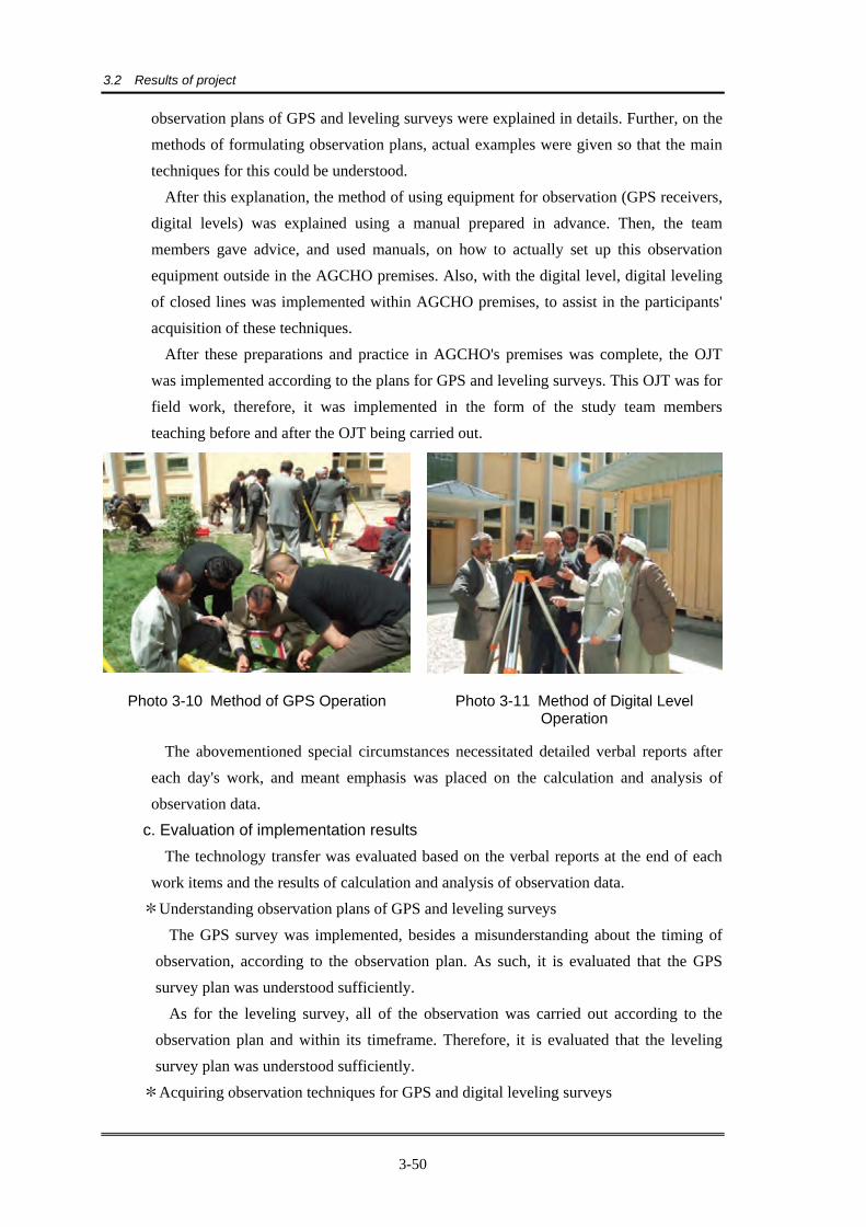
After this explanation, the method of using equipment for observation (GPS receivers, digital levels) was explained using a manual prepared in advance. Then, the team members gave advice, and used manuals, on how to actually set up this observation equipment outside in the AGCHO premises. Also, with the digital level, digital leveling of closed lines was implemented within AGCHO premises, to assist in the participants' acquisition of these techniques.
After these preparations and practice in AGCHO's premises was complete, the OJT was implemented according to the plans for GPS and leveling surveys. This OJT was for field work, therefore, it was implemented in the form of the study team members teaching before and after the OJT being carried out.
Photo 3-10 Method of GPS Operation Photo 3-11 Method of Digital Level Operation
The abovementioned special circumstances necessitated detailed verbal reports after each day's work, and meant emphasis was placed on the calculation and analysis of observation data.
c. Evaluation of implementation results The technology transfer was evaluated based on the verbal reports at the end of each
work items and the results of calculation and analysis of observation data. *Understanding observation plans of GPS and leveling surveys
The GPS survey was implemented, besides a misunderstanding about the timing of observation, according to the observation plan. As such, it is evaluated that the GPS survey plan was understood sufficiently.
As for the leveling survey, all of the observation was carried out according to the observation plan and within its timeframe. Therefore, it is evaluated that the leveling survey plan was understood sufficiently.
*Acquiring observation techniques for GPS and digital leveling surveys

3.2 Results of project
3-51
The observation techniques for both the GPS and leveling surveys were evaluated to have been reliably transferred to the AGCHO side, and neither needed any resurveying.
*Acquisition of techniques to determine the quality/reliability of observation results The determination of observation results was implemented in each process of
calculation and analysis, and the AGCHO side was able to understand cases that needed resurveying.
*Acquisition of techniques for calculation and analysis of observation results The technology transfer for the GPS survey was comprised of downloading observation
data, baseline analysis and network adjustment and evaluation of the respective results. It was evaluated that the technology transfer of these techniques—while some of the participants from AGCHO had experience in them—went smoothly and all of the participants acquired them.
The technical transfer for the leveling survey consisted of downloading of observation data, and the method of calculation for each type of observation. The technology transfer for the leveling survey also went smoothly, and besides the use of the digital equipment, there were experienced participants from AGCHO. Therefore, it was evaluated that the techniques for digital leveling were transferred to AGCHO.
Techniques for the accuracy control of products after calculation and analysis were also evaluated to have been acquired by the AGCHO side. *Other
The photo control point (horizontal position, elevation) pricking (including method of selecting pricking points) and the making of sketches were instructed by the Study Team and implemented with AGCHO's cooperation. However, the AGCHO side was evaluated to have insufficient capability to implement these techniques.
(2)Field identification As the basic policy restricted the instruction of techniques in the field, the methods and
essentials for the field identification were taught to the counterparts within the AGCHO headquarter premises.
Field identification using aerial photography has the different impression of high level surveying techniques, although, it only requires aerial photo interpretation and topographic map reading techniques. Further, in order for a survey to be efficient and not waste time and to attain accurate results, a certain degree of proficiency and experience in field identification in the particular scale of topographic map are required.
However, because there was quite a gap in degree of proficiency and experience amongst the participants, priority was given technology transfer of understanding basically map symbol regulation and adopting it, and the technology transfer was carried out using the manual of field identification.

3.2 Results of project
3-52
1)Technical transfer program a. Schedule
The technology transfer for the field identification was agreed, upon discussion with AGCHO, to be implemented within the following timeframes of actual field identification:
*First identification: August 1 to 27, 2008 (27 days) *Second identification: November 25 to December 27, 2008 (33 days)
b. Techniques transferred The following field identification techniques were transferred: *Method of preparing for field identification *Improve understanding of each type of map symbol for field identification *Method of pre-photo interpretation and procedure of field identification *Method of identification in the field *Method of arrangement after the field identification
c. Participants There was a total of 20 participants in the field identification technology transfer: two
group officers and six groups (three per group). Details of the participants were as follows:
Table 3-12 Technology transfer participant list
Group officer Eng. Gholam Raza Samim
Group officer Eng. M. Asif Shahaby
Group A Mr. Syed Abdul Wahab Leader
Mr. Shuaip
Mr. Zalmishaa
Group B Mr. Ahmaddullah Leader
Mr. Ziaurraman
Mr. Syed Mohammad
Group C Mr. Hayatullah Leader
Mr. Shakib
Mr. Saifurraman
Group D Mr. Mohammad Daud Leader
Mr. Mohammad Aziz
Mr. Abdul Ghafor
Group E Mr. Nimatullah Leader
Mr. Asghar Shar
Mr. Mohammad Mafoz
Group F Mr. Haider Shah Leader
Mr. Abdul Basir
Mr. Aman Khan
d. Method
The method of technology transfer was OJT, taking into consideration the Study Team's restrictions in the field. In particular, the technology transfer was implemented with emphasis—more so than in general OJT—on pre-training and on reporting and

3.2 Results of project
3-53
inspecting results after the implementation of field work.
2)Implementation The technology transfer was implemented for the above participants after preparatory
discussions with AGCHO on August 4, 2008.
a. Goals The techniques to be transferred were as aforementioned. However, advanced goals
were not set out of consideration of the AGCHO engineers' experience ascertained beforehand; the goal was to improve the basic techniques of all counterparts: *Improve understanding of field identification procedures *Acquire basic capacity in aerial photo interpretation and topographic map reading *Acquire effective and efficient identification procedures *Improving method of representing and arrangement of field identification results
b. Implementation Firstly in the field identification technology transfer, the Work Procedure Manual and
Application of Symbols in Field Identification contents were explained to those involved with the survey at AGCHO (6 groups).
In the explanation of the Work Procedure Manual, concrete examples of field identification procedures for preliminary photo interpretation, identification and arrangement were given. Basic identification procedures were emphasized with the aim of improving all of the participants' understanding of identification procedures.
Further, in the explanation of Application of Symbols in Field Identification, symbols necessary for field identification were selected, and definition of each symbol, applicable specification and data type (point, line and plane) were explained. Moreover, methods of representing these on the aerial photos—the field identification results—were explained, with the aim of improving all participants' understanding of symbols and ability to implement field identification.
However, there were differences between groups in their understanding of implementation procedures, perspectives on the symbol specification applicable, method of representing field identification results and so on. This was caused by various factors such as differences in actual experience and degree of proficiency, adherence to former analog field identification methods, and not being able to give instructions in the field. During the technology transfer period, efforts were made to eliminate differences in understanding and acquisition of techniques between the groups as much as possible, in particular, by giving supplementary explanation and instructions to those groups that needed it.

3.2 Results of project
3-54
Photo 3-12 Discussion of representation of results
Photo 3-13 Explanation of identification procedures to all groups
c. Evaluation of implementation results In the field identification technology transfer, it was confirmed that the field
identification ability of all groups had improved through the lectures and field work. Particularly in the photo interpretation, as they became more familiar with aerial photography, they were able to distinguish between items that they would be able to, or would have difficulty, photo interpreting. It is hoped that in the near future, all of the surveyors will be able to carry out field identification on their own.
The following are the evaluation results of each goal. * Improved understanding of field identification procedures:
The sequence of procedures for field identification was understood indoors. In the actual work, however, pre-photo interpretation, which should take place before the field work, was not always undertaken. Therefore, it is hoped that the efficiency of identification can be improved by definitely following the procedures understood during deskwork.
* Acquiring basic capacity in aerial photo interpretation and topographic map reading There were individual differences in degree of attainment in the photo interpretation and topographic map reading basic capacity, although, a level so as not to obstruct future field identification was reached. However, it is hoped there will be further improvements in understanding of applicable symbol specifications and precision of vegetation layer interpretation.
* Acquiring effective and efficient identification procedures In the preliminary photo interpretation, as they became more familiar with aerial photography, they were able to distinguish between items that they would be able to or would have difficulty photo interpreting. However, there is room for improvement in speed. It is hoped that each group can improve their photo interpretation ability and it hope to formulate and implement plans of survey area and routes so that many items can be identified effectively and efficiently.
* Improving method of representation and arrangement of field identification results

3.2 Results of project
3-55
The results of field identification are represented on the aerial photos—based on the Symbol Specifications for Field Identification—with a reference point corresponding to code of each features and a symbol of line type features and so forth. However, methods of representation and expression need to be improved further. Also, representation considering the identification results of neighboring groups such as uniformity across all groups and joining with neighboring group's sheets is desirable.
(3)Supplementary field identification
1)Technology transfer program As with the field identification, instruction of techniques in the field was restricted.
Therefore, technology transfer was implemented by lecture and OJT within AGCHO headquarters. Technology transfer by OJT was through the evaluation and instruction of supplementary field identification results. Also, because the supplementary field identification had to place emphasis on correcting, revision and collection of annotations; the technology transfer content was in accordance with this.
d. Schedule The technology transfer for supplementary field identification was implemented from
April 12 to May 11, 2009, the supplementary field identification implementation period decided upon in discussions with AGCHO.
e. Techniques transferred As already mentioned, the supplementary field identification placed emphasis on
correcting, revision and collection of annotations; therefore, the techniques transferred for supplementary field identification were in accordance with this. They were: *Method of confirming unclear items during digital plotting/editing *Method of determining whether existing annotations are necessary or not *Method of collecting additional annotations *Method of compiling supplementary field identification map results *Quality control of supplementary field identification results
f. Participants Supplementary field identification technical transfer participants totaled 21, including
18 who actually implemented the supplementary field identification, two group officers and one person in charge of romanization.
Table 3-13 Supplementary field identification technology transfer participant list
Group officer Eng. Gholam Raza Samim
Group officer Eng. M. Asif Shahaby
Group A Mr. Azghar Shah Leader
Mr. Shamsuddin
Mr. Aman
Group B Mr. Hayatullah Leader

3.2 Results of project
3-56
Mr. Mohammad Nasir
Mr. Syed Mohammad
Group C Mr. Saleh Mohammad Leader
Mr. Mir Ahmad Shah
Mr. Ahamadurah
Group D Mr. Mahfooz Leader
Mr. Nawab Shah
Mr. Haider Shah
Group E Mr. Basir Khan Leader
Mr. Aziz
Mr. Shuaib
Group F Mr. Hazrat Noor Leader
Mr. Syed Abdul Wahab
Mr. Noor Rahman
Romanization Mr. Nematullah
g. Method
The technology transfer for supplementary field identification was implemented in lecture style to explain the Supplementary Field Identification Implementation Manual prepared in Japan, and in OJT style based on these lectures.
2)Implementation of technical transfer The technology transfer was implemented with the following goals:
a. Goals *Understand and master the Supplementary Field Identification Implementation Manual *Understand and acquire methods of compiling supplementary field identification
results uniformly *Understand and master quality control of supplementary field identification results
b. Implementation *Technology transfer by lecture
The method of implementing the supplementary field identification (method of: confirming unclear items, determining necessary/unnecessary annotations, collecting additional annotations and compiling results etc.) was explained to the participants in lecture style using the manual prepared in Japan.
Also, towards the end of the supplementary field identification, the method of quality control of supplementary field identification results was explained. *Technology transfer by OJT
The supplementary field identification was implemented by OJT according to the abovementioned lectures. Because the Study Team's movements in the field were restricted, the technology transfer OJT was implemented by instructing and supervising each group's supplementary field identification products (confirming unclear items, determining necessary/unnecessary annotations, collecting additional annotations and

3.2 Results of project
3-57
compiling results etc.) upon their return from the field each day.
Photo 3-14 Supervision/instruction of results
Photo 3-15 Additional explanation by the group officer
Photo 3-16 Confirmation of results by group
c. Evaluation of implementation results The results of technology transfer implementation were evaluated as follows:
*Understand and master the Supplementary Field Identification Implementation Manual
The explanation of the Supplementary Field Identification Implementation Manual, undertaken in a lecture style, can be evaluated as being mostly understood by all of the participants. As to whether they mastered its contents and were able to carry out the OJT accordingly, however, cannot be said to be sufficient. Their understanding was not fully put to use, there were departures from the compiling rules, and there were more than a few non-uniform representations. Each item in the implementation manual was taught so it could be mastered intuitively, but the individual items that were systems were not taught sufficiently.
*Understand and master quality control for supplementary field identification Understanding of the concept and necessity of quality control taught in lecture style
was insufficient due to a lack of awareness of quality control within AGCHO. The quality control of the results of supplementary field identification in the OJT was also insufficient.

3.2 Results of project
3-58
(4)Aerial triangulation Technology transfer of digital aerial triangulation was carried out by using the result of
photo control point survey and aerial photo data from which are obtained in this Study.
1)Technology transfer program d. Schedule
The technology transfer of digital aerial triangulation and the demonstration of DTM generation and orthophoto creation were executed following schedule.
Execution term: 24th April 2010 to 15th May 2010 (actual training: 15days:72hours total) Prior to the commencement of technology transfer, inspection of the digital
photogrammetric system, upgrading of related software and checking overall operations were carried out.
e. The target of technology transfer The target of digital aerial triangulation training is to understand the photogrammetric
theory and to acquire the techniques to get the aerial triangulation results using digital photogrammetric system. However, the following technical items were executed as the technology transfer except the theory of aerial triangulation because of temporal restriction.
*Preparation-------------------Registration of block of necessary triangulation area and installation of photo data
*Setup the each strip---------Registration of the direction of each photographed strip *Automatic measurement---Registration of necessary tie-point number of overlap area
in one model and automatic measurement of tie-points *Bundle block adjustment---The computation of bundle block adjustment with control
points *Accuracy control------------Evaluation of the results *Others-------------------------The demonstration of automatic DTM generation and
orthophoto creation
f. Participants JICA Study Team requested AGCHO to select suitable persons who have knowledge
of the basic concept and theory of the aerial triangulation as the participants in advance, because of temporal constraint.
AGCHO selected the following three counterparts who belong to the department of large scale mapping.
Mr. Syed Qader Shah Hashim Mr. Mir Asghar Shah Mr. Nemat Ullah Nemat

3.2 Results of project
3-59
g. Methodology The lecture method and repeated actual training method was executed for technology
transfer using existing data. The training textbook translated in both English and Dari language were prepared before starting technology transfer and used it in both the lecture and actual technical training method of fundamental operation for the digital aerial triangulation..
2)Implementation of technology transfer After making an inspection of digital plotting system and upgrading related software,
technology transfer for digital aerial triangulation was carried out.
a. Goals According to technical level of the counterparts and limited time schedule, the goals
of technology transfer were laid out as follows; Acquirement of the basic operation of digital aerial triangulation system Understanding of data creation in relation to digital aerial triangulation and
management method Understanding of method of quality management for results of digital aerial
triangulation
b. Implementation During this technology training, practical training targeting sample area using 30
photos (3 strips, 27 models) with three courses of aerial photos and the results (including GPS 6 points and leveling 6 points) of implemented photo control point survey was carried out by repetition.
c. Evaluation of implementation results *Result of goal is acquirement of the basic operation of digital aerial triangulation Basic digital aerial triangulation operation by using LPS and Orima software had
executed by using default value. *Understanding of data creation in relation to digital aerial triangulation and
management method The exterior orientation file is generated as a result of aerial triangulation. As LPS
system is a total system of self-contained system. it is no problem for delivery files which are generated in the each module. In this training, we transferred technology of separately storing method both aerial photographs data and aerial triangulation data to manage files in a same system. Therefore, if operator made wrong operation, counterparts understood to recover the same work circumstance to use the original files for digital mapping work.
*Understanding of method of quality management for results of digital aerial

3.2 Results of project
3-60
triangulation The residual error of digital aerial triangulation which are executed area by
counterparts described in the table below. We can compute standard deviation of control points were 1.24m and maximum error
was 2.48m using flight height of 6200m. The tolerance of aerial triangulation is related to the flight height. The counterparts
understood that it is no problem for the results are not exceeding these limited value through this implemented technology transfer result.
*Others (Demonstration of DEM extraction and orthophoto image creation) We introduced and demonstrated the methodology of automatic DEM extraction and
DEM data editing and orthophoto creation and clipping out the orthophoto image using LPS system by the request from the AGCHO
d. Necessary future measures of AGCHO
The counterparts exercised repeated training of basic operation. Unfortunately, as electricity will be shut down beyond the working hours, it was very difficult to process large volumes of aerial triangulation data such as 11 strips, 239 models. Processing expectation time is 24 hours, we recommend establishing the working hour system and facility and stable circumstances for automatic computation processing.
It is necessary for the AGCHO to execute successive photogrammetric work through the real work in future based on the acquired technology in this study.
(5)Digital plotting/editing The technology transfer for digital plotting, editing and supplementary digital editing;
was implemented for AGHCHO engineers in two periods. For the digital plotting Leica Geosystem's plotting system, Leica Photogrammetry Suite (hereinafter LPS), and for the digital editing/supplementary digital editing Bentley's MicroStation V8 XM (hereinafter, MicroStation) was used.
1)Technology transfer program a. Schedule
After the technology transfer equipment arrived in Kabul City, it was set up in AGCHO starting from November 23, 2008. Firstly, the equipment was check that there were no accidents in transportation and that it was all there; after which, it was set up with AGCHO's help in the plotting room, where it was fine tuned and its operation checked over the next week.

3.2 Results of project
3-61
Photo 3-17 Setting up the system Photo 3-18 Checking system operation
After the equipment was tuned and operation checked, the initial environment settings necessary for the digital plotting/editing/supplementary editing for digital photogrammetry were confirmed. Then, the first period of the technology transfer was implemented from November to the first half of December 2008, and the second period from April to the last half of June 2009.
b. Techniques transferred As a result of discussions with the AGCHO side on the technology transfer schedule,
it was agreed that digital plotting would be in the first period, and digital editing/supplementary digital editing in the second period. *Digital plotting techniques transferred
・Basic computer operation ・Method of managing data on the network ・Basic operation of digital plotting software; environmental set-up and making
project files ・Method of digital plotting (horizontal, elevation) ・Quality control of digital plotting
*Digital editing/supplementary digital editing techniques transferred ・ Confirming methods of digital plotting according to the digital plotting
specifications ・Basic operation of digital editing software ・ Techniques for digital editing/supplementary digital editing (horizontal
information) ・ Techniques for digital editing/supplementary digital editing (elevation
information) ・Method of printing out topographic map data ・Quality control of digital editing/supplementary digital editing
c. Participants The technology transfer was implemented towards certain engineers for each period as

3.2 Results of project
3-62
designated by AGCHO. *Participants in the first technology transfer period:
Mr. Nangialai Panah Mr. Syed Qader Shah Hashim Ms. Shokria Sadat Ms. Tahmina Yadgari
*Participants in the second technology transfer period: Mr. Syed Qader Shah Hashim Ms. Tahmina Yadgari Mr. Bahram Alipoor
d. Method The technology transfer employed a lecture style and the OJT method—by remaking
one section of the digital topographic map made in the study work. The lectures used the English summary manual prepared in Japan and its Dari
translation to explain the techniques for transfer. Then, based on the results of these lectures, practical were held on digital topographic mapping. Another method employed, was getting the AGCHO side to complete an operation manual based on the actual work process undertaken in these digital topographic mapping practical.
Further, considering the participants' level of capability in each technique, a method was adopted where participants able to be leaders were given more in-depth technical transfer, so that they could then give additional technical transfer to other participants.
2)Implementation of technology transfer The technology transfer was implemented under the following goals.
a. Goals *Goals of the digital plotting technology transfer were to acquire methods of:
・starting up and shutting down the system, ・managing data in the digital plotting system, ・environment settings of digital plotting software, and ・obtaining data according to digital plotting specifications.
*The goal of the digital editing/supplementary digital editing technology transfer was to acquire: ・basic operation of digital editing software, ・method of digital editing/supplementary digital editing (horizontal information)
work, ・method of digital editing/supplementary digital editing (elevation information)
work, ・techniques for printing out digital topographic map data, and

3.2 Results of project
3-63
・method of quality control of digital topographic map data. b. Implementation
*Digital plotting technology transfer The digital plotting technology transfer necessary for digital topographic mapping
was implemented by lecture and OJT to the four engineers in charge of plotting in AGCHO. This was split into two periods of 19 days—from November 29 to December 18, 2008; and April 13 to May 5, 2009—for a total of 38 days.
The basic techniques for digital plotting were transferred in lecture style using LPS based on the aerial photo data (250 color photos) and aerial triangulation results. At the same time, technology transfer by OJT was also being implemented—using the results of the technology transfer by lecture and the summary manual prepared by the Study Team—on a 12 ㎢ digital plotting exercise area that was set within the Project Area for digital topographic mapping.
As a result, completion rate 70% of digital plotting was completed for approximately 9km2, of the OJT technical transfer exercise area, while for the remaining 3 km2 it was only done for residential building data.
Digital plotting technology transfer was given mainly to the highly experienced Mr. Syed Qader Shah Hashim, as the leader of the participants. Technology transfer based on the results of this was then repeated gradually to the other engineers.
Moreover, the engineers in charge of plotting made a detailed and practical manual by including the results of this technology transfer into the prepared manual.
Photo 3-19 digital plotting lecture Photo 3-20 digital plotting practical
The table below shows the status of technology transfer implementation, and of whether verification of participants' understanding/acquisition has been implemented.

3.2 Results of project
3-64
Technology Transfer Item Status of
Technology Transfer
Verification of CP’s Understanding and
Mastering 1. Basic PC operation (including related
software) Completed Executed
2. Data management on network Completed Executed
3. Basic operation of digital plotting software ・ Transfer of work files ・ Adjustment and printing of images ・ Start/stop operation of Microstation ・ Start/stop operation of LPS ・ Start/stop operation of PRO600
Completed Completed Completed Completed Completed
Executed Executed Executed Executed Executed
4. Building of environment and creation of project files ・ Addition of categories to design files ・ Insertion of aerial triangulation results ・ MFC register of digital plotting
(PRO600)
Completed
Completed
Completed
Executed
Executed
Executed
5. Digital plotting technology (plane) ・ Acquisition of roads ・ Acquisition of fences ・ Acquisition of houses ・ Acquisition of rivers ・ Artificial structures (acquisition of covers,
bridges, etc.) ・ Layout of symbols and others (vegetation
boundaries, symbols) ・ Layout of characters
Completed Completed Completed Completed
Completed
Completed Completed
Executed Executed Executed Executed
Executed
Executed Executed
6. Digital plotting technology (elevation) ・ Acquisition of contour lines
(index/intermediate contours) ・ Layout of elevation contours ・ Acquisition of spot heights
Completed Completed Completed
Executed Executed Executed
7. Quality control of digital plotting ・ Inspection of digitally plotted data ・ Accuracy control
Completed Completed
Executed Executed
Implemented: Status of understanding/acquisition of the content of AGCHO's technical transfer has been verified. *Digital editing/supplementary digital editing technology transfer
The digital editing/supplementary digital editing technology transfer necessary for digital topographic mapping was implemented by lecture and OJT to the three engineers in charge of editing in AGCHO over 26 days from May 6 to June 4, 2009.
In the process of implementing the technology transfer, it was found that the AGCHO side's basic technical capability with respect to digital editing was lower than expected. In response, the Study Team implemented the technology transfer focusing on Ms. Tahmina Yadgari, the group leader, and Mr. Bahram Alipoor. Then, after their technology transfer, these two transferred the techniques they had learnt to Mr. Syed

3.2 Results of project
3-65
Qader Shah Hashim. The digital editing technology transfer was implemented using MicroStation to
teach basic techniques based on the digital plotting data made by the engineers in charge of plotting.
The technology transfer used the English manual prepared in Japan and the summary manual translated into Dali. To this, the AGCHO side added the results of the technology transfer to make a more detailed and practical manual.
The status of technology transfer implementation and whether verification of AGCHO's understanding/acquisition has been implemented is listed below.
Technology Transfer Item Status of
Technology Transfer
Verification of CP’s Understanding and
Mastering
1. Basic operation of digital editing software ・ Start/stop operation of software ・ Operation of editing functions ・ Creation of 2/3-dimensional files ・ Creation/registration of symbol files ・ Patterning of lines/polygons ・ Change/addition of attributes ・ Change of curve attribute data into line
data ・ Change of color TBL ・ Reference and correction of image & DGN
data
Completed Completed Completed Completed Completed Completed
Completed Completed
Completed
Executed Executed Executed Executed Executed Executed
Executed Executed
Executed
2. Digital editing technology (plane) ・ Editing roads ・ Editing houses/fences ・ Editing rivers/bridges/culverts ・ Editing covers ・ Layout/editing of symbols ・ Creation of vegetation lines ・ Layout of characters
Completed Completed Completed Completed Completed Completed Completed
Executed Executed Executed Executed Executed Executed Executed
3. Digital editing technology (elevation) ・ Editing contour lines ・ Editing spot heights
Completed Completed
Executed Executed
4. Printout of topographic mapping data ・ Creation of plot files ・ Control of printout
Completed Completed
Executed Executed
5. Quality control of digital editing ・ Inspection of digitally edited data ・ Accuracy control method
Completed Completed
Executed Executed
Further, in the digital editing technology transfer: contours, elevation points and control points were 3-D data; while all other features were 2-D data.
c. Evaluation of implementation results There were many techniques transferred. As such, a general evaluation of
implementation results covering all participants (an overall evaluation as opposed one on every technique for each participant) is given below.

3.2 Results of project
3-66
*System start-up/shutdown It is evaluated that AGCHO can start-up and shutdown the digital plotting system.
Moreover, for the security of the whole system, authority to start-up and shutdown the digital plotting system was given to the two leaders, Mr. Syed Qader Shah Hashim and Ms. Tahmina Yadgari.
*Management of data in the digital plotting system It was evaluated that data can be sufficiently managed for the size of the system
established by this project. The storage method adopted for the topographic data made in the digital
plotting/editing was in an exclusive folder. Further, from the perspective of managing file versions, a new file was made whenever the topographic data was updated; with the date this took place in the file name. Also, Mr. Syed Qader Shah Hashim was designated as the main data manager for digital plotting, and Ms. Tahmina Yadgari for digital editing.
If the size of the system is increased (re-established), it will be necessary to reconsider the procedure of data management according to the established system.
*Environmental settings of the digital plotting software It was evaluated that the AGCHO side can make the environmental settings limited
to this project. It is also likely that AGCHO will be able to make environmental settings for a new project by referring to the operation manual it made in this technology transfer.
*Obtaining data according to digital plotting specifications It was evaluated that there would be no problem obtaining the features determined
in the symbol specification for digital topographic maps. Also, a detailed digital plotting manual was made by AGCHO engineers during the digital plotting technology transfer.
The map scale for these specifications was 1:5,000. New training is believed to be necessary for mapping at scales larger or smaller than this.
*Basic operation of digital editing software It is evaluated that they have a minimal understanding for operating the basic
commands needed for this project's digital editing. In future, it will be vital to develop editing support software that optimizes map
editing in order to improve digital topographic map production. *Digital editing/supplementary digital editing (horizontal)
It is evaluated that they have a minimal understanding of digital editing/ supplementary digital editing (horizontal) necessary for this project. As with obtaining digital plotting data, the method of editing is different according to the mapping scale. Therefore, new training is believed to be necessary for digital editing of maps at

3.2 Results of project
3-67
scales larger or smaller than for this project. *Digital editing/supplementary digital editing (elevation information) work
It is evaluated that digital editing/supplementary digital editing necessary for this project is sufficiently understood. Also, there are no problems in particular operating the basic commands prepared in MicroStation.
Moreover, they made a detailed digital editing manual in this technology transfer. In future, it will be vital to develop digital editing (both horizontal and elevation)
support software that optimizes map editing in order to improve digital topographic map production. To do this, it is deemed necessary to train a system engineer.
*Printing of digital topographic map data It is evaluated that the technology transfer for printing out digital topographic map
data in the current system is sufficiently understood. *Quality control of digital topographic map data
The procedure of inspecting printed out map data and the method of recording the inspection results on the accuracy control sheets—part of the quality control of digital topographic data that is carried out after both digital plotting and editing—were both understood. The procedure of additional plotting or editing of sections where the inspection results found irregularities was also understood.
*Evaluation of technology transfer results of each participant There were four participants of the technology transfer for digital plotting. One of
whom did minimal work in the OJT; therefore, it was not possible to appropriately evaluate what he produced in the digital plotting technology transfer. Two of the other three participants were not very capable at obtaining 3-D data and need further training; which should improve their capability in this respect.
The remaining participant had plotting experience and a high technical capability in obtaining 3-D data and topographic interpretation. However, he needs further training in the effective use of IT technology and software necessary for digital photo interpretation.
There were three participants of the technology transfer for digital editing. Two of whom achieved the expected level of basic computer and editing software operation. The acquisition of further techniques for digitization, including computer operation, of the other participant is a major issue.
(6)Map symbolization In the technology transfer of map symbolization with Illustrator software, as we had the
map data symbolized by Microstation software, the technology transfer of map
symbolization was implemented using these data namely the tools that uses the digital map
symbols in the Microstation software were prepared and these tools were used in the

3.2 Results of project
3-68
technology transfer of the map symbolization with Illustrator software.
1)Technology transfer program a. Schedule
The first technology transfer of the map symbolization was implemented from January 13,
2010 to February 3, 2010 based on the discussion with AGCHO. The second technology
transfer was implemented from April 21, 2010 to May 16, 2010.
b. Techniques transferred
The targeted techniques for map symbolization with Illustrator software were
*Character of map symbolization with Illustrator
*Operation method of Adobe Illustrator CS3
*Decision method of initial information(color, font, over print, relationship of each layer,
mask)
*Method of map symbols(point, line, pattern) creation
*Method of marginal information plate
*Method of detailed symbolization using tools
*Method quality control
c. Schedule Participants
Map symbolization participants totaled 2 persons as follows.
Mr. Amanulah Rasuly
Ms. Masuda Younisy
d. Method
The technology transfer for map symbolization with Illustrator was implemnted in lecture
style and practical training style using the documents and tool as follows.
1. Layer of Symbol Definition Table for Illustrator.xls
2. Map_Symbilization_Manual_using_Illustrator.doc
3. Check_List_for_symbolization.xls
4. Symbolization_Tool.ai
5. Map_Symbilization_Memo randum_for_Illustrator_ Dari.doc
2)Technology transfer program a. Goals
The goals of technology transfer were set out as follows.
*Understand the character of map symbolization method using several kinds map
symbolization software
*Understand the basic operation method of Illustrator software for map symbolization
*Understand the method of setting up initial information and map symbolization
*Understand the creation method of map symbolization tool

3.2 Results of project
3-69
*Understand the method for utilization of map symbolization tool
*Understand the method of the quality contro
b. Implementation
At first, the explanation of the different character of symbolization between using
Illustrator and the other software (CAD, GIS software etc,) was implemented in lectures style.
After that, the techniques of the basic operation of Illustrator were transferred in practical
training style.
Based on the understanding of basic operation, the technology transfer of map
symbolization was implemented by each stage of 11 steps (from a step of setting up initial
information to map symbolization) as follows using the prepared manual and adding
necessary items on the manual. In addition, the data that used in technology transfer was the
non map symbolized data of topographic map scale 1/5,000(Sheet numbers: 42-I-MA-6-33-4
and 42-I-MA-6-32-1).
01:Preparation of two kind of data in DGN format
02:Conversion of cell symbols to point data and continuing of line data
03:Transformation of data format from DGN format DXF format
04:Transformation of data from DXF format to AI format and booting Illustrator with a
conversion of scale
05:Adjustment of scale
06:Combining a data in DXF format
07:Copy and paste on Illustrator
08:Change a order of layer
09:Creation of symbols using a various functions
10:Adding a marginal information
11:Transformation of data from AI format to EPS format
The techniques of quality control that is carried out on a display and an outputted
topographic map were transferred. The techniques that record a results of quality control on a
quality control sheet were transferred.
c. Evaluation of implementation results
As two participants were not familiar with computer, the technology transfers were carried
out dividing 11 steps. Furthermore the tools of map symbolization that were prepared in Japan
were used in the technology transfer.
The implementation results of technology transfer are evaluated as follows.
*Understand the character of map symbolization method using several kinds map
symbolization software
:They understood that there were differences of work methods and utilization goals by
creating a map symbolized data using the software of AUTOCAD and ArcGIS.
*Understand the basic operation method of Illustrator software for map symbolization

3.2 Results of project
3-70
:The participants understood the procedures of tasks according to a manual but they
didn’t understand sufficiently how to process when the procedure was reversed by
mistake.
*Understand the method of setting up initial information for map symbolization
:The participants understood completely.
*Understand the method for utilization of map symbolization tool
:The participants understood completely.
*Understand the creation method of map symbolization tool
:The participants didn’t understand completely, because the period of technology
transfer was too short to understand.
*Understand the method of a marginal information creation
:The participants didn’t understand completely, because the period of technology
transfer was too short to understand.
*Understand the method of the quality control
:The participants didn’t understand completely, because the period of technology
transfer was too short to understand. As well, the data structure errors of data in DXF format were founded when the format
conversions from DGN to DXF and from DXF to AI format were implemented. As it is
necessary a considerable experience to check and correct these errors, the technology
transfer of these techniques will be future tasks.
3.2.4 Topographic map management and dissemination plan
(1)Implementation of AGCHO's baseline survey
1)Survey purpose The survey purpose were the followings:
・ Monitoring of the present status of geographic information (topographic maps) held (created) by AGCHO (For the list, refer to Appendix )
・ Monitoring of the present status of geographic information (topographic maps) managed by AGCHO
2)Target departments This survey was conducted in the following departments of AGCHO: ・ Large Scale Mapping Department ・ Metadata and Customer Services Department ・ Planning Department Other persons related to this Project (President, Vice President, Project Manager, etc.)
were included in this survey.

3.2 Results of project
3-71
3)Survey items This baseline survey was made of the following items: ・ Organizational structure of AGCHO (including duties) ・ Geographic information developed and held by AGCHO ・ Geographic information development specifications ・ Various plans of AGCHO ・ Geographic information disclosure system and regulations ・ Other matters related to management and dissemination of topographic maps
4)Survey method The survey was conducted through interviews of important persons in AGCHO (including
the President, Vice President and Project Manager) and the Managers of Departments. In addition, inspection of the equipment environment in each Department was adopted as one of the survey methods.
5)Implementation The interview-type survey in each Department was conducted as follows:
Large Scale Mapping Department: 1st survey on February 26, 2008 Metadata and Customer Services Department: 1st survey on February 25, 2008 2nd survey on April 12, 2008 3rd survey on August 12, 2008 4th survey on August 13 & 15, 2008 Policy and Planning Department: 1st survey on April 29, 2008 General Forum: Workshop on January 27, 2010
The interviews with important persons in AGCHO were conducted on dates and at times convenient to those persons.
6)Survey results a. Organizational structure of AGCHO and duties
* Organizational structure President―Vice President― Geodesy Department Large Scale Mapping Department Topographic Mapping Department Policy and Planning Department Survey and Cadastral Department Metadata and Customer Services Department In addition to the above, Branch Offices have been established in 16 Provinces

3.2 Results of project
3-72
across the country. AGCHO has approximately 700 employees, including the staff of the Branch Offices in 16 Provinces (as of April 2008).
* Duties by Department Geodesy Department: In charge of the control point surveys necessary for
development of national control points and creation of large-scale topographic maps.
Large Scale Mapping Department: In charge of updating existing and preparing new large-scale topographic maps mainly by photogrammetry.
Topographic Mapping Department: In charge of correcting as well as printing, and final inspection of topographic maps.
Policy and Planning Department: In charge of formulation and promotion of projects by AGCHO.
Survey and Cadastral Department: The interview survey could not be carried out because this Department is located outside AGCHO headquarters.
Metadata and Customer Services Department: This is a new department set up in 2007 and it is in charge of the following items: ・ Education in IT technology, equipment management
and technical issues within AGCHO ・ Collection and standardization of all types of data
including geographic information within AGCHO ・ Supply of geographic information to the outside ・ AGCHO website management and operation on
Internet
Photo 3-21 Stock room 1 for Topographic maps
Photo 3-22 Stock room 2 for Thematic maps

3.2 Results of project
3-73
Photo 3-23 Large size plotter of Customer servi
Photo 3-24 Statistic product data section
b. Geographic information held by AGCHO (topographic maps, specifications and rules, etc.) The geographic information held by AGCHO includes topographic maps called “Secret
Maps” which contain contour lines and coordinates, thematic maps which contain no coordinates, atlases, orthophoto maps, aerial photos, satellite images, a analog symbol regulation, a special map symbol instruction manual, control point coordinates and benchmark heights. They are kept in each Department, in the AGCHO storehouse and in an external storehouse.
c. AGCHO project plans This Study made clear that no short-, medium- or long-term projects with continuity had
been formulated by AGCHO. On the other hand, AGCHO had formulated sporadic projects as follows:
・ Preparation of a Kabul city guide map for traveler use This project is intended to prepare a Kabul city guide map indicating hospitals, clinics, hotels, shopping centers, etc. based on the 1/25,000-scale topographic map.
・ Preparation of various thematic maps This project is intended to prepare thematic maps by linking economic, weather and water resource information with statistical data (such as population statistics).
・ Digital equipment introduction project The Economy Ministry has executed a tender for the introduction of a new digital photographic survey system within the framework of digitalization of AGCHO, but more information is not available.
・ Assistance projects by foreign donors Development of a national atlas by Germany, installation of control points by ISAF and installation of 8 geodetic control points by NGA have been promised, but no concrete working plans have been formulated yet.
d. Disclosure and dissemination of topographic maps Topographic maps are supplied by the Metadata and Customer Services Department to

3.2 Results of project
3-74
the public with certain limitations and in accordance with given rules. The supplied maps are the output maps from a plotter. Index maps will be made available on the AGCHO website on the Internet within one
year, but no digital data for the index maps were acquired during the period of this Study.
・ Certain limitations Maps indicating coordinate values (Secret Maps) are made available only to governmental agencies (by submitting an application signed by the relevant Minister). Therefore, the supply of “Secret Maps” to the public is extremely limited at present and there are many cases in which no “Secret Maps” are made available to the public. Maps other than the above are supplied to schools and the public by submitting an application for approval.
・ Given rules (acquisition procedure) (i) Check the desired map on the index map provided by the Metadata
Department. (ii) Receive an “Application/Receipt” (4-page hand written form) and fill in the
necessary items (map scale, Province, District, Village, applicant’s name, organization, signature of the representative of the organization) and submit it to the Metadata Department for verification of the written entries. (For “Application/Receipt”, refer to Appendix.)
(iii) When the application has been accepted, remit the price of the map to be supplied to the bank account of AGCHO.
(iv) When the remittance to the bank account has been confirmed, the map for which application was made to AGCHO will be received. Then, fill in the necessary items on the Receipt and submit it to AGCHO.
e. Other
・ The “Cartographic Digital Mapping Project” has been launched under U.S. technical assistance and the construction of an office, provision of equipment and training in the provided equipment are making progress. In April 2008, the President and staff of AGCHO made a study tour to the United States within the framework of the assistance project. Photomaps on a scale of 1/7,500 have been created using satellite images and technology transfer to the AGCHO staff is underway.
・ In May 2009, the digital plotting system and an aerial photography scanner were introduced and installed in order to prepare the Kabul city guide map for travelers and various thematic maps as described in “c. AGCHO project plans” and to scan the analog photos.
(2)Implementation of a topographic map dissemination survey The surveys of map dissemination and map demand including the consciousness
research within AGCHO were made through hearing surveys and in the round-table

3.2 Results of project
3-75
meeting with important members and staff at the workshop.
1)Survey purpose The survey purpose were the followings:
・ To enhance and manifest the awareness of the staff of AGCHO as a mapping agency toward preparing and disseminating topographic maps.
・ To clarify the awareness level of map users and the mapping agency regarding the supply of maps from the agency.
・ To clarify the requests of map users from the viewpoint of map dissemination.
2)Target organizations The consciousness research within AGCHO was targeted at the managers of each
Department and the general staff. On the other hand, the map dissemination and demand surveys were targeted at the counter personnel in governmental agencies such as the Afghanistan Information Management Services (AIMS) and Afghanistan Research and Evaluation Unit (AREU), and they were also targeted at public organizations such as Kabul City Office, the Ministry of Public Works, Central Statistics Bureau, Ministry of Public Health and Ministry of Water Resources.
3)Survey items The map dissemination survey items were the followings:
・ Present status of mapping projects ・ Present status of map dissemination (including supplier and acquisition procedure) ・ Status of map utilization ・ Present status of AGCHO activities ・ Demand for maps ・ Awareness level of AGCHO among communities ・ Demands to AGCHO
4)Survey method The surveys were conducted using the questionnaire method and the interview method. The surveys of individual staff members in each agency were made using the
questionnaire sheets prepared at the project seminars for each individual participant to write his or her answers.
For organizations including Kabul City Office, the direct visit and hearing system was adopted. (For the results of the questionnaires, refer to Appendix.)

3.2 Results of project
3-76
5)Survey implementation The questionnaire survey was conducted by the following procedure:
・ The questionnaire survey of individual members of each organization was carried out by distributing the questionnaire sheets to the participants at the venue of Seminar 1 held on December 7, 2009 and collecting the sheets on which they had written their answers. However, the number of answer sheets was very low.
・ The questionnaire survey of AGCHO staff was made by translating the questions from English to Dari and the answers from Dari to English. However, the respondents said that some questions were difficult to understand because some of the translations from English to Dari were unclear. This problem was a lesson for future questionnaire surveys.
・ The questionnaire survey to external organizations was carried out in English. There were many answers based on projects for which development studies are being conducted at present. The hearing survey was conducted at those public organizations in Kabul Province listed in “CONTACTS” in the “A-to-Z Guide (Sixth Edition)” issued by AREU (Afghanistan Research and Evaluation Unit) and from which approval for the interviews had been acquired.
6)Results a. Awareness level of AGCHO among related organizations
The questionnaire and hearing surveys made clear that AGCHO activities (mapping) were not known well for reated organizations. The reason for this may be that the necessary maps were acquired from a route other than AGCHO.
b. Demand for maps There are cases in which governmental agencies require maps to perform their own work. In such agencies, the demand for maps to meet their own purposes (for instance, detailed maps to meet specific themes, or maps drawn to a specific scale) is high. The demand for maps indicating the latest information is also high.
c. Acquisition of maps There are many requests for improvement of the attitude of AGCHO toward supplying maps. The map acquisition procedure (rules) in AGCHO and the price information are not publicly known. Some people are of the opinion that the procedures and prices should be improved.
d. Copyrights in map dissemination Awareness of the copyrights to maps is only found among a small number of users other than AGCHO.

3.2 Results of project
3-77
e. Others There are many employees of AGCHO who are aware of the topographic mapping work in AGCHO that support the map dissemination. It is also fully expected that they believe that only AGCHO can develop topographic maps of high quality in accordance with world standards.
3.2.5 Other work
Other work undertaken was the discussion and explanation of each report, seminars and workshops.
(1)Preparation and examination/discussion of each report During the study period the Inception Report, Interim Report, Draft Final Report and
Final Report were prepared. Further, the inception, interim and draft final reports were explained and discussed with the AGCHO side.
1)Preparation of the Inception Report The Inception Report was prepared in English based on documents collected in Japan
and on a preliminary study report. A Dari version of the Inception Report was then translated from the English report. Ten copies of both the English and Dari versions were printed.
2)Examination/Discussion of the Inception Report The Inception Report examination/discussion was held on February 14, 2008, to explain
how the project would be implemented. In attendance were five persons from AGCHO, including the vice president; seven from the Study Team, including two interpreters; and two from the JICA Afghanistan Office.
A summary of the project (processes, products, etc.) based on the report was explained in the discussion. After the explanation, a question and answer session was held. There was an objection to the area of the 1:5,000 topographic mapping. However, their understanding on the report was gained after it was explained that the aerial photography would also cover the area of 1:5,000 topographic mapping in question. After this, minutes of meeting was exchanged.
3)Preparation of the Interim Report The Interim Report was prepared in English by compiling the results and
implementation status of the project up until October 2008, policy for the future, and work remaining. A Dari version of the Interim Report was then translated from the English report. Ten copies of both the English and Dari versions were printed.

3.2 Results of project
3-78
4)Explanation/Discussion of the Interim Report
The Interim Report explanation/discussion was held on December 1, 2008. In attendance were 12 persons from AGCHO, including the president, the vice president; 8 from the Study Team, including two interpreters; and two from the JICA Afghanistan Office.
In the discussion, the state of project progress and future policy and work was explained. After this, there were several questions: "Why isn't the digital plotting/editing work in Japan done together with AGCHO?" "If the work is done in Japan it will not contribute to improving AGCHO's technical capability?" "How will you attempt to improve AGCHO's capability?" The Study Team's responses were: because of the short project timeframe; the OJT method was adopted; and, that it would be improved through the implementation of technical transfer based on the specifications and manuals; respectively.
After the questions and answers, the Interim Report was approved, and the minutes of meeting were exchanged.
5)Preparation of the Draft Final Report The Draft Final Report was prepared in English by compiling the results and
implementation status of the entire project, issues, and recommendations to AGCHO based on project products and issues. A Dari version of the Draft Final Report was then translated from the English report. Ten copies of both the English and Dari versions were printed.
6)Explanation/Discussion of the Draft Final Report The draft final report explanation/discussion was held on April 27, 2010 at the general
president of AGCHO's office. In attendance were 8 persons from AGCHO, including the general president and the vice president; and 8 persons from the Study Team.
In the explanation/discussion, the Study Team explained the process and results of the whole project, and the issues (the field of topographic mapping and management/dissemination of geographic information) and the recommendations (preparation of topographic maps, expanding the results of project, capacity building of personnel and organizational strengthening, management/dissemination of topographic maps) based on the results of project.
During the explanation of the draft final report, the following questions and answers relating to the project works arose:
Q) Why did the target area of the orthophoto map scale 1/10,000 increase from 2,000 km2 to 5020 km2?
A) Because we purchased SPOT image data of more than 2,000 km2 for future planning of new city development, then we produced an orthophoto map covering more than 2,000 km2 and submitted it.

3.2 Results of project
3-79
Q) What is POS aerial photography? A) POS aerial photography means the aerial photography with data of inclination of
aerial camera and observation data of GPS for determining the position of the centre point of the aerial camera when the aerial photo is taken.
Q) How much difference is there between the coordinates of photo control points based on the GPS survey and the calculated coordinates of photo control points using the POS data?
A) There is a maximum 7 m in vertical direction between the coordinates of photo control points observed by the GPS survey and the calculated coordinates of photo control points using the POS data.
Q) What does it mean that the language used is English in the orthophoto map? A) It means that the marginal information of orthophoto map is expressed in English.
Only contour data is plotted on the orthophoto map with ortho image as a backdrop. At the end of the explanation/discussion, the general president of AGCHO was grateful
to JICA for their cooperation and he would like to request new projects similar to this one for the other major cities besides Kabul.
Lastly, the draft final report was approved and the minutes of meeting were exchanged.
7)Preparation of the Final Report The final report was prepared by making alterations and additions based on the results of
the draft final explanation/discussion and the work items (the technology transfer, seminar2) that were implemented after preparing the draft final report.
After preparing the final report in English, it was translated into Dari. 10 copies of both the English and Dari versions were printed
(2)Seminars Seminars were held at the mid- and final-stages of the project.
1)Holding Seminar 1 The purpose of Seminar 1 was to publicize the project and the various activities of
AGCHO and to explain the state of project progress. It was held in the finance ministry's meeting room on December 17, 2008.
There were many mishaps getting ready for the seminars, such as sending out invitations, however, it was implemented with approximately 130 participants.
Seminar one included: a message from the president's office, congratulatory address from the head of the JICA Afghanistan Office, greeting speech by the president of AGCHO, a brief summary of the project, a background of AGCHO's activities and such, a report on the progress of the project, an explanation of geographic information that

3.2 Results of project
3-80
AGCHO can provide and so on. On the other hand, from the participants there were requests regarding products of the
project and inquiries anticipating technical cooperation after this project. Furthermore there was questions regarding the obtain of geographic information provided by AGCHO.
2)Holding Seminar 2 The seminar2 was held in SERENA Hotel on May13th, 2010 with the followings
purpose. ・Reporting the process and results of the entire project ・Introducing and applying the results of project ・Recommending the establishment of geographic information for AGCHO ・Recommending the disseminations of topographic maps etc, for AGCHO The seminar2 was implemented with approximately 140 participants including external
interested parties. Seminar 2 included: a message from the president’s office, congratulatory address from
the JICA Afghanistan office, greeting speech by the general president of AGCHO after the opening ceremony. The process and results of project, that was the results, the procedures of product, the result and evaluation of technology transfer, were reported by the study team continuously. The study team recommended the establishment of geographic information and the dissemination of topographic map etc, for AGCHO based on the results of project.
At the end of seminar 2, AGCHO informed that this was the first time to prepare the digital topographic map on a scale of 1:5,000 for AGCHO and the technology transfer of its were a meaningful for AGCHO. Also it was reported that the digital topographic map scale of 1:5,000 would be utilized effectively in the governmental institutions that targets the area of produced digital topographic maps for their business.
(3)Workshop The workshop was held in one of AGCHO's conference rooms on January 27, 2010,
with a total of nearly 60 participants. The intent of this workshop was to make the technical transfer of the project known extensively within AGCHO and at the same time for it to be an opportunity to disseminate these techniques.
The workshop commenced with an opening greeting by the president of AGCHO, then a congratulatory address from the JICA Afghanistan Office. In the AGCHO conference room examples of project products and photos of the work undertaken were displayed to promote the project to other workers not directly involved with it.
After the opening speeches, the technology transfer participants—divided into ground survey and digital photogrammetry groups—presented the content of technology transfer

3.2 Results of project
3-81
implemented and their products. After each presentation there were detailed technical questions (on the technical transfer content, products, etc.) from other engineers.
When the presentations by the technology transfer participants were over, they gave a display of the equipment they used (GPS receivers, digital level, digital plotter and digital editing machine) in order to explain the content of the technical transfer and to give the attendees an opportunity to also handle it. This aroused the relevant engineer's interest in digital mapping technology.
Further, in the deliberation regarding the management and dissemination of geographical information such as topographic maps, there were comments from various members of management on their perception of the current situation and responses to these. There were also frank comments by general employees about management and dissemination from the perspective of those actually carrying out the work.
Photo 3-25 Presentation in Workshop Photo 3-26 Introduction of equipment


4.1 Status of Project Products
4-1
Chapter4 Issues
This chapter is on the issues involved with the various aspects of this project.
4.1 Status of Project Products
Through this project the following results, including products were attained. The presumed situation of these products is also mentioned.
1) Project products: Digital topographic map data: 42 sheets (scale 1:5,000) 398 km2
(Format: Shape, DXF, PDF) Digital Orthophotos: Scale 1:10,000 approximately 5,020 km2
Scale 1:5,000 approximately 717km2 Of the digital topographic map data, the data in PDF format can be printed out in the form of a traditional analog topographic map. On the other hand, the Shape and DXF format digital topographic map data can be used for GIS purposes. The digital orthophoto data is according to the neatline divisions decided upon in discussions; and can be printed out as an analog style orthophoto.
2)Results besides the project products Aerial photo digital data: 11 strips, 250 photos, approximately 1,120km2
Aerial triangulated (aerial photo) digital data: 11 strips, 239 models, approximately 1,120km2
The digital data of the aerial photos that were aerial triangulated covers approximately 1,120 km2, including the area that this project prepared digital topographic map data for. There is aerial triangulated data of another approximately 700km2 remaining on the northern side of this digital topographic map data. This area is also covered by the new city plan of Kabul.
3)Product of the technology transfer Photo control point survey: GPS survey, digital leveling, pricking work Other ground surveys: field identification (using aerial photos), supplementary
field identification Digital photo survey: digital aerial triangulation, digital plotting/editing, map
symbolization The various technology transfer results were evaluated in 3.2.3 Technology transfer. However, in some respects this is still insufficient for AGCHO to independently develop the results of the technology transfer in its actual work, not merely in a training setting.

4.2 Issues in the field of topographic mapping
4-2
4.2 Issues in the field of topographic mapping 4.2.1 Issues in the field of field survey
In this field the project carried out technology transfer and actual work in: photo control point survey, pricking, field identification, and supplementary field identification. 1)Issues in photo control point survey
AGCHO already had some experience in GPS survey. This experience allowed the technology transfer/actual work of observation to be implemented with out mishap and commensurable results could be gained. With respect to the after processes—namely analysis/adjustment calculation—based on these observation results, on the other hand, neither technology transfer nor actual work was sufficient, and in addition, nor was AGCHO's experience. Techniques for the digital leveling can be perceived along the same lines as analog leveling techniques, and commensurable results were achieved in technology transfer/actual work. However, with regard to one of the after processes, network adjustment, because there was no need to actually carry this out, the technology transfer ended up being insufficient. From the abovementioned outcome of the project, AGCHO can be considered to have the following issues in this field: *to obtain technical skills so analysis/adjustment calculation (particularly substantial
calculations) for GPS survey can be implemented dependably, *to obtain technical skills so adjustment calculation for leveling can be implemented
dependably, and * to obtain technical skills so that the results of the above analysis/adjustment
calculations can be appropriately evaluated from a quality control perspective. 2)Pricking work
The technology transfer of and actual pricking work was implemented without any problems and sufficient results were achieved. This work was supplementary to cover for the lack of air signals; therefore, the following issues remain for AGCHO: *to obtain technical skills for the installation of air signals.
3)Field identification, supplementary field identification The technology transfer and actual work involved in both surveys was implemented according to plan. There was, however, a gap in the level of understanding shown by those in charge at AGCHO during the indoor explanation of implementation items for both surveys, and their level of understanding as judged from the implementation results. This is considered to be mainly a result of their level of experience. It was evaluated that the AGCHO side faces the following issues:

4.2 Issues in the field of topographic mapping
4-3
*relearning study materials from technology transfer *undertake activities to expand experience based on the results of this relearning
4.2.2 Issues in the field of digital photogrammetry
In this field the project carried out technology transfer in digital triangulation, digital plotting/editing, and map symbolization. 1) Digital aerial triangulation, plotting and editing
Each of these technology transfers was implemented according to plan; and the AGCHO side can be considered to have obtained all of these techniques. This is from a training/educational perspective, however, from a practical perspective their level has to be considered insufficient. From this perspective, the AGCHO side faces the following issues: *review the results of technology transfer using the teaching materials obtained in the
technology transfer, *gain further experience using the project products, and *set and achieve minimum goals (implementation volume per unit of time) for these, particularly regarding digital plotting/editing.
2)Map symbolization Similarly, this technical transfer went according to plan, and the AGCHO side can be considered to have obtained all of these techniques. This is from a training/educational perspective, however, from a practical perspective their level has to be considered insufficient. From this perspective, the AGCHO side faces the following issues: *review the results of technology transfer using the teaching materials obtained in the
technical transfer, *gain further experience using the project products, and *set and achieve minimum goals (implementation volume per unit of time) for these, particularly regarding map symbolization.
4.2.3 Issues in digital topographic mapping
This project made approximately 395 ㎢ of 1:5,000 digital topographic maps centered on the current urban area of Kabul City. On the other hand, as mentioned in 4.1 Status of project products, there is approximately 1,120 ㎢ (including the area of digital topographic mapping) aerial photo data that has been aerial triangulated. This data includes an area to the north of the digital topographic mapping area, namely, it covers the Kabul City Plan area.
Those involved in formulating the city plan have made evident their strong desire to have digital topographic maps made for not only the current urban area, but also areas covered by the city plan.

4.3 Issues in the fields of dissemination/management of topographic maps
4-4
With this as background, AGCHO—the only mapping agency in Afghanistan—faces this kind of issue regarding digital topographic mapping: *promptly prepare digital topographic maps for the northern urban area of Kabul, namely, the area of the city plan.
4.3 Issues in the fields of dissemination/management of topographic maps
4.3.1 Issues in the management of topographic maps
The issues of AGCHO was made clear in this field based on the results of the survey implemented in 3.2.4 Topographic map management and dissemination plan.
(1)Issues of prepared topographic maps There are many prepared topographic maps at AGCHO, however, the actual situations
(including scale, range, number of maps, number of map sheets, nature of topographic maps, year of preparation) are not fully-monitored. There are the tasks for management of topographic maps to monitor the statistical information on their actual situations and to use such information for updating of topographic maps and as the basic information for development of new topographic maps.
(2)Management of actual topographic maps already made The tasks for management of topographic maps to monitor the statistical information are
mentioned above. There are also the tasks to arrange and put in order the topographic maps as actual objects (including printed maps, films for printing, output maps and output map data) and to build a system which is able to respond quickly to retrieval (drawing out) of those maps.
4.3.2 Issues in the dissemination of topographic maps
It became evident that topographic maps are disclosed and provided to the public based on the results of the survey. The actual conditions of their disclosure and provision have various tasks from the viewpoint of dissemination of topographic maps.
(1)Issues on rules for release Parts of topographic maps are actually provided, however, the principle of release of the
topographic maps (geographic information) is not disclosed from a fundamental viewpoint of release/provision. From the viewpoint of dissemination of topographic maps, a major issue is to establish and disclose the principle of disclosure of the topographic maps to the public.

4.3 Issues in the fields of dissemination/management of topographic maps
4-5
(2)Issues in the clarification of target of release/provision Important matters for users, bearers of the dissemination of topographic maps, are to
know which topographic maps are released/provided and what rules are imposed, even the abovementioned principle of disclosure is established. From this perspective, a major issue is to make public the topographic maps to be disclosed and provided to the public, and the rules of disclosure of those maps.
(3)Formulation of procedures for release/provision and transparency It is important for users to know the procedures for release/provision when the target of
release/provision and the rules are clarified. It is therefore important for the supplying party to establish and disclose the procedure for disclosing the topographic maps for the convenience of users. From this perspective, the tasks are to establish the procedure for disclosing and providing the topographic maps, and to disclose those procedures for transparency to the public.


5.1 Development of geographic information
5-1
Chapter5 Recommendations to the C/P Agency
5.1 Development of geographic information 5.1.1 Reestablishment of the national control point network
As mentioned in 4.2.1 Issues in the field of field survey, AGCHO has an issue in acquiring implementation capacity in adjustment calculation for extensive GPS surveys. Along with overcoming this issue, the following are proposed for the reestablishment of a national control point network:
(1)Reconnaissance of the national control point network This project surveyed the condition of the national control points within the study area.
As a result, most national control points were found to be already lost and unusable. Therefore, a reconnaissance of nation control points within the state, including Kabul
City and its surrounds will be carried out. Also, stone markers should be re-installed at national control points that have been lost. Moreover, new stone markers should be established where national control points are necessary.
(2)Reestablishment of the national control point network A plan for GPS surveying should be formulated based on the results of the
abovementioned reconnaissance. In the formulation process, consideration should be given to the results of this project's technology transfer, the state of AGCHO's equipment, and personnel resources in GPS surveying. Then, the scale of the survey should be decided. The area of the survey should be the area—for which the abovementioned reconnaissance was conducted—within the state, including Kabul City and its surrounds. The post-observation analysis/adjustment calculations, should, as a rule, utilize the
results of this project's technology transfer. Substantial adjustment calculations—and evaluation of the results—however, should be considered being implemented as OJT as part of the later mentioned technical assistance.
(3)Prospect of conversion of prepared national control point network to the World Geodetic System The reestablished national control point network is essentially based on the existing
geodetic system in Afghanistan. However, from the trends in worldwide geodetic techniques, sooner or later, it is likely that Afghanistan will be forced to adopt the world geodetic system. Therefore, in order to respond to this, the after mentioned technical assistance will work towards the acquisition of the technical knowledge necessary to convert to the world geodetic system, and to realize this conversion in the near future.
(4)Formulation of a plan to reestablish the national control point network Based on the result of the abovementioned proposals being implemented, a plan to
expand the national control point network to other areas should be formulated.

5.1 Development of geographic information
5-2
5.1.2 Preparation and revision of a national digital base map
As mentioned in 4.2.2 Issues in the field of digital photogrammetry, and 4.2.1 Issues in the field of field survey, AGCHO has acquired all of the various techniques in digital aerial triangulation, digital plotting/editing, map symbolization, field identification, and supplementary field identification. However, acquiring the capacity to actually implement this work, and revising and gaining further experience in these fields remain as issues.
Along with overcoming these issues, the following are proposed for the preparation and revision of a national digital base map:
(1)Preparation of a national digital base map The digital topographic map made in this project can be said to have the attributes of a
digital national base map. From this perspective, the preparation of the same type of digital topographic map should be advanced. Furthermore, the specifications of the digital topographic map in this project should be adopted for this.
(2)Coordination with the later mentioned technical assistance In coordination with the technical assistance mentioned in 5.1.3, endeavors should be
made to cultivate implementation capacity, expand experience, and relearn techniques relevant to the preparation a national digital base map. In this coordination, the national base map will be prepared.
5.1.3 Request technical assistance to contribute to the preparation of geographic information
The project implemented technical transfer with an emphasis on the preparation of products. Furthermore, there is a variety of factors influencing the techniques transferred, from those in fields which the AGCHO side had some experience in, and those which were being implemented for the first time in over 20 years after a blank caused by the civil war, and also those vastly changed with the shift from the analog to the digital method. Moreover, generally speaking, and without even considering this situation, not only the technology transfer, but also the time spent on capacity building was limited when compared with the technical content that needed to be transferred.
It is proposed that AGCHO—based on the above situation and so that it can reliably implement the above proposals—request further technical assistance in:
(1)Characteristics of the new technical assistance The purpose of this project was the technical transfer and, digital ortho and digital
topographic map making. The utmost purpose of the new technical assistance, however, will be improving technical capacity conducive to the preparation of geographic information. In other words, its purpose will be the improvement of AGCHO's technical capability in the field of geographic information, and the development of human

5.2 Development of project products
5-3
resources. (2)Target technical field
The target technical field is techniques for the preparation of geographic information; while capacity will be improved in the following techniques, and the development of relevant personnel.
1. Digital photogrammetry techniques: digital aerial triangulation, digital plotting/editing, map symbolization, field identification, supplementary field identification
2. GPS survey: Analysis/adjustment calculation, quality evaluation 3. Digital leveling: adjustment calculation, quality evaluation
(3)Method of implementing technical assistance Technical assistance in digital photogrammetry techniques will be implemented by the
OJT method, targeting the realization of a national digital base map, as proposed earlier. Further, in technical fields besides these, it will be implemented by OJT method using the Afghanistan side's existing plan or a new plan.
(4)Target of the request for technical assistance The request for technical assistance based on the issues and proposals, is closely related
to the products and content of the work implemented in the project. On the other hand, the technical products are recorded objectively in the specifications, manual and reports.
Considering the above situation, this technical assistance should be requested of Japan, the implementer of this project.
5.2 Development of project products
Various types of products related to field survey and photogrammetry were obtained in this project. These products are highly relevant to the abovementioned proposals. Therefore, the future development of these products can be expected.
5.2.1 Expansion of digital topographic mapping for the Greater Kabul City Plan
(1)Formulation of a plan for the expansion of digital topographic mapping As mentioned in 4.2.3, the prompt preparation of digital topographic maps for the
northern urban area of Kabul, namely, the area of the city plan, is a major issue. A plan should be formulated—to realize this expansion of digital topographic mapping—for the digital topographic mapping of an area of approximately 700 km2, for which aerial triangulation has already finished. In formulating this plan, collaboration with the new technical assistance in 5.1.3 should be explored.
The collaboration will require compatibility with the content of the reconfirmation of

5.3 Capacity building of personnel and organizational strengthening
5-4
technology transfer and development of personnel and so on to be implemented. (2)Implementation of the digital topographic mapping expansion plan
Digital topographic maps should be prepared in accordance with the expansion plan formulated above. Moreover, the expanded topographic mapping should be accomplished through the OJT of the new technical assistance.
5.2.2 Establishment of a control point network for greater Kabul
The project installed photo control points for aerial triangulation. Some of the installed points were simple permanent monuments. These photo control points—both permanent monument or otherwise—however, were only installed so as to have no negative impact on the work to follow.
As such, these are not suitable as permanent control points. Meanwhile, the GPS survey technology transfer produced results that will contribute to the establishment of a national control point network. It might be expected that a control point network will be established based on those results.
(1)Design of the control point network Taking into consideration the primary network installed by the project, a national control
point network should be established for greater Kabul. For this, the density of point distribution and average distance between points should be scrutinized taking into account the strength and precision of the network to be established.
Moreover, the opportunity provided by the new technical assistance should be utilized effectively for the establishment of the control point network.
(2)Implementation of GPS survey of control points To realize the establishment of a national control point network—based on the results of
this control point network design—permanent monuments should be embedded, and observation by GPS survey and analysis calculations should be implemented. Further, the analysis calculations for the control point network should be implemented through the OJT of the new technical transfer.
5.3 Capacity building of personnel and organizational strengthening
In 5.1 and 5.2 proposals were given on project products and on envisaged urgent issues. On the other hand, the project provided tangible products (improvement of the C/P technical
capability), and intangible products (provided equipment, digital topographic maps, and orthophotos).
Besides the urgent issues, a future plan with long-term vision based on these tangible and intangible products is anticipated.

5.3 Capacity building of personnel and organizational strengthening
5-5
5.3.1 Capacity building of personnel
The project implemented technology transfer to a limited number of AGCHO employees, attaining a certain degree of intangible products (improvement of each individual's technical capacity). This alone, however, will not significantly contribute to the improvement of AGCHO's technical potential.
As part of improving AGCHO's overall technical potential, the following proposals on capacity building of personnel are made. Moreover, these proposals should be implemented as part of AGCHO's organizational policy and measures.
(1)Revision of technical transfer training by participants Each of the technology transfer participants should revise the content of the training.
This revision should be undertaken with a perspective of transferring these techniques to other employees in relevant AGCHO departments and with intent to make teaching materials for the dissemination of these techniques (technical training). Further, if the aforementioned new technical assistance is being implemented, it can be used in this OJT.
(2)Implementation of technical training Upon completion of the abovementioned teaching materials and revision, technical
training should be held, where the participants of the technical transfer now becoming the teachers and the employees from relevant departments the trainees.
This should be implemented as OJT if the new technical assistance is being implemented.
(3)Capacity building of personnel The institutionalization of the above revision and technical training will be realize to
establish a personnel development system in AGCHO. As for the size and target of the revision and technical training, emphasis should be
placed on feasibility and sustainability—not on its size—considering institutionalization and continuation.
5.3.2 Organizational strengthening
The technical capability of each AGCHO employee can be expected to demonstrably improve with the capacity building of personnel mentioned in 5.3.1. This alone, however, will not lead to improving the technical potential of AGCHO as an organization.
Only when the AGCHO employees use their technical capabilities—which has been improved and expanded in the technical training and revision—organizationally, can it be said that AGCHO's technical potential has improved. Therefore, the following kind of organizational strengthening should be implemented:
(1)Grasping productivity based on personnel development outputs The up skilling of individuals at AGCHO will become apparent as a result of the
capacity building of personnel. This capacity building will be grasped as it is manifest in

5.4 Management of topographic maps
5-6
the productivity of each technical field. More specifically, this is the actual quantity of technical products for each technique and for each holder of that skill.
(2)Organizational realignment per task The organizational realignment on a task basis should be undertaken by defining the
tasks required of AGCHO. If the organizational realignment proves time consuming, projects on the defined tasks should be established with a project structure that bypasses the existing organizational structure towards achieving these tasks.
(3)Establishing leadership within tasks Organizations and individuals to take responsibility for and to carry out the
operation/management within each task (within projects and departments) should be set up. The establishment of leadership for the operation/management and achievement of these tasks should be realized centered on these individuals and organizations.
5.3.3 Preparation and implementation of master plans
Master plans (short-, mid- and long-term) should be established for each task based on the results of the personnel development and organizational strengthening. The plans should then be implemented according to priority.
(1)Preparation of master plans Within the master plans the preparation of plans on a short-term of several years, mid-
term of 5 to 6 years, and long-term of approximately 10 years are intended; however, it is possible to set the planning term according to the situation. Moreover, the master plan is to cover not only a plan to achieve the task, but also, to support this, a plan for regular personnel development and organizational strengthening.
(2)Implementation of master plans The master plans—prepared according to the actual situation—are to be implemented
after they have obtained budgetary provisions. The operation/management division (individuals) within the task is to show leadership, so the project progresses smoothly, by constantly working on advancing the project and finding problems.
5.4 Management of topographic maps
The following recommendations to AGCHO will be made based on “4.3.1 Issues in the management of topographic maps”.

5.4 Management of topographic maps
5-7
5.4.1 Keeping existing topographic maps in order
(1)Decide rules for keeping in order In arranging and putting in order a number of existing topographic maps that are kept
within AGCHO, the rules of arrangement should be determined. The rules will include the following items, for example:
・ Arrangement of topographic maps in order of year of production, scale, nature and range
・ Arrangement of topographic maps in order of scale, range, nature and year of production
・ Arrangement of topographic maps in order of range, scale, nature and year of production
In determining the rules, the procedure of retrieval (drawing out) of the topographic maps should be taken into full consideration.
(2)Securing space to keep in order The existing topographic maps should be arranged and put in order and the place of
storage should be provided. The place of storage should have sufficient space necessary for extending a topographic map retrieved (drawn out) and for the manager to work.
(3)Collection of statistical information of ordered existing topographic map The statistical information from the existing topographic maps that have been arranged
and put in order in accordance with the rules decided above (1) should be collected in accordance with the rules as determined. The statistical information is expected to include the year of production, scale, map sheet number, name of map sheet, range and number of map sheets.
5.4.2 Management of topographic maps
(1)Updating statistical information in existing topographic maps The statistical information collected as described in 5.4.1 will become outdated with
time. As newly prepared topographic maps are added, the statistical information will increase. (Naturally, newly prepared topographic maps should be arranged in order and stored.) In response to this situation, statistical information on existing topographic maps should
be updated regularly, such as once a month or 4 times a year, thereby ensuring that the management of topographic maps is strengthened.
(2)Utilization of statistical information The collected statistical information on the existing topographic maps should be utilized
as follows: ・ Utilized as the basic information for preparation of the development plan of

5.5 Dissemination of topographic maps
5-8
topographic maps. ・ Utilized as the basic information for disclosing and providing the topographic maps.
5.5 Dissemination of topographic maps
5.5.1 Definition of Topographic Maps for Disclosure and Release
(1)Principle of disclosure and release
For disclosure and release of topographic maps, the principle of disclosure and release should be defined through mutual discussions on the applicable laws and regulations with related agencies. In these discussions, the revision or abrogation of any of the applicable laws and regulations should be discussed taking the social circumstances into consideration.
(2)Definition of topographic maps to be disclosed and released
The topographic maps to be disclosed and released should be determined in accordance with the principle of disclosure and release so determined and based on the statistical information on the existing topographic maps
5.5.2 Establishment of Topographic Maps Dissemination System
(1)Institutionalization for disclosure and release of topographic maps The procedures (including necessary documents, prices and copyright protection) for
acquiring the disclosed and released topographic maps which have been defined should be made a routine formality, which should be made public to ensure that anyone can acquire those maps.
(2)Fixing the place of disclosure and release of topographic maps When the above system of disclosure and release of topographic maps is established, the
place of release of topographic maps and the place of collecting payment for them should be determined. For the time being, the AGCHO office in the city of Kabul is recommended as the place for disclosure and supply of topographic maps. It is essential that the collection of payment for them should be made at the AGCHO office, thereby ensuring that the time from the purchase request to the delivery of any topographic maps is minimized. In future, the Branch Offices in the Provinces will also be places for the disclosure and supply of maps.
5.5.3 Transmit ion of Information on dissemination of Topographic Maps
(1)Selection of information to be transmitted Topographic map management and dissemination have been described so far and much

5.5 Dissemination of topographic maps
5-9
related information has been explained. From this information, the necessary information essential for dissemination of topographic maps will be selected. The items of information to be selected are as follows:
・ Principle of disclosure and release ・ Topographic maps to be disclosed and released (including scale, range, map sheet
name, form of supply and price) ・ Procedure of disclosure and supply ・ Place of disclosure and supply
(2)Method of information transmit ion The information selected for transmit ion as above should be distributed widely by the
following methods: ・ Posting such information on the AGCHO website (including the English version) on
the internet. ・ Issuing a pamphlet containing such information for transmit ion.
For governmental agencies and local municipalities that are expected to make much use
of topographic maps, Brochures and leaflets will be prepared and distributed and a presentation meeting to explain the supply of topographic maps will be held. At this meeting, demands for AGCHO activities, the release of various types of geographic information and the preparation of geographic information will be heard from participants. Then, the further dissemination of geographic information will be realized by embodying such demands.
・ Prepare reduced-size samples of topographic maps end in this Study and distribute them free of charge.
・ Make the information on new topographic maps known to the public positively through media such as information magazines, newspapers, TV and radio.
・ Recruit sponsors from banks, supermarkets, hotels and restaurants and print maps and tourist maps with advertisements for the sponsors using an offset printing machine, and send them to Kabul International Airport and the sponsors for free distribution to tourists.


![[ABRAHIM BAZE JR] Linha de produção ou linha criativa? O trabalho do designer nas agências de Manaus.](https://static.fdocuments.net/doc/165x107/55a93e091a28aba0758b47f9/abrahim-baze-jr-linha-de-producao-ou-linha-criativa-o-trabalho-do-designer-nas-agencias-de-manaus.jpg)