32 Cycles of Painted Maps in the Renaissance · rope.5 John Dee made known the fashion for...
27
In the early modern period, the use of maps to embellish private and public buildings became a widespread prac- tice in Europe. From the fifteenth century onward, maps of various types and materials—painted and printed; large and small; illustrating the world, continents, re- gions, cities, harbors, and gardens—were prominently displayed in the halls of power of kings and popes, in the audience chambers of civic authorities, and in the studies of scholars and merchants. The predilection for the dis- play of maps can be related to the general interest in the new discoveries, the growing availability of printed maps, and the increased use of maps for such diverse activities as learning the classics, freight calculation of merchan- dise, reading the Bible, and administration of the state. Some sophisticated patrons who cultivated an excep- tional passion for maps, however, did not simply hang preexisting maps, but rather commissioned painted maps for specific rooms of their palaces. Generally, these painted maps were so coherently selected in relation to each other and noncartographic images, such as alle- gories, religious scenes, and historical events, that they can be regarded as a cycle, that is, as a coherent series of images organized around a central theme. The interpre- tation of these cycles of painted maps is inextricably tied to the circumstances of their production, their original location, and the political and religious beliefs of their patrons. By interacting with other symbolic forms, par- ticularly the noncartographic images surrounding them, these map cycles became the primary vehicles in the con- struction of political legitimacy, religious supremacy, or universal knowledge. (The main cycles are summarized and described according to their original location in Appendix 32.1). Burckhardt found painted maps such a fashion that he listed cartographic images among the artistic genres of the Italian Renaissance. 1 Traditionally, however, cycles of painted maps have been regarded as mere cartographic curiosities, for they hardly ever reflected the most ad- vanced cartographic knowledge of an area and never con- tributed to the discovery of new lands or trading routes. Long relegated to the margins of the history of cartogra- phy, cycles of painted maps have recently acquired promi- nence of place as sophisticated artifacts that enlighten us 32 • Cycles of Painted Maps in the Renaissance Francesca Fiorani 804 on the pervasiveness of cartographic images in Renais- sance culture. The Ancient Pedigree The creation of cycles of painted maps in the Renaissance was part of a longer tradition dating from the early Middle Ages that favored the display of encyclopedic world maps in monastic libraries, chambers of rulers, or papal dining halls. Renaissance patrons and mapmakers, however, intended to break with this medieval tradition, preferring ancient models of map display to medieval ones. They learned from the Roman historian Livy that Tiberius Sempronius Graccus celebrated his conquest of the island of Sardinia by publicly exhibiting a map in the shape of the island, on which were marked the battles of the Roman conquest. They read in the writings of Aelian, an authority on military art, that Socrates used maps to impart moral lessons on the relativity of earthly things, and they gleaned from the revered Pliny that maps and city views adorned private houses and public sites in an- cient Rome. 2 Pliny praised Ludius, a painter of the days of Augustus, for bringing in the “fashion of painting walls with pic- tures” and “using pictures of seaside cities to decorate un- Abbreviations used in this chapter include: MCV for Roberto Al- magià, Monumenta cartographica Vaticana, 4 vols. (Vatican City: Bi- blioteca Apostolica Vaticana, 1944 –55). 1. Jacob Burckhardt, “Orbis Terrarum,” in L’arte italiana del Ri- nascimento, vol. 2 of Pittura: I Generi, ed. Maurizio Ghelardi (Venice: Marsilio, 1992), 109 –13. The most important study on Renaissance map murals remains Juergen Schulz, “Maps as Metaphors: Mural Map Cycles of the Italian Renaissance,” in Art and Cartography: Six Histor- ical Essays, ed. David Woodward (Chicago: University of Chicago Press, 1987), 97–122, republished in Juergen Schulz, La cartografia tra scienza e arte: Carte e cartografi nel Rinascimento italiano (Modena: F. C. Panini, 1990), 97–113. This chapter is partially based on chapter 1 of my book The Marvel of Maps: Art, Cartography and Politics in Re- naissance Italy (New Haven: Yale University Press, 2005). 2. The passage from Livy is discussed in Schulz, La cartografia tra scienza e arte, 37–38. The reference to Aelian comes from Gabriele Pa- leotti, Discorso intorno alle imagini sacre e profane (Bologna, 1582), re- published in Paola Barocchi, Trattati d’arte del Cinquecento, 3 vols. (Bari: G. Laterza, 1960 – 62), 2:117–509, esp. 356.
Transcript of 32 Cycles of Painted Maps in the Renaissance · rope.5 John Dee made known the fashion for...

In the early modern period, the use of maps to embellishprivate and public buildings became a widespread prac-tice in Europe. From the fifteenth century onward, mapsof various types and materials—painted and printed;large and small; illustrating the world, continents, re-gions, cities, harbors, and gardens—were prominentlydisplayed in the halls of power of kings and popes, in theaudience chambers of civic authorities, and in the studiesof scholars and merchants. The predilection for the dis-play of maps can be related to the general interest in thenew discoveries, the growing availability of printed maps,and the increased use of maps for such diverse activitiesas learning the classics, freight calculation of merchan-dise, reading the Bible, and administration of the state.Some sophisticated patrons who cultivated an excep-tional passion for maps, however, did not simply hangpreexisting maps, but rather commissioned painted mapsfor specific rooms of their palaces. Generally, thesepainted maps were so coherently selected in relation toeach other and noncartographic images, such as alle-gories, religious scenes, and historical events, that theycan be regarded as a cycle, that is, as a coherent series ofimages organized around a central theme. The interpre-tation of these cycles of painted maps is inextricably tiedto the circumstances of their production, their originallocation, and the political and religious beliefs of theirpatrons. By interacting with other symbolic forms, par-ticularly the noncartographic images surrounding them,these map cycles became the primary vehicles in the con-struction of political legitimacy, religious supremacy, oruniversal knowledge. (The main cycles are summarizedand described according to their original location inAppendix 32.1).
Burckhardt found painted maps such a fashion that helisted cartographic images among the artistic genres of theItalian Renaissance.1 Traditionally, however, cycles ofpainted maps have been regarded as mere cartographiccuriosities, for they hardly ever reflected the most ad-vanced cartographic knowledge of an area and never con-tributed to the discovery of new lands or trading routes.Long relegated to the margins of the history of cartogra-phy, cycles of painted maps have recently acquired promi-nence of place as sophisticated artifacts that enlighten us
32 • Cycles of Painted Maps in the RenaissanceFrancesca Fiorani
804
on the pervasiveness of cartographic images in Renais-sance culture.
The Ancient Pedigree
The creation of cycles of painted maps in the Renaissancewas part of a longer tradition dating from the earlyMiddle Ages that favored the display of encyclopedicworld maps in monastic libraries, chambers of rulers, orpapal dining halls. Renaissance patrons and mapmakers,however, intended to break with this medieval tradition,preferring ancient models of map display to medievalones. They learned from the Roman historian Livy thatTiberius Sempronius Graccus celebrated his conquest ofthe island of Sardinia by publicly exhibiting a map in theshape of the island, on which were marked the battles ofthe Roman conquest. They read in the writings of Aelian,an authority on military art, that Socrates used maps toimpart moral lessons on the relativity of earthly things,and they gleaned from the revered Pliny that maps andcity views adorned private houses and public sites in an-cient Rome.2
Pliny praised Ludius, a painter of the days of Augustus,for bringing in the “fashion of painting walls with pic-tures” and “using pictures of seaside cities to decorate un-
Abbreviations used in this chapter include: MCV for Roberto Al-magià, Monumenta cartographica Vaticana, 4 vols. (Vatican City: Bi-blioteca Apostolica Vaticana, 1944 –55).
1. Jacob Burckhardt, “Orbis Terrarum,” in L’arte italiana del Ri-nascimento, vol. 2 of Pittura: I Generi, ed. Maurizio Ghelardi (Venice:Marsilio, 1992), 109–13. The most important study on Renaissancemap murals remains Juergen Schulz, “Maps as Metaphors: Mural MapCycles of the Italian Renaissance,” in Art and Cartography: Six Histor-ical Essays, ed. David Woodward (Chicago: University of Chicago Press,1987), 97–122, republished in Juergen Schulz, La cartografia tra scienzae arte: Carte e cartografi nel Rinascimento italiano (Modena: F. C.Panini, 1990), 97–113. This chapter is partially based on chapter 1 ofmy book The Marvel of Maps: Art, Cartography and Politics in Re-naissance Italy (New Haven: Yale University Press, 2005).
2. The passage from Livy is discussed in Schulz, La cartografia trascienza e arte, 37–38. The reference to Aelian comes from Gabriele Pa-leotti, Discorso intorno alle imagini sacre e profane (Bologna, 1582), re-published in Paola Barocchi, Trattati d’arte del Cinquecento, 3 vols.(Bari: G. Laterza, 1960–62), 2:117–509, esp. 356.

Cycles of Painted Maps in the Renaissance 805
covered terraces, giving a most pleasing effect and at avery small expense.”3 Pliny also reported on a now-lostmap of the Roman world by Agrippa that Augustus hadset up in a colonnade along the Via Lata. He also gave adetailed description of the topography of Rome, whichRenaissance antiquarians and mapmakers must haveused to decipher the “Forma urbis Romae,” the marblemap carved between A.D. 203 and 208 and originally dis-played in a room attached to the Temple of Peace inRome.4 Fragments of the “Forma urbis Romae” were sur-facing in Renaissance Rome, demonstrating that the mon-umentality of a map was germane to the richness of its de-scription. The monumental size and scale of the “Formaurbis Romae” allowed it to include a plethora of details:the division of the city into quarters; the routes of streetsand their names; the location, name, function, and heightof monuments and buildings. Though it mapped only thecity of Rome, the “Forma urbis Romae” was the most au-thoritative evidence for the public display of monumentalmaps made of durable materials.
Inspired by and wishing to surpass this Roman tradi-tion, Renaissance patrons transformed the ancient dis-play of individual maps into a true Renaissance fashion.Paraphrasing Pliny, Leon Battista Alberti recommendedthe use of maps as mural decorations to instruct and de-light. Paolo Cortesi regarded map murals as particularlysuitable embellishments for the residences of cardinals. Inthe late sixteenth century, Giovanni Battista Armeniniand Gabriele Paleotti repeated the arguments of earlierart theorists, demonstrating that the fascination with car-tographic murals was still active in post-Tridentine Eu-rope.5 John Dee made known the fashion for carto-graphic decorations to England, reporting that “some, tobeautifie their Halls, Parlers, Chambers, Galeries, Studies,or Libraries . . . liketh, loueth, getteth and useth, Mappes,Chartes, & Geographicall Globes.”6 The widespreadpublic display of maps in early modern Europe bespeaksnot only the achievements of Renaissance mapping butalso the wish to emulate Ludius’s art through the recre-ation of ancient interiors in modern palaces.
Wall Maps
Many Renaissance maps were specifically conceived forwall display. Some were painted on panels or canvas;others were woven as tapestries or combined as mosaics.Most, however, were printed on multiple sheets of paperpasted together to obtain a uniform image of the mappedterritory. Imposing in size, these printed wall maps weremasterpieces of copper engraving and woodcut, oftenproviding the most detailed representation of an areaavailable in print. The refinement of their graphic lines,the precision of their design, and the clarity of their let-tering considerably facilitated the spatial understanding
of the mapped territory, while their large scale favored the inclusion of numerous geographical features and inscriptions.
Approximately fifteen hundred wall maps, each about2 by 3 meters, existed by the mid-sixteenth century. Theseincluded such landmarks of Renaissance mapping as Ja-copo de’ Barbari’s view of Venice (1500), GiacomoGastaldi’s map of the world (1561), Gerardus Mercator’smap of Europe (1554 and 1572) and map of the world(1569), and Abraham Ortelius’s map of Africa (1564)and map of the world (1569).7 Despite the fact that onlya few examples of this vast production of printed wallmaps survived, contemporary memoirs, correspondence,and inventories provide indirect evidence of their wideuse. Visitors to the imperial court reported that CharlesV of Spain had numerous maps hung in his private rooms,while his son Philip II adorned his throne room at the Es-corial with seventy maps taken from the 1578 edition ofOrtelius’s Theatrum orbis terrarum and his dining room
3. Pliny, Natural History, 10 vols., trans. H. Rackham et al. (Cam-bridge: Harvard University Press, 1938–63), 9:346 – 49 (35.116 –17).On the importance of Pliny in the Renaissance, see Paula Findlen, Pos-sessing Nature: Museums, Collecting, and Scientific Culture in EarlyModern Italy (Berkeley: University of California Press, 1994).
4. On Agrippa’s map, see Pliny, Natural History, 2:17 (3.17), and O. A. W. Dilke, Greek and Roman Maps (London: Thames and Hud-son, 1985), 41–54. On the topography of Rome, see Pliny, Natural His-tory, 2:50–53 (3.66 –68) and 10:78–79 (36.101–122). Pliny’s descrip-tion of the topography of Rome might have been inspired by an earlierversion of the “Forma urbis Romae” displayed in the same location. Onthe “Forma urbis Romae” (ca. 1800 � 1300 cm), see The Stanford Digi-tal Forma Urbis Romae Project, <http://formaurbis.stanford.edu /> withbibliography, and Claude Nicolet, L’inventaire du monde: Géographieet politique aux origines de l’Empire romain (Paris: Fayard, 1988), 173.
5. The most important comments on map murals by Renaissance au-thors are in Leon Battista Alberti, De re aedificatoria, 2 vols., ed. PaoloPortoghesi (Milan: Il Polifilo, 1966), 2:767–68. For Paolo Cortesi, seeKathleen Weil-Garris and John F. D’Amico, “The Renaissance Cardi-nal’s Ideal Palace: A Chapter from Cortesi’s De Cardinalatu,” in Stud-ies in Italian Art and Architecture 15th through 18th Century, ed.Henry A. Millon (Cambridge: MIT Press, 1980), 45–123; GiovanniBattista Armenini, De’ veri precetti della pittvra (1587; Hildesheim: G.Olms, 1971), 192 and 206; and Paleotti, Discorso, 2:356.
6. John Dee, The Mathematicall Praeface to the Elements of Geome-trie of Euclid of Megara (1570), intro. Allen G. Debus (New York: Sci-ence History Publications, 1975), a.iiij.
7. On printed wall maps, see C. Koeman, The History of AbrahamOrtelius and His Theatrum Orbis Terrarum (Lausanne: Sequoia, 1964),24, which estimated their number in the sixteenth century; Helen Wal-lis and Arthur H. Robinson, eds., Cartographical Innovations: An In-ternational Handbook of Mapping Terms to 1900 (Tring, Eng.: MapCollector Publications in association with the International Carto-graphic Association, 1987), 77–80; and Günter Schilder, Monumentacartographica Neerlandica (Alphen aan den Rijn: Canaletto, 1986 –),esp. 2:1–90, on Abraham Ortelius’s wall maps. On the display of mapsin general, see David Woodward, Maps as Prints in the Italian Renais-sance: Makers, Distributors & Consumers (London: British Library,1996), 79–87.

806 State Contexts of Renaissance Mapping
with prints of animals, plants, and modern gardens.8
Henri IV of France adorned the Louvre with large mapsof the world, the oceans, and France so as to convey tohis visitors the dominant position of France in world af-fairs.9 English kings had modern maps hung alongsidemedieval world maps in the Privy Gallery at Whitehall, inthe lobby of a gallery at Greenwich, and in the LongGallery at Hampton Court; in the early eighteenth cen-tury, George of Denmark likewise adorned his privateapartment at Kensington Palace with maps.10
The predilection for the display of maps extended tocourtiers, scholars, and merchants. Venetian inventoriesrecord the display of wall maps in the houses of mer-chants, patricians, and antiquarians.11 In Florence, Nic-colò Niccoli was among the first to display modern mapsin his house, a practice followed by the Medici, who dis-played maps in their city palace and country retreats gen-eration after generation.12 In Austria, the BibliothecaWindhagiana of Graf Joachim Enzmilner at SchlossWindhag was decorated with maps.13 In south Holland,the lords of Brederote embellished their residence at Via-nen with fifty-two wall maps in the 1560s. Viglius vanAytta, the Flemish president of the Spanish Council of theNetherlands, hung some of the two hundred maps heowned in his library and study. The interiors painted byJan Vermeer document the prominent display of wallmaps among the luxury goods of Dutch merchants.14
Ministers of the English crown also displayed maps intheir private residences, as did Queen Elizabeth’s trea-surer, William Cecil, Lord Burghley, who covered thewalls of his house with a large selection from his aston-ishing cartographic collection, and Samuel Pepys, the di-arist and naval administrator, who had a large manu-script nautical chart by John Burston mounted for displayin his office.15
Generally, these printed wall maps were dedicated toindividual patrons, and they were often made for specificpurposes. For instance, Mercator’s map of Europe (1554)was dedicated to Antoine Perrenot de Granvella and wasmade specifically to chart Catholic holdings in religiouslydivided Europe, but it also appealed to a much largerclientele: over 850 buyers acquired copies of it inChristoffel Plantijn’s shop in Antwerp between 1558 and1576.16 Indeed, as was the case with any other paintingnot made for a specific location, printed wall maps ac-quired their meanings not exclusively in relation to thecircumstances of their production but also in relation tothe diverse patrons who bought them and to the differentcontexts in which they were displayed.
Cycles of Painted Maps
In the late fifteenth century, monumental painted mapsand city views started to appear in royal, papal, and re-
publican palaces. Map rooms added variety to the over-all decorative schemes of these palaces; flattered their patrons’ interests in geography, astronomy, and cartogra-phy; and were in accordance with the principle of deco-rum, which dictated the suitability of the decoration to
8. On the cartographic patronage of Charles V and Philip II, seeRichard L. Kagan, “Philip II and the Geographers,” in Spanish Cities ofthe Golden Age: The Views of Anton van den Wyngaerde, ed. RichardL. Kagan (Berkeley: University of California Press, 1989), 40–53; JerryBrotton, Trading Territories: Mapping the Early Modern World (Lon-don: Reaktion Books, 1997), 150–60; and Kaiser Karl V. (1500–1558):Macht und Ohnmacht Europas, exhibition catalog (Milan: Skira, 2000).
9. On the display of maps at the French court, see David Buisseret,“Monarchs, Ministers, and Maps in France before the Accession ofLouis XIV,” in Monarchs, Ministers, and Maps: The Emergence of Car-tography as a Tool of Government in Early Modern Europe, ed. DavidBuisseret (Chicago: University of Chicago Press, 1992), 99–123.
10. On the display of maps at the English court, see Peter Barber,“Maps and Monarchs in Europe 1550–1800,” in Royal and Republi-can Sovereignty in Early Modern Europe: Essays in Memory of Ragn-hild Hatton, ed. Robert Oresko, G. C. Gibbs, and H. M. Scott (NewYork: Cambridge University Press, 1997), 75–124, esp. 111–12.
11. On the display of maps in Venice, see Federica Ambrosini, “‘De-scrittioni del mondo’ nelle case venete dei secoli XVI e XVII,” ArchivioVeneto, 5th ser., no. 152 (1981): 67–79, and Woodward, Maps asPrints, 80–84.
12. Niccolò Niccoli, the famous Florentine scholar who was instru-mental in spreading Ptolemy’s Geography and in translating Ptolemy’smaps from Greek into Latin, kept his maps of Italy and Spain notamong his books and manuscripts, as might have been expected, butrather among other collectibles, a fact that might suggest their publicdisplay. On Niccoli’s maps, see pp. 293–95 in this volume. On the dis-play of maps in fifteenth-century Florentine houses, see Woodward,Maps as Prints, 79 and 119–20. On the Medici, see the numerous in-ventories of their palace, especially the one dated 1574 (Archivio diStato, Florence, G. 87, in which the display of maps is recorded in thefollowing folios: 31v, 41v, 42, 42v, 58v, 66, 75v, and 76v).
13. Eric Garberson, “Bibliotheca Windhagiana: A Seventeenth-Century Austrian Library and Its Decoration,” Journal of the Historyof Collections 5 (1993): 109–28.
14. On Van Ayatta, see E. H. Waterbolk, “Viglius of Aytta, SixteenthCentury Map Collector,” Imago Mundi 29 (1977): 45– 48, and AntoineDe Smet, “Viglius ab Aytta Zuichemus: Savant, bibliothécaire et collec-tionneur de cartes du XVIe siecle,” in The Map Librarian in the Mod-ern World: Essays in Honour of Walter W. Ristow, ed. Helen Wallis andLothar Zögner (Munich: K. G. Saur, 1979), 237–50. On the lords ofBrederode, see Koeman, History of Abraham Ortelius, 24. On Jan Ver-meer’s interiors, see Svetlana Alpers, The Art of Describing: Dutch Artin the Seventeenth Century (Chicago: University of Chicago Press,1983), 119–68.
15. Barber, “Maps and Monarchs,” 110–16.16. On Mercator’s map of Europe, see Robert W. Karrow, Map-
makers of the Sixteenth Century and Their Maps: Bio-Bibliographies ofthe Cartographers of Abraham Ortelius, 1570 (Chicago: Newberry Li-brary by Speculum Orbis Press, 1993), 386 –87; Arthur Dürst, “TheMap of Europe,” in The Mercator Atlas of Europe: Facsimile of theMaps by Gerardus Mercator Contained in the Atlas of Europe, circa1570–1572, ed. Marcel Watelet (Pleasant Hill, Ore.: Walking TreePress, 1998), 31– 41; Marcel Watelet, ed., Gérard Mercator cosmo-graphe: Le temps et l’espace (Antwerp: Fonds Mercator Paribas, 1994);and Brotton, Trading Territories, 161.

Cycles of Painted Maps in the Renaissance 807
the function of the room. Although often based onprinted wall maps, painted maps differed fundamentallyfrom their printed counterparts. They were conceived asa three-dimensional display in a defined location, either aroom or a set of rooms. This three-dimensional displaystrengthened the relationship between the individualmaps as well as the connection between the maps andother parts of the decoration. Such a display was germaneto the perception of painted maps as a cycle of coherentimages centered on a common theme. Indeed, the mean-ing of cycles of painted maps can be recaptured not by fo-cusing exclusively on the maps themselves, but by con-sidering them in relation to the surrounding decoration.Map cycles in three dimensions forced the viewer to makeconnections, create constructive interactions, and buildanalogies, primarily visual ones. These analogies were notspelled out in inscriptions in the rooms or in accompany-ing booklets, but were made possible—indeed encour-aged—by the very layout of the different parts of theiconography.
Undoubtedly, cycles of painted maps relate historicallyto printed map books such as Georg Braun and FransHogenberg’s Civitates orbis terrarum or Ortelius’s The-atrum orbis terrarum, which offered a ready-made selec-tion of maps that could be easily enlarged and painted onthe walls of princely palaces.17 But cycles of painted mapswere rarely mere copies of printed atlases, presenting in-stead additional cartographic challenges. In some cases,the painted cycles predated map books; in other in-stances, they were based on original surveys or dependedon unprecedented combinations of verbal and visualsources, both manuscript and printed. Generally, theirsheer size and large scale demanded the addition of nu-merous geographical details that were absent on smallerprinted maps. Renaissance patrons were certainly awarethat the relationship between printed atlases and cycles ofpainted maps was more complex than that of source tocopy, for they did not hesitate to hire professional car-tographers to plan their map cycles: the Republic ofVenice asked the Piemontese mapmaker GiacomoGastaldi to design cartoons for the Sala dello Scudo of theducal palace; Pope Pius IV consulted the French cartog-rapher Etienne Du Pérac for the design of the west wingof the Terza Loggia in the Vatican Palace; CardinalAlessandro Farnese enlisted the expertise of the mathe-matician Orazio Trigino de’ Marii for the Sala del Map-pamondo in his palace at Caprarola; Duke Cosimo I de’Medici had the polymath Egnazio Danti plan hisGuardaroba Nuova; and Pope Gregory XIII asked Dantito plan the Galleria delle Carte Geografiche in the Vati-can. The main task of these cartographic advisers was tochoose, compare, collate, and unify heterogeneousprinted and manuscript maps made by different authorsin different periods. Their work was greatly simplified if
a wall map could be used as the main cartographicsource, for wall maps offered the distinct advantage ofrepresenting large areas on a unified scale and within acoherent system of coordinates. Translating the printedwall maps into paint, these cartographic advisers con-tributed to the production of map cycles that fascinatemodern viewers, just as they must have Renaissance ones.
The painting technique used in map cycles variedgreatly depending on the local climate. Generally, in thedry climate of southern Italy, the maps were painted afresco, that is, directly on the plaster, a fact that facilitatesthe historic reconstruction of their original viewing con-ditions as well as their intended meaning. In Venice, themaps were usually painted on teleri, large canvasesframed to fit the wall. Maps on teleri resisted humiditybetter than those painted a fresco, but were not perma-nently connected to their original location, making ourmodern reconstruction much more tentative. Similarly, innorthern Europe the fresco technique was avoided in fa-vor of tempera or oil on panel. Independent of paintingtechnique, however, these painted maps were spectacularartifacts for their large scale, their monumental size, theprofusion of their colors, the richness of their carto-graphic content, and the depth of their symbolic mean-ings. The most remarkable cycles of painted maps aredocumented as having been in Italy, where they seem tohave originated in the second half of the fifteenth century.Some of these are still well preserved in Rome, Florence,Parma, Naples, and Caprarola. Most, however, areknown only through documents describing them. Thefashion of cycles of painted maps later spread to otherparts of Europe, such as the royal palace throne room inMadrid and the archbishop’s palace in Salzburg.18
The cartographic content and meaning of cycles ofpainted maps varied greatly from place to place and pa-tron to patron. The significance of each cycle wasgrounded within the context of its production, the cir-
17. On the genesis of the idea of the modern atlas, see James R. Ak-erman, “From Books with Maps to Books as Maps: The Editor in theCreation of the Atlas Idea,” in Editing Early and Historical Atlases, ed.Joan Winearls (Toronto: University of Toronto Press, 1995), 3– 48, andJohn Gillies, Shakespeare and the Geography of Difference (Cambridge:Cambridge University Press, 1994).
18. Henry IV of France planned a map cycle for the Grand Galerie atthe Louvre, a project inspired by the Galleria delle Carte Geografiche inthe Vatican Palace, but he never realized it; see Jacques Thuillier, “Pein-ture et politique: Une théorie de la Galerie royale sous Henri IV,” inÉtudes d’art francais offertes à Charles Sterling (Paris: Universitaires deFrance, 1975), 175–205. In 1614, the archbishop of Salzburg decoratedhis Italianate palace with map murals inspired by the Vatican examples;see Roswitha Juffinger, “Die ‘Galerie der Landkarten’ in der SalzburgerResidenz,” and Heinz Leitner, “Restaurierbericht zu den Wandbildernder Landkartengalerie der Residenz,” both in Barockberichte 5–6(1992): 164 –67 and 168–71. On Madrid, see Kagan, “Philip II.”
808 State Contexts of Renaissance Mapping
cumstances of its viewing, and the accuracy of its carto-graphic sources, making it difficult to consider them asa single group. Nonetheless, they can be roughly dividedinto two groups according to the maps or city views in-cluded in the cycle. To the first group belonged map cy-cles representing the dominion of the commissioning pa-tron. The second group included map cycles with mapsor views not corresponding to any political unity. Thissecond group can be further organized from the generalto the particular, starting with painted maps of theworld and moving to map cycles with maps of conti-nents, regions of the world, single countries, and indi-vidual cities.
The Dominion
Many Renaissance map murals depicted the dominion ofthe commissioning patron through either maps or cityviews, occasionally a combination of both. Such predilec-tion for the cartographic depiction of the dominion is firstdocumented as having existed in the official seats of theRepublics of Venice and Siena, but it soon became a fea-ture of other civic palaces, such as the palace of thedeputies in Vicenza, the governor’s palace in Perugia, andthe town hall in Amsterdam. Rulers and aristocrats acrossEurope also showed a predilection for the cartographicdepiction of their dominions, which was usually repre-sented in the entrance halls of their residences, while bish-ops favored the cartographic representation of theirdioceses as a tool for religious control, such as the docu-mented but now lost maps that Cardinal Gabriele Pa-leotti had displayed in his bishop’s palace in Bologna in1572.19 The function and purpose of these map cycles,occasionally made in conjunction with new surveys of thepatron’s land, varied between governments and palaces.Generally, however, they fulfilled two related needs: theneed to visualize the extent of the political, administra-tive, and commercial power of their patron and, at thesame time, the need to serve administrative purposes,such as taxation, distribution of resources, and the sup-ply of water.
the ducal palace in venice
A major center of geographical studies, mapmaking, andprinting, the Republic of Venice had favored the displayof maps in its official palace since at least the early four-teenth century.20 Wishing to preserve the traditionaliconography of its palaces, the Republic continued dis-playing maps throughout the Renaissance. In 1459, inconjunction with the new decoration of its audience hallwith scenes of Venetian history, the Council of Ten com-missioned Antonio Leonardi to produce two public mapsfor the Sala delle Nappe, one illustrating the Venetian do-minion and one Italy.21 While Leonardi’s maps did not sur-
19. On the civic palace in Vicenza, see Schulz, Cartografia tra scienzae arte, 109. On map murals in Perugia (1577), see Francesca Fiorani,“Post-Tridentine ‘Geographia Sacra’: The Galleria delle Carte Geo-grafiche in the Vatican Palace,” Imago Mundi 48 (1996): 124 – 48. Onthe maps that Cardinal Gabriele Paleotti, bishop of Bologna, commis-sioned for his bishop’s palace in 1572, see Giambattista Comelli, Piantee vedute della città di Bologna (Bologna: U. Berti, 1914).
20. The oldest mention of maps displayed in the ducal palace inVenice appears in an undocumented report in Paolo Morosini, Historiadella città e repubblica di Venetia (Venice: Baglioni, 1637), 243, whichrelated that Doge Francesco Dandolo (1329–39) commissioned largemaps for his audience chamber, a room that was later identified withthe anteroom to the doge’s apartment on the first floor of the palace. Forthe history of the ducal palace and its Renaissance transformations, seeGiambattista Lorenzi, Monumenti per servire alla storia del Palazzoducale di Venezia (Venice, 1868), and Umberto Franzoi, Terisio Pignatti,and Wolfgang Wolters, Il Palazzo ducale di Venezia (Treviso: Canova,1990). For a general overview of the map cycles in the ducal palace inVenice, see Rodolfo Gallo, “Le mappe geografiche del Palazzo ducale diVenezia,” Archivio Veneto, 5th ser., no. 31 (1943): 47–113.
21. The surviving documents attest that Leonardi’s maps were madefor the Sala delle Nappe, although the identification of this room re-mains debatable. Some identify the Sala delle Nappe with the room to-day named Sala dello Scudo (fig. 32.1), but others suggest more per-suasively that it corresponded to the antechamber to the Sala dell’Udienza. Gallo, in “Le mappe geografiche,” 49–54, was the first to pro-pose that the original location of Leonardi’s map of Italy was theantechamber to the Sala dell’Udienza, a view accepted by WolfgangWolters in “Il Palazzo ducale: Scultura” and by Terisio Pignatti in “IlPalazzo ducale: Pittura,” both in Il Palazzo ducale di Venezia, byUmberto Franzoi, Terisio Pignatti, and Wolfgang Wolters (Treviso:Canova, 1990), 117–224, esp. 158–59, and 225–364, esp. 256, wherePignatti proposed the identification of this antechamber with the roomthat was later named the Sala del Mappamondo. See also Lorenzi,Monumenti, doc. no. 193, dated 24 September 1479, for the relationbetween Leonardi’s map of Italy and his map of the Venetian dominion.On the decoration of the Sala delle Nappe, see Lorenzi, Monumenti,80–81, doc. no. 183, and Umberto Franzoi, “Il Palazzo ducale: Ar-chitettura,” in Il Palazzo ducale di Venezia, 5–116, esp. 53.
22. On Leonardi’s map of the Venetian dominion, see Lorenzi, Monu-menti, doc. no. 184, where the map is described thus: “A true picturethat makes the shape and image of all our states, lands, castles,provinces, and palaces.” A later source described it as a “Cosmographyfor our domain,” attesting that it was displayed in the Chancellery, aroom that might have corresponded to the antechamber of the Udienza(Lorenzi, Monumenti, doc. no. 193, dated 24 September 1479). Thesame document related that “there was no better work in the whole ofItaly.” The fire of 1483 devastated large sections of the doge’s apart-ment, including the Sala delle Nappe, the Sala dell’Udienza, the Sala delMappamondo (probably the antechamber to the Udienza), and thedoge’s private chapel.
vive and existing evidence does not allow for the unequiv-ocal identification of their original location (fig. 32.1), itis known that both maps were made with the specific pur-pose of enabling the Council of Ten to base its delibera-tions on the detailed knowledge of its possessions in themainland and Italy.22 Although no source attests it un-equivocally, it is probable that the two maps were dis-played together; they were certainly destroyed together inthe fire of 1483. In 1497, the Republic commissionedLeonardi to make a new map of Italy. As far as we know,

Cycles of Painted Maps in the Renaissance 809
the new map of the Venetian dominion was commis-sioned only in 1578, when the Republic’s senate asked theVeronese artist Cristoforo Sorte to make a map for itsmeeting room, the Sala del Senato (fig. 32.2). Sorte, whohad previously designed a new coffered ceiling for thehall, planned a monumental Corografia di tutto lo Statodi terraferma for the long wall between the Sala del Sen-ato and the Sala del Concilio. Originally, Sorte’s map hadto be displayed together with allegorical paintings cele-brating the Republic and the virtues of its senators. Butalthough the paintings were indeed installed between1585 and 1595, Sorte’s map was drastically altered in1582. Due to security concerns, the senate asked Sorte to
transform the large map, intended for public display, intoa smaller map, now lost, to be kept in a locked closet inthe Antichiesetta, a small vestibule between the Sala delSenato and the Chapel of San Nicolò.23 The physicalchanges in Sorte’s map corresponded to the changed func-
23. Francesco Sansovino described Sorte’s map of the Venetian do-minion as “a very large painting” (un gran quardone), which he saw dis-played in the Antichiesetta; see Francesco Sansovino, Venetia, cittànobilissima et singolare (Venice: I. Sansovino, 1581), fol. 123. See alsoLorenzi, Monumenti, doc. no. 1012. On Sorte’s maps in general, seeSchulz, Cartografia tra scienza e arte, 65–95.
Terrazza
Sala degli stucchi
Sal
a E
rizzo
S
ala
Grim
ani
Sal
a de
i filo
sofi
App
arat
amen
to p
rivat
o de
l Dog
e
Sala dello Scudo
Sala degli
scarlatti
Scala d’oro
Courtyard
Rio
di P
alaz
zo
Gastaldi,Africa and Brazil
(1549)
Most likely location ofLeonardi, Italy (1459) and
Leonardi, Venetian Dominion(1459); both maps were
destroyed in 1483
Gastaldi, Asia and America
(1533)
*
*
fig. 32.1. PLAN OF THE RENAISSANCE WING, FIRSTFLOOR, DUCAL PALACE, VENICE. Maps are documentedas having been in the Sala dello Scudo and in the adjacentroom toward the Rio di Palazzo, which was known eitheras the Antechamber to the Udienza or as the Sala delMappamondo.
Arc
hivi
o se
gret
o
Chiesetta
Zorzi, the Holy Land(1536), Cypus (1536), and
Constantinople (1541);the maps were
destroyed in 1574
Anti- chiesetta
Col
legi
o Zorzi, world map(1531); destroyed
in 1574
Sal
a de
l Sen
ato
Sorte, chorographyof Venetian
Dominion, originalproject (1578)
Ant
i- co
llegi
o
Leonardi, Italy,second version
(1497); documentedhere 1547-74
Sala delle 4 porte
Atrio quadrato
Scala d’oro
Andito
Courtyard
Rio
de
Pal
azzo
*
* Sorte, chorography of Venetian Dominion, revised
project (1582)
fig. 32.2. PLAN OF THE RENAISSANCE WING, SECONDFLOOR, DUCAL PALACE, VENICE. Maps are documentedas having been in the following rooms: the Anticollegio,the Collegio, the Sala del Senato, the Chiesetta, and theAntichiesetta.

810 State Contexts of Renaissance Mapping
tion of the map, from the celebration of the Venetian do-minion to the control of its military defense.
the palazzo pubblico in siena
The Republic of Siena had maps of its dominion paintedin the Palazzo Pubblico in order to celebrate the centralposition of the city in the world. In 1338, the Sienese Am-brogio Lorenzetti painted Good Government and BadGovernment, three stunning views of Siena and its coun-tryside relating the effects of good and bad government.Meant to celebrate the role of the Sienese magistrates,who met in the Sala dei Nove, adorned by the frescoes, aswell as to warn them of the consequences of their delib-erations, the representation of Siena and its territory wasat once topographically precise and symbolic.
The tradition of displaying maps of the Sienese domin-ion in the Palazzo Pubblico continued in the followingcenturies. Around 1573, a map of the Sienese territorymade by Orlando Malavolti, a renowned local historianwho had traveled extensively in the Sienese on behalf ofthe civic authorities, was painted in the Sala dei Conser-vatori. Malavolti’s map mural is now lost, but it is wellknown through a 1599 print version, which explicitlymentions the earlier painted map in the Palazzo Pubblico,and through a seventeenth-century copy, which docu-ments the map’s detailed tracing of coasts, waterways,roads, towns, and villages.24 The use of Malavolti’spainted map for administrative purposes is suggested byits original location, the meeting room of the conserva-tori. This new magistrate committee was instituted byCosimo I de’ Medici in 1561 in order to administer theSienese dominion after its annexation to the Mediciduchy. In recognition of the strong local pride, Cosimo Iagreed to keep a separate jurisdiction for the Sienese do-minion through the conservatori. Both the power struc-ture of the Medici duchy and Sienese pride are repre-sented in the frescoes that surrounded Malavolti’s mapand indeed should be regarded as complementary to it.The Medici coat of arms, conspicuously represented onthe ceiling of the room, stood for the Medici dominionover the city, while the Virgin Mary, the patron saint ofthe city, depicted above the map, protected the citizens ofSiena by embracing with her mantle the Sienese saintsCatherine and Bernardino. Underneath Cosimo’s symbolof power and Siena’s divine protectors, the magistrate wasrepresented metonymically through the coat of arms of itsofficials. Later in the century, a diagram of the podesterie,the rule of each podestá in the territory, was added to theroom. In this room, the name of each podesteria was con-nected with the names of other locales under its jurisdic-tion, thus reflecting the power structure of the dominion,which dictated that the podestá of important cities alsocontrolled smaller towns and villages. The scheme of the
podesterie might have extended to other areas of theroom, now lost. Malavolti’s map and the podesterie dia-gram referred to the division of the land administered bythe magistrate and might also have been used for taxationpurposes. The entire decoration of the room celebratedthe task of the conservatori in controlling the Sienese do-minion, a task that they performed under the spiritualauspices of the Virgin Mary, the patronage of Sienesesaints, and the political control of Cosimo I.25
the uffizi palace in florence
Painted maps of the dominion were a favored feature ofRenaissance courts, with the Medici leading the way inthis cartographic fashion. Cosimo I, who owned a con-siderable collection of maps and globes, displayed “apainted Tuscany with a frame and the ducal coat of arms”in the Sala dei Gigli of his ducal palace (today the PalazzoVecchio).26 In 1589, his son Ferdinand I had two largemap murals of the Medici dominion painted in the ter-
24. The legend of Orlando Malavolti’s printed map reads as follows:“Orlandus Malavolta measured out and took care that [something] waspainted at that time by public decree in the Hall of the Lord Conserva-tive Senators.” The Sala dei Conservatori di Siena, mentioned in the leg-end, has been identified with a room on the first floor of the PalazzoPubblico (today the Ufficio della Provincia). The seventeenth-centurycopy is in Florence, Archivio di Stato (Regie Possessioni, Scaff. C. Palch.2, Carta no. 49). On Orlando Malavolti’s map mural, see Roberto Al-magià, Monumenta Italiae cartographica (Florence: Istituto GeograficoMilitare, 1929), pl. XLVIII, no. 3; MCV, 2:54 –55; Leonardo Rombai,“Una carta geografica sconosciuta dello Stato Senese: La pittura muraledipinta nel Palazzo Pubblico di Siena nel 1573 da Orlando Malavolti,secondo una copia anonima secentesca,” in I Medici e lo Stato Senese,1555–1609: Storia e territorio, ed. Leonardo Rombai (Rome: De Luca,1980), 205–24; Gabriele Borghini, “Le decorazioni pittoriche del pianoterreno,” in Palazzo Pubblico di Siena: Vicende costruttive e deco-razione, ed. Cesare Brandi (Milan: Silvana, 1983), 147–214, esp. 191;and Leonardo Rombai, “La nascita e lo sviluppo della cartografia aFirenze e nella Toscana granducale,” in Imago et descriptio Tusciae: LaToscana nella geocartografia dal XV al XIX secolo, ed. Leonardo Rom-bai (Venice: Marsilio, 1993), 83–159, esp. 102–3.
25. At least one other painted map is documented in the Palazzo Pub-blico in Siena. In 1609, the artist Rutilio Manetti painted on canvas alarge map of the city of Siena (223 � 223 cm) for the magistrate of theQuattro Conservatori. This map was located in a room adjacent to theroom of the Conservatori, where Malavolti’s map was painted, andmust have been similarly used for taxation purposes. Manetti’s map,currently kept in Siena, Archivio di Stato, also includes the coats of armsof the four Conservatori who were in charge when the map was madeand who likely commissioned it; see Alessandro Bagnoli, ed., RutilioManetti, 1571–1639, exhibition catalog (Florence: Centro Di, 1978),76 –77, and Borghini, “Le decorazioni pittoriche,” 190.
26. On the map of Tuscany with the ducal coat of arms, displayed inthe Sala dei Gigli, see Florence, Archivio di Stato, G. 87, fol. 76v. Onthe representation of the dominion at the Medici court, see PhilippeMorel, “L’état médicéen au XVIe siècle: De l’allégorie à la cartogra-phie,” Mélanges de l’École Francaise de Rome: Italie et Méditerranée105 (1993): 93–131.

Cycles of Painted Maps in the Renaissance 811
race of the Uffizi Palace, which housed some of the Medicicollection of scientific instruments. Blending with the realviews of the Tuscan countryside visible from the terrace,the painted maps represented the regions that Cosimo Ihad unified in 1561: the old dominion of Etruria and thenewly acquired dominion of Siena (plate 26).27 A map ofthe island of Elba, part of which was then under Medicirule, was also included. The map murals were painted byLudovico Buti and designed by Stefano Buonsignori, whofollowed his own printed map of Etruria (1584) com-bined with additional geographical features. On the ceil-ing of the terrace are paintings by Jacopo Zucchi repre-senting gods, goddesses, and personifications pertainingto the night: Diana, Endymion, Mercury, Pan, Night, andthe four virtues (Fidelity, Obedience, Vigilance, and Si-lence). Even though these ceiling panels had been origi-nally painted for Ferdinand’s residence in Rome and lateradapted to the Uffizi Palace, their references to the moonand the night must have been regarded as appropriate for a room that housed astronomical instruments. As awhole, the Sala delle Carte Geografiche celebrates theDuchy of Tuscany through the cartographic representa-tion of the two regions that constituted it. More generally,however, it celebrated the Medici patronage in astron-omy, the applied sciences, and instrumentmaking, disci-plines that remained at the core of Medici patronage inthe following centuries.
the sala bologna in the vatican palace
In ways similar to those of other rulers, Pope GregoryXIII had the papal dominion represented in large mapmurals. Unlike other monarchs, however, he used thepainted maps to convey the importance of cartographywithin the spirituality of the post-Tridentine church. In-spired by Cardinal Paleotti’s maps in Bologna’s bishop’spalace, the Bolognese Gregory XIII had maps of his na-tive town and surrounding territory painted in the SalaBologna, the dining room of the new papal apartment heprepared for the Jubilee Year of 1575 (fig. 32.3). A pas-sionate patron of cartography, Gregory XIII was person-ally involved in the making of these murals: he selectedthe cartographer and the cartographic sources to be usedand imposed a pressing schedule that made it impossibleto achieve the cartographic accuracy he required, let
27. This terrace is now walled, and it is known today as the Saladelle Carte Geografiche, although its original name was Terrazzo delle Matematiche. On the Sala delle Carte Geogafiche in the UffiziPalace, see Detlef Heikamp, “L’antica sistemazione degli strumentiscientifici nelle collezioni fiorentine,” Antichità Viva 9, no. 6 (1970):3–25; Morel, “L’état médicéen au XVIe siècle,” esp. 127–28; andRombai, “La nascita e lo sviluppo della cartografia a Firenze,” esp.98–101.
fig. 32.3. MAP OF THE BOLOGNESE, 1575, SALABOLOGNA, VATICAN PALACE, ROME. Fresco.
Photograph courtesy of Scala / Art Resource, New York.

alone to survey the city and the county anew.28 Nonethe-less, the Sala Bologna included the most detailed maps ofBologna and its territory available at the time, at least un-til Gregory XIII himself embarked on the ambitious proj-ect of having the Papal States surveyed anew.
As is typical in Renaissance maps, the geography ofBologna and its territory is complemented by representa-tions of events of local history that conflated theglorification of the city with the glorification of the Bolo-gnese pope: Gregory IX Promulgating the Decretales de-picted the medieval pope with the likeness of the modernGregory, and Bonifacius VIII Confirming the Privilegesto the University of Bologna referred to the historicprecedence of Gregory XIII’s promulgation of the Decre-tals. The glorification of Bologna extended to the ceiling,which not only was painted by two Bolognese artists, Ot-taviano Mascherino and Lorenzo Sabatini, but also in-cluded a stunning loggia in perspective, one of the spe-cialties of Bolognese painting. The loggia was painted ashousing ten ancient astronomers and contained a skymap that provided an unbroken panorama of the heavensfrom Gemini to Gemini. Giovanni Antonio Vanosino, anartist from the northern town of Varese, designed but didnot paint the panorama and was included in the artisticteam for his expertise in adapting maps and globes tolarge walls, having just completed a similar sky map forthe Sala della Cosmografia of Cardinal Alessandro Far-nese at Caprarola.29 Indeed, the meaning of the SalaBologna comes into full focus as an ironic response to theFarnese room rather than as a mere copy. Decorated withmaps of the world, the Farnese Sala della Cosmografia in-tended to reassert the worldwide spiritual aspiration of itspatron immediately following Cardinal Farnese’s loss toGregory XIII in the papal election of 1572. While the as-piring pope had to reassert his papal destiny through therepresentation of continents, the elected pope couldconfidently concentrate on a parochial view of historyand place by representing his own native town. Added tohis parochial view of power was the celebration of hisown interests in cartography and other mixed sciences ofthe Renaissance.
In fact, while the general themes of the Sala Bologna—the celebration of the pope’s birthplace, the deeds of hisnamesakes, and the display of his cultural interests—were popular in papal iconography, the images GregoryXIII selected as a vehicle to convey such meanings werehighly innovative. Based on terrestrial and celestial mapsand on perspective views, the Sala Bologna was a visualglorification of the interrelations among cartography, as-tronomy, and perspective.30 The importance of thesemixed sciences to the understanding of the natural worldwas a common theme of discourse in the sixteenth cen-tury, but the discussion of their intermediary role betweenthe knowledge of the physical world and that of the meta-
physical was peculiar to Gregory XIII’s cultural and reli-gious milieu. A few years later, Egnazio Danti, GregoryXIII’s papal cosmographer, explicitly wrote that themixed sciences “elevate the intellect, and sharpen [one’s]wits to the contemplation of divine things,” and thus wereindispensable to theologians in order to achieve a correctinterpretation of the Bible, a view that Gregory XIIIshared and proclaimed in his Sala Bologna.31
812 State Contexts of Renaissance Mapping
28. Through the Bolognese ambassador in Rome, the pope requestedthat Scipione Dattili, a civic engineer who worked extensively for theBolognese senate, update an older map of the city and county ofBologna, then kept in the Bolognese cathedral of St. Peter. This old mapis now lost, but Gregory XIII surely knew it well. Both the old map ofSt. Peter and Dattili’s updated version were sent to Rome, then back toBologna to be revised according to the pope’s wishes and the require-ments of the reception room. On the Sala Bologna, see Comelli, Piantee vedute, esp. 4 –16; D. Redig de Campos, I Palazzi Vaticani (Bologna:Cappelli, 1967), 173–74; Carlo Pietrangeli, ed., Il Palazzo ApostolicoVaticano (Florence: Nardini, 1992), 154 –55; Manuela Ghizzoni, “L’im-magine di Bologna nella veduta vaticana del 1575,” in Imago Urbis:L’immagine della città nella storia d’Italia, ed. Francesca Bocchi andRosa Smurra (Rome: Viella, 2003), 139–73; and Fiorani, Marvel ofMaps, 138–50. On Gregory XIII, see Ludwig Freiherr von Pastor, TheHistory of the Popes, from the Close of the Middle Ages, 40 vols. (Lon-don: Kegan Paul, 1891–1953), vols. 19 and 20.
29. The sky map of the Sala Bologna is centered on the northern ce-lestial hemisphere, which runs from Virgo to Pisces. The southern hemi-sphere, instead, is divided into two crescent-shaped parts and added atthe sides of the central circular northern hemisphere. Beside the canon-ical forty-eight Ptolemaic constellations, the star map also illustrates thelate Roman constellation of Antinous, and its source was the popularstar map made by Francois Demongenet after 1552. The ceiling waspainted mostly by Sabatini, but Mascherino may have contributed a fewfigures, such as the putti at the corners of the sky map and the Fall ofPhaeton, a drawing of which, now in Boston and traditionally attrib-uted to Pellegrino Tibaldi, is instead related to the Sala Bologna and styl-istically close to the work of Mascherino. On Tibaldi’s drawing, seeDavid McTavish, “Pellegrino Tibaldi’s Fall of Phaethon in the PalazzoPoggi, Bologna,” Burlington Magazine 122, no. 924 (1980): 186 –88.On the sky map of the Sala Bologna and its relation to the similar mapin the Sala della Cosmografia in the Farnese Palace at Caprarola, seeDeborah Jean Warner, “The Celestial Cartography of Giovanni Anto-nio Vanosino da Varese,” Journal of the Warburg and Courtauld Insti-tutes 34 (1971): 336 –37; Jacob Hess, “On Some Celestial Maps andGlobes of the Sixteenth Century,” Journal of the Warburg and Cour-tauld Institutes 30 (1967): 406 –9; Loren W. Partridge, “The Room ofMaps at Caprarola, 1573–75,” Art Bulletin 77 (1995): 413– 44; andMary Quinlan-McGrath, “Caprarola’s Sala della Cosmografia,” Re-naissance Quarterly 50 (1997): 1045–1100.
30. For the interpretation of the Sala Bologna as a representation ofthe interrelation among the mixed sciences of the Renaissance, see Mar-tin Kemp, The Science of Art: Optical Themes in Western Art fromBrunelleschi to Seurat (New Haven: Yale University Press, 1990), 71–72, and Fiorani, Marvel of Maps, 150–57.
31. Egnazio Danti in Giacomo Vignola, Le due regole della prospet-tiva pratica (Rome: Francesco Zannetti, 1583), introduction (unpagi-nated). It is possible that one of the allegorical personifications in theSala Bologna, now lost, might have represented Religio and thus mighthave suggested more closely the application of these mixed sciences toGregory XIII’s pastoral mission.

the monastery of san lorenzo maggiore in naples
In the last decade of the sixteenth century, the carto-graphic depiction of the dominion was also favored bythe viceroy of Naples, Enrique de Guzmán, second countof Olivares. Under an elaborate ceiling decorated withgrotesques and allegorical personifications of the virtues,the artist Luigi Rodriguez painted the provinces of thekingdom of Naples and the Spanish possessions in Tus-cany in the refectory of the convent of San Lorenzo Mag-giore in Naples, a hall then used as the meeting place ofthe Neapolitan parliament. The painted maps were aschematic rendition of the famous maps of the kingdomof Naples that Nicola Antonio Stigliola had made in the1580s.32 Inspired by the Galleria delle Carte Geografichein the Vatican Palace, which Guzmán knew from his1580–82 service as the Spanish ambassador to the papalcourt, the map murals in San Lorenzo Maggiore andStigliola’s maps were meant to supplement the poor de-piction of southern Italy in the papal corridor.
The discourse of control and supremacy, inherent toRenaissance cartography, was particularly explicit in therepresentation of the actual dominion of the governingauthority, be it a republican government, a duke, a bishop,or a pope. But even within this more strictly political rep-resentation of the land, Renaissance cartography offeredthe space for the articulation of grander themes that,while grounded in local traditions, were also becomingobsolete in light of the new discoveries and the partitionsof power in Europe. The Atlantic routes were rapidlypushing Venetian ships to the margins of world com-merce, and the Medici conquest of Siena limited the au-tonomy of the ancient republic to a mere administrativematter. The rise of the modern nation-states gradually re-duced the significance of the territorial dominion of thepapacy. Within the new European order, the Duchy ofTuscany could claim its supremacy on the basis not of itsterritorial domain but of the breath of its cultural and sci-entific patronage. To these governing authorities cartog-raphy offered a powerful symbolic realm within whichthey were able to maintain their traditional pride in theglories of the past.
Beyond the Dominion
The symbolic possibility afforded by Renaissance cartog-raphy became even more evident in cycles of painted mapsthat included maps or views not under the jurisdiction ofa single ruler. Maps of the old and new worlds or views ofimportant European cities were imaginatively combined inorder to articulate the aspirations, dreams, and utopias oftheir patrons. These cycles of painted maps construed sym-bolically such diverse notions of dominion as Cardinal
Farnese’s wish to be elected Pope, Gregory XIII’s dream ofglobal evangelization, Cosimo I’s desire for intellectualpossession of the cosmos, or the aspiration to divineknowledge of Benedictine monks. In so doing, these imag-inative map cycles took full advantage of the innovationsof Renaissance cartography. In some cases, they antici-pated the idea of the modern atlas, an idea that eventuallyfound its permanent form within the binding structure ofthe printed book. The atlas of Italy and the atlas of themodern world were first realized as cycles of painted maps.The maps of the continents, issued as separate geographi-cal prints, were first unified as a group in painted cycles,while the encyclopedic map of the world continued to ex-ercise its alluring power on Renaissance rulers and popes.
The World Map
The encyclopedic world map that dominated the geo-graphical imagination of educated viewers in the MiddleAges enjoyed an enduring fascination well after the re-discovery of Ptolemy’s Geography. Displayed everywherethroughout the Renaissance, the Renaissance map of theworld acquired Ptolemy’s cartographic grid while contin-uing to function as a symbol of imperial authority, a vi-sual synthesis of encyclopedic knowledge, and a vehicle,with Jerusalem at its center, for the Christian world-view.33 To these traditional meanings others were added,and the center of the world map was shifted to other cities(Rome, Siena, or Venice) and other countries (France orthe imperial dominions).
The tradition of displaying a map of the world in orderto convey the religious aspirations of the Roman pontiff,which is documented as having existed since at least theearly eighth century, continued almost without interrup-tion from the papacy of Paul II, who had a world map byAntonio Leonardi displayed in the audience hall of thePalazzo Venezia in Rome, to the reign of Pope GregoryXIII, who a century later selected a world map for thenew papal villa on the Quirinal.34 World maps were also
Cycles of Painted Maps in the Renaissance 813
32. On Stigliola’s maps of the kingdom of Naples, see pp. 962–70 inthis volume.
33. On medieval world maps in general, see David Woodward, “Me-dieval Mappaemundi,” in HC 1:286 –370. On the display of worldmaps in the Middle Ages, see Marcia A. Kupfer, “Medieval WorldMaps: Embedded Images, Interpretive Frames,” Word & Image 10(1994): 262–88.
34. On Antonio Leonardi’s world map, which was displayed in theroom of the Palazzo Venezia still named the Sala del Mappamondo andwhich Ulisse Aldrovandi saw still in place in 1554, see Ulisse Al-drovandi, Delle statue entiche, che per tutta Roma, in diversi luoghi, ecase si veggono (1562; reprinted Hildesheim: B. Olms, 1975), 261;Giuseppe Zippel, “Cosmografi al servizio dei Papi nel Quattrocento,”Bollettino della Società Geografica Italiana, ser. 4, vol. 11 (1910): 843–52; and Ignazio Filippo Dengel, “Sulla ‘mappa mundi’ di Palazzo

displayed in European courts to convey political su-premacy. João III of Portugal had the earth’s globe wovenas a tapestry to celebrate his imperial marriage and toclaim his sovereignty over the trading routes to Africa andBrazil. Emperor Charles V, who had the imperial orb de-picted as the earth’s globe in his personal emblems, like-wise commissioned magnificent tapestries with maps toconvey his aspirations to worldwide dominion. The kingof England had court artist Hans Holbein paint two largeworld maps for the pageantry organized at Greenwich in1527 to celebrate the conclusion of hostilities betweenFrance and England. Holbein’s painted maps must havebeen quite spectacular, for the Venetian ambassador, whowas present at the celebration, described them in detail tothe Venetian authorities.35 Even the residence of a minornoble had mural world maps, as the recently discov-ered painted map in the Palazzo Besta in northern Italysuggests.36
The most important republics were particularly fond ofthe medieval world map. The citizens of the Republic ofSiena continued to use the gigantic rotating world mapthat Ambrogio Lorenzetti had painted in their officialmeeting hall. Featuring the city of Siena at the center of theknown world and facing Simone Martini’s majestic frescoof the Virgin Mary, the rotating map conveyed the idealsof the Republic: the centrality of the city in world affairsand its privileged position under the spiritual patronage ofthe Virgin.37 In Holland, a mosaic map of the worldadorned the floor of the Burgerzaal (the Great CentralHall) in the town hall of Amsterdam. The official seat ofthe Venetian Republic was likewise adorned with a worldmap, which Alessandro Zorzi had made in 1531 for theCollegio, the meeting and audience room of the executivemagistrate of the Republic (fig. 32.2).38 The merchants ofVenice had a monumental world map displayed for theiruse in the loggia of the Rialto market; this was repaintedin 1459 after the map was destroyed in the construction ofa new loggia.39 Influential cardinals of the lagoon followedthe predilection of their merchants and had world mapsdisplayed alongside their collections of antiquities, as wasthe case with Cardinal Domenico Grimani, who conveyedhis cosmopolitan and humanistic knowledge to his visitorsthrough the joint display of Giovanni Bellini’s now-lostworld map and his prestigious art collection.40
The Continents
Ptolemy had divided the world into continents, but onlyRenaissance mapmakers represented these main parti-tions of the earth’s globe in individual maps, which wereproduced either as geographical prints or as illustrationsfor geography books, including Renaissance editions ofPtolemy’s Geography. Important sets of maps of the con-tinents, however, appeared in the form of map murals;
one of the earliest was in the Sala dello Scudo in the ducalpalace in Venice.
the sala dello scudo in venice
Located on the first floor of the Renaissance wing of theducal palace, the Sala dello Scudo derived its name fromits function: the exhibition of the coat of arms of the gov-
814 State Contexts of Renaissance Mapping
Venezia,” in Atti del II Congresso Nazionale di Studi Romani, 3 vols.(Rome: Cremonese, 1931), 2:164 –69. Antonio Leonardi also madecopies of this world map for Cardinal Francesco Todeschini Piccolomini(1465) and for the duke of Ferrara, Borso d’Este; see Schulz, Cartografiatra scienza e arte, 30–31. Gregory XIII’s world map for the Palazzo delQuirinale is now lost.
35. On Hans Holbein’s painted maps of the world, see Peter Barber,“England I: Pageantry, Defense, and Government. Maps at Court to1550,” in Monarchs, Ministers, and Maps: The Emergence of Cartogra-phy as a Tool of Government in Early Modern Europe, ed. David Buis-seret (Chicago: University of Chicago Press, 1992), 26 –56, esp. 30 andn. 35. World maps were also displayed at the English court in the MiddleAges. Henry III commissioned a world map for his bedroom, the PaintedChamber in the royal palace at Westminster, and later, in 1236, anotherworld map for the Great Hall at Winchester; see Paul Binski, The PaintedChamber at Westminster (London: Society of Antiquaries of London,1986), and Kupfer, “Medieval World Maps,” 277–79.
36. Recently, a painted map of the world was discovered in thePalazzo Besta, Teglio, in Valtellina, Italy. The painted maps are copiesof Caspar Vopel’s world map (Cologne, 1545), a wall map of whichonly two later examples have survived.
37. On Ambrogio Lorenzetti’s now-lost world map in the Sala delMappamondo (then the Sala del Concilio) in the Palazzo Pubblico inSiena, see Marcia Kupfer, “The Lost Wheel Map of Ambrogio Loren-zetti,” Art Bulletin 78 (1996): 286 –310.
38. In addition to the world map for the Collegio, Zorzi made twomore maps for the Chapel of San Nicolò, known also as the Chiesetta,a small chapel adjacent to the Collegio; these maps, illustrating the HolyLand and the island of Cyprus and dated between 1535 and 1536, musthave been regarded as visual aids to religious readings. In 1541, Zorziadded a third map (or city view) to the Chiesetta, illustrating Constan-tinople, where Zorzi had lived extensively in previous years. On Zorzi’smaps for the ducal palace, see Lorenzi, Monumenti, doc. no. 415, dated17 June 1531, about “uno mapamundo da poner ne la sala del Colle-gio”; doc. no. 435, dated 26 May 1535, about “uno disegno de la TerraSanta et la isola de Cypri da esser posto in la giesiola”; doc. no. 448,dated 27 April 1541, about “pictura chel fa del paese di Constantinop-oli in qua posta nella Chiesiola del Palazzo”; and doc. nos. 441, 527,531, and 21 in Lorenzi’s appendix. On Zorzi’s maps, see also Gallo, “Lemappe geografiche,” 55–58; Schulz, Cartografia tra scienza e arte, 107;and Pignatti, “Il Palazzo ducale,” 261, which says that Zorzi’s map wasa chorographic map of the Venetian terra firma. On the fire of 1574 thatdestroyed Zorzi’s maps, see Franzoi, “Il Palazzo ducale,” 99–101.
39. On the world map near the Rialto market, see Sansovino, Vene-tia, fol. 134r; Morosini, Historia, 233, which related that the world mapwas painted at the Rialto bridge around 1322–24; Lorenzi, Monu-menti, doc. no. 183b; and Schulz, Cartografia tra scienza e arte, 29.
40. On Bellini’s world map in the Grimani Palace, see Carlo Ridolfi,Le maraviglie dell’arte, 2 vols. (1648; Milan: Arnaldo Forni, 1999),1:72, and Pio Paschini, “Le collezioni archeologiche dei prelati Grimanidel Cinquecento,” Rendiconti della Pontificia Accademia Romana diArcheologia 5 (1926 –27): 149–90, esp. 175 and 189.

erning doge. To further mark this prominent place ofVenetian power, the Council of Ten decided to adorn itwith maps of the continents. Between 1549 and 1553, thecouncil commissioned Giacomo Gastaldi to provide thecartoons for four large maps painted on teleri.41 An expertcartographer who had previously done works for the Re-public, Gastaldi had to extensively revise the original car-toons according to the extremely detailed instructionsprovided by the Council of Ten, which included the carto-graphic sources and books Gastaldi was required to con-sult. It is plausible that these unusually detailed instruc-tions came from the geographer Giovanni BattistaRamusio, then a member of the council. Gastaldi was fur-ther required to obtain approval for any cartographicchange. One of these changes is particularly interesting,pointing to the deep interrelation between art and cartog-raphy in Renaissance mapping. Considering the large sizeof the map of Africa and its correct measurements,Gastaldi suggested adding the coast of Brazil; according toGastaldi, this addition would have documented moderndiscoveries while at the same time improving the overallcomposition of the cartographic image by filling a largearea of the map that otherwise would have been left empty.
Gastaldi’s maps did not survive; the maps presently inthe Sala dello Scudo were painted in the eighteenth cen-tury by the polymath Francesco Grisellini. AlthoughGrisellini claimed that he had restored Gastaldi’s maps,the existing maps do not correspond to Renaissance de-scriptions of Gastaldi’s work, suggesting either that Gri-sellini altered the Renaissance originals or that the mapshe thought were Gastaldi’s had already been heavily al-tered in an earlier, undocumented restoration. Above the doorways, Grisellini also added three new maps illus-trating famous Venetian travels, including the inventedtravels of the Zeno brothers in northern Europe.42 Signifi-cantly, however, the meaning of the maps of the conti-nents in the Sala dello Scudo remained unchanged in thetwo centuries between Gastaldi’s work and Grisellini’srestorations. Commissioning the restoration of the origi-nal maps in the eighteenth century, the Council of Ten un-equivocally stated: “From now on, these maps will rep-resent the glories of this City in relation to both thediscoveries of new lands and the remarkable reports onunknown places. They will also serve as a noble incentiveto their viewers to either cultivate their erudition or takeinspiration for emulation.”43 While describing the world,the maps contributed to the glory of Venice by demon-strating the contribution of its citizens to the discovery ofnew lands and trading routes.
the sala del mappamondo at caprarola
Map murals illustrating the continents also adorned thesumptuous palace that Cardinal Alessandro Farnese built
at Caprarola and lavishly decorated with scenes of mythol-ogy, deeds of the Farnese family, and much more.44 For theSala della Cosmografia, his reception room, Cardinal Far-nese selected maps of the four continents (plate 27), whichwere connected by means of three additional maps illus-trating the Holy Land, Italy, and the world. The maps ofthe continents articulated the cardinal’s aspiration to beelected pope, a reading that became apparent once themaps were connected with the other parts of the room’sdecoration, namely the sky map and the astrological friezeon the ceiling. The star map was a map of the destiny ofthe young Farnese, who was elected cardinal in spite of hisright of primogeniture, which usually entailed a responsi-bility for continuing the family line through marriage. Theastrological frieze sustaining the sky map expressed thecardinal’s papal expectations in the language of astrology;the maps of the continents were the stage of his secular andspiritual power, while the maps of the Holy Land and Italyrepresent the respective epicenters of Jewish and Christianreligion. The high expectations of Alessandro Farnesewere no secret to his own circle, the papal court, and theEuropean powers. Underestimated so far, surprisingly, isthe fact that Cardinal Farnese commissioned the iconog-raphy of the Sala della Cosmografia—emphasizing hisdestiny as cardinal, his future as pope, and his worldwideinfluence—immediately following his loss in the papalelection of 1572. The defeated cardinal, whom the starsdestined to be the spiritual ruler of the world, had toreaffirm his destiny against the contingency of politics, and
Cycles of Painted Maps in the Renaissance 815
41. Sansovino described Gastaldi’s maps in the ducal palace as “fourlarge pictures that cover the upper part of the walls up to the ceiling, inwhich pictures are seen of all the parts of the world painted with greatdiligence” (Sansovino, Venetia, 218). He also reported on the otherpaintings in the room: a Resurrection of Christ by Jacopo Tintoretto, aCrucifixion by Salviati, and a painting of sibyls and prophets, also bySalviati. On Gastaldi’s maps in the Sala dello Scudo, see also Lorenzi,Monumenti, doc. no. 571, dated 6 May 1549, about a map of “tota re-gio Aphricae”; doc. no. 573, dated 8 January 1550, on the additions of“tutto il mondo ritrovato da Spagnuoli da 50 anni in qua, cioè l’isolespagnole, la Cuba, la nova Spagna, il paese del Peru et el mar del Sur”;and doc. no. 594, dated 6 August 1553, on the companion map. Seealso Gallo, “Le mappe geografiche,” 60–64; Karrow, Mapmakers ofthe Sixteenth Century, 240– 45; and Pignatti, “Il Palazzo ducale,” 261.
42. On Francesco Grisellini’s restorations, see Gallo, “Le mappe geo-grafiche,” 75–100. Grisellini also painted the portraits of Venetian trav-elers still preserved in the Sala dello Scudo.
43. Quoted in Gallo, “Le mappe geografiche,” 79–80.44. On the Sala del Mappamondo in the Farnese Palace at Caprarola,
see Kristen Lippincott, “Two Astrological Ceilings Reconsidered: TheSala di Galatea in the Villa Farnesina and the Sala del Mappamondo atCaprarola,” Journal of the Warburg and Courtauld Institutes 53 (1990):185–207; Partridge, “Room of Maps,” 413– 44; Quinlan-McGrath,“Caprarola’s Sala della Cosmografia,” 1045–1100; and pp. 395–96 inthis volume. On the artistic patronage of Cardinal Farnese, see ClareRobertson, “Il gran cardinale”: Alessandro Farnese, Patron of the Arts(New Haven: Yale University Press, 1992).

he used the cartographic language of earlier papal decora-tions to claim his place at the top of the ecclesiastical hier-archy. Modeled after Pius IV’s map cycle in the Terza Log-gia, the map murals of the Farnese room expressed theuniversal aims of the aspiring pope.
The Regions of the World
Printed maps of the regions of the world were widely dif-fused either as individual geographical prints or as mod-ern additions to the maps illustrated in the Renaissanceeditions of Ptolemy’s Geography. From 1570 onward, themaps of the modern world were also assembled in mapbooks that we today call atlases, such as Abraham Or-telius’s Theatrum orbis terrarum. Historically, however,the idea of the modern atlas of the world found its firstrealization not in printed books but rather in cycles ofpainted maps such as those of the Terza Loggia and theGuardaroba Nuova. Including an unprecedented numberof maps of the modern world, these princely map cycleswere conceived as three-dimensional versions of the Re-naissance editions of Ptolemy’s Geography; they not onlyfollowed the cartographic conventions of Ptolemy, butalso were ordered according to the sequence he had de-vised for the known world. The cartographic content ofthese cycles of painted maps, however, departed sig-nificantly from Ptolemy’s maps. Unlike Ptolemy’s geogra-phy manual, but like contemporary cosmography books,these painted maps were connected with additional im-ages illustrating different aspects of the mapped regions.Such a combination of maps of the world’s regions withother images made it possible to attach very differentmeanings to identical maps: to one the aspirations forworld evangelization of the post-Tridentine papacy, to an-other the Medici duke’s desire for symbolic possession ofthe cosmos.
the terza loggia in the vatican palace
The first map cycles with maps of the modern world werepainted for the papal residence at the Vatican between1560 and 1585. Pope Pius IV commissioned the Frenchcartographer Etienne Du Pérac to prepare the cartoonsfor thirteen modern maps of Europe, which were to bepainted in the east wing of the Terza Loggia, the thirdstory of the Renaissance addition to the papal residence(fig. 32.4).45 Du Pérac arranged the maps according to theorder of Ptolemy, but based their cartographic content onGerardus Mercator’s map of Europe (1554) and addi-tional modern maps.46 On the wall above the maps arelandscape views related to the mapped territories, whileon the vaults of the loggia are inscriptions commemorat-ing papal deeds, along with scenes painted by LorenzoSabatini illustrating examples of good and bad life. Un-
finished at Pius IV’s death and untouched by his succes-sor, Pius V, the Terza Loggia was completed around1580, when Gregory XIII entrusted the Dominican poly-math Egnazio Danti with the design of a world map di-vided into two hemispheres (fig. 32.5) and ten maps ofAfrica, Asia, and America, which were painted by Gio-vanni Antonio Vanosino. Danti, who had served GregoryXIII in the Galleria delle Carte Geografiche, based thecompletion of the Terza Loggia on the similar map cyclesin the Guardaroba Nuova in Florence that he had madefor Cosimo I in the 1560s, a fact attested by comparingthe Vatican maps with the earlier Florentine maps.47 Themaps of the world were complemented by city views that
816 State Contexts of Renaissance Mapping
45. Seminal in the map cycle of the Terza Loggia remains MCV, vol.4, which identified the cartographic sources of the entire cycle; see alsoFlorio Banfi, “The Cosmographic Loggia of the Vatican Palace,” ImagoMundi 9 (1952): 23–34, and Schulz, Cartografia tra scienza e arte, 99–103. On the vault’s decoration, see Jacob Hess, Kunstgeschichtliche Studien zu Renaissance und Barock, 2 vols. (Rome: Edizioni di Storia eLitteratura, 1967), 1:117–25; Redig de Campos, I Palazzi Vaticani,161–62 and 169–74; and Pietrangeli, Palazzo Apostolico Vaticano. Onthe landscape above the maps, see Cristina Bragaglia Venuti, “EtienneDupérac e i paesaggi della Loggia di Pio VI,” Rivista dell’IstitutoNazionale d’Archeologia e Storia dell’Arte 57 (2002): 279–310. Im-portant in the understanding of the Terza Loggia in relation to the post-Tridentine papacy is John M. Headley, “Geography and Empire in theLate Renaissance: Botero’s Assignment, Western Universalism, and theCivilizing Process,” in Renaissance Quarterly 53 (2000): 1119–55. Onthe iconography of the Terza Loggia in its entirety, see Fiorani, Marvelof Maps, 231–50.
46. On the maps of the west wing, see MCV, 4:7–26, esp. 25, whichidentifies the following cartographic sources: Gerardus Mercator, mapof Europe (1554); George Lily’s map of the British Isles (1546); ThomasGeminus’s map of Spain (1555; second edition 1559); Jean Jolivet’s mapof France (1560); Giacomo Gastaldi’s map of Italy (1561); Gastaldi’smap of Germany (1552); and Olaus Magnus’s map of northern Europe(1539). The religious scenes on the vault represent the Trinity; per-sonifications of Time, the Sun, the Moon, Spring, Summer, Autumn,Winter, the Year, Life, and the Century; and examples of the good andbad behavior of children, youth, men and women, elders, and seniors.
47. On the maps of the north wing of the Terza Loggia, see MCV,4:28–33, although it did not compare them to the maps that Danti haddone previously in Florence. Danti based the Vatican map of Africa onGastaldi’s map of Africa (1564), the same source he used for theGuardaroba Nuova. And, as in the Guardaroba Nuova, for the repre-sentation of Madagascar he followed Portuguese manuscript maps avail-able at the Medici court, copies of which he must have kept after his de-parture from Florence. For the maps of Asia, Danti used the same sourcesof the Florentine map cycle, Gastaldi’s maps of Asia (1559–61), and An-thony Jenkinson’s map of Muscovy. Similarly, he based the maps ofAmerica on Abraham Ortelius’s world map (1564), which he had usedalready in the Guardaroba Nuova. Also, the two hemispheres, which arenot based on printed maps, correspond to Danti’s work in theGuardaroba Nuova and might have been based on a world map thatDanti himself compiled and described in a later letter to Ortelius, pub-lished in Abraham Ortelius, Abrahami Ortelii (geographi antverpiensis)et virorvm ervditorvm ad evndem et ad Jacobvm Colivm Ortelianvm . . .Epistvlae . . . (1524 –1628), ed. Jan Hendrik Hessels, Ecclesiae Londino-Batavae Archivum, vol. 1 (1887; reprinted Osnabrück: Otto Zeller,1969), letter no. 100.

fig. 32.4. MAP OF ASIA MINOR, 1565, TERZA LOGGIA,VATICAN PALACE, ROME. Fresco designed by Etienne DuPérac.
Photograph courtesy of the Vatican Museums, Vatican City(Neg. N. II 25.9).

have not survived.48 Danti was also responsible for theconnection between the maps and the other parts of thedecoration. On the wall above the maps, a frieze paintedby Antonio Tempesta and Mattheus Bril illustrates theprocession staged in 1580 for the translation of Gregoryof Nazianzus’s body to Saint Peter’s, celebrating GregoryXIII’s wish to reunify believers under the Greek and Ro-man rites. On the ceiling, scenes of paradise inspired bythe breviary, the liturgical text Gregory XIII had re-formed in the early 1580s, refer to the papal desire tounify the Catholic liturgy worldwide. The inscriptionscommemorating important events of Gregory XIII’s pon-tificate, also on the ceiling, restate the centrality of Rometo Catholic spirituality.49
As a whole, the Terza Loggia celebrates the wish of thepost-Tridentine papacy to expand Catholicism univer-sally by reconverting large parts of Europe to the Catho-lic faith, reaffirming the unity between those under theGreek and Roman rites, and converting the peoples ofAfrica, Asia, and America. The actions of the Romanpontiffs, recalled metonymically in the frieze of the Gre-gorian procession and in the inscriptions of papal deedson the ceiling, took place in Rome, but their effect neededto spread to the world mapped on the walls below. Thatpapal actions were meant to affect the world spirituallyrather than politically is made manifest by the scenesfrom paradise, which crown both the scenes of papaldeeds and the maps of the world below. Following a firmmedieval tradition, post-Tridentine popes adopted the
language of Renaissance cartography as a vehicle of theirecumenical message. But, unlike their medieval predeces-sors, they had detailed maps with which to penetrate un-known lands and thus transform the medieval dream intoa real program of propagating the faith. Indeed, the useof modern cartography for religious purposes becamesuch a distinctive element of papal iconography that theTerza Loggia, even before its completion, served as amodel for Cardinal Farnese’s Sala della Cosmografia dis-cussed earlier.
the guardaroba nuova in the palazzo vecchio, florence
The map cycle of the Terza Loggia served as a model for asimilar series of maps of the world that Cosimo I de’Medici had painted in his ducal palace in Florence. In themanner of other European dynasties, the Medici collectedmaps and globes extensively, and Cosimo I consistentlyused globes as part of his personal political iconography.In 1563, he asked his iconographic advisers to plan acomplex decoration representing the cosmos for hisGuardaroba Nuova, a room on the second floor of thepalace that he had refurbished with large cupboards meantto accommodate a selection of his collections. The courtartist Giorgio Vasari described the planned decoration indetail: the doors of the cupboards were to be painted withfifty-seven maps of the world; the maps were to be con-nected with images of plants and animals native to themapped countries, and also with portraits and busts of fa-mous people and rulers who were related to the mappedlands; and the Ptolemaic constellations were to be repre-sented on the ceiling, which would conceal a terrestrial and
818 State Contexts of Renaissance Mapping
48. The city views were already badly damaged in the eighteenth cen-tury. Agostino Maria Taja, in Descrizione del Palazzo Apostolico Vati-cano (Rome: Niccolò e Marco Pagliarini, 1750), 250 and 263, detectedtraces of city views under each map and between the loggia’s arcadesbut could identify only the following: views of Senega, Fessa nova, andFessa vetus underneath the map Africa occidentalis; a view of “Cassu-mum reginae Candacis sedes” underneath the map Africa orientalis;and views of Alexandria and Damascus below the map of Turkey. Tajaalso recorded the original legends of the maps and their titles: Africa oc-cidentalis, Africa orientalis, Turcicum extra Europam Dominium, Per-sarum Regnum, Utriusque Indiae regiones, Sinese Imperium, TartariaSeptemtrionalis, America, Hispania nova, and Insulae iuxta primummeridianum. The Terza Loggia was heavily restored in 1875, when PopePius IX commissioned a major restoration by the painter AlessandroMantovani, who repainted the city views and created new legends forthe maps; see MCV, 4:2–6.
49. The scenes on the ceiling of the northern wing represent groupsof children, married couples, widows, virgins, confessors, martyrs, doc-tors of the church, evangelists, apostles, angels, and the Trinity (Hess,Kunstgeschichtliche Studien, 1:117–25). On the frieze with views ofRome, see Carlo Pietrangeli, “Roma 1580,” Strenna dei Romanisti,1979, 457–68, and Fiorani, Marvel of Maps, 16 and 136.
fig. 32.5. AMERICAN HEMISPHERE, CA. 1582, TERZALOGGIA, VATICAN PALACE, ROME. Fresco designed byEgnazio Danti.Photograph courtesy of Scala / Art Resource, New York.

a new invention. The scholars Vincenzo Borghini andMiniato Pitti acted as artistic and cartographic advisers,respectively; Vasari oversaw its execution; Danti madethe cartoons and painted the maps from 1563 to 1575(fig. 32.6); and Stefano Buonsignori completed whatDanti had left unfinished from 1577 to 1586. For eachcontinent, a single wall map was chosen as the main car-tographic source and divided to fit the panels of theGuardaroba Nuova. Additional regional maps were oftenused, including unpublished maps, nautical charts, andtravel reports that Cosimo made available from his li-brary.51 With its extensive collection of maps of theworld’s regions, the Guardaroba Nuova was an originalpainted atlas of the modern world.
The maps of the Guardaroba Nuova also had an inno-vative function within the practice of collecting. Paintedon the doors of the cupboards, the maps were labels to al-low the viewer to easily locate the objects both in theroom’s cupboards and in the world’s geography. Theyserved as a visual catalogue for the collection of artifactsdisplayed in the room. At the same time, the entireiconography of the Guardaroba Nuova was a giganticthree-dimensional metaphor of Cosimo I’s rule, emphati-cally proclaiming the grand duke’s possession of theworld both literally and symbolically. Literally, the room
Cycles of Painted Maps in the Renaissance 819
50. On the Guardaroba Nuova, see Giorgio Vasari, Lives of thePainters, Sculptors and Architects, 2 vols., trans. Gaston du C. de Vere,intro. and notes David Ekserdjian (New York: Knopf, 1996), 2:891–93;Ettore Allegri and Alessandro Cecchi, Palazzo Vecchio e i Medici: Guidastorica (Florence: Studio per Edizioni Scelte, 1980), 287–316, in whichare published the documents pertaining to the room’s construction anddecoration; MCV, 3:13–16; and Schulz, Cartografia tra scienza e arte,97–122. For a complete set of handsome illustrations of the maps, seeGemmarosa Levi-Donati, ed., Le tavole geografiche della GuardarobaMedicea di Palazzo Vecchio in Firenze (Perugia: Benucci, 1995). On theplace of the Guardaroba Nuova in the context of European curiositycabinets, see Scott Schaefer, “The Studiolo of Francesco I de’ Medici inthe Palazzo Vecchio in Florence” (Ph.D. diss., Bryn Mawr College,1976), 149–53; Philippe Morel, “Le Studiolo de Francesco I de’ Mediciet l’economie symbolique du pouvoir au Palazzo Vecchio,” in Symbolesde la Renaissance, vol. 2 (Paris: Presses de l’Ecole Normale Supérieure,1982), 185–205; and Wolfgang Liebenwein, Studiolo: Storia e tipolo-gia di uno spazio culturale, ed. Claudia Cieri Via (Modena: Panini,1988), 118–30. On its relation to the iconography of Cosimo I, seeFrancesca Fiorani, “Maps, Politics, and the Grand Duke of Florence:The Sala della Guardaroba Nuova of Cosimo I de’ Medici,” in Renais-sance Representations of the Prince: Basilike Eikon, ed. Roy Eriksenand Magne Malmanger (Rome: Kappa 2001), 73–102.
51. Danti used Gerardus Mercator’s map of Europe (1554) as themain source for the old continent, Giacomo Gastaldi’s maps of Asia(1559–61) for his maps of Asia, Abraham Ortelius’s map of the world(1564) for the new world, and Mercator’s map of the world (1569) tofill gaps everywhere. Among the Medici maps were the Portuguese nav-igational charts made by Lopo Homem (1554) and Bartolomeu Velho(1561), which Danti used to represent Madagascar and the Africancoast. Buonsignori, instead, used Abraham Ortelius’s Theatrum orbisterrarum (Antwerp, 1570) as a cartographic source.
fig. 32.6. MAP OF INDOCHINA AND INDONESIA, 1573,GUARDAROBA NUOVA, PALAZZO VECCHIO, FLOR-ENCE. Oil on panel, designed and painted by Egnazio Danti.With permission from Fototeca dei Musei Comunali diFirenze.
a celestial globe that could be lowered to pedestals on thefloor.50 Vasari’s description vividly suggests to the modernreader that the Guardaroba Nuova was conceived as anexploration of the cosmos accurately reduced to room-sizedimensions. Entering the room would have been like walk-ing into the center of the cosmos, with the regions of theworld displayed at the sides and the sky depicted on theceiling. The room-size exploration of the cosmos was en-riched by observation and study of the images of plants,animals, and people that populate the world and by theadded wonder of handling fragments of the world’s trea-sures and oddities kept in the cupboards.
This map cycle was a group achievement of Medicicourtiers who worked together to flatter their ruler with
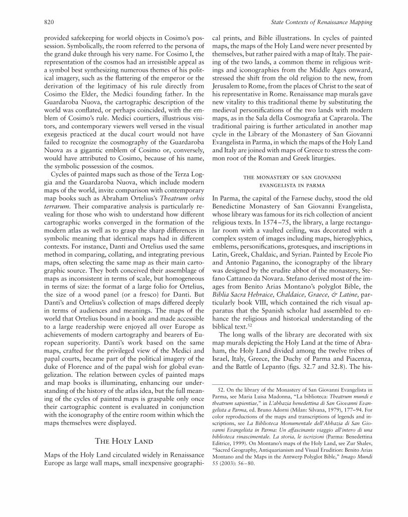
provided safekeeping for world objects in Cosimo’s pos-session. Symbolically, the room referred to the persona ofthe grand duke through his very name. For Cosimo I, therepresentation of the cosmos had an irresistible appeal asa symbol best synthesizing numerous themes of his polit-ical imagery, such as the flattering of the emperor or thederivation of the legitimacy of his rule directly fromCosimo the Elder, the Medici founding father. In theGuardaroba Nuova, the cartographic description of theworld was conflated, or perhaps coincided, with the em-blem of Cosimo’s rule. Medici courtiers, illustrious visi-tors, and contemporary viewers well versed in the visualexegesis practiced at the ducal court would not havefailed to recognize the cosmography of the GuardarobaNuova as a gigantic emblem of Cosimo or, conversely,would have attributed to Cosimo, because of his name,the symbolic possession of the cosmos.
Cycles of painted maps such as those of the Terza Log-gia and the Guardaroba Nuova, which include modernmaps of the world, invite comparison with contemporarymap books such as Abraham Ortelius’s Theatrum orbisterrarum. Their comparative analysis is particularly re-vealing for those who wish to understand how differentcartographic works converged in the formation of themodern atlas as well as to grasp the sharp differences insymbolic meaning that identical maps had in differentcontexts. For instance, Danti and Ortelius used the samemethod in comparing, collating, and integrating previousmaps, often selecting the same map as their main carto-graphic source. They both conceived their assemblage ofmaps as inconsistent in terms of scale, but homogeneousin terms of size: the format of a large folio for Ortelius,the size of a wood panel (or a fresco) for Danti. ButDanti’s and Ortelius’s collection of maps differed deeplyin terms of audiences and meanings. The maps of theworld that Ortelius bound in a book and made accessibleto a large readership were enjoyed all over Europe asachievements of modern cartography and bearers of Eu-ropean superiority. Danti’s work based on the samemaps, crafted for the privileged view of the Medici andpapal courts, became part of the political imagery of theduke of Florence and of the papal wish for global evan-gelization. The relation between cycles of painted mapsand map books is illuminating, enhancing our under-standing of the history of the atlas idea, but the full mean-ing of the cycles of painted maps is graspable only oncetheir cartographic content is evaluated in conjunctionwith the iconography of the entire room within which themaps themselves were displayed.
The Holy Land
Maps of the Holy Land circulated widely in RenaissanceEurope as large wall maps, small inexpensive geographi-
820 State Contexts of Renaissance Mapping
52. On the library of the Monastery of San Giovanni Evangelista inParma, see Maria Luisa Madonna, “La biblioteca: Theatrum mundi etheatrum sapientiae,” in L’abbazia benedettina di San Giovanni Evan-gelista a Parma, ed. Bruno Adorni (Milan: Silvana, 1979), 177–94. Forcolor reproductions of the maps and transcriptions of legends and in-scriptions, see La Biblioteca Monumentale dell’Abbazia di San Gio-vanni Evangelista in Parma: Un affascinante viaggio all’intero di unabiblioteca rinascimentale. La storia, le iscrizioni (Parma: BenedettinaEditrice, 1999). On Montano’s maps of the Holy Land, see Zur Shalev,“Sacred Geography, Antiquarianism and Visual Erudition: Benito AriasMontano and the Maps in the Antwerp Polyglot Bible,” Imago Mundi55 (2003): 56 –80.
cal prints, and Bible illustrations. In cycles of paintedmaps, the maps of the Holy Land were never presented bythemselves, but rather paired with a map of Italy. The pair-ing of the two lands, a common theme in religious writ-ings and iconographies from the Middle Ages onward,stressed the shift from the old religion to the new, fromJerusalem to Rome, from the places of Christ to the seat ofhis representative in Rome. Renaissance map murals gavenew vitality to this traditional theme by substituting themedieval personifications of the two lands with modernmaps, as in the Sala della Cosmografia at Caprarola. Thetraditional pairing is further articulated in another mapcycle in the Library of the Monastery of San GiovanniEvangelista in Parma, in which the maps of the Holy Landand Italy are joined with maps of Greece to stress the com-mon root of the Roman and Greek liturgies.
the monastery of san giovanni evangelista in parma
In Parma, the capital of the Farnese duchy, stood the oldBenedictine Monastery of San Giovanni Evangelista,whose library was famous for its rich collection of ancientreligious texts. In 1574 –75, the library, a large rectangu-lar room with a vaulted ceiling, was decorated with acomplex system of images including maps, hieroglyphics,emblems, personifications, grotesques, and inscriptions inLatin, Greek, Chaldaic, and Syrian. Painted by Ercole Pioand Antonio Paganino, the iconography of the librarywas designed by the erudite abbot of the monastery, Ste-fano Cattaneo da Novara. Stefano derived most of the im-ages from Benito Arias Montano’s polyglot Bible, theBiblia Sacra Hebraice, Chaldaice, Graece, & Latine, par-ticularly book VIII, which contained the rich visual ap-paratus that the Spanish scholar had assembled to en-hance the religious and historical understanding of thebiblical text.52
The long walls of the library are decorated with sixmap murals depicting the Holy Land at the time of Abra-ham, the Holy Land divided among the twelve tribes ofIsrael, Italy, Greece, the Duchy of Parma and Piacenza,and the Battle of Lepanto (figs. 32.7 and 32.8). The his-
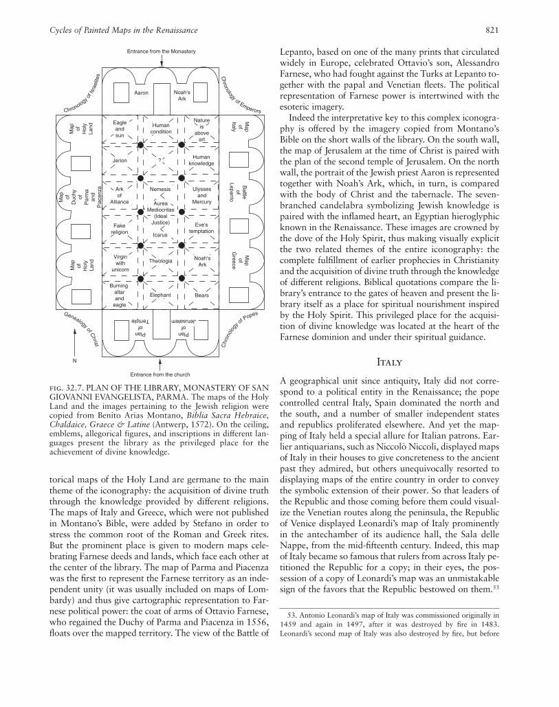
Cycles of Painted Maps in the Renaissance 821
torical maps of the Holy Land are germane to the maintheme of the iconography: the acquisition of divine truththrough the knowledge provided by different religions.The maps of Italy and Greece, which were not publishedin Montano’s Bible, were added by Stefano in order tostress the common root of the Roman and Greek rites.But the prominent place is given to modern maps cele-brating Farnese deeds and lands, which face each other atthe center of the library. The map of Parma and Piacenzawas the first to represent the Farnese territory as an inde-pendent unity (it was usually included on maps of Lom-bardy) and thus give cartographic representation to Far-nese political power: the coat of arms of Ottavio Farnese,who regained the Duchy of Parma and Piacenza in 1556,floats over the mapped territory. The view of the Battle of
Lepanto, based on one of the many prints that circulatedwidely in Europe, celebrated Ottavio’s son, AlessandroFarnese, who had fought against the Turks at Lepanto to-gether with the papal and Venetian fleets. The politicalrepresentation of Farnese power is intertwined with theesoteric imagery.
Indeed the interpretative key to this complex iconogra-phy is offered by the imagery copied from Montano’sBible on the short walls of the library. On the south wall,the map of Jerusalem at the time of Christ is paired withthe plan of the second temple of Jerusalem. On the northwall, the portrait of the Jewish priest Aaron is representedtogether with Noah’s Ark, which, in turn, is comparedwith the body of Christ and the tabernacle. The seven-branched candelabra symbolizing Jewish knowledge ispaired with the inflamed heart, an Egyptian hieroglyphicknown in the Renaissance. These images are crowned bythe dove of the Holy Spirit, thus making visually explicitthe two related themes of the entire iconography: thecomplete fulfillment of earlier prophecies in Christianityand the acquisition of divine truth through the knowledgeof different religions. Biblical quotations compare the li-brary’s entrance to the gates of heaven and present the li-brary itself as a place for spiritual nourishment inspiredby the Holy Spirit. This privileged place for the acquisi-tion of divine knowledge was located at the heart of theFarnese dominion and under their spiritual guidance.
Italy
A geographical unit since antiquity, Italy did not corre-spond to a political entity in the Renaissance; the popecontrolled central Italy, Spain dominated the north andthe south, and a number of smaller independent statesand republics proliferated elsewhere. And yet the map-ping of Italy held a special allure for Italian patrons. Ear-lier antiquarians, such as Niccolò Niccoli, displayed mapsof Italy in their houses to give concreteness to the ancientpast they admired, but others unequivocally resorted todisplaying maps of the entire country in order to conveythe symbolic extension of their power. So that leaders ofthe Republic and those coming before them could visual-ize the Venetian routes along the peninsula, the Republicof Venice displayed Leonardi’s map of Italy prominentlyin the antechamber of its audience hall, the Sala delleNappe, from the mid-fifteenth century. Indeed, this mapof Italy became so famous that rulers from across Italy pe-titioned the Republic for a copy; in their eyes, the pos-session of a copy of Leonardi’s map was an unmistakablesign of the favors that the Republic bestowed on them.53
53. Antonio Leonardi’s map of Italy was commissioned originally in1459 and again in 1497, after it was destroyed by fire in 1483.Leonardi’s second map of Italy was also destroyed by fire, but before
N
Entrance from the Monastery
Aaron Noah'sArk
Eagleandsun
Humancondition
Natureis
aboveart
Jerion ?Human
knowledge
Arkof
Alliance
Nemesis Ulyssesand
Mercury
Fakereligion
AureaMediocritas
(IdealJustice)
Icarus
Eve'stemptation
Virginwith
unicorn
Theologia Noah'sArk
Burning altarand
eagle
Elephant Bears
Map of
Hol
yLa
nd
Map of
Duc
hyof
Par
ma
and
Pia
cenz
a
Map of
Hol
y La
nd
Map
ofItaly
Battleof
Lepanto
Mapof
Greece
Planof
Jerusalem
Planof
Temple
Entrance from the church
Chronology of Emperors
Chr
onol
og
y of P
opesGenealogy of Christ
Chronology o
f Isr
aelit
es
fig. 32.7. PLAN OF THE LIBRARY, MONASTERY OF SANGIOVANNI EVANGELISTA, PARMA. The maps of the HolyLand and the images pertaining to the Jewish religion werecopied from Benito Arias Montano, Biblia Sacra Hebraice,Chaldaice, Graece & Latine (Antwerp, 1572). On the ceiling,emblems, allegorical figures, and inscriptions in different lan-guages present the library as the privileged place for theachievement of divine knowledge.

The mapping of Italy, however, found its most complexachievement when a Roman pontiff, in a radical breakfrom the traditional pairing of Italy and the Holy Land,had only the regions of Italy painted in the Vatican Palace;more than a new Holy Land, Italy was an exceptional ec-clesiastical unit, the very place where the Roman pope ex-ercised his authority more fully.
the galleria delle carte geografiche in the vatican palace
In 1578, when Pope Gregory XIII selected the iconogra-phy for the long corridor connecting the old VaticanPalace with Belvedere Hill, he resorted once again to themap murals he had already used in his Sala Bologna. Ina more ambitious move, however, he commissioned anunprecedented map cycle including forty gigantic maps ofItalian regions, twenty-four scenes of biblical sacrifices,fifty-one episodes of church history, and over one hun-dred personifications. An inscription in the Galleria delleCarte Geografiche explains the organizing principle ofthis complex iconography. The regions of Italy are repre-sented as they would appear to an imaginary travelerwalking on the Apennine ridge from north to south: the
822 State Contexts of Renaissance Mapping
fig. 32.8. MAP OF THE HOLY LAND AT THE TIME OFABRAHAM, 1575, LIBRARY, MONASTERY OF SAN GIO-
VANNI EVANGELISTA, PARMA. Fresco.Photograph courtesy of Stefano Brozzi.
regions on the Tyrrhenian Sea are represented on the eastwall of the corridor, while the regions on the Adriatic Seaappear on the west wall.54 The same inscription reveals
that it was displayed in the antechamber of the Collegio on the secondfloor. In 1506, Francesco II Gonzaga, marquis of Mantua, requested acopy of Leonardi’s map, which he displayed in his apartment in thepalace of San Sebastiano together with a world map and city views ofCairo and Jerusalem; in turn, he himself distributed copies as presti-gious diplomatic gifts, donating one to Cardinal Giuliano de’ Medici.See David Chambers and Brian Pullan, eds., Venice: A DocumentaryHistory, 1450–1630 (Oxford: Blackwell, 1992), 405–6, and MollyBourne, “Francesco II Gonzaga and Maps as Palace Decoration in Re-naissance Mantua,” Imago Mundi 51 (1999): 51–81, including relevantarchival sources. In 1547, Cardinal Ippolito d’Este asked for a copy ofLeonardi’s map of Italy, which was then displayed in the Anticollegio,receiving it in Ferrara shortly thereafter. Sansovino, in Venetia, fol. 122r,reported that the map was displayed in the Anticollegio until 1574,when it was destroyed by fire.
54. The inscription on the northern portal reads: “Italy, the most no-ble region of the entire world: as it is divided by nature by the Apen-nines, similarly to this end the gallery is divided into two parts, on thisside the one bounded by the Alps and the Upper Sea, on this side theother bounded by the Lower Sea; from the river Var as far as the far-thest Bruttij and Sallentinians, with kingdoms, provinces, dominionsand islands arranged within their own borders, as they are now, the en-tirety [of Italy] is displayed in tables on both sides of the long hall. The

that the historical scenes on the ceiling illustrate episodesof church history that took place in the territories mappedon the walls. The artists involved in this project are wellknown. Egnazio Danti designed and planned the maps.The painters Girolamo Muziano and Cesare Nebbia wereresponsible for the partition and design of the ceiling, re-spectively. A conspicuous team of artists translated intofresco the cartoons of the maps, painted boats, gro-tesques, historical scenes, biblical sacrifices, tablets, andpersonifications.
Individual elements of the iconography of the Galleriadelle Carte Geografiche—maps, episodes of church his-tory, and biblical sacrifices—had an honorable history inother parts of the Vatican Palace, but the synthesis ofthese different iconographic traditions in one single, all-encompassing program is a unique accomplishment ofthe Gregorian corridor. In a radical invention, Italy andits regions not only were connected with episodes ofchurch history and scenes of biblical sacrifice but, moreimportant, were represented through modern, accuratemaps rather than traditional allegorical personifications.The maps are arranged from the general to the particu-lar: two maps of Italy (Italia antiqua and Italia nova) startthe cycle at the south entrance, and the regional maps ofthe peninsula follow (fig. 32.9). Each map is providedwith a scale, wind rose, coordinates of latitude and lon-gitude, and at least one cartouche that briefly explains thepeculiarities and the history of the territory and its in-habitants. There are also perspective and plan views ofcities and other important places; historical vignettes aredepicted on the topography of the maps, and landscapefeatures are at the bottom of most maps.
The representation of Italy in forty colossal maps hadnever been attempted before and unequivocally bespeaksthe papal intention of producing a cartographic novelty.But the Italy depicted in the Vatican Gallery corre-sponded neither to the ancient geographical area de-scribed by Strabo and Ptolemy (both portrayed in theGalleria delle Carte Geografiche) nor to any past or fu-ture political partition. It represented, instead, a utopianconstruction of a place under the ecclesiastical authorityof the papacy. This imaginary Italy included the regionsof the peninsula and the main islands, as well as the mil-itary bulwarks against the infidels north and south of thepeninsula: the islands of Corfu and Malta, gateways tothe east, and the county of Avignon, the papal post in re-bellious France.
The mapping of this notional Italy is conceptually andspatially linked with an equally imaginary view of churchhistory. Such notional history starts with Emperor Con-stantine, whose life is represented in five episodes con-nected to the general maps of Italy, explicitly suggestingthe continuity between the Constantinian era and thepost-Tridentine church, a leading theme of Gregory XIII’s
Cycles of Painted Maps in the Renaissance 823
vault shows the pious deeds of holy men in the places where they hap-pened, each corresponding to the other. Gregory XIII, highest pontiff,in the year 1581 wished these things, begun by himself, to be finishedwith skill and splendor, not for his own advantage as much as for thatof the Roman pontiffs, and so that utility not be absent from the delightand knowledge of things and places.” The inscription does not mentionthe biblical sacrifices (mentioned later). It should be noted that the ori-entation of the peninsula in the corridor does not correspond to its realorientation; that is, northern Italy is represented at the south end of thecorridor rather than at the north. Nonetheless, in the corridor itself, theillusion of walking along the peninsula from north to south is achieved.On the Galleria delle Carte Geografiche, see MCV, vol. 3, in which Al-magià focused exclusively on the maps, magisterially investigating theirsources. See Schulz, Cartografia tra scienza e arte, 99–103, which consid-ered it in relation to other map murals; Iris Cheney, “The Galleria delleCarteGeograficheat theVaticanandtheRomanChurch’sViewoftheHis-tory of Christianity,” Renaissance Papers, 1989, 21–37, which was thefirst to investigate the symbolic meaning of the ceiling narratives and bib-lical sacrifices; and Margret Schütte, Die Galleria delle Carte Geograficheim Vatikan: Eine ikonologische Betrachtung des Gewölbeprogramms(Hildesheim: G. Olms, 1993), which discussed mainly the ceiling deco-ration. For a comprehensive evaluation of the cycle, see Lucio Gambiand Antonio Pinelli, eds., La Galleria delle Carte geografiche in Vati-cano / The Gallery of Maps in the Vatican, 3 vols. (Modena: FrancoCosimo Panini, 1994); Fiorani, “Post-Tridentine ‘Geographia Sacra,’”124 – 48; Walter A. Goffart, “Christian Pessimism on the Walls of theVatican Galleria delle Carte Geografiche,” Renaissance Quarterly 51(1998): 788–827; Fiorani, Marvel of Maps, 169–230; and pp. 396 –99in this volume.
55. On the Donation of Constantine and Gregory XIII, see von Pas-tor, History of the Popes, 20:650–53; Rolf Quednau, Die Sala diCostantino im Vatikanischen Palast: Zur Dekoration der beiden Medici-Päpste Leo X. und Clemens VII (Hildesheim: Georg Olms, 1979);Guido Cornini, Anna Maria De Strobel, and Maria Serlupi Crescenzi,“La Sala di Costantino,” in Raffaello nell’appartamento di Giulio II eLeone X (Milan: Electa, 1993), 167–201; Jack Freiberg, “In the Sign ofthe Cross: The Image of Constantine in the Art of Counter-ReformationRome,” in Piero della Francesca and His Legacy, ed. Marilyn AronbergLavin (Washington, D.C.: National Gallery of Art, 1995), 66 –87, esp.71–75, which suggested the connection between the ceiling of the Saladi Costantino and the Galleria delle Carte Geografiche; and WilliamMcCuaig, Carlo Sigonio: The Changing World of the Late Renaissance(Princeton: Princeton University Press, 1989), 251–90. On the strict po-litical meaning of the Galleria delle Carte Geografiche, see AntonioPinelli, “Sopra la terra, il cielo: Geografia, storia e teologia. Il Pro-gramma iconografico della volta /Above the Earth, the Heavens: Geog-raphy, History, and Theology. The Iconography of the Vault,” in LaGalleria delle Carte geografiche in Vaticano / The Gallery of Maps in theVatican, 3 vols., ed. Lucio Gambi and Antonio Pinelli (Modena: FrancoCosimo Panini, 1994), 1:125–54; and Antonio Pinelli, “Geografia dellafede: L’Italia della Controriforma unificata sulla carta,” in Car-tographiques: Actes du colloque de l’Académie de France à Rome, 19–20 mai 1995, ed. Marie-Ange Brayer (Paris: Réunion des Musées Na-tionaux, 1996), 63–94.
pontificate. Indeed, for Gregory XIII the connection be-tween Constantine and Italy was a compelling one, for,dismissing century-long disputes, he thought that it wasprecisely Italy that the emperor had donated to PopeSylvester I.55 By interpreting the Donation of Constantineas a donation of Italy and by having it represented in hisgallery, Gregory XIII was not claiming that he ruled the

entire peninsula politically, but rather was laying the his-torical and religious foundation for the ecclesiastical primacy of the church of Italy. As did other Renaissanceand post-Tridentine popes, Gregory XIII knew that theimperial donation could not be adapted to the reality of sixteenth-century Italy and that his role was as theguardian of its precarious balance of powers, not of theclaimants to its temporal dominion. In light of post-Tridentine papal policy, what the Galleria delle CarteGeografiche triumphantly celebrated was the ecclesiasti-cal primacy that post-Tridentine popes enjoyed in Italy.Although the spiritual mission of the post-Tridentine pa-pacy was universal, that mission could be accomplishedmore fully in Italy than in the rest of the world.56
824 State Contexts of Renaissance Mapping
The interpretation of the Galleria delle Carte Geo-grafiche as a celebration of papal primacy comes into full focus when we consider the presence of the biblicalscenes of sacrifice depicted on the vault. These scenesfrom Genesis, Exodus, and Leviticus document the earlyhistory of biblical sacrifices, the early instances of altarbuilding, and the connection between the sacrifice and thetithe, the offering of the tenth part of produce and live-stock to provide for whoever performed the sacrifice.
56. On the primacy of Italy in the Catholic Church, see A. D. Wright,The Early Modern Papacy: From the Council of Trent to the FrenchRevolution, 1564 –1789 (London: Longman, 2000), a study that revisesPaolo Prodi, Il sovrano pontefice (Bologna: Il Mulino, 1982).
fig. 32.9. MAP OF FLAMINIA, 1578–81, GALLERIADELLE CARTE GEOGRAFICHE, VATICAN PALACE,ROME. Fresco designed by Egnazio Danti.
Photograph courtesy of the Vatican Museums, Vatican City(Neg. N. XXXVII.1.14).

The New Testament does not include an obligation to of-fer a tithe to provide for church ministers; that obligationhad to be argued through exegesis of the Old Testament.The sacramental justification for ecclesiastical revenues to sustain the clergy was as vital as ever in the post-Tridentine church, especially in consideration of their de-creased significance in the overall papal budget. The pa-pal claim regarding the sacramental tithe was universal,but it was in Italy rather than in the larger Catholic worldthat the pope collected the financial means to sustain hismission. The Galleria delle Carte Geografiche mappedthe geographical boundaries of the lands where ecclesias-tical revenues were primarily collected.
Gregory XIII’s greater success in collecting ecclesiasti-cal revenues in Italy than in Catholic Europe was part ofhis concerted effort to assert papal authority through im-plementation of the decrees of the Council of Trent. Greg-ory XIII’s papacy, which was in many respects typical ofthe decades immediately following the Council of Trent,was crucial in moving the church steadily toward the in-stitutional, diplomatic, and ecclesiastical reforms thatwould make the ecclesiastical leadership of Italy possiblewithin the Catholic world. Indeed, the Galleria delleCarte Geografiche not only mapped the boundaries of the largest papal ecclesiastical revenues, but also tri-umphantly celebrated the primacy of Italy within the uni-versal church, which would remain one of the character-istics of the early modern papacy. What was peculiar tothe Boncompagni pope was the zeal with which he over-saw his church of Italy as he literally marched on itsApennine spine.
The Galleria delle Carte Geografiche is the embodi-ment of the ecclesiastical leadership of the Roman church,and the chorography of Italy is the minute cartographicrepresentation of the boundaries of the Western churchthat had embraced the Tridentine reforms. In the cartog-raphy of this ecclesiastical unit, the mapping of bishopricand archbishopric seats was as defining an element as therepresentation of local history, both secular and ecclesi-astical. Politically, the post-Tridentine papacy was losingground against the nation-states, but its spiritualinfluence was becoming global. Increasingly, the urgencyof action was directed toward the church beyond the Alps and overseas, in China, Japan, and the Americas.The post-Tridentine universal church is epitomized in themap cycle of the Terza Loggia, which indeed should be regarded as complementary to that of the Galleria delleCarte Geografiche. Considered in conjunction with theTerza Loggia, the Galleria delle Carte Geografiche revealsits full meaning: not only to convey the spiritual primacyof the popes in Italy but also to reassure the papal court,the cardinals, and the Italian rulers of their special placewithin the Catholic world, a place that Gregory XIII both
Cycles of Painted Maps in the Renaissance 825
reasserted and revised through his actions directed to-ward the universal church outside of Italy and overseas.
City Views
City views were among the most popular cartographicimages of the Renaissance, and their diffusion as printswas so widespread that they were widely assembled inbooks, such as Braun and Hogenberg’s bestseller Civi-tates orbis terrarum, and commonly used to embellish do-mestic interiors. Inventories of royal and princely palacesfrequently record city views, either as framed pictures onpermanent display or, more frequently, as items in stor-age. The most common use of such views was to furbishguest apartments in order to flatter important visitorswith the display of their hometowns. From the latefifteenth century onward, city views also appeared aspainted cycles, indeed becoming so common that no at-tempt has ever been made to count them. The meaningsand functions of painted cycles with city views were notinherently different from those of cycles of painted maps,although their diffusion encourages their consideration asa separate group.
An early cycle of painted city views appeared in theBelvedere villa, the summer house Pope Innocent VIIIbuilt at the Vatican to escape the stuffy climate of the oldpalace as well as to provide an all’antica setting for thepapal collection of ancient sculpture.57 Around 1480, thepainter Pinturicchio painted individual views of the citiesof Florence, Genoa, Milan, Rome, and Venice, whichwere also the capitals of papal military allies. Fusing an-tiquarianism, cartography, and politics, this papal seriesof city views was inspired by Pliny’s description of Romanvillas while simultaneously reflecting the political aspira-tions of the current pope. Almost entirely lost today, thiscycle inspired similar decorations around Europe.Francesco II Gonzaga, marquis of Mantua, had views ofimportant Mediterranean cities in different rooms of hispalaces, seeming to suggest to his visitors that his owncity of Mantua could rival the depicted ones.58 In anotherinstance, he commissioned the painting of city views ofstops on the trading route between Mantua and the Ot-toman Empire, where he acquired his famous horses.
Although some belligerent patrons painted city viewsto celebrate their military campaigns, patrons by and
57. On the city views for the Belvedere villa, see Sven Sandström,“The Programme for the Decoration of the Belvedere of Innocent VIII,”Konsthistorisk Tidskrift 29 (1960): 35–75; idem, “Mantegna and theBelvedere of Innocent VIII,” Konsthistorisk Tidskrift 30 (1963): 121–22; and Juergen Schulz, “Pinturicchio and the Revival of Antiquity,”Journal of the Warburg and Courtauld Institutes 25 (1962): 35–55.
58. Bourne, “Francesco II Gonzaga.”

826 State Contexts of Renaissance Mapping
large represented the main cities and castles of their do-minion.59 An early instance of the latter type dates from1450, but later examples are documented in villas andpalaces throughout Italy.60 Henry IV of France, a pas-sionate hunter, celebrated his favorite pastime by havingbird’s-eye views of his favorite hunting places painted inthe Galérie des Cerfs at Fontainebleau.61 Philip II of Spainhad views of the Spanish and Flemish countryside hungin his throne room and, according to a traveler, also dis-played wooden models of Spanish cities in the Alcazar.Philip II might have even intended to hang copies of thefamous views of Spanish cities and towns by Antoon van den Wijngaerde, which he himself had commissionedin the 1570s. Such a cycle of painted city views is still preserved at El Viso, Spain, in the palace of the famousnaval commander Álvaro de Bazán, marqués de SantaCruz, who had his gallery embellished with views of im-portant European cities connected with his own sea vic-tories.62 A display of wooden models of German citieswas a defining feature of the Kunstkammer at Munich inthe 1560s.63
City views were also a subject favored by Renaissanceladies. For instance, Eleanor of Aragon commissioned acycle of city views, including her native Naples, for hernew residence at the court of her husband in Ferrara. Sim-
59. One such belligerent patron was Gentile Virginio Orsini, whocommissioned city views of his conquests for his residence in Bracciano;see Marco Iuliano, “Napoli a volo d’uccello: Un affresco per lo studiodella topografia aragonese,” Mélanges de l’École Francaise de Rome,Italie et Méditerranée 113 (2001): 287–311.
60. On the early cycle of city views, see Joanna Woods-Marsden,“Pictorial Legitimation of Territorial Gains in Emilia: The Iconographyof the Camera Peregrina Aurea in the Castle of Torchiara,” in Renais-sance Studies in Honor of Craig Hugh Smyth, 2 vols., ed. Andrew Mor-rogh et al. (Florence: Giunti Barbèra, 1985), 2:553–68.
61. On the map murals of French kings, see Buisseret, “Monarchs,Ministers, and Maps in France,” 113, and Barber, “Maps and Mon-archs,” 111–12.
62. Kagan, “Philip II,” 53.63. On the Kunstkammer at Munich, see Samuel Quicchelberg, In-
scriptiones vel tituli theatri amplissimi, complectentis rerum universi-tatis singulas materias et imagines eximias . . . (Munich: Adam Berg,1565), and Woodward, Maps as Prints, 88–89.
fig. 32.10. VIEW OF THE CITY OF GRAZ, 1565, MAINCOURTYARD, PALAZZO VECCHIO, FLORENCE. Fresco.This view is part of a series of seventeen views of Austriancities including Prague, Passau, Stain (probably Steyr),Klosterneuburg, Graz, Frieburg, Linz, Poznan, Vienna, Inns-
bruck, Ebsdorf, Constance, Neustadt, and Schwäbisch-Hall.The city views are connected with the reverse of Medici medalscelebrating Cosimo I’s rulership.With permission from Fototeca dei Musei Comunali diFirenze.

Cycles of Painted Maps in the Renaissance 827
ilarly, her daughter Isabella d’Este had city views in herquarters, while Eleanor of Toledo, Cosimo de’ Medici’swife, had views painted in her private balcony.
The Medici, with their nose for iconographic novelties,resorted to a cycle of city views to celebrate a wedding.On the occasion of the marriage between Francesco de’Medici, heir to the ducal title, and Joanna of Austria,daughter of Emperor Charles V, Duke Cosimo I had sev-enteen views of famous Austrian cities painted in thecourtyard of his palace, the very place where Francescogreeted his bride (fig. 32.10).64 Because no printed ormanuscript source existed for this exceptional cycle ofAustrian city views, the Florentine ambassador at Viennawas requested to provide accurate drawings in perspec-tive (far in prospettiva) for all of the cities as well as to re-port on their important buildings, historical events, coatsof arms, and toponomy. The city views were connectedwith roundels that represented the reverse of ducalmedals celebrating important events of Cosimo’s rule. Inthis courtyard, the city views were a cartographic noveltyand an integral component of Cosimo’s political iconog-raphy: they honored Joanna by reminding her of her na-tive land, celebrated the political alliance between theMedici and the Habsburg, showed the Medici artistictaste, and displayed their diplomatic skills in obtainingoriginal, detailed views of Austrian cities.
Conclusion
The spread of cycles of painted maps throughout Europein the early modern period is documented, even thoughthe most spectacular examples were a characteristic of thecourts and republics of the Italian Peninsula. However,whether cycles of painted maps constituted a pictorial
genre of the Renaissance, as Burckhardt suggested, is de-batable, not only in light of modern skepticism about thetaxonomy of symbolic forms but, more important, be-cause of the questionable approach of grouping map cy-cles based on the simple consideration that they all con-tain cartographic images. Although close in date andsimilar in cartographic content, map cycles such as thoseof the Venetian Republic, the papal Terza Loggia, or theMedici Guardaroba Nuova were so different in meanings,patronage, and function that it seems misguided to try to unify them. What, instead, these map cycles mag-niloquently demonstrate is the pervasiveness that carto-graphic images enjoyed in Renaissance Europe. These accurate representations of the world, displayed three-dimensionally, integrally contributed to the politicaliconography of rulers, to the propagandistic message ofcivic authorities, and to the religious aspirations of popesand cardinals. Their metaphorical meanings were createdby the interaction of the painted maps with images of his-tory, mythology, zoology, botany, and religion and couldbe fully grasped only through the firsthand experience ofthe rooms that contained them. To consider cycles ofpainted maps exclusively from the perspective of cartog-raphy or simply as an artistic genre is to miss the richnessof their meanings: even though their cartographic contentwas dated and their impact on modern discoveries andvoyages negligible, they poignantly encapsulated the sym-bolism of Renaissance mapping, indeed the deep signifi-cance of mapping in Renaissance culture.
64. On this courtyard, see Edmund Pillsbury, “An Unknown Projectfor the Palazzo Vecchio Courtyard,” Mitteilungen des Kunsthistori-schen Institutes in Florenz 14 (1969): 57–66, and Allegri and Cecchi,Palazzo Vecchio, 277–82.
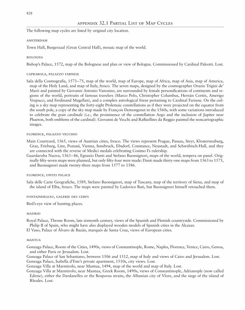
828
appendix 32.1 Partial List of Map Cycles
The following map cycles are listed by original city location.
amsterdam
Town Hall, Burgerzaal (Great Central Hall), mosaic map of the world.
bologna
Bishop’s Palace, 1572, map of the Bolognese and plan or view of Bologna. Commissioned by Cardinal Paleotti. Lost.
caprarola, palazzo farnese
Sala della Cosmografia, 1573–75, map of the world, map of Europe, map of Africa, map of Asia, map of America,map of the Holy Land, and map of Italy, fresco. The seven maps, designed by the cosmographer Orazio Trigini de’Marii and painted by Giovanni Antonio Vanosino, are surrounded by female personifications of continents and re-gions of the world, portraits of famous travelers (Marco Polo, Christopher Columbus, Hernán Cortés, AmerigoVespucci, and Ferdinand Magellan), and a complex astrological frieze pertaining to Cardinal Farnese. On the ceil-ing is a sky map representing the forty-eight Ptolemaic constellations as if they were projected on the equator fromthe south pole, a copy of the sky map made by Francois Demongenet in the 1560s, with some variations introducedto celebrate the gran cardinale (i.e., the prominence of the constellation Argo and the inclusion of Jupiter nearPhaeton, both emblems of the cardinal). Giovanni de Vecchi and Raffaellino da Reggio painted the noncartographicimages.
florence, palazzo vecchio
Main Courtyard, 1565, views of Austrian cities, fresco. The views represent Prague, Passau, Steyr, Klosterneuburg,Graz, Frieburg, Linz, Poznan, Vienna, Innsbruck, Ebsdorf, Constance, Neustadt, and Schwäbisch-Hall, and theyare connected with the reverse of Medici medals celebrating Cosimo I’s rulership.
Guardaroba Nuova, 1563–86, Egnazio Danti and Stefano Buonsignori, maps of the world, tempera on panel. Orig-inally fifty-seven maps were planned, but only fifty-four were made: Danti made thirty-one maps from 1563 to 1575,and Buonsignori made twenty-three maps from 1577 to 1586.
florence, uffizi palace
Sala delle Carte Geografiche, 1589, Stefano Buonsignori, map of Tuscany, map of the territory of Siena, and map ofthe island of Elba, fresco. The maps were painted by Ludovico Buti, but Buonsignori himself retouched them.
fontainebleau, galerie des cerfs
Bird’s-eye view of hunting places.
madrid
Royal Palace, Throne Room, late sixteenth century, views of the Spanish and Flemish countryside. Commissioned byPhilip II of Spain, who might have also displayed wooden models of Spanish cities in the Alcazar.
El Vaso, Palace of Álvaro de Bazán, marqués de Santa Cruz, views of European cities.
mantua
Gonzaga Palace, Room of the Cities, 1490s, views of Constantinople, Rome, Naples, Florence, Venice, Cairo, Genoa,and either Paris or Jerusalem. Lost.
Gonzaga Palace of San Sebastiano, between 1506 and 1512, map of Italy and views of Cairo and Jerusalem. Lost.Gonzaga Palace, Isabella d’Este’s private apartment, 1510s, city views. Lost.Gonzaga Villa at Marmirolo, near Mantua, 1494, map of the world and map of Italy. Lost.Gonzaga Villa at Marmirolo, near Mantua, Greek Room, 1490s, views of Constantinople, Adrianople (now called
Edirne), either the Dardanelles or the Bosporus straits, the Albanian city of Vlore, and the siege of the island ofRhodes. Lost.

829
naples, church of san lorenzo maggiore
Refectory of the church, 1590s, Luigi Rodriguez, maps of the kingdom of Naples, fresco. The maps are based on themaps of the regions of the kingdom of Naples that Nicola Antonio Stigliola had made in the 1580s.
parma, monastery of san giovanni evangelista
Library of the monastery, 1575, map of the Holy Land at the time of Abraham, map of the Holy Land divided intothe lands of the Twelve Tribes of Israel, map of Greece, map of Italy, map of the Duchy of Parma and Piacenza, andview of the Battle of Lepanto, fresco. On the ceiling there are emblems, allegorical figures, and inscriptions in dif-ferent languages, mainly derived from Benito Arias Montano’s polyglot Bible. Painted by the artists Ercole Pio andAntonio Paganini, with iconography invented by the abbot of the monastery, Stefano Cattaneo da Novara.
perugia
Governor’s Palace, 1577, map of the territory around Perugia and/or view of Perugia, fresco painted by Egnazio Danti.Lost.
rome, palazzo venezia
Sala del Mappamondo, mid-fifteenth century, Antonio Leonardi, map of the world. Commissioned by Pope Paul IIfor his audience hall. Lost.
rome, vatican palace
Belvedere Villa, ca. 1480, Pinturicchio, city views of Florence, Genoa, Milan, Rome, and Venice, fresco. Largely lost.Terza Loggia, West Wing, early 1560s, thirteen maps representing the British Isles, Spain, France, Italy, Greece, Asia
Minor, the Holy Land, Germany, Hungary (together with Poland and Lithuania), Scandinavia, Muscovy, Tartary,and Greenland, fresco. Designed by Etienne Du Pérac, these maps were heavily restored by Alessandro Mantovaniin the nineteenth century. On the vault’s ceiling are scenes of examples of good and bad life, depicted by LorenzoSabatini, that complement the maps.
Sala Bologna, 1574, map of the Bolognese territory, plan of Bologna, and city view of Bologna, fresco. The carto-graphic sources of these three items and the artist who painted them are unknown (Lorenzo Sabatini, who super-vised the completion of the room, painted only the ceiling). The sky map on the ceiling, which is sustained by an il-lusionistic loggia, in perspective, housing famous astronomers, was based on a similar map in the Palazzo Farnese,Sala della Cosmografia.
Galleria delle Carte Geografiche, 1578–81, forty maps of Italy designed by Egnazio Danti, fresco. The maps repre-sent territories of the Italian Peninsula, the main islands of the Mediterranean (Malta, Corfu, the Tremiti, and Elba),four important ports (Genoa, Venice, Ancona, and Civitavecchia), and the county of Avignon. The vaulted ceilingof the gallery is filled with a multitude of scenes: twenty-four representing sacrificial subjects from the Old Testa-ment, fifty-one illustrating episodes of church history that took place in the territories mapped below, and over onehundred personifications.
Terza Loggia, North Wing, early 1580s, ten maps of Africa, Asia, and America representing Western Africa, EasternAfrica, Turkey, Persia, India, China, Tartaria, America, New Spain, and the islands of the Indian Ocean, fresco. De-signed by Egnazio Danti and painted by Giovanni Antonio Vanosino, the maps were heavily restored by Alessan-dro Mantovani in the nineteenth century. Scenes of saints in paradise depicted on the vault’s ceiling complement themaps.
rome, quirinal palace
Map of the world, 1585, fresco. Commissioned by Pope Gregory XIII and painted by Giovanni Antonio Vanosino.Lost.
salzburg
Archbishop’s Palace, 1614, maps of the world, fresco.
appendix 32.1 (continued)

830
siena, palazzo pubblico
Sala dei Nove, 1338–39, Ambrogio Lorenzetti, Good and Bad Government, fresco.Sala del Mappamondo, ca. 1340, Ambrogio Lorenzetti, map of the world, fresco. Lost.Sala dei Conservatori di Siena (today Office of the Provincia), between 1573 and 1599, Orlando Malavolti, map of
the Sienese territory, fresco. Lost. The map is known through a seventeenth-century copy (Florence, Archivio diStato, Regie Possessioni, Scaff. C. Palch. 2, Carta no. 49).
Archivio di Stato, 1609, Rutilio Manetti, map of Siena. It was originally located in the room adjacent to the Sala deiConservatori.
venice, rialto market
Loggia near the Rialto Market, 1459, map of the world. Lost.
venice, ducal palace
Sala delle Nappe (first floor), ca. 1459, Antonio Leonardi, map the Venetian territory. The Sala delle Nappe mostprobably corresponded to the antechamber to the doge’s apartment on the first floor (perhaps the same room thatwas later known as the Sala del Mappamondo). Destroyed in 1483.
Sala delle Nappe, ca. 1459, Antonio Leonardi, map of Italy, displayed together with Leonardi’s map of the Venetianterritory (previous entry). Destroyed in 1483.
Anticollegio, 1497, Antonio Leonardi, map of Italy. In 1547 it was documented as being in the Anticollegio, pre-sumably the room located on the second floor still named the Anticollegio. It is unclear whether the map wasspecifically painted for the Anticollegio or moved there at a later time. Destroyed in 1574.
Collegio (second floor), 1531, Alessandro Zorzi, map of the world, oil on canvas. Destroyed in 1574.Chapel of San Nicolò (Chiesetta), a small chapel adjacent to the Collegio (second floor), 1535–36, Alessandro Zorzi,
map of the Holy Land, displayed together with Zorzi’s maps of Cyprus and Constantinople (following two entries),oil on canvas. Destroyed in 1574.
Chapel of San Nicolò (Chiesetta), 1535–36, Alessandro Zorzi, map of Cyprus, oil on canvas. Destroyed in 1574.Chapel of San Nicolò (Chiesetta), 1535–36, Alessandro Zorzi, map (or view) of Constantinople, 1541, oil on can-
vas. Destroyed in 1574.Sala dello Scudo (first floor), 1549, Giacomo Gastaldi, map of Africa and South America, displayed on the short in-
ternal wall (toward the courtyard), oil on canvas. Painted by the miniaturist Vitruvio Buonconsiglio, it was heavilyrestored by Francesco Grisellini in the mid-eighteenth century. Displayed together with Gastaldi’s map of Asia andAmerica (following entry).
Sala dello Scudo (first floor), 1553, Giacomo Gastaldi, map of Asia and America, oil on canvas. It was heavily re-stored by Francesco Grisellini in the mid-eighteenth century.
Sala del Senato (second floor), 1578, Cristoforo Sorte, map of the Venetian territory, oil on canvas. Commissioned asa large map to be displayed in the audience hall of the senate, this map was reduced in size in 1582 and displayedin the Antichiesetta, a small vestibule between the Sala del Senato and the Chapel of San Nicolò (Chiesetta).
Sala dello Scudo (first floor), ca. 1750, Francesco Grisellini, map of the western Mediterranean illustrating the trav-els of Alvise Cà da Mosto, oil on canvas.
Sala dello Scudo (first floor), ca. 1750, Francesco Grisellini, map of the travels of Sebastian Cabot in America, oil oncanvas.
Sala dello Scudo (first floor), ca. 1750, Francesco Grisellini, map of northern Europe illustrating the travels of theZeno brothers, oil on canvas.
vicenza
Governor’s Palace, 1573, map of the territory around Vicenza. Lost.
appendix 32.1 (continued)