
312 U.S. Coast Pilot 3, Chapter 15 19 NOV 2017 · PDF file11/18/2017 ·...
17
312 ¢ U.S. Coast Pilot 3, Chapter 1 19 NOV 2017 12278 12281 12274 BUSH RIVER SWAN CREEK PATAPSCO RIVER FAIRLEE CREEK WORTON CREEK SASSAFRAS RIVER BOHEMIA RIVER ELK RIVER BACK RIVER Baltimore Rock Hall Swan Point Howell Point Turkey Point Bodkin Point General Index of Chart Coverage in Chapter 15 (see catalog for complete coverage) 76° 76° 76° 40' 76° 40' 76° 30' 76° 30' 76° 20' 76° 20' 76° 10' 76° 10' 75° 50' 75° 50' 39° 30' 39° 30' 39° 20' 39° 20' 39° 10' 39° 10' Havre de Grace Elkton MIDDLE RIVER GUNPOWDER RIVER CHESAPEAKE BAY NORTHEAST RIVER SUSQUEHANNA RIVER CHESTER RIVER
Transcript of 312 U.S. Coast Pilot 3, Chapter 15 19 NOV 2017 · PDF file11/18/2017 ·...

312 ¢ U.S. Coast Pilot 3, Chapter 15 19 NOV 2017
1227
8
1228
1
1227
4
BU
SHR
IVE
R
SWA
N C
RE
EK
PAT
AP
SCO
RIV
ER
FAIR
LE
E C
RE
EK
WO
RT
ON
CR
EE
KSASS
AF
RA
S R
IVE
R
BO
HE
MIA
RIV
ER
EL
K R
IVE
R
BA
CK
RIV
ER
Ba
ltim
ore
Roc
k H
all
Swan
Poi
nt
How
ell P
oint
Turk
ey P
oint
Bodk
in P
oint
Gen
eral
Inde
x of
Cha
rt C
over
age
in C
hapt
er 1
5(s
ee c
atal
og fo
r com
plet
e co
vera
ge)
76°
76°
76°4
0'
76°4
0'
76°3
0'
76°3
0'
76°2
0'
76°2
0'
76°1
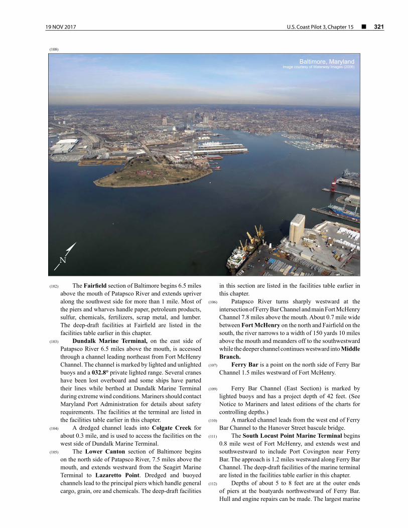
0'
76°1
0'
75°5
0'
75°5
0'
39°
30'
39°
30'
39°
20'
39°
20'
39°
10'
39°
10'
Hav
re d
e G
race
Elkt
on
MID
DL
E R
IVE
R
GU
NP
OW
DE
R
RIV
ER
CH
ES
AP
EA
KE
BA
Y
NO
RT
HE
AST
RIV
ER
SUSQ
UE
HA
NN
A
RIV
ER
CH
EST
ER
RIV
ER

19 NOV 2017 U.S. Coast Pilot 3, Chapter 15 ¢ 313
Baltimore to Head of Chesapeake Bay(1) This chapter describes the northern part of
Chesapeake Bay and the many tributaries that empty into it, including the more important Patapsco, Elk, and Susquehanna Rivers. Also described is the major port of Baltimore and several smaller ports and landings in this part of the bay.
(2) COLREGS Demarcation Lines
(3) The lines established for Chesapeake Bay are described in 33 CFR 80.510, chapter 2.
(4) Chart 12273
(5) Patapsco River forms Baltimore Harbor, and Elk River is the approach to the Chesapeake and Delaware Canal. The other tributaries that empty into this part of the bay are seldom used by vessels drawing more than 12 feet. The shores are mostly wooded in the undeveloped areas and rise to considerable heights in the vicinity of Northeast and Susquehanna Rivers.
(6) There are extensive shoal areas in the upper part of the bay, and fishtraps are numerous in season; fishtrap limits are shown on the chart. All of the tributaries are usually closed by ice for extended periods during the winter.
(7) Chart 12278
(8) Sandy Point Shoal Light and Baltimore Light, respectively 131.5 and 134.2 miles above the Virginia Capes, were described in chapter 13. The channel to Baltimore and the channel to the head of Chesapeake Bay divide at 0.5 mile eastward of Sandy Point Shoal Light.
(9) Sevenfoot Knoll Light (39°09'19"N., 76°24'33"W.), 58 feet above the water, is shown from a skeleton tower on the northeast side of the channel to Baltimore, 140.1 miles from the Capes.
(10) Caution–Large vessels transiting Craighill Channel Upper Range and Brewerton Channel Eastern Extension in the vicinity of Sevenfoot Knoll Light may generate large and dangerous wakes; waves as high as 10 to 12 feet have been reported. Small craft in the area are advised to use extreme caution.
(11) Baltimore Harbor consists of the entire Patapsco River and its tributaries; a part of the waterfront thus included lies outside the municipal limits of Baltimore, but by State law is within the jurisdiction of the Maryland Port Administration.
(12) Patapsco River joins the west side of Chesapeake Bay between Bodkin Point and North Point, 4 miles to the northward; the midchannel point in the entrance, 2 miles northwest of Sevenfoot Knoll Light, is 142.1 miles above the Virginia Capes, and 54 miles from Delaware River by way of the Chesapeake and Delaware Canal.
(13) Channels
(14) Federal project depths are: 50 feet in Craighill Entrance Channel to Ferry Bar Channel, thence 49 feet in East Channel and 40 feet in West Channel, both in Northwest Harbor. Ferry Bar Channel has a project depth of 42 feet and Curtis Bay Channel has a project depth of 50 feet. The Federal project in the main channel between the Delaware Capes and Baltimore via the Chesapeake and Delaware Canal is 35 feet.
(15) The channels are maintained at or near project depths. (See Notice to Mariners and latest editions of the charts for controlling depths.)
(16) Bodkin Point is the low northeastern extremity
of Bodkin Neck, on the south side of the entrance to Patapsco River. Shoals extend northward and eastward from the point to the edge of the main channel.
(17) Bodkin Creek, which flows into Patapsco River along the inner side of Bodkin Neck, has depths of 9 feet in the approaches and 7 to 9 feet for considerable distances into its branches. The channel is very narrow at the mouth and leads between extensive shoals. Shoaling to 3 feet is reported in the entrance to the creek between Daybeacon 9 and Light 11; mariners are urged to use caution in this area.
(18) Back Creek is on the northeast side of Bodkin Creek just inside the mouth. A boatyard is in the upper part of the creek. Gasoline and slips are available. Hull and engine repairs can be made; marine railway, 50 tons; lift, 5 tons.
(19) Main Creek is separated from Back Creek by Spit Neck. Both branches have depths of 7 to 9 feet almost to their heads and are much used by pleasure craft.
(20) Several marinas are on Graveyard Point, on the south side of Main Creek 0.2 mile above the mouth. Gasoline, diesel fuel, slips, and some marine supplies can be obtained. Hull and engine repairs can be made. Largest haul-out capacities are: railway, 55 feet; lift, 5 tons.
(21) A marina at the entrance to Perry Cove, 1.3 miles above the mouth of Main Creek, has gasoline and some marine supplies. Hull and engine repairs can be made; lift, 30 tons.

314 ¢ U.S. Coast Pilot 3, Chapter 15 19 NOV 2017
(22) Rock Point is on the southwest side of Patapsco River 3 miles above Bodkin Point. A pier extends out from the Rock Creek side to depths of 5 feet or more. White Rocks, 0.6 mile northwest of Rock Point, are about 15 feet high and marked by a light; the deepest water is north and west of the rocks.
(23) Rock Creek, on the northwest side of Rock Point, has depths of 11 feet almost to the head. The creek is marked by lights and daybeacons. A light on the east side of the creek marks the narrow part of the channel off Fairview, 0.5 mile above the mouth.
(24) Wall Cove empties into the southeast side of Rock Creek along the south side of Fairview. In 1991, centerline controlling depths of about 10 feet were reported available for most of its length but gradual shoaling to about 5 feet had occurred near the head of the cove. The Maryland Yacht Club piers on the Fairview side of the entrance have depths of about 13 feet at their outer ends.
(25) There are several marinas and boatyards in Wall Cove and along Rock Creek where marine supplies, gasoline, diesel fuel, pump-out station, launching ramp, storage, water and ice can be obtained. Largest haul-out capacities for hull and engine repairs are: marine railway, 60 feet; lift, 50 tons.
(26) Stony Creek, on the southwest side of Patapsco River 5 miles above Bodkin Point, has depths of 12 feet or more almost to the head. The entrance channel into the creek, is about 70 yards wide and marked by lights, buoys and daybeacons. The creek mouth on the east side is obstructed by rocks, some of which bare at all stages of the tide. The State Route 173 highway bridge 0.8 mile above the mouth of Stony Creek has a 40-foot bascule span with a clearance of 18 feet. The bridgetender monitors VHF-FM channel 16 and works on channels 13 and 68; call sign KAJ-667. (See 33 CFR 117.1 through 117.59 and 117.573, chapter 2, for drawbridge regulations.) A marina on the north side just above the bridge has gasoline.
(27) Nabbs Creek, a tributary on the northwest side of Stony Creek, 1 mile above the mouth, has depths of 12 feet almost to the head. A marina near the head of the creek has gasoline, diesel fuel, berths, and marine supplies. Hull and engine repairs can be made. A marine railway can handle craft up to 60 feet; a 15-ton lift is available.
(28) Back Cove, on the north side of Nabbs Creek near the mouth, has depths of 12 feet to a boatyard 0.3 mile above the entrance. The marine railway can handle craft up to 60 feet for hull and engine repairs; gasoline is available.
(29) Old Road Bay, which empties into the north side of Patapsco River along the west side of North Point, has general depths of 7 to 10 feet. A light marks the edge of a shoal that extends westward from North Point. A dredged channel, marked by buoys and a 353.6° lighted range, leads north from Brewerton Channel to a turning basin off the east side of Sparrows Point. A cable area extends from the west side of North Point, across the bay and
through the turning basin, to the east shore of Sparrows Point.
(30) North Point Creek and Jones Creek, which empty into the northeast and northwest corners of Old Road Bay, respectively, have depths of 3 to 6 feet. The approach to North Point Creek is marked by lights and the approach to Jones Creek is marked by lights and daybeacons. Approach both creeks by passing eastward of Jones Creek Light 1, being careful to avoid the reported underwater obstruction about 150 yards south of the light. Small-craft facilities are in both creeks.
(31) Charts 12281, 12278
(32) Baltimore, one of the major ports of the United States, is at the head of tidewater navigation on Patapsco River. The midharbor point, at the intersection of Fort McHenry and Ferry Bar Channels 0.6 mile southeast of Fort McHenry, is 8 miles from the mouth of the river, 150 miles above the Virginia Capes, and 62 miles from Delaware River.
(33) Principal imports of the port are: general cargo, petroleum products, coke of coal, iron ore, aluminum manganese, inorganic chemicals, salt, gypsum, lumber, motor vehicles, fertilizers and sugar. Principal exports are chiefly: general cargo, coal, automobiles and machinery. Coastwise receipts include: petroleum products, sand, cement, fertilizers, sulfur, sugar and lumber; shipments are petroleum and metal products.
(34) Channels
(35) Federal project channels were discussed at the beginning of the chapter. The branch channels will be covered in the descriptions of the tributaries.
(36) Anchorages
(37) General and dead ship anchorages are in Baltimore Harbor. (See 33 CFR 110.1 and 110.158, chapter 2, for limits and regulations.)
(38) Tides and currents
(39) Prolonged winds of constant direction may cause substantial variation in the tide. Currents in the harbor are 0.8 knot on the flood and ebb.
(40) Weather
(41) Baltimore is in a region about midway between the rigorous climates of the North and the mild climates of the South and adjacent to the modifying influences of the Chesapeake Bay and Atlantic Ocean to the east and the Appalachian Mountains to the west. The net effect is to produce a more equable climate compared to inland locations of the same latitude.
(42) Rainfall distribution throughout the year is rather uniform; however, the greatest intensities are confined to the summer and early fall, the season for hurricanes and

19 NOV 2017 U.S. Coast Pilot 3, Chapter 15 ¢ 315
severe thunderstorms. Rainfall during this period occurs principally in the form of thundershowers, and rainfall totals during these months vary appreciably, depending on the number of thundershowers which occur largely by chance in a given locality. Hurricane force winds, however, may occur on rare occasions due to a severe cold front or a severe thunderstorm. The greatest damage by hurricanes is that produced along waterfronts and shores by the high tides and waves.
(43) In summer, the area is under the influence of the large semipermanent high-pressure system commonly known as the Bermuda High and centered over the Atlantic Ocean near latitude 30°N. This high-pressure system brings a circulation of warm, humid air masses over the area from the deep South. The proximity of large water areas and the inflow of southerly winds contribute to high relative humidities during much of the year.
(44) January is the coldest month, and July, the warmest. Winter and spring have the highest average windspeeds. Snowfall occurs on about 25 days per year on the average; however, an average of only 9 days annually produce snowfalls greater than 1.0 inch. Although heaviest amounts of snow generally fall in February, occasional heavy falls occur as late as March. Records for the period, August 1950 through December 1967, indicate that the average date of the last temperature as low as 32° in the spring is April 15, while the average date of the first temperature as low as 32° in the autumn is October 26.
(45) Glaze or freezing rain occurs on an average of two to three times per year, generally in January or February. However, some occurrences have been noted in November and December. Some years pass without the occurrence of freezing rain, while in others it occurs on as many as 8 to 10 days. Sleet is observed on about 5 days annually. The sleet season begins as early as November in some years, and ends as late as March in some cases, with the greatest frequency of occurrence in January.
(46) The National Weather Service office is at Baltimore-Washington International Airport, about 7 miles southward of Baltimore. Barometers may be compared there or by telephone. (See Appendix B for Baltimore climatological table.)
(47) Fogs occur chiefly from October to March, inclusive. From April to September there are only a few days with dense fogs. Very light winds clear the fog away.
(48) Ice
(49) Baltimore Harbor is frozen over during severe winters, but the ice-breakers and the larger power-driven vessels keep the dredged channels open so that self-propelled vessels seldom have difficulty in entering the harbor. Ice conditions in the main channel are most severe in the vicinity of Sevenfoot Knoll Light, where ice moving from the northern end of Chesapeake Bay tends to collect in packs. Navigation from Baltimore to the upper end of the bay and the Chesapeake and Delaware
Baltimore Harbor, MarylandImage courtesy of Waterway Images (2006) N
(50)

316 ¢ U.S. Coast Pilot 3, Chapter 15 19 NOV 2017
(68)
Facilities in Baltimore
Name LocationBerthing Space
(feet)Depths*
(feet)
Deck Height (feet) Purpose
Owned/Operated by:
Locust Point
Tate & Lyle North American Sugars Baltimore Refinery Raw Sugar Dock
39°16'31"N., 76°36'44"W.
1,040 38 7 Receipt of raw sugar; mooring vessels
Tate & Lyle North American Sugars, Inc.
Maryland Port Administration North Locust Point Terminal Pier 10
39°16'30"N., 76°35'19"W.
580 31 to 34 11 Receipt of molasses and liquid Maryland Port Administration/Westway Terminal Co., Inc. and Ennar Latex, Inc.
Maryland Port Administration North Locust Point Terminal Piers 4 and 5
39°16'18"N., 76°34'52"W.
375 (face)1,200
(east and west)
34 to 35 9 Receipt and shipment of conventional general cargo, paper products and liquid latex
Maryland Port Administration/ Balterm (Baltimore Forest Products Terminals); Guthrie Latex Inc. and Firestone Tire & Rubber Co.
Maryland Port Administration North Locust Point Terminal Pier 3
39°16'15"N., 76°34'52"W.
270 (face)1,212 (west side)1,230 (east side)
35 to 3824 to 3818 to 33
5 and 995
Receipt and shipment of con-ventional general cargo, paper products and liquid latex
Maryland Port Administration/ Balterm (Baltimore Forest Products Terminals) and Firestone Tire & Rubber Co.
Maryland Port Administration South Locust Point Terminal Berth 9
39°15'50"N., 76°35'54"W.
1,139 (face) 35 9 Mooring vessels for storage Maryland Port Administration
Maryland Port Administration South Locust Point Terminal Berths 10, 11 and 12
39°15'43"N., 76°35'34"W.
2,050 (face) 36 9 Receipt and shipment of conventional, containerized, roll-on/roll-off general cargo/machinery and steel products in foreign and domestic trade
Maryland Port Administration/International Terminal Operating Corp. of Baltimore
Facilities at Fairfield
Hobelmann Port Services Baltimore Terminal Pier
39°14'57"N., 76°34'36"W.
825 (west side)575 (east side)
3432
6 Receipt and shipment of automobiles and roll-on/roll-off general cargo
Hobelmann Port Services, Inc./Atlantic Venture, Inc.
ST Services Baltimore Terminal Pier
39°14'57"N., 76°34'23"W.
1,100 33 10.2 Receipt and shipment of miscellaneous bulk liquid commodities
ST Services, Inc.
Liquid Transfer Terminal Front Wharf
39°14'24"N., 76°33'53"W.
582 30 6 Receipt of liquid latex, asphalt and petroleum products
Liquid Transfer Terminal, Inc./ Liquid Transfer Terminal, Inc., Chevron Products Co., and Stratus Petroleum Corp.
Condea Vista Co. Pier 39°14'27"N., 76°33'53"W.
600 30 9 Receipt and shipment of miscellaneous liquid chemicals, including paraffin, benzene and alkalates; receipt of fuel oil
Condea Vista Co., Inc.
Facilities in Curtis Bay
Citgo/Tosco, Baltimore Pier 39°14'27"N., 76°33'45"W.
600 30 9 Receipt and shipment of petroleum products by vessel and barge
Citgo Petroleum Corp., and Tosco Refining Corp.
CSX Transportation Chesapeake Bay Ore Pier
39°13'33"N., 76°34'51"W.
800 40 8 Receipt and shipment of miscellaneous bulk materials, including ore, salt, fertilizer and stone in foreign and domestic trades
CSX Transportation, Inc.
CSX Transportation Chesapeake Bay Coal Pier
39°13'23"N., 76°34'36"W.
900 (north and south sides)
3042
8 Shipment of coal and stone by barge and vessel
CSX Transportation, Inc.
CSX Transportation Chesapeake Shiploader No. 2 Pier
39°13'16"N., 76°34'34"W.
909 (north and south sides)
50 9.5 Shipment of coal by barge and vessel
CSX Transportation, Inc.
General Chemical Main Wharf
39°12'57"N., 76°34'56"W.
800 26 7 Receipt of asphalt, sulfuric acid and potash
Olin Corp., Olin Chemicals Group/ Olin Corp. and General Chemical
Amerada Hess Corperation Baltimore Terminal Pier
39°12'46"N., 76°34'48"W.
700 (north side)500 (south side)
24 to 35 6 Receipt and shipment of petroleum products, bunkering tankers berthed at pier, loading barges for bunkering vessels at berth in harbor
Amerada Hess Corp.
Amoco Oil Company Curtis Bay Terminal Dock
39°12'37"N., 76°34'54"W.
285 35 6 Receipt and occasional shipment of petroleum products by barge and small tanker
Amoco Oil Co. and Bitumar USA, Inc./Amoco Oil Co.
W.R. Grace & Company Caustic Soda and Sulfuric Acid Pier
39°12'56"N., 76°34'26"W.
425 28 8 Receipt and shipment of 50% sodium hydroxide solution, hydroxide solution and sulfuric acid
W.R. Grace & Co.
U.S. Gypsum Company Baltimore Plant Dock
39°13'07"N., 76°33'18"W.
740 32 11 Receipt of gypsum rock and aragonite sand by self-unloading vessel
U.S. Gypsum Co.
Facilities at Hawkins Point

19 NOV 2017 U.S. Coast Pilot 3, Chapter 15 ¢ 317
Facilities in Baltimore
Name LocationBerthing Space
(feet)Depths*
(feet)
Deck Height (feet) Purpose
Owned/Operated by:
Eastalco Aluminum Co. Hawkins Point Pier
39°12'50"N., 76°32'22"W.
720 (north and south sides)
36 to 39 9 Receipt of alumina, liquid fertilizer, and cement
Maryland Port Administration/Eastalco Aluminum Co., Trans-maryland Terminal Corp., and St. Lawrence Cement Co.
Facilities at Sparrows Point
Bethlehem Steel Corp. Sparrows Point Plant Ore Pier
39°12'11"N., 76°28'55"W.
1,153 42 15 Receipt of miscellaneous bulk materials, including pelletized ore, coke and olivine
Bethlehem Steel Corp.
Bethlehem Steel Corp. Pennwood Wharf
39°12'40"N., 76°27'42"W.
870 24 12 Occasional shipment of steel and steel products; occasional receipt of construction materials and general cargo
Bethlehem Steel Corp.
Facilities at Dundalk
Dundalk Marine Terminal 39°14'42"N., 76°32'20"W.
9,492 36 to 42 9 Receipt and shipment of containerized and roll-on/roll-off general cargo in foreign and domestic trade, receipt of molasses, automobiles; boarding passengers, mooring cruise vessels
Maryland Port Administration
Facilities at Lower Canton
Seagirt Marine Terminal Barge Berth
39°15'33"N., 76°33'00"W.
700 32 9 Receipt and shipment of containerized and roll-on/roll-off cargo by barge
Maryland Port Administration
National Gypsum Co. Baltimore Plant Wharf
39°15'36"N., 76°33'16"W.
459 32 8 Receipt of gypsum rock by self-unloading vessel
National Gypsum Co.
Canton Marine Terminal Pier No. 13
39°15'27"N., 76°33'21"W.
690 (east side)1,418 (west side)
3928
128
Receipt and shipment of roll-on/roll-off and conventional general cargo by vessel and barge; mooring vessels and barges
Canton Marine Terminal
Consolidated Coal Sales Co. Pier No. 11
39°15'29"N., 76°33'32"W.
1,623 32 8 Mooring floating equipment; mooring hospital ship USNS Comfort
Consolidated Coal Sales Co./Sadowski Towing Co., Inc. and Consolidation Coal Sales Co.
Consolidated Coal Sales Co. Pier No. 10
39°15'29"N., 76°33'37"W.
1,485 30 to 32 8 Mooring floating equipment Consolidated Coal Sales Co./Vane Brothers Co.
Great Lakes Dredge & Dock Co. Pier No. 6
39°15'30"N., 76°33'42"W.
1,069 (east side)927 (west side)
3220 to 30
8 Occasional receipt and shipment of general cargo; mooring miscellaneous vessels
Consolidated Coal Sales Co./Great Lakes Dredge & Dock Co. and Consolidated Coal Sales Co.
Consolidated Coal Sales Co. Piers No. 4 and 5
39°15'31"N., 76°33'46"W.
837 20 to 30 6 Mooring coal barges; occasional receipt and shipment of general cargo
Consolidation Coal Sales Co.
Consolidated Coal Sales Co. Pier No. 3
39°15'23"N., 76°33'48"W.
818 (east side)859 (west side)
35 8 Occasional mooring of coal barges Consolidation Coal Sales Co.
Consolidated Coal Sales Co. Pier No. 2
39°15'23"N., 76°33'48"W.
802 (east side)1,253 (west side)
2742 to 50
6 Shipment of coal by barge and vessel
Consolidation Coal Sales Co.
Facilities at Lazaretto Point
Rukert Terminals Corp. Lazaretto Depot, Berths A and B
39°15'36"N., 76°34'12"W.
525 (Berth A)575 (Berth B)
3534
9 Receipt and shipment of conventional and roll-on/roll-off general cargo in foreign and domestic trade; receipt of cement
Rukert Terminals Corp.
Rukert Terminals Corp. Agrico Pier
39°15'52"N., 76°34'18"W.
450 30 8 Mooring vessels Rukert Terminals Corp.
Facilities at Canton
Rukert Terminals Corp. Pier No. 5
39°16'01"N., 76°34'22"W.
870 36 7.3 Receipt and occasional shipment of general cargo in foreign domestic trade and of dry bulk commodities, including potash, salt, gypsum rock, and ferro-alloys
Rukert Terminals Corp.
Clinton Street Marine Terminal Pier No. 1
39°16'05"N., 76°34'22"W.
223 (face)1,100 (north and
south sides)
3240 to 50
10 Mooring harbor tugs and ships in storage
Maryland Port Administration/McAllister Towing of Baltimore, Inc. and Keystone Ship Berthing, Inc.
Petroleum Fuel and Terminal Co. Baltimore Barge Dock
39°16'19"N., 76°34'19"W.
453 (north side)400 (south side)
25 to 27 8 Receipt and shipment of petroleum products by barge
Petroleum Fuel and Terminal Co., Subsidiary of Apex Oil Co.
Petroleum Fuel and Terminal Co. Baltimore Tanker Dock
39°16'23"N., 76°34'20"W.
260 40 5 Receipt and occasional shipment of petroleum products by vessel and barge
Petroleum Fuel and Terminal Co., Subsidiary of Apex Oil Co.

318 ¢ U.S. Coast Pilot 3, Chapter 15 19 NOV 2017
Canal is likely to be interrupted by ice for short periods during an average winter.
(51) Pilotage, Baltimore
(52) Pilotage is compulsory for all foreign vessels and for U.S. vessels under register in the foreign trade bound to or from the port of Baltimore. Pilotage is optional for U.S. vessels under enrollment in the coastwise trade who have on board a pilot licensed by the Federal Government for these waters.
(53) The Association of Maryland Pilots has an office in Baltimore (telephone: 410–276–1337, fax: 410–276–364, telex: 87-574 MARPILOTS BALTIMORE, cable address: MARPILOT BALTIMORE). They provide service to any port in Maryland and service between Baltimore and the entrance of the Chesapeake Bay at Cape Henry, VA. The pilot office also monitors VHF-FM channel 11.
(54) The Chesapeake and Interstate Pilots Association offers pilot services to U.S. vessels, engaged in the coastwise trade, and public vessels to or from Baltimore, via the Chesapeake Bay if the vessel is entering from sea at Cape Henry or transiting between any port or place on the Chesapeake Bay and its tributaries. Pilot service is also offered to vessels to or from Baltimore that are transiting the Chesapeake and Delaware Canal. Pilots will meet vessels upon prior arrangement at Cape Henlopen or any port or place on the Delaware Bay and River, at Cape Henry or any port or place on the Chesapeake Bay and its tributaries. Pilots will also provide all pilot services required from the port of departure to the port of arrival. Arrangements for pilots may be made through the ships’ agents or the pilot office in Norfolk (telephone, 757–855–2733).
(55) Interport Pilots Agency, Inc. offers pilotage to public vessels and private vessels in the coastal trade operating between Baltimore Harbor and many northeast ports via the Chesapeake and Delaware Canal. The 24 hour telephone number is 732–787–5554 and the e-mail address is [email protected]. Additional information about Interport Pilots can be obtained at interportpilots.com.
(56) Pilotage information for incoming vessels is given in chapters 6, 7, and 9.
(57) Towage
(58) Tugs up to 3,800 hp are available at all times to assist vessels arriving or departing, in docking or undocking, and in shifting within the harbor. Long-distance towage is also available. Tug services are usually arranged far in advance through ships’ agents.
(59) Quarantine, customs, immigration, and agricultural quarantine
(60) (See chapter 3, Vessel Arrival Inspections, and appendix for addresses.)
(61) Quarantine is enforced in accordance with regulations of the U.S. Public Health Service. (See Public Health Service, chapter 1.)
(62) Baltimore is a customs port of entry.(63)
Harbor regulations(64) The Maryland Port Administration has general
jurisdiction over the physical operation of Baltimore Harbor and issues rules and regulations pertaining to the use of the public wharves and piers. The Port Administration office is at the World Trade Center Baltimore, Baltimore, MD 21202.
(65) Wharves
(66) Baltimore has more than 200 piers and wharves at Locust Point, Port Covington, Fairfield, Curtis Bay, Hawkins Point, Sparrows Point, Dundalk, Lower Canton, Canton, Lazaretto Point, and in the Inner Harbor. Only the deep-draft facilities are listed in the table. The alongside depths for the facilities are reported depths. (For information of the latest depths contact the Maryland Port Administration or the private operator.) All of the facilities have direct highway connections, and most have railroad connections. Water and electrical shore-power connections are available at most piers and wharves.
(67) General cargo at the port is usually handled by ship’s tackle. There are 22 traveling, container cranes with lift capacities from 27.5 to 50 long tons and 5 full-portal gantry cranes with lift capacities up to 100 tons at the Port of Baltimore. Numerous warehouses and cold storage facilities adjacent to the waterfront are available. Several municipal piers, administered by the city harbormaster whose office is on Municipal Pier 4, are used mainly by coastwise vessels.
(69) Supplies
(70) Marine supplies of all kinds are available in the Port of Baltimore. All grades of heavy marine bunker fuel, lubricants, and diesel oil can be obtained. Vessels may bunker directly at marine oil terminals or may be serviced by barge at anchor. Most of the piers and wharves described have water and shore power connections. Water can also be delivered by waterboat anywhere in the harbor.
(71) Repairs
(72) Marine railways can haul out vessels up to 125 feet and up to 300 tons. Shafts of any size required can be produced in the port. Several smaller repair facilities along the tributaries cater to yachtsmen and small-boat operators.
(73) Baltimore has extensive facilities for wrecking and salvage. In addition to equipment especially designed for salvage operations, there are heavy hoisting facilities which, though primarily designed for private industrial purposes, are available in case of need.

19 NOV 2017 U.S. Coast Pilot 3, Chapter 15 ¢ 319
(74) Communications
(75) Nearly all the piers and wharves in Baltimore Harbor are near the center of the city, and all are connected to it by wide paved streets. Most of the piers and wharves have direct connections with mainline railroads whose tracks are connected with all parts of the port area.
(76) The Port of Baltimore is served by two Class I railroads. The Canton Railroad is a terminal line that operates about 35 miles of track in the port area and connects with the major railroads.
(77) More than 100 shipping companies connect Baltimore with principal U.S. and foreign ports by regular sailings in the overseas, coastwise, and intercoastal trades. About 150 truck carriers service the port.
(78) Several major airlines provide frequent scheduled services between Baltimore-Washington International Thurgood Marshall Airport, inland about 7 miles southwestward of Fort McHenry, and domestic and overseas points.
(79) TheBaltimore Maritime Exchange, located at the Maritime Center, provides to its members information concerning ship movements, local harbor conditions, weather data and various other services. The Exchange operates on VHF-FM channel 11 from 0400 to 1900, call sign WHX-654. Members are requested to contact the Association of Maryland Pilots on VHF-FM channel 11 at other than previously mentioned times; call sign KMC-290.
(80) Sparrows Point, the former site of a large industrial
area, is a projection of land on the northeast side of Patapsco River, 3 miles above the mouth. Access to the wharves at Sparrows Point are through two dredged channels leading north from Brewerton Channel to the south side of the point. Channels also lead to wharves on the west side. These channels are well-marked with lights, lighted and unlighted buoys.
(81) Bear Creek, on the northeast side of Patapsco River 4 miles above the mouth, has channel depths of 8 feet or more almost to the head, 3.5 miles above the mouth. Rocks, covered 2 feet, are southeast of Sollers Point in about 39°13'10"N., 76°31'01"W. Numerous piles and obstructions are in the entrance to the creek between Coffin Point and Lloyd Point. A fixed highway bridge with a clearance of 55 feet crosses Bear Creek from the northern side of Coffin Point to the opposite shore. An overhead power cable close south of the bridge has an
authorized clearance of 46 feet, with 75 feet between the charted lights.
(82) Peachorchard Cove, on the west side of Bear Creek about 0.8 mile above the entrance, has depths of 7 feet for 0.4 mile to within 0.1 mile of its head.
(83) The Peninsula Expressway Bridge, 2.1 miles above the mouth of Bear Creek, has a bascule span with a clearance of 25 feet. (See 33 CFR 117.1 through 117.59 and 117.543, chapter 2, for drawbridge regulations.) The railroad bridge, just northeast of the expressway bridge, has a swing span with a clearance of 8 feet.
(84) Lynch Cove, on the northwest side of Bear Creek 2.4 miles above the mouth, has general midchannel depths of 8 feet or more for about 0.6 mile, thence shoaling to 1 foot to the head of the cove. There are several small-craft facilities in Lynch Cove.
(85) Schoolhouse Cove, 3.2 miles above the mouth, has depths of 7 feet to near the head. A small boatyard in the cove can haul out boats up to 45 feet for hull and engine repairs. A yacht club is on the east side of Bear Creek just below Schoolhouse Cove.
(86) The highway bridge over Bear Creek just above Schoolhouse Cove, has a bascule span with a clearance of 12 feet. (See 33 CFR 117.1 through 117.59 and 117.543, chapter 2, for drawbridge regulations.)
(87) A 6 m.p.h. speed limit is enforced in Bear Creek above Lynch Cove on Saturdays, Sundays, and holidays.
(88) Fort Carroll is a stone-and-concrete structure on
the northeast side of Patapsco River main channel 4.4 miles above the mouth. The white tower of the abandoned lighthouse is on the west front of the fort.
(89) Hawkins Point, on the southwest side of Patapsco River 4.5 miles above the mouth, is at the southeastern limits of Baltimore. There are many obstructions surrounding the point. A privately dredged and marked 33-foot channel leads to a 720-foot-long cargo pier with rail and truck connections 0.4 mile northwestward of the point.
(90) The Francis Scott Key Bridge, a fixed highway bridge with a clearance of 185 feet, crosses the Patapsco River between Hawkins Point and Sollers Point.
(92) Curtis Bay, on the southwest side of Patapsco River 6 miles above the mouth, is the approach to large coal and oil wharves and to several plants. The entrance is between Leading Point and Fishing Point, 0.8 mile to the northwestward. The federal project depth in Curtis Bay
Facilities in Baltimore
Name LocationBerthing Space
(feet)Depths*
(feet)
Deck Height (feet) Purpose
Owned/Operated by:
Facilities at Northwest Harbor
Broadway Recreation Pier 39°16'49"N., 76°35'32"W.
150 (face)500
2516 to 25
4 to 5 Baltimore City Dockmaster(410–396–3174)
* The depths given above are reported. For information on the latest depths contact the port authorities or the private operators.

320 ¢ U.S. Coast Pilot 3, Chapter 15 19 NOV 2017
Channel is 50 feet. (See Notices to Mariners and latest editions of charts for controlling depths.)
(93) A privately dredged channel leads to the gypsum pier with mooring dolphins and conveyor belt 0.2 mile west of Leading Point.
(94) The petroleum terminals on Fishing Point, the ore pier on the southwest side of Stonehouse Cove, the coal pier at the head of Curtis Bay, and the other deep-draft facilities in Curtis Bay are listed in the facilities table earlier in this chapter.
(95) Curtis Creek empties into the head of Curtis Bay from southward between Sledds Point and Ferry Point. A dredged channel in the creek has a Federal project depth of 35 feet in the lower reach and 22 feet in the middle and upper reaches. (See Notice to Mariners and the latest edition of the charts for controlling depths.) The channel is marked by lighted and unlighted buoys.
(96) Cabin Branch, on the west side of Curtis Creek just south of Ferry Point, has depths of 17 feet or more to within 0.1 mile of a fixed bridge 0.4 mile above the entrance.
(97) A shipyard on the west side of Curtis Creek just north of the Pennington Avenue bridge has a marine railway that can handle vessels up to 125 feet for hull and engine repairs; cranes to 65 tons are available.
(98) Curtis Creek is crossed by the three bascule bridges, 1 mile above the mouth, with a least vertical clearance of 40 feet. The railroad bridge, 1.3 miles above the mouth,
has a swing span with a clearance of 13 feet. (See 33 CFR 117.1 through 117.59 and 117.557, chapter 2, for drawbridge regulations.)
(99) Arundel Cove is on the east side of Curtis Creek 1.6 miles above the entrance. The Coast Guard yard is on the north side of the cove. A highway bridge 0.4 mile above the entrance to the cove has a 28-foot fixed span with a clearance of 6 feet.
(100) A depth of 13 feet can be carried up Curtis Creek from Arundel Cove to the forks 2.3 miles above the entrance. Furnace Creek, the west fork, in 1976, had reported depths of 11 feet or more for 0.8 mile, then shoals gradually to 4 feet at the fixed highway bridge 0.4 mile farther up; the bridge has a clearance of 8 feet. Overhead power cables about 0.1 mile above the bridge have a least clearance of 46 feet. Marley Creek, the middle fork, in 1997 had a reported controlling depth of 5 feet for 1.6 miles, thence 3.5 feet to the fixed bridge about 0.4 mile farther up; the bridge has a clearance of 9 feet. Overhead power cables crossing Marley Creek have a least clearance of 28 feet.
(101) A marine service pier on the west side of Marley Creek 1.3 miles above the forks has depths of 12 feet at the face; gasoline and water are available. A marine railway can handle boats up to 50 feet for hull and engine repairs.
Patapsco River (Francis Scott Key Bridge), MarylandImage courtesy of Waterway Images (2006) N
(91)
19 NOV 2017 U.S. Coast Pilot 3, Chapter 15 ¢ 321
(102) The Fairfield section of Baltimore begins 6.5 miles above the mouth of Patapsco River and extends upriver along the southwest side for more than 1 mile. Most of the piers and wharves handle paper, petroleum products, sulfur, chemicals, fertilizers, scrap metal, and lumber. The deep-draft facilities at Fairfield are listed in the facilities table earlier in this chapter.
(103) Dundalk Marine Terminal, on the east side of Patapsco River 6.5 miles above the mouth, is accessed through a channel leading northeast from Fort McHenry Channel. The channel is marked by lighted and unlighted buoys and a 032.8° private lighted range. Several cranes have been lost overboard and some ships have parted their lines while berthed at Dundalk Marine Terminal during extreme wind conditions. Mariners should contact Maryland Port Administration for details about safety requirements. The facilities at the terminal are listed in the facilities table earlier in this chapter.
(104) A dredged channel leads into Colgate Creek for about 0.3 mile, and is used to access the facilities on the west side of Dundalk Marine Terminal.
(105) The Lower Canton section of Baltimore begins on the north side of Patapsco River, 7.5 miles above the mouth, and extends westward from the Seagirt Marine Terminal to Lazaretto Point. Dredged and buoyed channels lead to the principal piers which handle general cargo, grain, ore and chemicals. The deep-draft facilities
in this section are listed in the facilities table earlier in this chapter.
(106) Patapsco River turns sharply westward at the intersection of Ferry Bar Channel and main Fort McHenry Channel 7.8 miles above the mouth. About 0.7 mile wide between Fort McHenry on the north and Fairfield on the south, the river narrows to a width of 150 yards 10 miles above the mouth and meanders off to the southwestward while the deeper channel continues westward into Middle Branch.
(107) Ferry Bar is a point on the north side of Ferry Bar Channel 1.5 miles westward of Fort McHenry.
(109) Ferry Bar Channel (East Section) is marked by lighted buoys and has a project depth of 42 feet. (See Notice to Mariners and latest editions of the charts for controlling depths.)
(110) A marked channel leads from the west end of Ferry Bar Channel to the Hanover Street bascule bridge.
(111) The South Locust Point Marine Terminal begins 0.8 mile west of Fort McHenry, and extends west and southwestward to include Port Covington near Ferry Bar. The approach is 1.2 miles westward along Ferry Bar Channel. The deep-draft facilities of the marine terminal are listed in the facilities table earlier in this chapter.
(112) Depths of about 5 to 8 feet are at the outer ends of piers at the boatyards northwestward of Ferry Bar. Hull and engine repairs can be made. The largest marine
Baltimore, MarylandImage courtesy of Waterway Images (2006)
N
(108)

322 ¢ U.S. Coast Pilot 3, Chapter 15 19 NOV 2017
railway can handle boats up to 60 feet; largest mobile lift, 20 tons. Gasoline, diesel fuel, slips, and some marine supplies are available.
(113) The Hanover Street bridge over Middle Branch 0.3 mile above Ferry Bar has a bascule span with a clearance of 38 feet at the center, and 23 feet for a central width of 150 feet. The Western Maryland Railway bridge, 1 mile above Ferry Bar, has a swing span with a clearance of 9 feet. (See 33 CFR 117.1 through 117.59 and 117.566, chapter 2, for drawbridge regulations.)
(114) Most of the marine facilities in Middle Branch are used by small vessels and barges for delivery of petroleum and coal for local consumption.
(115) Northwest Harbor, the northerly branch of Patapsco River, is entered between Fort McHenry and Lazaretto Point, 8.2 miles above the mouth of Patapsco River. East Channel, a dredged channel with a project depth of 49 feet, extends north from the entrance for about 0.7 mile to a turning basin. West Channel, with a project depth of 40 feet, branches northwest from East Channel for about 0.8 mile to a turning basin. (See Notice to Mariners and latest editions of the charts for controlling depths.) Above the West Channel turning basin, depths of about 25 to 21 feet can be carried to the head of Northwest Harbor at Inner Harbor.
(116) Fort McHenry Tunnel, crosses under the entrance to Northwest Harbor, extending from Lazaretto Point to a point about 0.2 mile westward of Fort McHenry.
(117) The North Locust Point Marine Terminal is on the southwest side between Fort McHenry and Locust Point. Most of the piers handle general cargo, but some also handle bulk. The piers and wharves on the east and north sides of Northwest Harbor handle general cargo, coal, petroleum products, chemicals and fertilizers. The deep-draft facilities in this section are listed in the facilities table earlier in this chapter.
(118) The ship repair facilities in Northwest Harbor can handle large ocean-going vessels. The graving dock on the southwest side of the harbor 0.4 mile above Fort McHenry is 460 feet long, 58 feet wide at the bottom, with a water depth of 18 feet. A shipbuilding basin, 1,200 feet long and 198 feet wide, is on the west side of Sparrows Point.
(119) Inner Harbor, at the head of Northwest Harbor, has a marina on the south side with depths of 12 feet or more at the slips. Berths, electricity, gasoline, diesel fuel and some marine supplies are available.
(120) A 6-knot speed limit is enforced in Inner Harbor.
(121) Chart 12278
(122) Swan Point (39°08'41"N., 76°16'44"W.), on the east side of Chesapeake Bay opposite Patapsco River entrance, has been mentioned in chapter 14.
(123) Tolchester Beach, on the east side of Chesapeake Bay 4.5 miles north-northeast of Swan Point, has a privately dredged entrance channel and basin. In 2003,
the reported approach and alongside depth was 6 feet. Gasoline, diesel fuel, marine supplies, pump-out station, storage, water, ice, electricity, and limited berths are available. A 55-ton mobile lift is available for repairs.
(124) Fairlee Creek, on the east side of Chesapeake Bay 8.5 miles north-northeastward of Swan Point, has a narrow entrance between a jetty on the east and a long, low hook on the west. The privately buoyed entrance has depths of about 6 feet. In 2007, shoaling to 3.3 feet was reported in the entrance. A marina with berthing facilities is on the east side of the creek just inside the entrance; gasoline, diesel fuel, pump-out station, and some marine supplies are available. A 50-ton mobile lift is available for hull and engine repairs.
(125) Worton Point Light (39°19'06"N., 76°11'11"W.), 93 feet above the water, is shown from a watch tower on Worton Point. The point is 152.5 miles above the Virginia Capes.
(126) About 1.5 miles southward of Worton Point is Worton Creek, which has depths of 10 to 12 feet in the broad bight at the entrance and 7 feet inside for 1.4 miles. Good anchorage, protected from easterly winds, is available in depths of 11 to 12 feet just inside the entrance. The channel into the creek is marked by a lighted buoy and daybeacons.
(127) A marina at Green Point Wharf, on the east side of Worton Creek about 1.1 miles above the mouth, has gasoline, diesel fuel, berths with electricity, a pump-out station, a 15-ton lift, water, ice, and some marine supplies; limited engine repairs can be done. The marina at Buck Neck Landing, on the east side of the creek 1.4 miles above the entrance, has gasoline, diesel fuel, berthing facilities and marine supplies are available. Lifts to 70 tons are available for repairs. The public bulkhead adjoining the fuel pier has depths of about 6 feet alongside.
(128) Pooles Island, 10 miles northeastward of Baltimore Harbor entrance, is a portion of the Aberdeen Proving Ground complex constituting prohibited land areas and dangerous contiguous water areas. Landing is prohibited to all personnel and boats, primarily because of the presence of hazardous unexploded ordnance and because such landings violate Federal Regulations. (See 33 CFR 334.140, chapter 2, for limits and regulations of the restricted area.) Pooles Island Light (39°17'26"N., 76°15'59"W.), 38 feet above the water, is shown from a stone tower on the northwest side of the island.
(129) Local magnetic disturbance
(130) Differences of as much as 5° from the normal variation have been observed in the channel from Pooles Island to Howell Point (chart 12274).
(131) Pooles Island Bar Light (39°15'42"N.,
76°16'41"W.), 27 feet above the water, is shown from a black skeleton tower on a cylinder base, in depths of 15 feet 0.8 mile south-southwestward of the island; the light is 147.1 miles above the Virginia Capes.

19 NOV 2017 U.S. Coast Pilot 3, Chapter 15 ¢ 323
(132) A buoyed lane extends southwestward between fishtrap areas from eastward of Pooles Island to the Baltimore channel 1 mile southward of North Point. Mariners are cautioned that the southwest end of the lane runs over a discontinued spoil area. Pooles Island Bar Light, a sector light for the channel, is on the northwest side of the lane.
(133) The approach to the rivers between North Point (39°11'42"N., 76°26'38"W.) and Pooles Island is through a buoyed side lane southwestward of Pooles Island Bar Light.
(134) Hawk Cove, 5 miles north-northeastward of North Point, has depths of 8 to 11 feet and is a good anchorage.
(135) A shallow passage known as Pleasure Island Channel, 3 miles northeast of North Point and leads to Hawk Cove. In 2010, the controlling depth was 7.5 feet. The channel is marked by lights and daybeacons.
(136) Back River, which flows into the southwest end of Hawk Cove, has depths of 7 to 4 feet for 6 miles to a fixed highway bridge with a clearance of 16 feet; overhead power cables above and below the bridge have a clearance of 34 feet. Even the smallest boats seldom go above the bridge. The channel, marked by private buoys and daybeacons, is clear except for a 4-foot middle ground about halfway between Hawk Cove and the bridge.
(137) There are small-craft facilities on both sides of Back River.
(138) Charts 12278, 12274, 12273
(139) Middle River, 6.5 miles north-northeastward of North Point, is entered through a marked dredged channel which leads to an anchorage basin at the Martin Marietta Company plant at the head ofDark Head Creek, the east fork of the river 3.2 miles above the mouth. The west fork of Middle River has depths of 7 feet to within 0.5 mile of a fixed bridge near the head.
(140) A 6 m.p.h. speed limit is enforced on Saturdays, Sundays and holidays.
(141) Sue Creek, on the south side of the entrance to Middle River, has depths of about 7 feet to the yacht club just inside the entrance, thence depths of 5 to 3 feet for 1 mile inside. The entrance is marked by a light.
(142) Galloway Creek, a broad cove on the north side of Middle River just inside the entrance, has depths of 8 to 5 feet except along the shoreline.
(143) Frog Mortar Creek, on the northeast side of Middle River 1.5 miles above the mouth, has depths of 6 to 8 feet. A 12-foot marked channel leads from Middle River to the Martin Marietta seaplane basin on the west side of the creek 0.5 mile above the entrance. A 6 m.p.h. speed limit is enforced on Saturdays, Sundays and holidays.
(144) Warning.–Small-craft operators in Frog Mortar Creek are advised to use caution in the vicinity of Martin State Airport. Small-craft with masts exceeding 37 feet in height above the waterline create an obstruction to low-flying aircraft. Operators of such vessels transiting Frog
Mortar Creek should contact Martin State Airport Control Tower by telephone at 410–238–1008 when visibility is less than 1.0 statute mile so approaching aircraft can be warned. Tower operations are from 0600 to 2200 daily.
(145) Hopkins Creek, on the southwest side of Middle River 2.6 miles above the mouth, has depths of 8 to 5 feet.
(146) Numerous small-craft facilities are at the upper end of Middle River and in most of the tributaries.
(147) Seneca Creek, 8 miles north-northeastward of North Point, has depths of 8 feet in the entrance and 5 to 6 feet into the several arms. A light marks the outer end of the shoal on the east side of the entrance. Gasoline, slips, and some marine supplies can be obtained at several marinas along the creek. Lifts to 25 tons are available for hull and engine repairs.
(148) Gunpowder River, 9 miles northeastward of North Point, is entered through a channel marked by lighted buoys and lights. Spry Island Shoal, in mid-entrance, is east of the entrance channel and reported to be covered 2 to 4 feet and should be avoided. In 1998, the river channel had reported depths of 8 feet for 2 miles, thence 2 to 9 feet for 4 miles, thence 3 feet in a privately dredged channel leading to a creek below Joppatowne. In 1998–2001, depths of 5 feet were in the middle of the creek below Joppatowne; thence in 1998–2000, depths range from 3 to 6 feet in the middle of the marina basin at Joppatowne.
(149) The fixed railroad bridge 6.3 miles above the mouth has a 19-foot channel span with a clearance of 11 feet. An overhead power cable at the bridge has a clearance of 37 feet.
(150) Above the bridge, Joppatowne Marina has slips, gasoline, launching ramps, bath houses and some marine supplies.
(151) Spry Island Shoal and most of Gunpowder River are within the Aberdeen Proving Ground complex, a restricted area, shown on charts 12273, 12274 and 12260. Some waters of the Aberdeen Proving Ground are closed to the public at all times. Others have a limited access during specified hours. (See 33 CFR 334.140, chapter 2, for limits and regulations.) The area is marked by private seasonal buoys.
(152) It is stressed that opening these restricted and dangerous waters to navigation in the Aberdeen Proving Ground complex does not include the privilege of landing personnel or boats on any of the Government property. All these land areas constitute an extremely hazardous risk due to the presence of unexploded ordnance. Any landings constitute punishable Federal offenses.
(153) Additional information on this subject is contained in the pamphlet “Boater’s Guide to Restricted Water Zone,” published by the Aberdeen Proving Ground. This pamphlet is available at most local marinas in the area.
(154) Chart 12274
(155) Bush River is on the northwest side of Chesapeake Bay 152 miles above the Virginia Capes. The lower

324 ¢ U.S. Coast Pilot 3, Chapter 15 19 NOV 2017
5 miles of the river are within the Aberdeen Proving Ground complex constituting prohibited land areas and restricted and dangerous water areas.
(156) The river has minimum depths of 7 feet to the railroad bridge 6.3 miles above the mouth, thence 5 to 6 feet for another 1.5 miles. The approach to the river and the channel inside are marked by lighted and unlighted buoys and a light to Doves Cove. The channel farther upriver is marked by a light on the east side, near the railroad bridge, which shows a high-intensity beam down river. Lights mark wrecks near Redman Cove and just north of Tapler Point. A lighted warning buoy marks a submerged pipe on the west side of the river between Wilson Point and Beach Point. A submerged pipe, marked by a private light and two daybeacons, is on the east side of the river, near Sod Run.
(157) The railroad bridge 6.3 miles above the mouth of Bush River has a 35-foot bascule span with a vertical clearance of 12 feet. (See 33 CFR 117.1 through 117.59 and 117.547, chapter 2, for drawbridge regulations.) The power cable at the bridge has a clearance of 35 feet. A power cable about 200 yards below the bridge has a least clearance of 25 feet and is supported by towers on either bank and a tower near midriver; the towers are marked by private lights.
(158) Otter Point Creek, on the west side of Bush River 0.5 mile above the railroad bridge, has depths of 3 feet for 1 mile above the entrance. The overhead power cable across the creek has an authorized clearance of 49 feet. The towers that support the cable are marked by private lights.
(159) Marinas in Otter Point Creek and on the eastern shore of the Bush River just above the bridge have slips, gasoline, launching ramps, and some marine supplies. Hull and engine repairs can be made; the largest haul-out capacities are: railway, 45 feet; lift, 12 tons.
(160) Still Pond (39°20'25"N., 76°08'30"W.), a bight on
the southeast side of Chesapeake Bay 154.7 miles above the Virginia Capes, has general depths of 9 to 11 feet and is a good anchorage for small craft during easterly winds. Churn Creek, which empties into the southwest corner of the bight, has depths of 2 feet in the very narrow entrance and deeper water inside.
(161) Stillpond Creek, at the southeast corner of the bight, is entered through a narrow privately dredged channel. The entrance channel is marked by lights, buoys and daybeacons. Stillpond Creek entrance channel is subject to frequent shoaling; local knowledge is advised.
(162) Coast Guard
(163) Stillpond Coast Guard Station is on the north side of the entrance to Stillpond Creek.
(164) Sassafras River joins Chesapeake Bay from
eastward 159 miles above the Virginia Capes. The
entrance is between Howell Point, marked by a light, and Grove Point, 3.5 miles east-northeastward; the entrance width normal to the channel is about 1 mile. The river is used by vessels drawing up to 12 feet, but the usual draft is 6 feet or less.
(165) The river channel has depths of 13 feet, or more to a point 1 mile above the U.S. Route 213 bascule bridge, thence 7 to 3 feet for another 2 miles. The channel is broad and straight for the first 4 miles, then is narrow and crooked in places, but is marked as far as the highway bridge 10 miles above the mouth.
(166) Betterton is a village on the south side of Sassafras River 2 miles eastward of Howell Point. The principal wharf has depths of 9 feet at the outer end. Excursion boats from Baltimore call at the wharf during the summer. Gasoline and some supplies are available in the summer.
(167) Turner Creek, on the south side of Sassafras River 4.5 miles above the mouth, has depths of at least 7 feet in the very narrow entrance and 5 feet for 0.6 mile upstream. The entrance is marked by a seasonal buoy. The creek has several small landings along its shores and is much traveled by local pleasure boats.
(168) Kentmore Park is a small community on the south side of Sassafras River 5 miles above the mouth. The community wharf has depths of 7 feet at the upper end.
(169) Fredericktown, on the north side, and Georgetown, on the south side of Sassafras River 10 miles above the mouth, are connected by a highway bridge that has a 40-foot bascule span with a clearance of 5 feet. The bridgetender monitors VHF-FM channel 16 and works on channels 13 and 68; call sign KYU-699. (See 33 CFR 117.1 through 117.59 and 117.570, chapter 2, for drawbridge regulations.) Many yachts and pleasure craft harbor here. The speed limit is 6 miles per hour in Sassafras River in an area extending about 0.5 mile above and 0.5 mile below the highway bridge.
(170) There are numerous small-craft facilities on both sides of the river just below the bridge. Berthing, electricity, water, gasoline, diesel fuel, pump-out station, storage and marine supplies can be obtained at these marinas. Mobile lifts are available to 45-tons for hull and engine repairs.
(171) The unmarked channel in Sassafras River above the bridge is narrow in places and difficult to follow without local knowledge. A marina on the south side of the river 1 mile above the bridge has gasoline and some supplies; an 18-ton lift can haul out boats for hull and engine repairs.
(172) Spesutie Narrows (39°25.2'N., 76°05.7'W.), on the
northwest side of Chesapeake Bay 159 miles above the Virginia Capes, is between the mainland and Spesutie Island, close to the eastward. A privately dredged channel leads from the flats off the southern entrance into and along the narrows to a basin at the Army landings at Mulberry Point. In 2001, the reported controlling depth was 6 feet to the basin with 4 to 7 feet at the landings. The entrance channel is marked by buoys and privately

19 NOV 2017 U.S. Coast Pilot 3, Chapter 15 ¢ 325
maintained lighted ranges, and the inner channel is marked by daybeacons.
(173) The upper end of the narrows is closed by a solid-fill causeway.
(174) Spesutie Island and Spesutie Narrows are within the Aberdeen Proving Ground complex constituting prohibited land areas and restricted and dangerous contiguous water areas. (See 33 CFR 334.140, chapter 2, for limits and regulations.)
(175) Elk River, on the east side of Chesapeake Bay 162 miles above the Virginia Capes, is the approach to the Chesapeake and Delaware Canal, which is described in chapter 7. The entrance to the river is between Grove Point and Turkey Point, 3 miles north-northeastward; the latter point is a thinly wooded bluff with abrupt slopes at the south end. The entrance width normal to the channel is about 1 mile.
(176) Note.—Mariners are required to observe the Federal speed regulation when navigating throughout Elk River, Back Creek and Chesapeake and Delaware Canal. (See Navigation Regulation 33 CFR 162.40(b), chapter 7, for the regulated speed limit and other warnings.)
(177) A special anchorage is on the east side of Turkey Point in Jacobs Nose Cove. (See 33 CFR 110.1 and 110.71, chapter 2, for limits and regulations.)
(178) The current velocity is 0.8 knot.
(179) Local magnetic disturbance
(180) Differences of 3° to 8° from normal variation have been observed in Elk River channel from Grove Point to Courthouse Point.
(181) Bohemia River, on the east side of Elk River 5
miles above the mouth, has depths of 7 feet or more for 4 miles to the junction of Great Bohemia Creek and Little Bohemia Creek, thence 6 to 4 feet for 1.5 miles in Great Bohemia Creek and 7 feet for 1 mile in Little Bohemia Creek. The channel is broad and easy to follow for 2 miles above the entrance, then becomes very narrow and crooked. In 1980, shoaling to an unknown extent was reported in the entrance to the Bohemia River in about 39°28'45"N., 75°56'13"W.
(182) The cove on the southwest side of Bohemia River 3 miles above the entrance has depths of 3 to 5 feet and is much used as a small-boat anchorage.
(183) A highway bridge 4.0 miles above the mouth at Bohemia River has a 40-foot fixed span with a clearance of 30 feet. The speed limit is 6 miles per hour from the highway bridge to a point about 1 mile downstream in Bohemia River.
(184) There are several small-craft facilities along the north side of Bohemia River, about 1.5 miles above the entrance, and along the south side of the river below the bridge.
Susquehanna River, MarylandImage courtesy of Waterway Images (2006)N
(193)

326 ¢ U.S. Coast Pilot 3, Chapter 15 19 NOV 2017
(185) Old Town Point Wharf, on the southeast side of Elk River 7 miles above the mouth, has depths of 10 feet at the outer end. This is a Government wharf and a vessel identification and monitoring station for the west end of the Chesapeake and Delaware Canal. (See 33 CFR 207.100, chapter 7, for navigation regulations.)
(186) Back Creek, on the east side of Elk River 9 miles above the mouth and 171.4 miles above the Virginia Capes, is the route of the Chesapeake and Delaware Canal and has been described in chapter 7.
(187) Above Back Creek, the natural channel in Elk River is marked by private buoys to just above Locust Point (39°33'54"N., 75°50'56"W.). Depths in the narrow crooked channel vary considerably, ranging from about 10 feet at the south end to about 1 foot off Locust Point; the chart is the best guide. In 1978, a depth of 1 foot was reported to be available in the winding channel above Locust Point. For a distance of about 0.4 mile northward of Locust Point and about 0.2 mile southward of Whitehall Point, the channel is reported to be marked by private stakes. Mariners bound for Elkton are advised to seek local knowledge when transiting the channel.
(188) Small-craft facilities are on both sides of Elk River 5 miles above Old Town Point Wharf.
(189) Big Elk Creek, on the east, and Little Elk Creek, on the west, have depths of 3 feet to the fixed highway bridges 0.6 and 0.4 mile above their respective mouths. The channels in each are narrow and crooked with numerous snags and shoals that are unmarked. Extreme caution is advised beyond the junction. Elkton, between the creeks and 16 miles above the mouth of Elk River, is on the main line of the Penn Central Railroad and has several industrial plants.
(190) The natural channel of Chesapeake Bay turns
northward off the mouth of Elk River and splits into two branches between Turkey Point and Spesutie Island, 2.3 miles to the westward. One branch rounds Spesutie Island and continues northward to Susquehanna River; the other hugs the west side of Turkey Point and high thickly wooded Elk Neck, and continues to Northeast River. The flats between the two branches are very shallow, and large areas bare at low water.
(191) Swan Creek, on the western shore of Chesapeake Bay, just north of Spetsutie Island, has depths of 4 feet in the entrance and 3 to 10 feet inside for about 2 miles. The creek is little used except by boats of the U.S. Army. An overhead power cable with a reported clearance of 38 feet crosses the northern part of the creek.
(192) Susquehanna River empties into the head of Chesapeake Bay from northwestward, 170.1 miles above the Virginia Capes. The entrance is between Concord Point and Perry Point, 1 mile east-northeastward. A marked dredged channel leads through the flats from deep water in Chesapeake Bay to Havre de Grace. A side channel leads to a basin at City Park at Havre de Grace. It is reported that the river is usually closed by ice for a
few weeks during the winter, but ice gorges and freshets are infrequent because of the dams upstream.
(194) A seaplane landing area is in the middle of the entrance to Susquehanna River; mariners are advised to use caution.
(195) Havre de Grace, on the west side of the entrance to the Susquehanna River, is on the main lines of Amtrak and the CSX Transportation, Inc. The town has many pleasure craft and a significant amount of tug and barge traffic. Most wharves along the waterfront are in poor condition.
(196) A rock covered 6 feet and marked by buoys on the east, west, and south sides, is about 200 yards off the Havre de Grace wharves and 500 yards below the drawspan of the first bridge. There are said to be several other rocks between this rock and the wharves that require local knowledge to avoid. In 1967, a submerged rock was reported just north of the first bridge in 39°33'20"N., 76°04'58"W., about 200 yards east-northeastward of the charted rock.
(197) The railroad bridge 0.8 mile above the mouth has a swing span with a clearance of 52 feet. (See 33 CFR 117.1 through 117.59 and 117.575, chapter 2, for drawbridge regulations.) The overhead power cable on the lower side of the bridge has a clearance of 127 feet. Stone piers of a former highway bridge, just below the railroad bridge, stand 15 feet above high water. The remaining three fixed bridges between Havre de Grace and Port Deposit have minimum clearance of 85 feet.
(198) There are berthing and repair facilities for small craft at Havre de Grace. One of the basins is protected by old railroad barges sunk in place.
(199) Perryville, on the opposite side of the river from Havre de Grace, has berthing facilities for small craft above the first bridge. Storage, some marine supplies and engine repairs are available; largest lift, 20 tons.
(200) Above Havre de Grace, depths of 13 feet to 50 feet are in the channel of Susquehanna River to Port Deposit, on the northeast side 4 miles above the mouth; the river is obstructed by rocks above this point. In 1977, rocks were reported in about 39°35.8'N., 76°07.2'W., about 3.6 miles above the mouth.
(201) Garrett Island, 0.8 mile long and 0.4 mile broad, high and wooded, is in midriver 1 mile above the mouth. The favored channel is west of the island, however, mariners are advised to use caution because of the numerous rocks, shoals, logs, and submerged pilings in this area.
(202) Port Deposit has a large manufacturing company that builds barges, derricks, and boats. The marinas at the south end of the town have berthing, storage, launching ramp and engine repair facilities; largest lift, 12 tons. Gasoline and some supplies are available.
(203) Conowingo Dam is about 10 miles above the mouth of the Susquehanna River.
(204) North East River empties into the head of Chesapeake Bay 4.5 miles eastward of Susquehanna

19 NOV 2017 U.S. Coast Pilot 3, Chapter 15 ¢ 327
River and 169.1 miles above the Virginia Capes. The entrance is between Red Point, which is 5 miles north-northeastward of Turkey Point, and Carpenter Point, on the west. The commercial traffic on the river is in seafood products and gravel shipped by barges; yachtsmen use it extensively.
(205) Extensive small-craft facilities are at Hance Point, on the east side of North East River 2 miles above the mouth; at Charlestown, on the west side 2.5 miles above the mouth; and at Northeast Heights, on the east side 3 miles above the mouth.
(206) A special anchorage is westward of Northeast Heights. (See 33 CFR 110.1 and 110.70a, chapter 2, for limits and regulations.)
(207) North East, a town at the head of navigation 4.5 miles above the mouth of North East River, has good rail and highway connections. The river narrows considerably at North East. A dredged channel leads through this section of the river to a basin. Gasoline and some supplies are available at a few of the fish piers.

328 ¢ U.S. Coast Pilot 3, Chapter 15 19 NOV 2017


