3. OVERVIEW OF THE STUDY AREA 3.1. Location of the ... - · PDF fileLocation of the Study Area...
22
Environmental Impact Assessment Report for the Proposed Matimba-Witkop No 2 400 kV Transmission Line, Northern Province Overview of the Study Area 29/05/02 19 3. OVERVIEW OF THE STUDY AREA 3.1. Location of the Study Area The broader study area falls within the Northern Province and extends from the Matimba Powerstation in the west, includes a portion of the Waterberg Biosphere Reserve area, as well as towns such as Marken and Overyssel and tribal land up to the Witkop Substation in the east, near Pietersburg. The Matimba and Witkop Substations lie approximately 250 km apart, and are separated by a varying landscape ranging from open game farming areas in the west, through the mountainous Waterberg Biosphere Reserve region, through agricultural areas in the east to the Witkop Substation. 3.2. Key Demographic Information 3.2.1. General Description of the Study Area The key towns in the study area are Ellisras, Marken, and Pietersburg, with several scattered rural settlements scattered throughout. The Matimba Substation is situated approximately 5 km outside of Ellisras, which falls under the jurisdiction of the Lephalale Municipality. Pietersburg, situated in the central part of the Northern Province, falls under the jurisdiction of the Polokwane Municipality and is also the seat of the provincial government in the Northern Province. The Witkop Substation is situated less than 20 km to the south of Pietersburg. Marken is a small town situated approximately 70 km to the east of Ellisras and falls under the jurisdiction of the Mogalakwena Municipality. The Waterberg Biosphere Reserve includes protected areas such as the Masebe Nature Reserve, Moepel Farms, Mokolo Dam, Keta Nature Reserve, Kwalata Game Reserve, Lapalala Wilderness and Touchstone Game Ranch area, and was formed in 2001 under the “Man and the Biosphere” (MaB) programme of UNESCO. This area has a rich diversity of plant and animal life, with several eco-tourism projects being initiated. 3.2.2. Demographic and Socio-Economic Characteristics The economy of the Lephalale area is dominated by electricity production due to the proximity of the Matimba Powerstation, and supported by agricultural activities (game and cattle farming) and mining (Grootgeluk Coal Mine) and, therefore, provide the majority of employment opportunities in the area. The game farming and the hunting industries have
-
Upload
trinhthien -
Category
Documents
-
view
216 -
download
3
Transcript of 3. OVERVIEW OF THE STUDY AREA 3.1. Location of the ... - · PDF fileLocation of the Study Area...
Environmental Impact Assessment Report for the Proposed Matimba-Witkop No 2 400 kV Transmission Line,Northern Province
Overview of the Study Area 29/05/0219
3. OVERVIEW OF THE STUDY AREA
3.1. Location of the Study Area
The broader study area falls within the Northern Province and extends from the Matimba
Powerstation in the west, includes a portion of the Waterberg Biosphere Reserve area, as well
as towns such as Marken and Overyssel and tribal land up to the Witkop Substation in the
east, near Pietersburg. The Matimba and Witkop Substations lie approximately 250 km apart,
and are separated by a varying landscape ranging from open game farming areas in the west,
through the mountainous Waterberg Biosphere Reserve region, through agricultural areas in
the east to the Witkop Substation.
3.2. Key Demographic Information
3.2.1. General Description of the Study Area
The key towns in the study area are Ellisras, Marken, and Pietersburg, with several scattered
rural settlements scattered throughout. The Matimba Substation is situated approximately
5 km outside of Ellisras, which falls under the jurisdiction of the Lephalale Municipality.
Pietersburg, situated in the central part of the Northern Province, falls under the jurisdiction of
the Polokwane Municipality and is also the seat of the provincial government in the Northern
Province. The Witkop Substation is situated less than 20 km to the south of Pietersburg.
Marken is a small town situated approximately 70 km to the east of Ellisras and falls under
the jurisdiction of the Mogalakwena Municipality.
The Waterberg Biosphere Reserve includes protected areas such as the Masebe Nature
Reserve, Moepel Farms, Mokolo Dam, Keta Nature Reserve, Kwalata Game Reserve,
Lapalala Wilderness and Touchstone Game Ranch area, and was formed in 2001 under the
“Man and the Biosphere” (MaB) programme of UNESCO. This area has a rich diversity of
plant and animal life, with several eco-tourism projects being initiated.
3.2.2. Demographic and Socio-Economic Characteristics
The economy of the Lephalale area is dominated by electricity production due to the
proximity of the Matimba Powerstation, and supported by agricultural activities (game and
cattle farming) and mining (Grootgeluk Coal Mine) and, therefore, provide the majority of
employment opportunities in the area. The game farming and the hunting industries have

Environmental Impact Assessment Report for the Proposed Matimba-Witkop No 2 400 kV Transmission Line,Northern Province
Overview of the Study Area 29/05/0220
grown over the past couple of years, with numerous farmers converting from cattle farming to
game farming. A similar situation exists in the Marken area, where a number of farms are
geared to accommodate foreign and/or local hunters and tourists. The area between Ellisras
and Marken, the Waterberg Biosphere and the Moepel Farms to the south-east of Marken has
significant potential for further tourism development (especially hunting and eco-tourism
activities) due to its favourable location, distance from main centres like Gauteng, the absence
of malaria as well as the scenic beauty and natural diversity of this area.
The demographic data of the Lephalale area reflect a high migrant labour force between the
ages of 20-29, as people in this category are employed elsewhere. The 5-19 year category,
however, is the highest and this young population, therefore, results in a high dependency
ratio, as this category is reliant on income earners. This generates the demand for
employment, and many income earners would be required to migrate to bigger centres in
search of work. The Ellisras-Marapong area has numerous schools, but there is still a definite
need for additional primary schools in the area.
The majority of communities in the Pietersburg area are characterised by low employment
levels, low income and high illiteracy levels, as well as relatively poor health conditions.
Population growth in the area is high, especially in the urban areas surrounding Pietersburg.
Economic activities in the greater Pietersburg area include mining, commerce, agriculture and
manufacturing, and the tourism sector shows potential for development.
Pietersburg has various schools, business centres, post offices, libraries, health and emergency
facilities, sports facilities, as well as the Gateway International Airport. The Pietersburg area
also has eight tertiary institutions, the University of the North being the largest.
The prevalence of HIV/Aids in the Northern Province is estimated at 7,9% based on 1996
figures.
3.2.3. Infrastructure
A number of roads traverse the study area. The main roads serving the Ellisras and Marken
areas (i.e. the western portion of the study area) include the R33, R510 and R518. Numerous
gravel roads also provide access to the area. The Grootgeluk Coal Mine and Matimba
Powerstation dominate the Ellisras area.
Environmental Impact Assessment Report for the Proposed Matimba-Witkop No 2 400 kV Transmission Line,Northern Province
Overview of the Study Area 29/05/0221
Infrastructure related facilities in Marken include the Marken Co-operation, a garage, liquor
stores, butcheries and several smaller shops.
The major route to Pietersburg is the N1, with the R101, R521 and R567 serving as secondary
roads. A railway line also traverses the area. The roads and airport assist in attracting
numerous tourists to the greater Pietersburg municipal area as it falls within the north-south
route through the Northern Province.
3.3. Land-Use Profile
The study area is characterised by agricultural land, rural settlements (residential areas) and
nature conservancy areas. The primary land-uses within the western section of the study area
are game farming and conservation areas, with harvesting being commonly found around
smaller towns, such as Marken and Ellisras. The cultivation of table grapes also takes place
adjacent to the Lephalala River in the centre of the study area. The primary land-use within
the eastern section of the study area is agriculture in the form of cattle farming, maize
production (usually for household purposes) and harvesting, as well as both commercial and
subsistence farming. This eastern section is predominantly tribal land. The farming activities
surrounding the Pietersburg area and Witkop Substation range from pig farming and cattle
farming to cultivation.
The majority of the properties in the western sector of the study area are registered in the
name of private owners and companies. However, most portions in the eastern sector of the
study area traverse Tribal land and State-owned land. Some portions are registered in the
names of Trusts and Companies, which generally implies that the properties are being used
for the purposes of commercial farming.
3.4. Climate and Atmospheric Conditions
Climate data for the study area is only available from weather stations in Ellisras and
Pietersburg.
3.4.1. Precipitation
The area between Ellisras and Pietersburg is best described as semi-arid, with a mean annual
rainfall of 435 mm and 478 mm per annum (p.a.), respectively. Both areas are subject to a
summer rainfall regime, with a high in December at Ellisras (80 mm), and November at

Environmental Impact Assessment Report for the Proposed Matimba-Witkop No 2 400 kV Transmission Line,Northern Province
Overview of the Study Area 29/05/0222
Pietersburg (85 mm). In contrast, only 3 mm of rain falls on average in the months of May
and July at Ellisras, and July at Pietersburg.
3.4.2. Temperature
Mean annual air temperatures range from 15,0°C in June to 26,7°C in January in the Ellisras
area, and from 12,2°C in June/July to 22,6°C in January in the Pietersburg area.
Average daily maxima range from 28,2°C to 38,2°C in the Ellisras area and from 24,6°C to
33,2°C in the Pietersburg area. Average daily minima range from 11,1°C to 24,2°C in the
Ellisras area, and from 9,4°C to 20,2°C in the Pietersburg area (Weather Bureau, 1997).
Record highs were measured at Ellisras (40,7°C) on 11 January 1983, and at Pietersburg
(36,8°C) on 24 October 1961, while record lows were measured at the former on 10 June
1988 (0,2°C) and at the latter on 28 June 1964 (-3,5°C).
3.4.3. Wind
At Pietersburg, the wind tends to blow from the east in summer and the south-west in winter
(Schulze, 1965).
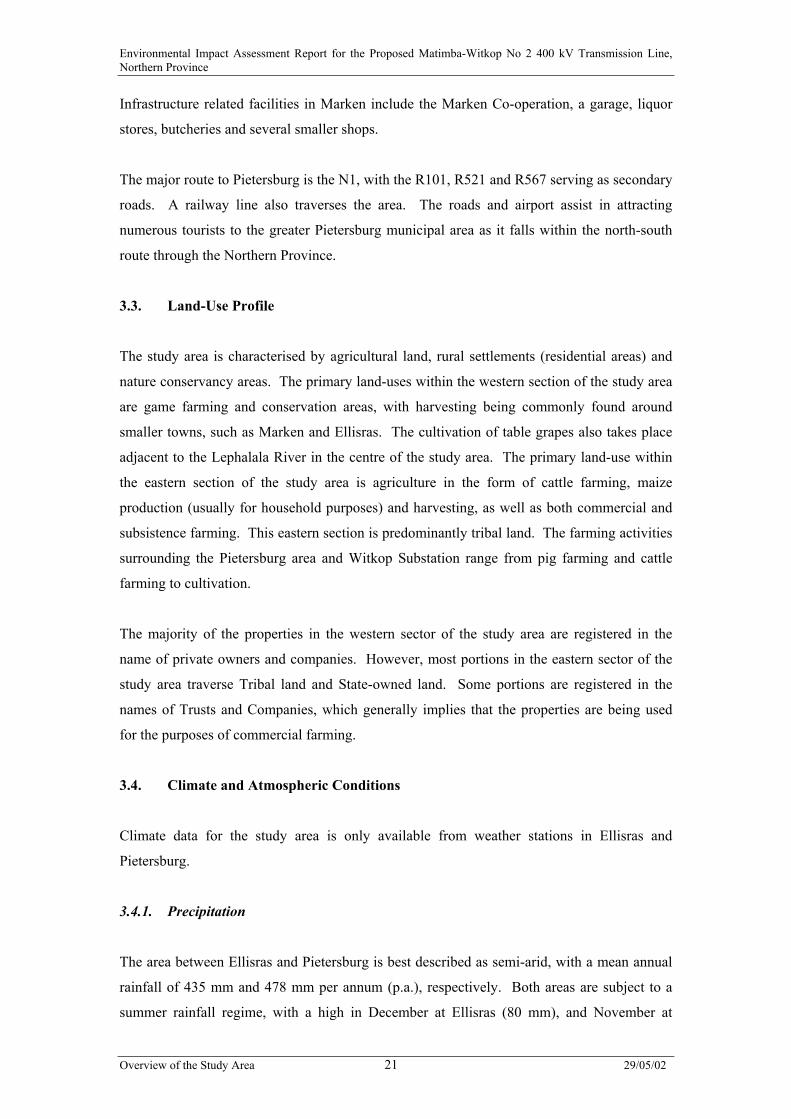
3.4.4. Lightening
The lightening Ground Flash Density in the study area is between 3 to 9 strikes/km2/year
(refer to Figure 3.1 overleaf).
3.4.5. Extreme Events
Thunderstorm activity occurs on average 44 days a year at Pietersburg, with most activity
concentrated in the summer months when it can be expected more than seven days a month
during November, December and January. The least thunderstorm activity occurs in winter,
with a low in July (0,4 events per month). A maximum gust of 39,4 m/s (adjusted to sea
level) can be expected every 50 years at Pietersburg (Anon., 1975).
Environmental Impact Assessment Report for the Proposed Matimba-Witkop No 2 400 kV Transmission Line,Northern Province
Overview of the Study Area 29/05/0223
Figure 3.1: Lightening density map
Environmental Impact Assessment Report for the Proposed Matimba-Witkop No 2 400 kV Transmission Line,Northern Province
Overview of the Study Area 29/05/0224
3.5. Topography
The study area traverses undulating topography within the Limpopo River catchment,
punctuated by isolated koppies (e.g. Tafelkoppe, Height = 1 189 m) and inselbergs (e.g.
Mamothololo, Height = 1 254 m), becoming hilly in the south-east. The area between
Marken and the Mogalakwena River is rugged terrain, being dominated by a band of steep
rocky terrain, rising to elevations of 1 200 m amsl. This rocky range forms part of the
Waterberg Biosphere Reserve and Masebe Nature Reserve areas.
Elevations range from 810 m at the confluence of the Makolo and Tambotie rivers in the west
to 1 614 m in the extreme south-east of the study area.
3.6. Surface Water
Four tributaries of the Limpopo River, namely (from west to east) the Mokolo, Lephalala,
Mogalakwena and Sand intersect the corridors while draining northwards towards the
Limpopo River.
3.7. Geology and Soils
The Tafelkoppe and Ga-Mabula in the far west of corridor 1 are likely to owe their origins, at
least in part, to resistant sediments of the Swartrand Formation (Karoo Sequence). Further
east, the higher lying areas on the farm Lilie Fontein 506 LR are underlain by the sandstones
and conglomerates of the Mogalakwena Formation (Waterberg Group). The same resistant
units are associated with the rugged terrain west of Skrikfontein se Nek on the farms
Schurwepoort 502 LR and Klip Bank 713 LR. To the south-east, Mamothololo is underlain
by a diabase sill within the Nebo Granite (Lebowa Suite - Bushveld Igneous Complex). The
extreme south-eastern segment of corridor 1 and the surrounding area is underlain by the Hout
River Gneiss, Mashashane Suite (Lunsklip and Uitloop granites), Turfloop and Geyser
granites, diabase dykes and metasediments and volcanics of the Pietersburg Group.
3.7.1. Mineral Deposits
A number of deposits are known from within or immediately adjacent to the study area.
These include active and abandoned mines, and unworked deposits for beryllium, building
sand, feldspar, gold, mica, platinum, nickel, copper, and stone aggregate.

Environmental Impact Assessment Report for the Proposed Matimba-Witkop No 2 400 kV Transmission Line,Northern Province
Overview of the Study Area 29/05/0225
3.7.2. Dolomitic/Limestone Areas
Dolomitic material in the form of marble is known from the Bandelierkop Complex and
Gumbu Group of the Beit Bridge Complex, while the Chuniespoort Group occurs as
serpentinised dolomitic xenoliths within the Bushveld Igneous Complex (Brandl, 1986). In
addition, a thin limestone unit (thickness ca. 300 mm) has been described from exposures
near the Limpopo River from within the Wellington Formation of the Karoo Sequence
(Brandl, 1996). None of these units as found within the corridors are expected to facilitate
sinkhole formation.
Dolomites and limestones are largely restricted to the Duitschland Formation (Vd) and
Malmani Subgroup (Vmd) of the Chuniespoort Group south of Pietersburg, neither of which
underlie the study area. Both of these units are, however, present in close proximity to the
south-eastern extremity of corridor 1.
3.8. Agricultural Potential
The study area crosses a total of 34 land types. The soils were classified according to
MacVicar, et al (1977). Each land type is a unique combination of soil pattern, terrain and
macroclimate. Figures 3.2a and 3.2b indicate land type boundaries (single solid lines) in
relation to the proposed Transmission line corridors (double dashed lines). The main
characteristics of each land type are provided in Appendix L.
In general, the land types with a higher agricultural potential are those containing higher
proportions of red and/or yellow soils, as well as the alluvial areas. Some land types show a
mixture of soils of varying potential. The land types with mainly rock and shallow soils have
a low agricultural potential and usually have significantly steeper slopes throughout most of
the land type.
Land type Ea208 (black, swelling clays), which covers a small section of the eastern portion
of the study area, consists mainly of fairly deep, black, swelling clay (turf) soils, which have a
moderate agricultural potential. The mainly smectitic nature, with consequent shrinking and
swelling properties, of the Arcadia (turf) soils means that there is a narrower moisture range
for cultivation than other agricultural soils. If the swelling clay soils become wet, the pores
fill up, they saturate easily and drain slowly, causing anaerobic conditions (especially under
irrigation) and a deficit of oxygen in the root zone. If allowed to dry out, however, these soils
can crack, damaging roots.

Environmental Impact Assessment Report for the Proposed Matimba-Witkop No 2 400 kV Transmission Line,Northern Province
Overview o
Figure 3.
f the Study Area 29/05/0226
2a: Land type boundaries for western section of study area (single solid lines)
shown in relation to the proposed Transmission line corridors (double dashed
lines)

Environmental Impact Assessment Report for the Proposed Matimba-Witkop No 2 400 kV Transmission Line,Northern Province
O
F
verview of the Study Area 29/05/0227
igure 3.2b: Land type boundaries for eastern section of study area (single solid lines)
shown in relation to the proposed Transmission line corridors (double dashed
lines)
Environmental Impact Assessment Report for the Proposed Matimba-Witkop No 2 400 kV Transmission Line,Northern Province
Overview of the Study Area 29/05/0228
Surface crusting is also a potential problem, due to the swelling and sealing nature of the
soils, which can lead to increased infiltration rates. However, the black clay soils are
naturally fertile, with high cation exchange capacities and high organic carbon contents. If
well managed, they can be productive soils.
3.9. Flora
3.9.1. Vegetation Types and Condition within the Study Area
Four vegetation types occur within the study area (Low & Rebelo, 1996). Mixed Bushveld
(Vegetation Type 18, Low & Rebelo 1996) is the dominant vegetation type within the study
area (75 – 82%). Other vegetation types include Sweet Bushveld (Vegetation Type 17, Low
& Rebelo 1996), Sour Bushveld (Vegetation Type 12, Low & Rebelo 1996), and a narrow
strip of Clay Thorn Bushveld (Vegetation Type 14, Low & Rebelo 1996; refer to Figure 3.3).
Large areas of the Mixed Bushveld to the east of the Waterberg Biosphere Reserve, as well as
most of the Clay Thorn Bushveld are cultivated (approximately 40%). The rural areas utilised
for grazing display various degrees of degradation, depending on the stocking rates and level
of farm management. Serious degradation due to overgrazing and the absence of correct
grazing management programs was recorded within these rural areas. Another feature of the
rural agricultural areas within this section of the study area is the almost total eradication of
all trees and shrubs.
To the west of, and within the Waterberg Biosphere Reserve, most of the area is utilised for
grazing (livestock, game or mixed systems), especially within corridor 1, which traverses an
area known for its rugged terrain. The bush in this area is very dense in certain areas, with the
tree canopy layer often growing quite tall (15 - 20 m). Within corridor 2, the tree layer is
typically shorter, the soils are generally deeper, and crop production may be the main
agricultural activity on some farms. Various instances of bush encroachment were also
recorded within all corridors with Dichrostachys cinerea (sicklebush) and Acacia tortilis
being the main encroacher species.
3.9.2. Red Data Species
None of the plant species recorded in the study area are found in the “Red Data List of
Southern African Plants” (Craig Hilton-Taylor, 1996) or on the updated PRECIS database of
the National Botanical Institute (NBI), Pretoria.
Environmental Impact Assessment Report for the Proposed Matimba-Witkop No 2 400 kV Transmission Line,Northern Province
Overview of the Study Area 29/05/0229
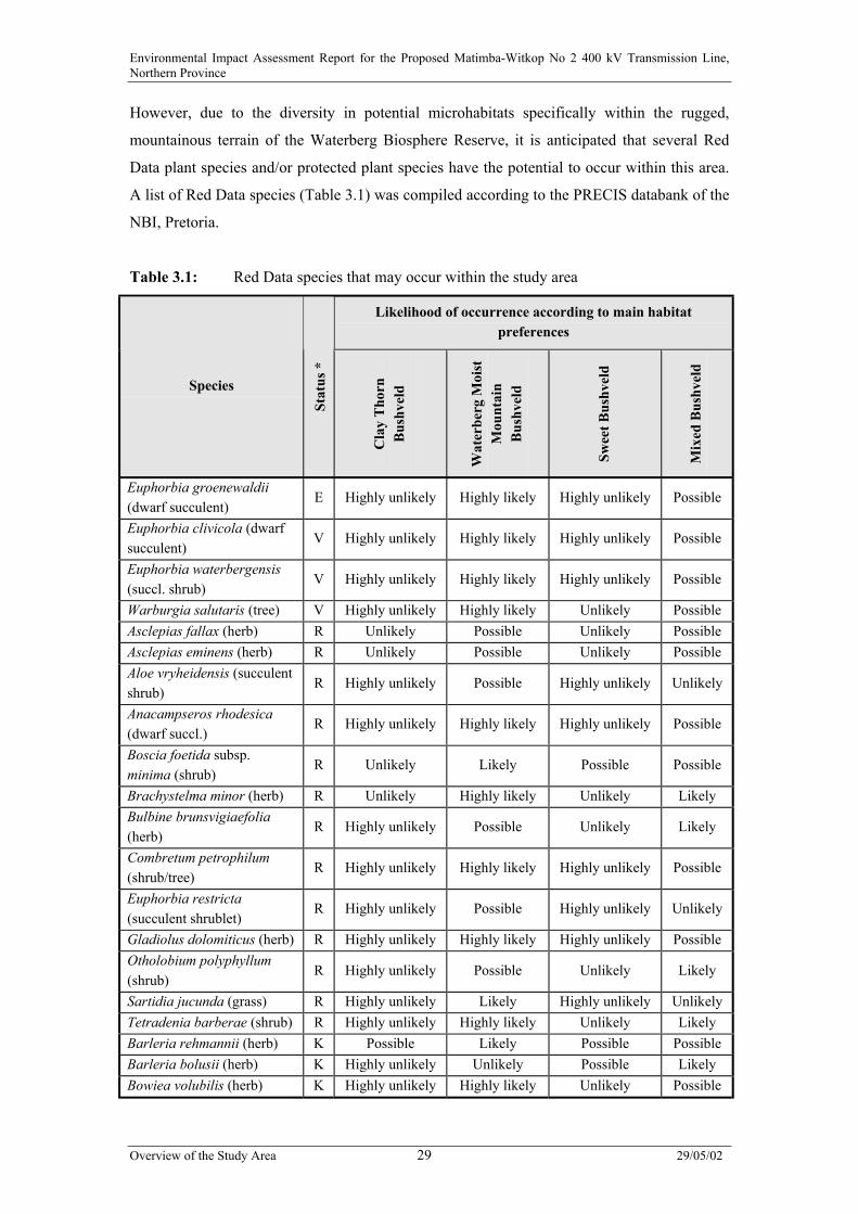
However, due to the diversity in potential microhabitats specifically within the rugged,
mountainous terrain of the Waterberg Biosphere Reserve, it is anticipated that several Red
Data plant species and/or protected plant species have the potential to occur within this area.
A list of Red Data species (Table 3.1) was compiled according to the PRECIS databank of the
NBI, Pretoria.
Table 3.1: Red Data species that may occur within the study area
Likelihood of occurrence according to main habitatpreferences
Species
Stat
us *
Cla
y T
horn
Bus
hvel
d
Wat
erbe
rg M
oist
Mou
ntai
nB
ushv
eld
Swee
t Bus
hvel
d
Mix
ed B
ushv
eld
Euphorbia groenewaldii(dwarf succulent)
E Highly unlikely Highly likely Highly unlikely Possible
Euphorbia clivicola (dwarfsucculent)
V Highly unlikely Highly likely Highly unlikely Possible
Euphorbia waterbergensis(succl. shrub)
V Highly unlikely Highly likely Highly unlikely Possible
Warburgia salutaris (tree) V Highly unlikely Highly likely Unlikely PossibleAsclepias fallax (herb) R Unlikely Possible Unlikely PossibleAsclepias eminens (herb) R Unlikely Possible Unlikely PossibleAloe vryheidensis (succulentshrub)
R Highly unlikely Possible Highly unlikely Unlikely
Anacampseros rhodesica(dwarf succl.)
R Highly unlikely Highly likely Highly unlikely Possible
Boscia foetida subsp.minima (shrub)
R Unlikely Likely Possible Possible
Brachystelma minor (herb) R Unlikely Highly likely Unlikely LikelyBulbine brunsvigiaefolia(herb)
R Highly unlikely Possible Unlikely Likely
Combretum petrophilum(shrub/tree)
R Highly unlikely Highly likely Highly unlikely Possible
Euphorbia restricta(succulent shrublet)
R Highly unlikely Possible Highly unlikely Unlikely
Gladiolus dolomiticus (herb) R Highly unlikely Highly likely Highly unlikely PossibleOtholobium polyphyllum(shrub)
R Highly unlikely Possible Unlikely Likely
Sartidia jucunda (grass) R Highly unlikely Likely Highly unlikely UnlikelyTetradenia barberae (shrub) R Highly unlikely Highly likely Unlikely LikelyBarleria rehmannii (herb) K Possible Likely Possible PossibleBarleria bolusii (herb) K Highly unlikely Unlikely Possible LikelyBowiea volubilis (herb) K Highly unlikely Highly likely Unlikely Possible

Environmental Impact Assessment Report for the Proposed Matimba-Witkop No 2 400 kV Transmission Line,Northern Province
Overview of the Study Area 29/05/0230
Likelihood of occurrence according to main habitatpreferences
Species
Stat
us *
Cla
y T
horn
Bus
hvel
d
Wat
erbe
rg M
oist
Mou
ntai
nB
ushv
eld
Swee
t Bus
hvel
d
Mix
ed B
ushv
eld
Euphorbia louwii (succulentshrub)
K Highly unlikely Highly likely Highly unlikely Possible
Lophacme digitata (grass) K Highly unlikely Likely Unlikely PossibleLoudetia pedicellata (grass) K Highly unlikely Possible Unlikely LikelyMelhania integra (herb) K Highly unlikely Possible Unlikely LikelyMosdenia leptostachyus(grass)
K Highly unlikely Possible possible Likely
Ozoroa albicans (shrub) K Highly unlikely Likely Unlikely PossibleParapodium costatum (herb) K Unlikely Likely Possible Likely
Rhynchosia nitens (shrub) K Possible Likely PossibleHighlylikely
Salvia dolomitica (shrub) K Highly unlikely Likely Unlikely LikelyTristachya biseriata (grass) K Highly unlikely Likely Unlikely PossibleR – Rare; V – Vulnerable; K – Insufficiently known
According to this list, the following breakdown of red data species occurrence can be made:
• Endangered Species: At least one species that is categorised as Endangered (Euphorbia
groenewaldii, dwarf succulent) may occur in the study area, with a high likelihood of
occurrence in the Waterberg Moist Mountain Bushveld corridor 1.
• Vulnerable Species: three Vulnerable species, i.e. Euphorbia clivicola (dwarf succulent),
Euphorbia waterbergensis (succl. shrub) and Warburgia salutaris (tree), have a high
likelihood of occurrence in the same area.
• Rare Species: Thirteen Rare species may possibly occur within the study area, of which
six may in all likelihood occur along corridor 1 in the Waterberg Moist Mountain
Bushveld (Table 3.1).
• Another thirteen species which is insufficiently Known may also occur within the study
area (Table 3.1).
A permit is required to be obtained for the removal of any Red Data plant species, in terms of
Article 98 of the Transvaal Nature Conservation Ordinance (No 12 of 1983), which applies to
the old Transvaal area including the Northern Provcince.

Environmental Impact Assessment Report for the Proposed Matimba-Witkop No 2 400 kV Transmission Line,Northern Province
Overview of the Study Area 29/05/0231
Apart from the Red Data species, several species occurring in the study area are listed in the
Transvaal Nature Conservation Ordinance (No 12 of 1983) as protected and specially
protected plants:
• Scadoxis multiflora
• Huernia hystrix
• Amocharis coranica
• Aloe – several species
• Cussonia - several species
• Protea - several species
3.10. Terrestrial Fauna
The Waterberg Biosphere area is rich in biodiversity and habitat. Endangered species such as
black rhino, roan and sable antelope all have been successfully reintroduced into the area.
Other species which have been reintroduced into the area include lion, elephant, hippo,
leopard, buffalo and numerous antelope species.
Threatened/endemic wildlife occurring in the Waterberg Biosphere Reserve area include the
Waterberg Dwarf Gecko, the Waterberg Girdled Lizard, and the Waterberg Flat Lizard.
These species are virtually restricted to this rugged terrain. Both the Dwarf Flat Lizard and
the Relict Flat Lizard have global ranges restricted to the Waterberg and nearby Soutpansberg
(Barnes, 1998).
3.11. Avifauna
Vegetation type is one of the most important factors influencing bird distribution (Harrison et.
al, 1997), as it directly influences the species composition, abundance and range. The study
area falls within the Pietersburg Plateau. The original vegetation that prevailed in the area
contained elements of arid woodland, moist woodland and sour grassland. In general, the
western section of the study area between the Matimba Substation and the Masebe Nature
Reserve is generally far less impacted by human activity than the eastern section of the study
area up to the Witkop Substation.
Environmental Impact Assessment Report for the Proposed Matimba-Witkop No 2 400 kV Transmission Line,Northern Province
Overview of the Study Area 29/05/0232
3.11.1. Western Section of Study Area
The dominant land use within the western section of the study area is commercial game farms
and nature reserves (e.g. the Waterberg Biosphere Reserve that contains the Masebe Nature
Reserve and the Moepel Farms Nature Reserve). The habitat is generally intact, except for
areas around human settlements where some subsistence farming is evident. The area is
mostly savanna, with a distinct grassy understorey and woody upperstorey of trees and tall
shrubs. Elements of arid woodland (Acacia woodland on alluvial plains) and moist woodland
(broadleaved woodland on higher slopes) are interwoven. Several large drainage lines cross
through the area, including the Mokolo, Mogalakwena and Lephalala rivers. Intensively
irrigated agricultural land is maintained in a narrow strip along these river courses.
3.11.2. Eastern Section of Study Area
The eastern portion of the study area falls within woodland bordered by densely populated,
rural townships. The original vegetation cover within this area has been extensively degraded
by human activity, particularly as a result of bush clearing to make way for grazing, dry land
cultivation and settlements. Erosion is also extensive in places. However, pockets of the
original vegetation survive intact. The area is characterised by extensive electrical
infrastructure development, since the Witkop Substation is located here. This substation
serves as the central point for many high voltage Transmission lines running to and from it.
The area also contains a substation with several powerlines emanating from here. The area
has a high population density, with many smallholdings. The land cover is a patchwork of
agricultural land, including several irrigated fields adjacent to the Witkop Substation, and
degraded woodland.
3.12. Tourism Attractions
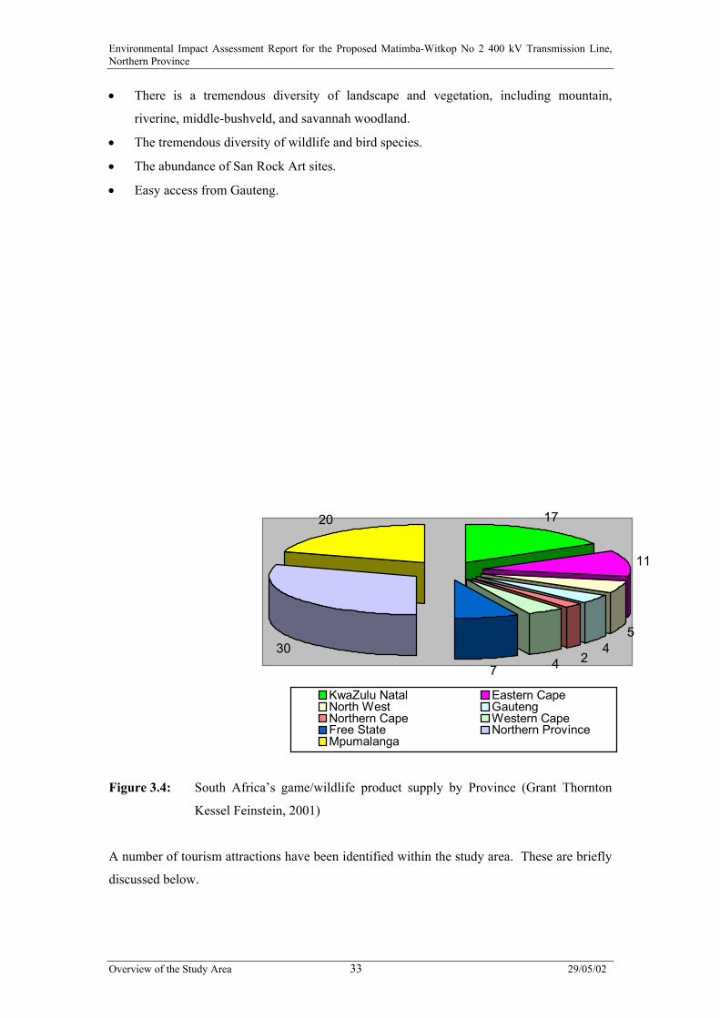
The Northern Province offers nearly a third of South Africa’s game and wildlife product
(30%), followed closely by Mpumalanga (20%), KwaZulu-Natal (17%) and the Eastern Cape
(11%). The Northern Province and Mpumalanga together comprise close to half of South
Africa’s game and wildlife product (refer to Figure 3.4 overleaf).
The popularity of the Northern Province, and particularly the Waterberg Region for eco-
tourism development is related to the following:
• The area is deemed to be malaria free.
Environmental Impact Assessment Report for the Proposed Matimba-Witkop No 2 400 kV Transmission Line,Northern Province
Overview of the Study Area 29/05/0233
• There is a tremendous diversity of landscape and vegetation, including mountain,
riverine, middle-bushveld, and savannah woodland.
• The tremendous diversity of wildlife and bird species.
• The abundance of San Rock Art sites.
• Easy access from Gauteng.
17
11
54
24730
20
KwaZulu Natal Eastern CapeNorth West GautengNorthern Cape Western CapeFree State Northern ProvinceMpumalanga
Figure 3.4: South Africa’s game/wildlife product supply by Province (Grant Thornton
Kessel Feinstein, 2001)
A number of tourism attractions have been identified within the study area. These are briefly
discussed below.
Environmental Impact Assessment Report for the Proposed Matimba-Witkop No 2 400 kV Transmission Line,Northern Province
Overview of the Study Area 29/05/0234
3.12.1. D’Nyala Game Reserve
D’Nyala Nature Reserve, 8 281 ha in extent, is situated approximately 10 km south of Ellisras
on the new Vaalwater road. Tourism-related activities within this reserve include a hiking
trail, a game viewing route, and bird-watching facilities.
3.12.2. Zingela Lodge
Zingela Lodge (more commonly known as Ellington Ranch) is situated approximately 18 km
west of Ellisras. The 9 600 ha reserve is a combination of four freehold farms. The reserve is
used exclusively for commercial hunting and the breeding of endangered species, such as
sable antelope.
3.12.3. Rhinoland Safaris
Situated west of Marken, Rhinoland Safaris comprises of a 14 000 ha game farm, which is
used for both hunting and photographic safaris. Wildlife species include white rhino, giraffe,
sable, impala, blue wildebeest, zebra, tsessebe, gemsbok, nyala and eland, as well as
numerous other antelope species.
3.12.4. The Waterberg Biosphere Reserve
The Waterberg Biosphere Reserve was initiated in 1995 and was registered in March 2001
and accredited to the UNESCO MaB programme (refer to www.unesco.org/mab/brlist.htm).
The Waterberg Biosphere Reserve extends for more than 150 000 ha, and includes formal
conservation areas such as nature reserves, game sanctuaries, and a vast number of private
farms. In accordance with the parameters laid down by UNESCO, the Waterberg Biosphere
is structured as follows:
• A core area of 114 571 ha. This is required to be an area within the total biosphere
system that has high status and is linked to some significant ecological factor, such as the
protection of rare plants.
• A buffer zone of 150 000 ha. It is within this zone that general activities, such as
hunting, tourism and environmental education, may be practised. The principle objective
within this zone must, however, be conservation.
• A transitional zone of 1 500 ha. It is within this zone that farming activities and
communities can be accommodated.

Environmental Impact Assessment Report for the Proposed Matimba-Witkop No 2 400 kV Transmission Line,Northern Province
Overview of the Study Area 29/05/0235
A number of luxury game lodges and eco-tourism ventures have been initiated within the
Biosphere, including:
• Lapalala Wilderness, a 26 000 ha reserve.
• Touchstone Game Lodge, a luxury game lodge situated within a 17 500 ha reserve.
• Keta Private Nature Reserve, a private luxury game hunting lodge situated within a
18 000 acre reserve.
• Mangweni Game Lodge, a luxury game lodge situated within the central Waterberg
Biosphere.
• Kwalata Game Ranch, a game lodge situated in a 900 ha reserve.
Masebe Nature Reserve falls within the Waterberg Biosphere, and is a thickly wooded, mixed
bushveld reserve of 4 546 ha in extent on the Potgietersrus/Marken road. San paintings are
found on some of the cliffs typical found in this reserve. Two trails of 11 km and 17 km
traverse the reserve.
Moepel Farms is situated within the Waterberg Biosphere Reserve and comprises of a number
of freehold farms, which have been settled on by previously disadvantaged communities. The
main activity in this area is cattle farming, although some subsistence agricultural activities
are undertaken.
3.12.5. Twiga Wildlife Sanctuary
Twiga Wildlife Sanctuary is situated approximately 9 km south-west of Marken, and
comprises of a total area of approximately 2 300 ha. Approximately 600 ha have been set
aside as an endangered breeding species sanctuary, and currently tuberculosis (TB) free
buffalo, roan antelope and white rhino are being bred under supervised conditions within this
reserve.
3.12.6. Witvinger Nature Reserve
The Witvinger Nature Reserve is approximately 4 450 ha in extent, and is situated to the
south of the study area between Potgietersrus and Pietersberg. The reserve has a variety of
habitats and landscape, including open plains and mountains. Wildlife species include
Environmental Impact Assessment Report for the Proposed Matimba-Witkop No 2 400 kV Transmission Line,Northern Province
Overview of the Study Area 29/05/0236
bushbuck, kudu, reedbuck, tsessebe, leopard and zebra. It is not envisaged that the reserve
will be developed for tourism-related activities in the foreseeable future.
3.12.7. Percy Fyfe Nature Reserve
Percy Fyfe Nature Reserve is situated to the south of the study area, approximately 35 km
north-east of Pietersburg. This reserve has been successfully used to breed threatened
antelope, especially roan and tsessebe.
Tourism-related activities within the reserve include camping facilities, game viewing, a one-
day hiking trail and a circular mountain-bike trail, which forms part of the Thabaphaswa
Mountain Bike Trails.
Environmental Impact Assessment Report for the Proposed Matimba-Witkop No 2 400 kV Transmission Line,Northern Province
Overview of the Study Area 29/05/0237
3.12.8. Kuschke Nature Reserve
Kuschke Nature Reserve is situated south of Pietersburg and in close proximity to the existing
Witkop Substation. The reserve comprises of two separate farm portions, totalling
approximately 2 100 ha in extent. The activities currently undertaken on the farm portions
include pig farming, chicken farming, nature conservation, beef farming and tourism-related
activities. Wildlife species include warthog, impala, blesbuck, bushpig, anteater, and a
variety of bird species. This reserve is a well establish Agricultural School, which was
founded on 6 July 1935.
3.12.9. Other Tourism Attractions in the Study Area
Numerous small eco-tourism and hunting operations have been identified within the study
area, mainly between Ellisras and Marken. Some farmers in the Marken area are in the
process of forming a conservancy of several thousands of hectares (approximately 60 000 ha)
aiming to promote conservation and tourism related activities, and thereby creating
employment opportunities for the local community.
3.13. Visual/Aesthetic Aspects
Critical areas within the study area in terms of views and visibility include tourism-focussed
areas such as the Waterberg Biosphere Reserve area (including Masebe Nature Reserve), and
private game farms (such as Zingela Lodge, Rhinoland Safaris, Keta Nature Reserve, etc),
public routes, and residences located in close proximity to the proposed corridors.
The numerous existing Transmission and Distribution lines which occur within the study area
impose an existing visual impact on the study area. The existing Matimba-Witkop No 1
400 kV Transmission line traverses the visually sensitive Waterberg Biosphere area, and
crosses the roads within the study area in several places.
The study area is currently dissected by several roads. Views from these public routes are
impacted on where introduced infrastructure (such as Transmission and Distribution lines,
railway lines, and fence lines) is located close to, or crosses the road.
Environmental Impact Assessment Report for the Proposed Matimba-Witkop No 2 400 kV Transmission Line,Northern Province
Overview of the Study Area 29/05/0238
3.14. Sites of Archaeological, Cultural and Historical Interest
A number of heritage sites were identified within the study area. These are detailed on Figure
3.5, and discussed below.
• Site 1 (23º 38' 37,6" S; 27º 52'53,8" E):
A small scattering of Late Stone Age (LSA) tools was found at this site. No cores or
unmarked flakes were present and combined with the small number of tools. This site
can not be seen as representing a manufacturing site.
• Site 2 (23º 35'18,5" S; 28º 31' 50,3" E):
A community graveyard at the village of Kafferboom with approximately 50 graves next
to the dirt road. The graveyard is still in use.]
• Site 3 (23º 41' 32,5" S; 28º 08' 42,1" E):
A surface scatter of potsherds, daga fragments and even a few stone tools occur at this
site. The scatter was of low density and was found in the neck between two hills. The
surrounding areas were very rocky as opposed to this area, which was without rocks. A
fragment of a grinding stone was also found. Evidence of hut clay or a daga fragment
was found all over the site. Possible features like dilapidated stone walls were also
encountered. The site extended over an area at the foot of one hill and measured
approximately 50 m x 120 m. The site was not very big or rich in feature and artifacts.
The Euphoribias growing on the side of the hill were most probably brought in by
occupants.
• Site 4 (23º 41' 20,7" S; 28º 08' 40,6" E):
A small concentration of slag and tuyére fragments was found in the road. The road was
slightly graded open to expose scatter. The concentration measured approximately
20 m x 30 m but was of a very low density.
• Site 5 (23º 41' 33,6" S; 28º 11' 59,1" E):
A low density scatter of stone tools was found in a sandy area in-between a stretch of
exposed rocks. The stone tools consisted of cores, flakes, scrapers and blades. The area
measured approximately 100 m x 100 m. Only a surface scatter was found with
reworked cores. This was not a production site.
Environmental Impact Assessment Report for the Proposed Matimba-Witkop No 2 400 kV Transmission Line,Northern Province
Overview of the Study Area 29/05/0239
• Site 6 (23º 41' 32,9" S; 28º 12' 33,2" E):
A concentration of Late Stone Age tools and microliths were found. The area is slightly
disturbed due to development of infrastructure (fencing, a road and the existing 400 kV
Transmission line).
• Site 7 (23º 41' 26,1" S; 28º 14' 51,3" E):
A low density scattering of Late Stone Age tools was found on this site.
• Site 8 (23º 45' 15" S; 28º 43' 03" E):
Abandoned stretches of low stone walling were found. The stone walling was of a recent
nature and could be associated with the school approximately 50 m further on. The stone
walling was abandoned after recent improvements (such as fencing) at the school
(Malapile Primary School). The stone walling appears to be an entrance to the
schoolyard.
• Site 9 (23º 45' 25" S; 28º 43' 31" E):
A cluster of eleven graves indicated by a paved stone outline dressing was found. These
are located on a ploughed field approximately 80 m from the existing 400 kV
Transmission line.
• Site 10 (23º 46' 27" S; 28º 45' 10" E):
A dilapidated hut foundation and some scattered potsherds indicate the remains of an
informal settlement. The settlement has moved during the early 1960s to a formal
village in the Vlakfontein region. The area covered a maximum of 10 ha. The area was
destroyed and damaged by the construction of a road and a powerline.
• Site 11 (24º 02' 39,7" S; 29º 20' 35,8" E):
A large number of European type structures are located in a 3 – 4 ha area. Several
porcelain and metal remains were found. Most of the inhabited area is defined by cacti
and large tracts of pioneer plant growths. The document studies seem to indicate that
these were the ruins of the Dorsland settlement, which was abandoned during the 1960s.
Although no reference to a graveyard could be found, it is highly likely that graves will
be located close to this settlement.
Environmental Impact Assessment Report for the Proposed Matimba-Witkop No 2 400 kV Transmission Line,Northern Province
Overview of the Study Area 29/05/0240
• Site 12 (23º 56' 46,4" S; 29º 03' 46,8" E):
The remains of an old farmhouse and homestead are located here. The site consists of
approximately 4 – 5 buildings within a 50 m x 50 m area. The buildings were
constructed from sundried bricks and cement.
• Site 13 (26º 02' 39,7" S; 29º 20' 35,8" E):
A historic fenced-in graveyard with 3 graves was recorded on the northern side of
Witkop Substation. The graveyard and the layout seems to indicate that the graveyard is
of Western or European origin. No names were indicated on the headstones.
• Site 14 (24º 02' 11" S; 29º 18' 01" E):
A large area on the northern side of the valley running from Witkop Power Station
towards the N1 shows indications of habitation. This was most likely a Late Stone Age
site and there is a strong possibility of gravesites being located in the vicinity.