284 - National Oceanic and Atmospheric Administration · lying between the shores of Connecticut...
30
284 ¢ U.S. Coast Pilot 2, Chapter 8 17 MAY 2020 LONG ISLAND SOUND C O N N E C T I C U T L O N G I S L A N D THAMES RIVER NIANTIC BAY HOUSATONIC RIVER Norwich New London Essex New Haven Port Jefferson 72°30'W 73°W 72°W 41°30'N 41°N Branford Harbor Guilford Harbor Westbrook Harbor Orient Point C O N N E C T I C U T R I VE R Hartford NORTH ATLANTIC OCEAN BLOCK ISLAND SOUND Chart Coverage in Coast Pilot 2—Chapter 8 NOAA’s Online Interactive Chart Catalog has complete chart coverage http://www.charts.noaa.gov/InteractiveCatalog/nrnc.shtml 12377 12373 13213 13211 12375 12374 12354 12370 12362 12378 12372 12372 12358 12371 12372
Transcript of 284 - National Oceanic and Atmospheric Administration · lying between the shores of Connecticut...

284 ¢ U.S. Coast Pilot 2, Chapter 8 17 MAY 2020
LON
G
ISL
AN
D S
OU
ND
CO
NN
EC
TI
CU
T
LO
NG
I
SL
AN
D
TH
AM
ES
RIV
ER
NIA
NT
IC B
AY
HO
USA
TO
NIC
RIV
ER
Nor
wic
h
New
Lon
don
Esse
x
New
Hav
en
Port
Je� e
rson
72°3
0'W
73°W
72°W
41°3
0'N
41°N
Bran
ford
Har
bor
Gui
lford
Har
bor
Wes
tbro
ok H
arbo
r
Orie
nt P
oint
CO
NN
EC
TI C
UT
RI V
E R
Har
tfor
d
NO
RT
H
AT
LA
NT
IC
OC
EA
N
BLO
CK
IS
LA
ND
SO
UN
D
Cha
rt C
over
age
in C
oast
Pilo
t 2—
Cha
pter
8N
OAA
’s O
nlin
e In
tera
ctiv
e C
hart
Cat
alog
has
com
plet
e ch
art c
over
age
http
://w
ww.
char
ts.n
oaa.
gov/
Inte
ract
iveC
atal
og/n
rnc.
shtm
l
1237
7
1237
313
213
1321
1
1237
5
1237
4
1235
4
1237
0
1236
2
1237
8
1237
2
1237
2
1235
8
1237
1
1237
2

17 MAY 2020 U.S. Coast Pilot 2, Chapter 8 ¢ 285
Eastern Long Island Sound
(1) This chapter describes the eastern portion of Long Island Sound following the north shore from Thames River to and including the Housatonic River and then the south shore from Orient Point to and including Port Jefferson. Also described are the Connecticut River; the ports of New London, New Haven and Northville; and the more important fishing and yachting centers on Niantic River and Bay, Westbrook Harbor, Guilford Harbor, Branford Harbor and Mattituck Inlet.
(2) COLREGS Demarcation Lines
(3) The lines established for Long Island Sound are described in 33 CFR 80.155 Chapter 2.
(4) ENCs - US4NY1GM, US4NY1JM Chart - 12354
(5) Long Island Sound is a deep navigable waterway lying between the shores of Connecticut and New York and the northern coast of Long Island.
(6) In this region are boulders and broken ground but little or no natural change in the shoals. The waters are well marked by navigational aids so that strangers should experience no difficulty in navigating them. As all broken ground is liable to be strewn with boulders, vessels should proceed with caution in the broken areas where the charted depths are not more than 6 to 8 feet greater than the draft. All of the more important places are entered by dredged channels; during fog, vessels are advised to anchor until the weather clears before attempting to enter. The numerous oyster grounds in this region are usually marked by stakes and flags. These stakes may become broken off and form obstructions dangerous to small craft. Mariners should proceed with caution especially at night.
(7) Caution
(8) Submarine operating areas are in the approaches to New London Harbor and Connecticut River and off the northern shore of Long Island. As submarines may be operating submerged in these areas, vessels should proceed with caution.
(9) Anchorages
(10) New London Harbor is the most important of the anchorages sought for shelter in the eastern part of Long Island Sound. Niantic Bay and the approach between Bartlett Reef and Hatchett Reef are used to some extent
by small vessels when meeting unfavorable weather or reaching the eastern part of the sound. Small vessels can select anchorage eastward or westward of Kelsey Point Breakwater, also in Duck Island Roads. Off Madison there is anchorage sheltered from northerly winds. New Haven Harbor is an important harbor of refuge.
(11) Several general anchorages are in Long Island Sound. (See 33 CFR 110.1 and 110.146, Chapter 2, for limits and regulations.)
(12) No-Discharge Zone
(13) The States of New York and Connecticut, with the approval of the Environmental Protection Agency, have established a No-Discharge Zone (NDZ) in Long Island Sound and a portion of the East River, extending from the Hell Gate Bridge in the west to Block Island Sound in the east (see charts 12339 and 13205 for limits).
(14) Within the NDZ, discharge of sewage, whether treated or untreated, from all vessels is prohibited. Outside the NDZ, discharge of sewage is regulated by 40 CFR 140 (see Chapter 2).
(15) Tides
(16) The time of tide is nearly simultaneous throughout Long Island Sound, but the range of tide increases from about 2.5 feet at the east end to about 7.3 feet at the west end. Daily predictions of the times and heights of high and low waters are given in the Tide Tables.
(17) The effect of strong winds, in combination with the regular tidal action, may at times cause the water to fall several feet below the plane of reference of the charts.
(18) Current
(19) In the eastern portion of Long Island Sound the current turns from ½ to 1½ hours earlier along the north shore than in the middle of the sound.
(20) Proceeding westward from The Race in the middle of the sound, the velocity of current is 1.8 knots off Cornfield Point, about 1 knot off New Haven, 1 knot off Eatons Neck, 0.4 knot between Peningo Neck and Matinecock Point and 0.5 knot eastward of Hart Island.
(21) About 1.5 miles east-southeastward of Bartlett Reef, the velocity of flood is 1.2 knots and ebb 1.6 knots. The flood current sets 285° and the ebb 062°.
(22) At a point about 3 miles southward of Cornfield Point, the flood current sets 256° with a velocity of 2 knots and the ebb sets 094° with a velocity of 1.7 knots.
(23) About 1 mile north of Stratford Shoal (Middle Ground) Light, the velocity is 1 knot, the flood setting

286 ¢ U.S. Coast Pilot 2, Chapter 8 17 MAY 2020
westward and the ebb eastward. (See Tidal Current Tables for predictions.)
(24) Weather, Long Island Sound and vicinity
(25) Weather is most favorable from mid-May to mid-October, when the most common hazards are thunderstorms and fog. There is also a rare threat of a tropical cyclone. During June, July and August on the average, there are 20 to 25 days per month with conditions generally considered ideal even for small boaters. Fog is most likely in spring and early summer. Fog, or the lack of it, at inland locations is not a guide to conditions in the Sound or its approaches. Areas along the coast, at the heads of bays and within rivers may be relatively clear, while offshore the fog is thick. For example, on exposed Block Island heavy fog is encountered about 10 to 12 percent of the time from April though August compared to 1 to 3 percent at Westhampton. Thunderstorms on the other hand are more likely over land but can be viscous in the Sound, especially in a squall line preceding a cold front in spring and early summer. Winter winds are mostly out of the west through north, but gales blow less than 5 percent of the time in these somewhat sheltered waters. Waves are restricted by limited fetch except to the east. However, choppy conditions can create problems.
(26) Ice
(27) In ordinary winters the floating and pack ice in Long Island Sound, while impeding navigation, does not render it absolutely unsafe, but in exceptionally severe winters the reverse is true; none but powerful steamers can make their way.
(28) Drift ice, which is formed principally along the northern shore of the sound under the influence of the prevailing northerly winds, drifts across to the southern side and accumulates there, massing into large fields, and remains until removed by southerly winds, which drive it back to the northerly shore.
(29) In ordinary winters ice generally forms in the western end of the sound as far as Eatons Neck; in exceptionally severe winters ice may extend to Falkner Island and farther eastward.
(30) Effects of winds on ice
(31) In Long Island Sound northerly winds drive the ice to the southern shore of the sound and southerly winds carry it back to the northern shore. Northeasterly winds force the ice westward and cause formations heavy enough to prevent the passage of vessels of every description until the ice is removed by westerly winds. These winds carry the ice eastward and, if of long duration, drive it through The Race into Block Island Sound, thence it goes to sea and disappears.
(32) In New Haven Harbor, the influence of the northerly winds clears the harbor and its approaches unless the local formation is too heavy to be moved. Southerly
winds force the drift ice in from the sound and prevent the local formations from leaving the harbor. Tides have little effect upon the ice. Additional information concerning ice conditions in the waters adjoining Long Island Sound is given under the local descriptions.
(33) Vessel Traffic Service, New York, operated by the U.S. Coast Guard, serves New York Harbor. (See 33 CFR 161.1 through 161.25, Chapter 2, for regulations.)
(34) Pilotage, Long Island Sound
(35) Pilotage by a state licensed pilot is compulsory in Long Island Sound for foreign flag vessels and U.S. vessels that are under register (i.e. engaged in foreign trade). Such vessels can arrange for a state licensed pilot by contacting the joint rotation administrator, Block Island Pilots, at 243 Spring Street, Newport, RI 02840; telephone 401–847–9050 (24 hours), 800–274–1216; FAX 401–847–9052. Enrolled vessels (i.e., U.S. vessels engaged in coastwise trade) may be required to have a U.S. Coast Guard Federally licensed pilot unless the master has recency for the intended area.
(36) The pilot boat sets radio guard at least 1 hour before a vessel’s ETA.
(37) Vessels to be boarded should provide a ladder 3 feet above the water on the lee side.
(38) Pilot services must be arranged at least 24 hours in advance through ships’ agents or directly by shipping companies.
(39) Pilotage, in the waters of Long Island Sound for enrolled vessels (i.e. U.S. vessels engaged in coastwise trade), is available from, but not limited to:
(40) Northeast Marine Pilots, Inc., 243 Spring Street, Newport, RI 02840; nemarinepilots.com; telephone 401–847–9050 (24 hours), 800–274–1216; FAX 401–847–9052. Pilot boats are NORTHEAST IV, 52-foot, gray hull and superstructure, word PILOT on both sides and NORTHEAST II, 47-foot, gray hull and superstructure, word PILOT on both sides. The boats monitor VHF-FM channels 16, 10, 13, 14; work on 10.
(41) Interport Pilots Agency, Inc./Connecticut State Pilots, P.O. Box 236, Port Monmouth, NJ 07758; interportpilots.com; telephone 732–787–5554 (24 hours); email: [email protected]. Pilot boats are CONNECTICUT PILOT, 65-foot with blue hull and white superstructure and KEN JOHNSON, 48-foot with blue hull and white superstructure. These boats monitor VHF-FM channels 16 and 13, work on 11 and are equipped with AIS.
(42) Constitution State Pilots Association, 9 Nottingham Drive, Old Lyme, CT 06371, telephone 203–627–5057. Pilot boat is CONSTITUTION, 65-foot with black hull and white superstructure displaying the word PILOT on both sides. The boat monitors VHF-FM channels 16, 13 and 9A; works on 13 or 9A.
(43) Connecticut River Pilots Association (CRPA), P.O. Box 107, Old Saybrook, CT 06475; telephone 860–388–4167. Pilot boat TRUDEE II is 36-foot, with black hull, white superstructure, and with the word PILOT on the

17 MAY 2020 U.S. Coast Pilot 2, Chapter 8 ¢ 287
house, forward. The boat monitors VHF-FM channels 16 and 13; works on 13.
(44) See Pilotage, New London-Groton (indexed as such), this chapter; Pilotage, New Haven (indexed as such), this chapter; Pilotage, Bridgeport (indexed as such), Chapter 9; Pilotage, Offshore Terminal, Northville-Riverhead (indexed as such), this chapter; and Pilotage, Offshore Terminal, Northport (indexed as such), Chapter 9.
(45) ENCs - US5CN43M, US5CN42M, US5CN20M Charts - 13213, 13212, 12372
(46) New London Harbor, near the east end of Long Island Sound at the mouth of the Thames River, is an important harbor of refuge. Vessels of deep draft can find anchorage here in any weather and at all seasons.
(48) Waterborne commerce in New London Harbor and on the Thames River is chiefly in petroleum products, chemicals, coal, copper, lumber, seafood products and general cargo.
(49) Security zones have been established in New London Harbor. (See 33 CFR 165.1 through 165.7, 165.30, 165.33, and 165.140, Chapter 2, for limits and regulations.)
(50) New London is a city on the west bank of Thames River about 2.5 miles above the mouth. The town of
Groton on the east bank is connected to New London by a highway bridge and a railroad bridge. The main harbor comprises the lower 3 miles of Thames River from Long Island Sound to the bridges and includes Shaw Cove, Greens Harbor and Winthrop Cove. It is approached through the main entrance channel extending from deep water in Long Island Sound to deep water in the upper harbor. The harbor is generally used by vessels drawing 9 to 30 feet; the deepest draft entering is about 36 feet. Petroleum products, seafood products, copper, lumber and other forest products are the principal waterborne commodities handled at the port.
(51) Greens Harbor, a small-craft shelter just north of the entrance, has general depths of 6 to 17 feet. Special anchorages are in the harbor. (See 33 CFR 110.1 and 110.52, Chapter 2, for limits and regulations.)
(52) New London Coast Guard Station and Fort Trumbull State Park are on the west side of the main channel northward of Greens Harbor.
(53) Shaw Cove is a dredged basin about 0.8 mile northward of Greens Harbor. In 2015, the controlling depth was 14 feet in the entrance channel through the south draw of the bridge, thence 12 feet was available in the basin.
(54) Winthrop Cove, northward of Shaw Cove, is part of the main waterfront channel.
Thames River and New London, ConnecticutImage courtesy of Airphoto/Jim Wark (2004)
N
(47)

288 ¢ U.S. Coast Pilot 2, Chapter 8 17 MAY 2020
(55) Prominent features
(56) New London Ledge Light (41°18'21"N., 72°04'39"W.), 58 feet above the water, is shown from a red brick building on a square white pier on the west side of New London Ledge. A sound signal at the light is operated by keying the microphone five times consecutively on VHF-FM channel 83A.
(57) Other prominent features in approaching New London Harbor are New London Harbor Light, on the west side of the entrance channel; the monument at Fort Griswold; the microwave tower atop a building in downtown New London; the large sheds at the shipyard on the east side of the river opposite Fort Trumbull State Park and the highway bridge at New London.
(58) Channels
(59) A U.S. Navy project for New London Harbor provides for a channel 40 feet deep to Fort Trumbull, thence 38 feet to the Submarine Force Library and Museum, thence 36 feet to the U.S. Navy Submarine Base. A federal project provides for a channel 23 feet deep in the waterfront channels north of Fort Trumbull and in Winthrop Cove. (See Notice to Mariners and latest editions of the charts for controlling depths.) Lighted and unlighted buoys and a 354° lighted range mark the channel. The range does not mark the center of the lower end of the channel.
(60) Pine Island Channel, northeastward of New London Ledge Light, between Pine Island and Black Ledge, has a rocky and very broken bottom on which the least found depth is 9 feet. It is used some by local vessels between New London Harbor and Fishers Island Sound but should be avoided by any vessel drawing more than 10 feet.
(61) Anchorages
(62) General and naval anchorages are in the approaches to, and in, New London Harbor. (See 33 CFR 110.1 and 110.147, Chapter 2, for limits and regulations.) Special anchorages are in Greens Harbor and in the vicinity of the U.S. Coast Guard Academy. (See 33 CFR 110.1 and 110.52, Chapter 2, for limits and regulations.)
(63) Dangers
(64) On the west side of the approach to New London Harbor, foul ground extends about 1 mile from shore in the vicinity of Goshen Point (chart 13211). The southerly and southeasterly limits of this area are marked by buoys. The area has numerous rocky patches and boulders, some showing above water, and should be avoided by small craft. Rapid Rock, marked by a buoy on its southeast side, is about 1.6 miles southwestward of New London Ledge Light; it has a least depth of 10 feet. An unmarked ledge covered 35 feet is about 100 yards south by eastward of Rapid Rock and is the outermost shoal to the southward. Sarah Ledge, 0.7 mile northeastward of Rapid Rock and marked by a buoy, has a least depth of 14 feet and is the easternmost shoal on the west side of the main channel approach.
(65) On the east side of the main channel foul ground extends about 1 mile offshore. New London Ledge, marked by New London Ledge Light, has a least depth of 7 feet. Black Ledge, just to the northeastward of New London Ledge, has a rocky islet, 2 feet high, on it. Depths are 5 to 18 feet on the ledge. Buoys mark the shoal area.
(66) Broken ground fringes the shore southwestward of New London Harbor Light. A rock covered 6 feet
(68)
Structures across Thames River
Name•Description•Type Location
Clear Width of Draw or Span Opening (feet)
Clear Height above Mean High Water
(feet) Information
Railroad Bridge (swing) 41°20'57"N., 72°05'50"W. 70 (north and south draw)
6 Note 1Crosses the entrance to Shaw Cove
Railroad Bridge (fixed) 41°21'32"N., 72°05'44"W. 14 4 Crosses the head of Winthrop Cove
Amtrak Thames Railroad Bridge (vertical lift) 41°21'47"N., 72°05'16"W. 150 29 (down), 135 (up) Notes 2, 3 and 4
Gold Star Memorial Bridges (fixed) 41°21'52"N., 72°05'16"W. 500 135 Vertical clearance is for a middle width of 200 feet. A racon is on the south span.
Overhead power cable 41°26'19"N., 72°05'21"W. 160
Route 2A Bridge (fixed) 41°28'54"N., 72°04'32"W. 200 75
Shetucket River
Route 2/Water Street Bridge (fixed) 41°31'25"N., 72°04'34"W. 123 18
Railroad Bridge (fixed) 41°31'25"N., 72°04'30"W. 229 13
Viaduct Road Bridge (fixed) 41°31'24"N., 72°04'30"W. 119 18
Main Street Bridge (fixed) 41°31'26"N., 72°04'08"W. 94 23
Yantic River
Route 32 Bridge (fixed) 41°31'28"N., 72°04'51"W. 62 11
Note 1 – See 33 CFR 117.1 through 117.59 and 117.223 Chapter 2, for drawbridge regulations.Note 2 – See 33 CFR 117.1 through 117.59 and 117.224 Chapter 2, for drawbridge regulations.Note 3 – Bridgetender monitors VHF-FM channel 13; call sign KT-5473.Note 4 – In 1998, it was reported that cross currents of 1 to 2 knots can be encountered in the vicinity of this bridge.

17 MAY 2020 U.S. Coast Pilot 2, Chapter 8 ¢ 289
is located about 0.1 mile from shore in the bight just southward of the light.
(67) White Rock, an islet in Greens Harbor, is 250 yards from the 18-foot curve on the western edge of the channel. Hog Back, a small ledge awash at low water, is 150 yards southwestward of White Rock and about 0.3 mile from the western shore and is marked by a buoy. Rocks, covered 2 to 6 feet, are in the middle of the northern part of Greens Harbor. Melton Ledge, northward of White Rock, with one-half foot over it, is 125 yards eastward of Powder Island and is marked by a buoy; a rock awash is close westward of Melton Ledge.
(69) Current
(70) The tidal currents follow the general direction of the channel and usually are not strong. At Winthrop Point, on the west side of the river at New London, the velocity is 0.4 knot, and at Stoddard Hill, about 6.5 miles above New London, 0.7 knot on the flood and 0.4 knot on the ebb. During freshets or when the river is high and the wind is from the north, the current can have considerable southerly set even on the flood.
(71) Ice obstructs navigation about 2 months each year above the naval station, which is some 5 miles above New London Ledge Light, but seldom forms below the station. In extremely severe winters, however, heavy ice from the sound, driven in by winds, has been known to extend about 1.8 miles above the entrance. Between New London and the mouth of the river small vessels may navigate with comparative safety in ordinary winters; even in severe weather, it is rare that navigation for small vessels stops for more than a week. Steamers can nearly always enter and leave with safety. Drift ice sometimes forms a decidedly dangerous obstruction in the approaches through Long Island Sound during severe winters, especially during February and March, and small vessels are much hindered in their movements during January, February and March.
(72) Freshets usually occur in the river in the spring. It is reported that they seldom exceed 2 feet above high water at Norwich.
(73) New London Harbor and Thames River are easy of access by day or night, but local knowledge is required to take drafts greater than 20 feet above the submarine base.
(74) Pilotage, New London-Groton
(75) Pilotage by a state-licensed pilot is compulsory in Long Island Sound for foreign flag vessels and U.S. vessels that are under register (i.e., engaged in foreign trade). Such vessels can arrange for a state-licensed pilot by contacting the joint rotation administrator, Block Island Pilots at 243 Spring Street, Newport, RI 02840; telephone 401–847–9050 (24 hours), 800–274–1216; FAX 401–847–9052. Enrolled vessels (i.e., U.S. vessels engaged in coastwise trade) may be required to have a U.S. Coast Guard federally licensed pilot unless the
master has recency for the intended area. See Pilotage, Long Island Sound (indexed as such), Chapter 8.
(76) Towage
(77) Tugs to 3,200 hp are available at New London. Vessels usually proceed to the upper harbor without assistance, although a tug may be required when entering with a head wind and contrary current. Large vessels normally require tugs for docking and undocking.
(78) New London is a customs port of entry.(79)
Quarantine, customs, immigration and agricultural quarantine
(80) (See Chapter 3, Vessel Arrival Inspections, and Appendix A for addresses.)
(81) Quarantine is enforced in accordance with regulations of the U.S. Public Health Service. (See Public Health Service, Chapter 1.) New London has several hospitals.
(82) Harbor regulations are in force for New London Harbor. The harbormaster has authority to berth vessels, shifting them if necessary, but occasion for doing so seldom arises.
(83) Wharves
(84) New London Harbor has more than 30 wharves and piers. Most of these facilities are used as repair berths and for mooring recreational craft, fishing vessels, barges, ferries and government vessels. Depths alongside these facilities range from 10 to 40 feet. Only the deep-draft facilities are described. The alongside depths are reported; for information on the latest depths contact the private operator.
(85) Amerada Hess Corp. Wharf (41°20'09"N., 72°04'58"W.): on the east side of the river opposite Greens Harbor; T-head pier with 55-foot face, 960 feet of berthing space with dolphins; 40 feet alongside; deck height, 8 feet; pipelines to storage tanks; fresh water connection; railroad and highway connections; receipt and shipment of petroleum products and receipt of molasses; bunkering vessels; owned and operated by Hess Oil and Chemical Division, Amerada Hess Corp.
(86) Admiral Shear State Pier: the more easterly of the two long piers southwestward of the Thames River bridges, about 1.3 miles northward of Amerada Hess Corp. Wharf; 200-foot face, 26 feet alongside; west side 1,000 feet, 23 to 27 feet alongside; east side 1,020 feet, 34 to 38 feet alongside; deck height, 10 feet; 90,000 square feet of covered storage, 20 acres of open storage; electricity, potable and feed water connections on pier; railroad and highway connections; receipt and shipment of general cargo, copper, zinc, steel and wood products; owned by the State of Connecticut and operated by Logistec U.S.A. Inc., a division of Logistec Stevedoring of Montreal.
(87) Supplies of all kinds are available. Gasoline and diesel oil can be obtained from oil companies on 48 hours’

290 ¢ U.S. Coast Pilot 2, Chapter 8 17 MAY 2020
notice by tank truck. Water is available at most of the piers, wharves and marinas.
(88) Repairs
(89) A shipbuilding company at New London can perform all kinds of repairs on steel-hulled vessels. The company has floating drydocks with lifting capacities from 1,000 to 10,000 tons. The company’s largest drydock is on the west side of the river and has a maximum pontoon length of 300 feet and a width between wingwalls of 110 feet and is about 0.9 mile north of the Thames River bridges.
(90) Cranes to 70 tons and floating derricks to 25 tons are available at New London.
(91) Several companies in New London are in the business of wrecking, salvage and marine contracting work. They are equipped with pumps, divers’ outfits, floating equipment and other gear.
(92) Small-craft facilities
(93) There are numerous small-craft facilities in Greens Harbor and Shaw Cove.
(94) Communications
(95) New London has good railroad and bus communications. Automobile-passenger ferry service is available to Block Island and Fishers Island and to Orient Point, Long Island.
(96) Thames River above New London has a dredged
channel to Norwich, the head of navigation. In 2006, the controlling depth was 25 feet from the bridges at New London to the north end of the turning basin opposite Smith Cove, thence 7.1 feet (14.9 feet at midchannel) to Stoddard Hill, thence 15 feet to the turning basin at Norwich with 12 feet in the turning basin except for shoaling to lesser depths near the upper limits of the basin. The channel is well marked by navigational aids.
(97) Caution
(98) The dikes along the Thames River from Easter Point (41°28.2'N., 72°04.5'W.) to Norwich are submerged at half tide.
(99) Pilotage, Thames River
(100) For Pilotage for the river see Pilotage, New London-Groton (indexed as such) earlier this chapter.
(101) The U.S. Coast Guard Academy is on the west
side of Thames River about 1 mile north of the center of New London. The administration building, with its white tower and clock, and the lighted chapel spire are very prominent but are not visible until almost abeam of the academy. Depths alongside the 410-foot-long academy pier were reported in 2005 to be 30 feet at the face, 30 feet along the south side and 30 to 34 feet on the north side.
(102) The U.S. Naval Submarine Base is on the east side of the Thames River about 2.5 miles above New London. USS Nautilus is permanently moored just south of the base as part of the Submarine Force Library and Museum.
(103) A restricted area is off the U.S. Naval Submarine Base. (See 33 CFR 334.75, Chapter 2, for limits and regulations.)
(104) Just below Gales Ferry, on the east side about 4 miles above the bridges, are the crew training quarters and boathouses of Harvard and Yale Universities. Opposite Gales Ferry is the town of Bartlett, site of a prominent power plant with two tall and conspicuous stacks. A privately dredged channel with depths of about 20 feet leads to the dock and coal tipple.
(105) At Montville Station, just above Bartlett, is a dock with a depth of 23 feet at the face. The northeast end of the dock is in ruins. Overhead power cables with a clearance of 160 feet cross the river 0.5 mile above the station near Kitemaug.
(106) Allyn Point, on the east side about 5 miles above New London, is the site of a large private pier for receiving liquid chemicals, with a reported depth of about 30 feet alongside. It is marked by an elevated water sphere and several small tanks on the pier.
(107) Fort Point, on the east side 8 miles above New London, has a long fuel pier marked by privately maintained red lights, and on shore is a building with several stacks. Numerous piles are in the water southward of the pier.
(108) The red brick buildings of the Norwich State Hospital are on a bluff just north of Fort Point and are a conspicuous landmark.
(109) At Thamesville, on the west side of the river about 1 mile below Norwich, are two finger piers each with breasting dolphins used to receive petroleum products from barges. Depths of 20 to 25 feet are reported alongside the face of the piers.
(110) Norwich, a city at the head of navigation on Thames River at its junction with Shetucket River and Yantic River, is about 11 miles above New London. Small boats generally anchor in Shetucket River just above the fixed bridges at Norwich.
(111) ENCs - US5CN41M, US5CN42M, US5CN20M Charts - 13211, 13212, 12372
(112) Bartlett Reef Light (41°16'28"N., 72°08'14"W.), 35 feet above the water and shown from a skeleton tower with a red and white diamond-shaped dayboard, is about 3.3 miles southwestward of New London Ledge Light and marks the south end of Bartlett Reef. A mariner-activated sound signal at the light is initiated by keying the microphone five times on VHF-FM channel 79. The reef, about 1.3 miles long in a general north-south direction and about 0.3 mile wide, is covered 2 to 18 feet and has rocks awash near its northern end. The north end of the reef is marked by a buoy. A lighted bell buoy and

17 MAY 2020 U.S. Coast Pilot 2, Chapter 8 ¢ 291
an unlighted buoy are about 0.9 mile southward and about 0.3 mile eastward of the light, respectively.
(113) A general anchorage is about 0.8 mile northeastward of Bartlett Reef Light. (See 33 CFR 110.1 and 110.147(a)(4), and (b), Chapter 2, for limits and regulations.)
(114) Twotree Island, small and bare, about 1.4 miles northwestward of Bartlett Reef Light, is surrounded by shoals. A buoy marks rocks awash that extend off the northern end of the island.
(115) Twotree Island Channel leads northward of Bartlett Reef and Twotree Island. With an adverse current in the sound, this channel is used to some extent by light tows and sailboats with a leading wind in the daytime, as the tidal currents turn about 1 hour earlier along the north shore than in the middle of the sound. About 0.3 mile southwestward of Seaside, the tidal currents have a velocity of 1.2 knots and ebb 1.6 knots. Flood sets westerly and the ebb easterly. The channel is buoyed, but strangers are advised to use it with caution and should never attempt to beat through.
(116) From Goshen Point (41°18.0'N., 72°06.8'W.) westward, there are scattered boulders that extend offshore as much as 0.2 mile in places. Jordan Cove, 1.5 miles west of Goshen Point, is foul in its northerly half, and the southerly part is obstructed by Flat Rock, bare at low water and marked by a buoy, and High Rock, which shows at high water and is marked by a buoy.
(117) Millstone Point, on the east side at the entrance of Niantic Bay, is occupied by the buildings of the Millstone Nuclear Power Station. A 389-foot red and white stack at the station and a radio tower on the point are the most conspicuous landmarks in the area. A cove with depths of 2 to 17 feet is on the west side of the point. A rock with 1 foot over it lies 60 feet off the mouth of the cove. The station maintains channel markers and a range for occasional barge traffic. A dredged area for the power station’s water intakes is 0.2 mile northwest of the cove.
(118) ENCs - US5CN41M, US5CN20M Charts - 13211, 12372
(119) White Rock is an islet on the east side of the entrance to Niantic Bay 0.5 mile westward of Millstone Point. Little Rock, two rocks partly bare at low water, is 150 yards east of White Rock. Rocks with a least depth of 8 feet extend 0.25 mile northwest from Millstone Point. A rock, covered 11 feet, is about 300 yards south-southeast of White Rock and is marked by a lighted bell buoy.
(120) Niantic Bay, 4.5 miles westward of New London Harbor, is a good anchorage sheltered from easterly, northerly and westerly winds. It is a harbor of refuge in northerly gales and can be used by small vessels and tows. The general depth of the bay is about 19 feet; the water shoals gradually northward. The entrance is 1.5 miles wide, and the dangers are marked by buoys or show above water.
(121) Niantic and Crescent Beach are summer resorts with railroad communication at the north end and northwest side of the bay.
(122) The Niantic Bay Yacht Club basin at Crescent Beach is protected on the south, east, and partially on the north side by a U-shaped breakwater; a private seasonal light is near the outer end of the breakwater.
(123) A special anchorage is on the west side of Niantic Bay off Crescent Beach. (See 33 CFR 110.1 and 110.53, Chapter 2, for limits and regulations.)
(124) Niantic River empties into the northeast end of Niantic Bay and is entered through a dredged channel that leads from the bay, thence through a narrow passage at the entrance, thence to a point about 300 yards northward of the entrance to Smith Cove. The channel is marked by daybeacons and seasonal buoys. Two bridges cross the narrow passage at the entrance. The more southerly is the Amtrak railroad bascule bridge with a clearance of 16 feet. The State Route 156 highway bridge, about 0.1 mile northward, has a bascule span with a clearance of 32 feet. (See 33 CFR 117.1 through 117.59 and 117.215, Chapter 2, for drawbridge regulations.) The bridgetender at each bridge monitors VHF-FM channel 13; call signs KGA-511 and KXR-911, respectively.
(125) Strangers attempting to enter Niantic River are cautioned to pass through the bridges either at slack water or against the current.
(126) Above the head of the dredged channel, small craft can navigate for about another 1.5 miles to Golden Spur (East Lyme) with local knowledge. The river from westward of Sandy Point to the stone bulkhead at Golden Spur is deep and clear; vessels generally follow the west bank. Pine Grove, Sandy Point, and Saunders Point are summer resorts on Niantic River.
(127) Current
(128) The tidal currents through the bridges set fair with the channel; the flood velocity is 1.6 knots and the ebb velocity, 0.8 knot. It has been reported that much greater velocities may be expected under storm and freshet conditions. (See Tidal Current Tables for predictions.)
(129) Ice
(130) Ice generally closes the river to navigation for about 3 months during the winter.
(131) Smith Cove is on the west side of Niantic River
about 1.5 miles above the channel entrance. A channel, marked by private daybeacons, leads westward from the river channel into the cove. In 1999, the channel had a reported depth of 5 feet.
(132) Small-craft facilities
(133) There are several small-craft facilities just above the entrance at Niantic and Waterford, on the west side and east side of Niantic River, respectively, and in Smith Cove.

292 ¢ U.S. Coast Pilot 2, Chapter 8 17 MAY 2020
(134) Harbormasters are at Niantic and Waterford. A 6
mph speed limit is enforced on the river.(135) Black Point, on the west side at the entrance to
Niantic Bay, is flat with bluffs at the water and is occupied by many summer cottages. Broken ground extends 0.6 mile south of the southwest side of the point.
(136) Strangers entering the bight between Black Point and Hatchet Point should proceed with caution as there is broken ground with several rocks and ledges. An area with covered rocks and shallow ledges extends about 0.6 mile south of Griswold Island. A rock with a least depth of 3 feet is at the outer end of this area; buoys mark the west side of the rocky area and the south side of the outer rock. North Brother, in the northwest part of the bight and South Brother, in the center, are prominent bare rocks. Johns Rock, covered 6 feet, is in 41°17’12”N., 72°14’57”W., about 0.5 mile southwest of South Brother.
(137) Anchorages
(138) A special anchorage is east of Giants Neck. (See 33 CFR 110.1 and 110.54, Chapter 2, for limits and regulations.) An unmarked rock is within the anchorage area, about 0.1 mile south of Giants Neck; depth over the rock is not known.
(139) Hatchett Point has several large dwellings. A reef
extends about 0.2 mile off the southwest side of the point.
(140) Hatchett Reef, 0.6 to 1 mile south-southwestward of Hatchett Point, has a least depth of 5 feet and is marked by buoys. Close to the southeast side of the reef the depths are greater than 30 feet. A bar extends westward from Hatchett Reef to Saybrook Bar.
(141) ENCs - US5CN30M, US5CN31M, US5CN32M, US-5CN20M Charts - 12375, 12377, 12378, 12372
(142) Connecticut River rises in the extreme northern part of New Hampshire, near the Canadian border, and flows southerly between the States of Vermont and New Hampshire and across Massachusetts and Connecticut to Long Island Sound. It is approximately 375 miles long and is one of the largest and most important rivers in New England. The head of commercial navigation is at Hartford, about 45 miles from the mouth. Waterborne commerce on the river is mostly in petroleum products and chemicals.
(143) The river water is fresh at and above Deep River. Each year after the spring freshets, shoals with least depths of 10 feet are found in places on bars in the upper river; dredging to remove such shoals is begun as soon as the water subsides.
(144) Between the entrance and Middletown the river banks are hard and in some places rocky, but between Middletown and Hartford the river flows through alluvial
(154)
Structures across Connecticut River
Name•Description•Type Location
Clear Width of Draw or Span Opening (feet)
Clear Height above Mean High Water
(feet) Information
Amtrak Old Saybrook-Old Lyme Bridge (bascule) 41°18'39"N., 72°20'54"W. 139 19 Notes 1, 2 and 3
Raymond E. Baldwin/I-95 Bridge (fixed) 41°19'09"N., 72°20'52"W. 258 81
Overhead power cable 41°19'12"N., 72°20'47"W. 108
State Route 82 Bridge (swing) 41°27'07"N., 72°27'51"W. 180 (east draw)200 (west draw)
22 Notes 1 and 4
Overhead power cable 41°27'40"N., 72°27'58"W. 105
Overhead power cables 41°30'44"N., 72°33'24"W. 101
Overhead power cable 41°33'30"N., 72°34'38"W. 65
Overhead power cable 41°33'30"N., 72°35'46"W. 111
Conrail Middleton-Portland Bridge (swing) 41°34'00"N., 72°38'50"W. 100 25 Note 1
Arrigoni/Sate Route 66 Bridge (fixed) 41°34'09"N., 72°38'55"W. 480 89
William H. Putman Memorial Bridge (fixed) 41°42'52"N., 72°38'26"W. 300 80 Vertical clearance is over main channel
Overhead power cable 41°45'09"N., 72°39'12"W. 120
Charter Oak/State Route 15 Bridge (fixed) 41°45'10"N., 72°39'16"W. 215 69 Vertical clearance is over main channel
Overhead power cable 41°45'12"N., 72°39'23"W. 150
Founders Highway Bridge (fixed) 41°45'57"N., 72°39'55"W. 155 49 Note 5
Bulkeley/I-84 Bridge (fixed) 41°46'10"N., 72°39'55"W. 100 39
Railroad Bridge (fixed) 41°46'37"N., 72°39'28"W. 125 28
Note 1 – See 33 CFR 117.1 through 117.59 and 117.205 Chapter 2, for drawbridge regulations.Note 2 – Bridgetender monitors VHF-FM channel 13; call sign KT-5414.Note 3 – Vessels requesting openings are cautioned to confirm by radiotelephone that the bascule span is safely raised and stabilized before making passage.Note 4 – Bridgetender monitors VHF-FM channel 13; call sign KXR-913.Note 5 – When travellers are in use, minimum vertical clearance is 44 feet.

17 MAY 2020 U.S. Coast Pilot 2, Chapter 8 ¢ 293
bottom land, where freshets and ice jams may cause shoaling.
(145) Channels
(146) A federal project for Connecticut River provides for a 15-foot jettied entrance channel and 15-foot dredged cuts across the bars to Hartford, 45 miles above the entrance. For detailed channel information and minimum depths as reported by the U.S. Army Corps of Engineers (USACE), use NOAA Electronic Navigational Charts. Surveys and channel condition reports are available through a USACE hydrographic survey website listed in Appendix A.
(147) The channel above the jettied entrance channel usually follows the banks on the outside of the curves of the river, except through the dredged cuts across the bars that are marked by navigational aids.
(148) Saybrook Breakwater Light (41°15'48"N., 72°20'34"W.), 58 feet above the water, is shown from a white conical tower on a brown cylindrical pier on the south end of the west jetty at the entrance to Connecticut River. A mariner radio activated sound signal at the light is initiated by keying the microphone five times consecutively on VHF-FM channel 83A.
(149) Anchorages
(150) Secure anchorage can be had eastward or northeastward of Lynde Point Light. Farther up anchorage can be selected in the wider parts of the channel. Special anchorage areas have been established along the river as far north as Middletown. (See 33 CFR 110.1, 110.55 and 110.55b, Chapter 2, for limits and regulations.)
(151) Dangers
(152) Saybrook Outer Bar, which obstructs the mouth of the Connecticut River, is shifting, with depths of 2 to 12 feet extending nearly 2 miles off the mouth; it is marked off its southeastern end by a lighted bell buoy.
(153) In 1976, obstructions were reported in the channel at the railroad bascule bridge 3 miles above the mouth of the Connecticut River; a least depth of 13 feet is reported in the channel in area 40 to 50 feet from the east abutment of the bridge. Mariners requiring greater depths are advised to avoid this area of the channel during passages.
(155) Tides
(156) The time of tide becomes later and the range diminishes in progressing up the river. High water and low water at Hartford occur about 4.5 and 6 hours later, respectively, than at the entrance.
(157) Current
(158) At the entrance the currents have considerable velocity at times and always require careful attention, as the tidal current of the sound often sets directly across the direction of the current setting out or in between jetties. This condition is reported to be especially dangerous
during the first 3 hours of ebb tide. (Consult the Tidal Current Tables for times and velocities of currents at a number of locations in Connecticut River.)
(159) During the ebb, a strong current runs from the Lyme Landing toward the center of the railroad bridge. Towboats with vessels in tow should steer for the east pier of the draw and should not swing out for the draw until almost in it, to avoid being set to the west side of the channel. Because of river discharge, the ebb current usually will be considerably stronger than the flood. Ebb current velocities of 1 knot or more have been observed under normal conditions on the bars in Connecticut River between Higganum and Hartford; the velocities of the flood currents are much less.
(160) Freshets occur principally in the spring, when the
snow is melting, although occasional floods have occurred in every month of the year except July and September. At Hartford the usual rise due to spring freshets is between 16 and 24 feet. The highest freshets are generally of short duration, but the period during which the river at Hartford is at the level of 8 feet or more above mean low water averages nearly 2 months of each year. Below Middletown the height of the crest of a freshet decreases rapidly. At the mouth the variation in water level is due to the tides.
(161) Ice closes the river to navigation a part of every winter for wooden hull boats. The duration of closing is about 2 months.
(162) Weather, Hartford and vicinity
(163) Hartford is well inside the northern temperate climatic zone in a prevailing west to east movement of air carrying the majority of weather systems into Connecticut from the west. The average wintertime position of the “Polar Front” boundary between cold dry polar air and warm moist tropical air is just south of New England, which helps to explain the extensive winter storm activity and the day-to-day variability of local weather. In the summer, the “Polar Front” has an average position along the New England-Canada border and Hartford has a warm and pleasant climate.
(164) The location of Hartford, relative to the continent and ocean, is also significant. Rapid weather changes result when storms move northward along the Mid-Atlantic Coast, frequently producing strong and persistent northeast winds associated with storms known locally as “coastals” or “nor'easter.” Seasonally, weather characteristics vary from the cold and dry continental-polar air of winter to the warm, maritimes air of summer, the one from Canada, the other from the Gulf of Mexico, Caribbean Sea, or Atlantic Ocean.
(165) Summer thunderstorms develop in the Berkshire Mountains to the west and northwest, move over the Connecticut Valley and, when accompanied by wind and hail, sometimes cause considerable damage to crops. Thunderstorm days average 20 each year. June, July

294 ¢ U.S. Coast Pilot 2, Chapter 8 17 MAY 2020
and August are the most favored months. During the winter, rain often falls through cold air trapped in the valley and creates extremely hazardous ice conditions. On clear nights in the late summer or early autumn, cool air drainage into the valley and the moisture from the Connecticut River produce steam and/or ground fog that becomes quite dense throughout the valley and temporarily hampers transportation. An average 162 days each year report fog.
(166) The average annual temperature for Hartford is 50°F (10°C). The warmest month is July with an average temperature of 74°F (23.3°C) and the coolest is January with an average temperature of 26°F (-3.3°C). The warmest temperature on record is 102°F (38.9°C) recorded in July 1966 and the coolest temperature on record is -26°F (-3.3°C) recorded in January 1961. Each month except June, July and August has recorded temperatures below freezing. Each month June through September has recorded temperatures in excess of 100°F (37.8°C). An average of 18 days each year record temperatures in excess of 90°F (32.2°C) and an average of 134 days each year have a temperature of 32°F (0°C) or cooler. An average of eleven days each year have temperatures of 5°F (-15°C) or lower.
(167) The average annual precipitation for Hartford is 44.20 inches (1,123 mm). Precipitation is fairly uniform with the difference between the wettest and driest month being less than one inch (25.4 mm). The wettest month is November, averaging 4.07 inches (104 mm), and the driest month is February, averaging 3.13 inches (80 mm). Average snowfall, on an annual basis, totals 44 inches (1,118 mm). February 1961 holds the record of the greatest snowfall in a 24-hour period with 14.3 inches (363 mm).
(168) The National Weather Service office is at Bradley International Airport, northwest of Hartford.
(170) Routes
(171) To enter Connecticut River from eastward, pass southward of Hatchett Reef and Saybrook Bar, until Saybrook Breakwater Light bears 315°. Steer for Saybrook Breakwater Light on this course through the buoyed opening between the south end of Saybrook Bar and the east end of Long Sand Shoal to the entrance channel between the jetties.
(172) To enter from westward, pass 1 mile southward of Falkner Island Light on course 076°. This will lead about 0.4 mile northward of the lighted bell buoy on the western end of Long Sand Shoal and about 0.2 mile southward of the lighted bell buoy southward of Cornfield Point. Then steer about 067°, with Saybrook Breakwater Light a little on the port bow to the entrance channel between the jetties.
(173) Boating regulations for waters within the State of Connecticut can be found at ct.gov/deep/site/default.asp.
(174) Pilotage, Connecticut River
(175) Pilotage by a state-licensed pilot is compulsory in Long Island Sound for foreign flag vessels and U.S. vessels that are under register (i.e., engaged in foreign trade). Such vessels can arrange for a state-licensed pilot by contacting the joint rotation administrator, Block Island Pilots at 243 Spring Street, Newport, RI 02840; telephone 401–847–9050 (24 hours), 800–274–1216; FAX 401–847–9052. Enrolled vessels (i.e., U.S. vessels engaged in coastwise trade) see Pilotage, Long Island Sound (indexed as such), Chapter 8.
(176) Pilot services are arranged in advance through ships’ agents or directly by shipping companies. A 24-hour advance notice is requested.
(177) Hartford is a customs port of entry.(178)
Wharves(179) The Connecticut River has more than 20 commercial
piers and wharves, most of which handle petroleum products from barges or coastal tankers. Most of the facilities below Rocky Hill, about 34 miles above Saybrook Point, are marginal-type wharves, while those above Rocky Hill are finger-type piers with breasting dolphins. Depths of 11 to 15 feet are reported alongside these facilities.
(180) Supplies and repairs
(181) Gasoline, diesel fuel, water, ice and marine supplies are available at the principal towns and landings along the Connecticut River. Boatyards along the river can make engine, hull and electronic repairs.
(182) ENCs - US5CN30M, US5CN20M Charts - 12375, 12372
(183) Old Saybrook is a village on the west side of Connecticut River, about 1.4 miles northward of Saybrook Breakwater Light. There are several small-craft facilities along the west side of the river from Saybrook Point to Ferry Point, about 2 miles to the northward.
(184) A “Slow no-wake” speed limit is enforced at Old Saybrook between the railroad bridge and Buoy 20, 0.25 mile above the Raymond E. Baldwin/I-95 Bridge.
(185) North Cove, a dredged small-boat basin that affords excellent anchorage, is entered through a dredged channel that leads westward from the main channel about 0.4 mile northward of Saybrook Point. The entrance channel is marked by private buoys. Special anchorage areas are just south of the entrance and in North Cove. (See 33 CFR 110.1 and 110.55b, Chapter 2, for limits and regulations.)
(186) From Saybrook Point to Hartford local knowledge is required to carry the best water. Small craft should have no difficulty in following the channel.
(187) Lieutenant River, leading to Old Lyme, enters the east side of Connecticut River about 1.4 miles northward

17 MAY 2020 U.S. Coast Pilot 2, Chapter 8 ¢ 295
(169)
CLIMATOLOGICAL DATA – HARTFORD, CONNECTICUT (41°56'N, 72°41'W) 200 feet (61 m)
WEATHER ELEMENTS JAN FEB MAR APR MAY JUN JUL AUG SEP OCT NOV DEC YEAR
YEA
RS
OF
REC
OR
D
SEA LEVEL PRESSURE (station pressure reduced to sea level)Mean (millibars) 1017.3 1016.8 1015.3 1014.4 1015.3 1014.3 1015.2 1016.2 1018.3 1018.9 1017.3 1018.1 1016.5 47TEMPERATURE (°F)Mean 25.8 28.3 37.1 49.0 59.6 68.6 73.7 71.6 63.2 52.7 42.0 30.1 50.3 47 Mean daily maximum 34.1 37.0 46.1 59.9 71.4 80.0 84.8 82.4 74.3 63.9 50.9 38.1 60.4 47 Mean daily minimum 17.0 19.1 27.7 37.6 47.4 56.7 62.2 60.2 51.6 41.0 32.6 21.5 39.7 47 Extreme (highest) 66 73 87 96 97 101 102 101 101 91 83 74 102 47 Extreme (lowest) -26 -21 -8 9 28 37 44 36 27 17 1 -14 -26 47 RELATIVE HUMIDITYAverage percentage 48.2 43.4 28.2 18.5 28.0 17.5 27.0 36.9 57.9 64.1 47.8 56.4 39.7 47CLOUD COVERPercent of time clear 20.6 22.9 20.9 17.6 16.4 15.5 15.1 18.1 22.2 26.7 18.6 19.7 19.5 47 Percent of time scattered 16.2 16.0 15.5 15.2 16.3 19.6 21.5 22.3 18.7 17.6 16.8 15.9 17.6 47 Percent of time broken 14.9 14.2 14.6 17.1 19.5 22.8 24.1 21.6 17.7 15.9 15.8 13.4 17.6 47 Percent of time overcast 44.4 43.5 44.9 45.1 41.9 36.1 33.3 32.4 36.3 34.9 44.5 47.2 40.3 47 PRECIPITATION (inches)Mean amount 3.4 3.1 3.8 3.8 3.7 3.5 3.2 4.0 3.7 3.6 4.0 3.8 44.2 47Greatest amount 9.6 7.2 9.4 9.9 12.0 13.6 8.4 21.8 9.0 11.6 8.5 8.3 64.5 47Least amount 0.3 0.4 0.2 1.3 0.7 0.2 1.0 0.5 0.8 0.3 0.5 0.7 29.0 47Maximum amount (24 hours) 2.2 2.1 2.5 2.9 4.8 5.8 2.9 7.7 5.1 4.3 3.3 2.9 7.7 47Mean number of days 17 15 17 16 16 14 13 13 13 12 15 17 178 46SNOWMean amount 12.4 11.5 9.1 1.4 0.0 0.0 0.0 0.0 0.0 0.0 2.0 9.7 46.1 47 Greatest amount 37.0 32.2 43.3 14.3 1.3 0.0 0.0 0.0 0.0 1.7 8.7 35.4 88.2 47 Least amount 0.2 0.8 0.0 0.0 0.0 0.0 0.0 0.0 0.0 0.0 0.0 T 17.0 47 Maximum amount (24 hours) 14.1 14.3 14.0 14.1 1.3 0.0 0.0 0.0 0.0 1.7 7.6 13.5 14.3 47 Mean number of days 14 11 10 3 Miss 0 0 0 0 Miss 4 12 54 46 WINDPercentage with gales 0.01 0.01 0.03 0.01 0.00 0.00 0.00 0.01 0.00 0.00 0.02 0.01 0.04 47Mean wind speed (knots) 7.7 8.2 8.6 8.5 7.5 6.9 6.3 6.1 6.3 6.8 7.3 7.5 7.3 47Direction (percentage of observations)North 13.3 13.5 12.2 10.2 9.6 8.0 8.2 11.0 12.7 12.2 12.7 13.9 11.5 47 North Northeast 6.8 7.3 8.1 7.3 7.0 5.2 4.2 5.8 6.9 6.9 6.3 6.7 6.5 47 Northeast 2.7 3.6 4.7 4.9 5.1 3.8 3.0 3.6 4.1 4.0 3.1 2.7 3.8 47 East Northeast 0.7 1.3 1.6 2.1 2.3 1.7 1.3 1.7 1.8 1.5 1.3 0.8 1.5 47 East 0.6 0.9 1.4 1.7 1.7 1.4 1.2 1.2 1.3 1.5 1.1 0.7 1.2 47 East Southeast 0.7 0.9 1.3 1.5 1.8 1.3 1.2 1.2 1.3 1.0 1.0 0.9 1.2 47 Southeast 1.9 2.0 2.1 2.4 3.4 3.1 2.9 2.5 2.6 2.2 1.9 1.9 2.4 47 South Southeast 3.6 3.7 4.5 5.9 7.7 8.3 7.2 6.5 6.2 5.5 4.2 3.3 5.6 47 South 8.7 8.9 9.6 13.3 16.6 18.1 16.9 14.9 12.8 12.6 10.8 9.0 12.7 47 South Southwest 5.1 4.9 4.3 6.0 7.7 9.6 9.3 8.8 7.6 6.9 6.3 5.9 6.9 47 Southwest 4.8 3.9 2.9 3.6 4.3 6.1 7.5 6.5 5.3 4.7 5.5 5.9 5.1 47 West Southwest 4.5 4.1 3.6 3.9 3.6 4.2 5.0 4.5 3.7 4.2 5.0 4.7 4.3 47 West 5.5 5.5 5.1 5.1 4.1 5.0 5.7 5.3 4.9 5.1 5.8 5.0 5.2 47 West Northwest 10.5 10.2 10.6 8.7 6.0 6.0 6.1 5.8 6.2 7.2 9.2 9.6 8.0 47 Northwest 14.9 14.4 14.3 11.7 8.1 7.9 7.5 7.9 8.2 9.9 11.4 13.9 10.8 47 North Northwest 10.1 10.4 10.3 8.3 6.6 5.8 6.9 6.9 8.3 8.0 9.1 9.8 8.4 47 Calm 5.6 4.6 3.6 3.4 4.2 4.4 6.2 6.2 6.3 6.1 5.6 5.6 5.2 47 Direction (mean speed, knots)North 7.4 7.7 8.0 7.9 7.0 6.3 5.7 5.9 6.3 6.6 7.0 7.3 7.0 47 North Northeast 7.4 7.8 8.6 8.5 7.6 6.5 5.8 6.0 6.4 7.1 6.7 7.3 7.2 47 Northeast 5.8 7.2 8.3 8.5 7.0 7.2 5.8 6.5 6.1 7.2 6.3 5.9 7.0 47 East Northeast 4.4 5.4 6.2 7.4 6.8 6.0 5.1 5.4 5.5 6.1 5.5 5.0 5.9 47 East 3.2 4.2 5.8 5.8 5.7 5.3 4.5 4.9 4.4 5.5 4.8 3.5 5.0 47 East Southeast 4.2 4.9 5.9 7.1 6.1 5.4 5.1 5.6 5.2 5.0 5.5 4.8 5.5 47 Southeast 4.8 5.3 6.6 7.3 6.3 5.7 5.4 5.6 5.5 5.3 5.6 5.0 5.8 47 South Southeast 6.1 7.0 7.5 7.8 7.2 7.1 6.5 6.2 6.2 6.4 6.3 6.2 6.8 47 South 7.2 7.6 8.1 8.7 8.3 7.6 7.2 6.8 7.1 7.2 7.4 6.9 7.5 47 South Southwest 7.7 7.9 8.5 8.8 8.6 8.0 7.5 7.2 8.0 7.9 7.8 7.8 7.9 47 Southwest 8.6 8.5 8.6 8.6 8.5 7.8 7.6 7.4 7.7 7.7 8.6 7.9 8.0 47 West Southwest 7.7 7.6 8.7 8.1 7.6 7.2 6.9 6.5 6.5 6.8 7.5 7.2 7.3 47 West 8.1 8.8 8.8 8.4 7.4 7.0 6.7 6.1 6.3 6.7 7.3 7.9 7.5 47 West Northwest 10.2 10.9 11.3 10.6 9.3 8.3 7.3 6.8 7.6 8.4 9.5 10.3 9.5 47 Northwest 10.4 11.0 10.8 10.7 9.7 8.2 7.3 7.1 7.8 8.8 9.8 10.2 9.6 47 North Northwest 8.4 8.8 9.1 8.8 7.8 7.0 6.3 6.0 6.5 7.1 7.9 8.0 7.8 47 VISIBILITYMean number of days with fog 12 10 12 12 13 15 16 17 16 14 13 12 162 46T = trace (not measurable) amount of precipitationMiss or blank is a missing value

296 ¢ U.S. Coast Pilot 2, Chapter 8 17 MAY 2020
of Saybrook Point. Pipe stakes mark the south side of the channel across the bar at the entrance. A midchannel depth of about 3 feet can be carried over the bar to about 0.2 mile above the second bridge. A railroad bridge with a 33-foot fixed span and a clearance of 11 feet crosses the river 0.4 mile above the entrance. An overhead power cable with a reported clearance of about 10 feet is on the north side of the bridge. About 0.3 mile above that bridge is a highway bridge with a 24-foot fixed span and a clearance of 6 feet. A harbormaster is at Old Lyme.
(188) The passage to the east and north of Calves Island, about 1 mile above the railroad bridge crossing Connecticut River, is used extensively for mooring small craft in the summer. This passage is subject to shoaling, particularly on the north side of Calves Island; caution is advised. A small-craft facility is on the east side of the passage just above the entrance. Berths, electricity, water, ice, marine supplies, storage facilities, a 25-ton lift and some repairs are available. In 2002, depths of 18 feet were reported at the facility. A special anchorage area is west of Calves Island and the dredged channel across Calves Island Bar. (See 33 CFR 110.1 and 110.55b, Chapter 2, for limits and regulations.)
(189) Lord Cove has its entrance about 300 yards northward of Calves Island. In 1981, a depth of 3½ feet was available through the unmarked entrance. The marshlands surrounding Lord Cove and the other coves between Essex and the river mouth at Saybrook are frequented by duck hunters in October and November. Because of danger of gunfire, mariners are cautioned not to stray too close to the numerous duck blinds that exist in this area.
(190) The dredged section of the main channel in Connecticut River westward of Calves Island has numerous obstructions and sunken rocks close to its edges; mariners are advised to exercise caution and to avoid the edges of the channel.
(191) Haydens Point, about 4.6 miles above Saybrook Point, is marked by a light. Foul ground is between the light and the shore.
(192) Essex, a town on the west bank about 5 miles above Saybrook Point, is the scene of considerable small-boat activity. Depths alongside the town landing are about 6 feet. Essex Cove is the area off the main river channel skirting the waterfront at Essex. A dredged channel, marked by private buoys, leads from the main channel through the cove and thence rejoins the main channel to the northward. In 2007, the controlling depth was 5.5 feet in the buoyed channel. A 5 mph speed limit is enforced. A privately marked small-boat channel leads westward from the dredged buoyed channel in Essex Cove to a yacht basin in Middle Cove, northward of Thatchbed Island. In 2008, the small-boat channel had a reported midchannel controlling depth of 4½ feet to the marina at the north end of the cove.
(193) Small-craft facilities
(194) There are several small-craft facilities at Essex. The facilities provide berths and mooring, electricity, gasoline, diesel fuel, water, ice, marine supplies, pump-out facilities, storage and full repairs. The marina just north of the entrance to Middle Cove has an approach depth of 8 feet and an alongside depth of 11 feet.
(195) Anchorages
(196) Special anchorages are at Essex. (See 33 CFR 110.1 and 110.55, Chapter 2, for limits and regulations.)
(197) Hamburg Cove and Eightmile River, which
empties into the north end of the cove, indent the east side of Connecticut River, 6 miles above Saybrook Point. A dredged channel leads from Connecticut River to a turning basin at Hamburg, a village at the head of navigation. There are boulders in places outside the dredged channel and the entrance channel is outlined by grassy flats on each side. Buoys mark the entrance and private aids to navigation mark the channel to Hamburg. The center of the turning basin has piles used for moorings.
(198) Small-craft facility
(199) A small-craft facility, on the east side of the basin, has sewage pump-out, water, ice and some marine supplies. A 35-ton travel lift is available for hull and engine repairs.
(200) ENCs - US5CN31M, US5CN32M Charts - 12377, 12378
(201) Eustasia Island, 8.5 miles above Saybrook Point, divides the Connecticut River into two channels. A light off the southeast end of the island marks the junction of the two channels. The eastern channel crossing Potash Bar through a dredged cut is better marked and easier to follow. The western channel leads to Pratt Creek, westward of the southerly end of Eustasia Island, and to the landing at Deep River and thence crosses Chester Creek Bar through a swash channel to Chester Creek. A sand shoal and a rocky reef, both bare at low water, are north of Eustasia Island, between the main channel east of the island and Chester Creek.
(202) A rock, covered 3 feet, is on the south side of the entrance to Chester Creek in about 41°24'24.1"N., 72°25'46.6"W.
(203) The Chester-Hadlyme vehicular ferry crosses the river near Fort Hill, 2 miles above Eustasia Island. The ferry operates from April through November.
(204) Small-craft facilities
(205) There are several small-craft facilities on Pratt Creek and Chester Creek. Berths and moorings, electricity, gasoline, diesel fuel, ice, marine supplies, a pump-out,

17 MAY 2020 U.S. Coast Pilot 2, Chapter 8 ¢ 297
storage and a launching ramp are available in the area. Lifts to 55 tons are available for complete hull, engine and electronic repairs.
(206) Anchorages
(207) Special anchorages are off Chester Creek and 2 miles up river at Lord Island and Eddy Rock Shoal. (See 33 CFR 110.1 and 110.55, Chapter 2, for limits and regulations.)
(208) On the east side of the river, the turret of the opera
house at East Haddam, 13.3 miles above Saybrook Point, is prominent. A marina is on the west side of the river just above the swing bridge between East Haddam and Tylerville. Limited guest berths, limited marine supplies, electricity, water and ice are available. In 1990, a reported depth of 5 feet was available in the marina basin.
(209) The shoal off the west side of the river, just north of East Haddam, is reported to be increasing.
(210) Salmon Cove, on the east side of the river, 1 mile above East Haddam, is reported to be navigable only by small craft at high tide. The entrance to the cove is subject to shoaling. Considerable grass in the channel and cove makes boat operation difficult.
(211) Overhead power cables with a least clearance of 86 feet cross the cove about 1.2 miles above the mouth.
(212) Small-craft facility
(213) A small-craft facility is on the west side of the river about 1.1 miles above East Haddam. Berths, electricity, water, ice, a 10-ton mobile hoist and a launching ramp are available; hull and engine repairs can be made. In 1990, a depth of 6 feet was reported at the facility.
(214) Haddam Island divides the Connecticut River
about 3.2 miles above East Haddam. The main river channel leads eastward of the island through a dredged cut known as Haddam Island Bar Channel. A pinnacle rock, covered 13 feet, is in the approach to Haddam Island Bar Channel in 41°29'31"N., 72°30'49"W.
(215) The passage westward of Haddam Island is closed by a bare sand shoal lying between the island’s southerly tip and the westerly shore of the river.
(216) The shoal off the east side of the river opposite Higganum Creek, 5.5 miles above East Haddam, is extending westward.
(217) A rock breakwater extends southward from the east side of the river, 1 mile above Higganum Creek. In 1969, the shoal, about 200 yards southward of the breakwater, was found to be extending southward.
(218) A boatyard is on the north side of the river at Cobalt, about 3.5 miles above Higganum Creek. Storage facilities and a 15-ton hoist are available. In 1990, a reported depth of 7 feet could be carried to the facility.
(219) After passing through the channel in Paper Rock Shoal, 9.7 miles above East Haddam, favor the south side
of the river to about 300 yards southeastward of Bodkin Rock, then cross to the north side and pass it close-to.
(220) About 0.5 mile westward of Bodkin Rock, a dredged section of the channel leads along the southerly shore of Connecticut River and southward of Mouse Island Bar.
(221) Anchorages
(222) Special anchorages are along the north and east sides of the river, between Bodkin Rock and Portland. (See 33 CFR 110.1 and 110.55(f) and (g), Chapter 2, for limits and regulations.)
(223) Caution
(224) Caution is recommended when rounding the point on the south side of the river, about 1.5 miles above Bodkin Rock, to avoid a submerged crib that extends northward from the point.
(225) Portland, 26.3 miles above Saybrook Point, has
several boatyards with marine railways; the largest railway can handle craft to 60 feet for engine and hull repairs. Gasoline, water, berths with electricity, ice, storage facilities, marine supplies, a pump-out station, launching ramps and lifts to 50 tons are available at Portland. In 1990, depths of 7 to 9 feet were reported available.
(226) Berthing and water are available at Harbor Park in Middletown, across the river from Portland. Depths of 18 feet are reported to be available along the wharves.
(227) Two small-craft facilities are on the east side of the river at Gildersleeve, about 2.5 miles above Portland. Gasoline, diesel fuel, berths with electricity, water, ice, storage facilities, marine supplies, a launching ramp and 15- and 35-ton lifts are available, and hull and engine repairs can be made.
(228) From Belamose, 6.5 miles above Portland, northward to Hartford, the land is much lower, and the Connecticut River narrows, its curves become more pronounced, and both of its shores have numerous wood-stake-and-rock groins.
(229) A marina on the east side of the river opposite Belamose has gasoline, berths, electricity, water, ice, marine supplies and a 15-ton lift; engine and hull repairs can be made. In 1983, the privately marked channel into the marina basin had a reported controlling depth of 7 feet.
(230) At Rocky Hill, 1 mile above Belamose, a seasonal vehicular ferry crosses the river to South Glastonbury. A small-craft launching ramp is just above the ferry landing.
(231) The cove at Crow Point, on the west side of the river about 5.7 miles above Belamose, is used to obtain land fill. Dredging in the cove is uneven, but the bottom is soft ooze. In 1981, it was reported that the entrance had shoaled to bare and could be used only by small outboards.
(232) A rock, covered 5 feet, is on the south side of the dredged channel about 0.8 mile above Crow Point in

298 ¢ U.S. Coast Pilot 2, Chapter 8 17 MAY 2020
about 41°42'43.0"N., 72°37'46.5"W.; and a shoal that bares is in 41°43'11"N., 72°38'52"W., on the west side of Connecticut River, about 1.9 miles above Crow Point.
(233) Wethersfield Cove, on the west side of the river 14 miles above Portland, is entered through a narrow dredged channel that leads to a dredged anchorage basin about 0.3 mile above the entrance. (See Notice to Mariners and the latest editions of the charts for controlling depths.) The channel is marked by daybeacons. The Interstate 91 highway bridge over the entrance has a fixed span with a clearance of 38 feet. The speed limit in the channel and cove is 5 knots. Ice, transient berthing and some supplies can be obtained at the yacht club on the south side of the cove. A town marina is on the east side of the cove; a launching ramp is available at the facility. The Wethersfield harbormaster can be contacted through the local police department or town hall.
(234) The only remaining commercial docks at Hartford are the bulk fuel handling facility of the Hartford Electric Light Company’s powerplant on the west side of the river, about 0.2 mile below the Charter Oak Bridge, and the Hartford Gas Company’s barge unloading facilities on the west side of the river, about 0.5 mile above the Charter Oak Bridge. A public facility with floating docks is on the west side of the river just below the Founders Bridge. A flood control dike is along the west side of the river from just north of the Charter Oak Bridge to the Bulkeley Bridge.
(235) Connecticut River above Hartford is practically unimproved but is navigable about 30 miles to Holyoke for boats not exceeding 3-foot draft, when the river is not low. The channel is constantly shifting.
(236) ENCs - US4NY1GM, US4NY1JM Chart - 12354
(237) Long Sand Shoal extends 6 miles westward from off the entrance of Connecticut River and has a greatest width of nearly 0.3 mile; the shoal is constantly shifting. The general depths on the shoal are 4 to 15 feet; bottom is hard and lumpy. Shoaling is abrupt on both sides, but especially on the south side, where the 30-foot curve is only 100 yards from it in places. The shoal is marked at its eastern end by a buoy and on the south side and west end by a lighted buoy and gong buoy, respectively.
(238) At the western end of Long Sand Shoal and 1 mile southward is an area about 0.6 mile long with rocky and broken bottom and with a least found depth of 21 feet.
(239) Sixmile Reef, about 3 miles southwestward of Long Sand Shoal, is an area of migrating sandwaves about 2.5 miles long in a west-northwesterly direction with depths of 22 to 32 feet. Shoaling is abrupt in places. A lighted buoy is off the southerly edge of this reef. With extreme low tides, due to northerly and westerly winds, this shoal may be dangerous to vessels with 15-foot draft. Tide rips occur on the reef whenever the direction of the tidal
currents is opposed to that of the wind. This is especially true during spring tides and a southwest wind.
(240) A ridge with depths of 29 to 30 feet is near the middle of Long Island Sound southward of Sixmile Reef and 5 miles north-northwestward of Horton Point Light. The ridge is marked by a lighted whistle buoy on the east side.
(241) ENCs - US5CN30M, US5CN20M Charts - 12375, 12372
(242) Cornfield Point, 2 miles westward of Saybrook Breakwater Light, is marked by a large red-roofed stone building. Rocky shoals and foul ground extend 0.5 mile south and 1.9 miles. Cornfield Point Shoal, a small rocky patch covered 3 feet, is about 0.4 mile south of the point. Westward of this shoal are Hen and Chickens, bare in spots at low water, and Crane Reef, an area of broken ground with a least depth of 3 feet; these dangers are buoyed. About 0.5 mile west of the point is Halftide Rock, surrounded by foul ground.
(243) ENCs - US5CN16M, US5CN20M Charts - 12374, 12372
(244) Westbrook Harbor is the western part of the open bight between Cornfield Point and Menunketesuck Island. It has many unmarked submerged rocks and is seldom used as an anchorage; the anchorage in Duck Island Roads is better. The bight is characterized by boulders.
(245) Westbrook, a town on the north side of Westbrook Harbor, is marked on its east side by an elevated tank. A harbormaster is at Westbrook and can be contacted through the town hall.
(246) Menunketesuck Island is the outermost of several low narrow islands connected to the mainland at low water on the west side of Westbrook Harbor. It has boulders at the south end. A boulder reef extends nearly 0.5 mile south-southeastward from the point to the 18-foot curve. Tide rips frequently occur on this reef. A private seasonal buoy is about 0.3 mile southeastward of Menunketesuck Island.
(247) Between Menunketesuck Island and Hammonasset Point, about 4 miles westward, broken ground extends about 1.5 miles offshore. A boulder reef extends 0.5 mile southward from Duck Island to the 18-foot curve and is marked by a buoy. A rock with 1 foot over it is on this reef about 300 yards south of Duck Island. Tide rips have been reported to extend from the vicinity of these rocks to the buoy. During strong flood currents and a southwest wind, tide rips extend from the shoal water southwest of Duck Island to the vicinity of Southwest Reef over 1 mile southwestward. Caution is advised when navigating small boats in this vicinity during these conditions.
(248) Duck Island Roads, between Menunketesuck Island and Kelsey Point, is a harbor of refuge protected

17 MAY 2020 U.S. Coast Pilot 2, Chapter 8 ¢ 299
by breakwaters 1,100 feet northward and nearly 0.5 mile westward from Duck Island, with the added protection of Kelsey Point Breakwater on Stone Island Reef. A prominent landmark on Duck Island is a stone chimney. Both breakwaters extending from Duck Island are marked by lights.
(249) The dredged anchorage enclosed by the breakwaters extending northward and westward from Duck Island is subject to shoaling. General depths of 3 to 8 feet are in the protected area, and 4 to 16 feet in the western end. In addition to the area inside the breakwaters, a small area northward and northeastward of Duck Island North Breakwater Light can be used as an anchorage in southwesterly weather.
(250) The western entrance of Duck Island Roads is easy of access and should be used by vessels with greater draft than 8 feet.
(251) Routes
(252) Pass southward of Duck Island and keep the light on the end of Kelsey Point Breakwater bearing northward of 264° until Duck Island West Breakwater Light 2DI bears 010°, then steer northward. Approaching from westward, the main dangers are 15- to 17-foot spots, south-southwestward of Kelsey Point Breakwater Light; the 15-foot spot is marked by a buoy.
(253) The eastern entrance of Duck Island Roads is obstructed by a sand shoal with a least depth of 8 feet about 0.3 mile eastward of Duck Island and by boulder reefs that extend about 0.2 mile off the western side of Menunketesuck Island. This entrance is easy of access for vessels drawing up to 8 feet.
(254) Anchorage, bottom generally sticky, can be had between Duck Island West Breakwater Light 2DI and Kelsey Point. This anchorage is exposed to southerly winds.
(255) Patchogue River, used chiefly by fishing and
recreational craft, empties into Duck Island Roads just west of Menunketesuck Island. A dredged channel leads north from Duck Island Roads and into the river to just below the first fixed highway bridge, about 0.6 mile above the mouth; an anchorage basin is adjacent to the east channel limit between Daybeacons 8 and 10. The approach channel is marked by lighted and unlighted buoys, and the river channel is marked by private daybeacons. A light is on the outer end of the breakwater on the west side of the river mouth. Several small-craft facilities are on the river.
(256) Menunketesuck River, sharing the same entrance
channel as Patchogue River, is a shallow stream westward of Patchogue River. A shoal was reported extending south from shore at the junction of Patchogue and Menunketesuck Rivers; caution is advised. The junction is marked by a private seasonal buoy. Small-craft facilities on the river can provide berths, electricity,
gasoline, diesel fuel, water, ice, storage, marine supplies, a pump-out station and engine, hull and electronic repairs; a 12-ton mobile hoist and an 80-ton lift are available. The privately maintained channel in the river is reported to be marked by seasonal private aids; local knowledge is advised.
(257) A 6 mph speed limit is enforced on both rivers.(258) Kelsey Point Breakwater extends south-
southeastward from Stone Island and is marked by a light on the outer end. The rocky, broken ground southwestward of the light has a least depth of 16 feet; the outer shoal is marked by a buoy. Tide rips occur frequently between the end of the breakwater and the buoy. Stone Island, at the north end of the breakwater, is mostly covered at high water. There are several rocks of unknown depth between Stone Island and Kelsey Point. Anchoring should be avoided in the area surrounding the breakwater as the bottom is broken and rocky.
(259) The bight at the entrance of Clinton Harbor and westward of Kelsey Point Breakwater affords anchorage but is exposed to southeasterly and southwesterly winds.
(260) Clinton Harbor, the bight westward of Kelsey Point Breakwater, is the entrance to Hammonasset River, a stream used chiefly by fishing and recreational craft. Wheeler Rock, awash at low water, is just outside the bar and is marked by a lighted buoy. A dredged channel leads north, around Cedar Island to the town dock at Clinton. The channel is marked by buoys to Cedar Island and thence by seasonal private buoys to the anchorage basin at Clinton. Buoys are shifted often due to changing channel conditions. Local knowledge is advised. From opposite the basin to the upstream limit of the federal project, the southwest and south side of the channel is obstructed by a series of pilings. Boats may be moored between the pilings; caution is advised. Above the dredged channel, the midchannel controlling depth is about 2 feet in the Hammonasset River to the overhead pipeline and bridge crossing about 2 miles above Clinton. Private daybeacons mark this section of the channel.
(261) Several boatyards and marinas are in the harbor. Mooring facilities are available by arrangement with the town dockmaster, who can be contacted through the town hall or police department. A 6 mph speed limit is enforced in the harbor. The town maintains a fireboat at Clinton Harbor. The vessel can be contacted through the Clinton Police Department or the Coast Guard.
(262) Northeastward of Cedar Island in Clinton Harbor are two narrow crooked channels close together, with depths of about 1 foot. The eastern one is usually marked by bush stakes; it leads to a marina and boatyard just inside the mouth of Hammock River. The western channel, marked by a private range, leads to a boatyard on Indian River.
(263) Hammonasset Point, on the southwest side of Clinton Harbor, is a low marshy area with many wooded knolls. The end of the point is a rocky knoll. Hammonasset State Park is marked by a conspicuous flagstaff and the buildings at the recreational center. In the

300 ¢ U.S. Coast Pilot 2, Chapter 8 17 MAY 2020
summer it is an active resort. Broken ground with rocky irregular bottom and least depths of 10 to 11 feet extends 0.5 mile southward of Hammonasset Point. A reef, with a least depth of 3 feet and a groin on its inner part, extends 0.4 mile southwestward from the point and is marked by a buoy, northeastward of which tide rips frequently occur. When rounding the point, vessels should not pass between the buoy and Hammonasset Point. West Rock is the outermost of the bare rocks that extend a short distance off the east end of Hammonasset Point.
(264) Madison Reef, over 2 miles westward of Hammonasset Point, extends over a mile east and west. This reef consists of several rocky patches with depths of 4 to 17 feet, with deeper water between them. Charles Reef, with a least depth of 7 feet, is about 0.5 mile southwest of Madison Reef and marked by a buoy.
(265) Kimberly Reef, about 1.9 miles southward of Charles Reef, is an area of broken ground with a least depth of 12 feet. Rocks with a least depth of 20 feet, marked by a lighted bell buoy, are about 0.2 mile south of the shoal. A bank with depths of 14 to 28 feet extends about 1.5 miles west of Kimberly Reef to Falkner Island.
(266) Vessels of 10-foot draft can anchor northward of Madison Reef but should proceed with caution to avoid the rocky patches at lesser depths.
(267) Tuxis Island, northward of Madison Reef and 0.2 mile south of Middle Beach, is high and rocky. Between the island and the shore the water is shallow and the ground foul. Rocks awash are 200 to 600 yards eastward of the island, and an islet is 100 yards westward of the island. A steel bulkhead in ruins, the top of which is awash at high water, extends from shore to Gull Rock, a high bare ledge about 300 yards east-northeastward of Tuxis Island.
(268) Madison, a town on the railroad, has one landing that bares alongside at low water and is in disrepair. A few small craft moor in the cove on its north side. Rocks, bare at low water, are 100 yards eastward of the landing. A beach club building, with a small stone landing, is northward of Tuxis Island. A church with a prominent tower and gilded dome is 0.8 mile northward of Tuxis Island.
(269) ENCs - US5CN15M, US5CN20M Charts - 12373, 12372
(270) Guilford Harbor, a bight 5.5 miles westward of Hammonasset Point, is used only by small craft. East River and Sluice Creek empty into Guilford Harbor from the northward. The approach to the harbor is obstructed by rocks and foul ground. The outermost dangers are Half Acre Rock (41°15'17"N., 72°39'10"W.), Outer White Top (41°15'03"N., 72°40'00"W.) and Indian Reef (41°14'52"N., 72°40'21"W.), extending about 1 mile southwestward of Outer White Top. Indian Reef is marked on its south side by buoys. Stakes and fish
traps may exist northward of Riding Rock (41°15'32"N., 72°39'52"W.)
(271) The approach channel to Guilford Harbor, marked by buoys, leads along the southeasterly side of Indian Reef, thence westward of Half Acre Rock to a dredged channel about 0.5 mile northwestward of Half Acre Rock. The dredged channel leads northward through the harbor and eastward of Guilford Point to a junction with Sluice Creek and East River, about 0.6 mile above the channel entrance. At the junction, the dredged channel leads northwesterly into Sluice Creek for about 0.1 mile and northeasterly into East River for about 0.4 mile to an anchorage basin. A lighted buoy marks the entrance to the channel, and unlighted buoys mark the channel to the junction.
(272) At high water and with local knowledge, small boats can go above the anchorage basin in East River to the fixed railway bridge, about 1.3 miles above the basin. A town marina, just above the entrance to Sluice Creek, has berths with electricity, water, ice and a launching ramp. In 1993, depths of 1½ to 6 feet were reported alongside the marina.
(273) A 5 mph speed limit is enforced in the harbor.(274) West River empties into the western side of Guilford
Harbor 0.2 mile westward of Guilford Point. The entrance channel is marked by buoys and a 321.3° lighted range.
(275) There are two boatyards with several marinas and marine railways on West River. The largest marine railway can handle craft up to 40 feet; berths with electricity, water, ice, gasoline, diesel fuel, limited supplies, a 12-ton mobile crane, a 25-ton lift and complete engine and hull repairs are available.
(276) Falkner Island and Goose Islands, with Stony Island to the southward, are about 3 miles south of Guilford Harbor. Each is surrounded by reefs and rocks that bare at low water. A depth of about 16 feet can be carried between Goose Islands and Falkner Island by staying in the middle of the passage and avoiding the 8-foot and 11-foot spots, about 0.35 mile 244° and 0.4 mile 300° from the light on Falkner Island, respectively, and the shoals and reefs extending from the islands. Falkner Island Light (41°12'43"N., 72°39'13"W.), 94 feet above the water, is shown from a 46-foot white octagonal tower near the center of Falkner Island. A lighted gong buoy marks the shoal off the northern end of Falkner Island, and a lighted bell buoy is off the southern end of Stony Island.
(277) From Indian Reef westward are rocky shoals and islets extending from 0.2 to 0.7 mile off Vineyard Point and Sachem Head. Chimney Corner Reef, about 0.3 mile south of Sachem Head and marked by a buoy, is a rocky broken area on which the least depth is 9 feet. Westward of it are Goose Rocks Shoals, on which are Goose Rocks, the northerly of which is bare and the southerly one covered at high water. The outer limit of Goose Rocks Shoals is marked by a lighted bell buoy. To ensure clearing the westerly end of Goose Rocks Shoals, care must be taken not to round the buoy too closely.

17 MAY 2020 U.S. Coast Pilot 2, Chapter 8 ¢ 301
(278) Sachem Head Harbor, an anchorage for small craft on the southwest side of Sachem Head, is 0.3 mile long and 0.1 mile wide and has depths of 3 to 8 feet at the floats and in the moorings; it is sheltered except from westerly winds. The island forming the south point at the entrance is connected with the shore by a bridge. A yacht clubhouse is on the island. From the north point of the island a breakwater extends 100 yards in a northwesterly direction; a rock awash, marked by a private seasonal light, is off the end of the breakwater. A rock covered at half tide is 50 yards off the southeast side of the harbor, about 350 yards eastward of the end of the breakwater.
(279) The approach to Sachem Head Harbor for small craft from eastward is along the south side of the rocks making off from the south side of Sachem Head. Approaching eastward of Goose Rocks, give the rocks a berth of over 300 yards. The approach from westward is clear between Goose Rocks and Leetes Rocks.
(280) Uncas Point, the western extremity of Sachem Head, is marked by a rocky islet on its west side and a privately maintained seasonal light. Just northward of the islet a stone jetty with a bulkhead on its north side extends about 100 yards in a northwesterly direction from the shore. Vessels can anchor in the angle near the shore where the depth is about 4½ feet.
(281) Joshua Cove, northwestward of Sachem Head, is little used, but affords good anchorage in its entrance for small vessels in northerly or easterly winds in 6 to 10 feet, soft bottom. The approach from southwestward is clear between Goose Rocks and Leetes Rocks.
(282) Leetes Rocks, midway between Sachem Head and the north end of The Thimbles, are two rocks bare at low water, with an area of broken ground around them. A 9-foot spot is about 200 yards southward of the southerly rock, and a 3-foot spot is 0.3 mile northeast of the southerly rock.
(283) Leetes Island Quarry is a prominent feature on the south side of Hoadley Point; on the north side of the cove eastward of the point are the ruins of an old dock.
(284) The Thimbles, about 1.6 miles west of Sachem Head, comprise many islands, islets and rocks that bare. All of the area, extending over 2 miles from Hoadley Point southwestward to East Reef, is foul with rocky bottom and many shoals. To lesser extent, the area from East Reef for 2 miles westward and northwestward to Branford Harbor entrance is dotted with islets and rocks. The whole area is suitable only for small pleasure craft, which are very active here in summer. Many oyster stakes are encountered; these do not mark channels, and caution should be used to avoid fouling them. Caution also is advised to avoid fouling the pipelines and cables in the area.
(285) The outermost of The Thimbles proper is Outer Island, marked by a house chimney. A boat landing protected by a stone jetty is on the northeast side of this island, and an unmarked rock, bare at lowest tides, is 200 yards eastward. The reefs southwestward of Outer Island, to and including East Reef and Browns Reef, are buoyed.
(286) From eastward a buoyed channel leads through The Thimbles. The channel passes between Wayland Island and a buoy marking the foul area southward of Cat Island. The channel extends between Davis Island and Dogfish Island, thence north of East Crib and West Crib into the more open water westward of The Thimbles; it is good for about 13 feet.
(287) Stony Creek, a village on the railroad, extends southward to Flying Point (41°15.5'N., 72°45.1'W.). A dredged channel west of Flying Point leads north to a turning basin at Stony Creek. The channel is marked by buoys. Rocks were reported in the northwest corner of the basin. Gasoline, marine supplies, inside storage, and a small-craft launching ramp are available at marinas eastward of the turning basin; small craft can be hauled out on a flatbed trailer for hull and engine repairs. The village dock is on the southeast side of the turning basin.
(288) Between the rocks westward of Rogers Island and Blackstone Rocks, a privately dredged channel, about 0.9 mile westward of Flying Point, leads northeastward to a quarry wharf on the west side of a dredged basin. In 1995, the reported controlling depths were 14 feet from the channel entrance to the basin, thence a depth of 14 feet was available in the basin except for lesser depths along the north and west edges. The entrance channel is marked by a private 028° range consisting of a front and middle light and a rear daybeacon.
(289) Thimble Island Harbor, in the western part of The Thimbles, affords good shelter for small craft between Pot Island and Money Island on the east and High Island and West Crib on the west. Although open southwestward, the sea from that direction loses much of its force before reaching the inner harbor. A rock with 3 feet over it and marked by a buoy is 80 yards off the east side of High Island, just above its south end. Vessels sometimes anchor near midchannel, between this rock and the north end of Pot Island in depths of 13 to 18 feet, soft bottom, but care should be taken to avoid the cables in the area. The harbor is easy of access between Outer Island and Inner Reef.
(290) Pine Orchard, about 3 miles westward of Sachem Head, is a summer resort extending northward and westward of Brown Point. A breakwater extending about 300 yards southeastward from Brown Point protects a yacht basin entered through a privately dredged channel that leads from southward of St. Helena Island north-northwestward to the basin. In 1994, the entrance channel and basin had reported depths of 5 feet. The basin approach northward of St. Helena Island has depths of 3 to 5 feet. Gasoline, diesel fuel, ice and water may be obtained at the yacht club landing.
(291) From Brown Point to Branford Harbor, 2.5 miles westward, bare rocks and shoals extend up to about 2 miles offshore. A seawall extends westward from Brown Point, and the shore is thickly settled. A rock bare at half tide is 600 yards westward of Brown Point and 300 yards from shore.

302 ¢ U.S. Coast Pilot 2, Chapter 8 17 MAY 2020
(292) Rocks bare at low water are eastward of Haycock Point, and rocks that bare at half tide are off the southeast side and southwest end of Green Island. The foul ground extends about 0.6 mile south-southwestward from Haycock Point, including Foot Rocks which are partly above water.
(293) Branford Reef, about 1.8 miles southward of Indian Neck and 5 miles eastward of New Haven entrance, is marked by a light. This reef is surrounded by shoal water for a distance of 150 to 450 yards from the light.
(294) Deep water is between Branford Reef and Negro Heads, a reef bare in one place at low water about 0.9 mile northward. Shoreward of Negro Heads are Spectacle Island, Sumac Island and Clam Island, together with numerous rocks bare and covered.
(295) A private boat landing is on the northwest side of Clam Island. Small craft can enter Maltby Cove between the bare rocks off the southwest end of Clam Island and Jeffrey Rock, favoring the northwest side of Clam Island. Private markers are sometimes at the entrance. The northwest side of the cove is foul, the principal danger being a rock bare at low water near the middle, northwestward of Clam Island; the rock is sometimes marked by a seasonal private spindle.
(296) Jeffrey Point, the eastern point at the entrance of Branford Harbor, has a bare rock close to its western end.
(297) Branford Harbor is a shallow cove between Jeffrey Point and Johnson Point. Vessels up to 10-foot draft can select anchorage in the harbor southward of the Mermaids in 10 to 14 feet, protected against all but southerly and southwesterly winds. Boats up to 5-foot draft can select a well-sheltered anchorage in the upper part of the harbor above the Mermaids. The harbor is used chiefly for recreational boating and by the small local lobster fishing fleet.
(298) The dangers in the approach and entrance to Branford Harbor either show above water or are marked by buoys. Cow and Calf, 1.3 miles southwestward of Jeffrey Point, are two boulders close together bare at low water. Boulders, reported covered 10 feet, are about 0.2 mile northward of Cow and Calf. Five Foot Rock, 0.5 mile northeastward of Cow and Calf, has 5 feet over it. Taunton Rock, 0.9 mile northeastward of Cow and Calf near the middle of the entrance to Branford Harbor, is large but low and bare. Blyn Rock, midway between Johnson Point and Taunton Rock, is covered at extreme high tide. Bird Rock, 0.2 mile northward of Blyn Rock, has 5 feet over it.
(299) Little Mermaid, showing a little above high water, and Big Mermaid, a high rock marked by a light, are near the middle of Branford Harbor. Two bare rocks are near the head of the harbor. A rock, bare at low water and usually marked by stakes, is about 100 feet north-northeastward of the north end of Lovers Island.
(300) Routes
(301) To enter Branford Harbor from eastward, pass southward of the lighted buoy marking Negro Heads, steer about 306° heading for Taunton Rock, and enter between Taunton and Jeffrey Rocks; or a 333° course with Branford Reef Light astern will lead into the harbor between Jeffrey and Taunton Rocks. From westward, pass southward and over 100 yards eastward of the lighted bell buoy marking Cow and Calf, thence westward of the buoys marking Blyn Rock and Bird Rock to the buoyed channel in the harbor.
(302) Local craft pass northwestward of Cow and Calf Shoal and midway between Johnson Point and Blyn Rock.
(303) Branford River, narrow and crooked, extends
northeasterly from Branford Harbor. At low water the channel above Branford Point is defined by bare shoals on each side. During the summer numerous stakes used as moorings mark both sides of the channel. A privately dredged channel and basin at a marina 0.5 mile east of Branford Point had reported depths of 9 feet in 1999.
(304) The principal waterborne commerce at Branford is in petroleum products. There are several marinas and boatyards on the river.
(305) A 5 mph speed limit is enforced on the river.(306) The harbormaster at Branford controls all moorings
and anchoring; he can be contacted through the small-craft facilities.
(307) Johnson Point is the western entrance point to Branford Harbor; a rock covered 2 feet is about 100 yards off its south side. A small privately dredged basin on the southwest side of the point is well protected in all but southerly winds. In 1971, it was reported that 4 feet could be carried to and in the basin.
(308) Gull Rocks, about 0.3 mile westward of Johnson Point, consist of small islets and submerged rocks that extend about 0.5 mile southwestward from shore on the easterly side of the entrance to a large cove. A rock, bare at half tide, is in the northwestern part of the cove about 350 yards southward of Short Beach. The northwest end of the cove has a yacht club landing with a reported depth of 2 feet alongside.
(309) Farm River Gut, a small bight on the west side of the cove, is a good anchorage for small craft. Depths range from 4 to 5 feet in the eastern part of the gut with shoaling to bare in the northern and western parts. Two rocks awash are on the north side of the gut about 125 yards inside the entrance. The gut offers good protection from all but easterly winds, mud bottom. A marine railway at a boatyard on the north side of the gut can handle boats to 36 feet for hull repairs; storage facilities are available. The yard can be reached only at high tide. Old Clump is a bare rock about 400 yards south of the bight.
(310) Farm River, locally known as East Haven River, about 1.5 miles westward of Branford Harbor, is used
17 MAY 2020 U.S. Coast Pilot 2, Chapter 8 ¢ 303
by local craft. In 1981, it was reported that depths of 3 feet could be carried in the river to the fixed bridge with a clearance of 4 feet about 1 mile above the mouth. Several boatyards on the river provide gasoline, berths, electricity, water, storage and limited marine supplies; diesel fuel can be delivered by truck. A 10-ton mobile hoist and a 12-ton crane can handle vessels for complete engine and hull repairs.
(311) East Indies Rocks, about 0.4 mile south of the entrance to Farm River, cover at half tide and are marked by a buoy to the eastward; a rocky shoal with a least depth of 5 feet is 0.2 mile to the eastward. A small ledge, bare at low water, is midway between East Indies Rocks and the south side of Mansfield Point, the western entrance point to Farm River. Darrow Rocks, a group of bare rocks, are on the east side of the entrance to the river. The westernmost rocky knoll is marked by a flagstaff. A ledge, bare at low water, with a buoy off its southern end, is 200 yards south of the flagstaff.
(312) Mansfield Point and the shore westward of the entrance to Farm River are thickly settled. Bus communication is available to New Haven.
(313) ENCs - US5CN14M, US5CN20M Charts - 12371, 12372
(314) New Haven Harbor, an important harbor of refuge, is about 68 miles from New York, 179 miles from Boston via Cape Cod Canal, and 171 miles from Nantucket Shoals. It comprises all the tidewater northward of the breakwaters constructed across the mouth of the bay, including the navigable portions of the West, Mill, and Quinnipiac Rivers. It is about 2 miles wide. The inner harbor, northward of Sandy Point and Fort Hale, is shallow for the most part, except where the depths have been increased by dredging. The main entrance channel, between Middle Breakwater and the East Breakwater, leads northward to Tomlinson Bridge at New Haven. Anchorage basins for medium draft vessels are on the west side of the channel north of Sandy Point. Waterborne commerce in the harbor consists of petroleum products, scrap metal, lumber, automobiles, gypsum, paper and pulp products, steel products, chemicals, rock salt and general cargo.
(315) New Haven, at the head of the harbor, is an important manufacturing city.
(316) Prominent features
(317) New Haven Harbor Lighted Whistle Buoy NH (41°12’07”N., 72°53’47”W.), is marked with red and white stripes and red spherical topmark.
(318) On the approach from well offshore in clear weather, the prominent landmarks are: on East Rock (41°19.7'N., 72°54.4'W.), the Soldiers and Sailors Monument; in New Haven, the Knights of Columbus Building, a tall rectangular structure with circular pillars at its corners;
the lighted stack of the power plant on the east side of the harbor opposite City Point. The lights on the ends of the breakwaters, the aerolight at Tweed-New Haven Airport and the abandoned tower on Lighthouse Point are also prominent.
(319) Southwest Ledge Light (41°14'04"N., 72°54'44"W.), 57 feet above the water, is shown from a white octagonal house on a brown cylindrical pier at the westerly end of East Breakwater. A sound signal at the light is operated by keying the microphone five times consecutively on VHF-FM channel 83A.
(320) Channels
(321) A federal project for New Haven Harbor provides for an entrance channel 35 feet deep to a point just below the junction of Mill River and Quinnipiac River. The channel is well marked. For detailed channel information and minimum depths as reported by the U.S. Army Corps of Engineers (USACE), use NOAA Electronic Navigational Charts. Surveys and channel condition reports are available through a USACE hydrographic survey website listed in Appendix A.
(322) West River, marked by buoys, is located on the west side of the main channel about 3 miles above Southwest Ledge Light. A dredged channel leads west from the main channel into West River; an anchorage area on the south side of the channel is 0.9 mile above the entrance. (See Notice to Mariners and latest editions of charts for controlling depths.) Principal waterfront facilities are at City Point.
(323) Mill River, on the west side of Fair Haven about 4 miles above Southwest Ledge Light, is entered from the main channel through a dredged entrance channel that branches into an east and west fork to the Grand Avenue Bridge, 0.6 mile above the mouth. (See Notice to Mariners and latest edition of the chart for controlling depth information.)
(324) Quinnipiac River, on the east side of Fair Haven about 4 miles above Southwest Ledge Light, has a dredged channel to Grand Avenue Bridge, about 1 mile above the mouth. (See Notice to Mariners and latest edition of the chart for controlling depths.)
(325) Anchorages
(326) Inside West Breakwater and the southwest part of Middle Breakwater, anchorage is available for vessels up to a 19-foot draft. Caution should be exercised to avoid the fish stakes in this area. Vessels anchoring in the area should also be aware that water levels may drop significantly following a long continuous northwesterly wind.
(327) Vessels may anchor northward of Southwest Ledge Light in depths of 18 to 20 feet, soft bottom in places. Care should be taken to avoid the ledges northward of the East Breakwater. Deep-draft vessels awaiting berthing assignments can anchor about 1 mile southward of the sea buoy; holding ground is excellent.

304 ¢ U.S. Coast Pilot 2, Chapter 8 17 MAY 2020
(328) Morris Cove, on the east side of the main channel just above Lighthouse Point, affords good anchorage and is used by yachts but is rough in westerly and southerly winds. In 1981, isolated, uncharted 40-foot spots were reported in the cove. Caution is advised when anchoring. New Haven Coast Guard Station is on the north side of the jutting point, about 1.5 miles northward of Lighthouse Point.
(329) An anchorage basin on the west side of the main channel southward of New Haven Long Wharf is sometimes used, but considerable shoaling is gradually extending into the anchorage from westward. A sunken barge with 5 feet over it is in this anchorage about 550 yards southward of New Haven Long Wharf. In 1985, depths of 10 to 5 feet were available in the anchorage basin with lesser depths along the edges.
(330) Small craft and scows may anchor northward of the New Haven Long Wharf (Naval Reserve Pier), northwest of the main channel where depths range from about 5 to 6 feet.
(331) No special regulations prescribe the limits within which vessels must anchor, except that the dredged channels must be kept clear.
(332) Dangers
(333) Townshend Ledge, 2.7 miles southeastward of Southwest Ledge Light, has a least depth of 18 feet and is marked by a lighted buoy.
(334) Stony Islet, 2.2 miles eastward of Southwest Ledge Light, is low, bare and surrounded by ledges bare at low water to a distance of about 100 yards. A partly bare ledge is about 0.2 mile north-northwestward of Stony Islet. From this ledge and Stony Islet westward to the entrance
of New Haven Harbor, an area of foul ground with many rocks bare at low water extends about 0.5 mile offshore. This area should be avoided.
(335) Shoals with depths of 16 to 18 feet extend over 0.5 mile southeastward from the breakwaters on both sides of the dredged entrance channel.
(336) The bights on the west shore of New Haven Harbor from Pond Point northward are shoal with bare rocks and foul ground in most of them. The shore is rocky at Woodmont, about 2 miles northeastward of Pond Point.
(337) Black Rock, bare at low water and marked by a seasonal buoy, is 0.2 mile off the north end of Morris Cove. Opposite, on the west side, is a breakwater, partly covered, extending from Sandy Point and marked by a light. Shag Bank, a flat extending about 0.5 mile northward from Sandy Point, has a sand tip about 0.1 mile long.
(339) Current
(340) In the entrance between the breakwaters, the tidal current has a velocity on flood of 1.4 knots and ebb 0.9 knot. The flood sets 319° and the ebb 152°. In the draw of Tomlinson Bridge, the velocity is 0.4 knot. The flood sets 015° and the ebb 215°. Ebb velocities are increased by freshets. (Consult the Tidal Current Tables for predicted times and velocities of currents.)
(341) Ice
(342) Ice generally obstructs navigation to some extent for low-powered vessels from December to March and sometimes extends to the mouth of the harbor. During severe winters the accumulation of ice is local. Except in severe weather, powered vessels can always enter and
(338)
Structures over Tributaries of New Haven Harbor
Name•Description•Type Location
Clear Width of Draw or Span Opening (feet)
Clear Height above Mean High Water
(feet) Information
West River
Kimberly Avenue Bridge (fixed) 41°16'52"N., 72°56'18"W. 75 23
Quinnipiac River
Tomlinson Bridge (vertical lift) 41°17'54"N., 72°54'21"W. 241 62 (up), 13 (down) Notes 1, 2 and 3
Pearl Harbor Memorial/I-95 Bridges 41°17'56"N., 72°54'16"W. 478 63 Note 2
Overhead power cable 41°17'58"N., 72°54'19"W. 96
Ferry Street Bridge (bascule) 41°18'07"N., 72°53'34"W. 101 25 Note 1
Grand Avenue Bridge (swing) 41°18'33"N., 72°53'18"W. 70 9 Note 1
Interstate 91 Bridge (fixed) 41°19'15"N., 72°53'23"W. 40 7
Mill River
Chapel Street Bridge (swing) 41°18'13"N., 72°54'20"W. 72 8 Note 1
Grand Avenue Bridge (fixed) 41°18'30"N., 72°54'21"W. 39 6
Overhead power cable 41°18'17"N., 72°54'22"W. 86 Crosses West Branch of Mill River
Overhead power cable 41°18'26"N., 72°54'30"W. 80 Crosses West Branch of Mill River
Grand Avenue Bridge (fixed) 41°18'31"N., 72°54'27"W. 30 2 Crosses West Branch of Mill River
Note 1 – See 33 CFR 117.1 through 117.59 and 117.213 Chapter 2, for drawbridge regulations.Note 2 – See 33 CFR 165.1 through 165.13 and 165.150 Chapter 2, for limits and regulations. Note 3 – Bridgetender monitors VHF-FM channel 13; call sign KXJ-688.
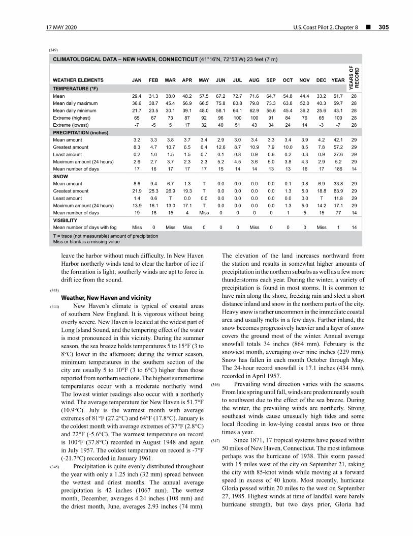
17 MAY 2020 U.S. Coast Pilot 2, Chapter 8 ¢ 305
leave the harbor without much difficulty. In New Haven Harbor northerly winds tend to clear the harbor of ice if the formation is light; southerly winds are apt to force in drift ice from the sound.
(343) Weather, New Haven and vicinity
(344) New Haven’s climate is typical of coastal areas of southern New England. It is vigorous without being overly severe. New Haven is located at the widest part of Long Island Sound, and the tempering effect of the water is most pronounced in this vicinity. During the summer season, the sea breeze holds temperatures 5 to 15°F (3 to 8°C) lower in the afternoon; during the winter season, minimum temperatures in the southern section of the city are usually 5 to 10°F (3 to 6°C) higher than those reported from northern sections. The highest summertime temperatures occur with a moderate northerly wind. The lowest winter readings also occur with a northerly wind. The average temperature for New Haven is 51.7°F (10.9°C). July is the warmest month with average extremes of 81°F (27.2°C) and 64°F (17.8°C). January is the coldest month with average extremes of 37°F (2.8°C) and 22°F (-5.6°C). The warmest temperature on record is 100°F (37.8°C) recorded in August 1948 and again in July 1957. The coldest temperature on record is -7°F (-21.7°C) recorded in January 1961.
(345) Precipitation is quite evenly distributed throughout the year with only a 1.25 inch (32 mm) spread between the wettest and driest months. The annual average precipitation is 42 inches (1067 mm). The wettest month, December, averages 4.24 inches (108 mm) and the driest month, June, averages 2.93 inches (74 mm).
The elevation of the land increases northward from the station and results in somewhat higher amounts of precipitation in the northern suburbs as well as a few more thunderstorms each year. During the winter, a variety of precipitation is found in most storms. It is common to have rain along the shore, freezing rain and sleet a short distance inland and snow in the northern parts of the city. Heavy snow is rather uncommon in the immediate coastal area and usually melts in a few days. Farther inland, the snow becomes progressively heavier and a layer of snow covers the ground most of the winter. Annual average snowfall totals 34 inches (864 mm). February is the snowiest month, averaging over nine inches (229 mm). Snow has fallen in each month October through May. The 24-hour record snowfall is 17.1 inches (434 mm), recorded in April 1957.
(346) Prevailing wind direction varies with the seasons. From late spring until fall, winds are predominantly south to southwest due to the effect of the sea breeze. During the winter, the prevailing winds are northerly. Strong southeast winds cause unusually high tides and some local flooding in low-lying coastal areas two or three times a year.
(347) Since 1871, 17 tropical systems have passed within 50 miles of New Haven, Connecticut. The most infamous perhaps was the hurricane of 1938. This storm passed with 15 miles west of the city on September 21, raking the city with 85-knot winds while moving at a forward speed in excess of 40 knots. Most recently, hurricane Gloria passed within 20 miles to the west on September 27, 1985. Highest winds at time of landfall were barely hurricane strength, but two days prior, Gloria had
(349)
CLIMATOLOGICAL DATA – NEW HAVEN, CONNECTICUT (41°16'N, 72°53'W) 23 feet (7 m)
WEATHER ELEMENTS JAN FEB MAR APR MAY JUN JUL AUG SEP OCT NOV DEC YEAR
YEA
RS
OF
REC
OR
D
TEMPERATURE (°F)Mean 29.4 31.3 38.0 48.2 57.5 67.2 72.7 71.6 64.7 54.8 44.4 33.2 51.7 28 Mean daily maximum 36.6 38.7 45.4 56.9 66.5 75.8 80.8 79.8 73.3 63.8 52.0 40.3 59.7 28 Mean daily minimum 21.7 23.5 30.1 39.1 48.0 58.1 64.1 62.9 55.6 45.4 36.2 25.6 43.1 28 Extreme (highest) 65 67 73 87 92 96 100 100 91 84 76 65 100 28 Extreme (lowest) -7 -5 5 17 32 40 51 43 34 24 14 -3 -7 28 PRECIPITATION (inches)Mean amount 3.2 3.3 3.8 3.7 3.4 2.9 3.0 3.4 3.3 3.4 3.9 4.2 42.1 29Greatest amount 8.3 4.7 10.7 6.5 6.4 12.6 8.7 10.9 7.9 10.0 8.5 7.8 57.2 29Least amount 0.2 1.0 1.5 1.5 0.7 0.1 0.8 0.9 0.6 0.2 0.3 0.9 27.6 29Maximum amount (24 hours) 2.6 2.7 3.7 2.3 2.3 5.2 4.5 3.6 5.0 3.8 4.3 2.9 5.2 29Mean number of days 17 16 17 17 17 15 14 14 13 13 16 17 186 14SNOWMean amount 8.6 9.4 6.7 1.3 T 0.0 0.0 0.0 0.0 0.1 0.8 6.9 33.8 29 Greatest amount 21.9 25.3 26.9 19.3 T 0.0 0.0 0.0 0.0 1.3 5.0 18.8 63.9 29 Least amount 1.4 0.6 T 0.0 0.0 0.0 0.0 0.0 0.0 0.0 0.0 T 11.8 29 Maximum amount (24 hours) 13.9 16.1 13.0 17.1 T 0.0 0.0 0.0 0.0 1.3 5.0 14.2 17.1 29 Mean number of days 19 18 15 4 Miss 0 0 0 0 1 5 15 77 14 VISIBILITYMean number of days with fog Miss 0 Miss Miss 0 0 0 Miss 0 0 0 Miss 1 14
T = trace (not measurable) amount of precipitationMiss or blank is a missing value

306 ¢ U.S. Coast Pilot 2, Chapter 8 17 MAY 2020
been supporting winds in excess of 125 knots. Due to geographical orientation, all tropical systems approach the coastline from the south or southwest.
(348) The National Weather Service maintains an office at the Tweed-New Haven Airport, about 3 miles southeast of the city.
(350) Routes
(351) To enter New Haven Harbor from eastward, it is safer for large vessels to pass southward of Branford Reef and Townshend Ledge to the entrance channel. To enter from westward, pass northward of Stratford Shoal Light at a distance of 1.8 miles and head for the entrance channel.
(352) The passage eastward of East Breakwater has boulder patches and is very broken but can be used by small craft drawing less than 6 feet, taking care to avoid the foul ground along the northeast side of the passage. This passage is buoyed, and local vessels of 10- to 12-foot draft use it at high water. Avoid Quixes Ledge, which extends about 200 yards southeastward from the eastern end of the breakwater, and pass about 100 yards eastward of the breakwater. The principal danger inside the breakwater is the reef, marked by a buoy, that extends 300 yards southwestward from Lighthouse Point. Adams Fall, a rock with 5 feet over it and marked by a buoy, is 0.4 mile southwestward of Lighthouse Point.
(353) Pilotage, New Haven
(354) Pilotage by state-licensed pilot is compulsory in Long Island Sound for foreign flag vessels and U.S. vessels that are under register (i.e., engaged in foreign trade). Such vessels can arrange for a state-licensed pilot by contacting the joint rotation administrator, Block Island Pilots at 243 Spring Street, Newport, RI 02840; telephone 401–487–9050 (24 hours), 800–274–1216; FAX 401–847–9052. Enrolled vessels (i.e., U.S. vessels engaged in coastwise trade) may be required to have a U.S. Coast Guard federally licensed pilot unless the master has recency for the intended area. See Pilotage, Long Island Sound (indexed as such), chapter 8.
(355) Pilot services are arranged in advance through ships’ agents or directly by shipping companies.
(356) Towage
(357) Tugs up to 1,800 hp are available at New Haven, and tugs to 4,000 hp can be obtained by prior arrangement. Vessels usually proceed to the harbor without assistance. Large vessels normally require tugs for docking and undocking. Arrangements for tug service should be made 24 hours in advance, usually through ships’ agents or directly by shipping companies. The tugs monitor VHF-FM channels 13 and 16 and use channel 19A as a working frequency; call sign KEE-234.
(358) Launch service to ships at anchor is available. Launches monitor VHF-FM channel 16 and use channel 19A as a working frequency.
(359) New Haven is a customs port of entry.(360)
Quarantine, customs, immigration and agricultural quarantine
(361) (See Chapter 3, Vessel Arrival Inspections, and Appendix A for addresses.)
(362) Quarantine is enforced in accordance with regulations of the U.S. Public Health Service. (See Public Health Service, Chapter 1.)
(363) New Haven has many public and private hospitals.(364)
Coast Guard(365) The Captain of the Port maintains an office in New
Haven. The nearest vessel documentation office is in Bridgeport, CT. (See Appendix A for addresses.)
(366) The harbormaster at New Haven has charge of the anchoring of vessels; he can be contacted through the local police department.
(367) The city police maintain a harbor patrol during the summer.
(368) Wharves
(369) The deep-draft facilities at the Port of New Haven are along the north and east sides of the inner portion of New Haven Harbor. Facilities for smaller vessels and barges are along the sides of the harbor and in Mill, Quinnipiac and West Rivers. Depths alongside the facilities in Quinnipiac River range from about 5 to 15 feet; Mill River, 12 to 13 feet; and West River, about 12 to 18 feet. Only the deep-draft facilities are described. The alongside depths for the facilities described are reported; for information on the latest depths contact the private operator. All the facilities have direct highway connections, and most have railroad connections. Water and electrical shore power connections are available at most piers and wharves.
(370) General cargo at the port is usually handled by ship’s tackle; special handling equipment, if available, is mentioned in the description of the particular facility. Cranes up to 250 tons and warehouses and cold storage facilities adjacent to the waterfront are available.
(371) Wyatt Light Oil Pier: north end of harbor 0.35 mile northeastward of New Haven Long Wharf; 150-foot face, 715 feet of berthing space with dolphins, 38 feet alongside; deck height, 11 feet; receipt and shipment of petroleum products; owned and operated by Wyatt, Inc.
(372) Wyatt Heavy Oil Wharf: 50 yards east of Wyatt Light Oil Pier; west side 210 feet, 480 feet of berthing space with dolphins; 30 feet alongside; deck height, 11 feet; receipt and shipment of petroleum products, receipt of asphalt; owned and operated by Wyatt, Inc.
(373) Gulf Refining and Marketing Co. Wharf: on each side of harbor, 200 yards south of Tomlinson Bridge; 60-foot face, 735 feet of berthing space with dolphins; 35 feet alongside; deck height, 13 feet; vessels normally moor starboardside-to; receipt and shipment of petroleum products; owned and operated by Gulf Oil Refining and Marketing Co.

17 MAY 2020 U.S. Coast Pilot 2, Chapter 8 ¢ 307
(374) Gulf Refining and Marketing Co. Pier: 100 yards southward of Gulf Refining and Marketing Co. Wharf; north side 400 feet, 25 feet alongside; south side 380 feet, 25 feet alongside; deck height, 10 feet; receipt and shipment of petroleum products; owned and operated by Gulf Refining and Marketing Co.
(375) ARCO Petroleum Products Co. Wharf: 300 yards southwestward of Gulf Refining and Marketing Co. Pier; 110-foot face, 760 feet with dolphins; 35 feet alongside; deck height, 15 feet; vessels normally moor starboardside-to; receipt and shipment of petroleum products; owned and operated by ARCO Petroleum Products Co.
(376) New Haven Terminal, Scrap Metal Dock: 275 yards southward of ARCO Petroleum Products Co. Wharf; 640-foot face; 35 feet alongside; deck height, 14 feet; two 30-ton traveling gantry cranes, crawler cranes to 250 tons; receipt and shipment of general and containerized cargo and steel products, shipment of scrap metal, receipt of copper, zinc, and lumber; owned and operated by New Haven Terminal, Inc.
(377) New Haven Terminal Pier: 50 yards southward of Scrap Metal Dock; north and south sides, 650 feet usable, can accommodate tankers up to 700 feet; 35 and 39 feet alongside, north and south sides, respectively; deck height, 13 feet; cranes up to 50 tons; 36,000 square feet covered storage; receipt and shipment of general cargo, receipt of petroleum products, petrochemicals, chemicals, copper, zinc, lumber and steel products; owned and operated by New Haven Terminal, Inc.
(378) Exxon Co. Terminal Wharf: 175 yards southward of New Haven Terminal Pier; 80-foot face, 700 feet with dolphins; 35 feet alongside; deck height, 13 feet; vessels normally moor starboardside-to; receipt and shipment of petroleum products; owned and operated by Exxon Co., U.S.A.
(379) Supplies
(380) Oil bunkering terminals at New Haven are maintained by the major oil companies. Fuel oil and diesel oil in the usual commercial grades are obtainable. Barges are available for bunkering in the anchorages outside the breakwaters or at the piers; 24-hour advance notice is required, and arrangements should be made through ships’ agents. Water, provisions and marine supplies can be procured.
(381) Repairs
(382) New Haven has no facilities for making major repairs or for drydocking deep-draft vessels; the nearest such facilities are at Boston, MA, and New York. Machine shops in the area can make limited repairs to machinery and boilers and fabricate shafts and other pieces of equipment.
(383) Small-craft facilities
(384) There are excellent facilities on the east and west sides of the harbor and on West and Quinnipiac Rivers.
(385) ENCs - US5CN13M, US5CN10M Charts - 12370, 12364
(386) Pond Point, about 5 miles southwestward of the New Haven Harbor entrance, has a rocky shoal with little depth over the greater part of it that extends about 0.3 mile southward. It is marked by a buoy. A prominent white mast is on the point.
(387) Welches Point, 0.8 mile westward of Pond Point, forms the east side of the entrance of the Gulf. A reef extends 0.2 mile southward from the point and is marked by a buoy. Several scattered rocks extend a southeasterly direction for about 0.5 mile from the buoy.
(388) The Gulf, a bight between Welches Point and Charles Island, about 6.5 miles westward of New Haven Harbor entrance, affords anchorage in 6 to 15 feet and is sheltered in all but southerly and southeasterly winds. The entrance is clear. The shoaling is gradual, and soundings are the best guide on the northwest side of the bight; the western side of Welches Point and the reefs around Charles Island extending to the mainland should be approached with caution, as the shoaling is abrupt.
(389) Milford Harbor, comprising the lower portion of the Wepawaug River, is entered at the mouth of the river between two jetties at the head of The Gulf. The westerly jetty extends southward from Burns Point, and the easterly jetty is marked by Milford Harbor Light 10. The harbor is used chiefly for recreational boating and occasionally for the receipt of shellfish and fish. A dredged channel leads from The Gulf through the jettied entrance to a point about 400 feet above the town wharf, 0.6 mile above Burns Point. The channel is marked by a lighted buoy at the entrance and unlighted buoys in the approach. There are several small-craft facilities, and a 5 mph speed limit is enforced in the harbor. The National Marine Fisheries Service, U.S. Department of Commerce, maintains a laboratory and research vessel base on the west side of the harbor, about 0.2 mile northward of Burns Point.
(390) Charles Island, on the southwest side at the
entrance to The Gulf, is low and partly covered with trees. The island is connected to the mainland by The Bar, a narrow neck about 0.5 mile long and surrounded by rocks awash and shoals. A buoy marks the end of a shoal that extends 250 yards east-northeastward from the island, and a lighted bell buoy marks the end of a rocky area that extends 0.4 mile southward from the island. Northward of Charles Island is a good anchorage in 10 to 16 feet, sheltered from southerly to southwesterly winds.
(391) Between Charles Island and Stratford Point, about 3 miles southwestward, several summer resorts are along the shore, and the Housatonic River empties into Long Island Sound just above the point. The shoals that extend southward from Stratford Point toward Stratford Shoal Light (see chart 12354) consist of narrow ridges of hard

308 ¢ U.S. Coast Pilot 2, Chapter 8 17 MAY 2020
sand with deeper water between and have oyster beds marked with stakes. Depths of 12 feet or less extend 1 mile offshore.
(392) Stratford Point Light (41°09'07"N., 73°06'12"W.), 52 feet above the water, is shown from a white conical tower, with dark red band midway of its height, from the southerly part of the point.
(393) ENC - US5CN13M Chart - 12370
(394) Housatonic River rises in the Berkshire Hills of western Massachusetts and Connecticut and empties into Long Island Sound about 10 miles southwestward of the New Haven Harbor entrance. The river is joined by the Naugatuck River, which is not navigable, in the vicinity of Derby, CT. Housatonic River is navigable to a point about 1 mile above Shelton, CT, where it is closed by a power dam. The head of navigation for all practical purposes is at the towns of Derby and Shelton, 11.5 miles above the entrance. Small vessels can anchor in the river abreast of Stratford, where the channel has an available width of about 500 feet. The waterborne commerce on the river is principally in barge shipments of aggregate, fuel oil to the power plant at Devon and seasonal commercial shellfishing. Navigation above Devon is limited to recreational boating.
(395) On the east side of the entrance to Housatonic River, a breakwater extends out from Milford Point across the bar and is marked at its south end by Housatonic River Breakwater Light 2A. The inner section of the breakwater is awash at high water.
(396) Channels
(397) A federal project provides for an 18-foot dredged channel from Long Island Sound between the breakwater on the east and Stratford Point on the west upriver for about 4.3 miles to the lower end of Culver Bar. (See Notice to Mariners and the latest editions of the charts
for controlling depths.) Above the lower end of Culver Bar, the river channel extends through several dredged sections across river bars to the towns of Derby and Shelton about 11.5 miles above the river entrance. In 2005, the controlling depths were 2.2 feet in the buoyed channel from the lower end of Culver Bar and across Mill Bar to the naturally deep river channel, thence 5.7 feet in the dredged channels across lower Oronoque Bar and 3.0 feet across upper Oronoque Bar, thence 5.5 feet across Camp Meeting Bar, thence 6.2 feet across Drews Bar except for shoaling to 3.9 feet in the lower part of the dredged channel along the left edge, thence 7 feet across Mouthrops Bar and Hidelom Rock Bar, thence 7 feet in the left outside quarter of the dredged channel across Twomile Island Bar with shoaling to bare in the remainder of the channel, thence 7 feet in the dredged channel near Sow and Pigs Jetty. The channel is marked to a point about 2.5 miles below Derby and Shelton.
(398) Stratford is a town on the west side of the river
2.3 miles above the entrance. The principal wharf has a depth of about 9 feet at its end. The harbormaster at Stratford controls anchorages and moorings and has jurisdiction from the entrance of the river to the Shelton town line. Harbor regulations may be obtained from the harbormaster, who may be contacted through the Stratford police or at the Town Hall. Stratford has several small-craft facilities.
(399) Devon is on the east side about 1 mile above Stratford. Local small craft anchor near the east bank of the river, just north of the highway bridge, in depths up to 10 feet. A 40-foot marine railway at a small-craft facility at Devon can haul out craft for engine and hull repairs; gasoline, water, ice, marine supplies and storage are available. In 1981, depths of 4 feet were reported alongside the facility.
(400) Shelton, a town on the west side of the river about 11.5 miles above the entrance is connected to Derby by two bridges; the town has several important factories. In 1971, the wharves at Derby and Shelton were in ruins and unsuitable for craft of any size.
(401)
Structures across Housatonic River
Name•Description•Type Location
Clear Width of Draw or Span Opening (feet)
Clear Height above Mean High Water
(feet) Information
U.S. Route 1 Bridge (bascule) 41°12'01"N., 73°06'38"W. 125 32 Notes 1 and 2. Call sign KXJ-695
Moses Wheeler/I-95 Bridge (fixed) 41°12'17"N., 73°06'35"W. 100 65 Bridge under construction
Metro-North/Devon Railroad Bridge (bascule) 41°12'18"N., 73°06'36"W. 83 19 Notes 1 and 2. Call sign KU-6035
Overhead power cable 41°12'20"N., 73°06'36"W. 91* *Reported
Overhead power cables 41°13'46"N., 73°06'35"W. 79
Sikorsky/Route 15 Bridge (fixed) 41°14'47"N., 73°05'27"W. 100 79
Shelton-Derby Highway Bridge (fixed) 41°18'53"N., 73°05'12"W. 100 34
Railroad Bridge (fixed) 41°19'03"N., 73°05'21"W. 148 17
Shelton-Derby Highway Bridge (fixed) 41°19'09"N., 73°05'28"W. 84 30
Note 1 – Bridgetender monitors VHF-FM channel 13.Note 2 – See 33 CFR 117.1 through 117.59 and 117.207, Chapter 2, for drawbridge regulations.

17 MAY 2020 U.S. Coast Pilot 2, Chapter 8 ¢ 309
(402) Tides
(403) The mean range of tide is 5.5 feet at Stratford and 5 feet at Shelton. The time of the tide becomes later and the range diminishes in progressing up the river. At Stratford the tide is about 0.8 hour later than at the entrance, whereas at Shelton high water is about 1.8 hours later and low water about 2.8 hours later than at the entrance. The river water is fresh about 6 miles above the entrance.
(404) Current
(405) At the entrance near the end of the breakwater the flood has a strong westerly set. Between Milford Point and Crimbo Point, flood and ebb have a velocity of about 1.2 knots. The flood sets about 330° and the ebb 135°. Just north of the draw of the railroad bridge above Stratford, the velocity of flood is 1.1 knots and of ebb, 1.3 knots. In the openings of the bridge the flood current has some easterly set, but the ebb sets fair with the openings. Between that bridge and Shelton the tidal current has a velocity of about 1 knot. Because of the drainage flow of the river, the ebb is usually greater and the flood less than 1 knot. (Consult the Tidal Current Tables for current predictions and further details.)
(406) Spring freshets at Shelton rise 10 feet or more above
mean high tide.(407) Ice closes the river above Stratford during the winter
and sometimes extends to the entrance.(408)
Routes(409) The channel in Housatonic River is narrow and
crooked, with little depth on either side, and across the bars in the channel are dredged cuts 100 feet wide. The tidal currents are strong, especially in the lower part of the river, and strangers are advised to take a pilot. Small craft, without a pilot, should proceed with caution and preferably on a rising tide.
(410) When entering the river during a flood current, care must be taken to avoid being set on the shoals on the west side by strong westerly currents. In the vicinity of Milford Point care should be exercised to avoid a shoal that reportedly extends from Milford Point to the eastern edge of the channel. Care should also be exercised off the extreme northern end of Nells Island as a shoal is reported to have encroached into the channel. By steering a midchannel course no difficulty should be encountered.
(411) Pilots and tugs can be obtained at New Haven.(412) A 5 mph speed limit is enforced on the river near
anchorage and mooring areas and near boat slips.
(413) ENCs - US4NY1GM, US4NY1JM Chart - 12354
(414) Stratford Shoal Middle Ground, 5.4 miles south of Stratford Point and covered 9 to 18 feet, is marked by Stratford Shoal (Middle Ground) Light (41°03'35"N., 73°06'05"W.), 60 feet above the water and shown from a gray granite octagonal tower projecting from a house on a pier, and by buoys that mark the outer ends of shoal areas extending 1 mile north, 0.9 mile northeast and 0.5 mile south of the light. A sound signal is at the light.
(415) North Shore of Long Island
(416) From Orient Point (41°09.6'N., 72°14.0'W.), for about 11 miles to Horton Point, the south shore of Long Island Sound is generally bluff and rocky. The 10-fathom curve is from 0.3 to 0.8 mile from shore, and the shoaling is generally abrupt. The outlying dangers are Orient Shoal and the rocky patch northward of Horton Point.
(417) The prominent features are Browns Hills, a tower at Rocky Point, a tank and television tower at Greenport and Horton Point Light.
(418) Several rocky shoals, including Orient Shoal with a least depth of 6 feet, are offshore in the vicinity of Rocky Point, about 5 miles westward of Orient Point. The north end of Orient Shoal is marked by a buoy.
(419) Several rocks can be found out to 0.6 mile offshore between Orient Point and Inlet Point. A wreck with a least depth of 29 feet is 0.4 mile north of Inlet Point.
(420) Horton Point Light (41°05'06"N., 72°26'44"W.), 103 feet above the water, is shown from a white square tower attached to a dwelling on the northwest part of the point. The former lighthouse tower is close by, southwestward of the present light.
(421) A rocky shoal with a least found depth of 29 feet is 1.6 miles northward of Horton Point. The shoal is a ridge having a northeast-southwest direction, with abrupt shoaling on its northwest and southeast sides.
(422) From Horton Point for about 32 miles to Old Field Point, the shore is fringed with shoals that extend off a greatest distance of 1.5 miles and rise abruptly from the deep water of Long Island Sound. Boulders are found near the shore on the shoals that extend off 0.5 mile in places. A sand shoal, about 0.5 mile in extent with a least depth of 22 feet, is about 1.1 miles northwestward of Duck Pond Point.
(423) The bluffs begin about 1 mile westward of Goldsmith Inlet and reach their greatest elevation just eastward of Duck Pond Point. A valley, formed by a break in the bluffs, is just westward of the point; a bathing pavilion is on the beach. Boulders that bare at low water are on the shoals that fringe the shore between Duck Pond Point and Mattituck Inlet.

310 ¢ U.S. Coast Pilot 2, Chapter 8 17 MAY 2020
(424) ENCs - US5NY1IM, US5NY1KM Chart - 12358
(425) Mattituck Inlet, 6.7 miles southwestward of Horton Point Light, is entered between two short jetties. The inlet is marked by a long break in the bluffs. The outer end of the west jetty is marked by a light. A gong buoy about 1 mile north of the jetty light marks the entrance of the inlet. The sides of the channel are sandy, and, although shoaling is liable to occur at the entrance, strangers can enter the inlet without great danger. A federal project provides for depths of 7 feet in the channel from the entrance of Mattituck Creek to the turning basin at Mattituck. (See Notice to Mariners and the latest edition of the chart for controlling depths.) The channel is marked by buoys and private markers. The overhead power cable about 1 mile above the entrance has a clearance of 78 feet.
(426) Current
(427) The tidal currents have an estimated velocity of about 3 knots in the narrow parts of the entrance of Mattituck Inlet. Slack waters occur possibly 1 hour after the time of high and low water. With northerly and westerly winds, the sea is rough in the entrance. The inlet is sometimes closed by ice during portions of cold winters.
(428) Several marinas and a boatyard are inside the inlet. A
70-ton mobile hoist at the boatyard can haul out craft for engine, hull and radio repairs. Marine supplies, gasoline, diesel fuel, water and covered and wet storage can be obtained. A transient dock, operated by the Mattituck Park Commission, is at the head of the inlet; depths of about 6 feet are at the dock. A dockmaster is at the dock; water is available.
(429) Mattituck is a village on the railroad at the head of the inlet. Provisions can be obtained.
(430) Jacobs Point is about 11 miles southwestward of Horton Point Light.
(431) Riverhead Production Platform
(432) An offshore platform for the delivery and receipt of petroleum products is in open roadstead, off Northville, NY (and Riverhead, NY), about 1.2 miles northward of Jacobs Point.
(433) The facility consists of a 45 by 100-foot steel platform structure with breasting dolphins and mooring dolphins providing two berths, one on the northeast side and one on the southwest side. The deck height is 24.5 feet. The northeast berth has depths alongside of 64 feet and can accommodate tankers up to 225,000 DWT and up to 1,150-foot length, of 62-foot maximum draft.
(434) The southwest berth has depths alongside of 50 feet and can accommodate tankers of up to 42,000 DWT and up to 600-foot length, of 42-foot maximum draft. Barges mooring in this berth must be at least 220 feet long.
(435) A private sound signal is on the platform. Private lights are on the northeast and northwest corners, and two lights mark the center of the platform. Lights are also on each of the dolphins.
(436) Wharf
(437) An 800-foot barge pier is just east of Jacobs Point and southward of the platform. The pier is used for receipt and shipment of petroleum products and has tank storage for 5¼ million barrels. Depth alongside is 13 feet. Lesser depths surround the area, and a shoal with depths of 10 feet is in the recommended southwest approach to the west pier berth. Vessels with draft greater than 12 feet should exercise caution when approaching the pier and should endeavor to arrive or depart at high water.
(438) Prominent feature
(439) The numerous light green oil storage tanks on Jacobs Point are prominent.
(440) Communications
(441) Vessels transiting Long Island Sound or approaching the facility may do so through a VHF-FM marine operator. Available marine operator stations’ name and channel are:
(442) Riverhead 28(443) New Bedford 26(444) New London 26(445) Bridgeport 24.(446) Upon the approach of an incoming vessel, the
platform, voice call “TOSCO Corporation Offshore Platform,” or “Riverhead Platform,” or “TOSCO’s Riverhead Terminal,” monitors VHF-FM channels 16, 13 and 19A; works channel 19A.
(447) Vessels calling at the platform are moored at any time,
weather conditions permitting. The tidal current periods are substantially the same as at The Race. Strong winds from the north and northwest are experienced during the winter and spring. Tidal currents during maximum ebb and flood may reach 3 knots.
(448) Vessels awaiting berth at the platform will normally anchor north of the platform. A vessel drawing more than 50 feet of water may wish to anchor in deeper water northwest of the platform. Pilots are familiar with the best anchorages. Holding ground is good, and a scope of 8 shots (120 feet) is considered adequate.
(449) Pilotage, Riverhead Production Platform
(450) Pilotage by a state-licensed pilot is compulsory in Long Island Sound for foreign flag vessels and U.S. vessels that are under register (i.e., engaged in foreign trade). Such vessels can arrange for a state-licensed pilot by contacting the joint rotation administrator, Block Island Pilots at 243 Spring Street, Newport, RI 02840; telephone 401–847–9050 (24 hours), 800–274–1216;

17 MAY 2020 U.S. Coast Pilot 2, Chapter 8 ¢ 311
FAX 401–847–9052. Enrolled vessels (i.e., U.S. vessels engaged in coastwise trade) may be required to have a U.S. Coast Guard federally licensed pilot unless the master has recency for the intended area. See Pilotage, Long Island Sound (indexed as such), Chapter 8 and Pilotage, New York Harbor and Approaches, (indexed as such), Chapter 11.
(451) The pilot serves as docking master and remains on board on standby while the vessel is moored at the platform. Pilot services are arranged in advance through ships’ agents or directly by shipping companies.
(452) Tugs
(453) Tug service is available from New Haven, Providence, Brooklyn or Staten Island on advance notice. Normally two or three tugs are used for docking and one or two tugs for undocking.
(454) Launch service
(455) J & H Launch Service, Port Jefferson (516–331–5336), provides transfer service for vessels at anchor or alongside the platform.
(456) Supplies
(457) Fueling of a ship alongside the platform is not permitted. A ship may fuel while at anchor from a barge. Water is not available from this facility. Stores may be brought on board via launch while alongside or at anchor.
(458) New York City is the quarantine, customs,
immigration and agricultural quarantine port of entry for Northville. Officials are stationed in New York City. (See Appendix A for addresses.) Arrangements for such inspections must be made by ships’ agents in advance, usually not less than 24 hours Monday through Friday and 48 hours on Saturday and Sunday. Officials will board vessels in the anchorage prior to arrival within the vicinity of the offshore mooring facility.
(459) ENCs - US4NY1GM, US4NY1JM Chart - 12354
(460) Between Mattituck Inlet and Port Jefferson the shore is fringed with rock shoals extending in places 1.5 miles offshore. The outer ends of the shoals are marked by buoys.
(461) Horse in Bank, 7.3 miles westward of Mattituck Inlet, is an area of white patches in the brush-covered bluff at Friars Head. The feature is at the western end of Roanoke Point Shoal and 14 miles westward of Horton Point Light.
(462) The valley of Wading River, about 20 miles westward of Horton Point Light, forms a broad break in the high bluffs. The entrance to Wading River is protected by a short jetty on the west side. In 1981, a reported depth of about 3 feet could be carried in the river
to a town launching ramp 0.1 mile above the entrance. A small canal, about 350 yards westward of the entrance to Wading River, leads southward to the site of a nuclear power station. The canal, closed to general navigation, had a reported depth of about 12 feet in 1989.
(463) Tuttles White Bank is a high white bluff 0.6 mile westward of Wading River.
(464) ENCs - US5NY17M, US5CN10M Charts - 12362, 12364
(465) Mount Sinai Harbor, 22.5 miles westward of Mattituck Inlet, is marked by a low break in the beach nearly 1 mile long. The entrance is between two rubble mound jetties; caution should be exercised when near them. The jetties are each marked on the outer end by a private light. In 2015, the west jetty was reported partially submerged at high tide, and the adjacent east beach has receded, creating a breach between the jetty and land. A channel marked by private buoys leads eastward from the entrance to small-craft facilities on the north shore of the harbor.
(466) Small-craft facilities in the harbor can provide transient berths, gasoline, diesel fuel, electricity, water, ice, marine supplies, pump-out facilities and launching ramps. The minimum approach and alongside depths to the facilities is 10 feet.
(467) A speed limit of 6 mph is enforced in the harbor by
the Suffolk County Police.(468) Mount Misery, 180 feet high, between Mount Sinai
Harbor and Port Jefferson, slopes off gradually toward the sound where the bluffs are about 60 feet high and very prominent. Sand banks dug out by sand and gravel companies are very conspicuous.
(469) Port Jefferson Harbor, on the south shore of Long Island Sound eastward of Old Field Point, is entered through a dredged channel that leads between two jetties that are in ruins to a docking area near the southwestern end of the harbor; the jetties are each marked by a light. The approach is marked by a lighted whistle buoy, about 1.1 miles northwest of the entrance. Three stacks on the west side near the head of the harbor are conspicuous landmarks. A 12 mph speed limit is enforced in the main entrance channel, and a 5 mph speed limit is enforced at the head of the harbor in the vicinity of the mooring areas and wharves.
(470) A 121°–301° measured nautical mile is westward of the entrance to Port Jefferson Harbor on Old Field Beach. The front markers are orange posts about 8 feet high; the rear markers are rectangles mounted on legs about 12 feet high, painted red with a 6-inch black vertical stripe in the middle.
(471) The approach to Port Jefferson Harbor is clear, taking care to avoid Mount Misery Shoal with depths of 7 to 12 feet, about 0.8 mile north-northeast of the east jetty light.

312 ¢ U.S. Coast Pilot 2, Chapter 8 17 MAY 2020
(472) A federal project provides for a channel 26 feet deep from Long Island Sound to the south end of Port Jefferson Harbor. For detailed channel information and minimum depths as reported by the U.S. Army Corps of Engineers (USACE), use NOAA Electronic Navigational Charts. Surveys and channel condition reports are available through a USACE hydrographic survey website listed in Appendix A. The channel is marked by lighted and unlighted buoys and a directional light with a 145.7°–147.3° white sector.
(473) Shoals with little depth are on both sides of the channel from the entrance to Port Jefferson to Lighted Bell Buoy 5 inside the entrance. The ground from the east jetty to the lighted bell buoy is broken, with shoals covered 4 to 11 feet. The lighted bell buoy cannot be seen over the breakwater at low tide by small vessels approaching the harbor.
(474) Current
(475) In the channel between the jetties the velocity of the tidal currents is 2.6 knots on flood and 1.9 on ebb; flood sets 151° and the ebb 323°. It is reported that on the ebb there is a current with a velocity of 1 to 2 knots across the entrance to the harbor.
(476) Ice
(477) Ice forms over the entire harbor and interrupts navigation in very cold weather but does not endanger shipping in the harbor.
(478) Pilotage, Port Jefferson
(479) Pilotage by a state-licensed pilot is compulsory in Long Island Sound for foreign flag vessels and U.S. vessels that are under register (i.e., engaged in foreign trade). Such vessels can arrange for a state-licensed pilot by contacting the joint rotation administrator, Block Island Pilots at 243 Spring Street, Newport, RI 02840; telephone 401–847–9050 (24 hours), 800–274–1216; Fax 401–847–9052. Enrolled vessels (i.e., U.S. vessels engaged in coastwise trade) may be required to have a U.S. Coast Guard federally licensed pilot unless the master has recency for the intended area. See Pilotage, Long Island Sound (indexed as such), Chapter 8 and
Pilotage, New York Harbor and Approaches, (indexed as such), Chapter 11.
(480) Pilot services are arranged in advance through ships’ agents or directly by shipping companies.
(481) Tugs
(482) Tug service is available from New Haven, Providence, Brooklyn or Staten Island on advance notice. Normally, two tugs are used for docking and one for undocking.
(483) Port Jefferson is a town at the southern end of
the harbor. The principal industries of the port are the shipping of sand and gravel and the distribution of petroleum products. There are small-craft facilities and a launching ramp along the waterfront.
(484) Wharves
(485) Depths ranging from 2 to 29 feet are reported alongside the commercial wharves and piers at the head of the harbor. The oil wharf on the west side of the harbor, about 400 yards from the head, has depths of 29 feet alongside the face and 20 feet along the north side. The power plant wharf, about 150 yards northwestward, has depths of 29 feet alongside.
(486) Communications
(487) Port Jefferson is served by railroad and bus. A ferry operates to Bridgeport, CT.
(488) Conscience Bay is entered through a long, narrow
channel at the northwest end of Port Jefferson Harbor. The bay and entrance have depths of 1 to 2 feet. Strangers should not attempt to enter as there are many rocks at the entrance.
(489) Setauket Harbor, on the western side of Port Jefferson Harbor, has a narrow crooked channel. In 1981, a reported depth of about 2½ feet was available in the channel to the boatyard at Setauket. The entrance from Port Jefferson is marked by private seasonal buoys. Gasoline, moorings and limited marine supplies are available at the boatyard; a flatbed trailer can haul out craft to 32 feet long.
(490) Setauket is a village on the south shore of Setauket Harbor about 1 mile above the entrance.

17 MAY 2020 U.S. Coast Pilot 2, Chapter 8 ¢ 313