2.7 Hazards and Hazardous Materials...Subchapter 2.7 Hazards and Hazardous Materials 2.7-2 State...
52
Subchapter 2.7 Hazards and Hazardous Materials 2.7-1 2.7 Hazards and Hazardous Materials This subchapter presents a summary of the multiple Phase I Environmental Site Assessments (ESAs) prepared for the project by Environmental Equalizers, Inc. (EEI). A Phase I ESA was prepared for each of the 17 ownerships which comprise the project site, along with off-site improvement areas. These reports can be found in their entirety in this EIR as Appendix I. In addition, a Limited Phase II ESA was prepared for one of the properties, and can also be found in its entirety in Appendix I. Fire hazards are also analyzed within this subchapter of the EIR due to the potential for wildland fires at the project site. The FPP can be found in its entirety as Appendix J (FIREWISE 2000, Inc. 2014a), and the Evacuation Plan can be found in its entirety as Appendix K (FIREWISE 2000, Inc. 2014b). This subchapter also references the Lilac Hills Ranch Fire Service Response Capabilities Assessment (Dudek and Hunt Research Corp. 2014) which can be found in its entirety in Appendix F of the Specific Plan. Finally, vector sources are analyzed, due to the use of on-site standing water sources. The Vector Management Plan (VMP) can be found in its entirety as Appendix L (RECON 2013d). Impacts associated with potential project incompatibility with ongoing off-site agricultural operations are addressed in subchapter 2.4 of the EIR, Agricultural Resources. 2.7.1 Existing Conditions 2.7.1.1 Regulatory Setting Federal Resource Conservation and Recovery Act (RCRA) of 1976, as amended by the Hazardous and Solid Waste Amendments of 1984 Federal hazardous waste laws are generally stated under RCRA. These laws provide for the “cradle to grave” regulation of hazardous wastes. Any business, institution, or other entity that generates hazardous waste is required to identify and track its hazardous waste from the point of generation until it is recycled, reused, or disposed. U.S. Environmental Protection Agency Region 9, Preliminary Remediation Goals Region 9 is the Pacific Southwest Division of the EPA, which includes California. Preliminary remediation goals (PRGs) are tools for evaluating and cleaning up contaminated sites. PRGs for the Superfund/RCRA programs are risk-based concentrations, derived from standardized equations combining exposure information assumptions with EPA toxicity data. They are considered to be protective for humans (including sensitive groups) over a lifetime. However, PRGs are not always applicable to a particular site and do not address non-human health issues such as ecological impacts. Region 9’s PRGs are viewed as agency guidelines, not legally enforceable standards.
Transcript of 2.7 Hazards and Hazardous Materials...Subchapter 2.7 Hazards and Hazardous Materials 2.7-2 State...

Subchapter 2.7 Hazards and Hazardous Materials
2.7-1
2.7 Hazards and Hazardous Materials
This subchapter presents a summary of the multiple Phase I Environmental Site Assessments (ESAs) prepared for the project by Environmental Equalizers, Inc. (EEI). A Phase I ESA was prepared for each of the 17 ownerships which comprise the project site, along with off-site improvement areas. These reports can be found in their entirety in this EIR as Appendix I. In addition, a Limited Phase II ESA was prepared for one of the properties, and can also be found in its entirety in Appendix I.
Fire hazards are also analyzed within this subchapter of the EIR due to the potential for wildland fires at the project site. The FPP can be found in its entirety as Appendix J (FIREWISE 2000, Inc. 2014a), and the Evacuation Plan can be found in its entirety as Appendix K (FIREWISE 2000, Inc. 2014b). This subchapter also references the Lilac Hills Ranch Fire Service Response Capabilities Assessment (Dudek and Hunt Research Corp. 2014) which can be found in its entirety in Appendix F of the Specific Plan. Finally, vector sources are analyzed, due to the use of on-site standing water sources. The Vector Management Plan (VMP) can be found in its entirety as Appendix L (RECON 2013d).
Impacts associated with potential project incompatibility with ongoing off-site agricultural operations are addressed in subchapter 2.4 of the EIR, Agricultural Resources.
2.7.1 Existing Conditions
2.7.1.1 Regulatory Setting
Federal
Resource Conservation and Recovery Act (RCRA) of 1976, as amended by the Hazardous and Solid Waste Amendments of 1984
Federal hazardous waste laws are generally stated under RCRA. These laws provide for the “cradle to grave” regulation of hazardous wastes. Any business, institution, or other entity that generates hazardous waste is required to identify and track its hazardous waste from the point of generation until it is recycled, reused, or disposed.
U.S. Environmental Protection Agency Region 9, Preliminary Remediation Goals
Region 9 is the Pacific Southwest Division of the EPA, which includes California. Preliminary remediation goals (PRGs) are tools for evaluating and cleaning up contaminated sites. PRGs for the Superfund/RCRA programs are risk-based concentrations, derived from standardized equations combining exposure information assumptions with EPA toxicity data. They are considered to be protective for humans (including sensitive groups) over a lifetime. However, PRGs are not always applicable to a particular site and do not address non-human health issues such as ecological impacts. Region 9’s PRGs are viewed as agency guidelines, not legally enforceable standards.

Subchapter 2.7 Hazards and Hazardous Materials
2.7-2
State
Government Code Section 65962.5 (a), Cortese List
The Hazardous Waste and Substance Sites Cortese List is a planning document used by the state, local agencies and developers to comply with CEQA requirements in providing information about the location of hazardous materials release sites. Government Code Section 65962.5 requires the California Environmental Protection Agency (Cal EPA) to develop at least annually an updated Cortese List. The California Department of Toxic Substances Control (DTSC) is responsible for a portion of the information contained in the Cortese List. Other state and local government agencies are required to provide additional hazardous material release information for the Cortese List.
California Health & Safety Code, Hazardous Materials Release Response Plans and Inventory
Two programs found in the California Health & Safety Code (H&SC) Chapter 6.95 are directly applicable to the CEQA issue of risk due to hazardous substance release. In San Diego County, these two programs are referred to as the Hazardous Materials Business Program (HMBP) and the California Accidental Release Program (CalARP). The County’s Department of Environmental Health (DEH) is responsible for the implementation of the HMBP and CalARP in San Diego County.
The HMBP and CalARP provide threshold quantities for regulated hazardous substances. When the indicated quantities are exceeded, an HMBP or risk management plan is required pursuant to the regulation. Congress requires the EPA Region 9 to make risk management plan information available to the public through the EPA’s Envirofacts Data Warehouse. The Envirofacts Data Warehouse is considered the single point of access to select EPA environmental data. CalARP requires that a risk management plan include a hazard assessment program, an accidental release prevention program, and an emergency response plan. The risk management plan must be revised every five years or as necessary. The majority of facilities or businesses in San Diego County that have prepared risk management plans are ammonia refrigeration facilities and water treatment and wastewater treatment plants that handle chlorine gas. The required components of a risk management plan are detailed below.
Hazard Assessment Program
The Hazard Assessment Program identifies regulated substances and quantities on-site, includes a five-year accident history, and assesses a worst-case release scenario analysis (based on realistic parameters). The main purpose of the release scenario analysis is to identify vulnerable public receptors, such as residences, schools, child day care facilities, hospitals, businesses, prisons, and other facilities, as well as vulnerable environmental receptors, such as wildlife preserves, parks, and other natural areas. The analysis identifies the scope and needs of the vulnerable receptors in order to plan for a community response to accidents. Worst-case scenarios assume the total quantity of the regulated substance is quickly released, atmospheric conditions will maximize the effect of the event, and no mitigation or response actions are taken. Worst-case scenarios can predict long distance effects that represent a highly unlikely chain of events. Alternative release scenarios are based on more credible and predicable factors. The scenario can

Subchapter 2.7 Hazards and Hazardous Materials
2.7-3
assume, for example, that mitigation measures operate as designed and atmospheric conditions are typical, rather than worst-case.
Accidental Release Prevention Program
In addition to requiring facilities to identify and assess hazards, CalARP requires facilities to develop accident prevention programs. risk management plans must contain summary information about major hazards identified, safety features and process controls to prevent releases, mitigation systems (e.g., dikes, shut-off valves, scrubbers) used to lessen the effect of any release, monitoring and detection systems, worker training, and maintenance records. Facilities must also include a summary of their five-year accident history for relevant chemical processes. The frequency and extent of past releases provides a measure of the facilities effectiveness in controlling chemical hazards.
Emergency Response Plan
The risk management plan must also describe emergency response procedures that are in place in the event of a release of a regulated substance. The emergency response plan must detail the actions taken by employees and other individuals on-site over the entire course of the release event. It must address the alarm system; the evacuation, assembly, and return procedures; emergency first aid; and the use of response equipment and personnel cleanup and decontamination procedures. The emergency response plan must describe the type of off-site response assistance that will be needed in the event of a release, including firefighting, security, and public notification.
California Health & Safety Code, Vector Control
Sections 116110 through 116112 of the California H&SC establishes mosquito abatement and vector control districts, which are charged to protect Californians and their communities against the threats of vector borne diseases. Locally, this is the San Diego County Vector Control Program, a branch within the DEH. These districts are responsible for developing and conducting programs for the prevention and control of vectors; surveillance of vectors and vector-borne diseases; coordinating and conducting emergency vector control, as required; training and certifying government agency vector control technicians, and disseminating information to the public regarding protection from vectors and vector-borne diseases.
Title 14 Division 1.5 of the California Code of Regulations
CCR Title 14 Division 1.5 establishes the regulations for the California Department of Forestry and Fire Protection (CAL FIRE) and is applicable in all State Responsibility Areas (SRA)—areas where CAL FIRE is responsible for wildfire protection. Most of the unincorporated area of the County is an SRA, and any development in these areas must comply with these regulations. Among other things, Title 14 establishes minimum standards for emergency access, fuel modification, setback to property line, signage, and water supply.

Subchapter 2.7 Hazards and Hazardous Materials
2.7-4
Title 22 of the California Code of Regulations & Hazardous Waste Control Law, Chapter 6.5
DTSC is responsible for implementing the RCRA program as well as California’s own hazardous waste laws, which are collectively known as the Hazardous Waste Control Law. Under the Certified Unified Program Agency (CUPA) program, Cal EPA has in turn delegated enforcement authority to the County of San Diego for State law regulating hazardous waste producers or generators. The DTSC regulates the generation, transportation, treatment, storage and disposal of hazardous waste under RCRA and the California Hazardous Waste Control Law. Like RCRA, Title 22 imposes “cradle to grave” regulatory systems for handling hazardous waste in a manner that protects human health and the environment. Cal EPA has delegated some of its authority under the Hazardous Waste Control Law to county health departments and other CUPAs, including the San Diego County DEH.
California Human Health Screening Levels
The California Human Health Screening Levels (CHHSLs) or “Chisels” are concentrations of 54 hazardous chemicals in soil or soil gas that Cal EPA considers to be below thresholds of concern for risks to human health. The CHHSLs were developed by the Office of Environmental Health Hazard Assessment on behalf of Cal EPA. The CHHSLs were developed using standard exposure assumptions and chemical toxicity values published by the EPA and Cal EPA. The CHHSLs can be used to screen sites for potential human health concerns where releases of hazardous chemicals to soils have occurred. Under most circumstances, the presence of a chemical in soil, soil gas, or indoor air at concentrations below the corresponding CHHSL can be assumed to not pose a significant health risk to people who may live or work at the site. There are separate CHHSLs for residential and commercial or industrial sites.
Emergency Response to Hazardous Materials Incidents
California has developed an Emergency Response Plan to coordinate emergency services provided by federal, State, and local government, and private agencies. The plan is administered by the California Emergency Management Agency (Cal EMA) and includes response to hazardous materials incidents. Cal EMA coordinates the response of other agencies, including Cal EPA, California Highway Patrol (CHP), CDFW, RWQCB, SDAPCD, the City of San Diego Fire Department, and the DEH Hazardous Incident Response Team (HIRT).
California Education Code
The CEC establishes the law for California public education. CEC requires that the DTSC be involved in the environmental review process for the proposed acquisition and/or construction of school properties that will use State funding. The CEC requires a Phase I ESA be completed prior to acquiring a school site or engaging in a construction project. Depending on the outcome of the Phase I ESA, a Preliminary Environmental Assessment and remediation may be required. The CEC also requires potential, future school sites that are proposed within two miles of an airport to be reviewed by Caltrans Division of Aeronautics. If Caltrans does not support the proposed site, no state or local funds can be used to acquire the site or construct the school.
Subchapter 2.7 Hazards and Hazardous Materials
2.7-5
Local
County of San Diego, Site Assessment and Mitigation Program
The County of San Diego DEH maintains the Site Assessment and Mitigation (SAM) list of contaminated sites that have previously or are currently undergoing environmental investigations or remedial actions. San Diego County SAM Program, within the Land and Water Quality Division of the DEH, has a primary purpose to protect human health, water resources, and the environment within San Diego County by providing oversight of assessments and cleanups in accordance with the California H&SC and the CCR. The SAM’s Voluntary Assistance Program (VAP) also provides staff consultation, project oversight, and technical or environmental report evaluation and concurrence (when appropriate) on projects pertaining to properties contaminated with hazardous substances.
County of San Diego, Underground Storage Tank (UST) Program
The DEH Hazardous Materials Division (HMD) Underground Storage Tank (UST) Program administers and enforces federal and State laws and regulations and local ordinances for the construction/installation, modification, upgrade, and removal of USTs the County. If contamination is discovered or likely to be present, owners or operators of USTs are required by law to report the contamination to the DEH HMD and SAM Programs and to take corrective action.
County of San Diego Code of Regulatory Ordinances Sections 68.401-68.406, Defensible Space for Fire Protection Ordinance
This ordinance addresses the accumulation of weeds, rubbish, and other materials on a private property found to create a fire hazard and be injurious to the health, safety, and general welfare of the public. The ordinance makes the presence of such weeds, rubbish, and other materials as a public nuisance, which must be abated in accordance with the provisions of this section. This ordinance is enforced within all County Service Areas, and in the unincorporated areas of the County outside of a fire protection district. All fire protection districts have a combustible vegetation abatement program, and many fire protection districts have adopted and enforce the County’s ordinance.
County of San Diego Code of Regulatory Ordinances Sections 96.1.005 and 96.1.202, Removal of Fire Hazards
The San Diego County Fire Authority, in partnership with CAL FIRE, the Bureau of Land Management, and the U.S. Forest Service, is responsible for the enforcement of defensible space inspections. Inspectors from the fire district are responsible to ensure an adequate defensible space has been created and maintained around structures. If violations of the program requirements are noted, inspectors provide a list of required corrective measures and provide a reasonable timeframe to complete the task. If the violations still exist upon re-inspection, the local fire inspector will forward a complaint to the County for further enforcement action.

Subchapter 2.7 Hazards and Hazardous Materials
2.7-6
County of San Diego Consolidated Fire Code
The County of San Diego, in collaboration with the local fire protection districts, created the first Consolidated Fire Code in 2001. The Consolidated Fire Code contains the County and fire protection districts amendments to the California Fire Code. The purpose of consolidation of the County and local fire districts adoptive ordinances is to promote consistency in the interpretation and enforcement of the Fire Code for the protection of the public health and safety, which includes permit requirements for the installation, alteration, or repair of new and existing fire protection systems, and penalties for violations of the code. The Code provides the minimum requirements for access, water supply and distribution, construction type, fire protection systems, and vegetation management. Additionally, the fire code regulates hazardous materials and associated measures to ensure that public health and safety are protected from incidents relating to hazardous substance releases.
County Department of Planning & Development Services and Land Use Fire Prevention in Project Design Standards
Following the October 2003 wildfires, the County incorporated a number of fire prevention strategies into the discretionary project review process for CEQA projects. One of the more significant changes is the requirement that the majority of discretionary permits (e.g., subdivision and use permits) in wildland urban interface areas prepare a FPP for review and approval. A FPP is a technical report that considers the topography, geology, combustible vegetation (fuel types), climatic conditions, and fire history of the project site. The plan addresses the following in terms of compliance with applicable codes and regulations including but not limited to: water supply, primary and secondary access, travel time to the nearest fire station, structure setback from property lines, ignition-resistant building features, fire protection systems and equipment, impacts to existing emergency services, defensible space, and vegetation management.
County of San Diego General Plan – Safety Element
The purpose of the Safety Element is to include safety considerations in the planning and decision‐making process by establishing policies related to future development that will minimize the risk of personal injury, loss of life, property damage, and environmental damage associated with hazards, including hazardous materials and wildfires.
As stated in the Safety Element, hazardous materials are generally associated with select commercial, industrial, and agricultural operations, and their use is highly regulated by federal and state law. The Safety Element has several goals and policies that are relevant to hazards and hazardous materials as described below.
GOAL S‐11
Controlled Hazardous Material Exposure. Limit human and environmental exposure to hazardous materials that pose a threat to human lives or environmental resources.

Subchapter 2.7 Hazards and Hazardous Materials
2.7-7
Policies
S‐11.1 Land Use Location. Require that land uses involving the storage, transfer, or processing of hazardous materials be located and designed to minimize risk and comply with all applicable hazardous materials regulations.
S‐11.3 Hazards‐Sensitive Uses. Require that land uses using hazardous materials be located and designed to ensure sensitive uses, such as schools, hospitals, day care centers, and residential neighborhoods, are protected. Similarly, avoid locating sensitive uses near established hazardous materials users or High Impact Industrial areas where incompatibilities would result.
S‐11.4 Contaminated Lands. Require areas of known or suspected contamination to be assessed prior to reuse. The reuse shall be in a manner that is compatible with the nature of the contamination and subsequent remediation efforts.
S‐11.5 Development Adjacent to Agricultural Operations. Require development adjacent to existing agricultural operations in Semi‐Rural and Rural Lands to adequately buffer agricultural areas and ensure compliance with relevant safety codes where pesticides or other hazardous materials are used.
This element also contains several policies that focus on minimizing the impact of wildfires through land use planning techniques and other mitigation measures.
GOAL S-3
Minimize Fire Hazards. Minimize injury, loss of life, and damage to property resulting from structural or wildland fire hazards.
Policies
S‐3.1 Defensible Development. Require development to be located, designed, and constructed to provide adequate defensibility and minimize the risk of structural loss and life safety resulting from wildland fires.
S‐3.2 Development in Hillsides and Canyons. Require development located near ridgelines, top of slopes, saddles, or other areas where the terrain or topography affect its susceptibility to wildfires to be located and designed to account for topography and reduce the increased risk from fires.
S‐3.3 Minimize Flammable Vegetation. Site and design development to minimize the likelihood of a wildfire spreading to structures by minimizing pockets or peninsulas, or islands of flammable vegetation within a development.
S‐3.5 Access Roads. Require development to provide additional access roads when necessary to provide for safe access of emergency equipment and civilian evacuation concurrently.
S‐3.6 Fire Protection Measures. Ensure that development located within fire threat areas implement measures that reduce the risk of structural and human loss due to wildfire.

Subchapter 2.7 Hazards and Hazardous Materials
2.7-8
GOAL S-6
Adequate Fire and Medical Services. Adequate levels of fire and emergency medical service in the unincorporated County.
Policies
S‐6.1 Water Supply. Ensure that water supply systems for development are adequate to combat structural and wildland fires.
S‐6.3 Funding Fire Protection Services. Require development to contribute its fair share towards funding the provision of appropriate fire and emergency medical services as determined necessary to adequately serve the project.
S-6.4 Fire Protection Services for Development. Require that new development demonstrate that fire services can be provided that meets the minimum travel times identified in Table S‐1 of the General Plan (Travel Time Standards from Closest Fire Station). Table S‐1 of the General Plan establishes a service level standard for fire and first responder emergency medical services that is appropriate to the area where a development is located. Standards are intended to (1) help ensure development occurs in areas with adequate fire protection and/or (2) help improve fire service in areas with inadequate coverage by requiring mitigation for service‐level improvements as part of project approval.
3.7 Fire Resistant Construction. Require all new, remodeled, or rebuilt structures to meet current ignition resistance construction codes and establish and enforce reasonable and prudent standards that support retrofitting of existing structures in high fire threat areas.
Emergency Response and Evacuation
Emergency response plans are maintained at the federal, state, and local level for all types of disasters, including human-made and natural. Emergency response plans include elements to maintain continuity of government, emergency functions of governmental agencies, mobilization, and application of resources, mutual aid, and public information. The Unified San Diego County Emergency Services Organization has the primary responsibility for preparedness and response activities, and addresses disasters and emergency situations within the unincorporated area of San Diego County. The County of San Diego Office of Emergency Services (OES) serves as staff to the Unified Disaster Council (UDC), the governing body of the Unified San Diego County Emergency Services Organization. Emergency response and preparedness plans include the Operational Area Emergency Response Plan and the San Diego County Multi-Jurisdictional Hazard Mitigation Plan.
Operational Area Emergency Plan: The comprehensive emergency plan, known as the Operational Area Emergency Plan, would provide the framework for emergency response at the project site, in the case of an emergency. Numerous stand-alone emergency plans for the Operational Area exist, such as the Hazardous Material Plan and the Multi-Jurisdictional Hazard Mitigation Plan.
Subchapter 2.7 Hazards and Hazardous Materials
2.7-9
The Multi-Jurisdictional Hazard Mitigation Plan: This plan includes an overview of the risk assessment process, vulnerability assessments, and identifies hazards present in each jurisdiction of San Diego County. Hazards profiled in the plan include wildfire, structure fire, flood, coastal storms, erosion, tsunami, earthquakes, liquefaction, rain-induced landslide, dam failure, hazardous materials, incidents, nuclear materials release, and terrorism. The plan sets forth a variety of objectives and actions based on a set of broad goals including: (1) promoting disaster-resistant future development; (2) increased public understanding and support for effective hazard mitigation; (3) building support of local capacity and commitment to become less vulnerable to hazards; (4) enhancement of hazard mitigation coordination and communication with federal, state, local and tribal governments; and (5) reducing the possibility of damage and losses to existing assets, particularly people, critical facilities or infrastructure, and County-owned facilities, due to dam failure, earthquake, coastal storm, erosion, tsunami, landslides, floods, structural fire/wildfire, and manmade hazards.
Emergency Air Support
Helicopters and small planes are used in a variety of emergency response actions such as search and rescue operations and retrieving water to extinguish wildfires. During an emergency response, aircraft tend to fly low to the ground thus increasing the potential hazards to aircraft from towers and other objects within airspace. CAL FIRE and the County of San Diego Sheriff’s Department Aerial Support Detail, Air Support to Regional Enforcement Agencies (ASTREA) base carry out emergency response actions.
San Diego County Air Pollution Control District
The SDAPCD maintains air quality and develops and implements cost-effective programs meeting state and federal mandates. The Asbestos National Emission Standard for Hazardous Air Pollutants (NESHAP), 40 CFR 61, Subpart M is enforced locally under San Diego Air Pollution Control District Regulation XI, Subpart M - Rule 361.145). This regulation requires the owner or operator of a demolition or renovation to submit an Asbestos Demolition or Renovation Operational Plan at least 10 working days before any asbestos stripping or removal work begins (such as, site preparation that would break up, dislodge, or similarly disturb asbestos containing material).
San Diego County, Vector Control Program
The San Diego County Vector Control Program is a branch within the DEH. This program monitors and controls vectors and the diseases that they carry. The primary objective of controlling vectors is to preserve or create an environment favorable to humans and animals by lessening the effect that vectors and/or nuisances have upon the quality of life. Under the powers of a vector control district, as adopted by the County Board of Supervisors, this program provides countywide vector prevention and control services funded through a voter approved benefit assessment district. Mosquito, domestic rat, fly and other vector prevention and control programs are provided to reduce the risk of diseases these vectors can transmit and to minimize nuisances they cause.
Subchapter 2.7 Hazards and Hazardous Materials
2.7-10
2.7.1.2 Environmental Setting
Hazardous Materials
Hazardous materials are commonly stored and used by a variety of businesses and are commonly encountered during construction activities. Hazardous materials typically require special handling, reuse, and disposal because of their potential to harm human health and the environment. The California Health and Safety Code (Section 25501) defines a hazardous material as:
Any material that, because of its quantity, concentration, or physical or chemical characteristics, poses a significant present or potential hazard to human health and safety or to the environment if released into the workplace or the environment. “Hazardous materials” include, but are not limited to, hazardous substances, hazardous waste, and any material that a handler or the administering agency has a reasonable basis for believing that it would be injurious to the health and safety of persons or harmful to the environment if released into the workplace or the environment.
The following discussion outlines the existing hazardous materials conditions on the project site.
Environmental Conditions
The parcels within the project site are all privately owned. The primary land uses found in the project site are agricultural related (i.e., orchards, vineyards, row crops, and nursery operations). Some of the agricultural uses are not currently operating. Single-family residential dwellings with associated garages, sheds, storage areas, and greenhouses are located at various locations throughout the project site. Land uses on properties surrounding the project site consist of similar agricultural uses.
An on-site survey of the properties which comprise the project site was conducted in order to physically observe each site and adjoining properties for conditions indicating a potential RECs. Typical RECs include any evidence of contamination, distressed vegetation, petroleum-hydrocarbon staining, waste drums, illegal dumping, and improper waste storage or handling. Several aboveground storage tanks (ASTs), USTs, septic tanks, wells, pesticide storage areas, and abandoned farming equipment were observed during the on-site surveys conducted for each of the Phase I ESAs (environmental site assessments).
It is likely that restricted agricultural chemicals were applied to on-site soils, which is a potential REC. Additional investigation efforts (i.e., soil sampling and analysis) were performed to further evaluate the soils for agricultural chemicals. The results of the soil sampling efforts are discussed in detail below in Section 2.7.2.
Agricultural activities include the application of fertilizers, herbicides, and pesticides. Soils contaminated by past agricultural activities are a growing concern, generally because of land use changes involving proposed housing developments on former agricultural lands. Investigation of suspected pesticide contamination on properties proposed for development typically includes soil sampling in areas where materials were

Subchapter 2.7 Hazards and Hazardous Materials
2.7-11
stored, handled, and mixed in addition to identifying the historical crops grown, pesticides applied and the methods of application. The investigation and any remedial actions related to pesticide contamination focuses on the elimination of human or environmental exposure.
A complicated issue relative to pesticide-contaminated sites is the definition of a hazardous waste. Even though the concentrations in soil may exceed the Title 22 CCR levels for a hazardous waste, legally applied pesticides, and the resulting residues in soil, are not regulated as hazardous waste unless transported off the subject property (California H&SC Sec. 25117). Constituents of concern at former agricultural sites include organochloride pesticides and metals, which may pose a human health risk.
Hazardous Materials Sites
As a part of each Phase I ESA, a review of federal and state databases was conducted to determine if the project site or any adjacent properties were listed as hazardous waste generators, UST releases, or as having other environmental concerns. No releases, leaks, or spills were documented on any of the databases researched for each of the Phase I ESAs prepared for the project.
Hazardous Building Materials
According to the state and federal OSHA, hazardous chemicals are chemicals that would be a risk to employees, if there is exposure in the workplace. There are several structures existing on-site that were constructed prior to 1978. Two hazardous substances commonly encountered during construction and demolition activities in structures constructed prior to 1978 are lead-based paint (LBP) and asbestos containing materials (ACM). Both LBP and ACM are toxic and thus require measures to ensure workers involved in demolition activities are not exposed to unsafe levels of LBP and ACM. Polychlorinated biphenyls (PCBs) were used in light ballasts, transformers, and other commercial products prior to 1978. PCBs are highly toxic and have been banned in the U.S. since 1979. The existing on-site structures may have the potential for containing LBP and ACM.
Hazardous Materials Release Threats
When unexpectedly released into the environment, hazardous materials may create a significant hazard to the public or environment. As discussed above, DEH is responsible for the implementation of the HMBP and CalARP in San Diego County. No existing on-site operations pose a hazardous materials release threat.
Wildland Fire Hazards
The DSFPD is the Fire Authority Having Jurisdiction (FAHJ). Areas of significant fire hazards in the County have been mapped by CAL FIRE through their Fire and Resource Assessment Program. These maps place areas of the County into different Fire Hazard Severity Zones (FHSZ) based upon fuels, terrain, weather, and relevant factors. The FHSZs are divided into three levels of fire hazard severity: moderate, high, and very high. Portions of the project site are within a very high FHSZ, and the remainder of the project site is within a moderate FHSZ (CAL FIRE 2009).

Subchapter 2.7 Hazards and Hazardous Materials
2.7-12
A Wildland Urban Interface (WUI) is an area where development is located in proximity to open space or lands with native vegetation and habitat that are prone to brush fires. The WUI creates an environment that if not properly designed and maintained, can facilitate movement of fire between structural and vegetation fuels. Once homes are built within (or adjacent to) natural habitat settings, it increases the complexity of fighting wildland fires because the goal of extinguishing the wildland fire is often superseded by protecting human life and private property. The project site is within a WUI area, as mapped by CAL FIRE (CAL FIRE 2003).
The general area near the project site has a history of burning from wildland fires. There is no record of any large fires that have burned the project site in the last 50 years. The data indicates that in the last 50 years, there have been several large fires around the project site to the north, east, and south. Local weather conditions, such as wind speed and live and dead fuel moistures, and topography all contribute to fire intensity and rate of spread.
The County is divided into five climate zones from the coast to the desert: maritime, coastal, transitional, interior, and desert. The project site is within the transitional climate zone. Table 2.7-1 represents the typical weather of a hot summer day in the transitional climate zone, Santa Ana and “peak” (or worst-case fire weather/climate) conditions.
TABLE 2.7-1 TRANSITIONAL CLIMATE ZONE TYPICAL WEATHER CONDITIONS
Period
Temperature
Relative Humidity
Sustained Wind Speed
Burning Index (99%)
Summer 90-109°F 10-14% 19 mph 119 Santa Ana 90-109°F 5-9% 28 mph 145 Peak 90-109°F 5-9% 41 mph -
The Burning Index listed above is an indicator of the relative difficulty of fire control. The higher the number, the more intense and severe a wildfire would be burning under the weather conditions described.
The wind factor is a key to the spread of wildfires in southern California. The most critical wind pattern for the project area would be an off-shore wind coming out of the north/northeast, typically referred to as a Santa Ana wind. Such wind conditions are usually associated with strong, hot winds with very low relative humidity. Santa Ana winds are caused by high-pressure weather systems and can occur any time of the year. However, they generally occur in the late fall (September through November). This is also when non-irrigated vegetation is at its lowest moisture content. The typical prevailing summer time wind pattern near the project site is out of the south or southwest, and normally is of a much lower velocity than a Santa Ana wind. The typical summer wind pattern is also associated with higher relative humidity readings than Santa Ana winds, due to a moist air on-shore flow from the ocean.
Topography on the project site is varied, ranging from rolling to steeper slopes and three primary on-site riparian zones. The elevation ranges from 750 to 930 feet above MSL. The steeper slopes allow faster combustion of fuel in the upslope direction. As a general
Subchapter 2.7 Hazards and Hazardous Materials
2.7-13
rule with other factors constant, it can be assumed that the steeper slopes on-site would contribute to faster fire speed.
In an undisturbed environment, the historic native vegetative communities would predominately have been coastal sage scrub, southern coast live oak riparian woodland and mixed southern chaparral. Presently, the exposure to natural fuel loads will remain in the planned open space areas within the development. These vegetation types are characterized as high and very high load, dry climate brush.
Vectors
A vector is any insect, arthropod, rodent, or other animal of public health significance that can cause human discomfort, injury or is capable of harboring or transmitting disease. Disease causing microorganisms can be carried by a vector, such as a flea, tick, or mosquito that transfers the disease agent from its source in nature to a human host. In the County of San Diego, the most significant vector populations include mosquitoes, rodents, flies, and fleas.
Vector sources occur where site conditions provide habitat suitable for breeding. Within a new development such as the project, a standard requirement is the incorporation of measures, or BMPs, to reduce storm water flow rates, allow storm water to infiltrate back into the ground, and to reduce constituent concentrations in runoff. However, BMPs used to manage runoff often provide aquatic habitats suitable for mosquitoes and other vector species as an unintended consequence of their implementation.
Ponds and reservoirs are another major source of vectors. Any source of standing water, including but not limited to natural and constructed wetlands, irrigation ponds, detention basins, percolation and infiltration basins, and other storm water conveyance systems that hold standing water can be breeding grounds for mosquitoes and other vectors resulting in adverse public health effects related to vectors and disease transmission.
2.7.2 Analysis of Project Impacts and Determination of Significance
The project would result in a significant impact if it would:
1. Hazardous Substance Handling: Create a significant hazard to the public through the use of hazardous substances.
2. Existing On-site Contamination: Expose the public or environment to hazardous materials or contaminated soils that exist on-site.
3. Emergency Response and Evacuation Plans: Interfere with an adopted emergency response plan or emergency evacuation plan.
4. Wildland Fires: Expose people or structures to a significant risk involving wildfires.
5. Vectors: Substantially increase human exposure to vectors.
Subchapter 2.7 Hazards and Hazardous Materials
2.7-14
2.7.2.1 Issue 1: Hazardous Substance Handling
Guidelines for the Determination of Significance
Based on Appendix G of the CEQA Guidelines, the project would have a significant impact if it would: create a significant hazard to the public or the environment through the routine transport, use, or disposal of hazardous materials; or create a significant hazard to the public or the environment through reasonably foreseeable upset and accident conditions involving the release of hazardous materials into the environment; or if it would emit hazardous emissions or handle hazardous or acutely hazardous materials, substances, or waste within one-quarter mile of an existing or proposed school, in non-compliance with existing hazardous substance regulations, in non-compliance with existing hazardous substance regulations.
Based on the County’s Guidelines for Determining Significance – Hazardous Materials and Existing Contamination (County of San Diego 2007e), a significant impact would also occur if the project is a business, operation, or facility that proposes to handle hazardous substances in excess of the threshold quantities listed in Chapter 6.95 of the H&SC, generate hazardous waste regulated under Chapter 6.5 of the H&SC, and/or store hazardous substances in underground storage tanks regulated under Chapter 6.7 of the H&SC and the project will not be able to comply with applicable hazardous substance regulations; or if the project is a business, operation, or facility that would handle regulated substances subject to CalARP risk management plan requirements that in the event of a release could adversely affect children’s health due to the presence of a school or day care within one-quarter mile of the facility.
Analysis
The project includes residential and commercial uses, a school, public parks, a site for religious/institutional use, and an assisted living facility. Also, proposed on-site are: a WRF; a RF; active orchards, and other supporting infrastructure. The residential, commercial, and institutional uses proposed on-site would not include the handling of hazardous substances.
Recycling Facility
The purpose of this facility would be to supplement recycling opportunities for project residents in addition to the weekly collection of waste, recycling material and green waste provided by franchised waste haulers. The facility would include temporary roll-off bins or storage containers where recyclables and/ or green waste generated from project residents may be consolidated for efficient off-site processing. As discussed in Chapter 1.0, these facilities would not accept hazardous household products such as pesticides, leftover paint, solvents, and automotive fluids. Therefore, the recycling facility would not handle, generate, or store hazardous substances. No impacts associated with hazardous substance handling would occur in conjunction with the on-site recycling facility.
Water Reclamation Facility
An MUP is being processed for an on-site WRF, concurrent with the Specific Plan for the project.

Subchapter 2.7 Hazards and Hazardous Materials
2.7-15
The proposed on-site WRF has the potential to handle regulated substances. The on-site WRF would use an extended aeration activated sludge process, which includes the use of a chlorine contact tank. Disinfection of the wastewater would be accomplished through the use of sodium hypochlorite and a chlorine contact tank. During water chlorination, chlorine gas may be added to the water at first; however, the chlorine is quickly transformed into other chemicals (hypochlorous acid and hypochlorite anion), which actually disinfect the water.
Chlorine is one of the regulated substances subject to Chapter 6.95 of the H&SC requirements, because it may pose a threat to public health, safety, or the environment due to its toxicity. The on-site WRF would use amounts of chlorine that may exceed the established threshold levels identified in the CCR.
Based on these conditions, operation of the WRF would require the preparation of a Risk Management Plan or Hazardous Materials Business Plan (HMBP) pursuant to CalARP requirements (as discussed above in subchapter 2.7.1). Specifically, these requirements state that any business handling, storing, or disposing of hazardous substance at or above the designated threshold quantity must prepare an emergency response plan designed to minimize hazards to human health and the environment from fires, explosions, or an unplanned release of hazardous substances into the air, soil, or surface water. The preparation of a Risk Management Plan is intended to aid both employers and employees in managing emergencies at a given facility, as well as to better prepare emergency response personnel for handling a wide range of emergencies that could potentially occur at the WRF. The Risk Management Plan would be implemented immediately upon the occurrence of a fire, explosion, or unplanned chemical release at the WRF or other applicable facilities (as discussed below). The preparation of a Risk Management Plan is a regulatory requirement that would be implemented for any aspect of the project that would include the use or storage of hazardous materials as described, prior to issuance of a building permit. Based on conformance with the described requirements for hazardous materials, the project would result in less than significant impacts related to use of hazardous substances.
A school site is proposed as a part of the project. The on-site WRF would be located 0.13 mile or within one-quarter mile of the school site proposed as a part of the project, as shown in Figure 1-4 (Specific Plan Map). Although hazardous materials would be used and stored in proximity to the school site, uses of such materials would be required to conform to applicable hazardous materials regulations, including the preparation and implementation of an HMBP. Existing regulations also require the DEH to conduct ongoing routine inspections of applicable hazardous materials use and storage sites to ensure conformance with associated laws and regulations, identify safety hazards that could cause or contribute to an accidental spill or release, and suggest preventative measures to minimize the risk of such a spill or release.
Moreover, prior to the siting of a school, the local education agency is required to consult with local officials to identify facilities within one quarter mile of the proposed site that might reasonably be anticipated to emit hazardous air emissions or handle hazardous materials, substances, or wastes. Where such facilities are present within one-quarter mile of a proposed school site, the local education agency is required to make a finding either that no such facilities were identified; or that they do exist, but the health risks do not or will not constitute an actual or potential endangerment of public health at the site or that corrective measures will be taken that will result in emissions mitigation to levels

Subchapter 2.7 Hazards and Hazardous Materials
2.7-16
that will not constitute endangerment. Therefore, based on conformance with the described requirements for hazardous materials, the project would result in less than significant impacts related to the location of the proposed school site.
As shown in Figure 1-4 (Specific Plan Map), the on-site WRF shall be located a minimum of 250 feet from any residence, and a risk management plan would be required for the facility. CalARP requires that the risk management plan include a hazard assessment program, an accidental release prevention program, and an emergency response plan. The risk management plan must be revised, as necessary, or every five years. The required components of a risk management plan are detailed above in subchapter 2.7.1. The risk management plan would be subject to the approval of the DEH HMD. The MUP for the WRF would not be issued by the County P&DSDEH until the RMP is approved by DEH. This would assure safety measures, as discussed in the RMP, are in place. The DEH HMD is also required to conduct ongoing routine inspections to ensure compliance with existing laws and regulations; to identify safety hazards that could cause or contribute to an accidental spill or release; and to suggest preventative measures to minimize the risk of a spill or release of hazardous substances.
Therefore, due to the strict requirements that regulate the handling and operation of hazardous substances outlined above, and the fact that the initial planning, ongoing monitoring, and inspections would occur in compliance with local, state, and federal regulation; the project would not result in any potentially significant impacts related to the routine transport, use, and disposal of hazardous substances or related to the accidental explosion or release of hazardous substances. Overall, impacts related to hazardous substance handling use would be less than significant.
2.7.2.2 Issue 2: Existing On-site Contamination
Guidelines for the Determination of Significance
Based on Appendix G of the CEQA Guidelines, the project would have a significant impact if it would be located on a site which is included on a list of hazardous materials sites compiled pursuant to Government Code Section 65962.5 and, as a result, would create a significant hazard to the public or the environment.
Based on the County’s Guidelines for Determining Significance: Hazardous Materials and Existing Contamination (County of San Diego 2007e), a significant impact would also occur if the project includes structure(s) for human occupancy and/or significant linear excavation within 1,000 feet of an open, abandoned, or closed landfill; if development is proposed on or within 250 feet of the boundary of a parcel identified as containing burn ash (from the historic burning of trash); if the project is located on or within 1,000 feet of a Formerly Used Defense Site (FUDS); if human or environmental exposure to soils or groundwater in exceedance of EPA Region 9 PRGs, Cal/EPA CHHSLs, or Primary State or Federal Maximum Contaminant Levels (MCLs) for applicable contaminants would occur; or if the project would involve the demolition of commercial, industrial or residential structures that contain ACM, LBP, and/or other hazardous materials.

Subchapter 2.7 Hazards and Hazardous Materials
2.7-17
Analysis
Sites Listed Pursuant to Government Code Section 65962.5
None of the ESAs prepared for the project identified any hazardous material sites within one-quarter mile of the project site. Therefore, the project site is neither on nor within one-quarter mile of a listed hazardous materials site. No impact is associated with the hazardous materials site list.
Proximity to Landfill
None of the ESAs prepared for the project identified any open, abandoned, or closed landfill within 1,000 feet of any of the properties surveyed. Therefore, the project would be located neither on nor within 1,000 feet of an open, abandoned, or closed landfill. Thus, no impact is associated with the project being located near a landfill.
Burn Ash Site
None of the ESAs prepared for the project identified any burn ash related to the historic burning of trash. Therefore, the project would neither be located on nor within 250 feet of the boundary of a parcel identified as containing burn ash. Thus, no impact is associated with the project being located near a burn ash site.
Formerly Used Defense Site
None of the ESAs prepared for the project identified any FUDS on any of the properties surveyed or researched. Therefore, the project would be located neither on nor within 1,000 feet of a FUDS, and it is not probable that munitions or other hazards are located on-site. Thus, no impact is associated with the project being located near a FUDS.
Contaminated Soils
The primary land uses found within the project site are agricultural related (i.e., orchards, vineyards, row crops, and nursery operations). Agricultural activities include the application of fertilizers, herbicides, and pesticides. As such, most of the RECs investigated are associated with agricultural use. The discussion below evaluates the potential impacts due to contaminated soils, and potential impacts due to existing agricultural storage materials.
Soils Contaminated due to Agricultural Uses
Soils contaminated by agricultural activities are a concern because of land use changes involving the construction of housing developments on former agricultural lands. The Phase I and limited Phase II ESAs performed on the project site evaluated agricultural chemical residues on-site against CHHSLs. A total of 338 soil samples were gathered in 2011–2012 for 14 of the 17 properties (Table 2.7-2). The investigation of suspected pesticide contamination included soil sampling in areas where materials were stored, handled, and mixed in addition to identifying the historical crops grown, pesticides applied, and the methods of application. Several soil samples exceeded the applicable screening levels as detailed below.

Subchapter 2.7 Hazards and Hazardous Materials
2.7-18
• Concentrations of lead in two sample locations were above CHHSLs.
• Endosulfan levels exceeded the CHHSLs One of the soil samples taken at a former AST location contained Diesel Range Organics at a concentration of 480 milligrams/kilograms (mg/kg), which exceeds the screening level of 110 mg/kg.
• Toxaphene was detected at a level above the CHHSLs. The level of toxaphene detected in one soil sample exceeds the residential PRG and the CHHSLs.
Although concentrations of pesticides in soil may exceed the Title 22 levels for a hazardous waste, legally applied pesticides, and the resulting residues in soil, are not regulated as hazardous waste unless transported off the subject property (H&SC Sec. 25117). Prior to issuance of a building permit, the impacted soils in the above referenced locations would be excavated and disposed of off-site, and confirmation samples would be collected to verify removals. The appropriate documentation of the soil removal and subsequent testing would be verified by the County before a building permit would be issued. Therefore, compliance with existing regulations would ensure that impacts associated with contaminated soils would be less than significant.
Agricultural Materials Storage
Due to the historical agricultural use, it is possible that buried/concealed/hidden agricultural by-products, both below and above ground, may have existed or exist on the project site. The Phase I ESAs recommend the preparation of a Soil Management Plan (SMP) prior to the start of construction activities. This plan would provide guidance on addressing buried debris, stained or odorous soils, or other wastes that may be encountered during future site improvements.
The agricultural operations on the project site store and use pesticides, petroleum hydrocarbon, and motor oil. These chemicals are stored in ASTs and drums located on portions of the project site, and may contain hazardous materials. The County DEH HMD provides guidelines on how to determine if waste is hazardous (County of San Diego 2011e). A generator may determine that the waste on-site is hazardous waste by either 1) testing the waste according to the methods set forth in the CCR (Title 22, Division 4.5) and/or 2) applying knowledge of the hazardous characteristic(s) or properties of the waste in light of the materials or the processes used and the criteria set forth in the hazardous waste regulations. A non-hazardous designation would apply only under the conditions set forth in the DEH HMD guidelines (San Diego County 2011e). Waste material that is determined to be hazardous must be disposed of as a hazardous waste. The landfill operators must also be contacted for their approval prior to disposal to a landfill. In many cases they require the submittal of a "Special Waste" or "Non-hazardous Waste" form(s) before disposing of the waste at a local landfill. Therefore, all ASTs would be removed and disposed according to applicable regulations prior to development. Impacts associated with the storage of pesticides or other potentially hazardous materials would be less than significant.
Off-site Improvement Areas
Off-site improvements, including roadway widening and sewer easements, would be required as part of project implementation. A Phase I ESA was conducted (EEI 2012a-u) for each of the five sites where off-site improvements would occur. None of the Phase I

Subchapter 2.7 Hazards and Hazardous Materials
2.7-19
ESAs revealed evidence of RECs in connection with the sites. The Phase I ESAs also included limited soil investigations. The results of the limited soil investigations revealed:
• Concentrations of lead in the soil samples collected at one of the off-site areas where roadway widening would occur were at the applicable residential screening value of 150 mg/kg. Although the concentrations of lead are at the CHHSLs for residential land uses, the concentrations are within acceptable levels for reuse per Caltrans and DTSC guidance; therefore, further investigation would not appear to be warranted at this time.
• At another off-site location where roadway widening would occur, no concentrations of arsenic were detected above the laboratory reporting limit. Low levels of DDE and DDD (organochlorine pesticides) were detected in site soils. The concentrations were less than applicable residential screening levels, and no further investigation regarding these constituents appears to be warranted. Concentrations of lead in soil sample in this area were slightly above the applicable residential screening value of 150 mg/kg; however, the concentrations are within acceptable levels for reuse per Caltrans and DTSC guidance.
At the other three off-site areas, no concentrations of arsenic, lead, or organochlorine pesticides were detected above residential screening levels warranted. The soils from the two sites identified above would not be relocated or reused (i.e. placed beneath a residential use area), during construction of the project. Off-site areas that currently contain contaminated soils would not be disturbed, and would be recompacted in the area for the intended use (i.e., sewer easement or roadway widening). Impacts associated with site contamination would be less than significant.
Demolition of Existing Structures
A significant impact would occur if the project would involve the demolition of commercial, industrial, or residential structures that may contain ACM, LBP, and/or other hazardous materials and as a result, the project would represent a significant hazard to the public or the environment.
The ESAs prepared for the project indicate that numerous structures located on-site were constructed prior to 1978. There is a potential for ACMs and LBP to be present in any structure constructed prior to 1978. Lead is a highly toxic metal that was used up until 1978 in paint and other products found in and around residences. Lead may cause a range of health effects, from behavioral problems and learning disabilities, to seizures and death. LBP has been banned since 1978, but many older structures still have this paint on walls, woodwork, siding, windows, and doors. Construction and demolition workers can be exposed to lead contamination by cutting, scraping, sanding, heating, burning, or blasting LBP from building components, metal bridges, pavement striping, and metal storage tanks. In addition to exposure to workers, LBP debris or dust can also make its way into soil, potentially contaminating surface waters. Lead contaminated soil can be concentrated in the soils around structures, particularly if paint removal or scraping has occurred over the years.
Asbestos was used extensively from the 1940s until the late 1970s. Although asbestos is usually safe when it is undisturbed and the ACMs are in good condition, once disturbed (such as during remodeling or demolition) the fibers can become airborne. The EPA has

Subchapter 2.7 Hazards and Hazardous Materials
2.7-20
determined that there is no “safe” exposure level to asbestos. Demolition or renovation operations that involve asbestos-containing materials must conform to SDAPCD Rules 361.140–361.156. To ensure that proper procedures are followed to control the emissions of asbestos into the atmosphere, the SDAPCD must be notified in writing at least 10 days in advance of any demolition and 10 days in advance of any demolition that exceeds threshold amounts (excludes residential buildings with four or fewer dwelling units), regardless of whether ACMs are present or not.
Prior to the issuance of a building permit that includes demolition of on-site structures and prior to commencement of demolition or renovation activities, a Hazardous Materials Assessment would be performed to determine the presence or absence of ACMs/LBP located in the buildings to be demolished. This requirement would be included prior to the issuance of a building permit and also be included in the project’s conditions of approval. Suspect materials that would be disturbed by the demolition or renovation activities would be sampled and analyzed for asbestos content, or assumed to be asbestos containing. All lead containing materials scheduled for demolition must comply with applicable regulations for demolition methods and dust suppression. Lead containing materials shall be managed in accordance with applicable regulations. The ACM survey would be conducted by a person certified by Cal/OSHA. The LBP survey would be conducted by a person certified by the California Department of Health Services. Copies of the surveys would be provided to the County DEH once completed. Therefore, impacts associated with ACMs/LBP would be less than significant.
Three pole-mounted transformers were observed within the project site. The transformers are owned and operated by SDG&E, and based on the presumed date of installation, are expected to be PCB-containing. The management of potential PCB-containing transformers is the responsibility of the local utility or the transformer owner. Actual material samples need to be collected to determine if transformers are PCB-containing. No spills, staining or leaks were observed on or around the transformers. Based on the good condition of the equipment, the transformers are not expected to represent a significant environmental concern.
On-site Septic Systems
Some of the existing residential structures located on-site utilize septic tank systems. A septic system is a small-scale sewage treatment system common in areas with no connection to main sewage pipes provided by local governments or private corporations. The system usually includes a storage tank of varying size and utilizes leach lines to leach the liquid collected in the tank into the subsurface. The sludge within the tanks is periodically pumped out by a licensed septic waste hauler and disposed of at an appropriate facility. Septic systems and water wells were found on numerous properties within the project site.
The project includes the abandonment and removal of all on-site septic systems. Prior to development, septic systems located within the project site would require abandonment per San Diego County Code (Section 1, Title 6, Division 8, Chapter 3). When a septic tank is disconnected, the discontinued system shall be deemed abandoned. In that case, any septic tank, holding tank, or seepage pit shall be destroyed within 30 days from the date the system or system component is deemed abandoned. “Destroy,” according to the ordinance, means that the property owner has had a licensed septic waste hauler remove the contents from any abandoned septic tank, holding tank or seepage pit and

Subchapter 2.7 Hazards and Hazardous Materials
2.7-21
the property owner has backfilled the component with sand, gravel, or other clean fill material. In addition, the applicant would submit a signed letter that states all septic tanks will be pumped and abandoned according to County ordinance prior to future site improvements. Furthermore, the Phase I ESAs recommend preparing a Well Summary Report, which would identify the on-site well locations, provide construction details, and discuss the future plan for the wells (e.g., abandonment or production). The project would abandon and destroy all septic systems on-site in accordance with the County Code. Therefore impacts associated with the on-site septic systems are less than significant.
Overall, numerous federal, state, and County regulations provide requirements that must be met prior to the commencement of any ground-disturbing activities. Areas of the project site that currently contain contaminated soils would be removed in accordance with existing regulations. Structures constructed prior to 1978 would be surveyed for ACMs and LBP. Septic systems and water wells will be pumped and abandoned in accordance with County regulations. Therefore, compliance with the existing regulatory framework would ensure that impacts associated with existing on-site contamination would be less than significant.
2.7.2.3 Issue 3: Emergency Response and Evacuation Plans
Guidelines for the Determination of Significance
Based on Appendix G of the CEQA Guidelines, a significant impact would occur if the project would impair implementation of or physically interfere with an adopted emergency response plan or emergency evacuation plan.
Based on the County’s Guidelines for Determining Significance - Emergency Response Plans (County of San Diego 2007f), a significant impact would also occur if the project proposes a structure or tower 100 feet or greater in height on a peak or other location where no structures or towers of similar height already exist and as a result, the project could cause hazards to emergency response aircraft resulting in interference with the implementation of an emergency response.
Analysis
The following sections summarize the project’s consistency with applicable emergency response plans or emergency evacuation plans.
Operational Area Emergency Plan and Multi-Jurisdictional Hazard Mitigation Plan
The Operational Area Emergency Plan provides guidance for emergency planning and requires subsequent plans to be established by each jurisdiction that has responsibilities in a disaster situation. The Multi-Jurisdictional Hazard Mitigation Plan includes an overview of the risk assessment process, identifies hazards present in the jurisdiction, hazard profiles, and vulnerability assessments. The plan also identifies goals, objectives, and actions for each jurisdiction in the County of San Diego, including all cities and the County unincorporated areas.
Hazards profiled in the plan include wildfire, structure fire, flood, coastal storms, erosion, tsunami, earthquakes, liquefaction, rain-induced landslide, dam failure, hazardous

Subchapter 2.7 Hazards and Hazardous Materials
2.7-22
materials, incidents, nuclear materials release, and terrorism. As discussed in subchapters 3.1.1 and 3.1.3 of this EIR, the project would have less than significant impacts in regards to flooding, coastal storms, erosion, earthquakes, liquefaction, rain-induced landslides, and dam failures. Hazardous materials are discussed above in subchapter 2.7.2.1 and 2.7.2.2. The project would not interfere with either the Operational Area Emergency Plan or the Multi-Jurisdictional Hazard Mitigation Plan. Both of these plans develop goals and objectives for OES in regards to large-scale natural or man-made disasters.
The project also includes an Evacuation Plan that details measures for the evacuation of residents if a wildfire were to occur. The Evacuation Plan is discussed further in subchapter 2.7.2.4 below. The Evacuation Plan would not interfere with the implementation of either the Operational Area Emergency Plan or Multi-Jurisdictional Hazard Mitigation Plan because it is designed to complement the existing regional evacuation plans and programs. For example, the Evacuation Plan requires that the HOA meet annually with the DSFPD to review existing evacuation plans and programs and update said plans if necessary. Thus, the project would not interfere with the implementation of either the Operational Area Emergency Plan or Multi-Jurisdictional Hazard Mitigation Plan, and impacts would be less than significant.
San Diego County Nuclear Power Station Emergency Response Plan
The project would not impede implementation of the San Diego County Nuclear Power Station Emergency Response Plan due to the relative location of the project to the plant and the specific requirements of the Plan. The emergency plan for the San Onofre Nuclear Generating Station includes an emergency planning zone within a 10-mile radius. All land area within 10 miles of the plant is not within the jurisdiction of the unincorporated County and as such, a project in the unincorporated area is not expected to interfere with any response or evacuation. As such, no impact would occur.
Oil Spill Contingency Element
The project would not impede implementation of the Oil Spill Contingency Element because the project is not located along the coastal zone or coastline. As such, no impact would occur.
Emergency Water Contingencies Annex and Energy Shortage Response Plan
The project would not impede implementation of the Emergency Water Contingencies Annex and Energy Shortage Response because the project does not propose altering major water or energy supply infrastructure, such as the California Aqueduct. As such, no impact would occur.
Structure or Tower Greater than 100 feet
As detailed in the Specific Plan, the maximum height of structures would be 35 feet, except non-habitable space for architectural projections and icon village monuments (such as clock towers and dormers), which may exceed 35 feet. Specifically, Specific Plan Section III states that the community clock tower would be allowed to be a maximum of 60 feet in height. Because no structure or tower 100 feet or greater in

Subchapter 2.7 Hazards and Hazardous Materials
2.7-23
height would be permitted to be built, there would be no interference with emergency response missions.
In addition, the project is required to prepare and comply with its own Evacuation Plan. The Evacuation Plan is detailed below under Issue 4. Impacts associated with the interference of an adopted emergency response plan would be less than significant.
2.7.2.4 Issue 4: Wildland Fires
Guidelines for the Determination of Significance
Based on Appendix G of the CEQA Guidelines, a significant impact would occur if the project would expose people or structures to a significant risk of loss, injury, or death involving wildland fires, including where wildlands are adjacent to urbanized areas or where residences are intermixed with wildlands.
Based on the County’s Guidelines for Determining Significance – Wildland Fire and Fire Protection (County of San Diego 2010c), a significant impact would also occur if the project cannot demonstrate compliance with all applicable fire codes; or if a comprehensive FPP has been accepted, and the project is inconsistent with its recommendations.
Based on the County’s Guidelines for Determining Significance – Wildland Fire and Fire Protection (County of San Diego 2010c), also provides that a significant impact would also occur if the project does not meet the emergency response objectives identified in the Public Facilities Element of the County General Plan or offer feasible alternatives that achieve comparable emergency response objectives.
Analysis
The project site is within the DSFPD boundaries and, thus DSFPD is the FAHJ. Portions of the project site are within a very high FHSZ, and the remainder of the project site is within a moderate FHSZ (CAL FIRE 2009). The project site is within a WUI area, as mapped by CAL FIRE (CAL FIRE 2003). Therefore, a FPP was prepared for the project (see Appendix J). The FPP identifies and prioritizes the measures necessary to adequately mitigate potential wildfire impacts. The FPP requires defensible space and vegetation management areas as part of the fuel modification zones (FMZ), ignition-resistant construction methods, guidance for the protection of commercial structures, and fuel treatment locations. In addition, the Evacuation Plan prepared for the project (see Appendix K) requires evacuation routes, evacuation points, and specific measures to keep future residents and employees informed about what to do if a wildfire occurs.
Fire Protection
Several scenarios were evaluated within the FPP (see Appendix J) to determine the potential behavior of a wildland fire that might occur in the vicinity of the project site. Fire behavior modeling calculations were used to assist in the determination of suitable fuel modification requirements, and adequate widths of vegetation treatment and maintenance areas. The distances and requirements are delineated as FMZ.

Subchapter 2.7 Hazards and Hazardous Materials
2.7-24
A Wildland Fire Behavior Assessment, or fire model, is included in the FPP. This evaluation utilized the BEHAVE PLUS 4.0.0 Fire Modeling System to provide four worst-case scenario wildland fires based on site topography, fuel loads, weather conditions, and maximum heat production.
Risks from an off-site fire, as determined through the modeling, are presented below.
• Northern Boundary: A large area of native vegetation is located north of West Lilac Road in the Draft MSCP PAMA, which includes existing single-family dwellings, orchards, and other agricultural activities. The fuel modification associated with the existing single-family dwellings, agricultural activities, and a County-maintained road provide significant protection from wildfires along this boundary. The greatest risk from fire would be embers generated from the area of native vegetation and/or the fuels associated with existing single-family dwellings to the north of West lilac Road during a worst case scenario of late fire season northeast Santa Ana Winds. A fire from the north would not pose as great a threat as there is significant separation between off-site fuels and the project site. However, embers can be carried a long distance (potentially one mile or more) by fire drafts or strong Santa Ana winds and can ignite open space fuels or other combustible materials.
• Eastern Boundary: The vegetation on the eastern boundary of the project site has much lighter fuels. Also, the eastern boundary of the development is adjacent to single-family dwellings, and a large portion is contiguous to roads and road easements and existing agriculture crops and activities (orchards, commercial flower field, and other agricultural activities). The roads and managed and irrigated agriculture provide significant fuel modification that result in less ignition prone vegetation and reduced fire intensity and spread rates, resulting in a reduced risk of wildfires along this boundary.
• Southern Boundary: The exposure along the eastern side of the southern boundary is part of a narrow strip of disturbed southern willow scrub which occurs along a drainage course. Access roads and adequate fuel modification would provide fire protection for this part of the southern boundary exposure.
• Western Boundary: A riparian woodland vegetation community occurs along most of the western border of the project site and along tributary east-west drainages in the central portions of the site. Also, southern mixed chaparral vegetation occurs as large, relatively undisturbed patches in the northwest, central, and southern portions of the project site on the western-facing slopes. A wildland fire threat for the project would be from a fire approaching from the south, southwest or west exposures in off-site and on-site highly flammable native and non-native vegetation along these exposures. As discussed above, a fire from the north would not pose as great a threat as there is significant separation between off-site fuels and the project site. A fire threat along the western boundary would be the greatest during a typical late fire season with above average 30 mile-per-hour southwest wind conditions. Fuel modification zones meeting code requirements, infrastructure facilities, roadways, and a maintained park facility would provide the fire buffer required to protect ignition-resistant structures along this exposure from late fire season wildfires during 30

Subchapter 2.7 Hazards and Hazardous Materials
2.7-25
mile-per-hour southwest wind conditions. If a fire were to start in these exposures during a Santa Ana, it would be blown away from the project.
As a result of the findings of the fire modeling, project design features would be incorporated into the project, including the creation of FMZs; the use of ignition resistant building materials; fire and building code requirements for the protection of non-residential structures; the provision of secondary emergency access roads, and adequate water supply for fire hydrants. Each of these features are discussed in detail below. The FPP also addresses the adequacy of available emergency services, including travel time requirements pursuant to the County’s general Plan. Details of the fire behavior modeling are discussed in the FPP (see Appendix J).
Fuel Modification Zones
In compliance with the County’s Consolidated Fire Code (Section 96.1.4907.2) and the Public Resources Code, the project includes a 100-foot FMZ or provides alternative measures to meet the intent of the requirement. . The 100-foot FMZ is defined in terms of two distinct zones. The area 50 feet from the edge of all structures, identified as Zone A, requires clearing of all vegetation that is not fire resistant and replanted with irrigated fire-resistant landscaping. Actively managed irrigated agricultural crops/orchards may be integrated into the zone. Zone B is the remaining 50 feet of fuel management adjacent to flammable vegetation. Roads and other “non-structure” improvements are allowed in this zone.
Specifically, Zone A provides defensible space for fire suppression forces to protect those structures from radiant and convective heat. Zone A would be irrigated and free of all combustible construction, firewood, propane tanks, fuel, and flammable native and ornamental vegetation. Zone B would be comprised of an additional 50 feet beginning at the outer edge of Zone A. Zone B is the remaining 50 feet of fuel management adjacent to flammable vegetation where fuel volume is required to be removed or thinned by 50 percent. Roads and other “non-structure” improvements are allowed in Zone B. Zone B can either be cleared in conformance with Zone A, or selectively cleared and modified as detailed in Section 4.5.2 of the FPP.
Acceptable plantings and required landscaping and maintenance for both Zone A and Zone B are detailed in Sections 4.5.1 and 4.5.2 of the FPP. A Fuel Treatment Location Map (Appendix 1 of the FPP) illustrates the location of the zones for each developmental phase.
The responsibility for maintaining the fuel modification zones, as set forth in the FPP, would be included in the project’s CCRs and be the responsibility of the HOA. The HOA would either contract with an acceptable company to perform the necessary clearing on an annual basis, or would send notices to homeowners requiring that fuel modification be done. The HOA would perform the necessary clearing for owners who do not comply and would bill them. The local fire district with jurisdiction also has the ability to enforce compliance with this provision.
As shown on Figure 1-6, several areas of the project site would not meet the 100-foot standard for FMZs as described by Consolidated Fire Code. The Consolidated Fire Code provides that fuel modification zones may be reduced where fire-resistive structures or other features are provided above and beyond the code that meet the

Subchapter 2.7 Hazards and Hazardous Materials
2.7-26
intent of the code. Specific fire-resistive building features and/or landscape features are found in Section 4.6 of the FPP that provides the same function as a full 100 feet of fuel modification. Section 4907.2 of the Consolidated Fire Code requires a FMZ around every building that is designed primarily for human habitation. The project’s FMZs are detailed throughout the FPP and found specifically in Sections 4.4.1 through 4.4.5 of the FPP. Section III of the project’s Specific Plan requires the establishment of a FMZ in accordance with the requirements set forth in the FPP. Each Implementing Tentative Map will include a Site Plan that will designate the location of required FMZ as required by the analysis conducted based upon the procedure and protocol set forth in the FPP. In addition to the required measures, the project incorporates the following design considerations, which would be implemented through the project’s conditions of approval and subsequent permit requirements, into the project:
• Ignition-resistant structures that have proven to perform extremely well in wildfires per Building Code;
• Fire sprinklers in all structures which effectively extinguish interior fires over 98 percent of the time and extend the time of “flash-over,” resulting in more time for responding firefighters;
• Fuel modification for every structure;
• Roads and access meeting San Diego County Private Road Standards (internal) and public road standards (external);
• Roadside fuel modification;
• Long-term agriculture areas adjacent the site (reduced, irrigated fuels not native brush);
• No buildings 35 feet or taller, and no buildings requiring 3,500 gallons per minute (gpm) fire flow, minimizing or eliminating the need for a ladder truck;
• Redundant water supply consisting of district water;
• Fire protection systems service meters (special water meters designed for use where residential fire suppression systems are being used) of a minimum of one inch, and will be separated from the domestic supply.
• Automated External Defibrillators (AEDs) installed in any high occupancy uses with staffing for use by trained administrators.
Pursuant to Section 4907.2(b) of the Consolidated Fire Code, , where the standard 100 feet of fuel modification cannot be met entirely within the boundary of the project, alternative fire protection measures consistent with the Fire Code can be proposed that achieve the same level of protection as fuel modification. Pursuant to the FPP as implemented by the project’s Specific Plan, conditions of approval and subsequent permit requirements, the project provides fuel modification requirements that reduce the risk of exposure of people or structures to a significant risk of loss, injury or death from wildland fires. Notwithstanding regulatory compliance and the inclusion of project design

Subchapter 2.7 Hazards and Hazardous Materials
2.7-27
considerations, the analysis recognizes that the inability to meet the standard 100-foot FMZ could represent a significant impact (Impact HZ-1).
Ignition-Resistant Building Materials
Ignition-resistant construction for all structures would provide significant protection. Ignition-resistant construction requirements would provide critical improvements to structures, allowing them to survive a worst-case scenario fire storm. The maintenance and repair of the proposed residences would be with the same ignition-resistant materials and construction features. All structures within a wildland-urban interface, as defined in the County Building Code, must be built using ignition-resistive construction methods (San Diego County Code of Regulatory Ordinances Title 9, Division 2, Chapter 1). Construction must meet all current Building Code (Chapter 7A) requirements for construction in wildland areas. Ignition-resistant building requirements would greatly reduce the threat of wildfire for the project, especially with regard to flying embers entering a structure through the attic ventilation or landing on a fuel and starting a new fire. Section 4.6.1 of the FPP outlines specific fire-resistive building features that would be used in all structures. These measures would be included in the site plan and implemented through the building permits. DSFPD would review building permits for compliance with these building features. Therefore, the project would comply with the recommendations of the FPP, and no impacts associated with noncompliance with use of ignition-resistant building materials would result.
Guidance for the Protection of Commercial, Civic, School, Senior Citizen Neighborhood, and other non-Residential Structures
The project includes commercial buildings within the development. Section 4.7 of the FPP provides specific requirements to reduce the structural firefighting risks related to individual buildings. When building permits are requested for commercial and mixed-use structures, the County and the DSFPD would review the building plans for compliance with the requirements of the FPP. The checklist of design measures provided in the FPP would be utilized to ensure that future commercial buildings meet specific performance standards required by the DSFPD. The project would comply with the recommendations of the FPP and project conditions, and no impacts associated with noncompliance protection of non-residential structures would result.
Secondary Emergency Access
The project includes a comprehensive circulation plan that provides access to the project site and improves vehicular circulation throughout the project site in accordance with County standards. To minimize impediments to secondary emergency access, all streets within the project site would be designed in compliance with the County Consolidated Fire Code and DSFPD standards. The needs of truck traffic, secondary emergency access, and loading activities related to commercial structures would also be incorporated in the design of the roadways.
Initial development of the project would be accessed through two connections along West Lilac Road with unrestricted internal roads throughout Phases 1, 2, and 3. A third existing connection point off West Lilac Road through Bird Song Drive would be gated for use only as a private driveway by the existing resident once construction is completed.

Subchapter 2.7 Hazards and Hazardous Materials
2.7-28
Additional gated access points are proposed throughout the project site for use by residents and/or emergency access. The project’s gated access is shown on Figure 2.7-1 and is described as follows:
• Gated Access 1: Located at the entrance of Phase 4, at the intersection of Lilac Ranch Road and Covey Lane. This gate would allow access for permanent residents of Phases 4 and 5, guests and institutional visitors.
• Gated Access 2: Located at the project boundary at Street B. This gate provides only emergency access via Rodriguez Road for residents of SFS-3 and SFS-4.
• Gated Access 3: Located on the access road to Rodriguez Road. This gate provides only emergency access via Rodriguez Road for residents of SFS-3, SFS-4, SFS-5 and SFS-6.
• Gated Access 4: Located on the south side of Rodriguez Road and will open to residents of SFS-5 and SFS-6.
• Gated Access 5: Located at the northeast corner of Phase 5 at Rodriguez Road at the northeast corner of Phase 5. This gate provides only emergency access via Rodriguez Road for residents of Phase 5.
• Gated Access 6: Located on-site on Mountain Ridge Road: This gate would provide access for residents of SFS-5 and SFS-6.
As detailed in Section 4.2.6 of the FPP, gates proposed for the project would be in compliance comply with DSFPD guidelines and County Consolidated Fire Code, Section 503.6. All gates would be accessible by emergency vehicles at all times. In addition, during an emergency such as wildfire, all gates would also be open for evacuation. The Fire Code requires that the gates be fitted with automatic emergency gate openers as well as a back-up manual system. The gates on roads that will be used by residents to go in and out of the project would have automatic openers (for exiting) that are triggered by either a buried sensor or an optical sensor. After being triggered the gates would remain open to accommodate a stream of traffic. An automatic gate across a fire access roadway or driveway shall be equipped with an approved emergency key-operated switch overriding all command functions and opening the gate. A gate across a fire access roadway shall be equipped with an approved design feature for opening the gate for access by the fire department or law enforcement.
Any gate or barrier across a fire access roadway shall be reviewed and approved by DSFPD prior to installation. All automatic gates across fire access roadways and driveways shall be equipped with approved emergency key-operated switches overriding all command functions and opening the gate(s).
Per the DSFPD conditions attached and part of the Project Availability Form (see Appendix R), and as set forth in the project’s Specific Plan, gates accessing more than four residences or residential lots, or gates accessing hazardous institutional, educational or assembly occupancy group structures, shall also be equipped with approved emergency traffic control-activating strobe light sensor(s), or other devices approved by the fire code official, which would activate the gate on the approach of emergency apparatus with a battery back-up or manual mechanical disconnect in case

Subchapter 2.7 Hazards and Hazardous Materials
2.7-29
of power failure. In addition, all automatic gates would be required to have a Knox key switch override system along with an approved emergency traffic control-activating strobe light sensor. Other optional features may include:
1. Backup (battery) or solar power;
2. Access control motors that accept and interface with various third-party accessories;
3. Design provisions to open if bumped by a fire engine, and a hidden “break glass” manual release; and
4. Gates programmed to remain open in the event of power outage.
It is estimated that it takes about one minute to stop the fire engine, operate a Knox key switch on a gate, get back in the engine, and go through gate. So the response to the gated areas, if using a Knox key switch, would be delayed at maximum by 1 minute per gate. However, automated gates (recommended), will require less time, roughly one-quarter to one-third the time to open and proceed through the gate as the gate can be triggered remotely by siren or radio and results in minimal delay related to the time for the gate to move from closed to open.
As recommended in the FPP, standards for emergency access, as summarized below, would be incorporated into the project design, and implemented through the project’s conditions of approval.
• Unobstructed improved width of not less than 24 feet would be maintained at all times, except for single-family residential driveways, serving no more than two single-family dwellings, shall be a minimum of 16 feet of unobstructed improved width. All emergency access roads and driveways shall have an unobstructed vertical clearance of not less than 13 feet 6 inches. The fire code official shall have the authority to require an increase in the minimum access road widths and/or vertical clearance where determined the minimum are inadequate for fire or rescue operations.
• Roadway infrastructure for each phase would be installed prior to the allowance of combustibles on the project site.
• One-way secondary emergency access roads, roadways with gated entrances, guard stations, or center medians are allowed, provided that each lane is not less than 14 feet wide.
• One-way roads in the Town Center could accommodate secondary emergency access because the roads would include 14-foot-wide improved surface/travel lane.
• Access points to pockets of islands of open space/flammable vegetation, as shown in the appendix of the FPP, would be provided and identified for fire and emergency service apparatus.
• Emergency vehicle turnarounds would be provided on ‘fire lanes’ exceeding 150 feet in length and approved by the DSFPD.

Subchapter 2.7 Hazards and Hazardous Materials
2.7-30
• Secondary emergency access roads would extend within 150 feet of all portions of a structure and all portions of the exterior walls of the first story of the building as measured by a route around the exterior of every building in the development.
• The road and street grade standard for secondary emergency access would not exceed 20 percent, and any roadway over 15 percent would be a concrete surface with a deep broom finish perpendicular to the direction of travel to enhance traction. The angle of departure and the angle of approach shall not exceed 12 percent or as approved by the fire code official.
• The turning radius of a secondary emergency access road shall comply with the County public and private road standards approved by the Board of Supervisor. The turning radius for a private residential driveway shall be a minimum of 28 feet, as measured on the inside edge of the improved width or as approved by the fire code official.
• Secondary emergency access roads would be designed and maintained to support the imposed loads of fire apparatus of not less than 75,000 pounds (unless the DSFPD allows otherwise) and would be provided with an approved surface such as asphalt, concrete, or pavers so as to provide all-weather driving capabilities. In addition, all roads shall be provided with an approved driving surface for all phases of development prior to building permit issuance, construction and/or bringing combustible building products onto each parcel.
• Secondary access and dead-end roadways would be designated and marked ‘fire lanes’ to provide adequate secondary access. There will be two public access points on the northwest corner of the project and one in the northeast area, both off West Lilac Road. Successive proposed phases of development will include two access points via Covey Lane and an additional gated emergency ingress/egress via Mountain Ridge Road and Rodriquez Road. Mountain Ridge Road is accessed from Circle R Road, and Rodriquez Road is accessed via Covey Lane.
• The maximum length of a dead-end road, including all dead-end roads accessed from that dead-end road, would not exceed 800 feet. Also, all dead-end secondary emergency access in excess of 150 feet in length shall be provided with approved provisions for turning around emergency apparatus. Hammerheads do not serve as a desirable turnaround design for DSFPD.
• Roadway design features (speed bumps, speed humps, speed control dips, traffic calming devices) which may interfere with emergency apparatus responses shall not be installed on fire access roadways unless they meet design criteria approved by DSFPD.
• Approved signs or other approved notices shall be provided for secondary emergency access roads to identify such roads or prohibit the obstruction thereof. Signs or notices shall be maintained in a clean and legible condition at all times. All public roads and private roads serving four or more parcels shall be named. Road names signs shall comply with County of San Diego Department of Public Works Design Standard #DS-13.

Subchapter 2.7 Hazards and Hazardous Materials
2.7-31
• To ensure secondary emergency access, the fire code official may designate existing roadways as fire access roadways as provided by Vehicle Code Section 22500.1.
• The fire code official is authorized to require more than one secondary emergency access road on the potential for impairment of a single road by vehicle congestion, condition of terrain, climatic conditions or other factors that could limit access.
The project would comply with DSFPD guidelines and County Consolidated Fire Code requirements related to gates, the recommendations of the FPP and project conditions related to emergency access. In addition, all streets within the project site would be designed in compliance with the County Consolidated Fire Code and DSFPD standards (as discussed below). No impacts associated with noncompliance with secondary emergency access to the project site would result.
Road Requirements
All on-site roads would be constructed in compliance with applicable road standards relating to width, grade and surface type as provided in Consolidated Fire Code sections 902.2.2.1, 902.2.2.6, and 902.2.2.2, respectively. The project’s circulation plan includes 10 exceptions to County road standards to allow construction of roads associated with the project as allowed under Section 1.3 and Section 9 of the County’s Public Road Standards. As detailed in the FPP, no road within the development would exceed 20 percent grade, and any roadway over 15 percent grade would be a concrete surface with a deep broom finish perpendicular to the direction of travel to enhance traction. As detailed in Section 503.2.5 of the Consolidated Fire Code (County of San Diego 2011d):
All dead-end fire access roads in excess of 150 feet in length shall be provided with approved provisions for turning around emergency apparatus. A cul-de-sac shall be provided in residential areas where the access roadway serves more than two structures. The minimum unobstructed radius width for a cul-de-sac in a residential area shall be 36 feet paved, 40 feet graded, or as approved by the fire code official. The fire code official shall establish a policy identifying acceptable turnarounds for various project types.
Pursuant to the County’s Consolidated Fire Code for clearance of brush and vegetative growth from roadways, the project would provide fuel modification on either side of the roadways. Zone B fuel management) would be applied to all roadways, including private controlled access roadways; i.e., Covey Lane and Mountain Ridge Road. The FPP requires the area on each side of the improved width of all roads and driveways to comply with the requirements of a FMZ. Specifically, for newly constructed roads, the vegetation would be cleared by 50 percent for 30 feet on either road. Maintenance of the roads would be incorporated into the project’s CCRs and the HOA would be responsible for the clearing adjacent to the on-site sides of private roadways and off-site owners along existing roads would be responsible for their own fuel maintenance. In addition, DSFPD has the authority to enforce compliance with the Consolidated Fire Code requirements with respect to clearance of brush and vegetative growth within the FMZ along the roadways.
Subchapter 2.7 Hazards and Hazardous Materials
2.7-32
The project would comply with the Consolidated Fire Code, recommendations of the FPP, and project conditions of approval, and no impacts associated with noncompliance with road standards would result. Specifics of the proposed road designs compared to the Consolidated Fire Code are detailed in the Road Standard Comparison Matrix, Attachment P of the FPP.
Water Supply/Fire Hydrants
Water supply would meet the water supply requirements of the San Diego County’s Consolidated Fire Code for commercial, business, or residential development. For residential areas, fire hydrants would be installed at intersections, at the beginning radius of cul-de-sacs, and every 300 feet from structures, regardless of parcel size. Hydrants will be installed for each phase prior to the allowance of combustibles on the active project site. All fire hydrants would be made of bronze. The approved fire hydrant system would be capable of supplying 2,500 gallons per minute fire flow for two hours. Approval of the DSFPD is required for on-site hydrant locations and fire service waterlines based on the location, type, and largest building size. All buildings would be fully protected with automatic fire sprinkler systems. Other specific requirements relating to fire hydrants are detailed in Section 4.3 of the FPP. The project would comply with the Consolidated Fire Code, recommendations of the FPP and project conditions, and no impacts associated with noncompliance with water supply/fire hydrant requirements would result.
Adequate Emergency Services/ and Travel Time (General Plan Consistency)
Based upon the County’s Guidelines for Determining Significance, implementation of the project would have a significant adverse impact on the environment if the project did not meet the emergency response objectives identified in the County General plan or offer feasible alternatives that achieve comparable emergency response objectives. The provision of adequate facilities for fire protection and emergency services is determined by the adequacy of the fire services available that has the capability of the FAHJ to provide adequate service and the ability to meet designated emergency response times.
Capability: The project could result in an increase in emergency calls to DSFPD from 2.0 calls per day to 3.9 calls per day at build-out. As shown in Table 76 of the FPP, the DSFPD averages 3.74 calls per 24-hour shift for all stations (including Miller Station). The data is for seven years and thereby shows the variation of responses over a longer period of time. The data also indicates that a very large volume of responses for DSFPD is for medical aid (37 percent), traffic collisions (11 percent), and cancelled calls (17 percent). Based on this data, and the information presented in the Lilac Hills Ranch Fire Service Response Capabilities Assessment (Dudek & Hunt Research Corp. 2014), that the DSFPD would have the existing capacity to respond to expected calls from the project (see also Appendix K of the FPP- 2005–2011 Response Data for Deer Springs Fire Protection District). The call volume and call type data provided by the DSFPD, and presented in the Capabilities Assessment, indicates that the closest responding units (Miller Station and Station 11) would not be overloaded with incidents due to the build-out of the project. In addition, the existing fire service delivery system is considered underutilized on a call volume basis and DSFPD’s fire stations and other resources in the areas were found to be located where they can respond in an efficient manner

Subchapter 2.7 Hazards and Hazardous Materials
2.7-33
and provide good overall coverage to the current highest population centers within the District, as shown in A-1 through A-3 of the Capabilities Assessment.
Travel time: An indicator of adequate regional fire protection and emergency medical services is the ability to respond to every emergency within acceptable time parameters. Travel time is defined as the estimated time it would take for responding emergency personnel to reach the furthest structure in a proposed development project. Travel time is defined as the estimated time it will take for the “closest fire station” to reach the furthest structure in a proposed development project. As shown in Table S-1 of the Safety Element of the County’s General Plan, the maximum allowable emergency travel times for the project would be within 5 minutes.
Miller Station (Station 15): The “closest” fire station to the project site is CAL FIRE’s Miller Station (Station 15) located at 9127 West Lilac Road, located adjacent to the project site and approximately 2.3 miles from the furthest structure when the development is fully constructed. Miller Station consists of a 3,000-square-foot fire station located on a 2-acre parcel and is staffed by a three-member crew. This station receives funding from the County of San Diego, for extension of its use during the non-fire season under an Amador contract. The travel time from the Miller Station site to the furthest structure when all phases of the proposed development are completed would be approximately 4.5 minutes, below the 5-minute travel time requirement (Figure 2.7-2).
Response times from Miller Station to the furthest structure of the project when all phases of the proposed development are completed would be approximately 4.5 minutes, well below the 5 minutes travel time standard set forth in the General Plan. Miller Station is located 2.3 miles from the furthest structure when the development is fully constructed. It is a publicly supported facility, fully staffed 24 hours a day, 7 days a week, and includes three firefighting personnel per shift. Miller Station is committed to responding to emergency alarms through an Amador Contract with the County of San Diego pursuant to Public Resources Code Section 4143.
Station 11: DSFPD identified Fire Station 11 as the “primary” fire station for the project in the Project Facility Availability Form (DPLU J-399F Form). Response times from Station 11 do not fully meet the time standards identified by the County General Plan (Dudek and Hunt Research Corp 2014). Specifically, using Covey Lane or Mountain Ridge Road, Station 11 would not be able to reach the entire project site within 5-minute travel time. Engines from Station 11 could reach the southern portion of the project within a roughly 7.5-minute travel time (including gates). Engines from Station 11 could reach the northern portion of the project (via I-15 to Old Highway 395 to West Lilac Road) within 6 minutes travel (to most remote point) or less, with 71 units reachable within 5 minutes travel. A total of 85 percent of Phase 1 of the project could be reached by Station 11 within 5 minutes 50 seconds travel and up to 70 percent of Phase 2 could be reached by Station 11 within 6 minutes travel.
As presented in Table 4 of the Capabilities Assessment, Station 11 averages from 1.7–2.0 calls per day and is the busiest District station based on call volume, but is well below what would be considered a busy fire station. For perspective, a busy urban fire station may respond to 10 or more calls per day while an average station would respond to 5 calls per day. Rural stations respond to fewer calls, but are likely to have longer response times. Therefore, a busy rural station may respond to 5 or 6 calls per day. Adding the project to the DSFPD’s response load would add a conservatively calculated

Subchapter 2.7 Hazards and Hazardous Materials
2.7-34
1.8 calls per day to DSFPD’s and CAL FIRE’s call volume. Because the stations have averaged 1.4 and 1.0 calls per day over the last several years, respectively, there is capacity in terms of available resources and time (with a low probability of call stacking or longer response times). The low probability of call-stacking or longer response times is due to the very low baseline number of calls currently responded to by these stations. The currently low call volumes would increase to an estimated 3.2 calls per day for DSFPD station 11 and 2.8 calls per day for CAL FIRE Station 15, if they responded to every call received. These stations would still remain below the typical average station call load. (“Deer Springs Fire Protection District Response Time to Lilac Hills Ranch Memorandum,” by Dudek, dated June 1, 2015, and attached to the Capabilities Assessment, page 3)
The project includes additional factors, that when considered by the DSFPD, have allowed them to determine that adequate service could be provided to the project site to protect health, safety and the general welfare of the community. These include the following:
1. The DSFPD can augment response with ALS capable equipment to the entire project within 7–9 minutes, which is an acceptable District Standard travel time and would ensure adequate fire services to protect health, safety and the general welfare of the community;
2. The analysis shows that the DSFPD has existing capability and capacity to respond to fire emergency incidents on the project (see below);
3. The project would pay statutory mitigation fees and annual assessments that would be provided to the DSFPD, which can be used by the DSFPD to upgrade and provide new facilities if necessary, as determined by the District;
4. The project can be provided with fire services from three fire stations within 10 minutes to the furthest structure and nearby fire departments pursuant to mutual aid agreements;
5. Sufficient project design and mitigation measures (as set forth in the FPP that minimize fire hazards are included in the project, such as fire-resistant construction methods and fuel modification zones;
6. Travel time from the closest fully staffed fire station – Miller Station – to the furthest structure within the project would meet the travel time identified by the County General Plan;
7. The project’s water supply would meet the requirements of the San Diego County’s Consolidated Fire Code and the Fire Code for a commercial/business/residential development; and
8. Fire access to the project would meet the requirements of the County and DSFPD.
DSFPD has determined that sufficient project factors associated with fire protection would be available for the project. In particular, one of those factors is that travel time from the closest fully staffed fire station – Miller Station – to the furthest structure within the project would meet the travel time identified by the County General Plan. As

Subchapter 2.7 Hazards and Hazardous Materials
2.7-35
required by the County’s Guidelines, the project’s PFAF was submitted by the District which determined that based upon the “capacity and capability of the District’s existing and planned facility, fire protection facilities are currently adequate or will be adequate to service the project.” The District determined that it can provide emergency service to the entire project and the community within their standard travel time of 7 to 9 minutes which is an acceptable standard travel time to ensure adequate emergency services to protect health, safety and the general welfare of the community. For the reasons, described in the “Deer Springs Fire Protection District Response Time to Lilac Hills Ranch Memorandum,” by Dudek dated June 1, 2015, and attached to the Capabilities Assessment (“Updated Analysis” providing emergency services within 7 to 9 minutes to the project would adequately protect the health, safety and general welfare of the community.
All together considering response times and call volume, DSFPD’s fire stations and other resources in the area were found to be located where they can respond in an efficient manner and provide good overall coverage to the current highest population centers. Rural land use designations are allowed a longer travel time under the General Plan. The project would not be expected to result in a significant impact on existing residents in terms of fire and medical emergency responses because there is capacity in terms of available resources with a low probability of call stacking or longer response times. The low probability of call-stacking or longer response times is due to the very low baseline number of calls currently responded to by the District’s existing stations.
General Plan Consistency: The project would also comply with General Plan Policies regarding water supply (S-6.1), the payment of a project’s fair share (S-6.3), and require that staffing, facilities, and equipment necessary to serve development are operating prior to, or in conjunction with, the development (S-6.5).
Additionally, the General Plan requires new development to demonstrate that fire services can be provided that meets the minimum travel times identified in Table S-1 the improvement of fire service in areas with inadequate coverage by requiring mitigation for service‐level improvements as part of project approval (S-6.4). Station 11 The project would meet the response travel time standards identified by the County’s General Plan at project build-out with any of the four fire options, listed below, which would result in the project being served within thewithin the travel time standards of the General Plan. required five minutes response time. The four fire options are addressed as possible project components throughout the EIR and are as follows:
Fire Option 1: Under Tthis option, would be based upon Miller StationDSFPD and/or CAL FIRE would provideing fire and medical emergency services from the Miller Station site to the project within the 5-minute travel time standard pursuant to an agreement as specified herein. in the manner currently being provided within the DSFPD under the existing Amador Agreement (fire services during the off-season) and the Automatic Aid Agreement between DSFPD and North County Fire Protection District. The existing Miller Station’s Station site location is optimal for servicing serving the entire project site within a 5-minutes travel time. This option may involve a co-located facility at the Miller Station site, improvements to the Miller Station or another approach that would ensure that emergency services would be provided to the project from the Miller Station site consistent with the 5-minute travel time standard. An agreement that is
Subchapter 2.7 Hazards and Hazardous Materials
2.7-36
satisfactory to Planning & Development Services, DSFPD, and CAL FIRE that provides assurances that emergency services will be provided to the project within the 5-minute travel time will be required. Specific augmentations would be provided so that the response capability of the station’s engine company would be enhanced for the type of responses it would routinely receive. The project would provide funding to augment the fire and emergency medical services capabilities of Miller Station, which could include adding a cross-staffed Type I engine at this site. This amount would be in addition to the fire mitigation fees that will be paid to DSFPD pursuant to the Fire Mitigation Fee Ordinance. This option may also include improvements to the existing station to add a dual bay engine room or to increase the living quarters
Fire Option 2: This option would include a new separate DSFPD fire station on the Miller Station site in order for such a facility to be completely independent from CAL FIRE. (Although the new facility would be staffed by CAL FIRE personnel under contract with DSFPD). This option would include an agreement between DSFPD with CAL FIRE to either remodel Miller Station 15 to co-locate and staff a DSFPD Type I paramedic engine on the site with the existing CAL FIRE station or the construction of a completely separate DSFPD station. The project will be required to fund the capital expenditures that are needed to provide services to the project, and emergency services will be funded from the project based upon the ongoing revenues available from property taxes and other assessments. The new station or remodel would accommodate an additional three person engine company with the third position being a reserve firefighter. The engine could be a reassigned engine from Station 11 or a new engine purchased for the new facility.
Fire Option 3: This option may be implemented in addition to Option 1, in-lieu of Option 1, or if an agreement cannot be reached between San Diego County Fire Authority (SDCFA) and/or DSFPD and CAL Fire under Option 2. Under this option, DSFPD could agree to build a neighborhood fire station within the community purpose facility site located within Phase 3 of the Lilac Hills Ranch project. A Type I paramedic engine with a 3-person crew and the third position as a reserve firefighter could be added at this station by DSFPD. The engine would either be reassigned from Station 11 or a new Type I purchased for the station. A fire station at the Phase 3 site would be triggered prior to the issuance of the first building permit in Phase 3 or another date agreed to by DSFPD and the developer. Interim fire service would be provided as described below.
Fire Option 4: This option may be implemented in conjunction with Option 1, in lieu of Fire Option 1 or 3, or if an agreement cannot be reached between the County and/or DSFPD and CAL FIRE under Option 2. This option includes a new DSFPD fire station within Phase 5, the southern portion of the project site. This option is identified as the Mountain Ridge Road Fire Station Alternative in the EIR. The Mountain Ridge Road Fire Station Alternative must be adopted under this option with the requirement to provide a fire station within Phase 5 (see subchapter 4.9).The Mountain Ridge Road Fire Station Alternative must be adopted under this option
Subchapter 2.7 Hazards and Hazardous Materials
2.7-37
with the requirement to provide a fire station within Phase 5 (see subchapter 4.9). The Phase 5 neighborhood fire station would be built prior to the issuance of the first building permit in Phase 5 or another date agreed to by DSFPD. Interim fire service would be provided as described below. This future fire station option would include a permanent fire station in Phase 5 with the specifications detailed in Fire Option 3 with regard to size, equipment, apparatus and staffing.
If interim fire services are required, (1) the applicant would construct a temporary fire station within the project, at any of the locations allowed in the Specific Plan, prior to the issuance of the 72nd residential building permit within Phase 1 or prior to the issuance of the first residential building permit in which such facility is needed in order to meet the General Plan’s travel time standards for the project, whichever occurs first, (2) by providing other options, if such measures are approved by the County as a part of the project’s approval, (3) by receiving fire and emergency medical services from CAL FIRE, or (4) by another option determined appropriate by the County for providing such services.
Impacts associated with adequacy of fire service and response time would be less than significant because of the additional factors as described above, allow adequate emergency services to be provided to the project site. The implementation of one of the four options identified above, would allow the project to be consistent with the travel time standard of General Plan Policy S-6.4. In addition General Plan policies assure that adequate fire protection services are available concurrent with development. Specifically, General Plan Policy S-6.5 requires that staffing, facilities, and equipment necessary to serve development are operating prior to, or in conjunction with, the development.
Evacuation Plan
In addition to the fire design features discussed above, the project also includes an Evacuation Plan (Appendix K). The Evacuation Plan details project design measures, the implementation of which would assure the safe and efficient evacuation of residents and guests throughout the project site. These measures include the identification of primary and secondary evacuation routes, adoption of the “Ready, Set, Go” Program, and implementation of a resident awareness and education program.
Evacuation Routes
The Evacuation Plan includes both primary and secondary evacuation routes. Primary evacuation routes are those roadways within the development that are open with unrestricted access. Secondary evacuation routes are those roadways controlled through the use of emergency gates. The Evacuation Plan is shown on Figure 2.7-3.
The primary evacuation routes are accessed through a series of internal roadways with the development, which in turn permits direct emergency evacuations to the north, south, east, and west to accommodate pending wildfire conditions. As shown highlighted in red on Figure 2.7-3, these routes consist of Main Street, Street “Z,” Lilac Hills Ranch Road, Covey Lane and Mountain Ridge Road.
The project site would also be served by secondary emergency evacuation routes using Street “F” and Birdsong Drive on the north and Rodriguez Road in the southern Senior

Subchapter 2.7 Hazards and Hazardous Materials
2.7-38
Neighborhood (see Figure 2.7-3). There is also potential to coordinate with the DSFPD and the San Diego County Water Authority to utilize Nelson Way, to the west, in the event of an emergency situation.
All proposed roads have been designed in accordance to the County Consolidated Fire Code and would exceed the driveway minimum horizontal radius, fall within the 20 percent maximum allowable grade and meet or exceed the minimum paved width requirements. Specifics of the proposed road designs compared to the Consolidated Fire Code are detailed in the Road Standard Comparison Matrix, Attachment P of the FPP.
The Evacuation Plan is designed to allow adjustments to the plan throughout each phase of construction. The plan provides that as each phase of construction is completed, fire and law enforcement officials would be given the opportunity to review the plan to assure its adequacy and with each phase, the evacuation routes may be subject to changes, as deemed necessary by fire and/or law enforcement officials.
“Ready, Set, Go” Program
The Evacuation Plan requires the implementation of a program known as “Ready, Set, Go.” The focus of the program is on the public’s awareness and preparedness especially for those living in the wildland-urban interface areas. The program is designed to incorporate the local fire protection agency as part of the training and education process in order to ensure that the information is disseminated to those subject to the impact from a wildfire. Details of the program are discussed in Section IV of the Evacuation Plan (see Appendix K).
Resident Awareness and Education Program
The project’s evacuation plan includes an education component, the process of which is delivered in two phases. Initially, the developer would be responsible for the provision and distribution of complete copies of the FPP and the Evacuation Plan, including the materials from the “Ready, Set, Go” Program to each new resident. As to subsequent purchasers, the HOA would be responsible for ensuring the distribution of copies of the FPP and Evacuation Plan to those individuals that purchase properties for resale and to the management of multi-family residential and other non-residential properties. The management of multi-family residential units that do not have individual unit ownership would be responsible for conducting informational sessions regarding the Evacuation Plans and would be responsible for making copies of the Evacuation Plans available for each unit. As with the multi-family residential properties, management of the schools and commercial properties would also be responsible for the dissemination of the Evacuation Plan information to their employees.
The resident awareness and education feature of the Evacuation Plan also requires the developer to actively participate with the Deer Springs Safety Council and to assist with the coordination and distribution of fire safety information they develop. Thereafter, the HOA would be required to meet annually with the appropriate officials of the DSFPD for the purpose of developing any updates to the Evacuation Plan and to distribute those updates as necessary

Subchapter 2.7 Hazards and Hazardous Materials
2.7-39
Through implementation of the project design features included in the Evacuation Plan, impacts associated with the adequacy of an evacuation process would be less than significant.
2.7.2.5 Issue 5: Vectors
Guidelines for the Determination of Significance
Based on the County’s Guidelines for Determining Significance – Vectors (San Diego County 2009b), a significant impact would occur if the project substantially increased human exposure to vectors capable of spreading disease by:
a. Proposing a vector breeding source, including but not limited to, sources of standing water for more than 72 hours (e.g., ponds, storm water management facilities, constructed wetlands); or
b. Proposing a vector breeding source, including but not limited to, composting or manure management facilities, confined animal facilities, animal boarding/breeding/training operations; or
c. Proposing a substantial increase in the number of residents located within one-quarter mile of a significant existing off-site vector breeding source.
Analysis
The project would not involve the use, production, or storage of manure, nor does the project propose a composting or manure management facility. The project is not located within one-quarter mile of a significant existing off-site vector breeding source.
The project would include facilities that have standing water, and thus have the potential to attract vectors. These facilities include the WRF, hydromodification detention basins and storm water management facilities, and existing and proposed wetlands. Each facility is discussed in detail below and is based on the Vector Management Plan prepared for the project (RECON 2013).
Water Reclamation Facility
The on-site WRF could be a vector source because of two primary components; the disposal of excess recycled water (during wet weather) into the hydromodification basins, and the screening process. Within the WRF (upon build-out), wastewater would be pumped to the preliminary treatment building, which would also be located on-site. Post-treatment, the recycled water pump station would convey recycled water to the recycled water storage tank. The recycled water would then be used throughout the project site for irrigation. During wet weather, excess recycled water could be directed into the hydromodification basins. The hydromodification basin component is discussed further below.
The second process associated with the WRF that could be a source for vectors is the initial screening process wherein the larger solids contained within the influent wastewater entering the WRF are physically screened and separated from the liquids via two stainless steel rotary screens (Dexter Wilson Engineering 2014a). The screenings

Subchapter 2.7 Hazards and Hazardous Materials
2.7-40
would drop into a bin located at grade. The project would implement measures to reduce the storage bin’s attraction to flies, mosquitoes, and other vectors, including rodents.
The following project design measure, as included in Table 1-3 and the Vector Management Plan for Lilac Hills Ranch (see Appendix L), would be implemented as a condition of approval to reduce attraction of flies, mosquitoes, and other vectors, including rodents, associated with the screening process of wastewater treatment.
• Screened material shall be removed from the facility two to three times per week. The screening process would take place indoors, with screened material disposed of in a commercial dumpster that would be housed indoors until transported off site. Routine removal of material would minimize fly attraction/propagation.
Implementation of this project design measure through the MUP would ensure that the screening process associated with the WRF would not be a vector breeding source; thus, impacts would be less than significant.
Hydromodification Basins
The project would include on-site drainage facilities, including water quality treatment BMPs and three hydromodification basins (one per existing drainage basin), to protect against sedimentation resulting from storm water runoff. Storm water BMPs could result in vector production through the pooling or ponding of water for time sufficient to permit the emergence of adult mosquitoes. In order to prevent such infestation, the primary method is to ensure that captured water is discharged within 72 hours, which is too short a time frame for mosquitos to complete their breeding cycle.
With respect to the project, the hydromodification basins are developed to protect against sedimentation resulting from storm water runoff. However, the storage of water within the basins could result in increase in vector populations. The basins would be designed to ensure that no vector production would occur through the pooling or ponding of water for time sufficient to permit the emergence of adult mosquitoes. In order to prevent such infestation, the primary method is to ensure that captured water is discharged within 72 hours, which is too short of a time period for the mosquitos to complete their breeding cycle. Additionally, all hydromodification basins and other storm water infrastructure would be designed either to exclude vectors from enclosed sources of standing water; or for rapid discharge, completely draining within 24 to 72 hours in order to prevent basins from becoming sources for vectors. As necessary, should standing water for longer than 72 hours be required, a third option is to make the breeding habitat less suitable. Mosquito larvicides may be applied within the hydromodification basins to deter mosquito breeding. The U.S. EPA reports that, when used properly, mosquito larvicides are of no concern for human health threats and do not pose risks to wildlife or the environment.
For drainage facilities where rapid discharge or vector exclusion is not an option, the primary tool for vector management is to make the habitat less suitable for mosquito breeding through vegetation management, physical practices (e.g., introduction of mosquito predators), and chemical control as appropriate. The hydromodification basins would be disked in the fall in order to remove vegetation within and around the perimeter of the pond.
Subchapter 2.7 Hazards and Hazardous Materials
2.7-41
The specific design measures to promote rapid discharge of captured water in BMPs and to exclude vectors from enclosed sources of standing water in structural BMPs are detailed in the Vector Management Plan, and are reproduced in Table 1-3. Additional design measures are also detailed when rapid discharge or vector exclusion is not an option. Implementation of these specific design measures would ensure that potential vector impacts associated with on-site drainage facilities, such as hydromodification basins and storm water BMPs, would be less than significant.
Wetlands
The project site contains several north-south and northeast-southwest trending drainage courses, as well as existing and proposed wetlands in the southern portion of the project site, which could potentially contain stagnant water that could support mosquito breeding. Flowing and aerated water generally does not support mosquito breeding. However, there are both existing and proposed wetlands in the southern portion of the project site that could potentially contain stagnant water, which could support mosquito breeding.
For wetlands, the design measures associated with rapid discharge or vector exclusion is not an option. The primary tool for vector management, then, is to make the habitat less suitable for mosquito breeding through vegetation management, physical practices, and chemical control (as appropriate). Design measures to make the habitat less suitable for mosquitos are detailed below.
• Support mosquito predators (e.g., mosquitofish, tilapia, killifish; dragonfly naiads; nemotodes; the crustacean Mesocyclops copepods) or other biological control (e.g., the fungi Metarhizium anisopliae and Beauveria bassiana; or the soil bacterium Bacillus thuringiensis), where feasible. It should be noted that mosquito fish are not allowed in any jurisdictional wetlands or in BMPs that flow to jurisdictional wetlands.
• Storm water ponds and constructed wetlands should maintain water quality sufficient to support surface-feeding fish which feed on immature mosquitoes and can aid significantly in mosquito control (County of SD Vector Management Guidelines).
• Large predatory fish (e.g., perch and bass) can negatively impact or eradicate mosquitofish populations. In this case, careful vegetation management remains the only non-chemical mosquito control measure.
• Removal of emergent vegetation is necessary as it provides mosquito larvae refuge from predators, protection from surface disturbances, and increased nutrient availability. Also, vegetation overgrowth can interfere with monitoring and control efforts.
The VMP details the specific vegetation management measures associated with wetlands, such as routine maintenance, eliminating floating vegetation conducive to mosquito production, and controlling emergent vegetation.

Subchapter 2.7 Hazards and Hazardous Materials
2.7-42
The design measures detailed in the VMP would ensure that both the existing and proposed wetlands on-site would not become sources of vector breeding. Potential vector impacts associated with wetlands would thus be less than significant.
Overall, implementation of the project would include facilities—such as the WRF, drainage basins, and wetlands—that could expose humans residing on the project site to vectors capable of spreading disease. However, the project includes several design features, as detailed in the VMP and shown in Table 1-3, that would ensure these facilities would not become significant sources of vector breeding. These design measures would ensure that impacts associated with vectors would be less than significant.
2.7.3 Cumulative Impact Analysis
The cumulative study area for potential impacts associated with hazards would be different based on the particular issue.
2.7.3.1 Issue 1: Hazardous Substance Handling
The cumulative impact study area for this issue consists of the nearby proposed projects (see Table 1-5 and Figure 1-24). The WRF associated with the project would handle regulated substances subject to the CalARP, which is administered locally by the County DEH HMD. The project will not result in a significant hazard to the public or environment because all storage, handling, transport, emission and disposal of hazardous substances will be in full compliance with federal, state and County regulations. Other projects within the localized study area that use hazardous materials are likewise subject to all federal, state and County regulations. Therefore, due to the strict requirements that regulate hazardous substances and the fact that the initial planning, ongoing monitoring, and inspections occur in compliance with federal, state and County regulations, the project’s contribution to any potential cumulative impact would be less than cumulatively considerable .
2.7.3.2 Issue 2: Existing On-site Contamination
Impacts to residents of the project from existing on-site hazardous materials would be less than significant through compliance with the existing regulatory framework set forth by federal, state, and local agencies. Similar compliance would be required for the other nearby cumulative projects under consideration (see Table 1-5 and Figure 1-24). Therefore, the project’s contribution to any potential cumulative impact would be less than cumulatively considerable.
2.7.3.3 Issue 3: Emergency Response and Evacuation Plans
The cumulative study area related to emergency response and evacuation plans would be nearby community planning areas in northern San Diego County (i.e., Pala, Bonsall). The OES oversees implementation of the Operational Area Emergency Plan and the Multi-Jurisdictional Hazard Mitigation Plan. Both plans outline mechanisms to ensure proper protocols are followed in the event of a region-wide emergency. Other projects within County jurisdiction would also be required to demonstrate that they would not interfere with implementation of either plan. The project, and other projects similar in scale, would be required to prepare and comply with an Evacuation Plan. Therefore, the

Subchapter 2.7 Hazards and Hazardous Materials
2.7-43
project’s contribution to any potential cumulative impact would be less than cumulatively considerable.
The cumulative study area related to potential hazards from interfering with emergency air support would be San Diego County. As detailed in the Specific Plan, the maximum height of structures will be 35 feet, except non-habitable space for architectural projections and icon village monuments (such as clock towers and dormers) may exceed 35 feet. Specifically, the clock tower could be a maximum of 60 feet in height. Because no structure or tower 100 feet or greater in height would be permitted to be built, there would be no interference with emergency response missions. Therefore, the project’s contribution to any potential cumulative impact would be less than cumulatively considerable.
The resulting impact on fire services has been analyzed in detail within this report and despite the large population increase, the existing fire service delivery system is considered underutilized on a call volume basis, based on the results of this study’s analysis and when compared to standard utilization rates for busy fire stations (5 or 6 calls per day for a rural station). There is capacity in terms of available resources and time (with a low probability of call stacking or longer response times). The low probability of call-stacking or longer response times is due to the very low baseline number of calls currently responded to by these stations. Future projects will be required to meet emergency response objectives or offer feasible alternatives that achieve comparable emergency response objectives. These projects will also provide fire availability and suppression assessments that are intended to enable the fire agencies to proportionally augment and enhance staffing, which would in turn offset the growing population and call volume and result in a favorable condition. Therefore, the project’s contribution to any potential cumulative impact would be less than cumulatively considerable.
2.7.3.4 Issue 4: Wildland Fires
Due to the unpredictable and damaging nature of a wildfire, the entirety of the undeveloped portions of San Diego County could be considered the cumulative impact area for wildland fire hazard impacts. Throughout the study area, projects are required to comply with the County Consolidated Fire Code. These regulations help reduce the spread of wildfires within the unincorporated County. Generally, when a project is constructed it results in the removal of available flammable fuels for wildfire to consume and breaks up fuel continuity. This effectively gives fire suppression resources an opportunity to contain and control a wildfire. The project has prepared an FPP that addresses the project’s specific risk for wildfire impacts. The FPP reduces wildfire impacts through design measures, landscaping standards, and operational procedures. Additionally, the project is required to adhere to Fire Code standards of construction and land development. Based on the FPP, associated landscaping plans, and implementation of mitigation measures related to FMZs, project’s contribution to a potential cumulative impact would be less than cumulatively considerable.
2.7.3.5 Issue 5: Vectors
The cumulative impact study area for this issue would be the localized study area that includes nearby proposed projects (see Table 1-5 and Figure 1-24). Other nearby projects that may propose uses, which could attract on-site vectors, would be subject to
Subchapter 2.7 Hazards and Hazardous Materials
2.7-44
similar design measures as included for the project. Nearby cumulative projects (see Table 1-5) include residential developments. These developments would likely be required to use BMPs for water quality issues, which would in turn, would have the potential to attract vectors. However, the County would require these projects to demonstrate that such design measures would remove of opportunities for vector breeding (e.g., standing water), similar to measures implemented by the project. Therefore, existing regulations regarding vectors, and implementation of project design features, would ensure that the project’s contribution to any potential cumulative impact would be less than cumulatively considerable.
2.7.4 Significance of Impacts Prior to Mitigation
Impact HZ-1: The project would result in a potentially significant adverse impact associated with wildland fires, due to the fact that within several areas of the project site, FMZs would be less than 100 feet in width, as required by County Consolidated Fire Code.
2.7.5 Mitigation
M-HZ-1: Prior to approval of the Final Map, for areas within the project site where buildings or structures do not meet the standard 100-foot setback for fuel management, one of the following measures shall be met:
A. A recorded easement on adjacent property shall be obtained and recorded in order to allow compliance with the 100-foot FMZ standards.
B. If an easement on adjacent property cannot be obtained, the applicant shall select alternative mitigation measures from those described in the FPP that would achieve the same level of protection. The specific measures shall be subject to approval by DSFPD and, once approved, shall be incorporated into the site plan and/or use permit plot plan for the area:
1. Additional ignition-resistant construction methods and other non-combustible features, such as parking lots, sidewalks, concrete patios, decorative rock, natural boulders on-site, and similar landscape features; and/or
2. Fire-barrier walls.
These specific measures shall be incorporated into the Site Plan and/or Major Use Permit Plan for the project and shall be subject to the approval of DSFPD.
2.7.6 Conclusion
Construction and operation of the project may involve the use of hazardous substances, including the WRF (Issue 1). The WRF would require the preparation of a risk management plan in accordance with CalARP. The risk management plan would be subject to the approval of the DEH HMD, and the MUP associated with the WRF would not be issued until final acceptance. The DEH HMD is also required to conduct ongoing routine inspections to ensure compliance with existing laws and regulations. Therefore, due to the strict requirements that regulate the handling and operation of hazardous

Subchapter 2.7 Hazards and Hazardous Materials
2.7-45
substances as outlined above, impacts related to hazardous substance handling would be less than significant.
A Phase I ESA was prepared for each of the 17 ownerships which comprise the project site in order to document existing on-site contamination (Issue 2). The RECs investigated in each Phase I ESA are mostly associated with agricultural uses, such as contaminated soils, existing structures that may contain ACM, LBP, or other hazardous materials, and septic systems and water wells. Numerous federal, state, and County regulations provide requirements that must be met prior to the commencement of any ground-disturbing activities. For example, areas of the project site that currently contain contaminated soils as identified in the Phase I ESAs would be removed in accordance with existing regulations. Therefore, compliance with the existing regulatory framework would ensure that impacts associated with existing on-site contamination would be less than significant.
Several emergency and evacuation plans adopted by the County provide the framework and protocols for agencies to follow in the event of a man-made or natural disaster (Issue 3). In addition, the project must follow the Evacuation Plan prepared for the project. The project would not interfere with the implementation of any applicable emergency or evacuation plan, including the Draft Valley Center Community Evacuation Plan, and would not construct structures greater than 35 feet high that would interfere with emergency aircraft operations. Thus, impacts associated with emergency response and evacuation plans would be less than significant.
The project site is within a WUI area, as well as a moderate to very high FHZ, and thus would be susceptible to wildland fires (Issue 4). An FPP was prepared for the project that details numerous requirements and conditions with which the project would be required to comply, including FMZs, ignition-resistant building materials, vegetation management, emergency access requirements, and water supply/fire hydrant requirements. Proposed structures within some areas of the project site would not meet the standard 100-foot buffer for FMZs (Impact HZ-1). However, the FPP explains that efficient fire protection can be provided through the use of a combination of measures that include various ignition resistant building techniques combined with a buffer in which fuel loads are managed. Mitigation measure M-HZ-1 provides alternative measures including obtaining off-site permission to clear, or alternatively, additional ignition-resistant construction methods and other non-combustible features, or fire barrier walls that achieve the same level of protection from potential wildfires as the 100-foot buffer. This mitigation measure would reduce impacts to wildland fires to less than significant.
Implementation of the project would include facilities—such as the WRF, hydromodification basins, and wetlands—that could expose humans residing on the project site to vectors capable of spreading disease (Issue 5). However, the project includes several design features, as detailed in the VMP and shown in Table 1-3, that would ensure these facilities would not become significant sources of vector breeding. These design measures would ensure that impacts associated with vectors would be less than significant.
Compliance with federal, state and local laws and regulations would ensure that both the project and nearby projects reduce their impacts associated with hazards and hazardous materials to less than significant levels. Therefore, the project’s contribution to a potential cumulative impact with regard to hazards and hazardous materials would not be cumulatively considerable.
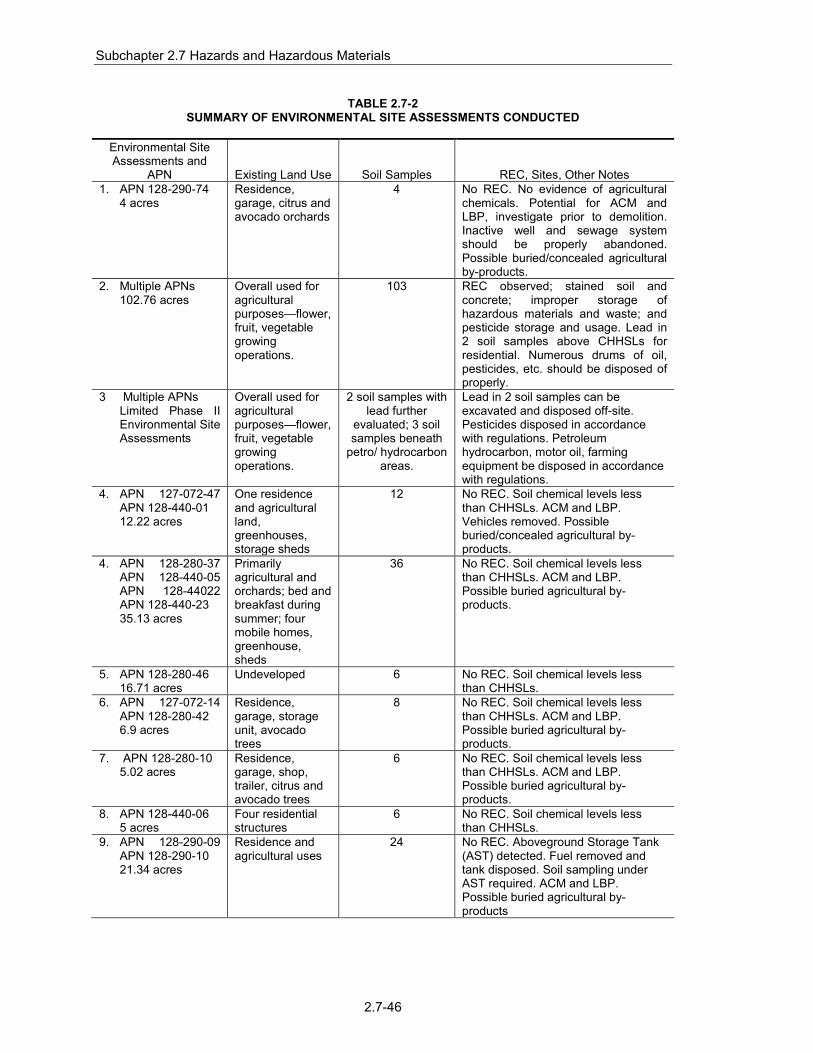
Subchapter 2.7 Hazards and Hazardous Materials
2.7-46
TABLE 2.7-2
SUMMARY OF ENVIRONMENTAL SITE ASSESSMENTS CONDUCTED
Environmental Site Assessments and
APN Existing Land Use Soil Samples REC, Sites, Other Notes 1. APN 128-290-74 4 acres
Residence, garage, citrus and avocado orchards
4 No REC. No evidence of agricultural chemicals. Potential for ACM and LBP, investigate prior to demolition. Inactive well and sewage system should be properly abandoned. Possible buried/concealed agricultural by-products.
2. Multiple APNs 102.76 acres
Overall used for agricultural purposes—flower, fruit, vegetable growing operations.
103 REC observed; stained soil and concrete; improper storage of hazardous materials and waste; and pesticide storage and usage. Lead in 2 soil samples above CHHSLs for residential. Numerous drums of oil, pesticides, etc. should be disposed of properly.
3 Multiple APNs Limited Phase II
Environmental Site Assessments
Overall used for agricultural purposes—flower, fruit, vegetable growing operations.
2 soil samples with lead further
evaluated; 3 soil samples beneath
petro/ hydrocarbon areas.
Lead in 2 soil samples can be excavated and disposed off-site. Pesticides disposed in accordance with regulations. Petroleum hydrocarbon, motor oil, farming equipment be disposed in accordance with regulations.
4. APN 127-072-47 APN 128-440-01 12.22 acres
One residence and agricultural land, greenhouses, storage sheds
12 No REC. Soil chemical levels less than CHHSLs. ACM and LBP. Vehicles removed. Possible buried/concealed agricultural by-products.
4. APN 128-280-37 APN 128-440-05 APN 128-44022 APN 128-440-23 35.13 acres
Primarily agricultural and orchards; bed and breakfast during summer; four mobile homes, greenhouse, sheds
36 No REC. Soil chemical levels less than CHHSLs. ACM and LBP. Possible buried agricultural by-products.
5. APN 128-280-46 16.71 acres
Undeveloped 6 No REC. Soil chemical levels less than CHHSLs.
6. APN 127-072-14 APN 128-280-42 6.9 acres
Residence, garage, storage unit, avocado trees
8 No REC. Soil chemical levels less than CHHSLs. ACM and LBP. Possible buried agricultural by-products.
7. APN 128-280-10 5.02 acres
Residence, garage, shop, trailer, citrus and avocado trees
6 No REC. Soil chemical levels less than CHHSLs. ACM and LBP. Possible buried agricultural by-products.
8. APN 128-440-06 5 acres
Four residential structures
6 No REC. Soil chemical levels less than CHHSLs.
9. APN 128-290-09 APN 128-290-10 21.34 acres
Residence and agricultural uses
24 No REC. Aboveground Storage Tank (AST) detected. Fuel removed and tank disposed. Soil sampling under AST required. ACM and LBP. Possible buried agricultural by-products

Subchapter 2.7 Hazards and Hazardous Materials
2.7-47
TABLE 2.7-2 SUMMARY OF ENVIRONMENTAL SITE ASSESSMENTS CONDUCTED
Environmental Site Assessments and
APN Existing Land Use Soil Samples REC, Sites, Other Notes 10. Multiple APNs 21.76 acres
Agricultural uses, citrus and avocado orchards. Four structures on-site.
24 A UST, containing fuel, was formerly present on-site. A small shed with a fuel pump was associated with the UST. Soil samples indicate that further investigation is not warranted. Soil chemical levels less than CHHSLs. ACM and LBP. Possible buried agricultural by-products. Septic systems to be abandoned following County Health Department requirements.
11. APN 127-072-20 40.59 acres
Active orchards, storage sheds
43 AST removed in March 2012. Diesel Range Organics (DRO) exceeds screening levels. Soil should be excavated and disposed. Other soil chemicals less than CHHSLs. Possible buried agricultural by-products. Septic systems to be abandoned following County Health Department requirements.
12. APN 129-011-16 6.08 acres
Agricultural lands and orchard groves. Single wood structure for farming operations.
12 No REC. Soil chemical levels less than CHHSLs. Buried agricultural by-products possible.
13. APN 127-072-38, APN 127-072-40, APN 127-072-41 APN 127-07246 34.99 acres
Mainly agricultural land including orchard groves and agricultural fields. Storage tanks utilized by the Valley Center Municipal Water District are located within an easement on the southwest portion of the property (not part of the assessment)
30 No REC. No releases, leaks, or spills. Soil chemical levels less than CHHSLs. Three 55-gallon storage drums, two of which were full (contents unknown), should be properly disposed. Septic systems (if found) to be abandoned following County Health Department requirements. Buried agricultural by-products possible.
14. Multiple APNs 86.8 acres
Mix of mature citrus orchards under active cultivation; two residential structures
16 AST (currently empty) is present. No leakage below AST. Should be removed and properly disposed. Previous sampling (2007-8) showed toxaphene levels in soils above CCHSLs. Additional investigation needed. Potential for ACM and LBP. Septic systems and wells to be abandoned. Buried agricultural by-products possible.
15. Multiple APNs 58.6 acres
Active agricultural land, consisting of citrus groves.
In 2006-8, 93 soil samples. In 2012,
3 additional samples.
No REC. No releases, leaks, or spills. Soil chemical levels less than CHHSLs. Buried agricultural by-products possible.
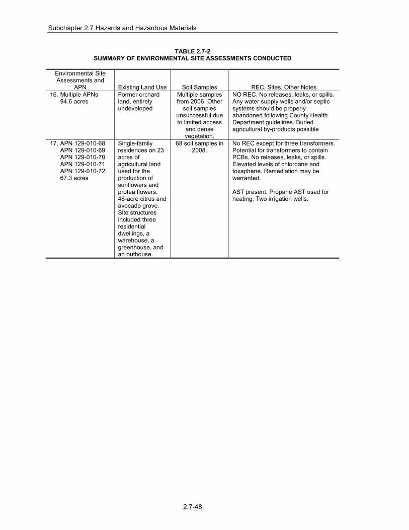
Subchapter 2.7 Hazards and Hazardous Materials
2.7-48
TABLE 2.7-2 SUMMARY OF ENVIRONMENTAL SITE ASSESSMENTS CONDUCTED
Environmental Site Assessments and
APN Existing Land Use Soil Samples REC, Sites, Other Notes 16. Multiple APNs 94.6 acres
Former orchard land, entirely undeveloped
Multiple samples from 2006. Other
soil samples unsuccessful due to limited access
and dense vegetation.
NO REC. No releases, leaks, or spills. Any water supply wells and/or septic systems should be properly abandoned following County Health Department guidelines. Buried agricultural by-products possible
17. APN 129-010-68 APN 129-010-69 APN 129-010-70 APN 129-010-71 APN 129-010-72 67.3 acres
Single-family residences on 23 acres of agricultural land used for the production of sunflowers and protea flowers. 46-acre citrus and avocado grove. Site structures included three residential dwellings, a warehouse, a greenhouse, and an outhouse.
68 soil samples in 2008.
No REC except for three transformers. Potential for transformers to contain PCBs. No releases, leaks, or spills. Elevated levels of chlordane and toxaphene. Remediation may be warranted. AST present. Propane AST used for heating. Two irrigation wells.

FIGURE 2.7-1Project Gated Access
M:\JOBS4\6153\env\graphics\fig2.7-1.ai 06/06/13
Not to Scale
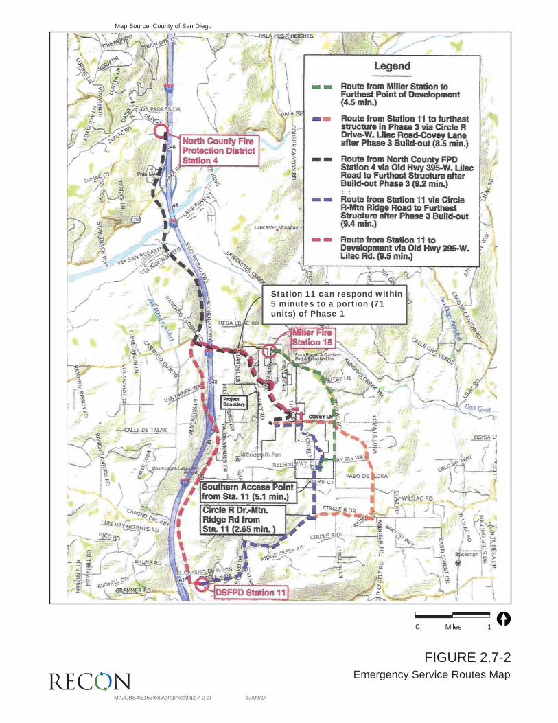
-Station 11 can respond within 5 minutes to a portion (71 units) of Phase 1
FIGURE 2.7-2Emergency Service Routes Map
M:\JOBS4\6153\env\graphics\fig2.7-2.ai 12/09/14
Map Source: County of San Diego
0 1Miles

FIGURE 2.7-3Lilac Hills Ranch Evacuation Plan
M:\JOBS4\6153\env\graphics\fig2.7-3.ai 05/06/14
Map Source: FIREWISE 2000, Inc. 2014
0 1,200Feet

Subchapter 2.7 Hazards and Hazardous Materials
2.7-52
THIS PAGE IS INTENTIONALLY BLANK.