24356 - US 29 & 70 Borrow Sites GEOTECH REPORT
58
REPORT OF PRELIMINARY SUBSURFACE EXPLORATION SERVICES US 29 & HWY 70 – BORROW SITES GREENSBORO, NORTH CAROLINA ECS CAROLINAS, LLP PROJECT NUMBER 09.24356 PREPARED FOR BALFOUR BEATTY INFRASTRUCTURE WILIMINGTON, NORTH CAROLINA JUNE 13, 2014
Transcript of 24356 - US 29 & 70 Borrow Sites GEOTECH REPORT
REPORT OF PRELIMINARY SUBSURFACE EXPLORATION SERVICES
US 29 & HWY 70 – BORROW SITES GREENSBORO, NORTH CAROLINA
ECS CAROLINAS, LLP PROJECT NUMBER 09.24356
PREPARED FOR
BALFOUR BEATTY INFRASTRUCTURE WILIMINGTON, NORTH CAROLINA
JUNE 13, 2014
June 13, 2014 Mr. Phil Broom Balfour Beatty Infrastructure Inc. 765 S. Kerr Avenue Wilmington, NC 28403
ECS Project No. 09.24356 Reference: Report of Preliminary Subsurface Exploration Services US 29 & Hwy 70 – Borrow Sites Greensboro, North Carolina Dear Mr. Broom: ECS Carolinas, LLP (ECS) has completed a subsurface exploration for the subject sites as authorized by acceptance of our Proposal No. 09.21928-P, dated May 28, 2014. The purposes of this exploration were to explore the subsurface conditions at the sites and provide geotechnical information to guide design and construction of the project. This report presents our evaluations and recommendations, the results of our exploration, our scope of work, and our understanding of the project information. This report is provided for the use of Mr. Phil Broom and Balfour Beatty Infrastructure Inc. This report is not intended to be used or relied upon in connection with other projects or by other unidentified third parties without the written permission of ECS. The unauthorized use of this report by any undesignated third party or parties will be at such party’s sole risk and ECS disclaims liability for any such unauthorized third party use or reliance. ECS appreciates the opportunity to provide our professional services during this phase of your project. Please contact us if you have questions concerning the following report. Respectfully, ECS CAROLINAS, LLP Kalen Cuthbertson Reviewed by: David M. Cutter, P.E. Assistant Project Manager Principal Engineer License No. 022089
Attachments
Page 1 of 5
US 29 & Hwy 70 – Borrow Sites Greensboro, North Carolina ECS Project No 09.24356 June 13, 2014
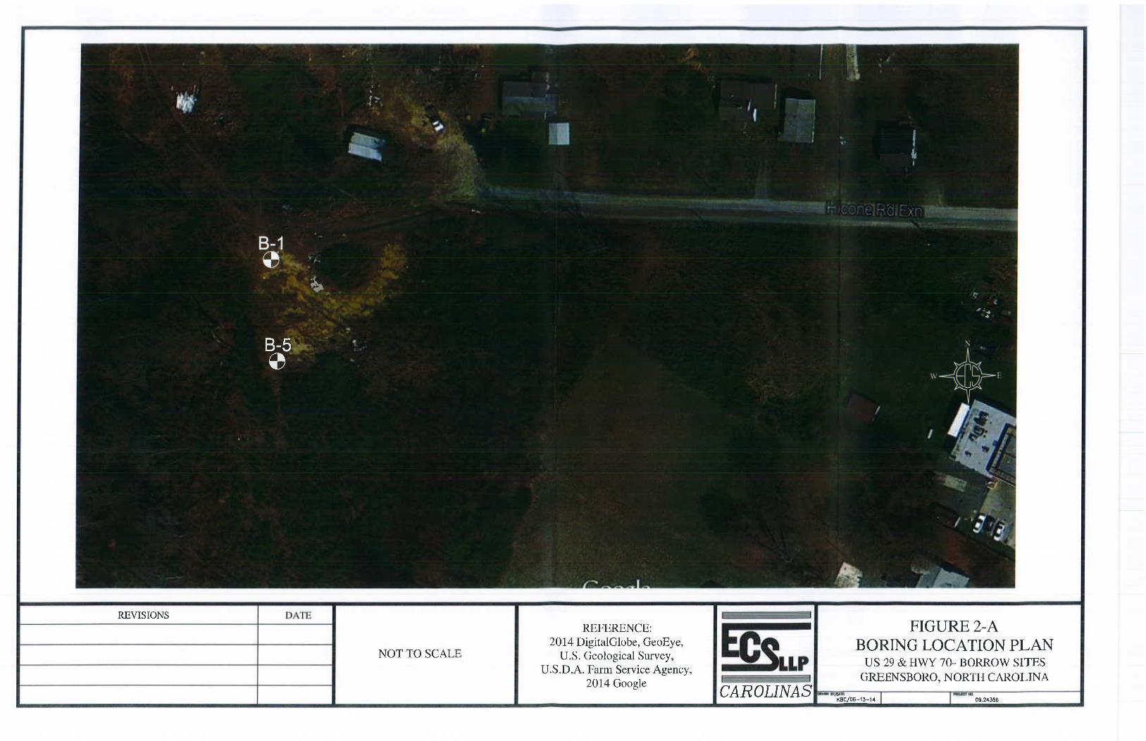
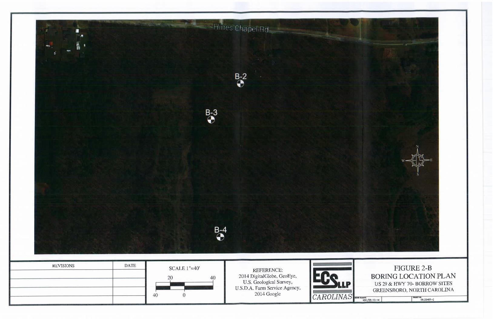
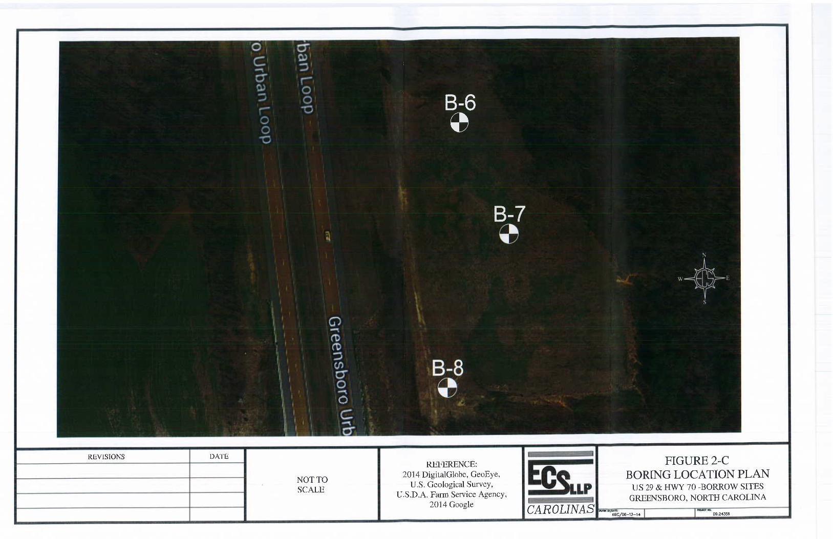
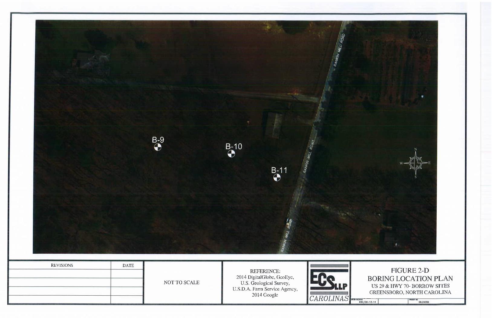
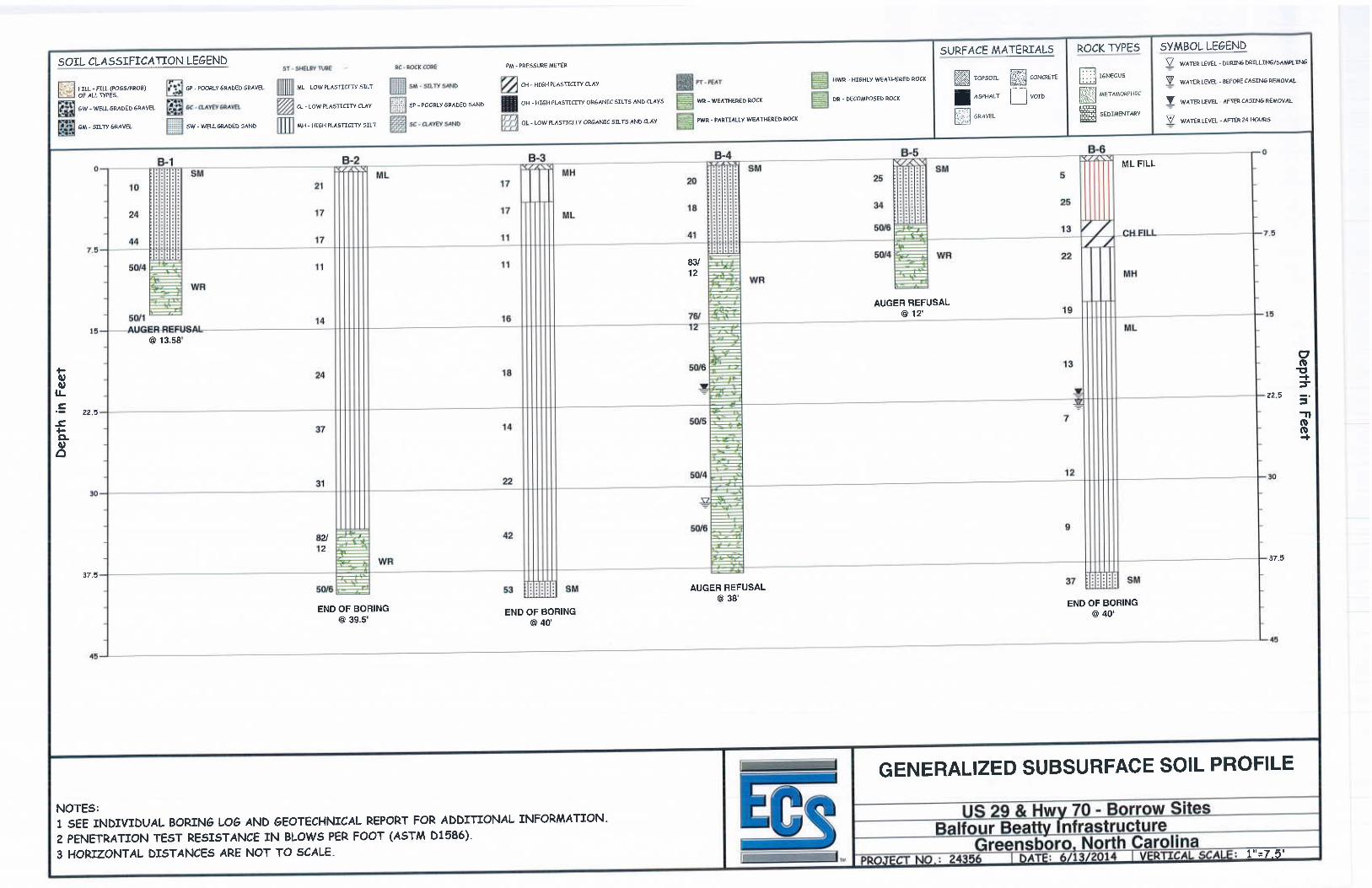
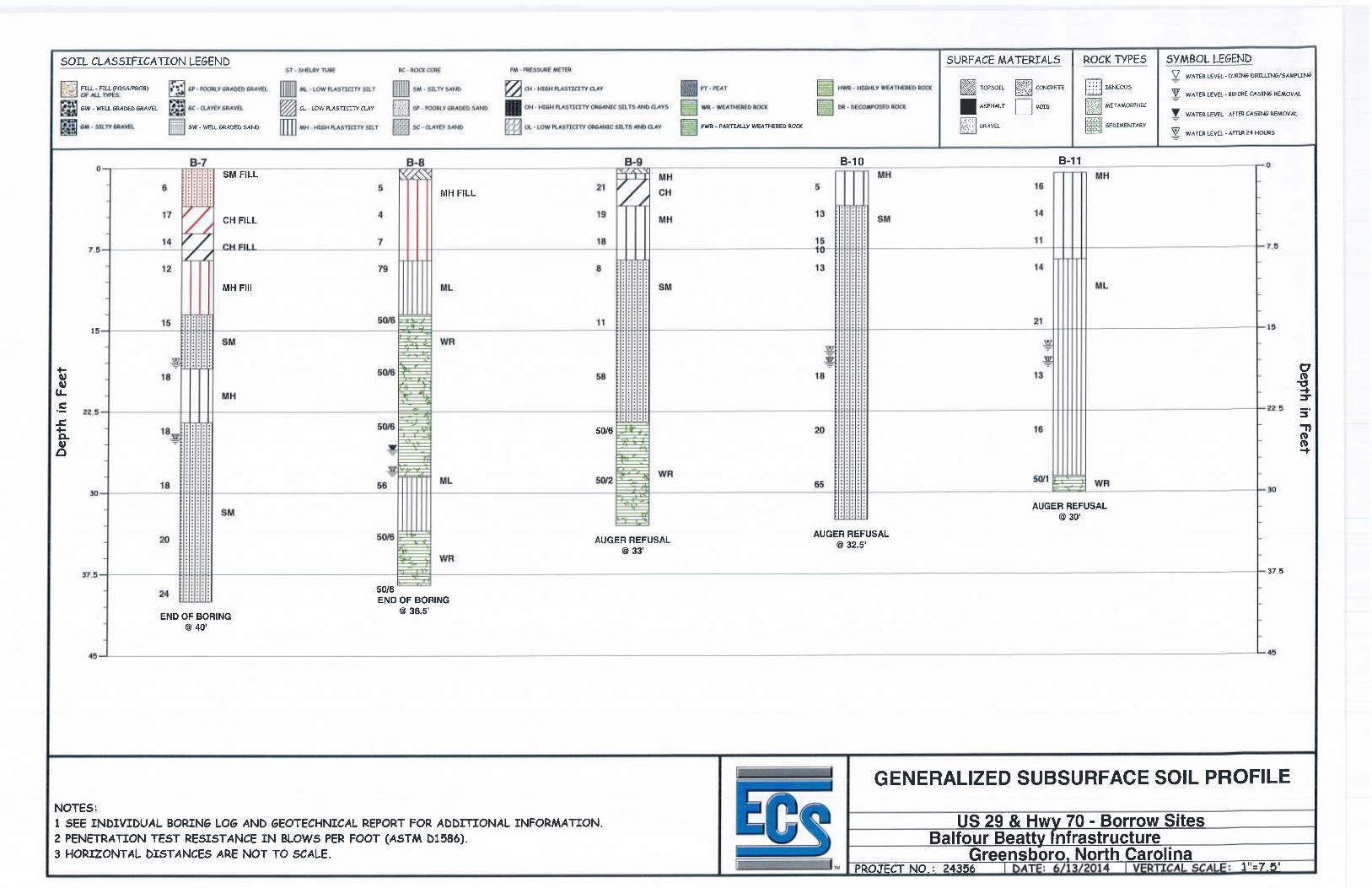
Project Information At this time, the project consists of exploration of four different properties for borrow material for the future US 29 and Highway 70 connector. Project Information was provided by Mr. Phil Broom with Balfour Beatty Infrastructure. Exploration Procedures Subsurface conditions were explored at a total of eleven(11) boring locations, denoted B-1 to B-11, at four separate site locations. Borings B-1 and B-5 were completed at 2005 Brightwood School Road in Greensboro, NC. Borings B-2 to B-4 were completed at 3202 Hines Chapel Road in Mcleansville, NC. Borings B-6 to B-8 were completed at 270 Clapp Farms Road in Greensboro, NC. Borings B-9 to B-11 were completed at 1245 Rankin Mill Road in Greensboro. NC. The borings were advanced to depths of approximately 12 to 40 feet below existing site grades. The boring locations were selected and located in the field by others. The approximate boring locations are shown on the attached Boring Location Plans. Detailed topographic information was not provided to estimate the ground surface elevations at the boring locations. Drilling was performed by a B-47 truck-mounted drill rig using continuous-flight hollow stem augers. Soil samples were obtained by means of the split-barrel sampling procedures in accordance with ASTM Specification D-1586. In the split-barrel sampling procedure, a 2-inch O.D., split-barrel sampler is driven into the soil a distance of 18 inches by means of a 140-pound hammer falling 30 inches. The number of blows required to drive the sampler through a 12-inch interval is termed the Standard Penetration Test (SPT) value and is indicated for each sample on the boring logs. This value can be used to provide a qualitative indication of the in-place relative density of cohesionless soils. In a less reliable way, it also indicates the consistency of cohesive soils. This indication is qualitative, since many factors can significantly affect the SPT value and prevent a direct correlation between drill crews, drill rigs, drilling procedures, and hammer-rod-sampler assemblies. Representative portions of each SPT sample were sealed in airtight containers and returned to our laboratory for classification, testing, and storage. The soil samples were visually classified in general accordance with the Unified Soil Classification System (USCS). The basic elements of the USCS are described on a legend sheet attached in Appendix E and in ASTM D2487. Additional information from each soil boring is provided on the individual soil test boring logs in Appendix E.
Soil Classification Procedures
Each soil sample was classified on the basis of texture and plasticity in accordance with the Unified Soil Classification System. The group symbols for each soil type are indicated in the parentheses following the soil descriptions on the boring logs. A brief
Page 2 of 5
US 29 & Hwy 70 – Borrow Sites Greensboro, North Carolina ECS Project No 09.24356 June 13, 2014
explanation of the Unified Soil Classification System is included with this report. The various soil types were grouped into the major zones noted on the boring logs. The stratification lines designating the interfaces between earth materials on the boring logs are approximate; in-situ, the transitions may be gradual and/or at slightly different levels.
Subsurface Conditions
The specific soil conditions at each boring location are noted on the attached boring logs. A general description is also provided below. Subsurface conditions can and often do vary between boring locations and in unexplored areas.
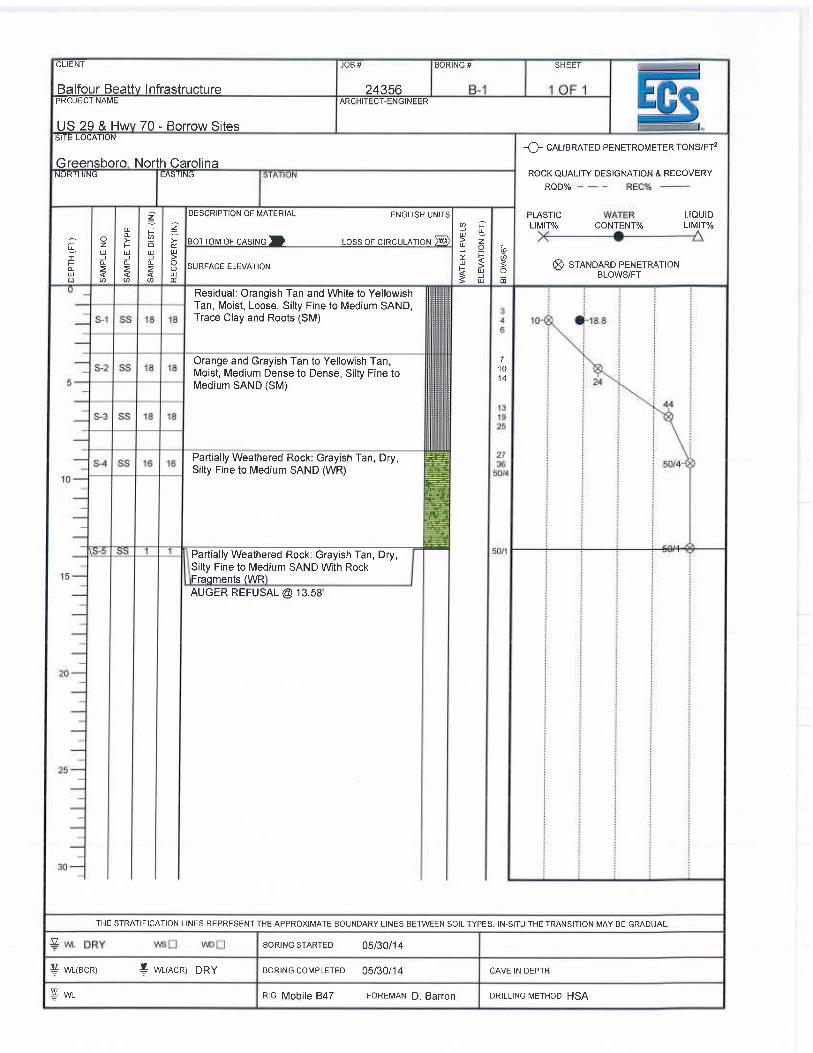
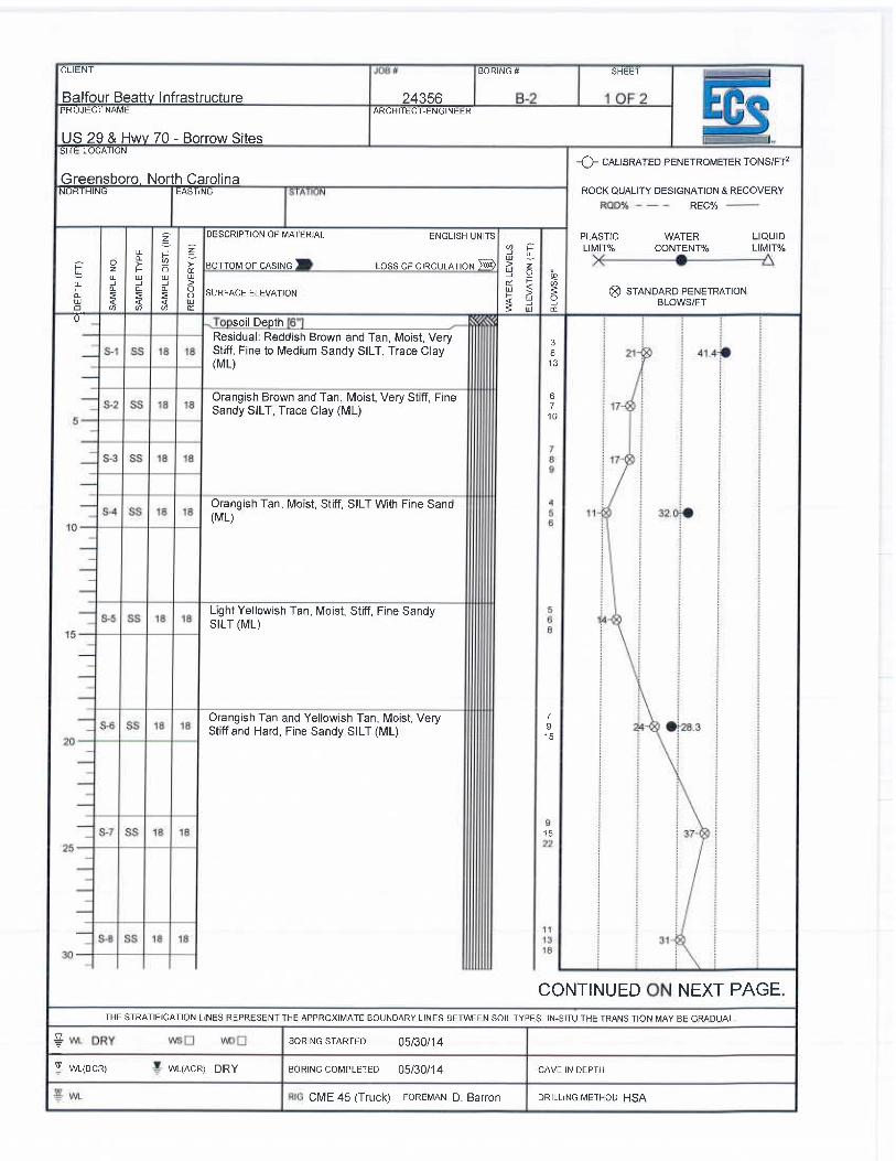
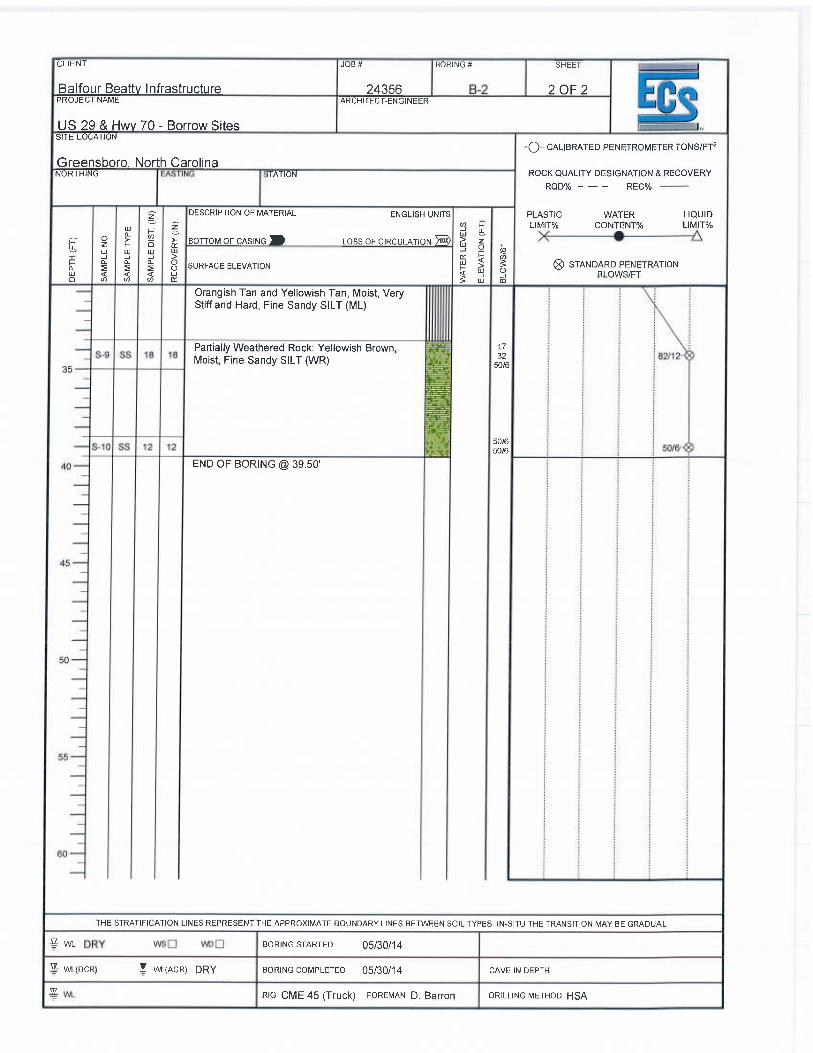
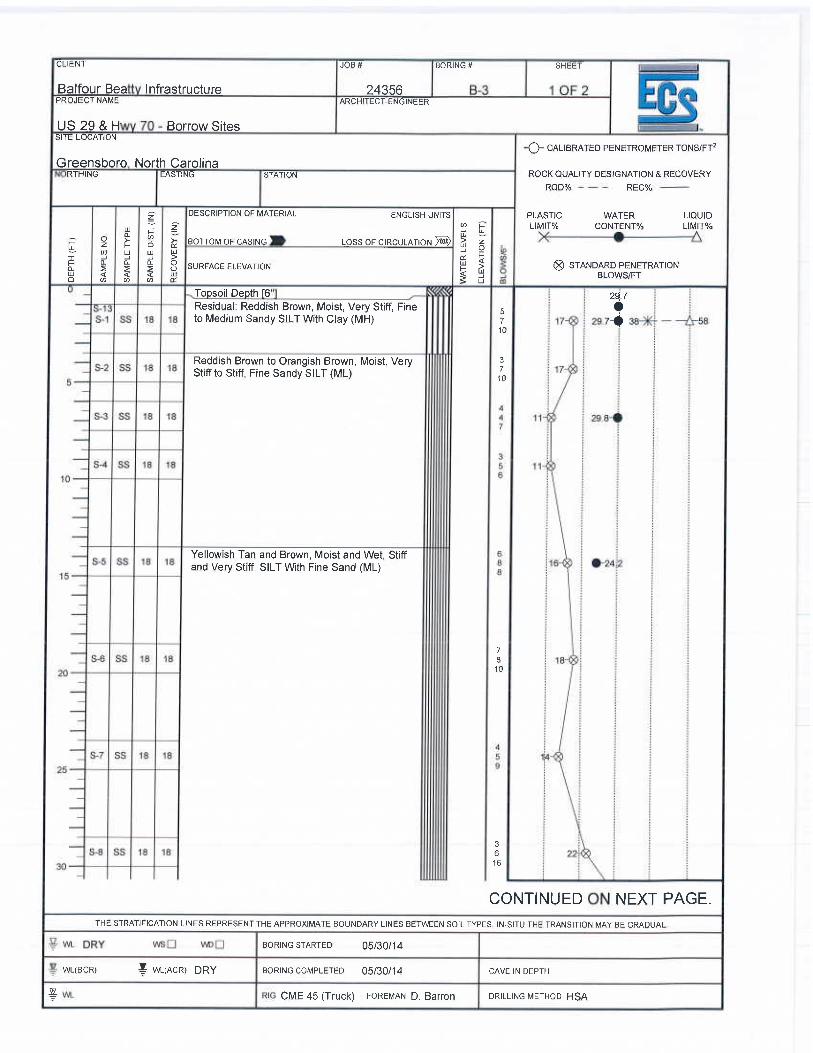
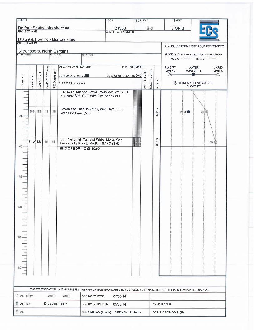
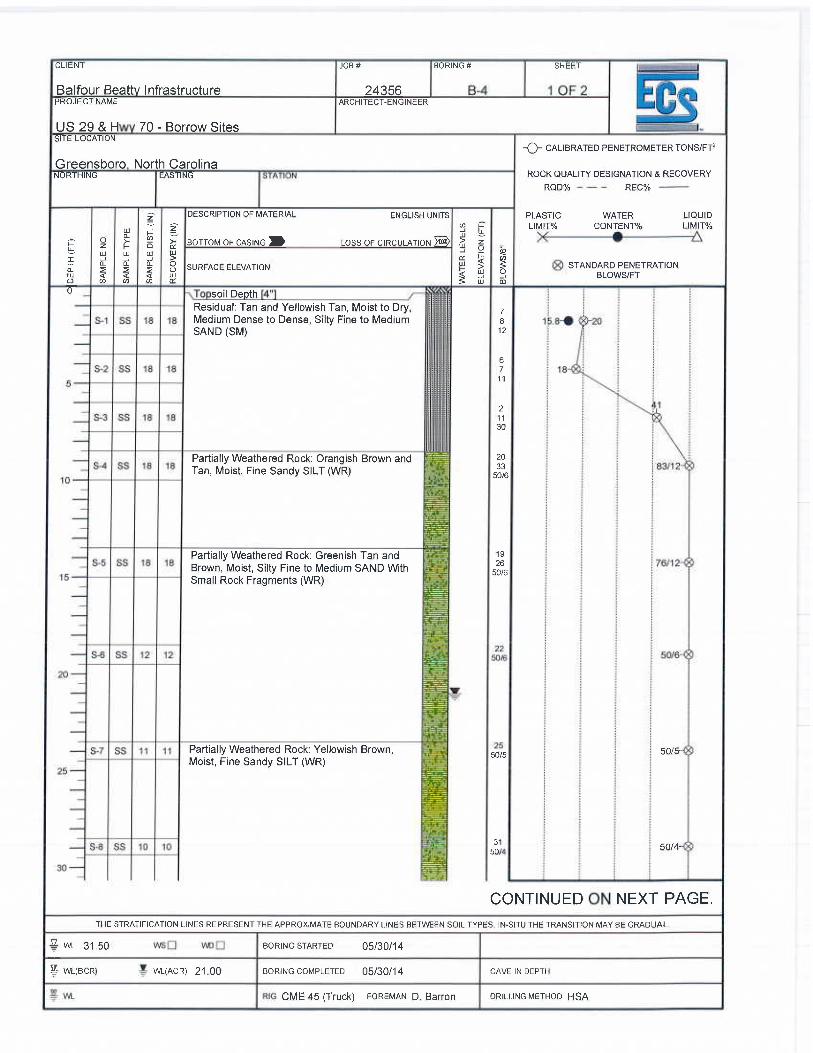
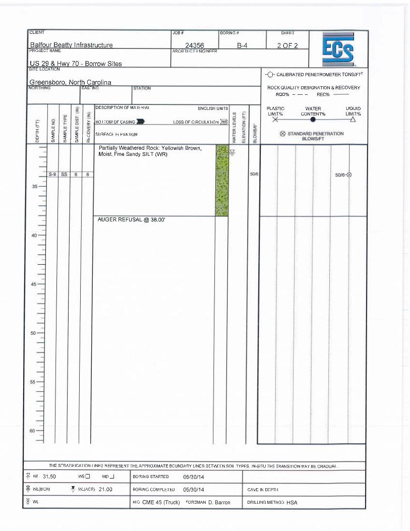
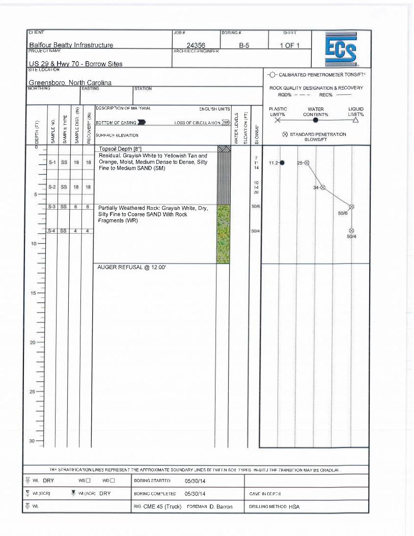
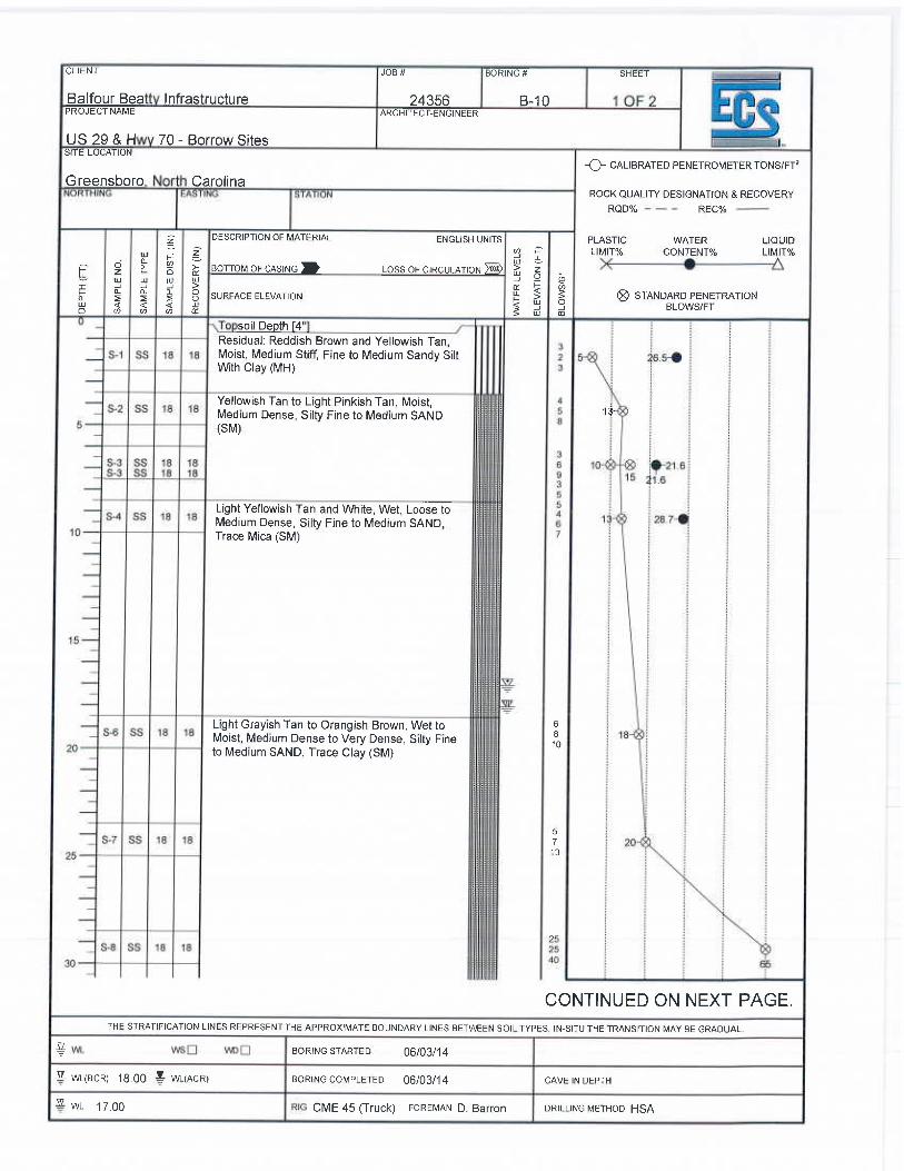
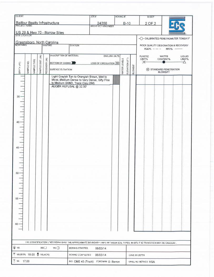
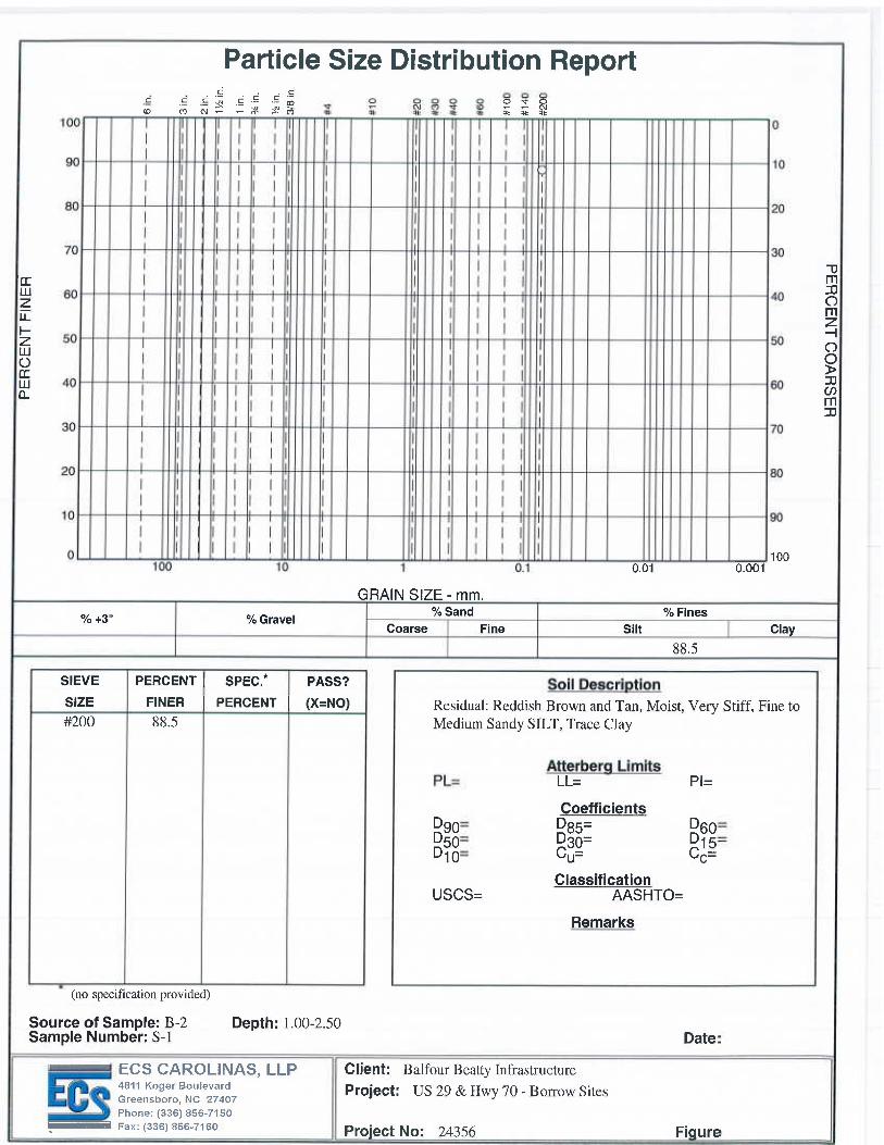
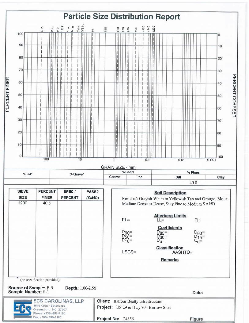
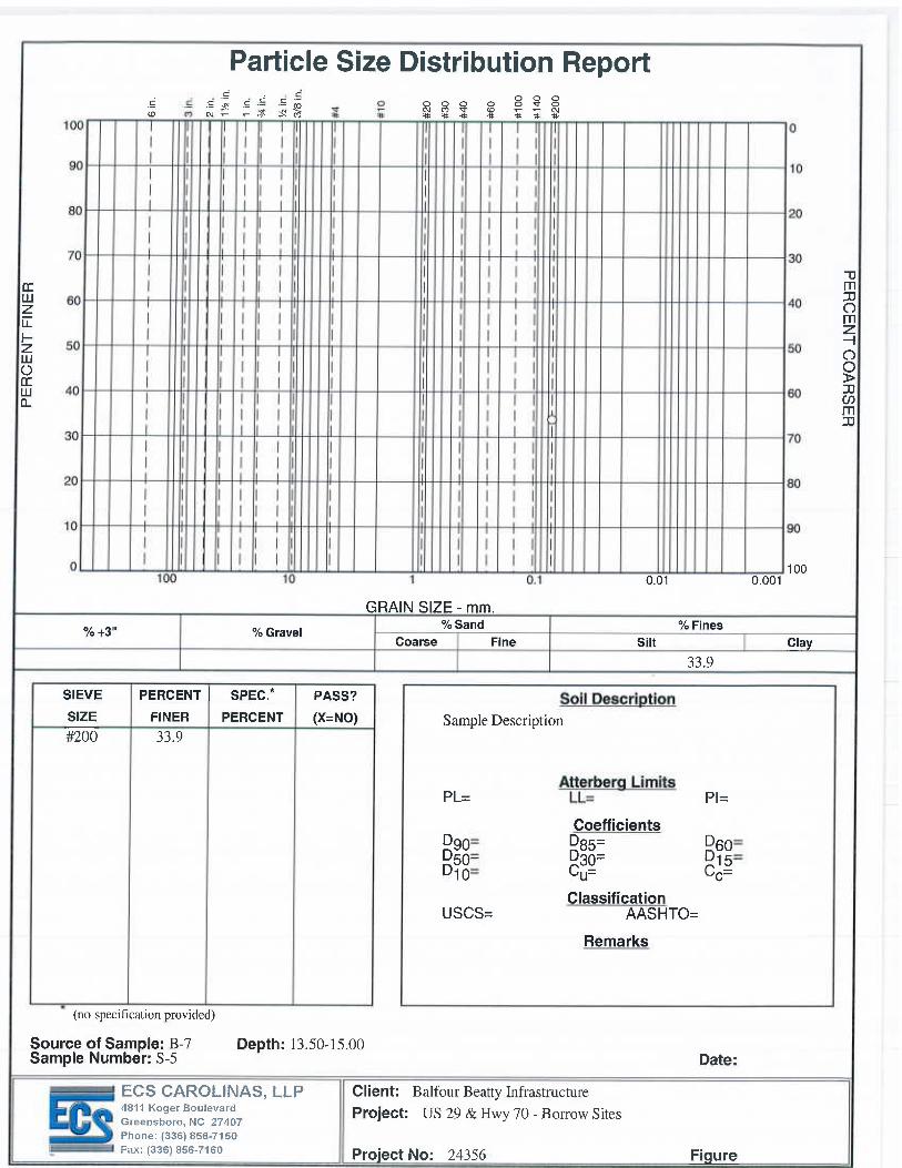
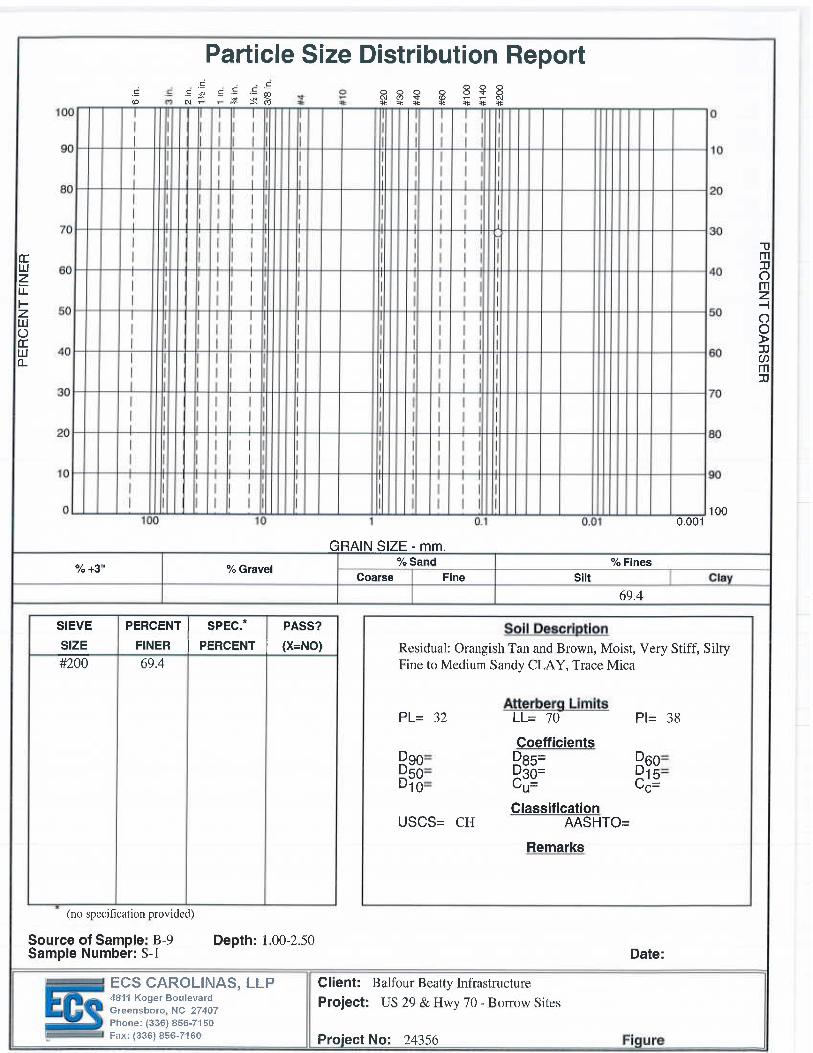
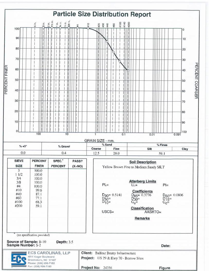
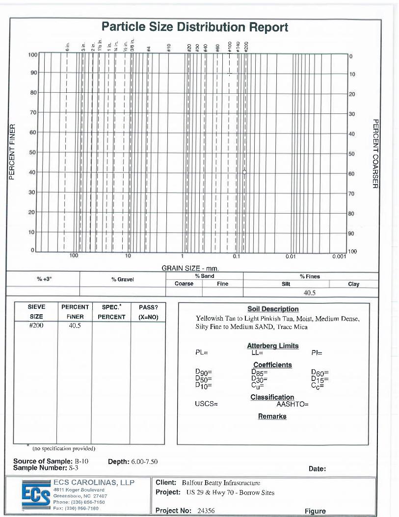
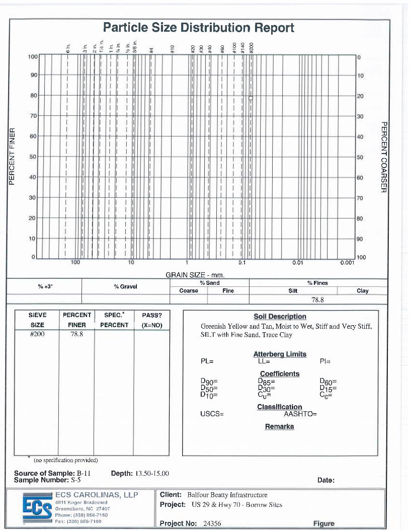
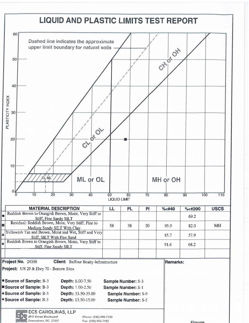
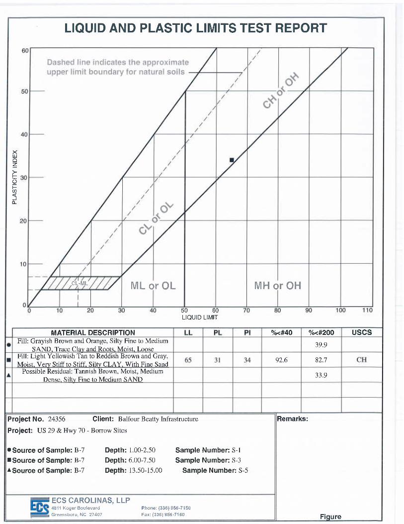
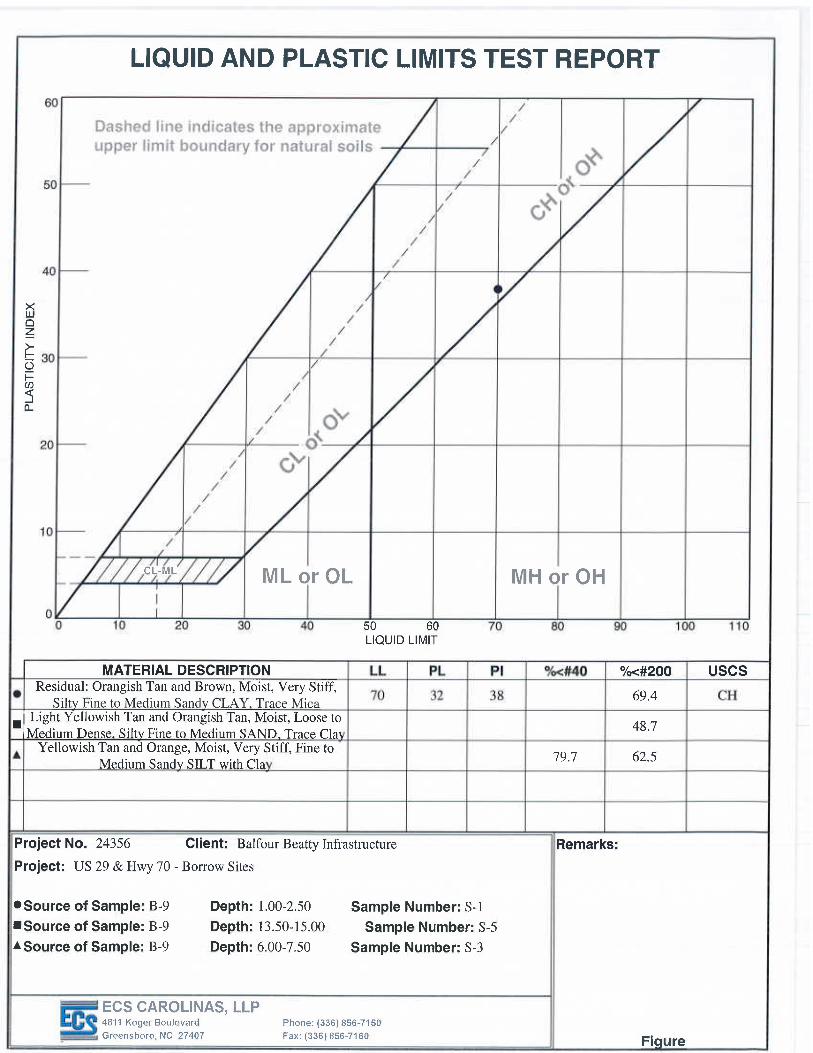
2005 Brightwood School Road, Greensboro, NC (borings B-1 and B-5): The residual soils generally consisted of moist silty fine to medium sand (SM). The SPT N-values for the sand layers encountered ranged from 10 to 44 bpf denoting loose to dense relative densities. Groundwater was not observed in the borings at the completion of drilling operations. Materials appeared suitable for use as structural fill without a need for drying. Partially weathered rock should generally be rippable in open cut excavations. Partially weathered rock and auger refusal materials were encountered by the borings. Partially weathered rock consisting of dry silty fine to medium sand was encountered in borings B-1 and B-5 at depths of 6 to 8.5 feet below the ground surface. Auger refusal materials were encountered in borings B-1 and B-5 at depths of 12 to 13.6 feet below the ground surface. 3202 Hines Chapel Road, Mcleansville, NC (borings B-2 to B-4): The natural soils generally consisted of clayey sandy silt, sandy silt, and silty sand. SPT blow counts ranged from 11 to 53 blows per foot indicating stiff to very hard consistencies. Partially weathered rock and auger refusal materials were encountered by the borings. Partially weathered rock consisting of moist fine sandy silt and silty fine to medium sand was encountered in borings B-2 and B-4 at depths of 8.5 to 33.5 feet below the ground surface. Auger refusal materials were encountered in borings B-2 and B-4 at depths of 38 to 39.5 feet below the ground surface. Groundwater was observed in the boring B-4 at approximately 21 feet below ground surface after the completion of drilling operations. Materials were generally suitable for reuse as structural fill although drying may be required. MH materials will be moisture sensitive and should not be used for direct foundation or pavement support. Partially weathered rock should be rippable in open cut excavations.
Page 3 of 5
US 29 & Hwy 70 – Borrow Sites Greensboro, North Carolina ECS Project No 09.24356 June 13, 2014
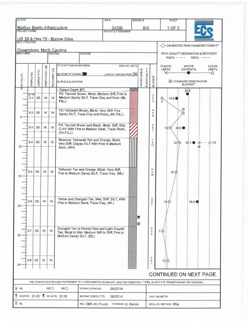
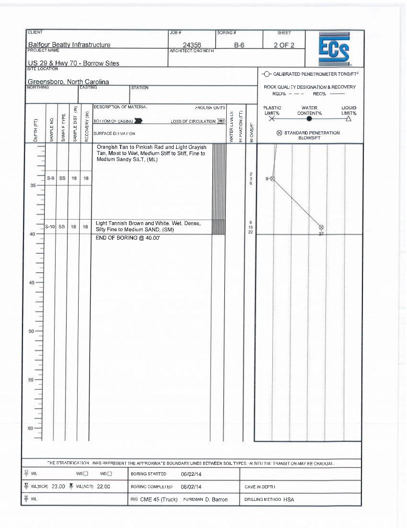
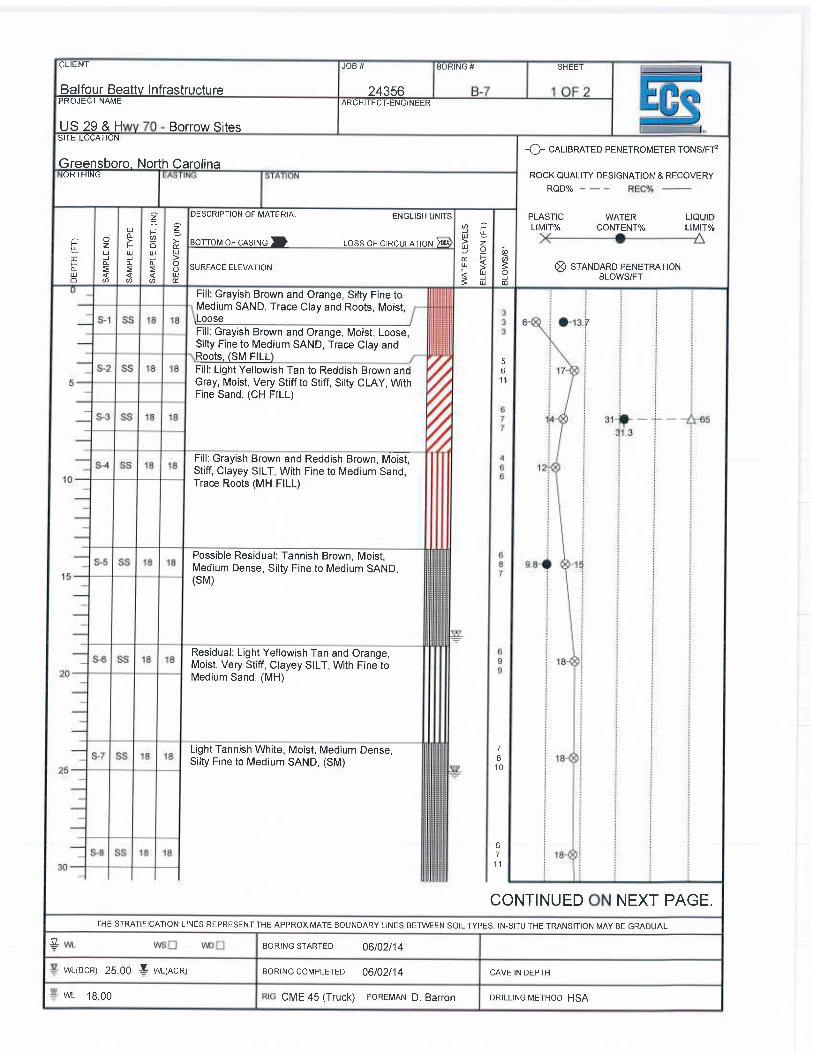
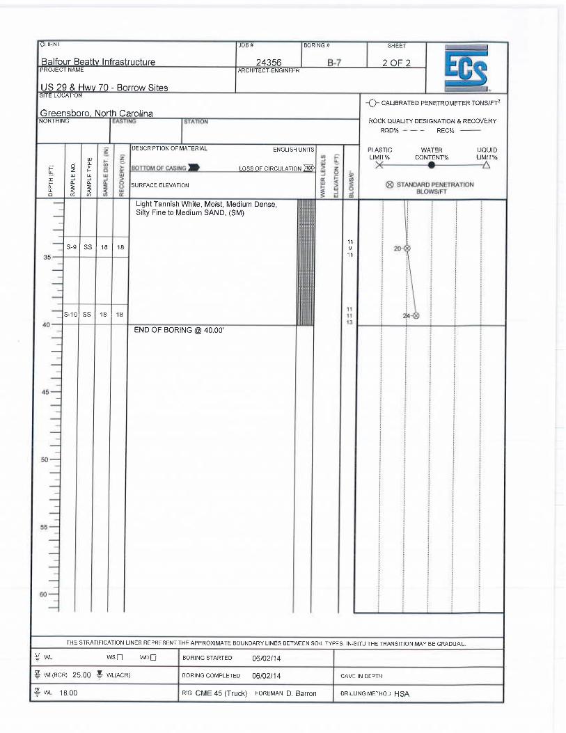
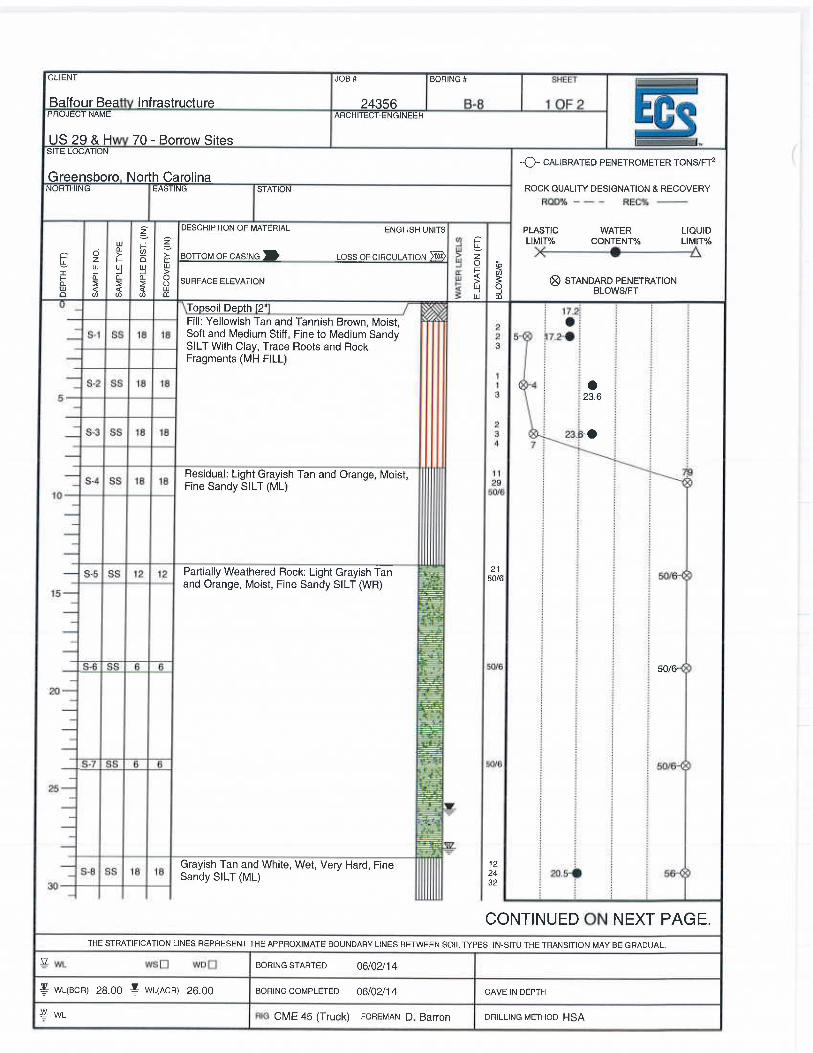
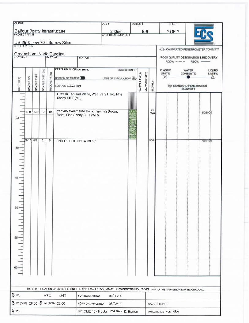
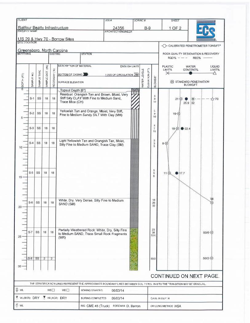
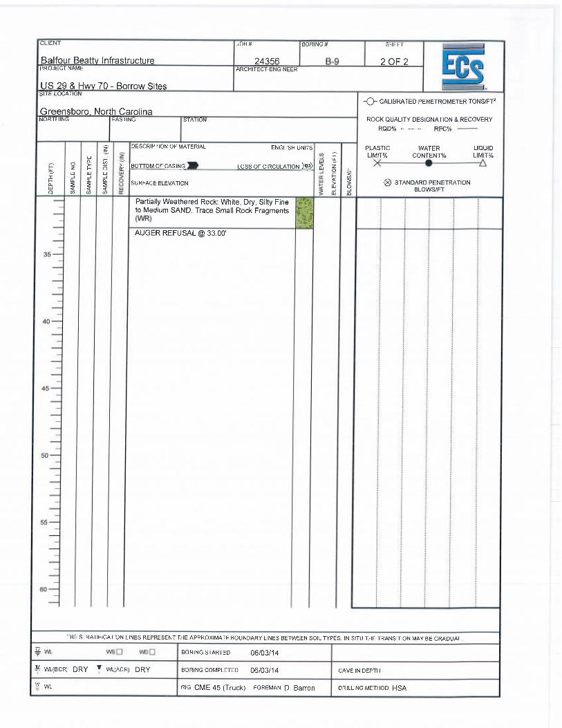
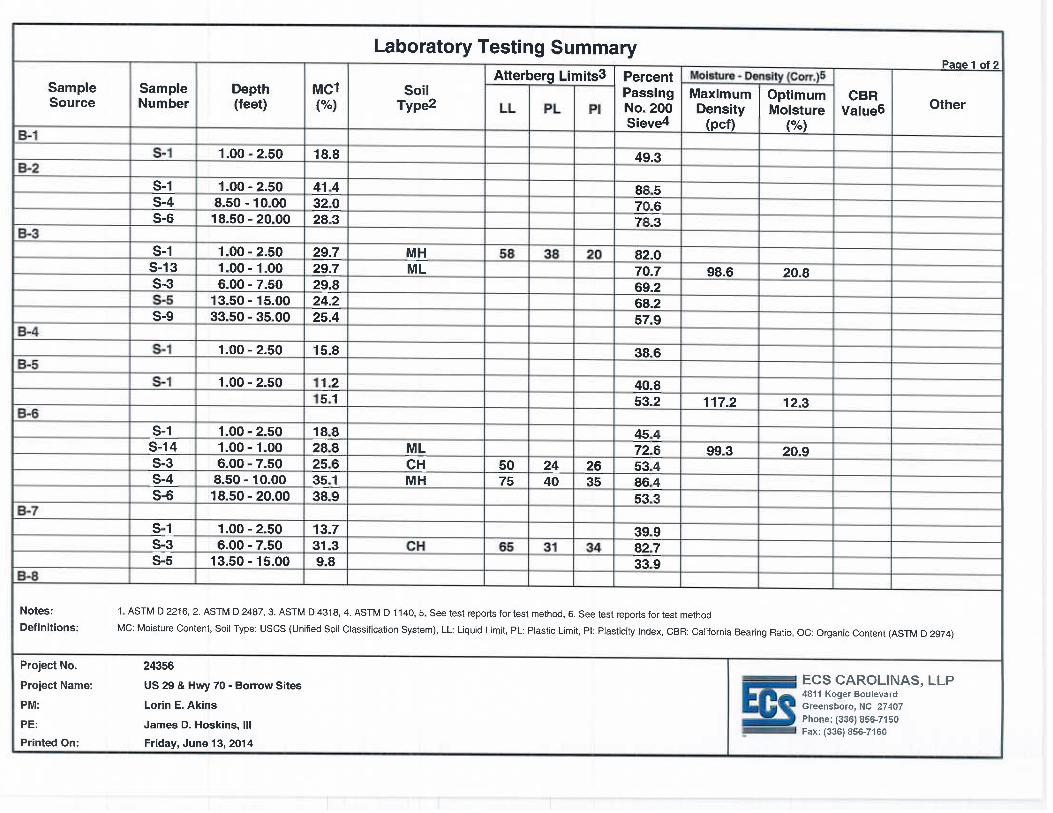
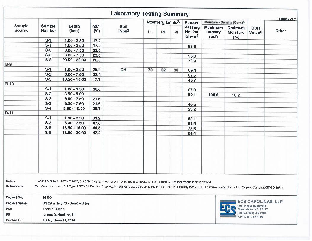
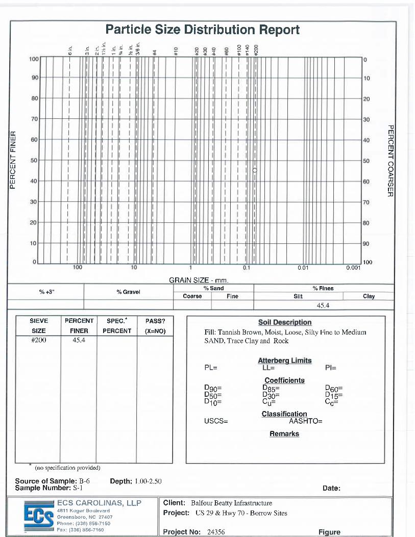
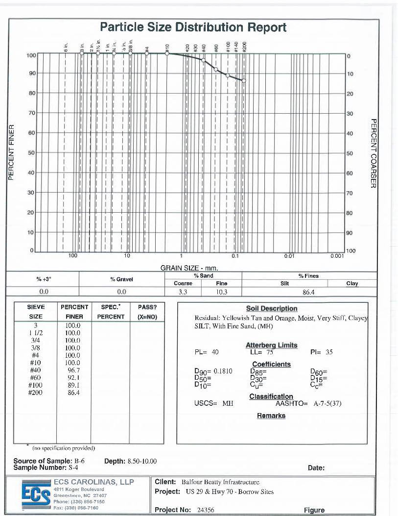
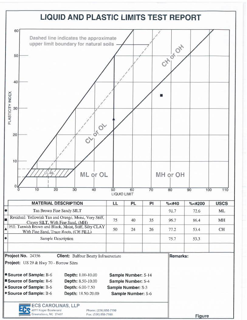
270 Clapp Farms Road, Greensboro, NC (borings B-6 to B-8): Fill was encountered at borings B-6 through B-8. Fill soils consisting of moist silty clay with fine to medium sand, fine sandy silt and fine to medium sandy silt were found to extend to a depth of about 8.5 to 13.5 feet below the ground surface. The SPT N-values in the fill ranged from 5 to 25 blows per foot (bpf). The natural soils generally consisted of sandy silts and silty sands, with isolated zones of clayey sandy silt. SPT N-counts ranged from 7 to 56 blows per foot indicating medium stiff to very hard consistencies. Partially weathered rock consisting of moist fine sandy silt was encountered in boring B-8 from a depth of 8.5 to 28.5 feet below the ground surface and from 33.5 to 39 feet below ground surface. Groundwater was observed in the borings at approximately 18 to 26 feet after the completion of drilling operations. Existing CH fill material will be moisture sensitive, difficult to compact, and should only be used in deep fill sections. MH materials may be used as noted above but will be moisture sensitive. Residual soils appear suitable for use as fill but may require drying. Weathered rock should be rippable in open cut excavations. 1245 Rankin Mill Road, Greensboro, NC (borings B-9 to B-11): The residual soils generally consisted of silty clay, clayey silt, sandy silt, and silty sands. SPT N counts ranged from 5 to 65 BPF. Partially weathered rock consisting of dry silty fine to medium sand was encountered in boring B-9 at a depth of 23.5 to 33 feet below the ground surface. Auger refusal materials were encountered by borings B-9 to B-11 at depths of 30 to 33 feet below the ground surface. Groundwater was observed in borings B-10 and B-11 after the completion of drilling operations. High plasticity CH and MH soils will be moisture sensitive, as noted above. Residual materials appear suitable for reuse but will likely require drying before reuse. Laboratory Testing Representative soil samples obtained during our field exploration were selected and tested in our laboratory to verify field classifications and to help determine pertinent engineering properties of the site soils. Laboratory testing included visual classifications in accordance with the Unified Soil Classification System, (USCS, as described in ASTM D 2487), Standard Proctor testing (ASTM D 698), natural moisture content (ASTM D 2216), Atterberg limits (ASTM D 4318), Percent Fines (ASTM D 1140), and Grain Size Analysis (ASTM D 422). The laboratory testing was performed in general conformance
Page 4 of 5
US 29 & Hwy 70 – Borrow Sites Greensboro, North Carolina ECS Project No 09.24356 June 13, 2014
Testing Summary in the Appendix of this report. Select index property test results are also included on the Boring Logs and individual test data sheets in the Appendix. General Comments
This data report has been prepared in order to aid in the evaluation of borrow material for highway construction and to assist the architect and/or engineer in the design of this project. The scope is limited to the specific project and locations described herein and our description of the project represents our understanding of the significant aspects relative to soil and foundation characteristics. In the event that any changes in the nature or location of the proposed construction outlined in this report are planned, we should be informed so that the changes can be reviewed and the conclusions of this report modified or approved in writing by the geotechnical engineer. It is recommended that the construction operations dealing with earthwork and foundations be reviewed by an experienced geotechnical engineer to provide information as to whether the design requirements are fulfilled in the actual construction. If you wish, we would welcome the opportunity to provide field construction services for you during construction.
The data submitted in this report are based upon the information obtained from the soil borings and tests performed at the locations as indicated on the Boring Location Plan and other information referenced in this report. This report does not reflect variations which may occur between and outside of the borings. In the performance of the subsurface exploration, specific information is obtained at specific locations at specific times. However, it is a well known fact that variations in soil conditions exist on most sites between boring locations and also such situations as groundwater levels vary from time to time. The nature and extent of variations may not become evident until the course of construction.
Thank you for the opportunity to work with you on this project. Should you have any questions or if we could be of further assistance, please do not hesitate to contact us.
Page 5 of 5
US 29 & Hwy 70 – Borrow Sites Greensboro, North Carolina ECS Project No 09.24356 June 13, 2014
APPENDICES
Appendix A – Illustrations
Boring Location Plan Generalized Subsurface Profile
Legend Sheet and Unified Soil Classification System Soil Test Boring Logs
Appendix B – Laboratory Test Results
Laboratory Testing Summary
Moisture Density Relationship Curve Atterberg Limits
Grain Size Percent Fine

US 29 & Hwy 70 – Borrow Sites Greensboro, North Carolina ECS Project No 09.24356 June 13, 2014
i
APPENDIX A – ILLUSTRATIONS
1
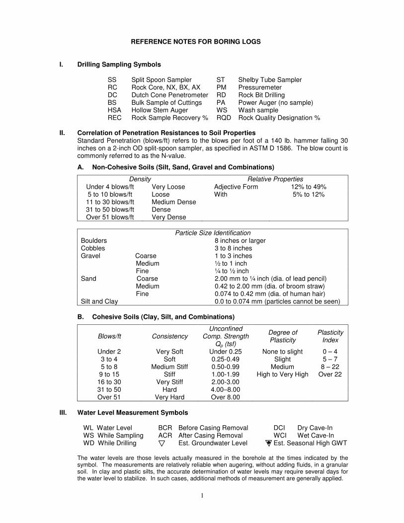
REFERENCE NOTES FOR BORING LOGS I. Drilling Sampling Symbols
SS Split Spoon Sampler ST Shelby Tube Sampler RC Rock Core, NX, BX, AX PM Pressuremeter DC Dutch Cone Penetrometer RD Rock Bit Drilling BS Bulk Sample of Cuttings PA Power Auger (no sample) HSA Hollow Stem Auger WS Wash sample REC Rock Sample Recovery % RQD Rock Quality Designation %
II. Correlation of Penetration Resistances to Soil Properties
Standard Penetration (blows/ft) refers to the blows per foot of a 140 lb. hammer falling 30 inches on a 2-inch OD split-spoon sampler, as specified in ASTM D 1586. The blow count is commonly referred to as the N-value.
A. Non-Cohesive Soils (Silt, Sand, Gravel and Combinations)
Density Relative Properties Under 4 blows/ft Very Loose Adjective Form 12% to 49% 5 to 10 blows/ft Loose With 5% to 12% 11 to 30 blows/ft Medium Dense 31 to 50 blows/ft Dense Over 51 blows/ft Very Dense
Particle Size Identification
Boulders 8 inches or larger Cobbles 3 to 8 inches Gravel Coarse 1 to 3 inches Medium ½ to 1 inch Fine ¼ to ½ inch Sand Coarse 2.00 mm to ¼ inch (dia. of lead pencil) Medium 0.42 to 2.00 mm (dia. of broom straw) Fine 0.074 to 0.42 mm (dia. of human hair) Silt and Clay 0.0 to 0.074 mm (particles cannot be seen)
B. Cohesive Soils (Clay, Silt, and Combinations)
Blows/ft Consistency Unconfined
Comp. Strength Qp (tsf)
Degree of Plasticity
Plasticity Index
Under 2 Very Soft Under 0.25 None to slight 0 – 4 3 to 4 Soft 0.25-0.49 Slight 5 – 7 5 to 8 Medium Stiff 0.50-0.99 Medium 8 – 22 9 to 15 Stiff 1.00-1.99 High to Very High Over 22 16 to 30 Very Stiff 2.00-3.00 31 to 50 Hard 4.00–8.00 Over 51 Very Hard Over 8.00
III. Water Level Measurement Symbols
WL Water Level BCR Before Casing Removal DCI Dry Cave-In WS While Sampling ACR After Casing Removal WCI Wet Cave-In WD While Drilling Est. Groundwater Level Est. Seasonal High GWT
The water levels are those levels actually measured in the borehole at the times indicated by the symbol. The measurements are relatively reliable when augering, without adding fluids, in a granular soil. In clay and plastic silts, the accurate determination of water levels may require several days for the water level to stabilize. In such cases, additional methods of measurement are generally applied.