24 Definitions Alteration - kaipara.govt.nz · CHAPTER 24 – DEFINITIONS OPERATIVE KAIPARA...
11
CHAPTER 24 – DEFINITIONS OPERATIVE KAIPARA DISTRICT PLAN – NOVEMBER 2013 Page 24-1 24 Definitions Introduction Words in this Chapter define the meaning of words used in this District Plan unless the context requires otherwise. Any words included under this Section shall have the meaning as defined here throughout this Plan unless specifically stated otherwise in the text of the District Plan. Where the definition of a word is tagged with an asterisk (*) it is identified as being from the Resource Management Act 1991. The definition is repeated here to assist readers. In the case of an inconsistency, the statutory definition prevails. Any term or expression not defined in this District Plan but which is defined by the Resource Management Act 1991 shall have the meaning given to it by the Resource Management Act 1991. For words not defined in this Chapter or the Resource Management Act 1991, meaning can be taken from The New Zealand Oxford Dictionary (2005). The Act The Resource Management Act 1991, including amendments. Access Strip * A strip of land created by the registration of an easement in accordance with Section 237B (of the Act) for the purpose of allowing public access to or along any river, or lake, or the coast, or to any esplanade reserve, esplanade strip, other reserve, or land owned by the local authority or by the Crown (but excluding all land held for a public work except land held, administered, or managed under the Conservation Act 1987 and the Acts named in Schedule 1 to that Act). Accessory Building Any building, the use of which is incidental to that of the principal building or buildings on the site, and in relation to a site on which no principal building stands, means a building, the use of which is incidental to any Permitted Activity on the site. Access Lot A lot owned in common in undivided shares by the owners of two or more adjacent lots for the principal purpose of providing road frontage and/or access to those lots, where their interests in the access lot are recorded in the Certificates of Title for those adjacent lots (see Diagram 24-1). Diagram 24-1: Access Lot Access Way Any passage way which provides pedestrian access between roads, streets, service lanes, reserves or other public places but excludes any footpaths provided in conjunction with any road or street. Aerial(s) A device being a rod, wire, dish or similar, anemometer or other meteorological equipment (but excluding a weather balloon) used for the purpose of measuring, collecting and distributing meteorological information or the reception of transmission of radio, telephone or electromagnetic signals. Allotment See Site. Alteration Any change to, addition to, or partial demolition of, any feature, building, structure, memorial or precinct; and any maintenance involving new finishes or materials. For the purposes of the rules identified in Chapter 17: Historic Heritage, alteration to heritage buildings, structures, features or shall be deemed to exclude general maintenance, where that maintenance involves replacement with materials that are the same as the original materials, and general cleaning. Amenity Values * Those natural or physical qualities and characteristics of an area that contribute to people’s appreciation of its pleasantness, aesthetic coherence, and cultural and recreational attributes. Archaeological Site (As defined in the Historic Places Act 1993 including any amendments): Any place in New Zealand that— a) Either - - Was associated with human activity that occurred before 1900; or - Is the site of the wreck of any vessel where that wreck occurred before 1900; and b) Is or may be able through investigation by archaeological methods to provide evidence relating to the history of New Zealand. Average Net Site Area The average area of all lots which have been subdivided from a site but excludes any land in the lots which is solely or principally available for access purposes. Bed * a) In relation to any river— - For the purposes of esplanade reserves, esplanade strips, and subdivision, the space of land which the waters of the river cover at its annual fullest flow without overtopping its banks: - In all other cases, the space of land which the waters of the river cover at its fullest flow without overtopping its banks; and b) In relation to any lake, except a lake controlled by artificial means,- - For the purposes of esplanade reserves, esplanade strips, and subdivision, the space of land which the waters of the lake cover at its annual highest level without exceeding its margin: - In all other cases, the space of land which the waters of the lake cover at its highest level without exceeding its margin; and c) In relation to any lake controlled by artificial means, the space of land which the waters of the lake cover at its maximum permitted operating level; and d) In relation to the sea, the submarine areas covered by the internal waters and the territorial sea. Biodiversity The variability among the living organisms from all sources including, inter alia, terrestrial, marine and other aquatic ecosystems and the ecological complexes of which they are a part; this includes diversity within species, between species and of ecosystems. Boundary Any boundary of the net area of a site and includes any road boundary or internal boundary. Site boundary shall have the same meaning as boundary.
Transcript of 24 Definitions Alteration - kaipara.govt.nz · CHAPTER 24 – DEFINITIONS OPERATIVE KAIPARA...

CHAPTER 24 – DEFINITIONS
OPERATIVE KAIPARA DISTRICT PLAN – NOVEMBER 2013 Page 24-1
24 Definitions Introduction Words in this Chapter define the meaning of words used in this District Plan unless the context requires otherwise. Any words included under this Section shall have the meaning as defined here throughout this Plan unless specifically stated otherwise in the text of the District Plan. Where the definition of a word is tagged with an asterisk (*) it is identified as being from the Resource Management Act 1991. The definition is repeated here to assist readers. In the case of an inconsistency, the statutory definition prevails. Any term or expression not defined in this District Plan but which is defined by the Resource Management Act 1991 shall have the meaning given to it by the Resource Management Act 1991. For words not defined in this Chapter or the Resource Management Act 1991, meaning can be taken from The New Zealand Oxford Dictionary (2005).
The Act The Resource Management Act 1991, including amendments.
Access Strip * A strip of land created by the registration of an easement in accordance with Section 237B (of the Act) for the purpose of allowing public access to or along any river, or lake, or the coast, or to any esplanade reserve, esplanade strip, other reserve, or land owned by the local authority or by the Crown (but excluding all land held for a public work except land held, administered, or managed under the Conservation Act 1987 and the Acts named in Schedule 1 to that Act).
Accessory Building Any building, the use of which is incidental to that of the principal building or buildings on the site, and in relation to a site on which no principal building stands, means a building, the use of which is incidental to any Permitted Activity on the site.
Access Lot A lot owned in common in undivided shares by the owners of two or more adjacent lots for the principal purpose of providing road frontage and/or access to those lots, where their interests in the access lot are recorded in the Certificates of Title for those adjacent lots (see Diagram 24-1).
Diagram 24-1: Access Lot
Access Way Any passage way which provides pedestrian access between roads, streets, service lanes, reserves or other public places but excludes any footpaths provided in conjunction with any road or street.
Aerial(s) A device being a rod, wire, dish or similar, anemometer or other meteorological equipment (but excluding a weather balloon) used for the purpose of measuring, collecting and distributing meteorological information or the reception of transmission of radio, telephone or electromagnetic signals.
Allotment See Site.
Alteration Any change to, addition to, or partial demolition of, any feature, building, structure, memorial or precinct; and any maintenance involving new finishes or materials. For the purposes of the rules identified in Chapter 17: Historic Heritage, alteration to heritage buildings, structures, features or shall be deemed to exclude general maintenance, where that maintenance involves replacement with materials that are the same as the original materials, and general cleaning.
Amenity Values * Those natural or physical qualities and characteristics of an area that contribute to people’s appreciation of its pleasantness, aesthetic coherence, and cultural and recreational attributes.
Archaeological Site (As defined in the Historic Places Act 1993 including any amendments):
Any place in New Zealand that—
a) Either -
− Was associated with human activity that occurred before 1900; or
− Is the site of the wreck of any vessel where that wreck occurred before 1900; and
b) Is or may be able through investigation by archaeological methods to provide evidence relating to the history of New Zealand.
Average Net Site Area The average area of all lots which have been subdivided from a site but excludes any land in the lots which is solely or principally available for access purposes.
Bed * a) In relation to any river—
− For the purposes of esplanade reserves, esplanade strips, and subdivision, the space of land which the waters of the river cover at its annual fullest flow without overtopping its banks:
− In all other cases, the space of land which the waters of the river cover at its fullest flow without overtopping its banks; and
b) In relation to any lake, except a lake controlled by artificial means,-
− For the purposes of esplanade reserves, esplanade strips, and subdivision, the space of land which the waters of the lake cover at its annual highest level without exceeding its margin:
− In all other cases, the space of land which the waters of the lake cover at its highest level without exceeding its margin; and
c) In relation to any lake controlled by artificial means, the space of land which the waters of the lake cover at its maximum permitted operating level; and
d) In relation to the sea, the submarine areas covered by the internal waters and the territorial sea.
Biodiversity The variability among the living organisms from all sources including, inter alia, terrestrial, marine and other aquatic ecosystems and the ecological complexes of which they are a part; this includes diversity within species, between species and of ecosystems.
Boundary Any boundary of the net area of a site and includes any road boundary or internal boundary. Site boundary shall have the same meaning as boundary.
CHAPTER 24 – DEFINITIONS
OPERATIVE KAIPARA DISTRICT PLAN – NOVEMBER 2013 Page 24-2
Building A temporary or permanent movable or immovable structure (including a structure intended for occupation by people, animals, machinery, or chattels) and includes—
a) A deck exceeding 1m in height;
b) A mechanical, electrical, or other system; and
c) Any fence or wall exceeding 2m in height; and
d) A vehicle or motor vehicle (including a vehicle or motor vehicle as defined in Section 2(1) of the Land Transport Act 1998) that is immovable and is occupied by people on a permanent or long-term basis; and
e) A mast, pole, aerial, or dish that is on, or forms part of, a building and that is more than 7m in height above the point of its attachment or base support (except a dish aerial that is less than 2m wide);
but does not include any tent or marquee erected for periods not exceeding 50 days in any continuous term of occupancy.
Building Coverage The portion of the net site area which may be covered by buildings and includes all accessory buildings, balconies, and parts covered by eaves, overhangs or cantilevered structures but does not include fences (under 2m high), terraces, inground swimming pools or other structures less than 1.2m high or concrete or masonry wall, or retaining walls less than 1.2m high.
Catchment The area of land which contributes water, via surface runoff or subsurface flow, to a particular water body.
Child Care Facility Land and buildings for the care, education and welfare of preschool age children, and includes a child care centre, crèche, day nursery, kohanga reo, play centre and kindergarten and includes after school care and school holiday care for children aged 5-14 years.
Coastal Protection Works Any works, structures, buildings, restrictions of access, or deposition of materials designed to protect land, property, infrastructure, development and any other assets from coastal erosion or inundation from the sea.
Coastal Marine Area * The foreshore, seabed, and coastal water, and the air space above the water-
a) Of which the seaward boundary is the outer limits of the territorial sea:
b) Of which the landward boundary is the line of mean high water springs, except that where that line crosses a river, the landward boundary at that point shall be whichever is the lesser of:
− One kilometre upstream from the mouth of the river; or
− The point upstream that is calculated by multiplying the width of the river mouth by 5.
Coastal Water * Seawater within the outer limits of the territorial sea and includes:
a) Seawater with a substantial fresh water component; and
b) Seawater in estuaries, fiords, inlets, harbours, or embankments.
Commercial Activity The use of land and buildings for the display, offering, provision, sale or hire of goods, equipment or services, and includes shops, markets, showrooms, restaurants, take-away food bars, professional, commercial and administration offices, service stations, motor vehicle sales, visitor accommodation, the sale of liquor and parking areas associated with any of the above.
Commercial Redress Any Crown assets, such as property, that contribute to the total settlement redress quantum provided to iwi as the commercial or economic part of the Treaty Settlement Process.
Community Facility Land or buildings used for community or public use and run on a not-for-profit basis. It includes places used for the gathering of people for recreation, worship, cultural and spiritual instruction, public halls, education facilities and libraries. It does not include any of the following:
• Entertainment facilities; or
• Healthcare services.
Conservation Covenant A Deed of Covenant made under Section 77 of the Reserves Act 1977 or Section 27 of the Conservation Act 1987 or both.
Contaminant * Includes any substance (including gases, odorous compounds, liquids, solids, and micro-organisms) or energy (excluding noise) or heat, that either by itself or in combination with the same, similar, or other substances, energy, or heat –
a) When discharged into water, changes or is likely to change the physical, chemical, or biological condition of water; or
b) When discharged onto or into land or into air, changes or is likely to change the physical, chemical, or biological condition of the land or air onto or into which it is discharged.
Contaminated Land * Land that has a hazardous substance in or on it that-
a) Has significant adverse effects on the environment; or
b) Is reasonably likely to have significant adverse effects on the environment.
Controlled Activity * If an activity is described in this Act, regulations (including any national environmental standard), or a plan, or proposed plan as a Controlled Activity, a Resource Consent is required for the activity and—
a) The consent authority must grant a Resource Consent (except if Section 106 applies); and
b) The consent authority's power to impose conditions on the Resource Consent is restricted to the matters over which control is reserved (whether in its plan, proposed plan, a national environmental standard, or otherwise); and
c) The activity must comply with the requirements, conditions, and permissions, if any, specified in the Act, regulations, plan, or proposed plan.
Council The Kaipara District Council or any Committee, Sub Committee, Council Officer or person to whom the Council’s powers, duties and discretions under the Act have lawfully been delegated pursuant to the provisions of the Act or any other statute.
dBA A frequency-weighted sound pressure level in decibels relative to a sound pressure of 20 micropascals. That is, a weighted measure of sound pressure expressed in decibels which aims to stimulate a response typical of the human ear. Micropascals (see NZS 6801:1999 Appendix A for definitions of frequency, sound pressure, reference sound pressure, sound pressure level, decibel, weighting, and sound level).
Deed of Recognition Provides for governance entity to be consulted on specified matters and regard had to its views; may be added to area where a statutory acknowledgement has been made; only used over land managed by the Crown.
Demolition The complete destruction of a building, feature, memorial, structure or precinct. Includes the removal of intact buildings from, the site.
Designation * A provision made in a District Plan to give effect to a requirement made by a requiring authority under Section 168, 168A or Clause 4 of Schedule 1 of the Act.
Development The erection of a building, the carrying out of building, engineering, excavation or other work, and any other use of land or part of a building which is different in character, intensity, and scale from the purpose for which the land, building or part of a building was last being used and includes any alteration to a building.
Discretionary Activity * If an activity is described in this Act [the Resource Management Act 1991], regulations (including any national environmental standard), a plan, or proposed plan as a Discretionary Activity, a Resource Consent is required for the activity and—
a) The consent authority may decline the Resource Consent or grant the consent with or without conditions; and
b) If granted, the activity must comply with the requirements, conditions, and permissions, if any, specified in the Act, regulations, plan or proposed plan.

CHAPTER 24 – DEFINITIONS
OPERATIVE KAIPARA DISTRICT PLAN – NOVEMBER 2013 Page 24-3
Drip Line The area beneath the canopy of a tree, measured at ground level from any part of the surface of the trunk, with a radius to the outer most extent of the spread of the tree’s branches (see Diagram 24-2).
Diagram 24-2: Drip Line
Driveway A permanently formed access for the use of motor vehicles and pedestrians between a road or street and a carport, garage, parking space or loading space on a site.
Dwelling Any self-contained residence of one or more persons as a single household which in each case contains one kitchen, and includes any dwelling house, flat, home unit or townhouse or papakainga housing on ancestral land, but does not include a sleep out.
Eco-sourcing Eco-sourcing is sourcing seed or plant material for propagating from the ecological district (as identified by the Department of Conservation) where planting is to take place.
Ecological District An area where geological, topographical, climatic and biological features and processes interrelate to produce a characteristic landscape and range of biological communities.
Educational Facility Land and/or buildings for the provision of regular instruction, teaching, learning or training at state, private or integrated facilities, together with any associated boarding activities, and includes ancillary administrative, recreational, health, cultural, car parking and retail facilities. This includes, but is not limited to, any primary school, intermediate school, secondary school, Maori education facility, special education facility, language school, learning centre or tertiary education facility but excludes child care facilities.
Effect * Includes—
a) Any positive or adverse effect; and
b) Any temporary or permanent effect; and
c) Any past, present, or future effect; and
d) Any cumulative effect which arises over time or in combination with other effects—
Regardless of the scale, intensity, duration, or frequency of the effect, and also includes—
e) Any potential effect of high probability; and
f) Any potential effect of low probability which has a high potential impact.
Electricity Transmission Corridor No Build Area and Electricity Transmission Corridor Assessment Area The area of land and airspace within a distance of the centreline of an electricity transmission line, in which certain activities are restricted because of the risk that they can potentially pose to the line, themselves and public safety. The Electricity Transmission Corridor rules apply only to those electricity transmission lines shown on the Planning Maps (Map Series 2).
Electricity Transmission Network and Electricity Transmission Part of the national grid of transmission lines and cables (aerial, underground and undersea), stations and sub-stations and other works used to connect grid injection points and grid exit points to convey electricity throughout the North and South Islands of New Zealand.
Entrance Strip In relation to a rear site that part of the site which extends from the street boundary to the nearest rear yard of the site and which provides street frontage and access to the site (refer to Diagram 24-5 for ‘Gross Site Area’).
Entranceway Refer to definition for Vehicle Crossing.
Environment * Includes-
a) Ecosystems and their constituent parts, including people and communities; and
b) All natural and physical resources; and
c) Amenity values; and
d) The social, economic, aesthetic, and cultural conditions which affect the matters stated in paragraphs (a) to (c) of this definition or which are affected by those matters.
Environmental Benefit a) Ecological “Environmental Benefit” includes the following:
− Permanent physical and legal protection of indigenous habitats, including stands of indigenous vegetation;
− wetlands of ecological value, identified by Department of Conservation’s Protected Natural Areas programme or a suitably qualified ecologist, or where ecological value is unknown it shall be measured against Appendix 25G;
− Newly planted or enhanced areas of indigenous re-vegetation that, in the opinion of a suitably qualified ecologist, strengthen to existing ecological corridors, expand other natural areas or are identified through Council’s Reserves and Open Space Strategy;
b) Public Access “Environmental Benefit”
− An area that significantly contributes to public access to the Coastal Marine Area;
c) Landscape “Environmental Benefit” includes the following:
− Permanent physical and legal protection of any Outstanding Natural Landscape mapped on Map Series 2 of the District Plan; and
d) Riparian Margin “Environmental Benefit” includes the following:
− Riparian margins of waterways (see also definition of Riparian Margin).

CHAPTER 24 – DEFINITIONS
OPERATIVE KAIPARA DISTRICT PLAN – NOVEMBER 2013 Page 24-4
Esplanade Reserve * A reserve within the meaning of the Reserves Act 1977:
a) Which is either –
− A local purpose reserve within the meaning of Section 23 of that Act, if vested in the territorial authority under Section 239; or
− A reserve vested in the Crown or a regional council under Section 237D; and
b) Which is vested in the territorial authority, regional council, or the Crown for the purpose or purposes set out in Section 229.
Esplanade Strip * A strip of land created by the registration of an instrument in accordance with Section 232 of the Resource Management Act 1991 for a purpose or purposes set out in Section 229 of the Resource Management Act.
Excavation Modification of land surfaces by blading, contouring, ripping, moving, and removing soil, spoil or earth.
Note: Rules relating to Excavation and Fill (see Rules 12.10.1a, 12.10.2b, 13.10.1a, 13.10.1b, 14.10.1, 15A.10.1a, 15A.10.1b, 15b.10.1a and 15B.10.1b) exclude some excavation and fill activities.
Diagram 24-3: Cut and Fill
Existing Use Rights The term that is commonly applied to the rights protected under Section 10 and Section 10A of the Resource Management Act 1991.
Farming Any agricultural activity having its primary purpose the commercial production of any livestock or vegetative matter for human or animal consumption. The production of livestock or vegetative matter utilises the in situ production capacity of the soil, water and air as a medium for production. Farming includes all types of livestock breeding, cropping, grazing, aquaculture and horticulture, including covered cropping as in greenhouses, but excludes forestry and intensive farming. (See also Normal Rural Practices, defined for Rules 12.10.1, 13.10.1, 14.10.1, 15A.10.1 and 15B.10.1).
Fill Modification of land surfaces by placing or replacing soil, spoil or earth including the importation of fill (see Diagram 24-3).
Note: Rules relating to Excavation and Fill (see Rules 12.10.1, 13.10.1, 14.10.1, 15A.10.1 and 15B.10.1) exclude some excavation and fill activities.
Foreshore * Any land covered and uncovered by the flow and ebb of the tide at mean spring tides and, in relation to any such land that forms part of the bed of a river, does not include any area that is not part of the Coastal Marine Area.
Forestry The on-going management of native or exotic trees of stands of trees deliberately established for commercial purposes for the production of timber or timber related products, and includes activities associated with land preparation, planting, pruning, felling and removal of trees from the site including the location and operation of mobile sawmill facilities on a site but excludes any other sawmilling or timber processing.
Frontage The boundary of a site adjacent to the road.
Front Yard See ‘setback’.
Gross Floor Area The sum of the total area of all floors of all buildings on a site, measured from the exterior faces of the exterior walls, or from the centre lines of walls separating two buildings. This does not include covered parking, covered vehicle loading and unloading areas, or uncovered steps.
Gross Site Area The total area of a site (see Diagram 24-4)
Diagram 24-4: Gross Site Area and Net Site Area
Habitable Room Any room in a residential building which is or is likely to be, used as a rumpus or games room, study, lounge, living room, bedroom, dining room, kitchen or general amusement room.
Hapu A sub tribe of Maori comprising a number of Whanau who have ancestral ties to an eponymous ancestor.
Hazardous Facility The use of land associated with hazardous substances. Hazardous facilities are not limited to industrial activities, but include many activities associated with primary food production (e.g. agriculture, horticulture and viticulture), transport activities (including petrol stations and garages, as well as the storage, loading and unloading of vehicles used for the transportation of hazardous substances) and smaller scale commercial land use.

CHAPTER 24 – DEFINITIONS
OPERATIVE KAIPARA DISTRICT PLAN – NOVEMBER 2013 Page 24-5
Hazardous Substance (As defined in the Hazardous Substances and New Organisms Act 1996 including any amendments):
Unless expressly provided otherwise by regulations, any substance—
a) With one or more of the following intrinsic properties:
− Explosiveness:
− Flammability:
− A capacity to oxidise:
− Corrosiveness:
− Toxicity (including chronic toxicity):
− Ecotoxicity, with or without bioaccumulation; or
b) Which on contact with air or water (other than air or water where the temperature or pressure has been artificially increased or decreased) generates a substance with any one or more of the properties specified in paragraph (a) of this definition.
Hazardous Waste Any waste that contains hazardous substances at sufficient concentrations to exceed the minimum degrees of hazard specified by Hazardous Substances (Minimum Degrees of Hazard) Regulations 2001 under the Hazardous
Substances and New Organism Act 1996; or that meets the definition for infectious substances included in the Land Transport Rule: Dangerous Goods 1999 and NZS5433: 1999 – Transport of Dangerous Goods on Land; or that meets the definition for radioactive material included in the Radiation Protection Act 1965 and Regulations 1982.
Health Care Services / Facilities Land and buildings used in whole or in part relating to the physical and mental health and the care and welfare of people but excludes medical insurance brokers. These are also “Places of Assembly”.
Height In relation to a building, means the vertical distance between ground level at any point and the highest part of the building immediately above that point (see Diagram 24-5).
For the purpose of calculating height, account shall not be taken of:
a) Radio or television aerials;
b) Chimneys, steeples, turrets, spires or towers provided that the maximum height normally permitted by the rules for the area is not exceeded by more than 2m (not exceeding 1.1m in any horizontal direction); and
c) Finials.
Diagram 24-5: Rolling Height
Historic Heritage * a) Means those natural and physical resources that contribute to an understanding and appreciation of New Zealand's
history and cultures, deriving from any of the following qualities:
i. Archaeological;
ii. Architectural;
iii. Cultural;
iv. Historic;
v. Scientific;
vi. Technological; and
b) Includes-
i. Historic sites, structures, places, and areas; and
ii. Archaeological sites; and
iii. Sites of significance to Maori, including wahi tapu; and
iv. Surrounds associated with the natural and physical resources.
Historic Place (As defined in the Historic Places Act 1993 including any amendments):
a) Means -
− Any land (including an archaeological site); or
− Any building or structure (including part of a building or structure); or
− Any combination of land and a building or structure; or
− Any combination of land, buildings or structures, and associated buildings or structures (including any part of those buildings or structures, or associated buildings or structures) that forms a place that is part of the historical and cultural heritage of New Zealand and lies within the territorial limits of New Zealand; and
b) Includes anything that is in or fixed to such land.
Home Occupation Any occupation, craft, or profession that is carried out in a residential dwelling or accessory building and is ancillary to the residential use of a site such that:
a) The activity is carried out by at least one person who resides permanently on the site and not more than two persons who reside off the site; and
b) The activity occupies not more than 25% of the gross floor area of any residential dwelling and any associated accessory buildings; and
c) The activity does not involve the sale of goods or products other than those produced on or repaired on the site.
Hospital a) Any hospital or institution for the reception and treatment of persons requiring medical treatment or suffering from any
disease; or
b) Any maternity hospital; or
c) Any convalescent home;
And includes all clinics, dispensaries, out-patient departments, services, offices and undertakings maintained in connection with, or incidental to, the primary health care activity.
Impermeable Surface In relation to a site means any part of that site which does not allow natural percolation of water into the ground and includes:
a) Roofs;
b) Solid or non-slotted decks less than 1m in height about the ground;
c) Any paved surface used for manoeuvring, access, loading of motor vehicles or parking; and
d) Any paved area with a continuous surface or with open jointed slabs, bricks, gobi or similar blocks.

CHAPTER 24 – DEFINITIONS
OPERATIVE KAIPARA DISTRICT PLAN – NOVEMBER 2013 Page 24-6
Indigenous Vegetation Plants which belong naturally in the ecological locality. It includes manuka and kanuka, but does not include plants naturalised in New Zealand with human intervention or varieties and cultivars of indigenous plants.
Indigenous Wetland An indigenous wetland is any naturally occurring wetland of 50m2 or more (with a minimum width of 5m) which is permanently or intermittently wet (in that the water table is at or near the ground surface during high water table conditions) and which supports a natural ecosystem of plants and animals that are adapted to living in wet conditions. In the Kaipara District, indigenous wetlands are likely to be dominated by one or more of the following:
a) Indigenous sedges (including kuta), rushes, flax and raupo;
b) Native wetland trees including: Kahikatea; Ti Kouka (cabbage tree), Pukatea and Swamp Maire (Maire Tawake);
c) Manuka/kanuka;
d) Mangroves; and
e) Saltmarsh species.
For the purposes of this Plan, indigenous wetlands that have been created for conservation purposes, as a requirement of a Resource Consent, are included within the definition of "indigenous wetlands". The definition excludes wetlands created and subsequently maintained principally for or in connection with:
a) Effluent treatment and disposal systems; or
b) Stormwater management; or
c) Water storage; or
d) Other artificial wetlands, water courses or open drains.
The definition also excludes:
a) Trees with a pasture understorey; or
b) Exotic rush/pasture communities; or
c) Land which has been modified prior to 27 October 2001 to the extent that it is no longer ecologically viable.
Industrial Activity The use of land or buildings for the primary purpose of manufacturing, fabricating, processing, packaging or storage of goods and the servicing and repair of goods and vehicles.
Infrastructure * a) Pipelines that distribute or transmit natural or manufactured gas, petroleum, biofuel, or geothermal energy;
b) A network for the purpose of telecommunications as defined in Section 5 of the Telecommunications Act 2001;
c) A network for the purpose of radiocommunication as defined in Section 2(1) of the Radiocommunications Act 1989;
d) Facilities for the generation of electricity, lines used or intended to be used to convey electricity, and support structures for lines used or intended to be used to convey electricity, excluding facilities, lines, and support structures if a person-
i. Uses them in connection with the generation of electricity for the person's use; and
ii. Does not use them to generate any electricity for supply to any other person;
e) A water supply distribution system, including a system for irrigation;
f) A drainage or sewerage system;
g) Structures for transport on land by cycleways, rail, roads, walkways, or any other means;
h) Facilities for the loading or unloading of cargo or passengers transported on land by any means;
i) An airport as defined in Section 2 of the Airport Authorities Act 1966;
j) A navigation installation as defined in Section 2 of the Civil Aviation Act 1990;
k) Facilities for the loading or unloading of cargo or passengers carried by sea, including a port related commercial undertaking as defined in Section 2(1) of the Port Companies Act 1988;
l) Anything described as a network utility operation in regulations made for the purposes of the definition of network utility operator in Section 166 of the Resource Management Act 1991; and
m) In relation to financial contributions, this definition does not include state highways.
Integrated Development Management Plan Any Integrated Development Management Plan described in Appendix 25B: ‘Integrated Development Guidelines’, of this District Plan (Part D).
Intensive Farming The rearing and/or breeding of animals for commercial purposes which is not dependent on the soil characteristics of the site on which it is located and/or which is mainly under building cover, and/or which is dependent on the importation of energy or materials onto the site to sustain its viability and includes such activities as poultry, pig and rabbit farming and dog breeding. This definition does not include the keeping of animals or any of the above activities on a non-commercial basis as an accessory use and does not include activities such as the rearing of calves which occur for a limited time only and are part of normal pastoral farming activities.
Iwi Authority * The authority which represents an iwi and which is recognised by that iwi as having authority to do so.
Kaipara District Council Engineering Standards 2011 Standards that reflect New Zealand engineering design standards appropriate to the Kaipara District’s environment and conditions. The Standards specify the design and construction of public services and set standards for private infrastructure services to ensure a uniform minimum engineering standard is achieved throughout the District. When providing for upgraded or new infrastructure within the Kaipara District, the Standards must be considered in conjunction with the District Plan rules.
Kaitiakitanga * The exercise of guardianship by the Tangata Whenua of an area in accordance with Tikanga Maori in relation to natural and physical resources; and includes the ethic of stewardship.
Kirihipi
An overlay classification under the Te Uri o Hau Claims Settlement Act that applies to specified highly significant sites on land administered by the Department of Conservation. Kirihipi recognises a statement of Te Uri o Hau's associations, describes their values and principles, and identifies actions to avoid harm to these.
Lake * A body of fresh water which is entirely or nearly surrounded by land.
Landscaped Planned planting of trees, shrubs and plants and may include grassed and paved areas, earth mounding and fencing arranged for the improvement of visual amenity.
Lmax The maximum sound level expressed in dBA during a stated time period.
Lux Unit of illumination, being 1 lumen per m².
Mana Whenua * Customary authority exercised by an iwi or hapu in an identified area.
Maori Land Land owned and administered by Maori people under the Te Ture Whenua Maori Act 1993.
Marae An area of land set apart for the common use of a Maori community family or tribe and any associated buildings including a meeting house, dining hall, kitchen, education facilities, and Urupa.
Matauranga Maori Knowledge handed, down by ancestors, that holds traditional and environmental values.
Mineral Extraction and Processing Activities The excavation of overburden rock, sand and clay; blasting; processing (crushing, screening, washing and blendings); the storage, distribution and sale of minerals, including aggregate; ancillary earthworks; deposition of overburden; treatment of wastewater; landscaping and rehabilitation works, including clean filling; ancillary buildings and structures; and residential accommodation necessary for security purposes.

CHAPTER 24 – DEFINITIONS
OPERATIVE KAIPARA DISTRICT PLAN – NOVEMBER 2013 Page 24-7
Minor Repairs The repair of materials by patching, piecing-in, splicing and consolidating existing materials, and including minor replacement of minor components, such as individual bricks, cut stone, timber sections, tiles and slates, where these have been damaged beyond reasonable repair or are missing. The replacement should be of the original or similar material, colour, texture, form and design as the original it replaces, and the number of components replaced should be substantially less than the existing components.
Mixed Use Development that contains both residential and non-residential uses. It is of any scale, from a single development / building to an entire precinct or area and may be organised either vertically or horizontally, or as a combination of the two.
Natural Hazard * Any atmospheric or earth or water related occurrence (including earthquake, tsunami, erosion, volcanic and geothermal activity, landslip, subsidence, sedimentation, wind, drought, fire or flooding) the action of which adversely affects or may adversely affect human life, property, or other aspects of the environment.
Net Site Area The total site area minus the area of any entrance strip (see Diagram 24-5 for ‘Gross Site Area’).
Network Utility Operator * A person who-
a) Undertakes or proposes to undertake the distribution or transmission by pipeline of natural or manufactured gas, petroleum, bio fuel, or geothermal energy; or
b) Operates or proposes to operate a network for the purpose of—
− telecommunication as defined in Section 5 of the Telecommunications Act 2001; or
− radio communication as defined in Section 2(1) of the Radio communications Act 1989; or
c) Is an electricity operator or electricity distributor as defined in Section 2 of the Electricity Act 1992 for the purpose of line function services as defined in that Section; or
d) Undertakes or proposes to undertake the distribution of water for supply (including irrigation); or
e) Undertakes or proposes to undertake a drainage or sewerage system; or
f) Constructs, operates, or proposes to construct or operate, a road or railway line; or
g) Is an airport authority as defined by the Airport Authorities Act 1966 for the purposes of operating an airport as defined by that Act; or
h) Is a provider of any approach control service within the meaning of the Civil Aviation Act 1990; or
i) Undertakes or proposes to undertake a project or work prescribed as a network utility operation for the purposes of this definition by regulations made under this Act;
And the words network utility operation have a corresponding meaning.
Nohoanga Areas of up to one hectare of Crown land located near waterways that give access to traditional sources of food. The iwi that are affiliated with the waterway have the right to use this entitlement for non-commercial fishing and food gathering for up to 210 days per year. Areas of Nohoanga have been identified and agreed through the Treaty Settlement process.
Noise Limit An L10 or Lmax sound level expressed in dBA which is not to be exceeded.
Noise Sensitive Activities Includes residential use, hospitals, homes for the aged, places of assembly for cultural, entertainment, recreation, leisure, education facilities, conference centres, public halls, child care facility, theatres, motels, hotels, cinemas, display galleries and museums, and other similar uses and activities.
Non-Complying Activity * If an activity is described in this Act [the Resource Management Act 1991], regulations (including a national environmental standard),a plan, or proposed plan as a Non-Complying Activity, a Resource Consent is required for the activity and the consent authority may—
a) Decline the consent; or
b) Grant the Resource Consent, with or without conditions, but only if the consent authority is satisfied that the requirements of Section 104D are met and the activity must comply with the requirements, conditions, and permissions, if any, specified in the Act, regulations, plan, or proposed plan.
Normal Rural Practices For the purpose of the Excavation and Fill Rules (see Rules 12.10.1a, 12.10.1b, 13.10.1a, 13.10.1b, 15A.10.1a, 15A.10.1b, 15B.10.1a and 15B.10.1b) of the Plan this means the maintenance of rural tracks, maintenance of dams, stop-banks and drains, digging offal holes, establishment and maintenance of fences and fence-lines, land cultivation and harvesting of crops, and outside ONL areas obtaining roading material for farming or forestry use on or servicing the same farm or forest production unit in which the extraction is located.
Notable Tree Any tree or group of trees listed in Appendix 19.1 of this District Plan: Schedule of Notable Trees.
Notional Boundary The line 20 metres from any side of a dwelling, papakainga, child care facility, educational facility or retirement facility, or the legal boundary where this is closer to the dwelling, papakainga, child care facility, educational facility or retirement facility.
Outstanding Natural Landscape Any landscape identified as ‘Outstanding’ as listed in Appendix 18A of Chapter 18 of the Plan and shown in Map Series 2.
Papakainga Papakainga is the development of housing for Maori to support traditional Maori cultural living on Maori and Treaty Settlement Land (it may be collective housing or just one individual house on its own).
Parking Area The part of a site where land is set aside for the parking of motor vehicles.
Perennial Stream See River.
Permanent Protection Permanent protection has two components: legal protection and on-going management to protect environmental, cultural or heritage values. As part of permanent protection of an environmental or heritage feature the owner will enter into a binding covenant to preserve the environmental feature with one of the following:-
a) Conservation Covenants under the Reserves Act 1977;
b) Protected Private Land under the Reserves Act 1977;
c) Open Space Covenants under the Queen Elizabeth II National Trust 1977;
d) Conservation Covenants under the Conservation Act 1987;
e) Heritage Covenants under the Historic Places Act 1993; or
f) Maori Reservations under Sections 338 and 340 of Te Ture Whenua Maori (Maori Land) Act 1993.
Permeable Any part of a site which is grassed or planted in trees or shrubs and is capable of absorbing water.
Permitted Activity * If an activity is described in this Act [the Resource Management Act 1991], regulations (including any national environmental standard), a plan, or a proposed plan as a Permitted Activity, a Resource Consent is not required for the activity if it complies with the requirements, conditions, and permissions, if any, specified in the Act, regulations, plan, or proposed plan.
Places of Assembly Any building and/or land used for public and/or private assembly or meeting of people, including marae, libraries, churches, halls, clubrooms, community centres, child care facilities, educational facilities, health care facilities, conference centres, chartered clubs and premises with a club licence and other similar establishments, including outdoor recreation facilities, but excludes motor sports. Places of assembly shall also include recreation and entertainment facilities such as badminton and squash courts but not amusement centres.
CHAPTER 24 – DEFINITIONS
OPERATIVE KAIPARA DISTRICT PLAN – NOVEMBER 2013 Page 24-8
Private Road * (As defined in Section 315 of the Local Government Act 1974):
Means any roadway, place, or arcade laid out or formed within a district on private land, whether before or after the commencement of this Part of this Act, by the owner thereof, but intended for the use of the public generally.
Private Way * (As defined in Section 315 of the Local Government Act 2002):
Any way or passage whatsoever over private land within a district, the right to use which is confined or intended to be confined to certain persons or classes of persons, and which is not thrown open or intended to be open to the use of the public generally; and includes any such way or passage as aforesaid which at the commencement of this Part of the Act exists within any district.
Prohibited Activity * If an activity is described in this Act [the Resource Management Act 1991], regulations (including a national environmental standard), a plan, or a proposed plan as a Prohibited Activity,-
a) no application for a Consent may be made for that activity; and
b) the Consent Authority must not grant a Consent for it.
Public Work * (As in Section 2 of the Public Works Act 1981):
a) Every Government work or local work that the Crown or any local authority is authorised to conduct, undertake, establish, manage, operate, or maintain, and every use of land for any Government work or local work which the Crown or any local authority is authorised to construct, undertake, establish, operate, or maintain by or under this or any other Act; and include anything required directly or indirectly for any such Government work or local work or use;
b) Every Government work or local work constructed, undertaken, established, managed, operated, or maintained by any Education Authority within the meaning of the Education Act 1964 and every use of land for any Government work or local work which such Education Authority constructs, undertakes, establishes, manages, operates, or maintains, and include anything required directly or indirectly for any such Government work or local work or use;
c) Any Government work or local work that is, or is required, for any university within the meaning of the Education Act 1989.
Rear Yard See ‘setback’.
Receiving Environment With respect to stormwater and wastewater activities, any land or water body to which a discharge occurs.
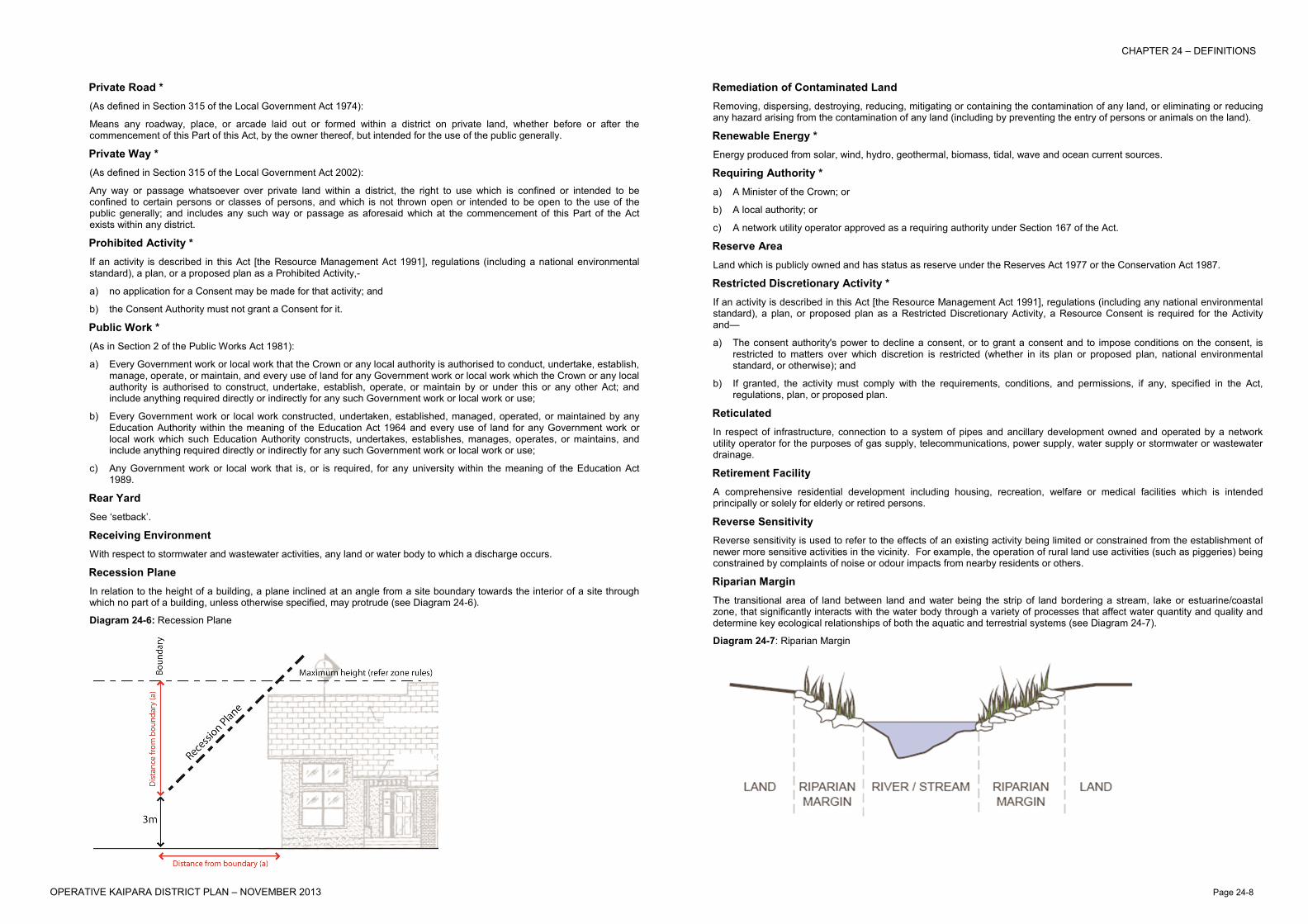
Recession Plane In relation to the height of a building, a plane inclined at an angle from a site boundary towards the interior of a site through which no part of a building, unless otherwise specified, may protrude (see Diagram 24-6).
Diagram 24-6: Recession Plane
Remediation of Contaminated Land Removing, dispersing, destroying, reducing, mitigating or containing the contamination of any land, or eliminating or reducing any hazard arising from the contamination of any land (including by preventing the entry of persons or animals on the land).
Renewable Energy * Energy produced from solar, wind, hydro, geothermal, biomass, tidal, wave and ocean current sources.
Requiring Authority * a) A Minister of the Crown; or
b) A local authority; or
c) A network utility operator approved as a requiring authority under Section 167 of the Act.
Reserve Area Land which is publicly owned and has status as reserve under the Reserves Act 1977 or the Conservation Act 1987.
Restricted Discretionary Activity * If an activity is described in this Act [the Resource Management Act 1991], regulations (including any national environmental standard), a plan, or proposed plan as a Restricted Discretionary Activity, a Resource Consent is required for the Activity and—
a) The consent authority's power to decline a consent, or to grant a consent and to impose conditions on the consent, is restricted to matters over which discretion is restricted (whether in its plan or proposed plan, national environmental standard, or otherwise); and
b) If granted, the activity must comply with the requirements, conditions, and permissions, if any, specified in the Act, regulations, plan, or proposed plan.
Reticulated In respect of infrastructure, connection to a system of pipes and ancillary development owned and operated by a network utility operator for the purposes of gas supply, telecommunications, power supply, water supply or stormwater or wastewater drainage.
Retirement Facility A comprehensive residential development including housing, recreation, welfare or medical facilities which is intended principally or solely for elderly or retired persons.
Reverse Sensitivity Reverse sensitivity is used to refer to the effects of an existing activity being limited or constrained from the establishment of newer more sensitive activities in the vicinity. For example, the operation of rural land use activities (such as piggeries) being constrained by complaints of noise or odour impacts from nearby residents or others.
Riparian Margin The transitional area of land between land and water being the strip of land bordering a stream, lake or estuarine/coastal zone, that significantly interacts with the water body through a variety of processes that affect water quantity and quality and determine key ecological relationships of both the aquatic and terrestrial systems (see Diagram 24-7).
Diagram 24-7: Riparian Margin
CHAPTER 24 – DEFINITIONS
OPERATIVE KAIPARA DISTRICT PLAN – NOVEMBER 2013 Page 24-9
River * A continually or intermittently, flowing body of fresh water; and includes a stream and modified water course; but does not include any artificial watercourse (including an irrigation canal, water supply race, canal for the supply of water for electricity power generation and farm drainage canal).
Road (As defined in Section 315 of the Local Government Act 1974 including any amendments):
Road means the whole of any land which is within a district, and which—
a) Immediately before the commencement of this Part of this Act was a road or street or public highway; or
b) Immediately before the inclusion of any area in the district was a public highway within that area; or
c) Is laid out by the council as a road or street after the commencement of this Part of this Act; or
d) Is vested in the council for the purpose of a road as shown on a deposited survey plan; or
e) Is vested in the council as a road or street pursuant to any other enactment;—
and includes—
f) Except where elsewhere provided in this Part of this Act, any access way or service lane which before the commencement of this Part of this Act was under the control of any council [or is laid out or constructed by or vested in any council as an access way or service lane] or is declared … by the Minister of Works and Development as an access way or service lane after the commencement of this Part of this Act [or is declared by the Minister of Lands as an access way or service lane on or after the 1st day of April 1988]:
g) Every square or place intended for use of the public generally, and every bridge, culvert, drain, ford, gate, building, or other thing belonging thereto or lying upon the line or within the limits thereof;—
but, except as provided in the Public Works Act 1981 or in any regulations under that Act, does not include a motorway within the meaning of that Act or the Government Roading Powers Act 1989.
In relation to financial contributions, this definition does not include state highways.
Roadside Stall A building or structure for the sale of arts and crafts, fruit, vegetables, plants or shrubs, all of which are grown or produced on sites owned or occupied by the stall owner.
Rural Amenity Lot A site of net site area of more than 4,000m2 but less than 8,000m2 within the Rural Zone for the purposes of countryside living within the rural area whilst maintaining the rural amenity of the Zone. Rural amenity lots will be located in such a way so as to provide for the continued rural activities and character of the Zone.
Rural Heartland The ‘Rural Heartland’ is one of the five communities identified in Kaipara’s Future – Working Together. This area is described as the “engine that drives Kaipara’s primary production” and the mainstay of our economy and covers the largely rural part of the District.
Serviced Site Means a site connected to reticulated wastewater provided by a network utility operator irrespective of whether it has water and stormwater systems provided on-site.
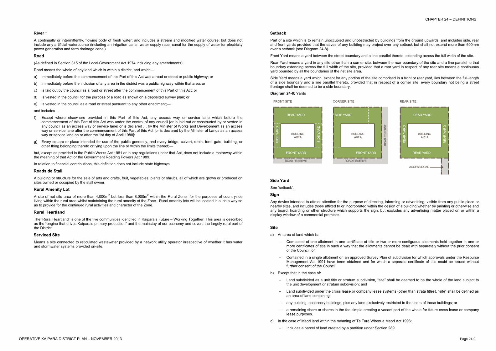
Setback Part of a site which is to remain unoccupied and unobstructed by buildings from the ground upwards, and includes side, rear and front yards provided that the eaves of any building may project over any setback but shall not extend more than 600mm over a setback (see Diagram 24-8).
Front Yard means a yard between the street boundary and a line parallel thereto, extending across the full width of the site.
Rear Yard means a yard in any site other than a corner site, between the rear boundary of the site and a line parallel to that boundary extending across the full width of the site, provided that a rear yard in respect of any rear site means a continuous yard bounded by all the boundaries of the net site area.
Side Yard means a yard which, except for any portion of the site comprised in a front or rear yard, lies between the full-length of a side boundary and a line parallel thereto, provided that in respect of a corner site, every boundary not being a street frontage shall be deemed to be a side boundary.
Diagram 24-8: Yards
Side Yard See ‘setback’.
Sign Any device intended to attract attention for the purpose of directing, informing or advertising, visible from any public place or nearby sites, and includes those affixed to or incorporated within the design of a building whether by painting or otherwise and any board, hoarding or other structure which supports the sign, but excludes any advertising matter placed on or within a display window of a commercial premises.
Site a) An area of land which is:
− Composed of one allotment in one certificate of title or two or more contiguous allotments held together in one or more certificates of title in such a way that the allotments cannot be dealt with separately without the prior consent of the Council; or
− Contained in a single allotment on an approved Survey Plan of subdivision for which approvals under the Resource Management Act 1991 have been obtained and for which a separate certificate of title could be issued without further consent of the Council.
b) Except that in the case of:
− Land subdivided as a unit title or stratum subdivision, “site” shall be deemed to be the whole of the land subject to the unit development or stratum subdivision; and
− Land subdivided under the cross lease or company lease systems (other than strata titles), “site” shall be defined as an area of land containing:
− any building, accessory buildings, plus any land exclusively restricted to the users of those buildings; or
− a remaining share or shares in the fee simple creating a vacant part of the whole for future cross lease or company lease purposes.
c) In the case of Maori land within the meaning of Te Ture Whenua Maori Act 1993:
− Includes a parcel of land created by a partition under Section 289.

CHAPTER 24 – DEFINITIONS
OPERATIVE KAIPARA DISTRICT PLAN – NOVEMBER 2013 Page 24-10
Sites of Ecological Significance A site or area containing indigenous vegetation or habitat considered moderate, moderate-high, high or outstanding based on an assessment of that ecological feature. Assessments of significance and ranking are to be based on the criteria contained in Appendix 25G – Assessment of Ecological Significance in Part D of the Plan.
Sleep Out A building containing bedrooms or living areas with a floor area limit of 36m2 and maximum distance from principal dwelling of 20 metres. It may have bathroom facilities, but no kitchen facilities.
Statutory Acknowledgement Statutory instrument in which the Crown recognises a claimant iwi group’s special relationship with sites of high and significant importance to them, e.g. lakes, rivers, mountains, forests, islands, wetlands, coastal areas, etc.
Structure * Any building, equipment, device or other facility made by people and which is fixed to land; and includes any raft.
Structure Plan A Council approved plan showing generally, the layout and configuration of roads and utilities that are required to serve a new urban development area. The purpose of a Structure Plan is to promote the efficient use of infrastructural resources. Structure Plans will also assist to avoid, remedy or mitigate the effects of the more intensive development on existing roading and utility services and the environment. Structure Plans are undertaken on a catchment basis for the identified Growth Areas (e.g. drainage and visual catchments), and give consideration to the effects of growth to the wider surrounding area and receiving environments.
Subdivision * a) The division of an allotment –
− By an application to the Registrar-General of Land for the issue of a separate certificate of title for any part of the allotment; or
− By the disposition by way of sale or offer for sale of the fee simple to part of the allotment; or
− By a lease of part of the allotment which, including renewals, is or could be for a term of more than 35 years; or
− By the grant of a company lease or cross lease in respect of any part of the allotment; or
− By the deposit of a unit plan, or an application to the Registrar-General of Land for the issue of a separate certificate of title for any part of a unit on a unit plan; or
b) An application to the Registrar-General of Land for the issue of a separate certificate of title in circumstances where the issue of that certificate of title is prohibited by Section 226,—
and the term subdivide land has a corresponding meaning.
Sustainable Management * Managing the use, development, and protection of natural and physical resources in a way, or at a rate, which enables people and communities to provide for their social, economic, and cultural well-being and for their health and safety while -
a) Sustaining the potential of natural and physical resources (excluding minerals) to meet the reasonably foreseeable needs of future generations; and
b) Safeguarding the life-supporting capacity of air, water, soil, and ecosystems; and
c) Avoiding, remedying, or mitigating any adverse effects of activities on the environment.
Tangata Whenua * In relation to a particular area, the iwi or hapu that holds mana whenua over that area.
Taonga Treasures and sacred possessions of Maori.
Telecommunications Facility Devices such as aerials, dishes, antennae, lines, wires, cables, casings, tunnels and associated equipment and support structures, and equipment shelters, such as towers, masts and poles, and equipment buildings and telephone boxes, used for the transmitting, emission or receiving of communications.
Temporary Activities An activity which is undertaken for a short term, not exceeding five days duration or more than 500 attendees, either as an isolated event or as a series of events where the cumulative period of operation is less than 12 days in a calendar year, and includes any gala, sports event, festival, hui or other community activity.
Temporary Military Training Activities Training activities involving New Zealand Defence Force regular and territorial force personnel and N.Z. Cadet Force personnel and associated air and road transport, where such activities do not require the construction or erection of any permanent structure.
Te Tarehu An Overlay classification under the Te Roroa Claims Settlement Act that applies to Waipoua Forest which is a highly significant site on land administered by the Department of Conservation. Te Tarehu recognises a statement of Te Roroa's associations, describes their values and principles, and identifies actions to avoid harm to these.
Trade Waste The wastes from an industrial or trade premise which are discharged into a reticulated sewerage system.
Traffic Intensity Factor A means of assessing the likely traffic effects from a particular new activity and is based on the average typical daily one-way vehicle movements for that activity.
Transport Infrastructure / Transport Networks Includes roads, railway lines, foopaths, cycleways, bridges, culverts, overpasses and underpasses.
Note: In relation to financial contributions (Chapter 22), this definition does not include state highways.
Treaty Settlement Land Commercial Redress and Vested Cultural Redress Land owned by iwi or hapu within the Kaipara District.
Urban Site An allotment no greater than 4000m2 and on which is a building used for industrial or commercial purposes, or a dwelling house.
Urupa An area acknowledged by Maori as a burial place.
Vegetation Clearance Removal of indigenous vegetation.
Note: Rules relating to Vegetation Clearance (see Rules 12.10.2a, 12.10.2b, 13.10.2a, 13.10.2b, 14.10.2, 15A.10.2a, 15A.10.2b, 15B.10.2a and 15B.10.2b) exclude some vegetation clearance activities.
Vehicle Crossing The formed and properly constructed vehicle access from the carriageway of any road up to and including that portion of the road boundary of the site across which vehicle access is permitted and includes any culvert, bridge or kerbing (see Diagram 24-9).
Diagram 24-9: Vehicle Crossing
Verandah A weatherproof covering, substantially covering a footpath used by the public.

CHAPTER 24 – DEFINITIONS
OPERATIVE KAIPARA DISTRICT PLAN – NOVEMBER 2013 Page 24-11
Vested Cultural Redress Land Non-commercial land (including areas of cultural, spiritual, historical or traditional significance) which is returned to an iwi or hapu group by statutory vesting of fee simple estate in the settlement of their historical claims, under the Treaty of Waitangi, to meet its cultural rather than economic interests.
Waahi Tapu A place which is sacred or spiritually meaningful to Maori.
Waterbody * Fresh water or geothermal water in a river, lake, stream, pond, wetland, or aquifer, or any part thereof that is not located within the Coastal Marine Area.
Wetland * Includes permanently or intermittently wet areas, shallow water, and land water margins that support a natural ecosystem of plants and animals that are adapted to wet conditions.
Whanau An extended family including the nuclear family, and aunties, uncles and cousins.
Yard See ‘Setback’.