2020 CALIFORNIA ACTION PLAN UPDATE For …
43
1 2020 CALIFORNIA ACTION PLAN UPDATE For Implementation of Department of the Interior Secretarial Order 3362: “Improving Habitat Quality in Western Big-Game Winter Range and Migration Corridors” Introduction - Secretarial Order 3362 (SO 3362) directs appropriate agencies within the Department of the Interior [DOI; U.S. Fish and Wildlife Service (USFWS), National Park Service (NPS), and Bureau of Land Management (BLM)] to work in close partnership with the California Department of Fish and Wildlife (CDFW) to identify, enhance, and improve the quality of big-game winter range habitats and migration corridors on appropriate DOI managed lands in a way that recognizes state authority for conserving and managing big-game species and respects private property rights. Through research and land management actions, wildlife such as mule deer (Odocoileus hemionus; hereafter deer), pronghorn antelope (Antilocapra americana; hereafter pronghorn), Rocky Mountain elk (Cervus canadensis), Roosevelt elk (C. c. roosevelti), and Tule elk (C. c. nannodes; collectively hereafter elk) and other wildlife and their habitats may benefit. Conditions in the broader landscape may influence the function of migration corridors and sustainability of big game populations. Such conditions may include habitat fragmentation, land use patterns, resource management, or urbanization. The United States Department of Agriculture (USDA), through the USDA Forest Service (USFS) and USDA Natural Resource Conservation Service, will collaborate with DOI, the states, and other natural resource managers across the broader landscape when developing an all-lands approach to research, planning, and management, for ecological resources, to include migration corridors in a manner that promotes the welfare and populations of elk, deer, and pronghorn, as well as the ecological integrity of terrestrial ecosystems in the plan area. California has about 99.7 million acres of total land area, and approximately 22.9 million acres (23.0%) are managed by three DOI agencies: BLM (15.0 million acres; 15.0%), NPS (7.6 million acres; 7.6%), and USFWS (0.3 million acres; 0.3%; Fig. 1). An additional 20.8 million acres (20.8%) are managed by the USFS. To achieve the objectives of SO 3362, the DOI asked states to identify 3-5 priority migration corridors or winter range habitats for big game species in their respective state. Where information on specific migration corridors or winter range habitats are lacking, the DOI requested states to identify research priorities to fill these data or knowledge gaps to produce Brownian Bridge Movement Models (BBMM) using methods and tools developed by the United States Geological Survey. Additionally, recent improvements to these methods have been developed that make legacy data available for analyses to inform corridor delineations.
Transcript of 2020 CALIFORNIA ACTION PLAN UPDATE For …

1
2020 CALIFORNIA ACTION PLAN UPDATE
For
Implementation of Department of the Interior Secretarial Order 3362: “Improving Habitat
Quality in Western Big-Game Winter Range and Migration Corridors”
Introduction - Secretarial Order 3362 (SO 3362) directs appropriate agencies within the
Department of the Interior [DOI; U.S. Fish and Wildlife Service (USFWS), National Park
Service (NPS), and Bureau of Land Management (BLM)] to work in close partnership with the
California Department of Fish and Wildlife (CDFW) to identify, enhance, and improve the
quality of big-game winter range habitats and migration corridors on appropriate DOI managed
lands in a way that recognizes state authority for conserving and managing big-game species and
respects private property rights. Through research and land management actions, wildlife such as
mule deer (Odocoileus hemionus; hereafter deer), pronghorn antelope (Antilocapra americana;
hereafter pronghorn), Rocky Mountain elk (Cervus canadensis), Roosevelt elk (C. c. roosevelti),
and Tule elk (C. c. nannodes; collectively hereafter elk) and other wildlife and their habitats may
benefit.
Conditions in the broader landscape may influence the function of migration corridors and
sustainability of big game populations. Such conditions may include habitat fragmentation, land
use patterns, resource management, or urbanization. The United States Department of
Agriculture (USDA), through the USDA Forest Service (USFS) and USDA Natural Resource
Conservation Service, will collaborate with DOI, the states, and other natural resource managers
across the broader landscape when developing an all-lands approach to research, planning, and
management, for ecological resources, to include migration corridors in a manner that promotes
the welfare and populations of elk, deer, and pronghorn, as well as the ecological integrity of
terrestrial ecosystems in the plan area.
California has about 99.7 million acres of total land area, and approximately 22.9 million acres
(23.0%) are managed by three DOI agencies: BLM (15.0 million acres; 15.0%), NPS (7.6
million acres; 7.6%), and USFWS (0.3 million acres; 0.3%; Fig. 1). An additional 20.8 million
acres (20.8%) are managed by the USFS.
To achieve the objectives of SO 3362, the DOI asked states to identify 3-5 priority migration
corridors or winter range habitats for big game species in their respective state. Where
information on specific migration corridors or winter range habitats are lacking, the DOI
requested states to identify research priorities to fill these data or knowledge gaps to produce
Brownian Bridge Movement Models (BBMM) using methods and tools developed by the United
States Geological Survey. Additionally, recent improvements to these methods have been
developed that make legacy data available for analyses to inform corridor delineations.

2
Implementation of this SO 3362 will occur alongside and in coordination with ongoing efforts.
Executive Order B-54-18 Biodiversity Initiative has tasked the California Department of
Transportation (Caltrans) and CDFW with updating the 2010 statewide assessment of essential
habitat connectivity. The science, data and modeling techniques have progressed, and an updated
connectivity analysis is necessary to integrate biodiversity conservation with transportation and
infrastructure planning.
CDFW and Caltrans Headquarters staff conducted a one-day collaborative symposium in
January of 2020. Both departments want to coordinate, integrate, and focus investments on
projects that maintain and restore habitat connectivity and support landscape resiliency. Both
departments also want to focus their efforts on incorporating wildlife connectivity features into
future transportation projects that have the highest biological priority and provide the greatest
benefit to the safety of the traveling public and Caltrans maintenance operations. A diverse group
of stakeholders and experts participated in the symposium which served as an opportunity for
participants to share data and knowledge to inform a larger collaborative effort. The overall
objectives of the symposium included the following:
• Engage a diverse group of stakeholders.
• Identify partnership opportunities and funding sources to support design and
implementation of wildlife crossings to remediate barriers to wildlife movement.
• Identify potential partnership opportunities for filling data gaps and research needs.
• Identify data gaps and research needs related to animal movement and barriers.
• Identify potential focal species that could be used in developing a fine-scale regional
connectivity assessment.
• Identify engagement points in which CDFW and other agencies, such as non-
governmental organizations, can provide comments and be involved in transportation
scoping and nomination.
• Brainstorm criteria and explore parameters that could be used to develop a transparent
and repeatable method to prioritize barriers for remediation that can be replicated in other
parts of the state.
• Work to develop a map of wildlife connectivity areas of interest based on scientific data,
expert opinion, and stakeholder input.
• Develop recommendations for replicating the process statewide
CDFW will continue to focus on priority migration areas identified in the 2019 state plan. The
migration focus areas reflect a careful consideration of population stressors, habitat quality and
geography (Fig. 2) and represent our top big game migration corridors in response to SO 3362.
With research support in 2020 from DOI, we are beginning to gather and analyze data to develop
fully analyzed corridors.
3
Winter Range – Mule Deer
Mule deer are common throughout the State of California. East of the Sierra Nevada Crest they
are managed within premium deer hunt zones. Deer habitats in California typically include a mix
of densely forested summer range and more open shrub communities on winter range. These
deer are mostly migratory, moving into both Oregon and Nevada, and as such are managed
cooperatively with those states. Primary threats on summer range include development, fire
impacts, lack of early seral habitat, and high human population and disturbance. On winter range,
development, fire and conversion of habitats to invasive weed species and senescence of high-
quality forage are important issues for deer. Deer traverse multiple highway systems, which
creates cumulative impacts in the form of direct mortality or conditions that tax deer
energetically as they attempt daily or seasonal movements between ranges.
Conservation of deer habitats and management of herds is challenging for deer managers with
the CDFW. Land use practices oftentimes conflict with wildlife habitat needs. The USFS is the
primary federal landowner (>20%) in California (Fig. 1) and often manages forests to provide a
high canopy cover of even-aged stands. This not only reduces early seral habitats important in
summer range, but provides abundant fuel for intense wildland fire, which affects deer habitats
across their range.
Many research projects have or continue to monitor deer movements but there are gaps in
information. A comprehensive statewide migration assessment plan is currently being developed
for deer in California. This project will collect high-resolution movement data suitable for robust
spatial analyses to identify important corridors and stopover locations and provide much needed
information to inform wildlife managers.
Mule Deer, Mono Ecoregion, Deserts Province, X9a Deer Hunt Zone
Between 2002-2015, a total of 1,845 deer-vehicle collisions were recorded on Caltrans facilities
in District 9, which includes Mono County. Of these deer-vehicle collisions, 397 occurred on the
US Highway 395 corridor in the Long Valley Wildlife Crossing (LVWC) project area located
between State Route 203 and the Crowley Lake area. A preliminary report by the University of
California, Davis, identified Highway 395 on the east side of the Sierra Nevada as an area with
statistically significant hotspots for vehicle-wildlife collisions (Shilling and Waetjen 2016). In
addition to deer, this area contains bear, mountain lion, numerous meso-carnivore species, and a
variety of other important wildlife.
The LVWC project area is of high importance to deer because habitats on both sides (east and
west) of Highway 395 are used for summer range, migration, migration transition (holding areas
for spring and fall migrations) and winter range during droughts.

4
This priority deer focus area is located in Mono County and has deer winter, transition and
summer ranges in the eastern Sierra front (summer), down into the toe slopes (transition), and
into mixed sagebrush, desert scrub, and agricultural lands. Habitats vary depending upon
altitude and aspect and include shrub-steppe and shrub communities, open forest communities,
and alpine meadows (Fig. 3). There is limited anecdotal information available as there have not
been sufficient data or methods to produce BBMMs to date. This area is known to provide
important stopover habitat (Sherwin Holding Area) that is intensely used by deer for 6-10 weeks
in the spring and for several months in the fall during migrations.
The USFS (Inyo National Forest) manages much of the land along the north portion of the focus
area (Fig. 4). The BLM and the Los Angeles Department of Water and Power own lands along
the southern border. The area is a popular and heavily used recreation destination. Livestock
grazing and agriculture supporting the ranching industry are also a dominant land use.
Risks/Threats and Proposed Actions
Deer vehicle collision rates are high along highways, particularly within the LVWC located on
U.S. Highway 395 from State Route 203 to Crowley Lake. Deer passage is impeded for
transitioning between winter and summer ranges.
• State Action: Identification of important seasonal crossing areas.
• Collaborative Action: Funding and other support for installation of passes and other crossing
structures in areas with the greatest need to reduce collisions and provide safe passage to deer
and other wildlife during migration.
Increasing development and fragmentation of available summer, winter and migratory habitats
reduces deer herd carrying capacity. The conversion of agricultural lands to industrial and
housing developments due to growth pressures is a primary cause.
• State Action: Identify site-specific crossing locations, movement routes, and stopover areas
within the focus area.
• Collaborative Action: Incorporate movement data into planning documents and efforts to
facilitate conservation of migration pathways.
• Collaborative Action: Work with private landowners to facilitate safe passage of deer along
migration pathways.
• Collaborative Action: Pursue conservation easements with willing parties to conserve
important areas of deer movement through private lands.
It is anticipated that high-intensity catastrophic wildfires will continue throughout the focus area
due to high fuel loads from historic fire suppression efforts, persistent drought conditions in
recent years, and changes to precipitation patterns.
• Federal Action: Forest thinning, noxious weed control, and planting of native shrubs with
prioritization for high-use deer areas on federal lands.

5
The Mammoth-Yosemite Airport east of Highway 395 between mile markers 22.74 and 20.36 is
planning an impermeable fence around its perimeter. The fence will include a 1.7-mile-long
segment that abuts the Caltrans right-of-way on the east side of the highway.
• Collaborative Action: Plan and build additional fencing on the west side of the highway to
prevent deer being trapped within the right-of-way and reduce deer-vehicle collisions.
Current Efforts
• In March 2019 and 2020, a total of 77 female mule deer from five eastern Sierra herds in
Mono County were marked with high-fix rate GPS collars to determine deer movements in
relation to US Highway 395 and in the LVWC area. A total of 20 collars were deployed in
the Casa Diablo herd, 15 collars each in the Mono Lake and the West Walker herds, and 6
collars in the East Walker herd. In addition, a total of 21 collars were deployed in the Round
Valley herd.
• A graduate student from Utah State University, Logan, Utah, was hired in September 2019 to
assess the migratory movements of the GPS collared female mule deer in relation to US
Highway 395 in Mono County. This student will use integrated step selection analysis to
model how landscape features affect both deer movement and habitat selection processes in
relation to US Highway 395. The results of this study will be used to formulate
recommendations for the placement of wildlife crossing structures and fencing necessary to
reduce deer-vehicle collisions on US Highway 395 in Mono County.
• Of the 21 GPS collared deer from the Round Valley herd, a total of 9 crossed US Highway
395 within the LVWC project area. This data provided valuable information on the temporal
pattern and specific locations of deer movements in the LVWC project area in relation to
known deer-vehicle collision hot spots (Figs. 5 and 6). Ultimately, these data will be used to
inform decisions regarding where to best locate crossing structures (overpasses and
underpasses) and deer fencing within the LVWC project area.
• A multi-agency task force, the Eastern Sierra Wildlife Stewardship Team, is continuing to
meet to develop strategies to mitigate deer-vehicle collisions on US Hwy 395 in Mono
County and identify fund sources for wildlife crossing project implementation.
• BLM - Bishop Field Office was awarded $70,000 in 2020 from the National Fish and
Wildlife Foundation (NFWF), Improving Habitat Quality in Western Big Game and
Migration Corridors Program. This funding is being used to purchase approximately 2 miles
of deer fencing to be placed along both sides of US Highway 395 between Mammoth Creek
bridge and the SR 203 junction. In addition, this funding is being used to purchase two
portable changeable message signs (CMS) that can be strategically situated during migration
at deer-vehicle collision hot spots along the US Highway 395 corridor.

6
Mule Deer, Sierra Nevada Ecoregion, Central Valley and Sierra Nevada Province, X6a and
X6b Deer Hunt Zones
This area contains an estimated 9,400 deer in the premium hunt zones X6a and X6b. Deer have
both economic and ecological value in this area that make this a big game priority for the state of
California. In addition to deer, this area contains pronghorn, an expanding population of elk, and
occasionally bighorn sheep and gray wolf.
This priority focus area is located approximately between north of Reno, NV and Susanville, CA
on the east side of the Sierra Nevada Range along Highway 395. Habitats vary and include
sagebrush steppe and shrub communities, dense forest communities, and agriculture lands (Fig.
7). Limited information is available on deer movements, but these tend to be quick and short
migrations with several stopovers.
Most of the area is owned by public agencies, with the Plumas, Humboldt-Toiyabe, and Lassen
National Forests, BLM, and CDFW’s Doyle and Bass Hill Wildlife Areas being the major public
land holdings (Fig. 8). Private timber companies also own large portions of forested areas within
this area. Most other lands held in private ownership are interspersed along the highway
including developments at Doyle, Janesville and others. Livestock grazing, human
developments, recreation, and timber harvest are the predominant land uses.
Risks/Threats and Proposed Actions
It is anticipated that high-intensity catastrophic wildfires throughout the area will continue due to
high fuel loads from historic fire suppression efforts and persistent drought conditions in recent
years.
• Collaborative Action: Identify vegetation restoration projects, potential fuel breaks, and best
management practices to limit habitat degradation and wildlife fires.
Mid-elevation forests used by deer during the spring and fall are mostly comprised of closed-
canopy, over-stocked stands of mixed conifer species with little understory vegetation. Burns and
cuts on privately owned timberlands or USFS lands are often treated with herbicide and
replanted with single age stands, activities that eliminate or greatly reduce early seral conditions
that are critical for summer forage and cover.
• Collaborative Action: Identify vegetation restoration projects to enhance nonproductive
vegetation communities and develop best management practices for private timber lands that
incorporate mule deer habitat needs.
Conversion of habitats to invasive weeds in wintering areas due to disturbance from largescale
and high-intensity wildfires, conifer encroachment on open shrub communities, and senescence
of nutritional forage all threaten the native habitats that support mule deer.

7
• Collaborative Action: Identify vegetation restoration projects, potential fuel breaks, and best
management practices to limit habitat degradation and wildlife fires.
Growing use and distribution of motorized and non-motorized off-road vehicles and increasing
disturbance on winter ranges.
• USFS Action: Develop new or modify existing travel management plans to include
restrictions on timing and location of motorized uses to minimize impacts to important
seasonal activities of mule deer.
Persistent drought conditions reduce water availability and may result in reduced overall
nutritional carrying capacity of the landscape. There may be resulting shifts in migration
strategies that result in higher deer densities on summer range and current winter range
abandonment.
• State Action: Fully analyze existing telemetry data, if available, using new BBMM methods
to establish baseline migration activities. Develop ongoing monitoring activities to monitor
potential shifts in migration strategies and adapt management as needed.
• Collaborative Action: Provide or maintain existing water development (guzzler) to combat
arid conditions and lack of water sources.
Increasing development and fragmentation of available winter and migratory habitats in the area
is an ongoing threat. Nevada does not have an equivalent to the California Environmental
Quality Act (CEQA) or the California Endangered Species Act (CESA) processes that can limit
or mitigate development. Critical ranges and corridors must be identified and protected as winter
range is being heavily developed.
• Collaborative Action: In coordination with Nevada Department of Wildlife (NDOW),
explore options to conserve priority winter and summer habitats, stopovers, and migration
routes.
Deer vehicle collision rates are high along highways, particularly on U.S. Highway 395 from
Susanville south through Honey Lake. Further south on 395 and Hwy 70 also contain many deer
vehicle collision hotspots.
• State Action: Identification of important seasonal crossing areas. Identify site-specific
crossing locations, movement routes, and stopover areas within the focus area.
• Collaborative Action: Incorporate movement data into planning documents and efforts to
facilitate conservation of migration pathways and landscape permeability.
• Collaborative Action: Funding and other support for installation of passes and other crossing
structures in areas with the greatest need to reduce collisions and provide safe passage to deer
and other wildlife during migration.
8
Current Efforts
• The BLM has performed post-fire restoration activities following the Long Valley Fire in
2017. They also plan to replace ~3,600’ of 8’ tall fencing in the Fort Sage Off-highway
Vehicle Area with wildlife friendly fencing to facilitate better access to surrounding BLM
lands and habitats. Additional post-fire rehabilitation plans include drill, broadcast, and hand-
seeding of ~5,350 acres of burned shrubland communities. Noxious weed control will occur
through implementation of the Eagle Lake Prevention Schedule.
• The Highway 89 Stewardship Team (H89ST) is expanding their reach to partner with
NDOW and other agencies and NGO’s to focus on Highway 395 where deer make inter-state
crossings. There are potential road-crossing sites on USFS and BLM lands.
Proposed Efforts
• Identify and undertake post-fire restoration opportunities following recent, large wildfires.
Immediate needs include replacement of diversion fencing along Highway 395 and crucial
winter range habitat restoration in the burned area.
• Identify federal land projects with USFS, BLM, or USFWS whose activities will benefit
migratory deer, pronghorn antelope or elk within this area. NEPA clearance is available for
several planned or ongoing projects on the Plumas, Tahoe, and Humboldt-Toiyabe National
Forests and BLM land related to aspen/meadow restoration or seeding (bitterbrush,
sagebrush, mahogany) of burned areas. Several areas within the area have burned in recent
years.
• On BLM lands juniper clearing is considered a Categorically Exempt activity and there is an
opportunity to partner for this work on critical deer winter range.
• Potentially convert standard livestock fencing along Highway 395, Highway 70, and County
Road 284 to deer fence, with jump-outs. Structures would be needed to create permeability
across the highway to help curtail vehicle strikes.
Mule Deer, Sierra Nevada Ecoregion, Central Valley and Sierra Nevada Province, X7a and
X7b Deer Hunt Zones
This area contains migratory deer from the Loyalton-Truckee Deer Herd in the premium hunt
zones X7a and X7b (an estimated 6,000 animals). This large priority focus area is located
approximately between Verdi, NV north to State Route 70 then south through the town of
Sierraville to the McKinney Bay area of Lake Tahoe. Deer have extreme financial and ecological
value in this area. In addition to deer, this area contains bear, mountain lion, occasional gray wolf
and a variety of other wildlife.
Habitats vary as you move west to east but include coniferous forest with closed canopy,
bitterbrush and shrub communities, riparian habitat, and pockets of aspen (Fig. 9). Much of this
area is privately owned with the Tahoe and Humboldt-Toiyabe National Forests and CDFW

9
comprising most of the public land. Livestock grazing, human development, and recreation are
the predominant land uses (Fig. 10).
Deer move quickly between summer and winter range but tend to stay on summer range later in
the year until snow and temperature pushes them out, sometimes in December (Fig. 11). Summer
range in the south near Truckee is very limited and highly developed leaving small pockets of
intact habitat. Migration is short but is constricted by the Truckee River, the railroad tracks and
Interstate 80 through the Truckee River Canyon. Stopovers are not prevalent in this short
migration. In the north migrations are over greater distance and the summer range is more
widespread. Stopover areas include Antelope Valley Wildlife Area, Dog Valley, Bear Valley,
and the lands around Prosser and Boca Reservoirs.
Risks/Threats and Proposed Actions
It is anticipated that high-intensity catastrophic wildfires throughout the area will continue due to
high fuel loads from historic fire suppression efforts and persistent drought conditions in recent
years. More than 47,000 acres burned in the Loyalton fire within this area at the time of this
document including habitats in winter range, and corridors (Fig. 11).
• Collaborative Action: Identify vegetation restoration projects, potential fuel breaks, and best
management practices to limit habitat degradation and wildlife fires.
Development has been somewhat limited by CEQA but does continue, especially around already
impacted ski resorts and the town of Truckee. Fragmentation by development, the interstate, and
railroad right-of-way’s limit traditional deer movements. The river and associated high recreation
use make for additional challenges in managing landscape permeability. Moving around barriers
to reach desired habitats is energetically taxing. Fecundity and fawn survival could be an issue if
connectivity is not restored or maintained.
Interstate 80 is one of several highways, but the most significant that bisects the Sierra Nevada
mountain range. Major crossing features to connect habitat on either side are absent but needed
and could open the movement ability by many species, including sensitive meso-carnivores.
Direct vehicle mortality on the Interstate 80 and roads throughout developed areas along with
high predator concentrations are additive mortalities to the deer herd.
• State Action: Identify site-specific crossing locations, movement routes, and stopover areas
within the focus area.
• Collaborative Action: Incorporate movement data into planning documents and efforts to
facilitate conservation of migration pathways and landscape permeability.
High deer-vehicle collision rates along sections of Highway 89. Wildlife crossing features exist
at Hallelujah Junction Wildlife Area and on Highway 89, but additional structures and fence are

10
needed. Connectivity must be created and maintained across the highway to reduce collisions
and other cumulative impacts from barriers during daily and seasonal movements.
• State Action: Identify site-specific crossing locations, movement routes, and stopover areas
within the focus area.
• Collaborative Action: Incorporate movement data into planning documents and efforts to
facilitate conservation of migration pathways and landscape permeability.
Most of the deer in this zone are migratory and winter in the lower elevations on the Nevada
side. Summer range habitats are limited, and weather conditions such as persistent drought have
caused shifts in migration strategy, concentrating deer year-round on limited summer range. This
could change the herd dynamics drastically.
• State /Collaborative Action: Fully analyze existing telemetry data, including data available
from NDOW, using new BBMM methods to establish baseline migration activities. Develop
ongoing monitoring activities to monitor potential shifts in migration strategies and adapt
management as needed.
• Collaborative Action: Provide or maintain existing water development (guzzler) to combat
arid conditions and lack of water sources.
Increasing development and fragmentation of available winter and migratory habitats in the area
is an ongoing threat. Nevada does not have an equivalent to the California Environmental
Quality Act (CEQA) or the California Endangered Species Act (CESA) processes that can limit
or mitigate development. As Reno expands, winter range is being heavily developed. Critical
ranges and corridors must be identified and protected.
• Collaborative Action: In coordination with NDOW, explore options to conserve priority
winter and summer habitats, stopovers, and migration routes.
Growing use and distribution of motorized and non-motorized off-road vehicles and increasing
disturbance on deer ranges.
• Collaborative Action: Develop new or modify existing travel management plans to include
restrictions on timing and location of motorized uses to minimize impacts to important
seasonal activities of mule deer.
Conversion of habitats to cheatgrass or other non-native vegetation communities.
• Collaborative Action: Manage invasive weed species by identifying areas of outbreak and
undertaking vegetation restoration projects that provide more desirable forage species for
mule deer.
Current Efforts
• CDFW has been working to improve communication with the Caltrans to increase planning
and mitigation of road projects in impacted areas. The H89ST constructed three underpasses

11
with fence and jump-outs on Highway 89, a stretch that deer in the area cross. CDFW has
also collaborated with NDOW to address interstate deer issues, connectivity between states,
and end-run issues at deer fences along the border. The H89ST is expanding their reach to
partner with NDOW and other agencies and NGO’s to focus on Highway 395 where deer
make inter-state crossings. There are potential crossing sites on USFS and BLM lands.
• A number of collars have been deployed for use in a population estimation project and by the
H89ST to monitor and effectively place crossings on the highway. More detailed analysis
with a focus on migration and stopovers is needed.
• Caltrans will complete a one million dollar project to extend the deer fence for CDFW’s
Hallelujah Junction Wildlife Area to the state line as well as replace all one way gates with
jump-outs, and repair the fence where it has not been maintained near the existing three
under crossings.
• NDOW in coordination with CDFW has mapped the movement corridors and analyzed the
Loyalton-Truckee deer herd telemetry datasets using Migration Mapper (Fig. 11).
• Juniper removal projects have been undertaken on CDFW land.
• Projects on CDFW lands have sought to control noxious weeds and promote natural
regeneration after fire.
• Deer monitoring of crossings under the highway with cameras.
• CDFW has deployed GPS collars to update the Loyalton-Truckee Deer Herd Plan.
• CDFW is collaborating on a large fee title acquisition of land within critical summer range
that is at risk for development.
• Caltrans is planning a project that will add deer fence and jump-outs to funnel deer and other
wildlife through two existing, concrete box culverts under Interstate 80.
• USFS has performed revegetation and habitat restoration in key winter habitats for mule deer
following wildfires across the area. Additionally, ~500 acres are treated annually to control
invasive plants to reduce wildfire risk and risk of vegetation type conversion to annual
invasive grasses. Treatments include mechanical, biological (insects), hand, and herbicide
treatments. Key riparian and meadow areas are the focus of reseeding and replanting efforts
(~100 ac.). The Humboldt-Toiyabe National Forest is a member of a wildlife working group
that focuses on opportunities to improve habitat for mule deer and other wildlife within this
area.
Proposed Efforts
• Identify federal land projects with USFS, BLM, or USFWS whose activities will benefit
migratory deer, pronghorn or elk within this area. NEPA clearance is available for several
planned or ongoing projects on the Plumas, Tahoe, and Humboldt-Toiyabe National
Forests and BLM land related to aspen/meadow restoration or seeding (bitterbrush,
sagebrush, mahogany) of burned areas. Several areas within the area have burned in
recent years.
• On BLM lands juniper clearing is considered a Categorically Exempt activity and there is
an opportunity to partner for this work on critical deer winter range.

12
• Identify and undertake post-fire restoration opportunities following recent, large
wildfires. Immediate needs include replacement of diversion fencing along Highway 395
and crucial winter range habitat restoration in the burned area.
• Potentially convert standard livestock fencing along Highway 395 to deer fence, with
jump-outs. Structures would be needed to create permeability across the highway to help
curtail vehicle strikes.
Elk
Roosevelt Elk, Northern California Coast Ecoregion, North Coast and Klamath Province,
Northwestern Elk Hunt Zone
Along the north coast, populations of Roosevelt elk have expanded dramatically in the last 20
years. Del Norte and Humboldt counties in northwestern California have experienced growing
conflict as a result of burgeoning Roosevelt elk herds and vehicle collisions along the Highway
101 corridor. As these Roosevelt elk populations continue to grow, access to suitable habitats can
be limited by barriers such as Highway 101, and elk may tend to concentrate on private lands
creating even more conflict and management issues by potentially impacting agricultural crops
and property. CDFW continues to work with local governments, tribes, and landowners to
expand hunter opportunities to help reduce conflict and manage the growing Roosevelt elk
populations. Improving movement corridors may also help increase the accessibility of elk on
public land and thereby reduce conflict.
Elk respond predictably to increased hunting pressure and traffic density by becoming more
mobile and expending more energy avoiding people and roads (Hurley and Sargeant 1991, Lyon
and Canfield 1991). In addition, increased road density has been shown to increase the
probability of mortality in cow elk, to decrease the ratio of bulls to cows, and to increase hunting
harvest mortality when compared to relatively roadless areas (Leptich and Zager 1991, Unsworth
et al. 1993, Leptich et al. 1995).
A preliminary report by the University of California, Davis, identified U.S. 101, a major
highway running north and south through Del Norte and Humboldt counties, as an area with
significant hotspots for vehicle-wildlife collisions (Shilling and Waetjen 2016). The North Coast
(Caltrans District 1) was reported as having the third highest density for wildlife-vehicle conflict
in California (Shilling et al. 2017).
This area is located along the north coast of California along U.S. Highway 101 in Del Norte and
Humboldt counties. Habitats vary from forested timberlands to agricultural lands (Figs. 12 and
13). Elevation in this area ranges from sea level to over 6,000 feet. Generally, most of Humboldt
and Del Norte counties provides suitable habitat for elk including conifer and mixed conifer-
hardwood forest, oak woodlands, montane and bottomland grasslands, and marshes.

13
Much of the occupied habitats are on timberlands, ranches, dairies, farms, and rural residential
areas. Ownership is mixed between public, tribal and private holdings with some large blocks of
USFS and private timber, particularly in the uplands (Figs. 14 and 15). Approximately 60% of
this area is privately owned with most public land administered by the USFS (Six River National
Forest), BLM (Lacks Creek and King Range), NPS, and California State Parks lands. The main
land use in this area includes timber production and agricultural practices ranging from irrigated
crop production to dairy and cattle production.
Elk that exist along the coast tend to utilize small home ranges and do not migrate seasonally
(Figs. 16, 17 and 18). This has led to an area of high concentration of elk along U.S. Highway
101. Inland, there appear to be seasonal changes in habitat utilization, but this extent is much
smaller than what is observed in other parts of the state.
Risks/Threats and Proposed Actions
Several herds of elk routinely cross Highway 101 and are utilizing areas adjacent to roadways to
an extent that causes serious safety concerns for motorists (Tables 1 and 2). As population
numbers increase along this section of highway, an increase in collisions is anticipated.
• State Action: Identification of important seasonal crossing areas.
• Collaborative Action: Funding and other support for installation of passes and other crossing
structures in areas with the greatest need to reduce collisions and provide safe passage to deer
and other wildlife during migration.
Current Efforts
• A total of 38 collars were ordered in 2019. Deployment of the collars occurred from
November 2019 to February 2020. A total of 25 collars were deployed with use of a
helicopter capture crew and through free-range darting. Additional capture efforts to deploy
the remining 13 collars will occur from November 2020 to February 2021. Ongoing research
efforts on the North Coast are being accomplished through Federal financial assistance made
available through the Pittman-Robertson Wildlife Restoration Act and include the following:
o Providing information about elk population parameters for management and
conservation planning. Knowledge about the relative abundance, distribution, and
population trends is important in the assessment of past management plans and practices
and for updating those plans.
o Forty-eight elk are currently collared in Humboldt and Del Norte counties. This collar
data allows subherd identification, habitat use and resource selection, movement patterns
and population connectivity, recruitment estimates, calf survival, causes of mortality,
and mark-resight estimates of abundance.
o Road surveys, remote cameras, and fecal DNA mark-recapture estimates are being
explored as new populations monitoring techniques. Research on these estimation
methods will lead to the development and implementation of standardized monitoring
protocols for estimating elk population parameters.

14
• BLM has completed ~200 acres of oak woodland and grassland restoration in Lacks Creek
Management Area. They have also removed Douglas-fir and replanted with native grasses to
improve forage for elk. Several prairie burns have also been deployed, and these BLM
activities have been undertaken with contributions from Rocky Mountain Elk Foundation
(RMEF), Mule Deer Foundation, and California Deer Association.
• Increase highway safety by working with the Caltrans by performing the following:
o Provide locations and crossing frequency data to support the improvement of signage for
elk crossing locations.
o Provide support and collaborate with the Caltrans to construct a wildlife overpass to
increase wildlife connectivity and improve highway safety at Stone Lagoon.
Proposed Efforts
• Identify federal land projects with USFS, BLM, or USFWS whose activities will benefit
elk within this area.
• Continue to work with the Caltrans to improve wildlife connectivity and highway safety.
Tule Elk, Central Valley and Sierra Nevada Province and Bay Delta and Central Coast
Province, San Luis Reservoir Elk Hunt Zone
This area contains the San Luis Reservoir Tule Elk meta-population, which is estimated at 1,000
animals. Tule elk are still recovering from near extirpation and require large tracts of land to
support healthy populations. Located in Merced County, the elk subpopulations are found in the
vicinity of San Luis Reservoir and within the San Luis Reservoir Tule Elk Hunt Zone.
Habitats vary depending upon elevation and aspect and includes non-native annual grasslands
and oak woodlands (Fig. 19). Land Ownership is distributed between CDFW, California
Department of Parks and Recreation, Bureau of Reclamation, and private lands (Fig. 20). Land
use in the area is comprised mainly of livestock grazing, agriculture, and recreation.
Risks/Threats and Proposed Actions
Development and overall fragmentation of habitats is a major issue. Elk-vehicle collision rates
along highways need to be reduced. Transportation networks have caused issues for elk
movements. Information on movement corridors between habitat patches is needed to identify
and model critical habitats, linkages, and barriers to movement, all of which hinder gene flow.
This information will benefit current and future management and conservation practitioners by
providing them with spatial and resource selection information that describes and delineates
areas of important use including home ranges, calving areas, habitat use, barriers, and meta-
population movement corridors.
• State Action: Data collected from GPS collars that have been deployed since 2015 are
currently being analyzed. Further analysis is needed for identification of important seasonal

15
crossing areas and for development of BBMM to identify key stopovers and areas of
importance for Tule elk.
• State Action: Delineation of important movement corridors and stopover locations to support
empirically based decisions regarding prioritization of habitat conservation needs in those
areas.
• State and Federal Action: Funding and other support for installation of passes and other
crossing structures in areas with the greatest need to reduce collisions and provide safe
passage to elk during migration and daily movements.
High-speed Rail is planned for the area and could bisect and further fragment the landscape.
• State Action: Identification of important use areas including calving grounds, home ranges,
and crossing areas.
• State and Federal Action: Funding and other support for installation of passes and other
crossing structures in areas with the greatest need to reduce collisions and provide safe
passage to elk during migration and daily movements.
It is anticipated that conversion from native habitat to non-native invasive plant species will
continue.
• State and Federal Action: Large-scale habitat restoration is needed to restore the habitat to
support a healthy ecosystem. Prescribed burns and noxious weed control along with
revegetation efforts are needed.
Tule elk in this area suffer from low genetic diversity. A lack of landscape permeability further
exacerbates this problem.
• State Action: Delineation, preservation, and creation of important movement corridors is
needed to maintain and facilitate critical gene flow between sub-groups and meta-
populations.
Current Efforts
• GPS collars are still in the field collecting data, so results are preliminary. Over the course of
the study nine animals have died. Of those, two females and one juvenile male were killed on
Highway 152.
• A gross assessment of home ranges shows a difference between elk that use the west side of
the reservoir versus elk using areas near Highway 152 and Interstate 5.
• Forty-three GPS collars have been deployed on elk in different sub-groups inhabiting the San
Luis Reservoir area. The collar data will supply detailed movement data to assess barriers,
habitat usage, and provide a robust population estimate and sightability correction model. A
detailed analysis with a focus on migration and stopovers is needed once the data collection
phase is completed.
• CDFW has been working to improve communication with the Caltrans to increase planning
and mitigation of road projects in impacted areas.

16
• CDFW has been coordinating with California State Parks regarding habitat restoration
projects on State Parks lands.
• CDFW has been working with the Santa Clara Open Space Authority and Pathways for
Wildlife to implement the Highway 152 permeability study, which is aimed at assessing
impacts from the highway on wildlife species.
• CDFW has been providing information to the High-Speed Rail Authority on elk biology and
preliminary movement data to reduce or eliminate impacts to elk and improve public safety.

17
Literature Cited
Hurley, M. A., and G. A. Sargeant. 1991. Effects of hunting and land management on elk habitat
use, movement patterns, and mortality in western Montana. Pages 10–12 in. Montana State
University, Bozeman, Montana.
Leptich, D. J., and P. Zager. 1991. Road access management effects on elk mortality and
population dynamics. Pages 126–137 in. Proceedings in elk vulnerability symposium. Montana
State University, Bozeman, Montana.
Leptich, D. J., S. G. Hayes, and P. E. Zager. 1995. Coeur D’Alene Elk Ecology. Idaho
Department of Fish and Game.
Lyon, L. J., and J. E. Canfield. 1991. Habitat selections by Rocky Mountain elk under hunting
season stress. Pages 99–105 in. Montana State University, Bozeman, Montana.
Shilling, F. and D. Waetjen. 2016. Impact of Wildlife-Vehicle Conflict on Drivers and Animals.
University of California Davis, UC Davis Road Ecology Center.
https://roadecology.ucdavis.edu/files/content/news/CA_WVC_Hotspots_2016.pdf. Accessed 05
October 2018.
Shilling, F., Waetjen, D., and K. Harrold. 2017. Impact of Wildlife-Vehicle Conflict on Drivers
and Animals. University of California Davis, UC Davis Road Ecology Center.
https://roadecology.ucdavis.edu/files/content/news/CROS-CHIPs_Hotspots_2017_ES2.pdf.
Accessed 05 October 2018.
Unsworth, J. W., L. Kuck, M. D. Scott, and E. O. Garton. 1993. Elk Mortality in the Clearwater
Drainage of Northcentral Idaho. The Journal of Wildlife Management 57:495.
18
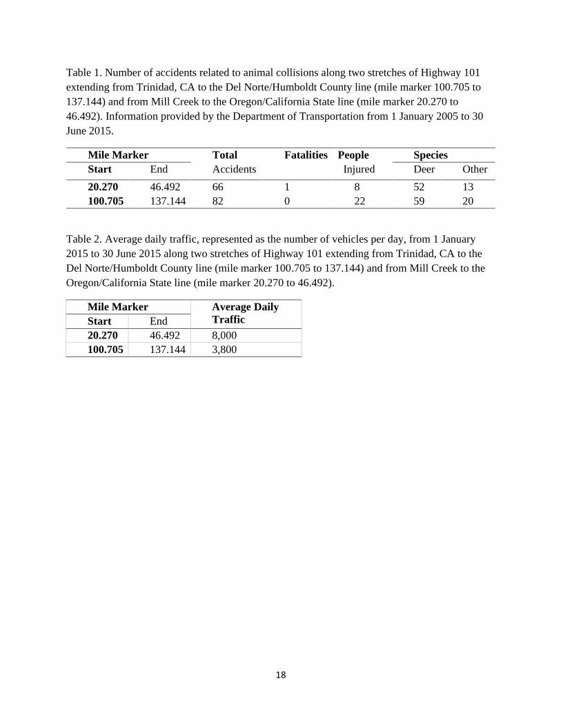
Table 1. Number of accidents related to animal collisions along two stretches of Highway 101
extending from Trinidad, CA to the Del Norte/Humboldt County line (mile marker 100.705 to
137.144) and from Mill Creek to the Oregon/California State line (mile marker 20.270 to
46.492). Information provided by the Department of Transportation from 1 January 2005 to 30
June 2015.
Mile Marker Total Fatalities People Species
Start End Accidents
Injured Deer Other
20.270 46.492 66 1 8 52 13
100.705 137.144 82 0 22 59 20
Table 2. Average daily traffic, represented as the number of vehicles per day, from 1 January
2015 to 30 June 2015 along two stretches of Highway 101 extending from Trinidad, CA to the
Del Norte/Humboldt County line (mile marker 100.705 to 137.144) and from Mill Creek to the
Oregon/California State line (mile marker 20.270 to 46.492).
Mile Marker Average Daily
Traffic Start End
20.270 46.492 8,000
100.705 137.144 3,800

19
Figure 1. Federal surface management distribution in California for Bureau of Land Management, U.S. Fish and
Wildlife Service, National Park Service, and U.S. Forest Service.

20
Figure 2. California Department of Fish and Wildlife corridor focus areas in response to U.S.
Department of Interior’s Secretarial Order 3362.

21
Figure 3. California Department of Fish and Wildlife priority corridor focal area for mule deer,
Mono Ecoregion, Deserts Province, X9a Deer Hunt Zone depicting dominant vegetation cover
type.

22
Figure 4. California Department of Fish and Wildlife priority corridor focal area for mule deer,
Mono Ecoregion, Deserts Province, X9a Deer Hunt Zone depicting land management agency
jurisdiction.

23
Figure 5. Deer vehicle collision hot spots along US Highway 395 within the Long Valley
Wildlife Crossing project area.
Figure 6. Movement data of four deer crossing US Highway 395 within the Long Valley Wildlife
Crossing project area.

24
Figure 7. California Department of Fish and Wildlife priority corridor focal area for mule deer,
Sierra Nevada Ecoregion-Central Valley and Sierra Nevada Province, X6a and X6b Deer Hunt
Zones depicting dominant vegetation cover type.

25
Figure 8. California Department of Fish and Wildlife priority corridor focal area for mule deer,
Sierra Nevada Ecoregion-Central Valley and Sierra Nevada Province, X6a and X6b Deer Hunt
Zones depicting land management agency jurisdiction.

26
Figure 9. California Department of Fish and Wildlife priority corridor focal area for mule deer,
Sierra Nevada Ecoregion-Central Valley and Sierra Nevada Province, X7a and X7b Deer Hunt
Zones depicting dominant vegetation cover type.

27
Figure 10. California Department of Fish and Wildlife priority corridor focal area for mule deer,
Sierra Nevada Ecoregion-Central Valley and Sierra Nevada Province, X7a and X7b Deer Hunt
Zones depicting land management agency jurisdiction.

28
Figure 11. Loyalton-Truckee mule deer herd migration corridors, winter range and recent fire
perimeters.

29
Figure 12. California Department of Fish and Wildlife priority corridor focal area for Roosevelt
elk, Northern California Coast Ecoregion, North Coast Province, Northwestern Elk Hunt Zone
depicting dominant vegetation cover type.

30
Figure 13. California Department of Fish and Wildlife priority corridor focal area for Roosevelt
elk, Northern California Coast Ecoregion, North Coast Province, Northwestern Elk Hunt Zone
depicting land management agency jurisdiction.

31
Figure 14. California Department of Fish and Wildlife priority corridor focal area for Roosevelt
elk, Northern California Coast Ecoregion, North Coast Province, Northwestern Elk Hunt Zone
depicting land management agency jurisdiction.

32
Figure 15. California Department of Fish and Wildlife priority corridor focal area for Roosevelt
elk, Northern California Coast Ecoregion, North Coast Province, Northwestern Elk Hunt Zone
depicting dominant vegetation cover type.

33
Figure 16. Roosevelt Elk distribution and usage area in Del Norte County. Home ranges based
on kernel density estimation at 99%, 95%, and 50%

34
Figure 17. Roosevelt Elk distribution and usage area south of Crescent City, Del Norte County.
Home ranges based on kernel density estimation at 99%, 95%, and 50%

35
Figure 18. Roosevelt Elk distribution and usage area in Northern Humboldt County. Home
ranges based on kernel density estimation at 99%, 95%, and 50%

36
Figure 19. California Department of Fish and Wildlife priority corridor focal area for Tule elk,
Central Valley and Sierra Nevada Province and Bay Delta and Central Coast Province, San Luis
Reservoir Elk Hunt Zone depicting dominant vegetation cover type.
37
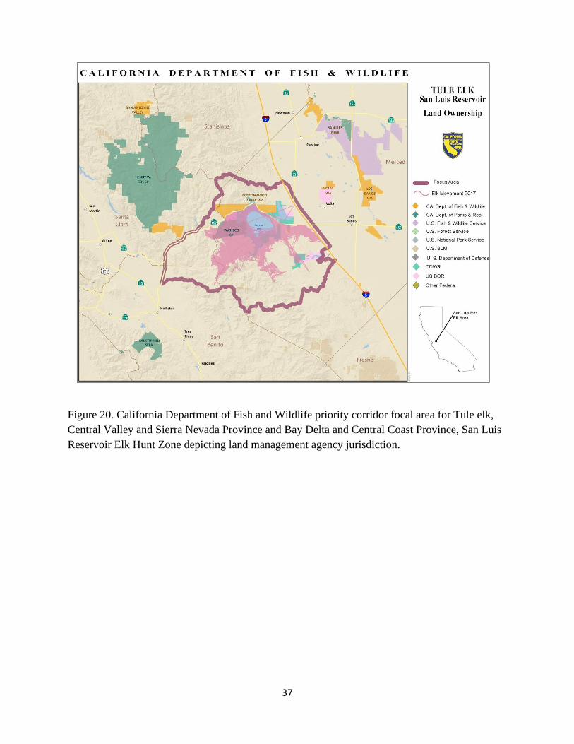
Figure 20. California Department of Fish and Wildlife priority corridor focal area for Tule elk,
Central Valley and Sierra Nevada Province and Bay Delta and Central Coast Province, San Luis
Reservoir Elk Hunt Zone depicting land management agency jurisdiction.

Appendix A. Secretarial Order 3362
38
THE SECRETARY OF THE INTERIOR
WASHINGTON
ORDER NO. 3362
Subject: Improving Habitat Quality in Western Big-Game Winter Range and Migration
Corridors
Sec. 1 Purpose. This Order directs appropriate bureaus within the Department of the Interior
(Department) to work in close partnership with the states of Arizona, California, Colorado, Idaho,
Montana, Nevada, New Mexico, Oregon, Utah, Washington, and Wyoming to enhance and improve
the quality of big-game winter range and migration corridor habitat on Federal lands under the
management jurisdiction of this Department in a way that recognizes state authority to conserve
and manage big-game species and respects private property rights.
Through scientific endeavors and land management actions, wildlife such as Rocky Mountain Elk
(elk), Mule Deer (deer), Pronghorn Antelope (pronghorn), and a host of other species will benefit.
Additionally, this Order seeks to expand opportunities for big-game hunting by improving priority
habitats to assist states in their efforts to increase and maintain sustainable big game populations
across western states.
Sec. 2 Authorities. This Order is issued under the authority of section 2 of Reorganization Plan No. 3
of 1950 (64 Stat. 1262), as amended, as well as the Department's land and resource management
authorities, including the following:
a. Federal Land Policy and Management Act of 1976, as amended, 43 U.S.C. 1701, et seq.;
b. U.S. Geological Survey Organic Act, as amended, 43 U.S.C. 31, et seq.;
c. National Wildlife Refuge System Improvement Act of 1997, as amended, 6
U.S.C. 668dd et seq.; and
d. National Park Service Organic Act of 1916, as amended, 54 U.S.C. 100101, et seq.
Sec. 3 Background. The West was officially "settled" long ago, but land use changes continue to
occur throughout the western landscape today. Human populations grow at increasing rates with
population movements from east and west coast states into the interior West. In many areas,
development to accommodate the expanding population has occurred in important winter habitat
and migration corridors for elk, deer, and pronghorn. Additionally, changes have occurred across
large swaths of land not impacted by residential development. The habitat quality and value of these
areas crucial to western big-game populations are often degraded or declining.

Appendix A. Secretarial Order 3362
39
The Bureau of Land Management (BLM) is the largest land manager in the United States (U.S.) with
more than 245 million acres of public land under its purview, much of which is found in Western
States. The U.S. Fish and Wildlife Service (FWS) and National Park Service (NPS) also manage a
considerable amount of public land on behalf of the American people in the West. Beyond land
management responsibilities, the Department has strong scientific capabilities in the U.S.
Geological Survey (USGS) that can be deployed to assist State wildlife agencies and Federal land
managers. Collectively, the appropriate bureaus within the Department have an opportunity to
serve in a leadership role and take the initiative to work closely with Western States on their
priorities and objectives as they relate to big-game winter range and migration corridors on lands
managed by the Department.
Consistent with the American conservation ethic, ultimately it is crucial that the Department take
action to harmonize State fish and game management and Federal land management of big-game
winter range and corridors. On lands within these important areas, if landowners are interested and
willing, conservation may occur through voluntary agreements.
Robust and sustainable elk, deer, and pronghorn populations contribute greatly to the economy and
well-being of communities across the West. In fact, hunters and tourists travel to Western States
from across our Nation and beyond to pursue and enjoy this wildlife. In doing so, they spend
billions of dollars at large and small businesses that are crucial to State and local economies. We
have a responsibility as a Department with large landholdings to be a collaborative neighbor and
steward of the resources held in trust.
Accordingly, the Department will work with our State partners and others to conserve and/or
improve priority western big-game winter range and migration corridors in sagebrush ecosystems
and in other ecotypes as necessary. This Order focuses on the Western States of: Arizona, California,
Colorado, Idaho, Montana, Nevada, New Mexico, Oregon, Utah, Washington, and Wyoming.
These States generally have expansive public lands with established sagebrush landscapes along
with robust big-game herds that are highly valued by hunters and tourists throughout the Nation.
The Department has broad responsibilities to manage Federal lands, waters, and resources for public
benefit, including managing habitat to support fish, wildlife, and other resources.
Secretary's Order 3356, "Hunting, Fishing, Recreational Shooting, and Wildlife Conservation
Opportunities and Coordination with States, Tribes, and Territories," (SO 3356) was issued on
September 15, 2017. SO 3356 primarily focused on physical access to lands for recreational
activities, particularly hunting and fishing. This Order is focused on providing access to big game
animals by providing direction regarding land management actions to improve habitat quality for
big-game populations that could help ensure robust big-game populations continue to exist. Further,
SO 3356 includes a number of directives related to working with States and using the best available
science to inform development of guidelines, including directing relevant bureaus to:
a. Collaborate with State, tribal, and territorial fish and wildlife agencies to attain or
sustain State, tribal, and territorial wildlife population goals during the Department's land
management planning and implementation, including prioritizing active habitat management

Appendix A. Secretarial Order 3362
40
projects and funding that contributes to achieving wildlife population objectives, particularly for wildlife
that is hunted or fished, and identifying additional ways to include or delegate to States habitat
management work on Federal lands;
b. Work cooperatively with State, tribal, and territorial wildlife agencies to enhance
State, tribe, and territorial access to the Department's lands for wildlife management actions;
c. Within 180 days, develop a proposed categorical exclusion for proposed projects
that utilize common practices solely intended to enhance or restore habitat for species such as
sage grouse and/or mule deer; and
d. Review and use the best available science to inform development of specific
guidelines for the Department's lands and waters related to planning and developing energy,
transmission, or other relevant projects to avoid or minimize potential negative impacts on
wildlife.
This Order follows the intent and purpose of SO 3356 and expands and enhances the specific directives
therein.
Sec. 4 Implementation. Consistent with governing laws, regulations, and principles of responsible
public stewardship, I direct the following actions:
a. NPS to: With respect to activities at the national level, I hereby direct the BLM, FWS, and
(1) Within 30 days, identify an individual to serve as the "Coordinator" for
the Department. The Coordinator will work closely with appropriate States, Federal agencies,
nongovernmental organizations, and/or associations to identify active programs focused on big
game winter range and/or migration corridors. The programs are to be organized and cataloged
by region and other geographic features (such as watersheds and principles of wildlife
management) as determined by the Deputy Secretary, including those principles identified in the
Department's reorganization plan.
(2) Within 45 days, provide the Coordinator information regarding:
(i) Past and current bureau conservation/restoration efforts on winter
range and migration corridors;
(ii) Whether consideration of winter range and corridors is included in
appropriate bureau land (or site) management plans;
(iii) Bureau management actions used to accomplish habitat objectives
in these areas;
(iv) The location of areas that have been identified as a priority for
conservation and habitat treatments; and

Appendix A. Secretarial Order 3362
41
(v) Funding sources previously used and/or currently available to
the bureau for winter range and migration corridor conservation/restoration efforts.
(3) Within 60 days, if sufficient land use plans are already established that
are consistent with this Order, work with the Coordinator and each regional Liaison (see
section 4b) to discuss implementation of the plans. If land use plans are not already
established, work with the Coordinator and each regional Liaison to develop an Action
Plan that summarizes information collected in section 4 (a) (1) and (2), establishes a clear
direction forward with each State, and includes:
(i) Habitat management goals and associated actions as they
are associated with big game winter range and migration corridors;
(ii) Measurable outcomes; and
(iii) Budgets necessary to complete respective action(s).
b. With respect to activities at the State level, I hereby direct the BLM, FWS, and
NPS to:
(1) Within 60 days, identify one person in each appropriate unified region
(see section 4a) to serve as the Liaison for the Department for that unified region. The
Liaison will coordinate at the State level with each State in their region, as well as with the
Liaison for any other regions within the State. The Liaison will schedule a meeting with the
respective State fish and wildlife agency to assess where and how the Department can work
in close partnership with the State on priority winter range and migration corridor
conservation.
(2) Within 60 days, if this focus is not already included in respective
land management plans, evaluate how land under each bureau's management
responsibility can contribute to State or other efforts to improve the quality and
condition of priority big-game winter and migration corridor habitat.
(3) Provide a report on October 1, 2018, and at the end of each fiscal year
thereafter, that details how respective bureau field offices, refuges, or parks cooperated and
collaborated with the appropriate State wildlife agencies to further winter range and
migration corridor habitat conservation.
(4) Assess State wildlife agency data regarding wildlife migrations early
in the planning process for land use plans and significant project-level actions that bureaus
develop; and
(5) Evaluate and appropriately apply site-specific management activities,
as identified in State land use plans, site-specific plans, or the Action Plan (described
above), that conserve or restore habitat necessary to sustain local and regional big-game
populations through measures that may include one or more of the following:

Appendix A. Secretarial Order 3362
42
(i) restoring degraded winter range and migration corridors by
removing encroaching trees from sagebrush ecosystems, rehabilitating areas damaged by fire, or
treating exotic/invasive vegetation to improve the quality and value of these areas to big game
and other wildlife;
(ii) revising wild horse and burro-appropriate management levels
(AML) or removing horses and burros exceeding established AML from winter range or
migration corridors if habitat is degraded as a result of their presence;
(iii) working cooperatively with private landowners and State highway
departments to achieve permissive fencing measures, including potentially modifying (via
smooth wire), removing (if no longer necessary), or seasonally adapting (seasonal lay down)
fencing if proven to impede movement of big game through migration corridors;
(iv) avoiding development in the most crucial winter range or
migration corridors during sensitive seasons;
(v) minimizing development that would fragment winter range and
primary migration corridors;
(vi) limiting disturbance of big game on winter range; and
(vii) utilizing other proven actions necessary to conserve and/or restore
the vital big-game winter range and migration corridors across the West.
C. With respect to science, I hereby direct the USGS to:
(1) Proceed in close cooperation with the States, in particular the Western
Association of Fish and Wildlife Agencies and its program manager for the Crucial Habitat
Assessment Tool, prior to developing maps or mapping tools related to elk, deer, or pronghorn
movement or land use; and
(2) Prioritize evaluations of the effectiveness of habitat treatments in
sagebrush communities, as requested by States or land management bureaus, and identified
needs related to developing a greater understanding of locations used as winter range or
migration corridors.
d. I further hereby direct the responsible bureaus and offices within the Department to:
(1) Within 180 days, to update all existing regulations, orders, guidance
documents, policies, instructions, manuals, directives, notices, implementing actions, and any
other similar actions to be consistent with the requirements in this Order;
(2) Within 30 days, provide direction at the state or other appropriate level to
revise existing Federal-State memorandums of agreement to incorporate consultation with State
agencies on the location and conservation needs of winter range and migration routes; and

Appendix A. Secretarial Order 3362
43
(3) Consult with State wildlife agencies and bureaus to ensure land use plans
are consistent and complementary to one another along the entire wildlife corridor in common
instances where winter range or migration corridors span jurisdictional boundaries.
e. Heads of relevant bureaus will ensure that appropriate members of the Senior
Executive Service under their purview include a performance standard in their respective current
or future performance plan that specifically implements the applicable actions identified in this
Order.
Sec. 5 Management. I hereby direct the Deputy Secretary to take is responsible for taking all
reasonably necessary steps to implement this Order.
Sec. 6 Effect of Order. This Order is intended to improve the internal management of the
Department. This Order and any resulting reports or recommendations are not intended to, and do not
create any right or benefit, substantive or procedural, enforceable at law or equity by a party against
the United States, its departments, agencies, instrumentalities or entities, its officers or employees, or
any other person. To the extent there is any inconsistency between the provision of this Order and any
Federal laws or regulations, the laws or regulations will control.
Sec. 7 Expiration Date. This Order is effective immediately. It will remain in effect until its provisions
are implemented and completed, or until it is amended, superseded, or revoked.
Date: FEB O 9 2018