2019 1120 Riverplace - DAR 2 - PRESENTATION
54
GBD Architects Incorporated 1120 NW Couch St., Suite 300 Portland, OR 97209 Tel. (503) 224-9656 www.gbdarchitects.com EASTBANK RIVERPLACE CENTRAL CITY MASTER PLAN DESIGN ADVICE REQUEST #2 EA 19 -215959 DA December 5 2019
Transcript of 2019 1120 Riverplace - DAR 2 - PRESENTATION

GBD Architects Incorporated 1120 NW Couch St., Suite 300 Portland, OR 97209 Tel. (503) 224-9656 www.gbdarchitects.com
EASTBANK
RIVERPLACECENTRAL CITY MASTER PLAN
DESIGN ADVICE REQUEST #2EA 19 -215959 DA
December 5 2019

NBP Capital | Riverplace Redevelopment DESIGN ADVICE REQUEST EA 19-215959 DA December 5, 2019 2
This is the submittal package for the Design Advice Request #2 for RiverPlace. At the first Design Advice Request meeting on October 3, 2019 the Design Commission identified areas within the proposed development for additional studies. The topics that drew the most discussion included:
• The size and scale of the western block• The location of required open space at the podium level of the western block• Implementation of a potential new pedestrian / bicycle bridge across SW Harbor Drive
In addition to new material on these topics, the first part of the submittal includes the Central City 2035 Plan Goals and descriptions of how the development proposal broadly addresses them.
This submittal also includes updated information on the proposed street network options for RiverPlace and massing envelopes for future buildings.
Over the course of developing the design options for this proposal, the project team has convened a series of meetings with various public agencies, neighborhood organizations and community groups. Though this is not an all inclusive accounting, the team has organized a transportation and traffic related meeting with the Downtown Neighborhood Association (DNA), formally met and presented the project to the DNA 2 times, met with the Bureau of Transportation 7 times, the Bureau of Environmental Services 2 times and the Bureau of Development Services 3 times.

NBP Capital | Riverplace Redevelopment DESIGN ADVICE REQUEST EA 19-215959 DA December 5, 2019 3
RiverPlace will create a new experience along downtown Portland’s waterfront. It will establish the next generation of Portland’s “front yard” along the Willamette River inviting thousands of residents, workers and visitors to engage in a vibrant urban waterfront district. It will offer a dynamic, signature new open space experience unlike any other in the city, yet is inspired by the iconic parks and open space sequences that exist nearby.
RIVERPLACEPOLICY GOALS
1. CC2035 - Regional Center2. CC2035 - Housing and Neighborhoods3. CC2035 - Transportation4. CC2035 - Willamette River5. CC2035 - Urban Design6. CC2035 - Health and Environment

VISION
NBP Capital | Riverplace Redevelopment DESIGN ADVICE REQUEST EA 19-215959 DA December 5, 2019 4
Most of all, RiverPlace will create a distinctive place where people want to be, where Portlanders feel comfortable, and the community can see themselves reflected in the quality of its design and the civic character of its public spaces.
CONCEPTUAL IMAGE DEMONSTRATING CHARACTER AND QUALITY OF OPEN SPACE

CENTRAL CITY 2035
DOWNTOWN
CENTRAL EASTSIDE
LLOYD
SOUTH WATERFRONT
NBP Capital | Riverplace Redevelopment DESIGN ADVICE REQUEST EA 19-215959 DA December 5, 2019 5
The City of Portland recently adopted the Central City 2035 Plan describing a new vision for Portland’s most urban place looking into the future. It includes a new set of compelling big ideas, one of which is “Enhance the Willamette for People and Wildlife.” The description recognizes that while some improvements have been made to the Willamette River and the spaces along it, there is still great potential for the city to truly “embrace the river,” as was originally envisioned decades ago.
The Central City 2035 Plan also updated the Central City’s subdistricts – creating some new ones as well. RiverPlace now sits in a new geography, the “University District/South Downtown” – an area stretching from Portland State University (PSU) east to the Willamette River with direct access to the water at RiverPlace. The vision for the district describes the relationships between RiverPlace, South Auditorium and PSU, and the combined opportunity they present in offering an attractive and vibrant residential community that helps support a multi-cultural center of learning, exchange and innovation.
Diagram from the Central City 2035 Plan for the University District/South Downtown area, showing a focus on the Harbor Drive mixed use path and Montgomery as “flexible” streets with an emphasis on walking and rolling.
GREEN LOOP DIAGRAM

CC2035 PLAN GOALS
NBP Capital | Riverplace Redevelopment DESIGN ADVICE REQUEST EA 19-215959 DA December 5, 2019 6
CC2035 GOAL 1 : REGIONAL CENTER
RiverPlace will positively contribute to the Central City’s dynamic urban character with a high density development that will add vibrancy and activity to the South Waterfront community. The scale and diversity of the proposed development will enable new uses and attractions not currently found in the community: new types of retail, event/entertainment venues or cultural attractions. The proximity of the site to the riverfront could attract river-related retail uses such as kayak or canoe rentals, guided river tour businesses, or river equipment sales and service to be a part of the commercial mix on the site. The dynamic and varied design of the open space would become an attraction in and of itself, offering an undulating open space experience and unique vantage points for views of the river and to the east.
GROCER/FOOD MARKET
NEW PLAZA SPACE
PORTLAND STEPS

NBP Capital | Riverplace Redevelopment DESIGN ADVICE REQUEST EA 19-215959 DA December 5, 2019 7
RiverPlace will provide more housing units, increasing the diversity of unit types, unit sizes and adding density. It will meet the city of Portlands inclusionary housing requirements providing both affordable as well as market rate residential units to the neighborhood. Ownership will work to re-house tenants displaced during construction. Reflecting the surrounding community, RiverPlace will also bring a broader range of uses than currently exist on the site. The proposed program includes: 250,000 square feet of office space, around 300 new hotel rooms, and as much as 100,000 square feet of retail space adding more activity to the site and a “24-hour” feeling to the neighborhood. Active ground floor uses will be incorporated in all new buildings with retail uses concentrated at key locations where they will be most successful.
CC2035 GOAL 2: HOUSING AND NEIGHBORHOODSEXISTING FAR: 1.7 : 1 PROPOSED FAR: 8.0 : 1
PROPOSED PROGRAMEXISTING PROGRAM
VACANTPARKING
HOTEL
LEGEND
RESIDENTIAL
OFFICE
RETAIL
RESIDENTIAL (1.8M SF)
RETAIL (100K SF)
PARKING (1500 STALLS)
OFFICE (250K SF)
HOTEL (400K SF)

NBP Capital | Riverplace Redevelopment DESIGN ADVICE REQUEST EA 19-215959 DA December 5, 2019 8
RiverPlace will add roughly 1500 linear feet of new, publicly-accessible streets and other connections through the site opening up its public spaces and amenities to all Portlanders. It will also provide critical links between highly trafficked and active transportation corridors – the Harbor Drive multi-use path to the west and the Willamette Greenway Trail to the east. RiverPlace also integrates connections to new Central City-wide projects like the Green Loop and existing infrastructure systems like the Portland Streetcar.
In addition, it is considering new access opportunities at significant barriers such as a potential new pedestrian and bicycle bridge spanning SW Harbor Drive. At its riverfront location with a new public plaza, RiverPlace offers a compelling and expanded end to the Montgomery Green Street corridor stretching from the West Hills to the Willamette River.
CC2035 GOAL 3: TRANSPORTATION
SW MONTGOMERY ST
PROPOSED BRIDGE
SW HALL ST
SW RIVER PKWAY
SW RIVER PKWAY
SW RIVER DR
SW HARBOR DR
A ST
SW HARBOR DR
SW RIVER DR
SW MONTGOMERY ST
EXISTING PROPOSED

CC2035 GOAL 4: WILLAMETTE RIVER
NBP Capital | Riverplace Redevelopment DESIGN ADVICE REQUEST EA 19-215959 DA December 5, 2019 9
RiverPlace will add thousands of new residents, workers and visitors to the Willamette Riverfront, generating interest and new stewardship of a clean and healthy Willamette River. Buildings at RiverPlace will step back from new open spaces and the Willamette River ensuring that they will be sunlit places and helping to frame the activity along the river. It will create a series of new places along this segment of riverfront informed by the history, culture and stories of people who have lived and worked along the river. RiverPlace will be the next new “pearl” on the string of the Willamette River Greenway complementing other destinations like the Hawthorne Bowl, Poet’s Beach and OMSI.

CC2035 GOAL 5 : URBAN DESIGN
NBP Capital | Riverplace Redevelopment DESIGN ADVICE REQUEST EA 19-215959 DA December 5, 2019 10
Incorporating close to an acre of new public open space at its northeast corner, RiverPlace will bring the green feeling and natural character of the Willamette River deeper into the site. The proposed open spaces are a unique blend of the smaller, intimate gathering spaces of South Waterfront Park and the iconic landform designs of the nearby Halprin Open Space Sequence. The open spaces will expand the range of possible functions and experiences, ranging from gathering spaces for socializing, quiet places to read a good book, grand spaces for a selfie and open areas for pickup frisbee games.
EXISTING PUBLICLY ACCESSIBLE OPEN SPACE (on site) PROPOSED PUBLICLY ACCESSIBLE OPEN SPACE (on site)
OPEN SPACE (ADDITIONAL)
LEGEND
OPEN SPACE (REQUIRED)

DISCUSSION TOPICS FOR DAR #2
01 - PODIUM SIZE & SCALE 02 - REQUIRED OPEN SPACE03 - MASSING04 - TRANSPORTATION ISSUES05 - STREET CHARACTER
NBP Capital | Riverplace Redevelopment DESIGN ADVICE REQUEST EA 19-215959 DA December 5, 2019 11

NBP Capital | Riverplace Redevelopment DESIGN ADVICE REQUEST EA 19-215959 DA December 5, 2019 12
2000 50 100
PROPOSED BLOCK CONFIGURATION
The 8-acre site is nestled along SW Harbor Dr and adjacent to the Willamette River. The Master Plan proposes to divide the site into 4 different blocks. Three of the blocks are more traditionally scaled blocks as seen throughout downtown Portland and a large block is proposed along the western edge of the site where the topography is more challenging. The larger block allows for a central neighborhood parking strategy that will encourage a much more active streetscape throughout the development.
Additional studies are ongoing with the City of Portland, PBOT, and ODOT with regards to connections of SW Hall St to SW Harbor Way and/or SW Harbor Dr. See inset diagrams.
SW HA
RBOR
WAY
SW RI
VER D
R
SW H
ARBO
R DR
IVE
SW HALL ST
SW HARBOR VIADUCT
SW H
ARRI
SON
ST
SW RIVER PARKWAY
SW MONTGOMERY ST
RIVERPLACE
MARINA
SOUTH WATERFRONT PARK
OPTION 2A
OPTION 2B
OPTION 1
DAR #1PODIUM SIZE AND SCALE

NBP Capital | Riverplace Redevelopment DESIGN ADVICE REQUEST EA 19-215959 DA December 5, 2019 13
105’
155’
220’14
0’ERODING THE PODIUM TO BREAK DOWN ITS SCALE
The podium at the western edge of RiverPlace has gotten smaller through the extension of Hall Street.
The eastern edge of the podium that was once roughly 750’ feet long, has now been broken into two pieces, the longer of which is now roughly 450’ feet in length.
In addition, the podium’s frontage has been further eroded by carving out public open spaces in the form of entry courtyards and other active areas, resulting in podium frontages that range from 150’ to 200’ in length, very similar to typical downtown building facade lengths.
PODIUM SIZE AND SCALE
EXTENDING HALL - DAR #02INITAL PROPOSAL - DAR #01
746’
463’
220’

NBP Capital | Riverplace Redevelopment DESIGN ADVICE REQUEST EA 19-215959 DA December 5, 2019 14
PERSPECTIVE A SHOWING PODIUM EROSION
A
220’
105’
A STREET
MONTGOMERY STREET
KEY PLAN
OPEN SPACE A
PODIUM SIZE AND SCALE

NBP Capital | Riverplace Redevelopment DESIGN ADVICE REQUEST EA 19-215959 DA December 5, 2019 15
PODIUM SIZE AND SCALE
PERSPECTIVE B SHOWING PODIUM EROSION
B
KEY PLAN
A STREETHALL STREET
105’220’
OPEN SPACE D
OPEN SPACE CONCEPTS
NBP Capital | Riverplace Redevelopment DESIGN ADVICE REQUEST EA 19-215959 DA December 5, 2019 16
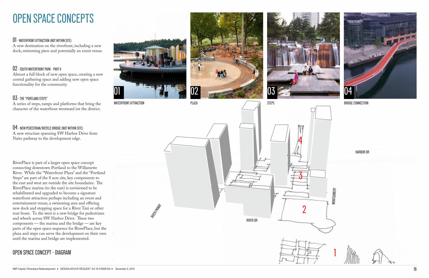
OPEN SPACE CONCEPT - DIAGRAM
01 - WATERFRONT ATTRACTION (NOT WITHIN SITE)A new destination on the riverfront, including a new dock, swimming piers and potentially an event venue.
02 - SOUTH WATERFRONT PARK - PART IIAlmost a full block of new open space, creating a new central gathering space and adding new open space functionality for the community.
03 - THE “PORTLAND STEPS”A series of steps, ramps and platforms that bring the character of the waterfront westward int the district.
04 - NEW PEDESTRIAN/BICYCLE BRIDGE (NOT WITHIN SITE)A new structure spanning SW Harbor Drive from Naito parkway to the development edge.
RiverPlace is part of a larger open space concept connecting downtown Portland to the Willamette River. While the “Waterfront Plaza” and the “Portland Steps” are part of the 8 acre site, key components to the east and west are outside the site boundaries. The RiverPlace marina (to the east) is envisioned to be rehabilitated and upgraded to become a signature waterfront attraction perhaps including an event and entertainment venue, a swimming area and offering new dock and stopping space for a River Taxi or other tour boats. To the west is a new bridge for pedestrians and wheels across SW Harbor Drive. These two components — the marina and the bridge — are key parts of the open space sequence for RiverPlace, but the plaza and steps can serve the development on their own until the marina and bridge are implemented.
01 02 03 04
RIVER
PKWAY
MONT
GOME
RY
RIVER DR
HARBOR DR
WATERFRONT ATTRACTION BRIDGE CONNECTION
1
2
3
4
STEPSPLAZA

NBP Capital | Riverplace Redevelopment DESIGN ADVICE REQUEST EA 19-215959 DA December 5, 2019 17
SW HA
RBOR
WAY
PUBLIC OPEN SPACE DIAGRAM
The Master Plan is proposing a large, world-class, publicly accessible open space in the form of a plaza space near the river and a meandering passage directly through the heart of the development. The Open Space pathway is unique in Portland and will encourage pedestrian exploration to the mixed-use towers of the development. Active, outdoor recreations activity areas would be mixed with quieter, smaller scale spaces for rest, reflection and socialization.
This extraordinary combination of large open plaza space and an elevated, connected pathway through the heart of the development will help connect adjacent downtown Portland through the RiverPlace neighborhood to the river at the core of our City. This publicly accessible Open Space would commingle beautifully landscaped natural areas with hardscaped plazas and recreation areas, allowing the citizens and visitors of Portland to be a part of living and enjoying the river and parks.
The proposed Open Space would total nearly 70,000 square feet between an approximately 35,000 Square feet plaza adjacent to South Waterfront Park and connected to an elevated pathway that bridges the central “main” street of the newly developed RiverPlace and connects to SW Harbor Way and the rest of Portland.
SW RI
VER D
R
SW H
ARBO
R DR
IVE
SW HALL ST
RIVERPLACE
MARINA
SW HARBOR VIADUCT
SW H
ARRI
SON
ST
SW RIVER PARKWAY
SW MONTGOMERY ST
REQUIRED PUBLIC OPEN SPACE69,940 SF
POSSIBLE TOWER FOOTPRINT 1A
POSSIBLE TOWER FOOTPRINT 1B
POSSIBLE TOWER FOOTPRINT 1C
POSSIBLE TOWER FOOTPRINT 1D
2
3
REQUIRED PUBLIC OPEN SPACE
69,940 SF - 20%
TOTAL DEVELOPMENT AREA 349,700 SF - 100%
POTENTIAL BUILDING FOOTPRINTS
231,840 SF - 66%
STREETS AND SIDEWALKS
38,140 SF - 11%
PROPOSED BUILDING FOOTPRINTS
241,620 SF - 69%
SOUTH WATERFRONT PARK
2000 50 100
CCMP REQUIRED OPEN SPACE DAR #1

NBP Capital | Riverplace Redevelopment DESIGN ADVICE REQUEST EA 19-215959 DA December 5, 2019 18
AB
E
C
D
SW HA
RBOR
WAY
SW HA
RBOR
DRIVE
LINCO
LN ST
RUCT
URE
A STR
EET
THE STRAND
CONDOMINIUMS
HYATT HOUSE
PORTLAND
SW HALL STREET
SW MONTGOMERY STRET
SW RI
VER D
R
SW H
ARIS
SON
STRE
ET
SW RIVER PARKWAY
SOUTH WATERFRONT
PARK
RIVERPLACE
MARINA
CCMP REQUIRED OPEN SPACE
The required open space for RiverPlace is divided into two parts — a large waterfront plaza at the northeast corner of the site and a series of smaller, “discovered” spaces at different moments around the development. The plaza itself represents over half of the required open space at about 45,000 square feet. The southern edge of plaza is designed like the Festival Streets in Old Town on Davis and Flanders: a curbless design that feels like an extension of the park, but could allow motor vehicles for loading or special access in some cases.
Directly to the west across the street from the plaza is an entry courtyard and termination of the “Portland Steps” offering a unique vantage point from which to take in the surroundings and great views of the river. At the southwest corner of the site is an entry/gateway plaza adjacent to the intersection of Harbor Drive and River Parkway and facing the Green Loop connection kitty-corner at the intersection.
REQUIRED PUBLIC OPEN SPACE
69,940 SF - 20%
TOTAL DEVELOPMENT AREA 349,700 SF - 100%
POTENTIAL BUILDING FOOTPRINTS
231,840 SF - 66%
STREETS AND SIDEWALKS
38,140 SF - 11%
PROPOSED BUILDING FOOTPRINTS
241,620 SF - 69%
THE STRAND
CONDOMINIUMS
RIVERPLACE
CONDOMINIUMS

NBP Capital | Riverplace Redevelopment DESIGN ADVICE REQUEST EA 19-215959 DA December 5, 2019 19
A - NEW PUBLIC OPEN SPACE and Plaza
B - THE PORTLAND STEPS
C - DOG PARK and PEDESTRIAN BRIDGE CONNECTION
D - CAFE + MINI PLAZA PARK
E - MONTGOMERY GREEN STREET
A B
D
C
E
A
D
BC
E
The required open space for RiverPlace is divided into 2 main parts – a large, river-facing plaza at the northeast corner of the site, and a series of smaller, “discovered” spaces at different moments around the development. Three of the smaller spaces are at the edges of the large podium creating building walls at the sidewalk edges consistent with Portland’s block pattern of 200’ building frontages.
CCMP REQUIRED OPEN SPACE

NEW PUBLIC OPEN SPACE AND PLAZAOPEN SPACE A
NBP Capital | Riverplace Redevelopment DESIGN ADVICE REQUEST EA 19-215959 DA December 5, 2019 20
The plaza at the northeast corner of the site is the largest public open area on the site at just over an acre. It will effectively double the size and character of South Waterfront Park’s open space and bring the feeling of the river deeper into RiverPlace. It will be a place for the broader community. The larger space could accommodate :
- Outdoor Market- Festivals- Casual Socializing- Play areas for children- Pick-up games of soccer
PERSPECTIVE OF OPEN SPACE “A” SHOWING LOCATION OF NEW PLAZA

THE PORTLAND STEPSOPEN SPACE B
NBP Capital | Riverplace Redevelopment DESIGN ADVICE REQUEST EA 19-215959 DA December 5, 2019 21
A signature element of the open space system of the site will be the “Portland Steps” – a series of interconnected platforms, stairways, ramps, seating and gathering spaces that washes up the east side of the podium facing the plaza. The Portland Steps are:
- Visually iconic Open Space for Portland- Space to access iconic views- Terraced seating opportunity for adjacent building programs- Vertical connection to podium and future bridge connection to SW Naito
PERSPECTIVE OF OPEN SPACE “B” SHOWING VERTICAL GRADE CHANGE

DOG PARK AND PEDESTRIAN BRIDGE CONNECTIONOPEN SPACE C
NBP Capital | Riverplace Redevelopment DESIGN ADVICE REQUEST EA 19-215959 DA December 5, 2019 22
RiverPlace will create new open space along the western edge of the site – responding to the significance of existing and planned public infrastructure projects, such as the Harbor Drive mixed use path and the future Green Loop. This edge of the site is an important side of the development, stretching between highly visible gateways at SW Montgomery and River Parkway Streets. The western edge open space could have:
- Possible Vertical connection to a new bridge- Bike related program space- Possible dog park
PERSPECTIVE OF OPEN SPACE “C” WITH BICYCLE RAMP
PERSPECTIVE OF OPEN SPACE “C” WITHOUT RAMP

NBP Capital | Riverplace Redevelopment DESIGN ADVICE REQUEST EA 19-215959 DA December 5, 2019 23
CAFE + MINI PLAZA PARKOPEN SPACE D
The smaller plaza at the southeast corner of the podium is intended to be an open space more geared to the neighborhood at RiverPlace. It will offer a more locally-oriented gathering space: a good spot to meet friends, have a cup of coffee or a comfortable spot to pause while walking the dog. This smaller space could accommodate:
- Stopping and resting options- Informal socializing- Space for outdoor dining
PERSPECTIVE OF OPEN SPACE “D” SHOWING CORNER MINI PLAZA

NBP Capital | Riverplace Redevelopment DESIGN ADVICE REQUEST EA 19-215959 DA December 5, 2019 24
SW MONTGOMERY ST.
SW H
ARBO
R PL
.
.R
D REVI
R WS
SW HALL ST. .EVA YD
OO
M WSSW RIVER PKWY.
YAW
RO
BRA
H WS
.R
D R
OB
RAH
WS
SW MONTGOMERY ST.
SW H
ARBO
R PL
.
SW R
IVER
DR.
SW HALL ST.
SW M
OO
DY
AVE.
SW RIVER PKWY.
SW H
ARBO
R W
AY
SW H
ARBO
R D
R.
FROM RIVER TO CITY AND BACKThis gesture is a big swath of nature through the blocks. Using varied scales of intimate outdoor rooms and wider flexible open spaces, the core concept of the development emphasizes activity and a sense of place, all along the pathways from river to city and back again. The idea is gentle navigation, relying on wandering and exploration.
C I T Y R I V E R
A
B
E
C
D

NBP Capital | Riverplace Redevelopment DESIGN ADVICE REQUEST EA 19-215959 DA December 5, 2019 25
SW MONTGOMERY ST.
SW H
ARBO
R PL
.
.R
D REVI
R WS
SW HALL ST. .EVA YD
OO
M WSSW RIVER PKWY.
YAW
RO
BRA
H WS
.R
D R
OB
RAH
WS
FROM RIVER TO CITY AND BACKThis gesture is a big swath of nature through the blocks. Using varied scales of intimate outdoor rooms and wider flexible open spaces, the core concept of the development emphasizes activity and a sense of place, all along the pathways from river to city and back again. The idea is gentle navigation, relying on wandering and exploration.
C I T Y R I V E R
NBP Capital | Riverplace Redevelopment DESIGN ADVICE REQUEST EA 19-215959 DA December 5, 2019 26
SW MONTGOMERY ST.
SW H
ARBO
R PL
.
.R
D REVI
R WS
SW HALL ST. .EVA YD
OO
M WSSW RIVER PKWY.
YAW
RO
BRA
H WS
.R
D R
OB
RAH
WS
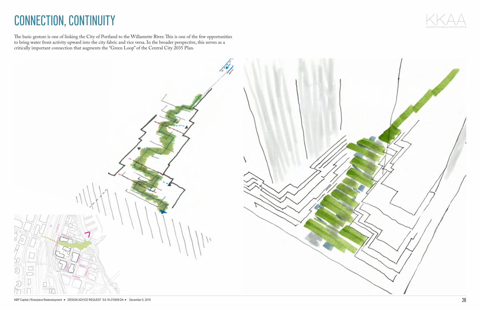
The basic gesture is one of linking the City of Portland to the Willamette River. This is one of the few opportunities to bring water front activity upward into the city fabric and vice versa. In the broader perspective, this serves as a critically important connection that augments the “Green Loop” of the Central City 2035 Plan.
CONNECTION, CONTINUITY
NBP Capital | Riverplace Redevelopment DESIGN ADVICE REQUEST EA 19-215959 DA December 5, 2019 27
SW MONTGOMERY ST.
SW H
ARBO
R PL
.
.R
D REVI
R WS
SW HALL ST. .EVA YD
OO
M WSSW RIVER PKWY.
YAW
RO
BRA
H WS
.R
D R
OB
RAH
WS
SW MONTGOMERY ST.
SW H
ARBO
R PL
.
SW R
IVER
DR.
SW HALL ST.
SW M
OO
DY
AVE.
SW RIVER PKWY.
SW H
ARBO
R W
AY
SW H
ARBO
R D
R.
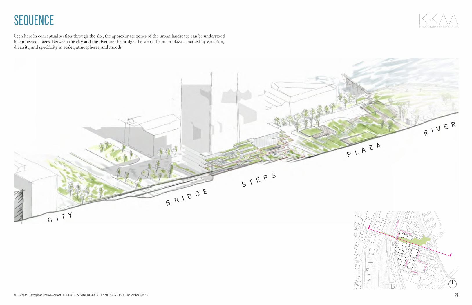
SEQUENCESeen here in conceptual section through the site, the approximate zones of the urban landscape can be understood in connected stages. Between the city and the river are the bridge, the steps, the main plaza... marked by variation, diversity, and specificity in scales, atmospheres, and moods.
C I T YB R I D
G ES T E
P S
P L AZ A
R I VE R

NBP Capital | Riverplace Redevelopment DESIGN ADVICE REQUEST EA 19-215959 DA December 5, 2019 28
SW MONTGOMERY ST.
SW H
ARBO
R PL
.
.R
D REVI
R WS
SW HALL ST. .EVA YD
OO
M WSSW RIVER PKWY.
YAW
RO
BRA
H WS
.R
D R
OB
RAH
WS
SW MONTGOMERY ST.
SW H
ARBO
R PL
.
SW R
IVER
DR.
SW HALL ST.
SW M
OO
DY
AVE.
SW RIVER PKWY.
SW H
ARBO
R W
AY
SW H
ARBO
R D
R.
INDOOR/ OUTDOOR SPACESThroughout the site and at each of the gently stepping first levels, the building bases are directly connected to the outdoors. These appear as entries, pocket gardens, outdoor extensions of interior spaces, open air living rooms and terraces, and so on. The boundaries of the buildings are functionally contiguous to the outdoors, softened by vegetation and human-scaled spaces.

NBP Capital | Riverplace Redevelopment DESIGN ADVICE REQUEST EA 19-215959 DA December 5, 2019 29
SW MONTGOMERY ST.
SW H
ARBO
R PL
.
.R
D REVI
R WS
SW HALL ST. .EVA YD
OO
M WSSW RIVER PKWY.
YAW
RO
BRA
H WS
.R
D R
OB
RAH
WS
SW MONTGOMERY ST.
SW H
ARBO
R PL
.
SW R
IVER
DR.
SW HALL ST.
SW M
OO
DY
AVE.
SW RIVER PKWY.
SW H
ARBO
R W
AY
SW H
ARBO
R D
R.
NATURE AS AN ICONIC URBAN PLACEThe steps are a dramatic moment in the project. They offer nature as a destination, a key place to be in the midst of the city and along the river. Architecturally, they demonstrate that the “podium” is not a conventional wall, but in fact a gently stepping terrain that is more tuned to the pedestrian scale and everyday activity.

NBP Capital | Riverplace Redevelopment DESIGN ADVICE REQUEST EA 19-215959 DA December 5, 2019 30
SW MONTGOMERY ST.
SW H
ARBO
R PL
.
.R
D REVI
R WS
SW HALL ST. .EVA YD
OO
M WSSW RIVER PKWY.
YAW
RO
BRA
H WS
.R
D R
OB
RAH
WS
SW MONTGOMERY ST.
SW H
ARBO
R PL
.
SW R
IVER
DR.
SW HALL ST.
SW M
OO
DY
AVE.
SW RIVER PKWY.
SW H
ARBO
R W
AY
SW H
ARBO
R D
R.
In order to navigate the varying levels, from city elevation to river elevation or vice versa, the project integrates ramps (with maximum 1:12 proportions) as a design element. Gentle slopes form part of the aesthetic rather than being a later consideration. All visitors should have the chance to experience this urban landscape.
ACCESSIBILITY
R A M P S
S T E P S
NBP Capital | Riverplace Redevelopment DESIGN ADVICE REQUEST EA 19-215959 DA December 5, 2019 31
SW MONTGOMERY ST.
SW H
ARBO
R PL
.
.R
D REVI
R WS
SW HALL ST. .EVA YD
OO
M WSSW RIVER PKWY.
YAW
RO
BRA
H WS
.R
D R
OB
RAH
WS
SW MONTGOMERY ST.
SW H
ARBO
R PL
.
SW R
IVER
DR.
SW HALL ST.
SW M
OO
DY
AVE.
SW RIVER PKWY.
SW H
ARBO
R W
AY
SW H
ARBO
R D
R.
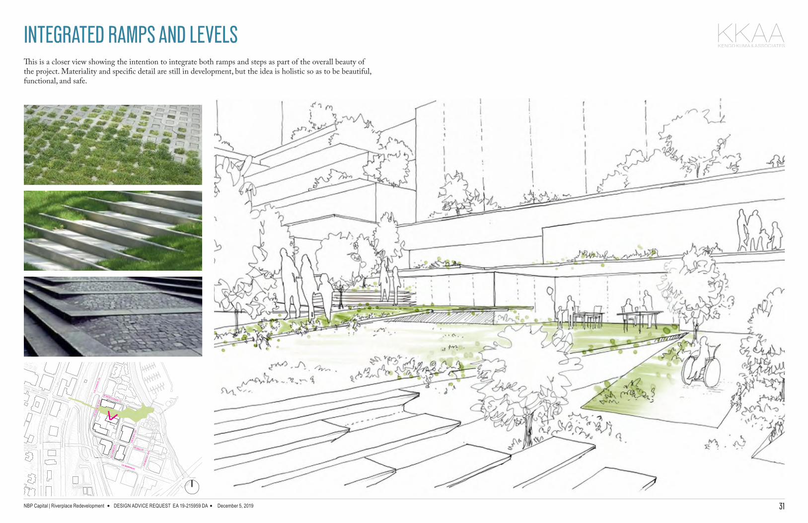
This is a closer view showing the intention to integrate both ramps and steps as part of the overall beauty of the project. Materiality and specific detail are still in development, but the idea is holistic so as to be beautiful, functional, and safe.
INTEGRATED RAMPS AND LEVELS
NBP Capital | Riverplace Redevelopment DESIGN ADVICE REQUEST EA 19-215959 DA December 5, 2019 32
SW MONTGOMERY ST.
SW H
ARBO
R PL
.
.R
D REVI
R WS
SW HALL ST. .EVA YD
OO
M WSSW RIVER PKWY.
YAW
RO
BRA
H WS
.R
D R
OB
RAH
WS
SW MONTGOMERY ST.
SW H
ARBO
R PL
.
SW R
IVER
DR.
SW HALL ST.
SW M
OO
DY
AVE.
SW RIVER PKWY.
SW H
ARBO
R W
AY
SW H
ARBO
R D
R.
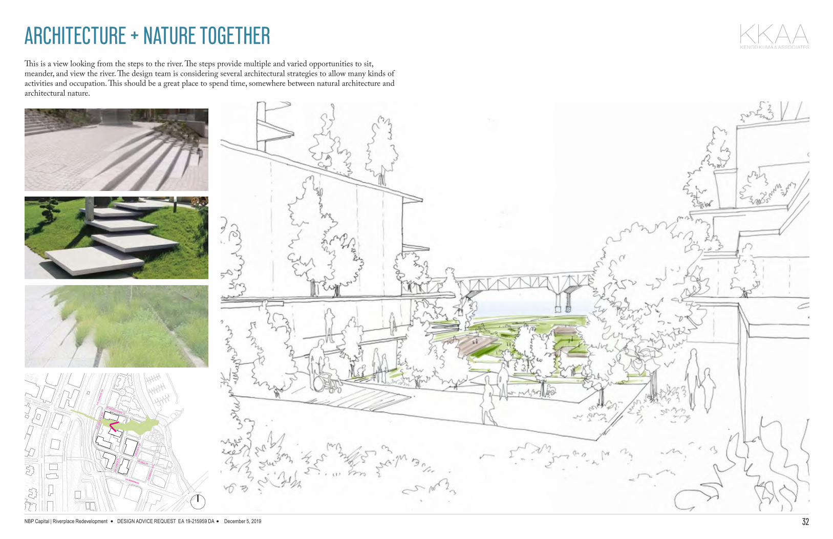
This is a view looking from the steps to the river. The steps provide multiple and varied opportunities to sit, meander, and view the river. The design team is considering several architectural strategies to allow many kinds of activities and occupation. This should be a great place to spend time, somewhere between natural architecture and architectural nature.
ARCHITECTURE + NATURE TOGETHER

NBP Capital | Riverplace Redevelopment DESIGN ADVICE REQUEST EA 19-215959 DA December 5, 2019 33
SW MONTGOMERY ST.
SW H
ARBO
R PL
.
.R
D REVI
R WS
SW HALL ST. .EVA YD
OO
M WSSW RIVER PKWY.
YAW
RO
BRA
H WS
.R
D R
OB
RAH
WS
SW MONTGOMERY ST.
SW H
ARBO
R PL
.
SW R
IVER
DR.
SW HALL ST.
SW M
OO
DY
AVE.
SW RIVER PKWY.
SW H
ARBO
R W
AY
SW H
ARBO
R D
R.
This is a view of the plaza (main open space) looking toward the steps. Continuity should be considered in the details and the materials, blending both harder more durable zones with softer areas of local vegetation.
HARDSCAPE + SOFTSCAPE

NBP Capital | Riverplace Redevelopment DESIGN ADVICE REQUEST EA 19-215959 DA December 5, 2019 34
SW MONTGOMERY ST.
SW H
ARBO
R PL
.
.R
D REVI
R WS
SW HALL ST. .EVA YD
OO
M WSSW RIVER PKWY.
YAW
RO
BRA
H WS
.R
D R
OB
RAH
WS
SW MONTGOMERY ST.
SW H
ARBO
R PL
.
SW R
IVER
DR.
SW HALL ST.
SW M
OO
DY
AVE.
SW RIVER PKWY.
SW H
ARBO
R W
AY
SW H
ARBO
R D
R.
This is a view of the plaza (main open space) looking toward the river. This should be like a big, green, and welcoming living room for the city. It is a place for all, a place to meet, inhabit the zone between the river and the neighborhood. It should feel intimate but open, architecturally distinctive without dictating specific uses, and should be flexible.
BIG GREEN LIVING ROOM

NBP Capital | Riverplace Redevelopment DESIGN ADVICE REQUEST EA 19-215959 DA December 5, 2019 35
SW MONTGOMERY ST.
SW H
ARBO
R PL
.
.R
D REVI
R WS
SW HALL ST. .EVA YD
OO
M WSSW RIVER PKWY.
YAW
RO
BRA
H WS
.R
D R
OB
RAH
WS
SW MONTGOMERY ST.
SW H
ARBO
R PL
.
SW R
IVER
DR.
SW HALL ST.
SW M
OO
DY
AVE.
SW RIVER PKWY.
SW H
ARBO
R W
AY
SW H
ARBO
R D
R.
CONSIDERING THE PLAZAThe idea of the plaza (main open space) is still under heavy consideration within the design team and development team. Factors under consideration are: flexibility, usage, scales of activity, a sense of vibrancy when occupied by many and by few. Some of the options include but are not limited to the diagrams on this page: low flat plates that are directly coordinated with the surrounding sidewalk elevations; a terrain swept up to view the plaza and river from above, and finally a consideration for programmed pavilions at key corners.
NBP Capital | Riverplace Redevelopment DESIGN ADVICE REQUEST EA 19-215959 DA December 5, 2019 36
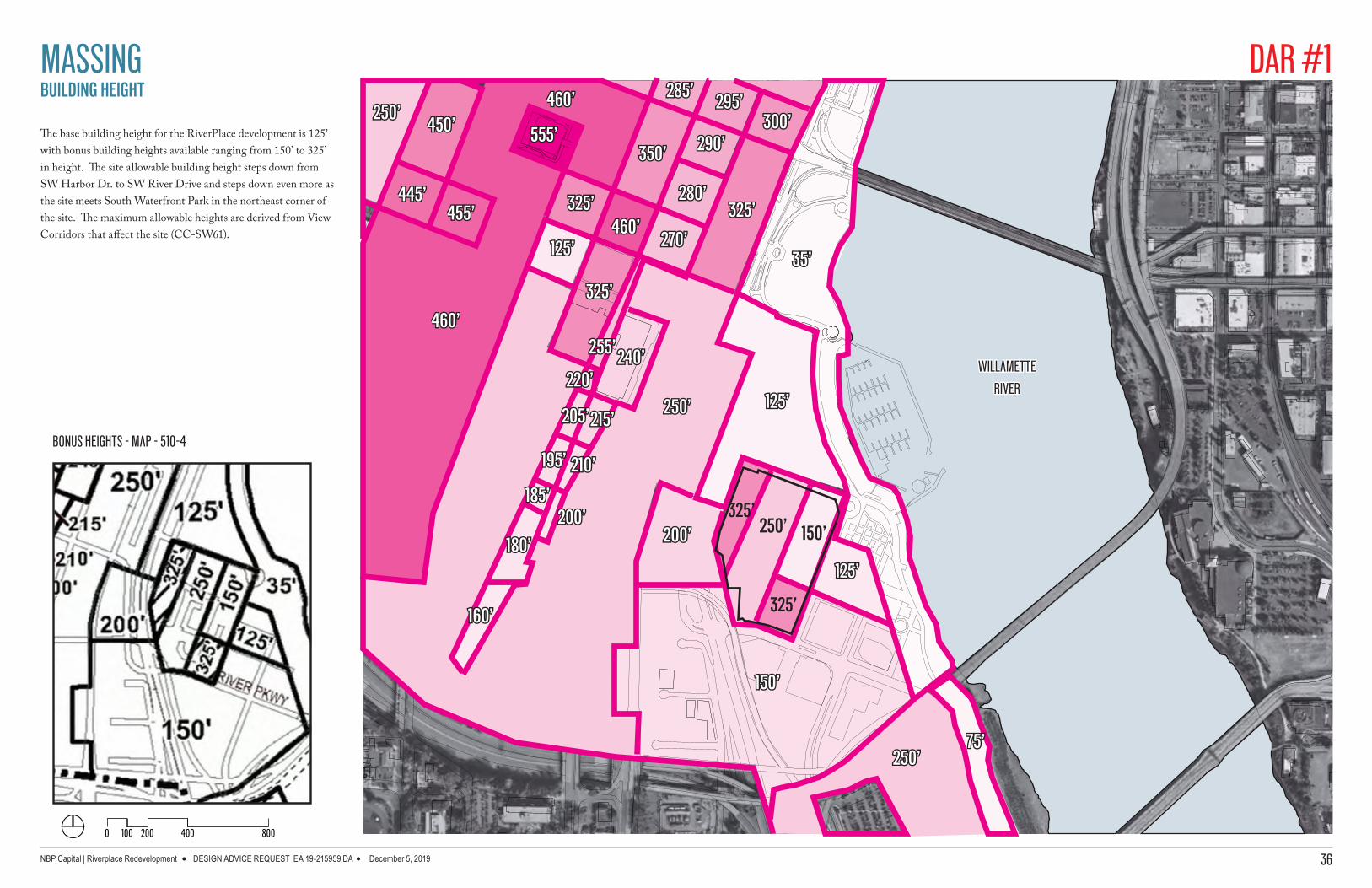
BUILDING HEIGHT
The base building height for the RiverPlace development is 125’ with bonus building heights available ranging from 150’ to 325’ in height. The site allowable building height steps down from SW Harbor Dr. to SW River Drive and steps down even more as the site meets South Waterfront Park in the northeast corner of the site. The maximum allowable heights are derived from View Corridors that affect the site (CC-SW61).
325’325’
250’250’
125’125’
325’250’ 150’
325’
125’125’
35’35’
75’75’
150’150’
200’200’
160’160’
250’250’
180’180’
185’185’
195’195’
205’205’
220’220’
215’215’
210’210’
200’200’
240’240’255’255’
325’325’
460’460’
350’350’
285’285’
270’270’
280’280’
290’290’
295’295’300’300’
325’325’
125’125’
460’460’
555’555’
455’455’445’445’
460’460’
450’450’250’250’
0 100 200 400 800
BONUS HEIGHTS - MAP - 510-4
WILLAMETTEWILLAMETTE
RIVERRIVER
MASSING DAR #1

NBP Capital | Riverplace Redevelopment DESIGN ADVICE REQUEST EA 19-215959 DA December 5, 2019 37
VIEW CORRIDORS
A major view corridor (CC-SW61) from Terwilliger Blvd in the southwest hills extends through the southern portion of the site to the Willamette River to the north, allowing for a view of Mt. St. Helens.
0 100 200 400 800
RIVERPLACESITE
VIEW CORRIDOR AREAS - MAP - 510-20
WILLAMETTEWILLAMETTE
RIVERRIVER
MASSING VIEW TO MT. ST. HELENS FROM SW TERWILLIGER PARKING DAR #1
NBP Capital | Riverplace Redevelopment DESIGN ADVICE REQUEST EA 19-215959 DA December 5, 2019 38
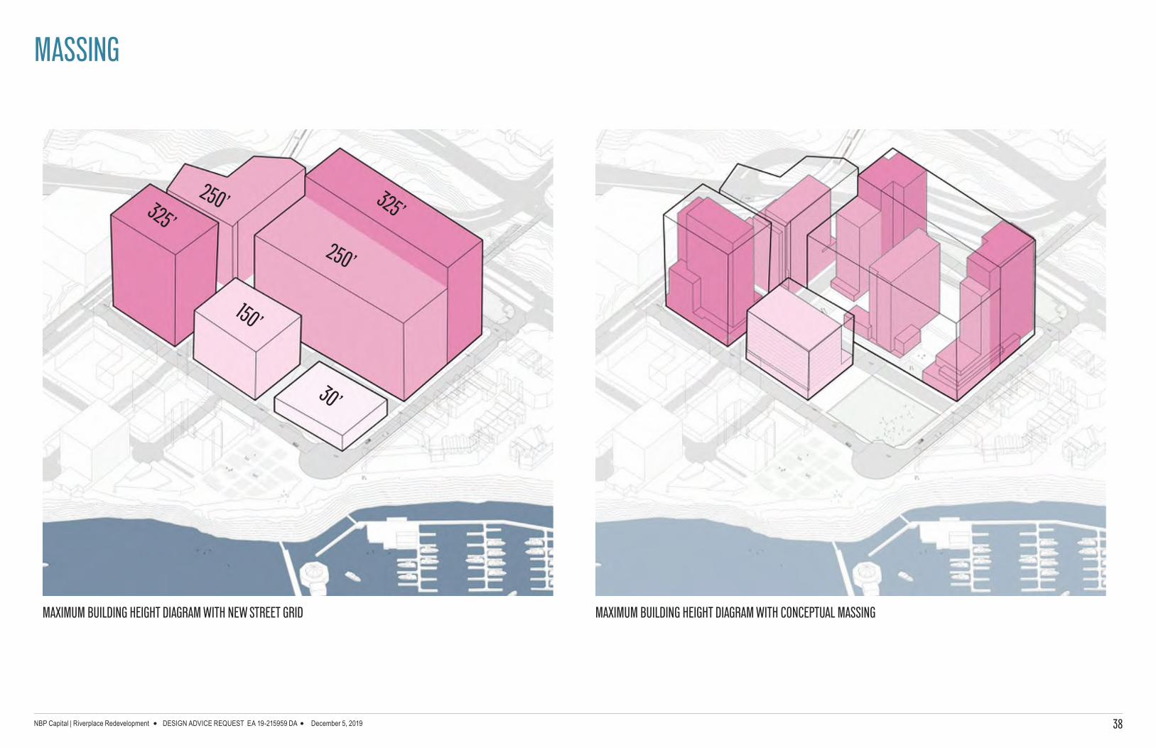
SW HARBOR DR
MASSING
MAXIMUM BUILDING HEIGHT DIAGRAM WITH CONCEPTUAL MASSING
SW HARBOR DR 325’325’
150’
30’
250’
250’
MAXIMUM BUILDING HEIGHT DIAGRAM WITH NEW STREET GRID
NBP Capital | Riverplace Redevelopment DESIGN ADVICE REQUEST EA 19-215959 DA December 5, 2019 39
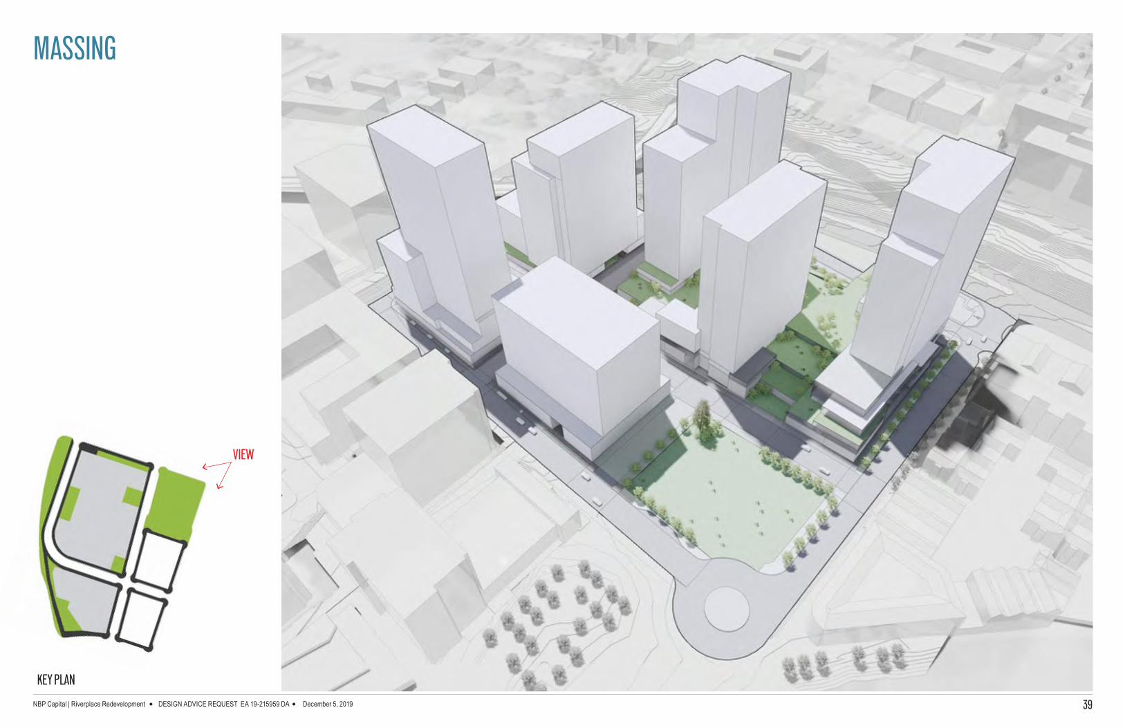
MASSING
VIEW
KEY PLAN

NBP Capital | Riverplace Redevelopment DESIGN ADVICE REQUEST EA 19-215959 DA December 5, 2019 40
MASSING
VIEW
KEY PLAN

NBP Capital | Riverplace Redevelopment DESIGN ADVICE REQUEST EA 19-215959 DA December 5, 2019 41
MASSING
VIEW
KEY PLAN

NBP Capital | Riverplace Redevelopment DESIGN ADVICE REQUEST EA 19-215959 DA December 5, 2019 42
MASSING
VIEW
KEY PLAN

NBP Capital | Riverplace Redevelopment DESIGN ADVICE REQUEST EA 19-215959 DA December 5, 2019 43
MASSING
VIEW
KEY PLAN

NBP Capital | Riverplace Redevelopment DESIGN ADVICE REQUEST EA 19-215959 DA December 5, 2019 44
MASSING

NBP Capital | Riverplace Redevelopment DESIGN ADVICE REQUEST EA 19-215959 DA December 5, 2019 45
Parking Garage Entry/Exit
Loading/ ServiceL
PL
P
L
P
P
L
SW HA
RBOR
WAY
SW RI
VER D
R
SW H
ARBO
R DR
IVE
SW HALL ST
SW HARBOR VIADUCT
SW H
ARRI
SON
ST
SW RIVER PARKWAY
SW MONTGOMERY ST
RIVERPLACE
MARINA
LOADING
LOAD
ING
LOAD
ING
LOAD
ING
Bike Share Location
Ride Share Location
SOUTH WATERFRONT PARK
2000 50 100
LOADINGLL
PROPOSED STREET CIRCULATION
Loading and service for the future towers on Site 1 is accommodated by on-street accessible loading areas both on the proposed internal street “A”, SW Montgomery St. and on SW Harbor Way.
PARKINGROADS
GREEN SPACE
POTENTIAL TOWER FOOTPRINTS
LEGEND
RETAIL/ACTIVE USE
SERVICE/LOADING
RESIDENTIAL
TRANSPORTATION ISSUES DAR #1

NBP Capital | Riverplace Redevelopment DESIGN ADVICE REQUEST EA 19-215959 DA December 5, 2019 46
SW RI
VER D
R
SW HALL STREET
L
P
L
P
L
PL
Given the parking and loading needs for a large, high density development featuring multiple buildings, RiverPlace has a need for multiple building loading and parking area access points.
Most of these are concentrated on Hall Street, given its function as a “working” or service street through the site.
Others are located where they won’t negatively affect active use frontages on other sides of the development.
Two-way traffic flow on streets Right-in, right-out movements at Montgomery and Harbor Way, and “A” Street and River Parkway Connecting Hall extension to Harbor Way or Harbor Drive.
ACTIVE USE AT GROUND LEVEL
SW HA
RBOR
WAY
SW HA
RBOR
DRIVE
“A”
SW MONTGOMERY STREET
P
L
Parking Garage Entry/Exit
Trimet MAXBike Trail
Street Car
Loading/ ServiceL
P
2000 50 100
GREEN SPACE
PARKING/LOADING
LEGEND
RETAIL/ACTIVE USE
RESIDENTIAL
THE STRAND
CONDOMINIUMS
HYATT HOUSE
PORTLAND
SOUTH WATERFRONT
PARK
RIVERPLACE
MARINA
THE STRAND
CONDOMINIUMS
RIVERPLACE
CONDOMINIUMS
SW H
ARRI
SON
STRE
ET
P L
SW RIVER PARKWAY
NBP Capital | Riverplace Redevelopment DESIGN ADVICE REQUEST EA 19-215959 DA December 5, 2019 47
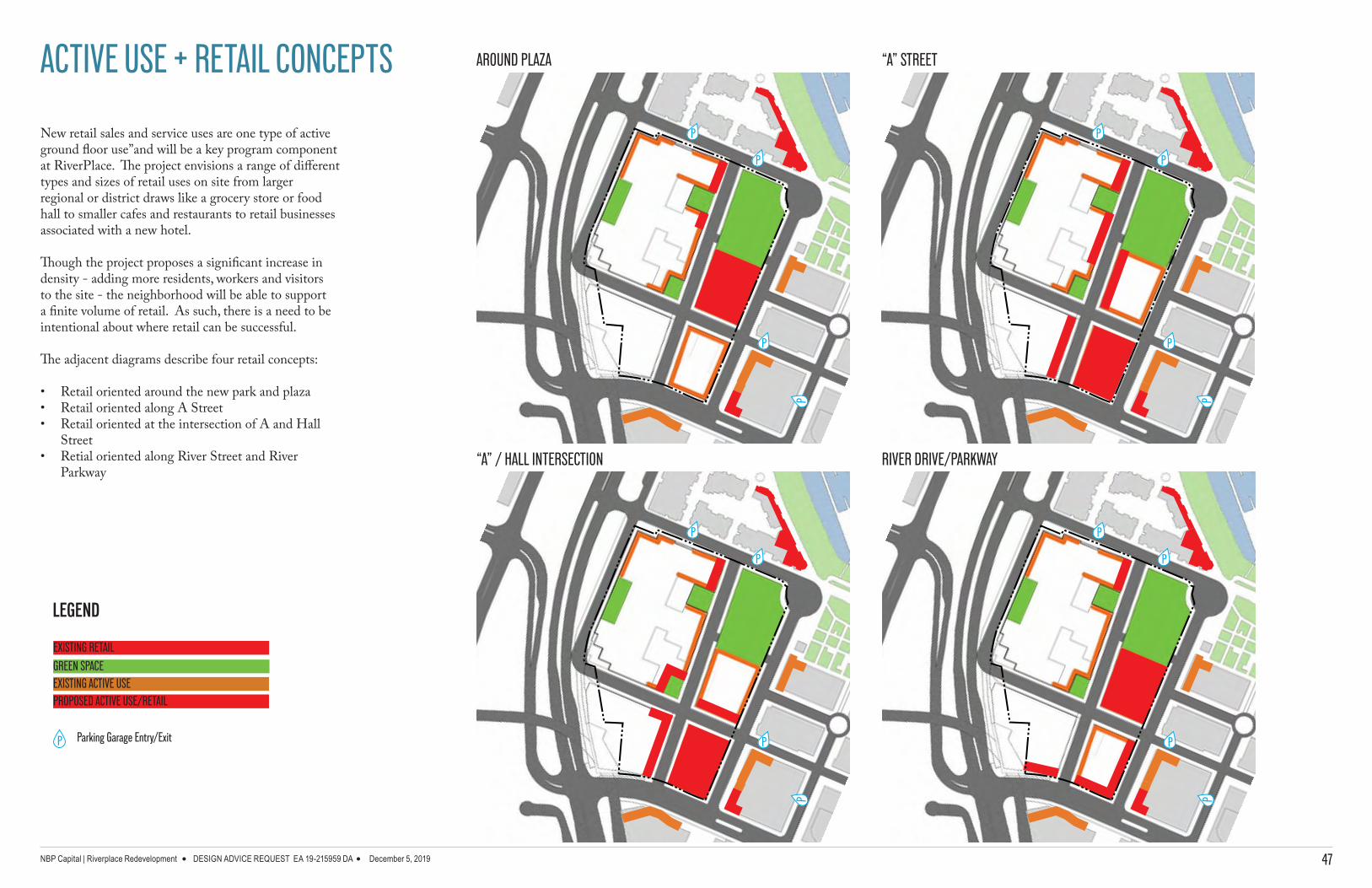
ACTIVE USE + RETAIL CONCEPTS
New retail sales and service uses are one type of active ground floor use”and will be a key program component at RiverPlace. The project envisions a range of different types and sizes of retail uses on site from larger regional or district draws like a grocery store or food hall to smaller cafes and restaurants to retail businesses associated with a new hotel.
Though the project proposes a significant increase in density - adding more residents, workers and visitors to the site - the neighborhood will be able to support a finite volume of retail. As such, there is a need to be intentional about where retail can be successful.
The adjacent diagrams describe four retail concepts:
• Retail oriented around the new park and plaza• Retail oriented along A Street• Retail oriented at the intersection of A and Hall
Street• Retial oriented along River Street and River
Parkway
P
P
P
P
P
P
P
P
P
P
P
P
P
P
P
P
Parking Garage Entry/ExitP
GREEN SPACE
LEGEND
EXISTING RETAIL
EXISTING ACTIVE USEPROPOSED ACTIVE USE/RETAIL
AROUND PLAZA
“A” / HALL INTERSECTION
“A” STREET
RIVER DRIVE/PARKWAY

NBP Capital | Riverplace Redevelopment DESIGN ADVICE REQUEST EA 19-215959 DA December 5, 2019 48
STREET CHARACTER
RiverPlace is proposing roughly 1500 linear feet of new streets and public access through the site. As the streets will be very public, they offer a unique opportunity to strengthen the different places on the site, helping to shape the public experiences at different nodes around the development. The project team is continuing to work with the Portland Bureau of Transportation and the Bureau of Development Services, among other agencies, to confirm the network and the design sections of the streets.
SW HARBOR DR
SW MONTGOMERY ST
NEW HARBOR WAY
“A” ST
SW RIVER PKWAY
SW HALL ST

NBP Capital | Riverplace Redevelopment DESIGN ADVICE REQUEST EA 19-215959 DA December 5, 2019 49
SW HARBOR WAY
Currently SW Harbor Way south of Montgomery is a narrow 40’ ROW that is infrequently used and ends in a cul-de-sac. It does include a piece of the Harbor Drive path connection within its roadway width. RiverPlace will dramatically improve Harbor Way, expanding to a 60’ ROW that will include a new segment of the Harbor Drive mixed use path. The street design will also add new space for street trees on both sides, adding canopy to help address increases in urban heat. Harbor Way will provide critical multi-modal access to multiple buildings at RiverPlace, and will serve as part of a site circulation system, helping to relieve pressure on existing street capacity at Montgomery, River Drive and River Parkway
STREET CHARACTER
EXISTING
CONCEPT

NBP Capital | Riverplace Redevelopment DESIGN ADVICE REQUEST EA 19-215959 DA December 5, 2019 50
SW MONTGOMERY ST.
The segment of SW Montgomery at RiverPlace is the eastern most portion of the “Montgomery Green Street” vision that stretches from the West Hills to the Willamette River. RiverPlace will rebuild the southern edge of Montgomery between Harbor Way and River Drive, strengthening the green street’s character with a wider planting strip, adding active uses to more of the frontage, providing more pedestrian space and exploring more public amenities. The last block of Montgomery at RiverPlace will be an expansion of the “green” into the public plaza space, before reaching the river.
STREET CHARACTER
EXISTING
CONCEPT

NBP Capital | Riverplace Redevelopment DESIGN ADVICE REQUEST EA 19-215959 DA December 5, 2019 51
SW RIVER DR.
River Drive runs along the eastern edge of the RiverPlace development, creating a north-south seam between old and new development. Ground level uses and edge conditions vary at the existing buildings along the east side of River Drive, ranging from retail spaces, residential units, office space and parking area access points. RiverPlace will maintain the quality and character of the current River Drive frontage, while potentially adding more active use building edges.
STREET CHARACTER
EXISTING

NBP Capital | Riverplace Redevelopment DESIGN ADVICE REQUEST EA 19-215959 DA December 5, 2019 52
STREET CHARACTERSW RIVER PKWAY.
River Parkway is the largest gateway to the site, offering a broad spectrum of access ranging from streetcar or bus transit options to pedestrian and bicycle facilities and multiple travel lanes for trucks and motor vehicles. Its levels of vehicle volumes creates the most visible location on the RiverPlace site, and the sweeping curve of the Lincoln structure for MAX trains and buses lend it a three-dimensional quality not present elsewhere on the site. RiverPlace will reinforce its frontage on River Parkway with a wide sidewalk and planting strip for street trees and landscaping
EXISTING
CONCEPT

NBP Capital | Riverplace Redevelopment DESIGN ADVICE REQUEST EA 19-215959 DA December 5, 2019 53
STREET CHARACTERHALL EXTENSION
The extension of Hall through the site will offer critical site mobility and access for the community. At RiverPlace, Hall is envisioned to be more of a “working street” providing necessary access to parking areas and building trash/loading enclosures. It will potentially extend to Harbor Way from River Drive and allow for east-west and north-south movement through the site, helping to relive pressure on River Drive and SW Montgomery for pedestrians, bicycles, motor vehicles and trucks.
CONCEPT

NBP Capital | Riverplace Redevelopment DESIGN ADVICE REQUEST EA 19-215959 DA December 5, 2019 54
STREET CHARACTER“A” STREET
As one of the primary new streets at RiverPlace, “A” Street provides an opportunity for different experiences. At its northern end, adjacent to the plaza, the vision is for a curbless and special street design that extends the feeling of the plaza west to the podium edge and the lower levels of the steps. The southern two blocks of the street would be designed to support active uses and retail, with a more traditional design featuring sidewalk, planting strips and on-street parking.
CONCEPT BTWN PLAZA & RIVER PKWAY - A
CONCEPT AT PLAZA - B
A
B