2017 Oregon Sport Fishing Regulations
100
OREGON SPORT FISHING REGULATIONS www.odfw.com
Transcript of 2017 Oregon Sport Fishing Regulations

GET READY FORYour FISHING SEASON FISHING SEASON
76 STORES THROUGHOUT THE NORTHWEST • WWW.BIMART.COM

GET READY FORYour FISHING SEASON FISHING SEASON
76 STORES THROUGHOUT THE NORTHWEST • WWW.BIMART.COM

2
CONTENTSAdvisories and Consumption Guidelines ����������������20–21
Angling Zones and Fish District Contacts ����������������������������22
Combined Angling Tag Instructions and Location Codes �����������������������89–91
Fish and Shellfish Identification ��������������������������������92–96
Fish and Wildlife Transfer Record ��������88
Free Fishing Weekend �������������������������14
General Statewide Regulations ���������10–19
Angling and Harvest Methods, Hours and Restrictions �����������������18–19
Bag, Possession, Size Limits ����������10–11
Definitions �����������������������������������12–14
Gear and Bait Restrictions �����������������16
General Restrictions ���������������������15–16
Hook and Weight Regulations �����������17
How to Use this Guide ��������������������������4
License information ���������������������������6–7
Columbia River Basin Endorsement ��������������������������������������8
Oregon Disabilities Hunting and Fishing Permit Information ������������9
Turn in Poachers (TIP) Information �������22
Zone Regulations ��������������������������24–87
Northwest Zone and Maps ��������� 24–31
Southwest Zone and Maps ���������� 32–39
Willamette Zone and Maps ��������40–49
Central Zone and Maps ��������������50–55
Northeast Zone and Maps ����������56–59
Southeast Zone and Maps ����������60–67
Snake River Zone and Maps �������� 68–70
Columbia River Zone and Maps ���������������������������������� 72–79
Marine Zone and Maps ��������������80–87
Cover Photo:Razor clamming in Seaside, Oregon, photo by Don Frank, donfrankphotography.com
Websitewww.odfw.com
Information and Education503-947-6002
Licensing503-947-6101
Fish Division503-947-6201
Wildlife Violations1-800-452-7888
OREGON DEPARTMENT OF FISH AND WILDLIFE
Full Service OfficesCentral
61374 Parrell Rd Bend, OR 97702
541-388-6363
Northeast107 20th Street
La Grande, OR 97850541-963-2138
Northwest17330 SE Evelyn StreetClackamas, OR 97015
971-673-6000
Southwest4192 N Umpqua HwyRoseburg, OR 97470
541-440-3353
Marine2040 SE Marine Science Dr.
Newport, OR 97365 541-867-4741
OREGONSPORT FISHING
REGULATIONS
2 0 1 7
WHAT’Sfor 2017
SeeNEW
• Simplified and streamlined regulations
• Updated Angling Zone maps
• Updated license information
• Expanded hatchery Chinook opportunities in NW zone
• Look for yellow highlighted text that designates changes and new opportunities

Clemens Marina is the #1 selling dealer for Hewescraft boats & North River boats in the NW!
4 2017 OREGON SPORT FISHING REGULATIONS
The information in this booklet will be furnished in alternate format for people with disabilities, if needed. Please call 503-947-6002 or e-mail [email protected] to request an alternate format.
ODFW prohibits discrimination on the basis of race, color, national origin, age, sex or disability. If you believe you have been discriminated against as described above in any program, activity or facility, or if you desire further information, please contact Deputy Director, Fish & Wildlife Programs, ODFW, 4034 Fairview Industrial Dr. SE, Salem, OR 97302, or call 503-947-6000, or write to the Chief, Public Civil Rights Division Department of the Interior, 1849 C Street NW, Washington, DC 20240.
ODFW allows appropriate advertising in this booklet to help offset the cost of printing. ODFW neither endorses products or services listed nor accepts any liability arising from the use of products or services listed.
Oregon Department of Fish and Wildlife
EnglishThis book includes important information about Oregon fishing laws. You can be fined or jailed if you violate these laws. Please have an English reader who fully understands this information and can accurately interpret the legal meaning of the regulations in this book explain them to you.
SpanishEste libro incluye información importante sobre las leyes de pesca de Oregon. Puede recibir multas o ir a la cárcel si infringe esas leyes. Haga que un lector angloparlante que entienda cabalmente esta información y pueda interpretar con exactitud el alcance legal de las leyes expresadas en este libro, se las explique.
Traditional Chinese本書包括有關俄勒岡州漁業法的重要資訊。如果違反這些法律,將會被處以罰款或監禁。請讓完全瞭解這些資訊並能夠準確詮釋本書條例法律含義的英文讀者為你解釋這些資訊。
RussianДанная книга содержит важную информацию о законах штата Орегон о рыбной ловле. За нарушение этих законов Вы можете быть оштрафованы или осуждены. Пожалуйста, убедитесь, что Вы полностью понимаете информацию правового характера, изложенную в этой книге.
UkranianЦя книга містить важливу інформацію про закони про риболовлю в штаті Орегон. Якщо Ви порушите ці закони, з Вас можуть стягнути штраф або посадити у вязницю.Будь ласка, попросіть людину, яка добре розуміє англійську і може точно передати юридичне значення цієї книги, прочитати і пояснити Вам ці правила.
VietnameseQuyển sách này bao gồm những thông tin quan trọng về luật đi săn của Oregon. Quý vị có thể bị phạt tiền hoặc phạt tù nếu vi phạm những luật này. Hãy nhờ một người thạo tiếng Anh, người có thể hoàn toàn hiểu những thông tin này và có thể giải thích chính xác ý nghĩa luật pháp của các quy chế nêu trong sách, giải thích cho quý vị.
Curt Melcher, Director Salem Headquarters Office 4034 Fairview Industrial Dr. SE Salem, OR 97302 503-947-6000ODFW in-state toll-free 800-720-6339 [email protected]
Oregon Fish and Wildlife CommissionMichael Finley (Chair) .......................... MedfordHolly Akenson..................................... EnterpriseLaura Anderson ..................................... NewportJason Atkinson ................................. JacksonvilleBruce Buckmaster .....................................AstoriaBob Webber .......................................Port OrfordGreg Wolley ............................................ Portland
Instructions1. Read the general statewide regulations for information about license and tag
requirements, catch and possession limits, gear and bait restrictions, harvest methods, and legal angling hours.
2. Read the zone regulations for where you will be angling and check for exceptions by water body. If a water body or a section of a water body is not listed in exceptions, zone regulations apply.
3. Emergency or temporary rules may be adopted after these rules are printed, and they will supersede these regulations. Anglers are responsible for knowing current regulations. Anglers may call ODFW Headquarters or field offices at the numbers shown on the table of contents page, or check ODFW’s website www.odfw.com for sport fishing regulations updates.
HOW TO USE THIS GUIDE
This high-quality regulation guide is offered to you by the Oregon Department of Fish and Wildlife through its unique partnership with J.F. Griffin Publishing, LLC.
The revenue generated through ad sales signifi-cantly lowers production costs and generates sav-ings. These savings translate into additional funds for other important agency programs.
If you have any feedback or are interested in advertising, please contact us at 413.884.1001 or at www.JFGriffin.com
About this Guide
OREGON2 0 1 72 0 1 7
SPORT FISHINGSPORT FISHINGSPORT FISHINGSPORT FISHINGSPORT FISHINGREGULATIONS
www.odfw.com
SPORT FISHINGSPORT FISHINGSPORT FISHINGSPORT FISHINGSPORT FISHING
Williamstown, MA | Birmingham, AL
This guide is also available online at
Graphic Design: Jon Gulley, Dane Fay, John Corey, Evelyn Haddad, Chris Sobolowski

for your boatgeico.com | 1-800-865-4846 | local offi ce
SMOOTH WATER TOMORROW.See how much you could save on boat insurance.SAVE TODAY.
Some discounts, coverages, payment plans and features are not available in all states or all GEICO companies. Boat and PWC coverages are underwritten by Seaworthy Insurance Company, a GEICO company. GEICO is a registered service mark of Government Employees Insurance Company, Washington, D.C. 20076; a Berkshire Hathaway Inc. subsidiary. GEICO Gecko Image © 1999-2017. © 2017 GEICO

Experience all the fruits of the sea!Buy licenses right at the dock • Rent a boat from the marina or bring your own
Drop a crab ring off a pier • Legendary Dungeness crabChinook Salmon fi shing in the Ghost Hole • Deep sea fi shing trips
The Port of Garibaldi is the gateway to all Tillamook Bay has to offer.
For more information, visit portofgaribaldi.org and www.visitgaribaldi.comPort of Garibaldi: (503)322-3292 City of Garibaldi: (503)322-3327
Legendary Fishing on Tillamook Bay
6
LICENSE INFORMATIONLicenses, Tags, Permits, Endorsements and Validations All persons 12 years or older must:• Have in possession a valid Oregon Angling
License to angle for or take, or help another angle for or take, any fish for personal use.
• Have a valid Oregon Shellfish License to take any shellfish for personal use.
• No fishing or shellfish license needed: » During Free Fishing Weekend(s); » When taking crayfish or bullfrogs; » When Oregon resident landowners are
angling on land they own, except when angling for salmon, steelhead, sturgeon or halibut.
» When an Oregon resident is angling on land owned by an immediate family member, and resides on that land, except when angling for salmon, steelhead, sturgeon or halibut.
• All anglers (regardless of age) need a valid Combined Angling Tag in possession to
angle for salmon, steelhead, sturgeon and halibut.
• Anglers may purchase only one Combined Angling Tag (authorizing harvest of 20 salmon or steelhead) per year.
• Harvested adult wild salmon or steelhead must be recorded on the Combined Angling Tag.
• Angler who takes the fish must record the fish on their tag irrespective of who hooked the fish
• Hatchery salmon or steelhead can be recorded on either the Combined Angling Tag or a Hatchery Harvest Tag, but hatchery catch must be recorded on one of these tags.
• Anglers may purchase multiple Hatchery Harvest Tags to record hatchery salmon and steelhead harvested, in lieu of recording these fish on the Combined Angling Tag.
• Only hatchery salmon and hatchery steelhead may be recorded on the Hatchery Harvest Tag.
• The combined angling tag along with all hatchery harvest tags must be in possession and presented when requested.
• Harvest tags are included with daily/multiday licenses
• Anglers are not required to record the harvest of jack salmon.
• All anglers, regardless of age, must have in possession a valid Columbia River Basin Endorsement when angling for salmon, steelhead and sturgeon in the mainstem Columbia River from Buoy 10 upstream, and in all rivers and their tributaries that flow into the Columbia River.
• When angling within three miles of shore from Cape Falcon, OR to Leadbetter Point, WA, or in the waters of the Columbia River where it forms the Oregon-Washington boundary both Washington and Oregon resident fishing licenses are valid. Any anglers other than Washington residents must have a valid Oregon angling or shellfish license when landing fish or taking shellfish by boat in Oregon.
• All licenses, tags, and permits are available online (website), and through license agents, and ODFW offices that sell licenses.
• Licenses and tags may be purchased for you by a family member or friend.
• Angling licenses may be exchanged for Combination License or Sports Pac License within 90 days of original purchase.
• State and federal laws require a Social Security Number to obtain most hunting and angling licenses.

2017 OREGON SPORT FISHING REGULATIONS 7
LICENSE, TAG AND PERMIT FEESDESCRIPTION RESIDENT NONRESIDENT
ANNUAL LICENSESAngling $38.00 $97.50Sports Pac (Includes: Angling, Shellfish, and Hunting License; combined angling tag; spring turkey, cougar, general or controlled bear tag, elk and deer tags; upland bird and waterfowl validations)
$180.00 N/A
Combination Angling and Hunting $65.00 N/AAnnual Shellfish $9.00 $26.00
ENDORSEMENTS AND VALIDATIONSTwo-Rod Validation $21.50 $21.50Columbia River Basin Endorsement (When purchased at same time as angling license)
$9.75
Columbia River Basin Endorsement (If purchased separately from angling license)
$11.75
TAGSAdult Combined Angling Tag $35.00 $55.00Hatchery Salmon / Steelhead Harvest Card $25.00
YOUTH LICENSESYouth License (12-17 years old) (Includes Angling, Hunting, Shellfish and Columbia River Basin Endorsement)
$10.00
Youth Sports Pac (Includes: Angling, Shellfish, and Hunting License; combined angling tag; spring turkey, cougar, general or controlled bear tag, elk and deer tags; upland bird and waterfowl validations and the Columbia River Basin Endorsement)
$55.00 N/A
YOUTH TAGSYouth Angling Combined Angling Tag $5.00
RESIDENT SENIOR AND PIONEER LICENSESSenior Angling (70 years old and Oregon resident for at least 5 years) $25.00 N/A
Senior Combination (70 years old and Oregon resident for at least 5 years) $41.50 N/A
LICENSE, TAG AND PERMIT FEESDESCRIPTION RESIDENT NONRESIDENT
Pioneer Combination (65 years old and Oregon resident for at least 50 years) (Includes: Angling and Hunting License and Columbia River Basin Endorsement). Available only at ODFW offices that sell licenses.
$6.00 N/A
DISABLED VETERAN AND UNIFORMED SERVICE MEMBER LICENSES
Uniformed Services Angling N/A $38.00Uniformed Services Annual Shellfish N/A $9.00Disabled Veteran Shellfish Free N/ADisabled Veteran Combination (Includes Columbia River Basin Endorsement) Free N/A
DAILY / MULTI-DAY LICENSESOne Day Angling $19.00Two Day Angling $34.50Three Day Angling $50.50Seven Day Angling N/A $76.50Columbia River Basin Endorsement (Each Day) $1.00
Daily Angling and Shellfish Combo $27.50Three Day Shellfish N/A $17.00
OTHER PERMITS AND APPLICATIONSDuplicate License, Tag, or Permit $25.50Abalone Harvest Permit FreeScallop Harvest Permit FreeWildlife Area Parking Permit (Daily) $10.00Wildlife Area Parking Permit (Annual) $30.00Aquatic Invasive Species Prevention Permit (Nonmotorized Boats) $7.00
Aquatic Invasive Species Prevention Permit (Motorized Boats) N/A $22.00
Oregon Disabilities Hunting and Fishing Permit (includes disabled clam digging) Free

2017 OREGON SPORT FISHING REGULATIONS8
Anglers fishing for salmon, steelhead or sturgeon in the Columbia River Basin are required to have a Columbia River Basin endorsement.• Cost is $9.75 a year when purchased with
an annual fishing license, or $9.75 plus a $2 agent fee when purchased separately.
• Cost is $1 per day for daily fishing licenses.• Endorsement is in addition to a fishing
license and Combined Angling Tag.
• Required when fishing for salmon, steelhead or sturgeon on all rivers and streams in the Columbia River Basin.
• Anglers with a resident disabled veteran, resident pioneer, youth license and youth under 12 licenses, will be issued a free endorsement upon request to fish for salmon, steelhead or sturgeon in the Columbia River Basin.
The endorsement may be purchased wherever fishing licenses are sold.
Money from the endorsement will help fund the transition to eliminate non-tribal commercial gill nets on the lower mainstem Columbia River and provide additional salmon and steelhead for sport fishing. More information about the endorsement and Columbia River fisheries reforms can be found at www.odfw.com/fish/CRP/columbia_river_basin_endorsement.asp.
Columbia River Basin Endorsement Area: Highlighted area requires a Columbia River Basin Endorsement when fishing for salmon, steelhead and sturgeon.
COLUMBIA RIVER BASIN ENDORSEMENT

92017 OREGON SPORT FISHING REGULATIONS
OREGON DISABILITIES HUNTING AND FISHING PERMIT INFORMATION
In order to be considered a person with a disability under the wildlife laws, a person shall provide either:1. Written certification from a licensed
physician, physician assistant or certified nurse practitioner, that states that the applicant:a. Is permanently unable to walk without
the use of, or assistance from, a brace, cane, crutch, prosthetic device, wheelchair, scooter, or walker;
b. Is restricted by lung disease to the extent that the person’s forced expiratory volume for one second, when measured by a spirometer, is less than 35% predicted, or arterial oxygen tension is less than 55 mm/Hg on room air at rest;
c. Has a cardiac condition to the extent that the person’s functional limitations are classified in severity as Class III or Class IV, according to standards established by the American Heart Association;
d. Has a permanent, physical impairment that prevent the person from holding or shooting a firearm or bow or from holding a fishing rod in hand; or
e. Has central visual acuity that permanently does not exceed 20/200 in the better eye with corrective lenses, or the widest diameter of the visual field is no greater than 20 degrees; or
2. Written proof that the last official certification of record by the United States Department of Veterans Affairs or any branch of the Armed Forces of the United States shows the person to be at least 65% disabled (ORS 496. 018).
The Oregon Disabilities Hunting and Fishing Permit is not a license or tag. Anglers must still obtain an angling license and/or Combined Angling Tag (if angling for salmon, steelhead, sturgeon or pacific halibut) and clam diggers must obtain a shellfish license. Hunters also must still obtain a hunting license and apply for and/or purchase appropriate tags prior to specified tag sale deadlines to hunt in controlled and general big game seasons. You must be in possession of your “Oregon Disabilities Hunting and Fishing Permit,” license, and tag while you are angling, taking shellfish or hunting (even holders of a Disabled Veteran/Pioneer license and tag). All license and tag fees are at regular rates.
Holder of the “Oregon Disabilities Hunting and Fishing Permit” are allowed to angle from an anchored craft in waters where angling from a floating device is prohibited by ODFW. This allowance does not supersede safety or security regulations enacted by other agencies.
May angle with use of electric powered reels. Rods with electric reels may be kept in rod holder when angling and landing fish.
May fish during authorized open fishing seasons from the Nehalem Hatchery Barrier Free Fishing Platform on the North Fork Nehalem River.
A person may assist shellfish licensed clam diggers who possess a valid “Oregon Disabilities Hunting and Fishing Permit” provided both diggers have their own containers and the assistant is within 100 feet of the Disabilities Permit holder while digging
clams. The assistant must possess their own shellfish license and a copy of the “Oregon Disabilities Hunting and Fishing Permit”.
When clam digging a disabled person may be assisted by another person provided:• Both diggers have their own containers for
clams.• The disabled clam digger is within 100
feet of the assistant while the assistant is digging.
• The disabled clam digger and their assistant each have a copy of permit in possession when on the clam beds.For additional information on the rules and
regulations pertaining to hunting and “Oregon Disabilities Hunting and Fishing Permit” consult the Oregon Hunting Regulations.
For more information or to obtain an “Oregon Disabilities Hunting and Fishing Permit” application packet, please visit our website at www.odfw.com/resources/hunting/disability. Application packets are also available at any ODFW office that sells licenses or by calling 503-947-6100.
PERMIT APPLICATION
© fo
odan
dwin
epho
togr
aphy
/ is
tock
phot
o.co
m

10
GENERAL STATEWIDE REGULATIONSBag and Possession LimitsBag and possession limits apply to all waters and across zone boundaries, and apply to all fish and shellfish in an angler’s possession in the field regardless of condition.
Daily Bag LimitMaximum number of fish or shellfish that may be legally taken and reduced to possession in one day. An angler may take daily limits of several types of fish per day.
Annual Bag LimitApplies to the following species only: • Abalone: 5• White sturgeon — see zone regulations • Pacific halibut: 6 • Salmon and steelhead: 20 — in any combination, when recorded on the
Combined Angling Tag.• Hatchery salmon or hatchery steelhead legally recorded on a Hatchery
Harvest Tag do not count toward annual salmon and steelhead limit.
Possession LimitMaximum number or amount of a single type of fish or shellfish that a person may lawfully possess in the field, or in transit to the place of permanent residence. The possession limit is 2 daily bag limits for all species, including jack salmon, except:• 1 daily bag limit for abalone • 1 daily bag limit on the vessel or three daily bag limits on land for
Pacific halibut • There is no possession limit for adult salmon and steelhead• Anglers are restricted to 1 daily bag limit and 1 annual bag limit for all
fish species from the Columbia River, even if licensed in Oregon and Washington.
Size LimitIt is unlawful to take or have in possession any fish or shellfish that are smaller than the minimum or larger than the maximum size limits.
Sturgeon are measured by fork length. Fork length is measured in a straight line from the tip of the nose to the fork in the caudal fin (tail), with the fish laying on its side, on a flat surface.
FISH MEASUREMENTS
Salmon, Steelhead, and Trout
Legal Measurement
Sturgeon
Legal Measurement
Halibut
Legal Measurement

11
SALMON LENGTH LIMITSJACK* ADULT
Chinook** 15 to 24 inches longer than 24 inchesCoho 15 to 20 inches longer than 20 inchesSockeye All sockeye are considered adults
* See Columbia Zone for jack length limit.** Also pertains to pink and chum salmon
STEELHEAD/TROUT LENGTH LIMITSALL OTHER ZONES NW AND SW ZONES
Steelhead longer than 20 inches longer than 16 inchesTrout shorter than 20 inches shorter than 16 inches
Visit the ODFW website at www.odfw.com for up-to-date information about fishing and regulations changes. You will also find a weekly recreation report, tips on how and where to fish and much more.
REGULATIONS MAY CHANGE
Our goal at Timberline is to provide the highest quality range camp trailers on the market - a range camp trailer that will last a lifetime! Range camps have a long history of being reliable, durable and comfortable and we hold true to that tradition. Providing better insulation or using better materials to strengthen and improve the longevity is a constant pursuit for us!
Isn’t it about time that someone builds a trailer that will outlast the life of its loan and hold its value? The Legacy by Timberline has it all, size, amenities, comfort and longevity.
The “Ultimate Hunting Lodge On Wheels”. These camps, like the rest of the Timberline line-up, are built to last. They will save you thousand of dollars when you look at their usable life as compared to conventional RVs!.
The Dawg House was created by oil fi eld workers working in cold climates. It comes equipped with a microwave, fridge, catalytic heater, air conditioner, table area and desk area.
The Escape by Timberline is another traditional model that has kept our customers comfortable and protected for years. Its 140 year old design is proven to maximize your storage and living space!
Timberline Range Camps, LLC | 1145 So Blackhawk Blvd, Mt. Pleasant, UT 435-462-5300 | www.trccamps.com
At Timberline we not only build the “Best Camp Out There” with our standard models, but we also offer custom built camps to suit your needs. Looking for a one-of-a-kind, or need a camp with special features, or to meet special needs? We Can Do It!
CUSTOM BUILT CAMPSESCAPE
LEGACY
DAWG HOUSE
OUTFITTER

2017 OREGON SPORT FISHING REGULATIONS12
GENERAL STATEWIDE REGULATIONSDefinitions• Adipose fin: Small fatty fin located between
the dorsal fin and the tail on some fish species (see page 95).
• Aggregate: The total number of fish or shellfish in a bag limit. Generally used where several species make up a combined bag limit, or where a single species bag limit is set for the combined harvest from a specified group of water bodies.
• Angling: To take or attempt to take fish for personal use using a hook and line. Also known as fishing.
• Artificial fly: A fly is a hook, dressed with conventional natural or synthetic fly tying materials. Tied in conjunction with other materials, wire (lead or other) used to weight the fly and dumbbell eyes or beads (metal, glass or plastic) may be part of the fly. A fly does not include sinkers, molded weights, spinners, spoons or similar attractors.
• Attractor: A hookless device attached to a fishing line between the end of the rod and the primary lure, fly or baited hook that provides additional motion or other visual attraction. Typical attractors include dodgers, lake trolls such as Ford fenders, willow leaf, or cowbell flashers, and
spreader bars with any number of hoochies, artificial rubber or molded plastic (soft or hard) attractors.
• Bait: Any item used to attract fish that is not an artificial fly, lure or attractor. Molded soft plastic or rubber imitations of worms, eggs, insects, bait fish, crayfish, etc. are considered baits. Scent is not considered bait.
• Bank angling: Fishing from shore or from docks physically attached to the shore. Generally includes wading. Fishing from a boat is not considered bank fishing even if the boat is attached to the shore, a dock or other fixed structure.
• Barbless hook: A hook manufactured without barbs or a hook with the point barb removed or bent down to the hook shank.
• Bass: Largemouth and smallmouth bass. Does not include striped bass or hybrid bass.
• Bobber: A hookless, floating device attached to or sliding along the mainline or leader above the bait, lure or artificial fly. It is designed to suspend the bait, lure or artificial fly and signal on the surface of the water a fish’s strike at the hook(s).
• Carcass: The entrails, gills, head, skin, fins and backbone of a fish.
• Chumming: Putting any substance, not attached to the hook, in the water to attract fish.
• Fish length: Except Pacific halibut and sturgeon, fish length is the shortest distance measured in a straight line between the tip of the tail and the tip of the snout. Fish should be measured while lying on its side, on a flat surface and with its tail in the normal position (see sketch, page 10). Pacific halibut are measured in a straight line from the tip of the lower jaw with the mouth closed to the extreme end of the middle of the tail (see sketch, page 10). The fork length of a sturgeon is measured in a straight line from the tip of the nose to the fork of the tail, with the fish laying on its side, on a flat surface (see sketch, page 10).
• Fly-fishing: Fishing with a fly rod and fly line combination with an artificial fly. Does not include the use of spinning, spincast, casting rods and reels and lead core lines.
• Game fish: Trout, salmon, steelhead, largemouth bass, smallmouth bass, bluegill, crappie, other sunfish, catfish, walleye, yellow perch, hybrid bass, whitefish, mullet, grayling, striped bass, sturgeon and shad when taken with a hook and line.
• Groundfish group: Lingcod, rockfish, greenling, cabezon, skates, leopard, spiny dogfish, and soupfin sharks, flatfish other than Pacific halibut, and all other marine fish not listed on page 81.
Bull trout, one of Oregon’s native species, is listed as threatened under the Endangered Species Act.
Harvest of bull trout is severely restricted in Oregon as part of conservation efforts to recover this species and rebuild the fishery. Please refer to regulations for the Willamette, Central, Northeast, and Southeast Zone regarding bull trout.
Research has shown that most anglers, experienced as well as inexperienced, have difficulty distinguishing between bull trout and brook trout, an introduced species in Oregon. This fish identification information will help you distinguish between native bull trout and introduced brook trout.
Your help is essential to help recover bull trout.
Brook trout and bull trout both have light spots on a dark grey or olive-green background. In general, bull trout have a clear dorsal fin, although in some fish light marks may be seen on the dorsal fin. Bull trout lack the worm-like markings on their backs and the red on their paired fins that characterize brook trout.
Brook trout may be identified by light colored worm-like markings on their back, dark wavy lines on the dorsal fin, and red on the paired fins.
ATTENTION ANGLERS!
Introduced Brook Trout
Dark marks on dorsal fin
Red on paired fins
Worm-like markings on back
Native Bull TroutNo dark marks on dorsal fin
No red on paired fins

THE RIGHT LINE. EVERY TIME TM www.maximafi shingline.com Distributed from Hillsboro, OR.
FIRST IN LINE
For more than 50 years, Maxima Fishing Line has been the mainstay for Oregon trout, salmon, steelhead, bass, tuna and panfi sh anglers. Shipped from our U.S. distribution headquarters in Hillsboro, Oregon, Maxima Fishing Line has proven itself strong, dependable and stoic. Just ask your Grampa.
13
FRESHWATER ANGLING ETHICS
Enjoying angling in Oregon’s waters brings with it some responsibilities. To ensure viable fish populations and continued fishing opportunities, all Oregonians are encouraged to make a personal commitment to the care of the state’s fish and their habitats. Positive voluntary efforts can reduce the necessity for future mandatory regulations.
Here are some guidelines to consider when pledging a personal code of ethics, one that reflects your values and your respect for Oregon’s natural places:
• Know and follow all state angling rules and regulations. Visit ODFW’s website at: www.odfw.com.
• Protect Oregon’s waters from pollutants and waste. Dispose of all trash, including fishing line and tackle, at collection stations or disposal sites.
• Ask first! Do not trespass on private land.• Be courteous to other anglers, boaters, hikers and campers.• Remember that warm water conditions can stress salmon, steelhead
and trout. Seek cooler waters during summer months, especially early in the day.
• Clean angling equipment and boats. Disinfect wading boots to prevent the spread of aquatic “hitchhikers.”
• Report angling violations to the Oregon State Police at: 1-800-452-7888.• Avoid actively spawning fish.• Teach future generations how to enjoy and conserve Oregon’s fish and
their habitats.
Catch-and-release Using Tackle:• Use barbless hooks so you can easily release your
catch. Use pliers to pinch down barbs.• Use tackle strong enough to bring your fish in quickly
and gently.
Removing Hooks:• Land fish as carefully as possible.• Avoid removing fish from the water, but if you must,
use a cotton or rubber net — not nylon.• Keep your hands wet when handling fish.• If taking a photo, cradle the fish at water level and
quickly take the picture.• Remove the hook quickly and gently while keeping
the fish under water.• Use long-nosed pliers or hemostats to back out the
hook.• If a fish is hooked deeply, cut the line near the hook,
which will dissolve.
Reviving Fish:• Point the fish into a slow current or move it back and
forth until its gills are working and it maintains its balance on its own. Be patient!
• When possible, let it swim out of your hands.

2017 OREGON SPORT FISHING REGULATIONS14
GENERAL STATEWIDE REGULATIONS• Hatchery fish: For the purpose of these
regulations, a hatchery fish is defined as a salmon, steelhead or trout from which the adipose fin or other fin has been removed (clipped) leaving a healed scar.
• Herring jig: A line or leader with any number of single-point hooks no larger than 3/8-inch hook gap. Typically used to catch species such as herring, sardine and anchovy.
• Hook gap: Distance, measured in a straight line, between the hook point and shank.
• Immediate family: A landowner’s spouse, domestic partner, father, mother, brother, brother-in-law, sister, sister-in-law, son, son-in-law, daughter, daughter-in-law, stepchildren, and grandchildren who reside on the landowner’s property.
• In the field, forest or transit: Anywhere other than a permanent residence.
• Lake: The slack-water portion of all lakes, ponds, and reservoirs; excludes beaver ponds and tide-gate sloughs.
• Leader: A section of line extending from the lowermost hook to the first swivel, weight, bobber or other attachment.
• Lure: An artificial device, complete with hooks, intended to attract and entice fish; excludes artificial flies or attractors. Corkies, spin-n-glos, birdy drifters, lead-head jigs, etc. are considered lures. Molded soft plastic or rubber imitations of worms, eggs, insects, bait fish, crayfish, etc. are considered baits.
• Metal core line: Line that when bent sharply remains bent once released.
• Nongame fish: Fish not otherwise defined as game fish.
• Offshore pelagic species: Includes opah, Pacific pomfret, all species of tuna and mackerel, swordfish, billfish, jacks and all sharks, except leopard, spiny dogfish and soupfin sharks (which are classified as groundfish).
• Permanent residence: A dwelling where a person normally lives, and verified by an address, phone number, utility account, etc.
• Resident: A person who has resided in Oregon at least six months immediately prior to the date of making application for a license, tag or permit issued by the State Fish and Wildlife Commission. Temporary absence from the state for a purpose other than establishing residency outside the state shall not be considered in determining whether a person meets the residency requirement. These requirements are waived for certain active members of the uniformed services and for some foreign exchange students.
• Rockfish: All species of the family Scorpaenidae which includes Sebastes and Sebastolobus that occur in Oregon.
• Salmon: Includes five species: coho, Chinook, chum, pink and sockeye.
• Salmon, jack: Not a separate species of salmon but a life-history stage that return to freshwater and become sexually mature after only a short time in the ocean.
• Shellfish: Abalone, clams, crabs, crayfish, mussels, oysters, piddocks, scallops, shrimp and other marine invertebrates with shells.
• Snagging: Taking or attempting to take a fish with a hook and line in a way that does not entice the fish to voluntarily take the hook inside its mouth, includes flossing. Game fish hooked anywhere other than inside the mouth must be immediately released unharmed.
• Steelhead: A sea-run rainbow trout.• Stream: The free-flowing portion of all
rivers and creeks, including beaver ponds and tide-gate sloughs.
• Strike indicator: A hookless, unscented floating device attached to a line or leader to signal a strike at the fly. Must be attached at least 18 inches from the fly. Strike indicators are not considered an “attachment” or “attractor” and are permitted in fly-fishing only waters.
• Take: To kill, reduce to possession or control, or attempt to possess and control. Includes catch-and-release angling.
• Tide-gate slough: The portion of a stream that is controlled by a tide gate so that it is still when the gate is closed and flowing when the gate is open.
• Tidewaters: Stream or estuary waters affected by daily ebb and flow of tides.
• Tributary: A stream flowing into a larger stream or lake.
• Trout: All rainbow (except steelhead), cutthroat, brook, brown, bull, golden, lake and tiger trout; Atlantic salmon and kokanee. Check exceptions and zone regulations for waters where Chinook salmon and/or coho salmon (landlocked) may be considered trout.
• Two-Rod Validation: Allows a licensed angler to use two rods or lines while angling in standing water bodies such as lakes, ponds and reservoirs, including Snake River impoundments above Hells Canyon Dam. Only when authorized, the two-rod validation may be used in specified streams. Two-Rod Validation is not required for youth under 12 years of age. Two-Rod Validation is prohibited in: » Columbia River and its impoundments. » Seasonal or permanent backwaters and
sloughs of rivers, streams and creeks. » Bays, estuaries and ocean waters. » Coastal lakes during wild coho seasons
— see zone regulations. • Wild Fish: For the purpose of these
regulations, a wild fish is a salmon, steelhead or trout with no fin clips — adipose or other. This term is used for regulation simplification purposes only, and in some cases encompasses unclipped hatchery fish and non-native fish (refer to OAR 635-007-0501(69) for the legal definition of “wild fish”).
TAKE THE FAMILY FISHING!
Free Fishing Weekend, June 3-4, 2017
Introduce a friend, child, co-worker or family member to fishing during Oregon’s annual Free Fishing Weekend. ODFW offers Oregon residents and visitors a full weekend to fish, crab and clam without a license or tags. For more information visit the ODFW website, www.odfw.com.

15
General RestrictionsThe Following Activities are Unlawful1. Using more than one rod or line when
angling except:a. A person with a Two-Rod Validation may
use two rods or lines in areas where use of the Two-Rod Validation is allowed.
b. Youth anglers can use two rods where legal without the endorsement.
c. When angling outside of three miles from shore for offshore pelagic species, any number of rods or lines are allowed only if no species other than offshore pelagic species have been retained.
d. Rods or lines must be closely attended.2. Using gurdies, winches or reels affixed to a
boat to land fish (rod or line must be held in hand) except when used to retrieve crab rings or pots.
3. Using drones/unmanned vehicles when angling or to aid in angling.
4. Snagging or attempting to snag gamefish.5. Angling through a human-made ice hole
larger than 12 inches in diameter or length.6. Taking or attempting to take any fish by
chumming, or knowingly angle with the aid of chum. Except when angling for offshore pelagic species outside of three miles from shore if no species other than offshore pelagic species have been retained.
7. Continuing to angle for the same type of fish after catching and retaining a bag or possession limit. Exceptions:a. In bass tournaments when provided for
in tournament regulations.b. When assisting a disabled angler who
has an Oregon Disabilities Hunting and Fishing permit.
c. When sturgeon angling, provided all subsequent fish are released.
d. Boat limit regulation in the ocean and portions of the Columbia River (see page 80)
8. Continuing to angle for jack salmon after taking a daily bag limit of adult salmon.
9. Catching all or part of another person’s bag limit, except as provided for by an Oregon Disabilities Hunting and Fishing Permit.
10. Buying or selling fish or shellfish, or parts thereof, that were caught or taken for personal use. Except the skeletal remains of ocean food fish may be sold; and eggs from ocean-caught salmon may be sold to a licensed fish or bait dealer.
11. All undersized, oversized, prohibited
species or unwanted fish or shellfish should not be removed from the water and must be immediately released unharmed.
12. Wasting fish, shellfish or marine intertidal invertebrates.
13. Disposing of a fish carcass into waters other than where the fish was caught. Anglers must retain enough of the carcass to identify the size, species and any fin clip.
14. Taking a fish with a radio tag (identified by an antenna trailing from its mouth or body) except in the mainstem Columbia River and its tributaries, when consistent with all other applicable laws and regulations.
15. Remove from streams, carcasses or parts of salmon and steelhead not taken legally.
16. Angling on private land without permission.
17. Trespassing on a fishway, weir or fish trap, or angling within 200 feet above and 200 feet below a weir or the entrance/exit of a private or public fishway or fish trap.
18. Taking or attempting to take fish from state or federal hatchery facilities.
19. Removal, alteration or possession of ODFW signs.
20. Failing to give the Department any part of a salmon or other fish containing coded-wire tags, such as the snouts of salmon that have been marked with adipose fin clips.

2017 OREGON SPORT FISHING REGULATIONS16
GENERAL STATEWIDE REGULATIONS21. Attaching a tag or physical mark to any
fish in Oregon waters without a scientific taking permit. However, adipose or otherwise fin-clipped fish may be tagged as part of fishing tournament activities authorized under Department tournament permits. Contact ODFW in Salem for an application.
22. Refusing to allow ODFW employees, peace officers or landowners to inspect license, catch and gear. It is also unlawful, for any person licensed by ODFW to fail to comply with the directions of authorized Department personnel related to the collection of sampling data or material from salmon or other fish. By purchasing a license or tag a person consents to these inspections.
23. Knowingly provide false information to the Department or Comission on any report required by law.
24. Bringing live fish or live eggs into the state, transporting them overland, or from one water body to another without a permit from ODFW.
25. Unless authorized by a specific take permit issued by the Oregon Fish and Wildlife Commission, no person may angle for or possess any of the following species of fish: » Goose Lake lamprey » Western brook lamprey » Pit-Klamath Lamprey » Klamath Basin lamprey » Warner Basin tui chub » Oregon Lakes tui chub » Borax Lake chub » California roach » Lahontan redside shiner » Tahoe sucker
» Jenny Creek sucker » Margined sculpin » Caribe or piranha » Pacific lamprey » Miller Lake lamprey » Alvord chub » Sheldon tui chub » Oregon chub of Hutton Spring » Millicoma dace » Goose Lake sucker » Lost River sucker » Warner sucker » Pit sculpin » Walking catfish » River lamprey » Klamath lamprey » Goose Lake tui chub » Catlow tui chub » Summer Lake Basin tui chub » Oregon chub (Willamette Basin) » Foskett Springs speckled dace » Modoc sucker » Short nose sucker (Klamath Co.) » Malheur mottled sculpin » Grass carp
Gear and Bait RestrictionsAnti-Snagging Gear Restriction Rules• See regulation exceptions where anti-
snagging gear restrictions are in place.• Fishing gear restricted to artificial fly, lure,
or bait with one single-point hook.• Hooks must measure 3/4 inch or less at the gap.
Weight
Hook / Lure
Salmon/Steelhead Bobber Rule
Leader less than 36 inches Mainline
Weight
Hook / Lure
Leader – consult exceptions to zone regulationsto see which leader length applies:1) Leader length: 18-36 inches2) Leader length: less than or equal to 6 feet
Anti-Snagging Gear Restriction
SwivelMainline
Swivel
Weight
Hook / Lure
Salmon/Steelhead Bobber Rule
Leader less than 36 inches Mainline
Weight
Hook / Lure
Leader – consult exceptions to zone regulationsto see which leader length applies:1) Leader length: 18-36 inches2) Leader length: less than or equal to 6 feet
Anti-Snagging Gear Restriction
SwivelMainline
Swivel
• Hook must be attached to or below any lure or bait. Weights cannot be less than 18 inches above the lure or bait, and no more than 36 inches above lowermost hook.
• See Exceptions for which leader length applies (see diagram below).
Salmon/Steelhead Bobber Fishing Rule• See regulation exceptions where salmon/
steelhead bobber rules are in place.• Fishing gear restricted to artificial fly, lure,
or bait with one single-point hook.• Salmon/steelhead bobber angling gear must
include a bobber and leader no longer than 36 inches.
• Any weight is to be no more than 36 inches from the lowermost hook when suspended vertically (see diagram below).
• The leader below the bobber must remain suspended vertically and not rest on the river bottom.
Use of Fish for BaitDead fish, preserved fish, parts of fish and shellfish, and fish eggs may be used as bait.
The following may NOT be used as bait:• Live fish. Except live nongame fish may
be used in the ocean, bays and tidewaters when taken from the same waters in which they will be used as bait.
• Goldfish. Nor can they be in an angler’s possession while angling.
• Lamprey.• Live crayfish.• Live leeches. Nor can they be in an angler’s
possession while angling.

17
It is unlawful to: transport live fish into, within, or out of this state; hold any live fish in the waters of this state; or release or attempt to release any live fish into the waters of this state, except as provided by OAR 635-007-0600(3)(a) for aquaria fish intended for aquaria use and those holding a valid Fish Transport Permit.
Hook and Weight RegulationsNo more than three hooks may be used when angling, except herring jigs may be used for marine food fish species (see page 19).• A double or treble point hook is classified as
one hook.• When angling with two rods (where
allowed and with a Two-Rod Validation), the general hook rule applies to each rod.
Barbless hooks are required when angling for salmon, steelhead, sturgeon or trout in certain waterbodies, please check zone regulations and exceptions prior to fishing. Barbless hooks are advised for fisheries where the catch-and-release of fish is anticipated.
For Salmon, Steelhead, Halibut and Sturgeon• Pacific halibut — no more than two hooks
may be used.• Sturgeon — no more than one single point
barbless hook may be used.• Ocean salmon — no more than two single
point barbless hooks when angling for salmon in the ocean, or when angling for other ocean species with salmon or steelhead onboard.
• Salmon/Steelhead (except ocean) » Single-point hooks larger than 1-inch
gap and multiple point hooks larger than 9/16 inch gap are prohibited.
» All weight, if not part of conventional lure, must be attached on the fishing line between the lure and the end of the rod.
» With hooks larger than 5/8 inch gap or multiple point hook, weight must be attached 18 inches or more above the uppermost hook.
JUST GETS BETTER BERKLEY KEEPS THE NORTHWEST FISHING.
Fishing_Hunting_Oregon_Guides.indd 1 10/15/15 4:46 PM
THE BEST
CoastalBerkley gear available at select Coastal stores. Find locations at CoastalFarm.com
Untitled-1 1 10/20/15 9:13 AM
For advertising inquiries, visit www.jfgriffin.com or call
(413) 884-1099
Share your exciting product or service
with the Oregon sporting community!
OREGON2 0 1 72 0 1 7
SPORT FISHINGSPORT FISHINGSPORT FISHINGSPORT FISHINGSPORT FISHINGREGULATIONS
www.odfw.com
SPORT FISHINGSPORT FISHINGSPORT FISHINGSPORT FISHINGSPORT FISHING

18
GENERAL STATEWIDE REGULATIONSAngling and Harvest Methods, Hours and RestrictionsFish, shellfish or marine invertebrates may be taken only by the method or gear and during hours listed on the following pages.
Game FishSalmon, shad, steelhead, sturgeon, trout, whitefish, largemouth bass, smallmouth bass, hybrid bass, striped bass, bluegill, catfish, crappie, sunfish, yellow perch, walleye and mullet.• Harvest Method: Angling.• Restrictions: It is unlawful to:
» Angle for or take salmon, shad, steelhead, sturgeon, trout or whitefish except during daylight hours (one hour before sunrise until one hour after sunset). See exceptions for specific waterbodies.
» Snag, spear, gaff, net, trap, club, shoot or ensnare any freshwater game fish. A
hand-held landing net may be used to land a legally hooked fish. A gaff may not be used to land salmon, steelhead or other freshwater game fish in inland or ocean fisheries.
» Take game fish other than those hooked inside the mouth.
» Remove eggs from any salmon, steelhead or sturgeon without retaining the carcass while in the field.
» Possess game fish in the field that have been dressed or mutilated so that size, species or fin clip cannot be determined. Fish may be dressed when the angler has reached their automobile (or principle means of land transportation) and has finished angling for the day.
» Use lures to angle for sturgeon in waters closed to salmon and steelhead angling.
» Gaff or penetrate sturgeon in any way while landing or releasing it.
» Remove sturgeon greater than 54 inches fork length totally or in part from the water.
» Not immediately release, unharmed, all fish not legal for retention, this includes tethering or tying a sturgeon to any object, including the shore, for take at a later time.
Nongame Fish and Shellfish — Freshwater
Bullfrogs• Harvest Method: Angling, hand, bow and
arrow, spear, gig, spear gun, dip net.• Restrictions: An angling license is not
required to take bullfrogs.
Crayfish• Harvest Method: Hand, baited lines (no
hooks allowed), net, rings and traps.• Restrictions: Neither an angling nor a
shellfish license is required to take crayfish.
Freshwater Clams and Mussels• Restrictions: It is illegal to harvest or
possess any freshwater mussels or clams.
Mazama is locally-owned and operated since 1972.When you think Fishing or Firearms, think Mazama!
Come gear up with our friendly staff!Home of the Build an AR-15 Wall!
1055 Bailey Hill Rd. Eugene, OR541-357-4419
www.mazamasportinggoods.comShop: www.TeamMazama.com
Fishing Pro Shop & Gun Room
Cured fish eggs have been a popular salmon and steelhead bait for decades. However, a recent study by ODFW and OSU has shown that a common ingredient in some cures – sodium sulfite – can be toxic at some levels when consumed by juvenile salmon and steelhead.
Thanks to the work of the Northwest Sportfishing Industry Association and the egg cure manufacturers, guidelines have been developed for cured egg recipes that reduce sodium sulfites to levels that are much safer for juvenile fish. Many manufacturers are now selling these new formulations.
If you’re making your own cure, we urge you to avoid using sodium sulfite. Borax is a good alternative that does not appear to cause mortality in juvenile salmon.If you’re buying commercially cured eggs: • choose products that are labeled Meets Oregon Guidelines and
carefully follow label instructions • don’t add additional sodium sulfite to already cured eggs• don’t dump unused eggs in the river where they can be eaten by
juvenile fish • consider the use of net bags to reduce the likelihood of juvenile
salmon consuming the eggs.
The effect of sodium sulfite on salmon and steelhead populations has not been determined. However, reducing sodium sulfite from cured eggs is a small step that individual anglers can take to help reduce salmon and steelhead smolt mortality.
For more information and a complete list of certified products that meet Oregon guidelines go to www.dfw.state.or.us/resources/fishing/cured_eggs.asp
REMOVING SODIUM SULFITE FROM CURED EGGS

192017 OREGON FISHING REGULATIONS
Fishing Line Recycling Stations
Discarded fishing line and tackle can be dangerous to fish and wildlife and spoil the scenery. Please discard line and tackle properly.
ODFW's Salmon and Trout Enhancement Program established collection stations at fishing areas across the state. Local volunteers including conservation and sporting groups maintain the collection stations. Materials collected are reused, recycled, or properly disposed of.
For information about the program, volunteer opportunities or placing a collection station in your area, please call 503-947-6232 or contact you local ODFW office. Look for a collection station at boat ramps and streambank access sites and help Keep Oregon’s Rivers Clean.
KEEP OREGON RIVERS CLEAN (KORC)
Pacific Lamprey• Harvest Method: Hand or hand-powered
tools.• Restrictions:
» May be taken at Willamette Falls only. » Must have in possession both a Personal
Use Permit and a Possession Permit issued from the ODFW Office in Clackamas when harvesting lamprey. Possession Permit does not authorize harvest of lamprey.
» Season, harvest hours and possession limits established by the Oregon Fish and Wildlife Commission are printed on Personal Use Permit.
» Personal Use Permit with completed catch information must be returned to the Clackamas Office within 30 days of end of season. Failure to report annual catch may jeopardize your ability to get a Personal Use Permit in the future.
Smelt• An angling license is required.• Unless specifically authorized under
emergency rules, it is unlawful to take or attempt to take Eulachon smelt in inland waters, including bays, rivers, estuaries, and streams.
• For smelt species other than Eulachon smelt, see Marine Zone regulations page 81 for allowed Harvest Methods and other Restrictions.
Suckers, Northern Pikeminnow, Carp, Chub, Sculpin, and other Nongame Freshwater Fish• Harvest Method: Angling, hand, bow and
arrow, crossbow, spear, spear gun, gaff and snag hook.
Food Fish and Shellfish — MarineRegulations for marine shellfish, marine invertebrates and other marine species listed on pages 81-82. For licensing requirements see pages 6-7.
Food FishHerring, anchovy, sardines (See special regulations above for taking smelt species.)• Harvest Method: Angling, dip net, cast net
and herring jig with any number of hooks.
Lingcod, Rockfish, Cabezon, Greenling, Flounder, Sole, Perch, other Nongame Marine Fish and Off-Shore Pelagic Species• Harvest Method: Angling, hand, bow and
arrow, spear, spear gun, gaff and snag, hook and herring jig.
• Restrictions: Unlawful to dress or mutilate fish prior to landing so that size or species cannot be determined and to transport mutilated fish across state waters. Except albacore tuna may be partially cleaned at sea (see page 80).
Pacific Halibut• Harvest Method: Single rod and line, with
no more than 2 hooks; spear.• Restrictions: Unlawful to dress or mutilate
fish prior to landing so that size or species cannot be determined and to transport mutilated fish across state waters.
Marine Shellfish and Marine InvertebratesSee Marine Zone, page 82.
Come and enjoy the beauty of Oregon’s majestic Odell Lake for the best in year-round fishing and boating. We offer large RV sites and comfortable cabins with a variety of on-site amenities including a convenient general store, boat mooring at the marina, on-site eatery, and complimentary Wi-Fi in the lodge.
SoSo what are you waiting for? Come catch some Kokanee, Mackinaw, and Rainbow Trout while you explore this incredible destination. Book early and secure one of our waterfront accommodations for the upcoming fishing season.
541-433-2548sheltercoveresort.com
Odell Lake
Fishing
Cabins
Boating

2017 OREGON SPORT FISHING REGULATIONS20
ADVISORIES AND CONSUMPTION GUIDELINES
FISH ADVISORIES AND CONSUMPTION GUIDELINES
ZONE WATERBODY CONTAMINANT AFFECTED FISH SPECIESMEALS PER MONTH
VULNERABLE POPULATION*
EVERYONE ELSE
Columbia
Bonneville Dam at Bradford Island (extending one mile upstream to Ruckel Creek)
PCBs, dioxins and/or certain pesticides
All resident fish (including sturgeon) 0 0
Mid-Columbia River (from Ruckel Creek to McNary Dam) Mercury All resident fish
(including sturgeon) 4 4
Southwest
Applegate Lake MercuryLarge and smallmouth bass, yellow perch 2 5
Panfish (bluegill and crappie) 4 13
Cooper Creek Reservoir Mercury All resident fish 1 4
Emigrant Reservoir Mercury All resident fish except rainbow trout 1 3
Galesville Reservoir Mercury All resident fish 1 4
Plat I Reservoir Mercury All resident fish 2 6
Central East Lake MercuryAll resident fish 1 3
Brown trout (16 inches or longer) 0 1
Southeast
Antelope Reservoir Mercury All resident fish 0 1
Jordan Creek (from Antelope Reservoir to the creek’s confluence with the Owyhee River) Mercury All resident fish 0 1
Owyhee Reservoir Mercury All resident fish 1 3
Owyhee River (upstream to Three Forks) Mercury All resident fish 2 6
Phillips Reservoir Mercury Yellow perch 2 5
Willamette
Columbia Slough PCBs, dioxins and/or certain pesticides All resident fish 2 2
Cottage Grove ReservoirMercury
All resident fish except stocked, hatchery rainbow trout (12 inches or less)
0 1
Dorena Reservoir 1 4
Portland Harbor — Lower Willamette River (from Sauvie Island south to the Fremont Bridge)
PCBs, dioxins and/or certain pesticides
All resident fish; avoid eating carp, bass and catfish 0 1
Willamette River mainstem (from its mouth on the Columbia River southward to Eugene. Includes: Coast Fork to Cottage Grove Reservoir. Does not apply to: Middle Fork, North Fork of the Middle Fork, or to any other tributary emptying into the Willamette)
Mercury All resident fish 1 4
Snake RiverSnake River (from just south of Adrien, OR north to the WA border. Includes: Brownlee Reservoir and Powder River arm)
Mercury All resident fish 3 8
Statewide All Waters Mercury Bass 2 6* Vulnerable population includes children under age 6, women of childbearing age and people with thyroid or immune system problems.
“Resident” fish spend their entire lives within a certain territory, and do not migrate. “Migratory” fish such as salmon, steelhead, shad and lamprey, spend most of their lives at sea, and contain less localized contaminants. In general, smaller, younger fish have fewer contaminants.
Mercury and PCBs accumulate in our bodies over time and are passed on to developing fetuses through the placenta. Children’s brains go through extraordinary development in the womb and during the first six years of life. Mercury and PCBs can interfere with normal brain development and cause lifelong learning disabilities. PCBs can also cause cancer in children and adults. Visit healthoregon.org/fishadv to learn more, including fish and shellfish cleaning guidelines that reduce your exposure to PCBs and other fat-soluble contaminants.

21
RECREATIONAL SHELLFISH ADVISORIES AND CONSUMPTION GUIDELINESZONE AFFECTED SPECIES CONTAMINANT LOCATION MEALS PER MONTH
Oregon Coast
Softshell clams (Mya arenaria)
Gaper clams (Tresus capax)
Inorganic Arsenic
North Coast (Mouth of Columbia to Neskowin) Siphon skin intact: 1 Siphon skin removed: 11
Central Coast (Cascade Head to mouth of Umpqua River) Siphon skin intact: 2 Siphon skin removed: 26
South Coast (Mouth of Umpqua River to California Border) Siphon skin intact: 4 Siphon skin removed: 33
SOFTSHELL AND GAPER CLAMSMEAL SIZES FOR DIFFERENT AGE GROUPS
AGE GROUP MEAL SIZE BY CLAM WEIGHT(EXCLUDING SHELLS)
MEAL SIZE BY CLAM VOLUME(EXCLUDING SHELLS)
Adult (17 years and older) 8 ounces 1 cup12-16 years old 6 ounces 3/4 cup7-11 years old 4 ounces 1/2 cup4-6 years old 3 ounces 1/3 cup2-3 years old 2 ounces 1/4 cup
A meal is about the size and thickness of your hand, or 1 oz. uncooked fish for every 20 lbs. of body weight.
160 lb. adult = 8 oz. 80 lb. child = 4 oz.
WHAT IS A MEAL?

22 2017 OREGON SPORT FISHING REGULATIONS
ANGLING ZONES AND FISH DISTRICT CONTACTS
SoutheastDave Banks541-573-6582
John DayTrevor Watson541-575-1167
UmatillaBill Duke
541-276-2344
DeschutesBrett Hodgson541-388-6363
UmpquaGreg Huchko541-440-3353
La GrandeTim Bailey
541-963-2138
Upper RogueDan VanDyke541-826-8774
WallowaJeff Yanke
541-426-3279
Mid-ColumbiaRod French541-296-4628Mid Willamette
Elise Kelley541-757-4186
UpperWillamette
Jeff Ziller541-726-3515
Mid-CoastJohn Spangler541-265-8306
North CoastRobert Bradley503-842-2741
North Willamette -Cascade Unit
Todd Alsbury971-673-6000
Coos-CoquilleMike Gray
541-888-5515
North Willamette - Coast Range
Tom Murtagh(971)673-6000
South Coast
Todd Confer541-247-7605
UNION
CROOK
BAKER
LINN
KLAMATH
GRANT
LANE
MALHEUR
HARNEY
LAKE
BENTON
SHERMANYAMHILL
CLATSOP
LINCOLN
POLK
GILLIAM
MARION
JEFFERSON WHEELER
MORROW
DESCHUTES
COOS
JACKSON
WASCO
HOODRIVER
WASH.
TILLAMOOK
JOSEPHINE
CURRY
WALLOWA
UMATILLA
DOUGLAS
COLUMBIA
KlamathBill Tinniswood541-883-5732
Angling Zones and Fish DistrictsFish Districts Counties
Angling Zones
Central
Northeast
Northwest
Southeast
Southwest
Willamette
Columbia Zone
Mar
ine
Zo
ne
Sna
ke Z
one
Report Wildlife and Habitat Violations
TIPs Can Remain Anonymous
Call 1-800-452-7888 or Dial *OSP (*677)
TURN IN POACHERS
OREGONTURN •
IN• POACHERS
PROGRAM

23
LEAD FISHING TACKLE: THE HEALTH RISKS MAY BE HEAVIER THAN YOU THINK
What are the risks?
Lead is toxic to both children and adults, and can affect almost every organ and system in your body. You can be exposed to lead or lead fumes while making your own fishing weights, or by inappropriately handling pre-made weights.
Tips for anglers
Children are especially vulnerable, but adults should take precautions as well.• Use non-lead fishing weights where possible.• Never throw old fishing gear into the water or discard along shore.• Don’t put split shot in your mouth or bite down on split shot —
use pliers.• Wash hands thoroughly after handling lead sinkers or cleaning
out your tackle box.• Take special precautions when making lead sinkers or jigs.• Spread the word. Encourage other anglers to switch to lead free
sinkers and jigs. Talk with your favorite retailer and ask them to stock non-lead fishing tackle.
• If you’re making your own fishing weights, never melt lead inside your home, always work in a well-ventilated area and wear a respirator mask, and be sure to wash your body and clothes after working with lead.
Lead-free alternatives
Non-lead fishing tackle is not just a novelty product. There are several alternative materials available — tin, steel, bismuth, brass and tungsten. Ask for it at retailers and stores. Or search the internet for on-line sources.
Fishing lead and the environment
While the impact of lead hunting ammunition on the environment and wildlife has been documented, the impact of lead tackle on fish or fish predators is less clear. However, lead is toxic to almost all organisms and has no biological benefit in any amount. So a cautious approach is to Get the Lead Out.
To learn more about the impact of lead exposure on human health go to: https://public.health.oregon.gov/HealthyEnvironments/HealthyNeighborhoods/LeadPoisoning/Pages/index.aspx
NORTHERN PIKEMINNOW SPORT REWARD PROGRAM
PIKEMINNOW.ORG
CATCH CASHSAVE SALMON
The Northern Pikeminnow Sport Reward Program pays anglers $5, $6 and $8 for each
qualifying pikeminnow caught within the program. In 2016, the top angler earned in excess of $100,000. Find rules, regulations
and registration info at pikeminnow.org.
Pikeminnow 3.375x9.75.indd 1 10/13/16 4:04 PM

2017 OREGON SPORT FISHING REGULATIONS24
NORTHWEST ZONE
NORTHWEST ZONE REGULATIONSSPECIES BAG LIMIT SIZE LIMIT AND OTHER SPECIFICATIONS SEASON
Trout
Lakes: 5 per day, 2 daily limits in possession.
Streams: (including tidewaters and bays):
• 2 per day, 2 daily limits in possession.
• Angling restricted to artificial flies and lures in streams above tidewater, May 22 - Aug 31. See Exceptions where use of bait is allowed.
• 8 inch minimum length.• Only 1 trout over 20 inches in length may be taken per day.• Rainbow trout over 16 inches are considered steelhead in streams.• Salmon under 15 inches are considered trout, except coho salmon, which are
always considered salmon regardless of size.• No limit on size or number of brook or brown trout in streams unless noted under
Exceptions.
Lakes: Open all year
Streams: (including tidewaters and bays): Open May 22 - Oct 31
Salmon and Steelhead
In the aggregate: 2 adult salmon or steelhead per day, 20 per year. 5 jack salmon per day, 2 daily jack limits in possession.
• See exceptions to the Chinook salmon catch limit under north coast streams (Necanicum to Salmon) and Yachats River.
• Pink salmon, sockeye salmon and hatchery coho salmon may be retained as part of the adult and jack salmon daily bag limit in all waters that are currently open to angling for Chinook salmon or steelhead, except as specified in Exceptions.
• Hatchery releases of coho salmon occur in the Trask River, North Fork Nehalem River, Big Creek, Klaskanine River and Youngs Bay.
• Closed angling for chum salmon (including jacks) unless noted under Exceptions.• See Exceptions in NW Zone to determine where harvest of any Chinook salmon
is allowed. Harvest of wild steelhead and wild coho salmon is prohibited in the NW Zone except as allowed under Exceptions for Big Elk Creek, Salmon River, Siltcoos Lake and Tahkenitch Lake. There is no annual limit on hatchery salmon or hatchery steelhead as long as the appropriate number of Hatchery Harvest Tags have been purchased to record the catch.
• Angling restricted to artificial flies and lures in streams above tidewater May 22 - Aug 31. See Exceptions where use of bait is allowed.
Closed unless noted under Exceptions.
Note: Regulation changes may occur throughout the year and are posted on the ODFW website: www.odfw.com. Check before you fish.
Sturgeon Catch-and-release only.
• Closed to the retention of white and green sturgeon.• All sturgeon must be immediately released unharmed into the water.• Sturgeon over 54 inches in fork length cannot be removed totally or in part from
the water.• Only one single-point barbless hook may be used for sturgeon.• Angling restricted to artificial flies and lures in streams above tidewater May 22 -
Aug 31. See Exceptions where use of bait is allowed.• Note: Tidewater portions of Columbia River tributaries are managed per
Columbia River regulations. Columbia River sturgeon fisheries downstream of Bonneville Dam are restricted to catch-and-release angling only.
Streams: (including tidewaters and bays): Open during trout, salmon or steelhead seasons.
DescriptionThe Northwest Zone is all waters north of the Umpqua River to the Columbia River that drain directly to the Pacific Ocean, not including the Umpqua River drainage, and tributaries of the Columbia River entering downstream of the City of St. Helens. Portions of Columbia River tributaries upstream of the railroad bridge (near the mouth), the Skipanon River upstream of the Harbor Street Bridge, and Youngs Bay upstream from the Highway 101 Bridge are included in the Northwest Zone and those portions of the tributaries other than Youngs Bay below the railroad bridge (near the mouth) are included in the Columbia River Zone, pages 72-79. Regulations for marine fish, marine shellfish and marine invertebrates are listed under the Marine Zone, pages 80-87.
Northwest Zone Regulations1. Angling for all species in streams above
tidewater is restricted to artificial flies and lures May 22 - Aug 31. See exceptions for use of bait in Siletz, Nestucca, Trask, Wilson, John Day, Lewis and Clark, Youngs and Klaskanine rivers, Big and Gnat creeks, and Three Rivers. Use of barbless hooks is required when angling for salmon, steelhead, or trout in the following areas: Youngs Bay Select Area (Clatsop Co.) from the Highway 101 bridge upstream to markers at confluence of Youngs and Klaskanine rivers, including lower Lewis and Clark River upstream to Alternate Highway 101 bridge, and lower Walluski River upstream to Highway 202 bridge; and Gnat Creek (Clatsop Co.) from railroad bridge upstream to Aldrich Point Road bridge.
2. A valid Columbia River Basin Endorsement must be in possession when fishing for
salmon, steelhead, or sturgeon in the mainstem Columbia River from Buoy 10 upstream and in all the rivers and their tributaries that flow into the Columbia River.
3. Use of bait allowed in bays and tidewaters year round.
4. Anglers may not continue to angle for jack salmon or trout after retaining a limit of adult salmon or steelhead.
All trout, salmon and steelhead that are released must be unharmed and should not be removed from the water.
CATCH-AND-RELEASE

2017 OREGON SPORT FISHING REGULATIONS 25
NORTHWEST ZONE REGULATIONS (CONTINUED)SPECIES BAG LIMIT SIZE LIMIT AND OTHER SPECIFICATIONS SEASON
Largemouth and Smallmouth Bass
5 per day, 2 daily limits in possession.
• No more than 3 over 15 inches in length.• Angling restricted to artificial flies and lures in streams above tidewater, May 22 -
Aug 31. See Exceptions where use of bait is allowed.
Lakes: Open all year.
Streams: (including tidewaters and bays): Open during trout, salmon or steelhead seasons, except tidewater areas of Columbia River tributaries downstream from the city of St. Helens are open all year.
Bluegill, Catfish, Crappie, Other Sunfish, Walleye and Yellow Perch
No limit.• No minimum length.• Angling restricted to artificial flies and lures in streams above tidewater, May 22 -
Aug 31. See Exceptions where use of bait is allowed.
Striped Bass2 per 24 consecutive hours; 2 daily limits in possession.
• 24 inch minimum length.• Angling restricted to artificial flies and lures in streams above tidewater, May 22 -
Aug 31. See Exceptions where use of bait is allowed.
Sucker, Northern Pikeminnow, Carp, Chub, Sculpin and other Nongame Fish and Shad
No limit. Angling restricted to artificial flies and lures in streams above tidewater, May 22 - Aug 31. See Exceptions where use of bait is allowed.
Bullfrogs No limit. An angling license is not required.
Open all year.Crayfish 100 per day, 2 daily
limits in possession.
• Neither an angling nor a shellfish license is required.• All streams are open to crayfish harvest including streams listed as closed under
Exceptions.
Freshwater Clams and Mussels
Harvest prohibited. It is illegal to harvest or possess any freshwater mussels or clams. Closed.
Marine Fish and Marine Shellfish See Marine Zone, pages 80-87.
Smelt
• Unless specifically authorized under emergency rules, it is unlawful to take or attempt to take Eulachon smelt in inland waters, including bays, rivers, estuaries, and streams.
• For smelt species other than Eulachon smelt, see Marine Zone regulations page 81 for allowed Harvest Methods and other Restrictions. An angling license is required.
No more than 2 wild adult Chinook salmon per day and 10 per year may be harvested in the north coast bays and streams from the Necanicum River to the Salmon River. Of these 10 wild adult Chinook salmon, no more than 5 may be harvested from the Nehalem River and Bay and/or North Fork Nehalem River from Apr 1 – Sep 15.
NORTH COAST WILD CHINOOK AGGREGATE BAG LIMIT
Daily bag limit of one wild coho salmon and one wild coho jack per day. No more than 5 wild adult coho salmon may be harvested per year in the Northwest and Southwest Zones with open wild coho salmon fisheries. All 5 may be harvested from Siltcoos Lake, Tahkenitch Lake, and/or Tenmile Lakes or as part of the aggregate with other open wild coho salmon fisheries in the Northwest and Southwest streams and lakes. Wild coho salmon seasons are determined annually, prior to September; please check www.odfw.com for information on wild coho seasons.
WILD COHO AGGREGATE BAG LIMIT

2017 OREGON SPORT FISHING REGULATIONS26
NORTHWEST ZONE Exceptions to Northwest Zone RegulationsAlsea River and Bay• Open for Chinook salmon Aug 1 - Dec 31,
upstream to USFS River Edge Boat Landing.• Open for hatchery steelhead Jan 1 - Apr 30
and Nov 1 - Dec 31.• No fishing from a floating device upstream
from Mill Creek.• Open for other fish as described in Marine
Zone.
Barney Reservoir• Catch-and-release for trout.• Artificial flies and lures only.
Bear Creek (Clatsop Co�)• Open for hatchery steelhead Jan 1 - Mar 31,
May 22 - Aug 31, and Oct 1 - Dec 31.• Open for hatchery Chinook Salmon
May 22 - Aug 31 and Oct 1 - Dec 31• Closed to all angling from Sep 1-30.
Bear Creek and Tributaries (Lincoln Co�) • Closed.
Beaver Creek (Columbia Co�)• Open for hatchery steelhead Jan 1 - Mar 31
and May 22 - Dec 31, upstream to 200 feet below lower falls.
• Open for hatchery Chinook salmon May 22 - Aug 31 and Oct 1 - Dec 31, upstream to 200 feet below lower falls.
Beaver Creek (Lincoln Co�)• Open for hatchery steelhead Jan 1 - Mar 31
and Dec 1 - Dec 31, up to county bridge near Ona.
Beaver Creek (Nestucca Basin, Tillamook Co�)• Open for hatchery steelhead Jan 1 - Mar 31
and Dec 1 - Dec 31.• Closed to all angling above West Beaver
Creek.
Big Creek (Clatsop Co�)Upstream to Hatchery Deadline• Open for hatchery steelhead Jan 1 - Aug 31
and Oct 1 - Dec 31.• Open for hatchery Chinook Salmon Jan 1 -
Aug 31 and Oct 1 - Dec 31• Anti-Snagging Gear Restriction: Leader• length must be between 18 and 36 inches. in
effect Aug 1 - Aug 31 and Oct 1 - Oct 31.• Closed to all angling from Sep 1-30,
including angling from the railroad trestle.
Upstream of Hatchery• Catch-and-release for trout.• Artificial flies and lures only.
Big Creek (Lane Co�)• Open for hatchery steelhead Jan 1 - Mar 31
and Dec 1-31.• Closed to all angling Apr 1 - Nov 30.
Big Elk Creek• Open for Chinook salmon Aug 1 - Dec 31,
upstream to Bear Creek.• Open for hatchery steelhead Jan 1 - Mar 31
and Dec 1 - Dec 31, upstream to Grant Creek bridge.
• Open for wild steelhead Jan 1 - Mar 31 and Dec 1-31 upstream to Grant Cr. bridge. Bag limit is 1 per day/3 per year
Bob Creek• Closed.
Cape Creek• Open for hatchery steelhead Jan 1 - Mar 31
and Dec 1 - Dec 31.• Closed to angling Apr 1 - Nov 30.
Cape Meares Lake• 1 bass per day.
Clatskanie River• Open for hatchery steelhead Jan 1 - Mar 31
and May 22 - Dec 31, up to Swedetown bridge.• Open for hatchery Chinook salmon
May 22 - Aug 31 and Oct 1 - Dec 31, up to Swedetown Bridge
Cook Creek (Tillamook Co�)• Open for hatchery steelhead Jan 1 - Mar 31
and May 22 - Dec 31, upstream to South Fork Cook Cr.
Cummins Creek• Open for hatchery steelhead Jan 1 - Mar 31
and Dec 1 - Dec 31.• Closed to angling Apr 1 - Nov 30.
Deadwood Creek• Open for hatchery steelhead Jan 1 - Mar 31
and Dec 1 - Dec 31, upstream to West Fork Deadwood Cr.
• Closed to angling on all tributaries.
Devils Lake• Only hatchery trout may be harvested.• No harvest of grass carp.
Drift Creek (Alsea Basin, Lincoln Co�)• Open for Chinook salmon Aug 1 - Dec 31,
upstream to lower Wilderness Boundary (RM 10).
• Open for hatchery steelhead Jan 1 - Apr 30 and Dec 1 - Dec 31, upstream to 200 feet below Bohannon Falls.
• Closed to angling on all tributaries.
Drift Creek (Siletz Basin, Lincoln Co�)• Open for Chinook salmon Aug 1 - Dec 31,
upstream to steel bridge entering Mennonite Camp.
• Open for hatchery steelhead Jan 1 - Mar 31 and Dec 1 - Dec 31 from mouth upstream to Sampson Creek.
East Fork Trask River• Open for trout May 22 - Oct 31.
Ecola CreekUpstream to the confluence of north and south forks• Mainstem open for hatchery steelhead Jan 1 -
Mar 31 and Nov 1 - Dec 31.• Closed to angling Apr 1 - Oct 31.
Fall Creek• Open for hatchery steelhead Jan 1 - Apr 30
and Dec 1 - Dec 31, upstream to Carns Creek.
Fishhawk Lake• Open for trout May 22 - Oct 31.• 2 trout per day, 8 inch minimum length.• Artificial flies and lures only.
Five Rivers• Open for hatchery steelhead Jan 1 - Apr 30
and Dec 1 - Dec 31, upstream to Buck Creek.• Closed to angling for Chinook salmon.• Closed to angling on all tributaries not listed.
Gnat CreekRR Bridge to Aldrich Point Road Bridge• Open all year for hatchery steelhead.• Open all year for hatchery Chinook salmon.• See regulations for Blind Slough/Knappa
Slough in Columbia Zone.
Aldrich Point Road Bridge to Falls• Open for hatchery steelhead Jan 1 - Aug 31
and Oct 1 - Dec 31.• Open for hatchery Chinook Jan 1-Aug 31
and Oct 1 - Dec 31.• Closed to angling from Sep 1-30.• Use of bait allowed.
Hunt Creek• Open all year for trout, catch-and release
only, above Hunt Creek Falls.• Artificial flies and lures only upstream of
Hunt Creek Falls.
Indian Creek• Open for hatchery steelhead Jan 1 - Mar 31
and Dec 1 - Dec 31, upstream to West Fork Indian Cr.
• Closed to angling on all tributaries.
John Day River (Clatsop Co.)• Open all year for hatchery steelhead.• Open all year for hatchery Chinook salmon.• Use of bait allowed.

2017 OREGON SPORT FISHING REGULATIONS 27
Kilchis RiverFrom Hwy 101 Bridge upstream to North Fork• Open all year for hatchery steelhead.• Open for hatchery spring Chinook salmon
Apr 1 - Jul 31.• Open for fall Chinook salmon Aug 1 - Dec 31
(North Coast Wild Chinook Aggregate Bag Limit applies).
• Catch-and-release for chum salmon Sep 16 - Nov 15.
• Closed to all salmon angling all year above Tilden Bluff Rd. bridge, RM 11.
• All other river sections and tributaries are closed.
Klaskanine RiverMainstem upstream from Marker (above Young’s River confluence), North Fork upstream to hatchery dam, and South Fork upstream to first falls (RM 4.7)• Open for hatchery steelhead all year (see
exceptions below).• Open all year for hatchery Chinook salmon
(see exceptions below).• Use of bait allowed.• Closed to salmon and steelhead angling
Aug 15 - Oct 15, upstream of Youngs River Loop Bridge.
• Closed on the North Fork between hatchery deadline marker and hatchery dam Aug 1 - Nov 30.
North Fork upstream of hatchery dam• Catch-and-release for trout.• Artificial flies and lures only.
South Fork upstream from first falls (RM 4.7)• Open all year for trout.• Catch-and-release only.• Artificial flies and lures only.
Lake Creek• Open for hatchery steelhead Jan 1 - Mar 31
and Dec 1 - Dec 31, upstream to Fish Creek.• Open for Chinook salmon Oct 15 - Dec 31,
upstream to Indian Creek.• Closed to angling Sep 1 - Nov 30, from
Indian Creek upstream to Fish Creek.• Closed to angling on tributaries not listed.
Lake Lytle• 1 bass per day.
Lewis and Clark RiverUpstream to 200 feet downstream of Warrenton Reservoir Dam• Open all year for hatchery steelhead.• Open all year for hatchery Chinook salmon.• Use of bait allowed.• No angling within 200 feet of fish ladder on
Warrenton Reservoir Dam.
Upstream of Saddle Mtn State Park access bridge• Open all year for trout.• Catch-and-release only.• Artificial flies and lures only.
Lily Lake• Catch-and-release only.• Artificial flies and lures only.
Little Nestucca RiverHwy 101 to USFS Bridge at Dolph• Open for hatchery steelhead Jan 1 - Mar 31
and May 22 - Dec 31.• Open for hatchery spring Chinook salmon
May 22 - Jul 31.• Open for fall Chinook salmon Aug 1 - Dec 31
(North Coast Wild Chinook Aggregate Bag Limit applies).
Tributaries and River Sections not listed• Closed.
Little North Fork Wilson River• Open for hatchery steelhead Jan 1 - Mar 31
and Dec 1 - Dec 31.
Lobster Creek• Closed to angling on tributaries and
mainstem above confluence with Little Lobster Creek.
Miami RiverUpstream from Hwy 101 Bridge• Open for hatchery steelhead Jan 1 - Mar 31
and May 22 - Dec 31.• Open for hatchery spring Chinook salmon
May 22 - Jul 31.• Open for fall Chinook salmon Aug 1 - Dec 31
(North Coast Wild Chinook Aggregate Bag Limit applies).
• Catch-and-release only for chum salmon Sep 16 - Nov 15.
• Closed to angling on all tributaries.
Necanicum RiverIncluding Neawanna Creek tidewater downstream of 12th Ave Bridge• Open for hatchery steelhead Jan 1 - Mar 31
and May 22 - Dec 31, upstream to Hwy 53 bridge at Necanicum Jct.
• Open for fall Chinook salmon Aug 1 - Dec 31 (North Coast Wild Chinook Aggregate Bag Limit applies), upstream to Hwy 53 bridge at Necanicum Jct.
• Closed to angling on all tributaries and river sections not listed.
Nehalem River and Bay• Open for hatchery steelhead all year,
upstream to Hwy 26 Bridge at Elsie.• Open for hatchery steelhead upstream of
Hwy 26 Bridge at Elsie Jan 1 - Mar 31, May 22 - Aug 31, and Nov 1 - Dec 31.
• Open for Chinook salmon Apr 1- Sep 15. Within the 2 adult salmon/steelhead daily
bag limit, only 1 wild Chinook may be retained (North Coast Wild Chinook Aggregate Bag Limit applies).
• Open for Chinook salmon Sep 16 - Dec 31 (North Coast Wild Chinook Aggregate Bag Limit applies)
• Closed to all angling upstream Hwy 26 Bridge at Elsie Sep 1 - Oct 31.
• Closed to all salmon angling above Foss Road (CC) bridge (rivermile 15.1) all year.
Neskowin Creek• Open for hatchery steelhead Jan 1 - Mar 31
and Nov 1 - Dec 31.• Closed to all angling Apr 1 - Oct 31.• Closed to all angling on all tributaries.
Nestucca River and BayBay and River upstream to First Bridge (near Beaver).• Open all year for hatchery steelhead.• Open for hatchery spring Chinook Apr 1 -
Jul 31.• Open for fall Chinook Aug 1 - Dec 31
(North Coast Wild Chinook Aggregate Bag Limit applies).
• Use of bait allowed.• Closed to Chinook angling upstream of
Cloverdale bridge Aug 1 - Sep 15.
First Bridge (near Beaver) upstream to Moon Creek• Open all year for hatchery steelhead.• Open for hatchery spring Chinook Apr 1 -
Jul 31.• Closed to all salmon angling Aug 1 - Dec 31.• Use of bait allowed.
Moon Creek to Elk Creek• Open for hatchery steelhead Jan 1 - Mar 31
and May 22 - Dec 31.• Artificial flies and lures only.
Tributaries and river sections not listed• Closed.
Netarts Bay and Tributaries• Closed to salmon, steelhead, and trout
angling.• Open for other fish as described in Marine
Zone.
North Fork Alsea River• Open for hatchery steelhead Jan 1 - Apr 30 and
Dec 1 - Dec 31, upstream to angling deadline marker above Alsea Hatchery fishway.
• No angling 100 feet below and above Alsea Hatchery fishway.
• No angling from a floating device.
North Fork Nehalem River• Open for hatchery steelhead Jan 1 - Mar 31
and May 22 - Dec 31, upstream to 4th bridge on Hamlet Rd. near MP 6.
• Open for Chinook salmon May 22 - Sep 15. upstream to Hwy 53 bridge. Within the 2

2017 OREGON SPORT FISHING REGULATIONS28
NORTHWEST ZONE adult salmon/steelhead daily bag limit, only 1 wild Chinook may be retained (North Coast Wild Chinook Aggregate Bag limit applies).
• Open for Chinook salmon Sep 16- Dec 31, upstream to Hwy 53 bridge (North Coast Wild Chinook Aggregate Bag limit applies).
• Closed to angling 200 feet upstream and 260 feet downstream of Fall Creek Falls adult trap.
• Angling from Nehalem Hatchery Platform open only to anglers with Disabled Veteran Angling License or Oregon Disabilities Hunting and Fishing Permit.
North Fork Siuslaw River• Open for Chinook salmon Aug 1 - Dec 31,
upstream to Meadows bridge at MP 11.• Open for hatchery steelhead Jan 1 - Mar 31
and Dec 1 - Dec 31.• Closed to angling on all tributaries.
North Fork Trask River• Open for hatchery steelhead Jan 1 - Mar 31
and Dec 1 - Dec 31, upstream to Bark Shanty Creek.
• Closed to angling on all tributaries.
Plympton Creek• Catch-and-release trout angling all year
above second falls (RM 1.4), artificial flies and lures only.
• Open for hatchery steelhead all year, except closed from Sep 1 - Sep 30.
• Open for hatchery Chinook salmon and hatchery coho salmon Aug 1 - Dec 31, except closed from Sep 1 - Sep 30.
• Closed to angling Sep 1-30.
Rock Creek (Clatsop/Columbia Co�)• Open for hatchery steelhead Jan 1 - Mar 31
and Dec 1 - Dec 31.• Closed to angling Sep 1 - Oct 31.
Rock Creek (Lane Co�)• Open for hatchery steelhead Jan 1 - Mar 31
and Dec 1 - Dec 31.• Closed to all angling Apr 1 - Nov 30.
Rock Creek (Lincoln Co�)Upstream to Big Rock Creek.• Open for hatchery steelhead Jan 1 - Mar 31
and Dec 1 - Dec 31.
Salmon River• Open for wild steelhead (1 per day and 3 per
year) and hatchery steelhead Jan 1 - Mar 31 and Dec 1-31, upstream to confluence with Sulphur Creek located west of the Van Duzer Corridor.
• Open for Chinook salmon Aug 1 - Dec 31, upstream to bridge located near MP 9 on Hwy 18 (2 adult Chinook salmon per day, and 10 adult wild Chinook salmon per year).
• Knight Park boat ramp to Sulphur Creek from Sep 1 - Dec 31, angling is restricted to
single point hook metal lures, fly angling, or salmon bobber angling (see diagram page 16.)
Salmonberry River• Open for hatchery steelhead Jan 1 - Mar 31
and Nov 1 - Dec 31.• Closed to all angling Apr 1 - Oct 31.• Closed to angling on all tributaries.
Sand Lake EstuaryUpstream to Jewell Creek• Open for hatchery steelhead Jan 1 - Mar 31
and May 22 - Dec 31.
Tributaries and stream sections not listed• Closed.
Schooner Creek• Open for hatchery steelhead Jan 1 - Mar 31
and Dec 1 - Dec 31, upstream to Erickson Creek.
• Open for Chinook salmon Aug 1 - Dec 31, upstream to Erickson Creek.
Scott Creek• Closed.
Siletz River and Bay• Open for hatchery steelhead all year,
upstream to 900 feet below Siletz Falls (painted boulder).
• Open for wild Chinook salmon Apr 1 - Jul 31 (1 per day and 2 per season), upstream to deadline marker at Moonshine boat ramp.
• Open for Chinook salmon Aug 1 - Dec 31, upstream to marker sign approx. 1200 feet upstream of Ojalla bridge.
• Open for Chinook salmon Oct 7 - Dec 31, upstream to Illahee boat ramp.
• Use of bait allowed.• Closed to angling upstream of the marker
located 900 feet below Siletz Falls and on all tributaries above the falls.
Siltcoos Lake• Open for coho salmon Oct 1 - Dec 31.
One wild adult coho salmon and one wild jack coho salmon per day and five adult wild coho salmon per year (Wild Coho Aggregate Bag Limit applies).
• Coho angling allowed upstream of Hwy 101 bridge, downstream of railroad trestle on Maple Creek arm, and the Fivemile Road crossing on the Fiddle Creek arm.
• Closed to two rod angling for all species during coho season.
Siuslaw River and Bay• Open for Chinook salmon Aug 1 - Dec 31,
upstream to Lake Creek.• Open for other fish (see page 25) all year in
tidewater.• Open for hatchery steelhead Jan 1 - Mar 31
and Dec 1 - Dec 31.
• Closed for Chinook salmon upstream of Lake Creek.
• Closed to angling Oct 1 - Nov 30, on mainstem and tributaries above Whittaker Creek.
Soapstone Creek• Open for hatchery steelhead Jan 1-Mar 31
and May 22-Dec 31, upstream to first bridge on Soapstone mainline road.
• All tributaries and sections not listed are closed.
South Fork Alsea River• Open for hatchery steelhead Jan 1 - Apr 30
and Dec 1 - Dec 31, upstream to first bridge above McBee Park.
• No angling from a floating device.
South Fork Trask River• Open for hatchery steelhead Jan 1 - Mar 31
and Dec 1 - Dec 31, upstream to Edwards Creek.
• Closed to angling on all tributaries.
South Fork Wilson RiverMouth to marked deadline near milepost 1• Open for hatchery steelhead Jan 1 - Mar 31
and Dec 1 - Dec 31.
Tributaries and river sections not listed• Closed.
Sunset Lake• 1 bass per day.
Sweet Creek• Open for hatchery steelhead Jan 1 - Mar 31
and Dec 1 - Dec 31, upstream to 200 feet below falls located near MP 10.
• Open for Chinook salmon Aug 1 - Dec 31, upstream to head of tidewater.
• Open for other fish in tidewater as described in Marine Zone.
• Closed to all angling Oct 1 - Nov 30, from head of tidewater to falls located near MP 10.
Tahkenitch Lake• Open for coho salmon Oct 1 - Dec 31.
One wild adult coho salmon and one wild jack coho salmon per day and five adult wild coho salmon per year (Wild Coho Aggregate Bag Limit applies).
• Coho angling allowed upstream of Hwy 101 bridge, downstream of first road crossing on Mallard arm, and downstream of the 059 bridge on the five-mile arm.
• Closed to two rod angling for all species during coho season.
Tenmile Creek• Open for hatchery steelhead Jan 1 - Mar 31
and Dec 1 - Dec 31.• Closed to all angling Apr 1 - Nov 30.

2017 OREGON SPORT FISHING REGULATIONS 29
Three Rivers• Open for hatchery steelhead all year,
except closed Jul 16 - Sep 30 from mouth to hatchery weir.
• Open for hatchery spring Chinook salmon Apr 1 - Jul 15.
• Youth angling only (ages 17 and under) Jun 1 - Jul 15 from Cedar Creek Hatchery deadline to marker located downstream of Gauldy Mtn. Road Bridge.
• Open for fall Chinook salmon Oct 1 - Dec 31 (North Coast Wild Chinook Aggregate Bag Limit applies).
• Use of bait allowed.• No angling from a floating device.• Closed to angling from mouth to hatchery
weir Jul 16 - Sep 30.• Anti-Snagging Gear Restriction: in effect
May 1 - Jul 15, except only one single point hook 3/8 inch gap width or smaller allowed and leader less than 36 inches in length (See diagram page 16).
• Closed to angling on all tributaries.
Tillamook BayAll tidewater upstream to Hwy 101 bridges on Kilchis, Miami, Wilson and Trask Rivers, and Burton Bridge on Tillamook River• Open all year for hatchery steelhead.• Open for hatchery spring Chinook salmon
inside the jetty tips from Apr 1 - Jul 31.• Open for fall Chinook salmon Aug 1 - Dec 31
(North Coast Wild Chinook Aggregate Bag Limit applies).
• Open to hatchery spring Chinook during any authorized ocean fishery prior to Aug 1 in the Tillamook spring Chinook Terminal Area.
• Tillamook spring Chinook Terminal Area (ocean) extends from the visible ends of jetty tips seaward to the 15 fathom line offshore from Twin Rocks (45* 35’54” N. lat.) to Pyramid rock (45* 29’ 48” N. lat.).
Tributaries not listed• Closed.
Tillamook RiverUpstream of Burton Bridge• Open for hatchery steelhead Jan 1 - Mar 31
and May 22 - Dec 31.• Open for hatchery spring Chinook salmon
Apr 1 - Jul 31.• Open for fall Chinook salmon Sep 16 - Dec 31
(North Coast Wild Chinook Aggregate Bag Limit applies).
Tributaries not listed• Closed.
Town Lake• 1 bass per day.
Trask RiverFrom Hwy 101 Bridge upstream to confluence of North and South Forks• Open all year for hatchery steelhead.• Open for hatchery spring Chinook salmon
Apr 1 - Jul 31.• Open for fall Chinook salmon Sep 16 - Dec 31
(North Coast Wild Chinook Aggregate Bag Limit applies).
• Use of bait allowed.• Closed to angling Sep 1 - Nov 30, from
marker at Dam Hole (MP 7 on Trask River RD) upstream to Blue Ridge Creek.
• Closed to angling Jul 16 - Oct 15, 200 feet upstream and 900 feet downstream of Gold Creek at Trask Hatchery.
• From Cedar Creek boat slide (RM 10.9) downstream to marker at Loren’s drift (RM 9.0) from May 1-Jul 31, angling is restricted to fly angling or salmon bobber angling (See diagram page 16).
Tributaries and river sections not listed.• Closed.
Vernonia Pond• 1 bass per day.• 10 crappie per day.
Whittaker Creek• Closed.
Wilson RiverFrom Hwy 101 Bridge upstream to South Fork• Closed Aug 1 - Dec 31 to salmon angling
upstream of Jordan Creek (RM 21.9)• Open all year for hatchery steelhead.• Open for hatchery spring Chinook salmon
Apr 1 - Jul 31.• Open for fall Chinook salmon Sep 16 - Dec 31
(North Coast Wild Chinook Aggregate Bag Limit applies).
• Use of bait allowed.
Tributaries and river sections not listed• Closed.
Yachats River• Open for hatchery steelhead Jan 1 - Mar 31
and Dec 1-31, upstream to North Fork Yachats River.
• Open for Chinook Salmon Aug 1 - Dec 31, upstream to North Fork Yachats River (1 per day and 5 per year).
Yaquina River and Bay• Open for hatchery steelhead Jan 1 - Mar 31
and Dec 1 - Dec 31, from visible ends jetty tips upstream to first bridge on Eddyville-Nashville Road.
• Open for Chinook salmon Apr 1 - Dec 31, from visible ends of jetty tips upstream to Simpson Creek.
• Open for other fish as listed in Marine Zone.
IS YOUR BOAT 10 FEET OR LONGER? You need an Aquatic Invasive Species Permit!• One permit per boat while in use;
permit is transferrable.• Required for all motorized boats and
non-motorized (drift boats, kayaks, canoes, etc.) 10 feet or longer
• $7 annually ($5 permit plus $2 agent fee) — $22 for nonresidents
• Purchase where hunting/fishing licenses are sold or online at Oregon Marine Board website at www.boatoregon.com.
• Automatically included with motorboat registration
All boats, regardless of size, are required to stop at inspection stations when stations are observed and open. Failure to stop could result in a $110 fine.
The Aquatic Invasive Species Prevention Program was established by the Oregon Legislature in an effort to keep Oregon’s lakes, rivers and streams free of destructive species like quagga mussels. See www.odfw.com for more information.
Youngs River and BayUpstream from Hwy 101 Bridge to marker at confluence of Youngs Bay and Klaskanine River (including Walluski River tidewater) and Youngs River mainstem• Open all year for hatchery steelhead.• Open all year for hatchery Chinook salmon.• Use of bait allowed.• Upstream of Youngs River falls is open for
catch-and-release trout angling all year, artificial flies and lures.
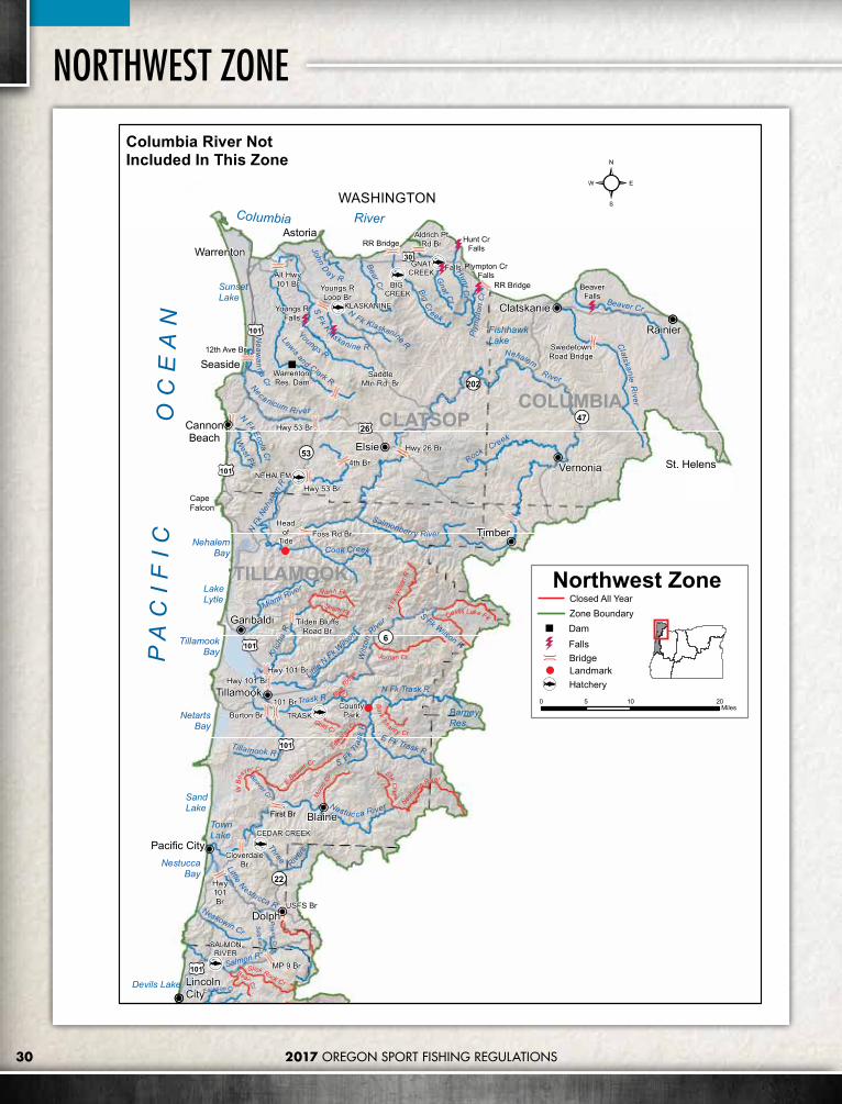
30 2017 OREGON SPORT FISHING REGULATIONS
NORTHWEST ZONE
Prairie Cr
First Br
Warrenton
Astoria
Rainier
St. Helens
LincolnCity
Seaside
Vernonia
Tillamook
Clatskanie
Garibaldi
CannonBeach
TRASK
NEHALEM
BIG CREEK
GNATCREEK
CEDAR CREEK
SALMONRIVER
KLASKANINE
BeaverFalls
Youngs RFalls
Warrenton Res. Dam
Hunt CrFalls
Plympton CrFalls
Falls
SandLake
BarneyRes.
SunsetLake
TownLake
FishhawkLake
Devils Lake
CapeFalcon
Columbia RiverWASHINGTON
LakeLytle
Headof
Tide
Nestuc
caRiver
ElkC
reek
Devils Lake Fk
Edward
s Cr
Nor th Fk
Moo
nCr
Slick Rock Cr
Bear Cr
Gold Cr
N Fk
Wils
on R
South Fk
BarkShanty Cr
WB
eaver Cr
EBea
ver Cr
Blue R
idge
Cr
Jordan Cr
Dolph
Elsie
Timber
Blaine
Pacific City
4th Br
USFS Br
Hwy 53 Br
Hwy 26 Br
RR Bridge
RR Bridge
Hwy101Br
12th Ave Br
Hwy 101 Br
Foss Rd Br
Alt Hwy101 Br
Aldrich PtRd Br
CloverdaleBr
Burton Br
SwedetownRoad Bridge
CountyPark
Youngs RLoop Br
Hwy 101 Br
101 Br
MP 9 Br
SaddleMtn Rd. Br
Hwy 53 Br
Tilden BluffsRoad Br
30
101
6
47
202
53
22
101
101
101
26
101
TillamookBay
NetartsBay
NehalemBay
NestuccaBay
PA
CI F
I C
OC
EA
N
TILLAMOOK
CLATSOPCOLUMBIA
Nestuc ca River
Wils
onRive
r
NehalemRiver
Rock Creek
ClatskanieR
iver
Youngs R
BigC
r eek
Necanicum River
Salmonberry River
Cook Creek
Tillamook R
NFk Klaskanine R
SF
k K
laskanine R
JohnD
ay R
Bear Cr
Gnat Cr
Plym
pton
Cr
Beaver Cr
N Fk
Neh
alem
R
Lewis and Clark R
Neaw
anna
Cr
N
Fk EcolaC
r
West Fk
Miami River
Ki lchi
sR
Little
N Fk W
ilson
Trask RN Fk Trask R
S Fk Trask
R
E Fk Trask R
Beaver CrThree
Rivers
LittleNestucca R
Neskowin Cr
Salmon R
Schooner Cr
S Fk Wilson R
HuntCr
Sulphur Cr
Erickson Cr
Northwest Zone
0 10 205Miles
Columbia River Not Included In This Zone
Closed All YearZone BoundaryDamFallsBridgeLandmarkHatchery

312017 OREGON SPORT FISHING REGULATIONS
Newport
Florence
Lincoln City
Toledo
Waldport
DepoeBay
Siletz
Yachats
Siuslaw River
Alsea Rive r
Yaquina Ri ver
Lake Creek
Big Elk Creek
Siletz
DriftCr
Five Rivers
Creek
Lobster Cr
Wildcat Cr
Yachat s R
Fa
ll Creek
Tenmile Cr
North
Fork Siuslaw
River
S Fk Alsea R
Cape Cr
Sw
eetC
r
Fish Cr
NF k Alsea
R
Li ttle Rock Cr
Big
Roc
k Cr
Mill C
r
Drift C reek
Rock Cr
Beaver Cr
Dea
dwoo
d
Schooner Cr
Cummins Cr
Gra
nt C
r
Erick
son Cr
Siltco os R
Sampson Cr
N Fk YachatsR
Carns Cr
Rock Cr
Big Cr
Whit
taker
Cr
PA
CI F
I C
OC
EA
N
Ce
dar Cr
Casca d e Cr
Riv
er
Bear Cr
SimpsonC
r
ALSEA
Siletz Falls
Lake CrFalls
Sweet CreekFalls
Bohannon Falls
SiltcoosLake
TahkenitchLake
LilyLake
TriangleLake
Devils Lake
Head of Tide
Head ofTide
Head of Tide
WildernessBoundary
Head of Tide
Head ofTide
MoonshinePark
FarnhamLanding
River EdgeLanding
Five
River
s
Bob Creek
S Fk SiletzR
N Fk SiletzR
Lobster Creek
Buck
Cre
ek
Slick Rock C rBear C
r
Little Lobster Cr
Scott C
r
Creek
West Fk
West Fk
IndianOna
Nashville
Eddyville
MeadowsBridge
MennoniteCamp Br
Ojalla Br
IllaheeBoat Ramp
126
36
229
34
Siuslaw
River
YaquinaBay
Alsea Bay
SiletzBay
LANE
LINCOLN
Northwest Zone
0 10 205Miles
101
101
Zone BoundaryClosed All Year
DamFallsBridgeLandmark
Hatchery

2017 OREGON SPORT FISHING REGULATIONS32
SOUTHWEST ZONE DescriptionThe Southwest Zone is all waters draining directly to the Pacific Ocean from the Umpqua River south to the Oregon-California border, and including, the Umpqua River drainage; and those portions of Klamath River drainage in Jackson County. Regulations for marine fish, marine shellfish and marine invertebrates are listed under the Marine Zone, pages 80-87.
Southwest Zone Regulations1. Rogue River tributaries below Lost
Creek Dam, Applegate River tributaries below Applegate Dam, all Illinois River tributaries, and the Illinois River above Pomeroy Dam are closed to all angling, except as noted under Exceptions.
2. Angling in streams above tidewater for all species during May 22 - Aug 31 is restricted to artificial flies and lures. See exceptions
for use of bait in Rogue, Applegate and Umpqua river basins.
3. Use of bait allowed in bays and tidewaters year round.
4. Anglers may not continue to angle for jack salmon or trout after retaining limit of adult salmon or steelhead.
5. See Health Advisory on page 20.
SOUTHWEST ZONE REGULATIONSSPECIES BAG LIMIT SIZE LIMIT AND OTHER SPECIFICATIONS SEASON
Trout
Lakes: 5 per day, 2 daily limits in possession.
Streams: (including tidewaters and bays); 2 per day, 2 daily catch limits in possession.
• Angling restricted to artificial flies and lures in streams above tidewater, May 22 - Aug 31. See Exceptions where use of bait is allowed.
• 8 inch minimum length.• Only 1 trout over 20 inches in length may be taken per day.• Rainbow trout over 16 inches are considered steelhead in streams.• Salmon under 15 inches are considered trout, except coho salmon, which are
always considered salmon regardless of size.• No limit on size or number of brook or brown trout in streams unless noted
under Exceptions.
Lakes: Open all year
Streams: (including tidewaters and bays): Open May 22 - Oct 31 unless noted under Exceptions.
Salmon and Steelhead
In the aggregate: 2 adult salmon or steelhead per day, 20 per year. 5 jack salmon per day, 2 daily jack limits in possession.
In the Coos, Coquille, Tenmile, and their tributaries, open for steelhead angling, one additional hatchery steelhead may be retained per day for a total aggregate of 3 adult fish harvested daily from Jan 1 - Apr 30 and Dec 1-31 only.
• There is no annual limit on hatchery salmon or hatchery steelhead as long as the appropriate number of Hatchery Harvest Tags have been purchased to record the catch.
• See exceptions to the Chinook salmon catch limit under Sixes, Elk, Pistol, Chetco and Winchuck rivers and Floras and Hunter creeks.
• Pink salmon, sockeye salmon and hatchery coho salmon may be retained as part of the adult and jack salmon daily bag limit in all waters that are currently open to angling for Chinook salmon or steelhead.
• Hatchery releases of coho salmon occur in the Rogue River and South Umpqua River.
• Only hatchery steelhead may be kept, except as noted under Exceptions for the mainstem Illinois, Chetco, Elk, Pistol, Rogue, Sixes and Winchuck rivers and Hunter and Euchre creeks.
• Where allowed, no more than a total of 1 per day and 5 per year wild steelhead may be taken per year zonewide.
• Angling restricted to artificial flies and lures in streams above tidewater, May 22 - Aug 31. See Exceptions where use of bait is allowed.
• Note: Regulation changes may occur throughout the year and are posted on www.odfw.com. Check before you fish.
Closed unless noted under Exceptions.
Sturgeon Catch-and-release only.
• Closed to the retention of white sturgeon and green sturgeon.• All sturgeon must be immediately released unharmed into the water.• Sturgeon over 54 inches in fork length cannot be removed totally or in part
from the water.• Only one single-point barbless hook may be used for sturgeon.• Angling restricted to artificial flies and lures in streams above tidewater May 22
- Aug 31. See Exceptions where use of bait is allowed.
Streams: (including tidewaters and bays): Open during trout, salmon or steelhead seasons.

2017 OREGON SPORT FISHING REGULATIONS 33
SOUTHWEST ZONE REGULATIONS (CONTINUED)SPECIES BAG LIMIT SIZE LIMIT AND OTHER SPECIFICATIONS SEASON
Largemouth and Smallmouth Bass
5 per day, 2 daily limits in possession unless noted under Exceptions.
• No more than 1 over 15 inches in length.• Angling restricted to artificial flies and lures in streams above tidewater, May 22
- Aug 31. See Exceptions where use of bait is allowed.
Lakes: Open all year.
Streams (including tidewaters and bays): Open during trout, salmon or steelhead seasons.
Bluegill, Catfish, Crappie, other Sunfish, Walleye, and Yellow Perch
No limit.• No minimum length unless noted under Exceptions.• Angling restricted to artificial flies and lures in streams above tidewater, May 22
- Aug 31. See Exceptions where use of bait is allowed.
Striped Bass2 per 24 consecutive hours; 2 daily limits in possession.
• 24 inch minimum length.• Angling restricted to artificial flies and lures in streams above tidewater, May 22
- Aug 31. See Exceptions where use of bait is allowed.
Lakes: Open all year.
Streams: (including tidewaters and bays): Open during trout, salmon or steelhead seasons, unless noted under Exceptions.
Sucker, Umpqua Pikeminnow, Carp, Chub, Sculpin, other Nongame Fish, and Shad
No limit. Angling restricted to artificial flies and lures in streams above tidewater, May 22 - Aug 31. See Exceptions where use of bait is allowed.
Smelt
• Unless specifically authorized under emergency rules, it is unlawful to take or attempt to take Eulachon smelt in inland waters, including bays, rivers, estuaries, and streams.
• For smelt species other than Eulachon smelt, see Marine Zone regulations page 81 for allowed Harvest Methods and other Restrictions. An angling license is required.
Crayfish 100 per day, 2 daily limits in possession.
• Neither an angling nor a shellfish license is required.• All streams are open to crayfish harvest including streams listed as closed
under Exceptions. Open all year.
Bullfrogs No limit. An angling license is not required.Freshwater Clams and Mussels
Harvest prohibited. It is illegal to harvest or possess any freshwater mussels or clams. Closed.
Marine Fish and Marine Shellfish See Marine Zone, pages 80-87.
No more than 1 adult wild Chinook salmon per day and 10 per year may be harvested in aggregate from waters of the Floras/New River, Sixes River, Elk River, and the Elk River Ocean Terminal Area.
FLORAS/NEW, SIXES, ELK RIVER WILD CHINOOK AGGREGATE BAG LIMIT
From Feb 1 – Jun 30: No more than 2 wild adult Chinook per day and 10 per year may be harvested in aggregate from the Mainstem Umpqua River and the North Umpqua River. Of these 10 wild adult Chinook no more than 5 may be harvested from the Mainstem Umpqua River.
UMPQUA WILD CHINOOK AGGREGATE BAG LIMIT

2017 OREGON SPORT FISHING REGULATIONS34
SOUTHWEST ZONE Exceptions to Southwest Zone RegulationsApplegate Reservoir• All landlocked salmon are considered trout.
Applegate RiverUpstream to Applegate Dam• 2 hatchery trout per day, Jan 1 - Mar 31 and
May 22 - Dec 31.• Wild rainbow trout and cutthroat trout
must be released.• Open for hatchery steelhead Jan 1 - Mar 31.• Use of bait allowed.• All tributaries closed, except Glade Creek.• No angling from a floating device.• Closed from ODFW markers, located 1,500
feet downstream from Applegate Dam, upstream to the Dam.
Mainstem and tributaries upstream of Applegate Dam• Open all year for trout.• Rainbow trout over 16 inches are not
considered steelhead.• Use of bait allowed.
Ashland Creek• Open all year for trout on East and West
forks, and all tributaries upstream of Reeder Dam.
• Use of bait allowed.• Rainbow trout over 16 inches are not
considered steelhead.
Big Butte Creek and TributariesUpstream of Cobleigh Road Bridge• Open for trout May 22 - Oct 31.• Artificial flies and lures only.
Brush Creek (Curry Co�)• Open for hatchery steelhead Jan 1 - Mar 31
and Nov 1 - Dec 31.• Closed from Apr 1 - Oct 31.• All tributaries closed to angling.
Chetco River• Open for steelhead Jan 1 - Mar 31 and
May 22 - Dec 31.• Wild steelhead may be harvested; 1 per day
and 5 per year, as part of daily or annual salmon/steelhead catch
• Open for Chinook salmon Jan 1 - Mar 31 and May 22 - Dec 31, upstream to Nook Creek.
• Wild Chinook may be harvested; 1 per day and 5 per year, as part of daily or annual salmon/steelhead bag limit.
• Gear Restriction: Angling restricted to fly-angling (must include a strike indicator) or salmon bobber angling Sep 1 - Nov 3 from RM 2.2 upstream to Nook Creek.
» Bobber angling gear must include a bobber and a leader no longer than 36 inches in length.
» The leader below the bobber or strike indicator must remain suspended in the water column and not resting on the bottom.
» Any weight may be no more than 36 inches from the hook when suspended vertically. (See diagram on page 16)
Coos BayFrom the visible tips of jetties upstream to head of tide or other landmarks including: Kentuck Slough, upstream to tide gate; Larson Slough upstream to Sullivan Creek; North Slough upstream to tide gate; Palouse Creek to Elliot Forest Boundary; Catching Slough to Sumner Rd Bridge; Isthmus Slough; Coal Bank and Davis sloughs to their tidegates; Shinglehouse Slough; and Pony Slough to Newmark Ave.• Open all year for Chinook salmon.• Open all year for hatchery steelhead.• Isthmus Slough from MP 3 on Hwy 42
upstream open to youth anglers (age 17 and under) and Oregon Disabled Hunting and Fishing Permit holders. Anti-Snagging Gear Restriction: Leader length must be between 18 and 36 inches. (see diagram page 16).
Coos River• Open all year for Chinook salmon.• Open all year for hatchery steelhead.
Coquille River• No limit on size or number of bass.• Open for Chinook salmon Jul 1 - Dec 31.• Open all year for hatchery steelhead.
Cow CreekMainstem upstream to Middle Creek Bridge• Open for trout, May 22 -Sep 15, catch-and-
release only.• Artificial flies and lures only, May 22 - Sep
15.• Open for hatchery steelhead Jan 1 - Apr 30
and Dec 1 - Dec 31.• No limit on size or number of bass.• Bait allowed Jan 1 - Apr 30 and Dec 1-31.• Closed to all angling May 1 - May 21 and
Sep 16 - Nov 30.
Mainstem above Middle Creek Bridge and all Cow Creek tributaries• Open for trout, May 22 -Sep 15, catch-and-
release only.• Artificial flies and lures only.• No limit on size or number of bass.
Diamond Lake• Catch-and-realese for tiger trout.
East Fork Coquille River• Open for hatchery steelhead Jan 1 - Apr 30
and Dec 1 - Dec 31, upstream to marker at the lower end of Brewster Gorge.
• No limit on size or number of bass.• Closed 200 feet upstream and downstream
of falls above MP 21 near Dora.
East Fork Millicoma River• Open for hatchery steelhead Jan 1 - Apr 30
and May 22 - Dec 31.
Eel Creek• Open for hatchery steelhead Jan 1 - Apr 30.
Elk River• Open for Chinook salmon Jan 1 - Mar 31
and May 22 - Dec 31, upstream to Bald Mtn. Creek.
• Floras/New, Sixes, Elk River Wild Chinook Aggregate Bag Limit applies.
• Open for steelhead Jan 1 - Mar 31 and May 22 - Dec 31, upstream to Bald Mtn. Creek; wild steelhead may be harvested; 1 per day and 5 per year, as part of daily or annual salmon/steelhead bag limit.
Emigrant Creek• Open all year for trout in the mainstem and
tributaries upstream from Emigrant Dam.• Use of bait allowed.• Rainbow trout over 16 inches are not
considered steelhead.
Emigrant Reservoir• All landlocked salmon are considered trout.
Euchre Creek• Open for steelhead Jan 1 - Mar 31 and
May 22 - Dec 31.• Wild steelhead may be harvested: 1 per
day, 5 per year as part of daily or annual salmon/steelhead bag limit.
Ferry Creek and Tributaries (Coquille Basin)• Closed to all angling above Fillmore Street
bridge near mouth.
Fish Lake (Jackson Co�)• Catch-and-release for tiger trout.• All landlocked salmon are considered trout.
Floras Creek and New River• Open for Chinook salmon May 22 - Dec
31, upstream to bridge located at MP 1.5 on Floras Cr. Road.
• Floras/New, Sixes, Elk River Wild Chinook Aggregate Bag Limit applies.
• Open for hatchery steelhead Jan 1 - Mar 31 and May 22 - Dec 31.
Galesville Reservoir• All landlocked salmon are considered trout.

35
Garrison Lake and Outlet• 1 bass per day, 15 inch minimum length.
Glade Creek• Open all year for trout above the lower
crossing of Forest Service Road 2030.• Rainbow trout over 16 inches are not
considered steelhead.• Artificial flies and lures only.
Hubbard Creek and Tributaries (Curry Co�)• Closed.
Hunter CreekUpstream to North Fork• Open for Chinook salmon Oct 1 - Dec 31,
upstream to Mateer Bridge 1 adult Chinook per day 5 per year.
• Open for steelhead Jan 1 - Mar 31; Wild steelhead may be harvested; 1 per day and 5 per year, as part of daily or annual salmon/steelhead bag limit.
• Closed for trout.• All tributaries closed to angling.
Illinois RiverMainstem up to Pomeroy Dam near Cave Junction• 5 hatchery trout per day, Jan 1 - Mar 31 and
May 22 - Dec 31.• Wild rainbow and cutthroat trout must be
released.• Open for hatchery steelhead Jan 1 - Mar 31
and May 22 - Dec 31.• Wild steelhead over 24 inches may be
harvested from Klondike Creek upstream to Pomeroy Dam; Jan 1 - Mar 31 and May 22 - Dec 31.; 1 per day and 5 per year, as part of daily or annual salmon/steelhead catch limit.
• Closed from mouth of Fall Creek to 400 feet upstream of Illinois Falls.
• Artificial flies and lures only.• All tributaries closed to angling.
Mainstem and tributaries upstream of Pomeroy Dam• Closed.
Jenny Creek and Tributaries• Open all year for trout.• Artificial flies and lures only.• Rainbow trout over 16 inches are not
considered steelhead.
Little Butte Creek and TributariesUpstream of the Forks• Catch-and-release for trout except no limit
on size or number or brook trout.• Artificial flies and lures only.
Lost Creek Reservoir• All landlocked salmon are considered trout.
Middle Creek (Coos Co�)• Open for hatchery steelhead Jan 1 - Apr 30
and May 22 - Dec 31, upstream to Cherry Creek.
Middle Fork Coquille River• Open for Chinook salmon Jan 1 - Apr 30
and Oct 1 - Dec 31.• Open for hatchery steelhead Jan 1 - Apr 30
and Oct 1 - Dec 31.• Closed to all angling Sep 16 - Nov 30,
upstream from Myrtle Creek.• No limit on size or number of bass.
Mill Creek• Closed to angling below Loon Lake.
Millicoma River• Open all year for Chinook salmon.• Open all year for hatchery steelhead.
Mussel / Myrtle Creek and Tributaries (Curry Co�)• Closed.
Myers Creek and Tributaries• Closed.
North Fork Coquille River• Open for Chinook salmon Jan 1 - Apr 30
and Oct 1 - Dec 31, upstream to East Fork.• Open for hatchery steelhead Jan 1 - Apr 30
and Oct 1 - Dec 31.• Closed to angling 200 feet upstream and
downstream of LaVerne Falls.
North Fork Smith River (Douglas Co�)Mainstem upstream to Bridge 10• Open for trout upstream to Bridge 10, May
22 - Sep 15,catch-and-release only.• Artificial flies and lures only, May 22 - Sep
15, use of bait allowed only from mouth upstream to Johnson Creek.
• Open for hatchery steelhead Jan 1-Apr 30 and Dec 1 - Dec 31, from Johnson Creek to Bridge 10.
• Open for fall Chinook salmon Aug 1 - Dec 31, upstream to Johnson Creek.
• No limit on size or number of bass.• Open all year for hatchery steelhead from
mouth to Johnson Creek.
Tributaries and mainstem above Bridge 10• 2 trout per day, 8 inch minimum, May 22
- Sep 15.• No limit on size or number of bass.• Use of bait allowed only in tidewater.

2017 OREGON SPORT FISHING REGULATIONS36
Hwy 62Hwy 62BridgeBridge HatcheryHatchery
OutflowOutflowChannelChannel
Markers 1200Markers 1200feet downstreamfeet downstreamof Fish Ladderof Fish Ladder
MarkersMarkers
MarkersMarkersDownstreamDownstream
of Fish Ladderof Fish LadderEntranceEntrance
LostLostCreekCreekDamDam
Lost
Cre
ekR
es.
HatcheryHatcheryDamDam
Rogue River Below Lost Creek Dam
SOUTHWEST ZONE North Umpqua RiverMouth to Fly Area Boundary at Deadline Falls• Catch-and-release for rainbow and
cutthroat trout May 22 - Oct 31.• Open all year for hatchery steelhead.• Open all year for hatchery coho salmon.• Open for Chinook salmon Feb 1 - Jun 30
(Umpqua Wild Chinook Aggregate Bag Limit Applies).
• No angling from a floating device upstream from Lone Rock slide put in (BLM recreational site).
• Closed to angling from Old Hwy 99 bridge to 200 feet upstream of Winchester Dam.
• Closed to angling between markers (painted lines) upstream of Rock Creek to fly area boundary at Deadline Falls.
• Anti-Snagging Gear Restriction: Any attached weight may be not more than 36 inches above the lowermost hook. (See diagram on page 16) in effect Mar 1 to Jul 31 from Lone Rock boat launch to markers (painted lines) upstream of Rock Creek.
• Use of bait allowed.
Fly Area Boundary at Deadline Falls upstream to Soda Springs Dam• Catch-and-release for rainbow and
cutthroat trout May 22 - Oct 31.• Open all year for hatchery steelhead.• Open all year for hatchery coho.• Jan 1 to Jun 30 and Oct 1 to Dec 31 angling
restricted to use of single, barbless artificial fly.• Jul 1 - Sep 30 all angling restricted to use of
single, barbless, unweighted, artifical fly.• Any type of rod or reel permitted.• No added weights or attachments (including
strike indicators) to line, leader or fly, except non-fly monofilament lines may have a bobber or similar device attached.
• No angling from a floating device.• Closed downstream of Soda Spring Dam to
marker near power plant enclosure.
Soda Springs Dam to Slide Creek Dam• Closed.
Upstream of Slide Creek Dam• Open all year.• Use of bait allowed.
North Umpqua River TributariesRock Creek and tributaries.• Closed.
Mouth to Fly Area Boundary at Deadline Falls• Open for trout May 22 - Sep 15, catch-and-
release only.• Artificial flies and lures only.
Fly Area Boundary at Deadline Falls upstream to Soda Springs Dam• Closed.
Soda Springs Dam to Slide Creek Dam• Catch-and-release for trout May 22 - Oct 31.• Artificial flies and lures only.
Upstream of Slide Creek Dam• Open all year.• Use of bait allowed.
Pistol River• Open for Chinook salmon Oct 1 - Dec 31,
upstream to Deep Creek, 1 adult Chinook per day, 5 per year.
• Open for steelhead Jan 1 - Mar 31 and May 22 - Dec 31.
• Wild steelhead may be harvested; 1 per day and 5 per year, as part of daily or annual salmon/steelhead bag limit.
Rogue RiverMouth to Fishers Ferry Boat Ramp• Open for hatchery rainbow trout Jan 1 -
Mar 31 and May 22 - Dec 31.• 5 hatchery rainbow trout per day.• Wild rainbow trout and cutthroat trout
must be released.• Open for hatchery Chinook salmon Jan
1 - May 31.• Open for Chinook salmon Jun 1 - Dec 31,
upstream to Hog Creek boat ramp.• Open for Chinook salmon Jun 1 - Sep 30,
from Hog Creek boat ramp upstream to Fishers Ferry boat ramp.
• Closed for Chinook salmon Oct 1 - Dec 31 from Hog Creek boat ramp upstream to Fishers Ferry boat ramp.
• Open all year for hatchery steelhead.• Open for wild steelhead at least 24" in
length Jan 1 - Apr 30 upstream to Hog Creek boat ramp, 1 per day and 5 per year, as part of daily or annual salmon/steelhead bag limit.
• Open for wild steelhead at least 24" in length Feb 1 - Apr 30 from Hog Creek boat ramp upstream to Fishers Ferry boat ramp 1 per day and 5 per year, as part of daily or annual salmon/steelhead bag limit.
• Open all year for hatchery coho.
• Use of bait allowed, except restricted to artificial flies and lures from Foster Creek upstream to Whiskey Creek Sep 1 to Oct 31.
• Anti-Snagging Gear Restriction: Any attached weight may be no more than six feet above the lowermost hook. (See diagram page 16)
• Closed to angling from Rainie Falls to 400 feet downstream (RM 66).
• Closed to angling from Gold Hill boat ramp (RM 121) upstream to Gold Hill municipal water intake.
Fishers Ferry Boat Ramp Upstream to Cole Rivers Hatchery Dam• Open for hatchery rainbow trout Jan 1 -
Mar 31 and May 22 - Dec 31.• 5 hatchery rainbow trout per day.• Wild rainbow trout and cutthroat trout
must be released.• Open for hatchery chinook Jan 1 - Jun 30
Fishers Ferry Boat Ramp to Dodge Bridge.• Open for chinook Jul 1 - Aug 31 Fishers
Ferry Boat Ramp to Dodge Bridge.• Closed for chinook Sep 1 - Dec 31 Fishers
Ferry Boat Ramp to Dodge Bridge.• Open for hatchery chinook Jan 1 - Jul 31
Dodge Bridge to Cole Rivers Hatchery Dam.
• Closed for chinook Aug 1 - Dec 31 Dodge Bridge to Cole Rivers Hatchery Dam.
• Open all year for hatchery steelhead.• Open for wild steelhead at least 24 inches
in length Feb 1 - Apr 30; 1 per day and 5 per year, as part of daily or annual salmon/steelhead bag limit.
• Open all year for hatchery coho.• Use of bait allowed in the Rogue except
restricted to artificial flies Sep 1 to Oct 31 from Fishers Ferry Boat Ramp upstream to markers below Cole Rivers Hatchery Dam. No added weights or attachments except a bubble or similar floating device attached to the line during this period.
• Restricted to artificial flies and lures Nov 1 to Dec 31 from Fishers Ferry Boat Ramp upstream to boat ramp at Shady Cove Park.
• Anti-Snagging Gear Restriction: Any attached weight may be no more than six feet above the lowermost hook. (See diagram page 16).
• No angling from a floating device from deadline markers located downstream of Cole Rivers Hatchery Dam to markers located 1200 feet downstream.
• Closed to all angling from 8pm to one half hour before sunrise from Apr 1 - Jul 31 from ODFW markers located downstream from fish ladder entrance at Cole Rivers Hatchery to Hwy 62 bridge at McGregor Park.
• Closed to all angling from Cole Rivers Hatchery Dam downstream to ODFW markers located downstream from the fish ladder entrance at the Hatchery (RM 157).
ESRI World Imagery. Sources: Esri, Digital Globe, GeoEye, i-cubed, USDA FSA, USGS, AEX, Getmapping, Aerogrid, IGN, IGP, swisstopo and the GIS User Community.

37
• Closed to all angling in the Cole Rivers Hatchery outflow channel to confluence with the main river channel.
Cole Rivers Hatchery Dam upstream to Lost Creek Dam• Catch-and-release all year.• Fly fishing only, barbless hooks required.
Mainstem and tributaries upstream of Lost Creek Dam• Open for 5 trout per day, all year (brook
and brown trout not included in bag limit).• Only 1 trout over 20 inches per day, no
steelhead present all rainbow trout are considered trout.
• Use of bait allowed.
Schuttpelz Lake• Catch-and-release only for trout.• Artificial flies and lures only.
Selmac Lake• 1 bass per day.
Sixes River• Open for Chinook salmon May 22 - Dec 31,
upstream to Edson Creek.• Floras/New, Sixes, Elk River Wild Chinook
Aggregate Bag Limit applies.• Open for steelhead Jan 1 - Mar 31 and
May 22 - Dec 31, upstream to South Fork.• Wild steelhead may be harvested; 1 per day
and 5 per year, as part of daily or annual salmon/steelhead bag limit.
Smith River (Douglas Co�)Mainstem upstream to Sisters Creek• Open for trout upstream to Sisters Creek,
May 22 - Sep 15, Catch-and-release only.• Open for fall Chinook salmon Aug 1 -
Dec 31, upstream to Spencer Creek.• Artificial flies and lures only, May 22 -
Sep 15, use of bait allowed only from mouth upstream to Spencer Creek.
• Open all year for hatchery steelhead from mouth to Spencer Creek.
• No limit on size or number of bass.• Open for hatchery steelhead Jan 1 - Apr 30
and Dec 1-31 from Spencer Creek to Sisters Creek.
Tributaries and Mainstem above Sisters Creek• Open May 22 - Sep 15, 2 trout per day,
8 inch minimum length.• No limit on size or number of bass.• Use of bait allowed only in tidewater.
South Fork Coos River• Open for hatchery steelhead all year,
upstream to head of tide at Dellwood.• Open for hatchery steelhead Jan 1 - Apr 30
and May 22 - Dec 31, from head of tide at Dellwood to concrete bridge near Tioga Creek.
• Open for Chinook salmon all year, upstream to head of tide at Dellwood.
South Fork Coquille River• Open for Chinook salmon Jan 1 - Apr 30 and
Oct 1 - Dec 31, upstream to Middle Fork.• Open for hatchery steelhead Jan 1 - Apr 30
and Oct 1 - Dec 31, upstream to USFS boundary near Powers.
• Closed to angling year around above USFS boundary near Powers to Coquille River Falls.
• All tributaries closed above USFS boundary near Powers to Coquille River Falls.
• Use of bait allowed.• No limit on size or number of bass.
South Umpqua RiverMainstem• Open for trout May 22 - Sep 15, catch-and-
release only.• Open for hatchery steelhead Jan 1 - Apr 30
and Dec 1 - Dec 31.• Open for hatchery coho salmon Jan 1 -
Apr 30 and Dec 1 - Dec 31.• No limit on size or number of bass.• Use of bait allowed. • Closed to angling upstream of Jackson
Creek Bridge.• Closed to angling May 1 - May 21 and
Sep 16 - Nov 30.
Tributaries• Open for trout May 22 - Sep 15, catch-and-
release only.• Artificial flies and lures only.• No limit on size or number of bass.• Jackson Creek closed to all angling.• All tributaries above Jackson Creek Bridge
closed to all angling.
Tenmile Creek (Coos Co�)• Open for hatchery steelhead Jan 1 - Apr 30
and May 22 - Dec 31.
Tenmile Lakes• Open for hatchery steelhead all year,
upstream from Hilltop Bridge.• Open for coho salmon Oct 1 - Dec 31
upstream from Hilltop Bridge. One wild adult coho salmon and one wild jack coho salmon per day and five adult wild coho salmon per year (Wild Coho Aggregate Bag Limit applies).
• Closed in all tributaries and in the canal connecting the North and South Lakes.
• Closed to two rod angling for all species during coho season.
Thomas Creek and Tributaries• Closed.
Tioga Creek• Open for hatchery steelhead Jan 1 - Apr 30,
upstream to concrete bridge 1/2 mile below Burnt Creek.
Umpqua RiverFrom the visible tips of the jetties upstream to the North and South Umpqua confluence• Catch-and-release for trout, open May 22
- Oct 31.• No limit on size or number of bass.• Open for Chinook salmon Feb 1 - Jun 30
(Umpqua Wild Chinook Aggregate Bag Limit applies).
• Open for Chinook salmon Jul 1 - Dec 31.• Open all year for hatchery coho.• Open all year for hatchery steelhead.• Use of bait allowed.
Tributaries of the Mainstem upstream to the North and South Umpqua confluence• No limit on size or number of bass.• Use of bait allowed only in tidewater.• Open for trout May 22 - Sep 15, 2 trout per
day, 8 inch minimum.
West Fork Millicoma River• Open for hatchery steelhead Jan 1 - Apr 30
and May 22 - Dec 31.
Winchuck River• Open for steehead Jan 1 - Mar 31 and
May 22 - Dec 31, upstream to Wheeler Creek; wild steelhead may be harvested; 1 per day and 5 per year, as part of daily or annual salmon/steelhead bag limit.
• Open for Chinook salmon May 22 - Dec 31, upstream to Wheeler Creek.
• Wild Chinook may be harvested, 1 per day and 5 per year, as part of daily or annual salmon/steelhead bag limit.
• Gear Restriction: From Sep 1 - Nov 3, angling is restricted to fly angling (must include a strike indicator) or bobber angling. » Bobber angling gear must include a
bobber and a leader no longer than 36 inches in length.
» The leader below the bobber or strike indicator must remain suspended in the water column and not resting on the bottom.
» Any weight may be no more than 36 inches from the hook when suspended vertically. (See diagram on page 16)
• No angling from a floating device.

38 2017 OREGON SPORT FISHING REGULATIONS
SOUTHWEST ZONE
See
Area
Abov
e
Gal
esvi
lleR
es
Ben
Irvin
g R
es
CA
LIFO
RN
IAST
ATE
LIN
E
199
38
138
230
62
238
66
42
234
46
227
140
99
138
42
Hum
bug
Mtn
5
5
62
5
Coo
s B
ay
Med
ford
Coo
s Ba
y
Ros
ebur
g
Ashl
and
Gra
nts
Pass
Suth
erlin
Nor
th B
end
Band
on
Broo
king
s
Coq
uille
Cen
tral P
oint
Ree
dspo
rt
Gol
dBe
ach
Port
Orfo
rd
Myr
tlePo
int
Cav
e Ju
nctio
n
Dra
in Oak
land
Pow
ers
Can
yonv
ille
Gle
ndal
e
Butte
Falls
Elkt
on
Lost
Cre
ekR
es
Dia
mon
dLa
ke
Tenm
ileLa
kes
How
ard
Prai
rieLa
keH
yatt
Res
Eel L
ake
Lem
olo
Res
Emig
rant
Res
Flor
asLa
ke
Loon
Lake
Gar
rison
Lake
Coo
per C
r Res
Toke
tee
Res
Ree
der R
es
Plat
I R
es
Brad
ley
Lake
Appl
egat
eR
eser
voir
Selm
ac L
ake
Fish
Lak
e
USF
SBo
unda
ry
Fron
a C
ount
yPa
rk
Hog
Cr
Boat
Lan
ding
Ferr
y H
ole
Boat
Ram
p
Rog
ue E
lkC
ount
y Pa
rk
Shad
y C
ove
Boat
Lan
ding
Cap
eBl
anco
Fly
Area
Betw
een
Poin
ts
700'
Clo
sure
Belo
w F
alls
Hea
dsof
Tid
e
Hw
y 42
MP
3
S Fk
& M
Fk
Con
fluen
ce
DO
UG
LAS
JAC
KSO
N
CO
OS
CU
RRY
JOSE
PHIN
ER
ogue
Riv
er
North
Um
pqua
R
Umpqua RiverSm
ithR
iver
Illin
ois
River
Elk
Cre
ek
Sou
thU
mpq
uaR
iver
Appl
egat
eR
iverCow
Cre
ek
Littl
eR
iver
Elk
Riv
er
Six
es
Riv
er
Che
tco
River
Cal
ap
ooyaCr
JennyCr
Pis
tol
River
Coq
uille R
Mid
dle
Cr
Willia m
s
River
Mid
dle
Fk
CoquilleR
S
FkCoqu
ille
R
Ca
vitt
Cr
Lake Creek
Hun
ter
Cr
EmigrantCrN
FkC
oqui
l leR
Myrtle Cr
Tioga
Creek
SFk Lit t
leB
utte
Cr
Flo
ras
Cre
ek
S
FkC
oos
R
Euc
hr
eCreek
NFkSmithR
Fall
Cr
Glade Cr
NFk
Litt
leB
utte
Cr
Four
mil e
Cr
Eas
t Fo r
k
Whe
el
erCr
Coos R
Bru
sh
Cr
NF
k
BigBu
tteC
r
South Winch
uck R
NorthS
l
Spencer Cr
SF
kB
igBu
tteC
r
Mid
dle
Cre
ek
E Fk Winchuck R
SFk
Sixes
R
W F
k Smith
R
EF
kC
oqu
ille
R
Tenm
ileC
r
Keene
Cr
Isthmus Sl
WestFork
Mill
icom
aR
W Fk
E Fk
Rogue
River
Bald
MtnCr
Deep Cr
Lampa CrSlough
NFk
Nook Cr
EdsonCr
Fish Creek
LobsterCr
Sis
ters
Cr
ELK
RIV
ER
RO
CK
CR
EEK
CO
LE R
IVER
S
Pom
eroy
Dam
Rai
nie
Falls
Fish
ers
Ferry
Boa
t Ram
p
Appl
egat
eD
am
Lave
rne
Falls
Win
ches
ter
Dam
Illin
ois
RFa
lls
Smith
Riv
er F
alls
Soda
Sprin
gsD
am
Coq
uille
R
Falls
Gol
d H
ill W
ater
Inta
ke /
Boat
Lan
ding
Slid
e C
rD
am
Bear Cr
Gra
veC
reek
ElkCre
ek
Jack
son
Creek
RockCr
Ste
ambo
atCreek
SU
mpq
uaRi
ver
CantonCr
Littl
eBu
tteCr
Little
Apple
gat e
R
CalfCr
Du
mont Cr
Big
Bend
Cr
Fall Cr
Mus
selC
r Mye
rs C
r
Hubba
rd C
r
Th
omasCr
Whisky Cr
W
FkIlli
noisR
EFkIllinoisR
B ig ButteCr
HogCreek
Mill Cr
Ashland Cr
Ferry C
r
Emig
ra
ntCr
Myr
tleC
r
Fost
er C
r
Cop
elan
dCr
Klondike Cr
S Fk
N Fk
Brid
ge #
10
Mel
rose Br
Cob
leig
hR
d Br
FS 2
030
Dod
ge B
ridge
Hw
y62 Br
Jack
son
Cre
ek B
r
Mid
dle
Cre
ek B
r
Gra
velfo
rd
Scot
tsbu
rg
Del
lwoo
d
OCEANSout
hwes
t Zon
e
020
4010
Mile
s
PACIFIC38
42
Coo
s B
ayC
oos
Bay
Nor
th B
end
Band
on
Coq
uille
Ree
dspo
rt
Myr
tlePo
int
Tenm
ileLa
kes
Eel
Lak
e
Loon
Lake
Fron
a C
ount
yPa
rk
Brew
ster
Gor
ge
Hea
dsof
Tid
e
Hw
y 42
MP
3
CO
OS
Coqu
illeR
Mid
dle
Cr
William s
Rive r
Mid
dle
Fork
CoquilleRiver
NFk
Coq
uille
R
Tioga Creek
S
FkC
oos
RFa
llCr
Eas tFo
rk
Palo
use
Cr
Coos R
SouthSlough
Kent
uck
Cr
North
Sl
Moon
Cr
Catching Sl
Burn
t Cr
EFk
Coq
uille
R
Tenmile
Cr
Coalb
ank S
l
Shing
lehou
se S
l
Sull i
van
Cr
Lars
onC
r
Isthmus Sl
WestFork
Milli
comaR
Davis
Sl
Lampa Cr
Sch
uttp
elz
Lake
Lave
rne
Falls
MP
21Fa
lls
Mill Cr
Ferry C
r
Cam
as C
r Br
Hillt
op Br
Con
cret
e Br
Con
cret
eBr
Gra
velfo
rd
Scot
tsbu
rg
Del
lwoo
d
Dam
Falls
Brid
ge
Land
mar
k
Clo
sed
All Y
ear
Zone
Bou
ndar
y
Hat
cher
y

2017 OREGON SPORT FISHING REGULATIONS 39
See
Area
Abov
e
Gal
esvi
lleR
es
Ben
Irvin
g R
es
CA
LIFO
RN
IAST
ATE
LIN
E
199
38
138
230
62
238
66
42
234
46
227
140
99
138
42
Hum
bug
Mtn
5
5
62
5
Coo
s B
ay
Med
ford
Coo
s Ba
y
Ros
ebur
g
Ashl
and
Gra
nts
Pass
Suth
erlin
Nor
th B
end
Band
on
Broo
king
s
Coq
uille
Cen
tral P
oint
Ree
dspo
rt
Gol
dBe
ach
Port
Orfo
rd
Myr
tlePo
int
Cav
e Ju
nctio
n
Dra
in Oak
land
Pow
ers
Can
yonv
ille
Gle
ndal
e
Butte
Falls
Elkt
on
Lost
Cre
ekR
es
Dia
mon
dLa
ke
Tenm
ileLa
kes
How
ard
Prai
rieLa
keH
yatt
Res
Eel L
ake
Lem
olo
Res
Emig
rant
Res
Flor
asLa
ke
Loon
Lake
Gar
rison
Lake
Coo
per C
r Res
Toke
tee
Res
Ree
der R
es
Plat
I R
es
Brad
ley
Lake
Appl
egat
eR
eser
voir
Selm
ac L
ake
Fish
Lak
e
USF
SBo
unda
ry
Fron
a C
ount
yPa
rk
Hog
Cr
Boat
Lan
ding
Ferr
y H
ole
Boat
Ram
p
Rog
ue E
lkC
ount
y Pa
rk
Shad
y C
ove
Boat
Lan
ding
Cap
eBl
anco
Fly
Area
Betw
een
Poin
ts
700'
Clo
sure
Belo
w F
alls
Hea
dsof
Tid
e
Hw
y 42
MP
3
S Fk
& M
Fk
Con
fluen
ce
DO
UG
LAS
JAC
KSO
N
CO
OS
CU
RRY
JOSE
PHIN
ER
ogue
Riv
er
North
Um
pqua
R
Umpqua RiverSm
ithR
iver
Illin
ois
River
Elk
Cre
ek
Sou
thU
mpq
uaR
iver
Appl
egat
eR
iverCow
Cre
ek
Littl
eR
iver
Elk
Riv
er
Six
es
Riv
er
Che
tco
River
Cal
ap
ooyaCr
JennyCr
Pis
tol
River
Coq
uille R
Mid
dle
Cr
Willia m
s
River
Mid
dle
Fk
CoquilleR
S
FkCoqu
ille
R
Ca
vitt
Cr
Lake Creek
Hun
ter
Cr
EmigrantCr
NFk
Coq
uil le
R
Myrtle Cr
Tioga
Creek
SFk Lit t
leB
utte
Cr
Flo
ras
Cre
ek
S
FkC
oos
R
Euc
hr
eCreek
NFkSmithR
Fall
Cr
Glade Cr
NFk
Litt
leB
utte
Cr
Four
mil e
Cr
Eas
t Fo r
k
Whe
el
erCr
Coos R
Bru
sh
Cr
NF
k
BigBu
tteC
r
South Winch
uck R
NorthS
l
Spencer Cr
SF
kB
igBu
tteC
r
Mid
dle
Cre
ek
E Fk Winchuck R
SFk
Sixes
R
W F
k Smith
R
EF
kC
oqu
ille
R
Tenm
ileC
r
Keene
Cr
Isthmus Sl
WestFork
Mill
icom
aR
W Fk
E Fk
Rogue
River
Bald
MtnCr
Deep Cr
Lampa CrSlough
NFk
Nook Cr
EdsonCr
Fish Creek
LobsterCr
Sis
ters
Cr
ELK
RIV
ER
RO
CK
CR
EEK
CO
LE R
IVER
S
Pom
eroy
Dam
Rai
nie
Falls
Fish
ers
Ferry
Boa
t Ram
p
Appl
egat
eD
am
Lave
rne
Falls
Win
ches
ter
Dam
Illin
ois
RFa
lls
Smith
Riv
er F
alls
Soda
Sprin
gsD
am
Coq
uille
R
Falls
Gol
d H
ill W
ater
Inta
ke /
Boat
Lan
ding
Slid
e C
rD
am
Bear CrG
rave
Cre
ek
ElkCre
ek
Jack
son
Creek
RockCr
Ste
ambo
atCreek
SU
mpq
uaRi
ver
CantonCr
Littl
eBu
tteCr
Little
Apple
gat e
R
CalfCr
Du
mont Cr
Big
Bend
Cr
Fall Cr
Mus
selC
r Mye
rs C
r
Hubba
rd C
r
Th
omasCr
Whisky Cr
W
FkIlli
noisR
EFkIllinoisR
B ig ButteCr
HogCreek
Mill Cr
Ashland Cr
Ferry C
r
Emig
ra
ntCr
Myr
tleC
r
Fost
er C
r
Cop
elan
dCr
Klondike Cr
S Fk
N Fk
Brid
ge #
10
Mel
rose Br
Cob
leig
hR
d Br
FS 2
030
Dod
ge B
ridge
Hw
y62 Br
Jack
son
Cre
ek B
r
Mid
dle
Cre
ek B
r
Gra
velfo
rd
Scot
tsbu
rg
Del
lwoo
d
OCEANSout
hwes
t Zon
e
020
4010
Mile
s
PACIFIC
38
42
Coo
s B
ayC
oos
Bay
Nor
th B
end
Band
on
Coq
uille
Ree
dspo
rt
Myr
tlePo
int
Tenm
ileLa
kes
Eel
Lak
e
Loon
Lake
Fron
a C
ount
yPa
rk
Brew
ster
Gor
ge
Hea
dsof
Tid
e
Hw
y 42
MP
3
CO
OS
Coqu
illeR
Mid
dle
Cr
William s
Rive r
Mid
dle
Fork
CoquilleRiver
NFk
Coq
uille
R
Tioga Creek
S
FkC
oos
RFa
llCr
Eas tFo
rk
Palo
use
Cr
Coos R
SouthSlough
Kent
uck
Cr
North
Sl
Moon
Cr
Catching Sl
Burn
t Cr
EFk
Coq
uille
R
Tenmile
Cr
Coalb
ank S
l
Shing
lehou
se S
l
Sull i
van
Cr
Lars
onC
r
Isthmus Sl
WestFork
Milli
comaR
Davis
Sl
Lampa Cr
Sch
uttp
elz
Lake
Lave
rne
Falls
MP
21Fa
lls
Mill Cr
Ferry C
r
Cam
as C
r Br
Hillt
op Br
Con
cret
e Br
Con
cret
eBr
Gra
velfo
rd
Scot
tsbu
rg
Del
lwoo
d
Dam
Falls
Brid
ge
Land
mar
k
Clo
sed
All Y
ear
Zone
Bou
ndar
y
Hat
cher
y

2017 OREGON SPORT FISHING REGULATIONS40
WILLAMETTE ZONE DescriptionThe Willamette Zone is all waters draining to the Columbia River between the city of St. Helens and Bonneville Dam, except for those portions of tributaries east of the Sandy River that are downstream from the Union Pacific Railroad line (see Columbia Zone pages 72-79, for more details). Includes all waters on Sauvie Island except the Columbia River.
Willamette Zone Regulations1. The use of barbless hooks is required when
angling for salmon, steelhead, or trout in Willamette River downstream of Willamette Falls (including Multnomah Channel and Gilbert River) and in lower Clackamas River upstream to Highway 99E bridge.
2. A valid Columbia River Basin Endorsement must be in possession when fishing for salmon, steelhead, or sturgeon in the mainstem Columbia River from Buoy 10 upstream and in all the rivers and their tributaries that flow into the Columbia River.
3. See Health Advisory on page 20.
WILLAMETTE ZONE REGULATIONSSPECIES BAG LIMIT SIZE LIMIT AND OTHER SPECIFICATIONS SEASON
Trout
Lakes: 5 per day, 2 daily limits in possession.
Streams: catch-and-release only, except as noted under Exceptions.
• Angling restricted to artificial flies and lures in streams. See Exceptions where use of bait is allowed.
• 8 inch minimum length.• Only 1 trout over 20 inches in length may be taken per day.• Rainbow trout over 20 inches are considered steelhead in streams.• Closed to angling for bull trout.• No limit on size or number of brook or brown trout in streams unless noted
under Exceptions.• Kokanee included in trout limits except as noted under Exceptions.
Lakes: Open all year.
Streams: Open May 22 - Oct 31 unless noted under Exceptions.
Salmon and Steelhead below Willamette Falls and Columbia River Tributaries
In the aggregate: 2 adult salmon or steelhead per day, 20 per year. 5 jacks per day, 2 daily jack limits in possession.
• Angling is restricted to artificial flies and lures in streams. See Exceptions where use of bait is allowed.
• Harvest of wild salmon or steelhead is prohibited in the Willamette Zone unless otherwise noted under Exceptions.
• There is no annual limit on hatchery salmon or hatchery steelhead as long as the appropriate number of Hatchery Harvest Tags have been purchased to record the catch.
Closed in all waters unless noted under Exceptions.
Salmon above Willamette Falls
2 adult salmon per day, 5 jacks per day, 2 daily jack limits in possession. 20 salmon and steelhead per year in aggregate.
• Angling is restricted to artificial flies and lures in streams. See Exceptions where use of bait is allowed.
• Harvest of wild salmon is prohibited in the Willamette Zone unless noted under Exceptions.
• There is no annual limit on hatchery salmon as long as the appropriate number of Hatchery Harvest Tags have been purchased to record the catch.
Steelhead above Willamette Falls
3 adult steelhead per day (in addition to daily salmon bag limit). 20 salmon and steelhead per year in aggregate.
• Angling is restricted to artificial flies and lures in streams. See Exceptions where use of bait is allowed.
• Harvest of wild steelhead is prohibited in the Willamette Zone unless noted under Exceptions.
• If harvest of wild steelhead is allowed under Exceptions, the daily limit for wild steelhead is 2 per day.
• There is no annual limit on hatchery steelhead as long as the appropriate number of Hatchery Harvest Tags have been purchased to record the catch.

2017 OREGON SPORT FISHING REGULATIONS 41
WILLAMETTE ZONE REGULATIONS (CONTINUED)SPECIES BAG LIMIT SIZE LIMIT AND OTHER SPECIFICATIONS SEASON
Sturgeon
Catch-and-release only, except as noted under Exceptions.
• Closed to retention of green sturgeon.• See page 75 for tag return information.• All sturgeon must be immediately released unharmed into the water.• Sturgeon over 54 inches in fork length cannot be removed totally or in part
from the water.• Only one single-point, barbless hook may be used for sturgeon.• Angling restricted to artificial flies and lures in streams. See Exceptions
where use of bait is allowed.
Catch-and-release: Open all year, except as noted under Exceptions.
Largemouth and Smallmouth Bass
5 per day, 2 daily limits in possession, except as noted under exceptions.
• No more than 3 over 15 inches in length.• Willamette River mainstem above Hwy 20 Bridge at Albany, the Santiam
and Calapooia basins: no limit on size or number taken.• Angling restricted to artificial flies and lures in streams. See Exceptions
where use of bait is allowed. Lakes: Open all year.
Streams: Open during trout, salmon or steelhead seasons, except mainstem Willamette River and sloughs and tidewater areas of Columbia River tributaries downstream from Bonneville Dam are open all year.
Bluegill, Catfish, Crappie, Other Sunfish, Spotted Bass, Walleye, and Yellow Perch
No limit, except as noted under Exceptions.
• No minimum length.• Angling restricted to artificial flies and lures in streams. See Exceptions
where use of bait is allowed.
Striped Bass2 per 24 consecutive hours, 2 daily limits in possession.
• 30 inch minimum length.• Angling restricted to artificial flies and lures in streams. See Exceptions
where use of bait is allowed.
Northern Pikeminnow, Carp, Sucker, Chub, Sculpin, Whitefish, Shad, and other Nongame Fish
No limit.• No length limit.• Angling restricted to artificial flies and lures in streams. See Exceptions
where use of bait is allowed.
Pacific Lamprey Refer to General (Statewide) Regulations on page 19 for regulations covering the harvest of Pacific lamprey.
Smelt Closed.Unless specifically authorized under emergency rules, it is unlawful to take or attempt to take Eulachon smelt in inland waters, including bays, rivers, estuaries, and streams.
Closed.
Freshwater Clams and Mussels Harvest prohibited. It is illegal to harvest or possess any freshwater mussels or clams. Closed.
Crayfish 100 per day, 2 daily limits in possession.
• Neither an angling nor a shellfish license is required.• All streams are open to crayfish harvest including streams listed as closed
under Exceptions. Open all year.
Bullfrogs No limit. An angling license is not required.

2017 OREGON SPORT FISHING REGULATIONS42
WILLAMETTE ZONE Exceptions to Willamette Zone RegulationsAbiqua Creek• Open all year upstream of Abiqua Falls.• 2 trout per day, 8 inch minimum length
upstream of Abiqua Falls.
Adair Pond• 1 bass per day.• 10 crappie per day.• 2 channel catfish per day.• No minimum length on warmwater fish.
Airport Pond• Closed.
Alton Baker Park Canoe Canal• Open all year for trout, hatchery steelhead,
and wild steelhead over 24 inches in length.• 5 trout per day, no minimum length for
hatchery trout.• Use of bait allowed.• Two Rod Validation may be used.
Balch Creek• Closed.
Bear Creek (Pudding River)• 5 hatchery trout per day, no minimum
length, upstream of Shorty’s Pond.• Use of bait allowed upstream of Shorty’s Pond.
Blue River and Tributaries• Open all year for trout, hatchery steelhead,
and wild steelhead over 24 inches in length.• 2 wild trout per day may be harvested
upstream of Blue River Dam only, 8 inch minimum length.
• 5 hatchery trout per day, no minimum length.• Use of bait allowed, Apr 22 - Oct 31.
Bond Butte Pond• 1 bass per day.• 10 crappie per day.• 2 channel catfish per day.• No minimum length on warmwater fish.
Breitenbush River• Open all year.• 5 trout per day, 8 inch minimum length.• Use of bait allowed.
Bull of the Woods Wilderness AreaThe following lakes; Beth, Big Slide, Lenore, Pansy, Lower Twin and Upper Twin Lake.• No limit on the size or number of brook trout.
Bull Run River• 5 hatchery trout per day, no minimum length.• Closed to angling from ODFW markers
located 75 ft. downstream and 200 ft upstream of the ODFW weir and fish trap in Dodge Park near the mouth of the Bull Run River.
• Combined daily limit of 3 hatchery salmon or hatchery steelhead per day.
• Open all year for hatchery salmon and hatchery steelhead up to the watershed boundary.
• Use of bait allowed.
Butte Creek• 2 trout per day, 8 inch minimum length
upstream of Butte Creek Falls.• Open all year upstream of Butte Creek Falls.
Canby Pond• Youth Only (17 years and under) or
Disabled Angler Permit holder.
Canyon Creek (South Santiam)• Closed.
Cascade LakesThe following Willamette National Forest Lakes: Blair, Blue, Corner, Lower and Upper Eddeeleo, Goose, Heart, Upper Horse, Linton, Nash, Penn, Porky, Upper Salmon, Separation, Spring, Spirit, Timpanogas, Lower Timpanogas.• No limit on size or number of brook trout.• Use of bait allowed.
Cedar Creek (Sandy River)• Closed for salmon and steelhead all year.• Closed from the mouth upstream to the
markers located 100 feet upstream of the hatchery water intake dam.
• Open for trout May 22 - Oct 31, upstream of the markers located 100 feet upstream of the hatchery water intake dam.
Clackamas RiverMouth to River Mill Dam• 5 hatchery trout per day, no minimum
length.• Open all year for hatchery salmon and
hatchery steelhead.• Combined daily limit of 3 hatchery salmon
or hatchery steelhead per day.• Use of bait allowed.• No angling from a floating device between
River Mill Dam and the ODFW markers approximately 100 feet upstream of the Clackamas Hatchery water intake.
Mainstem and tributaries (except Oak Grove Fork) upstream of Faraday Diversion (Cazadero) Dam, excluding North Fork Reservoir• Closed for salmon and steelhead all year.• Closed to angling from a floating device
or from the west shore for the length of the Three Lynx Powerhouse (111 feet).
• Harvest of bull trout prohibited.
Oak Grove Fork and tributaries between markers at upper end of Harriet Lake and Timothy Lake Dam• No limit on the number or size of brook or
brown trout taken.• 2 trout per day, 8 inch minimum length.
Clear Lake (Upper McKenzie River)• No limit on size or number of brook trout.
Coast Fork Willamette River and Tributaries• Open all year for trout, hatchery Chinook
salmon, hatchery steelhead, and wild steelhead greater than 24 inches in length.
• 2 wild trout per day, 8 inch minimum length.• 5 hatchery trout per day, no minimum length.• Use of bait allowed, Apr 22 - Oct 31.• Tributaries are closed for Chinook salmon
and steelhead angling.• See separate entry for Row River and
Tributaries.
Commonwealth Lake• 1 bass per day.• 10 crappie per day.• 2 channel catfish per day.• No minimum length on warmwater fish.
Dog Creek• Closed.
E.E. Wilson Pond• Open all year.
Eagle Creek (Clackamas River)• Open all year for hatchery salmon and
hatchery steelhead, upstream to markers 200 feet below hatchery ladder outlet.
• Combined daily limit of 3 hatchery salmon or hatchery steelhead per day.
• Use of bait allowed.• Closed from 200 feet upstream and 300 feet
downstream of fish ladder located 1/2 mile below Eagle Fern Park.
• Anti-Snagging Gear Restriction: Leader length must be between 18 and 36 inches. (see diagram page 16), from Aug 1 to Dec 31.
East Salish Pond• 1 bass per day.• 10 crappie per day.• 2 channel catfish per day.• No minimum length on warmwater fish.
Erma Bell Lakes and Tributaries• Open May 22 - Oct 31.• 2 rainbow trout per day, 8 inch minimum
length.• Use of bait allowed.• No limit on size or number of brook trout.

43
Estacada LakeClackamas River, River Mill Dam upstream to Faraday Diversion (Cazadero) Dam• Open for trout May 22 - Oct 31.• 5 hatchery trout per day, no minimum length.• Trout over 20 inches are considered
steelhead.• Open all year for hatchery salmon and
hatchery steelhead.• Combined daily bag limit of 3 hatchery
salmon or hatchery steelhead per day.• No angling between markers 400 feet
upstream and 126 feet downstream of the downstream corner of the Faraday Powerhouse from Jun 16 - Oct 31.
• Closed from the entrance of the fishway/fish trap at the Faraday Diversion (Cazadero) Dam downstream approximately 275 feet to the ODFW deadline markers.
Fall Creek and Tributaries (Middle Fork Willamette)• Open all year for trout.• 2 wild trout per day, 8 inch minimum length.• 5 hatchery trout per day, no minimum length.• Use of bait allowed, Apr 22 - Oct 31.• Open all year for hatchery Chinook salmon,
hatchery steelhead, and wild steelhead greater than 24 inches below Fall Creek Dam.
• Closed within 200 feet of entrance to the Fall Creek fish ladder.
• See separate entry for Little Fall Creek.
Faraday Lake• Only hatchery trout may be harvested.
Foster Reservoir• 5 hatchery trout or kokanee per day, 8 inch
minimum length.• No limit on size or number of bass.
Frazier Creek• Open all year. Harvest allowed May 22 -
Oct 31, remainder of year catch-and-release.• During harvest season: 2 trout per day,
8 inch minimum.
Gales Creek• Open for coho salmon Aug 1 - Oct 31 from
mouth upstream to NW Clapshaw Hill Road.• Open all year for trout. Harvest allowed
May 22 - Oct 31, remainder of year catch-and-release.
• During harvest season: 2 trout per day, 8 inch minimum length.
Gold Lake• Open May 22 - Oct 31.• Catch-and-release for rainbow trout.
• No limit on size or number of brook trout.• Fly fishing only, barbless hooks required.• Closed from Gold Lake boat ramp 100
yards down Salt Creek.
Green Peter Reservoir• 25 kokanee per day in addition to daily
trout limit. No size limits.• Salmon may be retained as part of kokanee
bag limit.
Haldeman Pond• Closed Jan 1 - Apr 15 and Oct 1 - Dec 31.
Henry Hagg Lake• Open all year.• 1 bass per day.• 25 crappie per day.• No minimum length on warmwater fish.
Hills Creek and Hills Creek Tributaries Above Hills Creek Reservoir• Open all year.• 2 trout per day, 8 inch minimum length.• Use of bait allowed, Apr 22 - Oct 31.
Hills Creek Reservoir• 5 hatchery trout per day, no minimum length.• Wild trout must be released.
Hunt
Fish
Roam
StayP E N D L E T O N , O R E G O N

2017 OREGON SPORT FISHING REGULATIONS44
WILLAMETTE ZONE • Hatchery salmon less than 24 inches in
length are considered trout.
Horn Creek• Closed.
Lava Lake and tributaries• No limit on size or number of brook trout.• Open all year.• Use of bait allowed.
Leaburg Canal and Tributaries• Open all year.• Catch-and-release for trout.• Artificial flies and lures only.• Closed within the Leaburg powerhouse
tailrace.• Closed from Leaburg Dam to below fish
screens (approx. 600 ft.).
Leaburg Lake• Open all year for trout, hatchery steelhead,
and wild steelhead greater than 24 inches in length.
• 5 hatchery trout per day, no minimum length.
• Wild trout must be released.• Use of bait allowed, Apr 22 - Oct 31.• Two Rod Validation may be used.• Closed within 200 feet upstream of Leaburg
Dam.
Little Fall Creek and Tributaries• Open all year for trout.• 2 trout per day, 8 inch minimum length.• Open all year for hatchery Chinook salmon,
hatchery steelhead and wild steelhead greater than 24 inches in length — from the mouth upstream to 200 feet below fish ladder.
• Use of bait allowed, Apr 22 - Oct 31.
Little Luckiamute River• Open all year for trout. Harvest allowed
May 22 - Oct 31, remainder of year catch-and-release.
• During harvest season: 2 trout per day, 8 inch minimum length.
Long Tom River• Open all year. Harvest allowed May 22 -
Oct 31, remainder of year catch-and-release.• During harvest season: 2 trout per day,
8 inch minimum length.• Use of bait allowed.
Lookout Creek and Tributaries• Closed.
Lost Creek and Tributaries (Middle Fork Willamette River)• Open all year for trout, hatchery steelhead,
and wild steelhead greater than 24 inches in length.
• 2 trout per day, 8 inch minimum length.• Use of bait allowed, Apr 22 - Oct 31.
Lost Lake (Santiam Pass)• Catch-and-release for trout.• Artificial flies and lures only.
Luckiamute River and Tributaries• Open all year for trout. Harvest allowed
May 22 - Oct 31, remainder of year catch-and-release.
• During harvest season: 2 trout per day, 8 inch minimum length.
Marys River and Tributaries• Open all year. Harvest allowed May 22 -
Oct 31, remainder of year catch-and-release.• During harvest season: 2 trout per day,
8 inch minimum length.• Use of bait allowed.
McKenzie River and Tributaries• Open all year for trout, hatchery steelhead,
and wild steelhead greater than 24 inches in length.
• Open all year for hatchery Chinook Salmon, in the mainstem McKenzie River from the mouth upstream to Leaburg Dam.
• Wild trout must be released, including brook trout.
• 5 hatchery trout per day, no minimum length.
• Bait allowed from Apr 22 - Oct 31 in the mainstem McKenzie River from Hendricks Bridge upstream to Forest Glen Boat Ramp.
• Gear Restriction: Hayden Bridge to Hendricks Bridge — Bait allowed May 1 - Jun 15 when angling for salmon and steelhead with hooks 5/8 inch gap or larger.
• Gear Restriction: Leaburg Dam downstream to Trout Creek (approx. 1 mile) any attached weight may be no more than six feet from the lowermost hook, in addition to the statewide hook and weight regulations (page 17)
• Closed within 200 feet downstream of Leaburg Dam.
• Closed within the Carmen Spawning Channel and in the McKenzie River from Trail Bridge Dam to 200 feet downstream from the Carmen Spawning Channel entrance.
• Closed from Cougar Dam downstream 700 feet (to concrete supports of the old adult fish trap).
• Closed — within the Walterville bypass canal from the Walterville Canal salmon weir upstream to the McKenzie River.
• See separate entries for Blue River & Tributaries, Leaburg Canal & Tributaries, Leaburg Lake, Mohawk River & Tributaries, Smith River & Tributaries above Smith Reservoir and Walterville Canal & Tributaries.
Middle Fork Willamette River and Tributaries• Open all year for trout.• Open all year for hatchery Chinook salmon,
hatchery steelhead, and wild steelhead greater than 24 inches below Dexter Dam.
• 2 wild trout per day downstream of Dexter Dam, 8 inch minimum length.
• 5 hatchery trout per day, no minimum length.
• Use of bait allowed downstream of Dexter Dam.
• Wild trout must be released, including brook trout, upstream of Lookout Point Reservoir.
• Angling gear may be cast within 200 feet of fish ladder at base of Dexter Dam.
• Gear Restriction: From Dexter Dam 700 feet downstream to markers: Only one single point hook with 5/8 inch gap or smaller may be used.
• Restrictions from Dexter Dam approximatley 700 feet downstream to markers: No angling from the north shore, from a floating device, or while wading.
• Gear Restriction: From Dexter Dam downstream to the power lines (approx. 1/2 mile)- any attached weight may be no more that six feet above lower most hook, in addition to the statewide hook and weight regulations (page 17).
Mill Creek (Marion Co.)• Open all year: Harvest allowed May 22 - Oct
31 remainder of year catch and release• During harvest season 2 trout per day, 8
inch minimum.
Mohawk River and Tributaries• Open all year.• 2 trout per day, 8 inch minimum length.• Use of bait allowed, Apr 22 - Oct 31.
Molalla River• Open for hatchery Chinook salmon,
hatchery steelhead, and coho salmon all year, upstream to Turner Creek Bridge.
• Open for any steelhead Jul 1 - Aug 31 upstream to Turner Creek Bridge.
• Use of bait allowed, May 15 - Jul 15.• No limit on size or number of bass.
Moose Creek• Closed from the mouth upstream to Moose
Lake.
Mt Hood Pond• Youth Only (17 years and under) and Disabled
Anglers Permit holder from Apr 1 - Aug 31.
Muddy Creek and Tributaries• Open all year. Harvest allowed May 22 -
Oct 31, remainder of year catch-and-release.• During harvest season: 2 trout per day,
8 inch minimum length.
North Fork Middle Fork Willamette River and Tributaries• Open all year.• 2 trout per day, 8 inch minimum length.• Fly fishing only, barbless hooks required.

45
North Fork Reservoir (Clackamas River)North Fork Dam upstream to MP 32 on Hwy 224• Open for trout May 22 - Oct 31.• 5 hatchery trout per day, no minimum length.• No limit on the number or size of brook
trout or brown trout taken.
Quartzville Creek• Open all year.• 5 trout per day, no minimum length.• Use of bait allowed.
Rainbow Lake (Charles Metzger County Park)• 5 hatchery trout per day, no minimum length.
Rickreall Creek and Tributaries• Open all year for trout. Harvest allowed
May 22 - Oct 31, remainder of year catch-and-release.
• During harvest season: 2 trout per day, 8 inch minimum length.
Round Lake (Collawash River)• 2 trout per day, 8 inch minimum length.• Artificial flies and lures only.
Row River and Tributaries• Open all year for trout, hatchery Chinook
salmon, hatchery steelhead, and wild steelhead greater than 24 inches in length.
• 2 wild trout per day, 8 inch minimum length.• Use of bait allowed, Apr 22 - Oct 31.• 5 hatchery trout per day, no minimum length.• Closed to salmon and steelhead angling in
Mosby Creek and Mosby Creek tributaries.
Salmon Creek and Tributaries (Middle Fork Willamette River)• Open all year.• 2 wild trout per day, 8 inch minimum length.• 5 hatchery trout per day, no minimum length.• Use of bait allowed, Apr 22 - Oct 31.
Salmon River (Sandy River Basin)• 2 trout per day, 8 inch minimum length
upstream of Final Falls.
Salt Creek and Tributaries• Open all year.• 2 trout per day, 8 inch minimum length.• Use of bait allowed, Apr 22 - Oct 31.• Closed to angling in Salt Creek from Gold
Lake boat ramp downstream 100 yards.
Sandy RiverMouth to ODFW markers at Salmon River confluence• Open for hatchery salmon and hatchery
steelhead all year.• 5 hatchery trout per day, no minimum length.• Combined daily bag limit of 3 hatchery
salmon or hatchery steelhead per day.• Use of bait allowed.• Closed within 200 feet of Chinook salmon
spawning areas located in Oxbow Park where posted by ODFW markers Sep 16 - Nov 15.
• No angling from a floating device upstream from a point that is 200 feet below the Oxbow Park boat ramp.
• Closed to angling for sturgeon including catch-and-release.
Santiam River (Mainstem)• 5 hatchery trout per day, no minimum length.• Open for hatchery steelhead and coho
salmon all year.• Open for wild steelhead Jul 1 - Aug 31.• Open for hatchery Chinook salmon Jan 1 -
Aug 31 and Oct 15 - Dec 31.• Use of bait allowed.
A fi sh focused, member driven, grassroots organization actively working to create healthy sustainable sport fi sheries and
promoting responsible stewardship.
We fi ght for the fi sh by:• Defending the Gillnet net ban on the Columbia river.• Working to implement bycatch reduction regulations.• Supporting pro-fi sheries legislation and policies.• Driving for science-based fi sheries management.• Advocating for Hatchery funding to support sport
fi sheries and harvest while sustaining and rebuilding native populations of fi sh.• Pushing back against arbitrary no-fi shing zones.• Lobbying for proper legislation and management
to end the devastation to our fi sh stocks from Sea Lion Predation.
Part of a larger national organization (Joincca.org), CCA Oregon receives broad-based recreational angler and sport fi shing industry support; maintains a strong legal and legislative presence; has decades of experience fi ghting for the fi sh and sport fi sheries; and is focused on protecting the sustainable health of our coastal and inland fi sheries and the ecosystems that they depend on.
When called into action, the impact of CCA Oregon’s grassroots membership infl uence is unparalleled.Check out our website and become a member at: ccaoregon.org or give us a call at 877-255-8772 to learn more!

2017 OREGON SPORT FISHING REGULATIONS46
WILLAMETTE ZONE Santiam River, Little North Fork• Open for hatchery steelhead all year.• Open for wild steelhead Jul 1 - Aug 31.
Santiam River, Middle Fork and TributariesUpstream of Green Peter Reservoir• Open all year.• 5 trout per day, 8 inch minimum length.• Use of bait allowed.
Santiam River, North ForkMouth to Big Cliff Dam• 5 hatchery trout per day, no minimum length.• Open for hatchery steelhead all year.• Open for wild steelhead Jul 1 - Aug 31.• Open for hatchery Chinook salmon Jan 1 -
Aug 31 and Oct 15 - Dec 31.• Open for coho salmon all year from mouth
to Stayton-Scio Bridge.• Open for coho salmon Jan 1 - Aug 31 and
Oct 15 - Dec 31 from Stayton-Scio Bridge to Big Cliff Dam.
• Use of bait allowed from mouth to ODFW markers at Packsaddle Park.
• Closed from the ODFW markers (located between the foot bridge and the 1st Ave Bridge) upstream to the falls in Mill City.
• Closed within the Stayton power canal.• Closed from the ODFW markers at
Packsaddle Park upstream to Minto Dam.• Closed from Big Cliff Dam downstream
400 feet.
North Fork and Tributaries, upstream of Big Cliff Dam• Open all year.• 5 trout per day, 8 inch minimum length.• Use of bait allowed.
Santiam River, South ForkMouth to Foster Dam• 5 hatchery trout per day, no minimum length.• Open for hatchery steelhead all year.• Open for wild steelhead Jul 1 - Aug 31.• Open for hatchery Chinook salmon Jan 1 -
Aug 31 and Oct 15 - Dec 31.• Gear Restriction: Waterloo Road Bridge to
200 feet above Waterloo Falls, fly fishing or bobber angling with 36 inch maximum length leader. (See diagram on page 16)
• Open for coho salmon all year from mouth to Grant Street Bridge in Lebanon.
• Open for coho salmon Jan 1 - Aug 31 and Oct 15 - Dec 31 from Grant St Bridge to Foster Dam.
• Use of bait allowed.• Closed from Foster Dam downstream
approximately 1/4 mile to ODFW markers.
Sauvie Island Wildlife Area• Closed from 10:00pm until 4:00am daily.• Closed all areas Jan 1 - Apr 15 and Oct 1 -
Dec 31, except Columbia River beaches, the Gilbert River boat ramp, and the Disabled anglers fishing pier which are open all year.
Silver Creek• Open all year upstream of Silverton
Reservoir.• 2 trout per day, 8 inch minimum length
upstream of Silverton Reservoir.
Small Fry Lake• Open for trout all year.• 2 trout per day, no minimum length.• Youth angling only (17 years and under).
Smith and Bybee Lakes and Canals• 1 bass per day.• 10 crappie per day.• 2 channel catfish per day.• No minimum length on warmwater fish.
Smith River and Tributaries Above Smith Reservoir• Open all year.• 2 trout per day, 8 inch minimum length.• Use of bait allowed, Apr 22 - Oct 31.
Spring Creek Pond (Maxwell Pond)• Closed.
Springfield Mill Race• Open all year for trout, hatchery Chinook
salmon, hatchery steelhead, and wild steelhead greater than 24 inches in length.
• 2 wild trout per day, 8 inch minimum length.• 5 hatchery trout per day, no minimum length.• Use of bait allowed, Apr 22 - Oct 31.
St. Louis Ponds• 1 bass per day.• 10 crappie per day.• 2 channel catfish per day.• No minimum length on warmwater fish.• Unlawful to use any floating craft.• Closed from 1 hour after sunset until 1
hour before sunrise.
Sturgeon Lake• Closed for sturgeon.
Tanner Creek• Open for hatchery steelhead Jan 1 - Mar 31
and Dec 1-31, upstream of the mainline railroad bridge.
Timothy Lake• 25 kokanee per day, no size limit, in
addition to daily trout bag limit. • No minimum length on hatchery trout.• No limit on the number or size of brook
trout.
Trail Bridge Reservoir• Wild trout must be released.• 5 hatchery trout per day, no minimum
length.• Artificial flies and lures only.
Tualatin River and Tributaries• Open all year for trout. Harvest allowed
May 22 - Oct 31, remainder of year catch-and-release.
• During harvest season: 2 trout per day, 8 inch minimum length.
• Open for coho salmon Aug 1 - Oct 31 from the mouth upstream to Hwy 47 bridge at Gaston.
• Use of bait allowed from the mouth upstream to Hwy 47 bridge at Gaston.
• Artificial flies and lures only in all tributaries and on the mainstem upstream of Hwy 47 bridge.
Walterville Canal• Open all year.• Artificial flies and lures only.• Catch-and-release for trout.• Closed — between the salmon weir and the
downstream confluence with the McKenzie River.
• Closed — within the Walterville bypass canal from the salmon weir upstream to the McKenzie River.
Willamette RiverMouth upstream to Willamette Falls including Multnomah Channel/Willamette Slough/and Gilbert River• Open for hatchery Chinook salmon and
hatchery steelhead all year.• Open for hatchery coho salmon Aug 1 -
Oct 31.• 10 walleye per day, of which no more than
5 may be over 18 inches, and only one over 24 inches per day.
• Use of bait allowed.• The Gilbert River is Closed Jan 1 - Apr 15
and Oct 1 - Dec 31.• Catch-and-release only for sturgeon.• Angling for sturgeon is prohibited from
May 1 - Aug 31 from the Lake Oswego-Oak Grove Railroad Bridge upstream to Willamette Falls.
• Bank angling is prohibited all year from the east shore of the Willamette River at the “Oregon City Wall.” “Oregon City Wall” is defined as the area beginning west of Hwy 99E at the northern most extent of the parking area near the intersection of 8th street and Hwy 99E in Oregon City, approx 290 feet downstream of the Oregon City /
All trout, salmon and steelhead that are released must be unharmed and should not be removed from the water.
CATCH-AND-RELEASE

2017 OREGON SPORT FISHING REGULATIONS 47
West Linn Bridge (Hwy 43) and extending upstream approx 1,715 feet to the retaining wall that extends into the river at the NW Corner of Blue Heron Paper Mill. (See map below)
• Closed from 200 feet upstream from the fishway at Oregon City Falls to an imaginary line described as: Beginning 54 feet below the southwest corner of electric plant on Black Point to the northeast corner of Mill A grinder room on the west side of the river then downstream 20 feet below the grinder room arches then west to the bank of the river.
• Closed in the tailrace of the West Linn Paper Company. The area is defined; beginning a the south of the tailrace on the south bank, extending across the tailrace to the north bank, then in a west, south, east direction around the bank of the tail race.
• No angling from a boat while any part of the boat is in this closed areas. (See map below.)
Willamette Falls upstream to Hwy 20 Bridge in Albany• Open for hatchery Chinook, coho, and
hatchery steelhead all year.• Open for white sturgeon 1 per day and 2
per year, 38 inch minimum and 54 inch maximum fork length.
• Use of bait allowed.
Hwy 20 Bridge upstream to Hwy 99 Bridge• Open all year for trout, hatchery Chinook,
and hatchery steelhead.• 2 trout per day, 8 inch minimum length.• Open for white sturgeon 1 per day and 2
per year, 38 inch minimum and 54 inch maximum fork length.
• Use of bait allowed.
Hwy 99 bridge located at Harrisburg upstream to McKenzie River mouth and tributaries: • Open all year for trout, hatchery Chinook,
and hatchery steelhead. • Angling restricted to artificial flies and
lures only.
Mouth of McKenzie River upstream to Coast Fork and tributaries not listed• Open all year for trout, hatchery Chinook
salmon, hatchery steelhead, and wild steelhead greater than 24 inches in length.
• 2 wild trout per day, 8 inch minimum length.• 5 hatchery trout per day, no minimum length.• Open for white sturgeon 1 per day and 2
per year, 38 inch minimum and 54 inch maximum fork length.
• Use of bait allowed.
Wilsonville Pond• 1 bass per day.• 10 crappie per day.• 2 channel catfish per day.• No minimum length on warmwater fish.
Winberry Creek and Tributaries• Open all year.• 2 trout per day, 8 inch minimum length.• Use of bait allowed, Apr 22 - Oct 31.
Woodburn Pond• 1 bass per day.• 10 crappie per day.• 2 channel catfish per day.• No minimum length on warmwater fish.• Closed from 1 hour after sunset until 1
hour before sunrise.
Yamhill River and Tributaries• Open all year for trout. Harvest allowed
May 22 - Oct 31, remainder of year catch-and-release.
• During harvest season: 2 trout per day, 8 inch minimum length.
• Open for coho salmon Aug 1 - Oct 31 from the mouth to the confluence of North and South Forks of Yamhill River and the South Yamhill to the mouth of Rock Creek near the town of Grande Ronde.
• Use of bait allowed from the mouth upstream to the confluence of North and South Forks of Yamhill River.
• Artificial flies and lures only on mainstem and tributaires upstream of the confluence of North and South Forks of Yamhill River.
0 300150Feet
Oregon City Wall Bank Closure Area
0 300150Feet
Willamette Falls Closure Area
0 300150Feet
Oregon City Wall Bank Closure Area
0 300150Feet
Willamette Falls Closure Area

48 2017 OREGON SPORT FISHING REGULATIONS
WILLAMETTE ZONE
5
205
105
30
58
22
226
211
228
214
18
213
99W
99
224
99E
219
240
223
10
51
43
233
212
210
47
99E
99W
224
47
214
126
214
34
821
7
9922
35
99E
26
5
219
20
99W
Neh
alem Ba
y
Scap
poos
eBa
y
Portl
and
Sale
m
Euge
ne
Hills
boro
Alba
ny
Gre
sham
Beav
erto
n
Cor
vallis
Sprin
gfie
ld
McM
innv
ille
Ore
gon
City
Dal
las
Leba
non
Wils
onvi
lleN
ewbe
rg
Swee
tH
ome
Fore
stG
rove
St. H
elen
s
Cot
tage
Gro
veO
akrid
ge
Sher
idan
Mill
City
Har
risbu
rg
Sauv
ieIs
land
Col
umbi
aR
iver
Was
hing
ton
Stat
e
Stay
ton
Willamette
River
McK
enzi
eR
iver
Cla
ckam
asRi
ver
Sand
yR
iver
Cal
apoo
iaR
iver
North
Sant
iam
Riv
er
Tual
atin
Riv
er
Bu
tteCreek Th
omas
Cree
kSou
thSan
tiam
River
Midd leFo
rkW
illam
ette
Rive
r
Salt
Creek
PuddingRiver
Abi qua Cre
ek
Mil l
Cr
Horse Creek
Cra
btre
eC
reek
Clear Creek
Eag
l eC
reek
Row River
Gales
Creek
Ric
krea
llC
r
Sou
thYa
mhi
ll
Riv
er
Bull
Run
R
Mosby Creek
MarysR
iver
Salm
onC
reek
M
ohawk
Rive
r
Blue Rive
r
Salmon
Riv
e r
Wi le
y Creek
Lucki
amuteR
Lost Cr
Bric
eCr
eek
Qua
rtzvi
lleC
reek
Hills C
reek
Mid
dle
Santia
mR
iver
LongTomR
Littl
eFa
llCre
ek
Ced
arCr
Sou th
Fork
McK
enzi
eR
iver
Big
Rive
r
Dee
p
C r
Silver Creek
Coyo
teC re
ek
Sharps Creek
Nor
thY
amhi
llR
ive
r
Zigz
agR
iver
NFk
Mid
dle
Fk
Wil l
amet
t eR
Littl
eLu
ckia
mut
e R
Littl
eN
Sant
iam
R
Layi
ng
Creek
Drift
Cr
Milton Cre
ek
Creek
San
tiam
River
Brei
tenb
ush
R
Oak
Gro
veF
kC
lack
amas
R
Yam
hill
R
Tee
ter
Cr
Marion Creek
Win
berr
yC
r
Tanner Cr
Sodom
Ditch
N F
ork
Colu
mbi
aS
loug
h
SSca
ppoo
seC
r
FrazierC
r
Mill
Cre
ek
Mill
Cre
ek
John
son
Cre
ek
CoastFkWillametteR
Scogg
ins Cr
Multnomah
C
hannel
Aber
nethy Cr
Cheh a lem
Cr
Rat CrShotgun Cr
NS
capp
oose
Cr
Nor
thFo
rk
Sout
h Fo
rk
S For
k
Butte
Cre
ek
WillametteRiver
Cla
ckam
asRiver
Wal
terv
ille
Can
al
Sta
yton
Pow
e rC
anal
Roc
kCr
FishCreek
Fall
Cre
ek
Molalla
River
Muddy Creek
Wal
doLa
ke
Fern
Rid
ge
Res
.
Det
roit
Lake
Look
out
Poi
nt
Res
ervo
ir
Gre
en P
eter
Lak
e
Dor
ena
Lake
Hill
s C
reek
R
eser
voir
Tim
othy
Lake
Cou
gar
Res
ervo
ir
Hen
ry H
agg
Lake
Sm
ith L
ake
Blu
e R
iver
Res
ervo
ir
Cot
tage
Gro
veR
es
Bul
l Run
Lake
Mar
ion
Lake
Byb
ee L
ake
Nor
th F
ork
Res
.
Sm
ithR
eser
voir
Gol
d La
ke
Lost
Lak
e
Fish
Lak
e
Erm
aB
ell
Lake
s
St L
ouis
Pon
ds
Moo
se L
ake
Woo
dbur
nP
ond
E. E
. Wils
onP
ond
Hal
dem
anP
ond
Fost
er L
ake
Cle
ar L
ake
Lava
Lak
e
Est
acad
aLa
ke
Leab
urg
Lake
Fara
day
Lake
Silv
erto
nR
es
Car
men
Res
ervo
ir
Har
riet
Lake
Abiq
ua F
alls
Big
Clif
f Dam
Riv
er M
ill D
am
Bonn
eville
Dam
Hills
Cre
ek D
am
Trai
lBr
idge
Dam
Cot
tage
Gro
ve D
am
Butte
Cre
ek F
alls
Leab
urg
Pow
erho
use
Fina
l Fal
ls
Leba
non
Dam
Silv
erto
n W
ater
Supp
ly D
amSi
lver
ton
Dam
Willa
met
te F
alls
Nor
thFo
rkD
amCaz
ader
o D
am
Leab
urg
Dam
Dex
ter D
am
Dor
ena
Dam
Fost
er D
am
Falls
at F
all C
ity
Det
roit
Dam
Dam
Tam
olitc
h Fa
lls
Oxb
ow P
ark
Vict
or P
t Rd
Dod
gePa
rkW
eir
Pack
sadd
lePa
rk
Wild
woo
d R
ec S
ite
Wat
ersh
ed b
ound
ary
Fore
st G
len
Boat
Ram
p
Thre
e Ly
nxPo
wer
hous
e
Gilb
ert R
iver
Bo
at R
amp
Mt H
ood
Fish
Lad
der
Salm
on R
mou
th
Har
riet L
kM
arke
rs
Salm
onW
eir
LAN
E
LIN
N
BEN
TON
MA
RIO
N
CLA
CK
AM
AS
POLK
YAM
HIL
L
WA
SHIN
GTO
N
MU
LTN
OM
AH
I-5 B
ridge
I-5Br
idge
Hay
den
Brid
ge
Rai
lroad
Brid
ge
Mill
Cr
Park
Brid
geTu
rner
Cr
Brid
ge
Hw
y 99
Br
idgeH
wy
20Br
idge
Foot
Brid
ge
Hw
y 47
BrH
wy
210
Br
Hen
dric
ksBr
idge
Canyon C
reek
Dog Cr
Balc
h C
r
Moo
se
Look
out C
r
Horn Cr
SAN
DY
MC
KEN
ZIE
WIL
LAM
ETTE
MAR
ION
FOR
KSR
OAR
ING
R
IVER
SOU
THSA
NTI
AMH
ATC
HER
Y
Eagl
e C
reek
NFH
CLA
CKA
MAS
LEAB
UR
G
Gal
esC
reek
Willa
min
a
Will
amet
te Z
one
010
205
Mile
s
Falls
Zone
Bou
ndar
y
Clo
sed
All
Year
Hat
cher
y
Land
mar
k
Brid
ge
Dam

492017 OREGON SPORT FISHING REGULATIONS
5
205
105
30
58
22
226
211
228
214
18
213
99W
99
224
99E
219
240
223
10
51
43
233
212
210
47
99E
99W
224
47
214
126
214
34
821
7
9922
35
99E
26
5
219
20
99W
Neh
alem Ba
y
Scap
poos
eBa
y
Portl
and
Sale
m
Euge
ne
Hills
boro
Alba
ny
Gre
sham
Beav
erto
n
Cor
vallis
Sprin
gfie
ld
McM
innv
ille
Ore
gon
City
Dal
las
Leba
non
Wils
onvi
lleN
ewbe
rg
Swee
tH
ome
Fore
stG
rove
St. H
elen
s
Cot
tage
Gro
veO
akrid
ge
Sher
idan
Mill
City
Har
risbu
rg
Sauv
ieIs
land
Col
umbi
aR
iver
Was
hing
ton
Stat
e
Stay
ton
Willamette
River
McK
enzi
eR
iver
Cla
ckam
asRi
ver
Sand
yR
iver
Cal
apoo
iaR
iver
North
Sant
iam
Riv
er
Tual
atin
Riv
er
Bu
tteCreek Th
omas
Cree
kSou
thSan
tiam
River
Midd leFo
rkW
illam
ette
Rive
r
Salt
Creek
PuddingRiver
Abi qua Cre
ek
Mil l
Cr
Horse Creek
Cra
btre
eC
reek
Clear Creek
Eag
l eC
reek
Row River
Gales
Creek
Ric
krea
llC
r
Sou
thYa
mhi
ll
Riv
er
Bull
Run
R
Mosby Creek
MarysR
iver
Salm
onC
reek
M
ohawk
Rive
r
Blue Rive
r
Salmon
Riv
e r
Wi le
y Creek
Lucki
amuteR
Lost Cr
Bric
eCr
eek
Qua
rtzvi
lleC
reek
Hills C
reek
Mid
dle
Santia
mR
iver
LongTomR
Littl
eFa
llCre
ek
Ced
ar
Cr
Sou th
Fork
McK
enzi
eR
iver
Big
Rive
r
Dee
p
C r
Silver Creek
Coyo
teC re
ek
Sharps Creek
Nor
thY
amhi
llR
ive
r
Zigz
agR
iver
NFk
Mid
dle
Fk
Wil l
amet
t eR
Littl
eLu
ckia
mut
e R
Littl
eN
Sant
iam
R
Layi
ng
Creek
Drift
Cr
Milton Cre
ek
Creek
San
tiam
River
Brei
tenb
ush
R
Oak
Gro
veF
kC
lack
amas
R
Yam
hill
R
Tee
ter
Cr
Marion Creek
Win
berr
yC
r
Tanner Cr
Sodom
Ditch
N F
ork
Colu
mbi
aS
loug
h
SSca
ppoo
seC
r
FrazierC
r
Mill
Cre
ek
Mill
Cre
ek
John
son
Cre
ek
CoastFkWillametteR
Scogg
ins Cr
Multnomah
C
hannel
Aber
nethy Cr
Cheh a lem
Cr
Rat CrShotgun Cr
NS
capp
oose
Cr
Nor
thFo
rk
Sout
h Fo
rk
S For
k
Butte
Cre
ek
WillametteRiver
Cla
ckam
asRiver
Wal
terv
ille
Can
al
Sta
yton
Pow
e rC
anal
Roc
kCr
FishCreek
Fall
Cre
ek
Molalla
River
Muddy Creek
Wal
doLa
ke
Fern
Rid
ge
Res
.
Det
roit
Lake
Look
out
Poi
nt
Res
ervo
ir
Gre
en P
eter
Lak
e
Dor
ena
Lake
Hill
s C
reek
R
eser
voir
Tim
othy
Lake
Cou
gar
Res
ervo
ir
Hen
ry H
agg
Lake
Sm
ith L
ake
Blu
e R
iver
Res
ervo
ir
Cot
tage
Gro
veR
es
Bul
l Run
Lake
Mar
ion
Lake
Byb
ee L
ake
Nor
th F
ork
Res
.
Sm
ithR
eser
voir
Gol
d La
ke
Lost
Lak
e
Fish
Lak
e
Erm
aB
ell
Lake
s
St L
ouis
Pon
ds
Moo
se L
ake
Woo
dbur
nP
ond
E. E
. Wils
onP
ond
Hal
dem
anP
ond
Fost
er L
ake
Cle
ar L
ake
Lava
Lak
e
Est
acad
aLa
ke
Leab
urg
Lake
Fara
day
Lake
Silv
erto
nR
es
Car
men
Res
ervo
ir
Har
riet
Lake
Abiq
ua F
alls
Big
Clif
f Dam
Riv
er M
ill D
am
Bonn
eville
Dam
Hills
Cre
ek D
am
Trai
lBr
idge
Dam
Cot
tage
Gro
ve D
am
Butte
Cre
ek F
alls
Leab
urg
Pow
erho
use
Fina
l Fal
ls
Leba
non
Dam
Silv
erto
n W
ater
Supp
ly D
amSi
lver
ton
Dam
Willa
met
te F
alls
Nor
thFo
rkD
amCaz
ader
o D
am
Leab
urg
Dam
Dex
ter D
am
Dor
ena
Dam
Fost
er D
am
Falls
at F
all C
ity
Det
roit
Dam
Dam
Tam
olitc
h Fa
lls
Oxb
ow P
ark
Vict
or P
t Rd
Dod
gePa
rkW
eir
Pack
sadd
lePa
rk
Wild
woo
d R
ec S
ite
Wat
ersh
ed b
ound
ary
Fore
st G
len
Boat
Ram
p
Thre
e Ly
nxPo
wer
hous
e
Gilb
ert R
iver
Bo
at R
amp
Mt H
ood
Fish
Lad
der
Salm
on R
mou
th
Har
riet L
kM
arke
rs
Salm
onW
eir
LAN
E
LIN
N
BEN
TON
MA
RIO
N
CLA
CK
AM
AS
POLK
YAM
HIL
L
WA
SHIN
GTO
N
MU
LTN
OM
AH
I-5 B
ridge
I-5Br
idge
Hay
den
Brid
ge
Rai
lroad
Brid
ge
Mill
Cr
Park
Brid
geTu
rner
Cr
Brid
ge
Hw
y 99
Br
idgeH
wy
20Br
idge
Foot
Brid
ge
Hw
y 47
BrH
wy
210
Br
Hen
dric
ksBr
idge
Canyon C
reek
Dog Cr
Balc
h C
r
Moo
se
Look
out C
r
Horn Cr
SAN
DY
MC
KEN
ZIE
WIL
LAM
ETTE
MAR
ION
FOR
KSR
OAR
ING
R
IVER
SOU
THSA
NTI
AMH
ATC
HER
Y
Eagl
e C
reek
NFH
CLA
CKA
MAS
LEAB
UR
G
Gal
esC
reek
Willa
min
a
Will
amet
te Z
one
010
205
Mile
s
Falls
Zone
Bou
ndar
y
Clo
sed
All
Year
Hat
cher
y
Land
mar
k
Brid
ge
Dam

2017 OREGON SPORT FISHING REGULATIONS50
CENTRAL ZONE
CENTRAL ZONE REGULATIONSSPECIES BAG LIMIT SIZE LIMIT AND OTHER SPECIFICATIONS SEASON
Trout
Lakes: 5 per day, 2 daily limits in possession.
Streams: 2 per day, 2 daily limits in possession.
• 8 inch minimum length.• Only 1 trout over 20 inches in length may be taken per day.• No limit on size or number of brook or brown trout in streams unless noted
under Exceptions.• Rainbow trout over 20 inches are considered steelhead in streams.• Salmon under 15 inches are considered trout, except coho salmon, which
are always considered salmon regardless of size.• Closed to angling for bull trout unless noted under Exceptions.• Kokanee included in trout limits unless noted under Exceptions.• Angling restricted to artificial flies and lures in streams. See Exceptions
where use of bait is allowed.
Lakes: Open all year.
Streams: Open May 22 - Oct 31
Salmon and Steelhead
In the aggregate: 2 adult salmon or steelhead per day, 20 per year. 5 jack salmon per day, 2 daily jack limits in possession, with the exception that one additional hatchery steelhead may be retained per day for a total aggregate of 3 adult fish harvested daily.
• Closed for coho salmon, except as listed under the Deschutes River and hatchery coho salmon as listed under Eagle Creek, Herman Creek and Hood River.
• Only hatchery steelhead may be taken.• See Exceptions in Central Zone under Deschutes or Hood River basins to
determine where harvest of Chinook and coho salmon is allowed. Harvest of wild steelhead is not permitted in the Central Zone. There is no annual limit on hatchery salmon or hatchery steelhead so long as the appropriate number of Hatchery Harvest Tags have been purchased to record the catch.
• Angling restricted to artificial flies and lures in streams. See Exceptions where use of bait is allowed.
• Note: Changes to salmon regulations for the Columbia River system are available online at www.odfw.com. Check regulations before you fish.
Closed in all waters unless noted by species under Exceptions.
Sturgeon Catch-and-release only.
• Angling restricted to one single-point, barbless hook for sturgeon.• Sturgeon may not be removed from the water and must be immediately
released unharmed.• Angling restricted to artificial flies and lures in streams. See Exceptions
where use of bait is allowed.
Lakes: Open all year.
Streams: Open during trout, salmon or steelhead seasons.
Largemouth and Smallmouth Bass
5 per day, 2 daily limits in possession.
• No more than 3 over 15 inches in length.• Angling restricted to artificial flies and lures in streams. See Exceptions
where use of bait is allowed. Lakes: Open all year.
Streams: Open during trout, salmon or steelhead seasons only, except portions of Columbia River tributaries flooded by Bonneville and The Dalles dams are open all year.
Bluegill, Catfish, Crappie, Other Sunfish, Walleye, and Yellow Perch
No limit. Angling restricted to artificial flies and lures in streams. See Exceptions where use of bait is allowed.
Whitefish, Sucker, Northern Pikeminnow, Carp, Chub, Sculpin and other Nongame Fish
No limit. Angling restricted to artificial flies and lures in streams. See Exceptions where use of bait is allowed.
Bullfrogs No limit. An angling license is not required.Open all year.
Crayfish 100 per day, 2 daily limits in possession.
Neither an angling nor a shellfish license is required. All streams are open to crayfish harvest including streams listed as closed under Exceptions.
Freshwater Clams and Mussels Harvest prohibited It is illegal to harvest or possess any freshwater mussels or clams. Closed.
DescriptionThe Central Zone is all waters draining into the Columbia River from Bonneville Dam up to and including the Deschutes River.
Central Zone Regulations1. Angling for all species is restricted to artificial flies and lures in streams. See Exceptions
where use of bait is allowed.2. A valid Columbia River Basin Endorsement must be in possession when fishing for salmon,
steelhead, or sturgeon in the mainstem Columbia River from Buoy 10 upstream and in all the rivers and their tributaries that flow into the Columbia River.
3. See Health Advisory on page 20.

512017 OREGON SPORT FISHING REGULATIONS
All trout, salmon and steelhead that are released must be unharmed and should not be removed from the water.
CATCH-AND-RELEASE
Exceptions to Central Zone RegulationsBakeoven Creek and Tributaries• Closed.
Bend Pine Nursery Pond• 2 fish per day.
Browns Creek• Closed.
Buck Hollow Creek and Tributaries• Closed.
Chenoweth Creek and Tributaries• Catch-and-release for trout.
Clear Branch Hood River• Closed.
Crane Prairie Reservoir• Open Apr 22 - Oct 31.• Wild rainbow trout must be released.
Crescent Lake• 1 lake trout per day, 24 inch minimum
length.
Crooked RiverDownstream of Bowman Dam• Open all year.• No harvest of rainbow trout over 20 inches.
Davis Lake and Odell Creek Channel• Catch-and-release for trout.• No limits on warmwater fish.• Fly fishing only, barbless hooks required.• Odell Creek channel is defined as upstream
to the boat ramp at West Davis Lake Campground.
Deschutes RiverFrom I-84 Bridge upstream to Northern Boundary of the Warm Springs Reservation (including White River upstream to first falls)• Open all year for trout and hatchery steelhead.• 2 rainbow trout per day, 10 inch minimum
and 13 inch maximum length.• Open for Chinook salmon upstream to
Sherars Falls Aug 1 - Oct 31.• Open for coho salmon Aug 1 - Dec 31.• No fishing from a floating device.
Sherars Falls Area• Bait allowed only from Sherars Falls
downstream to upper trestle (approximately 3 miles).
• Closed from Sherars Falls downstream to Buck Hollow Creek (about 1 mile) from Apr 1 - Jul 31.
• Closed for Chinook salmon fishing upstream of Sherars Falls.
Northern Boundary of the Warm Springs Reservation upstream to the Pelton Regulating Reservoir.• Open Apr 22 - Dec 31 for trout and hatchery
steelhead.• 2 rainbow trout per day, 10 inch minimum
and 13 inch maximum length.• Open for coho salmon Aug 1 - Dec 31.• No fishing from a floating device.• Closed from the Pelton Regulating Dam
downstream about 600 feet to ODFW markers.
Lake Billy Chinook upstream to Benham Falls• Open all year for trout.
Benham Falls upstream to Little Lava Lake• Open May 22 - Sep 30.• Wild rainbow trout must be released.• 2 trout per day, 8 inch minimum length
(including brook and brown trout, kokanee, and hatchery rainbow).
Other regulations• See the Confederated Tribes of Warm
Springs information on next page.
Eagle Creek Upstream from mainline railroad bridge• Open for hatchery steelhead Jan 1 - Mar 31,
May 22 - Aug 15, and Dec 1 - Dec 31.• Open for Chinook and coho salmon May 23
- Aug 15.• Catch-and-release for trout.• Use of bait allowed.• See Columbia River Zone, page 75, for
regulations downstream of mainline railroad bridge.
East Lake• Wild rainbow trout must be released.
Elk Lake• 25 kokanee per day in addition to daily trout
limit. No size limits.
Fall River• Open all year.• Fly fishing only, barbless hooks required.
Fifteen Mile Creek and Tributaries• Open all year.• Catch-and-release for trout.• Closed from the I-84 bridge to 200 feet
upstream from fishway at Seufert Falls.
Herman Creek East of peninsula from the markers at the mouth upstream to the mainline railroad bridge.• Open for salmon and steelhead consistent
with regulations for the Columbia River from Bonneville Dam upstream to the OR/WA border, except closed Aug 16 - Nov 30.
• See Central Zone for area upstream from the mainline railroad bridge. (See map)
Herman Creek Youth and Disabled Angler Angling Area — West of peninsula from the markers at the mouth upstream to lower Herman Creek Pond structure.• Open for salmon and steelhead consistent
with regulations for the Columbia River

52
CENTRAL ZONE from Bonneville Dam upstream to the OR/WA border. Open to youth (age 17 and under) and Oregon Disabilities Hunting and Fishing Permit holders only. (See map)
• Closed downstream of hatchery dam Aug 16 - Nov 30.
• See Columbia River Zone, page 75, for regulations downstream of mainline railroad bridge.
Hood River and Tributaries Not Listed• Open for hatchery coho salmon and
steelhead all year from the tips of the jetties upstream to confluence with East Fork.
• Catch-and-release for trout.• Use of bait allowed for salmon and steelhead.
Hosmer Lake• Fly fishing only, barbless hooks required.• Catch-and-release for all species.
Jefferson County Pond• Youth (17 years and under) and disabled
anglers only.• 2 fish per day.
Lake Billy ChinookMetolius Arm — East boundary is a line running from the west abutment of Round Butte Dam to the southern land point where
the Deschutes and Metolius arms intersect. West boundary is the cable car crossing.• Open Mar 1 - Oct 31.• Closed to all angling from the cable car
crossing on the Metolius River to a signed point approximately 350 yards downstream.
• All regulations for the balance of the reservoir (below) apply.
• Tribal angling permits are required. See the Confederated Tribes of Warm Springs information on next page.
Balance of reservoir• Stream regulations apply upstream of
ODFW markers on Crooked River and Deschutes River Arms.
• Trout limit may include one bull trout, 24 inch minimum length.
• All bull trout not retained in the bag limit must be released immediately unharmed.
• Rainbow trout over 20 inches and kokanee/sockeye salmon over 16 inches must be released.
• No limits on bass or brown trout.
Laurance Lake• Open Apr 22 - Oct 31.• Wild trout must be released.• No limits on smallmouth bass.• Artificial flies and lures only.
Link Creek• Closed.
McKay Creek• No harvest of rainbow trout over 20 inches.
Metolius River• Open all year below Allingham Bridge.• Open May 22 - Oct 31 above Allingham
Bridge.• Catch-and-release for trout including bull
trout.• Fly fishing only, barbless hooks required
upstream of Bridge 99.• All tributaries are closed with the exception
of Lake Creek (Lake Creek is managed under zone regulations).
Mill Creek and Tributaries (Wasco Co�)• Catch-and-release for trout.
Ochoco Creek Mouth to Ochoco Dam• Open all year.• No harvest of rainbow trout over 20 inches.
Odell Creek From boat ramp located at West Davis Lake campground to Odell Lake• Catch-and-release for trout.

53
Odell Lake• 25 kokanee per day in addition to daily trout
limit. No size limits.• 1 lake trout per day, 24 inch minimum length.• Closed between ODFW markers and the
mouth of Trapper Creek.• Closed between ODFW markers and Odell
Creek outlet.• Tributaries are closed to angling.
Paulina Lake• Wild rainbow trout must be released.
Pelton Regulating Reservoir• Closed.
Pinnacle Creek• Closed.
Prineville Reservoir• 5 bass per day, only 1 bass over 15 inches
may be harvested.
Prineville Youth Pond• Youth only (17 years and under).• 2 fish per day.
Shevlin Pond• Youth (17 years and under) and disabled
anglers only.• 2 fish per day.
Lake Simtustus• Confederated Tribes of Warm Springs
Reservation angling permit required. See the Confederated Tribes of Warm Springs Reservation information below.
Sparks Lake (and Tributaries upstream to Cascade Lake Hwy)• Fly fishing only, barbless hooks required.
Suttle Lake• 25 kokanee per day in addition to daily trout
limit. No size limits.
Trout Creek and Tributaries• Catch-and-release for trout.
The Confederated Tribes of Warm Springs Reservation• Anglers are restricted to the eastern
half of the river where it borders the Reservation. For more information and exceptions call (541) 553-2002, or visit www.tribalpermit.com.
• Oregon angling license and tribal fishing permits are required on the Metolius Arm of Lake Billy Chinook, Lake Simtustus, and on the Reservation portions of the Deschutes River.
MHCC offers a two-year degree program leading to employment as a fish culturist or as a fish technician with state or federal agencies.mhcc.edu/[email protected] • 503-491-7163
Earn a great living doing what you LOVE!
Net a Career in Fisheries Technology!
mhc
c.ed
u
TRIBALFISHING PERMITSSOLD HERE
“Let’s Go Fishing”Go to www.tribalpermit.com
The Confederated Tribes of the Warm Springs Reservation of Oregon
• Taking of crayfish from Reservation waters is prohibited.
• The Reservation boarders the Deschutes River for approximately 31 miles from Two Springs Ranch (4 miles downstream from the North Junction Railroad Bridge) upstream to the Pelton Reregulation.
West Fork Hood River and Tributaries• Closed upstream of angling deadline 200
feet downstream of Punchbowl Falls.• Mainstem Hood River regulations apply
downstream of deadline.
White River and Tributaries• Deschutes River regulations apply
downstream of first falls.• Open all year for trout upstream of first falls.
Whychus Creek• No harvest of rainbow trout over 20 inches.
Wickiup Reservoir• Open Apr 22 - Oct 31.• 25 kokanee per day in addition to daily trout
limit. No size limits.• The Deschutes River Arm, upstream of
ODFW marker at West South Twin boat ramp is closed to angling after Sep 30.

54 2017 OREGON SPORT FISHING REGULATIONS
CENTRAL ZONE
Candle
Cr
Can
yon
Cr
84
Sher
ars
Falls
20
197
97
97
197
216
35
19
27
242
126
216
WAR
M S
PRIN
GS
IND
IAN
RES
ERVA
TIO
N 26
97
20
20
KLA
MAT
H
CR
OO
K
DES
CH
UTE
S
JEFF
ERSO
N
WA
SCO
HOOD RIVER
Bend
Red
mon
dPr
inev
ille
Mad
ras
The
Dal
les
Hoo
d R
iver
Sist
ers
Cas
cade
Lock
s
Mau
pin
Ante
lope
Tygh
Valle
y
Cam
p Sh
erm
an
Des
chutesRiver
Cro
oked
Riv
er
Trout Creek
WhiteR
iver
Why
chus
Cree
k
LittleDeschutes
River
Och
oco
Creek
Will
ow
Cr
Eigh
tmile
Cre
ek
Fifte
enm
ileCre
ek
Beave
rCree
k
Five
mile
Cre
ek
HoodRiver
Tum
alo
Cre
ek
OdellC
r
EFkHoodR
Cultus
Cr
Mill
Cree
k
FallR
SFk
Coe BrC
heno
wet
hC
r
North
Fork
CrookedR
South Fork Crooked RiverMetoliusR
Dry Creek
Cre
scen
t Cre
ek
Eagle Cr
Cultus
RHerman Cr
N F
k
MiddleFk
Dee
r Cr
N F
k
S Fk
Spring
R
Met
o liu
sS
prin
g
DeschutesRC
olum
bia
Ri v
e r
Col
umbi
a R
iver
Not
In
clud
ed In
Thi
s Zo
ne
BigMarshCr
Thre
eC
reek
Lake
s
Deschu
tes
River
Deschutes
River
Deschutes
River
Brid
ge 9
9
Rai
lroad
Brid
ges
Allin
gham
Br
Cam
p Sh
erm
an B
r
Wic
kiup
Res
ervi
or
Cra
neP
rairi
e R
es.
Cre
scen
tLa
ke
Ode
llLa
ke
Dav
isLa
ke
Lake
Bill
y C
hino
ok
Prin
evill
eR
eser
voir
Pau
lina
Lake
Cul
tus
Lake
Eas
t Lak
e
Och
oco
Res
ervo
ir
Sum
mit
Lake
Lake
Sim
tust
us
Elk
Lake
Cle
ar L
ake
Lava
Lak
eH
osm
er L
ake
Lost
La
ke
Spar
ks L
ake
Pin
e H
ollo
wR
es.
Ola
llie
Lake
Littl
eC
ultu
sLa
ke
Littl
e La
va L
ake
Mirr
or
Pon
d
No.
Tw
in L
kS
o. T
win
Lk
Laur
ance
Lake
Roc
k C
reek
Res
.
Bak
er P
ond
She
vlin
Pon
d
Kin
gsle
yR
eser
voir
Ant
elop
e Fl
atR
eser
voirW
alto
nLa
ke
Buck
Hol
low
Cre
ek
Bak
eove
nCr
eek
Brow
nsC
r
Trapper Cr
Cry
stal
Cr
ClearB
ranc
h
Pinnac
leCr
Lake
Cr WFkHoodR
Jeffe
rson
Cr
Benh
am F
alls
Seuf
ert F
alls
Fall
Riv
erFa
lls
Pelto
n R
egul
atin
g D
am
Bow
man
Dam
Firs
tFa
lls
Rou
ndBu
tte D
am
Punc
hbow
lFa
lls
Och
oco
Dam
Mt H
ood
Dry
Cre
ek
Two
Spr
ings
Ran
ch
Nat
iona
lG
rass
land
s
CAS
CAD
E
WIZ
AR
D F
ALLS
War
m S
prin
gs N
FH
OXB
OW
OAK
SPR
ING
S
Cen
tral
Zon
e
020
4010
Mile
s
Can
yon
Cr
Jack
Cr
Cam
p Sh
erm
anLa
ke C
rM
etol
ius
Spr
i ng
Sprin
gC
r
Allin
gham
Brid
geC
amp
She
rman
Brid
ge
Blu
e La
keS
uttle
Lak
eLi
nk C
r
Inse
t
See
Inse
t
Hw
y 58
Cut
off
TRIB
AL P
ERM
IT R
EQU
IRED
FO
R A
NG
LIN
G O
N T
HE
MET
OLI
US
ARM
OF
LAKE
BIL
LY C
HIN
OO
K, L
AKE
SIM
TUST
US
AND
RES
ERVA
TIO
N P
OR
TIO
NS
OF
THE
DES
CH
UTE
S R
IVER
. TH
E R
ESER
VATI
ON
BO
RD
ERS
THE
DES
CH
UTE
S R
IVER
FO
R A
PPR
OXI
MAT
ELY
31M
ILES
FR
OM
TW
O S
PRIN
GS
RAN
CH
UPS
TREA
M T
OPE
LTO
N R
EGU
LATI
NG
DAM
. AN
GLE
RS
ARE
RES
TRIC
TED
TO
TH
E EA
STER
N H
ALF
OF
THE
RIV
ER W
HER
E IT
BO
RD
ERS
THE
RES
ERVA
TIO
N.
FOR
EXC
EPTI
ON
S, C
ALL
THE
RES
ERVA
TIO
N A
T(5
41) 5
53-2
002.
Clo
sed
All Y
ear
Zone
Bou
ndar
yD
am
Falls
Brid
ge
Land
mar
k
Hat
cher
y
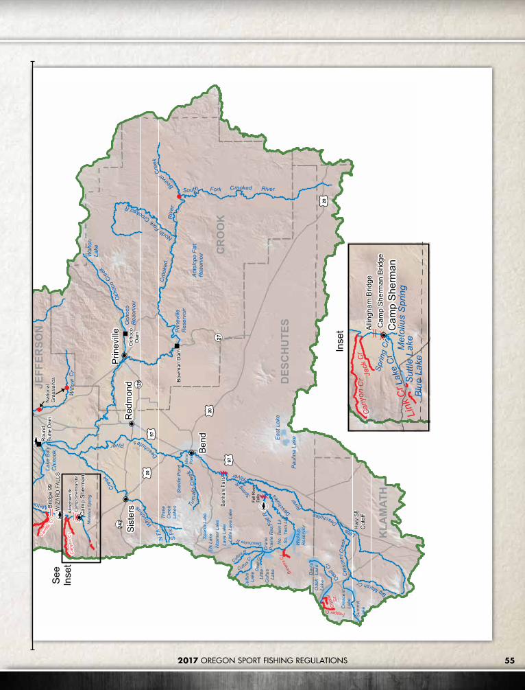
552017 OREGON SPORT FISHING REGULATIONS
Candle
Cr
Can
yon
Cr
84
Sher
ars
Falls
20
197
97
97
197
216
35
19
27
242
126
216
WAR
M S
PRIN
GS
IND
IAN
RES
ERVA
TIO
N 26
97
20
20
KLA
MAT
H
CR
OO
K
DES
CH
UTE
S
JEFF
ERSO
N
WA
SCO
HOOD RIVERBe
nd
Red
mon
dPr
inev
ille
Mad
ras
The
Dal
les
Hoo
d R
iver
Sist
ers
Cas
cade
Lock
s
Mau
pin
Ante
lope
Tygh
Valle
y
Cam
p Sh
erm
an
Des
chutesRiver
Cro
oked
Riv
er
Trout Creek
WhiteR
iver
Why
chus
Cree
k
LittleDeschutes
River
Och
oco
Creek
Will
ow
Cr
Eigh
tmile
Cre
ek
Fifte
enm
ileCre
ek
Beave
rCree
k
Five
mile
Cre
ek
HoodRiver
Tum
alo
Cre
ek
OdellC
r
EFkHoodR
Cultus
Cr
Mill
Cree
k
FallR
SFk
Coe Br
Che
now
eth
Cr
North
Fork
CrookedR
South Fork Crooked RiverMetoliusR
Dry Creek
Cre
scen
t Cre
ek
Eagle Cr
Cultus
RHerman Cr
N F
k
MiddleFk
Dee
r Cr
N F
k
S Fk
Spring
R
Met
o liu
sS
prin
g
DeschutesR
Col
umbi
aR
i ve r
Col
umbi
a R
iver
Not
In
clud
ed In
Thi
s Zo
ne
BigMarshCr
Thre
eC
reek
Lake
sDesc
hute
s
River
Deschutes
River
Deschutes
River
Brid
ge 9
9
Rai
lroad
Brid
ges
Allin
gham
Br
Cam
p Sh
erm
an B
r
Wic
kiup
Res
ervi
or
Cra
neP
rairi
e R
es.
Cre
scen
tLa
ke
Ode
llLa
ke
Dav
isLa
ke
Lake
Bill
y C
hino
ok
Prin
evill
eR
eser
voir
Pau
lina
Lake
Cul
tus
Lake
Eas
t Lak
e
Och
oco
Res
ervo
ir
Sum
mit
Lake
Lake
Sim
tust
us
Elk
Lake
Cle
ar L
ake
Lava
Lak
eH
osm
er L
ake
Lost
La
ke
Spar
ks L
ake
Pin
e H
ollo
wR
es.
Ola
llie
Lake
Littl
eC
ultu
sLa
ke
Littl
e La
va L
ake
Mirr
or
Pon
d
No.
Tw
in L
kS
o. T
win
Lk
Laur
ance
Lake
Roc
k C
reek
Res
.
Bak
er P
ond
She
vlin
Pon
d
Kin
gsle
yR
eser
voir
Ant
elop
e Fl
atR
eser
voirW
alto
nLa
ke
Buck
Hol
low
Cre
ek
Bak
eove
nCr
eek
Brow
nsC
r
Trapper Cr
Cry
stal
Cr
ClearB
ranc
h
Pinnac
leCr
Lake
Cr WFkHoodR
Jeffe
rson
Cr
Benh
am F
alls
Seuf
ert F
alls
Fall
Riv
erFa
lls
Pelto
n R
egul
atin
g D
am
Bow
man
Dam
Firs
tFa
lls
Rou
ndBu
tte D
am
Punc
hbow
lFa
lls
Och
oco
Dam
Mt H
ood
Dry
Cre
ek
Two
Spr
ings
Ran
ch
Nat
iona
lG
rass
land
s
CAS
CAD
E
WIZ
AR
D F
ALLS
War
m S
prin
gs N
FH
OXB
OW
OAK
SPR
ING
S
Cen
tral
Zon
e
020
4010
Mile
s
Can
yon
Cr
Jack
Cr
Cam
p Sh
erm
anLa
ke C
rM
etol
ius
Spr
i ng
Sprin
gC
r
Allin
gham
Brid
geC
amp
She
rman
Brid
ge
Blu
e La
keS
uttle
Lak
eLi
nk C
r
Inse
t
See
Inse
t
Hw
y 58
Cut
off
TRIB
AL P
ERM
IT R
EQU
IRED
FO
R A
NG
LIN
G O
N T
HE
MET
OLI
US
ARM
OF
LAKE
BIL
LY C
HIN
OO
K, L
AKE
SIM
TUST
US
AND
RES
ERVA
TIO
N P
OR
TIO
NS
OF
THE
DES
CH
UTE
S R
IVER
. TH
E R
ESER
VATI
ON
BO
RD
ERS
THE
DES
CH
UTE
S R
IVER
FO
R A
PPR
OXI
MAT
ELY
31M
ILES
FR
OM
TW
O S
PRIN
GS
RAN
CH
UPS
TREA
M T
OPE
LTO
N R
EGU
LATI
NG
DAM
. AN
GLE
RS
ARE
RES
TRIC
TED
TO
TH
E EA
STER
N H
ALF
OF
THE
RIV
ER W
HER
E IT
BO
RD
ERS
THE
RES
ERVA
TIO
N.
FOR
EXC
EPTI
ON
S, C
ALL
THE
RES
ERVA
TIO
N A
T(5
41) 5
53-2
002.
Clo
sed
All Y
ear
Zone
Bou
ndar
yD
am
Falls
Brid
ge
Land
mar
k
Hat
cher
y

56 2017 OREGON SPORT FISHING REGULATIONS
NORTHEAST ZONEDescriptionThe Northeast Zone is all waters draining into the Columbia River east of the Deschutes River and all waters draining into the Snake River system up to Hells Canyon Dam. This zone does not include any portion of the mainstem Columbia and Snake rivers. Regulations for the Columbia River can be found in the Columbia River Zone, pages 72-79,, and regulations for the Snake River can be found in the Snake River Zone, pages 68-70.
NORTHEAST ZONE REGULATIONSSPECIES BAG LIMIT SIZE LIMIT AND OTHER SPECIFICATIONS SEASON
Trout
Lakes: 5 per day, 2 daily limits in possession.
Streams: 2 per day, 2 daily limits in possession.
• Angling restricted to artificial flies and lures in streams. See Exceptions where use of bait is allowed.
• 8 inch minimum length.• Only 1 trout over 20 inches in length may be taken per day in lakes.• Rainbow trout over 20 inches are considered steelhead in streams.• Closed to angling for bull trout. See exceptions for catch-and-
release angling under Exceptions for Imnaha and Wenaha rivers.• No limit on size or number of brook or brown trout.• Kokanee included in trout limits except as noted under Exceptions.
Lakes: Open all year.
Streams: Open May 22 - Oct 31
Salmon• See Umatilla River under Exceptions.• There is no annual limit on hatchery salmon as long as the appropriate number of
Hatchery Harvest Tags have been purchased to record the catch. Closed in all waters unless noted by species under Exceptions.Steelhead 3 per day.
• Only hatchery steelhead may be taken. Wild steelhead must be released unharmed.
• There is no annual limit on hatchery steelhead so long as the appropriate number of Hatchery Harvest Tags have been purchased to record the catch.
Largemouth and Smallmouth Bass
5 per day, 2 daily limits in possession. No more than 3 over 15 inches in length.
Lakes: Open all year.
Streams: Open during trout, salmon or steelhead seasons only, except portions of Columbia River tributaries flooded by John Day and McNary dams are open all year.
Bluegill, Catfish, Crappie, Other Sunfish, Walleye, and Yellow Perch
No limit. None.
Sturgeon Catch-and-release only.
• Angling restricted to one single-point, barbless hook for sturgeon.• Sturgeon may not be removed from the water and must be
immediately released unharmed.
Sucker, Carp, Chub, Northern Pikeminnow, Sculpin, Whitefish, Shad and other Nongame Fish
No limit. None.
Bullfrogs No limit. An angling license is not required.
Open all year.Crayfish 100 per day, 2 daily
limits in possession.
• Neither an angling nor a shellfish license is required.• All streams are open to crayfish harvest including streams listed as
closed under Exceptions.
Freshwater Clams and Mussels Harvest prohibited It is illegal to harvest or possess any freshwater mussels or clams.
Closed.Margined Sculpin (Umatilla and Walla Walla river systems)
It is unlawful to angle for or possess all or any part of these fish because they are listed on the state’s sensitive species list for conservation purposes.
Northeast Zone RegulationsA valid Columbia River Basin Endorsement must be in possession when fishing for salmon, steelhead, or sturgeon in the mainstem Columbia River from Buoy 10 upstream and in all the rivers and their tributaries that flow into the Columbia River.
Exceptions to Northeast Zone RegulationsAldrich Ponds• 2 trout per day, 8 inch minimum length.
Big Sheep Creek• Open for hatchery steelhead Jan 1 - Apr
30 and Sep 1 - Dec 31 downstream of Little Sheep Creek.

2017 OREGON SPORT FISHING REGULATIONS 57
• Open all year for trout.• Wild rainbow trout must be released.• 5 hatchery rainbow trout per day, 8 inch
minimum length.• Use of bait allowed downstream of Little
Sheep Creek
Butter Creek and Tributaries• Open all year.• Use of bait allowed.
Catherine Creek• Open for hatchery steelhead Jan 1 - Apr 15
and Sep 1 - Dec 31, upstream to Hwy 203 Bridge located upstream from Catherine Creek State Park, use of bait allowed.
Deer Creek (Wallowa Co�) • Closed from the mouth upstream to marker
(0.2 miles).
Grande Ronde River• Open for hatchery steelhead Jan 1 - Apr 30
and Sep 1 - Dec 31 upstream to Meadow Creek.
• Open all year for trout.• Wild rainbow trout must be released from
the mouth upstream to the Wallowa River.• 5 hatchery rainbow trout per day, 8 inch
minimum length.• Use of bait allowed.
Granite Creek and Tributaries• Closed
Imnaha River• Open for hatchery steelhead Jan 1 - Apr
30 and Sep 1 - Dec 31 downstream of Big Sheep Creek.
• Open all year for trout.• 5 hatchery rainbow trout per day, 8 inch
minimum length.• Wild rainbow trout must be released.• Catch-and-release for bull trout from the
mouth upstream to the confluence of the North and South Forks.
• Use of bait allowed downstream of Big Sheep Creek.
• From May 1 - Aug 31, hook-gap size may not exceed 3/8 inch.
John Day River• Open for hatchery steelhead all year from
main line railroad bridge upstream to the North Fork.
• Open for hatchery steelhead Jan 1 - Apr 15 and Sep 1 - Dec 31 from the North Fork upstream to Indian Creek.
• No limits on size or number of bass.• Use of bait allowed.• Closed from ODFW marker ¼ mile
downstream from Tumwater Falls to 200 feet above the falls, located near the head of John Day Arm, except for warmwater fish.
LaGrande Reservoir and Upstream Tributaries• Open May 22 - Oct 31.• 2 rainbow trout per day, 8 inch minimum
length.• Artificial flies and lures only.
Little Sheep Creek• Closed within the fenced boundary of the
hatchery facility.
Lookingglass Creek and Tributaries• Hook-gap size may not exceed 3/8 inch.• Closed between 300 feet downstream from
Jarboe Creek and 200 feet upstream from the hatchery water intake (0.4 miles).
Lostine River• From the mouth to the confluence of the
East and West Forks, hook-gap size may not exceed 3/8-inch.
McKay Creek• Open all year.
McKay Reservoir• 5 bass per day, only 1 bass over 15 inches
may be harvested.
Meadow Creek• Closed from the forest boundary upstream
to Smith Creek Road crossing.
Middle Fork John Day River• Open for hatchery steelhead Jan 1- Apr 15
and Sep 1 - Dec 31, upstream to the Hwy 395 bridge.
• No limits on size or number of bass.• Use of bait allowed.• Upstream of Hwy 395 bridge, hook-gap size
may not exceed 3/8 inch.• Closed from Hwy 7 upstream to Summit
Creek.
Morgan Lake• Open Apr 22 - Oct 31.
North Fork John Day River• Open for hatchery steelhead Jan 1 - Apr 15
and Sep 1 - Dec 31, upstream to the Hwy 395 bridge.
• No limits on size or number of bass.• Use of bait allowed.• From Hwy 395 Bridge upstream to USFS
North Fork Campground, hook-gap size may not exceed 3/8 inch.
Prairie Creek (Wallowa Co�) • Use of bait allowed.
Spring Creek and Pond (Wallowa Hatchery)• Closed between Fish Hatchery Road
crossings.
Umatilla River• Open all year for warmwater fish.• Open for hatchery steelhead Jan 1 - Apr
15 and Sept 1 - Dec 31, from the Hwy 730 Bridge upstream to the CTUIR reservation boundary which is located upstream of the Hwy 11 bridge.
• Open for hatchery spring Chinook salmon from Apr 16 - Jun 10 from the Hwy 730 Bridge upstream to Threemile Dam and from Apr 16 - Jun 30 from Threemile Dam upstream to CTUIR reservation boundary located upstream of Hwy 11 bridge.
• 2 adult and 5 jack hatchery spring Chinook salmon per day.
• Open for coho and fall Chinook salmon from Sep 1 - Nov 30 from Threemile Dam upstream to CTUIR reservation boundary located upstream of Hwy 11 bridge.
• 3 adult fall Chinook salmon, coho salmon, or hatchery steelhead in aggregate per day and 5 jack salmon. In addition, 5 mini jack (8-15 inches) coho or fall Chinook salmon per day.
• 2 trout per day, 8 inch minimum length.• Use of bait allowed upstream to Ryan
Creek.• Tribal angling permits required on the
Umatilla Indian Reservation (541) 276-3165.
Walla Walla River• Open for hatchery steelhead Jan 1 - Apr 15
and Dec 1 - Dec 31, from the State Line upstream to the confluence of the North and South forks.
Wallowa Lake• 25 kokanee per day in addition to other
trout catch limits. No size limits.
Wallowa River• Open for hatchery steelhead Jan 1 -
Apr 30 and Sep 1 - Dec 31, from the mouth upstream to Trout Creek.
• Open all year for trout.• 5 hatchery rainbow trout per day, 8 inch
minimum length.• Wild rainbow trout must be released.• Use of bait allowed.
Wenaha River• Open for hatchery steelhead Jan 1 - Apr 30
and Sep 1 - Dec 31, upstream to Crooked Creek.
• Catch-and-release for bull trout in the mainstem Wenaha River upstream to the confluence of the North and South forks.
Willow Creek Reservoir• 25 crappie per day.• 5 bass per day, only 1 bass over 15 inches
may be harvested.
Willow Creek and Tributaries• Open all year.• Use of bait allowed.

2017 OREGON SPORT FISHING REGULATIONS58
John
Day
Riv
er
IrrigonHatchery
730
395
395
206
20782
74
19
244
3
204
237
37
7
11
218
207
206
207
207
84 84
26
GRANT
WHEELER
UMATILLA
UNION
WALLOWA
GILLIAM
SHERMAN
MORROW Pendleton
Hermiston
Umatilla
La Grande
Union
Boardman
ArlingtonRufus
John Day
Elgin
Mitchell
Heppner
Enterprise
Fossil
Ione
Joseph
Canyon City
Milton-Freewater
Condon
Wallowa
Shaniko
Dayville
MonumentSpray
Ukiah
IDAHO
WASHINGTON
Imnaha
Clarno
Rondowa
ServiceCreek
Nolin
Cold Springs Reservoir
WallowaLake
McKayRes.
Magone Lake
Kinney Res.
Bull Prairie Reservoir
MorganLake
Canyon Mdw Res.
La GrandeRes.
John Day Arm
Grande
Ro
nde
River
Rock Creek
Willow
Cr eek
Umatilla Imna
haRi
ver
Butte
r Cr
Wal lowa R
Minam
River
Rhea Creek
North
Fork
John DayRiver
Mi ll Cr
McKay Cr
LostineR
iver
Jose
phCr
Bear C
reek
BigShe
epCr
Deer C
r
South
Fork
John
DayRiver
Crow
Creek
Little
Sheep Cr
LittleButter Cr
Wenaha River
Beaver Creek
Meacham
Cr
Meadow Creek
Canyon
Cr
El k
Cr
Catherine Cr
IndianC
r
CottonwoodCr
Jarboe Cr
NFork
BeechCr
Chesnimnus C
r
Crooked Cr
Johnson Cr
Su mmit Cr
S Fork
Rock
Cr
EF
kW
allowa
RNor
thFk
South Fk
Wes
t Fk
Spring
Cr
N Fk
East Fk
N Fk Walla Walla
S Fk Walla Walla
Lookinggl ass Cr
Hur
rican
eC
rTr
out C
reek
Sw
amp
Cr
SnakeRiverGrande Rond
eRi
ver
JohnD
ay
River
Gra
nde
Ron
deR
iver
Imna
haR
iver
Columbia
River
River
Middle Fork John Day River
Tumwater Falls
HellsCanyonDam
ThreemileDam
Bull Run Cr
Clea
r Cr
M Fk
Beaver Cr
Granite C r
Hwy 11 Bridge
Hwy 203Bridge
Hwy 730 Bridge
Hwy 395 Bridge
Hwy 395 Bridge
Railroad Bridge
CottonwoodBridge
LookingglassHatchery
WallowaHatchery
UmatillaHatchery
Willow CreekWildlife Area
North Fork Campground
Spring Cr Rd
Hells
Can
yon
UmatilaIndian
Reservation
North Fork
Indian Cr
Weir
Weir
Weir
TRIBAL PERMIT REQUIRED FOR ANGLING ON THE RESERVATION
PORTION OF THE UMATILLA RIVER. FOR INFORMATION CALL THE UMATILLAINDIAN RESERVATION AT 541-276-4109.
COLUMBIA AND SNAKE RIVERS NOT INCLUDED IN THIS ZONE.
Northeast Zone
0 20 4010Miles
Closed All Year
Zone Boundary
Dam
Falls
Landmark
BridgeHatchery
NORTHEAST ZONE

592017 OREGON SPORT FISHING REGULATIONS
John
Day
Riv
er
IrrigonHatchery
730
395
395
206
20782
74
19
244
3
204
237
37
7
11
218
207
206
207
207
84 84
26
GRANT
WHEELER
UMATILLA
UNION
WALLOWA
GILLIAM
SHERMAN
MORROW Pendleton
Hermiston
Umatilla
La Grande
Union
Boardman
ArlingtonRufus
John Day
Elgin
Mitchell
Heppner
Enterprise
Fossil
Ione
Joseph
Canyon City
Milton-Freewater
Condon
Wallowa
Shaniko
Dayville
MonumentSpray
Ukiah
IDAHO
WASHINGTON
Imnaha
Clarno
Rondowa
ServiceCreek
Nolin
Cold Springs Reservoir
WallowaLake
McKayRes.
Magone Lake
Kinney Res.
Bull Prairie Reservoir
MorganLake
Canyon Mdw Res.
La GrandeRes.
John Day Arm
Grande
Ro
nde
River
Rock Creek
Willow
Cr eek
Umatilla Imna
haRi
ver
Butte
r Cr
Wal lowa R
Minam
River
Rhea Creek
North
Fork
John DayRiver
Mi ll Cr
McKay CrLostine
River
Jose
phCr
Bear C
reekBig
She
epCr
Deer C
r
South
Fork
JohnDay
River
Crow
Creek
Little
Sheep Cr
LittleButter Cr
Wenaha River
Beaver Creek
Meacham
Cr
Meadow Creek
Canyon
Cr
El k
Cr
Catherine Cr
IndianC
r
CottonwoodCr
Jarboe Cr
NFork
BeechCr
Chesnimnus C
r
Crooked Cr
Johnson Cr
Su mmit Cr
S Fork
Rock
Cr
EF
kW
allowa
RNor
thFk
South FkW
est F
k
Spring
Cr
N Fk
East Fk
N Fk Walla Walla
S Fk Walla Walla
Lookinggl ass Cr
Hur
rican
eC
rTr
out C
reek
Sw
amp
Cr
SnakeRiverGrande Rond
eRi
ver
JohnD
ay
River
Gra
nde
Ron
deR
iver
Imna
haR
iver
Columbia
River
River
Middle Fork John Day River
Tumwater Falls
HellsCanyonDam
ThreemileDam
Bull Run Cr
Clea
r Cr
M Fk
Beaver Cr
Granite C r
Hwy 11 Bridge
Hwy 203Bridge
Hwy 730 Bridge
Hwy 395 Bridge
Hwy 395 Bridge
Railroad Bridge
CottonwoodBridge
LookingglassHatchery
WallowaHatchery
UmatillaHatchery
Willow CreekWildlife Area
North Fork Campground
Spring Cr Rd
Hells
Can
yon
UmatilaIndian
Reservation
North Fork
Indian Cr
Weir
Weir
Weir
TRIBAL PERMIT REQUIRED FOR ANGLING ON THE RESERVATION
PORTION OF THE UMATILLA RIVER. FOR INFORMATION CALL THE UMATILLAINDIAN RESERVATION AT 541-276-4109.
COLUMBIA AND SNAKE RIVERS NOT INCLUDED IN THIS ZONE.
Northeast Zone
0 20 4010Miles
Closed All Year
Zone Boundary
Dam
Falls
Landmark
BridgeHatchery

2017 OREGON SPORT FISHING REGULATIONS60
SOUTHEAST ZONE DescriptionThe Southeast Zone is all tributaries (including their impoundments) of the Snake River system above Hells Canyon Dam; the Silvies River drainage in Grant County; all waters in Malheur and Lake counties; all waters in Harney County except South Fork John Day drainage; and all waters of the Klamath Basin in Klamath and Lake counties. This zone does not include any portion of the mainstem Snake River. The Klamath River Basin is all streams and their tributaries that drain toward Upper Klamath Lake or Klamath River. Regulations for the Snake River can be found in the Snake River Zone.
Southeast Zone Regulations1. Angling restricted to artificial flies and
lures in streams. See Exceptions where use of bait is allowed.
2. A valid Columbia River Basin Endorsement must be in possession when fishing for salmon, steelhead, or sturgeon in the mainstem Columbia River from Buoy 10 upstream and in all the rivers and their tributaries that flow into the Columbia River.
3. See Health Advisory on page 20.
SOUTHEAST ZONE REGULATIONSSPECIES BAG LIMIT SIZE LIMIT AND OTHER SPECIFICATIONS SEASON
Trout
Lakes: 5 per day; 25 kokanee per day in addition to trout limits; 2 daily limits in possession.
Streams: 2 per day, 2 daily limits in possession.
• Angling restricted to artificial flies and lures in streams.• 8 inch minimum length.• No size limit on kokanee.• Only 1 trout over 20 inches in length may be taken per day.• See Exceptions for streams where use of bait is allowed.• No limit on size or number of brook or brown trout in streams
unless noted under Exceptions.• Closed to angling for bull trout.
Lakes: Open all year.
Streams: Open all year, unless noted under Exceptions.
Largemouth and Smallmouth Bass
5 per day; 2 daily limits in possession, except no limit in southwest corner of Southeast Zone (see map page 67).
• Angling restricted to artificial flies and lures in streams.• No more than 3 over 15 inches in length.• No size limit in southwest corner of Southeast Zone.• Note: See Exceptions to catch limits, length limits and streams
where use of bait is allowed.
Lakes and Reservoirs: Open all year.
Streams: Open during trout season.
All trout, salmon and steelhead that are released must be unharmed and should not be removed from the water.
CATCH-AND-RELEASE

61
SOUTHEAST ZONE REGULATIONSSPECIES BAG LIMIT SIZE LIMIT AND OTHER SPECIFICATIONS SEASON
Bluegill, Catfish, Crappie, Other Sunfish, Walleye, and Yellow Perch
No limit. Angling restricted to artificial flies and lures in streams. See Exceptions where use of bait is allowed.
Lakes and Reservoirs: Open all year.
Streams: Open during trout season.
Whitefish, Sucker, Northern Pikeminnow, Carp, Chub, Sculpin, and other Nongame Fish
No limit.
• Closed for suckers in the Southwest corner of the Southeast Zone (see map).
• Closed to take and possession of Protected Fish (see item 25 in General (Statewide) Regulations on page 15).
• Angling restricted to artificial flies and lures in streams.• See Exceptions for streams where use of bait is allowed.
Hybrid Bass No limit. See Ana Reservoir under Exceptions.
Sturgeon Catch-and-release only.
• Sturgeon may not be removed from the water and must be immediately released unharmed.
• Only one single-point, barbless hook may be used for sturgeon.• Angling restricted to artificial flies and lures in streams. See
Exceptions where use of bait is allowed.Bullfrogs No limit. An angling license is not required.
Open all year.Crayfish 100 per day, 2 daily limits
in possession.
• Neither an angling nor a shellfish license is required.• All streams are open to crayfish harvest including streams listed
as closed under Exceptions.Freshwater Clams and Mussels Harvest prohibited It is illegal to harvest or possess any freshwater mussels or clams. Closed.

2017 OREGON SPORT FISHING REGULATIONS62
SOUTHEAST ZONE Exceptions to Southeast Zone RegulationsAgency Lake• 1 rainbow trout per day, 15 inch minimum
length.
Ana Reservoir• 1 hybrid bass per day, 15 inch minimum
length.
Ana River• 5 rainbow trout per day, 8 inch minimum
length.• Use of bait allowed.
Annie Creek• Use of bait allowed.
Antelope Creek (Malheur Co�) • Closed.
Big Alvord Creek• Closed.
Blitzen River• Catch-and-release for trout.• Malheur National Wildlife Refuge
downstream from Bridge Creek is closed, except from Sodhouse Lane to the bridge on the boat landing road from Aug 1 - Sep 15.
Burnt River• 5 rainbow trout per day, 8 inch minimum
length.• Use of bait allowed.
Calahan Creek• Use of bait allowed.
Chewaucan River• Use of bait allowed downstream of Hwy 31 at
Paisley.
Corral Creek• Use of bait allowed.
Cottonwood Creek (Harney Co�) • Closed.
Cottonwood Reservoir (Goose Lake Basin, Lake Co�)• 1 rainbow trout per day, 15 inch minimum
length.
Crater Lake National Park• Angling is regulated by the National Park
Service (541) 594-3000.
Crooked Creek (Klamath Co�)• Open May 22 - Oct 31.• Catch-and-release for rainbow trout.• Closed from the springs located at Klamath
Hatchery downstream 1,000 feet to a posted fence crossing.
Crystal Creek• Open May 22 - Oct 31.• 1 rainbow trout per day, 15 inch minimum
length.• Use of bait allowed.
Denio Creek• Closed.
Dog Lake• 1 rainbow trout per day, 15 inch minimum
length.• 5 bass per day, only 1 bass over 15 inches may
be harvested.
Drews Reservoir• 1 rainbow trout per day, 15 inch minimum
length.
Eagle Creek (including East and West Forks)• 5 rainbow trout per day, 8 inch minimum
length.• Use of bait allowed.
Fort Creek• Open May 22 - Oct 31.• Catch-and-release for rainbow trout.
Fourmile Creek• 1 rainbow trout per day, 15 inch minimum
length.• Use of bait allowed.
Goose Lake• 1 rainbow trout per day, 15 inch minimum
length.
Harriman Creek• 1 rainbow trout per day, 15 inch minimum
length.• Use of bait allowed.
Indian Creek (Malheur Co�) • Closed.
Jackson Creek• Use of bait allowed.
Jordan Creek• 5 trout per day, 8 inch minimum length.• Use of bait allowed.
Kiger Creek• 5 trout per day, 8 inch minimum length.• Use of bait allowed.
Klamath Lake• 1 rainbow trout per day, 15 inch minimum
length.
Klamath River• 1 rainbow trout per day, 15 inch minimum
length.
• Closed from JC Boyle Reservoir upstream to Keno Dam from Jun 16 - Sep 30.
Krumbo Creek• 5 trout per day, 8 inch minimum length.• Use of bait allowed.• Closed below Krumbo Reservoir.
Krumbo Reservoir• Closed to ice fishing and during adverse
conditions by Malheur National Wildlife Refuge (541) 493-2612.
Lake of the Woods• 5 bass per day, only 1 bass over 15 inches may
be harvested.• Angling allowed 24 hours per day for all
species.
Link River• 1 rainbow trout per day, 15 inch minimum
length.• Use of bait allowed.
Little Alvord Creek• Closed.
Little Blitzen River• Catch-and-release for trout.
Little McCoy Creek• Closed.
Little Whitehorse Creek and Tributaries (Harney /Malheur Co.)• Open year round. • Catch-and-release for trout.• Artificial flies and lures only.
Lost River and Tributaries• Use of bait allowed.
Malheur River• Use of bait allowed downstream of Otis
Creek.• 5 trout per day, 8 inch minimum length.
Mann Lake• 2 trout per day, 8 inch minimum length.• Artificial flies and lures only.• Tributaries are closed to angling.
McDermitt Creek Basin• Closed.
Miller Creek (Outlet of Miller Lake, Klamath Co�)• Use of bait allowed.
Miller Lake• Angling allowed 24 hours per day for all
species.
Mosquito Creek (Harney Co�) • Closed.

2017 OREGON SPORT FISHING REGULATIONS 63
CONNECT WITH ODFW ON SOCIAL MEDIA
Facebook.com/oregondepartmentoffishandwildlife and Facebook.com/oregonwildlifeviewing
Twitter @ODFW
Instagram @ODFW Hashtag your photos #ODFW so we can see them!
www.odfw.com
North Fork Malheur River• Use of bait allowed downstream of Beulah
Reservoir.• 5 trout per day, 8 inch minimum length.
North Fork Sprague River and Tributaries• 2 brown trout per day.• Use of bait allowed on the mainstem and
tributaries upstream of the lowermost 3372 road crossing.
Odessa Creek• 1 rainbow trout per day, 15 inch minimum
length.• Use of bait allowed.
Owyhee River• 5 rainbow trout per day, 8 inch minimum
length.• Catch-and-release for brown trout.• Use of bait allowed.
Phillips Reservoir• Catch-and-release for tiger muskie.
Pike Creek• Closed.
Pine Creek and Tributaries Upstream of Oxbow Bridge (Baker Co)• 5 rainbow trout per day, 8 inch minimum
length.• Use of bait allowed.
Poison Creek Reservoir• 2 trout per day, 8 inch minimum length.
Powder River• 5 rainbow trout per day, 8 inch minimum
length.• Use of bait allowed.
Rattlesnake Creek and Tributaries• 5 trout per day, 8 inch minimum length.• Use of bait allowed.
Recreation Creek• 1 rainbow trout per day, 15 inch minimum
length.• Use of bait allowed.
Riddle Creek and Tributaries• 5 trout per day, 8 inch minimum length.• Use of bait allowed.
Sage Creek• Closed.
Sand Creek• Use of bait allowed.
Scott Creek• Use of bait allowed.
Sevenmile Creek and Tributaries• Catch-and-release for rainbow trout.• Use of bait allowed upstream of Nicholson
Road.
Short Creek• 1 rainbow trout per day, 15 inch minimum
length.• Use of bait allowed.
Silver Creek and Tributaries• 5 trout per day, 8 inch minimum length.• Use of bait allowed upstream of the Malheur
National Wildlife Refuge boundary.
Silvies River and Tributaries• 5 trout per day, 8 inch minimum length.• Use of bait allowed.
Skull Creek (Harney Co�) • Closed.
South Fork Sycan River• Use of bait allowed.
Spencer Creek• Open May 22 - Oct 31.
Sprague River• Use of bait allowed from Saddle Mtn Pit Road
Bridge upstream to Godowa Springs Road.
Spring Creek (Klamath Co�)• Open May 22 - Oct 31.
Thomason Creek• 1 rainbow trout per day, 15 inch minimum
length.• Use of bait allowed.
Threemile Creek (Harney Co�) • Closed.
Threemile Creek (Klamath Co�)• Closed upstream of Westside Road.
Twin Lakes (Wallowa Mountains)• 1 rainbow trout per day, 15 inch minimum
length.
Unity Reservoir• 5 bass per day, only 1 bass over 15 inches may
be harvested.• Closed within 200 feet of the Dam from Jan 1
- Mar 31 and Dec 1 - Dec 31.
Van Horn Creek• Closed.
Watson Creek• Use of bait allowed.
Whitehorse Creek and Tributaries (Harney /Malheur Co.)• Open year round. • Catch-and-release for trout.• Artificial flies and lures only.
Williamson River• Open Apr 22 - Oct 31 from Kirk Road
Bridge to headwaters.• Open May 22 - Oct 31 from mouth to Kirk
Road Bridge. • Catch-and-release for rainbow trout.• No angling from a floating device upstream of
Chiloquin Bridge.
Willow Creek and Tributaries (Harney /Malheur Co.)• Open year round. • Catch-and-release for trout.• Artificial flies and lures only.
Willow Valley Reservoir• 5 bass per day, only 1 bass over 15 inches may
be harvested.
Wood River• Open Apr 22 - Oct 31.• Catch-and-release for rainbow trout.• 2 brown trout per day.
Snapchat @MyODFW

64 2017 OREGON SPORT FISHING REGULATIONS
SOUTHEAST ZONE
84
395
95
20
97
26
30
395
30
95
78
205
140
31
201
86
203
39
245
70
7
140
140
84
97
395
LAK
E
HA
RN
EY
MA
LHEU
R
KLA
MAT
H
BA
KER
Burn
s
Ow
yhee
Basq
ue
Fiel
ds
Che
mul
t
Silv
ies
Ric
hlan
d
McD
erm
itt
Chi
loqu
in
Fren
chgl
en
Hun
tingt
on
Fort
Klam
ath
Jord
an V
alle
y
Klam
ath
Falls
Chr
istm
as V
alle
y
Wei
ser,
Idah
o
Lake
view
Ont
ario
Mal
heur
Nat
iona
lW
ildlif
eR
efug
e
Bake
rC
ity
Whi
teho
rse
Pais
ley
Nat
iona
l
Pa
rk
Dre
wse
y
Mal
heur
River
Owyh
eeRiver
Burnt
Riv
er
Pow
der
Riv
er
Klamath
R
Spra
gue
R
Roc
kC
rSy
can
Riv
er
Jord
anCr
eek
DeepCr
Eagl
eCreek
Williamson R
Buck
Creek
SilverCr
N Fk Malheur R
Lost
River
Honey
Cre
ek
Tro ut Cr
Guano
CrSpe
ncer
Cr
Che
waucan R
Twen
tym
ileCr
Wood R
Ana R
NFk
Spra
gueR
Blitzen RiverS
Fk
MalheurR
SnakeRiver
OtisCr
Page
Dam
Keno
Dam
Ow
yhee
Dam
Hel
lsC
anyo
nD
am
Thie
fVa
lley
Dam
J. C
. Boy
leD
am
Oxb
ow D
am
Brow
nlee
Dam
Oxb
ow B
ridge
Kirk
Rd
Brid
ge
Sadd
le M
tn P
itt R
d B
rR
d 33
72Br
idge
Nic
hols
onR
d Br
Syc
anM
arsh
Pau
lina
Mar
sh
Kla
mat
hM
arsh
CA
LIFO
RN
IAN
EVA
DA
IDAHO
Lake
Abe
rt
Sum
mer
Lake
Goo
seLa
ke
Cra
ter
Lake
Age
ncy
Lake
Upp
er K
lam
ath
L
ake
Har
ney
Lake
Mal
heur
Lake
Bro
wnl
eeR
es.
Ow
yhee
Res
ervo
ir
Silv
erLa
ke
Cru
mp
Lake
Har
tLa
ke
Dre
ws
Res
ervo
ir
War
mS
prin
gsR
es.
Asp
enLa
ke
Alv
ord
Lake
Ger
ber
Res
ervo
ir
Ant
elop
eR
es.
Coy
ote
Lake
Phi
llips
Res
.
Thom
pson
Res
ervo
ir
Beu
lah
Res
ervo
ir
Lake
of
the
Woo
ds
Uni
tyR
es.
Bul
ly C
rR
es.
Mill
erLa
ke
Chi
ckah
omi n
yR
eser
voir
Man
n La
ke
Kru
mbo
Res
ervo
ir
See
Sout
hwes
tC
orne
r Ins
et
See
Sout
heas
tC
orne
r Ins
et
See
Nor
thea
stC
orne
r Ins
etSo
uthe
ast Z
one
025
5012
.5M
iles
Clo
sed
All Y
ear
Zone
Bou
ndar
yD
am
Falls
Brid
ge
SNA
KE
RIV
ERN
OT
INC
LUD
EDIN
TH
IS Z
ON
E.
(SEE
SN
AK
ER
IVER
ZO
NE)
Hat
cher
y

652017 OREGON SPORT FISHING REGULATIONS
84
30
30
86
237
203
245
7
84
BA
KER
Mal
heur
Ric
hlan
d
Hun
tingt
on
Wei
ser,
Idah
o
Bake
rC
itySu
mpt
er Uni
ty
Hel
lsC
anyo
nD
am
Thie
f Va
lley
Dam
Oxb
owD
am
Brow
nlee
Dam
Oxb
owBr
idge
Ric
hlan
d - H
untin
gton
Roa
d Br
idge
Ric
hlan
d - H
untin
gton
Roa
d Br
idge
Bro
wnl
eeR
es.
Phi
llips
Res
.
Uni
tyR
es.
Thie
fVa
lley
Res
.
Balm
Cr R
es.
Hig
gins
Res
.M
urra
yR
es.
Twin
Lake
s
Oxb
owH
atch
ery
Bur
nt
Rive
r
Pow
der
River
Eagle
Creek
N Fk Malheur R
Pine
Cree
k
Wolf
Cree
k
Big Cr
Fi
shCreek
Clear Cr
Balm Creek
Sutton Creek
NorthPowderR
Deer Creek
Elk
Cr
NorthPineCr
Alde
r Cre
ek
Jimmy Cr
Lawrenc
eC
r
East Fk
Cracker Creek
Anth
onyCr
eek
Pole
Cr
Rock Creek Camp Cr
Big Creek
Chanc
eCr
Last
SFkBurnt
R
West Fk
North Fork
Mid
dle
Fk
Wes
t Fk
Ebell CreekBeagle Cr
Powde
r
Riv
er
Ea st
Pine
Snake
River
DurkeeCr
Pri tc
hard Cr
Dix
ie C
r
North
For
k
Sout
h Fk
Durb
in Cr
Nor
thea
st C
orne
r of S
outh
east
Zon
e
IDAHO
Lege
nd
010
205
Mile
s
Zone
Bou
ndar
y
Dam
Brid
geH
atch
ery

2017 OREGON SPORT FISHING REGULATIONS66
SOUTHEAST ZONE
78
205
95HARNEY
MALHEUR
Basque
Fields
Frenchglen
MalheurNationalWildlifeRefuge
Whitehorse
Trout
C reek
Donner und
Bl itzenRiver
SFk
Mal
heur
R
Creek
Bridge CrMud Cr
F ish CrCold Spr
Little Blitzen R
Indian CrBig Indian Cr
Lil Indian
Home Cr
Cottonwood CrPueb
loS
l.
Antelope Cr
Oregon CanyonC
r
Rock Cr
MudCr
An kle
Cr Wi ldhorse
Cr
Willow
Creek
Whiteho rse
CreekLittleW
hi tehorseC
r
Fif teenmile
Cr
Doolitt le
Cr
PageDam
Headquarters
NEVADA
HarneyLake
MalheurLake
AlvordLake
CoyoteLake
MannLake
KrumboRes.
WildhorseLake
Southeast Corner of Southeast Zone
Donnerund
BlitzenR
iver
Skull
Cre
ek
Thre
emile
Creek
MosquitoC
r
IndianCrD
en io Cr Sage Cr
VanH
o rn C r
Big Alvord Cr
House Cr
Pike Cr
Little McCoy Cr
Little Alvord Cr
Willow Cr
War
m S
prin
gs C
anal
Krumbo
Cottonwood Cr
McDermitt Cr
N Fk
Cot
tonw
ood
Cr
Legend
Miles0 5 10 15
Zone BoundaryClosed All Year
DamLandmark

2017 OREGON SPORT FISHING REGULATIONS 67
Nic
hols
onR
d Br
395
97
140
39
70
140
140
97
395
31
LAK
E
KLA
MAT
H
Che
mul
t
Chi
loqu
in
Fort
Klam
ath
Klam
ath
Falls
Chr
istm
as V
alle
y Lake
view
Pais
ley
Nat
iona
lPa
rk
Klamath
River
Spragu
eR
iver
Syca
nR
ive
r
Dee
pCr
WilliamsonRiver
BuckCr
SilverCr
Lost
River
Honey
Cre
ek
Spen
cer Cr
Chewaucan R
Twen
tym
ile
Cr
Wood R
Ana R
NFk
Spr
ag
ueR
Spring Cr
Four
mile
CrCrystalC
r Thomason Cr
Rec
reat
ion
Cr
Crooked Cr
Fort Cr
Link
Riv
er
BridgeCr
SFk
Spr
agueRDr
ews
Cr
Antelop
e Cr
DryC
r
Cot
tonw
ood Cr
Thom
asCr
Cog
swel
l Cr
Cra
neCr
Kel
lyC
r
Seve
nmile Cr
Ode
ssa
Cr
Annie
Cr
Calahan Cr
Jack
son
Cr
S Fk
Corra
l C
r
Keno
Dam
Dam
Sadd
le M
tnPi
tt R
d Br
Roa
d 33
72Br
idge
Syc
anM
arsh
Pau
lina
Mar
sh
Kla
mat
hM
arsh
CA
LIFO
RN
IA
Lake
Abe
rt
Sum
mer
Lake
Goo
seLa
ke
Cra
ter
Lake
Age
ncy
Lake U
pper
Kla
mat
hLa
ke
Silv
erLa
ke
Cru
mp
Lake
Har
tLa
ke
Dre
ws
Res
ervo
ir
Asp
enLa
ke
Ger
ber
Res
ervo
irThom
pson
Res
ervo
ir
Lake
of
the
Woo
ds
Mill
erLa
ke
J.C
. Boy
leR
es.
Lake
Ew
auna
Flag
staf
fLa
ke
Sout
hwes
t Cor
ner o
f Sou
thea
st Z
one
Thre
emile
CrKl
amat
h
Riv
er m
outh
05
1015
20M
iles
Lege
nd
DamClo
sed
All Y
ear
Zone
Bou
ndar
y
Brid
ge
Land
mar
k
Hat
cher
y

2017 OREGON SPORT FISHING REGULATIONS68
SNAKE RIVER ZONE Snake River Zone Regulations1. Where the Snake River forms the boundary
between Oregon and Idaho, the following rules apply:a. License of either state is valid in the
Snake River when angling from a floating device. However, when fishing tributaries, sloughs or from sloughs or from lands within either state, the angler must be licensed by the state where the waters (or land) are located.
b. Anglers must follow the rules of the licensing state.
c. Anglers are restricted to one daily catch limit, even if licensed by both states.
d. Anglers may launch and take out their boats from either state, regardless of licensing state.
2. A valid Columbia River Basin Endorsement must be in possession when fishing for salmon, steelhead, or sturgeon in the mainstem Columbia River from Buoy 10 upstream and in all the rivers and their tributaries that flow into the Columbia River.
3. See Health Advisory on page 20.
Exceptions to Snake River Zone Regulations
All trout, salmon and steelhead that are released must be unharmed and should not be removed from the water.
CATCH-AND-RELEASE
Brownlee Reservoir • 12 inch minimum length limit on bass.• An Oregon angling license is required on
the Powder River Arm from the mouth upstream to the Huntington - Richland Road Bridge.
• Brownlee Reservoir ends at the downstream point of Porter Island.
Hells Canyon Reservoir • 12 inch minimum length limit on bass.• 3 hatchery trout over 20 inches may be
harvested per day.
Oxbow Reservoir • 2 bass per day.• No harvest of bass between 12 and
16 inches.
DescriptionThe Snake River Zone is all the waters of the Snake River from the Oregon-Washington border upstream to the Oregon-Idaho border. The boundary between the Snake River and its tributaries is defined as a straight line across the mouths of all rivers. The Snake River Zone includes the portions of the Burnt and Powder rivers downstream of the Huntington-Richland Road near their mouths and includes the portion of Pine Creek downstream of the Oxbow Bridge.
Snake River Upstream to Hells Canyon Dam• Open for hatchery steelhead Jan 1 - Apr 30
and Sep 1 - Dec 31.• Wild trout must be released.• No length limits on bass.• Closed from Hells Canyon Dam
downstream 400 feet to cable crossing.
STOP THE SPREAD OF INVASIVE
NORTHERN PIKENorthern Pike (Esox lucius) are a Prohibited Species in Oregon. Anglers are encouraged to kill all Northern Pike encountered, do not release them back into the water. Harvested Northern Pike must be dead before anglers leave the water where they are caught.
NO MINIMUM SIZE OR POSSESSION LIMIT
Northern Pike are currently not present anywhere in Oregon and with your help we can keep it that way. This fish species is known to have negative impacts
on native fish populations and popular sport fisheries. In addition, further spread of Northern Pike from their present location in the upper Columbia River
Basin into downstream portions of the Columbia River pose a severe threat to Salmon and Steelhead recovery efforts.
It is illegal to transport and release live fish into Oregon waters without an ODFW permit.
If you see someone transporting or releasing live fish, please call Oregon State Police at: 1-800-452-7888

692017 OREGON SPORT FISHING REGULATIONS
SNAKE RIVER ZONE REGULATIONSSPECIES BAG LIMIT SIZE LIMIT AND OTHER SPECIFICATIONS SEASON
Trout 6 per day, 2 daily limits in possession.
• No minimum length limit.• Closed to angling for bull trout.• Only 1 trout over 20 inches in length may be taken per day,
upstream of Hells Canyon Dam, except for Hells Canyon Reservoir. See Exceptions for Hells Canyon Reservoir.
• Rainbow trout over 20 inches are considered steelhead downstream of Hells Canyon Dam.
• No limit on size or number of brook or brown trout in streams unless noted under Exceptions.
Open all year.
Salmon •Closed. Closed.
Steelhead 3 per day.
• See Snake River entry from Oregon-Washington border upstream to Hells Canyon Dam.
• Only hatchery steelhead may be kept.• Restricted to barbless hooks for hatchery steelhead.• No annual limit on hatchery steelhead as long as the appropriate
number of Hatchery Harvest Tags has been purchased to record the fish.
Closed in all waters unless noted by species under Exceptions.
Largemouth and Smallmouth Bass
6 per day, 2 daily limits in possession. No more than 3 over 15 inches in length.
Open all year.Bluegill, Catfish, Crappie, Other Sunfish, Walleye, and Yellow Perch
No limit. None.
Sucker, Carp, Chub, Northern Pikeminnow, Sculpin, Whitefish, Shad and other Nongame Fish
No limit. None.
Open all year.Sturgeon Catch-and-release only.
• Angling restricted to one single-point, barbless hook for sturgeon.
• Sturgeon may not be removed from the water and must be immediately released unharmed.
Bullfrogs No limit. An angling license is not required.
Crayfish 100 per day, 2 daily limits in possession. Neither an angling nor a shellfish license is required.
Freshwater Clams and Mussels Harvest prohibited. It is illegal to harvest or possess any freshwater mussels or clams. Closed.

2017 OREGON SPORT FISHING REGULATIONS70
SNAKE RIVER ZONE
Brownlee Reservoir
Oxbow Reservoir
HellsCanyon
Reservoir
W A L L O W A
SU
MM
I T
RI D
GE
I D A H OOxbow Bridge
Richland -Huntington
Road Bridge
B ig SheepCr
eek
WallowaLake
Little
Sheep Creek
Snak
eRi
ver
Imnaha River
Pine Cr
Snake
RiverIm
naha
Rive
r
Powder R.
86
413
350
71
W A S H .I D A H O
B A K E R
SomersPoint
CactusMountain
LookoutMountain
Carson
Joseph
Imnaha
Halfway
Richland
Oxbow Dam
Brownlee Dam
HellsCanyonDam
0 8 164Miles
BrownleeReservoir
84
BurntRiverBridge
Weiser Bridge
Payette Bridge
Ontario Spur Bridge
Nyssa Bridge
Sugarloaf Mountain
Richland -Huntington Road Bridge
Powder R.
Porter Island
I D A H O
Snak
eRi
ver
Burnt R.
8671
201
451
52
20
95
95
Malheur River
Owy
hee
Rive
rSn
ake
Rive
r
B A K E R
I D A H O
M A L H E U R
BrownleeDam
Vale
Nyssa
Owyhee
Adrian
Ontario
Kingman
Richland
Huntington
Willowcreek
Snake River Zone
0 8 164Miles
Zone Boundary
Boat RampLandmark
DamBridge

L O T T E R Y G A M E S A R E B A S E D O N C H A N C E A N D S H O U L D B E P L A Y E D F O R E N T E R T A I N M E N T O N L Y
OregonFishGuide2016.indd 1 10/14/16 10:24 AM

72 2017 OREGON SPORT FISHING REGULATIONS
COLUMBIA RIVER ZONE
1. In the Columbia River where it forms the state boundary line, not including tributaries, sloughs and lands, the following rules apply:a. Both Washington and Oregon resident
or non-resident fishing licenses are valid except when the other state’s season is closed. Any anglers other than Washington residents must have a valid Oregon angling or shellfish license when landing fish or taking shellfish by boat in Oregon;
b. Anglers must follow the rules of the state in which they are fishing;
c. Anglers are restricted to one daily catch limit for all fish species from the Columbia River, even if licensed in Oregon and Washington;
d. Anglers are restricted to one annual catch limit of white sturgeon in the Columbia River above Bonneville Dam even if licensed in Oregon and Washington.
2. A valid Columbia River Basin Endorsement must be in possession when fishing for salmon, steelhead, or sturgeon in the mainstem Columbia River from Buoy 10 upstream and in all the rivers and their tributaries that flow into the Columbia River.
3. When fishing on tributaries, sloughs or from the land of a state, the angler must be licensed by that state and obey all angling regulations of that state.
4. For the mainstem Columbia River salmon and steelhead fishery upstream
of the Rocky Point-Tongue Point line to McNary Dam from February 15 through June 15, it is unlawful when fishing from vessels which are less than 30 feet in length, substantiated by U.S. Coast Guard documentation or Marine Board registration, to totally remove from the water any salmon or steelhead required to be released.
5. It shall be unlawful for any person to angle from a vessel while fish are onboard that are not allowed to be taken in the area being fished. This regulation does not apply to vessels in transit.
6. Use of barbless hooks is required when angling for salmon, steelhead, or trout in: mainstem Columbia River from Buoy 10 upstream to Oregon-Washington border located upstream of McNary Dam (RM 309.5); Youngs Bay Select Area (Clatsop Co.) from Highway 101 bridge upstream to markers at the confluence of the Youngs and Klaskanine rivers, including lower Lewis and Clark River upstream to Alternate Highway 101 bridge, and Walluski River upstream to Highway 202 bridge; and within the Knappa/Blind Slough Select Area (Clatsop Co.) from markers at the west end of Minaker Island upstream to markers at the mouth of Blind Slough, continuing upstream to railroad bridge in Blind Slough.
7. See Health Advisory on page 20.
Columbia River Zone RegulationsDescriptionThe Columbia River Zone is all waters of the Columbia River upstream from a north-south line through Buoy 10 at the river mouth and includes those portions of tributaries (including lakes) downstream from the mainline railroad bridges near the tributaries’ mouths except for the Willamette (including Multnomah Channel), Sandy, Hood, Deschutes and Umatilla river systems, Skipanon River, and Youngs Bay. The Columbia River Zone includes downstream from Hwy 730 on the Umatilla River and from Interstate 84 on the Deschutes River, and the lower Skipanon River downstream of the Harbor Street Bridge. The boundary is a straight line across the mouths of the Willamette (including Multnomah Channel), Sandy and Hood rivers and the Hwy 101 Bridge on Youngs Bay.
Oregon and Washington state waters are defined by the state line which lies within the waters of the Columbia River. In the area from the mouth upstream to Altoona, WA (Rivermile 24), the state line is near the Washington shore. In the area from Altoona, WA upstream to above McNary Dam (except near mainstem dams) the state line is in the middle of the ship channel.
Mainstem Columbia River fisheries for salmon, steelhead and sturgeon are co-managed by the Oregon and Washington Departments of Fish and Wildlife and the four Treaty Tribes, represented by the Columbia River Inter-Tribal Fish Commission. Based on discussions among the co-management agencies, Oregon may adopt in-season changes to sport fishery regulations in the Columbia River. Regulation changes can occur on short notice and will be made available to ODFW field offices, the news media and license agents. Anglers can check the status of regulations prior to fishing the Columbia River by checking the ODFW website: www.odfw.com for these rules, or calling 503-947-6000 during normal business hours.
COLUMBIA RIVER MANAGEMENT
While sturgeon are very hardy, anglers should still treat them with care. ODFW encourages responsible catch-and-release fishing for sturgeon to ensure that these incredible fish are available for future generations to enjoy.
Required: • Sturgeon greater than 54-inches in fork
length must remain in the water at all times.
• When catch-and-release fishing, fish must be returned to the water quickly and unharmed.
• Only single point, barbless hooks are allowed.
Recommended:• Keep sturgeon in the water, regardless
of size. • Never lift or hold the fish by the gill plates.• Non-offset circle hooks and short leaders
can prevent deep-hooking. • Attach your weight using a slider and
line that is lighter than the main line, to
ensure less gear will stay with the fish if you break off.
• Limit your fishing to times when the water temperature is less than 70⁰F.
• Limit your targeting of large, mature fish (over 6-feet). It takes 25 years for a sturgeon to reach this size and they are the future of the population.
• Take actions to release fish quickly. When fighting a large sturgeon from a boat, release from the anchor and follow the fish.
When taking photos:• Take photos as quickly as possible. Don’t
try to photograph every fish — just take a few pictures to remember the trip.
STURGEON BEST HANDLING PRACTICES

732017 OREGON SPORT FISHING REGULATIONS
COLUMBIA RIVER ZONE REGULATIONSSPECIES BAG LIMIT SIZE LIMIT AND OTHER SPECIFICATIONS SEASON
Trout 2 per day, 2 daily limits in possession.
• 12 inch minimum length.• Only hatchery cutthroat trout may be kept.• Barbless hooks are required.• Closed to angling for bull trout.• No limit on size or number of brook or brown trout in streams
unless noted under Exceptions.
Closed in all waters unless noted by species under Exceptions.
Salmon and Steelhead
In the aggregate: 2 adult salmon or steelhead per day, 20 per year. 5 jack salmon per day, 2 daily jack limits in possession.
• Only hatchery steelhead may be kept.• Closed for sockeye and chum salmon.• See Exceptions in Columbia River Zone to determine where
harvest of any Chinook or coho salmon is allowed. Harvest of wild steelhead is not permitted in the Columbia River Zone.
• There is no annual limit on hatchery salmon or hatchery steelhead so long as the appropriate number of Hatchery Harvest Tags have been purchased to record the catch.
• Barbless hooks are required.• Check for new regulations before you fish.
Sturgeon
Catch-and-release only, except as noted under Exceptions.
(See Bonneville Dam upstream to Oregon/Washington border.)
• Closed to retention of white and green sturgeon.• All sturgeon must be immediately released unharmed into the
water.• Sturgeon over 54 inches in fork length cannot be removed
totally or in part from the water.• Only one single-point, barbless hook may be used for sturgeon.• See page 75 for tag return information.
Catch-and-release: Open all year, except as noted under Exceptions.
Note: Sturgeon fisheries are managed on a quota basis. Check the status of regulations prior to fishing.
Largemouth and Smallmouth Bass No limit. None.
Open all year.Striped Bass
2 per 24 hours; 2 daily limits in possession.
24 inch minimum length.
Bluegill, Catfish, Crappie, other Sunfish, and Yellow Perch
No limit. None.
Walleye No limit. None.
Shad No limit. Shad angling closed from Buoy 10 line upstream to Bonneville Dam Apr 1 - May 15.
Open all year except as listed under Other Specifications.
Northern Pikeminnow, Carp, Sucker, Chub, Sculpin, Whitefish and other Nongame Fish
No limit. None. Open all year.
Smelt
• Unless specifically authorized under emergency rules, it is unlawful to take or attempt to take Eulachon smelt in inland waters, including bays, rivers, estuaries, and streams.
• For smelt species other than Eulachon smelt, see Marine Zone regulations page 81 for allowed Harvest Methods and other Restrictions. An angling license is required.
Crayfish 100 per day, 2 daily limits in possession. Neither an angling nor a shellfish license is required. Open all year.
Freshwater Clams and Mussels Harvest prohibited It is illegal to harvest or possess any freshwater mussels or
clams. Closed.
Bullfrogs No limit. An angling license is not required. Open all year.Marine Fish and Marine Shellfish (other than Eulachon Smelt)
See Marine Zone, pages 80-87. (Marine Zone regulations for marine fish and marine shellfish only apply to Columbia River downstream of Tongue Point/Rocky Point line at the mouth of the Columbia River.)

2017 OREGON SPORT FISHING REGULATIONS74
Exceptions to Columbia River Zone RegulationsColumbia RiverBuoy 10 line upstream to a line projected from Rocky Point on the Washington bank through Red Buoy 44 to the navigation light at Tongue Point on the Oregon bank• Closed for trout.• Open for hatchery steelhead Jan 1 - Mar 31
and Aug 1 - Dec 31.• Open for hatchery Chinook salmon and
hatchery coho salmon Jan 1 - Mar 31.• Open to adult Chinook salmon and adult
hatchery coho Aug 1 - Dec 31. Retention of jack salmon allowed Oct 1 - Dec 31. Minimum length for jack salmon is 12 inches.
• Minimum sizes for adult salmon are 24 inches for Chinook salmon and 16 inches for coho salmon.
• The Columbia River South Jetty is open to salmon fishing seven days a week when the fall Buoy 10 or adjacent ocean salmon fishery is open.
• In the waters of the Pacific Ocean and the Columbia River upstream to a line projected from Rocky Point on the Washington bank through Red Buoy 44 to the navigation light at Tongue Point on the Oregon bank, each angler aboard a vessel may continue to use angling gear until the daily limit of fish for all legally licensed and juvenile anglers aboard has been achieved. However, no individual angler may exceed any personal daily bag limit.
A line projected from Rocky Point on the Washington bank through Red Buoy 44 to the navigation light at Tongue Point on the Oregon bank upstream to I-5 Bridge• Open for trout Jan 1 - Mar 31 and May 22
- Dec 31.• Open for hatchery Chinook salmon,
hatchery coho salmon and hatchery steelhead Jan 1 - Mar 31.
• Open for hatchery jack Chinook salmon and hatchery steelhead May 16 - Jul 31.
COLUMBIA RIVER ZONE • Open for Chinook salmon, hatchery coho
salmon and hatchery steelhead Aug 1 - Dec 31.• Minimum length for jack salmon is 12 inches.• Angling from Big Creek railroad trestle
bridge near mouth closed Sep 1-30.
I-5 Bridge upstream to Bonneville Dam• Closed for trout.• Open for hatchery steelhead Jan 1 - Mar 31
and Jun 16 - Dec 31.• Open for hatchery jack Chinook salmon
Jun 16 - Jul 31.• Open for Chinook and hatchery coho
salmon Aug 1 - Dec 31.• Minimum length for jack salmon is 12 inches.• Closed:
» Between markers located 150 feet upstream and 450 feet downstream from the mouth of Tanner Creek out to center of the Columbia River Aug 16 - Oct 15;
» Inside the south navigation lock at Bonneville Dam from a marker on the western-most point of Robins Island to a marker on the Oregon mainland shore;
» Angling is prohibited for all species during Jan 1 - Apr 30 from a line between the upstream end of Sand Island (near Rooster Rock) and a marker on the Oregon shoreline, downstream to a line between the lower end of Sand Island and a marker on the Oregon shoreline.
• Bank angling prohibited: » From Bradford Island below Bonneville
Dam from south shore between the dam and a line perpendicular to the shoreline marker at west end of riprap and from north shore between fishway entrance and a line perpendicular to the shoreline marker 850 feet downstream;
» From Robins Island below Bonneville Dam downstream to a line perpendicular to the shoreline marker on mooring cell.
• Angling from a floating device or using a floating device to set lines is prohibited in the area between Bonneville Dam and a line crossing the river downstream from the dam marked by the boat-restricted zone sign on the Oregon shore at the western-most tip of Robins Island to the boat-restricted zone sign approximately 50 feet upstream of the Hamilton Island boat ramp on the Washington shore (USACE Boat Restricted Zone).
• Angling for sturgeon is prohibited from May 1 through Aug 31 from Bonneville Dam downstream approximately nine miles to a line crossing the Columbia River
from Navigation Marker 82 on the Oregon shore westerly to a boundary marker on the Washington shore upstream of Fir Point.
• Angling for salmon from a floating device is prohibited from Beacon Rock upstream to Bonneville Dam Nov 1 - Dec 31.
Bonneville Dam upstream to Oregon/Washington border located upstream of McNary Dam• Closed for trout.• Open for hatchery steelhead Jan 1 - Mar 31
and Jun 16 - Dec 31.• Open for hatchery jack Chinook salmon
Jun 16 - Jul 31.• Open for Chinook and coho salmon Aug 1 -
Dec 31. Only hatchery coho salmon may be retained between Bonneville Dam and the Hood River bridge at RM 169.
• Minimum length for jack salmon is 12 inches.• When angling for salmon and hatchery
steelhead, a single-point hook with a gap size no larger than 3/4-inch is required for all non-buoyant lures Aug 1 - Dec 31 from Bonneville Dam to the Oregon/Washington border. Non-buoyant lures sink in freshwater.
• From McNary Dam upstream to the Oregon/Washington Border, angling for salmon and steelhead is allowed 24 hours/day during retention seasons.
• Only single-point hooks allowed when angling at Cascade Locks in the area between the boat ramp at the lower end of the locks upstream to the east (upstream) end of the lock wall.
• Sturgeon Regulations: » Closed to retention of green sturgeon. » Open for white sturgeon retention 1 per
day, 2 per year, except: – Open Jan 1 - until quota reached, from
Bonneville Dam upstream to McNary Dam;
– Open Feb 1 through Jul 31 from McNary Dam upstream to the Oregon/Washington border;
– Angling for sturgeon is prohibited from The Dalles Dam downstream 1.8 miles to a line from the east (upstream) dock at the Port of The Dalles boat ramp straight across to a marker on the Washington shore during May 1 - Jul 31;
– Angling for sturgeon is prohibited from the west end of the grain silo at Rufus upstream to John Day Dam May 1 - Jul 31;
– Angling for sturgeon is prohibited from Highway 82 Bridge (Highway 395) near Umatillla upstream to

2017 OREGON SPORT FISHING REGULATIONS 75
McNary Dam May 1 - Jul 31; » 38 inch minimum to 54 inch maximum
fork lengths from Bonneville Dam upstream to The Dalles Dam and 43 inch minimum to 54 inch maximum fork lengths from The Dalles Dam upstream to the Oregon/Washington border.
» Only one single-point, barbless hook may be used to angle for sturgeon.
» All oversize, undersize, and unwanted legal size white sturgeon must be immediately released unharmed into the water.
» Oversize sturgeon cannot be removed totally or in part from the water.
» Catch-and-release angling for sturgeon may continue after taking the daily or annual limit or when quota is reached.
• Closed: » Bonneville Dam upstream to a line
across the river 1,000 feet from the dam as indicated by USACE signs;
» Interstate Hwy 197 bridge at The Dalles upstream to the upper line of The Dalles Dam, except bank angling is permitted upstream from the highway bridge for 1,100 feet to the cyclone fence;
» John Day Dam downstream about 3,000 feet except that bank angling is permitted up to 600 feet below the fishway entrance;
» From a floating device in USACE designated hazard zones above and below McNary Dam.
Benson Lake (Multnomah Co�)• Open all year.• 5 hatchery trout per day, 8 inch minimum
length.
Blind Slough/Knappa Slough Select Area Including Gnat Creek from railroad bridge up to Aldrich Pt. Road Bridge (Clatsop Co.) (see map on page 76)• Open for hatchery steelhead and hatchery
coho salmon all year.• Open for hatchery spring Chinook salmon
Jan 1 - Jul 31.• Open for fall Chinook salmon Aug 1 - Dec 31.
Eagle Creek Upstream to mainline railroad bridge • Open for Chinook, hatchery coho salmon,
and hatchery steelhead consistent with regulations for the Columbia River from Bonneville Dam upstream to Oregon/Washington border.
• See Central Zone for area upstream from mainline railroad bridge.
Hartman Pond • Open all year.• 1 bass per day.• 5 trout per day, 8 inch minimum length.• 10 crappie per day.• 2 channel catfish per day.• No minimum length on warmwater fish.
Herman CreekEast of peninsula from the markers at the mouth upstream to the mainline railroad bridge (see map on page 77).• Open for salmon and steelhead consistent
with regulations for the Columbia River from Bonneville Dam upstream to the OR/WA border, except closed Aug 16-Nov 30.
• See Central Zone for area upstream from the mainline railroad bridge.
Herman Creek Youth and Disabled Angler Angling Area - West of peninsula from the markers at the mouth upstream to lower Herman Creek Pond structure (see map on page 77).• Open for salmon and steelhead consistent
with regulations for the Columbia River from Bonneville Dam upstream to the OR/WA border. Open to youth (age 17 and under) and Oregon Disabilities Hunting and Fishing Permit holders only.
Herman Creek Lagoon- East of the line from Northwest tip of the jetty, south to marker on shore (See map on page 77).• Open for salmon and steelhead consistent
with regulations for the Columbia River from Bonneville Dam upstream to the OR/WA border. An Oregon angling license and combined angling tag are required.
Multnomah Creek • Open all year from Benson Lake
downstream to the culvert under Hwy 84.• 5 hatchery trout per day, 8 inch minimum
length.
Plympton Creek Upstream to mainline railroad bridge• Open for Chinook salmon, hatchery coho
salmon and hatchery steelhead consistent with regulations for the Columbia River from the Rocky Point-Tongue Point line upstream to I-5 Bridge, except closed Sep 1-30.
• See Northwest Zone for area upstream from mainline railroad bridge.
Tanner, Bridal Veil, Wahkeena, Multnomah, Horsetail and Oneonta Creeks Upstream to the mainline railroad bridge• Open for Chinook salmon, hatchery coho
salmon, and hatchery steelhead consistent with regulations for the Columbia River from I-5 Bridge upstream to Bonneville Dam except closed Aug 16 - Nov 30.
• See Willamette Zone for areas upstream from mainline railroad bridge.
Wahkeena Pond• See entry for Hartman Pond above.
Youngs Bay Select Area (Clatsop Co�) (see map on page 78)• Open for hatchery steelhead and hatchery
coho salmon all year.• Open for hatchery spring Chinook salmon
Jan 1 - Jul 31.• Open for fall Chinook salmon Aug 1 - Dec 31.
Please return sturgeon tags, they provide important biological information!
Do not remove tags from fish not being retained, but record the following:• Tag number and color• Fork length measurement• Date and location of catch• Your name and address
Mail tags and/or information to: Oregon Dept. of Fish and Wildlife 17330 SE Evelyn St. Clackamas, OR 97015
or: Washington Dept. of Fish and Wildlife 2108 Grand Blvd. Vancouver, WA 98661
STURGEON TAGS
Tag

76 2017 OREGON SPORT FISHING REGULATIONS
COLUMBIA RIVER ZONE
(See
nex
t pag
e)
Willa
met
te F
alls
Hay
den
Is.
Pow
erlin
es
War
rior
Roc
k
Bac
helo
rIs
land
4
14
101
26
205
405
5
84
5
526
Youn
gs
Gr
ay
s
Ba
yB
ay
Hw
y 43
3B
ridge
I-5
Brid
geI-2
05
Brid
ge
Yo
ungs
Rive
r
Kal
ama
Riv
er
WA
SH
IN
GT
ON
WAS
HIN
GTO
N
Sand
yR
iver
Mul
tnom
ahC
hann
elWillamette River
WashougalRiver
Wind River
Tanner CrEagle Cr
Herman Cr
BO
NN
EVIL
LED
AM
401
30
PacificOcean
Bea
con
Roc
k
Roo
ster
Roc
k
Kel
ley
Poin
t
Stea
mbo
atLa
ndin
g
Mt H
ood
War
rent
onA
stor
ia
St H
elen
s
Cla
tska
nie
Cas
cade
Loc
ks
Po
rtla
nd
Rai
nier
Cat
hlam
et
Long
view
Vanc
ouve
r
IIwac
o
Skam
okaw
a
Hw
y 40
9B
ridge
CL
AC
KA
MA
S
TILL
AM
OO
K
CL
AT
SO
P
YAM
HIL
L
CO
LU
MB
IA
WA
SHIN
GTO
N
Col
umbi
a R
iver
Zon
e
30Pu
get Is
.
Cat
hlam
etC
hann
el
Blin
dS
loug
h
POW
ERLIN
ER
ed B
uoy
#44
Roc
ky P
oint
Hw
y 40
9 B
r.
Buo
y 10
CL
AT
SO
P
Wau
naPo
wer
Line
s440
1
Youn
gs Bay
Gra
ys
Bay
Asto
ria-M
egle
rBr
idge
PlymptonCr
Sout
hJe
ttyTo
ngue
Po
int
Wau
na
War
rent
onAs
toria
Cat
hlam
et
IIwac
o
Skam
okaw
a
05
10M
iles
Horseta
il Cr
Oneonta Creek
Brid
alVe
ilCr
Wah
keen
a C
reekM
ultn
omah
Cre
ek
Roo
ster
Roc
k
Fir P
oint
Sand
Is.
Slou
gh
Mar
ker 8
2
Dam
Brid
ge
Land
mar
k
Pow
erlin
e
Mile
s0
1530
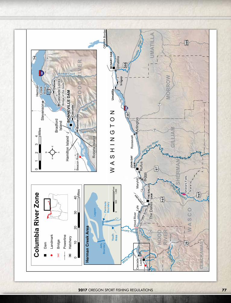
772017 OREGON SPORT FISHING REGULATIONS
WA
SH
IN
GT
ON
HoodRiver
DeschutesRiv
er
John Day River
Umat
illaR
iver
Sandy
Riv
er
Wind River
Cas
cade
Lock
s
Hoo
d R
iver
The
Dal
les
Bigg
s
Arlin
gton
Um
atill
aU
mat
illa
Irrig
on
TOW
ER IS
LAND
POW
ERLINES
Sher
ars
Falls
Ruf
us
OR
/WA
Bord
er
WhiteSalmonR
197
30
197
26
35
14
14
9719
74
395
395
84
Roo
ster
Roc
k
Mt H
ood
Lyle
Mar
yhill
Roo
seve
lt
UM
ATIL
LA
WA
SC
O
MO
RR
OW
GIL
LIA
M
CLA
CK
AM
AS
SHER
MA
N
HO
OD
RIV
ER
MC
NA
RY D
AM
THE
DA
LLES
DA
M
JOH
N D
AYD
AM
Col
umbi
a R
iver
Zon
e
010
2030
40M
iles
Beac
on R
ock
Cas
cade
Loc
ks
BO
NN
EVIL
LE D
AM
Rob
ins
Isla
nd
Brad
ford
Isla
nd
14
Ham
ilton
Isla
nd
Bon
nevi
lleCas
cade
Oxb
ow
Stev
enso
n84 Herman Creek
Eagle Creek
Tanner Creek
Her
man
Cre
ekAr
ea
Brid
ge o
f the
God
s
HO
OD
RIV
ER
01
23
4 Mile
s
Jetty
Boun
dary
Peni
nsul
aBo
unda
ry
Yout
hAr
ea
Lago
on
Herman Cr
Her
man
Cre
ek A
rea
01,
000
500
Feet
Dam
Land
mar
k
Brid
ge
Pow
erlin
eH
atch
ery

78 2017 OREGON SPORT FISHING REGULATIONS
COLUMBIA RIVER ZONE
Oregon
Washington
Youngs Bay
Blind Slough/Knappa Slough
5
10 15
2025 30
35
40
45
Walluski River
Lewis and Clark River
Old 101Bridge
HWY 101Bridge
Alternate HWY 101
Bridge
Tucker Slough
Youngs River
KlaskanineRiver
South Fork
North Fork
Klaskanine Hatchery
CEDC Hatchery
CEDC Net Pen Site
Battle Creek
Slough
Youngs River Falls
1st Falls
Youngs RiverLoop Bridge
0 5 10Miles
0 2 4Miles
Youngs Bay

792017 OREGON SPORT FISHING REGULATIONS
Prai
rie C
hann
el
Karlson Island
Minaker Island
Big C
reek
O r e g o n
Knappa
Slou
gh
Prairie Channel
Gnat Creek
Aldrich PointRoad Bridge
Net Pen SiteBlind Slough
0 1 2Miles
Columbia Control Zone(closed to all salmon fishing
from a floating device)
Red Buoy #446°13’35”N
124°06’50”W
Green Buoy #746°15’09”N
124°06’16”W
46°14’00”N124°03’07”W
End of Exposed South Jetty46°14’03”N
124°04’ 05”W
End of the North Jetty46°15’48”N
124°05’20”W
Columbia Control Zone
Blind Slough / Knappa Slough

2017 OREGON SPORT FISHING REGULATIONS80
MARINE ZONE DescriptionThe Marine Zone consists of the Pacific Ocean, coastal bays, and beaches.
Marine Zone Regulations1. The ocean is separated from rivers and
bays by:a. Normal high tide lines along coastal
beaches, where there are no jetties;b. The visible ends of the jetties, where they
exist, except for the Columbia River;c. A north-south line running through
Buoy 10 in the Columbia River.2. License requirements for those 12 years or
older for this zone are:a. An Oregon angling license is required to
angle for or land any fish species.b. A shellfish license is required to harvest
shellfish or other marine invertebrates.c. Children 12 to 17 years old may obtain
a youth license equivalent to angling, shellfish, and hunting licenses combined (new in 2016).
d. Additional tags or permits are required to harvest salmon, steelhead, sturgeon, Pacific halibut, abalone, scallop or the mechanical harvest of shrimp (see License Information, pages 6-7, and Marine Zone Regulations, pages 81-82).
3. Persons coming ashore in Oregon with ocean caught fish or shellfish are subject to all Oregon sport fishing and licensing regulations.
4. The sport fishing regulations apply within the state’s Fisheries Conservation Zone, which extends 50 miles from shore. In addition, some fisheries are co-managed with the federal government, so the regulations may apply out to 200 miles from shore.
5. All areas are open to harvest except those areas listed in Season (see Marine Zone Regulations, pages 81-82), indicated in Management Designations for Marine Areas (see maps, pages 83-87), or closed by a Public Health Advisory.
6. Shellfish Public Health Advisories (Oregon Dept. of Agriculture):a. Harvest of any species with a shellfish
public health advisory will be closed immediately within the area specified and will remain closed until the advisory is removed;
b. For current information concerning shellfish public health advisories, see page 21 and please call 503-986-4728 or 800-448-2474.
7. Gear: Barbed hooks are allowed when angling for marine fish except as noted for salmon, steelhead and sturgeon.
8. Boat limit: In waters of the Pacific Ocean and in the Columbia River upstream to a line projected from Rocky Point on the Washington bank through Red Buoy 44 to the navigation light at Tongue Point on the Oregon bank, each angler aboard a vessel may continue to use angling gear until the daily limit of fish for all legally licensed and juvenile anglers (age 12 years and older) aboard has been attained. However, no individual angler may exceed any personal daily bag limit or land fish that contribute to another angler’s limit (anglers who have
retained a species limit must pass their rod to an angler who has not reached a limit prior to the fish being landed (netted or boated), or release the fish).
9. Multi-species restrictions: It is unlawful for any person to fish for, or take and retain any species of salmon, Pacific halibut or marine fish while possessing on board any species not allowed to be taken in the area at that time.
10. Mutilation: It is unlawful for anglers fishing from a boat to mutilate fish so that size or species cannot be determined prior to landing or to transport mutilated fish across state waters, except albacore may be partially cleaned at sea. Partial cleaning means only the head and entrails may be removed; both the clavicle (collar) and the tail must stay intact. It is also unlawful for anglers fishing from shore to mutilate catch so that size or species cannot be determined prior to reaching their automobile or principle means of land transportation, and having completed their daily angling. These restrictions do not apply to herring, anchovy, smelt and sardine.
Harvest Caps and In-Season ChangesAnnual state and federal caps are set for sport fisheries including black rockfish, yelloweye rockfish, canary rockfish, cabezon, greenlings and others. When a species harvest cap is reached or is being approached, regulations may be changed in-season to stop or slow the harvest of that species. In-season changes may include (but are not limited to) reduced bag limits, a change in size limits, non-retention of a particular species, area closures and season closures. Check the regulations before you fish on ODFW’s website or by calling a Marine Resources Program office.
ODFW Fishing Regulations: www.dfw.state.or.us/resources/fishing
Marine Resources Program website: www.dfw.state.or.us/MRP
Marine Resources Program offices: • Newport (541) 867-4741• Charleston (541) 888-5515• Astoria (503) 325-2462• Brookings (541) 412-7364
CONTACT INFORMATION

2017 OREGON SPORT FISHING REGULATIONS 81
MARINE ZONE REGULATIONSFINFISH SPECIES DAILY LIMIT SIZE LIMITS, HARVEST METHODS, AND OTHER SPECIFICATIONS SEASON
Groundfish GroupLingcod (including green-colored lingcod) 2 fish.
Bag limit, season, and area regulations subject to change in-season. Check www.dfw.state.or.us/resources/fishing or call (541) 867-4741 before you fish. • 22 inch minimum length for lingcod.• 16 inch minimum length for cabezon.• 10 inch minimum length for greenling.• May be taken by angling, hand, bow and arrow, spear, gaff hook,
snag hook and herring jigs.• When Pacific halibut are onboard the fishing vessel during all-
depth halibut openers, no species from the groundfish group may be taken and retained, possessed or landed, except sablefish, other flatfish, and Pacific cod, in areas north of Humbug Mountain.
• It is unlawful to remove the fins or tail from a shark, except spiny dogfish, at any time. The fins and tail must remain attached and disposed with the carcass.
Waters open all year, 24 hours per day, unless noted under "Management Designations for Marine Areas" (pages 83-87).
Exceptions:
• Ocean closed Apr 1 - Sep 30 outside of a line approximating the 30-fathom curve, as defined by waypoints.
• Cabezon retention prohibited Jan 1 - Jun 30.
Rockfish (“sea bass,” “snapper”), Greenling (“sea trout”), Pacific Cod, Cabezon, Skates, Spiny Dogfish, Leopard Shark, Soupfin Shark, Topsmelt, Jacksmelt, and other marine species not listed on page 81.
7 fish in aggregate, of which only 1 may be a cabezon, only 1 may be a canary rockfish, and no more than 3 may be blue rockfish. Retention of yelloweye, China, quillback, and copper rockfish is prohibited.
Flatfish (flounders, soles, sanddabs, turbots, and halibuts except Pacific halibut)
25 fish in aggregate.
Surfperch (includes all marine perch species) 15 fish in aggregate. May be taken by angling, hand, bow and arrow, spear, gaff hook,
snag hook and herring jigs.
Waters open all year, 24 hours per day, unless noted under "Management Designations for Marine Areas" (pages 83-87).
Herring, Anchovy, Sardine, and true smelts (topsmelt and jacksmelt are part of the 7-fish bag limit)
25 pounds in aggregate.
• May be taken by dip net, cast net, angling and herring jigs.• Unless specifically authorized under emergency rules, it is
unlawful to take or attempt to take eulachon smelt in inland waters including: bays, estuaries, rivers and streams. See Marine Sport Fish Identification Key at: www.odfw.com/MRP/FishID.
Offshore Pelagic Species: Includes all tuna and mackerel species, swordfish, billfish, jacks (family Carangidae), opah, dorado, pomfret, and all sharks except leopard shark, spiny dogfish, and soupfin shark.
25 fish in aggregate. White shark, basking shark, mega-mouth shark, and oceanic whitetip shark are prohibited and must be immediately released unharmed.
• May be taken by angling, hand, bow and arrow, spear, gaff hook, snag hook, and herring jigs.
• Methods described below are only allowed when fishing outside of 3 miles from shore for offshore pelagic species. Only offshore pelagic species may be in possession, and any other species caught must be immediately released while using these methods.
» Chumming is allowed. Chum may be live, dead, or cut up squid, herring, sardine, anchovy, smelt, or Pacific mackerel.
» No restriction on the number of rods or lines fished per angler.• It is unlawful to remove the fins or tail from a shark, except spiny
dogfish, at any time. The fins and tail must remain attached and disposed with the carcass.
Striped Bass and/or Hybrid Bass
2 fish in 24 consecutive hours.
• May be taken by angling.• 24 inch minimum length.
Sturgeon Catch-and-release only.
• Closed to retention of White Sturgeon and Green Sturgeon.• Angling restricted to one single-point, barbless hook for sturgeon. Open all year.
Salmon and Steelhead
• Ocean salmon and steelhead seasons and restrictions are set each April by the Pacific Fishery Management Council. Regulations are published each May and are available from license agents.
• Columbia Control Zone (see page 79) is closed to all salmon fishing from a floating device.• See Northwest and Southwest Zones for seasons and regulations for salmon inside bays and estuaries.• See Northwest Zone, Tillamook Bay, for description of control zone off Tillamook Bay.• No more than 2 single point barbless hooks allowed at all times when fishing for salmon in the ocean or when
fishing for other species if a salmon has already been retained.• Check for new regulations before fishing: Ocean Salmon Hotline at (800) 662-9825 or the ocean salmon website
at www.dfw.state.or.us/MRP/salmon.
Pacific Halibut
• May be taken by angling with a single line, no more than 2 hooks; and by spear.• Pacific halibut seasons are managed and enforced based on port of landing. Halibut may only be landed at ports
located within areas currently open to halibut retention regardless of the area of catch.• During all-depth halibut openers, when Pacific halibut are onboard the vessel, no species from the groundfish
group may be taken and retained, possessed or landed, except sablefish, other flatfish, and Pacific cod, in areas north of Humbug Mountain.
• Catch limits and seasons are set in March and published in May but may change on short notice. In-season changes to regulations are available from 1) ODFW offices in Newport, Charleston, Astoria (see contact information on page 80); 2) the MRP website www.dfw.state.or.us/mrp; or 3) by calling (800) 662-9825 - press #7. Check regulations before you fish.

2017 OREGON SPORT FISHING REGULATIONS82
MARINE ZONE MARINE ZONE REGULATIONS
INVERTEBRATE SPECIES DAILY LIMIT SIZE LIMITS, HARVEST METHODS, AND OTHER SPECIFICATIONS SEASON
Razor Clams First 15 dug (no sorting or releasing)
• Razor clams may be taken by hand, shovel, clam gun or tube with opening no less than 4” (cylindrical) or 4” X 3” (elliptical).• All other clams may be taken by hand or hand-powered tools.• All razor, gaper, piddock and softshell clams must be retained regardless of size or condition.• Other species may be returned to the immediate digging area if they are unbroken.• Each digger must have their own container, dig their own clams, and may not possess more than one limit of clams while in the clam digging area except under an Oregon Disabilities Hunting and Fishing Permit (see Permit Information on page 9).• See Advisories and Consumption Guidelines for softshell and gaper clams on page 21.
Waters open all year, 24 hours per day
Exceptions:
• Razor clams are closed Jul 15 to Sep 30 north of Tillamook Head (Clatsop County)
Bay Clams (butter, littleneck, gaper, and cockle)
20 in aggregate, only 12 may be gapers.
Purple Varnish Clams 72
Other Clams: (softshell, piddocks and others not listed)
36 in aggregate
Dungeness Crab 12 (males only) • 5-3/4" minimum size for Dungeness crab.• Correct size is measured as a straight line across the back (caliper measurement) in front of, but not including the points (see photo on page 96).• May be taken using crab rings, baited lines, or pots (limited to 3 rings/lines/pots total, per person); by hand, dip net, or rake.• Pots may be left overnight.• Holding pots or devices, or live boxes are only allowed in bays and estuaries, and may not hold more than two daily limits.• Unlawful to mutilate crabs prior to landing, such that size, sex, or species may not be determined. Mutilated crabs may not be transported across state waters.
Waters open all year, 24 hours per day
Exceptions:
• Ocean waters are closed for Dungeness Crab Oct 16 - Nov 30• Bays, beaches, estuaries, tide pools, piers and jetties are open for crabbing all year, 24 hours per day
Red Rock Crab 24 of any size or sex.
Oysters No harvest allowed. • Take of native oysters is prohibited. All cultured oysters are private property and may not be taken without the owner's consent. Closed.
Abalone 1 (annual limit = 5)
• Special permit required for abalone and scallops (permit may be obtained at the ODFW Newport, Charleston or Astoria offices; see contact information on page 80); catch record must be submitted to ODFW to receive permit for next year.• Abalone may only be taken with abalone iron.• 8” minimum shell size for abalone.• Abalone harvesters must carry a caliper-measuring gauge with fixed arms at 8” gap for placing over abalone shell.• Scallops may be taken by hand or hand-powered tools.• Abalone and scallops brought ashore shall be whole and in a condition that size may be determined.• Abalone and scallops must not be removed from their shell in the field, except when prepared for immediate consumption.
Waters open all year, 24 hours per day
Scallops 24
Mussels 72 May be taken by hand or hand-powered tools.Shrimp (edible) 20 lbs in the shell May be taken by traps, pots, or rings.
Sand and Mole Crabs, Kelp and Sand Worms, Mud and Ghost Shrimp
No limit.
• May be taken by hand or hand-powered tools.• Permit required to harvest mud and ghost shrimp by mechanical methods (permit may be obtained at the ODFW Newport office; see contact information on page 80).
Octopus 1 May be taken by angling, dip net, pot, hand and hand-powered tools.
Squid No limit. May be taken by angling, (squid jigs and herring jigs allowed), dip net, cast net, hand, and hand powered tools.
Starfish, Urchins, Snails, Shore Crabs, and all other marine invertebrates not listed
10 in aggregate.• May be taken by hand or hand-powered tools.• Unwanted marine invertebrates must be immediately released unharmed.

2017 OREGON SPORT FISHING REGULATIONS 83
MANAGEMENT DESIGNATIONS FOR MARINE AREAS Haystack Rock Marine Garden (Inset 1)No take of shellfish and marine invertebrates, except single mussels may be taken for bait. Located within a 300 yard radius around the base of Haystack Rock, Cannon Beach, Clatsop County. Includes tide pools, and rocky or sandy beaches between extreme high and low tides.
Cape Falcon Marine Reserve and Marine Protected Areas (MPA) (Inset 2)• Marine Reserve: No take of any fish, invertebrates,
seaweeds or wildlife. No deployment of fishing gear. You may transit or anchor with catch on board.
• West MPA: You may take salmon (by troll) and crab.• Shoreside MPA: Angling from shore is allowed.• Shoreline Area: Harvest above the low tide line is
severely restricted along rocky shores south of the Shoreside MPA.
• These are summary rules. For complete rules and site boundary coordinates visit oregonmarinereserves.com/rules or call ODFW at (541) 867-4741.
Three Arch Rocks (Oceanside) (Inset 3)Closed to boats within a 500 foot radius around Finley Rock, Middle Rock, Shag Rock and Seal Rock from May 1 - Sep 15 by authority of the Oregon State Marine Board.
Netarts Bay Shellfish Preserve (Inset 4)No take of clams in posted shellfish preserve, which extends from an east-west line beginning at the mouth of Whiskey Creek to an east-west line 900 yards south.
Cape Kiwanda Marine Garden (Inset 5)No take of shellfish and marine invertebrates, except single mussels may be taken for bait. Located between the sandy beaches on the north and south sides of Cape Kiwanda and includes tide pools, and rocky or sandy beaches between extreme high and low tides. Includes rocky areas abutting the sand beaches on the north and south sides of the headland.
For a complete list of Marine Reserve and Marine Protected Area boundary coordinates visit: oregonmarinereserves.com/rules
Astoria
Cannon Beach
Pacific City
Tillamook
Garibaldi
£¤26
£¤101£¤101
Three Arch Rocks
Marine ReserveMarine Protected AreaMarine GardenVessel Closure AreaShellfish PreserveState Park
Cape Kiwanda
HaystackRock
0 0.5Miles
Oceanside
Netarts
0 2Miles
to Pacific
City
0 0.5 1Miles
£¤101
0 0.5 1Miles
0 1 2Miles
Cannon Beach
Cape Lookout
E
Cape FalconMarine Reserve
Wes
t MPA
Shor
elin
e M
PA
Netarts Bay
Management Designations For Marine Areas
Whiskey C
reek
Inset 1
Inset 2
Inset 3
Inset 4
Inset 5

2017 OREGON SPORT FISHING REGULATIONS84
MANAGEMENT DESIGNATIONS FOR MARINE AREAS Cascade Head Marine Reserve and Marine Protected Areas (MPA) (Inset 6)• Marine Reserve: No take of any fish,
invertebrates, seaweeds or wildlife. No deployment of fishing gear. You may transit or anchor with catch on board.
• North MPA: You may take salmon (by troll) and crab. You may take groundfish using hook and line from a private, non-chartered boat.
• West MPA: You may take salmon (by troll) and crab.
• South MPA: No use of net gear. You can participate in all other legal take.
• Shoreline Area: Harvest above the low tide line is severely restricted along rocky shores in the North MPA and on the north end of the Marine Reserve.
• These are summary rules. For complete rules and site boundary coordinates visit oregonmarinereserves.com/rules or call ODFW at (541) 867-4741.
Boiler Bay Research Reserve (Inset 7)No take of shellfish and marine invertebrates, except abalone, clams, Dungeness crab, red rock crab, mussels, piddocks, scallops and shrimp may be taken. Applies to all rocky areas, tide pools, and sandy beaches between extreme high and low tides, within the following boundaries:• North Boundary: a line due west from the mouth
of Fogarty Creek.• South Boundary: a line due west from the
westernmost tip of Government Point at Boiler Bay State Wayside.
Pirate Cove Research Reserve (Inset 7)No take of shellfish and marine invertebrates below the extreme high tide line and east of a line drawn across the mouth of the cove, as defined by points at: A) 44°49.083’N., 124°04.035’W. and B) 44°49.146’N., 124°04.060’W.
Whale Cove Habitat Refuge (Inset 8)No take of fish, shellfish and marine invertebrates in all areas in Whale Cove below extreme high tide east of a line drawn across the mouth of the cove, as defined by points at: A) 44°47.237’N., 124°04.298’W. and B) 44°47.367’N., 124°04.320’W.
For a complete list of Marine Reserve and Marine Protected Area boundary coordinates visit: oregonmarinereserves.com/rules
£¤101
Yaquina Head
Depoe Bay
£¤101
BA
Boiler Bay State Wayside
Depoe Bay
£¤101
Boiler BayResearchReserve
Cascade Head
Pirate CoveResearchReserve
LincolnCity
Marine ReserveMarine Protected AreaResearch ReserveHabitat RefugeState Park E
NorthMPA
Cascade Head
Marine Reserve
Cascade Head
Whale CoveHabitat Refuge
£¤101
Rocky CreekState Wayside
B
A
0 10.5Miles
0 10.5Miles
0 0.50.25Miles
Devil'sLake
SouthMPA
Marine Reserve
NorthMPA
SouthMPA
Wes
t MPA
Management Designations For Marine Areas
Roads End State Recreation Site
NW30th
Street
Inset 6
Inset 7
Inset 8

2017 OREGON SPORT FISHING REGULATIONS 85
Inset 11
Inset 12
Inset 9
Inset 10
Otter Rock Marine Garden (Inset 9)No take of shellfish and marine invertebrates, except single mussels may be taken for bait. Northern boundary extends from the highest point at Cape Foulweather to the southern boundary at Devil’s Punchbowl. Includes tide pools, and rocky or sandy beaches between extreme high and low tides. Where the marine garden overlaps with Otter Rock Marine Reserve, no take is allowed.
Otter Rock Marine Reserve (Inset 9)• No take of any fish, invertebrates, seaweeds or
wildlife. No deployment of fishing gear. You may transit or anchor with catch on board.
• Shoreline Area: No take from a line west from Gull Rock, south past Devil’s Punch Bowl State Park.
• These are summary rules. For complete rules and site boundary coordinates visit oregonmarinereserves.com/rules or call ODFW at (541) 867-4741.
Yaquina Head Marine Garden (Inset 10)No take of shellfish and marine invertebrates, except single mussels may be taken for bait. Includes all rocky areas, tide pools, and sandy beaches between extreme high and low tides lying between the sandy beaches on the north and the south sides of Yaquina Head. Includes rocky areas abutting the sandy beaches on the north and south sides of the headland.
Yaquina Shellfish Preserve (Inset 11)No take of clams in posted shellfish preserve, which is the tideflat on the north side of the Yaquina Bay commercial marina breakwater.
Stonewall Bank Yelloweye Rockfish Conservation Area (YRCA) (Inset 12)No take of Pacific halibut, lingcod, flatfish species, or any other species from the groundfish group listed under the seven fish marine daily limit in the table on page 81.

2017 OREGON SPORT FISHING REGULATIONS86
MANAGEMENT DESIGNATIONS FOR MARINE AREAS Yachats Marine GardenNo take of shellfish and marine invertebrates. Includes all rocky areas, tide pools, and sandy beaches between extreme high and low tides located between the north and south boundaries of Yachats State Park.
Cape Perpetua Marine GardenNo take of shellfish and marine invertebrates, except razor clams may be taken in the sandy beach area that does not overlap with the marine reserve. Includes all rocky areas, tide pools, and sandy beaches between extreme high and low tides lying between the north side of Devil’s Churn and the north boundary of Neptune State Park.
Neptune State Park Research Reserve• No take of shellfish and marine invertebrates, except abalone,
clams, Dungeness crab, red rock crab, mussels, piddocks, scallops and shrimp may be taken. Applies to all rocky areas, tide pools, and sandy beaches between extreme high and low tides lying between the northerly and southerly boundaries of the northern parcel of Neptune State Park.
• No take of shellfish or marine invertebrates where the research reserve overlaps with Cape Perpetua Marine Reserve.
Cape Perpetua Marine Reserve and Marine Protected Areas (MPA)• Marine Reserve: No take of any fish, invertebrates, seaweeds
or wildlife. No deployment of fishing gear. You may transit or anchor with catch on board.
• North MPA: Angling from shore is allowed. You may also take salmon (by troll) and crab.
• Southeast MPA and Seabird Protection Area: No take of herring, sardine, anchovies, smelt, and sand lance. Plus, no take of squid in the Southeast MPA.
• Shoreline Area: Harvest above the low tide line is severely restricted along rocky shores in the North MPA and in the Marine Reserve north of Bob Creek.
• These are summary rules. For complete rules and site boundary coordinates visit oregonmarinereserves.com/rules or call ODFW at (541) 867-4741.
For a complete list of Marine Reserve and Marine Protected Area boundary coordinates visit: oregonmarinereserves.com/rules
£¤101
Neptune State Park
Siuslaw River
Florence
Bob CreekWayside
YachatsState Park
£¤101
Heceta Head
Carl G. WashburneMemorialState Park
Marine Reserve
Marine Protected Area
Seabird Protection Area
Marine Garden
Marine Garden (Razor Clam Area)
Intertidal Research Reserve
State Park
ETenmile Creek State Wayside
0 10.5Miles
Management Designations For Marine Areas
MarineReserve
NorthMPA
Seab
ird P
rote
ctio
n A
rea
Sout
heas
t MPA
Nor
th M
PAC
ape
Perp
etua
Mar
ine
Res
erve
NeptuneState Park
Cape PerpetuaMarine Garden
Neptune StatePark Research
Reserve
Yachats Marine Garden
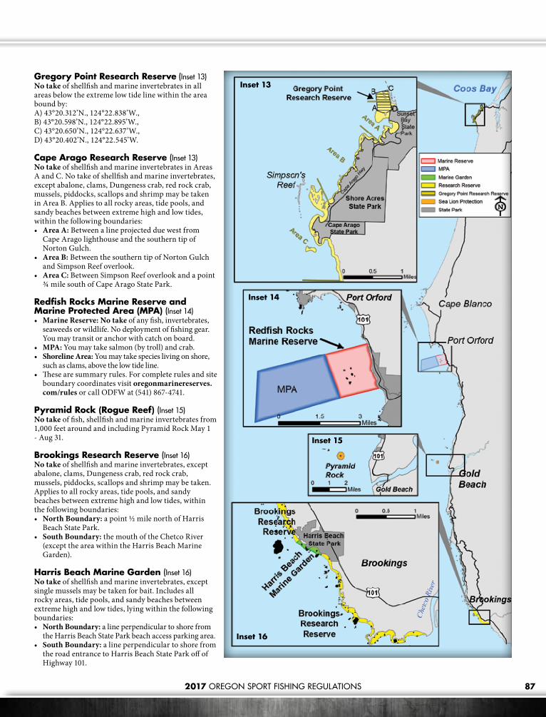
2017 OREGON SPORT FISHING REGULATIONS 87
Gregory Point Research Reserve (Inset 13)No take of shellfish and marine invertebrates in all areas below the extreme low tide line within the area bound by:A) 43°20.312’N., 124°22.838’W., B) 43°20.598’N., 124°22.895’W., C) 43°20.650’N., 124°22.637’W., D) 43°20.402’N., 124°22.545’W.
Cape Arago Research Reserve (Inset 13)No take of shellfish and marine invertebrates in Areas A and C. No take of shellfish and marine invertebrates, except abalone, clams, Dungeness crab, red rock crab, mussels, piddocks, scallops and shrimp may be taken in Area B. Applies to all rocky areas, tide pools, and sandy beaches between extreme high and low tides, within the following boundaries: • Area A: Between a line projected due west from
Cape Arago lighthouse and the southern tip of Norton Gulch.
• Area B: Between the southern tip of Norton Gulch and Simpson Reef overlook.
• Area C: Between Simpson Reef overlook and a point ¾ mile south of Cape Arago State Park.
Redfish Rocks Marine Reserve and Marine Protected Area (MPA) (Inset 14)• Marine Reserve: No take of any fish, invertebrates,
seaweeds or wildlife. No deployment of fishing gear. You may transit or anchor with catch on board.
• MPA: You may take salmon (by troll) and crab.• Shoreline Area: You may take species living on shore,
such as clams, above the low tide line.• These are summary rules. For complete rules and site
boundary coordinates visit oregonmarinereserves.com/rules or call ODFW at (541) 867-4741.
Pyramid Rock (Rogue Reef) (Inset 15)No take of fish, shellfish and marine invertebrates from 1,000 feet around and including Pyramid Rock May 1 - Aug 31.
Brookings Research Reserve (Inset 16)No take of shellfish and marine invertebrates, except abalone, clams, Dungeness crab, red rock crab, mussels, piddocks, scallops and shrimp may be taken. Applies to all rocky areas, tide pools, and sandy beaches between extreme high and low tides, within the following boundaries:• North Boundary: a point ½ mile north of Harris
Beach State Park. • South Boundary: the mouth of the Chetco River
(except the area within the Harris Beach Marine Garden).
Harris Beach Marine Garden (Inset 16)No take of shellfish and marine invertebrates, except single mussels may be taken for bait. Includes all rocky areas, tide pools, and sandy beaches between extreme high and low tides, lying within the following boundaries:• North Boundary: a line perpendicular to shore from
the Harris Beach State Park beach access parking area.• South Boundary: a line perpendicular to shore from
the road entrance to Harris Beach State Park off of Highway 101.
Inset 13
Inset 14
Inset 15
Inset 16

2017 OREGON SPORT FISHING REGULATIONS88
cut here
Fish and Wildlife Transfer Record
Person Transferring Fish or Wildlife:
Name: __________________________________________________________________ Phone: _____________________________________
Address: ____________________________________________________________________________________________________________
License Number: ___________________________________________Tag Number:________________________________________________
Location and Date: ____________________________________________________________________________________________________
Fish Species Transferred:
☐ Coho salmon
☐ Chinook salmon
☐ Steelhead
☐ Trout
☐ Other
Wildlife Species Transferred:
☐ Deer
☐ Elk
☐ Bear
☐ Cougar
☐ Other
Species Condition:
☐ Entire carcass
☐ Parts
Transferred to:
Name: __________________________________________________________________ Phone: _____________________________________
Address: ____________________________________________________________________________________________________________
TRANSFER OF FISH AND SHELLFISHFish and shellfish (whole or parts, including fish eggs) which have been taken for personal use and then given or shipped to another person must be accompanied by the following information or you may complete the Fish and Wildlife Transfer Record below:1. Kind and number of fish or shellfish transferred;2. Date fish or shellfish were caught;3. Name, address, Angling License or Shellfish License number, and Combined Harvest or Hatchery Harvest tag number (if applicable) of the
person who caught the fish or shellfish.
The above information must also be provided to the wholesale fish or bait dealer when eggs from ocean-caught salmon are sold.

89
COMBINED ANGLING TAG INSTRUCTIONSFISH SPECIES CODES
CODES SPECIES OF FISH
1Chinook Fin-Clipped (Hatchery) (king or blackmouth) — has black lower gum line
1WChinook Unmarked (Wild) (king or blackmouth) — has black lower gum line
2 Coho Fin-Clipped (Hatchery) (silver) — has white lower gum line
2W Coho Unmarked (Wild) (silver) — has white lower gum line
3 Other Salmon — Pink (humpy); Chum (dog); or Sockeye
6 Steelhead Fin-Clipped (Hatchery)
6W Steelhead Unmarked (Wild)
7 White Sturgeon — gray with uniform pale belly
9 Halibut
Instructions for Completing Salmon, Steelhead, Sturgeon, and Halibut Combined Angling TagSalmon, Steelhead, Sturgeon and Halibut Anglers: Upon taking an adult salmon, steelhead, legal size sturgeon, or Pacific halibut, the angler must immediately enter the codes for the species caught, ocean port or stream, and the month and day of catch. Record fish in consecutive order. Use only 1 line per fish. Sturgeon and Pacific halibut anglers must record the fish length in inches. Jack salmon are not required to be tagged. Entries must be recorded in ball point pen! No erasures allowed!
Return expired Combined Angling Tags (tags) to help ODFW manage the fisheries and estimate total harvest.
Return to ODFW, 4034 Fairview Industrial Drive SE, Salem, OR 97302-1142 or deposit with any ODFW license agent.
Example of a Coded Entry W hile fishing on the Lower Rogue River on January 25, a fin-clipped Chinook then an unmarked Steelhead are taken. At Tahkenitch Lake, on December 30, a wild Coho is taken.
SPECIES LOCATION LENGTH (INCHES) MONTH DAY
1 225 36 1 25
6W 225 28 1 25
2W 93 30 12 30

2017 OREGON SPORT FISHING REGULATIONS90
COMBINED ANGLING TAG LOCATION CODES
CODE WATERBODY21 Alsea R. & Bay22 North Fk. Alsea R.23 South Fk. Alsea R.24 Applegate R.25 Beaver Cr. (Lincoln Co.)26 Beaver Cr. (Tillamook Co.)27 Big Cr. (Lane Co.)28 Big Elk Cr. (Yaquina R.)29 Brush Cr. (Curry Co.)30 Cape Cr.31 Chetco R. & Bay32 Cook Cr. (Nehalem R.)33 Coos R. & Bay34 South Fk. Coos R.35 Coquille R. & Bay36 North Fk. Coquille R.37 East Fk. Coquille R.38 South Fk. Coquille R.39 Middle Fk. Coquille R.52 Cow Cr.40 Cummins Cr.42 Deadwood Cr. (Siuslaw R.)43 Drift Cr. (Alsea R.)44 Drift Cr. (Siletz R.)45 Eel Cr. & Lake46 Elk Cr. (Clatsop Co.)47 Elk R.48 Euchre Cr.49 Fall Cr. (Alsea R.)50 Five R. (Alsea R.)51 Floras Cr.54 Hunter Cr.55 Illinois R.
CODE WATERBODY240 Isthmus Slough56 Indian Cr. (Siuslaw R.)57 Kilchis R.58 Lake Cr. (Siuslaw R.)60 Miami R.61 Middle Cr. (Coquille R.)62 Millicoma R.63 East Fk. Millicoma R.64 West Fk. Millicoma R.65 Necanicum R.66 Nehalem R. & Bay below Hwy. 26/
Elsie204 Nehalem R. above Hwy 26/Elsie67 North Fk. Nehalem R.
224 Neskowin Cr.69 Nestucca R. & Bay70 Little Nestucca R.51 New R.71 Pistol R.72 Rock Cr. (Lane Co.)73 Rock Cr. (Nehalem R.)74 Rock Cr. (Siletz R.)
225 Rogue Bay up to Elephant Rock226 Rogue R. from Elephant Rock to
Grave Cr.227 Rogue R. from Grave Cr. to Fishers
Ferry Boat Ramp228 Rogue R. above Fishers Ferry Boat
Ramp77 Salmon R. (Coast)78 Salmonberry R.79 Sand Lk.80 Schooner Cr. (Siletz R.)
CODE WATERBODY81 Siletz R. & Bay84 Siltcoos R. & Lk.85 Siuslaw R. & Bay86 North Fk. Siuslaw R.87 Sixes R.89 Smith R.90 North Fk. Smith R.75 Soapstone Cr.92 Sweet Cr. (Siuslaw R.)93 Tahkenitch Cr. & Lake94 Tenmile Cr. & Lake (Coos Co.)95 Tenmile Cr. (Lane Co.)96 Three Rivers97 Tillamook Bay98 Tillamook R.
194 Tioga Cr.99 Trask R.
100 North Fk. Trask R.101 South Fk. Trask R.102 Umpqua R. & Bay103 North Fk. Umpqua R. below
Winchester Dam201 North Fk. Umpqua R. from
Winchester Dam to Rock Cr.219 North Fk. Umpqua R. from Rock
Cr. to Soda Springs (Fly Area)104 South Fk. Umpqua R.105 Wilson R.106 South Fk. Wilson R.107 Little North Fk. (Wilson R.)108 Winchuck R.110 Yachats R.111 Yaquina R. & Bay
COASTAL RIVER SYSTEMS
CODE COASTAL PORT OF DEPARTURE1 Astoria18 Gearhart Beach N to Astoria19 Cannon Beach2 Nehalem Bay3 Garibaldi4 Netarts Bay5 Cape Kiwanda & Pacific City
CODE COASTAL PORT OF DEPARTURE6 Salmon River7 Siletz Bay8 Depoe Bay9 Newport10 Waldport11 Florence12 Winchester Bay
CODE COASTAL PORT OF DEPARTURE13 Charleston20 Sunset Bay14 Bandon15 Port Orford16 Gold Beach17 Brookings
OCEAN HARVESTED FISH ONLY (FOR BAYS AND ESTUARIES USE RIVER SYSTEMS CODES)
The R&E Program is funded by anglers through a surcharge on fishing licenses. R&E grants are awarded to organizations and agencies for projects that benefit Oregon’s fisheries and improve fishing opportunities.
R&E projects benefit a diversity of anglers around the state through improvements to angler access (fishing docks and piers), fish habitat and passage, angler and aquatic education and the collection of information for sound fishery management.
If your organization/agency is interested in applying for R&E funding, call 503-947-6232 or visit the website: www.dfw.state.or.us/fish/RE. Find out how your license dollars are improving fishing and fishing access. View and sign up for the bimonthly publication “Fishworks” at orstep-re.com
FISH RESTORATION AND ENHANCEMENT (R&E) PROGRAM

2017 OREGON SPORT FISHING REGULATIONS 91
CODE WATERBODY
187 Alton Baker Canoe Canal (Willamette R.)
114 Bear Cr. (Clatsop Co.)115 Beaver Cr. (Columbia Co.)116 Big Cr. (Clatsop Co.)149 Big Sheep Cr. from mouth to Little
Sheep Cr.223 Blue R. (McKenzie R.)117 Bull Run R.120 Catherine Cr.122 Clackamas R. below Carver Bridge245 Clackamas R. from Carver Bridge to
Bakers Ferry Rd.246 Clackamas R. from Bakers Ferry Rd.
to River Mill Dam247 Clackamas R. from River Mill Dam
to Cazadero Dam123 Clatskanie R.131 Deschutes R. below Sherars Falls203 Deschutes R. above Sherars Falls132 Eagle Cr. (Clackamas. R.)133 Eagle Cr. (Columbia R.)134 Fall Cr. (Willamette R.)209 Little Fall Cr. (Willamette R.)135 Fifteenmile Cr.137 Gales Cr. (Tualatin R.)138 Gnat Cr.231 Grande Ronde R. from Stateline to
Wildcat Bridge232 Grande Ronde R. from Wildcat
Bridge to Island City Bridge233 Grande Ronde R. above Island City
Bridge
CODE WATERBODY140 Herman Cr. (Columbia R.)229 Hood R.144 Imnaha R.208 John Day Arm250 John Day R. (Clatsop Co.)238 John Day R. below Cottonwood
Bridge239 John Day R. above Cottonwood
Bridge146 Middle Fk. John Day R.147 North Fk. John Day R.148 Johnson Cr. (Willamette R.)151 Klaskanine R.152 North Fk. Klaskanine R.153 South Fk. Klaskanine R.150 Knappa / Blind sloughs154 Lewis & Clark R.220 Long Tom R.141 Lost Cr. (Will. R. Middle Fk.)156 Luckiamute R.156 Little Luckiamute R.241 Lookingglass Cr. 157 Marys R. 155 McKenzie R. below Leaburg Dam158 McKenzie R. above Leaburg Dam164 Molalla R.139 Mosby Cr. (Will. R. Coast Fk.)196 Plympton Cr.242 Powder R.165 Rickreall Cr.221 Row R.167 Salmon R. (Sandy R.)
CODE WATERBODY
168 Sandy R. from mouth to Revenue Bridge
205 Sandy R. from Revenue Bridge to Salmon R.
244 Sandy R. above Salmon R.169 Santiam R.170 North Fk. Santiam R.171 Little North Fk. Santiam R.172 South Fk. Santiam R.176 Snake R.183 Springfield Mill Race178 Tanner Cr.180 Tualatin R.236 Umatilla R. below Three-Mile Dam243 Umatilla R. Three-Mile Dam to Nolin237 Umatilla R. above Nolin182 Walla Walla R.234 Wallowa R. mouth to Minam State
Park235 Wallowa R. above Minam State Park184 Wenaha R.203 White R.
185 Willamette R. & Slough below Oregon City Falls
186 Willamette R. above Oregon City Falls
188 Middle Fk. Willamette R.210 Coast Fk. Willamette R.190 Yamhill R.191 North Fk. Yamhill R.192 South Fk. Yamhill R.193 Youngs R. & Bay
COLUMBIA RIVER TRIBUTARIES
CODE WATERBODY211 Buoy 10 to Tongue Pt.212 Tongue Pt. to Longview Bridge213 Longview Bridge to I-5 Bridge
CODE WATERBODY214 I-5 Bridge to Bonneville Dam215 Bonneville Dam to The Dalles Dam216 The Dalles Dam to John Day Dam
CODE WATERBODY217 John Day Dam to McNary Dam218 McNary Dam to Stateline
COLUMBIA RIVER MAINSTEM
STEP was established in 1981 to support the role of volunteers in restoring native stocks of salmon and trout. Volunteer efforts are supported by 11 local STEP biologists, the 13 member Governor appointed Salmon Trout Advisory Committee (STAC), and a STAC Mini-Grant Program.
Volunteer today!
As a STEP volunteer you can:• Improve and restore fish habitat.• Educate fellow Oregonians about salmon and trout.• Assist with research and monitoring.• Help spawn, raise, rear, and release fish from a STEP hatchery.
To learn more or become a STEP volunteer, visit www.dfw.state.or.us/fish/STEP, contact your local ODFW office, or call 503-947-6232. Find out how STEP and volunteers are helping improve fishing. View and sign up for the bimonthly publication “Fishworks” at orstep-re.com
SALMON TROUT ENHANCEMENT PROGRAM (STEP)

2017 OREGON SPORT FISHING REGULATIONS92
Redband Trout
Northern Pikeminnow
White Sturgeon
Coho Salmon (Silver)
Coastal Cutthroat Trout
Rainbow Trout
Bull Trout (Resident)Steelhead
Kokanee/Sockeye spawning colors
Chinook Salmon (King, Blackmouth)
Westslope Cutthroat Trout
Green Sturgeon
Kokanee/Sockeye pre-spawning colors
NATIVE FISH SPECIES
Bull Trout (Migratory)

2017 OREGON SPORT FISHING REGULATIONS 93
Yellow Perch Walleye
Channel Catfish
Striped Bass
Brook Trout Brown Trout
Largemouth Bass
American Shad
Smallmouth Bass
INTRODUCED FISH SPECIES
Lake Trout Atlantic Salmon
Black Bullhead
Black Crappie BluegillRedear Sunfish

2017 OREGON SPORT FISHING REGULATIONS94
SELECT GROUNDFISH SPECIES
Quillback Rockfish• Large dorsal spines with deep notch• "Freckles" on face/head• Yellowish blotch on back• Ocean and estuary species
Copper Rockfish• Large dorsal spines with membrane not
deeply notched• Distinct face stripes• Ocean and estuary species
China Rockfish• Distinct yellow band across body• Yellow speckles on black body• Ocean species
Yelloweye Rockfish• Solid yellow eye• Rounded tail fin, often lined in black• Juveniles have white lines on side• Ocean species
Prohibited (No harvest at any time)
Most Frequently Encountered (Check for seasonal closures)
Black Rockfish• Spots on dorsal fin• Large mouth (jaw past mid-eye)• Ocean and estuary species
Lingcod• Large mouth with sharp teeth• Elongated body• 22 inch minimum size• Ocean and estuary species
Yellowtail Rockfish• Yellow fins• More elongated than other rockfish• Ocean species
Kelp Greenling• Very small mouth• Males may have blue spots• 10 inch minimum size• Ocean and estuary species
Reduced Take (Sub-bag limits; check for seasonal closures)
Canary Rockfish• Grey, "chalky" lateral line• Thin eye band• Notched tail fin• Ocean species
Cabezon• Large head and pectoral fins• Scale-less body• 16 inch minimum size• Ocean and estuary species
Blue Rockfish (Solid Blue)• Small mouth (jaw not past mid-eye)• No spots on dorsal fin• Hump between eyes• Ocean and estuary species
Blue Rockfish (Blotched Blue)• Small mouth (jaw not past mid-eye)• No spots on dorsal fin• Distinct face stripes• Ocean and estuary species

2017 OREGON SPORT FISHING REGULATIONS 95
CHINOOK AND COHO SALMON IDENTIFICATIONCHINOOK (KING) SALMON
MOST RELIABLE FEATURE SECONDARY FEATURE LESS DEPENDABLE FEATURELower jaw is dark or mottled
from outside gums through base of teeth to inside gums.
Tail fin rays are smooth along length of rays.Round, black spots may be present
on both upper and lower lobes of tail. Extremely variable in saltwater.
COHO (SILVER) SALMONMOST RELIABLE FEATURE SECONDARY FEATURE LESS DEPENDABLE FEATURE
Lower jaw is banded from dark outside teeth, to white at base of teeth, to dark inside teeth.
Tail fin rays are ribbed with prominent crosshatching along length of rays.
Round, black spots may be present on upper lobe of tail.
Extremely variable in saltwater.
HOW TO IDENTIFY HATCHERY FISHWILD: NOT FIN-CLIPPED (UNMARKED) HATCHERY: FIN-CLIPPED (MARKED)
Hatchery Salmon, steelhead, and trout are marked by removing their adipose fin.

2017 OREGON SPORT FISHING REGULATIONS96
CLAM AND CRAB IDENTIFICATION
Male Crab
Female Crab
Correct size measurement
(minimum 5¾ inches)
Incorrect size measurement
Dungeness Crab Female crabs have a rounded flap on their underside. Male crabs have an elongated flap. Minimum measurement does not include points.
Gaper Clam(Blue, Empire, Horseneck) Large gape where neck protrudes. Size 3 to 6".
Razor ClamThin, oval shell has a smooth, lacquer-like, light brown coating; typically found on sandy ocean beaches. Size 3 to 6".
Purple Varnish Clam(non-native) Thin, flat, shiny brown shell with external hinge. Interior of shell has purple hue. Size 1½ to 4".
Cockle Shell has prominent, evenly spaced ridges (ribs). Size 1½ to 3".
Littleneck Clam(Steamer) Shell has radiating ribs, lacks deep scalloped edge of cockle. Size 1½ to 2½".
Butter Clam(Martha Washington) Shell has fine concentric lines of growth. Size 2 to 4".
Softshell Clam(Mud) (non-native) Egg shaped shell with concentric rings. Size 2 to 4".
For your safety, call the Oregon Department of Agriculture Shellfish Safety Hotline before harvesting clams or mussels at 1-800-448-2474 or visit: www.oregon.gov/ODA/FSD/pages/shellfish_status.aspx.
BEFORE HARVESTING CLAMS AND MUSSELS
Red Rock CrabNative crab with a red fan-shaped back and large black-tipped claws.
Whatever the road throws at you — from potholes to nails — any road hazard,
our FREE GUARANTEE protects you
WITH EVERY PASSENGER & LIGHT TRUCK TIRE PURCHASE
107 Oregon locations to serve you! Over 470 locations throughout the West • www.LesSchwab.com
Peace of Mind Tire Protection
Lifetime Tire & Mileage Care
TIRES • BATTERIES • BRAKES • SHOCKS • ALIGNMENTS • SUSPENSION • WHEELS