2017 Coastal Master Plan Appendix C:...
28
Coastal Protection and Restoration Authority 150 Terrace Avenue, Baton Rouge, LA 70802 | [email protected] | www.coastal.la.gov 2017 Coastal Master Plan Appendix C: Modeling Chapter 1 – Introduction Report: Final Date: April 2017 Prepared By: The Water Institute of the Gulf
Transcript of 2017 Coastal Master Plan Appendix C:...
Coastal Protection and Restoration Authority 150 Terrace Avenue, Baton Rouge, LA 70802 | [email protected] | www.coastal.la.gov
2017 Coastal Master Plan
Appendix C: Modeling Chapter 1 – Introduction
Report: Final
Date: April 2017
Prepared By: The Water Institute of the Gulf
2017 Coastal Master Plan: Modeling
Page | ii
Coastal Protection and Restoration Authority
This document was prepared in support of the 2017 Coastal Master Plan being prepared by the
Coastal Protection and Restoration Authority (CPRA). CPRA was established by the Louisiana
Legislature in response to Hurricanes Katrina and Rita through Act 8 of the First Extraordinary
Session of 2005. Act 8 of the First Extraordinary Session of 2005 expanded the membership, duties,
and responsibilities of CPRA and charged the new authority to develop and implement a
comprehensive coastal protection plan, consisting of a master plan (revised every five years)
and annual plans. CPRA’s mandate is to develop, implement, and enforce a comprehensive
coastal protection and restoration master plan.
Suggested Citation:
Meselhe, E., Reed, D. J., and Grace, A. O. (2017). 2017 Coastal Master Plan: Appendix C:
Modeling Chapter 1 – Introduction. Version Final. (p. 28). Baton Rouge, Louisiana: Coastal
Protection and Restoration Authority.
2017 Coastal Master Plan: Modeling
Page | iii
Acknowledgements
The authors would like to thank the entire 2017 Coastal Master Plan modeling team (listed in
Chapter 1), the Predictive Models Technical Advisory Committee (PM-TAC), external reviewers,
and the Planning Tool team for their contributions to this effort. Thanks also go to Jennifer Butler,
Jeff Heaton, Marla Muse-Morris, and Mark Legendre for contractual support and management,
and to Taylor Kimball for editorial support. Lastly, the authors would like to thank Natalie
Peyronnin, Mark Leadon, and Ed Haywood for contributions during early phases of the model
improvement planning effort and Brian Harper for his contributions to early phases of the PM-
TAC.
This effort was funded by the Coastal Protection and Restoration Authority (CPRA) of Louisiana
under Cooperative Endeavor Agreement Number 2503-12-58, Task Order No. 03.
2017 Coastal Master Plan: Modeling
Page | iv
Executive Summary
Coastal Louisiana has experienced dramatic land loss since at least the 1930’s. A combination
of natural processes and human activities has resulted in the loss of over 1,880 square miles since
the 1930’s and a current land loss rate of 16.6 square miles per year. Not only has this land loss
resulted in increased environmental, economic, and social vulnerability, but these vulnerabilities
have been compounded by multiple disasters, including hurricanes, river floods, and the 2010
Deepwater Horizon oil spill, all of which have had a significant impact on the coastal
communities in Louisiana and other Gulf coast states. To address this crisis the 2007 Coastal
Master Plan was developed under the direction of the Louisiana Legislature. 2012 marked the
first five-year update to the plan, and the second update is scheduled for 2017.
A number of substantial revisions have been made in preparation for the 2017 Coastal Master
Plan modeling effort. Chapter 1 provides an overview of the modeling improvements and other
components of the Master Plan with which the modeling is associated. Brief descriptions of
project modeling and the interaction of the modeling with the Planning Tool are included, as is
an overview of the external peer review of the 2012 modeling tools and the 2017 model
improvement planning process. Lastly, Chapter 1 provides information on the Predictive Models
Technical Advisory Committee (PM-TAC), external reviews, and a comprehensive list of 2017
Coastal Master Plan modeling team members.
Additional details for the modeling components are provided in a series of attachments.
2017 Coastal Master Plan: Modeling
Page | v
Table of Contents
Coastal Protection and Restoration Authority ............................................................................................ ii
List of Tables ....................................................................................................................................................... vi
List of Figures ...................................................................................................................................................... vi
List of Abbreviations ........................................................................................................................................ vii
Chapter 1: Introduction ................................................................................................................................... 1
1.0 Louisiana’s Coastal Master Plan Overview and Purpose ................................................................. 1
2.0 2012 Coastal Master Plan Modeling .................................................................................................... 2
3.0 Modeling Improvements ........................................................................................................................ 4
4.0 2017 Coastal Master Plan Technical Components ........................................................................... 5 4.1 Modeling ................................................................................................................................................... 5 4.2 Project Information .................................................................................................................................. 7 4.3 Planning Tool ............................................................................................................................................. 8
5.0 Model Review ........................................................................................................................................... 9 5.1 2012 Coastal Master Plan ....................................................................................................................... 9 5.2 2017 Coastal Master Plan Predictive Models Technical Advisory Committee ............................ 9 5.3 2017 External Review ............................................................................................................................. 10
6.0 2017 Modeling Team ............................................................................................................................. 11
7.0 Structure of Appendix C ....................................................................................................................... 16
8.0 References .............................................................................................................................................. 19
2017 Coastal Master Plan: Modeling
Page | vi
List of Tables
Table 1: Project Information for Evaluation by the Modeling Tools. ........................................................ 7
Table 2: 2017 Coastal Master Plan Modeling Team Members. .............................................................. 11
List of Figures
Figure 1: 2012 Coastal Master Plan Predictive Models. ............................................................................. 2
Figure 2: Coastal Components and Processes Represented by the Integrated Compartment
Model (ICM). ...................................................................................................................................................... 6

2017 Coastal Master Plan: Modeling
Page | vii
List of Abbreviations
ADCIRC Advanced Circulation
BIMODE Barrier Island Model
CLARA Coastal Louisiana Risk Assessment
CPRA Coastal Protection And Restoration Authority
EAD Expected Annual Damage
EwE Ecopath With Ecosim
FEMA Federal Emergency Management Agency
HSI Habitat Suitability Index
ICM Integrated Compartment Model
LACPR Louisiana Coastal Protection and Restoration
LCWCRTF Louisiana Coastal Wetlands Conservation and Restoration Task Force
PM-TAC Predictive Models Technical Advisory Committee
SWAN Simulating Waves Nearshore
TAC Technical Advisory Committee
USACE U.S. Army Corp Of Engineers
USGS U.S. Geological Survey
2017 Coastal Master Plan: Modeling
Page | 1
Chapter 1: Introduction
1.0 Louisiana’s Coastal Master Plan Overview and Purpose
Coastal Louisiana has experienced dramatic land loss since at least the 1930’s (Couvillion et al.
2011). A combination of natural processes and human activities has resulted in the loss of over
1,880 square miles since the 1930’s and a current land loss rate of 16.6 square miles per year
(Couvillion et al. 2011). Not only has this land loss resulted in increased environmental, economic,
and social vulnerability, but these vulnerabilities have been compounded by multiple disasters,
including hurricanes, river floods, and the 2010 Deepwater Horizon oil spill, all of which have had
a significant impact on the coastal communities in Louisiana and other Gulf coast states. For
example, nine of the 10 costliest U.S. hurricanes have impacted a portion of the Gulf coast, and
six of these have occurred in the last decade (Blake, Landsea, and Gibney, 2011). Hurricane
Katrina resulted in at least $105 billion in direct property damages (Blake, Landsea, and Gibney,
2011).
Decades of planning have focused on addressing either risk reduction or coastal restoration, or
only on specific regions of coastal Louisiana (e.g., Coast 2050 [LCWCRTF, 1998]; LACPR [USACE,
2009]; Morganza PAC [USACE, 2013]). It was not until the hurricanes of 2005 that planning efforts
began to integrate coastal restoration planning with coastal protection planning. Under the
direction of the Louisiana Legislature, the 2007 Coastal Master Plan was developed, and for the
first time in Louisiana, emphasis on coordinated storm protection and coastal restoration
planning was outlined. The Coastal Protection and Restoration Authority of Louisiana (CPRA), the
state entity responsible for the planning, designing and implementation of coastal protection
and restoration projects, is tasked by the Louisiana Legislature to update the master plan every 5
years. For the first update in 2012, CPRA focused on expanding the technical analysis to identify
specific projects: those that represent sound investments for Louisiana considering resource and
funding constraints and uncertain future conditions. The 2012 Coastal Master Plan built on
previous efforts by including a detailed assessment of the future without action and an objective
evaluation of the performance of hundreds of previously proposed projects, including
nonstructural measures, over the next 50 years. The final 2012 Coastal Master Plan included a
specific list of recommended restoration and protection projects and modeled predictions of
how those projects might perform. This report supports the 2017 Coastal Master Plan, which
builds on the work of all previous planning efforts in coastal Louisiana, leverages knowledge
developed by generations of scientists and engineers, and utilizes decades of experience
building and maintaining coastal restoration and protection projects across the coast.
The 2017 Coastal Master Plan has five objectives:
1. Reduce economic losses from storm surge-based flooding
2. Promote a sustainable coastal ecosystem by harnessing the processes of the natural
system
3. Provide habitats suitable to support coast wide commercial and recreational activities
4. Sustain the unique cultural heritage of coastal Louisiana
5. Promote a viable working coast to support important businesses and industries
2017 Coastal Master Plan: Modeling
Page | 2
The master plan focuses the State’s efforts and guides the actions needed to sustain the coastal
ecosystem, safeguard coastal populations, and protect economic and cultural resources. The
master plan also provides the context needed to evaluate other activities in the coastal zone,
including: transportation, navigation, and port projects; oil and gas development; ground water
management; and land use planning. It is the guiding document of CPRA and the State of
Louisiana’s efforts to protect and restore the Louisiana coast.
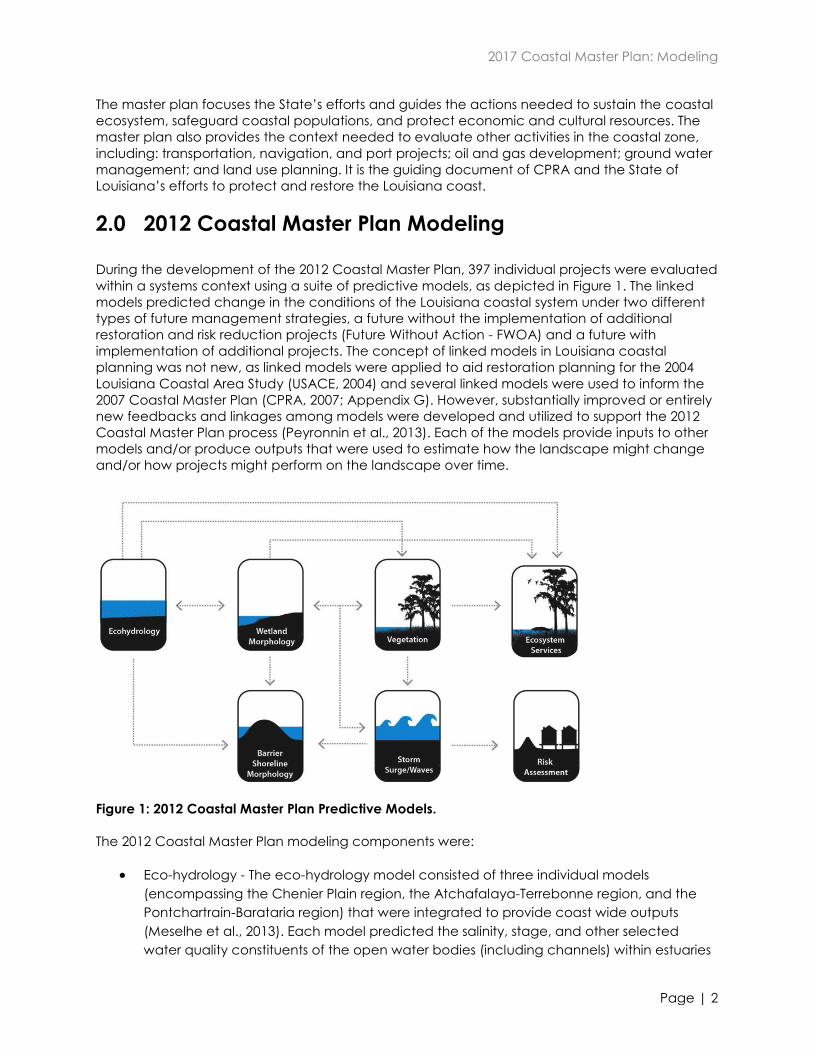
2.0 2012 Coastal Master Plan Modeling
During the development of the 2012 Coastal Master Plan, 397 individual projects were evaluated
within a systems context using a suite of predictive models, as depicted in Figure 1. The linked
models predicted change in the conditions of the Louisiana coastal system under two different
types of future management strategies, a future without the implementation of additional
restoration and risk reduction projects (Future Without Action - FWOA) and a future with
implementation of additional projects. The concept of linked models in Louisiana coastal
planning was not new, as linked models were applied to aid restoration planning for the 2004
Louisiana Coastal Area Study (USACE, 2004) and several linked models were used to inform the
2007 Coastal Master Plan (CPRA, 2007; Appendix G). However, substantially improved or entirely
new feedbacks and linkages among models were developed and utilized to support the 2012
Coastal Master Plan process (Peyronnin et al., 2013). Each of the models provide inputs to other
models and/or produce outputs that were used to estimate how the landscape might change
and/or how projects might perform on the landscape over time.
Figure 1: 2012 Coastal Master Plan Predictive Models.
The 2012 Coastal Master Plan modeling components were:
Eco-hydrology - The eco-hydrology model consisted of three individual models
(encompassing the Chenier Plain region, the Atchafalaya-Terrebonne region, and the
Pontchartrain-Barataria region) that were integrated to provide coast wide outputs
(Meselhe et al., 2013). Each model predicted the salinity, stage, and other selected
water quality constituents of the open water bodies (including channels) within estuaries
2017 Coastal Master Plan: Modeling
Page | 3
using a mass balance approach to estimate the exchanges of solids and chemicals due
to advection and dispersion.
Wetland morphology - This model tracked the changes in wetland-dominated
landscapes over time including the loss of existing wetlands, the creation of wetlands by
both natural and artificial process, and the fate of those newly created wetlands
(Couvillion et al., 2013). Whereas previous modeling efforts simply projected past trends
into the future, this model considered more characteristics of the landscape as
predictors of change.
Barrier shoreline morphology - Changes in barrier shorelines and headlands were derived
from a simple shoreline change model driven by analysis of historical shorelines that are a
part of the Barrier Island Comprehensive Monitoring project (BICM; Hughes et al., 2012).
Vegetation - The vegetation model predicted the extent of 19 types/communities of
emergent vegetation and submerged aquatic vegetation (Visser et al., 2013). It
estimated spatial and temporal changes in vegetation types/communities based on
environmental drivers such as salinity and water level change.
Ecosystem services - These models were used to predict how well Louisiana’s future coast
will provide habitat for commercially and recreationally important coastal species, and
key services for coastal communities (Nyman et al., 2013). In total, 19 ecosystem service
models were utilized to reflect species habitat, surge/wave attenuation potential
(restoration projects only), nature-based tourism, freshwater availability, potential for
agriculture/aquaculture, nitrogen uptake potential (Rivera-Monroy et al., 2013), and
carbon sequestration potential (CPRA 2012).
Storm surge/waves - For risk reduction projects or groups of projects, this model used the
widely-adopted ADCIRC large domain storm surge model coupled with the unstructured
SWAN wave model (Cobell et al., 2013). ADCIRC uses an unstructured mesh that allows
for variation of resolution from coarse in the open ocean to very fine near islands,
channels, levees, and areas where flow gradients are large (such as in channels and
wave breaking zones).
Risk assessment - This model estimated residual economic damage from storm surge
flooding by predicting the overtopping of flood risk reduction structures due to surge and
waves, assessed probabilistically any flooding due to breaching of hurricane risk
reduction systems, calculated flood elevations, and identified economic consequences
(Johnson, Fischbach, and Ortiz, 2013).
An uncertainty analysis was also conducted for the models addressing change in the coastal
landscape and ecosystem (Habib and Reed, 2013). Typically, an uncertainty analysis is
implemented such that all sources of parameter uncertainties are propagated starting from the
first model (e.g., eco-hydrology), through the intermediate models (e.g., wetland morphology)
and ending with the last model(s) (e.g., ecosystem service models). This approach, however,
requires an excessively large number of simulations. Instead, the adopted analysis started from
the end of the modeling components, focusing on the important outputs, and then worked
back to determine the most ‘uncertain’ parameters that were most relevant for such outputs.
This approach was driven by the master plan focus on assessing both near and long-term effects
of proposed protection and restoration projects. The analysis found that model predictions of
land area 20 years into the future in most regions have uncertainty bounds of less than ±5% if a
confidence interval of (25-75%) is used, and less than ±10% if a confidence interval of (10-90%) is
used. Furthermore, the uncertainty in land area predictions was similar across the different
2017 Coastal Master Plan: Modeling
Page | 4
regions along the coast, and uncertainties of model predictions of land area became larger as
the prediction extended into the future years.
3.0 Modeling Improvements
Following the completion of the 2012 Coastal Master Plan, a thorough technical peer review of
the models was conducted, and the process generated a number of recommendations for
model improvements. The 2012 Habitat Suitability Indices (HSIs) did not undergo review.
Recommendations for improvement were also made by the 2012 Coastal Master Plan modeling
teams. To consider potential improvements in the models for use in support of the 2017 Coastal
Master Plan, local, national, and international experts were engaged during two ‘brainstorming
workshops’ in fall 2012 to discuss and establish the technical aspects for developing a refined
modeling approach. In general, recommendations pointed to the development of a more
integrated and process-based modeling framework for hydrodynamic, morphological, and
ecological components, as well as an increase in the resolution and detail. For models
supporting risk assessment, the focus was on improving data sources and consideration of
parametric uncertainty.
Based in part on the recommendations of the technical peer review of the 2012 models and
input from the modeling teams, a Model Improvement Plan (CPRA, 2013) was developed, which
called for a number of desired improvements in the modeling approach including:
Refining the size of the compartments in the hydrology model to increase the spatial
resolution;
Developing and integrating the simulation of physical and ecological processes
controlling landscape and ecosystem dynamics;
Integrating landscape model components where possible to reduce manual data
transfer and facilitate an increase in output frequency; and
Improving spatial resolution within the risk assessment model, using updated data, and
understanding of parametric uncertainty.
Specific recommendations from the external peer review process that were either partially or
completely addressed as part of the 2017 modeling update effort are listed below:
Eco-hydrology
Regional integration
Better representation of the water, sediment and nutrient budgets
Improve how sediment flux calculations are implemented in the models
Synthesize missing data required to drive long-term simulations
Wetland Morphology
Include mechanistic improvements to soil processes
Incorporate stochastic effects of storms
2017 Coastal Master Plan: Modeling
Page | 5
Barrier Islands
Examine and consider developing hybrid models
Couple island and inlet models more frequently than 25 years
Incorporate stochastic effects of storms
Carry out both calibration and validation phases
Vegetation
Incorporate additional processes into the model (e.g., dispersal/recruitment
mechanisms)
Test/validate the model
Address model integration and error propagation
Storm Surge
Improve bottom friction and surface wind stress parameterizations
Include a larger set of synthetic storms
Increase commitment of computational resource
4.0 2017 Coastal Master Plan Technical Components
4.1 Modeling
The 2017 modeling effort largely builds on the 2012 Coastal Master Plan models. It was directed
by a team made up of CPRA and Water Institute personnel (the Model Decision Team) and
carried out largely by a multi-disciplinary team of experts from state and federal agencies,
academia, and the private sector; see Table 2 in the 2017 Modeling Team Section. As noted
above, the first step was the development of the Model Improvement Plan (CPRA, 2013), which
laid out a path forward for the improvements to be made to the modeling tools prior to use for
the 2017 Coastal Master Plan. The result was substantial revisions and improvements to the 2012
models, including entirely new modeling approaches in some cases (e.g., barrier islands, fish and
shellfish community models). Additional details regarding the modeling are provided in Chapter
3 and in the Attachments to this appendix.
The Integrated Compartment Model (ICM) replaces four previously independent models (eco-
hydrology, wetland morphology, barrier shoreline morphology, and vegetation) with a single
model code for all regions of the coast (Figure 2). It also includes the components of the
previous ecosystem services models that are being carried forward for 2017, and enables
integrated execution of the new fish and shellfish community models. Such integration allows for
coupling of processes and removes the inefficiency of manual data hand-offs and the potential
human error that may occur during the transfer of information from one model to another. The
ICM is computationally efficient and can be used for a large number of 50-year, coast wide
simulations in a reasonable timeframe. The ICM serves as the central modeling platform for the
2017 Coastal Master Plan to analyze the landscape and ecosystem performance of individual
projects and alternatives (groups of projects) under a variety of future environmental scenarios.
Key outputs include hydrodynamic variables (e.g., salinity and stage), changes in the landscape
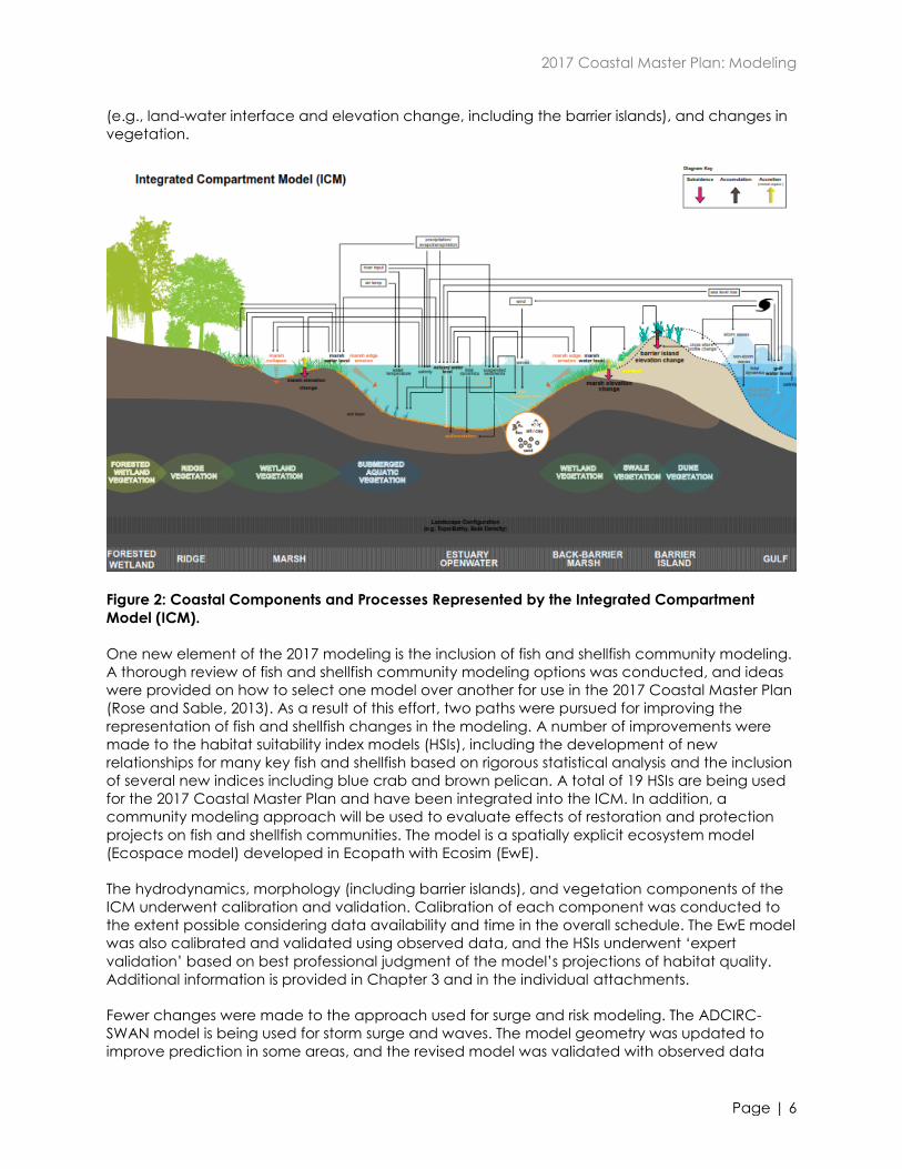
2017 Coastal Master Plan: Modeling
Page | 6
(e.g., land-water interface and elevation change, including the barrier islands), and changes in
vegetation.
Figure 2: Coastal Components and Processes Represented by the Integrated Compartment
Model (ICM).
One new element of the 2017 modeling is the inclusion of fish and shellfish community modeling.
A thorough review of fish and shellfish community modeling options was conducted, and ideas
were provided on how to select one model over another for use in the 2017 Coastal Master Plan
(Rose and Sable, 2013). As a result of this effort, two paths were pursued for improving the
representation of fish and shellfish changes in the modeling. A number of improvements were
made to the habitat suitability index models (HSIs), including the development of new
relationships for many key fish and shellfish based on rigorous statistical analysis and the inclusion
of several new indices including blue crab and brown pelican. A total of 19 HSIs are being used
for the 2017 Coastal Master Plan and have been integrated into the ICM. In addition, a
community modeling approach will be used to evaluate effects of restoration and protection
projects on fish and shellfish communities. The model is a spatially explicit ecosystem model
(Ecospace model) developed in Ecopath with Ecosim (EwE).
The hydrodynamics, morphology (including barrier islands), and vegetation components of the
ICM underwent calibration and validation. Calibration of each component was conducted to
the extent possible considering data availability and time in the overall schedule. The EwE model
was also calibrated and validated using observed data, and the HSIs underwent ‘expert
validation’ based on best professional judgment of the model’s projections of habitat quality.
Additional information is provided in Chapter 3 and in the individual attachments.
Fewer changes were made to the approach used for surge and risk modeling. The ADCIRC-
SWAN model is being used for storm surge and waves. The model geometry was updated to
improve prediction in some areas, and the revised model was validated with observed data
2017 Coastal Master Plan: Modeling
Page | 7
from Gustav and Ike. Approaches to incorporate raised features in the model grid, adjust the
wind drag formulation, and assess symmetrical versus asymmetrical storm patterns were also
explored. Improvements to the Coastal Louisiana Risk Assessment model (CLARA) include
expanding the model domain to account for a growing floodplain, creating a high resolution
spatial unit designed to inform local planning in coastal communities, updating and improving
the inventory of coastal assets at risk, and developing new scenarios of levee fragility to capture
the wide range of uncertainty.
The future environmental scenarios that were used in 2012 (CPRA, 2012) were revised based on
updated literature reviews, newly data and technical understanding, as well as sensitivity testing
of the ICM to the various parameters (e.g., eustatic sea level rise, subsidence, precipitation). See
Chapter 2 Future Scenarios and associated attachments for additional details regarding the
revised scenarios.
4.2 Project Information
The models are used to assess the individual and collective effects of groups of projects on the
coastal ecosystem and the level of risk to which coastal communities are exposed. Projects are
generally categorized as restoration or protection projects and evaluated according to their
restoration or protection effectiveness. However, the effects of individual restoration projects
(i.e., a protection effect) on coastal flooding can be generally evaluated using the ICM. When
restoration and protection projects are combined in alternatives, both the ICM and the
surge/risk models can be used to evaluate the net effect on both the ecosystem and levels of
risk. Table 1 below provides a general description of the project types. Additional information
regarding project development can be found in Appendix A: Project Definition.
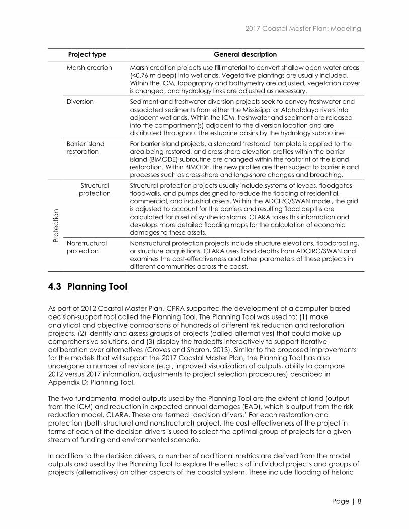
Table 1: Project Information for Evaluation by the Modeling Tools.
Project type General description
Re
sto
ratio
n
Hydrologic
restoration
Hydrologic restoration projects aim to maintain coastal wetlands and
improve ecosystem outcomes by altering hydrology. They often include
combinations of culvert, gates, locks, plug, weirs, etc. Links between
compartments in the ICM are adjusted to reflect the changes.
Shoreline
protection
Shoreline protection projects seek to maintain land by reducing the amount
of erosion along bay and channel shorelines using structures in the open
water adjacent to the shoreline. Within the ICM, the marsh edge erosion
rate in the influence area behind the structure is adjusted.
Bank stabilization Bank stabilization projects reinforce bank lines by adding material, thus
reducing the erosion of the shoreline. Within the ICM, the marsh edge
erosion rate in the area influenced by the additional material is adjusted.
Oyster barrier reef
Oyster barrier reef projects build a submerged structure similar in elevation to
a natural oyster reef with the aim of maintaining land by reducing the
amount of erosion along adjacent bay and lake shorelines. Within the ICM,
the marsh edge erosion rate in the area influenced by the reef is adjusted
and the availability of cultch for oyster habitat is increased.
Ridge restoration
Ridge projects seek to recreate the skeleton of the coastal wetlands along
previous distributary channels, providing diverse, higher-elevation habitats
and more structure for estuarine hydrology. Within the ICM, the ridge is
represented in the topography, and hydrology links are adjusted to account
for flow changes.
2017 Coastal Master Plan: Modeling
Page | 8
Project type General description
Marsh creation
Marsh creation projects use fill material to convert shallow open water areas
(<0.76 m deep) into wetlands. Vegetative plantings are usually included.
Within the ICM, topography and bathymetry are adjusted, vegetation cover
is changed, and hydrology links are adjusted as necessary.
Diversion Sediment and freshwater diversion projects seek to convey freshwater and
associated sediments from either the Mississippi or Atchafalaya rivers into
adjacent wetlands. Within the ICM, freshwater and sediment are released
into the compartment(s) adjacent to the diversion location and are
distributed throughout the estuarine basins by the hydrology subroutine.
Barrier island
restoration
For barrier island projects, a standard ‘restored’ template is applied to the
area being restored, and cross-shore elevation profiles within the barrier
island (BIMODE) subroutine are changed within the footprint of the island
restoration. Within BIMODE, the new profiles are then subject to barrier island
processes such as cross-shore and long-shore changes and breaching.
Pro
tec
tio
n
Structural
protection
Structural protection projects usually include systems of levees, floodgates,
floodwalls, and pumps designed to reduce the flooding of residential,
commercial, and industrial assets. Within the ADCIRC/SWAN model, the grid
is adjusted to account for the barriers and resulting flood depths are
calculated for a set of synthetic storms. CLARA takes this information and
develops more detailed flooding maps for the calculation of economic
damages to these assets.
Nonstructural
protection
Nonstructural protection projects include structure elevations, floodproofing,
or structure acquisitions. CLARA uses flood depths from ADCIRC/SWAN and
examines the cost-effectiveness and other parameters of these projects in
different communities across the coast.
4.3 Planning Tool
As part of 2012 Coastal Master Plan, CPRA supported the development of a computer-based
decision-support tool called the Planning Tool. The Planning Tool was used to: (1) make
analytical and objective comparisons of hundreds of different risk reduction and restoration
projects, (2) identify and assess groups of projects (called alternatives) that could make up
comprehensive solutions, and (3) display the tradeoffs interactively to support iterative
deliberation over alternatives (Groves and Sharon, 2013). Similar to the proposed improvements
for the models that will support the 2017 Coastal Master Plan, the Planning Tool has also
undergone a number of revisions (e.g., improved visualization of outputs, ability to compare
2012 versus 2017 information, adjustments to project selection procedures) described in
Appendix D: Planning Tool.
The two fundamental model outputs used by the Planning Tool are the extent of land (output
from the ICM) and reduction in expected annual damages (EAD), which is output from the risk
reduction model, CLARA. These are termed ‘decision drivers.’ For each restoration and
protection (both structural and nonstructural) project, the cost-effectiveness of the project in
terms of each of the decision drivers is used to select the optimal group of projects for a given
stream of funding and environmental scenario.
In addition to the decision drivers, a number of additional metrics are derived from the model
outputs and used by the Planning Tool to explore the effects of individual projects and groups of
projects (alternatives) on other aspects of the coastal system. These include flooding of historic
2017 Coastal Master Plan: Modeling
Page | 9
properties, effect on navigation, changes to traditional fishing communities, etc. Many of these
metrics combine information derived from CLARA analysis of protection projects and ICM
analysis of restoration projects, and thus can only be used to consider the effects of alternatives.
Other metrics, such as the effect on navigation or flooding of historic properties use only outputs
from CLARA or the ICM and can thus be used as constraints in the formulation of cost-
constrained alternatives (e.g., the Planning Tool selects the most cost-effective set of projects
that reduces EAD but also ensures only a limited number of historic properties are flooded).
Descriptions of these metrics and the inputs they use from the various models are described in
Attachment C4-11: Metrics.
5.0 Model Review
5.1 2012 Coastal Master Plan
Review of model development and application occurred throughout the development of the
2012 Coastal Master Plan. Several Technical Advisory Committees (TACs) were convened
including one specifically for the Predictive Models (PM-TAC). Additionally, the Science and
Engineering Board reviewed and commented on all aspects of the Master Plan development
process, including the modeling.
The PM-TAC focused their review and comment on the effectiveness of the models for
predicting project effects. The committee included four well known scientists with expertise and
experience not only with issues concerning coastal Louisiana, but also issues of national and
international concern. PM-TAC members participated in monthly conference calls and webinars
with CPRA leads on the modeling effort, but formal reporting was not part of their role/task. They
served in a more informal role of providing technical advice and guidance during the process.
To close out the PM-TAC effort, each member was asked to write a brief overview of his or her
experience as a PM-TAC member for the 2012 Coastal Master Plan modeling effort (CPRA,
2012b – Appendix H).
Following completion of the 2012 Coastal Master Plan, the model reports included as
appendices to the master plan, were subject to an independent technical review (described
previously). This review engaged 12 external topical experts and seven expert review editors.
Many suggested improvements were undertaken as part of the 2017 Coastal Master Plan Model
Improvement Plan.
5.2 2017 Coastal Master Plan Predictive Models Technical Advisory
Committee
During the 2012 Coastal Master Plan process, the PM-TAC only met in person once with the
modeling team. This limited their ability to interact and discuss problems and solutions directly
with those working on model development. The 2012 PM-TAC unanimously recommended that
more frequent in-person meetings during future efforts would enhance the overall efficacy of
the review process. To convene a TAC for 2017, the Modeling Decision Team identified the five
experts listed below (with their professional affiliations) to serve as “over the shoulder” technical
advisors throughout the model improvement process. This team of experts comprised the 2017
PM-TAC. They were selected based on their technical area of expertise and their ability to share
insight and experience from other relevant efforts.
2017 Coastal Master Plan: Modeling
Page | 10
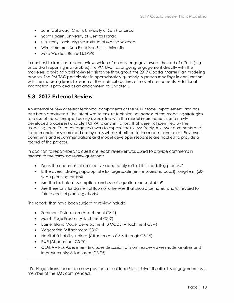
John Callaway (Chair), University of San Francisco
Scott Hagen, University of Central Florida1
Courtney Harris, Virginia Institute of Marine Science
Wim Kimmerer, San Francisco State University
Mike Waldon, Retired USFWS
In contrast to traditional peer review, which often only engages toward the end of efforts (e.g.,
once draft reporting is available,) the PM-TAC has ongoing engagement directly with the
modelers, providing working-level assistance throughout the 2017 Coastal Master Plan modeling
process. The PM-TAC participates in approximately quarterly in-person meetings in conjunction
with the modeling leads for each of the main subroutines or model components. Additional
information is provided as an attachment to Chapter 5.
5.3 2017 External Review
An external review of select technical components of the 2017 Model Improvement Plan has
also been conducted. The intent was to ensure technical soundness of the modeling strategies
and use of equations (particularly associated with the model improvements and newly
developed processes) and alert CPRA to any limitations that were not identified by the
modeling team. To encourage reviewers to express their views freely, reviewer comments and
recommendations remained anonymous when submitted to the model developers. Reviewer
comments and recommendations and model developer responses are tracked to provide a
record of the process.
In addition to report-specific questions, each reviewer was asked to provide comments in
relation to the following review questions:
Does the documentation clearly / adequately reflect the modeling process?
Is the overall strategy appropriate for large scale (entire Louisiana coast), long-term (50-
year) planning efforts?
Are the technical assumptions and use of equations acceptable?
Are there any fundamental flaws or otherwise that should be noted and/or revised for
future coastal planning efforts?
The reports that have been subject to review include:
Sediment Distribution (Attachment C3-1)
Marsh Edge Erosion (Attachment C3-2)
Barrier Island Model Development (BIMODE; Attachment C3-4)
Vegetation (Attachment C3-5)
Habitat Suitability Indices (Attachments C3-6 through C3-19)
EwE (Attachment C3-20)
CLARA – Risk Assessment (includes discussion of storm surge/waves model analysis and
improvements; Attachment C3-25)
1 Dr. Hagen transitioned to a new position at Louisiana State University after his engagement as a
member of the TAC commenced.
2017 Coastal Master Plan: Modeling
Page | 11
6.0 2017 Modeling Team
As previously mentioned, the 2017 Coastal Master Plan modeling team was directed by a team
made up of CPRA and Water Institute personnel (the Model Decision Team) and the technical
work was carried out largely by a multi-disciplinary team of experts from state and federal
agencies, academia, and the private sector (Table 2).
Table 2: 2017 Coastal Master Plan Modeling Team Members.
Organization Name
Model Decision Team
Water Institute Ehab Meselhe
Water Institute Denise Reed
Water Institute Alaina Owens Grace
Coastal Protection & Restoration Authority Mandy Green
Coastal Protection & Restoration Authority David Lindquist
Coastal Protection & Restoration Authority Angelina Freeman
Sediment Distribution
University of New Orleans Alex McCorquodale (Subtask Leader)
Moffatt & Nichol Jeff Shelden
USGS National Wetlands Research Center Gregg Snedden
USGS National Wetlands Research Center Hongqing Wang
USGS National Wetlands Research Center Brady Couvillion
Water Institute Ehab Meselhe
Water Institute Ben Roth
Water Institute Denise Reed
Water Institute Eric White
Marsh Edge Erosion
Water Institute Mead Allison (Subtask Leader)
Water Institute Brendan Yuill
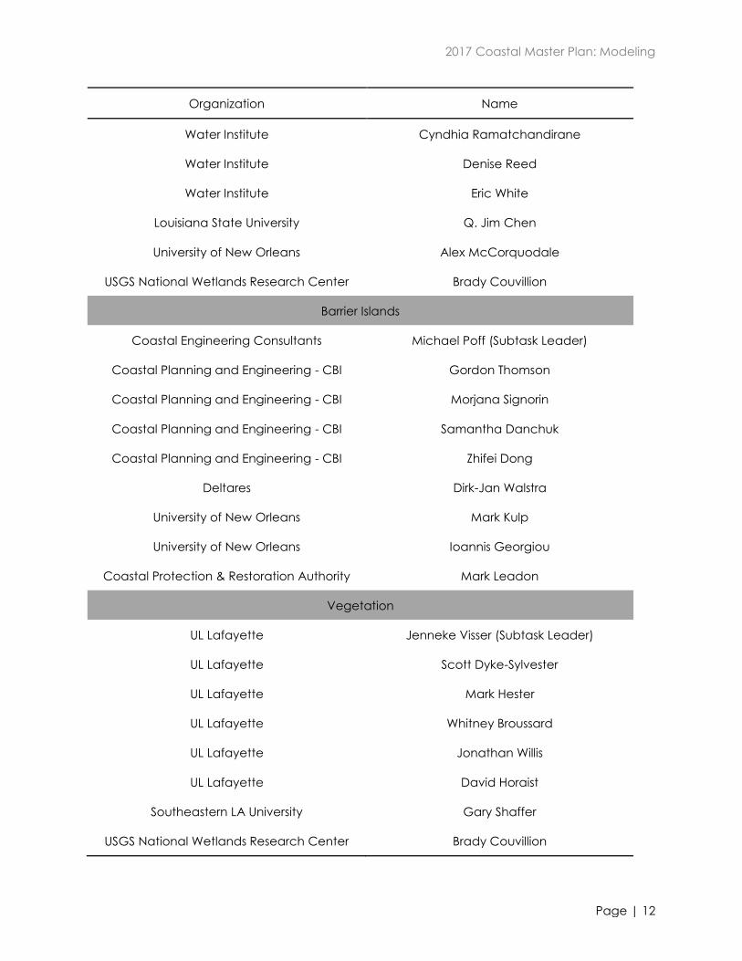
2017 Coastal Master Plan: Modeling
Page | 12
Organization Name
Water Institute Cyndhia Ramatchandirane
Water Institute Denise Reed
Water Institute Eric White
Louisiana State University Q. Jim Chen
University of New Orleans Alex McCorquodale
USGS National Wetlands Research Center Brady Couvillion
Barrier Islands
Coastal Engineering Consultants Michael Poff (Subtask Leader)
Coastal Planning and Engineering - CBI Gordon Thomson
Coastal Planning and Engineering - CBI Morjana Signorin
Coastal Planning and Engineering - CBI Samantha Danchuk
Coastal Planning and Engineering - CBI Zhifei Dong
Deltares Dirk-Jan Walstra
University of New Orleans Mark Kulp
University of New Orleans Ioannis Georgiou
Coastal Protection & Restoration Authority Mark Leadon
Vegetation
UL Lafayette Jenneke Visser (Subtask Leader)
UL Lafayette Scott Dyke-Sylvester
UL Lafayette Mark Hester
UL Lafayette Whitney Broussard
UL Lafayette Jonathan Willis
UL Lafayette David Horaist
Southeastern LA University Gary Shaffer
USGS National Wetlands Research Center Brady Couvillion
2017 Coastal Master Plan: Modeling
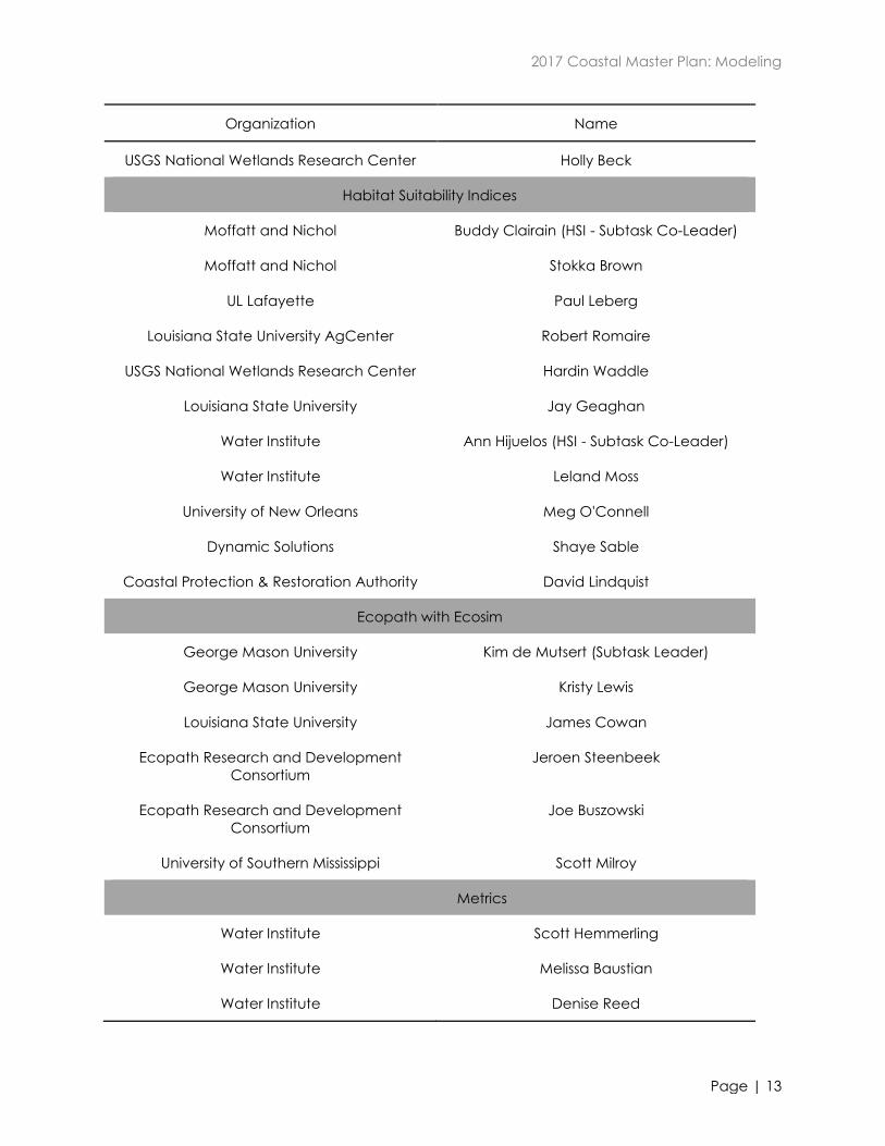
Page | 13
Organization Name
USGS National Wetlands Research Center Holly Beck
Habitat Suitability Indices
Moffatt and Nichol Buddy Clairain (HSI - Subtask Co-Leader)
Moffatt and Nichol Stokka Brown
UL Lafayette Paul Leberg
Louisiana State University AgCenter Robert Romaire
USGS National Wetlands Research Center Hardin Waddle
Louisiana State University Jay Geaghan
Water Institute Ann Hijuelos (HSI - Subtask Co-Leader)
Water Institute Leland Moss
University of New Orleans Meg O'Connell
Dynamic Solutions Shaye Sable
Coastal Protection & Restoration Authority David Lindquist
Ecopath with Ecosim
George Mason University Kim de Mutsert (Subtask Leader)
George Mason University Kristy Lewis
Louisiana State University James Cowan
Ecopath Research and Development
Consortium
Jeroen Steenbeek
Ecopath Research and Development
Consortium
Joe Buszowski
University of Southern Mississippi Scott Milroy
Metrics
Water Institute Scott Hemmerling
Water Institute Melissa Baustian
Water Institute Denise Reed
2017 Coastal Master Plan: Modeling
Page | 14
Organization Name
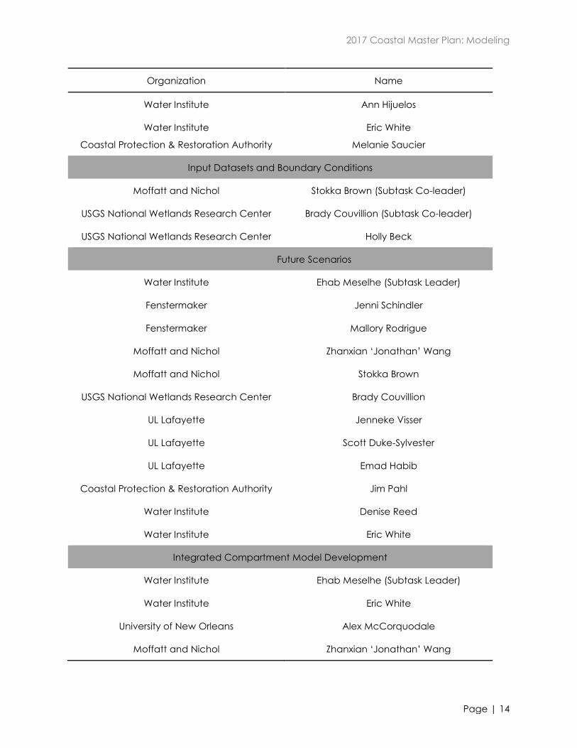
Water Institute Ann Hijuelos
Water Institute
Coastal Protection & Restoration Authority
Eric White
Melanie Saucier
Input Datasets and Boundary Conditions
Moffatt and Nichol Stokka Brown (Subtask Co-leader)
USGS National Wetlands Research Center Brady Couvillion (Subtask Co-leader)
USGS National Wetlands Research Center Holly Beck
Future Scenarios
Water Institute Ehab Meselhe (Subtask Leader)
Fenstermaker Jenni Schindler
Fenstermaker Mallory Rodrigue
Moffatt and Nichol Zhanxian ‘Jonathan’ Wang
Moffatt and Nichol Stokka Brown
USGS National Wetlands Research Center Brady Couvillion
UL Lafayette Jenneke Visser
UL Lafayette Scott Duke-Sylvester
UL Lafayette Emad Habib
Coastal Protection & Restoration Authority Jim Pahl
Water Institute Denise Reed
Water Institute Eric White
Integrated Compartment Model Development
Water Institute Ehab Meselhe (Subtask Leader)
Water Institute Eric White
University of New Orleans Alex McCorquodale
Moffatt and Nichol Zhanxian ‘Jonathan’ Wang
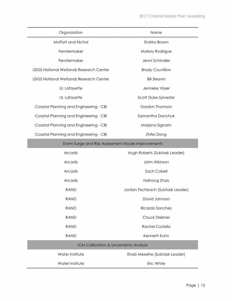
2017 Coastal Master Plan: Modeling
Page | 15
Organization Name
Moffatt and Nichol Stokka Brown
Fenstermaker Mallory Rodrigue
Fenstermaker Jenni Schindler
USGS National Wetlands Research Center Brady Couvillion
USGS National Wetlands Research Center Bill Sleavin
UL Lafayette Jenneke Visser
UL Lafayette Scott Duke-Sylvester
Coastal Planning and Engineering - CBI Gordon Thomson
Coastal Planning and Engineering - CBI Samantha Danchuk
Coastal Planning and Engineering - CBI Morjana Signorin
Coastal Planning and Engineering - CBI Zhifei Dong
Storm Surge and Risk Assessment Model Improvements
Arcadis Hugh Roberts (Subtask Leader)
Arcadis John Atkinson
Arcadis Zach Cobell
Arcadis Haihong Zhao
RAND Jordan Fischbach (Subtask Leader)
RAND David Johnson
RAND Ricardo Sanchez
RAND Chuck Stelzner
RAND Rachel Costello
RAND Kenneth Kuhn
ICM Calibration & Uncertainty Analysis
Water Institute Ehab Meselhe (Subtask Leader)
Water Institute Eric White
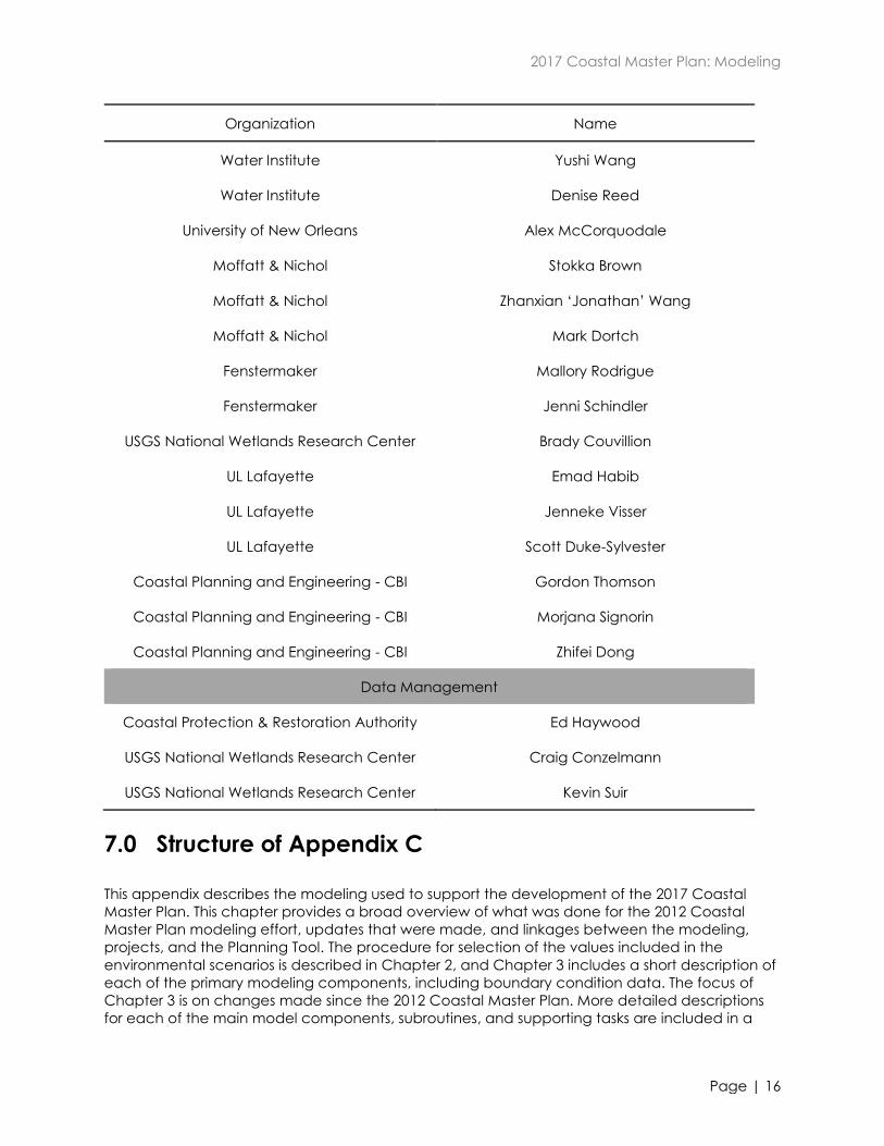
2017 Coastal Master Plan: Modeling
Page | 16
Organization Name
Water Institute Yushi Wang
Water Institute Denise Reed
University of New Orleans Alex McCorquodale
Moffatt & Nichol Stokka Brown
Moffatt & Nichol Zhanxian ‘Jonathan’ Wang
Moffatt & Nichol Mark Dortch
Fenstermaker Mallory Rodrigue
Fenstermaker Jenni Schindler
USGS National Wetlands Research Center Brady Couvillion
UL Lafayette Emad Habib
UL Lafayette Jenneke Visser
UL Lafayette Scott Duke-Sylvester
Coastal Planning and Engineering - CBI Gordon Thomson
Coastal Planning and Engineering - CBI Morjana Signorin
Coastal Planning and Engineering - CBI Zhifei Dong
Data Management
Coastal Protection & Restoration Authority Ed Haywood
USGS National Wetlands Research Center Craig Conzelmann
USGS National Wetlands Research Center Kevin Suir
7.0 Structure of Appendix C
This appendix describes the modeling used to support the development of the 2017 Coastal
Master Plan. This chapter provides a broad overview of what was done for the 2012 Coastal
Master Plan modeling effort, updates that were made, and linkages between the modeling,
projects, and the Planning Tool. The procedure for selection of the values included in the
environmental scenarios is described in Chapter 2, and Chapter 3 includes a short description of
each of the primary modeling components, including boundary condition data. The focus of
Chapter 3 is on changes made since the 2012 Coastal Master Plan. More detailed descriptions
for each of the main model components, subroutines, and supporting tasks are included in a
2017 Coastal Master Plan: Modeling
Page | 17
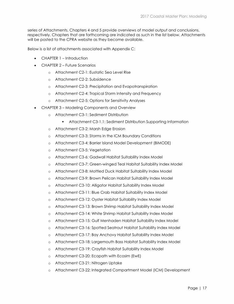
series of Attachments. Chapters 4 and 5 provide overviews of model output and conclusions,
respectively. Chapters that are forthcoming are indicated as such in the list below. Attachments
will be posted to the CPRA website as they become available.
Below is a list of attachments associated with Appendix C:
CHAPTER 1 – Introduction
CHAPTER 2 – Future Scenarios
o Attachment C2-1: Eustatic Sea Level Rise
o Attachment C2-2: Subsidence
o Attachment C2-3: Precipitation and Evapotranspiration
o Attachment C2-4: Tropical Storm Intensity and Frequency
o Attachment C2-5: Options for Sensitivity Analyses
CHAPTER 3 – Modeling Components and Overview
o Attachment C3-1: Sediment Distribution
Attachment C3-1.1: Sediment Distribution Supporting Information
o Attachment C3-2: Marsh Edge Erosion
o Attachment C3-3: Storms in the ICM Boundary Conditions
o Attachment C3-4: Barrier Island Model Development (BIMODE)
o Attachment C3-5: Vegetation
o Attachment C3-6: Gadwall Habitat Suitability Index Model
o Attachment C3-7: Green-winged Teal Habitat Suitability Index Model
o Attachment C3-8: Mottled Duck Habitat Suitability Index Model
o Attachment C3-9: Brown Pelican Habitat Suitability Index Model
o Attachment C3-10: Alligator Habitat Suitability Index Model
o Attachment C3-11: Blue Crab Habitat Suitability Index Model
o Attachment C3-12: Oyster Habitat Suitability Index Model
o Attachment C3-13: Brown Shrimp Habitat Suitability Index Model
o Attachment C3-14: White Shrimp Habitat Suitability Index Model
o Attachment C3-15: Gulf Menhaden Habitat Suitability Index Model
o Attachment C3-16: Spotted Seatrout Habitat Suitability Index Model
o Attachment C3-17: Bay Anchovy Habitat Suitability Index Model
o Attachment C3-18: Largemouth Bass Habitat Suitability Index Model
o Attachment C3-19: Crayfish Habitat Suitability Index Model
o Attachment C3-20: Ecopath with Ecosim (EwE)
o Attachment C3-21: Nitrogen Uptake
o Attachment C3-22: Integrated Compartment Model (ICM) Development
2017 Coastal Master Plan: Modeling
Page | 18
Attachment C3-22.1: ICM-Hydro Flow Calculations
Attachment C3-22.2: File Naming Convention
o Attachment C3-23: ICM Calibration, Validation, and Performance Assessment
Attachment C3-23.1: Hydrology Station Locations
Attachment C3-23.2: Model Performance - Stage
Attachment C3-23.3: Model Performance - Flow
Attachment C3-23.4: Model Performance - Salinity
Attachment C3-23.5: Model Performance - Total Suspended Solids
Attachment C3-23.6: Model Performance - Temperature
Attachment C3-23.7: Model Performance - Total Kjeldahl Nitrogen
Attachment C3-23.8: Model Performance - Total Phosphorus
o Attachment C3-24: ICM Uncertainty Analysis
o Attachment C3-25: Storm Surge and Risk Assessment
Attachment C3-25.1: Storm Surge
o Attachment C3-26: Hydrology and Water Quality Boundary Conditions
Attachment C3-26.1: Monitoring Station List
Attachment C3-26.2: Flow Data
Attachment C3-26.3: Water Level Data
Attachment C3-26.4: Water Quality Stations and Locations
o Attachment C3-27: Landscape Data
CHAPTER 4 – Model Outcomes and Interpretations
o Attachment C4-1: Model Quality Assurance and Quality Control (QA/QC)
o Attachment C4-2: Mid-Breton Sound Diversion Model Output
o Attachment C4-3: South Terrebonne Marsh Creation Model Output
o Attachment C4-4: Calcasieu Ship Channel Salinity Control Measures Model
Output
o Attachment C4-5: Lake Hermitage Shoreline Protection Model Output
o Attachment C4-6: Grand Lake Bank Stabilization Model Output
o Attachment C4-7: Bayou Decade Ridge Restoration Model Output
o Attachment C4-8: Barataria Pass to Sandy Point Barrier Island Restoration Model
Output
o Attachment C4-9: Biloxi Marsh Oyster Reef Model Output
o Attachment C4-10: Draft Master Plan Output
o Attachment C4-11: Metrics
Attachment C4-11.1: Metric Values by Project
2017 Coastal Master Plan: Modeling
Page | 19
Attachment C4-11.2: Social Vulnerability Index
CHAPTER 5 – Modeling Conclusions and Looking Forward
o Attachment C5-1: PM-TAC Report
o Attachment C5-2: Additional Comments
8.0 References
Blake, E.S., Landsea, C.W. and Gibney, E.J. (2011). The Deadliest, Costliest and Most Intense
United States Tropical Cyclones from 1851 to 2010 (and Other Frequently Requested
Hurricane Facts). Technical Memorandum NWS NHC-6 (p. 43). Miami, FL: National
Oceanic and Atmospheric Administration.
Coastal Protection and Restoration Authority (CPRA) and Louisiana Governor's Office of Coastal
Activities. (2007). Louisiana's Comprehensive Master Plan for a Sustainable Coast.
Retrieved from http://sonris-www.dnr.state.la.us/dnrservices/redirectUrl.jsp?dID=4063376.
Coastal Protection and Restoration Authority (CPRA) (2013). 2017 Coastal Master Plan: Model
Improvement Plan. Version I, prepared by The Water Institute of the Gulf (p.60). Baton
Rouge, Louisiana: Coastal Protection and Restoration Authority. Retrieved from
http://thewaterinstitute.cdn.z-
comm.com/files/pdfs/2017%20Coastal%20Master%20Plan%20Model%20Improvement%20
Plan%2010.13.pdf.
Coastal Protection and Restoration Authority (CPRA) (2012). 2012 Coastal Master Plan -
Appendix C: Environmental Scenarios. Retrieved from http://sonris-
www.dnr.state.la.us/dnrservices/redirectUrl.jsp?dID=4733670.
Coastal Protection and Restoration Authority (CPRA) (2012b). 2012 Coastal Master Plan -
Appendix H: Review and Coordination. Retrieved from http://sonris-
www.dnr.state.la.us/dnrservices/redirectUrl.jsp?dID=4734831.
Cobell, Z., Zhoa, H., Roberts, H.J., Clark, R. and Zou, S. (2013). Storm surge and wave modeling for
the Louisiana 2012 Coastal Master Plan. In: N.S. Peyronnin and D.J. Reed (Eds.),
Louisiana’s 2012 Coastal Master Plan Technical Analysis. Journal of Coastal Research,
Special Issue 67.
Couvillion, B.R., Barras, J.A., Steyer, G.D., Sleavin, W., Fischer, M., Beck, H., Trahan, N., Griffin, B.
and Heckman, D. (2011). Land area change in coastal Louisiana from 1932 to 2010: U.S.
Geological Survey Scientific Investigations Map 3164, scale 1:265,000 (p. 12 ). Pamphlet.
Couvillion, B.R., Steyer, G.D., Wang, H., Beck, H.J. and Rybczyk, J.M. (2013). Forecasting the
effects of coastal protection and restoration projects on wetland morphology in coastal
Louisiana under multiple environmental uncertainty scenarios. In: N.S. Peyronnin and D.J.
Reed (Eds.), Louisiana’s 2012 Coastal Master Plan Technical Analysis. Journal of Coastal
Research, Special Issue 67.
Groves, D.G. and Sharon, C. (2013). Planning tool to support planning the future of coastal
Louisiana. In: N.S. Peyronnin and D.J. Reed (Eds.), Louisiana’s 2012 Coastal Master Plan
Technical Analysis. Journal of Coastal Research, Special Issue 67.
2017 Coastal Master Plan: Modeling
Page | 20
Habib, E. and Reed, D.J. (2013). Parametric uncertainty analysis of predictive models in
Louisiana's 2012 Coastal Master Plan. In: N.S. Peyronnin and D.J. Reed (Eds.), Louisiana’s
2012 Coastal Master Plan Technical Analysis. Journal of Coastal Research, Special Issue
67.
Hughes, Z., Weathers, D., Georgiou, I., FitzGerald D. and Kulp, M. (2012). Appendix D-3: barrier
shoreline morphology model technical report. In: Louisiana’s Comprehensive Master Plan
for a Sustainable Coast (pp. 1-40). Baton Rouge, LA: Coastal Protection and Restoration
Authority.
Johnson, D.R., Fischbach, J.R. and Ortiz D.S. (2013). Estimating surge-based flood risk with the
coastal Louisiana risk assessment model. In: N.S. Peyronnin and D.J. Reed (Eds.),
Louisiana’s 2012 Coastal Master Plan Technical Analysis. Journal of Coastal Research,
Special Issue 67.
Louisiana Coastal Wetlands Conservation and Restoration Task Force and the Wetlands
Conservation and Restoration Authority (1998). Coast 2050: Toward a Sustainable Coastal
Louisiana (p.161). Baton Rouge, LA: Louisiana Department of Natural Resources.
Meselhe, E., McCorquodale, J.A., Sheldon, J., Dortch, M., Brown, T.S., Elkan, P., Rodrique, M.D.,
Schindler, J.K. and Wang, Z. (2013). Ecohydrology component of Louisiana’s 2012 Coastal
Master Plan: mass-balance compartment model. In: N.S. Peyronnin and D.J. Reed (Eds.),
Louisiana’s 2012 Coastal Master Plan Technical Analysis. Journal of Coastal Research,
Special Issue 67.
Nyman, J.A., Baltz, D.M., Green, M., Kaller, M.D., Leberg, P.L., Richards, C.P., Romaire, R.P. and
Soniat, T.M. (2013). Likely Changes in habitat quality for fish and wildlife in coastal
Louisiana during the next 50 years. In: N.S. Peyronnin and D.J. Reed (Eds.), Louisiana’s
2012 Coastal Master Plan Technical Analysis. Journal of Coastal Research, Special Issue
67.
Peyronnin, N., Green, M., Richards, C.P., Owens, A., Reed, D., Chamberlain, J., Groves, D.G.,
Rhinehart, W.K. and Belhadjali, K. (2013). Louisiana's 2012 Coastal Master Plan: overview
of a science-based and publicly informed decision-making process. In: N.S. Peyronnin
and D.J. Reed (Eds.), Louisiana’s 2012 Coastal Master Plan Technical Analysis. Journal of
Coastal Research, Special Issue 67.
Rivera-Monroy, V.H., Branoff, B., Meselhe, E., McCorquodale, A., Dortch, M., Steyer, G.D., Visser,
J. and Wang, H. (2013). Landscape-level estimation of nitrogen loss in coastal Louisiana
wetlands: potential sinks under different restoration scenarios. In: N.S. Peyronnin and D.J.
Reed (Eds.), Louisiana’s 2012 Coastal Master Plan Technical Analysis. Journal of Coastal
Research, Special Issue 67.
Rose, K.A. and Sable, S. (2013). 2017 Coastal Master Plan: Strategy for Selecting Fish Modeling
Approaches (p. 122). Baton Rouge, LA: Coastal Protection and Restoration Authority.
Retrieved from http://thewaterinstitute.cdn.z-
comm.com/files/pdfs/Fish%20Modeling%20Strategy_Final_10-31-131.pdf.
US Army Corps of Engineers (USACE). (2004). Louisiana Coastal Area (LCA) Ecosystem Restoration
Study (p. 506). New Orleans, LA.
2017 Coastal Master Plan: Modeling
Page | 21
USACE. (2009). Louisiana Coastal Protection and Restoration (LACPR) Final Technical Report (p.
293). New Orleans, LA.
USACE. (2013). Final Post Authorization Change Report Morganza to the Gulf of Mexico,
Louisiana (p. 122). New Orleans, LA.
Visser, J.M., Duke-Sylvester, S.M., Carter, J. and Broussard, W.P., III (2013). A computer model to
forecast wetland vegetation changes resulting from restoration and protection in coastal
Louisiana. In: N.S. Peyronnin and D.J. Reed (Eds.), Louisiana’s 2012 Coastal Master Plan
Technical Analysis. Journal of Coastal Research, Special Issue 67.