2016 Chino Basin Storm Water Resources Plan · 5/13/2016 · May 13, 2016 2016 Chino Basin Storm...
84
May 13, 2016 2016 Chino Basin Sto r m W a ter R esou r ces Plan Functional Equivalen c y Document
Transcript of 2016 Chino Basin Storm Water Resources Plan · 5/13/2016 · May 13, 2016 2016 Chino Basin Storm...

May 13, 2016
2016 Chino BasinStorm Water Resources Plan
Functional Equivalency Document
Table of Contents
Section 1 − Introduction ........................................................................................................................... 1-1 1.1 Background ..................................................................................................................... 1-1 1.2 Organization of This Report ........................................................................................... 1-2 1.3 Web Resources ............................................................................................................... 1-2
Section 2 – Storm Water Resource Planning in the Chino Basin ........................................................ 2-1 2.1 Chino Basin Storm Water Resource Plan ...................................................................... 2-1 2.2 Optimum Basin Management Program......................................................................... 2-4 2.3 Storm Water Resource Planning ................................................................................... 2-6 2.4 Recharge Master Plan Activities and Project Implementation .................................... 2-7 2.5 Storm Water Resource Planning in the Chino Basin is a Continuous Process ........... 2-9
Section 3 − Storm Water Resource Plan Checklist and Self-Certification Narrative ........................ 3-1 3.1 Watershed Identification (Guidelines Section VI.A) ...................................................... 3-1
3.1.1 Plan Identifies Watershed and Subwatershed(s) for Storm Water Resource Planning [Water Code Section 10565(c), 10562(b)(1), 10565(c)].................................... 3-2
3.1.2 Plan Is Developed on a Watershed Basis, Using Boundaries as Delineated by USGS, CalWater, USGS Hydrologic Unit Designations, or an Applicable Integrated Regional Water Management Group, and Includes a Description and Boundary Map of Each Watershed and Sub-watershed Applicable to the Plan ................................. 3-2
3.1.3 Plan includes an explanation of why the watershed(s) and sub-watershed(s) are appropriate for storm water management with a multiple-benefit watershed approach ............................................................................................................................... 3-3
3.1.4 Plan Describes the Internal Boundaries within the Watershed (Boundaries of Municipalities; Service Areas of Individual Water, Wastewater, and Land Use Agencies, Including Those Not Involved in the Plan; Groundwater Basin Boundaries, Etc.; Preferably Provided in a Geographic Information System Shape File) ........................................................................................................................................ 3-3
3.1.5 Plan Describes the Water Quality Priorities within the Watershed Based on, at a Minimum, Applicable TMDLs and Consideration of the Water Body-Pollutant Combinations Listed on the State’s Clean Water Act Section 303(d) List of Water Quality Limited Segments (a.k.a. Impaired Waters List) ..................................................... 3-3
3.1.6 Plan Describes the General Quality and Identification of Surface and Ground Water Resources within the Watershed (Preferably Provided in a Geographic Information System Shape File) ............................................................................................................... 3-4
3.1.7 Plan Describes the Local Entity or Entities that Provide Potable Water Supplies and the Estimated Volume of Potable Water Provided by the Water Suppliers ........................ 3-4
3.1.8 Plan Includes Map(s) Showing Location of Native Habitats, Creeks, Lakes, Rivers, Parks, and Other Natural or Open Space within the Sub-Watershed Boundaries ............. 3-4
3.1.9 Plan Identifies (Quantitative, if Possible) the Natural Watershed Processes that Occur within the Sub-Watershed and a Description of How Those Natural Watershed Processes Have Been Disrupted within the Sub-Watershed (e.g., High Levels of Imperviousness Convert the Watershed Processes of Infiltration and Interflow to Surface Runoff Increasing Runoff Volumes; Development Commonly Covers Natural Surfaces and Often Introduces Non-Native Vegetation, Preventing the Natural Supply of Sediment from Reaching Receiving Waters) ................................... 3-5
3.2 Water Quality Compliance (Guidelines Section V) ........................................................ 3-6 3.2.1 Plan Identifies Activities that Generate or Contribute to the Pollution of Storm
Water or Dry Weather Runoff, or that Impair the Effective Beneficial Use of Storm Water or Dry Weather Runoff [Water Code Section 10562(d)(7)]...................................... 3-6
3.2.2 Plan Describes How It Is Consistent and Assists in, Compliance with Total Maximum Daily Load Implementation Plans and Applicable National Pollutant Discharge Elimination System Permits [Water Code Section 10562(b)(5)] ...................... 3-6
3.2.3 Plan Meets Applicable Permits and Describes How It Meets all Waste Discharge Permit Requirements [Water Code Section 10562(b)(5)] .................................................. 3-7
i May 13, 2016

Table of Contents
3.3 Organization, Coordination, Collaboration (Guidelines Section VI.B) .......................... 3-7 3.3.1 Local Agencies and Nongovernmental Organizations Were Consulted in Plan
Development [Water Code Section 10565(a)] .................................................................... 3-7 3.3.2 Community Participation Was Provided for in Plan Development [Water Code
Section 10562(b)(4)] ............................................................................................................ 3-8 3.3.3 Plan Includes Description of the Existing Integrated Regional Water Management
Group(s) Implementing an Integrated Regional Water Management Plan ........................ 3-9 3.3.4 Plan Includes Identification of and Coordination with Agencies and Organizations
(Including, but Not Limited to Public Agencies, Nonprofit Organizations, and Privately Owned Water Utilities) that Need to Participate and Implement Their Own Authorities and Mandates in Order to Address the Storm Water and Dry Weather Runoff Management Objectives of the Plan for the Targeted Watershed ....................... 3-10
3.3.5 Plan Includes Identification of Nonprofit Organizations Working on Storm Water and Dry Weather Resource Planning or Management in the Watershed ........................ 3-10
3.3.6 Plan Includes Identification and Discussion of Public Engagement Efforts and Community Participation in Plan Development ................................................................. 3-11
3.3.7 Plan Includes Identification of Required Decisions That Must be Made by Local, State or Federal Regulatory Agencies for Plan Implementation and Coordinated Watershed-Based or Regional Monitoring and Visualization ............................................ 3-12
3.3.8 Plan Describes Planning and Coordination of Existing Local Governmental Agencies, Including Where Necessary New or Altered Governance Structures to Support Collaboration among Two or More Lead Local Agencies Responsible for Plan Implementation........................................................................................................... 3-12
3.3.9 Plan Describes the Relationship of the Plan to Other Existing Planning Documents, Ordinances, and Programs Established by Local Agencies .............................................. 3-12
3.3.10 (If Applicable) Plan Explains Why Individual Agency Participation in Various Isolated Efforts is Appropriate .......................................................................................................... 3-13
3.4 Quantitative Methods (Guidelines Section VI.C) ........................................................ 3-13 3.4.1 For All Analyses: Plan Includes an Integrated Metrics-Based Analysis to
Demonstrate That the Plan’s Proposed Storm Water and Dry Weather Capture Projects and Programs Will Satisfy the Plan’s Identified Water Management Objectives and Multiple Benefits ....................................................................................... 3-13
3.4.2 For Water Quality Project Analysis (Section VI.C.2.a): Plan Includes an Analysis of How Each Project and Program Complies with or Is Consistent with an applicable NPDES Permit. The Analysis Should Simulate the Proposed Watershed-Based Outcomes Using Modeling, Calculations, Pollutant Mass Balances, Water Volume Balances, and/or Other Methods of Analysis. Describes How Each Water Project or Program Will Contribute to the Preservation, Restoration, or Enhancement of Watershed Processes (as Described in Guidelines Section VI.C.2.a) .............................. 3-14
3.4.3 The surface water quality impacts and benefits from recharge of dry-weather runoff from the 2013 RMPU project implementation will be developed and reported in the CEQA document to be published in late 2016 for the 2013 RMPU. For Storm Water Capture and Use Project Analysis (Section VI.C.2.b): Plan Includes an Analysis of How Collectively the Projects and Programs in the Watershed Will Capture and Use the Proposed Amount of Storm Water and Dry Weather Runoff ...................................... 3-15
3.4.4 For Water Supply and Flood Management Project Analysis (Section VI.C.2.c): Plan Includes an Analysis of How Each Project and Program Will Maximize and/or Augment Water Supply ....................................................................................................... 3-15
3.4.5 For Environmental and Community Benefit Analysis (Section VI.C.2.d): Plan Includes a Narrative of How Each Project and Program Will Benefit the Environment and/or Community, with Some Type of Quantitative Measurement .......... 3-16
3.4.6 Data Management (Section VI.C.3): Plan Describes Data Collection and Management, Including: a) Mechanisms by Which Data Will Be Managed and Stored; b) How Data Will Be Assessed by Stakeholders and the Public; c) How Existing Water Quality and Water Quality Monitoring Will Be Assessed; d) Frequency at Which Data Will Be Updated; and e) How Data Gaps Will Be Identified ...................... 3-16
3.5 Identification and Prioritization of Projects (Guidelines Section VI.D)...................... 3-18
ii May 13, 2016

Table of Contents
3.5.1 Plan Identifies Opportunities to Augment Local Water Supply through Groundwater Recharge or Storage for Beneficial Use of Storm Water and Dry Weather Runoff [Water Code Section 10562(d)(1)] .................................................................................... 3-18
3.5.2 Plan Identifies Opportunities for Source Control for Both Pollution and Dry Weather Runoff Volume, Onsite and Local Infiltration, and Use of Storm Water and Dry Weather Runoff [Water Code Section 10562(d)(2)] ......................................................... 3-18
3.5.3 Plan Identifies Projects That Reestablish Natural Water Drainage Treatment and Infiltrations Systems, or Mimic Natural System Functions to the Maximum Extent Feasible [Water Code Section 10562(d)(3)] ..................................................................... 3-19
3.5.4 Plan Identifies Opportunities to Develop, Restore, or Enhance Habitat and Open Space through Storm Water and Dry Weather Runoff Management, Including Wetlands, riverside habitats, parkways, and parks [Water Code Section 10562(d)(4)] ....................................................................................................................... 3-19
3.5.5 Plan Identifies Opportunities to Use Existing Publicly Owned Lands and Easements, Including, but not Limited to, Parks, Public Open Space, Community Gardens, Farm and Agricultural Preserves, School Sites, and Governments Office Buildings and Complexes, to Capture, Clean, Store, and Used Storm Water and Dry Weather Runoff either Onsite or Offsite [Water Code Section 10562(d)(5), 10562(b)(8)] ........... 3-20
3.6 Identification and Prioritization of Projects (Guidelines Section VI.D)...................... 3-20 3.6.1 For New Developments and Redevelopments (if Applicable): Plan Identifies Design
Criteria and Best Management Practices to Prevent Storm Water and Dry Weather Runoff Pollution and Increase Effective Storm Water and Dry Weather Runoff Management for New and Upgraded Infrastructure and Residential, Commercial, Industrial, and Public Development [Water Code Section 10562(d)(6)] ......................... 3-20
3.6.2 Plan Uses Appropriate Quantitative Methods for Prioritization of Projects (This Should Be Accomplished by Using a Metrics-Based and Integrated Evaluation and Analysis of Multiple Benefits to Maximize Water Supply, Water Quality, Flood Management, Environmental, and Other Community Benefits within the Watershed) [Water Code Section 10562(b)(2)] ................................................................ 3-21
3.6.3 Overall: Plan Prioritizes Projects and Programs Using a Metric-Driven Approach and a Geospatial Analysis of Multiple Benefits to Maximize Water Supply, Water Quality, Flood Management, Environmental, and Community Benefits Within the Watershed ... 3-21
3.6.4 Multiple Benefits: Each Project in Accordance with the Plan Contributes to at Least Two or More Main Benefits and the Maximum Number of Additional Benefits as Listed in Table 4 of the Guidelines (Benefits are not counted twice if they apply to more than one category) .................................................................................................... 3-21
3.7 Implementation and Strategy and Schedule (Guidelines Section VI.E) ................... 3-22 3.7.1 Plan Identifies Resources for Plan Implementation, Including: 1) Projection of
Additional Funding Needs and Sources for Administration and Implementation Needs; and 2) Schedule for Arranging and Securing Plan Implementation Financing ... 3-22
3.7.2 Plan Projects and Programs Are Identified to Ensure the Effective Implementation of the Storm Water Resource Plan Pursuant to This Part and Achieve Multiple Benefits [Water Code Section 10562(d)(8)] ...................................................................... 3-23
3.7.3 The Plan Identifies the Development of Appropriate Decision Support Tools and the Data Necessary to Use the Decision Support Tools [Water Code Section 10562(d)(8)] ....................................................................................................................... 3-23
3.7.4 Plan Describes Implementation Strategy, Including: a) Timeline for Submitting Plan into Existing Plans, as Applicable; b) Specific Actions by Which Plan Will Be Implemented; c) All Entities Responsible for Project Implementation; d) Description of Community Participation Strategy; e) Procedures to Track Status of Each Project; f) Timelines for All Active or Planned Projects; g) Procedures for Ongoing Review, Updates, and Adaptive Management of the Plan; and h) A Strategy and Timeline for Obtaining Necessary Federal, State, and Local Permits ................................................... 3-24
3.7.5 Applicable IRWM Plan: The Plan Will Be Submitted, upon Development, to the Applicable Integrated Regional Water Management (IRWM) Group for Incorporation into the IRWM Plan [Water Code Section 10562(b)(7)] .................................................... 3-26
3.7.6 Plan Describes How Implementation Performance Measures Will be Tracked ............... 3-26
iii May 13, 2016

Table of Contents
3.8 Education, Outreach, Public Participation (Guidelines Section VI.F) ........................ 3-28 3.8.1 Outreach and Scoping: Community Participation Is Provided for in Plan
Implementation [Water Code Section 10562(b)(4)] ......................................................... 3-28 3.8.2 Plan Describes Public Education and Public Participation Opportunities to Engage
the Public when Considering Major Technical and Policy Issues Related to the Development and Implementation .................................................................................... 3-28
3.8.3 Plan Describes Mechanisms, Processes, and Milestones That Have Been or Will Be Used to Facilitate Public Participation and Communication during Development and Implementation of the Plan ......................................................................................... 3-29
3.8.4 Plan Describes Mechanisms to Engage Communities in Project Design and Implementation. .................................................................................................................. 3-29
3.8.5 Plan Identifies Specific Audiences Including Local Ratepayers, Developers, Locally Regulated Commercial and Industrial Stakeholders, Nonprofit Organizations, and the General Public ............................................................................................................... 3-30
3.8.6 Plan Describes Strategies to Engage Disadvantaged and Climate Vulnerable Communities within the Plan Boundaries and Ongoing Tracking of their Involvement in the Planning Process ................................................................................. 3-30
3.8.7 Plan Describes Efforts to Identify and Address Environmental Injustice Needs and Issues within the Watershed .............................................................................................. 3-30
3.8.8 Plan Includes a Schedule for Initial Public Engagement and Education.......................... 3-31 3.9 Compliance with Standard Provisions (Section V of Guidelines ............................... 3-31
3.9.1 A. California Environmental Quality Act Compliance ........................................................ 3-31 3.9.2 B. Consistency with Water Quality Control Plans, Applicable Water Quality Control
Policies, and Water Rights .................................................................................................. 3-32 3.9.3 C. Submission to Entities Overseeing Integrated Regional Water Management
Plans and Other Local Plans .............................................................................................. 3-33 3.9.4 D. Consistency with Applicable Permits ............................................................................ 3-33 3.9.5 E. Consistency with California Health and Safety Code – Pest and Mosquito
Abatement ........................................................................................................................... 3-33 3.9.6 F. Modification of a River or Stream Channel ................................................................... 3-34 3.9.7 G. Monitoring ...................................................................................................................... 3-34
3.9.7.1 Surface Water Monitoring .............................................................................................................. 3-34 3.9.7.2 Groundwater Monitoring ................................................................................................................ 3-34 3.9.7.3 Data Management.......................................................................................................................... 3-35
Section 4 – References ............................................................................................................................ 4-1 Appendix A – 2016 Chino Basin SWRP Checklist and Self Certification Form
iv May 13, 2016

Table of Contents
List of Tables
1 Elements of the 2016 Chino Basin Storm Water Resources Plan
2 OBMP Goals, Impediments, Action Items, Implications and Implementation Elements
3 Recommended 2013 Recharge Master Plan Update Yield Enhancement Projects, 2016 Chino basin Storm Water Resources Plan
4 Recommended 2013 Recharge Master Projects and Implementation Status, 2016 Chino Basin Storm Water Resources Plan
5 303 (d) List of Impaired Water Bodies and Related 2013 Recharge Master Plan Update Benefits
List of Figures
1 Location of the Chino Basin and the Santa Ana River Watershed
2 Time History of Channel Lining in the Chino Basin
3 Streambed Infiltration for the Santa Ana Tributaries that Traverse the Chino Basin 4 Recharge Improvements in the Chino Basin Since Implementation of the OBMP and
the 2001 Recharge Master Plan 5 Increase in Storm Water and Dry-Weather Runoff Recharge Due to Recharge
Improvements in the Chino Basin Since Implementation of the OBMP and the 2001 Recharge Master Plan
6 Surface Water Diversions in the Chino Basin 7 Water Service Areas and Recharge Facilities in the Chino Basin 8 Land Use Control Agencies and Recharge Facilities in the Chino Basin
v May 13, 2016

Section 1 − Introduction
1.1 Background
On September 24, 2014, Governor Brown signed SB 985 (Pavley) into law. This bill created a requirement that in order to receive grant funding for a storm water and/or dry-weather runoff project where the grant funding was provided by a bond act approved by the voters after January 1, 2014, the project be included in a Storm Water Resource Plan (SWRP). The minimum contents of an SWRP were specified in SB 985. The State Water Resources Control Board published the final Storm Water Resources Plan Guidelines in December, 2015 (hereafter Guidelines), which describe the requirements of an SWRP consistent with SB 985 and other laws and regulations. The Guidelines indicate that an entity may have existing plans and agreements that in aggregate are functionally equivalent to an SWRP, in which case the entity can provide documentation demonstrating the nexus of its aggregation of plans and agreements to the requirements in the Guidelines. The objective of this report is to demonstrate that the aggregation of the existing storm water and dry-weather flow management programs and their implementation agreements in the Chino Basin are functionally equivalent to an SWRP.
The Inland Empire Utilities Agency (IEUA), the Chino Basin Watermaster (Watermaster), the Chino Basin Water Conservation District (CBWCD), and the San Bernardino County Flood Control District (SBCFCD), and the region’s cities and water districts have worked together since 2000 to implement a regional program within the Chino Groundwater Basin to increase groundwater recharge with using storm water and dry-weather runoff. This is demonstrated through a 15-year process of collaboration; the development of recharge master plans; the construction, operation, maintenance, and monitoring of new recharge projects facilities; periodic reviews of these recharge projects’ performance; and periodic updates to recharge master plans. The IEUA, Watermaster, the CBWCD, the SBCFCD, and the related parties completed the latest update to the Chino Basin Recharge Master Plan in 2013 and are in the process of implementing new projects that will increase the recharge of storm water, dry-weather runoff, and recycled water within the watershed of the Chino Basin. These projects were incorporated into the IEUA’s 2015 Integrated Water Resources Plan (IRP) Phase 1 and will be further developed in IRP Phase 2, which is expected to begin in summer 2016.
The combined efforts of the IEUA, Watermaster, the CBWCD, and the SBCFCD to collect and recharge storm water and dry-weather runoff is part of a greater integrated water resources management plan for the Chino Groundwater Basin called the Optimum Basin Management Program (OBMP). The OBMP includes comprehensive monitoring (surface water, groundwater, and land subsidence), storm water and dry-weather runoff recharge improvements, salt and nutrient management, water quality improvements, the recovery of impaired groundwater for beneficial use, conjunctive use, land subsidence management, and safe yield management.
1-1 May 13, 2016

1 – Introduction
1.2 Organization of This Report
The remainder of this report is organized as follows:
• Section 2 of this report, Storm Water Resources Plan for the Chino Basin Watershed, describes the 2016 Chino Basin SWRP and the plans and agreements upon which it is built: the Chino Basin OMBP, recharge master plans (storm water and dry-weather runoff management programs), and implementation agreements.
• Section 3 of this report, Storm Water Resource Plan Checklist and Self-Certification Narrative, is organized to precisely follow the checklist in Appendix A of the Guidelines, included herewith as the Appendix A, and explains how the 2016 Chino Basin SWRP complies with the Guidelines in greater detail than provided for in the checklist form. The last subsection describes how the Chino Basin SWRP complies with the Requirements of Section V of the Guidelines.
• Section 4 of this report, References, contains references to the documents cited in Sections 2 and 3 with uniform resource locators (URLs), enabling online access to the reference documents. These references are also included in Sections 2 and 3 with URLs, enabling immediate reference to seminal documents.
• Appendix A, Appendix A: Checklist and Self-Certification, contains the completed Checklist and Self-Certification form from the Guidelines Appendix A. The form provided in the Guidelines contains insufficient space for a full explanation of how the 2016 Chino Basin SWRP complies with the Guidelines. Each checklist item references directly to a subsection of Section 3.
1.3 Web Resources
The IEUA has established an SWRP webpage (www.ieua.org/stormwater-resources plan/) that contains a portable document file (PDF) of this report and PDFs of most of the references cited herein. The URLs for references not contained on the IEUA SWRP webpage are provided in Table 1; Table 1 provides links to other websites where the references may be viewed. The relevant GIS shape files that were used to construct the map figures are also accessible from the IEUA SWRP webpage, as requested in the Guidelines.
1-2 May 13, 2016

Section 2 – Storm Water Resource Planning in the Chino Basin
2.1 Chino Basin Storm Water Resource Plan
The 2016 Chino Basin SWRP consists of a series of plans, implementation agreements and construction and operations activities that, when viewed in aggregate, are functionally equivalent to an SWRP as described in the Guidelines. Table 1 below summarizes the plans, agreements, monitoring and assessment activities, and construction and operations activities that define the scope of 2016 Chino Basin SWRP and, when considered in aggregate, demonstrate compliance with the Guidelines. Unless another URL is provided, the plans and agreements in Table 1 are available at www.ieua.org/stormwater-resources plan/
Table 1
Elements of the 2016 Chino Basin Storm Water Resources Plan
Item
Plan, Agreement, Monitoring,
Construction, or Operation
Function
Completed or Effective
Date
Optimum Basin Management Program (OBMP)
Plan Defines the integrated water resources plan for the Chino Basin and overlying Watershed that includes, among several initiatives, implementation of a recharge master plan and monitoring of its performance.
1999
Peace Agreement
Agreement Commits the Watermaster and the IEUA to implement the OBMP, and as to recharge, it provides direction on how the basin should be recharged
2000
2001 Recharge Master Plan (2001 RMP)
Plan Defines the universe of storm and dry-weather runoff recharge projects as of 2001
2001
Biennial State of the Basin Report
http://www.cbwm.org/rep_engineering.htm
Monitoring and Assessment
Contains a comprehensive assessment of the surface and groundwater resources of the Chino Basin based on monitoring
2002 and every other
year thereafter
2-1 May 13, 2016

2 – Storm Water Resource Planning in the Chino Basin
Table 1 Elements of the 2016 Chino Basin Storm Water Resources Plan
Item
Plan, Agreement, Monitoring,
Construction, or Operation
Function
Completed or Effective
Date
Chino Basin Maximum Benefit Annual Report
http://www.cbwm.org/rep_engineering.htm
Monitoring and Assessment
Contains a comprehensive assessment of the surface and groundwater resources of the Chino Basin based on monitoring
2005 and annually
thereafter
Four-Party Agreement
Agreement Defines IEUA, Watermaster, CBWCD, and SBCFCD responsibilities, and cost sharing in the implementation of the 2001 RMP
2001
Cost Sharing Agreement
Agreement Defines cost sharing and financial obligations for construction of 2001 RMP facilities
2001 and periodically
updated
Construction and operation of the 2001 RMP facilities
Construction and Operation
CEQA, design, and construction of the 2001 RMP facilities with most construction completed by 2008 and facilities in operation thereafter
2002 to present;
operations to continue indefinitely
Peace II Agreement
Agreement Requires the IEUA and Watermaster to update the recharge master plan every five years, revises cost sharing for O&M, and provides direction for supplemental water recharge
2007
One Water One Watershed 2.0 Plan Integrated Water Resources Management Plan for the Santa Ana Watershed
2014
2010 Recharge Master Plan Update (2010 RMPU)
Plan Defines the universe of storm and dry-weather runoff recharge projects as of 2010
2010
2-2 May 13, 2016

2 – Storm Water Resource Planning in the Chino Basin
Table 1 Elements of the 2016 Chino Basin Storm Water Resources Plan
Item
Plan, Agreement, Monitoring,
Construction, or Operation
Function
Completed or Effective
Date
2013 Amendment to the 2010 RMPU (hereafter the 2013 RMPU)
Plan Defines the universe of storm and dry-weather runoff recharge projects as of 2013 and includes recommended projects and an implementation plan
2013
Upper Santa Ana River Habitat Conservation Plan http://www.uppersarhcp.com/
Plan Defines a plan to protect habitat and develop the water resources of the upper Santa Ana River watershed
Projected 2017
Update to the 2001 Four-Party Agreement
Agreement Updates the 2001 Four Party Agreement
Projected 2016
Update to the 2001 Facilities Cost Sharing Agreement
Agreement Updates the IEUA and Watermaster cost sharing agreement for the 2013 RMPU
Projected 2016
Construction and operation of 2013 RMPU facilities
Construction and Operation
CEQA, design, and construction of the 2013 RMPU facilities with construction completed by 2020 and facilities in operation thereafter
Projected 2015-2020; operations to continue indefinitely
2015 Integrated Resources Plan Phase 1
Plan Integrates regional water resources plans into one master planning document and evaluates resource strategies under climate change impacts
May 2016
Integrated Resources Plan Phase 2
Plan Refine and identify projects and conduct additional modeling to determine benefits, funding, and prioritization.
Projected Winter 2016
2-3 May 13, 2016

2 – Storm Water Resource Planning in the Chino Basin
Table 1 Elements of the 2016 Chino Basin Storm Water Resources Plan
Item
Plan, Agreement, Monitoring,
Construction, or Operation
Function
Completed or Effective
Date
Regional Low Impact Development and Storm Water Plan
Plan Develop a strategy for decentralized storm water and runoff capture throughout the IEUA service area that is integrated and complementary to existing and future regional storm water management.
Projected Spring 2017
Annual IEUA Ten Year Capital Improvement Plans
Plan/Construction schedule
Identifies projects that have been approved for funding in the 10-year window and provides an estimate for when project construction will occur.
Updated annually. FY 16/17 projected May 2016.
2020 Recharge Master Plan Update
Plan Defines the universe of storm and dry-weather runoff recharge projects as of 2020
Projected 2020
The Chino Basin storm water and dry-weather runoff recharge improvements for the 2001 RMP are included in the Santa Ana Regional Quality Control Plan1 as a requirement to access the assimilative capacity for TDS and nitrate. When viewed over time, the Chino Basin SWRP began in 1998, has successfully progressed to the present, and continues into the future. The 2016 Chino Basin SWRP is not a static plan – it is a continuing process that will continue through 2030 pursuant to the Peace Agreements in the Chino Basin.
2.2 Optimum Basin Management Program
Figure 1 shows the location of the Chino Basin in the Santa Ana Watershed. The basin lies within the Counties of Los Angeles, San Bernardino, and Riverside; includes the Cities of Chino, Chino Hills, Eastvale, Fontana, Ontario, Pomona, Rancho Cucamonga, and Upland, as well as several other communities; and covers about 235 square miles.
The Chino Basin is an integral part of the regional and statewide water supply system. The Chino Basin is one of the largest groundwater basins in Southern California, containing about 5,700,000 AF of water in storage, and has an unused storage capacity of over 1,000,000 AF. Cities and other water supply entities produce groundwater for all or part of their municipal and industrial supplies. Agricultural users also produce groundwater from the basin. Irrigated
1 The Santa Ana Regional Water Quality Control Plan is located here::
http://www.waterboards.ca.gov/santaana/water_issues/programs/basin_plan/index.shtml
2-4 May 13, 2016

2 – Storm Water Resource Planning in the Chino Basin
agriculture has declined substantially in recent years and is projected to be almost nonexistent by 2020.
Production and storage rights in the Chino Basin are defined in the Stipulated Judgment2 (Judgment), issued in 1978 (Chino Basin Municipal Water District vs. the City of Chino et al. [SBSC Case No. RCV 51010]). Since that time, the basin has been sustainably managed, as required by the Judgment, under the direction of a court-appointed Watermaster. The Judgment declares that the safe yield of the Chino Basin is 140,000 AFY,3 which is allocated among three pools of right holders as follows:
Overlying agricultural pool 82,800 AFY Overlying non-agricultural pool 7,366 AFY Appropriative pool 49,834 AFY
A fundamental premise of the Judgment is that all Chino Basin water users are allowed to pump sufficient water from the basin to meet their requirements. To the extent that pumping by a party exceeds its share of the safe yield, assessments are levied by Watermaster to replace overproduction. The Judgment recognizes that there exists a substantial amount of available unused groundwater storage capacity space in the Chino Basin that can be utilized for storage and the conjunctive use of supplemental and basin waters, makes utilization of this storage subject to Watermaster control and regulation, and provides that any person or public entity, whether or not a party to the Judgment, may make reasonable beneficial use of the available storage, provided that no such use shall be made except pursuant to a written storage agreement with Watermaster.
The Chino Basin Judgment gave Watermaster the authority to develop an optimum basin management program (OBMP) for the Chino Basin, including both water quantity and quality considerations. Watermaster, with direction from the Court, began the development of the OBMP in 1998 and completed it in July 2000. The OBMP was developed in a public collaborative process that identified the needs and wants of all the stakeholders, developed a set of management goals, and identified impediments to those goals and a series of actions that could be taken to remove those impediments and achieve management goals. The goals of the OBMP process include:
1. Enhance Basin Water Supplies 2. Protect and Enhance Water Quality 3. Enhance Management of the Basin 4. Equitably Finance the OBMP
2 The stipulated agreement or Judgment, restated in 2012, is located here:
http://www.cbwm.org/rep_legal.htm 3 Watermaster has conducted extensive hydrologic investigations and recently concluded that the safe yield
has declined. Watermaster is currently in the process of resetting the safe yield. See Section 7 of 2013 Chino
Basin Model Update and Recalculation of Safe Yield Pursuant to the Peace Agreement, October 2015.:
http://www.ieua.org/referenced-documents/.
2-5 May 13, 2016

2 – Storm Water Resource Planning in the Chino Basin
Table 2 lists these goals, their impediments, actions that can be taken to remove the impediments, the implications of these actions, and the OBMP program element that contains the action.
The Court approved the OBMP and its implementation agreement, hereafter the Peace Agreement, in October 2000.4,5 The OBMP consists of nine program elements or initiatives that contain the actions that remove the impediments to the OBMP goals and enable their achievement. These include:
• Program Element 1 – Develop and Implement Comprehensive Monitoring Program
• Program Element 2 – Develop and Implement Comprehensive Recharge Program • Program Element 3 – Develop and Implement Water Supply Plan for the Impaired
Areas of the Basin • Program Element 4 – Develop and Implement Comprehensive Groundwater
Management Plan for Management Zone 1 • Program Element 5 – Develop and Implement Regional Supplemental Water
Program • Program Element 6 – Develop and Implement Cooperative Programs with the
Regional Water Quality Control Board, Santa Ana Region (Regional Board) and Other Agencies to Improve Basin Management
• Program Element 7 – Develop and Implement Salt Management Program • Program Element 8 – Develop and Implement Groundwater Storage Management
Program • Program Element 9 – Develop and Implement Conjunctive-Use Programs
Each program element contains an implementation plan and schedule. The implementation plan and schedule are included in both the OBMP and the Peace Agreement. The parties to the Peace Agreement were bound to implement it and have done so under close Court supervision.
2.3 Storm Water Resource Planning
The IEUA, Watermaster, the CBWCD, the SBCFCD, and the region’s cities and water districts have collaborated to implement all of these program elements. Program Element 2 – Develop and Implement Comprehensive Recharge Program is fundamental to achieving the first two OBMP goals (1 Enhance Basin Water Supplies and 2 Protect and Enhance Water Quality). Prior to the OBMP, the SBCFCD and the US Army Corps of Engineers (USACE) constructed flood control projects that efficiently capture and convey storm water to the Santa Ana River, effectively eliminating the groundwater recharge that formerly took place in the stream channels and flood plains of the Chino Basin. These flood control projects consisted of concrete lining of all the major drainages in the basin and the construction of passive retention basins to
4 Optimum Basin Management Program, Phase I Report, August 1998, WEI. The OBMP is located here:
http://www.ieua.org/referenced-documents/. 5 The Peace Agreement is located here: http://www.ieua.org/referenced-documents/.
2-6 May 13, 2016

2 – Storm Water Resource Planning in the Chino Basin
temporarily store storm water and release it in 24 hours or less. Insufficient provisions were made to mitigate the loss of recharge from these flood control projects. Figure 2 shows the locations of the major channels that drain the Chino Basin area and their time history of concrete lining. Figure 3 shows the time history of storm water recharge in the channels that cross the Chino Basin from the San Gabriel Mountains to the Santa Ana River. The loss in recharge to the basin is estimated to be at least 15,000 AFY. Also, there were no mitigation efforts to preserve recharge when land use was converted from native and agricultural uses to urban uses. Lining the drainages with concrete and changes in land use resulted in a decline in the sustainable yield of the Chino Basin. Program Element 2 was developed to reverse the loss in yield.
Increasing storm water recharge also results in the capture and recharge of dry-weather runoff. Capturing and recharging storm water and dry-weather runoff improves water quality in the Santa Ana River, reducing the concentrations of metals, nutrients, pathogens, and other constituents of concern. These contaminants are eliminated during recharge through soil-aquifer treatment processes and thus are not a concern for groundwater degradation. In fact, the total dissolved solids (TDS) and nitrogen concentrations in storm water recharge are very low, and subsequently increasing storm water recharge lowers the TDS and nitrate concentration in groundwater. In summary, increasing the recharge of storm water and dry-weather runoff increases the sustainable yield of the Chino Basin and improves the water quality of both the Chino Basin and the Santa Ana River, the latter being a regional benefit extending to other Santa Ana River Watershed parties and Santa Ana River Watershed habitat.
2.4 Recharge Master Plan Activities and Project Implementation
Pursuant to the OBMP and the Peace Agreement, the IEUA, Watermaster, the CBWCD, the SBCFCD, and the region’s cities and water districts completed a recharge master plan in 2001 (hereafter the 2001 Recharge Master Plan or 2001 RMP) and began its implementation in 2001 with construction occurring between 2004 and 2014. Seventeen existing flood retention facilities were modified to increase diversion rates, increase conservation storage, and subsequently increase the recharge of storm water and dry-weather runoff. And, two new recharge facilities were constructed. Figure 4 shows these facilities. The cost of these recharge improvements was about $60 million, of which half came from grants provided from Proposition 13 bonds and other grants with the remainder paid for by the IEUA and Watermaster. Watermaster has permits from the SWRCB to divert surface water to the spreading basins shown in Figure 4, store the recharged water, and subsequently recover it for beneficial use. Watermaster holds these permits in trust for all entities that rely on groundwater from the Chino Basin.
Figure 5 shows the estimated annual recharge of storm water, dry-weather runoff, and recycled water for the period of 2004 through 2015. Figure 5 is based on the comprehensive monitoring of the recharge basins by the IEUA; this information is documented in monthly reports prepared by the IEUA and annual reports prepared by the Chino Basin Watermaster, the latter of which are submitted to the SWRCB. Prior to 2004, there was no significant recharge of dry-weather runoff, and recycled water recharge was about 500 AFY. Based on monitoring of the recharge performance and numerical model investigations, the aggregate average annual increase in storm and dry-weather runoff recharge due to the implementation of the 2001 RMP
2-7 May 13, 2016

2 – Storm Water Resource Planning in the Chino Basin
is estimated to be about 6,000 AFY. The aggregate recharge of new storm water, dry-weather runoff, and recycled water created through the implementation of the 2001 RMP for the 10-year period July 2006 through June 2015 is about 106,000 AF and has assisted meeting water demands met from imported water from the State Water Project (SWP) , averaging about 10,600 AFY. During most of this period, storm water recharge was suppressed by drought, and the recycled system was expanding; the amount of storm and recycled water recharge due to the 2001 RMP will increase substantially with the fullness of time.
The IEUA, Watermaster, the CBWCD, and the SBCFCD prepared the 2010 Recharge Master Plan Update and amended it in 2013. The 2010 Recharge Master Plan Update and its 2013 amendment (hereafter the 2013 Recharge Master Plan Update or 2013 RMPU) were developed in a transparent process, including nine public workshops for the 2010 Recharge Master Plan Update and 67 steering committee meetings and workshops for the 2013 RMPU. The steering committee meetings were open to all stakeholders with an interest in storm water and dry-weather runoff management and groundwater management in the Chino Basin. The IEUA and Watermaster Boards of directors approved the 2013 RMPU, and it was submitted to the Court in the fall of 2013 for review and approval. The Court approved the 2013 RMPU in 2014 and directed the IEUA and Watermaster to implement it.
The 2013 RMPU contains two types of recharge projects: yield enhancement and production sustainability projects. The steering committee issued a “call for projects” to all entities with an interest in storm water and dry-weather management and groundwater management in the Chino Basin. The steering committee developed screening criteria to evaluate and rank the recharge projects. In total, 39 yield enhancement projects and nine production sustainability projects were identified and evaluated by the steering committee to determine average annual storm water recharge and recycled water recharge capacities. After four years of meetings, the steering committee recommended the storm water projects listed in Table 3. Table 3 lists the project name, new storm water recharge, recycled water recharge capacity, and capital cost.
The 2013 RMPU projects will increase storm water and dry-weather runoff recharge in the Chino Basin by about 5,500 AFY and increase recycled water recharge capacity by about 7,100 AFY. These increases are in addition to the 2001 RMP projects. The total cost to implement the 2013 RMPU is about $41 million. When fully implemented, the combined benefit of storm water/runoff capture and recycled water from the 2013 RMPU projects will assist in meeting future demands by about 12,600 AFY.
The 2013 RMPU implementation includes a process to create a database of all known local storm water and dry-weather runoff management projects implemented through the municipal separate storm sewer system (MS4) permits in the Los Angeles, Riverside, and San Bernardino County parts of the Chino Basin. The project types, physical characteristics, and time histories of maintenance are being stored in a relational database for periodic review with the intent of incorporating them into surface water and groundwater models. The surface water model will be used to estimate the new storm water discharge and dry-weather runoff and the subsequent recharge of these waters in the Chino Basin created by these projects. The groundwater model will be used to evaluate the groundwater basin response and net new recharge to the basin and to subsequently reset the basin safe yield. The water quality benefits to the Chino Basin and the Santa Ana River will be estimated in this process.
2-8 May 13, 2016
2 – Storm Water Resource Planning in the Chino Basin
Presently, the IEUA, Watermaster, the CBWCD, and the SBCFCD are in the process of updating their Four-Party Agreement, used to implement, operate, maintain, and monitor the 2001 RMP facilities, and to enable the implementation of the 2013 RMPU. The IEUA and Watermaster will split the capital cost of 2013 RMPU projects that result in an increase in storm, dry-weather runoff, and recycled waters, and Watermaster will pay the capital cost for improvements that increase storm water and dry-weather runoff recharge only. Pursuant to the Peace II Agreement, recharge operations and maintenance costs are shared on a pro rata basis with the IEUA’s share based on the annual amount of recycled water recharged relative to the total amount of annual recharge, the latter including storm water, dry-weather runoff, and recycled water recharge. The new storm water and runoff capture projects identified in the 2013 RMPU that will be constructed within the next 10 years are identified in the IEUA 2016 Ten Year Capital Improvement Plan. The financing plan for the 2013 RMPU is currently in development and will be completed in late 2016.
The IEUA and Watermaster are currently funding the advanced planning of the recharge improvements listed in Table 3 for the 2013 RMPU and reporting on the technical and budget statuses at monthly Recharge Investigation Project Committee (RIPCom) meetings and at their respective monthly board meetings. Table 4 summarizes the status of each of the recommended 2013 RMPU projects as of January 2016.
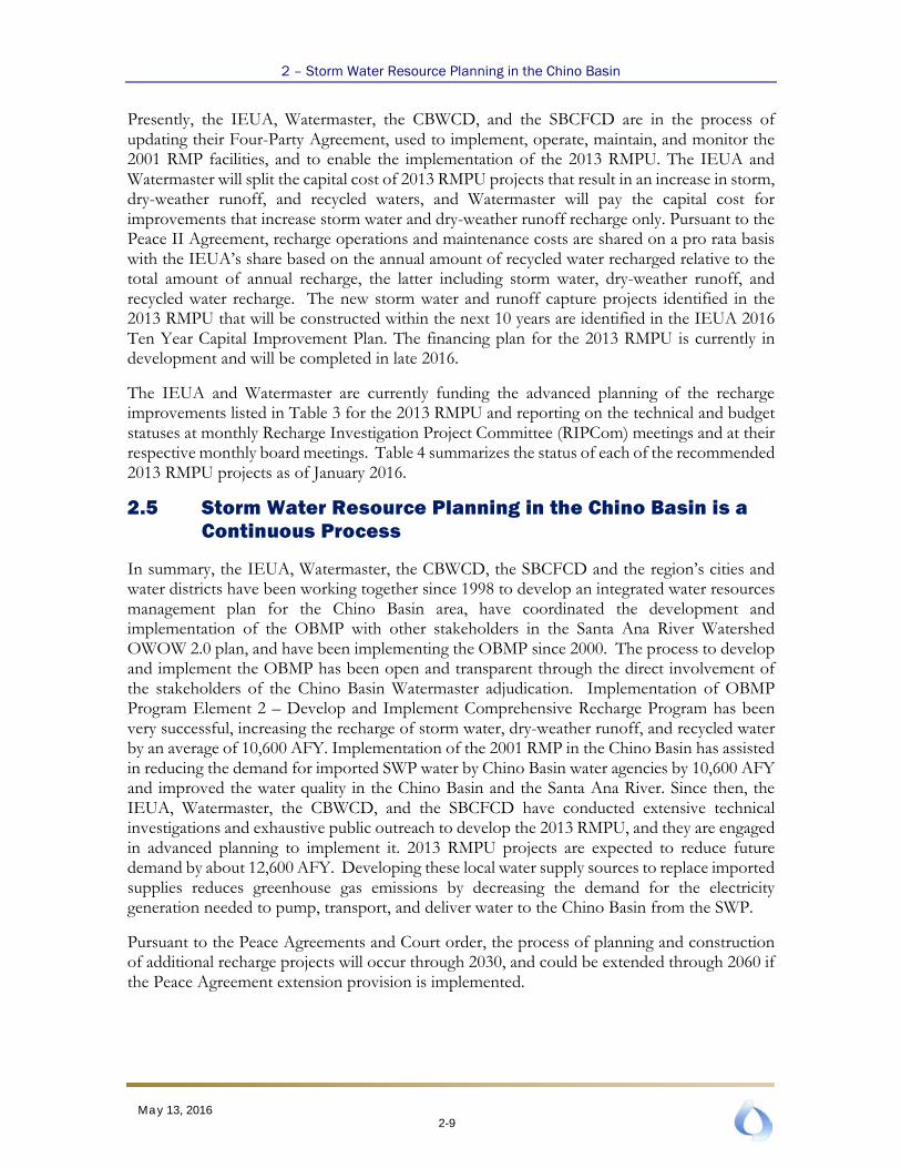
2.5 Storm Water Resource Planning in the Chino Basin is a Continuous Process
In summary, the IEUA, Watermaster, the CBWCD, the SBCFCD and the region’s cities and water districts have been working together since 1998 to develop an integrated water resources management plan for the Chino Basin area, have coordinated the development and implementation of the OBMP with other stakeholders in the Santa Ana River Watershed OWOW 2.0 plan, and have been implementing the OBMP since 2000. The process to develop and implement the OBMP has been open and transparent through the direct involvement of the stakeholders of the Chino Basin Watermaster adjudication. Implementation of OBMP Program Element 2 – Develop and Implement Comprehensive Recharge Program has been very successful, increasing the recharge of storm water, dry-weather runoff, and recycled water by an average of 10,600 AFY. Implementation of the 2001 RMP in the Chino Basin has assisted in reducing the demand for imported SWP water by Chino Basin water agencies by 10,600 AFY and improved the water quality in the Chino Basin and the Santa Ana River. Since then, the IEUA, Watermaster, the CBWCD, and the SBCFCD have conducted extensive technical investigations and exhaustive public outreach to develop the 2013 RMPU, and they are engaged in advanced planning to implement it. 2013 RMPU projects are expected to reduce future demand by about 12,600 AFY. Developing these local water supply sources to replace imported supplies reduces greenhouse gas emissions by decreasing the demand for the electricity generation needed to pump, transport, and deliver water to the Chino Basin from the SWP.
Pursuant to the Peace Agreements and Court order, the process of planning and construction of additional recharge projects will occur through 2030, and could be extended through 2060 if the Peace Agreement extension provision is implemented.
2-9 May 13, 2016

Section 3 − Storm Water Resource Plan Checklist and Self-Certification Narrative
This section demonstrates the functionally equivalency of the 2016 Chino Basin SWRP to the SWRP requirements in the Guidelines. This section is organized to precisely follow the Appendix A Self Certification and Checklist (Checklist) from the Guidelines. Each requirement in the Checklist is listed in a subsection below with a response. This approach is used to provide more a complete response to each requirement in the Checklist than can be accomplished due to space limitations in the Checklist form. Each response includes a “yes” or “no” as to whether or not a requirement has been met and an explanation as to why. All relevant documents used in the response are cited herein and they are available from the IEUA webpage: http://www.ieua.org/referenced-documents/ or can be accessed from another website at the URL assigned to it. The Checklist form from the Guidelines is also included in this report as Appendix A. The response to each requirement in the Checklist form in Appendix A refers explicitly to a subsection of this Section 3.
3.1 Watershed Identification (Guidelines Section VI.A)
The Chino Basin watersheds considered in the 2013 RMPU include, from west to east, the San Antonio Creek/Chino Creek system, the Cucamonga Creek system, the Day Creek system, and the San Sevaine Creek system. The watershed boundaries and subarea boundaries were developed based on fine-scale topographic mapping and storm drainage plans provided by the Cities and the Counties and were subsequently verified in the field. The scale of the watershed mapping covers the Chino Basin and the areas under the common jurisdictions of the IEUA, Watermaster parties, the CBWCD, and the SBCFCD. The subarea delineation used in the 2013 RMPU was required to develop and apply numerical surface water models to evaluate and design storm water and dry-weather runoff recharge facilities. The systems approach adopted in the 2013 RMPU allowed for determining the interaction between existing and proposed facilities, quantification of tradeoffs between various facilities, and various scales of improvements at recharge facilities. The drainage systems identified in the watershed maps were modeled such that the IEUA and Watermaster could evaluate the change in recharge at existing and/or proposed facilities due to the construction of new recharge facilities or the expansion of existing recharge facilities located upstream. The watershed maps are included in the 2013 Recharge Master Plan and the requested GIS files are available on the IEUA SWRP webpage located at http://www.ieua.org/stormwater-resources-plan/. The figures include the following:
• Figure 1 – Location of the Chino Basin and the Santa Ana River Watershed
• Figure 2 – Time History of Channel Lining in the Chino Basin
• Figure 3 – Streambed Infiltration for the Santa Ana River Tributaries that Traverse the Chino Basin
• Figure 4 – Recharge Improvements in the Chino Basin Since Implementation of the OBMP and the 2001 Recharge Master Plan
3-1 May 13, 2016

3 – Storm Water Resource Plan Checklist and Self-Certification Narrative
• Figure 5 – Increase in Storm Water and Dry-Weather Runoff Recharge Due to Recharge Improvements in the Chino Basin Since Implementation of the OBMP and the 2001 Recharge Master Plan
• Figure 6 – Surface Water Diversions in the Chino Basin
• Figure 7 – Water Service Areas and Recharge Facilities in the Chino Basin
• Figure 8 – Land Use Control Agencies and Recharge Facilities in the Chino Basin
3.1.1 Plan Identifies Watershed and Subwatershed(s) for Storm Water Resource Planning [Water Code Section 10565(c), 10562(b)(1), 10565(c)]
Yes. The Chino Basin Watershed is wholly contained in the Santa Ana River Watershed. The Chino Basin Watershed area overlies: most of the adjudicated Chino Basin, the service areas of the IEUA, the retail water agencies that depend on the Chino Basin for water supply, the CBWCD; and parts of the services areas of the Los Angeles County Flood Control District, Riverside, Riverside County Flood Control and Water Conservation District and SBCFCD. The subwatersheds include San Antonio/Chino Creek, Cucamonga Creek, Day Creek and San Sevaine Creek. Each of these subwatersheds has been subdivided into very small subdrainages to enable the detailed numerical surface water modeling, recharge project conceptualization and evaluations of existing and proposed recharge projects. This level of watershed discretization provides for a geographically comprehensive, watershed-based recharge master plan, enabling: the systematic numerical analysis of how the various spreading basins and channels function and interact; quantification of multiple benefits including water supply, water quality and other environmental benefits (e.g., reduction in greenhouse gas emissions); and for the optimization of recharge benefits and costs.
3.1.2 Plan Is Developed on a Watershed Basis, Using Boundaries as Delineated by USGS, CalWater, USGS Hydrologic Unit Designations, or an Applicable Integrated Regional Water Management Group, and Includes a Description and Boundary Map of Each Watershed and Sub-watershed Applicable to the Plan
Yes. The Chino Basin SWRP is developed on a watershed basis, the watershed being four tributaries to the Santa Ana River that include San Antonio Creek/Chino Creek system, the Cucamonga Creek system, the Day Creek system, and the San Sevaine Creek system. The initial watershed boundary delineation was based on the USGS Hydrologic Unit designations and then superseded by more refined delineation based on fine-scale topographic mapping and storm drainage plans provided by the Cities and the Counties, and subsequently verified in the field. The watershed boundaries used in the 2013 RMPU are consistent with the watershed boundaries included in the Santa Ana Watershed Integrated Regional Water Management Plan (IRWMP), called One Water One Watershed (OWOW) 2.0.
3-2 May 13, 2016

3 – Storm Water Resource Plan Checklist and Self-Certification Narrative
3.1.3 Plan includes an explanation of why the watershed(s) and sub-watershed(s) are appropriate for storm water management with a multiple-benefit watershed approach
Yes. The subwatersheds in the Chino Basin Watershed include San Antonio/Chino Creek, Cucamonga Creek, Day Creek, and San Sevaine Creek. Each of these subwatersheds has been subdivided into very small subdrainages to enable the detailed numerical surface water modeling, recharge project conceptualization, and evaluations of existing and proposed recharge projects. This level of watershed discretization provides for a geographically comprehensive, watershed-based recharge master plan, enabling: the systematic numerical analysis of how the various spreading basins and channels function and interact; the quantification of multiple benefits, including water supply, water quality, and other environmental benefits (e.g. reduction in greenhouse gas emissions); and the optimization of recharge benefits and costs.
3.1.4 Plan Describes the Internal Boundaries within the Watershed (Boundaries of Municipalities; Service Areas of Individual Water, Wastewater, and Land Use Agencies, Including Those Not Involved in the Plan; Groundwater Basin Boundaries, Etc.; Preferably Provided in a Geographic Information System Shape File)
Yes. The boundaries of the municipalities and counties, the service areas of individual water and wastewater agencies, the groundwater basin boundaries included in the 2013 RMPU, and the boundaries of land use control agencies (including those not involved in the Chino Basin SWRP) are shown in Figures 1 through 8 of the SWRP and are accessible as GIS shape files from the IEUA SWRP webpage: http://www.ieua.org/stormwater-resources-plan/.
3.1.5 Plan Describes the Water Quality Priorities within the Watershed Based on, at a Minimum, Applicable TMDLs and Consideration of the Water Body-Pollutant Combinations Listed on the State’s Clean Water Act Section 303(d) List of Water Quality Limited Segments (a.k.a. Impaired Waters List)
Yes. Table 5 lists the water quality limited segments in the Chino Basin6 for the watersheds included in the plan and the 2013 RMPU projects that will provide water quality benefits. The primary benefit is achieved through reduced storm water discharge downstream of the proposed Ely, Montclair, and Turner Basin projects, and the diversion of dry-weather (urban) runoff to the spreading basins and its subsequent recharge. While there are no impaired water quality segments on the Day and San Sevaine Creek systems, the reductions in storm water discharge and dry-weather runoff at the proposed facilities will improve water quality in these creeks downstream of the proposed 2013 RMPU projects and in the Santa Ana River.
6 The current 303 (d) of impaired water bodies in the Santa Ana River watershed is located here:
http://www.waterboards.ca.gov/santaana/water_issues/programs/tmdl/docs/303d/2010_303d.pdf
3-3 May 13, 2016

3 – Storm Water Resource Plan Checklist and Self-Certification Narrative
3.1.6 Plan Describes the General Quality and Identification of Surface and Ground Water Resources within the Watershed (Preferably Provided in a Geographic Information System Shape File)
Yes. Please see the comprehensive Watermaster Biennial State of the Basin Report sections entitled General Hydrologic Conditions and Water Quality. These sections characterize in great detail the groundwater conditions in the Chino Basin. See also the Chino Basin Maximum Benefit Annual Report Section 3 entitled Maximum-Benefit Monitoring Program: Data Collected in 2014 and Section 4 entitled The Influence of Rising Groundwater on the Santa Ana River that characterizes surface and ground water resource conditions in the Basin.7, 8 The former report was updated in spring of 2016 . The 2015 IRP Phase 1 report, chapter 3 also includes a description of the groundwater resources specific to the IEUA service area.
3.1.7 Plan Describes the Local Entity or Entities that Provide Potable Water Supplies and the Estimated Volume of Potable Water Provided by the Water Suppliers
Yes. Please see Section 2.4 of the 2013 RMPU9 for a detailed description of the potable water demands for entities that provide potable water supplies and the sources of those supplies. The IEUA Urban Water Management Plan and Chapter 3 of the 2015 IRP Phase 1 report also include a description of the all potable water resources specific to the IEUA service area.
3.1.8 Plan Includes Map(s) Showing Location of Native Habitats, Creeks, Lakes, Rivers, Parks, and Other Natural or Open Space within the Sub-Watershed Boundaries
Yes. Please see Section 5.9 of the OWOW 2.0 report10 for the subject maps. The maps and related documentation in the OWOW 2.0 report are presently being updated. The IEUA is working in partnership with the other regional water agencies in the Santa Ana River Watershed, including the Eastern Municipal Water District, the Orange County Water District, the San Bernardino Valley Municipal Water District, and the Western Municipal Water District to develop the Upper Santa Ana River Habitat Conservation Plan (USARHCP).11 One of the goals of the USARHCP is to identify key habitat areas and to create a mitigation bank to enable their protection and/or the creation of new habitat. This plan should be completed in July 2017.
The IEUA has dedicated 3.7 acres of habitat at its RP3 recharge site to the preservation of riparian and woodland habitat. The habitat is conserved as mitigation for the recharge facilities constructed following the 2000 RMP. The site collects dry-weather flows from Declez Creek (a tributary to San Sevaine Creek), which are cleaned by the wetlands and recharged. In addition, in 2004 the IEUA dedicated the Chino Creek Wetlands and Educational Park (CCP) in Chino
7 See the groundwater quality section in the 2014 State of the Basin Report, located here:
http://www.cbwm.org/rep_engineering.htm 8 See Sections 3 and 4 of the Maximum Benefit Annual Report, located here:
http://www.cbwm.org/rep_engineering.htm 9 See Section 2.4 of the 2013 RMPU located here: http://www.ieua.org/referenced-documents/. 10 See Section 5.9 of the OWOW 2.0 report located here: http://www.sawpa.org/owow-2-0-plan-2/. 11 Visit http://www.uppersarhcp.com for a description of the USARHCP.
3-4 May 13, 2016
3 – Storm Water Resource Plan Checklist and Self-Certification Narrative
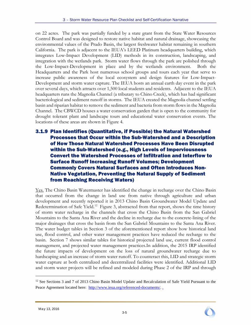
on 22 acres. The park was partially funded by a state grant from the State Water Resources Control Board and was designed to restore native habitat and natural drainage, showcasing the environmental values of the Prado Basin, the largest freshwater habitat remaining in southern California. The park is adjacent to the IEUA’s LEED Platinum headquarters building, which integrates Low-Impact Development (LID) methods in its construction, landscaping, and integration with the wetlands park. Storm water flows through the park are polished through the Low-Impact-Development in place and by the wetlands environment. Both the Headquarters and the Park host numerous school groups and tours each year that serve to increase public awareness of the local ecosystem and design features for Low-Impact-Development and storm water capture. The IEUA hosts an annual earth day event in the park over several days, which attracts over 1,500 local students and residents. Adjacent to the IEUA headquarters runs the Magnolia Channel (a tributary to Chino Creek), which has had significant bacteriological and sediment runoff in storms. The IEUA created the Magnolia channel settling basin and riparian habitat to remove the sediment and bacteria from storm flows in the Magnolia Channel. The CBWCD houses a water conservation garden that is open to the community for drought tolerant plant and landscape tours and educational water conservation events. The locations of these areas are shown in Figure 4.
3.1.9 Plan Identifies (Quantitative, if Possible) the Natural Watershed Processes that Occur within the Sub-Watershed and a Description of How Those Natural Watershed Processes Have Been Disrupted within the Sub-Watershed (e.g., High Levels of Imperviousness Convert the Watershed Processes of Infiltration and Interflow to Surface Runoff Increasing Runoff Volumes; Development Commonly Covers Natural Surfaces and Often Introduces Non-Native Vegetation, Preventing the Natural Supply of Sediment from Reaching Receiving Waters)
Yes. The Chino Basin Watermaster has identified the change in recharge over the Chino Basin that occurred from the change in land use from native through agriculture and urban development and recently reported it in 2013 Chino Basin Groundwater Model Update and Redetermination of Safe Yield.12 Figure 3, abstracted from that report, shows the time history of storm water recharge in the channels that cross the Chino Basin from the San Gabriel Mountains to the Santa Ana River and the decline in recharge due to the concrete-lining of the major drainages that cross the basin from the San Gabriel Mountains to the Santa Ana River. The water budget tables in Section 3 of the aforementioned report show how historical land use, flood control, and other water management practices have reduced the recharge to the basin. Section 7 shows similar tables for historical projected land use, current flood control management, and projected water management practices.In addition, the 2015 IRP identified the future impacts of development on the loss of natural groundwater recharge due to hardscaping and an increase of storm water runoff. To counteract this, LID and strategic storm water capture at both centralized and decentralized facilities were identified. Additional LID and storm water projects will be refined and modeled during Phase 2 of the IRP and through
12 See Sections 3 and 7 of 2013 Chino Basin Model Update and Recalculation of Safe Yield Pursuant to the
Peace Agreement located here: http://www.ieua.org/referenced-documents/. .
3-5 May 13, 2016

3 – Storm Water Resource Plan Checklist and Self-Certification Narrative
the development of a LID Storm water Plan, which began in FY15/16 and is expected to be completed in FY16/17.
3.2 Water Quality Compliance (Guidelines Section V)
3.2.1 Plan Identifies Activities that Generate or Contribute to the Pollution of Storm Water or Dry Weather Runoff, or that Impair the Effective Beneficial Use of Storm Water or Dry Weather Runoff [Water Code Section 10562(d)(7)]
Yes. Please see Sections 2 and 3 of the Phase 1 OBMP Report13and Sections 3 and 7 of the 2013 Chino Basin Model Update and Recalculation of Safe Yield14 report. These documents describe how historical land use changes and storm water management have impacted the discharge of storm water and dry-weather runoff in the major drainages that traverse and recharge the Chino Basin. Section 2 of the 2014 State of the Basin Report15 illustrates the cumulative impacts of land use and storm water management in the Chino Basin Watershed have impacted the storm water discharge in the Santa Ana River at Prado Dam.
3.2.2 Plan Describes How It Is Consistent and Assists in, Compliance with Total Maximum Daily Load Implementation Plans and Applicable National Pollutant Discharge Elimination System Permits [Water Code Section 10562(b)(5)]
Yes. The 2001 RMP projects were incorporated into the Santa Ana River Watershed Water Quality Control (Basin) Plan in Regional Board Resolution R8-2004-000116 as part of the salt and nutrient management plan for the Chino Basin. The Santa Ana Regional Water Quality Control Board (Water Board) subsequently included “completion” and “operation” of the storm water recharge projects into the recycling permits issued to the IEUA and Watermaster; the permits were issued in Water Board Resolutions R8-2005-0033, R8-2007-0039, and R8-2009-0057.17 The TDS and nitrogen concentration limits in the recycling permit are dependent
13 See Sections 2 and 3 of the Chino Basin Optimum Basin Management Program Report located here:
http://www.ieua.org/referenced-documents/. 14 See Sections 3 and 7 of the 2013 Chino Basin Model Update and Recalculation of Safe Yield Pursuant to
the Peace Agreement located here: http://www.ieua.org/referenced-documents/. 15 See Section 2 of the 2014 State of the Basin Report located here: http://www.cbwm.org/rep_engineering.htm 16 See Section 5 Implementation of the Santa Ana Water Quality Control Plan located here:
http://www.waterboards.ca.gov/santaana/water_issues/programs/basin_plan/index.shtml 17 The Water Board requires compliance with the maximum benefit demonstrations, including the
construction and operation of the 2001 RMP facilities. See the following historical issuance of permits that
requires the construction and operation of the 2001 RMP facilities and the storm water dilution requirements
are located here:
http://www.waterboards.ca.gov/santaana/board_decisions/adopted_orders/orders/2005/05_033_wdr_ieua_cb
w_04152005.pdf,
http://www.waterboards.ca.gov/santaana/board_decisions/adopted_orders/orders/2007/07_039_wdr_ieuacbw
_cbrwgrp_06292007.pdf,
3-6 May 13, 2016

3 – Storm Water Resource Plan Checklist and Self-Certification Narrative
on increasing storm water recharge pursuant to the OBMP and the 2001 RMP. The IEUA and Watermaster are fully compliant with the permit requirements. Note also that the 2001 RMP and proposed 2013 RMPU facilities intercept and recharge all dry-weather runoff that is tributary to them.
3.2.3 Plan Meets Applicable Permits and Describes How It Meets all Waste Discharge Permit Requirements [Water Code Section 10562(b)(5)]
Yes. See explanation provided in 3.2.2 immediately above regarding IEUA NPDES/water recycling permits that require the time-certain construction of storm water recharge improvements. The IEUA and the Watermaster are fully compliant with these permits. The Chino Basin Watermaster has acquired water rights to divert storm water for recharge in the Chino Basin. These permits, their priority dates, annual diversion limits, instantaneous diversion rates, and diversion periods are listed below.
Permit Number Priority Date Annual Diversion Limit
(AFY)
Instantaneous Diversion Rate
(cfs)
Diversion Period
19895 6/10/1985 15,000 179 11/1 to 4/30 20753 4/9/1987 27,000 440 10/1 to 5/1 21225 11/4/2002 68,500 115,570 1/1 to 12/31 Total -- 110,500 116,189 --
The IEUA constructed and has been operating monitoring equipment that enables them to compute the amount of storm water and dry-weather runoff recharge and reports this information to Watermaster. Watermaster prepares an annual report and submits it to the SWRCB, describing the amount of storm water and dry-weather runoff that is diverted and recharged and the change in discharge and relative change in discharge for each tributary to the Santa Ana River due to these diversions. Watermaster is fully compliant with all of its water rights permit requirements.
3.3 Organization, Coordination, Collaboration (Guidelines Section VI.B)
3.3.1 Local Agencies and Nongovernmental Organizations Were Consulted in Plan Development [Water Code Section 10565(a)]
Yes. Extensive coordination and outreach occurred in the development of the 2013 RMPU, including nine public community workshops18 and 67 steering committee meetings.19 Attendees
http://www.waterboards.ca.gov/santaana/board_decisions/adopted_orders/orders/2009/09_057_amending_07
-0039_ieua_cbw_phase1_2.pdf 18 The workshop agendas and presentation materials are located here: http://52.32.17.3:7777/ 19 The agendas, presentation materials, and sign-in sheets are located here:
http://www.cbwm.org/FTP/CB%20RMPU%20Steering%20Committee/Meetings%20By%20Date/
3-7 May 13, 2016

3 – Storm Water Resource Plan Checklist and Self-Certification Narrative
included public agencies (regional water management, retail water agencies, flood control districts, and regulatory agencies), private water companies, and members of the public. Please see the Watermaster ftp site 20; provided here are the sign-in sheets, agendas, and meeting materials for the 67 recharge master plan steering committee meetings that occurred through the development of the 2013 RMPU and the subsequent meetings in 2014 and 2015 related to its implementation.
See the 2013 RMPU, Section 821 and more specifically the implementation plan therein that identifies the public agencies, one private water company (Fontana Water Company), and one private business (CSI) required to implement the plan. In addition to steering committee meetings, regular progress reports were included at IEUA, Watermaster, CBWCD, and SBCFCD board meetings. This process continues through monthly Recharge Investigation and Projects Committee (RIPCom) meetings22 and updates at IEUA, Watermaster, CBWCD, and SBCFCD board meetings. Additional stakeholder input and outreach is expected to occur during the LID Storm Water Plan, which will be developed during FY16/17.
Development of the 2001 RMP projects and their permitting included multiple public meetings and workshops and included several nongovernmental organizations, such as the Inland Coast Keepers, the Endangered Habitat League, and the Natural Resources Defense Council.
3.3.2 Community Participation Was Provided for in Plan Development [Water Code Section 10562(b)(4)]
Yes. Extensive coordination and outreach occurred in the development of the 2013 RMPU, including nine public community workshops and 67 steering committee meetings. Attendees included public agencies (regional water management, retail water agencies, flood control districts, and regulatory agencies), private water companies, and members of the public. Please see the Watermaster ftp site, provided here are the sign-in sheets, agendas, and meeting materials for the 67 recharge master plan steering committee meetings that occurred through the development of the 2013 RMPU and the subsequent meetings in 2014 and 2015 related to its implementation.
See the 2013 RMPU, Section 8 and more specifically the implementation plan therein that identifies the public agencies, one private water company (Fontana Water Company), and one private business (CSI) required to implement the plan. In addition to steering committee meetings, regular progress reports were included at IEUA, Watermaster, CBWCD, and SBCFCD board meetings. This process continues through the monthly Recharge Investigation and Projects Committee (RIPCom) meetings and updates at IEUA, Watermaster, CBWCD, and SBCFCD board meetings. Additional stakeholder input and outreach is expected to occur during the LID Storm Water Plan, which will be developed during FY16/17.
20 Ibid 21 See the 2013 RMPU, Section 8 located here: http://www.ieua.org/referenced-documents/. 22 The agendas, presentation materials, and sign-in sheets are located here:
http://www.cbwm.org/FTP/Recharge%20Investigations%20and%20Projects%20Committee%20(RIPCom)/
3-8 May 13, 2016

3 – Storm Water Resource Plan Checklist and Self-Certification Narrative
Development of the 2001 RMP projects and their permitting included multiple public meetings and workshops and included several nongovernmental organizations, such as Inland Coast Keepers, the Endangered Habitat League, and the Natural Resources Defense Council.
IEUA and its regional partners developed the Inland Empire Landscape Alliance (IELA). The IELA spent two years working with local agencies to evaluate existing landscape policies and to provide information about all aspects of landscape water efficiency, through a series of educational newsletters, workshops and tours focused on low impact development practices, plant palettes, irrigation materials and techniques, and measures that cities are currently implementing within their communities to be wise water stewards. IEUA’s LID Storm Water Plan efforts included continued public outreach and community involvement.
3.3.3 Plan Includes Description of the Existing Integrated Regional Water Management Group(s) Implementing an Integrated Regional Water Management Plan
Yes. The Santa Ana Watershed Project Authority (SAWPA) led a collaborative process with public agencies, private utilities, and NGO stakeholders in the watershed and subsequently prepared and adopted an IRWMP called OWOW 2.0. The entities implementing OWOW 2.0 can be found at the OWOW 2.0 website.23 The IEUA, Watermaster, the CBWCD, and the SBCFCD participated in the development of OWOW 2.0.
The IEUA, Watermaster, the CBWCD, and the SBCFCD are working with SAWPA to incorporate the Chino Basin SWRP into OWOW 2.0 will occur in March 2016. The types of projects included in the 2013 RMPU are consistent with those recommended for optimization and prioritization (see OWOW 2.0, Section 5.8,) and cited here:
“Existing FCD (flood control district) basin and facility retrofit evaluation and implementation studies (MS4 Permit requirement): Determine storm water capture and groundwater recharge potential, concomitant with continued flood protection requirements, for FCD flood control district] facilities throughout the SAR [Santa Ana River] Watershed. Develop list of priorities for implementation, and consult with potential project partners.”
The IEUA, Watermaster, the CBWCD, the SBCFCD, public water agencies, private water retailers, municipal water users, agricultural water users, industrial water users, and other stakeholders in the Chino Basin area have worked together over four years to identify recharge opportunities with multiple benefits, to analyze them to determine recharge potential, to design the structural and operational improvements required to increase recharge, and to prioritize these improvements. The OWOW 2.0 recommendation regarding the retrofit of existing “FCD” facilities comes in part due to the successful recharge projects developed in existing FCD facilities in the 2001 RMP by the IEUA, Watermaster, the CBWCD, and the SBCFCD.
In addition, the 2015 IRP Phase 1 built upon the foundation established by the 2013 RMPU and OWOW process. During preparation of the 2015 IEUA IRP Phase 1, partners recognized
23 See Section 2.2 of OWOW 2.0, located at http://www.sawpa.org/owow-2-0-plan-2/
3-9 May 13, 2016

3 – Storm Water Resource Plan Checklist and Self-Certification Narrative
the role of a complementary, decentralized LID system that captures water onsite. Further refining, identification, and modeling of such projects will occur as part of the IRP Phase 2, throughout the summer and fall of 2016. The IEUA LID Storm Water Plan, which is to occur on a parallel track to the IRP Phase 2, will incorporate regional stakeholders and community members as part of the education, outreach, and site identification process to offset the loss of storm water capture due to anticipated development as identified by the 2015 IRP Phase 1.
3.3.4 Plan Includes Identification of and Coordination with Agencies and Organizations (Including, but Not Limited to Public Agencies, Nonprofit Organizations, and Privately Owned Water Utilities) that Need to Participate and Implement Their Own Authorities and Mandates in Order to Address the Storm Water and Dry Weather Runoff Management Objectives of the Plan for the Targeted Watershed
Yes. Extensive coordination and outreach occurred in the development of the 2013 RMPU, including nine public community workshops and 67 steering committee meetings. Attendees included public agencies (regional water management, retail water agencies, flood control districts, and regulatory agencies), private water companies, and members of the public. Please see the Watermaster ftp site, provided here are the sign-in sheets, agendas, and meeting materials for the 67 recharge master plan steering committee meetings that occurred through the development of the 2013 RMPU and the subsequent meetings in 2014 and 2015 related to its implementation.
See the 2013 RMPU, Section 8 and more specifically the implementation plan therein that identifies the public agencies, one private water company (Fontana Water Company), and one private business (CSI) required to implement the plan. In addition to steering committee meetings, regular progress reports were included at IEUA, Watermaster, CBWCD, and SBCFCD board meetings. This process continues through monthly Recharge Investigation and Projects Committee (RIPCom) meetings and updates at IEUA, Watermaster, CBWCD, and SBCFCD board meetings. Additional stakeholder input and outreach is expected to occur during the LID Storm Water Plan, which will be developed during FY16/17.
Development of the 2001 RMP projects and their permitting included multiple public meetings and workshops and included several nongovernmental organizations, such as the Inland Coast Keepers, the Endangered Habitat League, and the Natural Resources Defense Council.
3.3.5 Plan Includes Identification of Nonprofit Organizations Working on Storm Water and Dry Weather Resource Planning or Management in the Watershed
Yes. The OWOW2.0 IWRMP, in which the IEUA and Watermaster have participated, included nonprofit organizations in outreach, conferences, and development of the IWRMP pillars and subsequent meetings; however, nonprofit organizations have not been engaged directly in the development of the 2016 Chino Basin SWRP regional elements as they affect water rights holders. The IEUA and the Watermaster will be engaging with nonprofits on planning for local developments within its LID Storm Water Plan, being prepared through the summer and fall of 2016.
3-10 May 13, 2016

3 – Storm Water Resource Plan Checklist and Self-Certification Narrative
3.3.6 Plan Includes Identification and Discussion of Public Engagement Efforts and Community Participation in Plan Development
Yes. Extensive coordination and outreach occurred in the development of the 2013 RMPU, including nine public community workshops24 and 67 steering committee meetings.25 Attendees included public agencies (regional water management, retail water agencies, flood control districts, and regulatory agencies), private water companies, and members of the public. Please see the Watermaster ftp site 26; provided here are the sign-in sheets, agendas, and meeting materials for the 67 recharge master plan steering committee meetings that occurred through the development of the 2013 RMPU and the subsequent meetings in 2014 and 2015 related to its implementation.
See the 2013 RMPU, Section 827 and more specifically the implementation plan therein that identifies the public agencies, one private water company (Fontana Water Company), and one private business (CSI) required to implement the plan. In addition to steering committee meetings, regular progress reports were included at IEUA, Watermaster, CBWCD, and SBCFCD board meetings. This process continues through monthly Recharge Investigation and Projects Committee (RIPCom) meetings28 and updates at IEUA, Watermaster, CBWCD, and SBCFCD board meetings. Additional stakeholder input and outreach is expected to occur during the LID Storm Water Plan which will be developed during FY16/17.
Development of the 2001 RMP projects and their permitting included multiple public meetings and workshops and included several nongovernmental organizations, such as the Inland Coast Keepers, the Endangered Habitat League, and the Natural Resources Defense Council.
IEUA and its regional partners developed the Inland Empire Landscape Alliance (IELA). The IELA spent two years working with local agencies to evaluate existing landscape policies and to provide information about all aspects of landscape water efficiency, through a series of educational newsletters, workshops and tours focused on low impact development practices, plant palettes, irrigation materials and techniques, and measures that cities are currently implementing within their communities to be wise water stewards. IEUA’s LID Storm Water Plan efforts included continued public outreach and community involvement.
24 The workshop agendas and presentation materials are located here: http://52.32.17.3:7777/ 25 The agendas, presentation materials, and sign-in sheets are located here:
http://www.cbwm.org/FTP/CB%20RMPU%20Steering%20Committee/Meetings%20By%20Date/ 26 Ibid 27 See the 2013 RMPU, Section 8 located here: http://www.ieua.org/referenced-documents/. 28 The agendas, presentation materials, and sign-in sheets are located here:
http://www.cbwm.org/FTP/Recharge%20Investigations%20and%20Projects%20Committee%20(RIPCom)/
3-11 May 13, 2016

3 – Storm Water Resource Plan Checklist and Self-Certification Narrative
3.3.7 Plan Includes Identification of Required Decisions That Must be Made by Local, State or Federal Regulatory Agencies for Plan Implementation and Coordinated Watershed-Based or Regional Monitoring and Visualization
Yes, in part, but not all required decisions have been identified. Please see Section 8 of the 2013 RMPU29, specifically the implementation plan for a description of the permits and decisions that are presently known to be required. The permits and decisions required will be determined after preliminary designs are completed and the CEQA documents for the projects are certified in the fall of 2016. A list of required decisions will be prepared then.
3.3.8 Plan Describes Planning and Coordination of Existing Local Governmental Agencies, Including Where Necessary New or Altered Governance Structures to Support Collaboration among Two or More Lead Local Agencies Responsible for Plan Implementation
Yes. See section 3.3.1 above. Note that the existing governance structures did not need to be altered to develop the 2016 SWRP.
3.3.9 Plan Describes the Relationship of the Plan to Other Existing Planning Documents, Ordinances, and Programs Established by Local Agencies
Yes. The Chino Basin SWRP, as an equivalency document, has incorporated and described the interrelationship of other planning documents and processes, some of which are dictated by the Chino Basin Judgment and Peace Process. Much of these interrelations are stated in Sections 1 and 2 of the Chino SWRP. The IEUA and Watermaster entered into an agreement that describes their cost sharing of the 2001 RMP facilities and other recharge facilities that have been constructed since 2001.30 The IEUA and Watermaster are in a process to revise this agreement to finance the construction of the 2013 RMPU facilities. The revised agreement will be completed in the fall of 2016.
The IEUA, Watermaster, the CBWCD, and the SBCFCD continue to emphasize the integration of agencies and planning efforts by updating their existing “Four-Party” agreement31 that was used to implement the 2001 RMP and to operate and maintain the facilities. The revised agreement will be completed in the fall of 2016. The Four-Party agreement spawned the Groundwater Recharge Coordinating Committee (GRCC), which meets quarterly and as required to plan recharge operations and maintenance, to develop annual budgets, and to develop solutions to problems as they occur. The GRCC has been in existence since the implementation of the 2001 RMP projects.
29 Please see Section 8 of the 2013 RMPU, located here: http://www.ieua.org/referenced-documents/. 30 The existing agreement between the IEUA and Watermaster for financing the construction of recharge
facilities is located here: http://www.ieua.org/referenced-documents/. 31 The existing “Four Party” agreement between the IEUA, Watermaster, the CBWCD, and the SBCFCD is
located here: http://www.ieua.org/referenced-documents/.
3-12 May 13, 2016

3 – Storm Water Resource Plan Checklist and Self-Certification Narrative
An agreement between the IEUA, Watermaster, and California Steel Industries (CSI) will be prepared and completed by the end of 2016 to enable the IEUA to construct the 2013 RMPU recharge improvements on CSI property.
3.3.10 (If Applicable) Plan Explains Why Individual Agency Participation in Various Isolated Efforts is Appropriate
Stakeholders in the Chino Basin participate in the Watermaster process, based on their classification of water rights; thus, certain classifications may not participate in the RMPU storm water projects. The appropriative pool members gain water rights based on the development of projects that increase storm water recharge. Agencies may have different financial tolerances for the cost per AF to develop a project and may decide to pursue more expensive projects to fill that need over regionally selected projects. The agencies’ isolated projects may also benefit them individually; for example, they may mitigate pumping depressions, local flooding, or water quality enhancements.
3.4 Quantitative Methods (Guidelines Section VI.C)
3.4.1 For All Analyses: Plan Includes an Integrated Metrics-Based Analysis to Demonstrate That the Plan’s Proposed Storm Water and Dry Weather Capture Projects and Programs Will Satisfy the Plan’s Identified Water Management Objectives and Multiple Benefits
Yes. The 2013 RMPU consists of nine projects that will reduce storm water and dry-weather runoff discharges through recharge in spreading basins. The projected increase in storm water recharge will average about 5,500 AFY. These same improvements will increase recycled water recharge capacity by 7,100 AFY. Future water demands on average will thus lessen from those forecasted by approximately 12,600 AFY (equal to the sum of 5,500 AFY of storm water recharge plus 7,100 AFY of recycled water recharge) in addition to those gained by the 2001 RMP projects. A reduction in demand for imported SWP water supplies will subsequently reduce the greenhouse gas emissions created by transporting imported water to Chino Basin water users.
New storm water recharge was estimated using a sophisticated numerical surface water modeling approach that estimates the discharge available for diversion at each potential recharge project; routes the discharge through the basin; operates the basins for flood control and water conservation; and estimates recharge, evaporation, and discharge from the facility. The recharge estimates are based on a daily precipitation time history for the 61-year period of 1950 through 2010 and on 2010 land use and drainage conditions. The model is calibrated using the monitoring data developed by the IEUA and the USGS. The results of the modeling work are summarized in Section 8 of the 2013 RMPU report. 32, 33
32 See Section 8 of 2013 Amendment to the 2010 Recharge Master Plan Update (2013 RMPU):
http://www.ieua.org/referenced-documents/. 33 See Appendix B, 2013 Chino Basin Model Update and Recalculation of Safe Yield Pursuant to the Peace
Agreement, October 2015, WEI:
3-13 May 13, 2016

3 – Storm Water Resource Plan Checklist and Self-Certification Narrative
The projected increase in dry-weather runoff recharge is presently unknown and will be determined during the design of the facilities. The increase in dry-weather runoff will eliminate the discharge of all dry-weather runoff originating upstream of the recharge improvements and thus will reduce the pollutant loading to the downstream impaired water bodies (see Table 5 herein).
3.4.2 For Water Quality Project Analysis (Section VI.C.2.a): Plan Includes an Analysis of How Each Project and Program Complies with or Is Consistent with an applicable NPDES Permit. The Analysis Should Simulate the Proposed Watershed-Based Outcomes Using Modeling, Calculations, Pollutant Mass Balances, Water Volume Balances, and/or Other Methods of Analysis. Describes How Each Water Project or Program Will Contribute to the Preservation, Restoration, or Enhancement of Watershed Processes (as Described in Guidelines Section VI.C.2.a)
Yes. The 2013 RMPU projects are recharge projects whose primary function is to increase the sustainable yield of the Chino Basin. This new recharge provides quantifiable benefits to the groundwater basin and un-quantified benefits to surface water. The water quality benefits to groundwater are derived from the recharge of storm water with low TDS and low nitrate concentrations. This helps to reduce the TDS and nitrate concentration impacts from return flows from historical and on-going agricultural activities and dilutes the TDS and nitrate loading from the recharge of recycled water. The IEUA and Watermaster conduct monitoring for the recharge projects constructed in the 2001 RMP, and this monitoring will be expanded when the 2013 RMPU projects are implemented. Monitoring will include discharge, stage, groundwater level, and surface and ground water quality. The IEUA and Watermaster are currently updating/preparing an antidegradation analyses for the 2013 RMPU projects to project the TDS and nitrogen impacts to Chino Basin from current and proposed recharge projects and other basin management activities. This antidegradation analysis will be included in the CEQA document to be published in late 2016 for the 2013 RMPU. Historically, the IEUA has prepared antidegradation analyses and reported the results to the Watermaster and the Water Board. The IEUA prepares an antidegradation analysis about every five years coincident with permit renewal. The antidegradation analysis will use historical data and future projections to estimate the TDS and nitrogen impacts to groundwater from the recharge of storm water, dry-weather runoff, recycled water, and other sources of recharge, and provide impact attribution to each source of recharge. This information has and will be reported to the IEUA, Watermaster, the CBWCD, the SBCWD, and the Water Board.
http://www.cbwm.org/docs/engdocs/WEI%202013%20CBWM%20Recalculation%20Model%20Update/201
51005_WEI_2013_CBWM_Recal_Model_Final_low.pdf
3-14 May 13, 2016

3 – Storm Water Resource Plan Checklist and Self-Certification Narrative
3.4.3 The surface water quality impacts and benefits from recharge of dry-weather runoff from the 2013 RMPU project implementation will be developed and reported in the CEQA document to be published in late 2016 for the 2013 RMPU. For Storm Water Capture and Use Project Analysis (Section VI.C.2.b): Plan Includes an Analysis of How Collectively the Projects and Programs in the Watershed Will Capture and Use the Proposed Amount of Storm Water and Dry Weather Runoff
Yes. New storm water recharge was estimated using a sophisticated numerical surface water modeling approach that estimates the discharge available for diversion at each potential recharge project; routes the discharge through the basin; operates the basins for flood control and water conservation; and estimates recharge, evaporation, and discharge from the facility. The recharge estimates are based on a daily precipitation time history for the 61-year period from 1950 through 2010 and on 2010 land use and drainage conditions. The results of the modeling work are summarized in Section 8 of the 2013 Recharge Master Plan Report. 34, 35
Since the 2001 RMP projects were constructed, The IEUA has monitored their performance and prepares estimates of the amount of storm water recharged due to the 2001 RMP projects, and Watermaster subsequently allocates the storm water and dry-weather recharge attributable to the 2001 RMP projects to the municipal water agencies that are parties to the Chino Basin Judgment (the Community). The municipal water agencies then produce this water to meet their demands. Watermaster does this on an annual basis and includes this calculation in its annual assessment package. In this way, the new recharge is allocated out to the municipal water agencies that are parties to the Chino Basin Judgment (the Community) and subsequently produced. The basis for this allocation is the Chino Basin Judgment. Watermaster will allocate the new recharge from storm water and dry-weather runoff from the 2013 RMPU projects in an identical way. The projected increase in storm water recharge will average about 5,500 AFY and the projected increase in recycled water recharge will average about 7,100 AFY. The increase in dry-weather runoff capture and recharge is presently unknown and will be determined later this year when the bulk of the 2013 RMPU project final designs are completed. Regional demands for water are expected be supplemented by the combined amount of storm, dry-weather runoff, and recycled water recharge, and will equal about 12,600 AFY. When quantified through monitoring by the IEUA and Watermaster, the dry-weather runoff recharge will further reduce the rising demand for imported SWP water.
3.4.4 For Water Supply and Flood Management Project Analysis (Section VI.C.2.c): Plan Includes an Analysis of How Each Project and Program Will Maximize and/or Augment Water Supply
Yes. See discussion for 3.4.3. The RMPU includes an evaluation of recharge benefits for storm water and other source water, which is used to develop a project cost per AF.
34 See Section 5 and Appendix C of the 2010 RMPU, 2010, WEI, located here: http://52.32.17.3:7777/ 35 See Section 8 of 2013 RMPU, 2013, WEI, located here: http://www.ieua.org/referenced-documents/.
3-15 May 13, 2016

3 – Storm Water Resource Plan Checklist and Self-Certification Narrative
3.4.5 For Environmental and Community Benefit Analysis (Section VI.C.2.d): Plan Includes a Narrative of How Each Project and Program Will Benefit the Environment and/or Community, with Some Type of Quantitative Measurement
Yes. See discussion for 3.4.2. In addition to the water quality benefits described in section 3.4.2, the local community and environment have benefited from past regional planning through the development of the Chino Creek Wetlands and Educational Park, which serves as a habitat for local fish and wildlife as well as providing recreational opportunities for the local community; and from the additional habitat development for native woodland and riparian species on 3.7 dedicated acres at the IEUA’s RP-3 recharge basin site. The IEUA is also a participant in the Upper Santa Ana River Habitat Conservation Plan (USARHCP), which includes many regional stakeholders in the upper Santa Ana River watershed. The USARHCP is in the process of identifying key habitat areas in order to create a mitigation bank that will enhance, protect, and create new habitat for riparian species. Quantitative measurements of habitat enhancements will be built into the monitoring stage of this plan, which is currently under development. The USARHCP will allow long-term maintenance of storm water impacts to IEUA, Watermaster, SBCFCD, and CBWCD recharge facilities. The USARHCP is anticipated to be completed in 2017.
3.4.6 Data Management (Section VI.C.3): Plan Describes Data Collection and Management, Including: a) Mechanisms by Which Data Will Be Managed and Stored; b) How Data Will Be Assessed by Stakeholders and the Public; c) How Existing Water Quality and Water Quality Monitoring Will Be Assessed; d) Frequency at Which Data Will Be Updated; and e) How Data Gaps Will Be Identified
Yes. Data has been and will be managed as follows:
a. Mechanism by which data will be managed and stored:
i. The IEUA and Watermaster conduct extensive surface water, groundwater, and ground level monitoring programs using conventional and satellite monitoring techniques, including:
(1) groundwater level, production, and water quality monitoring throughout the Chino Basin, including specialized monitoring near all recharge facilities;
(2) surface water discharge, diversion, and water quality monitoring throughout the Chino Basin with specialized monitoring at recharge facilities to accurately assess inflow, recharge, evaporation, and discharge from each facility, and to assess the impacts to downstream resources and the Santa Ana River
ii. The IEUA stores the stage data collected at the recharge basins in its SCADA historian database. This stage data acquired at the recharge facilities and all other monitoring data is stored in a relational database managed by Watermaster, using the HydroDaVEsm managed service platform (HDMS).
3-16 May 13, 2016
3 – Storm Water Resource Plan Checklist and Self-Certification Narrative
b. How data will be accessed by stakeholders and the public?
i. Annual production and water quality reports are available online through the Watermaster website and SAWPA monitoring task forces. Additional information is available upon request from the Watermaster. The IEUA, Watermaster, the CBWCD, and the SBCFCD have complete access to all of the monitoring data maintained in Watermaster’s relational database through HDMS and, for some private wells, by request to the Watermaster. The IEUA, Watermaster and the SBCFCD have SCADA terminals in their offices that enable them real time monitoring of the recharge facilities. The SBCFCD makes significant use of the SCADA network to monitor and control storm water recharge.
c. How existing water quality and water quantity monitoring will be assessed?
i. The IEUA and Watermaster have joint reporting obligations to the Water Board pursuant to Water Board resolutions R8-2004-0001, R8-2007-0039, and R8-2009-0057. These resolutions require periodic reporting of ground and surface water data, ambient groundwater quality determinations, assimilative capacity determinations, antidegradation analyses, and direct comparisons of monitoring results to permit limits.
ii. Watermaster produces a comprehensive assessment of hydrologic conditions, including an extensive assessment of water quality, every two years in its State of the Basin reports.
iii. Watermaster conducts an annual assessment of the increase in groundwater recharge at each of the 2001 RMP projects and will do so for the recharge projects in the 2013 RMPU. Watermaster uses this information to adjust pumping rights for parties to the Chino Basin Judgment.
iv. Watermaster and the IEUA review the infiltration rates developed from monitoring data to program maintenance activities at each of the 2001 RMP projects and will do so for the recharge projects in the 2013 RMPU.
d. Frequency at which data will be updated
i. Groundwater level data is acquired at either a 15-minute or monthly interval. For wells near recharge basins, groundwater levels are measured at a 15-minute interval.
ii. Groundwater quality data is acquired at various time intervals ranging from monthly to every three years. For wells and lysimeters at and near recharge basins, the sampling rate ranges from every two weeks to every three months.
iii. Stage in recharge basins using sensors connected to the IEUA SCADA is measured continuously. Stage measurements from staff gage readings are acquired as necessary but no greater than weekly when water is present in the recharge basins.
iv. Surface discharge measurements are collected continuously for most storm water diversions to recharge basins and all imported and recycled water conveyed to recharge basins with meters that are connected to the IEUA’s SCADA system.
3-17 May 13, 2016

3 – Storm Water Resource Plan Checklist and Self-Certification Narrative
v. Surface water quality is collected when present in the recharge basins at various frequencies pursuant to permit and hydrologic conditions.
vi. Watermaster acquires ground and surface water data from: all the water agencies that utilize the Chino Basin, the Water Board and Department of Toxic Substances Control, the USGS and the ACOE, and NOAA. These data are updated quarterly.
e. How data gaps (for which additional monitoring is needed) will be identified?
i. The IEUA and Watermaster have developed their monitoring programs to meet the legal requirements of agreements, for regulatory compliance and to answer specific research question related to resource management. The data streams generated by these programs are reviewed continuously to ensure that the data is accurate, complete, and responsive to the management goals
ii. Monitoring needs are periodically (not less than annually) evaluated, and monitoring programs are revised in response to evolving management programs, questions, and regulatory requirements.
3.5 Identification and Prioritization of Projects (Guidelines Section VI.D)
3.5.1 Plan Identifies Opportunities to Augment Local Water Supply through Groundwater Recharge or Storage for Beneficial Use of Storm Water and Dry Weather Runoff [Water Code Section 10562(d)(1)]
Yes. See discussion in 3.4.3. The projected increase in storm water recharge will average about 5,500 AFY. The increase in dry-weather runoff capture and recharge is presently unknown and will be determined later this year when the bulk of the 2013 RMPU project final designs are completed. Future regional water demands will be supplemented by, at a minimum, the combined amount of storm, dry-weather runoff, and recycled water recharge, and will equal about 12,600 AFY. When quantified through monitoring by the IEUA and Watermaster, the dry-weather runoff recharge will in part offset projected demand for imported SWP water.
3.5.2 Plan Identifies Opportunities for Source Control for Both Pollution and Dry Weather Runoff Volume, Onsite and Local Infiltration, and Use of Storm Water and Dry Weather Runoff [Water Code Section 10562(d)(2)]
Yes. The storm water and dry-weather runoff recharge projects will reduce the quantity of storm and dry-weather runoff that reaches the unlined parts of the four primary drainages that traverse the Chino Basin and the Santa Ana River, thereby reducing pollutant loads to those water bodies. The surface water quality benefits from the recharge of storm water and dry-weather runoff from the 2013 RMPU project implementation will be developed and reported in the CEQA documents for the 2013 RMPU to be published later in 2016.
The 2013 RMPU implementation includes a process to create a database of all known local storm water and dry-weather runoff management projects implemented through the MS4
3-18 May 13, 2016

3 – Storm Water Resource Plan Checklist and Self-Certification Narrative
permits in the Riverside and San Bernardino County parts of the Chino Basin. The project types, physical characteristics, and time histories of maintenance are being stored in the database for periodic review with the intent of incorporating them into surface water and groundwater models. The surface water model will be used to estimate the new storm water and dry-weather runoff recharge in the Chino Basin that is created by these projects. The groundwater model will be used to evaluate the groundwater basin response and net new recharge to the basin and to subsequently reset the basin safe yield. The water quality benefits to the Chino Basin and the Santa Ana River will be estimated every five years starting in 2020 when the Chino Basin Recharge Master Plan is updated and every five years thereafter.
In addition, the IEUA LID Storm Water Plan, being prepared in 2016, will identify opportunities for decentralized storm water and runoff capture to complement the centralized system described in the 2013 RMPU.
3.5.3 Plan Identifies Projects That Reestablish Natural Water Drainage Treatment and Infiltrations Systems, or Mimic Natural System Functions to the Maximum Extent Feasible [Water Code Section 10562(d)(3)]
Yes. For new development and redevelopment, this will occur via the MS4 permits for Los Angeles, Riverside, and San Bernardino Counties for those parts of the Chino Basin Watershed. The 2013 RMPU will establish a database of all the MS4 projects that have been constructed since 2011 and, as mentioned in 3.5.2 above, will assess their performance and benefits starting in 2020 when the Chino Basin Recharge Master Plan is updated and every five years thereafter.
The construction of new recharge basins and improvements at existing storm water management/recharge basins will increase storm water and dry-weather recharge and offset, in part, the increase in imperviousness in the watershed and the concrete channel lining that has occurred in the past.
The IEUA and Watermaster recharge permit issued by the Regional Board recognizes that soil aquifer treatment is occurring in storm, dry-weather runoff and recycled water recharge. The IEUA has done extensive monitoring of SAT performance at the recharge facilities constructed in the 2001 RMP. The IEUA utilizes lysimeters and groundwater wells to assess the fate of total organic carbon and nitrogen and prepares quarterly and annual reports of its data and findings for submission to the Regional Board.
3.5.4 Plan Identifies Opportunities to Develop, Restore, or Enhance Habitat and Open Space through Storm Water and Dry Weather Runoff Management, Including Wetlands, riverside habitats, parkways, and parks [Water Code Section 10562(d)(4)]
Yes. The IEUA is working in a partnership with the other regional water agencies in the Santa Ana River Watershed, including the Eastern Municipal Water District, the Orange County Water District, the San Bernardino Valley Municipal Water District, and the Western Municipal Water District to develop the Upper Santa Ana River Habitat Conservation Plan (USARHCP). One of the goals of the USARHCP is identify key habitat areas and to create a mitigation bank
3-19 May 13, 2016
3 – Storm Water Resource Plan Checklist and Self-Certification Narrative
to enable their protection and/or the creation of new habitat. This plan should be completed in July 2017.
3.5.5 Plan Identifies Opportunities to Use Existing Publicly Owned Lands and Easements, Including, but not Limited to, Parks, Public Open Space, Community Gardens, Farm and Agricultural Preserves, School Sites, and Governments Office Buildings and Complexes, to Capture, Clean, Store, and Used Storm Water and Dry Weather Runoff either Onsite or Offsite [Water Code Section 10562(d)(5), 10562(b)(8)]
Yes. With the exception of one project (CSI, Project ID 18a) all currently identified projects are located on CBWCD, IEUA, or SBCFCD properties. Section 8 of the 2013 RMPU36 identifies project site locations. Additional opportunities, such as decentralized storm water and runoff LID type projects, will be identified as part of the IEUA LID Storm Water Plan, being prepared by the IEUA in 2016
.
3.6 Identification and Prioritization of Projects (Guidelines Section VI.D)
3.6.1 For New Developments and Redevelopments (if Applicable): Plan Identifies Design Criteria and Best Management Practices to Prevent Storm Water and Dry Weather Runoff Pollution and Increase Effective Storm Water and Dry Weather Runoff Management for New and Upgraded Infrastructure and Residential, Commercial, Industrial, and Public Development [Water Code Section 10562(d)(6)]
Yes. The land use control agencies in the Chino Basin Watershed area are subject to MS4 permits issued by the Los Angeles and Santa Ana Regional Water Quality Control Boards. The 2010 RMPU contains language that encourages the use of recharge as the means of compliance with these permits37 through the allocation of the new recharge in the form of groundwater production rights in the basin. Section 5 of the 2013 RMPU38 contains provisions that are being implemented by Watermaster to collect information on all local storm water and dry-weather runoff management and MS4 projects, store that information in a relational data base, and on a five year frequency, to use that information to calculate the new recharge created by these projects and allocate that recharge to the municipal water agencies with groundwater production rights in the basin.
36 See Section 8 of the 2013 RMPU, located here: http://www.ieua.org/referenced-documents/. 37 See Section 7 of the 2010 RMPU, located here: http://www.ieua.org/referenced-documents/. 38 See Section 5 of the 2013 RMPU, located here: http://www.ieua.org/referenced-documents/.
3-20 May 13, 2016

3 – Storm Water Resource Plan Checklist and Self-Certification Narrative
3.6.2 Plan Uses Appropriate Quantitative Methods for Prioritization of Projects (This Should Be Accomplished by Using a Metrics-Based and Integrated Evaluation and Analysis of Multiple Benefits to Maximize Water Supply, Water Quality, Flood Management, Environmental, and Other Community Benefits within the Watershed) [Water Code Section 10562(b)(2)]
Yes. See Sections 6, 7, and 8 in the 2013 RMPU.39 Section 6 of the 2013 RMPU includes a comprehensive list of all the storm water and dry-weather runoff recharge projects in the Chino Basin, as identified by the IEUA, Watermaster, the CBWCD, the SBCFCD, the cities, and the water districts. The IEUA, Watermaster, the CBWCD, and the SBCFCD have an agreement (the Four Party Agreement) stipulating how operation and maintenance costs for recharge and flood control are allocated and shared. Section 7 of the 2013 RMPU describes the development and selection of the criteria used to screen the projects listed in Section 6. Section 8 describes the application of the criteria from Section 7 to the list of projects in Section 6 and the selection of the nine projects shown in Table 8-2c of Section 8, an updated version of which is included herein as Table 3.
3.6.3 Overall: Plan Prioritizes Projects and Programs Using a Metric-Driven Approach and a Geospatial Analysis of Multiple Benefits to Maximize Water Supply, Water Quality, Flood Management, Environmental, and Community Benefits Within the Watershed
Yes. See Sections 6, 7, and 8 in the 2013 RMPU. Section 6 of the 2013 RMPU includes a comprehensive list of all the storm water and dry-weather runoff recharge projects in the Chino Basin, as identified by the IEUA, Watermaster, the CBWCD, the SBCFCD, the cities, and the water districts. The IEUA, Watermaster, the CBWCD, and the SBCFCD have an agreement (the Four Party Agreement) stipulating how operation and maintenance costs for recharge and flood control are allocated and shared. Section 7 of the 2013 RMPU describes the development and selection of the criteria used to screen the projects listed in Section 6. Section 8 describes the application of the criteria from Section 7 to the list of projects in Section 6 and the selection of the nine projects shown in Table 8-2c of Section 8, an updated version of which is included herein as Table 3.
3.6.4 Multiple Benefits: Each Project in Accordance with the Plan Contributes to at Least Two or More Main Benefits and the Maximum Number of Additional Benefits as Listed in Table 4 of the Guidelines (Benefits are not counted twice if they apply to more than one category)
Yes. Implementation of the 2013 RMPU provides three of the benefits listed in Table 4 of the 2015 Guidelines, as described below.
a. Water Quality. The RMPU projects will reduce storm water discharge to the Santa Ana River and the Prado Basin, thus reducing the pollutant loading from urban storm water.
39 See Sections 6, 7, and 8 of the 2013 RMPU, located here: http://www.ieua.org/referenced-documents/.
3-21 May 13, 2016

3 – Storm Water Resource Plan Checklist and Self-Certification Narrative
The 2013 RMPU projects will completely divert dry-weather runoff that is tributary to them, also reducing pollutant loading to the Santa Ana River and the Prado Basin. San Antonio/Chino Creek and Cucamonga/Mill Creek are listed on the 303 (d) list as impaired water bodies, as characterized in Table 5. The diversion improvements for the Montclair Basins and the basin expansion for the Ely and Turner Basins will reduce both the storm water and dry-weather runoff discharge to the Santa Ana River and Prado Basin.
b. Water Supply Reliability. Implementation of the 2013 RMPU will increase storm water recharge on average by 5,500 AFY and increase recycled water recharge capacity by 7,100 AFY. The increase in dry-weather runoff recharge is currently unknown and will be quantified in the design process for the 2013 RMPU that will be completed in late 2016. Thus implementation of the 2013 RMPU will increase local water supplies by approximately 12,600 AFY and will assist in meeting future water demands. The increase in recharge capacity created by the implementation of the 2013 RMPU will increase the capacity of future conjunctive use programs, enabling a more rapid rate of imported water to be recharged in the basin when surplus imported supplies available. Reducing the forecast demand for imported SWP water and greater capacity for conjunctive use provide benefits to the region and the State.
c. Environmental. Reducing the forecast demand for imported SWP water will reduce greenhouse gas generation attributed to conveying SWP to the Chino Basin. This reduction in greenhouse gas generation is a benefit to the region, the state, and the world.
3.7 Implementation and Strategy and Schedule (Guidelines Section VI.E)
3.7.1 Plan Identifies Resources for Plan Implementation, Including: 1) Projection of Additional Funding Needs and Sources for Administration and Implementation Needs; and 2) Schedule for Arranging and Securing Plan Implementation Financing
1. Yes. Projection of additional funding needs and sources for administration and implementation needs, above and beyond the needs of the existing storm water management plans and/or integrated regional water management plans.
IEUA is currently working with Watermaster to finalize the financing plan and agreement to construct the 2013 RMPU projects which is expected to be complete by the end of April 2016. The construction costs for projects that capture and recharge storm water and dry-weather runoff only will be paid for by Watermaster. The construction costs for projects that capture and recharge storm water, dry-weather runoff, and recycled water will be paid for as follows: fifty percent by Watermaster and fifty percent by the IEUA. The amount of construction costs to be financed for each project is equal to the construction cost less any grant funding received for the project. The IEUA will provide debt financing through the Chino Basin Regional Financing Authority for the project and will annually invoice Watermaster for its share of the construction cost. Watermaster, in turn, will assess the parties to the Judgment based
3-22 May 13, 2016

3 – Storm Water Resource Plan Checklist and Self-Certification Narrative
on an agreed to formula among the Watermaster parties. This is the same method of cost allocation and construction financing that was successfully used by the IEUA and Watermaster in the implementation of the 2001 RMP.
2. Yes. Schedule for arranging and securing Plan implementation financing, including identification of phased Plan implementation.
Table 4 lists the 2013 RMPU projects, implementation schedule, and cost projections in the absence of obtaining grants. Table 3 lists the cost of each 2013 RMPU project. Grant funding from Proposition 1 would reduce these costs. The schedule for arranging and securing Plan implementation financing is currently in preparation and will be available in late 2016.
3.7.2 Plan Projects and Programs Are Identified to Ensure the Effective Implementation of the Storm Water Resource Plan Pursuant to This Part and Achieve Multiple Benefits [Water Code Section 10562(d)(8)]
Yes. The projects selected for implementation (listed in Table 3) were exhaustively evaluated and vetted in a technically sound and transparent process. The boards of the IEUA and Watermaster have approved the 2013 RMPU and specifically these projects. Preliminary design reports, environmental investigations, and implementation agreements are being prepared for each of the projects listed in Table 3. The IEUA and the Watermaster monitor the recharge projects constructed from the 2001 RMP to estimate, among other things, storm water and dry-weather runoff recharge. Each of the new recharge projects in the 2013 RMPU will be monitored to estimate storm water and dry-weather runoff recharge to ensure that the multiple benefits are quantified and realized.
3.7.3 The Plan Identifies the Development of Appropriate Decision Support Tools and the Data Necessary to Use the Decision Support Tools [Water Code Section 10562(d)(8)]
Yes. The decision support tools utilized by the IEUA and Watermaster include: an extensive relational database that stores climatic, surface water, and groundwater data, and sophisticated numerical models that are used to simulate daily storm water discharge, route the discharge through the Chino Basin Watershed area, and estimate the recharge performance of the recharge facilities. The monitoring data are used to evaluate the historical performance of the recharge facilities, assess the need for maintenance, assess groundwater response, and update and calibrate surface water and groundwater models. The surface and groundwater models are routinely updated, reviewed by the stakeholders, and used in periodic planning efforts, including recharge master plan updates.
3-23 May 13, 2016
3 – Storm Water Resource Plan Checklist and Self-Certification Narrative
3.7.4 Plan Describes Implementation Strategy, Including: a) Timeline for Submitting Plan into Existing Plans, as Applicable; b) Specific Actions by Which Plan Will Be Implemented; c) All Entities Responsible for Project Implementation; d) Description of Community Participation Strategy; e) Procedures to Track Status of Each Project; f) Timelines for All Active or Planned Projects; g) Procedures for Ongoing Review, Updates, and Adaptive Management of the Plan; and h) A Strategy and Timeline for Obtaining Necessary Federal, State, and Local Permits
Yes. See text below: a. Timeline for submitting the SWRP into the existing Integrated Regional Water
Management Plan (IRWMP).
The IRWMP for the Santa Ana Watershed, OWOW 2.0, is administered by SAWPA. The IEUA is submitting the 2016 Chino Basin SWRP to the OWOW 2.0 steering committee for its review and subsequent recommendation to the SAWPA commission for their approval to include the 2013 RMPU into OWOW 2.0. The 2016 Chino Basin SWRP updated in May 2016 will be included into OWOW 2.0 in June 2016.
b. Implementation activities.
Table 4 lists the status and schedule for the major milestones for implementation of the 2013 RMPU projects that are included in the 2016 Chino Basin SWRP. The IEUA is administering the contracts for all implementation activities. The RIPCom, IEUA Board and Watermaster Board meets monthly to review progress and budget and provide recommendations and direction regarding implementation.
c. Entities responsible for implementation.
The entities responsible for implementation are listed below:
i. IEUA. The IEUA is responsible for coordinating and implementing the 2013 RMPU projects pursuant to an agreement with the CBWCD, Watermaster, and the SBCFCD. This agreement is currently being reviewed and may be revised in the near future. The IEUA also owns the RP3 basins. One of the 2013 RMPU projects involves increasing conservation storage at the RP3 facility for storm water and dry-weather runoff recharge. The IEUA will review and approve design plans for facilities constructed on their property and provide permits for construction and subsequent operations and maintenance of the project. The IEUA will conduct monitoring to enable estimating of the inflow and outflow hydrograph, storm water and dry-weather runoff recharge, and evaporation at each recharge facility. The IEUA will coordinate the operation and maintenance of all 2013 RMPU projects.
ii. The SBCFCD owns most of the property and facilities that will be used to construct storm water and dry-weather runoff recharge projects. The SBCFCD was involved in the development of the Plan and supports the 2013 RMPU projects. The SBCFCD will review and approve design plans for facilities constructed on their property and provide
3-24 May 13, 2016

3 – Storm Water Resource Plan Checklist and Self-Certification Narrative
permits to the IEUA for construction and subsequent operations and maintenance of the projects.
iii. CBWCD. The CBWCD owns the Montclair Basins and one of the three Ely Basins. One of the 2013 RMPU projects involves the construction of a new inlet from San Antonio Creek to Montclair Basins 2 and 3. Another 2013 RMPU project involves the deepening of all three of the Ely basins to create more conservation storage. The CBWCD was involved in the development of and supports the 2013 RMPU projects. The CBWCD will review and approve design plans for facilities constructed on their property and provide permits to the IEUA for the construction and subsequent operations and maintenance of the projects.
iv. Watermaster. Watermaster was the co-lead in the development of the 2013 RMPU projects along with the IEUA, the CBWCD, and the SBCFCD. Through the Judgment and the so-called Peace Agreements, Watermaster has the authority to manage all artificial recharge projects in the Chino Basin. Watermaster requires that all proposed recharge projects be subject to a material physical injury analysis and will only approve recharge projects that pose no potential material physical injury or where mitigation is proposed to prevent potential and/or actual material physical injury. Material physical injury will be evaluated in the CEQA process for each of the 2013 RMPU projects. Watermaster will conduct surface and ground water monitoring to evaluate the impacts of the new recharge created by the 2013 RMPU projects, to assess the increase in net recharge and safe yield, and to assess the water quality impacts.
d. Community participation strategy for Plan implementation.
RIPCom, Watermaster governance, CBWCD board, and IEUA board meetings are publically noticed and open to all. The community is invited to participate in all these meetings.
e. Procedure to track status of each element of the Plan.
The IEUA is responsible for coordinating the implementation of the 2013 RMPU. The IEUA prepares a monthly status report and reports on status at the monthly RIPCom meetings and at the Watermaster governance, CBWCD board, and IEUA board meetings.
f. Timeline for all active or planned project components and identification of the institutional structure that will ensure Plan implementation.
The timeline and status for the 2013 RMPU projects is listed in Table 4. The Four-Party Agreement was successfully used to implement the 2000 RMP. This agreement is being updated to incorporate the 2013 RMPU projects. The revised Four-Party Agreement should be completed and approved by late 2016.
g. Procedure for ongoing review, updates, and adaptive management of the Plan.
By agreement and Court Order, the IEUA and Watermaster will review and update the Chino Basin recharge master plan every five years starting in 2020. This periodic update also ensures the recharge master plan is adaptive. That said, the established GRCC and
3-25 May 13, 2016

3 – Storm Water Resource Plan Checklist and Self-Certification Narrative
RIPCom meeting process ensures that the new recharge is accounted for and that recharge operations will be revised as necessary to ensure the maximum amount of recharge within the constraints of flood control.
h. General strategy and potential timeline for obtaining necessary federal, state, and local permits.
The IEUA is working with the SBVMWD and other partners (see Section 3.5.1) to develop the Upper Santa Ana River Habitat Conservation Plan (USARHCP). Upon completion of the USARHCP in late 2017, the IEUA will be permitting with US Fish and Wildlife to operate and maintain its existing recharge facilities and planned recharge facilities in the 2013 RMPU. Construction permits from US Fish and Wildlife will be granted upon evaluation and completion of mitigation needs of the USARHCP. The mitigation bank will be completed in late 2018. The IEUA’s current US Army Corps of Engineers 404 permit expires in March 2017. The IEUA is currently preparing an individual operation and maintenance 404 permit application that includes all existing and planned recharge facilities and should receive that permits by March 2017. Concurrent with the 404 permit application, the IEUA is applying to update its 401 permit to include new recharge facilities.
3.7.5 Applicable IRWM Plan: The Plan Will Be Submitted, upon Development, to the Applicable Integrated Regional Water Management (IRWM) Group for Incorporation into the IRWM Plan [Water Code Section 10562(b)(7)]
Yes. The IRWMP for the Santa Ana Watersheds, OWOW 2.0, is administered by SAWPA. The IEUA is submitting the Chino Basin SWRP to the OWOW 2.0 steering committee for its review and subsequent recommendation to the SAWPA commission to include the 2013 RMPU into OWOW 2.0. The 2016 Chino Basin SWRP will be included in OWOW 2.0 in March 2016.
3.7.6 Plan Describes How Implementation Performance Measures Will be Tracked
Yes. The implementation Chino Basin SWRP will be tracked as follows:
a. Evaluation of the expected and actual outcomes of the Plan (i.e. water quality, water supply augmentation, other benefits).
The IEUA will monitor each of the 2013 RMPU projects and the prior constructed 2001 RMP projects and, based on that monitoring, estimate the recharge performance for each storm and for dry-weather runoff and will subsequently aggregate these estimates for each month and year. This information will be subsequently reported to the Watermaster, CBWCD and the SBCFCE. These estimates will be continuously and critically reviewed to improve recharge performance and to achieve the recharge goals of the 2013 RMPU. This review will include the periodic update of the numerical surface water models used to plan and design the 2013 RMPU projects and to subsequently revise the long-term average recharge projections.
3-26 May 13, 2016

3 – Storm Water Resource Plan Checklist and Self-Certification Narrative
b. Quantification of the storm water management objectives, multiple benefits, and environmental outcomes.
i. The IEUA and Watermaster will report the storm water and dry-weather runoff recharge and associated water quality as required by Water Board Resolutions R8-2004-0001, R8-2007-0039, and R8-2009-0057.
ii. Watermaster will document the storm water and dry-weather runoff recharge, pollutants intercepted and quantified and provide this information to the public through RIPCom, the biennial State of the Basin report, and in its annual report to the SWRCB.
iii. The IEUA and Watermaster will provide an annual accounting of the reduction in greenhouse gas generation due to the increase in availability of local supplies created by the implementation of the 2013 RMPU and the associated reduction in the forecasted increases in demand for imported SWP water.
c. The monitoring and information-management systems that will be used to gather performance data.
See Section 3.4.6 above. The IEUA and Watermaster conduct extensive surface water, groundwater, and ground level monitoring programs using conventional and satellite monitoring techniques, including:
(1) groundwater level, production, and water quality monitoring throughout the Chino Basin, including specialized monitoring near all recharge facilities; and
(2) surface water discharge, diversion, and water quality monitoring throughout the Chino Basin with specialized monitoring at recharge facilities to accurately assess inflow, recharge, evaporation, and discharge from each facility, and to assess the impacts to downstream resources and the Santa Ana River.
The IEUA stores the stage data collected at the recharge basins in its SCADA historian database. This stage data acquired at the recharge facilities and all other monitoring data is stored in a relational database managed by Watermaster, using the HydroDaVEsm managed service platform (HDMS).
d. Mechanisms to adapt project operations and Plan implementation based on performance data collected.
GRCC meetings are held at least quarterly and more often if needed. The members of the GRCC include the IEUA, Watermaster, the CBWCD, and the SBCFCD. The GRCC produced an Operating Procedure Manual to precisely define the operational parameters of each basin, contact lists, etc. The GRCC critically reviews the recharge performance of each recharge basin and ancillary facilities and updates operations and maintenance to improve recharge performance and reduce cost.
e. Mechanisms to share performance data with stakeholders. The storm water and dry-weather runoff recharge is reported to RIPCom, the Watermaster governance committees and board, and the IEUA, CBWCD, and
3-27 May 13, 2016
3 – Storm Water Resource Plan Checklist and Self-Certification Narrative
SBCFCD boards on a monthly basis, and is available on the IEUA and Watermaster websites.
3.8 Education, Outreach, Public Participation (Guidelines Section VI.F)
3.8.1 Outreach and Scoping: Community Participation Is Provided for in Plan Implementation [Water Code Section 10562(b)(4)]
Yes. Extensive public outreach was provided for in the development and scoping of the Chino Basin SWRP. The Watermaster’s ftp40 site contains agendas, presentation materials, and sign-in sheets for the 67 recharge master plan steering committee meetings that were held during 2013 RMPU development. In addition to the steering committee meetings, regular progress reports were included at IEUA, Watermaster, CBWCD, and SBCFCD board meetings. Public outreach and scoping involvement continues through the monthly Recharge Investigation and Projects Committee (RIPCom) meetings41 and monthly updates at IEUA, Watermaster, CBWCD, and SBCFCD board meetings. All meetings are noticed. Monitoring data and performance of the projects after construction are presented to the public at IEUA, Watermaster, CBWCD, and SBCFCD board meetings.
Inclusion of the 2016 Chino Basin SWRP in OWOW 2.0 has extended community participation to the entire Santa Ana River Watershed.
In addition, the IEUA LID Storm Water Plan being prepared in late 2016 will incorporate regional stakeholders and community members as part of the education, outreach, and site identification process.
3.8.2 Plan Describes Public Education and Public Participation Opportunities to Engage the Public when Considering Major Technical and Policy Issues Related to the Development and Implementation
Yes. Extensive public outreach was provided for in the development and scoping of the Chino Basin SWRP. Watermaster’s ftp site contains agendas, presentation materials, and sign-in sheets for the 67 recharge master plan steering committee meetings that were held during 2013 RMPU development. In addition to the steering committee meetings, regular progress reports were included at IEUA, Watermaster, CBWCD, and SBCFCD board meetings. Public outreach and scoping involvement continues through the monthly Recharge Investigation and Projects Committee (RIPCom) meetings and monthly updates at IEUA, Watermaster, CBWCD, and SBCFCD board meetings. All meetings are noticed. Monitoring data and performance of the projects after construction are presented to the public at IEUA, Watermaster, CBWCD, and SBCFCD board meetings.
40 Please see the Watermaster ftp site related to the 2013 RMPU, located here:
http://www.cbwm.org/FTP/CB%20RMPU%20Steering%20Committee/Meetings%20By%20Date/ 41 Ibid
3-28 May 13, 2016

3 – Storm Water Resource Plan Checklist and Self-Certification Narrative
Inclusion of the 2016 Chino Basin SWRP in OWOW 2.0 has extended community participation to the entire Santa Ana River Watershed.
In addition, the IEUA LID Storm Water Plan being prepared in late 2016 will incorporate regional stakeholders and community members as part of the education, outreach, and site identification process.
3.8.3 Plan Describes Mechanisms, Processes, and Milestones That Have Been or Will Be Used to Facilitate Public Participation and Communication during Development and Implementation of the Plan
Yes. Extensive public outreach was provided for in the development and scoping of the Chino Basin SWRP. The Watermaster’s ftp site contains agendas, presentation materials, and sign-in sheets for the 67 recharge master plan steering committee meetings that were held during 2013 RMPU development. In addition to the steering committee meetings, regular progress reports were included at IEUA, Watermaster, CBWCD, and SBCFCD board meetings. Public outreach and scoping involvement continues through the monthly Recharge Investigation and Projects Committee (RIPCom) meetings and monthly updates at IEUA, Watermaster, CBWCD, and SBCFCD board meetings. All meetings are noticed. Monitoring data and performance of the projects after construction are presented to the public at IEUA, Watermaster, CBWCD, and SBCFCD board meetings.
Inclusion of the 2016 Chino Basin SWRP in OWOW 2.0 has extended community participation to the entire Santa Ana River Watershed.
In addition, the IEUA LID Storm Water Plan being prepared in late 2016 will incorporate regional stakeholders and community members as part of the education, outreach, and site identification process.
3.8.4 Plan Describes Mechanisms to Engage Communities in Project Design and Implementation.
Yes. Extensive public outreach was provided for in the development and scoping of the Chino Basin SWRP. The Watermaster’s ftp site contains agendas, presentation materials, and sign-in sheets for the 67 recharge master plan steering committee meetings that were held during 2013 RMPU development. In addition to the steering committee meetings, regular progress reports were included at IEUA, Watermaster, CBWCD, and SBCFCD board meetings. Public outreach and scoping involvement continues through the monthly Recharge Investigation and Projects Committee (RIPCom) meetings and monthly updates at IEUA, Watermaster, CBWCD, and SBCFCD board meetings. All meetings are noticed. Monitoring data and performance of the projects after construction are presented to the public at IEUA, Watermaster, CBWCD, and SBCFCD board meetings.
Inclusion of the 2016 Chino Basin SWRP in OWOW 2.0 has extended community participation to the entire Santa Ana River Watershed.
3-29 May 13, 2016

3 – Storm Water Resource Plan Checklist and Self-Certification Narrative
In addition, the IEUA LID Storm Water Plan being prepared in late 2016 will incorporate regional stakeholders and community members as part of the education, outreach, and site identification process.
3.8.5 Plan Identifies Specific Audiences Including Local Ratepayers, Developers, Locally Regulated Commercial and Industrial Stakeholders, Nonprofit Organizations, and the General Public
Yes. Extensive public outreach was provided for in the development and scoping of the Chino Basin SWRP. The Watermaster’s ftp site contains agendas, presentation materials, and sign-in sheets for the 67 recharge master plan steering committee meetings that were held during 2013 RMPU development. In addition to the steering committee meetings, regular progress reports were included at IEUA, Watermaster, CBWCD, and SBCFCD board meetings. Public outreach and scoping involvement continues through the monthly Recharge Investigation and Projects Committee (RIPCom) meetings and monthly updates at IEUA, Watermaster, CBWCD, and SBCFCD board meetings. All meetings are noticed. Monitoring data and performance of the projects after construction are presented to the public at IEUA, Watermaster, CBWCD, and SBCFCD board meetings.
Inclusion of the 2016 Chino Basin SWRP in OWOW 2.0 has extended community participation to the entire Santa Ana River Watershed.
In addition, the IEUA LID Storm Water Plan being prepared in late 2016 will incorporate regional stakeholders and community members as part of the education, outreach, and site identification process.
3.8.6 Plan Describes Strategies to Engage Disadvantaged and Climate Vulnerable Communities within the Plan Boundaries and Ongoing Tracking of their Involvement in the Planning Process
Yes. Strategies to engage disadvantaged and climate communities are contained and are being implemented in the IRWMP OWOW 2.0 of which the IEUA, Watermaster, the CBWCD and SBCFCD are participants. The IEUA has also created the Chino Creek Wetlands Park in a portion of the City without high-end housing. The park serves as a recreational park but also provides educational opportunities for the community, such as student tours, water fairs, and environmental events (bird watching, Earth Day, etc.).
3.8.7 Plan Describes Efforts to Identify and Address Environmental Injustice Needs and Issues within the Watershed
Yes. Efforts to identify and address environmental injustice needs and issues within the watershed are being implemented in the IRWMP OWOW 2.0 of which the IEUA, Watermaster, the CBWCD and SBCFCD are participants.
3-30 May 13, 2016

3 – Storm Water Resource Plan Checklist and Self-Certification Narrative
3.8.8 Plan Includes a Schedule for Initial Public Engagement and Education
Yes. Extensive public outreach was provided for in the development and scoping of the Chino Basin SWRP. The Watermaster’s ftp site contains agendas, presentation materials, and sign-in sheets for the 67 recharge master plan steering committee meetings that were held during 2013 RMPU development. In addition to the steering committee meetings, regular progress reports were included at IEUA, Watermaster, CBWCD, and SBCFCD board meetings. Public outreach and scoping involvement continues through the monthly Recharge Investigation and Projects Committee (RIPCom) meetings and monthly updates at IEUA, Watermaster, CBWCD, and SBCFCD board meetings. All meetings are noticed. Monitoring data and performance of the projects after construction are presented to the public at IEUA, Watermaster, CBWCD, and SBCFCD board meetings.
Inclusion of the 2016 Chino Basin SWRP in OWOW 2.0 has extended community participation to the entire Santa Ana River Watershed.
In addition, the IEUA LID Storm Water Plan being prepared in late 2016 will incorporate regional stakeholders and community members as part of the education, outreach, and site identification process.
3.9 Compliance with Standard Provisions (Section V of Guidelines
The standard provisions as specified in the SWRP 2015 SWRCB Guidelines are described below in the order listed in Section V of the Guidelines commencing on pages 16 and 18.
3.9.1 A. California Environmental Quality Act Compliance
The storm water and dry-weather runoff capture and recharge plans as proposed in the 2013 RMPU are in compliance or will be in compliance with CEQA prior to final design and construction. CEQA processes have been completed and adopted on all past construction and past and current operations of the facilities constructed pursuant to the 2001 RMP. The history of CEQA documentation is as follows:
a. Programmatic Environmental Impact Report for the Chino Basin Optimum Basin Management Program and Peace Agreement, certified by the IEUA in July 2000. SCH No. 200004104742.
b. Initial Study for the Implementation of Storm Water and Imported Water Recharge at 20 Recharge Basins in Chino Basin (implementing the 2001 RMP), This Initial Study tiers off of the OBMP PEIR and covers the construction and operation of all of the 2001 RMP projects that were selected for implementation.43
42 This document is located here http://www.ieua.org/referenced-documents/. 43 Ibid
3-31 May 13, 2016
3 – Storm Water Resource Plan Checklist and Self-Certification Narrative
a. Supplemental Environmental Impact Report for IEUA Wastewater Projects and Peace II Projects, certified by IEUA in September 2010. SCH No. 200004104744. This SEIR, in addition to covering IEUA wastewater projects, includes the nexus of the constructed 2001 RMP projects and future storm water and dry-weather runoff recharge projects to the salt and nutrient management plan for the Chino Basin, as included in the Basin Plan for the Santa Ana River Watershed (see Section 3.9.2 below).
b. The CEQA process for the 2013 RMPU is being conducted as described below for the proposed recharge projects listed in Table 3:
i. CEQA process for the San Sevaine Basins project was completed and certified in January 2016.45
ii. CEQA process for the Lower Day Creek Basin project is projected to be completed and certified in March 2016.
iii. CEQA process for the remaining projects listed in Table 3 is projected to be completed and certified in November 2016.
3.9.2 B. Consistency with Water Quality Control Plans, Applicable Water Quality Control Policies, and Water Rights
The 2001 RMP projects were incorporated into the Santa Ana River Watershed Water Quality Control (Basin) Plan in Regional Board Resolution R8-2004-000146 as part of the salt and nutrient management plan for the Chino Basin. The Water Board subsequently included “completion” and “operation” of the storm water recharge projects into the recycling permits issued to the IEUA and Watermaster, which were issued in Water Board Resolutions R8-2005-0033, R8-2007-0039, and R8-2009-0057.47 The TDS and nitrogen concentration limits in the recycling permit are dependent on increasing storm water recharge pursuant to the OBMP and the 2001 RMP. The IEUA and Watermaster are fully compliant with the permit requirements.
44 Ibid 45 Ibid 46 See Basin Plan, Chapter 5 – Maximum Benefit Implementation for Salt Management, Chino North and
Cucamonga Management Zones, located here:
http://www.waterboards.ca.gov/santaana/water_issues/programs/basin_plan/index.shtml 47 These permits require compliance with the maximum benefit demonstrations, including the construction
and operation of the 2001 RMP facilities. These permits are located here:
http://www.waterboards.ca.gov/santaana/board_decisions/adopted_orders/orders/2005/05_033_wdr_ieua_cb
w_04152005.pdf,
http://www.waterboards.ca.gov/santaana/board_decisions/adopted_orders/orders/2007/07_039_wdr_ieuacbw
_cbrwgrp_06292007.pdf, and
http://www.waterboards.ca.gov/santaana/board_decisions/adopted_orders/orders/2009/09_057_amending_07
-0039_ieua_cbw_phase1_2.pdf, respectively
3-32 May 13, 2016

3 – Storm Water Resource Plan Checklist and Self-Certification Narrative
Watermaster has acquired water rights to divert storm water for recharge in the Chino Basin. These permits, their priority dates, annual diversion limits, instantaneous diversion rates, and diversion periods are listed below and in Section 3.2.3. The IEUA has constructed and operated monitoring equipment that enables them to compute the amount of storm water and dry-weather runoff recharge and reports this information to Watermaster. Watermaster prepares an annual report and submits it each year to the SWRCB, describing the amount of storm water and dry-weather runoff that is diverted and recharged and the change in discharge and relative change in discharge for each tributary to the Santa Ana River due to these diversions. Watermaster is fully compliant with all of its water rights permit requirements.
Permit Number
Priority Date Annual Diversion Limit (AFY)
Instantaneous Diversion Rate
(cfs)
Diversion Period
19895 6/10/1985 15,000 179 11/1 to 4/30 20753 4/9/1987 27,000 440 10/1 to 5/1 21225 11/4/2002 68,500 115,570 1/1 to 12/31 Total -- 110,500 116,189 --
3.9.3 C. Submission to Entities Overseeing Integrated Regional Water Management Plans and Other Local Plans
The IEUA is submitting this document and its appendix to the Santa Ana Watershed OWOW steering committee for their review and subsequent recommendation to the SAWPA commission that the Chino Basin SWRP be included in the OWOW 2.0 plan. The IEUA anticipates that the SAWPA Commission will approve the inclusion of the Chino Basin SWRP into OWOW 2.0 in March 2016.
3.9.4 D. Consistency with Applicable Permits
The proposed 2013 RMPU is consistent with all existing diversion permits with exception that the diversion points for some of the proposed 2013 RMPU projects are not entirely consistent with the diversion points in the existing Watermaster permits for the diversion of storm water. Watermaster is currently preparing a change petition pursuant to Water Code Water Code § 1701 et. seq. for submittal to the SWRCB for their review and subsequent approval. The requested change is for point of diversion only.
All other permits required for implementation of the 2013 RMPU will be identified in the CEQA and design processes.
3.9.5 E. Consistency with California Health and Safety Code – Pest and Mosquito Abatement
Watermaster and the IEUA work with the Cities and the San Bernardino County Department of Health, Mosquito and Vector control staff to monitor and control midge flies and mosquitos. The IEUA has a vector control program for each recharge basin that it operates. In addition,
3-33 May 13, 2016

3 – Storm Water Resource Plan Checklist and Self-Certification Narrative
the IEUA is continuously conducting research to develop cost-efficient and environmentally sound measures for the control of pests and vectors at recharge facilities.
3.9.6 F. Modification of a River or Stream Channel
The modifications proposed in the 2013 RMPU include some in in-channel diversion structures that will be constructed in existing concrete-lined channels. Improvements within existing storm water retention basins will include excavation, hauling to waste, compaction of embankments, and the construction of various hydraulic structures, including gates of various types and pump stations. All of these improvements will be constructed pursuant to existing law and regulations. Environmental impacts, if any, will be identified in the CEQA process and fully mitigated.
3.9.7 G. Monitoring
The following monitoring activities are included in the existing storm water and dry-weather runoff recharge projects constructed for the 2001 RMP and are proposed for the 2013 RMPU. The monitoring described below is a subset of the comprehensive monitoring program included in OBMP Program Element 1 – Develop and Implement Comprehensive Monitoring Program, which has been in place since 1998.
3.9.7.1 Surface Water Monitoring
Stage within each basin is measured through a water pressure sensor connected to the IEUA’s SCADA system and/or is measured manually at staff gauges at a frequency that enables the IEUA to determine the amount of water captured in a spreading basin during a storm and subsequently to estimate infiltration rates and the amount of water recharged. Watermaster reviews this information to complete its annual reporting to the Watermaster Board and to the SWRCB. Watermaster staff also reviews the raw data collected by the IEUA to compute the inflow and outflow hydrographs and verifies the recharge estimates developed by the IEUA. Watermaster and IEUA are initiating a process to comply with the new monitoring and reporting requirements adopted by the SWRCB in January 2016
The water quality of storm water and dry-weather runoff is measured at key points in the drainage system and in some of the basins as required in Water Recycling Requirements, Order No. R8-2007-0039 for the Chino Basin Recycled Water Groundwater Recharge Program, Phase I and Phase II Projects – Inland Empire Utilities Agency and Chino Basin Watermaster.48
3.9.7.2 Groundwater Monitoring
Watermaster monitors groundwater throughout the Chino Basin to assess changes in the basin that result from the implementation of the OBMP and to comply with the Water Board requirements in R8-2004-0001 and in coordination with the IEUA for compliance with the monitoring requirements specified in R8-2007-0039 for the Chino Basin Recycled Water
48 See monitoring provisions for the permit, located here:
http://www.waterboards.ca.gov/santaana/board_decisions/adopted_orders/orders/2007/07_039_wdr_ieuacbw
_cbrwgrp_06292007.pdf
3-34 May 13, 2016
3 – Storm Water Resource Plan Checklist and Self-Certification Narrative
Groundwater Recharge Program, Phase I and Phase II Projects - Inland Empire Utilities Agency and Chino Basin Watermaster Order R8-2007-0039.
This information is used to assess the ambient TDS and nitrate concentrations in the Chino Basin (pursuant to R8-2004-0001) that result in part from the recharge of storm water, dry-weather runoff, and recycled water. Ambient TDS and nitrate concentrations are computed by the Water Board for their triennial Basin Plan updates.
3.9.7.3 Data Management
All of the surface and ground water data collected in the Chino Basin Watershed is subject to a rigorous QA/QC process and uploaded to a relational database that is owned and managed by Watermaster. See Section 3.7.6.
3-35 May 13, 2016

Section 4 – References
Agreement for Operation and Maintenance of Facilities to Implement the Chino Basin Recharge Master Plan (Four-Party Agreement), Chino Basin. SB 318438 v 1:008350.0001. 14 January 2003.
Agreement Regarding Recharge Facilities Improvements Matching Funds Cost Sharing Agreement between Inland Empire Utilities Agency and Chino Basin Watermaster. SB 388778 v 1:008350.0001. March 2006.
Black and Veatch and Wildermuth Environmental, 2001. Recharge Master Plan Phase II Report, prepared for the Chino Basin Watermaster. http://www.ieua.org/referenced-documents/
Dodson and Associates, 2000. Programmatic Environmental Impact Report for the Chino Basin Optimum Basin Management Program and Peace Agreement, prepared for the Inland Empire Utilities Agency. . http://www.ieua.org/referenced-documents/
Dodson and Associates. Programmatic Environmental Impact Report for the Chino Basin Optimum Basin Management Program and Peace Agreement, prepared for the Inland Empire Utilities Agency, 2000. http://www.ieua.org/referenced-documents/
Dodson and Associates, 2010. Subsequent Environmental Impact Report for the Inland Empire Utilities Agency Peace II Project, prepared for the Inland Empire Utilities Agency. http://www.ieua.org/referenced-documents/
Inland Empire Utilities Agency, 2016. 2015 Integrated Water Resources Plan Phase 1.
Inland Empire Utilities Agency, 2016, Ten Year Capital Improvement Plan.
Peace Agreement, Chino Basin. SB 240104 v 1:08350.0001. 29 June 2000.
Peace II Agreement, Chino Basin. SB 447966 v 1:008350.0001. 25 October 2007.
Santa Ana River Regional Water quality Control Plan, 2015. Santa Ana Regional Water Quality Control Board. http://www.waterboards.ca.gov/santaana/water_issues/programs/basin_plan/index.shtml
Santa Ana Watershed Project Authority, 2014. One Water One Watershed 2.0 Plan (OWOW 2.0). http://www.ieua.org/referenced-documents/
Wildermuth Environmental, 1999. Optimum Basin Management program, Phase 1 Report, prepared for the Chino Basin Watermaster. http://www.ieua.org/referenced-documents/
Wildermuth Environmental, Black and Veatch, Wagner and Bonsignore, 2010. 2010 Recharge Master Plan Update, prepared for the Inland Empire Utilities Agency and the Chino Basin Watermaster. http://www.ieua.org/referenced-documents/
4-1 May 13, 2016

4 – References
Wildermuth Environmental, 2013. 2013 Amendment to the 2010 Recharge Master Plan Update, prepared for the Inland Empire Utilities Agency and the Chino Basin Watermaster. http://www.ieua.org/referenced-documents/
Wildermuth Environmental, 2015. Chino Basin Maximum Benefit Annual Report, prepared for the Chino Inland Empire Utilities Agency and Chino Basin Watermaster. http://www.cbwm.org/rep_engineering.htm
Wildermuth Environmental, 2015. 2014 State of the Basin Report, prepared for the Chino Basin Watermaster. http://www.cbwm.org/rep_engineering.htm
Wildermuth Environmental, 2015. 2013 Chino Basin Groundwater Model Update and Recalculation of Safe Yield Pursuant to the Peace Agreement, prepared for the Chino Basin Watermaster. http://www.ieua.org/referenced-documents/
Wildermuth Environmental, 2016. Annual Streamflow Monitoring Report for Water Rights Permit 21225, Fiscal 2014/15, prepared for the Chino Basin Watermaster. http://www.cbwm.org/rep_engineering.htm
4-2 May 13, 2016

Appendix A Chino Basin SWRP Checklist and Self Certification Form

Goal 1 ‐‐ Enhance Basin Water Supplies
1 Unless certain actions are taken the safe yield
of the basin will be reduced.
1a Basin yield is lost due to groundwater Maintain or increase groundwater This action will maintain and possibly 3 Develop and implement a outflow from the southern part of basin. production in southern part of the basin; increase safe yield; reducing production comprehensive water supply plan for
treat and serve contaminated groundwater to levels below 1965‐74 will result in a existing and future impaired areas from southern third of the basin. loss of safe yield.
This action will result in improved water quality in the Santa Ana River.
Locate new recharge facilities Recharge in the upper half of the basin 2 Develop and implement a comprehensive in the upper half of the basin. ensures that the water recharged can be recharge program. recovered and put to beneficial use; recharge in the lower half of the basin may be lost to the Santa Ana River.
Locate new recharge facilities in the lower half This action will result in localized water 2 Develop and implement a comprehensive of the basin when recovery of recharged water quality and supply improvements in the recharge program. can be ensured. lower half of the basin.
Develop and implement a comprehensive This action will provide Watermaster with 1 Develop and implement a comprehensive basin‐wide ground level, the information necessary to determine basin‐wide ground level, groundwater level, quality, and production outflow to the river, actual production, groundwater level, quality, and production monitoring program. and to design groundwater treatment monitoring program. facilities. This action is necessary to
maintain yield.
1b The basin is not using as much high Develop and implement a comprehensive plan This action will result in a list of 2 Develop and implement a comprehensive quality stormwater as it could for of stormwater recharge. feasible recharge projects that when recharge program.recharge. implemented will maintain/increase basin
yield, improve surface water and
groundwater quality, and reduce the cost
of flood control projects.
Develop a comprehensive stormwater flow This action will provide data that can be 2 Develop and implement a comprehensive and quality monitoring program in partnership used to quantify the increase in yield recharge program. with other agencies charged with flow and through stormwater recharge and will
quality monitoring. provide water quality benefits.
This action will quantify offset
credits for recycled water recharge.
Develop new stormwater recharge projects This action will maintain/increase yield 2 Develop and implement a comprehensive at existing and future flood control facilities. and improve groundwater quality. recharge program.
Impediments to the Goal
Table 2OBMP Goals, Impediments, Action Items, Implications, and Implementation Elements
Program Elements to be Implemented in the OBMPAction Items to Implement Goal Implications
Source: 1997 OBMP Phase I Report20160311 Table 2 aka OBMP Table 3‐8_v2.xlsx ‐‐ Table 2 SWRPCreated 01/08/2016Printed 3/10/2016 Page 1 of 6

Impediments to the Goal
Table 2OBMP Goals, Impediments, Action Items, Implications, and Implementation Elements
Program Elements to be Implemented in the OBMPAction Items to Implement Goal Implications
Maximize recharge capacity at existing This action will maintain/increase yield 2 Develop and implement a comprehensive recharge facilities through improved and improve groundwater quality. recharge program. maintenance.
1c The current manner Watermaster manages Develop methods to account for losses from This action will help maintain the safe 8 Develop and implement a storage cyclic and local storage accounts will cause cyclic and local storage accounts; and set yield and ensure that basin water is put management program.overdraft. limits on storage. to maximum beneficial use.
2 Unless certain actions are taken, groundwater Develop comprehensive ground level, This action will provide engineering and 4 Develop comprehensive ground level,levels in Management Zone (MZ) 1 will continue to groundwater level and quality monitoring scientific information that can be used groundwater level and quality monitoring decline adding to the potential for additional program in MZ 1. to accurately assess groundwater conditions program in MZ 1.subsidence and fissures, lost production capability, and manage MZ 1.
and water quality problems.
Develop groundwater management program for This action will result in a plan that 4 Develop and implement a MZ 1consisting of: will reduce potential future subsidence and groundwater management program for MZ 1. occurrence of ground fissures, maintain
minimum levels of production, and
improve water quality.
Increase recharge of stormwater and This action will help maintain or
supplemental water in MZ 1. increase groundwater levels and reduce
the potential for subsidence and ground
fissures.
Manage groundwater production in MZ 1 This action will help maintain or
to a sustainable level to minimize subsidence. increase groundwater levels and reduce
the potential for subsidence and ground
fissures.
Increase direct use of supplemental water This action will help maintain or
in MZ 1(including in lieu deliveries). increase groundwater levels and reduce
the potential for subsidence and ground
fissures.
3 Because there is limited assimilative capacity for total Create new assimilative capacity through the This action will result in increased use of 5 Develop and Implement Regional dissolved solids (TDS) and nitrogen in the basin, development of offset programs and through reclaimed water and will decrease the Supplemental Water Master Plan there are economic limitations on the recharge of other mitigation programs. dependence on expensive and less reliable
recycled water. imported sources.
4 Because future demands are increasing and Maximize the direct use of recycled water. This action will reduce the 5 Develop and Implement Regional there are limitations on basin and traditional dependence on expensive and less Supplemental Water Master Plansupplemental supplies, new sources of reliable imported sources.
supplemental water need to be developed.
Develop new sources of supplemental water This action will ensure that there will 5 Develop and Implement Regional from the Bunker Hill Basin, the Santa Ana be adequate supplies of high quality Supplemental Water Master Plan River and other outside basin sources. water to meet future demands.
Source: 1997 OBMP Phase I Report20160311 Table 2 aka OBMP Table 3‐8_v2.xlsx ‐‐ Table 2 SWRPCreated 01/08/2016Printed 3/10/2016 Page 2 of 6

Impediments to the Goal
Table 2OBMP Goals, Impediments, Action Items, Implications, and Implementation Elements
Program Elements to be Implemented in the OBMPAction Items to Implement Goal Implications
Goal 2 ‐‐ Protect and Enhance Water Quality
1 Watermaster lacks comprehensive, long term Develop and implement a comprehensive This action will provide a comprehensive 1 Develop and implement a comprehensive information on groundwater quality. groundwater quality monitoring program. assessment of current and future water basin‐wide ground level,
quality problems and solutions in the basin. groundwater level, quality, and production monitoring program. This action will contribute to the
the least‐cost and most expedient
plans to protect, enhance and use
groundwater to the maximum extent possible.
2 Watermaster does not have sufficient
information to determine whether point
and non‐point sources are being adequately
addressed in the basin.
2a RWQCB may not have adequate Coordinate with regulatory agencies to share This action will result in more efficient 6 Develop a cooperative program with the resources to address all the water monitoring and other information to use of Watermaster, producer regulatory agencies where Watermaster and quality problems within its jurisdiction in the detect and define water quality problems. and regulatory agency resources. producer resources can be used to improve Chino Basin. regulatory agency effectiveness.
Take coordinated action regarding This action will improve timeliness 6 Develop cooperative programs Watermaster priorities of mutual interest. and success in preventing water quality where Watermaster and producer degradation and in cleaning up existing resources can be used to improve degradation; may include Watermaster basin management. entering litigation to assist in clean up.
Participate in projects of mutual interest including This action will result in more efficient 6 Develop and implement programs to address the RWQCB Watershed management efforts in the use of resources of Watermaster, problems as identified and determined . Chino Basin producers, and dischargers. beneficial
2b A comprehensive approach to addressing Develop and implement programs to address This action will improve timeliness 6 Develop and implement programs to addresspoint and non‐point source problems problems posed by specific contaminants and success in preventing water quality problems posed by specific contaminants. does not exist. such as TDS, nitrate, methyl ter ‐butyl ether, degradation and in cleaning up existing
perchlorate and others. degradation.
2c There is ongoing salt and nitrogen loading Export manure. This action will reduce TDS and nitrogen 7 Develop and implement programs that resultfrom dairies. Source water quality available degradation of surface water and in maximum animal waste exportto the dairies is often too degraded to be groundwater at less cost than treatment
discharged. of receiving waters.
Treat dairy sewage and eliminate discharge This action will reduce TDS and nitrogen 7 Develop and implement programs that result to groundwater, or export dairy sewage. degradation of surface water and in maximum animal waste export groundwater at less cost than treatment
of receiving waters.
Source: 1997 OBMP Phase I Report20160311 Table 2 aka OBMP Table 3‐8_v2.xlsx ‐‐ Table 2 SWRPCreated 01/08/2016Printed 3/10/2016 Page 3 of 6
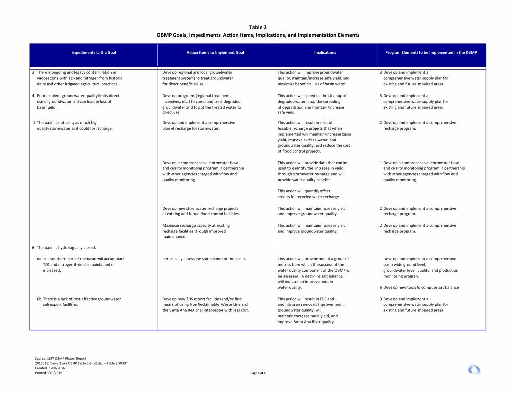
Impediments to the Goal
Table 2OBMP Goals, Impediments, Action Items, Implications, and Implementation Elements
Program Elements to be Implemented in the OBMPAction Items to Implement Goal Implications
3 There is ongoing and legacy contamination in Develop regional and local groundwater This action will improve groundwater 3 Develop and implement a vadose zone with TDS and nitrogen from historic treatment systems to treat groundwater quality, maintain/increase safe yield, and comprehensive water supply plan fordairy and other irrigated agricultural practices. for direct beneficial use. maximize beneficial use of basin water. existing and future impaired areas
4 Poor ambient groundwater quality limits direct Develop programs (regional treatment, This action will speed up the cleanup of 3 Develop and implement a use of groundwater and can lead to loss of incentives, etc.) to pump and treat degraded degraded water, stop the spreading comprehensive water supply plan forbasin yield. groundwater and to put the treated water to of degradation and maintain/increase existing and future impaired areas
direct use. safe yield.
5 The basin is not using as much high Develop and implement a comprehensive This action will result in a list of 2 Develop and implement a comprehensive quality stormwater as it could for recharge. plan of recharge for stormwater. feasible recharge projects that when recharge program.
implemented will maintain/increase basin
yield, improve surface water and
groundwater quality, and reduce the cost
of flood control projects.
Develop a comprehensive stormwater flow This action will provide data that can be 1 Develop a comprehensive stormwater flow and quality monitoring program in partnership used to quantify the increase in yield and quality monitoring program in partnership with other agencies charged with flow and through stormwater recharge and will with other agencies charged with flow and quality monitoring. provide water quality benefits. quality monitoring.
This action will quantify offset credits for recycled water recharge.
Develop new stormwater recharge projects This action will maintain/increase yield 2 Develop and implement a comprehensive at existing and future flood control facilities. and improve groundwater quality. recharge program.
Maximize recharge capacity at existing This action will maintain/increase yield 2 Develop and implement a comprehensive recharge facilities through improved and improve groundwater quality. recharge program. maintenance.
6 The basin is hydrologically closed.
6a The southern part of the basin will accumulate Periodically assess the salt balance of the basin. This action will provide one of a group of 1 Develop and implement a comprehensive TDS and nitrogen if yield is maintained or metrics from which the success of the basin‐wide ground level,increased. water quality component of the OBMP will groundwater level, quality, and production
be assessed. A declining salt balance monitoring program. will indicate an improvement in water quality. 6 Develop new tools to compute salt balance
6b There is a lack of cost‐effective groundwater Develop new TDS export facilities and/or find This action will result in TDS and 3 Develop and implement a salt export facilities. means of using Non Reclaimable Waste Line and and nitrogen removal, improvement in comprehensive water supply plan for
the Santa Ana Regional Interceptor with less cost. groundwater quality, will existing and future impaired areas maintain/increase basin yield, and
improve Santa Ana River quality.
Source: 1997 OBMP Phase I Report20160311 Table 2 aka OBMP Table 3‐8_v2.xlsx ‐‐ Table 2 SWRPCreated 01/08/2016Printed 3/10/2016 Page 4 of 6

Impediments to the Goal
Table 2OBMP Goals, Impediments, Action Items, Implications, and Implementation Elements
Program Elements to be Implemented in the OBMPAction Items to Implement Goal Implications
Establish financial incentives This action will result in more TDS and 3 Develop and implement a to ensure that existing groundwater is pumped and nitrogen removal, improvement in comprehensive water supply plan for and that high quality water is used to groundwater quality, will existing and future impaired areas replenish the basin. maintain/increase basin yield, and
improve Santa Ana River quality.
6c Existing production patterns in the basin cause Increase recharge without an increase in This action will result in a gradual 3 Develop and implement a salt and nitrate to accumulate in the southern production to cause an increase in rising water improvement in groundwater quality in the comprehensive water supply plan forend of the basin. southern part of the basin and an existing and future impaired areas
increase in TDS and nitrogen degradation
in the Santa Ana River.
7 Pesticide and chemical use, and petroleum product Public education. Members of the public will be encouraged 6 Develop and implement programs to addressdisposal habits to become individually involved in problems posed by specific contaminants.
protecting both surface and groundwater
quality
Goal 3 ‐‐ Enhance Management of the Basin
1 The way Watermaster manages cyclic Develop methods to account for losses from This action will help maintain the safe 8 Develop and implement a storage and local storage accounts will cause cyclic and local storage accounts; set yield and ensure that basin water is put management program.overdraft. limits on storage. to maximum beneficial use.
2 Existing production patterns are not Develop and implement a comprehensive This action will provide information that 1 Develop and implement a comprehensive balanced, cause losses, can cause basin‐wide ground level, can be used to understand the basin‐wide ground level,local subsidence, and water quality problems. groundwater level, quality, and production groundwater flow system and quality groundwater level, quality, and production
monitoring program. conditions. monitoring program.
Develop new production patterns that This action will maximize yield and 3 Develop and implement a maximize yield and beneficial use; and develop beneficial use of basin water; improve comprehensive water supply plan for incentive programs and basin water quality, and improve existing and future impaired areas policies that encourage (or rules that enforce) Santa Ana River quality.
new production patterns.
Develop programs (regional treatment, This action will maximize yield and 3 Develop and implement a incentives, etc.) to pump and treat degraded beneficial use of basin water; improve comprehensive water supply plan for groundwater and to put the treated water to basin water quality, and improve existing and future impaired areas direct use. Santa Ana River quality.
3 About 500,000 to 1,000,000 acre‐ft Develop conjunctive use programs that This action will result in lower water 9 Develop conjunctive use programs that of storage in the Chino Basin cannot be used take into account water quantity and quality supply costs to basin producers. take into account water quantity and qualitydue to water quality and institutional issues.
4 Poor ambient groundwater quality limits direct Develop programs (regional treatment, This action will speed up the cleanup of 3 Develop and implement a use of groundwater and can lead to loss of incentives, etc.) to pump and treat degraded degraded water, stop the spreading comprehensive water supply plan forbasin yield. groundwater and to put the treated water to of degradation and maintain/increase existing and future impaired areas
direct use. safe yield.
Source: 1997 OBMP Phase I Report20160311 Table 2 aka OBMP Table 3‐8_v2.xlsx ‐‐ Table 2 SWRPCreated 01/08/2016Printed 3/10/2016 Page 5 of 6

Impediments to the Goal
Table 2OBMP Goals, Impediments, Action Items, Implications, and Implementation Elements
Program Elements to be Implemented in the OBMPAction Items to Implement Goal Implications
Goal 4 ‐‐ Equitably Finance the OBMP
1 The equitable distribution of cost Identify an equitable approach to spread the cost This action will improve the likelihood Develop and implement a financial plan to associated with the OBMP is not of OBMP implementation either on a per acre‐ft that the OBMP will be implemented. implement the OBMPdefined. basis or some other equitable means.
Identify ways to recover value from utilizing This action will lower the cost of the Develop and implement a financial plan to basin assets including storage and rising OBMP to producers and improve the implement the OBMP water leaving the basin. likelihood that OBMP will be
implemented.
2 Limited resources restrict potential water resources Evaluate project and management components This action will result in the optimum set of
improvements of the OBMP. and rank components with equal consideration project and management components of given to water quantity, water quality and cost. the OBMP being implemented.
Source: 1997 OBMP Phase I Report20160311 Table 2 aka OBMP Table 3‐8_v2.xlsx ‐‐ Table 2 SWRPCreated 01/08/2016Printed 3/10/2016 Page 6 of 6

Recommended MZ3 Projects1
18a CSI Storm Water Basin 81 0 291,000$ 150,000$ 440,000$
2013 Proposed RP3 Improvements2 3,232,000$ 481,000$ 3,710,000$ 2013 RMPU Proposed Wineville PS to Jurupa,
Expanded Jurupa PS to RP3 Basin215,957,000$ 1,640,000$ 17,600,000$
27 Declez Basin 241 0 3,696,000$ 370,000$ 4,070,000$
Total MZ3 3,489 2,905 23,176,000$ 2,641,000$ 25,820,000$
Recommended MZ2 Projects3
11 Victoria Basin4 43 120 130,000$ 19,500$ 150,000$
7 San Sevaine Basins5 642 4,100 5,913,000$ 550,000$ 6,460,000$
12 Lower Day Basin (2010 RMPU) 789 0 2,158,000$ 324,000$ 2,480,000$
14 Turner Basin 66 0 739,200$ 148,000$ 890,000$ 15a Ely Basin 221 0 2,370,000$ 829,000$ 3,200,000$
Total MZ2 1,760 4,220 11,310,200$ 1,870,500$ 13,180,000$
Recommended MZ1 Projects2 Montclair Basins 248 0 1,251,900$ 188,000$ 1,440,000$
Total MZ1 248 0 1,251,900$ 188,000$ 1,440,000$
TotalRecommended
Projects5,497 7,125 35,738,100$ 4,699,500$ 40,440,000$
23a 3,166 2,905
1. PID 25a (Sierra Basin) was deleted from the recommended project list.2. PID23a (2013 RMPU Proposed Wineville PS to Jurupa, Expanded Jurupa PS to RP3 Basin, and 2013 Proposed RP3 Improvements) was updated to specify the parts of the project shared between IEUA and CBWM. Total Capital Cost of PID 23a is about $21,300,000.3. PID 12 (Lower San Sevaine Basin) was deleted from recommended project list.4. PID 11's total capital cost is about $150,000.5. PID 7 (San Sevaine Basins) project cost was updated based on the recently completed preliminary design report. Total capital cost for this project is about $6,460,000.
Engineering and Admin
Costs
Total Capital Cost
Table 3Recommended 2013 Recharge Master Plan Update Yield Enhancement Projects
2016 Chino Basin Storm Water Resources Plan
Project ID Project
New Storm Water
Recharge (AFY)
New Recycled Water
Recharge Capacity (AFY)
Direct Construction
Cost
20160311 Table 3 aka 20150317_xxx_v2.xlsx ‐‐ Table 3 SWRPCreated 01/24/2016Printed 5/10/2016

Project ID
Recharge Projects Property Owner Key Project Improvements
Review Draft
Preliminary Design
Finalize Preliminary
Design
Review CEQA
Documents
Adopt CEQA
Document
Finalize Design
Contract Bidding
Contract Award
Finalize Contract
7 San Sevaine SBCFCDConstruct pump station, pump from SS5 to SS1, SS2 and SS3
Completed Completed Completed 1/20/2016 3/18/2016 3/21/2016 5/18/2016 7/5/2017
12 Lower Day SBCFCDConstruct new inlet, harden embankments and install gate on mid‐level outlet.
Completed Completed Completed 3/16/2016 10/5/2016 10/6/2016 12/21/2016 1/5/2018
18aCSI Storm Water
BasinCalifornia Steel
Industries
New storage and recharge facility by deepening/removing 36,000 CY from existing retention basin
6/16/2016 8/17/2016 8/17/2016 11/16/2016 12/29/2017 Pending Pending 12/31/2019
23aWineville, Jurupa,
and RP3 SBCFCD
Create conservation storage in Wineville Basin and constructing pump stations to pump storm water and dry‐weather runoff to adjacent conservation basins
6/16/2016 8/17/2016 8/17/2016 11/16/2016 12/29/2017 Pending Pending 12/31/2019
27 Declez Basin SBCFCDIncreasing conservation storage by raising berms and hardening embankments
6/16/2016 8/17/2016 8/17/2016 11/16/2016 12/29/2017 Pending Pending 12/31/2019
11 Victoria Basin SBCFCDImprove the infiltration rate and by removing impermeable materials and abandoning mid‐level outlet
6/16/2016 8/17/2016 8/17/2016 11/16/2016 12/29/2017 Pending Pending 12/31/2019
14 Turner Basin SBCFCDIncrease conservation storage and recharge by raising the spillway height
6/16/2016 8/17/2016 8/17/2016 11/16/2016 12/29/2017 Pending Pending 12/31/2019
15a Ely BasinSBCFCD and CBWCD
Improve storage and recharge by expanding conservation storage (removing 470,000 CY)
6/16/2016 8/17/2016 8/17/2016 11/16/2016 12/29/2017 Pending Pending 12/31/2019
2 Montclair Basins CBWCDConstruction of new inlets expanding diversion capacity
6/16/2016 8/17/2016 8/17/2016 11/16/2016 12/29/2017 Pending Pending 12/31/2019
Table 4Recommended 2013 Recharge Master Plan Update Facilities and Implementation Status
2016 Chino Basin Storm Water Resources Plan
20160311 Tabless 4 and 5 2013 RMPU Status and Schedule_gr.xlsx ‐‐ Table 4Created 01/16/2016Printed 3/10/2016

Project Benefit
San Antonio CreekConfluence with Chino Creek to San Gabriel Mountains ridgeline
pH UnknownMontclair Basin Improvements
Reduced storm water discharge and eliminates dry‐weather runoff from areas upstream of improvements
Coliform
bacteriaUnknown
pH Unknown
COD Unknown
Nutrients Agriculture
PathogensAgriculture, dairies, urban runoff and storm water
Nutrients Agriculture, dairies
PathogensAgriculture, dairies, urban runoff and storm water
Cucamonga Creek Reach 2
Debris Basin to San Gabriel Mountains
ridgelinepH Unknown
Cadmium Unknown
Coliform‐
bacteriaUnknown
Copper Unknown
Lead Unknown
Zinc Unknown
Nutrients Agriculture, dairies
Pathogens Dairies
TSS Dairies
Table 5303 (d) List of Impaired Water Bodies and 2013 Recharge Master Plan Benefits
Water Body Reach Pollutant Potential Sources
2013 RMPU Project Benefit on Impaired Water Bodies
Ely and Turner Basin
Improvements
Reduced storm water discharge and eliminates dry‐weather runoff from areas upstream of improvements
Chino Creek Reach 2Start of channel lining to confluence with San
Antonio Creek
Montclair Basin Improvements
Reduced storm water discharge and eliminates dry‐weather runoff from areas upstream of improvements
Chino Creek Reach 1BMill Creek confluence to start of concrete
channel
Mill CreekConfluence with Chino Creek to confluence
with Cucamonga Creek
Chino Creek 1AConfluence with Santa Ana to confluence with
Mill Creek
Cucamonga Creek Reach 1
Confluence with Mill Creek to debris dam
20160311 Tabless 4 and 5 2013 RMPU Status and Schedule_gr.xlsx ‐‐ Table 5Created 01/17/2016Printed 3/10/2016

InlandEmpireUtilitiesAgency
Orange CountyWater District
Western MWD
Eastern MWD
San BernardinoValley MWD
Santa Ana River
Figure 1
Location of the Chino Basin andthe Santa Ana River Watershed»
0 10 20Miles
0 10 20 30Kilometers
Date: 3/2/2016
Author: GAR
Name: Figure1_SAR_Watershed
Prepared by:
23692 Birtcher DriveLake Forest, CA 92630949.420.3030www.weiwater.com
Major SAWPA Member Agencies
Chino Basin DWR Bulletin 118 Boundary
Santa Ana River Watershed
RiversideCounty
San BernardinoCounty
OrangeCounty
Los AngelesCounty
Santa Ana RiverWatershed
Los Angeles
SanBernardino
SantaAna
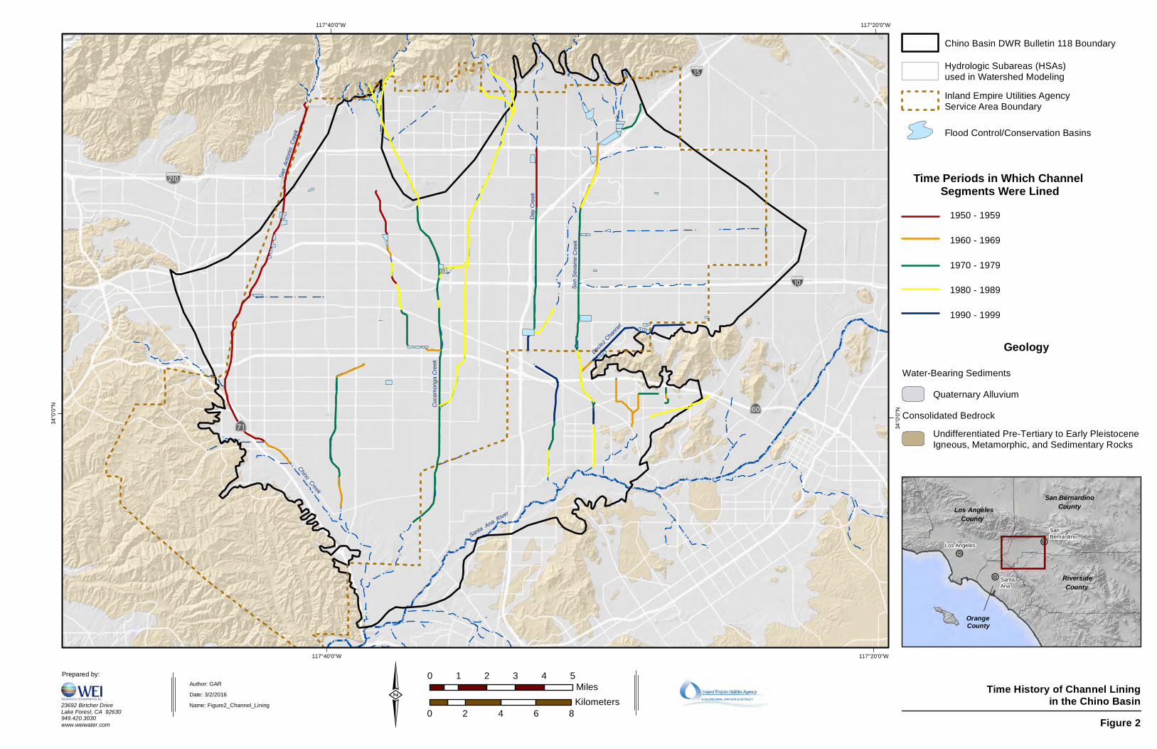
Cuca
mong
a Cree
k
Day C
reek
San
Anton
io Cr
eek
!"a$
?q
?£
%&g(
!"̀$San S
evain
e Cree
k
Declez C
hannel
Chino Creek
Santa Ana River
117°20'0"W
117°20'0"W
117°40'0"W
117°40'0"W
34°0
'0"N
34°0
'0"N
Figure 2
Time History of Channel Liningin the Chino Basin
RiversideCounty
San BernardinoCounty
OrangeCounty
Los AngelesCounty
Los Angeles
SanBernardino
SantaAna
»0 1 2 3 4 5
Miles
0 2 4 6 8Kilometers
Date: 3/2/2016
Author: GAR
Name: Figure2_Channel_Lining
Prepared by:
23692 Birtcher DriveLake Forest, CA 92630949.420.3030www.weiwater.com
Geology
Consolidated Bedrock
Water-Bearing Sediments
Quaternary Alluvium
Undifferentiated Pre-Tertiary to Early PleistoceneIgneous, Metamorphic, and Sedimentary Rocks
Time Periods in Which Channel Segments Were Lined
1950 - 1959
1960 - 1969
1970 - 1979
1980 - 1989
1990 - 1999
Inland Empire Utilities AgencyService Area Boundary
Hydrologic Subareas (HSAs)used in Watershed Modeling
Chino Basin DWR Bulletin 118 Boundary
Flood Control/Conservation Basins

Figure3_SW_Recharge.xlsxRevised 3/2/2016
0
5,000
10,000
15,000
20,000
25,000
30,000
35,000
1960 1965 1970 1975 1980 1985 1990 1995 2000 2005 2010
Estim
ated
Streambe
d Infiltration (acre‐ft/yr)
Fiscal Year
Figure 3 Streambed Infiltration for the Santa Ana River Tributaries that Traverse the Chino Basin
San Sevaine Creek
Day Creek
Cucamonga Creek
San Antonio Creek
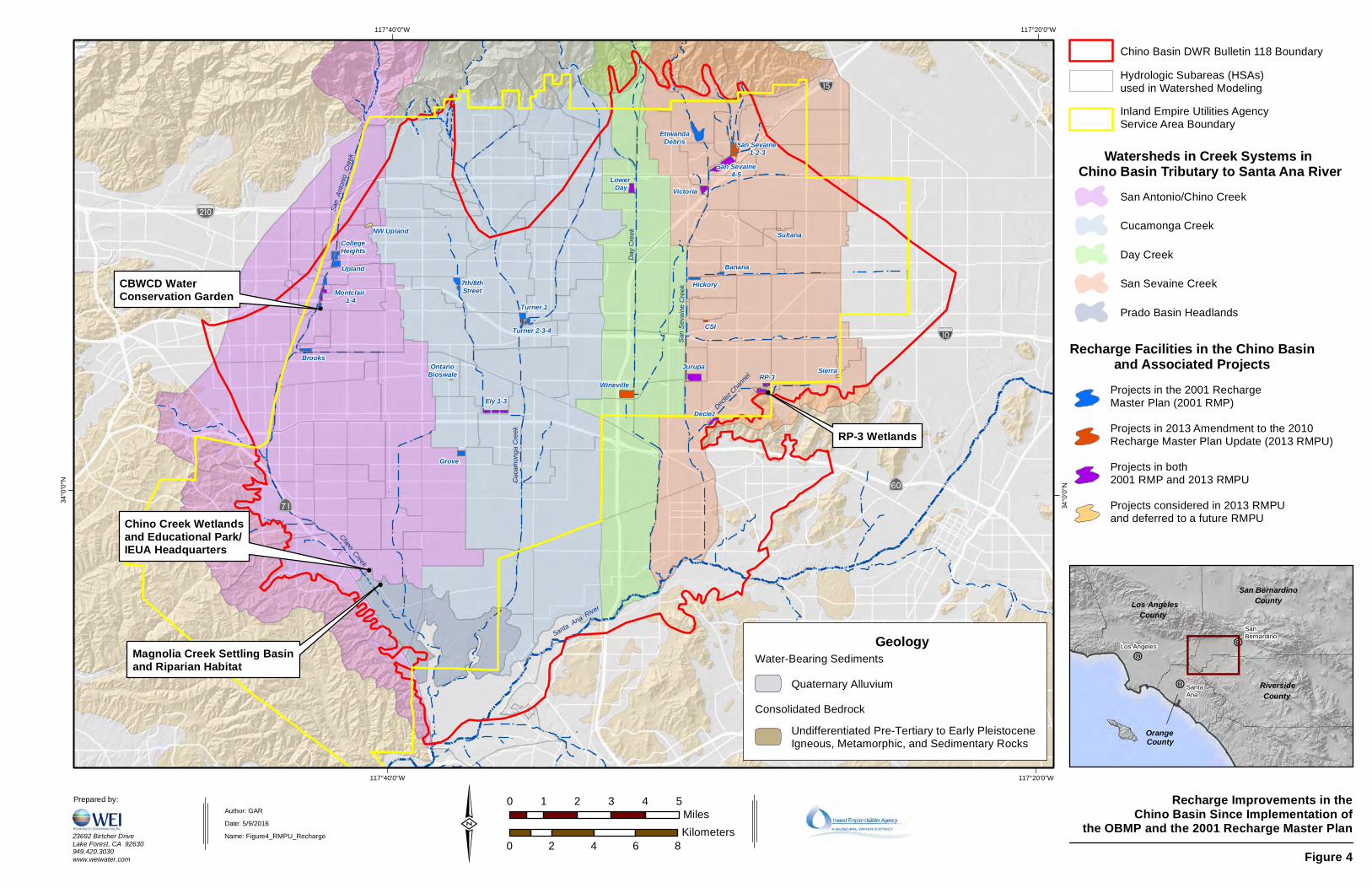
Cuca
mong
a Cree
k
Day C
reek
San
Anton
io Cr
eek
Montclair 1-4
Turner 1
Turner 2-3-4
Ely 1-3Declez
RP-3Jurupa
San Sevaine 1-2-3
Victoria
San Sevaine4-5Lower
Day
!"a$
?q
?£
%&g(
!"̀$
EtiwandaDebris
San S
evain
e Cree
k
Declez C
hannel
Banana
Hickory
Brooks
Grove
7th/8thStreet
Upland
CollegeHeights
Chino Creek
Santa Ana River
Wineville
NW Upland
OntarioBioswale
CSI
Sierra
Sultana
117°20'0"W
117°20'0"W
117°40'0"W
117°40'0"W
34°0
'0"N
34°0
'0"N
Figure 4
Recharge Improvements in theChino Basin Since Implementation of
the OBMP and the 2001 Recharge Master Plan
RiversideCounty
San BernardinoCounty
OrangeCounty
Los AngelesCounty
Los Angeles
SanBernardino
SantaAna
»0 1 2 3 4 5
Miles
0 2 4 6 8Kilometers
Date: 5/9/2016
Author: GAR
Name: Figure4_RMPU_Recharge
Prepared by:
23692 Birtcher DriveLake Forest, CA 92630949.420.3030www.weiwater.com
Recharge Facilities in the Chino Basinand Associated Projects
Cucamonga Creek
Day Creek
San Sevaine Creek
Prado Basin Headlands
Chino Basin DWR Bulletin 118 Boundary
Inland Empire Utilities AgencyService Area Boundary
Hydrologic Subareas (HSAs)used in Watershed Modeling
Watersheds in Creek Systems in Chino Basin Tributary to Santa Ana River
Projects in 2013 Amendment to the 2010 Recharge Master Plan Update (2013 RMPU)
Projects in the 2001 RechargeMaster Plan (2001 RMP)
Projects in both2001 RMP and 2013 RMPU
Projects considered in 2013 RMPUand deferred to a future RMPU
San Antonio/Chino Creek
Geology
Consolidated Bedrock
Water-Bearing Sediments
Quaternary Alluvium
Undifferentiated Pre-Tertiary to Early PleistoceneIgneous, Metamorphic, and Sedimentary Rocks
RP-3 Wetlands
Magnolia Creek Settling Basinand Riparian Habitat
Chino Creek Wetlandsand Educational Park/IEUA Headquarters
CBWCD WaterConservation Garden

Figure5_Recharge.xlsxPrinted on: 3/2/2016
0
5,000
10,000
15,000
20,000
25,000
30,000
2006 2007 2008 2009 2010 2011 2012 2013 2014 2015
Annu
al Recha
rge Vo
lume (acre‐ft)
Fiscal Year
Figure 5Increase in Storm Water and Dry‐Weather Runoff Recharge Due to Recharge Improvements in the
Chino Basin Since Implementation of the OBMP and the 2001 Recharge Master Plan
Recycled Water
Stormwater
Dry‐Weather
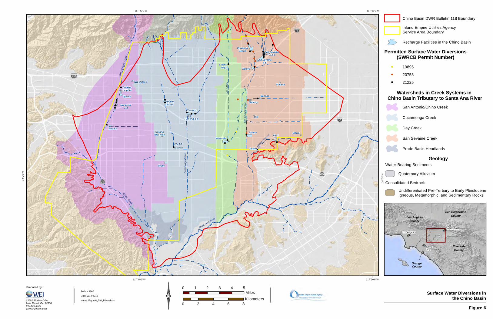
!(
!(
!(
!(
!(
!(
!(
!(
!(
!(
!(
!(
!( !(
!(
!(
!(
!(!(
!(!(!(
!(
!(!(
!(
!(!( !(
!(
!(
!(
!(
!( !(!(!(
!(
!(!(
!(
!(
!(
!(
!(
Cuca
mong
a Cree
k
Day C
reek
San
Anton
io Cr
eek
Montclair 1-4
Turner 1
Turner 2-3-4
Ely 1-3Declez
RP-3Jurupa
San Sevaine 1-2-3
Victoria
San Sevaine4-5Lower
Day
!"a$
?q
?£
%&g(
!"̀$
EtiwandaDebris
San S
evain
e Cree
k
Declez C
hannel
Banana
Hickory
Brooks
Grove
7th/8thStreet
Upland
CollegeHeights
Chino Creek
Santa Ana River
Wineville
Sultana
Sierra
CSI
OntarioBioswale
NW Upland
117°20'0"W
117°20'0"W
117°40'0"W
117°40'0"W
34°0
'0"N
34°0
'0"N
Figure 6
Surface Water Diversions inthe Chino Basin
RiversideCounty
San BernardinoCounty
OrangeCounty
Los AngelesCounty
Los Angeles
SanBernardino
SantaAna
»0 1 2 3 4 5
Miles
0 2 4 6 8Kilometers
Date: 3/14/2016
Author: GAR
Name: Figure6_SW_Diversions
Prepared by:
23692 Birtcher DriveLake Forest, CA 92630949.420.3030www.weiwater.com
Cucamonga Creek
Day Creek
San Sevaine Creek
Prado Basin Headlands
Chino Basin DWR Bulletin 118 Boundary
Watersheds in Creek Systems in Chino Basin Tributary to Santa Ana River
Recharge Facilities in the Chino Basin
San Antonio/Chino Creek
Geology
Consolidated Bedrock
Water-Bearing Sediments
Quaternary Alluvium
Undifferentiated Pre-Tertiary to Early PleistoceneIgneous, Metamorphic, and Sedimentary Rocks
Inland Empire Utilities AgencyService Area Boundary
19895
20753
21225
Permitted Surface Water Diversions(SWRCB Permit Number)
!(
!(
!(

Cuca
mong
a Cree
k
Day C
reek
San
Anton
io Cr
eek
Montclair 1-4 Turner 1
Turner 2-3-4
Ely 1-3Declez
RP-3Jurupa
San Sevaine 1-2-3
Victoria
San Sevaine4-5Lower
Day
!"a$
?q
?£
%&g(
!"̀$
EtiwandaDebris
San S
evain
e Cree
k
Declez C
hannel
BananaHickory
Brooks
Grove
7th/8thStreet
Upland
CollegeHeights
Chino Creek
Santa Ana River
Wineville
Sultana
CSI
OntarioBioswale
Los
Ang
eles
Cou
nty
San
Ber
nard
ino
Cou
nty
San Bernardino County
Orange County
San Bernardino County
Riverside County
Sierra
NW Upland
GSWCoClaremont
City ofPomona
City ofNorco
City ofChino
City ofChinoHills
FontanaWater
Company
City ofOntario
CucamongaValley Water
District
City ofRialto
City ofUpland
Jurupa CommunityServicesDistrict
San AntonioWater Co.
Marigold MutualWater Company
West ValleyWater
District
West ValleyWater
District
West ValleyWater
District
SantaAna RiverWater Co.
SwanLake
CIWEl PradoPark and
Golf Course
ChinoAirport
CIM
Monte VistaWater
District
Mira LomaSpaceCenter
CSI
Auto ClubSpeedway
GenOnWest
117°20'0"W
117°20'0"W
117°40'0"W
117°40'0"W
34°0
'0"N
34°0
'0"N
Figure 7
Water Service Areas andRecharge Facilities in the Chino Basin
RiversideCounty
San BernardinoCounty
OrangeCounty
Los AngelesCounty
Los Angeles
SanBernardino
SantaAna
»0 1 2 3 4 5
Miles
0 2 4 6 8Kilometers
Date: 5/9/2016
Author: GAR
Name: Figure7_WSA
Prepared by:
23692 Birtcher DriveLake Forest, CA 92630949.420.3030www.weiwater.com
Geology
Consolidated Bedrock
Water-Bearing Sediments
Quaternary Alluvium
Undifferentiated Pre-Tertiary to Early PleistoceneIgneous, Metamorphic, and Sedimentary Rocks
Inland Empire Utilities AgencyService Area Boundary
Recharge Facilities in the Chino Basinand Associated Projects
Projects in 2013 Amendment to the 2010 Recharge Master Plan Update (2013 RMPU)
Projects in the 2001 RechargeMaster Plan (2001 RMP)
Projects in both2001 RMP and 2013 RMPU
Projects considered in 2013 RMPUand deferred to a future RMPU
Chino Basin DWR Bulletin 118 Boundary
County Boundaries
Water Service Area Boundaries

Cuca
mong
a Cree
k
Day C
reek
San
Anton
io Cr
eek
Montclair 1-4 Turner 1
Turner 2-3-4
Ely 1-3Declez
RP-3Jurupa
San Sevaine 1-2-3
Victoria
San Sevaine4-5Lower
Day
!"a$
?q
?£
%&g(
!"̀$
EtiwandaDebris
San S
evain
e Cree
k
Declez C
hannel
BananaHickory
Brooks
Grove
7th/8thStreet
Upland
CollegeHeights
Chino Creek
Santa Ana River
Wineville
Sultana
CSI
OntarioBioswale
Los
Ang
eles
Cou
nty
San
Ber
nard
ino
Cou
nty
San Bernardino County
Orange County
San Bernardino County
Riverside County
Sierra
NW Upland
West ValleyWater
District
Claremont
Pomona
Chino
ChinoHills
Fontana
Montclair
Ontario
RanchoCucamonga
RialtoUpland
JurupaValley
Eastvale
117°20'0"W
117°20'0"W
117°40'0"W
117°40'0"W
34°0
'0"N
34°0
'0"N
Figure 8
Land Use Control Agencies andRecharge Facilities in the Chino Basin
RiversideCounty
San BernardinoCounty
OrangeCounty
Los AngelesCounty
Los Angeles
SanBernardino
SantaAna
»0 1 2 3 4 5
Miles
0 2 4 6 8Kilometers
Date: 3/14/2016
Author: GAR
Name: Figure8_LUA
Prepared by:
23692 Birtcher DriveLake Forest, CA 92630949.420.3030www.weiwater.com
Geology
Consolidated Bedrock
Water-Bearing Sediments
Quaternary Alluvium
Undifferentiated Pre-Tertiary to Early PleistoceneIgneous, Metamorphic, and Sedimentary Rocks
Inland Empire Utilities AgencyService Area Boundary
Recharge Facilities in the Chino Basinand Associated Projects
Projects in 2013 Amendment to the 2010 Recharge Master Plan Update (2013 RMPU)
Projects in the 2001 RechargeMaster Plan (2001 RMP)
Projects in both2001 RMP and 2013 RMPU
Projects considered in 2013 RMPUand deferred to a future RMPU
Chino Basin DWR Bulletin 118 Boundary
County Boundaries
City Boundaries
Unincorporated County Area

Appendix A Chino Basin SWRP Checklist and Self Certification Form
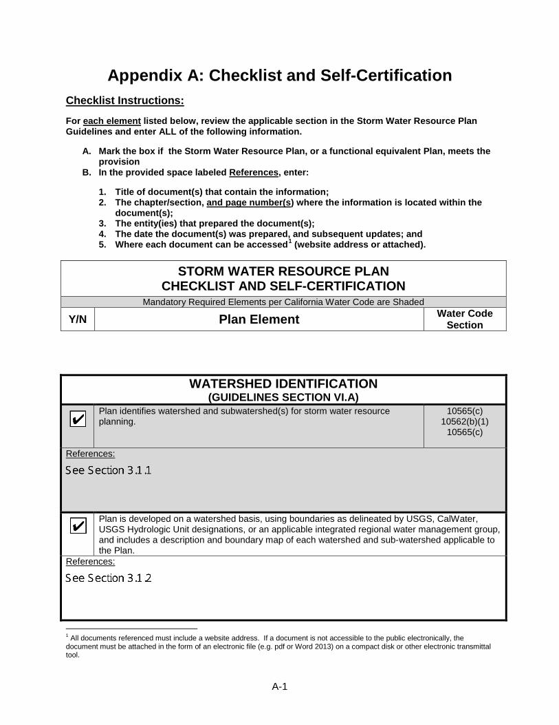
A-1
Appendix A: Checklist and Self-Certification
Checklist Instructions:
For each element listed below, review the applicable section in the Storm Water Resource Plan Guidelines and enter ALL of the following information.
A. Mark the box if the Storm Water Resource Plan, or a functional equivalent Plan, meets the provision
B. In the provided space labeled References, enter:
1. Title of document(s) that contain the information; 2. The chapter/section, and page number(s) where the information is located within the
document(s); 3. The entity(ies) that prepared the document(s); 4. The date the document(s) was prepared, and subsequent updates; and 5. Where each document can be accessed1 (website address or attached).
STORM WATER RESOURCE PLAN CHECKLIST AND SELF-CERTIFICATION
Mandatory Required Elements per California Water Code are Shaded
Y/N Plan Element Water Code Section
WATERSHED IDENTIFICATION (GUIDELINES SECTION VI.A)
� Plan identifies watershed and subwatershed(s) for storm water resource planning.
10565(c) 10562(b)(1)
10565(c)
References:
� Plan is developed on a watershed basis, using boundaries as delineated by USGS, CalWater, USGS Hydrologic Unit designations, or an applicable integrated regional water management group, and includes a description and boundary map of each watershed and sub-watershed applicable to the Plan.
References:
1 All documents referenced must include a website address. If a document is not accessible to the public electronically, the document must be attached in the form of an electronic file (e.g. pdf or Word 2013) on a compact disk or other electronic transmittal tool.

A-2
WATERSHED IDENTIFICATION (GUIDELINES SECTION VI.A)
� Plan includes an explanation of why the watershed(s) and sub-watershed(s) are appropriate for storm water management with a multiple-benefit watershed approach;
References:
� Plan describes the internal boundaries within the watershed (boundaries of municipalities; service areas of individual water, wastewater, and land use agencies, including those not involved in the Plan; groundwater basin boundaries, etc.; preferably provided in a geographic information system shape file);
References:
� Plan describes the water quality priorities within the watershed based on, at a minimum, applicable TMDLs and consideration of water body-pollutant combinations listed on the State’s Clean Water Act Section 303(d) list of water quality limited segments (a.k.a impaired waters list);
References:
� Plan describes the general quality and identification of surface and ground water resources within the watershed (preferably provided in a geographic information system shape file);
References:
� Plan describes the local entity or entities that provide potable water supplies and the estimated volume of potable water provided by the water suppliers;
References:
� Plan includes map(s) showing location of native habitats, creeks, lakes, rivers, parks, and other natural or open space within the sub-watershed boundaries; and
References:
� Plan identifies (quantitative, if possible) the natural watershed processes that occur within the sub-watershed and a description of how those natural watershed processes have been disrupted within the sub-watershed (e.g., high levels of imperviousness convert the watershed processes of infiltration and interflow to surface runoff increasing runoff volumes; development commonly covers natural surfaces and often introduces non-native vegetation, preventing the natural supply of sediment from reaching receiving waters).
References:

A-3
WATER QUALITY COMPLIANCE (GUIDELINES SECTION V)
� Plan identifies activities that generate or contribute to the pollution of storm water or dry weather runoff, or that impair the effective beneficial use of storm water or dry weather runoff.
10562(d)(7)
References:
� Plan describes how it is consistent with and assists in, compliance with total maximum daily load implementation plans and applicable national pollutant discharge elimination system permits.
10562(b)(5)
References:
� Plan identifies applicable permits and describes how it meets all applicable waste discharge permit requirements.
10562(b)(6)
References:
ORGANIZATION, COORDINATION, COLLABORATION (GUIDELINES SECTION VI.B)
� Local agencies and nongovernmental organizations were consulted in Plan development.
10565(a)
References:
� Community participation was provided for in Plan development. 10562(b)(4)
References:
� Plan includes description of the existing integrated regional water management group(s) implementing an integrated regional water management plan.
References:

A-4
ORGANIZATION, COORDINATION, COLLABORATION (GUIDELINES SECTION VI.B)
�
Plan includes identification of and coordination with agencies and organizations (including, but not limited to public agencies, nonprofit organizations, and privately owned water utilities) that need to participate and implement their own authorities and mandates in order to address the storm water and dry weather runoff management objectives of the Plan for the targeted watershed.
References:
� Plan includes identification of nonprofit organizations working on storm water and dry weather resource planning or management in the watershed.
References:
� Plan includes identification and discussion of public engagement efforts and community participation in Plan development.
References:
� Plan includes identification of required decisions that must be made by local, state or federal regulatory agencies for Plan implementation and coordinated watershed-based or regional monitoring and visualization
References:
� Plan describes planning and coordination of existing local governmental agencies, including where necessary new or altered governance structures to support collaboration among two or more lead local agencies responsible for plan implementation.
References:
� Plan describes the relationship of the Plan to other existing planning documents, ordinances, and programs established by local agencies.
References:
� (If applicable)Plan explans why individual agency participation in various isolated efforts is appropriate.
References:
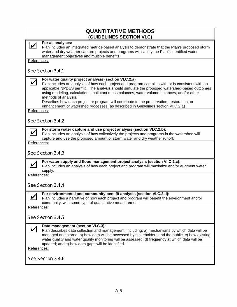
A-5
QUANTITATIVE METHODS (GUIDELINES SECTION VI.C)
� For all analyses: Plan includes an integrated metrics-based analysis to demonstrate that the Plan’s proposed storm water and dry weather capture projects and programs will satisfy the Plan’s identified water management objectives and multiple benefits.
References:
�
For water quality project analysis (section VI.C.2.a) Plan includes an analysis of how each project and program complies with or is consistent with an applicable NPDES permit. The analysis should simulate the proposed watershed-based outcomes using modeling, calculations, pollutant mass balances, water volume balances, and/or other methods of analysis. Describes how each project or program will contribute to the preservation, restoration, or enhancement of watershed processes (as described in Guidelines section VI.C.2.a)
References:
� For storm water capture and use project analysis (section VI.C.2.b): Plan includes an analysis of how collectively the projects and programs in the watershed will capture and use the proposed amount of storm water and dry weather runoff.
References:
� For water supply and flood management project analysis (section VI.C.2.c): Plan includes an analysis of how each project and program will maximize and/or augment water supply.
References:
� For environmental and community benefit analysis (section VI.C.2.d): Plan includes a narrative of how each project and program will benefit the environment and/or community, with some type of quantitative measurement.
References:
� Data management (section VI.C.3): Plan describes data collection and management, including: a) mechanisms by which data will be managed and stored; b) how data will be accessed by stakeholders and the public; c) how existing water quality and water quality monitoring will be assessed; d) frequency at which data will be updated; and e) how data gaps will be identified.
References:

A-6
IDENTIFICATION AND PRIORITIZATION OF PROJECTS (GUIDELINES SECTION VI.D)
� Plan identifies opportunities to augment local water supply through groundwater recharge or storage for beneficial use of storm water and dry weather runoff.
10562(d)(1)
References:
� Plan identifies opportunities for source control for both pollution and dry weather runoff volume, onsite and local infiltration, and use of storm water and dry weather runoff.
10562(d)(2)
References:
� Plan identifies projects that reestablish natural water drainage treatment and infiltration systems, or mimic natural system functions to the maximum extent feasible.
10562(d)(3)
References:
� Plan identifies opportunities to develop, restore, or enhance habitat and open space through storm water and dry weather runoff management, including wetlands, riverside habitats, parkways, and parks.
10562(d)(4)
References:
� Plan identifies opportunities to use existing publicly owned lands and easements, including, but not limited to, parks, public open space, community gardens, farm and agricultural preserves, school sites, and government office buildings and complexes, to capture, clean, store, and use storm water and dry weather runoff either onsite or offsite.
10562(d)(5), 10562(b)(8)
References:

A-7
IDENTIFICATION AND PRIORITIZATION OF PROJECTS (GUIDELINES SECTION VI.D)
� For new development and redevelopments (if applicable): Plan identifies design criteria and best management practices to prevent storm water and dry weather runoff pollution and increase effective storm water and dry weather runoff management for new and upgraded infrastructure and residential, commercial, industrial, and public development.
10562(d)(6)
References:
� Plan uses appropriate quantitative methods for prioritization of projects. (This should be accomplished by using a metrics-based and integrated evaluation and analysis of multiple benefits to maximize water supply, water quality, flood management, environmental, and other community benefits within the watershed.)
10562(b)(2)
References:
� Overall: Plan prioritizes projects and programs using a metric-driven approach and a geospatial analysis of multiple benefits to maximize water supply, water quality, flood management, environmental, and community benefits within the watershed.
References:
� Multiple benefits: Each project in accordance with the Plan contributes to at least two or more Main Benefits and the maximum number of Additional Benefits as listed in Table 4 of the Guidelines. (Benefits are not counted twice if they apply to more than one category.)
References:

A-8
IMPLEMENTATION STRATEGY AND SCHEDULE (GUIDELINES SECTION VI.E)
� Plan identifies resources for Plan implementation, including: 1) projection of additional funding needs and sources for administration and implementation needs; and 2) schedule for arranging and securing Plan implementation financing.
References:
� Plan projects and programs are identified to ensure the effective implementation of the storm water resource plan pursuant to this part and achieve multiple benefits.
10562(d)(8)
References:
� The Plan identifies the development of appropriate decision support tools and the data necessary to use the decision support tools.
10562(d)(8)
References:
� Plan describes implementation strategy, including: a) Timeline for submitting Plan into existing plans, as applicable; b) Specific actions by which Plan will be implemented; c) All entities responsible for project implementation; d) Description of community participation strategy; e) Procedures to track status of each project; f) Timelines for all active or planned projects; g) Procedures for ongoing review, updates, and adaptive management of the Plan; and h) A strategy and timeline for obtaining necessary federal, state, and local permits.
References:
� Applicable IRWM plan: The Plan will be submitted, upon development, to the applicable integrated regional water management (IRWM) group for incorporation into the IRWM plan.
10562(b)(7)
References:

A-9
IMPLEMENTATION STRATEGY AND SCHEDULE (GUIDELINES SECTION VI.E)
� Plan describes how implementation performance measures will be tracked.
References:
EDUCATION, OUTREACH, PUBLIC PARTICIPATION (GUIDELINES SECTION VI.F)
� Outreach and Scoping: Community participation is provided for in Plan implementation.
10562(b)(4)
References:
� Plan describes public education and public participation opportunities to engage the public when considering major technical and policy issues related to the development and implementation.
References:
� Plan describes mechanisms, processes, and milestones that have been or will be used to facilitate public participation and communication during development and implementation of the Plan.
References:
� Plan describes mechanisms to engage communities in project design and implementation.
References:
� Plan identifies specific audiences including local ratepayers, developers, locally regulated commercial and industrial stakeholders, nonprofit organizations, and the general public.
References:

A-10
DECLARATION AND SIGNATURE I declare under penalty of perjury that all information provided is true and correct to the best of my knowledge and belief. Signature Title Date Signature Title Date
EDUCATION, OUTREACH, PUBLIC PARTICIPATION (GUIDELINES SECTION VI.F)
� Plan describes strategies to engage disadvantaged and climate vulnerable communities within the Plan boundaries and ongoing tracking of their involvement in the planning process.
References:
� Plan describes efforts to identify and address environmental injustice needs and issues within the watershed.
References:
� Plan includes a schedule for initial public engagement and education.
References: