2.2 Coastal tree swamp (floodplain and non-floodplain): Melaleuca ...
Upload
bradley-hanson-mpa-cfmCategory
view
35download
0
2015 MCCANDLESS/CLEGHORN DRAINAGE DITCH INSPECTION
28E Agreement
JUNE 17, 2015 CITY OF ONAWA
Bradley J. Hanson, City Administrator

Page 1 of 24

INTRODUCTION
In May of 2014 the City of Onawa (City), in partnership with the McCandless/Cleghorn Drainage District (McCandless) entered into a 28E Partnership, or Memorandum of Understanding (agreement), to help inspect and handle minor cleanout operations within the McCandless property (inspection). This was reached for the mutual benefit of both the citizens of the City and the agricultural community along the McCandless. This agreement allows the City’s staff to visually inspect the McCandless and remove small items that could create a flooding problem by clogging the free flow of water within it. Documentation is also made of other potential flooding hazards or blockages. This inspection occurs up to one half (1/2 mile) north of City limits, north of 220th Street, through the entire City limits, and south of the City limits from the south side of 248th Street. The City requested this to ensure the free flow of water into and especially out of the City in order to lessen the impact of potential flooding in one of the City’s major commercial and industrial areas.
The City benefits by ensuring the west side of the City remains free of possible flood waters from the western area commercial and industrial businesses, which in turn keeps Citizens employed, tourists and regional visitors coming back to Onawa to acquire their needs and wants, and keeps the City’s economy strong. The agricultural community benefits in the efficient flow of water within the McCandless as well by keeping water from flooding their fields and ruining their crops. Therefore, this agreement is mutually beneficial to both the City and the agricultural community served by the McCandless.
The first inspection took place on three different days. It began on April 23, 2015, continued on April 28, 2015 and was completed on May 2, 2015. This inspection was completed wholly and fully by myself: the City’s City Administrator, Bradley J. Hanson; I am a Certified Floodplain Manager (CFM) for the City. I am not a planner, engineer, water quality expert, or environmentalist, but my knowledge has been obtained through training received from the Association of State Floodplain Managers (ASFPM) and the Iowa Floodplain and Stormwater Managers Association (IFSMA). I also currently serve as the Vice-Chair of the IFSMA Board of Directors. The findings documented within this report are based upon the lessons I’ve learned and experiences I’ve had regarding Floodplain Management and are my professional opinion and recommendations.
The entire inspection occurred adjacent to the McCandless bank and other times at the top of the retainer wall or edge of the McCandless ditch or property line. There were no noticeable crops breaking the surface of the dirt area next to the McCandless property, and I stayed within the natural grassland barrier of the McCandless. The wildlife within the McCandless are evident from trails along the McCandless: birds, water fowl, pheasants, fish, and beaver were viewed during this inspection. Due to the good condition of the McCandless, it is recommended not to conduct another inspection until the fall of 2016. Inspections should therefore continue at least once a year, as long as the Agreement is renewed.
Throughout the cleanout time period, there was appropriate and meaningful evidence of wildlife activity, along with items of concerns. This report will briefly cover those findings, will include photos from the cleanout inspection, and if necessary will recommend a possible action or actions. An electronic copy of all the photos obtained during this inspection has been delivered to the Monona County Drainage Office. Areas of concern will be discussed in the following sections, in no particular order or priority, and include:
1. Inspection Area Map 3 2. Vegetation Overgrowth 4 3. Refuse and Debris 6 4. Environmental Concerns 15 5. Agricultural Encroachment 16 6. Erosion Control 18
Page 2 of 24

INSPECTION AREA MAP
The Map below is of the City of Onawa’s western city boundary. The red line are the City’s corporate boundary limits. The dark blue line, running “parallel” to the light blue highlighted line, is Interstate 29; north and southbound. The light blue line is the highlighted portion of where the McCandless/Cleghorn Drainage Ditch runs through and north and south of the City. This is a rough estimate as to the area that was inspected.
Page 3 of 24

VEGETATION OVERGROWTH
During the inspection days, there were three areas of vegetation overgrowth for the McCandless. It would be my professional opinion that this be remedied by a controlled burn to alleviate this issue within the next three to five (3-5) years. One area was near the northern area of the inspection boundaries just north of 220th Street, within the middle of the inspection within City limits between 225th and 220th Streets, the southern area within the City limits between 230th and 235th Streets, and near the southern tip of the inspection area just south of 248th Street. The overgrowth area north of 220th Street was so dense that the inspection could not continue past a certain point. The other (middle and southern) overgrowth areas had opportunities to walk through to another clear area thanks in part to naturally occurring wildlife trails. Natural vegetation acts as a filter to help slow down the flow of the water; however, too much vegetation can become a blockage, as other items within the water flow can easily become entangled within the overgrowth and possibly create a flooding potential.
According to Ducks Unlimited, the benefits of a controlled burn in a ditch aid in the restoration of the natural by stimulating plant growth and riding the area of dead plants (2005). The U. S. Fish and Wildlife Service has been using controlled burns since the 1930s and the results of these controlled burns has been an increase in wildlife nesting grounds (2006). Appropriate controlled burns are further supported by U. S. D. A. Natural Resources Conservation Service (2015). This would truly benefit the McCandless and the City as an increase in natural beauty and wildlife could attract tourists to our region, spurring some well needed economic activity.
April 23, 2015 Photos taken north of 220th Street and half way between 220th and 225th Streets
Western Bank Overgrowth just north of 220th Street Impassable overgrowth about ¼ mile north of 220th April 28, 2015 Photos taken between 220th Street and half way between 220th and 225th Streets and to the South
Page 4 of 24
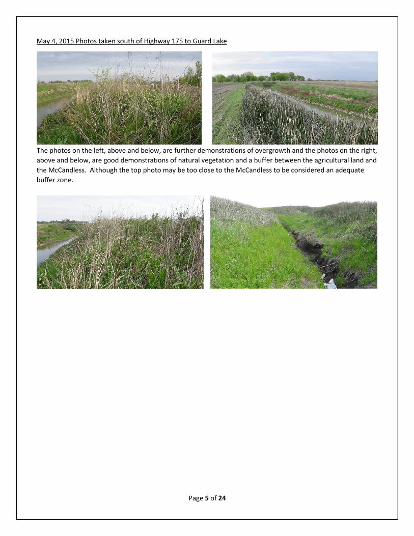
May 4, 2015 Photos taken south of Highway 175 to Guard Lake
The photos on the left, above and below, are further demonstrations of overgrowth and the photos on the right, above and below, are good demonstrations of natural vegetation and a buffer between the agricultural land and the McCandless. Although the top photo may be too close to the McCandless to be considered an adequate buffer zone.
Page 5 of 24

REFUSE AND DEBRIS
The cleanout portion of this inspection discovered furniture and appliances that had been dumped within the boundaries of the McCandless. One site could be construed as a “dump site” of an individual’s residential remodel. There were kitchen and bathroom fixtures/appliances in a position far from any vehicular access; i.e. hundreds of feet from any street. This area and the items within it appeared to have been there for a number of years, but should be removed as soon as possible. Any of these items, if a torrential rain fall occurs, could be dislodged from their location and create a possible barrier for potential flooding. This site was located approximately mid-way between 220th and 225th Streets on the east side of the McCandless. I strongly recommend that these items to be removed immediately from the McCandless.
Throughout the inspection, I noticed many items of refuse that appeared as if they had been thrown from a moving vehicle, along with items intentionally placed within the McCandless (tires, a TV, bookshelf, etc.) all of which could have created or enhanced a potential blockage within the McCandless. About a half a dozen (6) tires were removed from the McCandless and a few others remained within the McCandless, as they were unreachable to remove. Other debris was also unreachable and remains within the McCandless. Some of the items of refuse and debris were removed during this inspection, however most items were not. A controlled burn would not only remedy the vegetation overgrowth, but also the potential for refuse and debris to contribute to any potential blockage and possible flooding of the McCandless and surrounding area.
April 23, 2015 Photos taken north of 220th Street and half way between 220th and 225th Streets
Page 6 of 24

The photo on the right appears to be remains of an old beaver dam, the photo on the right is the remains of a structure. However, the remaining structure on the west side of the McCandless appears to be retaining debris (a branch) and the start of a possible blockage or flooding concern.
Page 7 of 24

April 28, 2015 Photos taken between 220th Street and half way between 220th and 225th Streets and to the South
Almost directly west of the Northern Ag elevators along 10th Street on the east side bank of the McCandless the next two photos of a kitchen sink were located. The first is where it was discovered and the next photo was taken after it was removed from its location to the top of the bank. This was the beginning of the largest repository of kitchen appliances, and bathroom fixtures were discovered just a few feet north of this location.
The cup and tire were items discovered prior to the “Appliance Dump” in the McCandless; above. The next few pictures are of the appliaces discovered in that same area. This area should be remedied as soon as possible, it can be accessed a large truck and possible lifting equipment to remove to potential flood enhancing debris.
Page 8 of 24

Page 9 of 24

The above photo is Elmwood Care Center which is just east of the next item of concern. The photo on the right was originally believed to be a concern with erosion, although this is still true, a closer inspection revealed the below unknown item; possibly an air conditioner or generator, within this drainage area.
Out of all the inspections, this TV has a funny story. As with some items that were carried, this item was removed from the west inlet on the south side of 225th Street (right) for Public Works Staff to retrieve the following morning. Prior to the work day, someone came by and pushed it back into the inlet; it had to be removed a second time.
Page 10 of 24

This pile of sheet metal was located on the eastern bank of the McCandless just along the north side of Vetter Equipment.
May 4, 2015 Photos taken south of Highway 175 to Guard Lake
The above small water heater was located in the McCandless directly west of the Onawa Municipal Water Tower.
Page 11 of 24

The photo on the left shows a piece of sheet metal; which is directly east of Struble Ag Services within the McCandless.
Page 12 of 24

Page 13 of 24

The above hay bales in the photo on the left, may have inadvertently rolled into the McCandless drainage area, however they could create barriers to flood water and the debris it contains; causing potential flooding. The photos to the right and below are photos taken in the Guard Lake area.
Page 14 of 24

ENVIRONMENTAL CONCERNS
The environmental concerns noted during this inspection included a small flowing creek feeding into the McCandless coming from an area of possible contaminants: salvage at a salvage yard located at 21868 230th Street and a pond of unknown water quality located on the property at 21849 State Highway 175.
The salvage yard has potential contaminants ranging from vehicular fluids to the deterioration of the paint and other vehicular parts to include rusting out of metal. These areas could require a permit from the Iowa Department of Natural Resources (IDNR). This area is also within the Monona County McCandless floodplain, and if the facility qualifies under the auto recycling facility, which is a large possibility, they may have to follow IDNR’s Standard Industrial Classification Code 5015 and 5093, where they could be required to have a storm water discharge permit and a storm water pollution prevention plan (SWPPP). Therefore, it is my strong recommendation that the McCandless in cooperation with the Monona County Zoning Administrator inquire into this status as soon as possible. May 4, 2015 Photos taken south of Highway 175 to Guard Lake
The above two photos are from small creek leading from the salvage yard mentioned above. It appears to be dry in the left photo, but moving up the bank of the McCandless demonstrates the water within the creek. This is the possible source of contamination to the McCandless for automotive related materials, not to mention the potential contamination from the unknown pond and its water quality. Whatever the case with the small pond of water and the salvage yard, I again strongly recommend the McCandless Board of Directors verify the permit with the IDNR and implement necessary steps to ensure that these properties are not contaminating the McCandless.
The above two photos were taken further downstream, and again I am not an environmentalist or water quality expert, but the “slicks” appearances should be investigated further to determine what if anything has entered the McCandless and the possible risks it places upon the City’s and downstream residents.
Page 15 of 24

AGRICULTURAL ENCROACHMENT
Upon completion of the physical inspection, I researched the McCandless property lines and neighboring farmland owners. Though it appears that there are differences in farming philosophies adjacent to the McCandless, there is still evidence that some farm land owners or tenant farmers are encroaching upon the ditch area to possibly increase their crop production. This is apparent by the cover page, bottom right photo. This encroachment is a benefit to the farmer; however, it is a detriment to the residents downstream, the gulf, the farmer or landowners themselves, and the wildlife within the McCandless. The detriment to the farmer is that farming immediately up to the McCandless increases potential erosion of the land’s soil; which in effect can take other contaminants with the soil into the McCandless, connecting to the Missouri River, and eventually the Gulf of Mexico. This, therefore, reduces the potential production of the field due to soil loss. This is something being debated currently with the Des Moines Water Works potential law suit against two northwestern Iowa counties due to water contaminants (Eller 2015).
Some farm land owners or tenant farmers have a buffer between their farm land and the McCandless. As for addressing this situation, there are many options to consider, but I will recommend a few. The McCandless Board of Directors could request that all farmers to let natural grasslands occur from the edge of their property adjoining the McCandless property for a minimum amount of feet. If this does not work, then the Board of Directors over the next twenty (20) years could slowly acquire what they believe would be an appropriate buffer zone of feet adjacent property to the McCandless to implement this barrier and should begin at the most northern area of the McCandless until the eventual end of the McCandless with the Missouri River.
The Iowa State University (ISU) Leopold Center has been developing good boundary guidelines since at least 1997, and recommends a three (3) zone buffer zone, with each varying in distance. In essence, the entire buffer of each side of the bank should be around 66 feet wide (Schultz, R. C.; Wray, P. H.; Colletti, J. P.; Isenhart, T. M.; Rodrigues, C. A.; & Kuehl, A. 1997). The buffer zone width varies with the intention of what is needed to include bank reinforcement or erosion control, pesticide removal, and nitrogen or phosphorous removal. The buffer zones can vary depending on the goal of the McCandless. The recommended ISU distance falls into the recommended widths from Yale University as well (Hawes & Smith, 2005). By completing buffer zones, this would also enhance and reduce erosion. Implementing a buffer zone will take time, but it can be achieved for the benefit for all involved. It is my personal opinion that these buffer zones were designed for rivers, and as such, the width of each buffer zone may differ for the McCandless. This may require more research to discover an appropriate distance for the McCandless.
April 23, 2015 Photos taken north of 220th Street and half way between 220th and 225th Streets
The photo above on the left is field, and the green portion is the beginning of the area on the east side of the McCandless. This photo demonstrates the encroachment by this farmer into the vegetation buffer area. As you
Page 16 of 24

can also see the “white” or “greying” is dead material that has been plowed under and could have possibly been a part of the buffer zone.
April 28, 2015 Photos taken between 220th Street and half way between 220th and 225th Streets and to the South
The first two photo graphs on the following page demonstrate the different philosophies of buffer zone usage by one property owner or tenant farmer, with the post acting as a possible property line marker. In this area according to the Monona County Assessor’s GIS webpage, the area does not increase in size for the McCandless property easement or ownership. Following the first two pages are sample photos of possible agricultural encroachment upon the McCandless.
Page 17 of 24
EROSION CONTROL
Erosion control methods were evident within the City, but not throughout the McCandless. Most of the McCandless did not have any erosion control; in fact, there was no evidence during the inspection of any erosion control methods outside of the City. The McCandless, possibly in cooperation with the City, had placed small to medium sized red rocks along the bends of the McCandless for bank reinforcement. There was also a small area within the City that had well-groomed landscaping and maintenance in place from the entire inspection area. It was good to see this implemented plan of action to control the erosion loss, but it is my professional recommendation that whatever this process was, it should be built upon and expanded throughout the McCandless.
Erosion control must be enhanced further with updated and improved infrastructure along the McCandless, as there is damage to culverts and outlets into the McCandless from other storm water sources. Further, as mentioned in the previous two (2) sections, vegetation barriers should be implemented not only with the agricultural area surrounding the McCandless, but for the commercial and industrial areas within the City as well.
There are many methods for bank reinforcement, which includes trees, natural grasslands, concrete, rock, etc. (Holste, Renholds, Ursic; 2006), but the McCandless should strongly consider natural grasses and trees to strengthen the McCandless banks. As mentioned earlier, control burns help with the native grasses, wetlands and wildlife’s development with wild life nesting and habitat.
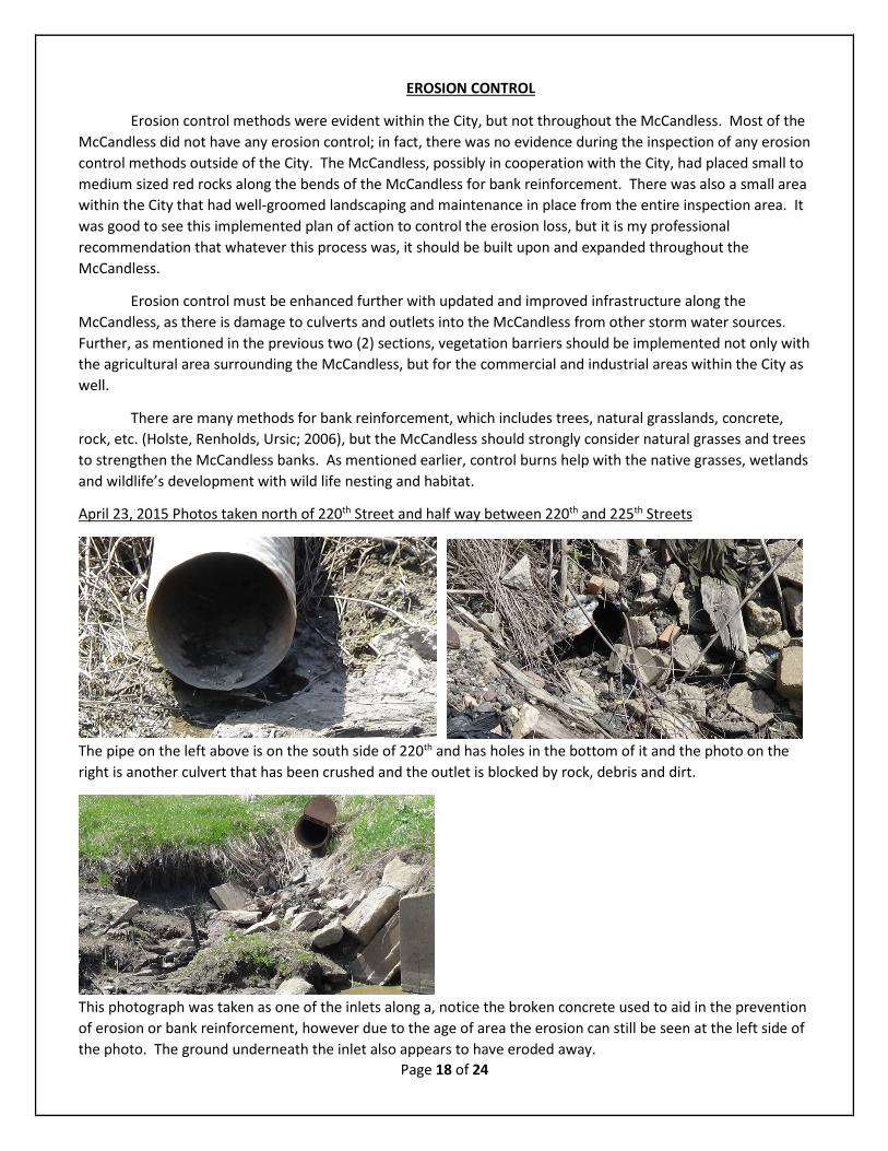
April 23, 2015 Photos taken north of 220th Street and half way between 220th and 225th Streets
The pipe on the left above is on the south side of 220th and has holes in the bottom of it and the photo on the right is another culvert that has been crushed and the outlet is blocked by rock, debris and dirt.
This photograph was taken as one of the inlets along a, notice the broken concrete used to aid in the prevention of erosion or bank reinforcement, however due to the age of area the erosion can still be seen at the left side of the photo. The ground underneath the inlet also appears to have eroded away.
Page 18 of 24

April 28, 2015 Photos taken between 220th Street and half way between 220th and 225th Streets and to the South
This inlet pipe is too low for the designed culvert, and upon closer examination, most of the water is actually draining into the McCandless behind the western edge of the culvert. This could be compromising the integrity of the road crossing, 225th Street.
These photos are great examples of the McCandless reinforcing banks to prevent erosion. The red rock addition, especially to the outer edge of a river bend reduces the erosion capability of the water.
These two photos are of the Vetter Equipment Company’s well developed and maintained buffer zone between their business area and the McCandless. Along the agricultural crop land this is what should be implemented, but maintained to this level. It would be best to plant natural grasslands native to Iowa and wet or grasslands.
Page 19 of 24

This photo is of the western bank for the bridge crossing the McCandless for U.S. Highway 175. Both the east and west bank appear to be in the same condition, and the Iowa Department of Transportation (IDOT) should be notified of the potential erosion. I would recommend to IDOT that this should be closely monitored or even researched by an erosion specialist, or engineer, regarding the stability of this bridge. May 4, 2015 Photos taken south of Highway 175 to Guard Lake
The above two photos demonstrate the lack of appropriate ground cover that can lead to erosion concerns. The right photo has a cover layer that appears to be ready to fall into the McCandless.
The photo on the left appears to be of an old dam, possibly of a beaver, but from whatever it is from this is a potential blockage to appropriate water flow and could lead to possible flooding.
Page 20 of 24

Page 21 of 24
RESOURCES CITED
Ducks Unlimited. (March 3, 2015). Wetland habitat management: a guide for landowners. Great Lakes/Atlantic Regional Office (retrieved June 14, 2015: http://www.ducks.org/media/Conservation/GLARO/_documents/_library/_landowner/Landowner_Guide.pdf). Eller, Donnelle (May 19, 2015). Fight over Des Moines Water Works lawsuit heats up. The Des Moines Register, Des Moines, IA (retrieved June 15, 2015: http://www.desmoinesregister.com/story/money/agriculture/2015/05/14/water-works-nitrates-lawsuit/27331305/)
Hawes, Ellen & Markelle Smith. (April 2005). Riparian buffer zones: functions and recommended widths. Yale University, New Haven, CT (retrieved June 14, 2015: http://eightmileriver.org/resources/digital_library/appendicies/09c3_Riparian%20Buffer%20Science_YALE.pdf) Nathan Holste, Jon Renholds, & Mick Ursic. (2006). Riverbank protection cive 717, assignment 4 problem 2. Colorado State University, Fort Collins, CO (retrieved June 14, 2015: http://www.engr.colostate.edu/~pierre/ce_old/classes/CE413/PPT%20files/Assign4.pdf Schultz, R. C.; Wray, P. H.; Colletti, J. P.; Isenhart, T. M.; Rodrigues, C. A.; & Kuehl, A. (April, 1997). Stewards of our streams: buffer strip design, establishment, and maintenance. Iowa State University, Ames, IA (retrieved June 14, 2015: https://www.google.com/url?sa=t&rct=j&q=&esrc=s&source=web&cd=1&cad=rja&uact=8&ved=0CB4QFjAAahUKEwjP_5iiqZDGAhWET5IKHUuAAHc&url=https%3A%2F%2Fstore.extension.iastate.edu%2FProduct%2Fpm1626b-pdf&ei=HAx-Vc8BhJ_JBMuAgrgH&usg=AFQjCNHXOwJsjVmBHwkqTa5eHruemV3EXg&bvm=bv.95515949,d.cWc) U. S. Fish and Wildlife Service. (February 2006). Case studies from the U.S. Fish & Wildlife Service Branch of Fire Management national wildlife refuge system briefing for the director. Washington, DC (retrieved June 14, 2015: http://www.fws.gov/fire/downloads/Benefits%20of%20Fire%20Case%20Studies.Feb06.pdf). U. S. Department of Agriculture – Natural Resources Conservation Service. Water SHEDSS wetland management. Washington, DC (retrieved June 14, 2015: http://www.water.ncsu.edu/watershedss/info/wetlands/manage.html#over).
Page 22 of 24

Page 23 of 24

Page 24 of 24