
2015 Developable Land Booklet
16
Spring 2015 Developable Land
Transcript of 2015 Developable Land Booklet

Spring 2015
Developable Land

CochiseCounty
City ofSierra Vista
Fort HuachucaMilitaryReservation
BuffaloSoldier
Gate
Van DemanGate
HIGHWAY 90
CHARLESTON RD
FRY BLVD
E YAQUI ST
ARIZ
ONA
ST
WHI
TSID
E RD
BUFFALO SOLDIER TRAIL
CART
ER ST
WINROW AVE
CUSHING ST
ALLISON RD
SMITH AVE
IRWIN ST
BUSBY DR
N C
ORON
ADO
DR
COLO
MBO
AVE
LENZ
NER
RD
N 7
TH S
TS
7TH
ST
N CA
RMIC
HAEL
AVE
S CA
RMIC
HAEL
AVE
MOO
RMAN
CALLE PORTAL
GIUL
IO C
EASA
REAV
ENID
A DE
L SO
L
SCHR
ADER
RD
COLO
NIA
DE S
ALUD
COLO
NIA
DE S
ALUD
S CO
RONA
DO D
R
EL C
AMIN
O RE
AL
S VIA RIATA
CALLE
MERCANCIA
CHOCTAW DR
WILCOX DR
KACHINA TRL GLENN RD
GATE
WOO
D RD
S CA
MPO
BELL
O AV
E
HUNT AVE
E BEVERS ST
E LOMA LN
SNYDER BLVD
GRIERSON
NORTH AVE
E SAGEBRUSH RD
RAMSEY CANYON RDRAMSEY RD
E TACOMA ST
CAMPUS DR
STEI
N S
T
E PONCHO TRL
S SI
OUX
AVE
WINROW AVE
IRWIN ST
HIGHWAY 90 BYPASS
TACOMA ST
THEATRE
E QUAIL RUN DR
SYCAMORE DR
DENMANCARMELITA DR
1ST
MARTIN LUTHER KING JR PKWY
GOLF LINKS RD
EL MERCADO LOOPGREENBRIAR RD
S HI
GHW
AY 9
2S
HIGH
WAY
92
BUFFALO SOLDIER TRAIL
KAYETAN
CHER
OKEE
HIGHWAY 90
N KI
NO R
D
N M
OSON
RD
S M
OSON
RD
S AR
ABIA
N DR
S NA
TOM
A T
RAIL
S RA
NCH
RD
S RI
CARD
O D
R
HATFIELD ST
LAW
TO
N RD
E PAWNEE DR
EQUE
STRI
AN A
VEST
AND
REW
S DR
GARDEN CA
NYON R
D
FOOTHILLS DR
PASE
O SA
N LU
IS
LAS BRISAS WY
AVENIDA COCHISE
ST A
NDREWS DR
TOWN
& COUNTRY D R
AVEN
IDA
ESCU
ELA
FAB
AVE
VeteransMemorial
Park
Nancy Hakes Park
ChaparrelPark
BolinRC Airfield
EnvironmentalOperationsPark
Purple HeartsPark
Len RobertsPark
Cyr Center ParkSoldier’s Creek Park
GatewayPark
CiaramitaroPark
TimothyLanePark A.V.
AndersonPark
TompkinsPark
SummitPark
CountryClubPark
GardenCanyon
Park
Garden CanyonLinear ParkTrail (dirt)
Coronado Crossings Trail
Pueb
lo de
l Sol
Golf Co
urse
ForrestDoernerLinearPark
Bella VistaPark
Civic Center Complex
Woo
dcut
ters
Line
ar P
ark
0 0.25 0.5 1miles
2
Sierra Vista Arizona
AVAILABLE LANDTable of Contents
COCHISE MEDICAL OFFICE PARK ....................................... 4
DUNLAP PROPERTY ............................................................ 4
MESA VERDE HEIGHTS .........................................................5
CANYON VISTA MEDICAL CENTER .......................................5
HIGHWAY 90 PROPERTY ..................................................... 6
HIGHWAY 90 AT TREE TOP AVENUE ................................... 6
COCHISE CROSSROADS AT CHARLESTON ROAD ................7
HIGHWAY 90 EAST OF FOOD CITY ...................................... 8
THE PROMENADE ON HIGHWAY 92 ................................... 8
HIGHWAY 92 AT AVENIDA COCHISE ................................... 9
AVENIDA COCHISE ............................................................... 9
THE MALL AT SIERRA VISTA “A” ....................................... 10
THE MALL AT SIERRA VISTA “B” ....................................... 10
TRIBUTE MASTER PLANNED COMMUNITY ......................11
BUFFALO SOLDIER TRAIL ...................................................11
FAB AVENUE ....................................................................... 12
WILCOX DRIVE & 7TH STREET ............................................ 12
WILCOX DRIVE & CORONADO DRIVE ............................... 13
FRY BOULEVARD NEAR VETERANS MEMORIAL PARK .. 13
HIGHWAY 90 & SOUTH SCHRADER ROAD PARCEL ......... 14
HIGHWAY 92 & BUFFALO SOLDIER TRAIL ....................... 14
COMMUNITY OVERVIEW ................................................... 15This information is provided by the City of Sierra Vista. Interested developers should do their own due diligence to verify the information presented.
City of Sierra Vista • [email protected]
Tucson

CochiseCounty
City ofSierra Vista
Fort HuachucaMilitaryReservation
BuffaloSoldier
Gate
Van DemanGate
HIGHWAY 90
CHARLESTON RD
FRY BLVD
E YAQUI ST
ARIZ
ONA
ST
WHI
TSID
E RD
BUFFALO SOLDIER TRAIL
CART
ER ST
WINROW AVE
CUSHING ST
ALLISON RD
SMITH AVE
IRWIN ST
BUSBY DR
N C
ORON
ADO
DR
COLO
MBO
AVE
LENZ
NER
RD
N 7
TH S
TS
7TH
ST
N CA
RMIC
HAEL
AVE
S CA
RMIC
HAEL
AVE
MOO
RMAN
CALLE PORTAL
GIUL
IO C
EASA
REAV
ENID
A DE
L SO
L
SCHR
ADER
RD
COLO
NIA
DE S
ALUD
COLO
NIA
DE S
ALUD
S CO
RONA
DO D
R
EL C
AMIN
O RE
AL
S VIA RIATA
CALLE
MERCANCIA
CHOCTAW DR
WILCOX DR
KACHINA TRL GLENN RD
GATE
WOO
D RD
S CA
MPO
BELL
O AV
E
HUNT AVE
E BEVERS ST
E LOMA LN
SNYDER BLVD
GRIERSON
NORTH AVE
E SAGEBRUSH RD
RAMSEY CANYON RDRAMSEY RD
E TACOMA ST
CAMPUS DR
STEI
N S
T
E PONCHO TRL
S SI
OUX
AVE
WINROW AVE
IRWIN ST
HIGHWAY 90 BYPASS
TACOMA ST
THEATRE
E QUAIL RUN DR
SYCAMORE DR
DENMANCARMELITA DR
1ST
MARTIN LUTHER KING JR PKWY
GOLF LINKS RD
EL MERCADO LOOPGREENBRIAR RD
S HI
GHW
AY 9
2S
HIGH
WAY
92
BUFFALO SOLDIER TRAIL
KAYETAN
CHER
OKEE
HIGHWAY 90
N KI
NO R
D
N M
OSON
RD
S M
OSON
RD
S AR
ABIA
N DR
S NA
TOM
A T
RAIL
S RA
NCH
RD
S RI
CARD
O D
R
HATFIELD ST
LAW
TO
N RD
E PAWNEE DR
EQUE
STRI
AN A
VEST
AND
REW
S DR
GARDEN CA
NYON R
D
FOOTHILLS DR
PASE
O SA
N LU
IS
LAS BRISAS WY
AVENIDA COCHISE
ST A
NDREWS DR
TOWN
& COUNTRY D R
AVEN
IDA
ESCU
ELA
FAB
AVE
VeteransMemorial
Park
Nancy Hakes Park
ChaparrelPark
BolinRC Airfield
EnvironmentalOperationsPark
Purple HeartsPark
Len RobertsPark
Cyr Center ParkSoldier’s Creek Park
GatewayPark
CiaramitaroPark
TimothyLanePark A.V.
AndersonPark
TompkinsPark
SummitPark
CountryClubPark
GardenCanyon
Park
Garden CanyonLinear ParkTrail (dirt)
Coronado Crossings Trail
Pueb
lo de
l Sol
Golf Co
urse
ForrestDoernerLinearPark
Bella VistaPark
Civic Center Complex
Woo
dcut
ters
Line
ar P
ark
Arizona
CochsieCounty
3
Developable Land
DISTANCE TO:Tucson ............................................. 75 milesDouglas/Agua Prieta, Mexico........ 51 milesNogalas ........................................... 63 milesPhoenix ........................................ 189 miles

4
Sierra Vista Arizona
COCHISE MEDIC AL OFFICE PARKNorthwest Corner of Highway 90 and Giulio Cesare AvenueAPN 107-16-014C • Zoning: General Commercial (GC) • Acreage: 5.10
Located on the emerging east side of the City, this 5.10 acre parcel is zoned General Commercial (GC) and would be suitable for office professional or retail uses. The signalized corner is near the recently completed hospital, located only ½ mile to the east. Shell Gasoline is across the street. Cochise Oncology is adjacent to the property.
DUNLAP PROPERT YSoutheast Corner of Highway 90 and Avenida del SolAPN 107-49-001Q • Zoning: General Commercial (GC) • Acreage: 2.12
Located on the emerging east side of the City, this 2.12 acre parcel is zoned General Commercial (GC) and would be suitable for office professional, retail, or service uses. The signalized corner is near the recently completed hospital, located only ½ mile to the east. Shell Gasoline is across the street. The parcel is surrounded by a larger, separately-owned parcel that is also zoned GC.
CONTACT Simone McFarland, City of Sierra Vista • [email protected] • 520.678.5608
CONTACT Mission Hill Management • 520.398.6171

5
Developable Land
MESA VERDE HEIGHTSSoutheast Corner of Highway 90 and Avenida del SolAPN 107-49-001P • Zoning: General Commercial (GC) • Acreage: 21.19
Located on the emerging east side of the City, this 21.19 acre parcel is zoned General Commercial (GC) and would be suitable for office professional or retail uses. The recently completed Canyon Vista Medical Center hospital is located only ¼ mile to the east. The parcel is adjacent to an available 2.12 acre parcel that is also zoned GC. The corner at State Highway 90 and Avenida del Sol is signalized.
C ANYON VISTA MEDIC AL CENTERSoutheast Corner of Highway 90 and Colonia de SaludAPN 107-49-291 (portion) • Zoning: Light Industrial (LI) • Acreage: 1.50 (est.)
Located on the east side of the City, this estimated 1.50 acre parcel is zoned Light Industrial (LI) and is ready for rezon-ing for office professional or retail uses. The parcel is located on the same prop-erty as the recently completed 100-bed Canyon Vista Medical Center hospital. The corner is signalized and would be perfect for a pharmacy/drug store.
CONTACT Simone McFarland, City of Sierra Vista • [email protected] • 520.678.5608
CONTACT Simone McFarland, City of Sierra Vista • [email protected] • 520.678.5608

6
Sierra Vista Arizona
HIGHWAY 90 PROPERT YEast of 4860 Highway 90APN 107-50-003 • Zoning: Office Professional (OP) • Acreage: 1.65
This 1.65 acre parcel is zoned Office Professional (OP) and is ready for office professional or possible retail uses. Located on the emerging east side of the City, the parcel is adjacent to a recently constructed Tractor Supply retail store and has good visibility.
HIGHWAY 90 AT TREE TOP AVENUESoutheast Corner of Highway 90 and Tree Top AvenueAPN 107-17-109B • Zoning: Limited Commercial (LC) • Acreage: 1.28
This 1.28 acre parcel is zoned Limited Commercial (LC) and is ready for retail uses. The parcel is located on a corner, is near Fry’s food store, Target, PetSmart and Staples.
CONTACT Simone McFarland, City of Sierra Vista • [email protected] • 520.678.5608
CONTACT Simone McFarland, City of Sierra Vista • [email protected] • 520.678.5608

7
Developable Land
COCHISE CROSSROADS AT CHARLESTON ROADEast of Highway 90 and South of E. Charleston RoadAPN • Zoning: General Commercial (GC)
Contiguous to Cochise Crossroads Shopping Center, this site has a variety of options.
Development Land: This property has frontage on Charleston Road and is zoned GC. The landlord will build-to-suit, land lease or sell all or part of the land. Sale price: $1,474,070 ($4/SF).
Shop Space: Additionally, shop space is available from 1,200 to 6,218 square feet of build-to-suit shop space adjacent to PetSmart and Staples. The landlord will build and lease all or part.
Pad Space: 12,000 square feet of pad space is available east of Staples and Fry’s. The landlord will build-to-suit, land lease or sell pad. Retail, office, medical or service type business can take advantage of this centrally located property. Sales price: $72,000 ($6/SF).
CONTACT David Blanchette, CBRE • [email protected] • 520.323.5138
8
Sierra Vista Arizona
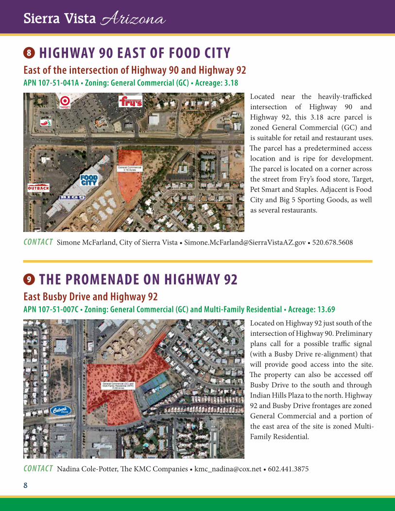
HIGHWAY 90 EAST OF FOOD CIT YEast of the intersection of Highway 90 and Highway 92APN 107-51-041A • Zoning: General Commercial (GC) • Acreage: 3.18
Located near the heavily-trafficked intersection of Highway 90 and Highway 92, this 3.18 acre parcel is zoned General Commercial (GC) and is suitable for retail and restaurant uses. The parcel has a predetermined access location and is ripe for development. The parcel is located on a corner across the street from Fry’s food store, Target, Pet Smart and Staples. Adjacent is Food City and Big 5 Sporting Goods, as well as several restaurants.
THE PROMENADE ON HIGHWAY 92East Busby Drive and Highway 92APN 107-51-007C • Zoning: General Commercial (GC) and Multi-Family Residential • Acreage: 13.69
Located on Highway 92 just south of the intersection of Highway 90. Preliminary plans call for a possible traffic signal (with a Busby Drive re-alignment) that will provide good access into the site. The property can also be accessed off Busby Drive to the south and through Indian Hills Plaza to the north. Highway 92 and Busby Drive frontages are zoned General Commercial and a portion of the east area of the site is zoned Multi-Family Residential.
CONTACT Simone McFarland, City of Sierra Vista • [email protected] • 520.678.5608
CONTACT Nadina Cole-Potter, The KMC Companies • [email protected] • 602.441.3875
9
Developable Land
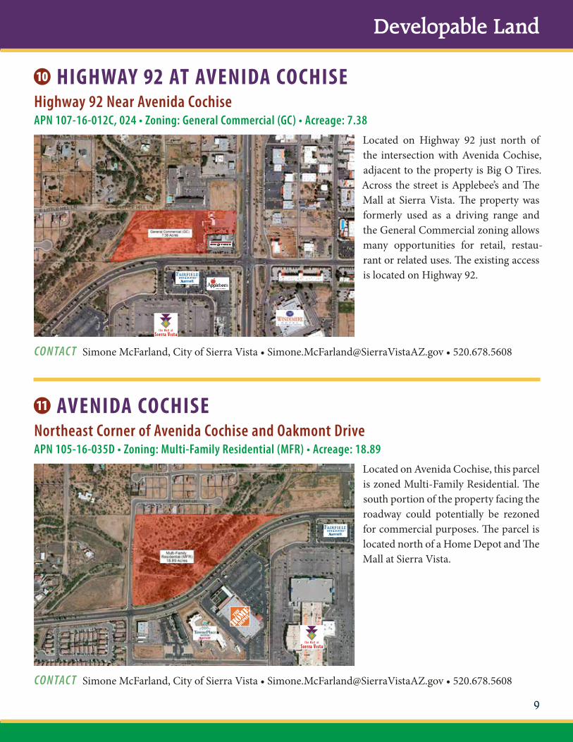
HIGHWAY 92 AT AVENIDA COCHISEHighway 92 Near Avenida CochiseAPN 107-16-012C, 024 • Zoning: General Commercial (GC) • Acreage: 7.38
Located on Highway 92 just north of the intersection with Avenida Cochise, adjacent to the property is Big O Tires. Across the street is Applebee’s and The Mall at Sierra Vista. The property was formerly used as a driving range and the General Commercial zoning allows many opportunities for retail, restau-rant or related uses. The existing access is located on Highway 92.
AVENIDA COCHISENortheast Corner of Avenida Cochise and Oakmont DriveAPN 105-16-035D • Zoning: Multi-Family Residential (MFR) • Acreage: 18.89
Located on Avenida Cochise, this parcel is zoned Multi-Family Residential. The south portion of the property facing the roadway could potentially be rezoned for commercial purposes. The parcel is located north of a Home Depot and The Mall at Sierra Vista.
CONTACT Simone McFarland, City of Sierra Vista • [email protected] • 520.678.5608
CONTACT Simone McFarland, City of Sierra Vista • [email protected] • 520.678.5608

10
Sierra Vista Arizona
THE MALL AT SIERR A VISTA “A”Avenida Cochise West of Highway 92APN 105-16-040 • Zoning: General Commercial (GC) • Acreage: 1.65
Located at the north entrance to The Mall at Sierra Vista on Avenida Cochise, this parcel is available for restaurant or retail use. The parcel is located between the Fairfield Inn and Home Depot and has good access on the mall’s loop road, El Mercado Loop.
THE MALL AT SIERR A VISTA “B”Highway 92APN 105-16-044 • Zoning: General Commercial (GC) • Acreage: 1.21
Located at the primary, signalized, entrance to The Mall at Sierra Vista on Highway 92, this parcel is available for restaurant or retail use. The parcel is located south of a Wells Fargo Bank and has good access on the El Mercado Loop. The mall is anchored with Sears, Best Buy, Dillard’s and Cinemark Theatres. Outpads include Texas Roadhouse and Applebee’s. Adjacent properties include Home Depot and Fairfield Marriott.
CONTACT Tina Tufts, Rouse Properties • [email protected] • 206.819.2006
CONTACT Tina Tufts, Rouse Properties • [email protected] • 206.819.2006
11
Developable Land
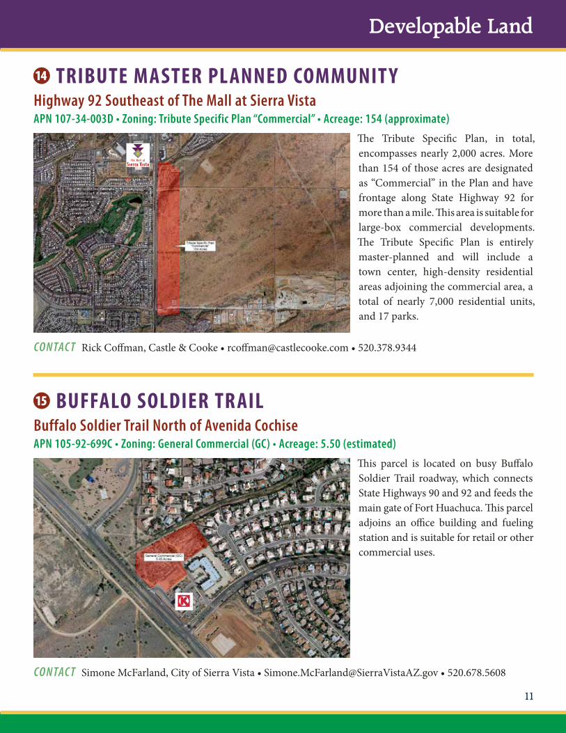
TRIBUTE MASTER PLANNED COMMUNIT YHighway 92 Southeast of The Mall at Sierra VistaAPN 107-34-003D • Zoning: Tribute Specific Plan “Commercial” • Acreage: 154 (approximate)
The Tribute Specific Plan, in total, encompasses nearly 2,000 acres. More than 154 of those acres are designated as “Commercial” in the Plan and have frontage along State Highway 92 for more than a mile. This area is suitable for large-box commercial developments. The Tribute Specific Plan is entirely master-planned and will include a town center, high-density residential areas adjoining the commercial area, a total of nearly 7,000 residential units, and 17 parks.
BUFFALO SOLDIER TR AILBuffalo Soldier Trail North of Avenida CochiseAPN 105-92-699C • Zoning: General Commercial (GC) • Acreage: 5.50 (estimated)
This parcel is located on busy Buffalo Soldier Trail roadway, which connects State Highways 90 and 92 and feeds the main gate of Fort Huachuca. This parcel adjoins an office building and fueling station and is suitable for retail or other commercial uses.
CONTACT Rick Coffman, Castle & Cooke • [email protected] • 520.378.9344
CONTACT Simone McFarland, City of Sierra Vista • [email protected] • 520.678.5608

12
Sierra Vista Arizona
FAB AVENUESoutheast Corner of Fab Avenue and Fry BoulevardAPN 105-11-012C • Zoning: General Commercial (GC) • Acreage: 1.26
This parcel is located on busy Fry Boulevard and is a corner location. A restaurant and hotel are located to the west and restaurants and retail uses to the east. There is an existing building on the back section of the lot that may need to be demolished. This lot is located within the West End Infill Incentive zone that allows additional flexibility to assist developers.
WILCOX DRIVE & 7TH STREETNorthwest Corner of Wilcox Drive and 7th StreetAPN 105-09-065 • Zoning: General Commercial (GC) • Acreage: 0.90
This parcel is located at the busy inter-section of Wilcox Drive and 7th Street and is a corner location. The area con-sists of a mix of services, retail and office development. This parcel is suited for most types of commercial development. A portion is within the 100-year flood-plain helping mitigate the parcel cost. This lot is located within the West End Infill Incentive Zone that allows addi-tional flexibility to assist developers.
CONTACT Simone McFarland, City of Sierra Vista • [email protected] • 520.678.5608
CONTACT Lee Cory, Long Realty • [email protected] • 520.439.3944

13
Developable Land
WILCOX DRIVE & CORONADO DRIVESouthwest Corner of Wilcox Drive and Coronado DriveAPN 105-07-003C • Zoning: Office Professional (OP) • Acreage: 1.82
This parcel is located at the busy inter-section of Wilcox Drive and Coronado Drive and is a signalized corner location. To the west of the parcel is the Sierra Extended Stay Hotel and to the east is the City’s Vista Transit Center. Offices and retail are nearby to the north. The parcel is suited to office development or could be rezoned for commercial uses.
FRY BOULEVARD NEAR VETER ANS MEMORIAL PARKWest of Avenida EscuelaAPN 105-05-125 • Zoning: General Commercial (GC) • Acreage: 1.84
This parcel is located on busy Fry Boulevard across from Veterans Memorial Park. There is an adjoining 1.83 acre parcel to the rear potentially allowing for a larger development. The site is adjacent to Days Inn and near hotels and retail development and is suitable for any commercial development.
CONTACT Simone McFarland, City of Sierra Vista • [email protected] • 520.678.5608
CONTACT Simone McFarland, City of Sierra Vista • [email protected] • 520.678.5608

14
Sierra Vista Arizona
HIGHWAY 90 & SOUTH SCHR ADER ROAD PARCELSouthwest Corner of Highway 90 and Schrader RoadAPN 107-49-282A • Zoning: General Commercial (GC) • Acreage: 11.58
This parcel is located just east of the newly developed 100-bed Canyon Vista Medical Center hospital on east Highway 90. The large acreage would allow for numerous commercial or office professional opportunities.
HIGHWAY 92 & BUFFALO SOLDIER TR AILSouthwest Corner of Highway 92 and Buffalo Soldier TrailAPN 105-95-986, 987, 988, 989, 990 • Zoning: General Commercial (GC) • Acreage: 6.54
This parcel is located at the Southwest Corner of Highway 92 and Buffalo Soldier Trail, which is the second bus-iest intersection in the City. It is located near the Tribute Specific Plan area, retail and restaurant uses, and extensive residential areas. Originally planned for a Walgreens and adjoining restaurant and retail uses, the five parcels are avail-able separately or combined. Access has been pre-determined by development agreement and the parcel is ripe for development.
CONTACT Simone McFarland, City of Sierra Vista • [email protected] • 520.678.5608
CONTACT Rick Coffman, Castle & Cooke • [email protected] • 520.378.9344
$0
$10,000
$20,000
$30,000
$40,000
$50,000
$60,000
$70,000
$80,000
PerCapita
Income
MedianFamily
Income
MedianHousehold
Income
United StatesArizonaCochise CountySierra Vista
$58,04
0$4
4,10
3$4
8,54
8$5
2,17
6 $69,18
6$5
3,20
3$5
7,31
7$6
3,78
4
$27,45
0$2
3,04
3$2
4,96
1$2
7,88
4
0%
20%
40%
60%
80%
100%
United StatesArizonaCochise CountySierra Vista
Bachelor’s Degreeor Higher
High School Graduateor Higher
93.386.4 86.385.8
32.723.6
29.127.2
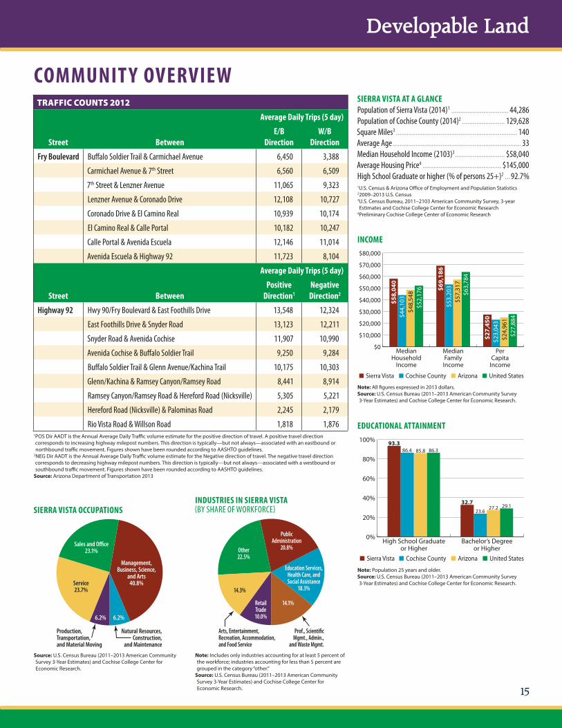
Sales and O�ce23.1%
Production,Transportation, and Material Moving
Natural Resources,Construction,
and Maintenance
Management,Business, Science,
and Arts40.8%Service
23.7%
6.2% 6.2%
Other22.5%
Arts, Entertainment,Recreation, Accommodation,and Food Service
Education Services,Health Care, andSocial Assistance
18.3%
PublicAdministration
20.8%
14.3%
RetailTrade10.0%
Prof., Scienti�cMgmt., Admin.,
and Waste Mgmt.
14.1%
15
Developable Land
SIERRA VISTA AT A GLANCEPopulation of Sierra Vista (2014)1 ................................ 44,286Population of Cochise County (2014)2 ........................ 129,628Square Miles3 .................................................................... 140Average Age ........................................................................ 33Median Household Income (2103)3 ............................ $58,040Average Housing Price4 ............................................ $145,000High School Graduate or higher (% of persons 25+)2 ... 92.7%1U.S. Census & Arizona Office of Employment and Population Statistics22009–2013 U.S. Census3U.S. Census Bureau, 2011–2103 American Community Survey, 3-year Estimates and Cochise College Center for Economic Research
4Preliminary Cochise College Center of Economic Research
INCOME
Note: All figures expressed in 2013 dollars.Source: U.S. Census Bureau (2011–2013 American Community Survey 3-Year Estimates) and Cochise College Center for Economic Research.
TRAFFIC COUNTS 2012Average Daily Trips (5 day)
Street BetweenE/B
DirectionW/B
Direction
Fry Boulevard Buffalo Soldier Trail & Carmichael Avenue 6,450 3,388
Carmichael Avenue & 7th Street 6,560 6,509
7th Street & Lenzner Avenue 11,065 9,323
Lenzner Avenue & Coronado Drive 12,108 10,727
Coronado Drive & El Camino Real 10,939 10,174
El Camino Real & Calle Portal 10,182 10,247
Calle Portal & Avenida Escuela 12,146 11,014
Avenida Escuela & Highway 92 11,723 8,104
Average Daily Trips (5 day)
Street BetweenPositive
Direction1Negative Direction2
Highway 92 Hwy 90/Fry Boulevard & East Foothills Drive 13,548 12,324
East Foothills Drive & Snyder Road 13,123 12,211
Snyder Road & Avenida Cochise 11,907 10,990
Avenida Cochise & Buffalo Soldier Trail 9,250 9,284
Buffalo Soldier Trail & Glenn Avenue/Kachina Trail 10,175 10,303
Glenn/Kachina & Ramsey Canyon/Ramsey Road 8,441 8,914
Ramsey Canyon/Ramsey Road & Hereford Road (Nicksville) 5,305 5,221
Hereford Road (Nicksville) & Palominas Road 2,245 2,179
Rio Vista Road & Willson Road 1,818 1,8761POS Dir AADT is the Annual Average Daily Traffic volume estimate for the positive direction of travel. A positive travel direction corresponds to increasing highway milepost numbers. This direction is typically—but not always—associated with an eastbound or northbound traffic movement. Figures shown have been rounded according to AASHTO guidelines.
2NEG Dir AADT is the Annual Average Daily Traffic volume estimate for the Negative direction of travel. The negative travel direction corresponds to decreasing highway milepost numbers. This direction is typically—but not always—associated with a westbound or southbound traffic movement. Figures shown have been rounded according to AASHTO guidelines.Source: Arizona Department of Transportation 2013
COMMUNIT Y OVERVIEW
EDUCATIONAL ATTAINMENT
Note: Population 25 years and older.Source: U.S. Census Bureau (2011–2013 American Community Survey 3-Year Estimates) and Cochise College Center for Economic Research.
SIERRA VISTA OCCUPATIONSINDUSTRIES IN SIERRA VISTA(BY SHARE OF WORKFORCE)
Source: U.S. Census Bureau (2011–2013 American Community Survey 3-Year Estimates) and Cochise College Center for Economic Research.
Note: Includes only industries accounting for at least 5 percent of the workforce; industries accounting for less than 5 percent are grouped in the category “other.”Source: U.S. Census Bureau (2011–2013 American Community Survey 3-Year Estimates) and Cochise College Center for Economic Research.

Sierra Vista Arizona
City of Sierra Vista1011 N. Coronado DriveSierra Vista, Arizona 85635520.678.5608Simone.McFarland@SierraVistaAZ.govwww.SierraVistaAZ.gov
Produced by the City of Sierra Vista Public Affairs Office 05/2015 250


