2015 Annual Report of The Porter County GIS Departmant
17
Annual Report of the Porter County GIS Office 2015 Developed by Charles T. Miller, GISP
-
Upload
charles-t-miller-gisp -
Category
Documents
-
view
125 -
download
5
Transcript of 2015 Annual Report of The Porter County GIS Departmant

Annual Report of the Porter County GIS Office
2015
Developed by Charles T. Miller, GISP

Written and Designed By:
Charles T. Miller, GISP
GIS Coordinator, Analyst,
Database Administrator
Porter County Development Department – GIS
Contact Information:
Porter County Administration Building
155 Indiana Avenue Suite 311
Valparaiso, IN 46383
Phone (219)465-3537
Cell (219)307-0024
Email [email protected]


PORTER COUNTY GIS DEPARTMENT ANNUAL REPORT 2015 1
F
A Message from the Coordinator
In sticking to our commitment the GIS Department is in a constant state of evolving and
learning new concepts and technology in GIS and related progressive technologies to
better serve our users be they public or private, part of the Porter County Government
network or citizens and business located in, or involved with, Porter County Indiana.
Making contact with our user base a constant, we strive to cater our project to their
specific needs. Whether there is time for a thorough needs assessment or an
emergency project arises, the Porter County GIS Department is committed to
responding with intelligent and resourceful solutions.
Having an incredible opportunity in a growing and constantly changing community the
Porter County GIS Projects offers its services and technology to support efficient and
harmonious growth with a technological edge providing in depth analysis and
reporting to support planning, development, resource utilization and inventory. I as the
GIS Analyst and Coordinator for the Porter County GIS Project look forward to growing
alongside the community we serve.
Charles T. Miller, GISP
The Porter County GIS Department Commitment
The Porter County GIS Department is committed to providing a robust, accurate, and
convenient data rich Information System to empower the organizations and citizens of
Porter County.
What is GIS?
‘A geographic information system (GIS) integrates hardware, software, and data for
capturing, managing, analyzing, and displaying all forms of geographically referenced
information.’
-ESRI

PORTER COUNTY GIS DEPARTMENT ANNUAL REPORT 2015 2
F
Table of Contents
FOREWORD
A Message from the Coordinator 1
Table of Contents 2
GIS Department Staff Profile 3
Departments Utilizing GIS 4
System Architecture 5 - 6
Organization Membership and Involvement 7
PROJECT DEVELOPMENT
University of Vermont – Urban Canopy Project 8
Python Coding Routines for Updating and Backing Up GIS Data 8
District 1 First Responders GIS Taskforce 9
LGIM – Local Government Information Model 9
Significant Mention and Ongoing County GIS Projects 10
PLANNED PROJECTS
Data Migration to LGIM – Local Government Information Model 11
Public Information Web Application 11
Porter County Plan Commission Zoning District Map 11
F
D
P

PORTER COUNTY GIS DEPARTMENT ANNUAL REPORT 2015 3
F
GIS Department Staff Profile
GIS Staff
Charles T. Miller, GISP
GIS Analyst, Coordinator, Database Administrator
Porter County Development - GIS Department
-The GIS Coordinator administers the database environment, performs all GIS
software installs, maintenance, troubleshooting, manages personnel,
coordinates with local, state and federal offices, performs needs assessment to
organize projects, serves as project developer and data analyst for Porter
County's Enterprise GIS.
Mariline Peabody
GIS Tech, Parcel Editor
Porter County Auditor Office – GIS
-The GIS Technician is the primary parcel map editor in the Porter County
Auditor's Office and is responsible for maintaining land parcel records in the
Porter County Plat Map.
2010 Contour
PORTER COUNTY GIS DEPARTMENT ANNUAL REPORT 2015 4
F
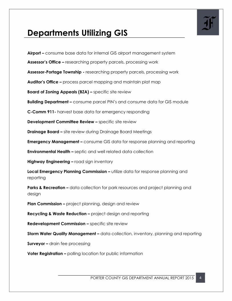
Departments Utilizing GIS
Airport – consume base data for internal GIS airport management system
Assessor’s Office – researching property parcels, processing work
Assessor-Portage Township - researching property parcels, processing work
Auditor’s Office – process parcel mapping and maintain plat map
Board of Zoning Appeals (BZA) – specific site review
Building Department – consume parcel PIN’s and consume data for GIS module
C-Comm 911- harvest base data for emergency responding
Development Committee Review – specific site review
Drainage Board – site review during Drainage Board Meetings
Emergency Management – consume GIS data for response planning and reporting
Environmental Health – septic and well related data collection
Highway Engineering – road sign inventory
Local Emergency Planning Commission – utilize data for response planning and
reporting
Parks & Recreation – data collection for park resources and project planning and
design
Plan Commission – project planning, design and review
Recycling & Waste Reduction – project design and reporting
Redevelopment Commission – specific site review
Storm Water Quality Management – data collection, inventory, planning and reporting
Surveyor – drain fee processing
Voter Registration – polling location for public information
PORTER COUNTY GIS DEPARTMENT ANNUAL REPORT 2015 5
F
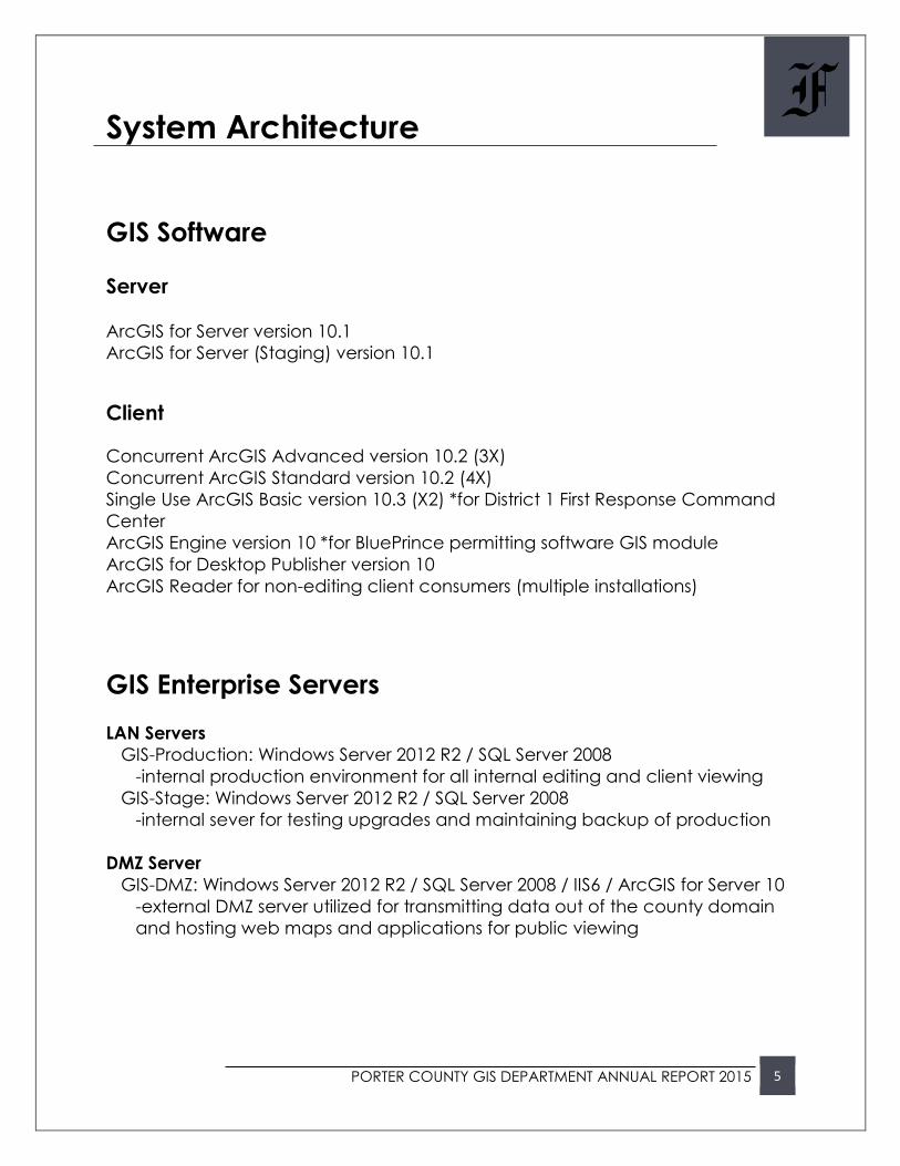
System Architecture
GIS Software
Server
ArcGIS for Server version 10.1 ArcGIS for Server (Staging) version 10.1
Client
Concurrent ArcGIS Advanced version 10.2 (3X)
Concurrent ArcGIS Standard version 10.2 (4X)
Single Use ArcGIS Basic version 10.3 (X2) *for District 1 First Response Command
Center
ArcGIS Engine version 10 *for BluePrince permitting software GIS module
ArcGIS for Desktop Publisher version 10
ArcGIS Reader for non-editing client consumers (multiple installations)
GIS Enterprise Servers
LAN Servers
GIS-Production: Windows Server 2012 R2 / SQL Server 2008
-internal production environment for all internal editing and client viewing
GIS-Stage: Windows Server 2012 R2 / SQL Server 2008
-internal sever for testing upgrades and maintaining backup of production
DMZ Server
GIS-DMZ: Windows Server 2012 R2 / SQL Server 2008 / IIS6 / ArcGIS for Server 10
-external DMZ server utilized for transmitting data out of the county domain
and hosting web maps and applications for public viewing

PORTER COUNTY GIS DEPARTMENT ANNUAL REPORT 2015 6
F
GIS System Diagram
WEB SERVER
-public facing Porter County
Web Server
GIS-DMZ1
GIS - DMZ
-server set up in the DMZ
for public facing service
data
GIS-SERVER1
GIS - Production
-server set up in the LAN
for production
GIS-SERVER2
GIS - Staging
-server set up in the LAN
for staging and testing
CLIENT MACHINES
-intranet Porter County GIS
viewers and data editors
*utilizing IIS 6.0
PUBLIC
DMZ
LAN
ArcGIS Catalog 10.3.1

PORTER COUNTY GIS DEPARTMENT ANNUAL REPORT 2015 7
F
Organization Membership and Involvement
Porter County Storm Water Advisory Committee (Analysis and
Reporting)
Porter County Drainage Board (GIS Mapping for meeting
reference)
NWI Indiana GIS Users Forum (member)
District One First Responders GIS Taskforce (member)
IGIC – Indiana Geographic Information Council (member)
URISA – Urban and Region Information Systems Association
o GISP – Geographic Information System Professional
(accredited)
NISWAG – Northwest Indiana Storm Water Advisory Group (GIS
Representative)
DNR Soil Report

Project Development
University of Vermont
- Urban Canopy Project
Coding Routines for Updating and
Backing Up GIS Data
District 1 First Responders GIS Taskforce
Local Government Information Model
- (LGIM)
D
2015 Porter County GIS Department Annual Report

PORTER COUNTY GIS DEPARTMENT ANNUAL REPORT 2015 8
D
University of Vermont – Urban Canopy Project
The University of Vermont’s Spatial Analyst Lab (SAL) began a nationwide project in
2015 to analyze the Urban Tree Canopy of select metropolitan areas in the United
States. The State of Indiana 2013 aerial imagery and LiDAR project was being utilized to
render higher level GIS based data layers for further analysis of urban tree cover and its
environmental impact. As part of this project the SAL was offering unrefined base
ground cover data to communities within the scope of the project with additional,
refined data, buy ups available at the cost of production. Porter County GIS worked
with the University of Vermont’s SAL to have some of this optional buy-up data
developed. This in the end has rendered multiple valuable data layers for Porter
County at a highly discounted rate saving the county over $100,000 under the cost from
commercial developers.
Python Code for Updating and Backing up GIS Data
A project was undertaken this year to write a series of python routines for the
automation of several tedious and repetitive GIS System maintenance tasks. The first
part of the project was to replace manual weekly updates of Porter County’s GIS data
to the Assessor’s Office cloud based server network. The data is consumed here for the
Assessor’s Pictometry Assessment software. After leaving the county’s IT network the
problem was realized that they no longer had access to much needed GIS data
updates. At first an application was manually launched to upload data to this cloud
server environment. This data was uploaded from outside the county’s domain DMZ
and so also necessitated the upload of data first from the county production servers to
the DMZ server. A series of python code was scripted to fist produce GIS data including
parcel data with inherent ownership related information and package that data within
the production server environment. Another series of python code and SQL Server
maintenance routines then move copies of the data to the DMZ environment where a
scheduled task initiates the Pictometry data loader application to weekly update the
Assessor’s copy of county GIS data. This code and SQL routines were also utilized to
simultaneously create backups of GIS data for added security and data integrity.

PORTER COUNTY GIS DEPARTMENT ANNUAL REPORT 2015 9
D
District 1 First Responders GIS Taskforce
Having it’s beginning rooted as early as 2010 local GIS professionals in northwest Indiana
have worked diligently to form a taskforce to add GIS technology to the State of
Indiana’s District One First Responders. Seeing a need early on some emergency
response personnel approached local GIS professionals to see if it was possible to form
a group to develop maps and utilities to aid in emergency and disaster response. It
had been noticed for some time that there was a serious lack of logistic mapping
available to responders when they were most needed. Being one of the frontrunners in
the state for this relatively new concept the group came together in monthly meetings
including emergency response personnel to do a needs assessment and begin the task
of creating a new facet to the District 1 First Response team. The GIS Taskforce began
planning a method for harvesting GIS data from across the state, building a list of
locally available GIS contacts in every district and compiling a state spanning intelligent
map. Working with responders, emergency personnel and FEMA the team has made
great strides toward forming an invaluable geographic resource for emergency
response personnel.
LGIM – Local Government Information Model
The Local Government Information Model was developed and embraced, by ESRI, as
the organizational answer to normalizing small (local level) government GIS data into
one consistent streamlined Geodatabase. The GIS Department made a decision in
2015 to start adopting this data infrastructure for Porter County. Noticing the use for
easy web app development and data standardization for data sharing and website
deployment the need to adopt this database structuring was clear. Two pilot projects
launching from this data restructuring will be Voters Registration Polling Location online
map services and Storm Water project and Zoning Maps for the Porter County
Development Department. The GIS Department will continue to migrate the data in
our existing Geodatabases into the LGIM in the coming year.

PORTER COUNTY GIS DEPARTMENT ANNUAL REPORT 2015 10
D
Significant Mention and Ongoing County GIS Projects
Highway Department Road Sign Inventory
Land Analysis for Proposed CAFO
Storm Water Fee Parcel Identification and Analysis Reports
US Census Local Government Annexation Annual Report
Porter County Development Department Annual Report
Developing Protocol and Process for District 1 First Responder GIS Taskforce
Mapping of Voters Polling Location and Council District Mapping
Land Analysis for Boone Grove Compost Site
Training HAZMAT and EMA Personnel in ESRI ArcGIS Desktop
Developing HAZMAT Planning and Response Geodatabase and Map
Smart 911 Park Property Emergency Personal Location Sign Mapping
TIF District Updating, Locating and Analysis for Porter County Auditor
2013 Land Cover

Planned Projects
Data Migration to LGIM –
Local Government Information Model
Public Information Web Application
Porter County Plan Commission
Zoning District Map
P
2015 Porter County GIS Department Annual Report

PORTER COUNTY GIS DEPARTMENT ANNUAL REPORT 2015 11
P
Data Migration to LGIM – Local Government Information Model
All Porter County Government GIS geodatabase data will be migrated to ESRI’s LGIM.
Once this data set is complete and configured, python scripted backup and data
transfer routines will be coded to update the LGIM geodatabase with current and
updated GIS data from the production environment. The LGIM database will be
replicated to all Porter County GIS databases via SQL Server backup routines.
Public Information Web Applications
Research and development is being planned for the launching of vital public
information web applications maps for Porter County residents. After data is migrated
to the Local Government Information Model this new geodatabase will be utilized to
host parcel-centric web applications displaying pertinent and vital information
available to citizens through a cloud based web portal.
Porter County Plan Commission Zoning District Map
The Zoning District map for Porter County will need to be updated and corrected to
accurately representing current zoning. A maintenance workflow will be designed and,
if needed, employees will be trained in basic editing in the ESRI ArcGIS Desktop
application environment. After revision and acceptance by the Porter County Planning
Director this data layer will be used to develop a publicly accessible Porter County
Zoning Districts web application.
Plan Commission Zoning Districts