2014 Study Plan for the Lower Auglaize River · PDF file2014 Study Plan for the Lower Auglaize...
20
2014 Study Plan for the Lower Auglaize River Tributaries Defiance, Mercer, Paulding, Putnam, and Van Wert Counties, Ohio Division of Surface Water Ecological Assessment Section April 11, 2014
Transcript of 2014 Study Plan for the Lower Auglaize River · PDF file2014 Study Plan for the Lower Auglaize...

2014 Study Plan for the Lower Auglaize River Tributaries
Defiance, Mercer, Paulding, Putnam, and Van Wert
Counties, Ohio
Division of Surface Water
Ecological Assessment Section
April 11, 2014
Lower Auglaize River Tributaries Study Plan, 2014
1
2014 Study Plan for the Lower Auglaize River Tributaries
(Mercer, Paulding, Putnam, and Van Wert counties, OH)
State of Ohio Environmental Protection Agency
Division of Surface Water
Lazarus Government Center
122 South Front St., Columbus, OH 43215
Mail to:
P.O. Box 1049, Columbus, OH 43216-1049
&
Monitoring and Assessment Section
4675 Homer Ohio Lane
Groveport, OH 43125
&
Surface Water Section
Northwest District Office
347 N. Dunbridge Road
Bowling Green, Ohio 43402
April 11, 2014

Lower Auglaize River Tributaries Study Plan, 2014
2
Introduction
As part of the Total Maximum Daily Load (TMDL) process and in support of the basin approach for National Pollution Discharge Elimination System (NPDES) permitting, an intensive ambient assessment will be conducted during the 2014 field sampling season within the lower Auglaize River tributaries (Figure 1). The study area is composed of all or portions of 25 HUC12 watershed assessment units. A total of 73 sampling stations will be completed in the lower Auglaize River tributary study area. Ambient biology, macrohabitat quality, water column chemistry, and bacteriological data will be collected concurrently from most of these sites. Diel water quality (DO, pH, conductivity, and temperature), sediment chemistry (metals, organics, and particle size), nutrients, and fish tissue will be evaluated at selected sampling locations Table 3.
Sampling Objectives
1 Systematically sample and assess the principal drainage networks of the lower
Auglaize River tributaries in support of the TMDL process,
2 Gather ambient environmental information (biological, chemical, and physical) from
designated water bodies, to assess current beneficial uses (e.g., aquatic life,
recreational, water supply), Table 3,
3 Collect fish tissue samples at selected stations as listed under sample types in Table 3,
4 Verify the appropriateness of existing, unverified, beneficial use designations,
5 Establish baseline ambient biological conditions at selected reference stations to
evaluate the effectiveness of future pollution abatement efforts, and
6 Document any changes in biological, chemical, and physical conditions of the study
areas where historical information exists, thus expanding the Ohio EPA data base for
statewide trends analysis (e.g., 305[b]).
Total Maximum Daily Load Information collected as part of this survey will support TMDL development for this study area. The objectives of the TMDL process are to estimate pollutant loads from the various sources within the basin, define or characterize allowable loads to support the various beneficial uses, and to allocate pollutant loads among different pollutant sources through appropriate controls (e.g., NPDES permitting (Table 1), Ohio Department of Agriculture (ODA) permitting (Table 2), storm water management, 319 proposals, NPS controls or other abatement strategies). The components of the TMDL process supported by this survey are primarily the identification of impaired waters, verification (and redesignating if necessary) of beneficial use designations, and sources of use impairment. These data are necessary precursors to the development of effective control or abatement strategies.

Lower Auglaize River Tributaries Study Plan, 2014
3
Aquatic Life Use Designations Many of the streams contained within the study area are designated MWH (Modified Warmwater Habitat). For some of the streams, this will be the first time that they will be sampled and assessed. The Ohio EPA is obligated to review, evaluate, or recommend (where appropriate) beneficial uses prior to basing any permitting actions on existing, unverified designations, or entirely unclassified water bodies. Much of the sampling effort for this survey is allocated to fulfill this obligation. SAMPLING ACTIVITIES Chemical/Physical Water and Sediment Chemical sampling locations within the study area are listed in Table 3. Conventional chemical/physical water quality samples will be collected 5 times at each designated location. Sediment samples will be collected at seven locations. Datasondes® will be deployed at 16 locations. Chemical parameters to be tested are listed in Table 4. Surface water sampling will occur across a variety of flow conditions, from lower flows to moderate and higher flows. Bacteriological Sampling Water samples will be collected at nine chemistry sites for bacteriological analyses to determine the attainment status of the Primary Contact recreational use of the streams within the study area. Testing will include Escherichia coli (E. coli) bacteria. Each site will be sampled at least 5 times, while sentinel sites may have 5-10 bacteriological samples. Chlorophyll Benthic chlorophyll a samples are to be collected at designated wadeable and headwater sites noted in Table 3. Benthic chlorophyll samples are to be collected at least once, and should be timed to coincide with deployment of Datasonde® automated data loggers during stable, baseflow conditions (i.e., typically the second deployment). Macroinvertebrate and Fish Assemblages Macroinvertebrate sampling methods will be used as listed in Table 3. Fish assemblages will be sampled as listed in Table 3. Qualitative Habitat Evaluation Index (QHEI) scores will be calculated on the habitat at all fish sampling locations. Fish Tissue Fish tissue samples will be collected from two locations as part of the Ohio Fish Tissue Consumption Monitoring Program. Fillet samples of edible size sport fish will be tested for organochlorinated pesticides, PCBs, mercury, lead, cadmium, arsenic, and selenium. Results will be used in the Ohio Sport Fish Consumption Advisory Program. QUALITY ASSURANCE/SAMPLING METHODS Ohio EPA Manuals All biological, chemical, data processing, and data analysis methods and procedures adhere to those specified in the Surface Water Field Sampling Manual for water column chemistry, bacteria and flows (Ohio EPA 2013a), Biological Criteria for the Protection of Aquatic Life, Volumes II - III (Ohio EPA 1987, 1989a, 1989b, 2014b, 2014c), and The Qualitative Habitat Evaluation Index (QHEI); Rationale, Methods, and Application (Ohio EPA 1989c, 2006) for habitat
Lower Auglaize River Tributaries Study Plan, 2014
4
assessment, Ohio EPA Sediment Sampling Guide and Methodologies (Ohio EPA 2012a), and Ohio EPA Fish Tissue Collection Guidance Manual (Ohio EPA 2012b). Use Attainment Attainment/non-attainment of aquatic life uses will be determined by using biological criteria codified in Ohio Administrative Code (OAC) 3745-1-07, Table 7-17. Numerical biological criteria are based on multimetric biological indices including the Index of Biotic Integrity (IBI) and modified Index of Well-Being (MIwb), indices measuring the response of the fish community, and the Invertebrate Community Index (ICI), which indicates the response of the macroinvertebrate community. Performance expectations for the basic aquatic life uses (Warmwater Habitat [WWH], Exceptional Warmwater Habitat [EWH], and Modified Warmwater Habitat [MWH]) were developed using the regional reference site approach (Hughes et al. 1986; Omernik 1987). This fits the practical definition of biological integrity as the biological performance of the natural habitats within a region (Karr and Dudley 1981). Attainment of an aquatic life use is FULL if all three indices (or those available) meet the applicable criteria, PARTIAL if at least one of the indices did not attain and performance did not fall below the fair category, and NON if all indices either fail to attain or any index indicates poor or very poor performance. The results will be compared to WWH biocriteria for the Western Allegheny Plateau (WAP) ecoregion. Recreational use attainment will be determined using fecal coliform bacteria and E. coli bacteria. Both types of organisms are indicator organisms for the potential presence of pathogens in surface water resulting from the presence of untreated human or animal wastes, and they are the basis for recreational use water quality criteria in Rule 3745-1-07 of the (OAC). Stream Habitat Evaluation Physical habitat is evaluated using the (QHEI) developed by the Ohio EPA for streams and rivers in Ohio (Rankin 1989). Various attributes of the available habitat are scored based on their overall importance to the establishment of viable, diverse aquatic faunas. Evaluations of type and quality of substrate, amount of instream cover, channel morphology, extent of riparian canopy, pool and riffle development and quality, and stream gradient are among the metrics used to evaluate the characteristics of a stream segment, not just the characteristics of a single sampling site. As such, individual sites may have much poorer physical habitat due to a localized disturbance yet still support aquatic communities closely resembling those sampled at adjacent sites with better habitat, provided water quality conditions are similar. QHEI scores from hundreds of segments around the state have indicated that values higher than 60 were generally conducive to the establishment of warmwater faunas while those which scored in excess of 75-80 often typify habitat conditions which have the ability to support exceptional faunas. Biological Community Assessment Macroinvertebrates will be collected from artificial substrates and/or natural stream habitats. Artificial substrate collections will be collected at all sites with greater than 20 mi2 drainage areas or at reference site locations. This sample provides quantitative data and consists of a composite sample of five modified Hester-Dendy multiple-plate artificial substrate samplers colonized for six weeks. Qualitative sampling will be conducted at all sampling locations. This sampling effort consists of an inventory of all observed macroinvertebrate taxa from the natural stream habitats at each site with no attempt to quantify populations other than notations on

Lower Auglaize River Tributaries Study Plan, 2014
5
the predominance of specific taxa or taxa groups within major macrohabitat types (e.g., riffle, run, pool, and margin). Detailed macroinvertebrate assemblage sampling protocols are documented in Biological Criteria for the Protection of Aquatic Life, Volume III (1989b, 2014c). Fish will be sampled at each sampling location using pulsed DC headwater, wading, or boat electrofishing methods depending on watershed size at each sampling zone. Sites with drainage areas greater than 20 mi2 or at reference site locations will be sampled twice during the sampling index period. Fish are processed in the field which includes identifying each individual to species, counting individuals at all sites, weighing individuals at wading and boat sites, and recording any external abnormalities. Detailed fish assemblage sampling protocols are documented in Biological Criteria for the Protection of Aquatic Life, Volume III (1989b, 2014c). Sediment Fine grained multi-incremental sediment samples will be collected in the upper 4 inches of bottom material using either decontaminated stainless steel scoops or Ekman dredges. Collected sediment will be placed into appropriate containers, placed on ice (to maintain 4oC) and shipped to the Ohio EPA Division of Environmental Services (DES) lab. Sampling and decontamination protocols will follow those listed in the Ohio EPA Sediment Sampling Guide and Methodologies (2012a). Chlorophyll Benthic chlorophyll a samples will be collected and preserved using appropriate methods, as outlined in Appendix II of Surface Water Field Sampling Manual for water column chemistry, bacteria and flows (Ohio EPA 2013a) and delivered to the Ohio EPA DES lab for analyses. Alkalinity must be requested as a routine water quality parameter at all study sites along with the routine field parameters, especially temperature and pH. Surface Water Surface water grab samples will be collected and preserved using appropriate methods, as outlined in Surface Water Field Sampling Manual for water column chemistry, bacteria and flows (Ohio EPA 2013a) and delivered to the Ohio EPA Division of Environmental Services lab for analyses. Field measurements of dissolved oxygen, pH, temperature, and conductivity will be made using YSI 556MPS meters along with all grab samples for surface water chemistry. Datasonde® continuous recorders will be placed at select locations to evaluate diel measurements of dissolved oxygen, pH, temperature, and conductivity. Bacteria Water samples will be collected into appropriate containers, cooled to 4°C, and transported to the Ohio EPA DES laboratory within 6 hours of sample collection. All samples will be analyzed for E. coli bacteria using U.S.EPA approved methods (STORET Parameter Code 31648). Fish Tissue Tissue fillet samples will be collected from fish of edible size, and species preferred for analysis may include spotted bass, largemouth bass, smallmouth bass, flathead catfish, walleye, saugeye, white bass, common carp, freshwater drum, and channel catfish. When possible, composite samples (by species) will be collected using a minimum of three fish and a minimum of 150 grams of material. At each sampling location, an attempt will be made to collect five fish species for fillet tissue analysis. Fish will be sampled using electrofishing boat methods at the

Lower Auglaize River Tributaries Study Plan, 2014
6
reservoir and wading method at the remainder sites. Sampling locations are listed in Table 2. Fish used for tissue analysis will be filleted in the field using decontaminated stainless steel fillet knives. Filleted samples will be wrapped in aluminum foil, placed in a sealed plastic bag, and placed on dry ice. Sampling and decontamination protocols will follow those listed in the Ohio EPA Fish Collection Guidance Manual (2012b). Fish tissue samples will be stored in chest freezers at the Ohio EPA Groveport Field Facility prior to delivery to DES. Field Quality Control Samples Ten percent of the sediment, water, and bacteria samples will be submitted to the lab as field duplicates. One Datasonde® recorder site will have two instruments placed in the river as field duplicates. Field blanks will occur at a minimum of 5 percent of the water samples. Field instruments will be calibrated daily, using manufacturer guidelines and requirements noted in the Manual of Ohio EPA Surveillance Methods and Quality Assurance Practices (Ohio EPA 2013a). Matrix spike duplicates will be collected for organic water samples at a minimum of 5 percent.
Lower Auglaize River Tributaries Study Plan, 2014
7
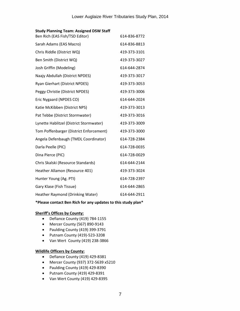
Study Planning Team: Assigned DSW Staff Ben Rich (EAS Fish/TSD Editor) 614-836-8772
Sarah Adams (EAS Macro) 614-836-8813
Chris Riddle (District WQ) 419-373-3101
Ben Smith (District WQ) 419-373-3027
Josh Griffin (Modeling) 614-644-2874
Naajy Abdullah (District NPDES) 419-373-3017
Ryan Gierhart (District NPDES) 419-373-3053
Peggy Christie (District NPDES) 419-373-3006
Eric Nygaard (NPDES CO) 614-644-2024
Katie McKibben (District NPS) 419-373-3013
Pat Tebbe (District Stormwater) 419-373-3016
Lynette Hablitzel (District Stormwater) 419-373-3009
Tom Poffenbarger (District Enforcement) 419-373-3000
Angela Defenbaugh (TMDL Coordinator) 614-728-2384
Darla Peelle (PIC) 614-728-0035
Dina Pierce (PIC) 614-728-0029
Chris Skalski (Resource Standards) 614-644-2144
Heather Allamon (Resource 401) 419-373-3024
Hunter Young (Ag. PTI) 614-728-2397
Gary Klase (Fish Tissue) 614-644-2865
Heather Raymond (Drinking Water) 614-644-2911
*Please contact Ben Rich for any updates to this study plan*
Sheriff’s Offices by County:
Defiance County (419) 784-1155
Mercer County (567) 890-9143
Paulding County (419) 399-3791
Putnam County (419)-523-3208
Van Wert County (419) 238-3866 Wildlife Officers by County:
Defiance County (419) 429-8381
Mercer County (937) 372-5639 x5210
Paulding County (419) 429-8390
Putnam County (419) 429-8391
Van Wert County (419) 429-8395
Lower Auglaize River Tributaries Study Plan, 2014
8
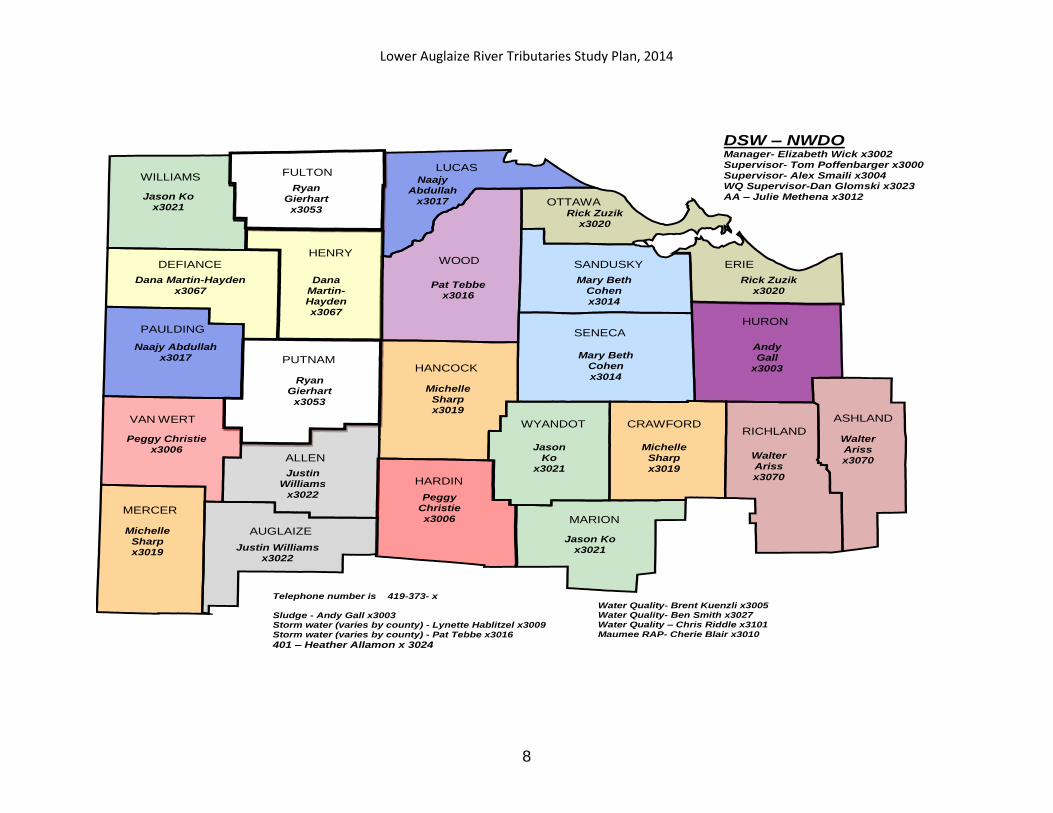
WOOD
HURON SENECA
ALLEN
HARDIN
HENRY
PUTNAM
MERCER
ERIE
HANCOCK
LUCAS FULTON
MARION
RICHLAND
ASHLAND
WILLIAMS
PAULDING
DEFIANCE
AUGLAIZE
VAN WERT
SANDUSKY
CRAWFORD
OTTAWA
WYANDOT
Jason Ko x3021
Dana Martin-Hayden
x3067
Naajy Abdullah x3017
Peggy Christie x3006
Michelle Sharp x3019
Ryan Gierhart x3053
Dana Martin-Hayden x3067
Ryan Gierhart x3053
Justin Williams
x3022
Justin Williams x3022
Naajy Abdullah
x3017
Pat Tebbe x3016
Michelle Sharp x3019
Peggy Christie x3006
Rick Zuzik x3020
Mary Beth Cohen x3014
Mary Beth Cohen x3014
Jason Ko
x3021
Jason Ko x3021
Michelle Sharp x3019
Walter Ariss x3070
Walter Ariss x3070
Andy Gall
x3003
Rick Zuzik x3020
Telephone number is 419-373- x Sludge - Andy Gall x3003 Storm water (varies by county) - Lynette Hablitzel x3009 Storm water (varies by county) - Pat Tebbe x3016
401 – Heather Allamon x 3024
Water Quality- Brent Kuenzli x3005 Water Quality- Ben Smith x3027 Water Quality – Chris Riddle x3101 Maumee RAP- Cherie Blair x3010
DSW – NWDO Manager- Elizabeth Wick x3002 Supervisor- Tom Poffenbarger x3000 Supervisor- Alex Smaili x3004 WQ Supervisor-Dan Glomski x3023 AA – Julie Methena x3012
Lower Auglaize River Tributaries Study Plan, 2014
9
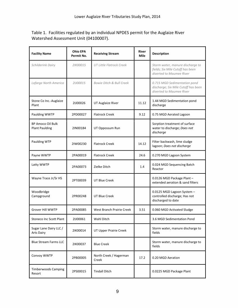
Table 1. Facilities regulated by an individual NPDES permit for the Auglaize River Watershed Assessment Unit (04100007).
Facility Name Ohio EPA
Permit No. Receiving Stream
River Mile
Description
Schilderink Dairy 2IK00015 UT Little Flatrock Creek
Storm water, manure discharge to fields; Six Mile Cutoff has been diverted to Maumee River
Lafarge North America 2IJ00015 Bowie Ditch & Bull Creek
0.715 MGD Sedimentation pond discharge; Six Mile Cutoff has been diverted to Maumee River
Stone Co Inc.-Auglaize Plant
2IJ00026 UT Auglaize River 11.12 1.44 MGD Sedimentation pond discharge
Paulding WWTP 2PD00027 Flatrock Creek 9.12 0.75 MGD Aerated Lagoon
BP Amoco Oil Bulk Plant Paulding 2IN00184 UT Oppossum Run
Sorption treatment of surface water to discharge; Does not discharge
Paulding WTP 2IW00230 Flatrock Creek 14.12
Filter backwash, lime sludge lagoon; Does not discharge
Payne WWTP 2PA00019 Flatrock Creek 24.6 0.270 MGD Lagoon System
Latty WWTP 2PA00073 Zielke Ditch 1.4
0.024 MGD Sequencing Batch Reactor
Wayne Trace Jr/Sr HS 2PT00039 UT Blue Creek
0.0126 MGD Package Plant – extended aeration & sand filters
Woodbridge Campground 2PR00248 UT Blue Creek
0.0125 MGD Lagoon System – controlled discharge; Has not discharged to date
Grover Hill WWTP 2PA00085 West Branch Prairie Creek 3.51 0.060 MGD Activated Sludge
Stoneco Inc Scott Plant 2IJ00061 Wahl Ditch 3.6 MGD Sedimentation Pond
Sugar Lane Dairy LLC / Arts Dairy
2IK00014 UT Upper Prairie Creek Storm water, manure discharge to fields
Blue Stream Farms LLC 2IK00037 Blue Creek
Storm water, manure discharge to fields
Convoy WWTP 2PB00005
North Creek / Hagerman Creek
17.2 0.20 MGD Aeration
Timberwoods Camping Resort
2PS00015 Tindall Ditch 0.0225 MGD Package Plant

Lower Auglaize River Tributaries Study Plan, 2014
10
Facility Name Ohio EPA
Permit No. Receiving Stream
River Mile
Description
Boyd Theaters 2PR00213 Maddox Creek ~14.7
0.002 MGD Package Plant to leaching tile field
Hickory Sticks Golf Club
2PR00270 Town Creek 20.34 0.003 MGDPackage Plant
Van Wert WTP 2IZ00131 Town Creek 18.35 Lime Sludge Lagoon
Federal Mogul Corp 2IR00025 Town Creek 15.22 Noncontact cooling water
Van Wert WWTP 2PD00006 Town Creek 13.87 4.0 MGD Aeration
Cooper Farms Cooked Meats
2IH00110 Town Creek 12.12 Lagoon – controlled discharge, spray irrigation
Huggy Bear Campground
2PS00014 Dog Creek 17.95 Lagoon – controlled discharge
Middle Point WWTP 2PA00022 Little Auglaize River 36.3 0.080 MGD Bio-Lac
Delphos Country Club 2PR00157 Little Auglaize River 26.4
0.003 MGD Package Plant – sand filtration
Ottoville WWTP 2PA00002 UT Little Auglaize River 0.35 0.339 MGD Extended Aeration
Country Manor Estates 2PY00043 Utrup Ditch 2,450 GPD Package Plant
Ohio Electro Polishing Co Inc
2IC00024 Evans Ditch 0.030 MGD pH adjustment and settling
Ohio City Auto Salvage 2II00105 Long Prairie Creek 7.98
Oil / water separator for storm water
Ohio City WWTP 2PB00030 Long Prairie Creek 7.95 0.150 MGD Oxidation Ditch
Gina Dairy 2IK00017 Roller Creek / Town Creek
Storm water, manure discharge to fields
ODOT Park 1-27 2PP00035 Monkey Run 1.3 0.004 MGD Package Plant
Defiance County Landfill
2IN00111 Three Mile Creek 0.7 Sedimentation pond discharge
Lower Auglaize River Tributaries Study Plan, 2014
11
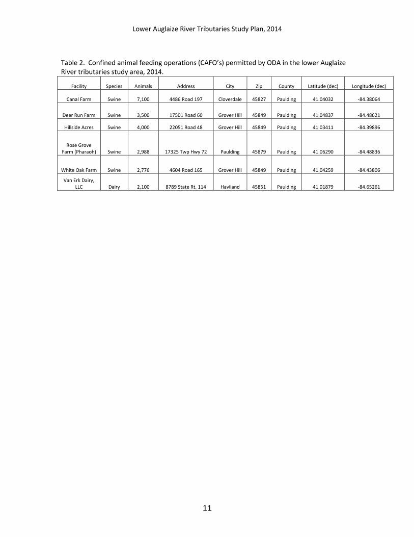
Table 2. Confined animal feeding operations (CAFO’s) permitted by ODA in the lower Auglaize River tributaries study area, 2014.
Facility Species Animals Address City Zip County Latitude (dec) Longitude (dec)
Canal Farm Swine 7,100 4486 Road 197 Cloverdale 45827 Paulding 41.04032 -84.38064
Deer Run Farm Swine 3,500 17501 Road 60 Grover Hill 45849 Paulding 41.04837 -84.48621
Hillside Acres Swine 4,000 22051 Road 48 Grover Hill 45849 Paulding 41.03411 -84.39896
Rose Grove Farm (Pharaoh) Swine 2,988 17325 Twp Hwy 72 Paulding 45879 Paulding 41.06290 -84.48836
White Oak Farm Swine 2,776 4604 Road 165 Grover Hill 45849 Paulding 41.04259 -84.43806
Van Erk Dairy, LLC Dairy 2,100 8789 State Rt. 114 Haviland 45851 Paulding 41.01879 -84.65261

Lower Auglaize River Tributaries Study Plan, 2014
12
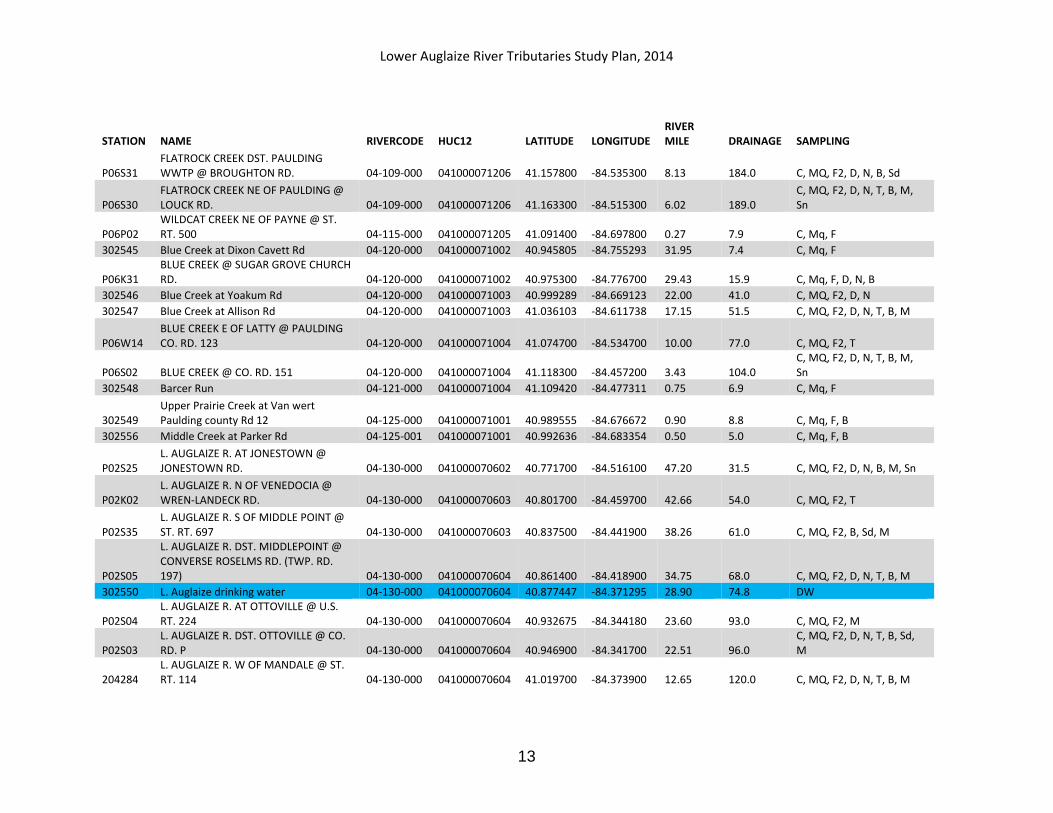
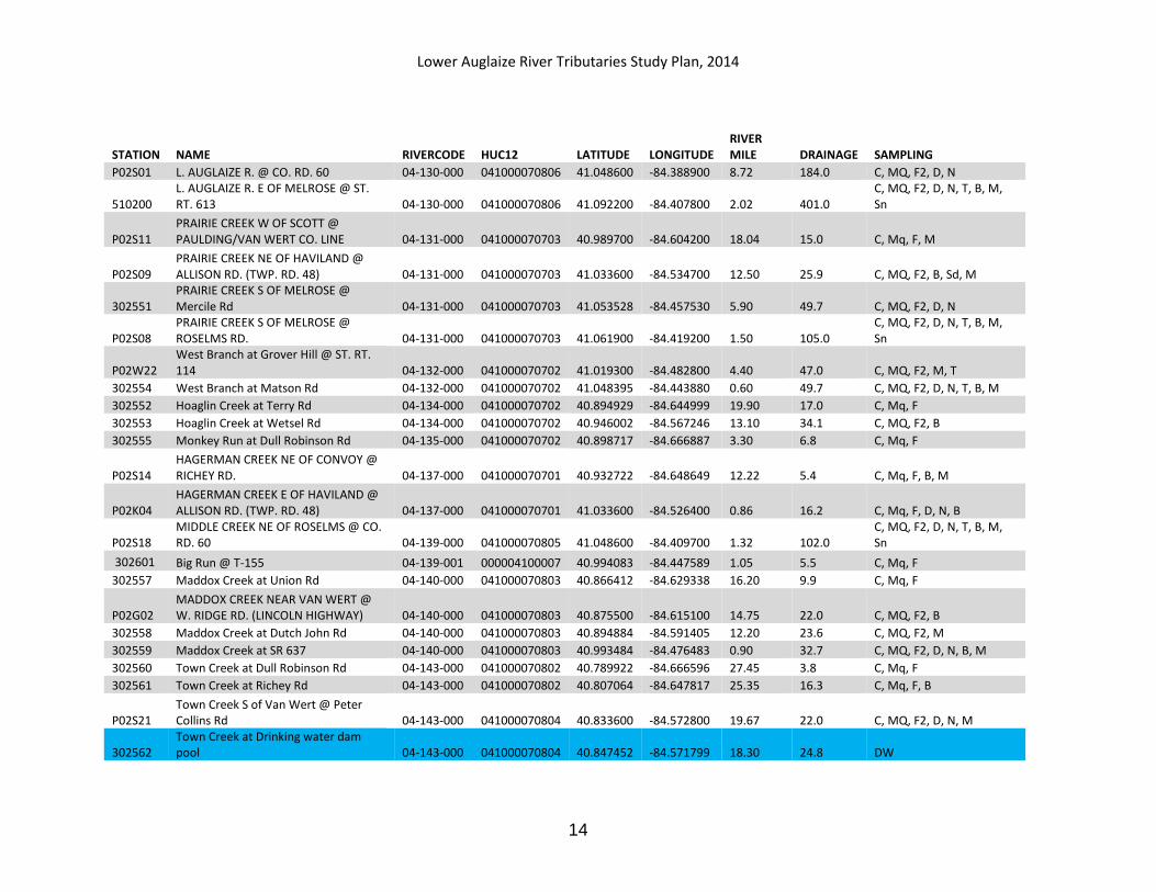
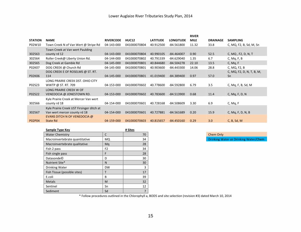
Table 3. Lower Auglaize River tributary sampling stations, 2014.
STATION NAME RIVERCODE HUC12 LATITUDE LONGITUDE RIVER MILE DRAINAGE SAMPLING
500130 AUGLAIZE R. AT OAKWOOD @ ST. RT. 613 04-100-000 041000070907 41.092200 -84.381900 19.30 1509.0 C, D, M, Sn
P06S10 AUGLAIZE R. AT CHARLOE @ CO. RD. 138 04-100-000 041000071005 41.128600 -84.431900 14.94 2041.0 C, M
P06P16 AUGLAIZE R. NEAR JUNCTION @ REST AREA AT JCT SR 111/SR 66 04-100-000 041000071209 41.195800 -84.447800 9.73 2276.0 C, M
500290 AUGLAIZE R. UPST. DEFIANCE @ HARDING RD. 04-100-000 041000071209 41.253800 -84.389600 4.14 2330.0 C, D, B, M, Sn
302568 Bobenmyer Ditch at Stouffer Rd (Trib to Auglaize at RM 13.17) 04-100-016 041000071005 41.145349 -84.419016 0.70 6.1 C, Mq, F, B
302569 Snyder Ditch at Stouffer Rd (Trib to Auglaize at RM 13.98) 04-100-017 041000071005 41.156567 -84.418686 0.30 5.2 C, Mq, F, B
302539 Fivemile Creek at Defiance-Paulding County Line Rd 04-104-000 041000071209 41.226030 -84.456979 1.70 2.9 B
P06K28 EAGLE CREEK WNW OF JUNCTION @ RIVER RD. (UPPER CROSSING) 04-105-000 041000071209 41.196872 -84.438001 1.57 3.7 B
302540 Sixmile Creek at Burns Rd 04-106-000 041000071208 41.211075 -84.534308 6.70 3.0 C
302541 Sixmile Cr at Dotterer Rd 04-106-000 041000071208 41.207989 -84.495558 3.90 12.0 C, Mq, F, D, N, B
302542 L. Flatrock Creek at Broughton Rd 04-108-000 041000071207 41.182573 -84.534148 5.90 7.6 C, Mq, F
302543 L. Flatrock Creek at Old State Route 111 04-108-000 041000071207 41.190327 -84.466439 1.50 17.8 C, Mq, F, D, N, B
302600 FLATROCK CREEK @ Kings Church Rd 04-109-000 000004100007 40.889638 -84.783840 51.7 6.3 C, Mq, F
302544 FLATROCK CREEK @ Werner Rd 04-109-000 041000071201 40.914667 -84.788954 48.30 13.4 C, Mq, F, B
P06S37 FLATROCK CREEK UPST. PAYNE WWTP @ PUGH RD. 04-109-000 041000071205 41.056700 -84.746100 28.84 119.0 C, MQ, F2, D, N, T, B, M
P06S35 FLATROCK CREEK DST PAYNE WWTP @ ST. RT. 613 04-109-000 041000071205 41.091700 -84.693300 23.72 145.0 C, MQ, F2, D, N, B, M, Sn
500250 FLATROCK CREEK UPST. PAULDING @ CO. RD. 107 04-109-000 041000071206 41.125600 -84.592500 14.11 173.0 C, DW, B, M
P06S33 FLATROCK CREEK AT PAULDING, DST. DAM, Reservior Dr behind WTP 04-109-000 041000071206 41.127500 -84.587500 13.80 173.0 C, MQ, F2, D, N, T
P06S32 FLATROCK CREEK UPST. PAULDING WWTP LAGOONS 04-109-000 041000071206 41.156400 -84.554200 9.70 183.0 C, MQ, F2, M
Lower Auglaize River Tributaries Study Plan, 2014
13
STATION NAME RIVERCODE HUC12 LATITUDE LONGITUDE RIVER MILE DRAINAGE SAMPLING
P06S31 FLATROCK CREEK DST. PAULDING WWTP @ BROUGHTON RD. 04-109-000 041000071206 41.157800 -84.535300 8.13 184.0 C, MQ, F2, D, N, B, Sd
P06S30 FLATROCK CREEK NE OF PAULDING @ LOUCK RD. 04-109-000 041000071206 41.163300 -84.515300 6.02 189.0
C, MQ, F2, D, N, T, B, M, Sn
P06P02 WILDCAT CREEK NE OF PAYNE @ ST. RT. 500 04-115-000 041000071205 41.091400 -84.697800 0.27 7.9 C, Mq, F
302545 Blue Creek at Dixon Cavett Rd 04-120-000 041000071002 40.945805 -84.755293 31.95 7.4 C, Mq, F
P06K31 BLUE CREEK @ SUGAR GROVE CHURCH RD. 04-120-000 041000071002 40.975300 -84.776700 29.43 15.9 C, Mq, F, D, N, B
302546 Blue Creek at Yoakum Rd 04-120-000 041000071003 40.999289 -84.669123 22.00 41.0 C, MQ, F2, D, N
302547 Blue Creek at Allison Rd 04-120-000 041000071003 41.036103 -84.611738 17.15 51.5 C, MQ, F2, D, N, T, B, M
P06W14 BLUE CREEK E OF LATTY @ PAULDING CO. RD. 123 04-120-000 041000071004 41.074700 -84.534700 10.00 77.0 C, MQ, F2, T
P06S02 BLUE CREEK @ CO. RD. 151 04-120-000 041000071004 41.118300 -84.457200 3.43 104.0 C, MQ, F2, D, N, T, B, M, Sn
302548 Barcer Run 04-121-000 041000071004 41.109420 -84.477311 0.75 6.9 C, Mq, F
302549 Upper Prairie Creek at Van wert Paulding county Rd 12 04-125-000 041000071001 40.989555 -84.676672 0.90 8.8 C, Mq, F, B
302556 Middle Creek at Parker Rd 04-125-001 041000071001 40.992636 -84.683354 0.50 5.0 C, Mq, F, B
P02S25 L. AUGLAIZE R. AT JONESTOWN @ JONESTOWN RD. 04-130-000 041000070602 40.771700 -84.516100 47.20 31.5 C, MQ, F2, D, N, B, M, Sn
P02K02 L. AUGLAIZE R. N OF VENEDOCIA @ WREN-LANDECK RD. 04-130-000 041000070603 40.801700 -84.459700 42.66 54.0 C, MQ, F2, T
P02S35 L. AUGLAIZE R. S OF MIDDLE POINT @ ST. RT. 697 04-130-000 041000070603 40.837500 -84.441900 38.26 61.0 C, MQ, F2, B, Sd, M
P02S05
L. AUGLAIZE R. DST. MIDDLEPOINT @ CONVERSE ROSELMS RD. (TWP. RD. 197) 04-130-000 041000070604 40.861400 -84.418900 34.75 68.0 C, MQ, F2, D, N, T, B, M
302550 L. Auglaize drinking water 04-130-000 041000070604 40.877447 -84.371295 28.90 74.8 DW
P02S04 L. AUGLAIZE R. AT OTTOVILLE @ U.S. RT. 224 04-130-000 041000070604 40.932675 -84.344180 23.60 93.0 C, MQ, F2, M
P02S03 L. AUGLAIZE R. DST. OTTOVILLE @ CO. RD. P 04-130-000 041000070604 40.946900 -84.341700 22.51 96.0
C, MQ, F2, D, N, T, B, Sd, M
204284 L. AUGLAIZE R. W OF MANDALE @ ST. RT. 114 04-130-000 041000070604 41.019700 -84.373900 12.65 120.0 C, MQ, F2, D, N, T, B, M
Lower Auglaize River Tributaries Study Plan, 2014
14
STATION NAME RIVERCODE HUC12 LATITUDE LONGITUDE RIVER MILE DRAINAGE SAMPLING
P02S01 L. AUGLAIZE R. @ CO. RD. 60 04-130-000 041000070806 41.048600 -84.388900 8.72 184.0 C, MQ, F2, D, N
510200 L. AUGLAIZE R. E OF MELROSE @ ST. RT. 613 04-130-000 041000070806 41.092200 -84.407800 2.02 401.0
C, MQ, F2, D, N, T, B, M, Sn
P02S11 PRAIRIE CREEK W OF SCOTT @ PAULDING/VAN WERT CO. LINE 04-131-000 041000070703 40.989700 -84.604200 18.04 15.0 C, Mq, F, M
P02S09 PRAIRIE CREEK NE OF HAVILAND @ ALLISON RD. (TWP. RD. 48) 04-131-000 041000070703 41.033600 -84.534700 12.50 25.9 C, MQ, F2, B, Sd, M
302551 PRAIRIE CREEK S OF MELROSE @ Mercile Rd 04-131-000 041000070703 41.053528 -84.457530 5.90 49.7 C, MQ, F2, D, N
P02S08 PRAIRIE CREEK S OF MELROSE @ ROSELMS RD. 04-131-000 041000070703 41.061900 -84.419200 1.50 105.0
C, MQ, F2, D, N, T, B, M, Sn
P02W22 West Branch at Grover Hill @ ST. RT. 114 04-132-000 041000070702 41.019300 -84.482800 4.40 47.0 C, MQ, F2, M, T
302554 West Branch at Matson Rd 04-132-000 041000070702 41.048395 -84.443880 0.60 49.7 C, MQ, F2, D, N, T, B, M
302552 Hoaglin Creek at Terry Rd 04-134-000 041000070702 40.894929 -84.644999 19.90 17.0 C, Mq, F
302553 Hoaglin Creek at Wetsel Rd 04-134-000 041000070702 40.946002 -84.567246 13.10 34.1 C, MQ, F2, B
302555 Monkey Run at Dull Robinson Rd 04-135-000 041000070702 40.898717 -84.666887 3.30 6.8 C, Mq, F
P02S14 HAGERMAN CREEK NE OF CONVOY @ RICHEY RD. 04-137-000 041000070701 40.932722 -84.648649 12.22 5.4 C, Mq, F, B, M
P02K04 HAGERMAN CREEK E OF HAVILAND @ ALLISON RD. (TWP. RD. 48) 04-137-000 041000070701 41.033600 -84.526400 0.86 16.2 C, Mq, F, D, N, B
P02S18 MIDDLE CREEK NE OF ROSELMS @ CO. RD. 60 04-139-000 041000070805 41.048600 -84.409700 1.32 102.0
C, MQ, F2, D, N, T, B, M, Sn
302601 Big Run @ T-155 04-139-001 000004100007 40.994083 -84.447589 1.05 5.5 C, Mq, F
302557 Maddox Creek at Union Rd 04-140-000 041000070803 40.866412 -84.629338 16.20 9.9 C, Mq, F
P02G02 MADDOX CREEK NEAR VAN WERT @ W. RIDGE RD. (LINCOLN HIGHWAY) 04-140-000 041000070803 40.875500 -84.615100 14.75 22.0 C, MQ, F2, B
302558 Maddox Creek at Dutch John Rd 04-140-000 041000070803 40.894884 -84.591405 12.20 23.6 C, MQ, F2, M
302559 Maddox Creek at SR 637 04-140-000 041000070803 40.993484 -84.476483 0.90 32.7 C, MQ, F2, D, N, B, M
302560 Town Creek at Dull Robinson Rd 04-143-000 041000070802 40.789922 -84.666596 27.45 3.8 C, Mq, F
302561 Town Creek at Richey Rd 04-143-000 041000070802 40.807064 -84.647817 25.35 16.3 C, Mq, F, B
P02S21 Town Creek S of Van Wert @ Peter Collins Rd 04-143-000 041000070804 40.833600 -84.572800 19.67 22.0 C, MQ, F2, D, N, M
302562 Town Creek at Drinking water dam pool 04-143-000 041000070804 40.847452 -84.571799 18.30 24.8 DW
Lower Auglaize River Tributaries Study Plan, 2014
15
STATION NAME RIVERCODE HUC12 LATITUDE LONGITUDE RIVER MILE DRAINAGE SAMPLING
P02W10 Town Creek N of Van Wert @ Stripe Rd 04-143-000 041000070804 40.912500 -84.561800 11.32 33.8 C, MQ, F2, B, Sd, M, Sn
302563 Town Creek at Van wert Paulding county rd 12 04-143-000 041000070804 40.990105 -84.464007 0.90 52.5 C, MQ , F2, D, N, T
302564 Roller Creek@ Liberty Union Rd. 04-144-000 041000070802 40.791339 -84.629040 1.35 6.7 C, Mq, F, B
302565 Dog Creek at Gamble Rd 04-145-000 041000070801 40.844680 -84.504278 22.10 13.5 C, Mq, F
P02K07 DOG CREEK @ Church Rd 04-145-000 041000070801 40.903600 -84.443300 14.06 28.8 C, MQ, F2, B
P02K06 DOG CREEK E OF ROSELMS @ ST. RT. 114 04-145-000 041000070801 41.019400 -84.389400 0.97 57.0
C, MQ, F2, D, N, T, B, M, Sn
P02S23 LONG PRAIRIE CREEK DST. OHIO CITY WWTP @ ST. RT. 709 04-153-000 041000070602 40.778600 -84.592800 6.79 3.5 C, Mq, F, B, Sd, M
P02S22 LONG PRAIRIE CREEK W OF VENEDOCIA @ JONESTOWN RD. 04-153-000 041000070602 40.783600 -84.513900 0.68 11.4 C, Mq, F, D, N
302566 Kyle Prairie Creek at Mercer Van wert county rd 18 04-154-000 041000070601 40.728168 -84.508609 3.30 6.9 C, Mq, F
302567 Kyle Prairie Creek UST Firsinger ditch at Van wert mercer county rd 18 04-154-000 041000070601 40.727881 -84.561689 0.20 15.9 C, Mq, F, D, N, B
P02P04 EVANS DITCH N OF VENEDOCIA @ State Rd 04-159-000 041000070603 40.815657 -84.450160 0.29 3.0 C, B, Sd, M
Sample Type Key
# Sites
Water Chemistry C 70
Chem Only
Macroinvertebrate quantitative MQ 34
Drinking Water or Drinking Water/Chem
Macroinvertebrate qualitative Mq 28
Fish 2 pass F2 34
Fish single pass F 28
Datasonde© D 30
Nutrient Site* N 30
Drinking Water DW 3
Fish Tissue (possible sites) T 17
E.coli B 39
Metals M 32
Sentinel Sn 12
Sediment Sd 7
* Follow procedures outlined in the Chlorophyll a, BOD5 and site selection (revision #3) dated March 10, 2014
Lower Auglaize River Tributaries Study Plan, 2014
16
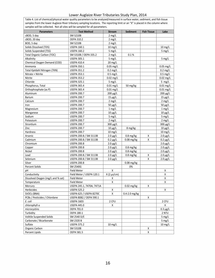
Table 4. List of chemical/physical water quality parameters to be analyzed/measured in surface water, sediment, and fish tissue samples from the lower Auglaize River tributary sampling locations. The reporting limit or an “X” is placed in the column where samples will be collected. Not all sites will be sampled for all parameters.
Parameters Test Method Stream Sediment Fish Tissue Lake
cBOD, 5 day SM 5210B 2 mg/L
cBOD, 20 day OEPA 310.2 2 mg/L
BOD, 5 day SM 5210B 2 mg/L
Solids Dissolved (TDS) USEPA 160.1 10 mg/L 10 mg/L
Solids Suspended (TSS) USEPA 160.2 5 mg/L 5 mg/L
Total Organic Carbon (TOC) SM 5310B / OEPA 335.2 2 mg/L 0.1 %
Alkalinity USEPA 305.1 5 mg/L 5 mg/L
Chemical Oxygen Demand (COD) USEPA 410.4 20 mg/L
Ammonia USEPA 350.1 0.05 mg/L 0.05 mg/L
Total Kjeldahl Nitrogen (TKN) USEPA 351.2 0.2 mg/L 0.2 mg/L
Nitrate + Nitrite USEPA 353.1 0.5 mg/L 0.5 mg/L
Nitrite USEPA 353.2 0.02 mg/L 0.02 mg/L
Chloride USEPA 325.1 5 mg/L 5 mg/L
Phosphorus, Total USEPA 365.4 0.01 mg/L 50 mg/kg 0.01 mg/L
Orthophosphate (as P) USEPA 365.4 0.01 mg/L 0.01 mg/L
Aluminum USEPA 200.7 200 µg/L 200 µg/L
Barium USEPA 200.7 15 µg/L 15 µg/L
Calcium USEPA 200.7 2 mg/L 2 mg/L
Iron USEPA 200.7 50 µg/L 50 µg/L
Magnesium USEPA 200.7 1 mg/L 1 mg/L
Manganese USEPA 200.7 10 µg/L 10 µg/L
Sodium USEPA 200.7 5 mg/L 5 mg/L
Potassium USEPA 200.7 2 mg/L 2 mg/L
Strontium USEPA 200.7 300 µg/L 300 µg/L
Zinc USEPA 200.7 10 µg/L 8 mg/kg 10 µg/L
Hardness USEPA 200.7 10 mg/L 10 mg/L
Arsenic USEPA 200.8 / SM 3113B 2.0 µg/L 0.8 mg/kg X 2.0 µg/L
Cadmium USEPA 200.8 / SM 3113B 0.2 µg/L 0.08 mg/kg X 0.2 µg/L
Chromium USEPA 200.8 2.0 µg/L 2.0 µg/L
Copper USEPA 200.8 2.0 µg/L 0.8 mg/kg 2.0 µg/L
Nickel USEPA 200.8 2.0 µg/L 0.8 mg/kg 2.0 µg/L
Lead USEPA 200.8 / SM 3113B 2.0 µg/L 0.8 mg/kg X 2.0 µg/L
Selenium USEPA 200.8 / SM 3113B 2.0 µg/L X 2.0 µg/L
Silver USEPA 200.8 0.08 mg/kg
Percent Solids SM 2540G 0%
pH Field Meter X X
Conductivity Field Meter / USEPA 120.1 X (2 µs/cm) X
Dissolved Oxygen (mg/L and % sat) Field Meter X X
Temperature Field Meter X X
Mercury USEPA 245.1, 7470A, 7471A 0.02 mg/kg X
Herbicides USEPA 525.2 X X
SVOCs (BNA) USEPA 625 / USEPA 8270C X 0.4-2.0 mg/kg
PCBs / Pesticides / Chlordane USEPA 8082 / OEPA 590.1 X
E. coli USEPA 1603 2 CFU 2 CFU
chlorophyll-a USEPA 445.0 X X
microcystins OEPA 701.0 0.3 µg/L
Turbidity OEPA 180.1 2 NTU
Volitile Suspended Solids SM 2540 D/E 5 mg/L
Carbonate / Bicarbonate SM 2320 B 5 mg/L
Sulfate USEPA 375.2 10 mg/L 10 mg/L
Organic Carbon SM 5310B X
Percent Lipids OEPA 581.5 X

Lower Auglaize River Tributaries Study Plan, 2014
17
Local Hospital: Defiance Regional Medical Center 1200 Ralston Ave, Defiance, OH 43512 (419) 783-6955.
Lower Auglaize River Tributaries Study Plan, 2014
18
REFERENCES
Hughes, R. M., D. P. Larsen, and J. M. Omernik. 1986. Regional reference sites: a method for assessing stream pollution. Env. Mgmt. 10(5): 629-635. Karr, J.R. and D.R. Dudley. 1981. Ecological perspective on water quality goals. Env. Mgmt. 5(1): 55-68. Ohio Environmental Protection Agency. 2013a. Surface water field sampling manual for water column chemistry, bacteria and flows. Version 4.0, January 31, 2013. Div. of Surface Water, Columbus, Ohio. 41pp. www.epa.ohio.gov/Portals/35/documents/SW_SamplingManual.pdf
Ohio Environmental Protection Agency. 2014b. Updates to Biological criteria for the protection of aquatic life: Volume II and Volume II Addendum. Users manual for biological field assessment of Ohio surface waters. Div. of Surface Water, Ecol.Assess. Sect., Columbus, Ohio http://epa.ohio.gov/Portals/35/documents/BioCrit88_Vol2Updates2014.pdf Ohio Environmental Protection Agency. 2014c. Updates to Biological criteria for the protection of aquatic life: Volume III. Standardized biological field sampling and laboratory methods for assessing fish and macroinvertebrate communities. Div.of Surface Water, Ecol. Assess. Sect., Columbus, Ohio. http://epa.ohio.gov/Portals/35/documents/BioCrit88_Vol3Updates2014.pdf Ohio Environmental Protection Agency. 2012a. Fish Tissue Collection Manual, cooperative fish issue monitoring program, State of Ohio. Division of Surface Water. April 12, 2012. 21pp www.epa.state.oh.us/portals/35/fishadvisory/FishCollectionGuidanceManual12.pdf
Ohio Environmental Protection Agency. 2012b. Sediment sampling guide and methodologies,
3rd edition. March, 2012. Division of Surface Water, Columbus, Ohio. 42pp. http://www.epa.ohio.gov/portals/35/guidance/sedman2001.pdf
Ohio Environmental Protection Agency. 2010a. Guidance on Evaluating Sediment Contaminant Results. Division of Surface Water, Standards and Technical Support Section, Columbus Ohio, January 2010. 30pp www.epa.ohio.gov/portals/35/guidance/sediment_evaluation_jan10.pdf
Ohio Environmental Protection Agency. 2010b. Inland Lakes Sampling Procedure Manual. March 2010. Appendix to the Manual of Ohio EPA Surveillance Methods And Quality Assurance Practices Section: Inland Lakes Monitoring. Division of Surface Water, Columbus, Ohio. 65pp. http://www.epa.ohio.gov/portals/35/inland_lakes/lake%20sampling%20proceduresfinal42 910.pdf
Ohio Environmental Protection Agency. 2006. Methods for assessing habitat in flowing waters: Using the Qualitative Habitat Evaluation Index (QHEI). Ohio EPA Tech. Bull. EAS/2006-06-1. Div. of Surface Water, Ecol. Assess. Sect., Columbus, Ohio. Ohio Environmental Protection Agency. 2004. State of Ohio Cooperative Fish Tissue Monitoring Program, Fish Collection Guidance ManualFinal.March 2004 http://www.epa.state.oh.us/dsw/fishadvisory/FishCollectionGuidanceManual05.pdf
Lower Auglaize River Tributaries Study Plan, 2014
19
Ohio Environmental Protection Agency. 1997. Draft. Biological Criteria for the Protection ofAquatic Life: Volume IV: Fish and Macroinvertebrate Indicies for Ohio’s Lake Erie Nearshore Waters, Harbors, and Lacustuaries. Division of Surface Water, Ecological Assessment Unit, Ohio EPA, Columbus, Ohio, USA. Ohio Environmental Protection Agency. 1987a. Biological criteria for the protection of aquatic life: Volume I. The role of biological data in water quality assessment. Division of Water Quality Monitoring and Assessment, Surface Water Section, Columbus, Ohio. http://www.epa.state.oh.us/dsw/bioassess/BioCriteriaProtAqLife.html
Ohio Environmental Protection Agency. 1987b. Biological criteria for the protection of aquatic life: Volume II. Users manual for biological field assessment of Ohio surface waters. Division of Water Quality Monitoring and Assessment, Surface Water Section, Columbus, Ohio http://www.epa.state.oh.us/dsw/bioassess/BioCriteriaProtAqLife.html
Ohio Environmental Protection Agency. 1989a. Addendum to biological criteria for the protection of aquatic life: Users manual for biological field assessment of Ohio surface waters. Division of Water Quality Planning and Assessment, Surface Water Section, Columbus, Ohio. http://www.epa.state.oh.us/dsw/bioassess/BioCriteriaProtAqLife.html
Ohio Environmental Protection Agency. 1989b. Biological criteria for the protection of aquatic life: Volume III. Standardized biological field sampling and laboratory methods for assessing fish and macroinvertebrate communities. Division of Water Quality Planning and Assessment, Columbus, Ohio. http://www.epa.state.oh.us/dsw/bioassess/BioCriteriaProtAqLife.html Ohio Environmental Protection Agency. 1989c. The qualitative habitat evaluation index (QHEI): rationale, methods, and application. Division of Water Quality Planning and Assessment, Columbus, Ohio. http://www.epa.state.oh.us/dsw/bioassess/BioCriteriaProtAqLife.html Omernik, J.M. 1987. Ecoregions of the conterminous United States. Ann. Assoc. Amer. Geogr. 77(1): 118-125.