2013 WA State Enhanced Hazard Mitigation Plan · Washington State Hazard Mitigation Plan November...
33
Final Hazard Profile – Landslide Washington State Hazard Mitigation Plan November 2012 Tab 5.7 – Landslide Profile - Page 1 Landslide Risk Level Frequency – Landslides happen in Washington on an annual basis. People – The likelihood that a single landslide would kill 1,000 people to meet the minimum threshold for this category is felt to be highly unlikely. Economy – While the cost to recover from or the money it takes to mitigate a landslide is substantial, the likelihood that a landslide would cost 1% of the State’s Gross Domestic Product (GDP) to meet this category’s minimum threshold is highly unlikely. Environment – While the environment and species that inhabit the areas in and around a landslide can be adversely affected in an event, the likelihood that 10% of a single species or habitat will be lost due to a landslide is highly unlikely. Property – During the week of February 4, 1996, sustained heavy rainfall at lower elevations caused more than $300 million dollars worth of damage due to flooding and landslides in the Puget Sound region. The January 2007 storms may have been more costly. Hazard Area Map Landslide Frequency 50+ yrs 10-50 yrs 1-10 yrs Annually People <1,000 1,000-10,000 10,000-50,000 50,000+ Economy 1% GDP 1-2% GDP 2-3% GDP 3%+ GDP Environment <10% 10-15% 15%-20% 20%+ Property <$100M $100M-$500M $500M-$1B $1B+ Hazard scale < Low to High >
Transcript of 2013 WA State Enhanced Hazard Mitigation Plan · Washington State Hazard Mitigation Plan November...

Final Hazard Profile – Landslide
Washington State Hazard Mitigation Plan November 2012
Tab 5.7 – Landslide Profile - Page 1
Landslide Risk Level
Frequency – Landslides happen in Washington on an annual basis.
People – The likelihood that a single landslide would kill 1,000 people to meet the minimum threshold for this category is felt to be highly unlikely.
Economy – While the cost to recover from or the money it takes to mitigate a landslide is substantial, the likelihood that a landslide would cost 1% of the State’s Gross Domestic Product (GDP) to meet this category’s minimum threshold is highly unlikely.
Environment – While the environment and species that inhabit the areas in and around a landslide can be adversely affected in an event, the likelihood that 10% of a single species or habitat will be lost due to a landslide is highly unlikely.
Property – During the week of February 4, 1996, sustained heavy rainfall at lower elevations caused more than $300 million dollars worth of damage due to flooding and landslides in the Puget Sound region. The January 2007 storms may have been more costly.
Hazard Area Map
Landslide
Frequency 50+ yrs 10-50 yrs 1-10 yrs Annually
People <1,000 1,000-10,000 10,000-50,000 50,000+
Economy 1% GDP 1-2% GDP 2-3% GDP 3%+ GDP
Environment <10% 10-15% 15%-20% 20%+
Property <$100M $100M-$500M $500M-$1B $1B+
Hazard scale < Low to High >

Final Hazard Profile – Landslide
Washington State Hazard Mitigation Plan November 2012
Tab 5.7 – Landslide Profile - Page 2
The landslide hazard map for Washington (Figure 1) was derived from the United States Geological Survey (USGS)1 open-file report titled, Landslide Overview Map of the Conterminous United States. A GIS data file was obtained for this map from the USGS and the landslide hazards for Washington were extracted to create the map. Landslide hazard areas are colored similar to the colors used for the original U.S. map. The landslide hazard is based on either the landslide incidence or the susceptibility of a landslide to occur in a given area. Susceptibility is not indicated on the map where it is the same or lower than incidence. Susceptibility to landslides was defined as the probable degree of response of [the areal] rocks and soils to natural or artificial cutting or loading of slopes, or to anomalous high precipitation. High, moderate and low susceptibility are delimited by the same percentages used in classifying the incidence of landslides.
Summary
o The hazard – Landslides are the movement of rock, soil and/or debris down a slope. Ground failures that result in landslides occur when gravity overcomes the strength of the soil and rock in a slope, often with the help of contributing factors such as heavy rainfall, erosion of the toe of a slope, ground shaking, or human action. Landslides take lives, destroy buildings, disrupt infrastructure, interrupt transportation systems, damage utilities, and cause environmental damage.
o Previous occurrences – Washington has a long history of landslides. Widespread
landslides have historically occurred during large storm events (1983, 1996, 1997, 2007, and 2009) and earthquakes (1949, 1965 and 2001). Landslides can also move without large events and without warning, such as the Aldercrest-Banyon landslide in Cowlitz County, the Carlyon Beach/Hunters Point landslide in Thurston County, and the Nile Landslide in Yakima County. Landslides can also be caused by volcanoes, such as the debris avalanche of the Mt. St. Helens eruption of 1980 and subsequent lahars (volcanic debris flows).
o Susceptibility and probability of future events – Landslides are natural but can be
exacerbated by development and will continue to occur throughout the state. Geologic mapping, landform mapping and landslide susceptibility mapping and modeling are all effective tools in determining areas of instability. Landslide precipitation forecasting is a new tool to forecast landslide initiation during large precipitation events.
o Jurisdictions at greatest risk – Areas most susceptible to landslides are difficult to determine, since site specific variables can alter susceptibility. Areas typically susceptible to landslides are steep hillsides (20 degrees and greater) and convergent topography. Landforms can also be a factor in landslide susceptibility, such as areas of steep shoreline bluffs, colluvial hollows (bedrock hollows), inner gorges, meander bends, rugged topography (mountainous terrain), and areas with previous deep-seated landslide movement. Features such as alluvial fans are areas of deposition for debris flows and other landslides.

Final Hazard Profile – Landslide
Washington State Hazard Mitigation Plan November 2012
Tab 5.7 – Landslide Profile - Page 3
The Hazard2 3 4567
Landslide is a general term for any downslope movement of rock, unconsolidated sediment, soil, and/or organic matter under the influence of gravity. It also refers to the deposit itself. Landslides can be classified in several different ways. One method is to describe the type of movement (fall, topple, slide, spread, or flow) and the type of material involved (rock, soil, earth, or debris). The failure surface can be planar, in which case the slide is called translational, or curved, in which case it is called rotational or a slump. Landslide can be small (a few cubic yards) or very large (cubic miles). They can range from very fast, as in free fall, to very slow, as in creep. Landslides can come to rest quickly or can continue to move for years or even centuries. Landslides can stop moving only to be later reactivated. These are called dormant slides. Eventually, a landslide deposit may permanently cease moving and undergo erosion and revegetation. This is called a relict slide. Landslides can injure or kill, destroy structures such as homes, businesses, and public buildings, interrupt infrastructure such as transportation or utilities, or impact the environment by disturbing or covering aquatic or other habitat or directly killing plants and animals. Landslides can also into two major categories, deep-seated landslides, which fail below the rooting depth of vegetation (Figure 2) or shallow (Figure 3). This distinction is important to evaluating the potential effectiveness of mitigation measures such as vegetation management. Shallow landslides tend to respond to rainfall events over periods of days or weeks, whereas deep-seated slides respond to weather over periods of months, years, or even decades. In the Washington Geological Survey’s statewide landslide database (Sarikhan and Davis, 2008), landslides are categorized into the following groups:
block, fall or topple,
debris flow,
debris slide and avalanches,
deep seated, deep-seated composite, deep-seated earthflow, deep-seated rotational, deep-seated translational
hyperconcentrated flows
shallow undifferentiated. Ground failures that result in landslides occur when gravity overcomes the strength of the soil and rock in a slope. While gravity is the driving force of a landslide, contributing factors, include:
Saturation, by rain on snow or heavy and/or prolonged rains that can saturate soils and create instability in weakened or weathered bedrock.
Erosion by rivers, glaciers, or ocean waves that over-steepened slopes or results in removing support from the base of the slopes.
Ground shaking caused by earthquakes that increase the driving force and weaken the supporting soils structure.

Final Hazard Profile – Landslide
Washington State Hazard Mitigation Plan November 2012
Tab 5.7 – Landslide Profile - Page 4
Volcanic eruptions that produce lahars and instability on the lateral flanks of the volcano.
Excess weight, from accumulation of rain or snow, from stockpiling of rock or ore, from waste piles, or from manmade structures that exert excessive stress on slopes.
Human action, such as construction, logging or road building that disturbs soils and weakens or removes the support for slopes, and/or increases runoff during prolonged, heavy precipitation events.
Landslides are most likely to occur where certain combinations of geologic materials are present: for example, groundwater percolating through porous and permeable sands and gravels and perching on underlying layers of impermeable silt and clay. At this interface, increased groundwater pore pressure can weaken and cause failure of the sand and gravels. In the Puget Lowland, this combination is common and widespread. Specifically, glacial outwash sand, locally called the Esperance Sand, overlies the fine-grained Lawton Clay, giving rise to oversteepened bluffs with benches composed of the perching layer (Figure 4). Similar conditions exist in many bluffs of the greater Puget Sound area (also known as the Salish Sea). Landslides commonly occur on slopes and in areas where they have taken place before. Historically, most areas of Washington State have experienced landslides. Areas that have been most active in the recent past includes the Columbia River Gorge, the banks of Lake Roosevelt, the Prosser to Benton City section of Interstate 82, several stretches of the Interstate 5 corridor, the U.S. 101 Highway corridor along the Pacific Coast from Astoria, Oregon to Olympia, in the Cascades, Olympics, and Blue Mountains, and Puget Sound coastal bluffs. The Washington State Department of Ecology description below illustrates three different settings of landslides that are of concern in the Puget Sound and coastal regions of Washington State.

Final Hazard Profile – Landslide
Washington State Hazard Mitigation Plan November 2012
Tab 5.7 – Landslide Profile - Page 5
Figure 2 shows a deep-seated landslide. This type of slide can be ancient and may persist for several millennia. These slides can reactivate every few years to decades in response to particularly wet conditions. Typically, these large slides range in area from less than an acre to several that extend over a mile of shoreline. The large ones often consist of several smaller blocks that may move independently.8 The deep-seated slide in figure 2is rotational, which means it rotates the earth and rock backward as gravity pulls the mass of the slide downward. This type of landslide has been seen all over Washington, with a recent occurrence in 1999 at Carlyon Beach near the city of Olympia, which forced over thirty families from their homes. Figure 3 shows a shallow slide. These slides are frequent and widespread along Puget Sound shoreline, typically occurring during prolonged periods of heavy rainfall. They involve a relatively thin layer (commonly less than five feet) of wet soil and vegetation, but can be dangerous, as mud and debris can travel fast and with destructive force. These slides are usually small and rarely result in serious widespread damage, although large storms can trigger hundreds or even thousands of shallow landslides, usually debris flows. The greatest danger from this type of slide is to homes or structures built close to the toe of the slope, where they may be struck or buried by rapidly moving mud and debris.
Figure 2 Deep-seated Landslide
Figure 3 Shallow Landslide

Final Hazard Profile – Landslide
Washington State Hazard Mitigation Plan November 2012
Tab 5.7 – Landslide Profile - Page 6
Figure 4 shows a bench formation, in which permeable sediments, typically sand, overlie impermeable sediments, leading to weakening and failure of the sand. Benches may occur along layers of resistant geologic materials, where long term erosion or land sliding of the overlying units has produced a stepped slope. Benches present an attractive site for development, since they offer level ground near the water on otherwise steep terrain. In many places, roads have been built down the steep upper slope to serve home sites along the bench itself. Examples of benches can be seen along the shoreline north of Kingston, above the railroad grade north of Carkeek Park in Seattle and on Magnolia Bluff in Seattle. Figure 5 shows a large-scale landslide which are relatively rare but do periodically strike the Puget Sound’s shoreline, as the large landslide that destroyed 36 homes at Carlyon Beach in Thurston County. As with any geologic hazard, small events are more common than large ones.
Determining probability of future landslide events in specific locations is difficult because so many factors can contribute to the cause of a landslide or ground failure. A collaboration of scientists led by the Department of Natural Resources (DNR), Division of Geology and Earth Resources continue to test a pilot system that warns of increased risk of landslides in Washington State during prolonged, heavy rainfall events. This system will be integrated into the NOAA weather alert system. Additionally, the Washington Geological Survey hosts the Statewide Landslide database, accessible and downloadable (in GIS format) from an interactive ArcIMS site. In 2012, the Washington Geological Survey began a Puget Sound coastal bluffs mapping project using Light Detection and Ranging (LIDAR) imagery, Google Earth, aerial photography, county assessor data, landslide reports and DNR field observations to map all landslides in this area and add it to the Statewide Landslide database on the ArcIMS site. The site is available to the public, professionals and local jurisdictions to inform them of their hazard mitigation and community planning efforts. Upon its conclusion in 2013, this landslide theme will provide consistently mapped landslides in the coastal zone of the Salish Sea.
Figure 4 Bench Landslide
Figure 5 Large Scale Landslide

Final Hazard Profile – Landslide
Washington State Hazard Mitigation Plan November 2012
Tab 5.7 – Landslide Profile - Page 7
Landslide Provinces9 Washington State has six landslide provinces, each with its own characteristics. Puget Lowland – North Cascade Foothills This landslide province is the portion of the Puget Lowland overridden by ice during the last continental glaciation. It has abundant rain, or in the foothills, rain and snow. This province has the largest and fastest growing population in the state. Unconsolidated glacial soil material lies on top of bedrock in the lowland, sculpted and compacted by the last continental ice sheet. During the retreat of the continental glaciers to the north, extensive glacial melt water eroded deep channels in the unconsolidated glacial sediments, resulting in oversteepened, unsupported slopes like those in Hood Canal, the Tacoma Narrows, and Lake Sammamish. The channels left by the earlier glacial runoff combined with the precipitation runoff in typical northwest maritime climate and Puget Sound wave action has cut hundreds of miles of steep bluffs into the thick, unconsolidated glacial sediments. Many bluffs are in or near population centers; demand for residential development is great on these bluffs because of the economic value of views from the top or access to the beach below. Slope stability maps of the Coastal Zone Atlas (Washington Department of Ecology, 1978-1980) show more than 660 miles of bluffs as unstable. Four landslide types affect these bluffs:
Slump – This type of landslide occurs when groundwater concentrates on layers of compact silt or clay in the lower bluff area; the existence of a saturated zone can cause the sands and gravels in the upper bluff to subside. Slumps tend to leave a distinctive mid-bluff bench; examples are found in the Alki, Fort Lawton, and Golden Gardens areas of Seattle, Scatchet Head on Whidbey Island, and the Thorndyke Bay area of Jefferson County.
Debris flows – Excessive groundwater combined with focused surface runoff during a heavy precipitation event can turn a landslide into a debris flow which occurs rapidly and typically accelerates with down slope movement. These types of landslides are usually responsible for a majority of the lives lost to landslides around the world annually. Debris flows typically contain trees and large woody debris suspended in a wet, concrete-like soil mixture that can cause loss of, or significant damage to, structures and property. Debris flows that reach a high enough speed can create a localized tsunami wave.
Dormant to relict deep-seated landslides in unconsolidated materials – Dormant and relict deep-seated landslides in the thick glacial sediments of the Puget Sound lowlands are a concern because of their large size, the difficulties the average citizen has in recognizing them, and development pressure, especially in shoreline areas. Reactivation of such landslides generally occur slowly, consisting of a few feet of movement in a particular
Final Hazard Profile – Landslide
Washington State Hazard Mitigation Plan November 2012
Tab 5.7 – Landslide Profile - Page 8
episode, usually in the late-winter or early spring after an unusually wet or series of wet winters. Even a small amount of movement can cause severe damage to structures and utilities.
Submarine landslides – Submarine landslides typically occur on submarine deltas (common in Hood Canal) and along steep submarine bluffs, typically formed by glacial processes. These landslides are apt to go unnoticed unless they trigger noticeable water waves or damage submarine utilities. They have the potential to generate localized tsunamis in Puget Sound.
The Northern Cascade foothills are susceptible to landslides in bedrock. The foothills are subject to moist Pacific storms; the shape and contour of the foothills enhance the amount and intensity of precipitation. Recent studies following the January 7-9th, 2009 storm suggests shallow landslides predominantly occur on the Chuckanut Formation. Deep-seated landslides appear to be more common in the phyllitic rocks, such as the Darrington Phyllite.
Debris flows – These slides commonly enter confined, steeply inclined, flood-swollen stream valleys, becoming more mobile than that of an isolated coastal bluff debris flow, capable of traveling miles from their point of origin. These predominantly deposit on alluvial plains at the base of the hills.
Bedrock landslides – These landslides are in folded and faulted sedimentary and phyllitic rocks that outcrop along the edges of the northern lowland. Nearly all are dormant to relict deep-seated landslides that move by two predominant factors: by removal of support by retreating glacial ice, glacial melt-water erosion oversteepening the valley slopes, or by strong ground shaking during earthquakes.
Southwest Washington The primary characteristics of this landslide province are the lack of glaciation and localized exposure to glacial melt water. In places, weathering processes have exposed much of the surface in this province for millions of years. Much of the province has deeply dissected terrain, with areas of midslope benches and gentle slopes at the toe of mountain slopes. Recent studies following the December 3, 2007 storm indicate that Crescent and related intrusive rocks are the dominant lithology where shallow (debris flows and debris avalanches) occur. The deep-seated landslides (earthflows and other deep-seated) occur predominantly in the surrounding marine and nearshore sediments.
Earthflow – This is the dominant form of deep-seated landslide in the province. Relict, dormant, and active earth flows are common, not only in the higher steep terrain, but also in the lower rolling hills of the Chehalis-Centralia area. Stream erosion along the toes of the earth flows usually causes reactivation of these landslides. Excavations, such as those for freeway construction, also may reactivate dormant earth flows or initiate new ones.

Final Hazard Profile – Landslide
Washington State Hazard Mitigation Plan November 2012
Tab 5.7 – Landslide Profile - Page 9
Dormant to relict deep-seated landslides in the Willapa Hills – Dormant to relict deep-seated landslides in the Willapa Hills of southwest Washington are a concern because of their large size and impact on commerce and utility corridors for the rural coastal communities in this part of the State. These deep-seated landslides typically occur along the deeply weathered soil interface with the bedrock. Reactivation of such landslides generally occurs slowly, consisting of a few feet of movement in a particular episode, usually in the late-winter or early spring after an unusually wet winter or during intense precipitation events. Even a small amount of movement can cause severe damage to structures and utilities. It is likely that a number of the large dormant to relict landslides in the Willapa Hills failed during strong ground shaking in this area.
Debris flows and Debris Avalanches – These types of landslides are a widespread problem in the Willapa Hills and foothills to the western Cascade Mountains; they tend to occur where the rocks have steep slopes and smooth surfaces overlain by thin soils. Debris avalanches can cause a rapid movement of material down the hill, blocking rivers and streams and creating temporary debris dams. Both debris avalanches and debris flows can deposit a tremendous amount of debris into the fluvial systems, creating large debris dams behind bridges and natural constrictions. Intense rainstorms, or rain on snow events in the mountains trigger these rapidly occurring landslides.
Cascade Range This landslide province has a number of different landslide types because of its volcanic and alpine glacial history and climate. There are three sub-provinces in the Cascades – north of Snoqualmie Pass, south of the pass, and the strato-volcanoes, which have distinct slope stability characteristics. The Cascades north of Snoqualmie Pass are steep and rugged, generally composed of old, strong granitic or metamorphic bedrock. The valley walls typically produce small to very large rock falls. Large deep-seated landslides, from relict to active, dot the landscape. Debris flows and to a lesser extent debris avalanches are common during prolonged, intense rainstorms and during rain on snow events. Some of these landslides have probably been triggered by strong seismic shaking. South of Snoqualmie Pass, the peaks are primarily composed of younger volcanic sediments and rock; deep-seated landslides, earthflows and block slides in bedrock are common throughout the area. Debris flows and to a lesser extent debris avalanches are common during prolonged, intense rainstorms and during rain on snow events. Large deep-seated landslides in volcanic sediments and bedrock occur in the Columbia River gorge area of the southern Cascades; more than 50 square miles of landslides are in the gorge, but less than 10 percent of the area is active. The states five strato-volcanoes – Mount Baker, Glacier Peak, Mount Rainier, Mount St. Helens and Mount Adams – have layers of strong volcanic rock and weak volcanic rock lying parallel to

Final Hazard Profile – Landslide
Washington State Hazard Mitigation Plan November 2012
Tab 5.7 – Landslide Profile - Page 10
the slopes. These volcanic deposits are prone to failure, with the weaker rock layers on the upper slopes weakened by hydrothermal action. Small rock falls and rock avalanches are common localized hazards on the slopes of the volcanoes; but earthquakes have triggered large rock avalanches. These volcanoes can also produce long distance and widespread lahars (also known as volcanic debris flows), which potentially can occur without an eruptive activity. Okanogan Highlands This landslide province extends from the slopes of the North Cascades in the west to the foothills of the Selkirk Mountains in the northeast corner of the state. The primary slope stability problem is sediments deposited by repeated damming of the Columbia River by lobes of the continental glacier ice sheet and repeated catastrophic floods from breached ice dams in western Montana. Debris flows can be a hazard in this area during intense thunderstorms, usually moving through the area during late spring to late summer. The debris flows are generally sparse and due to a sparse population, damage is usually minimal. Deep-seated landslides are most common in the areas surrounding Lake Roosevelt. Deep-seated landslide movement usually occurs in areas where relict to dormant deep-seated landslides exist. Landslide activity was greater when the lake levels were rapidly drawn down for flood control and power generation, but since this type of activity has been largely discontinued, landslides rarely occur from it. Some landslide complexes extend for thousands of feet along the lakeshores, have distinct landslide headscarps in terraces 300 feet or more above reservoir level and extend well below the surface of the water. One hazard in this setting is water waves (inland tsunamis) generated by very large and fast-moving (debris avalanche type) landslides. Columbia Basin This province is largely composed of thick sequences of lava flows known as the Columbia River Basalts. These lava flows can be traced from the Oregon, Washington, and Idaho border, where they were erupted from fissures in the ground, to the Pacific Ocean along the northern Oregon and southern Washington coasts via ancestral channels of the Columbia River. Sediments, sometimes thick sections, can be found between these voluminous lava flows in the Columbia Basin. These sediments are generally thicker in the western part of the province. Between 15,000 and 12,000 years ago, the catastrophic floods originating from Glacial Lake Missoula scoured much of the Columbia Basin from the Spokane Valley to Wallula Gap near Walla Walla before following the Columbia River Gorge to the Pacific Ocean. These catastrophic flood events, as many as 104 separate floods have been documented, scoured the soils and a portion of the bedrock in much of the Columbia Basin before re-depositing it in watersheds along the edges of the main flood way. The catastrophic floods deposited the eroded rock and soil materials in the edge basins, like the Walla Walla River watershed. This left behind a history of the flood events and a soil deposit highly susceptible to erosion capped

Final Hazard Profile – Landslide
Washington State Hazard Mitigation Plan November 2012
Tab 5.7 – Landslide Profile - Page 11
by wind-blown sands, silts, and clays known as loess. The loess deposits are extensive in the southeastern portion of the Columbia Basin. Landslides in this province include slope failures in bedrock along the soil interbeds and in the overlying catastrophic flood sediments and loess deposits. Bedrock slope failures are most common in the form of very large deep-seated translational landslides, deep-seated slumps or earth flows; a triggering mechanism appears to be over-steepening of a slope or removal of the toe of a slope by streams or the catastrophic glacial floods. These landslides usually move along sediment interbeds within the Columbia River Basalts. Major landslide problems occurred during the relocation of transportation routes required by the filling of the reservoir behind the John Day Dam and in the highly erosive and weak loessal soils of southeastern Washington. Rockfall occurs in the oversteepened rock slopes left behind by the erosion of the catastrophic floods along SR 730 and 14. Irrigation in the Columbia Basin compounds the provinces landslide problems. For example, irrigation near Pasco has increased drainage and landslide problems ten-fold since 1957. Reactivations of relict and dormant deep-seated landslide complexes have occurred in the bluffs along the Columbia River upstream of Richland. Olympic Mountains The Olympic Mountains consist of a core of sedimentary rock that has been thrust beneath seafloor basalts, causing uplift of the mountains that continues today. Continental glacial deposits overlay much of the bedrock at lower elevations in the Olympic Mountain province. At higher elevations, the larger drainages were occupied by alpine glaciers. The headwaters of the smaller drainages, however, did not accumulate enough snow to form glaciers. The lower valleys that did not have glaciers have thick sections of weathered soil and bedrock comparable to those in the Southwest Washington landslide province. In these areas, rapid debris flows in steep channels and deep-seated slumps or earth flows are prominent. Adjacent valleys that did have glaciers have soils comparable in age, texture, physical properties and behavior to the sediments in the Puget Lowland. Recently glaciated valleys that head in the core rocks have landslide problems similar to those in the North Cascades. Debris flows are common throughout the Olympics during intense, prolonged precipitation events and during rain on snow events. Rockfall is also prevalent along the glacially oversteepened bedrock slopes of Lake Crescent on SR 101. Slopes composed of older sediments undercut by wave action along the Strait of Juan de Fuca experience extensive deep-seated slumps and earth flows or translational block slides similar to failures discussed in the southern Cascades.
Previous Occurrences Landslides in the United States cause approximately $3.5 billion (year 2001 dollars) in damage, and kill between 25 and 50 people annually. Rock falls, rockslides, and debris flow primarily

Final Hazard Profile – Landslide
Washington State Hazard Mitigation Plan November 2012
Tab 5.7 – Landslide Profile - Page 12
cause casualties in the United States. Worldwide, landslides occur and cause thousands of casualties and billions in monetary losses annually.10 Washington is prone to landslides due to its unique geology, with over 660 miles of pristine waterfront and the geological makeup of its soil. Most landslides in Washington occur after intense periods of rainfall on already saturated soils. One of these events occurred in the winter of 1996 (February) in which an excess of 29 inches of rain fell in the Puget Sound lowlands over a period of 3 to 4 days resulting in widespread landslides and flooding causing more than $300 million dollars (1996 dollars) in damages. Large amounts of snow fell in the Puget Sound in December 1996, followed by rapid melting of snow from the large amounts of rain that followed. The rapidly melting snow and rain caused widespread flooding and landslide in January and mid-March 1997, as additional rain triggered more landslides.11
One widely publicized landslide from the 1997 event resulted in the deaths of four family members when a shallow debris flow landslide on Bainbridge Island, completely consumed and destroyed their home (Figure 6).
Figure 6 Rolling Bay, Bainbridge Island Landslide, 1997

Final Hazard Profile – Landslide
Washington State Hazard Mitigation Plan November 2012
Tab 5.7 – Landslide Profile - Page 13
Significant Historic Landslides12, 13, 14, 15, 16, 17, 18, 19, 20, 21 Landslides occur throughout Washington State every year, but only a portion of landslides have been mapped or recorded. Most landslides reflect mostly urban areas because they are more readily documented. >20,000BC (est.) – The Malaga (Stemilt) Landslide is the largest landslide complex in Washington State and one of the largest landslides in the world. It is located south of Wenatchee at the town of Malaga. Movement was probably caused by weak sedimentary rock interbedded with Columbia River Basalt. The landslide size is approximately 46 square miles in area, twice the size of the debris avalanche from the 1980 eruption of Mt. St. Helens. 400-600BC (est.) – The Church Mountain landslide occurred along the North Fork of the Nooksack River. It is considered a sturzstrom, a fast moving rock avalanche of very large size. It was probably triggered by an earthquake. 900AD (est.) – A Seattle fault earthquake occurred around this time, spawning landslides throughout Washington State. Landslides from this event blocked streams and rivers, some becoming permanent. Buried wood in these lakes helped date landslides to this event. Most notably is the Alderwood Landslide near Lynch Cove, which could have triggered a tsunami in Hood Canal. Landslides from Mercer Island into Lake Washington and a landslide at Greenwood Point into Lake Sammamish also date to this time. 1550 – 1700 (est.) – The Bonneville Landslide, a landslide inside the Cascade Landslide Complex, is in the Columbia River Gorge 30 miles east of Vancouver. Dating from a tree found in the debris suggests this landslide could have been seismically triggered from the 1700 Cascadia Earthquake. The landslide from Table Mountain shoved the river a mile off course and created a lake that may have stretched east for 100 miles. It is the youngest and largest of three landslides that make up the 14-square mile Cascade Landslide Complex north of the Columbia River near Cascade Locks and Stevenson. Explorers Lewis and Clark documented the landslide and its effects in 1803. 1700AD (est.) – A Cascadia subduction zone earthquake was the last major subduction earthquake off the Washington’s coastline. Numerous landslides were triggered from this earthquake. Slide Lake and Day Lake in Skagit County have been dated through a submerged forest to probably correlate to this event. Early 1800s – Historical accounts among the Snohomish people describe a large landslide at Camano Head that sent a tsunami south toward Hat Island. According to tribal accounts, the landslide sounded like thunder, buried a small village and created a large volume of dust. The accounts make no mention of ground shaking, suggesting that the slide was not associated with a large earthquake. Camano Head is at the south end of Camano Island in Puget Sound.
Final Hazard Profile – Landslide
Washington State Hazard Mitigation Plan November 2012
Tab 5.7 – Landslide Profile - Page 14
1872 – A landslide, triggered by a 6.8 (est.) magnitude earthquake, reportedly blocked the flow of the Columbia River north of Wenatchee for several days (although some scientists dispute this). The landslide was a translational deep-seated landslide and one of many landslides to move during the earthquake. Many more landslides are noted around Lake Chelan from this earthquake. 1894 – A submarine landslide in the delta of the Puyallup River in Commencement Bay, Tacoma, caused a tsunami. These events carried away a railroad track and roadway, resulting in two deaths. 1896, 1897, and 1902 – Rain on snow events in the Cascades produced numerous landslides throughout the region. Mining operations and railroads reported landslides in transportation routes or in areas of operation. 1944 to 1953 and 2009– Massive landslides generated a number of inland tsunamis in Lake Roosevelt in Eastern Washington: 1949 – On April 13th, a magnitude 7.1 earthquake initiated in the Puget Sound Region. Landslides generated by the earthquake were reported predominantly in the Cascade Range, Puget Lowlands, and the western Columbia River Valley. In urban areas, landslides in the form of slumps, slides, and flows, occurred in areas of fill, such as roads and roadways, and areas unstable by undercutting, such as along coastal bluffs and along banks of rivers and lakes. Landslides, such as rock falls, rock slides, and rock avalanches were concentrated in the Cascade Range and Columbia River Valley. A landslide at Salmon Beach occurred three days after the April 16 magnitude 7.1 earthquake generated a tsunami in the Narrows of Puget Sound near Tacoma. According to local newspaper reports, an 11 million cubic yard landslide occurred when a 400-foot high cliff gave away and slid into Puget Sound. The slide narrowly missed a row of waterfront homes, but the tsunami damaged them. 1965 – Ground shaking produced by the April 29th Seattle-Tacoma magnitude 6.5 earthquake generated at least 21 landslides within about 60 miles of the epicenter. 1965 – A landslide-triggered tsunami overran Puget Island in the Columbia River near Cathlamet. The landslide originated from Bradwood Point on the Oregon side of the river. The wave killed one person. May 18, 1980 - Mt. St. Helens Eruption A 5.1 magnitude earthquake near Mount St. Helens on May 18th triggered the largest modern debris avalanche – an estimated 3.7 billion cubic yards, or 0.67 cubic miles – in recorded history. The earthquake dislodged the summit and bulging north face of the volcano, depressurizing the volcano’s magma system, triggering powerful explosions and a massive eruption. Lahars (volcanic debris flows) flowed down the Toutle River, converging with the
Final Hazard Profile – Landslide
Washington State Hazard Mitigation Plan November 2012
Tab 5.7 – Landslide Profile - Page 15
Cowlitz River and ending in the Columbia River. Lahars also were reported in Swift Creek, Pine Creek, and Muddy River drainages. February 1996 – Storms and Landslides22, 23 Near-record snowfall in January followed by warm, heavy rain, mild temperatures and snowmelt in February caused a classic rain-on-snow event, triggering massive flooding and landslides throughout the state. The storm caused three deaths, and 10 people were injured. Landslides damaged or destroyed nearly 8,000 homes, and closed traffic along major highways for several days. Damage from all causes throughout the Pacific Northwest was at least $800 million. Stafford Act disaster assistance provided was $113 million. Small Business Administration disaster loans approved was $61.2 million. The landslide that created the most significant impact blocked Interstate 5 and the state’s main north-south railroad tracks three miles north of Woodland, Cowlitz County. The initial slide on February 8th blocked northbound lanes of I-5; a second, larger slide covered all lanes of the freeway as well as the railroad tracks to the west. It took crews until February 19th to fully reopen the interstate. The highest concentration of landslides occurred at the northwest edge of the Blue Mountains near Walla Walla. The main areas affected were the Mill Creek, Blue Creek, Touchet, Tucannon, and Walla Walla drainages. Debris flows were most numerous on open, grassy hillsides. In the Mill Creek area, debris flows destroyed seven vehicles and five homes. Similar occurrences of flooding and landslides took place in 1931 and 1964. December 1996 – January 1997 Holiday Storms and Landslides24, 25, 26
Snowmelt and rainfall in late December 1996 and January 1997 triggered hundreds of landslides and debris flows in the steep bluffs and ravines that border Puget Sound, Lake Washington, and the larger river valleys between late December 1996 and mid March 1997. Landslides caused the deaths of at least four people, millions of dollars of damage to public and private property, lost revenues, traffic diversions, and other losses. December precipitation was 191 percent of normal. More than 130 landslides occurred between Seattle and Everett, primarily along shorelines. Although shallow slides and debris flows were the most common slope failures, many deep-seated slides also occurred. Many bluffs and steep hillsides were sites of recurring failures. Washington State was declared Federal Disaster #1159. Stafford Act disaster assistance provided was $83 million. Small Business Administration loans approved was $31.7 million. Most landslides that resulted from these storms occurred mainly in and north of Seattle – along the bluffs of Puget Sound, Lake Washington, Lake Union, Portage Bay, West Seattle, Magnolia Bluff, and along the I-5 corridor. Many smaller landslides were scattered west and south of Seattle in Kitsap and Pierce counties. October 1998 – Aldercrest Landslide Disaster27, 28

Final Hazard Profile – Landslide
Washington State Hazard Mitigation Plan November 2012
Tab 5.7 – Landslide Profile - Page 16
The Aldercrest Landslide Disaster is the second-worst landslide disaster in United States history. Of the 137 homes in the east Kelso, Cowlitz County, neighborhood, the landslide destroyed or badly damaged 126 homes; a demolition contractor eventually removed the damaged structures. Washington State was declared Federal Disaster #1255. Stafford Act disaster assistance provided was $12.1 million. Small Business Administration disaster loans approved was $38.7 million. This ancient landslide began moving in March 1998 after soils were saturated by three straight years of above average rainfall. Eleven homeowners remained on a bluff above the slide; geologists say their houses eventually will succumb to the slide. February 28, 2001 - Nisqually Earthquake 29 The earthquake, magnitude 6.8, struck the Puget Sound area at 10:54 a.m. It produced a number of significant, but widely scattered landslides that caused damage resulting in direct monetary losses of $34.3 million; indirect costs such as loss of productivity, revenues and tax receipts, reduced real estate values, injuries, and environmental impacts are not included. Washington State was declared Federal Disaster #1361. Stafford Act disaster assistance provided was $155.9 million. Small Business Administration disaster loans approved was $84.3 million. Federal Highway Administration emergency relief provided was $93.8 million. October 2003 – Floods and Storms Heavy rainfall caused severe flooding and landslides in 15 counties. Landslides or ground failures caused temporary closures on nine state highways. Among the most significant events were a series of mud and rockslides that closed State Route 20 between Skagit and Okanogan Counties, and a landslide on State Route 112 in Clallam County that isolated the Makah Indian Reservation near the Sail River. Other landslide-related transportation problems included debris over the roadway or lodged beneath bridges on U.S. Highway 101 in Jefferson and Mason Counties, U.S. Highway 2 in Snohomish County, and State Route 410 in Pierce County. Washington State was declared Federal Disaster #1499. Stafford Act disaster assistance provided was $ 5.8 million. Small Business Administration disaster loans approved was $ 2.1 million. The most significant landslide was a series of rockslides that closed State Route 20, the North Cascades Highway. The largest, estimated at two to three million cubic yards, demolished the highway and isolated the town of Diablo. People and supplies were shuttled in and out of the town via helicopter for a month during the winter. The highway reopened April 8, 2004 for the season (the highway closes during the winter due to the threat of snow avalanche). Electronic monitoring devices connected to warning signs were installed to detect rock movement and to warn drivers if a rockfall occurs or is imminent. August 2004- Thunderstorms30, 31, 32

Final Hazard Profile – Landslide
Washington State Hazard Mitigation Plan November 2012
Tab 5.7 – Landslide Profile - Page 17
An intense thunderstorm on August 16-17 triggered four landslides near Rainy Pass, stranding 40 motorists and 25 firefighters. The landslides occurred on the North Cascades Highway at mileposts 149, 150, 153, and 156. Heavy rains also caused a wash out (by a debris flow or hyperconcentrated flow) on a USFS road leading to Harts Pass. 2005 Slides Close Interstate 90 at Snoqualmie Pass 33 A large rockslide in the early hours of Sept 11th collapsed onto a car, killing the three women inside. The landslide closed two westbound lanes and produced up to 30 dump truck loads (~300 cubic feet) of rock to clear. The landslide occurred several miles west of Hyak. A smaller rockslide also occurred on Sept 12th a few miles west of Snoqualmie Pass, causing no fatalities and closed two westbound lanes. A large rockslide just east of Snoqualmie Pass closed I-90 on November 6th, but reopened two lanes late November 7th. The landslide restricted and slowed traffic through the area for about two weeks near the Thanksgiving holiday weekend. Motorists were advised to take alternate routes through the Cascade Mountains, and the State Patrol used traffic control measures to limit and slow traffic through the slide area. The landslide was stabilized by removal of loose material and by the installation of a mesh fence to prevent additional rock fall from entering the roadway. Workers removed about 100 dump truck loads (~1,000 cubic feet) of debris from the site. 2006 Storms and Landslides 34 Prolonged rainfall from December 2005 into January 2006 caused numerous landslides throughout the state. Records of landslides are best documented in King County, but other counties also had numerous landslides move. Slides, slumps or settlement closed lanes of Interstate 5, U.S. 101, SR 4, SR 9, SR 14, SR 107, SR 105, SR 112, SR 116, SR 166, SR 302 and SR 530 for various periods. Governor Christine Gregoire declared a state of emergency following unprecedented 13 inches of rain in 26 days and $7.3 million in damage to infrastructure (primarily transportation) in Clallam, Grays Harbor, Jefferson, King, Kitsap, Lewis, Mason, Pacific, Pierce, Skagit, Spokane and Thurston counties. After more winter storms, Governor Christine Gregoire signed an Emergency Proclamation on February 3rd requesting federal funds for all 39 counties. A Pineapple Express packed with wind and heavy rain moved into Western Washington on November 6th, bringing flooding and landslides. Governor Christine Gregoire declared a state of emergency for 18 counties. A landslide occurred near Lake Crescent, blocking one lane. In Pend Oreille County, a large rockfall closed Highway 395, hitting a truck and a car. The occupants escaped unharmed. King County had a small amount of landslides across the area; one near Raging River destroyed the access to Upper Preston and temporarily isolating 200 homes. State Route 508, on the east side of Bear Canyon, failed and the road was closed for several months while repairs were made to the highway. The upper Cowlitz River valley was particularly hard-hit with numerous slides and debris flows that destroyed houses and seriously impacted state and local transportation infrastructure.

Final Hazard Profile – Landslide
Washington State Hazard Mitigation Plan November 2012
Tab 5.7 – Landslide Profile - Page 18
Figure 8. At about 9 p.m. on Saturday, May 13, 2006, a large section of bluff sloughed off and covered about a quarter-mile of Road 170 to a depth of about 40 feet. Photo courtesy of the South Columbia Basin Irrigation District.
The Hanukkah Eve Wind Storm of 2006 brought hurricane force wind gusts and heavy rains to Western Washington between December 14th and December 15th. The storm brought with it a small amount of landslides reported around Western Washington, but was overshadowed by the enormous wind damage and the resulting 1.8 million residences and businesses without power. Seattle reported five landslides across the city. The end of December brought more landslides to the Puget Sound coastal bluffs. A landslide just north of Carkeek Park in Seattle covered railroad tracks 20 feet wide and about a foot deep on December 26th. The landslide stopped passenger rail service for a mandated 48 hours. December 2007 Floods The storm event of December 1–3, 2007, was a truly historic event, where snow, strong winds, and heavy rainfall battered western Washington, triggering thousands of landslides and causing major flooding on numerous rivers. The storm came in three parts, bringing winds and heavy snow on December 1st. Warm temperatures and heavy rain followed on December 2-3, rapidly melting snow. Hurricane force winds blew into the area on December 3rd, hugging along the coastline with sustained winds of 80 miles per hour and gusts up to 145 miles per hour. It created a massive blowdown zone of timber, 600 to 800 million board feet, along the coastline.

Final Hazard Profile – Landslide
Washington State Hazard Mitigation Plan November 2012
Tab 5.7 – Landslide Profile - Page 19
Figure 9. Landslide at Rock Creek north of Skamania; taken on November 16, 2007.
Landslides blocked or damaged roads, isolating communities in the height of the storm and delaying emergency response. At least one person died as a consequence of the storm. The precipitation was mostly concentrated on the western side of Puget Sound and created a band of landslides from Mason County to Jefferson County. Just west of Pe Ell (Lewis County), a massive debris avalanche along with numerous smaller landslides blocked State Route 6, from Pe Ell to Raymond, isolating 21 households without electricity and water. In addition, State Route 8, just west of the SR 101 interchange in the vicinity of MP 18, State Route 12 in the vicinity of MP 27 between Porter and Malone, and SR 508 near Onalaska were blocked by landslides. In the Chehalis headwaters area, the hardest hit area from the storm, nearly 20 inches of rain was recorded within a 48-hour period, most of that falling within the first 24 hours. Intense flooding followed the heavy rain, primarily along the Chehalis River occurred. Woody debris and sediment, including material from more than 1,000 landslides in the Chehalis headwaters basin, clogged channels at bridges, creating temporary dams and causing widespread deposition of logs and debris, especially across the Boistfort valley. The flood waters reached Chehalis and Centralia on December 3rd, inundating Interstate 5 with as much as 10 feet of water and flooding numerous homes. The flood waters persisted and kept I-5 closed until December 6th, when flood waters finally receded enough to reopen the interstate highway.

Final Hazard Profile – Landslide
Washington State Hazard Mitigation Plan November 2012
Tab 5.7 – Landslide Profile - Page 20
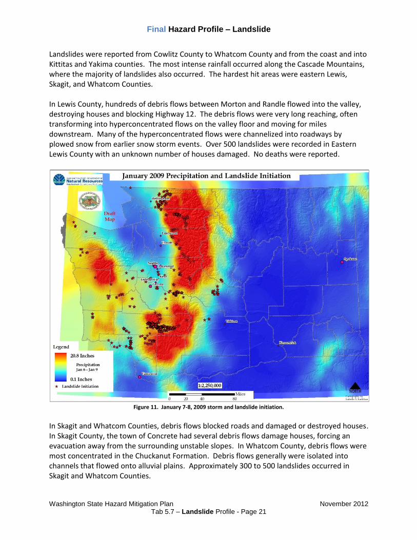
Figure 10. Landslide initiation points from the December 3, 2007 Storm
Numerous landslides occurred in Capital Forest, one destroying the Ranch House BBQ business on Highway 8. Landslides also occurred at the interchange of Highway 101 and Highway 8, temporarily closing both. Landslides blocked Highway 101 north of Skokomish River. Numerous debris flows, debris avalanches, and hyperconcentrated flows blocked the freeway, isolating communities along Hood Canal. Holiday Beach was hardest hit, with at least eight houses affected by a hyperconcentrated flow through the middle of the community. On the eastern shores of Hood Canal, numerous debris flows closed the North Shore Road and destroyed one house. Only eight landslides were recorded in the Seattle-Everett area, most of them localized and caused minor impacts to roads. January 2009 Storms The January 7th-8th Storm was a typical Pineapple Express storm, bringing warm rains that originated from around Kauai (Hawaiian Islands) and rapidly melting snow in a rain-on-snow event. The rainfall followed lowland snow in the Puget Sound region from December 2008 into January 2009, resulted in high amounts of flooding and saturation of soils. Washington State Geological Survey reported through field and aerial surveys that the storm caused over 1,500 landslides greater than 5,000 square feet in size. The flooding resulted in the largest evacuation in state history, forcing more than 30,000 people living in the Puyallup River area to flee.
Final Hazard Profile – Landslide
Washington State Hazard Mitigation Plan November 2012
Tab 5.7 – Landslide Profile - Page 21
Landslides were reported from Cowlitz County to Whatcom County and from the coast and into Kittitas and Yakima counties. The most intense rainfall occurred along the Cascade Mountains, where the majority of landslides also occurred. The hardest hit areas were eastern Lewis, Skagit, and Whatcom Counties. In Lewis County, hundreds of debris flows between Morton and Randle flowed into the valley, destroying houses and blocking Highway 12. The debris flows were very long reaching, often transforming into hyperconcentrated flows on the valley floor and moving for miles downstream. Many of the hyperconcentrated flows were channelized into roadways by plowed snow from earlier snow storm events. Over 500 landslides were recorded in Eastern Lewis County with an unknown number of houses damaged. No deaths were reported.
Figure 11. January 7-8, 2009 storm and landslide initiation.
In Skagit and Whatcom Counties, debris flows blocked roads and damaged or destroyed houses. In Skagit County, the town of Concrete had several debris flows damage houses, forcing an evacuation away from the surrounding unstable slopes. In Whatcom County, debris flows were most concentrated in the Chuckanut Formation. Debris flows generally were isolated into channels that flowed onto alluvial plains. Approximately 300 to 500 landslides occurred in Skagit and Whatcom Counties.

Final Hazard Profile – Landslide
Washington State Hazard Mitigation Plan November 2012
Tab 5.7 – Landslide Profile - Page 22
In Kittitas County, a large debris avalanche formed on the Hyak Ski area on Snoqualmie Pass. The landslide destroyed numerous buildings and ski infrastructure. Numerous landslides around Blewett Pass blocked Highway 97, resulting in its closure. In the Pierce, King, and Snohomish Counties, landslides occurred mostly in the Cascade foothills. Highway 410 near Greenwater was closed due to numerous debris flows across the highway, isolating the town of Greenwater. In Clark County, landslides dotted around the I-5 corridor and numerous landslides occurred in the Kelso and Longview area. Numerous landslides were also recorded on or near Highway 504 (Spirit Lake Highway). A smaller number of landslides occurred in many of the other counties within Western Washington. Highway infrastructure was most impacted along SR 112 in the vicinity of MP 37 where 500 feet of roadway dropped up to 8 feet, closing the highway indefinitely; the southern portion of US Highway 101 in the vicinity of MP 43 and 60.6; the Cowlitz River valley where several landslides and one major rockfall closed the highway for two days between Mossy Rock and Randal; the Tilton River drainage where the SR 508 bridge footing was scoured at Morton and a landslide subsided up to one foot on the west side of Bear Canyon; the Lewis River drainage where SR 503 was temporary closed by landslides in the vicinity of MP 30.3 and 37.7; the Snoqualmie River drainage where a landslide occurred on Interstate 90 in the vicinity of MP 36; the Cedar River drainage where the Cedar River bridge approach wall failed on SR 169 from river scour and a retaining wall near the Issaquah-Hobart interchange on SR 18 was undermined; near McCleary a landslide impacted the roadway in the vicinity of MP 8.5 on SR 108; and another landslide occurred adjacent to a home on SR 122 in the vicinity of MP 6.2. Perhaps the most damaging part of the January 2009 storm was the potential reactivation of movement of the landslide underneath Howard Hansen Dam, which might have caused a subterranean leak on the dam in King County. The leak was detected shortly after the January storm. The dam prevents wide scale flooding in the Kent Valley, but at a weakened strength, the dam may be forced to release flood waters. On January 16th, a landslide on the Spokane River arm of Lake Roosevelt resulted in an inland tsunami, creating a wave about 30 feet high. The tsunami destroyed numerous docks and did some damage to houses along the waterfront. A rockslide on March 23rd blocked the Entiat River Road in Chelan County. The landslide was about 11 miles northwest of Entiat. A hyperconcentrated flow moved through Glendale on south Whidbey Island on April 3rd, the result of a beaver dam-burst flood. A 100 to 150 foot section of the road on Glendale Creek gave way after a beaver dam collapsed, resulting in the hyperconcentrated flow. In Chelan County, an irrigation pipe leak resulting in a landslide on April 21st. The landslide occurred on the 1000 block of Vista Place and resulted in damage to a fence and tree. Two landslides on April 25th moved across Brender Canyon Road near Cashmere, Chelan County. One of the landslides was reported to be about 20 feet wide by about 4 feet deep. A rockslide on Interstate 90 temporarily closed eastbound lanes for five hours on May 12th. The slide was mostly the result of one boulder, with a minor amount of other debris.

Final Hazard Profile – Landslide
Washington State Hazard Mitigation Plan November 2012
Tab 5.7 – Landslide Profile - Page 23
A debris flow on July 29th closed the North Cascades Highway near Rainy Pass. The landslide was triggered following several days of thunderstorms. The landslide was reported to be about 900 feet long by about 10 feet deep along the Highway. An abutment along a railroad track in Stevens County gave way on August 6th, resulting in a small landslide. A train was derailed as a result of the damaged railroad tracks. On August 25th, a landslide on the Spokane River arm of Lake Roosevelt resulting in an inland tsunami. The tsunami damaged the Porcupine Bay Campground and injured two children. A massive landslide started to move on October 10th west of Naches near the town of Nile. On October 11th, the landslide catastrophically failed, diverting the Naches River covering Highway 410, and damaging 6 houses by ground deformation and over 20 homes by flooding.
Figure 12. An oblique photo of the Nile Landslide, photo by Jack Powell, DNR
Following the landslide movement Yakima County purchased 60 acres of land that included several homes at a cost of $1.78 million to realign the Naches River channel and a new road. WSDOT constructed a temporary route for Highway 410 on the other side of the valley. In response to the danger of the landslide, WSDOT, DNR, and the University of Washington monitored the landslide for movement. A radar system was employed to monitor landslide movement, monuments were set up on the landslide and portable seismometers were utilized

Final Hazard Profile – Landslide
Washington State Hazard Mitigation Plan November 2012
Tab 5.7 – Landslide Profile - Page 24
to detect any precursor to further movement of the landslide. A new Highway 410 route across the toe of the landslide opened in August 2012. Storms from November 15 - 24 triggered a handful of landslides. On November 16th, a landslide occurred on Hwy 101, near Ayock, another at 29th Court NW near Shawnee Drive, which damaged a garage, and a deep-seated earthflow in Clallam County on a forest service road. Continued rains triggered a landslide on November 17th along the tracks of Seattle, 4 miles north of Carkeek Park. Landslides in 201035 On January 13th along the 6000 block of Beach Drive in Seattle, a landslide temporarily closed the road. On January 14th a landslide shut down westbound SR 16 in Auburn. Sound Transit cancelled service on January 19th because of a mudslide in the south Seattle area. A weekend mudslide at North Waterview Street in Tacoma caused the road to collapse and break a major water main on October 12th. The National Weather Service reported 29 landslides after the weekend storm of December 11th - 12th. Landslides impacted 17 city or county roads, seven highways, three railways, two homes and two power lines. Amtrak service was canceled between Seattle and Portland. A landslide crashed into a house at Riviera Place NE along Lake Washington on December 13th. Nine slides closed the Burke-Gilman trail in various places. There was another slide at 12500 block of Edgewater Lane NE in Seattle. State Route 2 was closed near Muddy Creek Campground because of a landslide while SR11 Chuckanut Drive in Whatcom County also closed because of a landslide. Landslides in 201136 January 14th mudslide temporarily closed State Route 101 in Mason County and another landslide closed the West Valley Highway in Sumner for several days. A mudslide along the main railroad line near Everett suspended passenger rail service between Seattle and Vancouver, B.C. On February 12, a mudslide north of Vancouver, WA near Felida shut down Amtrak train service between Portland and Seattle. Another slide on March 1st closed the railroad to passenger traffic between Portland and Seattle. On March 14th a mudslide damages a home in Edmonds. Amtrak service between Everett and Seattle has been suspended numerous times because of slides during the month of March. On March 15th, landslides force evacuation of nine homes along Gertie Johnson Road on Bainbridge Island. Gertie Johnson is on the same hillside that slid on to Rolling Bay Walk in 1997, killing a Bainbridge High School teacher, his wife and their two young sons. On May 17th a large debris flow covered the North Cascade Highway SR 20. On June 10th a mudslide covered Leavenworth’s Icicle Road stranding 30 people above the slide. On July 6th a mudslide cut power to about 1,400 residents in Kent. On November 29th a slide closed the South Skagit Highway near mile marker 12. The Seattle-Everett railroad route had nearly 100 slides in 2011, the most in 20 years per Gus Melonas, a spokesman for the Burlington Northern Santa Fe railroad.

Final Hazard Profile – Landslide
Washington State Hazard Mitigation Plan November 2012
Tab 5.7 – Landslide Profile - Page 25
Landslides in 201237 On January 23rd a water main break caused a landslide that forced evacuations for four homes. On February 22nd, a slide closed the railroad tracks between Everett and Seattle while another slide damaged several homes in Stanwood. A mudslide wiped out one house and damaged another near Port Susan later that day. On February 23rd, a landslide on private property near Morton diverted water in a culvert which damaged a nearby home. On April 27th a large mudslide closed State Route 410 in the Nile Valley. A slide occurred at the same location the previous year. The mudslide area is 19 miles west of a landslide that wiped out SR 410 three years ago. On July 17th two landslides close State Route 821 in the Yakima River Canyon. The slides occurred in the same area as a massive 1998 landslide buried the highway for two weeks.

Final Hazard Profile – Landslide
Washington State Hazard Mitigation Plan November 2012
Tab 5.7 – Landslide Profile - Page 26
Jurisdictions Most Threatened and Vulnerable to Landslide Hazards Analysis of risk to local jurisdictions is a difficult process. Currently, there are no comprehensive statewide landslide hazard maps. However, models exist to aid in detecting potential areas more susceptible to landslides in some locations. All counties in Washington State have some landslide hazard and risk. In Washington State, landslide risk is higher in western Washington due to the higher amount of precipitation. Water and gravity are the main drivers of landslides. In Eastern Washington, the landslide risk is high during storm events (especially spring and summer thunderstorms) and in places where irrigation is near bluffs or near or on deep-seated landslides. Earthquakes have the potential to cause landslides in Eastern and Western Washington.
Figure 13. Counties Vulnerable to Landslide Hazards. Counties within in Washington State that contain known landslides are considered at-risk to future landslide activity.

Final Hazard Profile – Landslide
Washington State Hazard Mitigation Plan November 2012
Tab 5.7 – Landslide Profile - Page 27
Since no statewide landslide susceptibility map exists, a detailed analysis of public facilities is difficult. However, a simple analysis of public facilities on or nearby landslides indicates 23 facilities potentially at risk of future landslide activity. The risk could include reactivation of a deep-seated landslide or in areas susceptible to shallow landslides, such as debris flows. This simple analysis does not exclude features not shown on the map from landslide risk.
Figure 14. Public facilities in or within 100 feet of a landslide within the Washington Geologic Surveys landslide database.
These facilities are potentially at risk for future landslide activity.

Final Hazard Profile – Landslide
Washington State Hazard Mitigation Plan November 2012
Tab 5.7 – Landslide Profile - Page 28
Utilizing the Washington State Office of Financial Managements 2009 dataset of state leased and owned facilities, an analysis was performed to determine which, if any, state facilities may be at risk to a future landslide. For the state leased facilities in this dataset, 42 were determined to be within 500 feet of a landslide and may therefore be at risk to future landslide activity. These state owned facilities represent over 123,000 square feet of office space with a total value of over $2.4 million dollars. An identical analysis of state leased facilities was performed, but no state leased facilities were determined to be within the specified distance of any known landslide location contained in the landslide database.
Figure 15. State Owned Facilities within 500 feet a location of a known landslide according to the Washington Geologic Survey’s 2009 Landslide Database at 24K.

Final Hazard Profile – Landslide
Washington State Hazard Mitigation Plan November 2012
Tab 5.7 – Landslide Profile - Page 29
State Agency Structures At Risk
Number and Function of Buildings
No. of Affected
Staff / Visitors / Residents
Approx. Value of Owned Structures
Approx. Value of Contents All
Structures
Total at-risk buildings: 42 $2.4 million
Nine state highways considered emphasis corridors because of their importance to movement of people and freight are potentially at risk to landslide and ground failure:
1. Interstate 5 2. Interstate 82 3. Interstate 90 4. U.S. Highway 2 5. U.S. Highway 12 6. U.S. Highway 97 7. U.S. Highway 101 8. U.S. Highway 395 9. State Route 20
Additionally, ferry landings in Anacortes, Bainbridge Island, Bremerton, Clinton, Fauntleroy, Keystone, Mukilteo, Port Townsend, the San Juan Islands, Seattle, Southworth, Tacoma, and Vashon Island are potentially at risk because of their construction on poor soils in shoreline areas.

Final Hazard Profile – Landslide
Washington State Hazard Mitigation Plan November 2012
Tab 5.7 – Landslide Profile - Page 30
Potential Climate Change Impacts 38 39 Vulnerability to landslide hazards is a function of location, type of human activity, use, and frequency of landslide events. The effects of landslides on people and structures can be lessened by total avoidance of landslide hazard areas or by restricting, prohibiting, or imposing conditions on hazard-zone activity. Local governments can reduce landslide effects through land-use policies and regulations. Individuals can reduce their exposure to hazards by educating themselves on the past history of a site and by making inquiries to planning and engineering departments of local governments. In addition, it is highly advised to consult the professional services of an engineering geologist, geotechnical engineer, or a civil engineer, who can properly evaluate a site, built or un-built. With the advent of global warming coming into worldwide focus, it is only fitting to discuss its possible effects on landslide hazards. Antoni Lewkowicz of the University of Ottawa has studied several northern landslides and rockslides that he says can be at least partially attributed to thinning and weakening of ice or permafrost caused by climate change. Other experts from the United Nations University say “If climate change predictions are accurate you will expect … more intense and extreme rainfalls which could result in more landslides throughout the world.” Landslide hazards can be reduced by avoiding construction on steep slopes and existing landslides or by stabilizing the slopes. Slope stability will increase with one or more of the following actions: when ground water can be prevented from rising in the landslide mass by covering the landslide with an impermeable membrane, directing surface water away from the landslide area, draining the ground water away from the slide area, or minimizing surface irrigation. Slope stability can also increase when a retaining structure and/or the weight of a soil/rock berm are placed at the toe (bottom) of the landslide or when mass is removed from the top of the slope. City, county, and state mitigation plans can be a further source of information for strategies to reduce the impacts and potential for landslides and their associated hazards in Washington. Although the physical cause of many landslides cannot be removed, geologic investigations, good engineering practices, and effective enforcement of land-use management regulations can (greatly) reduce landslide hazards.

Final Hazard Profile – Landslide
Washington State Hazard Mitigation Plan November 2012
Tab 5.7 – Landslide Profile - Page 31
References
1 Jonathan Godt, “Landslide Overview Map of the Conterminous United States,” U.S. Geological Survey, Open File
Report 97-289, 1997, <http://landslides.usgs.gov/learning/nationalmap/> (January 17, 2008). 2 Washington State Department of Ecology, Puget Sound Landslides. Accessed 29 August 2012.
http://www.ecy.wa.gov/programs/sea/landslides/index.html 3 Washington State 2001 Hazard Identification and Vulnerability Assessment, Washington State Military
Department, Emergency Management Division, April 2001. 4 Hazard Fact Sheet, U.S. Geological Survey, Landslide Information Center, March 2002,
<http://landslides.usgs.gov/html_files/nlic/page5.html>, (August 12, 2003). 5 Oral communication from Edwin L. Harp, National Landslides Program, Central Region Geologic Hazards Team,
U.S. Geological Survey, August 12, 2003. 6 Washington State Department of Natural Resources, Washington Geological Survey’s Statewide Landslide
Database. Sarikhan and Davis, 2008. Accessed 23 October 2012. Available at https://fortress.wa.gov/dnr/geology/?Theme=landslides 7 Highland, L.M., and Bobrowsky, Peter, 2008, The landslide handbook—A guide to understanding landslides:
Reston, Virginia, U.S. Geological Survey Circular 1325, 129 pages. Accessed 23 October 2012. Available at http://pubs.usgs.gov/circ/1325/. 8 “About Slides on Puget Sound,” WA State Department of Ecology, n.d.,
<http://www.ecy.wa.gov/programs/sea/landslides/ about/about.html> (January 15, 2008). 9 Gerald W. Thorsen, Landslide Provinces in Washington, Engineering Geology in Washington Volume 1,
Washington Division of Geology and Earth Resources Bulletin 78, 1989. 10
“Landslide Types and Processes,” U.S. Geological Survey, Fact Sheet 2004-3072, July 2004, <http://pubs.usgs.gov/ fs/2004/3072/pdf/fs2004-3072.pdf> (January 15, 2008). 11
Edwin L. Harp, John A. Michael, and William T. Laprade, “Shallow-Landslide Hazard Map of Seattle, Washington,” U.S. Geological Survey, Open-File Report 2006-1139, 2006, <http://pubs.usgs.gov/of/2006/1139/pdf/of06-139_508.pdf> (January 22, 2008). 12
Richard L. Hill, A New Look at an Old Landslide, The Oregonian, September 29, 1999, <http://landslides.usgs.gov/html_files/bonneville/index.html>, (April 7, 2003). 13
High Shipman, The Fall of Camano Head: A Snohomish Account of a Large Landslide and Tsunami in Possession Sound During the Early 1800s, TsuInfo Alert, Volume 3, No. 6, December 2001. 14
Lee Walkling, Infrequently Asked Questions, TsuInfo Alert, Volume 1, No. 2, February 1999. 15
Oral communication from Timothy J. Walsh, Chief Geologist, Washington Department of Natural Resources, May 1, 2003.

Final Hazard Profile – Landslide
Washington State Hazard Mitigation Plan November 2012
Tab 5.7 – Landslide Profile - Page 32
16
Tsunamis Affecting the West Coast of the United States 1806 – 1992, National Geophysical Data Center Key to Geophysical Records Documentation No. 29, National Oceanic and Atmospheric Administration, December 1993. 17
Washington State 2001 Hazard Identification and Vulnerability Assessment, Washington State Military Department, Emergency Management Division, April 2001 18
Thomas J. Sokolowski, The Great Alaskan Earthquake and Tsunamis of 1964, West Coast and Alaska Tsunami Warning Center, http://wcatwc.gov/64quake.htm, (March 25, 2003). 19
Linda Lawrence Noson, Anthony Qamar and Gerald W. Thorson, Washington State Earthquake Hazards, Information Circular 85, Washington State Department of Natural Resource, Division of Geology and Earth Resources, 1988. 20
Carl A. Von Hake and William K. Cloud, United States Earthquakes 1965, U.S. Department of Commerce, Coast and Geodetic Survey, U.S. Government Printing Office, pp. 32-51, <http://www.ess.washington.edu/SEIS/PNSN/HIST_CAT/1965.html>, (February 24, 2003). 21
Steven R. Brantley and Bobbie Myers, U.S. Department of the Interior, U.S. Geological Survey, Fact Sheet 036-00, Mount St. Helens – From the 1980 Eruption to 2000, 2000. 22
Interagency Hazard Mitigation Team Report, with Early Implementation Strategies for DR-1079-WA and DR-1100-WA, Federal Emergency Management Agency Region X, July 1996. 23
Edwin L. Harp et al., Landslides and Landslide Hazards in Washington State Due to February 5 – 9, 1996 Storm, Department of Interior, U.S. Geological Survey Administrative Report, undated. 24
Hazard Mitigation Survey Team Report for the 1996-1997 Washington Winter Storms, Washington State Emergency Management Division and the Federal Emergency Management Agency Region 10, 1997. 25
Puget Sound Bluffs: The Where, Why, and When of Landslides Following the Holiday 1996/97 Storms, Washington Geology, 25:1, March 1997, Washington Department of Natural Resources, <http://www.wa.gov/dnr/htdocs/ger/pugetls.htm>, (December 13, 2002). 26
Rex Baum et al., Landslides Triggered by the Winter 1996-97 Storms in the Puget Lowland, Washington (online edition), Department of the Interior, U.S. Geological Survey, Open File Report 98-239, <http://geohazards.cr.usgs.gov/pubs/ofr/ofr98-239/ofr98-239.htm>, (April 7, 2003). 27
Dan Nailen, Federal, State Disaster Agencies Wrap Up Their Presence in Kelso, The Oregonian, Portland, OR, December 12, 1998, <http://oregonlive.com/9812/st12206.html>, (December 28, 1998). 28
Bonnie J. Yocum, Clearing Aldercrest Homes, The Daily News, Longview, WA, November 18, 2002, <http://www.tdn.com/articles/2000/11/18/news-56376.txt>, (April 11, 2003). 29
Lynn M. Highland, An Account of Preliminary Landslide Damage and Losses Resulting from the February 28, 2001 Nisqually, Washington, Earthquake, Department of the Interior, U.S. Geological Survey, Open File Report 03-211, <http://pubs.usgs.gov/of/2003/ofr-03-211/ofr-03-211.pdf>, (August 12, 2003). 30
Washington Department of Transportation news release, <http://www.wsdot.wa.gov/news/2004/feb04_i5-bellingham-rockslides.htm>, February 4, 2004. 31
King County news release, <http://dnr.metrokc.gov/dnrp/press/2004/0312cedar_landslide.htm>, March 12, 2004.

Final Hazard Profile – Landslide
Washington State Hazard Mitigation Plan November 2012
Tab 5.7 – Landslide Profile - Page 33
32
Washington Department of Transportation news release and news reports. 33
Various news reports from the Seattle Times and the Seattle Post-Intelligencer. 34
Information from news reports and the Washington Department of Transportation. 35
United State Geological Survey, Landslide Events 2010. Accessed 30 August 2012.
http://landslides.usgs.gov/recent/index.php?year=2010
36
United State Geological Survey, Landslide Events 2011. Accessed 30 August 2012.
http://landslides.usgs.gov/recent/index.php?year=2011
37
United State Geological Survey, Landslide Events 2012. Accessed 30 August 2012.
http://landslides.usgs.gov/recent/index.php?year=2012
38
Robert Roy Britt, “Surprising Side Effects of Global Warming,” LiveScience, December 22, 2004, <http://www.livescience.com/environment/041222_permafrost.html> (January 25, 2008). 39
Alister Doyle, “Landslide Could Worsen with Global Warming – UN,” Planet Ark. January 18, 2006, <http://www.planetark.com/dailynewsstory.cfm/newsid/34540/story.htm> (January 25, 2008).