
2013 Monte Cristo Mining Area Access Route Workplan
229
November 2005 Cascade Earth Sciences 12720 E. Nora Ave., Suite A Spokane, WA 99216 (509) 921-0290 www.cascade-earth.com ACCESS ROUTE WORK PLAN & DESIGN DRAWINGS Monte Cristo Mining Area Removal Action Mt. Baker-Snoqualmie National Forest Snohomish County, Washington July 2013
Transcript of 2013 Monte Cristo Mining Area Access Route Workplan

November 2005
Cascade Earth Sciences
12720 E. Nora Ave., Suite A Spokane, WA 99216
(509) 921-0290 www.cascade-earth.com
ACCESS ROUTE WORK PLAN & DESIGN DRAWINGS Monte Cristo Mining Area Removal Action Mt. Baker-Snoqualmie National Forest Snohomish County, Washington
July 2013

Disclaimer: The contents of this document are confidential to the intended recipient at the location to which it has been addressed. The contents may not be changed, edited, and/or deleted. The information contained in this document is only valid on the date indicated on the original project file report retained by CES. By accepting this document, you understand that neither CES nor its parent company, Valmont Industries, Inc. (Valmont) accepts any responsibility for liability resulting from unauthorized changes, edits, and/or deletions to the information in this document.
ACCESS ROUTE WORK PLAN & DESIGN DRAWINGS Monte Cristo Mining Area Removal Action Mt. Baker-Snoqualmie National Forest Snohomish County, Washington Prepared For: Mr. Joseph Gibbens, PE On-Scene Coordinator Abandoned Mine Lands Reclamation U.S. Forest Service Pacific Northwest Region 1835 Black Lake Blvd SW Olympia, Washington 98512 Prepared By: Cascade Earth Sciences
12720 E. Nora Avenue, Suite A Spokane, WA 99216 (509) 921-0290
Author(s): Tim Otis, PE, Senior Engineer Ryan M. Tobias, Senior Biologist Reviewer: Dustin G. Wasley, PE, Principal Engineer Report Date: July 30, 2013 Project Number: 2011230022-004 Submitted By: Dustin G. Wasley, PE, Principal Engineer Cover Photographs: Upper Left – Cabin at Monte Cristo Townsite; SFSR from Mystery Ridge; Lower Left – Upper
Glacier Basin

Cascade Earth Sciences – Spokane, WA Monte Cristo Mining Area Removal Action PN: 2011230022-004 Access Route Work Plan Doc: MCMA Access Route Work Plan.docx July 2013 / Page iii
CONTENTS 1.0 INTRODUCTION ............................................................................................................................... 1
1.1 Site Description ............................................................................................................................... 2 1.2 Mines and Related Features ............................................................................................................. 3 1.3 Schedule and Key Personnel ........................................................................................................... 3 1.4 Logistics ........................................................................................................................................... 4 1.5 Communications .............................................................................................................................. 4
2.0 2013 FIELDWORK ACTIVITIES ...................................................................................................... 5 2.1 Stream Crossings ............................................................................................................................. 5 2.2 Mobilization ..................................................................................................................................... 6 2.3 Access Route Traffic Control .......................................................................................................... 6 2.4 Sauk Wagon Road ........................................................................................................................... 7 2.5 Clearing and Grubbing .................................................................................................................... 7 2.6 Surface Water Diversion / Erosion Control Measures .................................................................... 7 2.7 Repository and Borrow Sources ...................................................................................................... 8
3.0 ACCESS ROUTE IMPLEMENTATION ........................................................................................... 9 3.1 Access Route Segments ................................................................................................................... 9 3.2 Timber Deck Sale .......................................................................................................................... 10 3.3 Log Stringer Bridges ..................................................................................................................... 10 3.4 Armored Fords ............................................................................................................................... 11 3.5 Cut and Fill .................................................................................................................................... 11 3.6 Grading and Compaction ............................................................................................................... 11 3.7 Subgrade and Surfacing ................................................................................................................. 11 3.8 Drainage ......................................................................................................................................... 11
4.0 POST-ROUTE ACTIVITIES ............................................................................................................ 12 4.1 Revegetation and Rehabilitation .................................................................................................... 12 4.2 Access Route Management ........................................................................................................... 12 4.3 Mowich Camp Decommissioning ................................................................................................. 12
5.0 REFERENCES .................................................................................................................................. 12
FIGURES Figure 1. Site Layout Map of Monte Cristo Mining Area Figure 2. Proposed SFSR Tributary Crossings
PLATES Plate 1. Detail of the Monte Cristo Townsite Area Plate 2. Record of Survey of The Townsite of Monte Cristo

Cascade Earth Sciences – Spokane, WA Monte Cristo Mining Area Removal Action PN: 2011230022-004 Access Route Work Plan Doc: MCMA Access Route Work Plan.docx July 2013 / Page iv
CONTENTS (continued)
DRAWINGS Sheet G1. Title Sheet Sheet G2. Typical Cross Sections Sheet G3. Survey Control Sheet C1. Plan and Profile – Sta. 10+00.00 to 14+50.00 Sheet C2. Plan and Profile – Sta. 14+50.00 to 20+25.00 Sheet C3. Plan and Profile – Sta. 20+25.00 to 26+00.00 Sheet C4. Plan and Profile – Sta. 26+00.00 to 31+75.00 Sheet C5. Plan and Profile – Sta. 31+75.00 to 37+50.00 Sheet C6. Plan and Profile – Sta. 37+50.00 to 43+50.00 Sheet C7. Plan and Profile – Sta. 43+50.00 to 49+00.00 Sheet C8. Plan and Profile – Sta. 49+00.00 to 55+00.00 Sheet C9. Plan and Profile – Sta. 55+00.00 to 61+00.00 Sheet C10. Plan and Profile – Sta. 61+00.00 to 67+00.00 Sheet C11. Plan and Profile – Sta. 67+00.00 to 73+00.00 Sheet C12. Plan and Profile – Sta. 73+00.00 to 78+25.00 Sheet C13. Plan and Profile – Sta. 78+25.00 to 84+25.00 Sheet C14. Plan and Profile – Sta. 84+25.00 to 89+50.00 Sheet C15. Plan and Profile – Sta. 89+50.00 to 95+50.00 Sheet C16. Plan and Profile – Sta. 95+50.00 to 101+50.00 Sheet C17. Plan and Profile – Sta. 101+50.00 to 107+50.00 Sheet C18. Plan and Profile – Sta. 107+50.00 to 113+50.00 Sheet C19. Plan and Profile – Sta. 113+50.00 to 119+50.00 Sheet C20. Plan and Profile – Sta. 119+50.00 to 125+50.00 Sheet C21. Plan and Profile – Sta. 125+50.00 to 131+50.00 Sheet C22. Plan and Profile – Sta. 131+50.00 to 137+50.00 Sheet C23. Plan and Profile – Sta. 137+50.00 to 143+50.00 Sheet C24. Plan and Profile – Sta. 143+50.00 to 149+50.00 Sheet C25. Plan and Profile – Sta. 149+50.00 to 152+50.00 Sheet D1. Details Sheet D2. Details Sheets 1-6. Log Stringer Bridge
APPENDICES
Appendix A. Health and Safety Plan Appendix B. Biological Monitoring Plan Appendix C. Access Route Implementation Schedule Appendix D. Existing Monte Cristo Road Evaluation Summary Appendix E. Cultural Resources Mitigation, Minimization, Avoidance, and Monitoring Plan Appendix F. Technical Specifications and Quality Assurance Plan

Cascade Earth Sciences – Spokane, WA Monte Cristo Mining Area Removal Action PN: 2011230022-004 Access Route Work Plan Doc: MCMA Access Route Work Plan.docx July 2013 / Page 1
1.0 INTRODUCTION The United States Department of Agriculture, Forest Service (Forest Service) retained Cascade Earth Sciences (CES) to complete an access route design for the Non-Time-Critical Removal Action (RA) at the Monte Cristo Mining Area (MCMA) located in the Mt. Baker-Snoqualmie National Forest of Washington. The RA will be completed to address metal contamination of soil, sediment, and water from the MCMA under the Comprehensive Environmental Response and Liability Act (CERCLA) cleanup authorities [42 USC 9604(a) and 7 CFR 2.60(m)] and Federal Executive Order 12580. The RA will be implemented in accordance with the provisions of National Oil and Hazardous Substances Pollution Contingency Plan, 40 CFR 300.415(b)(4)(i); and utilizing the U.S. Environmental Protection Agency (EPA) “Guidance on Conducting Non-Time-Critical Removal Actions under CERCLA” (EPA, 1993). The MCMA includes 10 mines (mines) and several facilities associated with storage, processing, and ore haulage (facilities). Performance of the RA will necessitate vehicle and equipment access to these mines and features to complete the requisite cleanup actions under the preferred alternative as described in the Engineering Evaluation/Cost Analysis (EE/CA; CES, 2010). The historic Monte Cristo Townsite Townsite (Townsite) is currently accessed from Barlow Pass at the three-way intersection of Mountain Loop Highway, Forest Road (FR) 20, and Monte Cristo Road. From Barlow Pass, the Townsite is accessed by foot, mountain bike, or all-terrain vehicle on the unmaintained, gravel Monte Cristo Road. Current vehicle access to the Townsite is limited, while equipment access is impractical. Monte Cristo Road was built largely within the floodplain of the SFSR, and has suffered recurring damage along several lower portions of the existing Monte Cristo Road prism. In addition, a Snohomish County (County) bridge over the SFSR was damaged and the main channel has shifted from the bridge span, rendering the structure unusable. The Forest Service and County have decided repairs to the bridge are not feasible. Moreover, the Monte Cristo Road will likely continue to be exposed to future damage and failures from flooding and river migration. The Forest Service concluded a more practical access route alignment will be necessary in the upland areas east of the SFSR to provide access to the Townsite. The RA will require varying cleanup strategies based on the unique circumstances of each mine/feature and the most appropriate combination of alternatives to best achieve the RA objectives. The EE/CA (CES, 2010) and Forest Service (2012) Removal Action Memorandum (RAM) outlined these strategies, which considered the level of recreational use (near and remote), potential exposure, and proximity to surface water bodies that could present an erosion hazard. The purpose of the RA is to “abate, prevent, minimize, stabilize, mitigate, or eliminate the release or the threat of a release” (40 CFR 300.415). The purpose of the access route is to provide reliable equipment and personnel access to the Townsite via development of a low-volume access route from the Mountain Loop Highway (Figures 1 and 2). The access route includes four main elements for the 2013 work season:
• Approximately 1.6 miles of new access route will be advanced from the Mountain Loop Highway to the former Python Logging Road (FR 4716) that will include construction of three log stringer bridges.
• About 0.8 miles of repair to the former Python Logging Road. • Approximately 0.3 miles of new access route from FR 4716 to the Monte Cristo Road to the top of
Haps Hill. • About 2 miles of upgrades of the Monte Cristo Road from the top of Haps Hill to the Townsite.
The new access route and Monte Cristo Road upgrades will allow equipment access for contaminated media consolidation required to complete the RA. As outlined in the EE/CA, arsenic is the primary contaminant of concern at the MCMA. The risk-based cleanup concentration is 236 milligrams per kilogram (mg/kg) for

Cascade Earth Sciences – Spokane, WA Monte Cristo Mining Area Removal Action PN: 2011230022-004 Access Route Work Plan Doc: MCMA Access Route Work Plan.docx July 2013 / Page 2
total arsenic in soil, waste rock, and tailings at near (high recreational use) feature locations. The cleanup goal for remote (low recreational use) feature locations is 659 mg/kg for total arsenic. Cleanup of waste rock, tailings, and soil to these concentrations is expected to be protective of both human and ecological receptors. This document comprises the Access Route Work Plan for RA activities to be completed in the 2013 work season. A separate Work Plan for the Non-Time-Critical RA will be prepared for the 2014 work season that will describe activities to be completed at the Townsite and the Henry M. Jackson Wilderness. A stand-alone site-specific Health and Safety Plan (HASP) has also been prepared for planned field activities and is included in Appendix A. Section 7 Consultation requirements under the Endangered Species Act (ESA) and monitoring for the Biological Opinion (USFWS, 2011) to address potential effects of the RA on threatened and endangered species is included in Appendix B. 1.1 Site Description
The MCMA is located in Snohomish County, Washington, near the west-center margin of the Henry M. Jackson Wilderness Area, and approximately 28 air miles east-southeast of Granite Falls, Washington. Driving time one-way via the Mountain Loop Road from Darrington or Granite Falls to the Barlow Summit trailhead near the MCMA is estimated to be approximately 45 minutes depending on road conditions. The new access route will originate near Mowich Camp, approximately 0.5 miles north of Barlow Pass (milepost [MP] 31.2) on the Mountain Loop Highway and will tie into the existing Monte Cristo Road at the top of Haps Hill. From that point at the top of Haps Hill, the existing Monte Cristo Road will be upgraded to the terminus at the Townsite. According to the United States Geological Survey (USGS) 1:24,000 quadrangle map (USGS, 1982a):
• Barlow Pass is located at an elevation of 2,361 feet above mean sea level (amsl) in Section (Sec) 6 of Township (T) 29 North (N), Range (R) 11 East (E) of the Willamette Meridian (WM), latitude 48° 01’ 33.08” N, longitude 121° 26’ 36.44” W.
• The Townsite (USGS, 1982b) is situated at an elevation of 2,755 feet amsl in Sec 21, T 29 N, R 11 E of the WM , latitude 47° 59’ 11.01” N, longitude 121° 23’ 39.10” W.
The high-elevation portion of the MCMA is drained by two creeks separated by Wilmans Peaks: Glacier Creek flows west to northwest about two and one-half miles from Glacier Basin to the Townsite, and Seventysix Gulch flows northwest about two miles to the confluence with Glacier Creek at the Townsite. The headwaters of both streams lie at elevations over 4,500 feet amsl, and their confluence at the Townsite marks the beginning of the SFSR. The SFSR flows 6.8 miles northwest to Monte Cristo Lake (MCL) and continues into the Sauk River, the Skagit River, and eventually Skagit Bay. Location, access, and ownership information for the ten mines and associated mining- and processing-related facilities are described in detail in the EE/CA and RAM. Land ownership in the MCMA is extremely complex, consisting of a mix of public lands administered by the Forest Service, Snohomish County, and private property. The Forest Service has CERCLA authority for the release or threatened release of hazardous substances where the release is on or the sole source of the release is from National Forest System lands. On private land, the Washington State Department of Ecology has similar cleanup authorities under Washington State’s Model Toxic Control Act. Parcel sizes range from very small lots (less than 0.1 acres) in the Townsite, to patented millsite and placer claims and multiple blocks of patented lode claims (in excess of 60 acres). The Forest Service previously purchased some privately held property in the MCMA, particularly within the Henry M. Jackson Wilderness Area. Approximate private property boundaries based on an examination of mineral

Cascade Earth Sciences – Spokane, WA Monte Cristo Mining Area Removal Action PN: 2011230022-004 Access Route Work Plan Doc: MCMA Access Route Work Plan.docx July 2013 / Page 3
survey plats and Snohomish County records are illustrated on Plate 1. A survey of Townsite lots was filed on December 26, 2012, documenting the locations of the Mineral surveys near the platted Townsite, as well as a record of Forest Service ownership corners on Townsite lots (Plate 2). 1.2 Mines and Related Features
The MCMA is divided into near (high recreational use) and remote (low recreational use) mine/feature areas. Details regarding the location, access, and characteristics of each of the mines/features are presented in the EE/CA (CES, 2010) and RAM (Forest Service, 2012). Near mines/features include the following:
• Pride of the Woods Mine • Rainy Mine • Boston-American Mine • Sidney Mine
• Liberty Prospect • Townsite (Concentrator and tailings, Ore
Collector, Assay Shack, Haulage Ways, and Comet Mine Terminal)
The list of remote mines/features are comprised of the following:
• Pride of the Woods Mine • New Discovery Mine • Mystery Mine
• Justice Mine • Golden Cord Mine • Sheridan Mine
1.3 Schedule and Key Personnel
Completion of the access route is expected during the 2013 field season. The Non-Time-Critical RA is currently scheduled to be completed in 2014. The field season at the MCMA is typically between May and October, depending on snow levels. The initial mobilization is scheduled to begin on July 22, 2013. A detailed schedule has been developed and is included in Appendix C. Following the completion of the access route, CES will also provide an annual assessment of erosion control measures, monitoring requirements outlined in the Biological Monitoring Plan (Appendix B), and other improvements. Annual reports for the biological monitoring are due to the USFWS by January 31 the following year for each year of monitoring. Surface water and sediment samples will also be collected from the established aquatic stations immediately prior, and following access route development. Details of the annual inspection and sampling will be determined following consultation with the Forest Service. The field team scheduled to perform work during field operations include:
• Dustin Wasley, PE – CES Program Manager / Principal-in-Charge • Tim Otis, PE – CES Senior Engineer / Engineer of Record / Field Inspector • Jay Williams, PE – CES Senior Engineer / Field Inspector • Ryan Tobias – CES Senior Biologist / Field Inspector • Bernard Kronschnabel – CES Project Engineer / Field Inspector
All personnel who will be performing invasive activities (i.e., sampling, oversight, etc.) during the RA are trained to work in hazardous environments as defined by the Occupational Safety and Health Act (OSHA) 1910.120. Other personnel who will periodically be on-site are listed below. The Contracting Officer Representative (COR) will be kept informed regarding project activities, plans, schedules, budget/invoicing, and other issues through monthly phone meetings.
• Joseph Gibbens, PE – Forest Service On-Scene Coordinator (OSC)/COR • Others Authorized Forest Service Personnel

Cascade Earth Sciences – Spokane, WA Monte Cristo Mining Area Removal Action PN: 2011230022-004 Access Route Work Plan Doc: MCMA Access Route Work Plan.docx July 2013 / Page 4
1.4 Logistics 1.4.1 Work Camp
Due to the remoteness of the MCMA, a temporary camp will be established at Camp Silverton, a non-active Forest Service campground situated near Silverton, Washington along Mountain loop Highway, and approximately 12 miles west of the project site. The camp will include tents, RV trailers, a cooking and eating area, as well as shower and sanitary facilities (porta potties). Care will be taken to avoid any significant impacts to forest resources and to reduce the potential for non-work related exposure to potentially hazardous materials known to be present at the MCMA. The camp area will be cleaned-up and left in good condition prior to departure. 1.4.2 Work Area
All food, equipment, and other supplies will be packed in and out, and will be stored in bear-proof containers and in a manner not to attract wildlife. All refuse will be stored in bear-proof containers, and routinely packed out of the MCMA and properly disposed at an approved solid waste facility. Porta potties will be placed at the beginning of the access route alignment near the Mountain Loop Highway. All-terrain vehicles will likely be used as part of the access route implementation, which will require that a small supply of fuel be kept available at the MCMA. A separate Spill Control Countermeasure Plan has been developed by CES for fuel storage/use and will be presented to the Forest Service for approval. In general, the following fuel-handling procedures will be employed:
• Only containers approved for gasoline and diesel fuel will be used. • A storage area with secondary containment will be established at the camp. • Care will be taken to avoid spills during refueling. • Refueling will be conducted near the fuel storage area at the work camp. Fuel will be transferred to
equipment along the access route with fuel tanks situated in the beds of work trucks. • There will be no open flames or other sources of ignition allowed in the vicinity of the fuel storage
area or during refueling operations. 1.5 Communications
Adequate communication is of paramount importance due to potential safety issues that may arise or forest fires that would need to be reported to the local Forest Service. Therefore, communications between CES, subcontractor, and Forest Service personnel will be maintained throughout the duration of the access route development. Three levels of communications will be available with standard hand-held radios, Forest Service provided handheld radios, and a satellite phone. 1.5.1 Radio Communications
Radio communications will include both standard hand-held radio operations between CES and subcontractors and Forest Service-supplied Bendix King radios to access local repeaters. Standard hand-held radio operations between CES and subcontractors will be conducted on an informal basis, with agreed-upon channel selection and radio protocol discussed at weekly health and safety meetings. Radio communications with Forest Service staff through the Darrington Ranger District or Verlot Public Service Center will be available via the Bendix King radios. The transmit frequency will be 162.6125 and the receive frequency is 170.525. The receive Continuous Tone-Controlled Squelch System (CTCSS) tone is 146.2. The transmit CTCSS tone frequencies are: Barlow 141.3, Lost Creek 131.8, Darrington (North Mountain) 146.2, and Verlot (Green Mountain) 103.5. The radios will be programmed for narrow band mode.

Cascade Earth Sciences – Spokane, WA Monte Cristo Mining Area Removal Action PN: 2011230022-004 Access Route Work Plan Doc: MCMA Access Route Work Plan.docx July 2013 / Page 5
1.5.2 Satellite Phone Communications
No cellular phone coverage is available at Barlow Pass or the Townsite. Thus, CES personnel will have at least one satellite phone to use for emergency communications and standard check-in procedures. Onsite staff will call into the Program Manager (Dustin Wasley) or the CES Safety Manager (Ellen Crawford) on a daily basis. A list of emergency contacts and local Forest Service numbers is listed in the Health and Safety Plan (Appendix A). 2.0 2013 FIELDWORK ACTIVITIES The 2013 field season will include development of a new access route originating near Mowich Camp, approximately 0.5 miles north of Barlow Pass (MP 31.2) on the Mountain Loop Highway. The new access route will tie into the existing Monte Cristo Road at the top of Haps Hill. From Haps Hill, the existing Monte Cristo Road will be upgraded to the terminus at the Townsite. Specifically, the proposed access route will include new development from the Mountain Loop Highway (~1.9 miles), repair of the former Python Logging Road (FR 4716) (~0.8 miles), new access route connection between the Python Logging Road and the Monte Cristo Road (~0.3 miles), and improvements of the Monte Cristo Road (~2 miles) to the Townsite. The work will consist of, but not be limited to, providing all labor, materials, earthwork, and incidentals necessary to develop and upgrade the new access route from the Mountain Loop Highway to the Townsite to provide equipment access for the 2014 RA. The new access route will be a single-lane route with turnouts, with a structurally stable subgrade and aggregate base road surfacing. Related mobilization, clearing and grubbing, road improvement and maintenance, erosion control, and revegetation will also be performed. An entrance gate will be placed at the Mountain Loop Highway along with signs to warn the public of the general hazards (both chemical and physical). Logistical difficulties associated with the performance of this project include the remoteness of the MCMA and generally steep slopes located throughout the area, which will require special handling. The remote location may cause mobilization difficulties and may complicate delivery of the required materials. 2.1 Stream Crossings
The proposed new access route will necessitate three primary stream crossings (log-stringer bridges) and three secondary stream crossings (armored fords) across tributaries of the SFSR. Upgrades to the Monte Cristo Road will include repairs to four culverts (repair sites) to the Townsite, as described in the table below.
Stream Crossing Station
Distance from Mountain Loop
Hwy (miles) Work Area Crossing Designation
36+00 0.68 New Access Route Log-Stringer Stream Crossing #1 54+50 1.03 New Access Route Log-Stringer Stream Crossing #2 68+00 1.29 New Access Route Log-Stringer Stream Crossing #3 74 + 00 1.45 New Access Route Armored Ford Armored Ford #1 94 + 00 1.84 Python Logging Road Armored Ford Armored Ford #2 136 + 00 2.35 New Access Route Armored Ford Armored Ford #3
N/A ~3.1 Monte Cristo Road Upgrade Armored Ford Repair Site 2 N/A ~3.6 Monte Cristo Road Upgrade Armored Ford Repair Site 5 N/A ~ 4.3 Monte Cristo Road Upgrade Culvert Repair Site 7 N/A ~4.7 Monte Cristo Road Upgrade Culvert Repair Site 8

Cascade Earth Sciences – Spokane, WA Monte Cristo Mining Area Removal Action PN: 2011230022-004 Access Route Work Plan Doc: MCMA Access Route Work Plan.docx July 2013 / Page 6
Details of the Monte Cristo Road Upgrade are provided in the January 2010 Existing Monte Cristo Road Evaluation Summary (Appendix D). Details regarding the log-stringer bridge and armored ford design/installation are provided in Sections 3.2 and 3.3. 2.2 Mobilization
Mobilization will be performed in accordance with Section 601 of the Technical Specifications. The initial mobilization date will be determined based on snowpack and weather conditions. The new log-stringer bridge weight limits are designed to allow transportation of equipment to the MCMA. The highest weight equipment will be approximately 80,000 pounds or 40 tons, and no loaded off-highway dump trucks will cross the new bridges. The following general equipment will be used during the access route development activities:
• 3 Pickup trucks • 3, 35-ton haul trucks • 2 Caterpillar D6 bulldozers or equivalent
• 2 Caterpillar 330 excavators or equivalent • 1 small mini-excavator
2.2.1 Equipment Cleaning
Equipment will be thoroughly pressure washed and cleaned to remove dirt/weeds prior to arrival on-site; the equipment will be made available for inspection prior to mobilization to the MCMA. Equipment cleaning and maintenance will be performed in accordance with the Forest Service Region 6 Record of Decision (ROD) for Preventing and Managing Invasive Plants (Forest Service, 2005), Standard 2:
“Actions conducted or authorized by the Forest Service that will operate outside the limits of the road prism require the cleaning of all heavy equipment prior to entering National Forest system lands.”
In addition, all equipment will be cleaned before leaving areas known to have noxious weeds. Specifically, the Townsite is known to have common hawkweed (Hieracium lachenalii) along Dumas Street. Hawkweed is a Washington State Noxious Weed Control Board (NWCB) Class C Noxious Weed, and therefore, it is imperative the infestation is not spread beyond the current boundaries. 2.2.2 Staging
The cleared area at Mowich Camp is an approved staging area for vehicles and equipment. Moreover, several potential staging areas have been identified along the proposed access route. Furthermore, as discussed in Section 1.4, the non-active Forest Service campground (Camp Silverton) is proposed to be utilized by contractors for access route fieldwork in 2013. 2.3 Access Route Traffic Control
The access route will close for public use for the 2013 field season and during the planned 2014 RA implementation. An entrance gate and signs will be posted at the beginning of the access route at the Mountain Loop Highway advising the public that the road is not open for public use and warning of equipment usage. The gate will be closed and locked at all times. Flaggers will not be needed because of the limited traffic on the access route. During the course of the 2013 field activities, the access route will be maintained, culverts kept clean, and erosion repairs will be made in a timely manner. CES will erect warning signs, in advance, on any place on the project where operations may interfere with the use of the road or trail by traffic and at all intermediate points where the new work crosses or coincides with an existing road or trail. CES will notify the District Ranger two weeks prior to mobilization of substantial equipment that will limit the public use along Monte Cristo Road.

Cascade Earth Sciences – Spokane, WA Monte Cristo Mining Area Removal Action PN: 2011230022-004 Access Route Work Plan Doc: MCMA Access Route Work Plan.docx July 2013 / Page 7
2.4 Sauk Wagon Road
Care will be taken during field activities scheduled for 2013 to avoid disturbance to the Historic Wagon Road. CES will notify subcontractors of flagged areas of historic/cultural importance and minimum work distances to avoid impacts. CES personnel and subcontractors will also participate in training prior to the commencement of the fieldwork to ensure the proper lines of communication are established, workers understand the limits of the access route, and steps necessary to prevent unexpected disturbance of these areas. A Cultural Resources Mitigation, Minimization, Avoidance, and Monitoring Plan has been developed for 2013 field activities and is included in Appendix E. 2.5 Clearing and Grubbing
Vegetation, including small diameter trees and debris will be cleared from the access route at the direction of CES. It is assumed the upper boundary will be located along the top of the cut slope with enough distance so the root systems of remaining trees will not be damaged by the excavation of the access route. The lower boundary will be situated at about the base of the fillslope. During surface grubbing, stumps and debris removed from the access route and overhanging the tops of cut banks will be sidecast out of view. No materials will be sidecast into streams or in a manner that would allow erosion into streams. Organic material will not be buried within the access route limits. 2.6 Surface Water Diversion / Erosion Control Measures
Improvements will consist of grading and placement of road material, and installation of erosion control devices. In addition, at the direction of CES and as shown on the drawings, stormwater and snowmelt run-on will be controlled on the upgradient side by placement of run-on control ditches or berms that channel the water around the revegetated areas. In full cut sections, or as directed by the Engineer, ditches will be placed on both sides of the access route. All Best Management Practices (BMPs) implemented during access route development will be completed in accordance with Low-Volume Roads, Best Management Practices: A Field Guide for US Agency for International Development (Sherar and Keller, 2001). 2.6.1 Natural Vegetation and Buffer Zones
Natural vegetation and buffer zones within relatively undisturbed areas will be preserved, wherever practical, to limit erosion and sedimentation. CES will flag preserve vegetation and buffer zones, especially on steep slopes and adjacent to waterways, wetlands, or standing water. 2.6.2 Materials On-Hand
Material for erosion prevention and sediment control will be retained within the project area for erosion/sedimentation mitigation. The subcontractor will bring a supply of straw wattles, silt fencing, and flagging to the MCMA before any site clearing, grubbing, or earthwork begins. 2.6.3 On-Site Erosion Control Management
CES will be responsible for minimizing erosion and controlling runoff. A CES representative will be on-site throughout the 2013 field season to guide activities and direct subcontractors. CES personnel will lead efforts to minimize erosion, execute BMPs, and provide inspections to establish the effectiveness and functionality of the BMPs. 2.6.4 Interceptor Dikes and Swales
Compacted and stabilized dikes and swales will be utilized at the top or base of a disturbed slope, or along the perimeter of a disturbed work area, to convey stormwater. The dike(s) and/or swale(s) will intercept runoff from unprotected areas and direct it to areas where erosion can be controlled. This will control storm runoff

Cascade Earth Sciences – Spokane, WA Monte Cristo Mining Area Removal Action PN: 2011230022-004 Access Route Work Plan Doc: MCMA Access Route Work Plan.docx July 2013 / Page 8
from entering the work area or sediment-laden runoff from leaving the work area. All conveyance channels will incorporate measures that provide energy dissipation. 2.6.5 Silt Fencing
Silt fences will be used downslope of disturbed areas to reduce the transport of coarse sediment from work areas. The fencing will provide a temporary physical barrier to sediment and reduce runoff velocities of overland flow. Silt fencing may be utilized in additional areas of the access route at the discretion of CES personnel to protect waterways and control erosion. 2.6.6 Straw Wattles
Certified weed-free straw wattles will be used as an additional erosion and sediment control barrier to reduce the velocity and spread the flow of sheet runoff and capture/retain sediment. Straw wattles will be placed in shallow trenches and staked along the base of disturbed areas along waterways. In many project work areas, straw wattles will be used in conjunction with silt fencing. Straw wattles may be utilized in additional areas of the access route at the discretion of CES personnel to protect waterways and control erosion. 2.7 Repository and Borrow Sources
The preferred siting for the three-acre repository to consolidate contaminated soil, waste rock, and tailings from the mines and features is adjacent to the Monte Cristo Road, approximately one mile northwest of Townsite near the Sauk River Campground. The engineered repository will be situated just downslope from the former Everett & Monte Cristo Railroad switchback. A Cultural Resources Mitigation, Minimization, Avoidance, and Monitoring Plan has been developed to address protection of historic resources within this proposed borrow source/repository area during the 2013 screening and geotechnical investigation (Appendix E). 2.7.1 Repository Screening
Surficial soils at the former Monte Cristo & Everett Railroad switchback have not been sampled to date, as it is not expected any significant spillage from ore hauling activities occurred at this location. However, x-ray fluorescence (XRF) in-situ field screening, using the Forest Service supplied XRF analyzer, will be utilized at the proposed repository to provide clearance to utilize the area to consolidate contaminated media. CES will develop a grid pattern to provide full lateral coverage of the proposed repository footprint. The XRF readings will be collected in 20-foot by 20-foot sections to assess approximate near-surface metals concentrations. The risk-based cleanup concentration is 236 mg/kg total arsenic for near features. If any of the total arsenic concentrations within the grid exceed the cleanup goal, the OSC will be notified. Potential alterations to the repository design will be discussed with Forest Service personnel in the unlikely event any of the concentrations exceed the cleanup goal. 2.7.2 Geotechnical Investigation
Following completion of the access route to Haps Hill and upgrades to the existing Monte Cristo Road, CES will oversee a geotechnical assessment and slope stability modeling of the proposed repository. As part of the assessment, test pits will be excavated to investigate the subsurface soil conditions. Results of the investigation and analysis will be outlined in a separate technical memorandum and will be incorporated into the 2014 Removal Design and layout. A total of 6 test pits will be excavated to a maximum depth of 10 to 15 feet below ground surface. Representative soil samples from the test pits will be collected and returned to the laboratory for review and geotechnical testing. Indications of groundwater or seepage will be noted, if observed, during the

Cascade Earth Sciences – Spokane, WA Monte Cristo Mining Area Removal Action PN: 2011230022-004 Access Route Work Plan Doc: MCMA Access Route Work Plan.docx July 2013 / Page 9
investigation. Results of the sampling and testing will be used to develop engineering parameters for repository soils. 2.7.3 Borrow Sources
Prior to final selection of borrow sources for the access route repository cover, proposed locations will be surveyed by the local botanist in accordance with the Region 6 ROD (Forest Service, 2005) Standard 7:
“Inspect active gravel, fill, and stockpiles, quarry sites, and borrow materials for invasive plants before use and transport.
Treat or require treatment of infested source before any use of pit material.
Use only gravel, fill, sand, and rock this is judged to be weed free by District or Forest weed specialists.” Based on these requirements, CES will only use gravel, fill, sand, and rock this is judged to be weed-free by District or Forest weed specialists. The proposed borrow source for the repository is located to the northwest toward Silvertip Campground along the Monte Cristo Road. The borrow source will also be screened with an XRF to clear the material for use as cover material. Material will be excavated in the borrow source to a maximum depth of 10 feet, or refusal to obtain sufficient material for an engineered cap. Borrow sources for road aggregate will include the area between Station 47+00 to 53+00 for base coarse and surfacing material. Well-graded, three-inch minus crushed rock from a Forest Service-approved commercial pit in Granite Falls will also be used for base coarse materials. Surfacing materials will also include well-graded 1.5-inch minus crushed rock from the Granite Falls pit. 3.0 ACCESS ROUTE IMPLEMENTATION The following sections include the components of the access route and are principally listed in order of sequence. Drawings/sheets are included with this plan (Sheets C1 – C25). All “field engineering” procedures, plans, and designs will be discussed with and approved by the OSC/COR prior to implementation. Technical Specifications (in CSI format) and the Quality Assurance Plan are attached in Appendix F. 3.1 Access Route Segments
The proposed access route will include the following segments for the 2013 field activities:
• New access route development (~1.9 miles) from the Mountain Loop Highway to the Python Logging Road
• Rehabilitation of the former Python Logging Road (~0.8 miles) • New connection from the Python Logging Road to Monte Cristo Road (~0.3 miles) • Improvements of the Monte Cristo Road (~2 miles) to the Townsite.
3.1.1 New Access Route Development to FR 4716 (Python Logging Road)
The initial new access route development will extend approximately 1.9 miles from the Mountain Loop Highway to the Python Logging Road (FR 4716). The new development will create a stable roadway of suitable grade, minimize short- and long-term sedimentation, minimize intrusion into the Riparian Reserve, and to the extent practicable, avoid the intact portions of the historic wagon road. The proposed route width is 12 feet plus curve widening and turnouts built to enable opposing traffic to maneuver. As discussed, three log-stringer bridges will be constructed across tributaries of the SFSR at the following locations:

Cascade Earth Sciences – Spokane, WA Monte Cristo Mining Area Removal Action PN: 2011230022-004 Access Route Work Plan Doc: MCMA Access Route Work Plan.docx July 2013 / Page 10
• Stream Crossing #1 (Station 36 + 00) (MP 0.68) • Stream Crossing #2 (Station 54 + 50) (MP 1.03) • Stream Crossing #3 (Station 68 + 00) (MP 1.29)
An armored ford (Armored Ford #1) will also be installed at the ephemeral tributary to the SFSR at about Station 74 + 00 (MP 1.45). 3.1.2 Rehabilitation of FR 4716
About 0.8 miles of rehabilitation will occur along the former Python Logging Road, which passes through both old forest and younger–aged second growth forest from a 1965 timber harvest (Forest Service, 2010). Road rehabilitation includes clearing the road of small diameter trees (primarily less than five inches dbh) in the road surface, replacement of culverts, implementation of an armored ford (Armored Ford #2) near Station 94+ 00 (MP 1.84), ditchline clean-out, and new surface aggregate. 3.1.3 New Connection from FR 4716 to Monte Cristo Road
New access route connection will be implemented from FR 4716 at about Station 126 + 00 (MP 2.46) and will traverse the toeslope of the ridge (between Sheep Mountain and Ida Pass) to the east and tie into the Monte Cristo Road at the top of Haps Hill (Station 140 + 00; MP 2.73). The road is located in second growth forest at an elevation of 2,470 feet amsl for approximately 0.3 miles. Armored Ford #3 will be placed at about Station 136 + 00 (MP 2.65). 3.1.4 Monte Cristo Road Upgrades
Monte Cristo Road will be upgraded for about two miles from the top of Haps Hill to the Townsite. Upgrades will incorporate new surface material, as needed along 750 linear feet and the repair of 4 washout sites. A total of five areas of grading and shaping are proposed between the intersection and the Townsite to provide safe equipment/vehicle passage. The road will be widened at three locations to bypass the washouts from road fill erosion. Repairs to culverts will occur at the following locations:
• Repair Site 2 • Repair Site 5 • Repair Site 7 (~MP 4.3) • Repair Site 8
Details of the Monte Cristo Road Upgrade are provided in the January 2010 Existing Monte Cristo Road Evaluation Summary (Appendix D). 3.2 Timber Deck Sale
Timbered felled during the access route pioneering in 2012 will be removed and decked as the new route is developed. When reached along the route within the new access segment, the timber will be removed and transported to a decking area proposed near the Mountain Loop Highway. The exact location of the decking area will be confirmed with site visits this spring, and will most likely be situated near the switchback above Mowich Camp. 3.3 Log Stringer Bridges
Log-stringer bridges intended for use over the three primary stream crossings were designed as temporary (15 yr) structures. Log-stringer bridge design drawings are included as Bridge Design Sheets 1 through 6.

Cascade Earth Sciences – Spokane, WA Monte Cristo Mining Area Removal Action PN: 2011230022-004 Access Route Work Plan Doc: MCMA Access Route Work Plan.docx July 2013 / Page 11
3.4 Armored Fords
Armored fords intended for use at the secondary stream crossings were designed to utilize locally available rock, and are intended to pass ephemeral flows with minimal damage to the access route. Typical maintenance of fords includes removal of rock or debris from the road surface, and replacement of the surface running course of crushed rock. 3.5 Cut and Fill
During new access route development, stable cut and fill slopes will be maintained along the entire access route. To the extent practicable, balanced cut and fill will be employed until the desired route width and grade is obtained. In areas where existing cross-slope is greater than 65%, full benches will be utilized. Slope stabilization measures will be employed as necessary, including use of large local rocks and gabions. All disturbed areas will be protected from erosion, within seven days of completion of the project, using vegetation or other means. 3.6 Grading and Compaction
As discussed, balanced cut and fill will be employed, where possible, on gentle terrain for the proposed access route. The following access route surface shape is anticipated based on the grade:
• 0% to 2% grade - crown or outslope road section • 2% to 5% grade - outslope road section • >5% grade - inslope road with ditch section
3.7 Subgrade and Surfacing
Due to the amount of precipitation received annually at the MCMA, the condition of the subgrade will be critical to the performance of the access route. As such, a structurally stable subgrade and access route surface will be developed. Fabric and rock will be added after the subgrade is finished, and the subgrade will be shaped and compacted prior to rocking. Well-graded, three-inch minus crushed rock will be used for the base coarse material and will be placed at depths ranging from 6 to 18 inches, as necessary. Surface material will be processed using the well-graded 1.5-inch minus crushed rock from the Granite Falls pit. The route will be surfaced by spreading gravel, and reshaping the surface to depths ranging from two to four inches, as necessary, to meet grade and compaction requirements. 3.8 Drainage
In general, CES will avoid alterations to natural drainage patterns within the proposed access route. However, water control features will be necessary in the form of broad-based dips, culverts, and ditches. Broad-based dips will be installed to accommodate equipment and provide water movement off the depression into the surrounding vegetation to minimize the connection between to streams. Broad-based dips will be fashioned in segments with grade steeper than 5%. Relief ditches will be installed on insloped surfaces only when necessary. Ditching resulting from insloping the roadway will be shaped and clear prior to application of surface material. High density polyethylene culverts will be used for the access route and were sized to pass 100-year flood flows, 24-hour storm event, and an additional 20% for debris. The culverts will be covered with compacted fill (1 foot or 1/3 the culvert diameter, whichever is greater) to minimize disturbance by traffic. Class 4 riprap and wingwalls will be installed as necessary to the edge of the ditches to convey water. Culverts will discharge to vegetation

Cascade Earth Sciences – Spokane, WA Monte Cristo Mining Area Removal Action PN: 2011230022-004 Access Route Work Plan Doc: MCMA Access Route Work Plan.docx July 2013 / Page 12
adjacent to the access route to avoid impacts to waterways. Where possible, energy dissipating structures (e.g., logs, rocks, etc.) will be placed at the outflow to reduce erosion from drainage. 4.0 POST-ROUTE ACTIVITIES Details of the reclamation activities are provided below. In general, disturbed areas will be rehabilitated and revegetated to minimize and reduce erosion and runoff. Native vegetation displaced during fieldwork will be spread on disturbed areas outside the access route surface. 4.1 Revegetation and Rehabilitation
Disturbed areas outside the route surface will be rehabilitated and revegetated following fieldwork in accordance with the Region 6 ROD (Forest Service, 2005) Standard 13, and Forest Service Manual (FSM) 2070 (Section 625 Seeding and Mulching of the Technical Specifications):
“Native plant materials are the first choice in revegetation for restoration and rehabilitation where timely natural regeneration of the native plant community is not likely to occur.”
Genetically, appropriate native plant species will be utilized for restoration. The appropriate species will originate from a similar seed zone, proximate to the project areas. The Botanical Specialists Report (Forest Service, 2011) provides a seed zone map and list of possible species for revegetation. Vegetative cuttings will be planted at a maximum interval of three feet (on center), and maintained as necessary for three years to ensure 80% survival. These include:
• Western hemlock (Tsuga hetereophylla) • Pacific silver fir (Abies amabilis) • Mountain hemlock (Tsuga mertensiana) • Goatsbeard (Aruncus dioicus) • False huckleberry (Menziesia ferruginea) • Alaska huckleberry (Vaccinium alaskaense)
• Single-leaf foam flower (Tiaralla unifoliata) • Deer fern (Blechnum spicant) • Sitka alder (Alnus sinuata) • Salmonberry (Rubus spectabilis) • Five-leaved bramble (Rubus pedatus) • Sidebells pyrola (Pyrola secunda)
All disturbed areas outside the road surface will be revegetated, including cuts, fills, and drainage outlets. Disturbed areas will be revegetated within one year with native or other woody species approved by the Forest Service. In the short term, the following non-native but non-invasive seed mix (Seed Mix “C”) may be used as plant cover along the edge and shoulders of the access route:
• tufted hairgrass (Deschampsia caespitosa) @ 4 pounds per acre (lb/ac) • annual ryegrass (Lolium multiflorum) @ 10 lb/ac • winter triticale (Triticum aestivum x Secale cereale) @ 60 lb/ac • alsike clover (Trifolium hybridum) @ 2 lb/ac
It is expected the Forest Service will provide grass and forb seeds for Seed Mix C. In addition, growth media may be added where substrate is inadequate, which will be dependent on available growth media on-site. Prior to placement, growth media will be checked with an XRF to document that metal concentrations are below the cleanup goal. No fertilizer will be applied during the revegetation activities. Up to two inches of state certified weed-free mulch will be placed over the seeds or seedlings.

Cascade Earth Sciences – Spokane, WA Monte Cristo Mining Area Removal Action PN: 2011230022-004 Access Route Work Plan Doc: MCMA Access Route Work Plan.docx July 2013 / Page 12
4.2 Access Route Management
The access route will provide reliable vehicular and equipment ingress to the Townsite to access the MCMA during the RA in 2014. Further details regarding access route management during 2014 will be provided in the Work Plan for 2014 field activities. 4.3 Mowich Camp Decommissioning
The dispersed camp at Mowich will be rehabilitated following completion of the RA in 2014. Furthermore, the segment of old road and the small parking area off the Mountain Loop Highway will be restored to riparian conditions. Details regarding the closure will be presented in the Work Plan for 2014 RA field activities. 5.0 REFERENCES EPA, 1993. Guidance on Conducting Non-Tine-Critical Removal Actions Under CERCLA. EPA
Publication 9360.0-32, Office of Emergency and Remedial Response. Washington, D.C. CES, 2010. Engineering Evaluation/Cost Analysis, Monte Cristo Mining Area, Mt Baker-Snoqualmie
Nationa Forest, Snohomish County, Washington. Cascade Earth Sciences, Spokane, Washington. Forest Service, 2005. Pacific Northwest Region, Invasive Plant Program, Preventing and Managing Invasive
Plants, Record of Decision. USDA Forest Service, Pacific Northwest Region, Portland, Oregon. Forest Service, 2010. Biological Assessment, Monte Cristo Comprehensive Environmental Response,
Compensation and Liability Act (CERCLA) Removal Action to be Conducted at the Monte Cristo Mining Area. Darrington Ranger District, Mt. Baker-Snoqualmie National Forest, Darrington, Washington.
Forest Service, 2011. Mount Baker-Snoqualmie National Forest, Monte Cristo CERCLA Project, Botanical
Specialist’s Report. Ann Risvold, North Zone Botanist Forest Service, 2012. Removal Action Memorandum, Non-Time-Critical Removal Action, Monte Cristo
Mining Area (MCMA) Site. Mt. Baker-Snoqualmie National Forest, Snohomish County, Washington.
Sherar J. and Keller, G. 2001. Low-Volume Roads, Best Management Practices: A Field Guide for US
Agency for International Development. 2001 Council on Forest Engineering (COFE) Conference Proceedings: “Appalachian Hardwoods: Managing Change” Snowshoe, July 15-18, 2001.
USFWS, 2011. Endangered Species Act Section 7 Consultation; Biological Opinion, Monte Cristo
CERCLA Project. U.S. Fish and Wildlife Service Reference: 13410-2011-F-0067. Washington Fish and Wildlife Office, Lacey, Washington.
USGS, 1982a. 7.5 Minute Topographic Map, Bedal, Washington. U.S. Geological Survey, Washington,
D.C. USGS, 1982b. 7.5 Minute Topographic Map, Monte Cristo, Washington. U.S. Geological Survey.

FIGURES Figure 1. Site Layout Map of Monte Cristo Mining Area Figure 2. Proposed SFSR Tributary Crossings


PLATES Plate 1. Detail of the Monte Cristo Townsite Area Plate 2. Record of Survey of The Townsite of Monte Cristo

Cox
Zeta
Sauk
Philo
Blake
Jones
Prairie
Sylvan
Virginia
Rattler
Summit
Union
Condor
89 Mine
75 Mine
Franklin
Orient
Junction
Iron Link
Little Lee
Seattle
Lillie Lode
Pusher
74 Mine
Lucky Day
Fortunate
Hettie Mine
Rainy Mine
Remnant
Pavonia
Cass
Galore Mine
Wyoming
Sentinel Mine
Senate Mine
Q.T. Lode
Monte Cristo
Stockton Mine
Washington
Hopeful Mine
Junction No. 1
Ranger Mine
I.X.L. Mine
Congress Mine
Portland No. 2
Side Line Mine
Uncle Sam Mine
Meridian
IBEX No. 2 Mine
Midnight
Cadet Mine
IBEX No. 1 MineOrphan Boy Mine
Portland No. 1
Pennsylvania
Golden Rule Lode
Emerson
Fontenoy
Evening Star Lode
Emma Moore Mine
Clara Mine
Glacier Mine
Baltic Mine
Lockwood
Jennie D Mine
Hierosolyma
Washington Mine
Gold Nugget
Phoenix Mine
Junction No. 2Junction No. 3
Thomas Moore
American Mine
Midnight No. 2
West Seattle Mine
Pride of the Mountains MinePride of the Woods Mine
Independence of 1776 Mine
Mystery mine
Mountain Beauty
Nan Fraction
Sentinel MineGlacier Mill Site
Anaconda
Ranger Mill Site
Galore Mill Site
Potomac Silver Mine
Cadet Mill Site
Orphan Boy Mill Site
Seventy Seven Mine
Monte Cristo Mill SiteSenate Mill Site
Anaconda
Glacier Mine
Anaconda
1492125
1492125
1495406
1495406
1498687
1498687
1501967
1501967
1505248
1505248
1508529
1508529
1511810
1511810
1515091
1515091
1518372
1518372
3502
62
3502
62
3535
43
3535
43
3568
23
3568
23
3601
04
3601
04
3633
85
3633
85
3666
66
3666
66
3699
47
3699
47
NAD_1983_StatePlane_Washington_North_FIPS_4601_FeetProjection: Lambert_Conformal_Conic
EXPLANATIONTownsite_Parcels_Final2surface
CountyFSPrivate
MS_Claims_only_7-30-10Surface
FSPrivate
.0 1,000 2,000 3,000 4,000500 Feet
Detail of the Monte Cristo Townsite Area27230297/22/10
USDA Forest ServiceMt. Baker-Snoqalmie National Forest
Monte Cristo, Washington
Monte Cristo Mining Area
KCA 7/22/10
C:\KAssmus\Monte_Cristo_WA\MXD_Land\MS_Plat_surveys.mxd
1:12000
BA
CAB
sjr1
Text Box
Plate 1. Detail of the Monte Cristo Townsite Area

sjr1
Typewritten Text
Plate 1.

DRAWINGS Sheet G1. Title Sheet Sheet G2. Typical Cross Sections Sheet G3. Survey Control Sheet C1. Plan and Profile – Sta. 10+00.00 to 14+50.00 Sheet C2. Plan and Profile – Sta. 14+50.00 to 20+25.00 Sheet C3. Plan and Profile – Sta. 20+25.00 to 26+00.00 Sheet C4. Plan and Profile – Sta. 26+00.00 to 31+75.00 Sheet C5. Plan and Profile – Sta. 31+75.00 to 37+50.00 Sheet C6. Plan and Profile – Sta. 37+50.00 to 43+50.00 Sheet C7. Plan and Profile – Sta. 43+50.00 to 49+00.00 Sheet C8. Plan and Profile – Sta. 49+00.00 to 55+00.00 Sheet C9. Plan and Profile – Sta. 55+00.00 to 61+00.00 Sheet C10. Plan and Profile – Sta. 61+00.00 to 67+00.00 Sheet C11. Plan and Profile – Sta. 67+00.00 to 73+00.00 Sheet C12. Plan and Profile – Sta. 73+00.00 to 78+25.00 Sheet C13. Plan and Profile – Sta. 78+25.00 to 84+25.00 Sheet C14. Plan and Profile – Sta. 84+25.00 to 89+50.00 Sheet C15. Plan and Profile – Sta. 89+50.00 to 95+50.00 Sheet C16. Plan and Profile – Sta. 95+50.00 to 101+50.00 Sheet C17. Plan and Profile – Sta. 101+50.00 to 107+50.00 Sheet C18. Plan and Profile – Sta. 107+50.00 to 113+50.00 Sheet C19. Plan and Profile – Sta. 113+50.00 to 119+50.00 Sheet C20. Plan and Profile – Sta. 119+50.00 to 125+50.00 Sheet C21. Plan and Profile – Sta. 125+50.00 to 131+50.00 Sheet C22. Plan and Profile – Sta. 131+50.00 to 137+50.00 Sheet C23. Plan and Profile – Sta. 137+50.00 to 143+50.00 Sheet C24. Plan and Profile – Sta. 143+50.00 to 149+50.00 Sheet C25. Plan and Profile – Sta. 149+50.00 to 152+50.00 Sheet D1. Details Sheet D2. Details Sheets 1-6. Log Stringer Bridge


APPENDICES Appendix A. Health and Safety Plan Appendix B. Biological Monitoring Plan Appendix C. Access Route Implementation Schedule - TBD Appendix D. Existing Monte Cristo Road Evaluation Summary Appendix E. Cultural Resources Mitigation, Minimization, Avoidance, and Monitoring Plan Appendix F. Technical Specifications and Quality Assurance Plan

Appendix A.
Health and Safety Plan

Cascade Earth Sciences 12720 E. Nora Ave., Ste. A
Spokane, WA 99216 (509) 9210290
www.cascade-earth.com
July 2013
HEALTH AND SAFETY PLAN 2013 Access Route Implementation Monte Cristo Mining Area Removal Action Mt. Baker-Snoqualmie National Forest Snohomish County, Washington

HEALTH AND SAFETY PLAN 2013 Access Route Implementation Monte Cristo Mining Area Removal Action Mt. Baker-Snoqualmie National Forest Snohomish County, Washington
EMERGENCY PHONE NUMBERS
Medical Emergency/Ambulance .................................................................... 911 Police ............................................................................................................... 911 Fire .................................................................................................................. 911 National Poison Control Center ................................................... (800) 222-1222 CES Corporate Safety Officer (Ellen Crawford) ........................ (541) 812-6620 US Forest Service, Snoqualmie National Forest-Everett ............ (800) 627-6000 US Forest Service, Darrington Ranger District-Darrington ........ (360) 436-1155 US Forest Service, Verlot Service Center-Verlot ........................ (360) 691-7791 Snohomish County Sheriff’s Office. ........................................... (425) 388-3393 Granite Falls Fire Dept ................................................................ (360) 691-5553 Hi-Line Helicopters, Inc. (Darrington) ....................................... (360) 436-1302 WA Dept. of Natural Resources (fires) ....................................... (800) 562-6010 Cascade Valley-Granite Falls Clinic ........................................... (360) 691-2419 405 W. Stanley Granite Falls, WA 98252 Cascade Valley Hospital .............................................................. (360) 435-2133 330 S. Stillaguamish Arlington, WA 98223
July 2013
November 2005

Disclaimer: The contents of this document are confidential to the intended recipient at the location to which it has been addressed. The contents may not be changed, edited, and/or deleted. The information contained in this document is only valid on the date indicated on the original project file report retained by CES. By accepting this document, you understand that neither CES nor its parent company, Valmont Industries, Inc. (Valmont) accepts any responsibility for liability resulting from unauthorized changes, edits, and/or deletions to the information in this document.
HEALTH AND SAFETY PLAN 2013 Access Route Implementation Monte Cristo Mining Area Removal Action Mt. Baker-Snoqualmie National Forest Snohomish County, Washington Prepared For: Mr. Joseph Gibbens, PE On-Scene Coordinator Abandoned Mine Lands Reclamation U.S. Forest Service Pacific Northwest Region 1835 Black Lake Blvd SW Olympia, Washington 98512 Prepared By: Cascade Earth Sciences 12720 E. Nora Avenue, Suite A Spokane, Washington 99216 (509) 921-0290 Author: Ryan Tobias, Senior Biologist Reviewed By: Timothy Otis, PE, Senior Engineer Dustin G. Wasley, PE, Principal Engineer Report Date: July 30, 2013 Project Number: 2011230022-004 Submitted By: Dustin G. Wasley, PE, Principal Engineer

Cascade Earth Sciences – Spokane, WA Monte Cristo Mining Area Removal Action PN: 2012230022-004 Access Route Health and Safety Plan Doc: App A MCMA Access Route HASP.docx July 2013 / Page iv
CONTENTS 1.0 INTRODUCTION............................................................................................................................... 1
2.0 SCHEDULE ........................................................................................................................................ 2
3.0 HAZARD ASSESSMENT .................................................................................................................. 2 3.1 Chemical Hazards ............................................................................................................................ 2 3.2 Physical Hazards .............................................................................................................................. 5 3.3 Remote Location .............................................................................................................................. 6 3.4 Biological Hazards ........................................................................................................................... 6 3.5 Weather Hazards .............................................................................................................................. 9
4.0 PERSONNEL .................................................................................................................................... 11 4.1 Communications ............................................................................................................................ 12
5.0 PERSONAL PROTECTIVE EQUIPMENT AND OTHER REQUIRED EQUIPMENT ................ 12 5.1 Summary of Safety Equipment Required for this Project ............................................................. 12 5.2 Personal Protective Equipment – Level D (modified) .................................................................. 13
6.0 OPERATIONAL PROCEDURES .................................................................................................... 13 6.1 Physical Hazards ............................................................................................................................ 13
7.0 DECONTAMINATION / DISPOSAL PROCEDURES .................................................................. 13
8.0 DISPOSAL OF DECONTAMINATION WASTES ........................................................................ 14 8.1 Standard Operating Procedures ..................................................................................................... 14
9.0 HAZWOPER TRAINING ................................................................................................................ 15
10.0 FIRST AID/CPR TRAINING ........................................................................................................... 15
11.0 MEDICAL MONITORING .............................................................................................................. 15
12.0 EMERGENCY RESPONSE PLAN AND SERVICES .................................................................... 15 12.1 Emergency Procedures – Immediate ............................................................................................. 16 12.2 Emergency Procedures - Secondary .............................................................................................. 17 12.3 Hospital Route ............................................................................................................................... 17
ATTACHMENTS Attachment A. Subcontractor Post-Job Safety Performance Review Form Attachment B. Acknowledgement Form Attachment C. Supplemental Forest Fire Precautions Attachment D. Loss Report and Diagnosis Form Attachment E. Hospital Route Map

Cascade Earth Sciences – Spokane, WA Monte Cristo Mining Area Removal Action PN: 2012230022-004 Access Route Health and Safety Plan Doc: App A MCMA Access Route HASP.docx July 2013 / Page 1
1.0 INTRODUCTION The United States Department of Agriculture, Forest Service (Forest Service) retained Cascade Earth Sciences (CES) to complete an access route design for the Non-Time-Critical Removal Action (RA) at the Monte Cristo Mining Area (MCMA) located in the Mt. Baker-Snoqualmie National Forest of Washington. Field activities necessary to support the new access route will be conducted during the 2013 field season. This Health and Safety Plan (HASP) has been prepared to protect employees undertaking the activities scheduled to be performed at the MCMA during the field season, anticipated to last between June and October. The purpose of this HASP is to identify, evaluate, and minimize potential health and safety hazards, as well as to provide emergency response to accidents during field operations at the MCMA. The new access route will provide reliable equipment access to the Monte Cristo Townsite (Townsite) via development of a low-volume access route from the Mountain Loop Highway (Figure 1). The access route includes four main elements:
• Develop approximately 1.6 miles of new access route from the Mountain Loop Highway to the former Python Logging Road (Forest Road [FR] 4716).
• About 0.8 miles of repair and upgrades to the former Python Logging Road.
• Approximately 0.3 miles of new route development from the former Python Logging Road to the Monte Cristo Road near Haps Hill Campground.
• About 2 miles of upgrades of the Monte Cristo Road from Haps Hill Campground to the Townsite. The objectives of this HASP include the following:
• Identification and evaluation of potential hazards
• Definition of levels of protection required for the activities
• Formulation of emergency action plans
• Requirements for medical monitoring (as needed)
• Requirements for appropriate personnel receiving hazardous waste operations and emergency response (HAZWOPER) training
• Implementation of appropriate record keeping. This HASP covers CES personnel working in the MCMA who have the potential for exposure to hazardous waste, hazardous substances, physical hazards, or a combination of these materials/activities. It also provides guidance for any CES subcontractors who will be performing support activities. Project Managers will perform a post-job safety performance review on all subcontractors. A Subcontractor Post-Job Safety Performance Review Form (Attachment A) should be completed. This HASP is intended to comply with the requirements of the Occupational Safety and Health Administration (OSHA) Standards as stated in 29 Code of Federal Regulations (CFR) 1910.120 (HAZWOPER), as well as other applicable OSHA requirements. Amendments to this HASP may be made as the contaminant profile is updated; a change in the work status or tasks is made, or as regulatory requirements dictate. Any changes will be brought to the attention of those covered under the plan through additional training. This HASP addresses the procedures to be followed during the access route development. It also addresses vehicle use while gaining access to the study area. All personnel working at the MCMA will follow the safety provisions outlined in this plan. The CES Principal-in-Charge for this project, Dustin Wasley, is responsible for the implementation of this HASP, and all questions or concerns regarding site safety should be directed to him.

Cascade Earth Sciences – Spokane, WA Monte Cristo Mining Area Removal Action PN: 2012230022-004 Access Route Health and Safety Plan Doc: App A MCMA Access Route HASP.docx July 2013 / Page 2
2.0 SCHEDULE Field work is tentatively scheduled to begin in July 2013, and is expected to occur through October 2013. Fieldwork will be dependent upon weather and snowpack, which could alter the start and finish dates.. 3.0 HAZARD ASSESSMENT The Hazard Assessment provides an outline of potential chemical, physical, and biological hazards that may be encountered during field activities. 3.1 Chemical Hazards
The Site Inspection (SI) (CES, 2008) and Engineering Evaluation/Cost Analysis (EE/CA) (CES, 2010) identified 10 hazardous substances - antimony, arsenic, cadmium, copper, iron, lead, manganese, mercury, selenium, and silver - with concentrations above screening levels in one or more media at many locations in the MCMA. The Agency for Toxic Substances and Disease Registry (ATSDR) includes arsenic, lead, and mercury in its list of the Top 20 Hazardous Substances from the 2005 CERCLA Priority List of Hazardous Substances. In general, chemical hazards will only be present from mine adit water and seeps from waste rock dumps, mine waste rock, and materials associated with the Ore Haulage Ways and Ore Collector, the Concentrator, and the Assay Lab. Nonetheless, these materials may be encountered, especially during work near the Townsite, or turbidity monitoring in streams originating from the MCMA. A summary of the potential hazards of metals and associated elements considered to pose a potential risk of exposure to CES and subcontractors is presented below. 3.1.1 Antimony
Prolonged exposure to antimony can irritate your eyes, skin, and lungs. Breathing 2 milligrams per cubic meter (mg/m3) of antimony for an extended period can cause problems with the lungs (pneumoconiosis), heart problems (altered electrocardiograms), stomach pain, diarrhea, vomiting, and stomach ulcers. The principal risk for antimony exposure to personnel in the MCMA is through inhalation of antimony-bearing dust and ingestion of contaminated soil if proper hygiene is not practiced. Refer to Section 7.0 for additional information. 3.1.2 Arsenic
Arsenic is carcinogenic to humans. Arsenic III is the most toxic form of arsenic and may be present in the MCMA. Arsenic ingestion is associated with skin cancer and may cause cancers of the lung, liver, bladder, kidney, and colon. Chronic inhalation of arsenicals is closely linked with lung cancer. Breathing high concentrations of inorganic arsenic can give you a sore throat or irritated lungs. Ingesting high concentrations of inorganic arsenic can result in death. Lower concentrations of arsenic can cause nausea and vomiting, decreased production of red and white blood cells, abnormal heart rhythm, damage to blood vessels, and a sensation of "pins and needles" in hands. The principal risk for arsenic exposure to personnel in the MCMA is through inhalation of arsenic-bearing dust and ingestion of contaminated soil or water, if proper hygiene is not practiced. 3.1.3 Cadmium
Cadmium binds strongly to soil particles, dissolves in water, and does not break down in the environment, but can change forms. Long term exposure to lower levels of cadmium in air, food, or water leads to a buildup of cadmium in the kidneys and possible kidney disease. Other potential long term effects are lung damage and fragile bones. Breathing high levels of cadmium severely damages the lungs and can cause death. Eating food or drinking water with very high levels severely irritates the stomach, leading to vomiting and diarrhea.

Cascade Earth Sciences – Spokane, WA Monte Cristo Mining Area Removal Action PN: 2012230022-004 Access Route Health and Safety Plan Doc: App A MCMA Access Route HASP.docx July 2013 / Page 3
The principal risk for cadmium exposure to personnel in the MCMA is through inhalation of cadmium-bearing dust and ingestion of contaminated water. 3.1.4 Copper
Concentrations of copper, such as those observed in the MCMA, can have an adverse effect on human health. Chronic exposure to copper can discolor and irritate the skin, cause mild dermatitis, runny nose, and irritation of the mucous membranes. Repeated ingestion of copper can damage the liver and kidneys. Copper is present in contaminated water and soils. The principal risk for copper exposure to personnel in the MCMA is through inhalation of copper-bearing dust and ingestion of contaminated water. 3.1.5 Iron
Iron can be absorbed in the soluble reduced (ferrous) state by cells of the intestinal mucous. However, the ferrous form is easily converted to the insoluble oxidized iron (ferric) in surface waters. Hence, the ferrous form of iron should not be present in large quantities in surface water in the MCMA. As such, incidental ingestion of iron-contaminated surface water should not pose a major health risk to personnel in the MCMA. The principal risk for iron exposure to personnel in the MCMA is inhalation of iron-bearing dust or ingestion of contaminated soil if proper hygiene is not practiced. Overexposure to iron-bearing dust can create a buildup in the body and eventually cause such diseases as Hemochromatosis and Siderosis. In addition, complications such as damaged blood vessels, bloody vomitus and stools, damage to the liver and kidneys, and eventual death can occur. 3.1.6 Lead
Although children under the age of six are most susceptible to lead exposure, adults can also experience adverse effects. In adults, overexposure to lead can cause increased blood pressure, fertility issues, nerve disorders, muscle pain, and memory and concentration problems. Damage to adult kidneys from ingested or inhaled lead can occur at 40 micrograms per deciliter (µg/dL), while nerve damage and anemia can occur at a concentration of 60 µg/dL. Ingestion or inhalation of high levels of lead can lead to convulsions, paralysis, and even death. The principal risk for lead exposure to personnel in the MCMA is through incidental ingestion of lead-contaminated surface water or soil. 3.1.7 Manganese
Some individuals exposed to very high levels of manganese for long periods of time (months or years) in their work may develop a disease called "manganism" characterized by mental and emotional disturbances and slow and clumsy body movements. Manganism occurs because too much manganese injures a part of the brain that helps control body movements. Exposure to high levels of airborne manganese can affect motor skills such as holding one's hand steady, performing fast hand movements, and maintaining balance. Exposure to high levels of the metal may also cause respiratory problems and sexual dysfunction. The Environmental Protection Agency (EPA) has set a non-enforceable guideline for the level of manganese in drinking water at 0.05 milligrams per liter (mg/L). The principal risk for manganese exposure to personnel in the MCMA is through incidental ingestion of manganese-contaminated surface water or inhalation of manganese-bearing dust.

Cascade Earth Sciences – Spokane, WA Monte Cristo Mining Area Removal Action PN: 2012230022-004 Access Route Health and Safety Plan Doc: App A MCMA Access Route HASP.docx July 2013 / Page 4
3.1.8 Mercury
Mercury is a toxic element to humans and many higher-order animals. All chemical compounds containing mercury are toxic to humans. Inorganic mercury salts show a high acute toxicity with a variety of symptoms and damages. Organic mercury compounds, such as methyl mercury, are considered even more hazardous to humans because of their high chronic toxicity with respect to the nervous system. Methyl mercury is typically the dominant toxic mercury species in sediments. Cinnabar, mercuric sulfide (HgS), a stable, non-reactive naturally occurring mercury compound, has not been identified in the MCMA and is most common in epithermal deposits rather than mesothermal deposits, such as those that occur in the MCMA. It is resistant to oxidation and weathering and is extremely insoluble in water. Therefore, it enters the environment mainly in the form of mechanically degraded particulate matter. Elevated mercury has been verified near the Concentrator, the Monte Cristo Mill. This occurrence probably indicates use of mercury amalgamation gold recovery. The residual mercury may be in elemental form in microscopic amounts. The principal risk for mercury exposure to personnel in the MCMA is through inhalation of mercury-bearing dust, particularly near the Concentrator. 3.1.9 Selenium
Much of the selenium in rocks is combined with sulfide minerals or with silver, copper, lead, and nickel minerals. Selenium compounds that dissolve in water are sometimes very mobile, thus, there is an increased chance of exposure to these compounds. Although selenium is an essential nutrient for humans and animals, it can be harmful when regularly taken in amounts higher than those needed for good health. Dizziness, fatigue, and irritation of mucous membranes have been reported in people exposed to selenium in workplace air at concentrations higher than legal levels. In extreme cases, collection of fluid in the lungs (pulmonary edema) and severe bronchitis have been reported. The exact exposure levels at which these effects might occur are not known, but they become more likely with increasing amounts of selenium and with increasing frequency of exposure. The EPA Office of Drinking Water regulates the amount of selenium allowed in drinking water. Public water supplies are not allowed to exceed 50 parts per billion total selenium. The principal risk for selenium exposure to personnel in the MCMA is through incidental ingestion of selenium-contaminated surface water or soil. 3.1.10 Silver
Many silver compounds dissolve in water and do not evaporate; therefore, the most common way that silver may enter the body of a person near a hazardous waste site is by drinking water that contains silver. If silver compounds are consumed or breathed over a long period (several months to many years), some areas of the skin and other body tissues can turn gray or blue-gray, a condition called "argyria." Argyria occurs in people who eat or breathe in silver compounds. Although a single exposure to a silver compound may cause silver to be deposited in the skin and in other parts of the body; this is not known to be harmful. Once you have argyria it is permanent. However, most doctors and scientists believe that the discoloration of the skin seen in argyria is the most serious health effect of silver. Skin contact with silver compounds has been found to cause mild allergic reactions, such as rash, swelling, and inflammation, in some people. For short-term exposures (l-10 days), the EPA suggests that drinking water levels of silver not be more than 1.142 mg/L (1.142 parts per million). The principal risk for silver exposure to personnel in the MCMA is through incidental ingestion of silver-contaminated surface water or soil.

Cascade Earth Sciences – Spokane, WA Monte Cristo Mining Area Removal Action PN: 2012230022-004 Access Route Health and Safety Plan Doc: App A MCMA Access Route HASP.docx July 2013 / Page 5
3.2 Physical Hazards
The MCMA is situated in a remote area with steep terrain, actively-flowing streams, potentially severe weather conditions, old mine workings, and abandoned processing equipment and related structures. As shown in the checklist below, physical hazards in the MCMA are primarily due to steep and irregular slopes in the mountainous terrain, weather conditions, and mine openings. In addition, physical hazards will be present during turbidity monitoring activities and heavy equipment operations. Mining areas often contain a variety of unknown hazards within the workings, structures, and debris piles. Overall hazards include operating a field vehicle in steep terrain with poor roads, twisting an ankle while traversing the slopes, slipping or tripping on obstructions, falls into open mine workings, and exposure to the heat or cold. Precautions should be taken to recognize and avoid hazards such as steep banks, slippery rocks, and fast-flowing cold water. All field activities will follow standard operating procedures to minimize the chance of human error and will be conducted in a safe and prudent manner.
Physical Hazard Description
Hazard Comments
Yes No Overhead Power Lines X None present at MCMA.
Heavy Equipment X Several excavators, bulldozers, and haul trucks will be used during development of the access route.
Pinch Points on Rigs X Excavators and bulldozers will be used – personnel should approach with caution. Buried Conduit X None present in the MCMA.
Tree Snags X Likely present at the MCMA. Will work with the On-Scene Coordinator (OSC) to determine methods for removal.
Fuel (gas and diesel) X Generator and equipment fuel will be transported in and stored on-site. Appropriate precautions including transport safety, selection of safe storage locations, safe dispensing procedures, and fire safety equipment will be employed.
Fatigue X Sleeping in tents. Personnel will monitor each other for alertness and the Site Safety Officer (SSO) will require fatigued personnel to leave the work area and rest. A two-week work rotation limit will be employed.
Illness X Diarrhea and other gastro-intestinal tract illnesses can be a hazard due to poor hygiene. Personnel will wash their hands with soap after visiting the toilet and before eating.
Uneven Ground X Appropriate precautions will be taken while traversing the area. Fall Hazards X Appropriate precautions will be taken while traversing the area. Steep Slopes X Appropriate precautions will be taken while traversing the area.
Ice X Ice may be present IN EARLY MORNING HOURS depending on weather conditions. In addition, the MCMA may contain lingering snow. Appropriate precautions will be taken.
Extreme Temperatures X Field activities are scheduled for late June and extreme temperatures could occur.
Slippery Conditions X Slippery conditions may be present depending on weather conditions, or remaining snowpack in the higher elevations. Appropriate precautions will be taken while traversing the areas.
Rain X Rain may exacerbate hazardous conditions.
Confined Space X No personnel will enter adits or stopes in the MCMA.

Cascade Earth Sciences – Spokane, WA Monte Cristo Mining Area Removal Action PN: 2012230022-004 Access Route Health and Safety Plan Doc: App A MCMA Access Route HASP.docx July 2013 / Page 6
Physical Hazard Description
Hazard Comments
Yes No
Open Stopes X Appropriate precautions will be taken while traversing the MCMA and no personnel will knowingly go near stopes open to the surface.
Potential Adit Collapse X
There is the potential for adits to collapse, especially near the portal. Caution should be taken by the selected trained personnel who will be collecting dimensions of mine working entrances (e.g. adit portals) in the MCMA. Underground workings will not be entered, and untrained personnel will not knowingly go near the vicinity of any working.
Abandoned Structures X
Abandoned processing equipment and structures are present in the MCMA. Such structures are known to host rodents and yellow jackets. CES and subcontractors will not enter any structures during field activities.
Surface Water X The potential for drowning exists while traversing near, crossing, or collecting turbidity measurements in streams. Appropriate precautions should be taken to avoid falling into streams.
3.3 Remote Location
In addition to the above, added physical hazards will be created due to the extended work (several months) in a remote location. A remote camp will be set up, which will include generators, tents, camp staff, cooking, and poor communication. Hazards associated with the above include fatigue from poor sleeping conditions, gastro-intestinal illnesses from poor hygiene, burns, and injury. Personnel will be expected to monitor each other for fatigue, practice good hygiene, and be current in first aid and cardiopulmonary resuscitation (CPR). Personnel will be restricted to a maximum two-week rotation to reduce chances for fatigue and injury. 3.4 Biological Hazards
Biological hazards can include encounters with wildlife species, especially rodents in old buildings, insects, poisonous plants, and/or exposure to disease-causing bacterial and viral pathogens. Exposure to the most dangerous of these biological hazards is unlikely and will probably not occur during access route implementation activities. However, biological hazards can be dangerous, even deadly, and should be recognized to prevent exposure during investigative field activities. 3.4.1 Black Bears
Black bears have a natural fear of humans and tend to avoid people or developed areas. However, bears should be considered unpredictable and potentially dangerous. A bear will usually detect the presence of humans and flee an area unless the bear has been conditioned to people and their foods. The best way to avoid a bear encounter is to make your presence known by shouting or making loud noises and watching for bear signs such as scat, claw marks, diggings, and logs or stumps torn apart. The following steps should be taken in the event of an encounter with a bear:
• If a bear is visible, but not close, alter your route to move away from the bear’s area. • If a bear approaches, do not run. Remain calm, continue facing the bear, and slowly back away. If the
bear continues to approach, attempt to scare the bear away by shouting and acting aggressively. • If a bear attacks, fight back using fists, sticks, rocks, and EPA registered bear pepper spray (if available).
3.4.2 Cougars
Cougar sightings in Washington are rare. Cougars are active mainly at dusk and dawn, although they will roam and hunt at any time of the day or night in all seasons. During late-spring and summer, one and two-year old

Cascade Earth Sciences – Spokane, WA Monte Cristo Mining Area Removal Action PN: 2012230022-004 Access Route Health and Safety Plan Doc: App A MCMA Access Route HASP.docx July 2013 / Page 7
cougars become independent of their mothers and roam vast areas in search of a home range. It is during this time that cougars are most dangerous and most likely to come into contact with humans. Cougars are predators, and their actions are unpredictable. Any cougar that approaches, follows, disappears then reappears, or displays other stalking behavior is acting in a predatory manner. The best way to prevent a cougar encounter is to avoid startling any cougar by making noise and traveling in groups. However, the following steps should be taken in the event of an encounter with a cougar:
• Never approach a cougar. Although most cougars will avoid a confrontation, all cougars are unpredictable.
• Always give a cougar an avenue of escape. • Stay calm. Talk to the cougar in a confident voice. • Do not run. Back away from the cougar slowly and always keep eye contact. Sudden movement may
trigger an attack. • Make yourself appear as large as possible with arms extended. Do not crouch or attempt to hide. If
possible, pick up sticks or branches and wave them around. • If a cougar attacks, fight back. Use rocks, sticks, fists, etc. to defend yourself.
3.4.3 Yellow Jackets
Yellow jackets are members of the wasp family and are recognizable by the distinct alternating yellow and black markings on the abdomen. They are not bees, which are somewhat less aggressive. Yellow jackets are social insects and will fiercely defend nests if threatened. Encounters with yellow jackets are difficult to avoid since they are small, extremely mobile, and numerous. Individuals can minimize encounters by not wearing perfumes, hair tonic, suntan lotion, aftershave lotion, shiny buckles, bright colored clothing (yellow, light blue, orange, fluorescent red), or flowered prints on clothing. Nevertheless, there is a possibility yellow jackets will be present during access route implementation activities. The following steps should be taken in the event of an encounter with yellow jackets:
• Never swing or strike at yellow jackets, since rapid movements often provoke painful stings. • If a yellow jacket is nearby, slowly raise your hand to protect your face remaining calm and stationary
and then move slowly (avoiding nests located in the ground). • Yellow jackets fly about seven to eight miles per hour, which is slower than the average running speed
for humans. However, running should be a last alternative since yellow jackets can produce up to a dozen stings before a human reaches full speed.
• Never strike or crush a yellow jacket against your body. Wasp venom contains chemical “alarm pheromones”, which, when released into the air, signals guard wasps to sting the perceived threat.
Despite peoples’ best efforts, yellow jacket stings are often difficult to avoid. Insect sting kits should be carried when conducting field activities. In addition, antihistamines can be effective in reducing the pain and swelling caused from the biogenic amines released during a sting. 3.4.4 Spiders
Approximately 760 species of spiders occur in Washington State. All spiders are technically “venomous”, however; the Black Widow and Hobo spiders are the only species in Washington considered as being dangerously venomous to humans. Black Widows occur only sporadically throughout Snohomish County and Hobo spiders have been documented in the Puget Sound area. The likelihood of encountering these two spiders is considered extremely low and the possibility of a bite resulting from an encounter is even lower. Spiders will often occupy dark, dry spaces such as firewood piles, old lumber, dry crawl spaces, barns, and sheds. Around

Cascade Earth Sciences – Spokane, WA Monte Cristo Mining Area Removal Action PN: 2012230022-004 Access Route Health and Safety Plan Doc: App A MCMA Access Route HASP.docx July 2013 / Page 8
mines, Black Widows are often found around adit portals. Care should be taken in these environments not to disturb or agitate spiders located in these habitats. 3.4.5 Ticks
Ticks are obligate vertebrate parasites, which are closely related to spiders. Lyme disease is a tick-borne illness known to cause muscle pain, arthritis, and neurological symptoms. In addition, ticks can cause relapsing fever and tick paralysis. Occurrences of these diseases in Washington are low, however; exposure to Lyme disease occurs primarily west of the Cascade Mountains. The only suspected carrier of Lyme disease in Washington is the Western Black-Legged Tick. The risk of contracting Lyme disease can be reduced by the following appropriate preventative measures:
• Wear light colored, long-sleeved shirts and long sleeved pants so ticks are easy to spot. • Pants should be tucked into socks and wear closed-toed boots. • Check periodically for ticks on the body. • Attempt to avoid grassy or brushy areas that may harbor ticks. • Tick repellents such as N, N diethylmeta-toluamide (DEET) can be an effective deterrent.
If a tick is found on the body, the following measures should be taken:
• Ticks can be removed with forceps or tweezers by grasping the tick’s body as close to the skin as possible.
• Apply gentle, steady pressure to the tick and pull the tick directly away from the skin. Care should be taken not to apply too much pressure to the tick’s body because an engorged tick can release spirochetes into the skin.
• Do not twist or jerk the tick because mouthparts may break off in the skin. • Do not apply a match or hot stick to the tick’s body. • Do not apply Vaseline in an attempt to suffocate the tick.
3.4.6 Hantavirus
Hantavirus is a virus that causes Hantavirus Pulmonary Syndrome (HPS), a form of adult respiratory disease syndrome. The infection caused by Hantavirus is a serious illness, with 38% of those infected dying from acute respiratory failure. Deer mice are the primary carriers of the Hantavirus observed in the northwest United States. They can carry the disease without showing any outward signs of sickness. Deer mice can shed the virus via urine, saliva, and droppings. Transmission of the disease can occur when fresh or dried materials contaminated with rodent excreta are disturbed and dust particles are breathed. In addition, direct introduction into broken skin, introduction into the eyes, ingestion, and bites from deer mice are believed to cause infection. The following steps can be taken to avoid exposure:
• Avoid contact with rodents or rodent nests. • Avoid cabins and shelters unless they have been aired and disinfected. • Avoid areas where burrows or droppings are present. • Wear a HEPA filter mask (if available) when working in areas assumed to be infested with rodents.

Cascade Earth Sciences – Spokane, WA Monte Cristo Mining Area Removal Action PN: 2012230022-004 Access Route Health and Safety Plan Doc: App A MCMA Access Route HASP.docx July 2013 / Page 9
3.4.7 Poison Oak
Poison oak is a deciduous shrub native to Western Washington. The easiest way to identify poison oak is by the leaflets that grow alternately in threes from the plant’s stem. Leaflets often times appear glossy, and in autumn they usually have a brilliant red coloration. Poison oak can be found in a wide range of temperatures, elevations, soil types, moisture conditions, and light intensities. However, it is commonly found on hillsides with shallow soils. In addition, it can be found in fencerows, waste areas, cut over forests, stream banks, and rocky canyons. All parts of the poison oak plant, except the pollen, contain a poisonous, oily substance called urushiol. The only methods of contraction are direct contact with the plant and skin or indirect contact with other objects that have come into direct contact with the plant. Exposure to poison oak can be prevented by avoiding the plant or by wearing protective clothing such as gloves and long sleeved shirts. In the event of exposure, the following steps should be taken:
• Wash the affected area with cold water, followed with isopropyl (rubbing) alcohol or equal parts alcohol and water or Technu (follow directions) to dissolve the unabsorbed poison.
• Take a regular shower with soap and warm water. Do not use soap before this point because soap can pick up urushiol and distribute it over a larger area of the body.
• Clothes, shoes, tools, and any other objects that may have come into contact with the poison Oak should be wiped with alcohol and water or Technu. Wear gloves while cleaning equipment and clothes and discard immediately after use.
Often times when a person is exposed to poison oak, there is not enough time to properly cleanse the body of the urushiol (Technu can be effective up to eight hours after exposure). The resulting rash or blisters can be relieved with Calamine Lotion and/or a cool compress. Moreover, over-the-counter corticosteroids can be effective in temporarily relieving symptoms. 3.5 Weather Hazards
Weather conditions at the MCMA can be extreme and unpredictable. The following sections provide a brief outline of potential hazards and prevention measures. 3.5.1 Wind
Wind is the most likely meteorological event to create a hazard by generating dust clouds. This allows an exposure pathway to personnel through possible inhalation of contaminated airborne particulates. If winds are strong enough to cause significant dust to rise from contaminated areas, all field personnel in the vicinity will don HEPA filters for the duration of the event. This will prevent exposure of potentially high levels of metal bearing dust. 3.5.2 Hot Weather
Heat is a potential concern at this location during the summer months. In hot weather, heat stress can be a serious hazard for workers. Heat stress usually is a result of protective clothing decreasing natural body ventilation, although it may occur at any time work is being performed at elevated temperatures. If the body's physiological processes fail to maintain a normal body temperature because of excessive heat, a number of physical reactions can occur. These reactions range from mild (fatigue, irritability, anxiety, and decreased dexterity) to fatal. Because heat stress is one of the most common and potentially serious illnesses that workers face, regular monitoring and other preventative measures are vital.

Cascade Earth Sciences – Spokane, WA Monte Cristo Mining Area Removal Action PN: 2012230022-004 Access Route Health and Safety Plan Doc: App A MCMA Access Route HASP.docx July 2013 / Page 10
Heat Stroke
Heat stroke is an acute and dangerous reaction to heat stress caused by failure of heat regulating mechanisms of the body (i.e., the individual's temperature control system that causes sweating stops working correctly). If the victim is not cooled quickly, the body temperature will rise to a point at which brain damage and/or death may occur. Symptoms – Red, hot, dry skin, although the person may have been sweating earlier; nausea, dizziness, confusion, extremely high body temperature, rapid respiratory and pulse rates, unconsciousness or coma. Treatment – Cool the victim quickly. This can be done by soaking the victim in an ice water bath, to reduce the temperature to a safe level (102 °F). If cell phone transmission is possible, call 911 and advise them of the situation. Follow their instructions about where to meet an ambulance. Heat Exhaustion
Heat exhaustion is a state of very definite weakness or exhaustion caused by the loss of fluids from the body. This condition is much less dangerous than heat stroke, but it must be treated. Symptoms – Pale, clammy, moist skin, profuse perspiration, and extreme weakness. Body temperature is normal, pulse is weak and rapid, and breathing is shallow. The person may have a headache, may vomit, and may be dizzy. Treatment – Remove the person to a cool place, loosen clothing, place in a head-low position, and provide bed rest. Consult a physician by cell phone, especially in severe cases. The normal thirst mechanism is not sensitive enough to ensure body fluid replacement. Have patient drink 1 to 2 cups of water immediately, and every 20 minutes thereafter, until symptoms subside. Total water consumption should be 1 to 2 gallons per day. 3.5.3 Cold Weather
Field activities may occur during cold weather events in the late spring and early fall. If snow coverage makes it difficult to complete work, field activities will be rescheduled as appropriate. Because weather conditions in the area can be unpredictable, preventative measures are included in this HASP, and all personnel should bring limited cold weather clothing. The conditions that promote cold-related illnesses are not always apparent. Therefore, it is essential that personnel wear appropriate clothing to protect against the elements. During extreme cold (<45 °F), raining or chilly wind conditions, personnel should wear appropriate clothing to protect hands, feet, and exposed body extremities, as well as the head and neck areas. If an employee becomes over-exhausted due to exertion during extreme weather conditions, curtailing of activities should be considered rather than shedding protective clothing. All indications of cold-related illnesses will be treated immediately by the designated on-site first aid responder. The physical health of all on-site personnel will be monitored closely throughout all remedial activities. Frostnip
Frostnip occurs when cooling occurs in the tissues, cheeks, chin, fingers, toes, and ears. Symptoms – Pale, white, grayish, glassy patches and tissues are soft and resilient. Treatment – Use steady, firm pressure on the cooled area with a warm body part (e.g., put fingers in armpit, put toes against a friend’s abdomen).

Cascade Earth Sciences – Spokane, WA Monte Cristo Mining Area Removal Action PN: 2012230022-004 Access Route Health and Safety Plan Doc: App A MCMA Access Route HASP.docx July 2013 / Page 11
Frostbite
Frostbite occurs when there is freezing of body tissues and is unlikely during fieldwork. Frostbite most commonly affects the hands and feet. Symptoms – Tissues pale, cold, solid; feels wood-like; tissues not resilient; grayish patches. Treatment – Check breathing, airway, circulation. Protect frozen areas from further damage, but DO NOT thaw. If feet are frozen, they can be walked on if necessary. However, once they begin to thaw, DO NOT walk on them. Seek professional medical aid for re-warming. WARNING: Improper warming can increase tissue loss. Hypothermia
Hypothermia is the lowering of body temperature to below normal levels. Hypothermia can occur in cool and wet or cold environments. Water, wet clothing, and wind accelerate heat loss. Symptoms – Shivering, weakness, loss of coordination, difficulty performing tasks and making decisions, loss of consciousness, slow or absent breathing and heartbeat. Treatment – Check breathing, airway, circulation. Protect from further heat loss by sheltering patient from wind and water. Replace wet clothing with dry attire if possible. Cover patient’s head. WARNING: Jarring the patient can cause an abnormal heart rhythm. If mild signs/symptoms, add heat to the neck, armpits, and groin. If moderate to severe signs and symptoms, prevent further heat loss and seek additional medical aid for re-warming. 3.5.4 Storms
Storms strong enough to endanger operations may require termination of access route development activities until the storm has passed. Storms are hazardous due to the potential for lightning strikes and falling trees. The possibility for being struck by lightning during a thunderstorm does exist. In order to minimize the possibility of this happening the following should be observed during storms:
• Do not make a human lightning rod of yourself by being the highest point around. • Do not stand under solitary trees or other isolated objects in field. • Do not hold metal objects in your hands, which may attract a strike. • Do not take refuge near wire fences or above ground pipes that could carry lightning currents to you
from a strike, which has hit some distance away. • Do get inside if possible, (but not in an isolated building in the middle of a field). Once you are inside,
avoid open doors and windows. • Do crouch or lie down if you are in an open field. • Do stay away from open water. • Do stay in your car with the windows rolled up. The car will provide a path around you for the current
of the lightning bolt. 4.0 PERSONNEL The CES Principal-in-Charge for this project is Dustin Wasley. In this capacity, Mr. Wasley will oversee compliance with all applicable health and safety regulations. The designated MCMA SSO, Tim Otis, will

Cascade Earth Sciences – Spokane, WA Monte Cristo Mining Area Removal Action PN: 2012230022-004 Access Route Health and Safety Plan Doc: App A MCMA Access Route HASP.docx July 2013 / Page 12
oversee day-to-day safety activities. Safety is affected by all involved parties or organizations. For this reason, the following key personnel and their organization have been identified:
Dustin Wasley, PE – CES Program Manager (509) 921-0290 Tim Otis, PE – CES Senior Engineer (541) 619-5044 Ryan Tobias – CES Senior Biologist (503) 931-3157 Subcontractor – TBD Joseph Gibbens - Forest Service On-Scene Coordinator (360) 956-2352
All personnel will receive copies of the HASP for review prior to the start of activities. After review, each person will sign the Acknowledgement Form included as Attachment B. The signed Acknowledgment Form and copies of hazardous waste training certificates will be attached to the HASP or otherwise available for inspection of the MCMA. 4.1 Communications
Due to the remote nature of the MCMA, CES will utilize three levels of communications to keep in contact with Principal-in-Charge and local Forest Service staff. Standard hand-held radios will be utilized by CES and subcontractors to communicate work details, with agreed-upon channel selection and radio protocol discussed at weekly health and safety meetings. Radio communications with Forest Service staff through the Darrington Ranger District or Verlot Public Service Center will be available via the Bendix King radios operated through local repeaters. Transmitter frequencies are included in the Access Route Work Plan. In addition, the SSO or PM will check in with Principal-in-Charge or other designee (to be arranged prior to commencement of field operations) twice per week with a satellite phone. Check-in times will generally be Monday morning and Friday afternoon. In the event that check-in is not performed, the appropriate authorities, including the Forest Service will be notified of a potential problem. In the event emergency evacuation is require or a life threating injury occurs, CES will utilize the satellite phone or Forest Service radios to contact personnel Hi-Line Helicopters, Inc. in Darrington, Washington. 5.0 PERSONAL PROTECTIVE EQUIPMENT AND OTHER REQUIRED EQUIPMENT The following basic Level D safety equipment and other personal protective equipment (PPE) are required to be available for activities in the MCMA. PPE will be used as appropriate and as directed by the CES SSO. 5.1 Summary of Safety Equipment Required for this Project
• First aid kit • 1 – A, B, C Fire extinguisher • Cellular telephone – cellular coverage may not be available at remote locations • Hand-held radios • Forest Service-supplied Bendix King radios • Satellite telephone – available with the CES SSO • Wash station to rinse dust and dirt from exposed skin • Insect bite kit • Personal flotation device for use with the modified pontoon boat.

Cascade Earth Sciences – Spokane, WA Monte Cristo Mining Area Removal Action PN: 2012230022-004 Access Route Health and Safety Plan Doc: App A MCMA Access Route HASP.docx July 2013 / Page 13
5.2 Personal Protective Equipment – Level D (modified)
• Work uniform with long pants and appropriate cold-weather gear (including rain protection) • Steel-toed boots, leather or PVC (optional) • Outer gloves, green Viton or equivalent (optional) • Inner gloves, latex/nitrile disposable for sampling • Safety glasses • Splash goggles (for use during decontamination with acid) • Disposable Tyvek coveralls (optional) • Hard hat (used near heavy equipment and where the possibility of objects falling from overhead)
6.0 OPERATIONAL PROCEDURES Invasive activities involving heavy equipment require Level D PPE. These guidelines are primarily intended to address work involving equipment operation. Such activities will initially be approached under Level D conditions, and will incorporate designated exclusion zones (EZ). The EZ will include all areas with contaminated material. Personnel at the MCMA that are not HAZWOPER-certified will not be allowed access to the EZ. Other activities such as water sampling will be performed using appropriate PPE. The use of a hard hat, steel-toed boots, and safety glasses may not be necessary for many types of sampling. A formal exclusion area also may not be required for such routine monitoring. However, reasonable effort should be made to keep non-essential personnel away from sampling activities. 6.1 Physical Hazards
The physical hazards associated with the MCMA include traversing steep terrain, working in and around flowing water, working around heavy equipment, fatigue, GI-tract illness, and injury in a remote location. Equipment will need to be carried near the creeks; waders and non-slip soled boots will be necessary for any work performed in the creeks (e.g., turbidity monitoring). Precaution will be needed in traversing the MCMA due to steep terrain. Very steep terrain will be avoided when slick from rain, as the slip and fall hazard is greatly increased. The SSO will hold a safety team meeting at the beginning of the project to set up hand or horn signals to be used for communication with equipment operators; and to establish working procedures around the equipment.
7.0 DECONTAMINATION / DISPOSAL PROCEDURES Extensive decontamination procedures have been determined to be unnecessary for this phase of the project. However, should comprehensive decontamination become necessary due to PPE Level upgrade, the SSO will devise a decontamination plan according to the following table. Personnel and equipment leaving the EZ shall be decontaminated. Level D decontamination protocol shall be used with the following decontamination stations:

Cascade Earth Sciences – Spokane, WA Monte Cristo Mining Area Removal Action PN: 2012230022-004 Access Route Health and Safety Plan Doc: App A MCMA Access Route HASP.docx July 2013 / Page 14
LEVEL C DECONTAMINATION STEPS LEVEL D DECONTAMINATION STEPS
1 Equipment Drop 1 Equipment Drop
2 Outer Garment, Boots, and Glove Wash and Rinse 2 Outer Glove Disposal and Boot Wash and Rinse
3 Disposable Garment, Boots, and Glove Removal 3 Outer Boot and Inner Glove Removal, as necessary
4 Cartridge Change (if necessary) 4 Field Wash
5 Remove Respiratory Protection
6 Field Wash
The following decontamination equipment is required at a boring location (Not applicable in the MCMA.).
DECONTAMINATION EQUIPMENT CHECKLIST
X Scrub Brushes X Garbage Bags
X Waste Containers X Paper Towels
X Soap X Isopropyl Alcohol
X Plastic Tubs X Pump Spray Bottles
X Plastic Drop Cloths X Pump Spray Bottles (DI water)
X De-Ionized (DI) or distilled water X Pump Spray Bottle (HNO3 solution)
8.0 DISPOSAL OF DECONTAMINATION WASTES All equipment and liquids used for decontamination shall be disposed of properly according to local, state, and federal regulations. Whenever field clothing is sent to commercial laundries or cleaning establishments that decontaminate protective clothing or equipment shall be informed of the potentially harmful effects of exposures. Skin exposed to MCMA dust will be washed periodically with soap and water or waterless hand cleaner. 8.1 Standard Operating Procedures
The major pathways for the exposure to chemicals in the MCMA are through inhalation of dust particles and ingestion of contaminated surface water. Therefore, all activities should be performed with minimal disruption of the soils and sediments. No eating, drinking, smoking, gum or tobacco chewing, or application of cosmetics will occur in the field while investigative activities are conducted. Skin exposed to MCMA dust will be washed periodically with soap and water, and always before ingesting food or drink. In addition, activities in the MCMA will include wearing gloves, which should minimize exposure to contaminated surface water. If personnel are exposed to surface water in areas identified in the on-going studies (e.g., Removal Action) as having detectable levels of contaminants, skin will be washed immediately following completion of sampling activities with soap and water or waterless hand cleaner.
• The instructions of the SSO will be followed. • No horseplay will be tolerated.

Cascade Earth Sciences – Spokane, WA Monte Cristo Mining Area Removal Action PN: 2012230022-004 Access Route Health and Safety Plan Doc: App A MCMA Access Route HASP.docx July 2013 / Page 15
• Work practices that minimize airborne release of contaminants will be used. • Contact with waste material will be minimized. • The hands and face of personnel must be thoroughly washed as soon as possible upon leaving the work
area and before eating, drinking, or other non-work related activities. All involved personnel are responsible for reading and understanding the provisions of this HASP and will agree to abide by it. Their signature at the end of the HASP signifies their personal review and acceptance of this plan. 9.0 HAZWOPER TRAINING All persons involved with fieldwork in the MCMA must have at least 40 hours of hazardous waste operations training plus three (3) days of field experience, or be under the direct supervision of a trained experienced supervisor, pursuant to 29 CFR 1920.120. If initial training took place more than 12 months prior to the job, an 8-hour refresher course must be taken. Copies of training certificates documenting the required training must be available in the MCMA. The SSO is responsible for inspecting documentation to ensure the requirements of this section are met. 10.0 FIRST AID/CPR TRAINING All persons working at the MCMA must be current in an accredited (e.g., American Red Cross) first aid and CPR certification. Copies of training certificates documenting the required training must be available at the MCMA. The SSO is responsible for inspecting documentation to ensure the requirements of this section are met. 11.0 MEDICAL MONITORING Employees are required by OSHA to have a full hazardous materials physical if exposed to concentrations of toxic substances above permissible exposure limits (PEL) for 30 or more days per year. It is the policy of CES that any person exposed at or above the toxic exposure limit (TEL) of a toxic substance will receive a full physical following exposure. The TEL for arsenic is 0.002 mg/m3 as dust particles in a 15-minute interval; TEL for antimony is 0.5 mg/m3. The TEL for copper is 1.0 mg/m3, while the TEL for iron is 10 mg/m3 during a standard 8-hour workday. The TEL for lead is 0.050 mg/m3 during a standard 8-hour workday. Mercury TEL is 0.025 mg/m3. Sampling activities are not anticipated to disturb soils to the extent that wind-borne dust concentrations approaching the TEL will be of concern for field personnel. Medical monitoring for activities during the implementation of the Work Plan will not be required, although CES field staff are routinely managed under our medical monitoring program. 12.0 EMERGENCY RESPONSE PLAN AND SERVICES In the unlikely event of a fire or explosion, proper action is required to safeguard personnel and the environment. A copy of the Forest Service Fire Protection and Suppression specifications are included in Attachment C. In the event of a fire, emergency services will be immediately contacted (fire, police, etc.) by calling 911 and/or the local fire departments, or by whatever means is practical when working in remote areas. In addition, CES will contact the Forest Service Darrington Ranger District office in Darrington, Washington, as well as Department of Natural Resources office in Sedro Woolley, Washington. MCMA personnel will be notified of the problem. Only small fires may be extinguished by workers in the MCMA. If the fire is too large, or if in doubt, the area

Cascade Earth Sciences – Spokane, WA Monte Cristo Mining Area Removal Action PN: 2012230022-004 Access Route Health and Safety Plan Doc: App A MCMA Access Route HASP.docx July 2013 / Page 16
will be evacuated. In the event of an accident or emergency during MCMA work, the following services are available:
Monte Cristo Mining Area Work Plan – RA Access Route Implementation Medical Emergency/Ambulance ................................................................... 911 Police ............................................................................................................. 911 Fire ................................................................................................................. 911 National Poison Control Center ................................................... 800-222-1222 CES Corporate Safety Officer (Ellen Crawford) ......................... 541-926-7737 US Forest Service, Snoqualmie National Forest-Everett ............. 800-627-6000 US Forest Service, Darrington Ranger District-Darrington ......... 360-436-1155 US Forest Service, Verlot Service Center-Verlot ........................ 360-691-7791 Snohomish County Sheriff’s Office. ............................................ 425-388-3393 Granite Falls Fire Dept ................................................................. 360-691-5553 WA Dept. of Natural Resources (fires) ........................................ 800-562-6010 Hi-Line Helicopters, Inc. (Darrington) ......................................... 360-436-1302 Cascade Valley-Granite Falls Clinic ............................................ 360-691-2419 405 W. Stanley Granite Falls, WA 98252 Cascade Valley Hospital .............................................................. 360-435-2133 330 S. Stillaguamish Arlington, WA 98223
Standard hand-held radios, Forest Service supplied radios, and a satellite telephone will be made available to field personnel. Radio or telephone contact will be made to the Forest Service office in Darrington or at the Verlot Public Service Center in the event of an emergency or forest fire. Arrangements will be made for helicopter transport via Hi-Line Helicopters in Darrington in the event that CES field staff experience a life-threatening injury or condition. In areas where 911 is not available, the telephone numbers of the physicians, hospitals, or ambulances shall be conspicuously posted. 12.1 Emergency Procedures – Immediate
1. ASSESS SITUATION: Can the site be entered? Does the hazard still exist?
2. MAKE THE SITE SAFE: Safe for others to enter?
3. ASSESS THE VICTIM: 1) Breathing? 2) Heartbeat? 3) Other life threatening?
4. CALL 911: Follow Oral Reporting Procedures below. If life threatening, request instructions from dispatcher; if not life threatening remove from contamination zone and consider the need for decontamination prior to transport.
• Name, location, and phone number of person reporting; • Location of accident/incident, i.e., building number, facility name, etc.; • How many persons need help; • Description of injuries; • Details of any chemicals or other contamination involved; • Summary of the accident including its suspected cause and the time it occurred;

Cascade Earth Sciences – Spokane, WA Monte Cristo Mining Area Removal Action PN: 2012230022-004 Access Route Health and Safety Plan Doc: App A MCMA Access Route HASP.docx July 2013 / Page 17
• Summary of what is being done for the victim(s); • Depending on severity of the accident you may want to suggest helicopter transport, or meeting the
ambulance somewhere along the transport route; Do not hang up until the other party has done so.
5. APPLY EMERGENCY FIRST AID: In the absence of an infirmary, clinic, or hospital in near proximity to the workplace which is used for the treatment of all injured employees, a person or persons shall be adequately trained to render first aid. Adequate first aid supplies shall be readily available and easily accessible. All persons administering first aid shall have a valid certificate in first aid training by the American Red Cross or equivalent. The injured party should be removed from the contaminated area or other unsafe zone, if possible without incurring additional injuries. Ensure breathing, heartbeat, and reduce immediate threat to life.
6. FIRST AID KITS: The contents of the first aid kits shall be placed in a weatherproof container with individual sealed packages for each type of item, and shall be checked by the employer before being sent out on each job and at least weekly on each job to ensure that the expended items are replaced.
12.2 Emergency Procedures - Secondary
1. Transport to hospital if possible, otherwise call ambulance (911).
2. Notify CES and the Forest Service and other key personnel.
3. Complete written accident/incident report using attached form (Attachment D). Send copies to CES Project Manager, Operations Manager (Health and Safety Advisor), and Human Resources.
12.3 Hospital Route
Maps and directions to clinics in Granite Falls, Washington and the Cascade Valley Hospital in Arlington, Washington are included in Attachment E.

ATTACHMENTS
Attachment A. Subcontractor Post-Job Safety Performance Review Form Attachment B. Acknowledgement Form Attachment C. Supplemental Forest Fire Precautions Attachment D. Loss Report and Diagnosis Form Attachment E. Hospital Route Map

Attachment A.
Subcontractor Post-Job Safety Performance Review Form

SUBCONTRACTOR POST JOB SAFETY PERFORMANCE REVIEW FORM Person Completing Review: ___________________________ Date: _____________ Project Name: ______________________________________ Subcontractor Name: ________________________________
1. Was the Subcontractor an engaged and willing participant in all safety briefings/activities?
Yes
No
If No, explain: _____________________________________________________
2. Did the Subcontractor adhere to the CES Health and Safety Plan?
Yes
No
If No, explain: _____________________________________________________
3. When you had a safety concern, did the Subcontractor follow your direction?
Yes
No
If No, explain: _____________________________________________________
4. Did the Subcontractor wear appropriate PPE at all times?
Yes
No
If No, explain: _____________________________________________________
5. Were there any near misses? Yes
If Yes, explain: _____________________________________________________
No
6. Were there any safety incidents to report? Yes
If Yes, explain: _____________________________________________________
No

Attachment B.
Acknowledgement Form

ACKNOWLEDGEMENT
To Be Signed and Returned To
Cascade Earth Sciences (CES) Health and Safety Officer I have received and carefully read the Site Health and Safety Plan (HASP) for the Removal Action Access Route Implementation in the MCMA project area. I agree to abide by these safety rules, regulations, and guidelines while working at the MCMA. I understand that any violation of these rules may result in my removal from the work area. I have had a 40-Hour Health and Safety Training course and an annual refresher course(s), and I have provided certificates of these courses to the Site Safety Officer. Signature Print Name Signature Date Print Name Signature Date Print Name Signature Date Print Name Signature Date Print Name Safety Officer Signature Date Print Name

Attachment C.
Supplemental Forest Fire Precautions (U.S. Forest Service, Region 6)

Because of the potential for elevated forest fire danger the following precautions will be adhered to. 1. Fire Period and Closed Season
Specific fire prevention measures are listed below and shall be effective for the period April 1 to October 31 of each year. The Forest Service may change the dates of said period by advance written notice if justified by unusual weather or other conditions. Required tools and equipment shall be kept currently in serviceable condition and immediately available for initial attack on fires.
2. Fire Plan Before starting any operations on the project, the Contractor, Permittee, Licensee, or Purchaser, hereinafter referred to as the "Contractor," shall prepare a fire plan in cooperation with the Engineer providing for the prevention and control of fires in the project area.The Contractor shall certify compliance with fire protection and suppression requirements before beginning operations during the fire period and closed season, and shall update such certification when operations change.
3. Substitute Measures The Engineer may by written notice authorize substitute measures or equipment or may waive specific requirements during periods of low fire danger.
4. Emergency Measures The Forest Service may require emergency measures, including the necessary shutting down of equipment or portions of operations in the project area during periods of fire emergency created by hazardous climatic conditions.
5. Fire Control
The Contractor shall, independently and in cooperation with the Forest Service, take all reasonable action to prevent and suppress fires in the project area. Independent initial action shall be prompt and shall include the use of all personnel and equipment available in the project area. For the purpose of fighting forest fires on or in the vicinity of the project which are not caused by the Contractor's operations, the Contractor shall place employees and equipment temporarily at the disposal of the Forest Service. Any individual hired by the Forest Service will be employed in accordance with the Interagency Pay Plan for Emergency Firefighters. The Forest Service will compensate the Contractor for equipment rented at fire fighting equipment rates common in the area, or at prior agreed to rates.
R6-FS-6300-52 Page 1 of 6 (Rev. 5/97)

6. Compliance with State Forest Laws Listing of specific fire precautionary measures herein is not intended to relieve the Contractor in any way from compliance with the State Fire Laws covering fire prevention and suppression equipment, applicable to operations under this contract, permit or license.
7. Fire Precautions Specific fire precautionary measures are as follows: a. Smoking and Open Fires
Smoking and fires shall be permitted only at the option of the Contractor. The Contractor shall not allow open fires on the project area without advance permission in writing from Forest Service. Unless restricted by State Law or Federal Regulation, smoking shall be permitted only in such portions of the project area that are free of flammable material. Smokers shall sit down to smoke in such a position that any burning material will fall within a cleared area, and shall extinguish and press out in mineral soil all burning material before leaving the cleared area.
b. Fire Extinguishers and Equipment on Trucks, Tractors, etc. All power-driven equipment operated by the Contractor on National Forest land, except portable fire pumps, shall be equipped with one fire extinguisher having a UL rating of at least 5 BC, and one "D" handled or long handled round point shovel, size "0" or larger. In addition, each motor patrol, truck and passenger-carrying vehicle shall be equipped with a double-bit axe or Pulaski, 3-1/2 pounds or larger. Equipment shall be kept in a serviceable condition and shall be readily available.
c. Power Saws Each gasoline power saw operator shall be equipped with a pressurized chemical fire extinguisher of not less than 8-ounce capacity by weight, and one long-handled round point shovel, size "0" or larger. The extinguisher shall be kept in possession of the saw operator at all times. The shovel shall be accessible to the operator within 1 minute.
d. Extinguishers One refill for each type or one extra extinguisher sufficient to replace each size extinguisher required on equipment shall be safely stored in the fire tool box or other agreed upon place on the project area that is protected and readily available.
R6-FS-6300-52 Page 2 of 6 (Rev. 5/97)

e. Spark Arresters and Mufflers Each internal combustion engine shall be equipped with a spark arrester meeting either (1) USDA Forest Service Standard 5100-1a, or (2) appropriate Society of Automotive Engineers (SAE) recommended practice J335(b) and J350(a) as now or hereafter amended unless it is: (1) Equipped with a turbine-driven exhaust supercharger such as the turbocharger.
There shall be no exhaust bypass. (2) A passenger-carrying vehicle or light truck, or medium truck up to 40,000 GVW,
used on roads and equipped with a factory-designed muffler complete with baffles and an exhaust system in good working condition.
(3) A heavy duty truck, such as a dump or log truck, or other vehicle used for
commercial hauling, used only on roads and equipped with a factory designed muffler and with a vertical stack exhaust system extending above the cab.
Exhaust equipment described in this subsection, including spark arresters and mufflers, shall be properly installed and constantly maintained in serviceable condition.
f. Emergency Fire Precautions The Contractor shall restrict operations in accordance with the Industrial Fire Precaution Levels listed below. The Forest Service may change the Industrial Fire Precaution Levels to other values upon revision of the National Fire Danger Rating System and may change the specific Industrial Fire Precaution Levels when such changes are necessary for the protection of the National Forest. When sent to the Contractor, the revised Industrial Fire Precaution Levels will supersede the attached levels. INDUSTRIAL FIRE PRECAUTIONS SCHEDULE ------------------------------------------------------------------------------- INDUSTRIAL FIRE PRECAUTION LEVEL (IFPL) ------------------------------------------------------------------------------- I. Closed season - Fire precaution requirements are in effect. A fire watch/security is
required at this and all higher levels unless otherwise waived. II. Partial hootowl - The following may operate only between the hours of 8 p.m. and 1
p.m., local time:
a. power saws, except at loading sites; b. cable yarding; c. blasting; d. welding or cutting of metal.
R6-FS-6300-52 Page 3 of 6 (Rev. 5/97)

III. Partial shutdown - The following shall be prohibited except as indicated:
Cable yarding - except that gravity operated logging systems employing non-motorized carriages may be operated between the hours of 8 p.m. and 1 p.m., local time, when all block and moving lines, except the line between the carriage and the chokers, are suspended 10 feet above the ground; Power saws - except power saws may be used at loading sites and on tractor/skidder operations between the hours of 8 p.m. and 1 p.m., local time. In addition, the following are permitted between the hours of 8 p.m. and 1 p.m., local time:
a. tractor/skidder operations; b. mechanized loading and hauling of any product or material; c. blasting; d. welding or cutting of metal; e. any other spark-emitting operation not specifically mentioned.
IV. General shutdown - All operations are prohibited.
The following definitions shall apply to these Industrial Fire Precaution Levels:
Cable yarding systems: A yarding system employing cables and winches in a fixed position. Closed season (Fire Precautionary Period): That season of the year when a fire hazard exists as declared by the responsible agency official. Engineer: The person executing the contract, permit or license on behalf of the Government and includes that person's designated representative, acting within the limits of their authority or the duly appointed successor to the individuals. Loading sites/woods site/project area: A place where any product or material (including but not limited to logs, firewood, slash, soil, rock, poles, posts, etc.) is placed in or upon a truck or other vehicle. Low hazard area: Means any area where the responsible agency representative (WDNR, ORF, BIA, BLM) determines the combination of elements reduces the probability of fire starting and/or spreading.
R6-FS-6300-52 Page 4 of 6 (Rev. 5/97)

Tractor/skidder operations: include a harvesting operation, or portion of a harvesting operation, where tractors, skidders, or other harvesting equipment capable of constructing fireline, are actively yarding forest products and can quickly reach and effectively attack a fire start. Waivers, written in advance, may be used for any and all activities. Activities for which waivers may be issued include, but are not limited to:
a. mechanized loading and hauling; b. road maintenance such as sprinkling, graveling, grading and
paving; c. cable yarding using gravity systems or suspended lines and
blocks, or other yarding systems where extra prevention measures will significantly reduce the risk of fire;
d. powers saws at loading sites or in felling and bucking where extra prevention measures will significantly reduce the risk of fire;
e. maintenance of equipment (other than metal cutting and welding) or improvements such as structures, fences and powerlines.
Such waiver, or substitute precautions will prescribe measures to be taken by the Contractor to reduce the risk of ignition, and/or the spread of fire. The Engineer shall consider Site specific weather factors, fuel conditions, and specific operations that result in less risk of fire ignition and/or spread than contemplated when precaution level was predicted. Consideration shall also be given to measures that reduce the precaution levels above. The Contractor shall assure that all conditions of such waivers or substitute precautions are met. The Contractor shall obtain the predicted Industrial Fire Precaution Level daily, prior to the start of work, from the appropriate Ranger District headquarters. If predictions made after 6:00 p.m., local time, are significantly different than the original prediction, the Forest Service will inform the Contractor when changes in restrictions or industrial precautions are made. NOTE: The IFPL system does not apply on lands protected by ODF east of the summit of the Cascades. Where hauling involves transit through more than one shutdown/regulated use area, the precaution level at the woods loading site shall govern the level of haul restriction, unless otherwise prohibited by other than industrial precaution level system.
R6-FS-6300-52 Page 5 of 6 (Rev. 5/97)

8. Fire Tools The Contractor shall furnish serviceable fire fighting tools in a readily accessible fire tool box or compartment of sound construction with a hinged lid and hasp so arranged that the box can be secured or sealed. The box shall be red and marked "Fire Tools" in letters one inch high. It shall contain a minimum of:
a. 2 axes or Pulaskis with a 32-inch handle; b. 3 adze eye hoes. One Pulaski may be substituted for 1 adze eye hoe; c. 3 long-handled, round point shovels, size "0" or larger.
9. Fire Security
When the Industrial Fire Precautions Level is "I" or higher, unless a waiver is granted, the Contractor shall designate a person who shall perform fire security services listed below on the project area and vicinity. The designated person shall be capable of operating the Contractor's communications and fire fighting equipment specified in the contract, excluding helicopters, and of directing the activities of the Contractor's personnel on forest fires. In lieu of having the designated person perform the required supervisory duties, the Contractor may provide another person meeting the qualifications stated above to direct the activities of Contractor's personnel and equipment during all fire fighting activities. Services described shall be for at least 1 hour from the time the Contractor's operations are shut down. For the purposes of this provision, personnel servicing equipment, and their vehicles, who are not engaged in cutting or welding metal are excluded. Fire security services shall consist of moving throughout the operation area or areas constantly looking, reporting, and taking suppression action on any fires detected. Where possible, the designated person shall observe inaccessible portions of helicopter operating areas from vantage points within or adjacent to project area.
10. Blasting Whenever the Industrial Fire Precaution Level is "II" or greater, a fire security person equipped with a long-handled, round point, No. "0" or larger, shovel, and a five-gallon backpack pump can filled with water will stay at location of blast for 1 hour after blasting is done. Blasting may be suspended by Forest Service in writing, in an area of high rate of spread and resistance to control. Fuses shall not be used for blasting. Explosive cords shall not be used without written permission of Forest Service, which may specify conditions under which such explosives may be used and precautions to be taken.
R6-FS-6300-52 Page 6 of 6 (Rev. 5/97)

USDA Forest Service - Pacific Northwest Region Fire Protection and Suppression Additional Fire Precautionary Measure 1 - Tank Truck The Contractor shall provide a tank truck or trailer containing not less than 300 gallons of water during yarding, loading, land clearing, right of way clearing, and mechanical treatment of slash. A tank truck or trailer will not be required if power saw falling and bucking is the only operation. Such tank truck or trailer shall be maintained in a serviceable condition and located within 10 minutes, round trip, from each project area during fire period and closed season. The tank truck or trailer shall be equipped with a pump capable of discharging 20 gallons of water per minute, using a ¼ inch nozzle tip, through a 50-foot length of rubber lined hose. In addition, 500 feet of serviceable fabric jacket rubber lined hose of not less than 1 inch outside diameter, fitted with a nozzle capable of discharging a straight stream of ¼ inch diameter and a spray pattern shall be immediately available for use. The tank, pump, and at least 250 feet of hose and nozzle shall be connected and ready for use at all times. If a trailer is used, it shall be equipped with a hitch to facilitate prompt movement. A serviceable tow vehicle shall be immediately available for attachment to the trailer and must meet the time requirements stated above. Such truck or trailer shall be equipped to operate for a minimum of 8 hours. Tank truck or trailer shall be available from the start of work to the end of the Fire Watch/Fire Security service.
R6-FS-6300-53 Additional Fire Precautionary Measure 2 - Communications The Contractor shall provide adequate two-way communication facilities to report a fire to the Forest Service within 15 minutes of detection. FCC regulations prohibit commercial use of Citizen Band (CB) radios. CB's are not considered adequate two-way communications. Such communications shall be operable during periods of operation of power driven equipment, including the time fire security is required.
R6-FS-6300-54

Attachment D. Loss Report and Diagnosis Form

LLOOSSSS RREEPPOORRTT && DDIIAAGGNNOOSSIISS
Employee Name _________________________________ Male Female SSN ________________________ DOB ____________
Address _________________________________ City & Zip ________________________ Clock # _________
(Optional) Marital Status_______ Spouse's Name________________________________________ # of Dependant Children __________
Date of Event _____________ Time __________ AM PM Report Date ______________ Time __________ AM PM
Department # ____________Exact Location _____________________________________ Home Phone # ________________________
Originated By ______________________________Title ____________________________ Date Hired _________ Wage __________
Title _________________________ Job at Time of Incident __________________________________ Time on this Job ___________
Time Began Work ________ Nature of Injury-(cut, burn, puncture) _____________________________ Body Part ___________________
What Harmed Employee (pipe, hammer, etc.) __________________ Date expected back ______________
Property Damaged _____________________________________________________________________________
Nature of Damage ____________________________ Work Order # _______________________________________
Repair/Replacement Cost: Estimated ________________________ Actual ___________________________________
DESCRIBE IN YOUR OWN WORDS HOW THE LOSS OCCURRED. (Must be completed by employee)
____________________________________________________________________________________________ ____________________________________________________________________________________________ ____________________________________________________________________________________________ ____________________________________________________________________________________________ _____________________________________________________________________________________________ _____________________________________________________________________________________________
TO BE COMPLETED BY SAFETY & HEALTH DEPARTMENT OR RESPONDING MEDICAL PERSONNEL DESCRIBE FIRST AID GIVEN ______________________________________________________________________________________________ _______________________________________________________________________________________________________________________
First Aid – On-Site First Aid – Off-Site Treated in Emergency Room? Yes No Hospitalized Overnight? Yes No Sutures Fracture Medication(s) ____________________________________________________________________
NAME OF TREATING PHYSICIAN AND/OR MEDICAL CENTER __________________________________________________________________
TO BE COMPLETED BY PERSON RESPONSIBLE FOR OSHA RECORDKEEPING INJURY ILLNESS OSHA RECORDABLE? Yes No Why ___________________________________________________
Lost Workday Restricted Duty Report Only Fatality? Yes No If yes, Date of Death ______________________________
PART
I BA
SIC
INFO
PA
RT II
INJU
RY
PART
III
PROP
ERTY
PART
IV
DES
CRIP
TION
OF
INCI
DENT
LLooccaattiioonn ______________________________________ SSeeccttiioonn II –– WWHHAATT HHAAPPPPEENNEEDD IInncciiddeenntt ## ______________ OOSSHHAA CCllaaiimm ## ____________
Part I contains basic, standard information which must be filled out for every report. Part II must be filled out for every injury loss, and the front page of this report must be turned into Safety & Health within 24 hours of the incident. A report must be made to the Workers Compensation Insurer within 3-days. Part III is for recording losses involving property damage. Part IV is a description of all events. Complete Parts I, II, and IV for injury events. Complete Parts I, III, and IV for property damage events. Section II on the backside of this form must be completed for every loss during the diagnosis review. Also, have the employee note the location of the pain on the Workers’ Compensation Pain Drawing form.
SEND TOP COPY OF FRONT TO SAFETY & HEALTH. Retain second copy of front and complete back. Return completed report to Safety & Health.

SSeeccttiioonn IIII –– BBEEHHAAVVIIOORRAALL AANNAALLYYSSIISS
Department Supervisors are to complete this section by conducting an interview with the employee involved in the incident. Each supervisor must record responses to each question in the space provided. Answers to the questions will most likely call for follow-up questions to obtain a better understanding of the response. (See instructions for completing this form in the file entitled “Loss Report & Diagnosis – Guidelines” in the Safety Cyber Library). THE FISHBONE ANALYSIS IS TO BE USED WITH THIS SECTION. 1. ARE THERE WORK/JOB INSTRUCTIONS FOR THIS JOB/TASK? Responses to Question: __________________________________________________________________________________________________ ______________________________________________________________________________________________________________________
2. WERE YOU DOING THE TASK AS YOU WERE TRAINED? PLEASE DESCRIBE TRAINING Responses to Question: __________________________________________________________________________________________________ ______________________________________________________________________________________________________________________
3. WHAT WERE THE POSITIVE RESULTS FOR THE METHOD YOU CHOSE? Responses to Question: __________________________________________________________________________________________________ ______________________________________________________________________________________________________________________ 4. DID YOU THINK THERE WAS A BETTER WAY TO PERFORM THE TASK? Responses to Question: __________________________________________________________________________________________________ ______________________________________________________________________________________________________________________
5. IS THERE ANYTHING ABOUT THE TASK THAT MAKES IT DIFFICULT FOR ANYONE TO COMPLETE CORRECTLY? Responses to Question: __________________________________________________________________________________________________ ______________________________________________________________________________________________________________________
6. SHOULD A HAZARD REPORT BE FILLED OUT? Responses to Question: __________________________________________________________________________________________________ ______________________________________________________________________________________________________________________
7. WERE THERE OTHER PRESSURES AT THE TIME THAT CAUSED SAFETY TO BE COMPROMISED? Responses to Question: __________________________________________________________________________________________________ ______________________________________________________________________________________________________________________
Section III – ADMINISTRATIVE DETAILS WHAT TYPE OF EVENTS CONTRIBUTED THE MOST TO THE INJURY? _____ Factors away from work _____ Non-Production tasks _____ Production tasks Loss Severity Potential: __ minor __ major __ serious __ catastrophic
Probable Occurrence Rate: __ negligible __ low __ moderate __ high Cost of Control: __ minor __ low __ medium __ high Degree of Control Achieved: __ low __ moderate __ substantial __ complete
Names of persons participating in the Incident Diagnosis. These persons are responsible for assuring that the "Actions to Prevent a Recurrence" are completed. (All Positions must sign)
Employee _______________________ Date _______________ Supervisor _______________________ Date _____________ Manager ________________________ Date _______________ Safety Coor.______________________ Date _____________ Other ____________________________________________ Title ___________________________ Date _____________ Other ____________________________________________ Title ___________________________ Date _____________
ACTIONS TO PREVENT A RECURRENCE
ACTION #1: __________________________________________ PERSON RESPONSIBLE: _______________ PROJECTED COMP. DATE______
ACTION #2: __________________________________________ PERSON RESPONSIBLE: _______________ PROJECTED COMP. DATE______ ACTION #3: __________________________________________ PERSON RESPONSIBLE: _______________ PROJECTED COMP. DATE______
This Diagnosis must be reviewed and signed by the site manager
___________________________________________________________________________________ Date: _________________________________________
ISRS Ref: 5.1; 5.5 Rev Date: 1/02, 10/02, 5/03, 6/03, 7/04;3/05
ASSE
SSME
NT
OF
RISK

Attachment E. Hospital Route Map

MAP: Monte Cristo Townsite to the Cascade Valley-Granite Falls Clinic in Granite Falls, WA and Cascade Valley Hospital in Arlington, WA
Emergency Evacuation Directions Distance 1: Depart MCMA and travel northwest to Barlow Summit intersection 3 miles 2: Turn LEFT and follow Mountain Loop Highway to Granite Falls 30 miles 3: Turn RIGHT at Highway 92 to Burn Rd. intersection 1 miles 4: Turn right on Burn Rd. to Arlington 14 miles Note: Helipad is available at Granite Falls Clinic! Road from Granite Falls to Arlington is slow, winding, and narrow!
Total Distance: About 50 miles Estimated Time: 1 hour, 30 minutes

Appendix B.
Biological Monitoring Plan

Cascade Earth Sciences 12720 E. Nora Avenue, Suite A
Spokane, WA 99216 (509) 921-0290
www.cascade-earth.com
ACCESS ROUTE BIOLOGICAL MONITORING PLAN Monte Cristo Mining Area Removal Action Mt. Baker-Snoqualmie National Forest Snohomish County, Washington
July 2013

Disclaimer: The contents of this document are confidential to the intended recipient at the location to which it is addressed. The contents may not be changed, edited, and/or deleted. The information contained in this document is only valid on the date indicated on the original project file report retained by CES. By accepting this document, you understand that neither CES nor its parent company, Valmont Industries, Inc. (Valmont) accepts any responsibility for liability resulting from unauthorized changes, edits, and/or deletions to the information in this document.
Access Route Biological Monitoring Plan Monte Cristo Mining Area Removal Action Mt. Baker-Snoqualmie National Forest Snohomish County, Washington Prepared For: Mr. Joseph Gibbens, PE On-Scene Coordinator Abandoned Mine Lands Reclamation U.S. Forest Service Pacific Northwest Region 1835 Black Lake Blvd SW Olympia, Washington 98512 Prepared By: Cascade Earth Sciences 12720 E. Nora Avenue, Suite A Spokane, Washington 99216 (509) 921-0290 Author: Ryan Tobias, Senior Biologist Reviewed By: Tim Otis, PE, Senior Engineer Dustin G. Wasley, PE, Principal Engineer Monitoring Plan Date: July 30, 2013 Project Number: 2011230022-004 Submitted By: Dustin G. Wasley, PE, Principal Engineer Cover Photographs: Upper Left – Monte Cristo Townsite; Upper Right – South Fork Sauk River Valley from Mystery
Ridge; Lower Left – South Fork Sauk River near Haps Hill Campground

Cascade Earth Sciences – Spokane, WA Monte Cristo Mining Area Removal Action PN: 2011230022-004 Access Route Biological Monitoring Plan Doc: App B MCMA RA Biological Monitoring Plan.docx July 2013 / Page iii
CONTENTS 1.0 INTRODUCTION............................................................................................................................... 1
1.1 Purpose and Need ............................................................................................................................ 2 1.2 Site Location and Description .......................................................................................................... 2
2.0 MONITORING PROCEDURES ........................................................................................................ 3 2.1 Murrelet Terms and Conditions ....................................................................................................... 3 2.2 Bull Trout Terms and Conditions .................................................................................................... 5 2.3 Fish Salvage ..................................................................................................................................... 7
3.0 DOCUMENTATION .......................................................................................................................... 7
4.0 SCHEDULING ................................................................................................................................... 7
5.0 QUALITY ASSURANCE/QUALITY CONTROL ............................................................................ 8
6.0 REPORTING ...................................................................................................................................... 9
7.0 REFERENCES .................................................................................................................................. 10
FIGURES Figure 1. Site Layout Map of Monte Cristo Mining Area Figure 2. Proposed SFSR Tributary Crossings Figure 3. Proposed Glacier Creek Crossings
APPENDICES Appendix A. Conservation Measures Appendix B. Copies of Monitoring Forms/Logs Appendix C. Turbidity Action Level Flowchart Appendix D. Biological Monitoring Plan Schedule

Cascade Earth Sciences – Spokane, WA Monte Cristo Mining Area Removal Action PN: 2011230022-004 Access Route Biological Monitoring Plan Doc: App B MCMA RA Biological Monitoring Plan.docx July 2013 / Page i
1.0 INTRODUCTION The United States Department of Agriculture, Forest Service (Forest Service) retained Cascade Earth Sciences (CES) to complete an access route design for equipment access to the Monte Cristo Mining Area (MCMA) located in the Mt. Baker-Snoqualmie National Forest of Washington. The access route design is a component of the Non-Time-Critical Removal Action (RA), which will be completed to address metal contamination of soil, sediment, and water from the MCMA. The RA will be performed for the Forest Service under the Comprehensive Environmental Response and Liability Act (CERCLA) cleanup authorities [42 USC 9604(a) and 7 CFR 2.60(m)] and Federal Executive Order 12580. The RA will be implemented in accordance with the provisions of National Oil and Hazardous Substances Pollution Contingency Plan (NCP), 40 CFR 300.415(b)(4)(i); and utilizing the U.S. Environmental Protection Agency (EPA) “Guidance on Conducting Non-Time-Critical Removal Actions under CERCLA” (EPA, 1993). The access route design and RA necessitated Section 7 Consultation under the Endangered Species Act (ESA). Consequently, the U.S. Fish and Wildlife Service (USFWS) prepared a Biological Opinion (BO) to address potential effects of the RA on the northern spotted owl (Strix occidentalis caurina), marbled murrelet (Brachyramphus marmoratus), bull trout (Salvelinus confluentus), and designated critical habitat. The BO and concurrence indicated the proposed RA "is not likely to jeopardize" the northern spotted owl, marbled murrelet, or the bull trout and "is not likely to destroy or adversely modify" designated critical habitat for these species. Moreover, the concurrence identified insignificant and discountable effects to grizzly bear (Ursus arctos horribilis) and gray wolf (Canis lupus) (USFWS, 2011). However, Section 9 of the ESA prohibits the “take” of specimens identified as threatened or endangered species. Thus, a provision of the BO recognized Terms and Conditions (T&Cs) and Conservation Measures needed to implement Reasonable and Prudent Measures (RPMs) to monitor conditions for minimization of incidental take of marbled murrelet (murrelet) and bull trout. This Monitoring Plan (Plan) provides a framework for outlining procedures to conduct the field activities necessary to achieve compliance of the T&Cs documented in the BO and comply with standard Washington State Hydraulic Permit Activity guidance (Washington Administrative Code [WAC] 220-110 and Revised Code of Washington [RCW] Chapter 77.55). The Plan also incorporates elements of EPA’s Green Remediation Best Management Practices: Mining Sites (EPA, 2012) and EPA’s suite of green remediation best management practices (BMPs) to limit the environmental footprint of the project. The plan generally follows the scope and purpose of the Memorandum of Understanding (MOU) between the Washington Department of Fish and Wildlife (WDFW, 2012), and integrates the substantive aspects of the MOU as an advisory supplement to the non-discretionary BO T&Cs. The Plan addresses the following RPMs for murrelet and bull trout. Murrelet
• RPM 1- Minimize the magnitude and likelihood of take to murrelets. This will require refuse management/removal during and after access route field activities.
• RPM 2 - Monitor the nature and extent of activities that are likely to result in incidental take or adversely affect murrelets through habitat impacts. This will be accomplished by:
o Documenting all potential nest trees felled and non-target nest trees damaged during access route access route implementation activities, and
o Sound level recordings during access route fieldwork when heavy equipment or chainsaws are used.

Cascade Earth Sciences – Spokane, WA Monte Cristo Mining Area Removal Action PN: 2011230022-004 Access Route Biological Monitoring Plan Doc: App B MCMA RA Biological Monitoring Plan.docx July 2013 / Page ii
Bull Trout
• RPM 3 - Minimize, monitor, and report on incidental take resulting from suspended sediment concentrations generated by stream crossing installation and removal. This will entail turbidity level monitoring downstream of four of the tributaries of the South Fork Sauk River (SFSR) and downstream of the two crossings in Glacier Creek.
• RPM 4 - Minimize and report on incidental take resulting from increased substrate embeddedness downstream of stream crossings. This RPM requires removal of the Glacier Creek crossing no later than August 31, appropriate channel restoration, and reporting.
Conservation Measures proposed in the BO will be performed in conjunction with the T&Cs for exemption from the prohibitions of Section 9 of the ESA. With the exception of the timing of heavy equipment during murrelet nesting season (see Section 2.1.2), these measures are generally considered BMPs, and are primarily not addressed in this Plan. However, CES has included a discussion of the Conservation Measures in Appendix A for reference and expects on-site contractors to abide the by these provisions. 1.1 Purpose and Need
The two primary purposes for performing the project are 1) to develop reliable equipment access to the Monte Cristo Townsite (Townsite), and 2) to conduct an RA to minimize exposure to contaminated media at the Townsite and contaminant loading to the SFSR, Glacier Creek, and Seventysix Gulch. The historic Townsite is currently accessed from Barlow Pass at the three-way intersection of Mountain Loop Highway, Forest Road (FR) 20, and Monte Cristo Road. From Barlow Pass, the Townsite is accessed by foot, mountain bike, or all-terrain vehicle on the unmaintained, gravel Monte Cristo Road. Current vehicle access to the Townsite is limited, while equipment access is impractical. Monte Cristo Road was built largely within the floodplain of the SFSR, and has suffered recurring damage along several lower portions of the existing Monte Cristo Road prism. In addition, a Snohomish County (County) bridge over the SFSR was damaged and the main channel has shifted from the bridge span, rendering the structure unusable. The Forest Service and County have decided repairs to the bridge are not feasible. Moreover, the Monte Cristo Road will likely continue to be exposed to future damage and failures from flooding and river migration. The Forest Service concluded a more practical access route alignment will be necessary in the upland areas east of the SFSR to provide access to the Townsite. Performance of the RA will result in the excavation and transport of contaminated media from 10 abandoned mines, processing facilities, haulage ways, terminals, assay shack, and waste rock piles at the MCMA to a permanent on-site repository. Access route development, in support of the RA, are anticipated to being in the spring of 2013. The RA is expected to be initiated during the spring/summer months in 2014. 1.2 Site Location and Description
The MCMA is located in the Mt. Baker-Snoqualmie National Forest, Darrington Ranger District, in Snohomish County, Washington (Figure 1). The Townsite is situated approximately 28 air-miles east-southeast of Granite Falls, Washington, which is about 9.5 miles east of Marysville, Washington. The project area includes the Townsite and proposed access route between the Townsite and Mowich Camp near Barlow Pass at the intersection with the Mountain Loop Highway. According to the United States Geological Survey (USGS) 1:24,000 quadrangle map (USGS, 1982a), Barlow Pass is located at an elevation of 2,361 feet above mean sea level (amsl) in Section (Sec) 6 of Township (T) 29 North (N), Range (R)11 East (E) of the Willamette Meridian (WM), latitude 48° 01’ 33.08” N, longitude

Cascade Earth Sciences – Spokane, WA Monte Cristo Mining Area Removal Action PN: 2011230022-004 Access Route Biological Monitoring Plan Doc: App B MCMA RA Biological Monitoring Plan.docx July 2013 / Page iii
121° 26’ 36.44” W. The Townsite (USGS, 1982b) is situated at an elevation of 2,755 feet amsl in Sec 21, T 29 N, R 11 E of the WM , latitude 47° 59’ 11.01” N, longitude 121° 23’ 39.10” W. The new access route will originate near Mowich Camp, approximately 0.5 miles north of Barlow Pass (milepost [MP] 31.2) on the Mountain Loop Highway. The access route will tie into the existing Monte Cristo Road in the proximity of the top of Haps Hill. In accordance with EPA’s Green Remediation Focus, site disturbance will be minimized by reusing remnant roads and other infrastructure components. This will be accomplished by positioning the new access route to the extent practicable, within the alignment of the former Python logging road (FR 4716). From the top of Haps Hill, the existing Monte Cristo Road will be upgraded to the terminus at the Townsite. 2.0 MONITORING PROCEDURES Monitoring activities for the access route development are expected to commence with the initiation of fieldwork in the summer of 2013. CES intends to use field test kits and in-situ monitors for screening, as a BMP to eliminate the need for off-site laboratory analysis. Monitoring for specific T&Cs will occur within, or will overlap with other T&Cs in several phases of the access route implementation and RA, as described below. 2.1 Murrelet Terms and Conditions
According to the Biological Assessment (BA) prepared by the Forest Service (2010), the project area is within a murrelet Critical Habitat Unit (CHU WA-09-b), which includes the Independence Late Successional Reserve (LSR 116) (Figure 2). The serial age class for these acres provided a total 90% of the CHU acres in old forest stands, which is an approximation of suitable murrelet nesting habitat for this CHU. Murrelet detections have been documented from Barlow Pass to Weden Creek, although the CHU boundary extends approximately 1.5 miles upstream (southeast) from the Weden Creek confluence with the SFSR to about Silvertip Campground. The USFWS has determined the level of anticipated take is not likely to result in jeopardy to the murrelets or result in the destruction or adverse modification of critical habitat for the murrelet. However, exemption from the prohibitions of Section 9 of the ESA requires the Forest Service to comply with RPMs described in the BO, which for the murrelet, include the following:
• RPM 1: Minimize the magnitude and likelihood of take to murrelets.
• RPM 2: Monitor the nature and extent of activities likely to result in incidental take or adversely affect murrelets through habitat impacts. Report the results of such monitoring.
2.1.1 Refuse Removal and Monitoring – RPM 1
The BO requires monitoring and removal of refuse as a T&C of RMP 1. Monitoring/removal must occur during the seasonal fieldwork period and for 2 years after, at least once every 45 days during the snow-free period of the murrelet nesting season. Based on the critical habitat mapping data provided in the BA, the extent of refuse removal and monitoring will span from the Mountain Loop Highway to about the Silvertip Campground. CES intends to employ good customary solid waste practices throughout the RA so that garbage is managed and removed from the entire project site, including areas outside the CHU. On-site personnel will also include a discussion of refuse removal and management with the contractor during all health and safety meetings conducted for the 2013 access route building activities. In addition, CES will confirm the

Cascade Earth Sciences – Spokane, WA Monte Cristo Mining Area Removal Action PN: 2011230022-004 Access Route Biological Monitoring Plan Doc: App B MCMA RA Biological Monitoring Plan.docx July 2013 / Page iv
contractors employ effective sanitation practices for proper disposal of food and garbage that could attract corvids (i.e., crows and ravens) and increase the possibility of predation on nesting murrelets and/or juveniles. To ensure the provisions of RMP 1 are realized, CES personnel will walk the access route alignment from the Mountain Loop Highway to the terminus of the access route in the CHU on a weekly basis during the 2013 seasonal fieldwork period to collect and remove refuse. Garbage collected will be recorded and documented in daily diaries when removed. Following completion of the access route, the two-year monitoring for refuse will occur during the nesting season (April 1st to September 15th), or from the beginning of the snow-free period, to the September 15th cutoff in 2014 and 2015. CES personnel will walk the access route alignment within the CHU during this nesting window to collect and remove refuse. Garbage collected during this period will also be recorded and documented in daily diaries when removed. 2.1.2 Nest Tree Documentation – RPM 2
The BO stipulates potential nest tree documentation occur as a T&C of RPM 2. Tree felling activities were completed within LSR-116 in the fall of 2012, following the murrelet nesting season. The USFWS defines a potential murrelet nest tree as a conifer with a live crown, at least 98 feet tall, at least 19 inches diameter at breast height (dbh), and containing platforms (USFWS, 2011). However, during the course of consultation, the USFWS and Forest Service concluded that due to the nature of the stand, trees smaller than 30 inches dbh did not contain braches large enough to be potential nesting platforms. A total of 5 potential nest trees in excess of 30 inches dbh were cut in preparation of access route development. CES will document and assess potential nesting platforms of the felled trees during the spring of 2013. In addition, CES will document damage (if any) to potential nest trees outside the clearing limits of the access route prism. Potential nest tree information will be included in the annual monitoring report presented to the Forest Service and USFWS in January 2014. Nest tree assessment forms are presented in Appendix B. 2.1.3 Noise Monitoring – RMP 2
Noise monitoring is a compulsory T&C under RPM 2 due to potential increased levels of sound and human activity into the project area that may cause disturbance to murrelets. As discussed in Section 2.1, the CHU extends from the Mountain Loop Highway to the south and east to about the Silvertip Campground. Approximately 90% of feedings by adult murrelets occur within 2 hours of sunrise and sunset (USFWS, 2011). Therefore, a Conservation Measure was included in the BO, which recommended activities using heavy equipment and other noise-generating equipment between April 1st and September 15th transpire outside these feeding windows. Based on this, CES will limit noise generating equipment usage in the CHU to approximately 2 hours after sunrise and 2 hours before sunset during access route field activities. Heavy equipment usage will be documented in daily diaries and will be incorporated into the annual monitoring report. The BO also requires noise levels be measured in suitable murrelet habitat at a distance of 45 yards from access route work at 2 locations over 3 days while heavy machinery is operating. Noise levels of 92 decibels (dB) or greater can result in negative effects to murrelets by causing an adult to flush from its nest during food delivery, resulting in a missed feeding opportunity for a fledgling. CES staff will utilize a handheld digital sound level meter in the field during heavy equipment and/or chainsaw use in the CHU. If sound levels over 92 dB are recorded at 45 yards, CES will estimate the distance out to which 92 dB sound levels extend.

Cascade Earth Sciences – Spokane, WA Monte Cristo Mining Area Removal Action PN: 2011230022-004 Access Route Biological Monitoring Plan Doc: App B MCMA RA Biological Monitoring Plan.docx July 2013 / Page v
Noise level data will be incorporated in the annual monitoring report presented to the Forest Service and USFWS in January 2014. Copies of noise level recording forms are included in Appendix B. 2.2 Bull Trout Terms and Conditions
The USFWS concluded the level of anticipated take is not likely to result in jeopardy to the bull trout or result in the destruction or adverse modification of critical habitat for bull trout. However, in order to be exempt from prohibitions of Section 9 of the ESA, the Forest Service must comply with the following RPMs for bull trout:
• RPM 3: Turbidity monitoring at four SFSR tributary crossings and in Glacier Creek during sediment generating activities at an ‘interim’ distance from the crossing that is less than the full extent of take.
• RPM 4: Minimize and report on incidental take resulting from increased substrate embeddedness downstream of stream crossings.
2.2.1 Turbidity Monitoring: Tributaries - RPM 3
The proposed access route will require three primary stream crossings and three secondary stream crossings within the proposed access route work area. However, two of these crossings will be built as fords in ephemeral streams not likely to contain water. Thus, turbidity monitoring will occur at the three primary crossings and one secondary stream crossing. These crossings are located at the following locations, as measured in mileage from the beginning of the new access route at the Mountain Loop Highway (Figure 2). Table 1. Proposed SFSR Tributary Crossings
Stream Crossing Station
Distance from Mountain Loop
Hwy (miles)
Distance from SFSR Confluence (feet)
Bull Trout Presence Crossing
36+00 0.68 850 Possible Log-Stringer 54+50 1.03 1,250 Not Likely Log-Stringer 68+00 1.29 1,150 Possible Log-Stringer
Repair Site 7 ~ 4.3 ~ 250 Possible Culvert CES will use a Horiba U-50 Series (Horiba) multi-parameter meter to monitor turbidity in the four stream crossings during fieldwork. The turbidity sensor will be serviced and calibrated in accordance with the manufacturer’s instructions. A portable LaMotte Model 2020 Turbidimeter will be on-site as a secondary measure to monitor turbidity in the event the Horiba meter does not function or calibrate properly. CES will collect background turbidity measurements from each tributary prior to the start of work to establish baseline conditions, which will be monitored upstream from sediment-generating activities at 10:00 a.m. and 3:00 pm daily. If a noticeable change in background turbidity is observed, an additional measurement will be collected. Monitoring will occur within each tributary at an “interim” distance established 100 feet downstream from the disturbance. CES will commence monitoring in the morning, prior to the start of work activities or stream diversion for each crossing, and will continue for 30-minute intervals during expected peak turbidity periods. If the turbidity measured during three consecutive 30-minute intervals are less than 12.1 nephelometric turbidity units (NTUs) above background, monitoring will continue during the remainder of the workday at a frequency of once every three hours, or if there is a noticeable increase in turbidity. In the event turbidity measurements exceed the 12.1 NTU threshold above background, monitoring will occur over the full extent of take downstream of the sediment generating activities. For the tributaries, these

Cascade Earth Sciences – Spokane, WA Monte Cristo Mining Area Removal Action PN: 2011230022-004 Access Route Biological Monitoring Plan Doc: App B MCMA RA Biological Monitoring Plan.docx July 2013 / Page vi
distances to the confluence with the SFSR are provided in Table 1. Monitoring will be completed at these locations at 30-minute intervals until turbidity measurements fall below 12.1 NTUs over background. If turbidity measurements at the full extent of take exceed the authorized amount under the incidental take statement described below, sediment generating activities will cease and CES will notify the Forest Service and USFWS of the exceedance.
• 12.1 NTUs above background for more than 7 hours cumulatively over any 10-hour work day • 22.9 NTUs above background for more than 3 hours cumulatively over any 10-hour work day • 54.8 NTUs above background for more than one hour continuously • 81.3 NTUs above background at any time
Data from the Horiba meter will be imported at least every other week and will be recorded on CES field forms to ensure validity. The raw data will be included as an appendix in the annual monitoring report. Turbidity data from the tributary crossing activities will be included in the annual monitoring report presented to the Forest Service and USFWS in January 2014. A copy of the turbidity monitoring form is included in Appendix B. The turbidity Action Level Flowchart is included in Appendix C. 2.2.2 Turbidity Monitoring: Glacier Creek - RMP 3
The RA will necessitate a temporary crossing over Glacier Creek. This crossing is planned as a temporary fill/culvert crossing at the Concentrator site. In addition, a conveyor system from the Ore Collector to the Rainy Mine is proposed (Figure 3). The conveyor system is planned to span the entire width of Glacier Creek. Table 2. Proposed Glacier Creek Monitoring Sites
Stream Station Distance from
Mountain Loop Hwy (miles)
Distance from SFSR Confluence (feet)
Bull Trout Presence Structure
Concentrator Crossing ~ 5 ~ 1,200 Yes Fill/culvert
Ore Collector – Rainy Mine ~ 5.5 ~ 3,900 Yes Conveyor Span
CES will utilize the Horiba meter to monitor turbidity levels at the Glacier Creek crossings. The turbidity sensor will be serviced and calibrated in accordance with the manufacturer’s instructions. Baseline conditions will be established by collecting daily measurements from July 15, 2014 to the proposed installation of the crossings on August 1, 2014. Monitoring will occur within Glacier Creek at “interim” distances located 300 feet downstream from the structures. Baseline conditions will be monitored every morning, and measurements will be collected at 10:00 a.m. and 3:00 p.m. daily throughout August 2014. After the crossings are removed on August 31, 2014, CES will continue to monitor turbidity levels until September 15, 2014, to document that turbidity levels are within the acceptable criteria. Data from the Horiba meter will be imported at least every other week and will be recorded on CES field forms to ensure validity. The raw data will be included as an appendix in the annual monitoring report. If turbidity measurements in the interim 300-foot distance exceed the 12.1 NTU threshold above background, CES will monitor turbidity with a portable a LaMotte Model 2020 Turbidimeter within the full extent of take.

Cascade Earth Sciences – Spokane, WA Monte Cristo Mining Area Removal Action PN: 2011230022-004 Access Route Biological Monitoring Plan Doc: App B MCMA RA Biological Monitoring Plan.docx July 2013 / Page vii
In Glacier Creek, this extends to just upstream from the confluence with Seventysix Gulch (Table 2). If measurements exceed the action level criteria (outlined in Section 2.2.1), sediment generating activities will cease and CES will notify the Forest Service and USFWS. Turbidity data from the Glacier Creek crossing activities will be included in the annual monitoring report presented to the Forest Service and USFWS in January 2015. 2.2.3 Incidental Take and Reporting – RPM 4
The T&Cs outlined under RPM 4 in the BO are primarily BMPs that include removal of the Glacier Creek crossing by August 31st. A discussion of these BMPs is presented in Appendix A. Monitoring report specifications, including photographic documentation, are presented in Section 6.0. 2.3 Fish Salvage
Fish salvage efforts are discussed in the BO, although they are not presented as an RPM or a specific Conservation Measure. According to the BO, the Forest Service will lead fish salvage efforts in the SFSR tributaries and Glacier Creek. CES will notify the Forest Service prior to all work activities at tributaries and within Glacier Creek. It is expected the Forest Service will provide documentation of these efforts to incorporate into the annual monitoring reports. 3.0 DOCUMENTATION Field logbooks, data forms, sketches and maps, and photographs will be used to document field activities and data collection. Refuse monitoring and heavy equipment usage removal will be documented in daily diaries. Other information generated from monitoring activities will be documented on the appropriate forms, which include the following:
• Nest tree documentation • Noise level log • Turbidity monitoring form • Daily diaries • Location sketches
All field records and digital files will be maintained in a project archive. Some operations, such as selection of noise sampling locations, will be based on equipment usage and will be determined in the field during access route development activities. 4.0 SCHEDULING As discussed, monitoring for specific T&Cs will occur within, or will overlap with other T&Cs in several phases of the access route implementation and the RA. The tentative schedule and milestones are included in the Gantt chart in Appendix D and are outlined below.
• June 23-28, 2013: Spring aquatic sampling/Marbled murrelet nest tree assessment • July 22, 2013: Mobilize road crew to Site and prepare work camp. • July 29, 2013: Begin access route building activities • July 29 - September 15, 2013: Refuse monitoring and removal in CHU (weekly) • July 29 - September 15, 2013: Noise monitoring during heavy equipment usage in the CHU

Cascade Earth Sciences – Spokane, WA Monte Cristo Mining Area Removal Action PN: 2011230022-004 Access Route Biological Monitoring Plan Doc: App B MCMA RA Biological Monitoring Plan.docx July 2013 / Page viii
• August 5 - 18, 2013: Bridge installation at MP 0.69 and turbidity monitoring/fish salvage • August 19 – September 1, 2013: Bridge installation at MP 1.03 and turbidity monitoring/fish salvage • September 3 - 14, 2013: Bridge installation at MP 1.29 and turbidity monitoring/fish salvage • September 9 - 13, 2013: Culvert upgrades and route building, turbidity monitoring/fish salvage at
culvert upgrade in tributary at MP 4.3 • September 27, 2013: Finish access route building • September 23 - 27, 2013: Fall aquatic sampling • January 10, 2014: Submittal of draft 2013 annual monitoring report to Forest Service • January 31, 2014: Submittal of final 2013 annual monitoring report to USFWS • April 1, 2014 (or following snowmelt): Begin Non-Time-Critical RA • April 1 - September 15, 2014 : First year of post-route refuse monitoring in CHU (every 45 days) • July 15 - September 15, 2014: Turbidity monitoring in Glacier Creek crossings • August 1, 2014: Installation of fill/culvert crossing at Concentrator and conveyor system at the Ore
Collector • August 1 - 31, 2014: Fish salvage efforts in Glacier Creek • August 31, 2014: Removal of fill/culvert crossing at the Concentrator and conveyor system at the
Ore Collector • January 10, 2015: Submittal of draft 2014 annual monitoring report to Forest Service • January 31, 2015: Submittal of final 2014 annual monitoring report to USFWS • April 1, 2015 (or following snowmelt): Commence any remaining cleanup activities for non-time-
critical RA (if necessary) • April 1 - September 15, 2015: Second year of post-route refuse monitoring in CHU (every 45 days) • January 10, 2016: Submittal of draft 2015 annual monitoring report to Forest Service • January 31, 2016: Submittal of final 2015 annual monitoring report to USFWS
5.0 QUALITY ASSURANCE/QUALITY CONTROL The purpose of the Quality Assurance/Quality Control (QA/QC) component of the Plan is to establish guidelines necessary to provide information that is representative of field conditions. The following standards will be maintained during monitoring activities so the data generated meet data quality objectives. Field observations and activities, and sample locations will be logged in field books or data forms compiled by on-site personnel. Daily diaries will include a description of all persons entering and leaving the work area, daily start and completion times, and any problems that were encountered. Photographs will be taken to document sampling and other fieldwork activities. Equipment used for data collection will include a Horiba U-50 meter, a backup portable handheld Turbidimeter, and a handheld digital sound level meter. The meters will be operated, calibrated, and maintained by trained CES personnel in accordance with manufacturer’s specifications. All calibration and maintenance efforts will be documented in daily diaries. In the event of equipment failure, CES will take the meter out of use until the unit can be properly repaired or the unit can be demonstrated to operate within the performance guidelines.

Cascade Earth Sciences – Spokane, WA Monte Cristo Mining Area Removal Action PN: 2011230022-004 Access Route Biological Monitoring Plan Doc: App B MCMA RA Biological Monitoring Plan.docx July 2013 / Page ix
6.0 REPORTING CES will prepare an annual monitoring report following each year of fieldwork until project completion, as outlined in the incidental take statement [50 CFR 402.14(i)(3)]. The report will include documentation of the compulsory tasks under the T&Cs and impacts to species. The monitoring report will include the following:
• Dates and times of work activities and heavy equipment usage.
• Monitoring results, sample times, locations, measured turbidities and noise levels, and documentation of refuse management and disposal.
• Summary of work activities and measured turbidities/noise levels during those activities.
o The summary will include four photographs from each crossing before work has begun and four photographs from each crossing after work is complete. The photographs will face the crossing from upstream, downstream, the right bank, and the left bank.
o The summary will also include documentation of obvious signs of channel bed or bank instability (e.g., headcutting) resulting from the work, any additional actions taken to correct this instability, and the final condition of the work area.
• Summary of corrective actions taken to reduce turbidity and/or noise levels.
• A qualitative description of the final disposition of the working area.
• Incidental take from suspended sediment levels generated during stream crossing installation and removal.
• Incidental take from increased substrate embeddedness downstream from the crossings.
• The number, species, and estimated dbh of potential nest trees felled during the fall of 2012.
• Documentation of non-target potential nest trees outside the clearing limit damaged from tree felling.
• Deviations from the work plan, and concurrence from the Forest Service and USFWS for the deviation(s).
Annual monitoring reports are due to the Forest Service by January 31st of the year following route development. Based on this, CES will submit a draft report to the Forest Service for review by January 10th of each year. The reports will include all documentation, including photographs, forms, logs, and maps of the RPMs employed for the work activities.

Cascade Earth Sciences – Spokane, WA Monte Cristo Mining Area Removal Action PN: 2011230022-004 Access Route Biological Monitoring Plan Doc: App B MCMA RA Biological Monitoring Plan.docx July 2013 / Page x
7.0 REFERENCES EPA, 1993. Guidance on Conducting Non-Tine-Critical Removal Actions Under CERCLA. EPA
Publication 9360.0-32, Office of Emergency and Remedial Response. Washington, D.C. EPA, 2012. Green Remediation Best Management Practices: Mining Sites. EPA 542-F-12-028. Office of
Solid Waste and Emergency Response (5102G), Office of Superfund Remediation and Technology Innovation, Washington, D.C.
Forest Service, 2010. Biological Assessment, Monte Cristo Comprehensive Environmental Response,
Compensation and Liability Act (CERCLA) Removal Action to be Conducted at the Monte Cristo Mining Area. Darrington Ranger District, Mt. Baker-Snoqualmie National Forest, Darrington, Washington.
Forest Service, 2011. Mount Baker-Snoqualmie National Forest, Monte Cristo CERCLA Project Botanical
Specialist’s Report, Ann Risvold, North Zone Botanist. USFWS, 2011. Endangered Species Act Section 7 Consultation; Biological Opinion, Monte Cristo
CERCLA Project. U.S. Fish and Wildlife Service Reference: 13410-2011-F-0067. Washington Fish and Wildlife Office, Lacey, Washington.
USGS, 1982a. 7.5 Minute Topographic Map, Bedal, Washington. U.S. Geological Survey, Washington,
D.C. USGS, 1982b. 7.5 Minute Topographic Map, Monte Cristo, Washington. U.S. Geological Survey. WDFW, 2012. Memorandum of Understanding Between Washington State Department of Fish and Wildlife
and USDA Forest Service, Pacific Northwest Region Regarding Hydraulic Projects Conducted by USDA Forest Service, Pacific Northwest Region. Cooperator Agreement Number 11-1949. Washington Department of Fish and Wildlife, Olympia, Washington

FIGURES Figure 1. Site Layout Map of Monte Cristo Mining Area Figure 2. Proposed SFSR Tributary Crossings Figure 3. Proposed Glacier Creek Crossings


APPENDICES Appendix A. Conservation Measures Appendix B. Copies of Monitoring Forms/Logs Appendix C. Turbidity Action Level Flowchart Appendix D. BO Monitoring Schedule

Appendix A.
Conservation Measures

Cascade Earth Sciences – Spokane, WA Monte Cristo Mining Area Removal Action PN: 2011230022-004 DRAFT Access Route Biological Monitoring Plan – Appendix A Doc: App A - Conservation Measures.docx July 2013 / Page i
APPENDIX A. BIOLOGICAL OPINION CONSERVATION MEASURES The Biological Opinion (BO) prepared by the U.S. Fish and Wildlife Service (USFWS) and Biological Assessment (BA) conducted by the U.S. Forest Service (Forest Service) outlined agreed-upon Conservation Measures in conjunction with Terms and Conditions (T&Cs) to implement the Reasonable Prudent Measures (RPMs) to be exempt from the prohibitions of Section 9 of the Endangered Species Act (ESA). These Conservation Measures are intended to minimize impacts to terrestrial and aquatic species during the access route development and the Removal Action (RA). Terrestrial Conservation Measures
Terrestrial Conservation Measures are provided below along with the proposed or previous enactment of these measures:
• Blasting will not be used at any point during the proposed action. CES intends to use alternative methods, such as chemical fracturing and hydro jacks.
• Activities using heavy equipment and other noise-generating equipment that will occur between April 1 and September 15, will only occur between 2 hours after sunrise and 2 hours before sunset. CES will operate noise-generating equipment outside this window, as discussed in Section 2.1.3 of the Access Route Biological Monitoring Plan.
• The route alignment within engineering plans will be adjusted to minimize the removal of large diameter trees, particularly those that contain possible marbled murrelet nesting platforms. To the extent practicable, the route alignment will follow existing Forest routes, logging routes, an old wagon trail, and other existing features. CES has completed the tree felling activities and has incorporated this Conservation Measure into the plans for the 2013 access route fieldwork. A total of 5 potential nest trees were felled in 2012, compared to a total of 18 possible nest trees the USFWS estimated would be cut for the access route prism.
• The “footprint” of the route will be minimized to reduce the removal of trees. The new route will consist of a 12-ft-wide single lane prism with 2-ft-wide ditches on both sides, pull-outs for passing, and cut/fill areas in steep terrain. The BO provided requirements consistent with a Level 2 Forest Road, which has since been revised to the current access route alignment. CES finished pioneering the alignment of the proposed access route and has implemented this Conservation Measure. As discussed, only five potential nest trees were felled for this alignment.
• All aquatic activities will follow standard Washington State Hydraulic Permit Activities requirements. Work activities that will use, divert, obstruct, or change the natural flow or bed of state waters will be conducted in a manner that meets the substantive aspects of the Hydraulic Permit Activities. However, since RAs conducted under the Comprehensive Environmental Response, Compensation, and Liability Act need only comply with these substantive aspects and not the administrative aspects (e.g., permitting), no Joint Aquatic Resources Permit Application will be necessary for the project.

Cascade Earth Sciences – Spokane, WA Monte Cristo Mining Area Removal Action PN: 2011230022-004 DRAFT Access Route Biological Monitoring Plan – Appendix A Doc: App A - Conservation Measures.docx July 2013 / Page ii
Aquatic Conservation Measures
Aquatic Conservation Measures are outlined below along with the proposed or previous implementation of these measures:
• To avoid and minimize mobilization and transport of coarse and fine sediments into the active channel:
o Water will be diverted around project sites if work is required in the active channel. As outlined in the BO, work area isolation, flow diversion, and partial dewatering are Conservation Measures intended to reduce the risk of fish stranding and other forms of injury. Substantive aspects of the activities will, to the extent practicable, be completed in accordance with Washington Administrative Code (WAC) 220-110-120; WAC 220-110-080; and Revised Code of Washington (RCW) Chapter 77.55. Since fish may be adversely impacted as a result of the project, the Forest Service will capture and safely move bull trout from the job site to the nearest free-flowing water in general accordance with WAC 110-110-120.
o Excess material (spoils) will be disposed of properly in uplands to avoid contamination into flowing waters. With the exception of the Glacier Creek crossings, it is not expected any excavated materials will be placed into any waterways at the job site. The BO allows for “hundreds to thousands” of yards of fill to be placed in Glacier Creek for the crossings. For all other job site activities, spoils will be placed upland of erosion control features to prevent contamination into flowing waters. Additional details will be provided in the RA Design.
o Barriers to sediment may include, but are not limited to, straw bales, silt fencing, filter fabric, temporary sediment ponds, check dams of pea gravel-filled burlap bags or other material, and/or immediate mulching of exposed areas. Silt fencing with straw waddles anchored on the uphill side of the fences was installed during tree felling activities in 2012.
Prior to the access route development and RA, it is expected sediment control devices will be installed adjacent to the South Fork Sauk River (SFSR) and tributaries, Glacier Creek, Seventysix Gulch, and minor tributaries to control the migration of sediment into surface water bodies. The location of the sediment control devices will be determined by CES after consultation with the Forest Service On-Scene Coordinator (OSC). The sediment control devices will be installed in accordance with manufacturer details and specifications and at the direction of CES.
o Operations during heavy precipitation events will cease until weather conditions improve. Work stoppage associated with heavy rainfall events will be assessed and implemented in agreement with the Forest Service OSC. CES will monitor weather forecasts to identify possible heavy precipitation events. If flooding of the work area is expected to occur within 24 hours, soil and sediment control structures in disturbed areas will be examined to ensure they are
Silt fencing and straw waddles established in 2012 at the job site

Cascade Earth Sciences – Spokane, WA Monte Cristo Mining Area Removal Action PN: 2011230022-004 DRAFT Access Route Biological Monitoring Plan – Appendix A Doc: App A - Conservation Measures.docx July 2013 / Page iii
properly installed for additional runoff. Equipment and materials will also be removed from near-stream work areas.
Following heavy rainfall events, sediment control structures will be inspected on the uphill side for signs of clogging, barrier to flow, and channelization of flows parallel to the structures. If this occurs, the structures will be replaced or the trapped sediment will be removed.
o All disturbed ground shall be stabilized using appropriate best management practices, including revegetation with native species. All disturbed areas will be recontoured and revegetated. Growth media may be added where substrate is inadequate as directed by the Engineer, which is dependent on available growth media on-site. Prior to placement, growth media would be checked with an x-ray fluorescence (XRF) device to document metal concentrations are below the cleanup goal.
Disturbed banks will be revegetated within one year with native or other woody species in accordance with Appendix B (Restoration Proposal) of the Mt Baker-Snoqualmie National Forest, Botanical Specialist’s Report, prepared on February 7, 2011 (Forest Service, 2011). During access route implementation, the edges and shoulders will be planted to prevent erosion. Over the course of these interim activities, the following seed mix may be used along the access route: tufted hairgrass (Deschampsia caespitosa) @ 4 pounds per acre (lb/ac) annual ryegrass (Lolium multiflorum) @ 10 lb/ac winter triticale (Triticum aestivum x Secale cereale) @ 60 lb/ac alsike clover (Trifolium hybridum) @ 2 lb/ac
Replanting at the Monte Cristo Townsite and surrounding areas will also proceed in accordance with the Botanical Specialist’s Report. The report identified the most common species observed at the job site: Western hemlock Tsuga hetereophylla Pacific silver fir Abies amabilis Mountain hemlock Tsuga mertensiana Goatsbeard Aruncus dioicus False huckleberry Menziesia ferruginea Alaska huckleberry Vaccinium alaskaense Single-leaf foam flower Tiaralla unifoliata Deer fern Blechnum spicant Sitka alder Alnus sinuata Salmonberry Rubus spectabilis Five-leaved bramble Rubus pedatus Sidebells pyrola Pyrola secunda
The Botanical Specialist’s report indicated a mix of all the above-mentioned species could be used, but at least five to six were recommended for greater chances of success. It is expected the Forest Service will provide grass and forb seeds. Vegetative cuttings would be planted at a maximum interval of three feet (on center) and maintained, as necessary, for three years to ensure 50% survival. State-certified weed-free mulch will be placed over the seeds or seedlings. No fertilizer will be used at any of the rehabilitated areas of the job site.

Cascade Earth Sciences – Spokane, WA Monte Cristo Mining Area Removal Action PN: 2011230022-004 DRAFT Access Route Biological Monitoring Plan – Appendix A Doc: App A - Conservation Measures.docx July 2013 / Page iv
Design elements of this Conservation Measure, as well as long-term rehabilitation of the access route and Monte Cristo Road will be included in the RA Work Plan and will be coordinated with the OSC and Forest Service botanist(s) in general accordance with WAC 220-110-070 (2)(h).
o Wastewater from project activities and water removed from within the work area shall be routed to an area landward of the 100-year floodplain. Wastewater generated during work activities would be routed to an area outside the 100-year floodplain to allow removal of fine sediment and other contaminants prior to being discharged to state waters. Details will be provided in the RA Design. Temporary on-site residency, which could include tents, a cooking and eating area, as well as shower and sanitary facilities, may necessitate on-site storage of wastewater that would be contained and transported off-site for disposal.
o Disturbed streambeds shall be restored to the natural gradient and bankfull width. Design elements of this measure will be included in the RA Work Plan. With the exception of the bridges at three tributary crossings, streambeds will be restored to the overall original condition.
o Streambanks shall be properly sloped to an angle of stability (natural repose) when removing culverts. Disturbance of the bed and banks shall be limited to that necessary to place culverts and any required channel modification associated with the culverts. Following removal of the culverts and fill in Glacier Creek, the disturbed bed and bank areas will, to the extent practicable, be reshaped to pre-project configuration. All disturbed areas will be protected from erosion, within seven days of completion of the project, using vegetation or other means.
• Measures to protect existing large woody debris already in the stream channel may include:
o All non-treated wood will be left in the stream/lake/wetland. CES does not intend to remove woody material from Glacier Creek, the SFSR, or wetlands. In tributaries where log-stringer bridges will be built, large woody material removal (if necessary) will be conducted by equipment stationed on the bank. Logs will be removed in a manner that avoids damage to streambanks and vegetation, and the bank will be restored. Large woody material removal or repositioning will be accomplished in a manner that minimizes the release of bedload, logs, or debris downstream. Large woody replacement will occur downstream of the work areas where it may provide aquatic habitat.
o Large woody material removed from a culvert inlet will be put back in the stream, downstream of the culvert. CES will place all large woody material removed from culverts downstream from the access route prism to provide aquatic habitat.
• To avoid/minimize the introduction of chemical contaminants associated with machinery (fuel, oil, hydraulic fluid, etc.) used in project implementation:
o Hazardous spill clean-up materials and trained operators will be available on site. All personnel who will be performing invasive activities during the RA will be Hazardous Waste Operations and Emergency Response (HAZWOPER)-trained personnel qualified to work in hazardous environments as defined by the Occupational Safety and Health Act (OSHA) 1910.120.
Vehicle use may necessitate a small supply of fuel storage at the job site. No fuel will be stored within the access route prism or Monte Cristo Townsite. A storage area with lined secondary

Cascade Earth Sciences – Spokane, WA Monte Cristo Mining Area Removal Action PN: 2011230022-004 DRAFT Access Route Biological Monitoring Plan – Appendix A Doc: App A - Conservation Measures.docx July 2013 / Page v
containment will be established at the job site and care will be taken to avoid spills. Refueling will be completed near the fuel storage area, whenever possible. Used materials, including grease, oil, oil filters, antifreeze, cleaning solutions, tires, hydraulic fluid, and transmission fluid will be properly managed by recycling or disposal in an approved off-site facility.
A fuel spill kit will be maintained at the job site with absorbent booms in the event of a spill to a waterway. In the unlikely event of a spill, it will be stopped, contained with sorbent pads or other materials, and recovered. The containment material(s) will be collected and secured for transport offsite and disposal. Spills to state waters would be reported to the following: National Response Center: 1-800-424-8802 Washington Emergency Management Division: 1-800-258-5990 -or- 1-800-OILS-911
o Machinery maintenance will occur outside the Riparian Reserve or at an approved site. To the greatest extent practicable, repairs and maintenance will occur at the staging and fueling areas at the job site. If possible, inoperative machinery will be towed or moved from riparian areas for repairs. Non-functioning equipment in the riparian area that cannot be moved will be repaired in an expeditious manner with appropriate containment and spill materials in place during repairs.
o Prior to starting work each day, all machinery will be checked for leaks and all necessary repairs made before entering a Riparian Reserve. CES and our contractors will inspect equipment on a daily basis for leaks and needed repairs. Buildup of oil and grease on equipment will be removed with rags and wipes, as necessary. Equipment will be operated only after these checks and evidence the machinery is in good condition. Equipment will be shut down and repaired immediately if oil sheen is observed.
• The disposition of downed wood, such as blown down or felled hazard trees, will be determined based on the Forest woody debris policy with priority given to retaining onsite or stockpiled for use in restoration projects. CES will coordinate with the Forest Service OSC regarding the final disposition of downed trees. Additional information will be provided in the RA Work Plan.
• In-channel activities will be limited to the approved work windows (Washington State Department of Fish and Wildlife [WDFW] Memorandum of Understanding [MOU]) unless coordinated with WDFW and consulting agencies. In addition, key holding areas for adult spawners or high-use areas for rearing fish may need special attention when deciding timing of in-channel activities. In-channel activities within Glacier Creek will be completed from August 1-31, 2014, in accordance with T&C 8 outlined on page 87 of the BO. Alternate dates provided by the Washington Department of Fish and Wildlife in the Memorandum of Understanding will be considered as an advisory recommendation, but the ultimate in-water work window for Glacier Creek is documented for the entire month of August in the BO.

Appendix B.
Copies of Monitoring Forms/Logs

CES – Nest Tree Assessment Form 7/2013
NEST TREE ASSESSMENT FORM INSPECTED BY: DATE:
LOCATION:
SPECIES WESTERN HEMLOCK PACIFIC SILVER FIR
WESTERN RED CEDAR DOUGLAS FIR
OTHER (SPECIFY)
DIAMETER AT BREAST HEIGHT (DBA):
TREE HEIGHT:
SUITABLE LIMBS OR NESTING PLATFORMS (FLAT SURFACES AT LEAST 4-INCHES IN DIAMETER AT LEAST 33 FEET ABOVE THE GROUND):
DEFORMITIES (LARGE OR FORKED LIMBS, BROKEN TOPS, DWARF MISTLETOE INFECTIONS, WITCHE’S BROOMS, OR OTHER FORMATIONS PROVIDING PLATFORMS OF SUFFICIENT SIZE TO SUPPORT ADULT MURRELETS):
POTENTIAL NESTING MATERIAL (MOSS, DETRITUS, OLD NESTS):
EVIDENCE OF PLATFORM COVER AND SUBSTRATE (BRANCHES ABOVE [VERTICAL COVER] OR THE SIDE [HORIZONTAL COVER]):
EVIDENCE OF DAMAGE TO NON-TARGET POTENTIAL NEST TREES OUTSIDE THE CLEARING LIMITS:

CES - Noise Level Recording Form 7/2013
NOISE LEVEL RECORDING FORM SAMPLER NAME:
SOUND LEVEL METER:
EQUIPMENT USAGE EXCAVATOR CHAINSAW
DOZER HYDRO-JACK
HAUL TRUCKS OTHER (SPECIFY)
INSTRUCTIONS: • RECORD SOUND LEVELS DURING ACCESS ROUTE DEVELOPMENT ACTIVITIES WHEN HEAVY
EQUIPMENT AND/OR CHAINSAWS ARE IN USE. • SOUND LEVELS SHALL BE MEASURED IN SUITABLE MURRELET HABITAT AT A DISTANCE OF
45 YARDS FROM ACCESS ROUTE DEVELOPMENT AT TWO LOCATIONS OVER 3 DAYS WHILE HEAVY MACHINERY IS OPERATING.
• IF SOUND LEVES OVER 92 DB ARE RECORDED AT 45 YARDS, DETERMINE THE DISTANCE OUT TO WHICH 92 DB SOUND LEVELS EXTEND.
WORK LOCATION DATE TIME NOISE LEVEL (dB) DISTANCE OUT TO 92dB (IF RECORDED)

CES - Noise Level Recording Form 7/2013
WORK LOCATION DATE TIME NOISE LEVEL (dB) DISTANCE OUT TO 92dB (IF RECORDED)

CES - Turbidity Log 7/2013
TURBIDITY LOG
SAMPLER NAME:
TURBIDITY METER:
SEE FLOWCHART FOR INSTRUCTIONS
CROSSING SITE DATE TIME
TURBIDITY MEASUREMENTS (NTUs)
ACTION TAKEN
Background/ Baseline
(Collected at 10:00 and
15:00 daily)
Interim Distance Measurement (100 feet for
Tributaries, 300 feet for Glacier Creek)
Comparison Between Background and Interim Distance (Over 12.1 NTUs
triggers full extent of take measurement)
Full Extent of Take
Measurement

CES - Turbidity Log 7/2013
CROSSING SITE DATE TIME
TURBIDITY MEASUREMENTS (NTUs)
ACTION TAKEN
Background/ Baseline (Collected at 10:00 and 15:00 daily)
Interim Distance Measurement (100 feet for
Tributaries, 300 feet for Glacier Creek)
Comparison Between Background and Interim Distance (Over 12.1 NTUs
triggers full extent of take measurement)
Full Extent of Take
Measurement

CES - Turbidity Log 7/2013
CROSSING SITE DATE TIME
TURBIDITY MEASUREMENTS (NTUs)
ACTION TAKEN
Background/ Baseline
(Collected at 10:00 and
15:00 daily)
Interim Distance Measurement (100 feet for
Tributaries, 300 feet for Glacier Creek)
Comparison Between Background and Interim Distance (Over 12.1 NTUs
triggers full extent of take measurement)
Full Extent of Take
Measurement

CES - Turbidity Log 7/2013
CROSSING SITE DATE TIME
TURBIDITY MEASUREMENTS (NTUs)
ACTION TAKEN
Background/ Baseline (Collected at 10:00 and 15:00 daily)
Interim Distance Measurement (100 feet for
Tributaries, 300 feet for Glacier Creek)
Comparison Between Background and Interim Distance (Over 12.1 NTUs
triggers full extent of take measurement)
Full Extent of Take
Measurement

Appendix C.
Turbidity Action Level Flowchart

Are turbidity readings greater than 12.1 NTUs above background during 30-
minute intervals at the interim distances?
Continue monitoring at 3-hour intervals for remainder of work day or when noticeable changes
occur in turbidity levels
Yes
No
Do turbidity measurements exceed one of the following: 12.1 NTUs over background for more than 7 hours over a 10-hour work day
22.9 NTUs over background for more than 3 hours over a 10-hour work day
54.8 NTUs above background for more than one hour continuously
81.3 NTUs above background at any time
Do turbidity measurements exceed 12.1 NTUs over back-ground at the full extent of
take?
Yes
No
Continue monitoring at the interim distances in the SFSR
Tributaries and/or Glacier Creek
Stop work and report results to the Forest Service and
USFWS
Turbidity Monitoring
Do turbidity measurements exceed background/baseline
concentrations?
No
No
Yes
Yes
NOTES:
NTU = nephelometric turbidity unit
SFSR = South Fork Sauk River
Interim distances are 100 feet for tributaries and 300 feet for Glacier Creek.
Full extent of take for tributaries is just above the confluence with the South Fork Sauk River
Full extent of take for Glacier Creek is just upstream from the confluence with Seventysix Gulch
Turbidity Action Level Flowchart

Appendix D.
Biological Monitoring Plan Schedule

ID Task Mode
Task Name Duration Start Finish
1 2013 Aquatic Monitoring and Nest Tree Assessment 6 days Sun 6/23/13 Fri 6/28/132 Mobilize Road Crew and Prepare Work Camp 1 day Mon 7/22/13 Mon 7/22/133 2013 Access Route Building Activities 133 days Mon 7/29/13 Wed 1/29/145 2013 Refuse Monitoring and Removal 36 days Mon 7/29/13 Sun 9/15/136 2013 Noise Monitoring in the CHU 51 days Mon 7/8/13 Sun 9/15/137 Bridge Installation at Mile Post (MP) 0.69 and Turbidity
Monitoring/Fish Salvage11 days Mon 8/5/13 Sun 8/18/13
8 Bridge Installation at MP 1.03 and Turbidity Monitoring/Fish Salvage
11 days Mon 8/19/13 Sun 9/1/13
9 Bridge Installation at MP 1.29 and Turbidity Monitoring/Fish Salvage
10 days Tue 9/3/13 Sat 9/14/13
10 Culvert Upgrades and Access Route Construction, TurbidityMonitoring/Fish Salvage at Culvert Upgrade in Tributary at MP 4.3
5 days Mon 9/9/13 Fri 9/13/13
11 Finish Access Route Building 0 days Fri 9/27/13 Fri 9/27/1312 2013 Fall Aquatic Sampling 5 days Mon 9/23/13 Fri 9/27/1313 Submittal of Draft 2013 Annual Monitoring Report to
Forest Service0 days Fri 1/10/14 Fri 1/10/14
14 Submittal of Final 2013 Annual Monitoring Report to USFWS
0 days Fri 1/31/14 Fri 1/31/14
15 Non-Time-Critical RA 155 days Tue 4/1/14 Sat 11/1/1417 2014 Post-Route Refuse Monitoring and Removal (Year 1) 120 days Tue 4/1/14 Mon 9/15/1418 Turbidity Monitoring at Glacier Creek Crossings 45 days Tue 7/15/14 Mon 9/15/1419 Installation of Culvert/Fill Crossing at Concentrator and
Conveyor at Ore Collector0 days Fri 8/1/14 Fri 8/1/14
20 Fish Salvage Efforts in Glacier Creek 22 days Fri 8/1/14 Sun 8/31/1421 Removal of Crossing and Conveyor in Glacier Creek 0 days Sun 8/31/14 Sun 8/31/1422 Submittal of Draft 2014 Annual Monitoring Report to
Forest Service0 days Sat 1/10/15 Sat 1/10/15
23 Submittal of Final 2014 Annual Monitoring Report to USFWS
0 days Sat 1/31/15 Sat 1/31/15
24 Remaining Non-Time-Critical RA Activities (if necessary)
153 days Wed 4/1/15 Fri 10/30/15
26 2015 Post-Route Refuse Monitoring and Removal (Year 2) 120 days Wed 4/1/15 Tue 9/15/1527 Submittal of Draft 2015 Annual Monitoring Report to
Forest Service0 days Sun 1/10/16 Sun 1/10/16
28 Submittal of Final 2015 Annual Monitoring Report to USFWS
0 days Sun 1/31/16 Sun 1/31/16
9/27
1/10
1/31
8/1
8/311/10
1/31
1/10
1/31
W T F S S M T W T F S S M T W T F S S M T W T F S Seb 24, '13 May 26, '13 Aug 25, '13 Nov 24, '13 Feb 23, '14 May 25, '14 Aug 24, '14 Nov 23, '14 Feb 22, '15 May 24, '15 Aug 23, '15 Nov 22, '15 Feb 21
Task
Split
Milestone
Summary
Project Summary
External Tasks
External Milestone
Inactive Task
Inactive Milestone
Inactive Summary
Manual Task
Duration-only
Manual Summary Rollup
Manual Summary
Start-only
Finish-only
Deadline
Progress
Appendix D. MCMA Access Route Biological Monitoring Plan Schedule
PN: 2011230022July 2013

Appendix C.
Access Route Implementation Schedule

ID Task Name Duration Start Finish
1 Access Route Development 76 days Mon 6/24/13 Tue 10/8/13
2 2013 Spring Aquatic Sampling 5 days Mon 6/24/13 Fri 6/28/13
3 Mobilize equipment, install SW controls, setup camp
4 edays Mon 7/22/13 Fri 7/26/13
4 Clearing, grubbing, additional logging 10 edays Thu 7/25/13 Sun 8/4/13
5 Construct bridge at Stream Crossing #1 14 edays Sun 8/4/13 Sun 8/18/13
6 Construct bridge at Stream Crossing #2 14 edays Sun 8/18/13 Sun 9/1/13
7 Construct bridge at Stream Crossing #3 14 edays Sun 9/1/13 Sun 9/15/13
8 Armored Ford #1 3 edays Sat 9/14/13 Tue 9/17/13
9 Base Coarse and Surface Aggregate for Development to Python Logging Road
3 edays Sat 9/14/13 Tue 9/17/13
10 Armored Ford #2 3 edays Mon 9/16/13 Thu 9/19/13
11 Development of Python Logging Road 5 edays Mon 9/16/13 Sat 9/21/13
12 Access Route Development Python Logging Road to Haps Hill
3 edays Fri 9/20/13 Mon 9/23/13
13 Repository/Borrow Source screening 5 edays Sun 9/22/13 Fri 9/27/13
14 Base Coarse and Surface Aggregate for Access Route to Haps Hill
5 edays Sun 9/22/13 Fri 9/27/13
15 Upgrades to Existing County Road 4 edays Thu 9/26/13 Mon 9/30/13
16 Install Erosion Control for Fall/Winter 3 edays Sun 9/29/13 Wed 10/2/13
17 Mowich Camp/Dozed Road Decommissioning 5 edays Tue 10/1/13 Sun 10/6/13
18 2013 Fall Aquatic Sampling 5 days Mon 9/23/13 Fri 9/27/13
19 Demobilize 3 edays Sat 10/5/13 Tue 10/8/13
S S M T W T F S S M T W T F S S M T W T F S S M T W T F S S M T W T F S SJun 23, '13 Jun 30, '13 Jul 7, '13 Jul 14, '13 Jul 21, '13 Jul 28
Task
Split
Milestone
Summary
Project Summary
External Tasks
External Milestone
Inactive Task
Inactive Milestone
Inactive Summary
Manual Task
Duration‐only
Manual Summary Rollup
Manual Summary
Start‐only
Finish‐only
Deadline
Progress
Appendix C. MCMA Access Route Implementation Schedule
Page 1 of 3
PN: 2011230022July 2013

ID Task Name Duration Start Finish
1 Access Route Development 76 days Mon 6/24/13 Tue 10/8/13
2 2013 Spring Aquatic Sampling 5 days Mon 6/24/13 Fri 6/28/13
3 Mobilize equipment, install SW controls, setup camp
4 edays Mon 7/22/13 Fri 7/26/13
4 Clearing, grubbing, additional logging 10 edays Thu 7/25/13 Sun 8/4/13
5 Construct bridge at Stream Crossing #1 14 edays Sun 8/4/13 Sun 8/18/13
6 Construct bridge at Stream Crossing #2 14 edays Sun 8/18/13 Sun 9/1/13
7 Construct bridge at Stream Crossing #3 14 edays Sun 9/1/13 Sun 9/15/13
8 Armored Ford #1 3 edays Sat 9/14/13 Tue 9/17/13
9 Base Coarse and Surface Aggregate for Development to Python Logging Road
3 edays Sat 9/14/13 Tue 9/17/13
10 Armored Ford #2 3 edays Mon 9/16/13 Thu 9/19/13
11 Development of Python Logging Road 5 edays Mon 9/16/13 Sat 9/21/13
12 Access Route Development Python Logging Road to Haps Hill
3 edays Fri 9/20/13 Mon 9/23/13
13 Repository/Borrow Source screening 5 edays Sun 9/22/13 Fri 9/27/13
14 Base Coarse and Surface Aggregate for Access Route to Haps Hill
5 edays Sun 9/22/13 Fri 9/27/13
15 Upgrades to Existing County Road 4 edays Thu 9/26/13 Mon 9/30/13
16 Install Erosion Control for Fall/Winter 3 edays Sun 9/29/13 Wed 10/2/13
17 Mowich Camp/Dozed Road Decommissioning 5 edays Tue 10/1/13 Sun 10/6/13
18 2013 Fall Aquatic Sampling 5 days Mon 9/23/13 Fri 9/27/13
19 Demobilize 3 edays Sat 10/5/13 Tue 10/8/13
M T W T F S S M T W T F S S M T W T F S S M T W T F S S M T W T F S S M T28, '13 Aug 4, '13 Aug 11, '13 Aug 18, '13 Aug 25, '13 Sep 1, '13
Task
Split
Milestone
Summary
Project Summary
External Tasks
External Milestone
Inactive Task
Inactive Milestone
Inactive Summary
Manual Task
Duration‐only
Manual Summary Rollup
Manual Summary
Start‐only
Finish‐only
Deadline
Progress
Appendix C. MCMA Access Route Implementation Schedule
Page 2 of 3
PN: 2011230022July 2013

ID Task Name Duration Start Finish
1 Access Route Development 76 days Mon 6/24/13 Tue 10/8/13
2 2013 Spring Aquatic Sampling 5 days Mon 6/24/13 Fri 6/28/13
3 Mobilize equipment, install SW controls, setup camp
4 edays Mon 7/22/13 Fri 7/26/13
4 Clearing, grubbing, additional logging 10 edays Thu 7/25/13 Sun 8/4/13
5 Construct bridge at Stream Crossing #1 14 edays Sun 8/4/13 Sun 8/18/13
6 Construct bridge at Stream Crossing #2 14 edays Sun 8/18/13 Sun 9/1/13
7 Construct bridge at Stream Crossing #3 14 edays Sun 9/1/13 Sun 9/15/13
8 Armored Ford #1 3 edays Sat 9/14/13 Tue 9/17/13
9 Base Coarse and Surface Aggregate for Development to Python Logging Road
3 edays Sat 9/14/13 Tue 9/17/13
10 Armored Ford #2 3 edays Mon 9/16/13 Thu 9/19/13
11 Development of Python Logging Road 5 edays Mon 9/16/13 Sat 9/21/13
12 Access Route Development Python Logging Road to Haps Hill
3 edays Fri 9/20/13 Mon 9/23/13
13 Repository/Borrow Source screening 5 edays Sun 9/22/13 Fri 9/27/13
14 Base Coarse and Surface Aggregate for Access Route to Haps Hill
5 edays Sun 9/22/13 Fri 9/27/13
15 Upgrades to Existing County Road 4 edays Thu 9/26/13 Mon 9/30/13
16 Install Erosion Control for Fall/Winter 3 edays Sun 9/29/13 Wed 10/2/13
17 Mowich Camp/Dozed Road Decommissioning 5 edays Tue 10/1/13 Sun 10/6/13
18 2013 Fall Aquatic Sampling 5 days Mon 9/23/13 Fri 9/27/13
19 Demobilize 3 edays Sat 10/5/13 Tue 10/8/13
W T F S S M T W T F S S M T W T F S S M T W T F S S M T W T F S S M T W TSep 8, '13 Sep 15, '13 Sep 22, '13 Sep 29, '13 Oct 6, '13
Task
Split
Milestone
Summary
Project Summary
External Tasks
External Milestone
Inactive Task
Inactive Milestone
Inactive Summary
Manual Task
Duration‐only
Manual Summary Rollup
Manual Summary
Start‐only
Finish‐only
Deadline
Progress
Appendix C. MCMA Access Route Implementation Schedule
Page 3 of 3
PN: 2011230022July 2013

Appendix D.
Existing Monte Cristo Road Evaluation Summary

TECHNICAL MEMORANDUM DATE: April 8, 2011 FROM: Timothy L. Otis, P.E. – Cascade Earth Sciences SUBJECT: Existing Monte Cristo Road Evaluation Summary Cascade Earth Sciences (CES) has prepared the following Condition Assessment of the Monte Cristo Road between the confluence of Weden Creek with the South Fork Sauk River and the Monte Cristo Townsite (Townsite). The purposed of this assessment is to identify required repairs and priorities associated with needed equipment access to the Townsite. On June 20, 2009, approximately three miles of road was surveyed and assessed by Mr. Timothy Otis, P.E. and Ryan Tobias of CES. Survey categories include:
1) Road structure (sub-grade, surfacing, wheel ruts)
2) Cut and fill slope stability 3) Existing erosion issues 4) Ditch condition 5) Ditch relief culvert condition and
spacing
6) Stream crossing structures 7) Landslide risk 8) Vegetation encroachment 9) Vertical or horizontal alignment issues 10) Curve widening and turnouts
The existing road is generally in good repair for the purposes of access for the proposed non-time critical Removal Action (RA) to be conducted under the Comprehensive Environmental Response, Compensation, and Liability Act (CERCLA). Eight specific sites were identified as needing repairs during the Condition Assessment and are summarized here:
Three stream-adjacent slope failures (Sites 1, 3, and 6) Two culvert crossings (Sites 2 and 8) Three areas of sediment transport/deposition (Sites 4, 5, and 7)
Specific Site repairs are proposed to the road, as described below. The remainder of the road appears to be in adequate condition for equipment access with respect the ten categories listed above. SITE 1 A South Fork of the Sauk River meander at this location has undercut the toe of the slope below the road, resulting in bank erosion and loss of a portion of the roadway (see Photographs 1 and 2). The recommended repair includes re-alignment of the roadway approximately 25-30 feet (ft) upslope to the north. The 65 ft of eroded roadway will require approximately 100 ft of replacement road, plus 100 ft transitions at each end, for a total of 300 ft of road construction. The forested area of road relocation will

Monte Cristo Existing Road Evaluation April 8, 2011 Page 2 require clearing and grubbing, and some cut and disposal of excavation to minimize vertical alignment change. The proposed horizontal alignment change concept is shown in Figure 1. SITE 2
Site 2 contains a 36 inch by 50 ft long high density polyethylene (HDPE) culvert (see Photograph 4) which has filled with sediment and experienced both erosion along the culvert alignment and deposition across approximately 110 ft of roadway (see Photographs 3, 4, and 5). The recommended repair is to remove the culvert, re-grade the roadway, side-casting the material on the downslope (south) side of the road, and add and compact 6 inches of 3 inch-minus crushed rock. This crossing is in a sediment transport and deposition zone, and will require periodic maintenance following runoff/deposition events. No culvert or other drainage structure is recommended due to the large volume of sediment located upslope from this site. SITE 3
Site 3 is in a depositional outwash area of a seasonal drainage. The original rails of the Monte Cristo Railway are exposed under approximately 4 ft of sediment (see Photograph 6). The South Fork of the Sauk River meander has undercut the southern section of the roadway (see Photograph 7), causing a collapse of the entire roadway into the river. The recommended repair is similar to Site 1, moving the roadway approximately 25-30 ft northeasterly, for a total of 300 ft of road construction including transitions (see Figure 1). SITE 4 Approximately 265 linear ft of the roadway in this area has been overlain by gravel and cobble debris flows of depths up to about 4 ft (see Photographs 8, 9, and 10). The upslope drainage lacks a defined channel, making future deposition possible across any of the previous outwash areas. The recommended repair, similar to Site 2, is to re-grade the roadway, side-casting the material on the downslope (south) side of the road, and add and compact 6 inches of 3-inch (minus) crushed rock. This crossing is in a sediment transport and deposition zone, and will require periodic maintenance following runoff/deposition events. No culvert or other drainage structure is recommended due to the large volume of sediment located upslope from the site. SITE 5 Site 5 is similar to Site 4, and appears to be a part of the same depositional delta, with approximately 65 linear ft of the roadway overlain by gravel and cobble debris flows to a depth of about 2 ft (see Photographs 11, 12, and 13). The recommended repair, similar to Site 2, is to re-grade the roadway, side-casting the material on the downslope (south) side of the road, and add and compact 6 inches of 3-inch (minus) crushed rock. This crossing is in a sediment transport and deposition zone, and will require periodic maintenance following runoff/deposition events. No culvert or other drainage structure is recommended due to the large volume of sediment located upslope from the site. SITE 6
Similar to Site 1, the South Fork of the Sauk River meander at this location has undercut the toe of the slope below the road; causing bank erosion and loss of a portion of the roadway (see Photographs 14 and 15). The recommended repair includes re-alignment of the roadway approximately 25-30 ft upslope to the north. The 160 ft of eroded roadway requires approximately 200 ft of replacement road, plus 100 ft long transitions at each end, for a total of 400 ft of road construction. The forested area of road relocation

Monte Cristo Existing Road Evaluation April 8, 2011 Page 3 will require clearing and grubbing, balancing cut and fill to minimize vertical alignment change. The proposed horizontal alignment change concept is shown in Figure 1. SITE 7 Site 7 is located at a perennial stream crossing of the roadway (see Photographs 16, 17, and 18). The recommended repair is to construct a road dip and an armored ford for the stream crossing. The largest of the available boulders can be used to construct a 12 ft wide by 15 ft long armored ford section. This should be constructed to allow lowest flows to move among the armoring boulders. The downstream side of the road should be armored with Class 7 Riprap to control loss of roadway materials during high flows. The remainder of the disturbed roadway (60 linear ft) should be graded smooth and finished by placing and compacting 6 inches of 3-inch (minus) crushed rock. This crossing is in a sediment transport and deposition zone, and will require periodic maintenance following runoff/deposition events. SITE 8 Site 8 contains an ephemeral stream crossing with a proper functioning culvert installation, constructed in a rolling dip section to remove road surface drainage and pass high stream flows (see Photographs 19, 20, and 21). The two 48-inch corrugated metal culverts are partially blocked by sediment and woody debris at the upstream (north) end, which should be removed (see Photograph 20). The multiple pipe design tends to accumulate debris and should be periodically checked and maintained. There is evidence of high flows overtopping the roadway, but upstream armoring and road surfacing remain intact. Figure 2 shows the locations of these 8 repair areas. All repair work at these 8 Sites should be completed using on-site available unclassified material to balance cut and fill. Following repairs, 2 inches of ¾-inch minus crushed gravel surfacing should be applied to all repair areas. TLO/sjr Att: Figures 1 and 2 Photographs 1-22 PN: 2010230020 Doc: Existing Road Evaluation Tech Memo 4-8-11.docx


Site Photographs

Monte Cristo Existing Road Evaluation Photographs
PN: 2010230020 Doc: Existing Road Evaluation Tech Memo 4-8-11.docx
Photograph 1. Site 1A Looking northwest down roadway.
Photograph 2. Site 1B Stream bank erosion encroaching on roadway, with log barriers, looking southeast.
Photograph 3. Site 2A Sediment deposition and erosion, looking northwest.

Monte Cristo Existing Road Evaluation Photographs
PN: 2010230020 Doc: Existing Road Evaluation Tech Memo 4-8-11.docx
Photograph 4. Site 2B 36 inch culvert blocked with sediment.
Photograph 5. Site 2C Sediment deposition, looking southeast.
Photograph 6. Site 3A Former railway tracks, sediment deposition, and streambank erosion.

Monte Cristo Existing Road Evaluation Photographs
PN: 2010230020 Doc: Existing Road Evaluation Tech Memo 4-8-11.docx
Photograph 7. Site 3B View of tracks from bypass trail above roadway.
Photograph 8. Site 4A Looking southeast to sediment which has flowed down roadway.
Photograph 9. Site 4B Looking upslope across road to northeast.

Monte Cristo Existing Road Evaluation Photographs
PN: 2010230020 Doc: Existing Road Evaluation Tech Memo 4-8-11.docx
Photograph 10. Site 4C
Photograph 11. Site 5A Looking southeast.
Photograph 12. Site 5B View across roadway to Northeast.

Monte Cristo Existing Road Evaluation Photographs
PN: 2010230020 Doc: Existing Road Evaluation Tech Memo 4-8-11.docx
Photograph 13. Site 5C Looking northwest.
Photograph 14. Site 6A Looking southeast.
Photograph 15. Site 6B Looking southeast, backpack in roadway for scale.

Monte Cristo Existing Road Evaluation Photographs
PN: 2010230020 Doc: Existing Road Evaluation Tech Memo 4-8-11.docx
Photograph 16. Site 7A Roadway looking northwest.
Photograph 17. Site 7B Looking downstream across road.
Photograph 18. Site 7C Roadway looking upstream to the northwest.

Monte Cristo Existing Road Evaluation Photographs
PN: 2010230020 Doc: Existing Road Evaluation Tech Memo 4-8-11.docx
Photograph 19. Site 8A Roadway looking southeast.
Photograph 20. Site 8B Inlet end of culverts.
Photograph 21. Site 8C Outlet end of culverts.

Appendix E.
Cultural Resources Mitigation, Minimization, Avoidance, and Monitoring Plan

November 2005
Cascade Earth Sciences 12720 E Nora Ave, Ste A
Spokane, Washington 99216 (509) 921-0290
www.cascade-earth.com
Cultural Resources Mitigation, Minimization, Avoidance, and Monitoring Plan Monte Cristo Mining Area Access Route Mt. Baker-Snoqualmie National Forest Snohomish County, Washington
July 2013

Disclaimer: The contents of this document are confidential to the intended recipient at the location to which it has been addressed. The contents may not be changed, edited, and/or deleted. The information contained in this document is only valid on the date indicated on the original project file report retained by CES. By accepting this document, you understand that neither CES nor its parent company, Valmont Industries, Inc. (Valmont) accepts any responsibility for liability resulting from unauthorized changes, edits, and/or deletions to the information in this document.
Cultural Resources Mitigation, Minimization, Avoidance, and Monitoring Plan Monte Cristo Mining Area Access Route Mt. Baker-Snoqualmie National Forest Snohomish County, Washington Prepared For: Mr. Joseph Gibbens, PE On-Scene Coordinator Abandoned Mine Lands Reclamation U.S. Forest Service Pacific Northwest Region 1835 Black Lake Blvd SW Olympia, Washington 98512 Prepared By: Cascade Earth Sciences 12720 E Nora Ave, Suite A Spokane, Washington 99216 (509) 921-0290 Author(s)/Reviewer(s): Ryan Tobias, Senior Scientist Tim Otis, PE, Senior Engineer Dustin Wasley, PE, Principal Engineer Report Date: July 30, 2013 Project Number: 2011230022-004 Submitted By: Dustin G. Wasley, PE, Principal Engineer

Cascade Earth Sciences – Spokane, WA Monte Cristo Mining Area Access Route PN: 2011230022-004 Cultural Resources Mitigation, Minimization, Avoidance, and Monitoring Plan Doc: Cultural Resources Monitoring Plan.docx July 2013 / Page iii
CONTENTS 1.0 INTRODUCTION .................................................................................................................. 1
1.1 Regulatory Overview and Summary of Historic Properties .............................................. 1 1.1.1 Sauk Wagon Road ................................................................................................. 1 1.1.2 Monte Cristo Mining Historic District .................................................................. 2 1.1.3 Everett & Monte Cristo Railway Grade ................................................................ 2
2.0 NATIONAL HISTORIC PRESERVATION ACT MITIGATION, MINIMIZATION, AND AVOIDANCE MEASURES ........................................................................................ 2 2.1 Mitigation Measures ........................................................................................................... 2
2.1.1 Cultural Resources Inventory ................................................................................ 2 Sauk Wagon Road Inventory ............................................................................................. 3 Monte Cristo Mining Historic District Inventory .............................................................. 3 Everett & Monte Cristo Railway Inventory....................................................................... 3
2.1.2 Training .................................................................................................................. 3 2.2 Minimization and Avoidance Measures ............................................................................ 4
2.2.1 Access Route Alignment ....................................................................................... 4 2.2.2 Repository/Borrow Area ........................................................................................ 4
2.3 Monitoring .......................................................................................................................... 5 2.3.1 Unanticipated Disturbance..................................................................................... 5
Human Remains ................................................................................................................. 5 Historic and Archeological Resources/Historic Properties ............................................... 5
3.0 REFERENCES ....................................................................................................................... 6
FIGURES Figure 1. Area of Potential Effect – Roadways Figure 2. Area of Potential Effect – RA Sites

Cascade Earth Sciences – Spokane, WA Monte Cristo Mining Area Access Route PN: 2011230022-004 Cultural Resources Mitigation, Minimization, Avoidance, and Monitoring Plan Doc: Cultural Resources Monitoring Plan.docx July 2013 / Page 1
1.0 INTRODUCTION The United States Department of Agriculture, Forest Service (Forest Service) retained Cascade Earth Sciences (CES) to complete an access route design for the Non-Time-Critical Removal Action (RA) at the Monte Cristo Mining Area (MCMA) located in the Mt. Baker-Snoqualmie National Forest of Washington. The RA will be completed to address metal contamination of soil, sediment, and water from the MCMA under the Comprehensive Environmental Response and Liability Act (CERCLA) cleanup authorities [42 USC 9604(a) and 7 CFR 2.60(m)] and Federal Executive Order 12580. The RA will be implemented in accordance with the provisions of National Oil and Hazardous Substances Pollution Contingency Plan, 40 CFR 300.415(b)(4)(i); and utilizing the U.S. Environmental Protection Agency (EPA) “Guidance on Conducting Non-Time-Critical Removal Actions under CERCLA” (EPA, 1993). The MCMA includes 10 mines (mines) and several facilities associated with storage, processing, and ore haulage (facilities; Figures 1 and 2). Performance of the RA will necessitate vehicle and equipment access to these mines and facilities to complete the requisite cleanup actions under the preferred alternative as described in the Engineering Evaluation/Cost Analysis (EE/CA; CES, 2010). Current access to the MCMA is only available from Barlow Pass by foot or mountain bike on the unmaintained gravel Monte Cristo Road. This current access includes a crossing of the South Fork Sauk River (SFSR) on a downed log. Present vehicular access to the MCMA is on Monte Cristo Road, currently operated as a closed road (county road) by Snohomish County, and is limited to all-terrain vehicle access during low water conditions, requiring a special use permit from U.S. Fish and Wildlife Service. Equipment access along this route is impractical. The Forest Service decided repairs to the present Monte Cristo Road alignment are not feasible. As such, the Forest Service concluded a more practical access route alignment for the RA exists in the upland areas east of the SFSR as described in the Removal Action Memorandum (RAM) signed September 28, 2012 (Forest Service, 2012). Appendix A of the RAM describes the avoidance, mitigation, minimization, and mitigation measures to address adverse effects to historic properties. This document details the Cultural Resources measures identified in the RAM to provide CES personnel and subcontractors with a blueprint for equipment operation and access route development near areas with cultural/historic significance. 1.1 Regulatory Overview and Summary of Historic Properties
The National Historic Preservation Act (NHPA), 16 U.S.C. § 470 et seq, provides that federal agencies take into account the effect of proposed actions (undertakings) on historic properties included or eligible for inclusion in the National Register of Historic Places (National Register) 16 U.S.C. § 470f. The Forest Service prepared a survey entitled A Cultural Resources Study of the Monte Cristo CERCLA Project (Friel, 2011). Based on this, the Forest Service and the Washington State Historic Preservation Office (SHPO) provisionally concurred that the 2013 access route and geotechnical work will have an adverse effect on the Sauk Wagon Road (SWR) and potential effects within unsurveyed resources of the Everett & Monte Cristo Railway. The Monte Cristo Mining Historic District (MCMHD) is also included in the Friel survey. However, the MCMHD is largely outside of the limits of the 2013 fieldwork, and will therefore, be addressed in the 2014 Cultural Resources Monitoring Plan. Characteristics that qualify these properties for inclusion in the National Register will be altered, demolished, or removed and the landscape will be altered so as to diminish the integrity of the properties. 1.1.1 Sauk Wagon Road
The SWR is a historic property and includes the physical remains of the wagon road built by the Wilmans brothers from Sauk City to access the Monte Cristo mining claims. The property is associated with the settlement, mining, and logging histories of the area. The SWR is typical of corduroy or puncheon routes

Cascade Earth Sciences – Spokane, WA Monte Cristo Mining Area Access Route PN: 2011230022-004 Cultural Resources Mitigation, Minimization, Avoidance, and Monitoring Plan Doc: Cultural Resources Monitoring Plan.docx July 2013 / Page 2
developed throughout the region, and is one of only a few surviving examples. The SWR is eligible for the National Register Criteria A and D, with a period of significance from 1891-1940, when it was considered abandoned. The development of the access route from Mountain Loop Highway to Haps Hill will utilize some segments of the SWR to the connection with Forest Road (FR) 4716 (former Python Logging Road). The access route design intends to avoid the historic property, where practicable, to protect these resources. Segments of the SWR that are within the areas of potential effect (APE) for the development of the access route are discussed in detail in Section 2.2.1. Other extant segments are outside of the APE. 1.1.2 Monte Cristo Mining Historic District
The MCMHD encompasses all of the mines and facilities including the archaeological ruins of buildings and structures, standing structures, isolates, and features of a mining-related settlement. As discussed, most of the MCMHD resources are within the APE for the MCMA RA, and will be considered and evaluated further in the 2014 Cultural Resources Monitoring Plan. 1.1.3 Everett & Monte Cristo Railway Grade
The Everett & Monte Cristo Railway grade is located within the APE for the 2013 field activities. The line may also include a mid-twentieth century refuse dump. These resources have not been fully inventoried. Nonetheless, it is assumed some of the these resources could be impacted during access route development in the following areas:
• The existing county road from Haps Hill to the MCMA Townsite (Townsite) generally follows the Everett & Monte Cristo rail alignment. The county road was constructed over the existing rail lines, as evidenced by protruding track lines in washed out areas along the present roadway. Upgrades to the county road will occur in 2013 to provide suitable access for equipment.
• The proposed repository and borrow site are situated in the proximity of the former switchback near the Sauk River Campground. Geotechnical work is proposed within a portion of the lower switchback in 2013.
2.0 NATIONAL HISTORIC PRESERVATION ACT MITIGATION, MINIMIZATION, AND
AVOIDANCE MEASURES The NHPA regulations require federal agencies to evaluate the effects of an undertaking and “to seek ways to avoid, minimize, or mitigate adverse effects”. The following measures will be implemented to avoid, minimize, or mitigate adverse effects on historic properties in accordance with the NHPA and the governing regulation (Title 36, CFR Part 800). 2.1 Mitigation Measures
Mitigation measures for field activities include a combination of pre-development surveys, training, and documentation. The following sections outline these measures. 2.1.1 Cultural Resources Inventory
In addition to the survey completed by Friel (2011), a reconnaissance level Cultural Resources Inventory will be conducted during the 2013 field season. Forest Service contractors will complete the survey prior to undertaking ground-disturbing activities that may impact the SWR (06050200056), MCHMD (06050200100), or Everett & Monte Cristo Railway (06050200065). An archeologist meeting the Secretary of the Interior’s Professional

Cascade Earth Sciences – Spokane, WA Monte Cristo Mining Area Access Route PN: 2011230022-004 Cultural Resources Mitigation, Minimization, Avoidance, and Monitoring Plan Doc: Cultural Resources Monitoring Plan.docx July 2013 / Page 3
Qualification Standards (48-FR 44738-9) will conduct these surveys, which will be documented in survey and inventory (Section 106) reports. Documentation will be reviewed and approved by the Forest Heritage Specialist and provided to the Washington Department of Archaeology and Historic Preservation (DAHP). Sauk Wagon Road Inventory
The SWR is eligible for the National Register under Criteria A and D, with a period of significance from 1891-1940. The Forest Service will document the identified segments of the SWR within the APE in a report with a Washington State Archaeological Site Inventory forms. Monte Cristo Mining Historic District Inventory
The MCMHD is recommended eligible for the National Register under Criteria A and D, with the period of significance from 1889-1930. The Forest Service will document the affected sites, resources, elements, and features within the MCMHD on Washington State Archaeological Site Inventory forms and complete a National Park Service Form 10-900 for the MCMHD Documentation will be incorporated into the 2014 Cultural Resources Work Plan for the RA. Everett & Monte Cristo Railway Inventory
RA activities may affect segments of the Everett & Monte Cristo Railway, and a mid-twentieth century debris scatter. If found to be within the APE, these (and any additional identified resources) will be documented on Washington State Archaeological Site Inventory forms. The historic significance or contribution of any resources located will be evaluated and additional mitigation measures may be developed, in consultation with the SHPO. CES will also survey the remnant railway grade with a Trimble® Geoexplorer® 6000 Series Global Navigation Satellite System (GNSS) unit. The survey will be conducted from Barlow Pass to the Townsite and will include the main line, branch lines, and switchbacks. The GNSS provides centimeter-level accuracy, which should be sufficient for the survey. Data collected will be integrated with the Cultural Resources Inventory to identify off-limit areas during the access route implementation and RA. 2.1.2 Training
Following the Cultural Resources Inventory, but prior to commencement of fieldwork for the access route development, CES and subcontractor personnel will participate in one half-day cultural resources training exercise. The training will be developed by the Forest Service contracted archaeologists and a Forest Service Heritage Specialist in cooperation with CES. The training will include the following:
• A walkthrough and identification of culturally/historically significant areas within the access route and repository/borrow source APEs;
• Recognition of flagged or marked areas considered off limits during field activities;
• Definitions of activities prohibited in or near these flagged areas (e.g., tree felling, all-terrain vehicle usage, walking, etc.); and
• Provisions for requisite activities in the event of disturbance of significant areas or unanticipated discovery of archaeological remains.
New personnel substituted during access route and RA implementation will receive proper training before commencing work. CES and the Forest Service On-Scene Coordinator (OSC) and/or the Forest Service Heritage Specialist will keep a list of trained personnel.

Cascade Earth Sciences – Spokane, WA Monte Cristo Mining Area Access Route PN: 2011230022-004 Cultural Resources Mitigation, Minimization, Avoidance, and Monitoring Plan Doc: Cultural Resources Monitoring Plan.docx July 2013 / Page 4
2.2 Minimization and Avoidance Measures
Minimization and avoidance measures include alleviation of adverse effects during the access route development and RA. Prior to commencement of field activities, the Forest Service OSC will coordinate with the Forest Service Heritage Specialist to ensure CES and the subcontractor employ appropriate, feasible, and safe preservation measures. 2.2.1 Access Route Alignment
The access route from the Mountain Loop Highway to Haps Hill has been designed to avoid remnant features of the SWR and Everett & Monte Cristo Railway, to the extent possible. Details of the alignment and proposed disturbance areas are provided in the 75% Design Set presented in the Work Plan. The work areas have been designed for the project, and unavoidable impacts will occur to historic properties eligible for listing in the National Register. Surveyed portions of the SWR outside the access route alignment will be delineated with flagging or other obvious means and will be designated as “off-limits” by CES and Forest Service personnel. These portions of the SWR will be avoided during access route development and the RA. This will include all equipment usage, all-terrain vehicle and foot access, and ground/tree disturbance. The following areas, based on MCMA 2013 Access Route 75% Design Drawings, within the SWR, will be assigned off-limits status during fieldwork:
• The SWR north of approximate station 14+00, between the access route and Mountain Loop Highway (Sheet C1)
• Between stations 39+75.07 and 56+00, except at the log-stringer bridge crossing at station 44+55.72 (Sheets C5 through C9)
• Between stations 63+40 and station 80+69.59 (Sheets C10 through C13) In addition, the existing county road from Haps Hill to the Townsite was built over much of the Everett & Monte Cristo rail alignment. Upgrades to the county road will be completed in 2013 to provide suitable access, but intact, visible portions of the railway will be preserved. Prior to completing upgrades, visible sections of the railway will be flagged and denoted as off-limits to CES and subcontractor personnel. The 75% Design Set has been submitted to the Forest Service OSC and will be available to SHPO and the Advisory Council on Historic Preservation for review and comment. Any comments or recommendations will be considered and incorporated, as necessary, into the final design. Implementation of mitigation measures contained in the final design documents will be overseen by the Forest Service OSC, Forest Service Heritage Specialist, and/or an archaeologist meeting Professional Qualification Standards 48-FR 447389. 2.2.2 Repository/Borrow Area
Geotechnical work scheduled for the 2013 field season will likely impact features and elements within the Everett & Monte Cristo Railway switchback near the Sauk River Campground. To the extent practicable, CES will abide by the following measures during the investigation.
• The visible upper portions of the switchback will be protected with flagging or other noticeable measures, and designated as off-limits during 2013 geotechnical work.
• A professional archaeological monitor will be onsite during the investigation to record features, photograph, and collect artifacts as determined appropriate and safe. The monitor may temporarily halt activity as necessary to allow photography and recovery of materials and data.

Cascade Earth Sciences – Spokane, WA Monte Cristo Mining Area Access Route PN: 2011230022-004 Cultural Resources Mitigation, Minimization, Avoidance, and Monitoring Plan Doc: Cultural Resources Monitoring Plan.docx July 2013 / Page 5
2.3 Monitoring
A qualified professional archaeologist will address potential important historic or cultural resources along the access route prior to and during project implementation. Following tree removal, but prior to any ground-disturbing activities, the archaeologist will conduct a reconnaissance level survey of the access route. The survey will include a cursory inspection of the proposed route alignment and documentation of potentially historic/culturally significant sites. Areas of high and low probability for archaeological sites shall be identified during the survey. The archaeologist will be present during ground-disturbing activities (e.g., excavation and creation of cut banks). Monitoring during excavation will include a visual inspection and daily logs of onsite activities. Logs will include observations of archaeological discoveries or artifacts, condition, time and date of discovery, work stoppages, and mitigation measures implemented. 2.3.1 Unanticipated Disturbance
This section outlines procedures to be implemented in the event of discovery of human remains, unanticipated archaeological resources, or unanticipated effects on historic properties. Human Remains
If human remains are encountered at any time during 2013 field activities, CES will take the following actions:
• Any potential human remain discoveries will be left in situ pending professional examination.
• Project work in the area of the discovery will halt and the discovery area will be secured and protected.
• The Forest Service Archaeologist/Heritage Specialist and the Snohomish County Coroner will be contacted immediately. CES will use a satellite phone or handheld radios to contact the Darrington Ranger District Office.
o If the remains are determined or suspected to be a crime scene, the Snohomish County Sheriff and Forest Service Law Enforcement Officer will be immediately contacted, and the Forest Service will work with the County Coroner to determine the appropriate course of treatment.
o If the remains are determined or suspected to be aboriginal, potentially affiliated Tribes and the DAHP Physical Anthropologist will be immediately contacted. If the remains are concluded to be aboriginal in origin, the Forest Service, potentially affiliated Tribes, and the DAHP will consult to determine potential descendent group(s) and determine an appropriate course of treatment.
o If the remains are indeterminate in origin, the Forest Service will consult with potentially affiliated Tribes, the DAHP, and the County Sheriff and Coroner to develop a plan for removal and secure storage, and an appropriate study method. Once positive identification is made, the abovementioned measures will guide the appropriate course of treatment.
Historic and Archeological Resources/Historic Properties
If unanticipated archaeological resources and/or unanticipated effects on historic properties are encountered at any time during 2013 field activities, CES will take the following actions.
• Protect the subject cultural resource(s) from project activities and immediately notify the Forest Service OSC and the Forest Service Archaeologist/Heritage Specialist.
• A professional archaeologist will inspect and assess the discovery as soon as practical.

Cascade Earth Sciences – Spokane, WA Monte Cristo Mining Area Access Route PN: 2011230022-004 Cultural Resources Mitigation, Minimization, Avoidance, and Monitoring Plan Doc: Cultural Resources Monitoring Plan.docx July 2013 / Page 6
• Commence consultation with SHPO and other interested parties and evaluate and document the significance or contribution to the significance of a historic property. If the discovery is determined significant, develop a treatment that takes into account the project work implementation schedule.
3.0 REFERENCES EPA, 1993. Guidance on Conducting Non-Tine-Critical Removal Actions Under CERCLA. EPA Publication
9360.0-32, Office of Emergency and Remedial Response. Washington, D.C. CES, 2010. Engineering Evaluation/Cost Analysis, Monte Cristo Mining Area, Mt Baker-Snoqualmie National
Forest, Snohomish County, Washington. Cascade Earth Sciences, Spokane, Washington. Forest Service, 2012. Removal Action Memorandum, Non-Time-Critical Removal Action, Monte Cristo
Mining Area (MCMA) Site. Mt. Baker-Snoqualmie National Forest, Snohomish County, Washington. Friel, 2011. A Cultural Resources Study of the Monte Cristo CERCLA Project. Mt. Baker-Snoqualmie
National Forest, Snohomish County, Washington. USGS, 1982a. 7.5 Minute Topographic Map, Bedal, Washington. U.S. Geological Survey, Washington, D.C. USGS, 1982b. 7.5 Minute Topographic Map, Silverton, Washington. U.S. Geological Survey.

FIGURES Figure 1. Area of Potential Effect – Roadways Figure 2. Area of Potential Effect – RA Sites


Appendix F.
Technical Specifications and Quality Assurance Plan

Cascade Earth Sciences Monte Cristo Mining Area – Removal Action PN: 2011230022 00100 - 1 Access Route Doc: 00100 Measurement and Payment.docx July 2013
DIVISION 00
SECTION 00100
MEASUREMENT AND PAYMENT
PART 1 - GENERAL
1.1 Measurement and Payment Measurement and payment for contract work will be made only for and under those pay items included in the SCHEDULE OF ITEMS. All other work and materials will be considered as included in the payment for items shown. When more than one class, size, or thickness is specified in the SCHEDULE OF ITEMS for any pay item, suffixes will be added to the item number to differentiate between items to be bid. Work under this contract will be subject to Davis-Bacon Act prevailing wage. The entire project, including construction of the log-stringer bridges and associated abutments, plus modifications to the existing Monte Cristo (County) road, and new access route construction are subject to Davis-Bacon wages.
1.2 Determination of Quantities The following methods of measurement are used to determine contract quantities for payment. For individual construction items, longitudinal and lateral measurements for area computations will be made horizontally or corrected to horizontal measurement unless otherwise specified. Measurements for seeding, mulching, geotextiles, netting, erosion control blankets, and sodding will be along slope lines. The average end area method will be used to compute volumes of excavation or embankment. However, if in the judgment of the ENGINEER, the average end area method is impractical, measurement will be made by volume in hauling vehicles or by other three dimensional methods. Structures will be measured according to neat lines SHOWN ON THE DRAWINGS or as altered by the ENGINEER in writing to fit field conditions. For items that are measured by the linear foot, such as pipe culverts, fencing, guardrail, and under drains, measurements will be made parallel to the base or foundation upon which the structures are placed. Pipe and pipe arch culverts shall be measured along center of invert; arches shall be measured at spring line. For aggregates weighed for payment, the tonnage will not be adjusted for moisture content, unless otherwise provided in SPECIAL PROJECT SPECIFICATIONS. For vehicular shipments, net certified scale weights or weights based on certified volumes will be used as a basis of measurement. Measurements will be adjusted when bituminous material has been lost from the vehicle or the distributor, has been wasted, or has otherwise not been incorporated into this work. Determining true weights of hauling vehicles shall be made by

Cascade Earth Sciences Monte Cristo Mining Area – Removal Action PN: 2011230022 00100 - 2 Access Route Doc: 00100 Measurement and Payment.docx July 2013
weighing the empty vehicles at least once a day at the times the ENGINEER directs. Each vehicle shall bear a plainly legible identification mark. For standard manufactured items, such as fence, wire, plates, rolled shapes, pipe conduits, etc., identified by gauge, weight, section dimensions, etc., such identification shall be considered the nominal weights or dimensions. Unless controlled by tolerances in cited specifications, manufacturer's tolerances will be accepted.
1.02 Units of Measurement
Payment will be by units defined and determined according to U.S. Standard measure as follows:
A. Cubic Yard - A measurement computed by one of the following methods:
1. Excavation, Embankment, or Borrow - The measurement computed by the average end area method from measurements made longitudinally along a centerline or reference line.
2. Material in Place or Stockpile - The measurement computed with dimensions of the in-place material.
3. Material in the Delivery Vehicle - The measurement computed using measurements of material in the hauling vehicles at the point of delivery. Vehicles shall be loaded to at least their water level capacity. Leveling of the loads may be required when vehicles arrive at the delivery point.
B. Cubic Yard Mile - A combination of linear and volumetric measurement meaning the movement of a cubic yard of material 1 mile.
C. Each - One complete unit, which may consist of one or more parts.
D. MFBM - One thousand board feet measure based on nominal widths, thickness, and extreme usable length of each piece of lumber or timber actually incorporated in the job.
E. Station - One hundred linear feet measured horizontally.
F. Station Yard - A combination of linear and volumetric measurement meaning the movement of a cubic yard of material one station.
G. Thousand Gallons Mile - A combination of linear and volumetric measurement meaning the movement of 1,000 gallons of material 1 mile.
H. Ton - Short ton consisting of 2,000 pounds.
I. Ton Mile - A combination of linear and weight measurement meaning the movement of 1 ton of material 1 mile.
1.3 Methods of Measurement One of the following methods of measurement for determining final payment is DESIGNATED on the SCHEDULE OF ITEMS for each pay item:
A. Designed Quantities (DQ) - These quantities denote the final number of units to be paid for under the terms of the contract. They are based upon the original design data available prior to advertising the project. Original design data include the preliminary survey information, design assumptions, calculations, drawings, and the presentation in the contract. Changes in the number of units SHOWN in the SCHEDULE OF ITEMS may be authorized under any of the following conditions:

Cascade Earth Sciences Monte Cristo Mining Area – Removal Action PN: 2011230022 00100 - 3 Access Route Doc: 00100 Measurement and Payment.docx July 2013
1. As a result of changes in the work authorized by the Contracting Officer.
2. As a result of the Contracting Officer determining that errors exist in the original design data used to determine designed quantities that cause a pay item to change by 15 percent or more.
3. As a result of the CONTRACTOR submitting to the Contracting Officer a written request showing evidence of errors in the original design data used to determine design quantities that cause a pay item total to change by 15 percent or more. The evidence must be verifiable and consist of calculations, drawings, or other data that show how the designed quantity is believed to be in error.
B. Staked Quantities (SQ) - These quantities are determined from staked measurements prior to construction.
C. Actual Quantities (AQ) - These quantities are determined from measurements of completed work.
D. Vehicle Quantities (VQ) - These quantities are measured or weighed in hauling vehicles.
E. Lump Sum Quantities (LSQ) - These quantities denote one complete unit of work as required by or described in the contract, including necessary materials, equipment, and labor to complete the job. They will not be measured.
1.4 Earthwork Tolerances Adjustments of horizontal or vertical alignment, within the tolerances specified in this contract, or shifts of balance points up to 100 feet shall be made by the CONTRACTOR as necessary to produce the designed route section and to balance earthwork. Such adjustments shall not be considered as "Changes."

Cascade Earth Sciences Monte Cristo Mining Area – Removal Action PN: 2011230022 00100 - 4 Access Route Doc: 00100 Measurement and Payment.docx July 2013
1.5 Pay Items, Unit Quantities, and Units of Measurement The following table outlines the pay items, unit quantities, and the units of measurement for the project.
Pay Item Quantity Unit Quantities
Units of Measurement
Logistics Mobilization 1 EA LSQ Logging 1 EA LSQ Clearing and Grubbing 1 EA LSQ Erosion / Sediment Control 1 EA LSQ Seeding and Mulching (USFS Provided seed) 1 EA LSQ
Log-Stringer Bridges* Bridge #1 1 EA LSQ Bridge #2 1 EA LSQ Bridge #3 1 EA LSQ
Access Route Construction New Access Route 7500 LF AQ Rock Excavation 100 CY AQ Ditch Relief Culverts 12 EA AQ Riprap 1500 CY AQ Signs 2 EA AQ Gate 1 EA AQ
Existing Road Reconstruction Python Logging Road Reconstruction 4000 LF AQ
Monte Cristo Road Repairs* Eight Repair Areas 1 LS LSQ
NOTES: * Log-stringer bridges and abutments, plus repairs to the existing Monte Cristo (County) road
are subject to Davis-Bacon Act prevailing wage rates.
PART 2 - PRODUCTS (NOT APPLICABLE)
PART 3 - EXECUTION (NOT APPLICABLE)
END OF SECTION

Cascade Earth Sciences Monte Cristo Mining Area – Removal Action PN: 2011230022 00101 - 1 Access Route Doc: 00102 Definitions.docx July 2013
DIVISION 00
SECTION 00101
ABBREVIATIONS, ACRONYMS, AND TERMS
PART 1 - GENERAL
1.1 Abbreviations
• ABS Acrylonitrile-butadiene-styrene • ACA Ammoniacal copper arsenate • ACZA Ammoniacal copper zinc arsenate • Agg Aggregate • Al Aluminum • AOS Apparent opening size • AQ Actual quantities • AQL Acceptable Quality Level • BMP Best Management Practice • CAPWAP Case pile wave analysis program • CCA Chromated copper arsenate • CMP Corrugated metal pipe • CMPA Corrugated metal pipe arch • CO Contracting Officer • CPF Composite pay factor • CSP Corrugated steel pipe • CSPA Corrugated steel pipe arch • CTB Cement-treated base • DAR Durability Absorption Ratio • Dia Diameter • DQ Designed quantities • DTI Direct tension indicator • Dwgs Drawings • FM Fineness modulus • GFM Government-furnished materials • Gr Grade • h Hour • H Height • ha Hectare • HDO High-density overlay • HDPE High-density polyethylene • Hor Horizontal • HSLA High-strength low-alloy • kg Kilogram • kL Kiloliter • kL km Kiloliter kilometer • km Kilometer

Cascade Earth Sciences Monte Cristo Mining Area – Removal Action PN: 2011230022 00101 - 2 Access Route Doc: 00102 Definitions.docx July 2013
• L Length • l Liter • LSL Lower specification limit • m Meter • m2 Square meter • m3 Cubic meter • m3 km Cubic meter kilometer • Matl Material • max. Maximum • Mbf Thousand board feet • min. Minimum • Misc Miscellaneous • mm Millimeter • N/C Numerically controlled • PG Performance-graded • PI Plasticity index • ppm Parts per million • PS Product Standard (issued by the U.S. Department of Commerce) • PVC Polyvinylchloride • SQ Staked quantities • t Ton (1,000 kg) • t km Ton kilometer • T Temperature • T&L Tops and limbs • TFE Tetraflouroethylene • Th Thickness • TV Target value • USL Upper specification limit • Vert Vertical • VMA Voids in Mineral Aggregate • VOC Volatile organic compound • W Width • W/ With • W/O Without • WW Woven wire • WWF Welded wire fabric
PART 2 - PRODUCTS (NOT APPLICABLE)
PART 3 - EXECUTION (NOT APPLICABLE)
END OF SECTION

Cascade Earth Sciences Monte Cristo Mining Area – Removal Action PN: 2011230022 00103 - 1 Access Route Doc: 00103 Intent of Contract.docx July 2013
DIVISION 00
SECTION 00103
INTENT OF CONTRACT
PART 1 - GENERAL
The intent of the contract is to provide for the complete construction of the project described in the contract. Unless otherwise provided, furnish all labor, materials, equipment, tools, transportation, and supplies, and perform all work required to complete the project in reasonably close conformity with drawings and specifications, and in accordance with provisions of the contract.
PART 2 - PRODUCTS (NOT APPLICABLE)
PART 3 - EXECUTION (NOT APPLICABLE)
END OF SECTION

Cascade Earth Sciences Monte Cristo Mining Area – Removal Action PN: 2011230022 00104 - 1 Access Route Doc: 00104 Maintenance for Traffic.docx July 2013
DIVISION 00
SECTION 00104
MAINTENANCE FOR TRAFFIC
PART 1 - GENERAL
1.1 Use of Roads by Contractor
The CONTRACTOR is authorized to use roads under the jurisdiction of the Forest Service for all activities necessary to complete this contract, subject to the limitations and authorizations SHOWN ON THE DRAWINGS, designated in the Road Order, or described in the SPECIAL PROJECT SPECIFICATIONS, when such use will not damage the roads or national forest resources, and when traffic can be accommodated safely.
PART 2 - PRODUCTS (NOT APPLICABLE)
PART 3 - EXECUTION (NOT APPLICABLE)
END OF SECTION

Cascade Earth Sciences Monte Cristo Mining Area – Removal Action PN: 2011230022 00105 - 1 Access Route Doc: 00105 Control of Materials.docx July 2013
DIVISION 00
SECTION 00105
CONTROL OF MATERIALS
PART 1 - GENERAL
Rights in and Use of Materials Found or Produced on the Work 1.1
A. With the written approval of the ENGINEER, suitable stone, gravel, sand, or other material found in the excavation can be used on the project. Replace, without additional compensation, sufficient suitable materials to complete the portion of the work that was originally contemplated to be constructed with such material.
B. Materials produced or processed from Government lands in excess of the quantities required for performance of this contract are the property of the Government. The Government is not obligated to make reimbursement for the cost of producing these materials.
Material Sources 1.2
A. Designated Sources. Sources of local materials designated in the SPECIAL PROJECT SPECIFICATIONS or SHOWN ON THE DRAWINGS are guaranteed by the Government for the quality and quantity of material in the source. Deter- mine the equipment and work required to produce the specified product. Submit test results and a Certificate of Compliance that states that the gradation of the aggregate meets the contract requirements.
Utilize all suitable material in the source. The designation of a source includes the Contractor’s right to use areas SHOWN ON THE DRAWINGS for the purposes designated (that is, plant sites, stockpiles, and haul roads). Unless otherwise indicated or approved, no additional operating area shall be allowed. In this case, operate only in the confines of the area(s) designated. The weight/volume relationship used for determining designed quantities (DQ) of material in designated sources subject to weight measurement is SHOWN ON THE DRAWINGS. Should the designated source contain insufficient suitable material due to causes beyond the CONTRACTOR’S control, the Government will provide another source, with an adjustment in contract price, in accordance with applicable contract provisions. Designated sources will be available for the CONTRACTOR’S use during the periods SHOWN ON THE DRAWINGS. Use at any other time will require an agreement with the party scheduled for that period, with the CONTRACTING OFFICER’S approval.
B. Contractor-Furnished Sources. When the material sources are not designated as provided above, or when designated sources are not used, furnish material that produces an end product equivalent in performance to that originally designated. An adjustment in contract price shall be made where the weight/ volume relationship differences between designated source material and CONTRACTOR-furnished source material result in a financial disadvantage to the Government. When SHOWN ON THE DRAWINGS, complete any pit

Cascade Earth Sciences Monte Cristo Mining Area – Removal Action PN: 2011230022 00105 - 2 Access Route Doc: 00105 Control of Materials.docx July 2013
development specified for a designated source, even when material is not obtained from the source.
Test for quality in conformance with applicable requirements, to establish the equivalency of the end product. Furnish test results and a Certificate of Compliance.
PART 2 - PRODUCTS (NOT APPLICABLE)
PART 3 - EXECUTION (NOT APPLICABLE)
END OF SECTION

Cascade Earth Sciences Monte Cristo Mining Area – Removal Action PN: 2011230022 00190 - 1 Access Route Doc: 00190 Mobilization.docx July 2013
DIVISION 00
SECTION 00190
MOBILIZATION
PART 1 - GENERAL
This item is intended to compensate the CONTRACTOR for operations including, but not limited to, those necessary for the movement of personnel, equipment, supplies, and incidentals to the project site; for payment of premiums for bonds and insurance for the project; and for any other work and operations which must be performed or costs that must be incurred incident to the initiation of meaningful work at the site and for which payment is not otherwise provided for under the contract.
Also included are:
• Set up and tear down at Camp Silverton
• Provide bear proof trash containers and regular removal of trash/debris
• Provide Porta Potties at work site, with regular maintenance and disposal
• Provide fuel storage and secondary containment at Camp Silverton
• Communications
• Protection of Cultural Resources
• Spill Prevention and Control
PART 2 - PRODUCTS (NOT APPLICABLE)
PART 3 - EXECUTION (NOT APPLICABLE)
END OF SECTION

Cascade Earth Sciences Monte Cristo Mining Area – Removal Action PN: 2011230022 00304 - 1 Access Route Doc: 00100 Measurement and Payment.docx July 2013
DIVISION 00
SECTION 00304
AGGREGATE BASE OR SURFACE COURSE
PART 1 - GENERAL
1.1 Description
A. Work
Furnish, haul, and place aggregate base or surface course on the subgrade or base or stockpile site approved by the ENGINEER. Produce aggregate by pit-run, grid-rolling, screening, or crushing methods, or procure Government-furnished aggregate, as Special Project Specifications.
PART 2 - PRODUCTS
2.1 Crushed Aggregate
Furnish crushed hard, durable particles or fragments of stone or gravel meeting the size and quality requirements for crushed aggregate material normally used locally in the construction and maintenance of highways by Federal or State agencies. Furnish crushed aggregate with a maximum size of 25 mm as determined by AASHTO T 27 and AASHTO T 11. Furnish crushed aggregate that is uniformly graded from coarse to fine and is free of organic matter and lumps or balls of clay.
2.2 Source
Obtain materials from sources or stockpiles SHOWN ON THE DRAWINGS, or from other approved sources. Develop and utilize Government-furnished sources in accordance with Section 611.
2.3 Gradation
Ensure that grading requirements for crushing or screening operations meet the requirements specified in the following table for 1.5 inch minus and 1.0 inch minus, respectively.
SIEVE SIZE PERCENT PASSING BY WEIGHT MM IN F G 37.5 1.48 100 - 25 0.98 97-100 100 19 0.75 76-89 (6) 97-100 9.5 0.374 56-68 (6) 70-80 (6) 4.75 0.187 43-53 (7) 51-63 (7) 1.18 0.046 23-32 (6) 28-39 (6) 0.425 0.017 15-23 (5) 19-27 (5) 0.075 0.003 10-16 (4) 10-16 (4)

Cascade Earth Sciences Monte Cristo Mining Area – Removal Action PN: 2011230022 00304 - 1 Access Route Doc: 00100 Measurement and Payment.docx July 2013
After a representative quantity of aggregate has been produced, and before incorporating the aggregate into the work, set target values (TV’s) for the required gradation within the gradation ranges shown in table 703-2 or table 703-3. No gradation other than maximum size will be required for pit-run or grid-rolled material. For grid rolling, utilize all suitable material that can be reduced to maximum size as DESIGNATED IN THE SCHEDULE OF ITEMS. After processing on the road, remove all oversize material from the road and dispose of it as SHOWN ON THE DRAWINGS.
2.4 Quality
Ensure that all aggregate meets the quality requirements specified in Subsection 703.05, unless otherwise required in the SPECIAL PROJECT SPECIFICATIONS.
PART 3 - EXECUTION
3.1 Preparation of Roadbed
Complete the roadbed in accordance with Sections 02130 and 02220, and have it approved in writing by the CONTRACTING OFFICER before placing base or surface course.
3.2 Mixing & Placing
If crushed aggregate products are being produced and mineral filler, binder, or additives are required, uniformly blend during crushing. Spread the aggregate in a uniform layer, with no segregation of size, and to a loose depth that has the required thickness when compacted. If the required compacted depth of any aggregate base or surface course exceeds 6 inches, place the aggregate base or surface course in two or more layers of approximately equal thickness. If the nominal maximum particle size exceeds 3 inches, place the aggregate in layers that do not exceed twice the maximum size of the specified aggregate size. During placement of aggregate over geotextile, place aggregate in a single lift to the full depth specified, unless otherwise SHOWN ON THE DRAWINGS or in the SPECIAL PROJECT SPECIFICATIONS. Operate hauling equipment over the surface of the previously constructed layer in a dispersed manner to minimize rutting or uneven compaction.
3.3 Compaction
Compact the aggregate using the following Compaction Method:
A. Moisten or dry the aggregate to a uniform moisture content suitable for compaction. Operate rollers that meet the requirements specified in Subsection 02220 over the full width of each layer until visual displacement ceases, making no fewer than two complete passes.
B. Blade the surface of each layer, during the compaction operations, to remove irregularities and produce a smooth even surface. When a density requirement is specified, determine the

Cascade Earth Sciences Monte Cristo Mining Area – Removal Action PN: 2011230022 00304 - 1 Access Route Doc: 00100 Measurement and Payment.docx July 2013
density of each layer in accordance with AASHTO T 191, T 205, T 238, T 217, T 239, T 255, or T 224.
3.4 Stockpiling
If DESIGNATED IN THE SCHEDULE OF ITEMS or if the CONTRACTOR elects to produce and stockpile aggregates prior to placement, the aggregates shall be handled and stockpiled at locations SHOWN ON THE DRAWINGS or approved by the ENGINEER. Clear and grub stockpile sites, if required, in accordance with Section 02130.
3.5 Thickness & Width Requirements
Ensure that the thickness and width of the compacted aggregate conform to the dimensions SHOWN ON THE DRAWINGS, and that measurements on the compacted aggregate meet the following criteria:
A. The maximum variation from the specified thickness is 1 inch.
B. The compacted width has a (+) 1 foot tolerance.
END OF SECTION

Cascade Earth Sciences Monte Cristo Mining Area – Removal Action PN: 2011230022 00306 - 1 Access Route Doc: 00306 Reconditioning Existing Road.docx July 2013
DIVISION 00
SECTION 00306
RECONDITIONING EXISTING ROAD
PART 1 - GENERAL
1.1 Work
Recondition existing road; clean ditches and culverts, including inlets and outlets; remove slide material; scarify where SHOWN ON THE DRAWINGS; and shape and compact the traveled way and shoulders, including parking areas, turnouts, and approach road intersections.
PART 2 - PRODUCTS (NOT APPLICABLE)
PART 3 - EXECUTION
3.1 Blading and Shaping
Unless otherwise SHOWN ON THE DRAWINGS, blade and shape the existing traveled way and shoulders, including turnouts, to remove minor surface irregularities. Maintain the existing cross slope or crown, unless otherwise SHOWN ON THE DRAWINGS. Establish a blading pattern that will retain the surfacing on the roadbed and provide a thorough mixing of the materials within the completed surface width. Scarify and shape the existing traveled way and shoulders at locations and to the depth and width SHOWN ON THE DRAWINGS. Remove any rock larger than 4 inches in its greatest dimension that is brought to the surface during scarification, except as provided below. When a base or surface course is required, remove to at least 6 inches below existing surface any rocks that protrude above the existing surface more than one-third of the depth of the base or surface course, and any rocks with exposed surface area exceeding 2 ft2. Remove all unsuitable materials and place them in areas as SHOWN ON THE DRAWINGS. Similarly treat the traveled way and shoulders of intersecting roads to provide a smooth transition for the distance SHOWN ON THE DRAWINGS.
3.2 Drainage
Grade the ditches to the typical sections and at the locations SHOWN ON THE DRAWINGS. Clean culverts to drain. Remove excess materials from the roadbed, culverts, and ditches, and place material as SHOWN ON THE DRAWINGS.

Cascade Earth Sciences Monte Cristo Mining Area – Removal Action PN: 2011230022 00306 - 1 Access Route Doc: 00306 Reconditioning Existing Road.docx July 2013
3.3 Compaction
Shape and compact the traveled way and shoulders using one of the methods described in Subsection 02220.
PART 4 - MEASUREMENT AND PAYMENT
4.1 Method
Use the method of measurement that is DESIGNATED IN THE SCHEDULE OF ITEMS.
4.2 Basis
The accepted quantities will be paid for at the contract unit price for each PAY ITEM DESIGNATED IN THE SCHEDULE OF ITEMS. Payment will be made under:
Pay Item Pay Unit
306 (01) Reconditioning of roadbed, compaction Linear Feet
END OF SECTION

Cascade Earth Sciences Monte Cristo Mining Area – Removal Action PN: 2011230022 00810 - 1 Access Route Doc: 00810 Biological Monitoring.docx July 2013
DIVISION 00
SECTION 00810
BIOLOGICAL MONITORING Section 00810, which is not a Standard Specification, is included in this Project by Special Provision.
PART 1 - GENERAL
1.1 Description
The access route will be completed within designated critical habitat of the following species listed as Threatened under the Endangered Species Act (ESA):
• northern spotted owl (Strix occidentalis caurina);
• marbled murrelet (Brachyramphus marmoratus);
• bull trout (Salvelinus confluentus) Section 9 of the ESA prohibits the “take” of specimens identified as threatened or endangered species. The Biological Opinion prepared by the U.S. Fish and Wildlife Service recognized Terms and Conditions and Conservation Measures needed to implement Reasonable and Prudent Measures to monitor conditions for minimization of incidental take of listed species.
PART 2 - PRODUCTS (NOT APPLICABLE)
PART 3 - EXECUTION
3.1 General
Meet with the ENGINEER and U.S. Forest Service Biologist on site prior to beginning any work, to ensure that all parties understand the locations of sensitive biological sites and the measures that shall be taken to protect them. The following measures apply to the Project:
• Maintain passage for adult and juvenile fish for the duration of the Project, including intermittent streams.
• Dewater work areas and discharge water to an upland location under the direction of the ENGINEER
• Do not remove or disturb trees with diameter at breast height (dhh) of 30 inches or greater, without the approval of the ENGINEER.
• Maintain working conditions with appropriate noise control during murrelet nesting season.

Cascade Earth Sciences Monte Cristo Mining Area – Removal Action PN: 2011230022 00810 - 2 Access Route Doc: 00810 Biological Monitoring.docx July 2013
3.2 Work Area Isolation
Implement work area isolation and dewatering measures prior to any work within intermittent and perennial streams. Minimize alteration or disturbance of stream banks and existing riparian vegetation. Placement or rip rap or other materials within the ordinary high water mark of any streams is prohibited, unless directed by the ENGINEER.
3.3 Dewatering
When drawing or pumping water from any stream, protect fish by equipping intakes with screens approved by the ENGINEER. Keep a backup pump available in the event of failure of the primary pump. Provide ditch screens with a bypass system to transport fish safely and rapidly back to the stream. Water removed from the work area will be pumped to an upland position not less than 100 feet from the stream. Do not discharge contaminated or sediment-laden water from the work area. Discharge points must be approved by the ENGINEER prior to dewatering. Pumped water will not be returned to the stream for any reason. The ENGINEER retains the authority to suspend the work for excessive turbidity or damage to natural resources.
3.4 Noise Control
Comply with 92-decibel noise control measure outlined in the Monitoring Plan - U.S. Fish and Wildlife Service – Biological Opinion, prepared by CES.
PART 4 - MEASUREMENT AND PAYMENT
Payment for the tasks related to Biological Monitoring, as listed above, will be included in the Erosion Control lump sum bid item. Payment for work under this specification includes all work required for providing and updating the work containment plan and for constructing, maintaining, and removing any containment system and for furnishing all materials, equipment, labor, and incidentals necessary to complete the work as specified.
END OF SECTION

Cascade Earth Sciences Monte Cristo Mining Area – Removal Action PN: 2011230022 00820 - 1 Access Route Doc: 00820 Communications.docx July 2013
DIVISION 00
SECTION 00820
COMMUNICATIONS Section 00820, which is not a Standard Specification, is included in this Project by Special Provision.
PART 1 - GENERAL
1.1 Description
Communications will be maintained throughout the duration of the access route development. The CONTRACTOR shall furnish all two-way radio satellite internet, and voice over internet services from Camp Silverton.
PART 2 - PRODUCTS (NOT APPLICABLE)
PART 3 - EXECUTION
3.1 Two Way-Radio Communications
Hand-held two-way radios will furnished by the CONTRACTOR for informal communications at Camp Silverton and the work areas. Agreed-upon channel selection and radio protocol will be approved by the ENGINEER.
3.2 Satellite Link
The CONTRACTOR shall provide a satellite link for internet access from Camp Silverton for the duration of access route development.
3.3 Voice Over Internet Protocol
The CONTRACTOR shall furnish voice over internet protocol (VOIP) services from Camp Silverton using the satellite internet connection.
PART 4 - MEASUREMENT AND PAYMENT
Payment for communications shall be included in the Mobilization lump sum bid item, and no separate payment will be made.
END OF SECTION

Cascade Earth Sciences Monte Cristo Mining Area – Removal Action PN: 2011230022 00830 - 1 Access Route Doc: 00830 Construction Camp.docx July 2013
DIVISION 00
SECTION 00830
CONSTRUCTION CAMP Section 00830, which is not a Standard Specification, is included in this Project by Special Provision.
PART 1 - GENERAL
1.1 Description
A temporary work camp will be established at Camp Silverton, a non-active Forest Service campground situated between Barlow Pass and Silverton, Washington along Mountain Loop Highway, and approximately 12 miles west of the work areas at the site.
PART 2 - PRODUCTS (NOT APPLICABLE)
PART 3 - EXECUTION
3.1 Setup
The CONTRACTOR shall establish a temporary camp with tents, RV trailers, a cooking and eating area, and shower/sanitary facilities (porta potties). Existing services available at the Camp Silverton site include water, sanitary sewer (one connection to the existing septic tank/drainfield system), and electricity (on-site existing diesel generator), and restroom building.
3.2 Maintenance
The CONTRACTOR will supply all food and equipment, and will be store materials in a manner not to attract wildlife. CONTRACTOR will store refuse in approved bear-proof containers. Solid waste will be packed out of the camp and shall be properly disposed at an approved facility. Ensure protection for natural resources by avoiding significant impacts to forest resources to reduce the potential for impacts within Camp Silverton.
3.3 Camp Breakdown
The CONTRACTOR will clean out the camp area, to be left in the approximate pre-existing condition prior to departure.
PART 4 - MEASUREMENT AND PAYMENT
Payment for Construction camp shall be included in the Mobilization lump sum bid item, and no separate payment will be made.
END OF SECTION

Cascade Earth Sciences Monte Cristo Mining Area – Removal Action PN: 2011230022 00840 - 1 Access Route Doc: 00840 Cultural Resources.docx July 2013
DIVISION 00
SECTION 00840
PROTECTION OF CULTURAL RESOURCES Section 00840, which is not a Standard Specification, is included in this Project by Special Provision.
PART 1 - GENERAL
1.1 Description
There are sensitive cultural sites at the work areas. The following were identified within the limits of the access route:
A. Sauk Wagon Road (SWR):
1. North of station 14+00, between the access route and Mountain Loop Highway.
2. Between stations 39+75.07 and 56+00, except at the log-stringer bridge crossing at station 44+55.72.
3. Between stations 63+40 and station 80+69.59.
B. Everett & Monte Cristo Railway Grade:
1. County Road between Haps Hill and Monte Cristo Townsite.
2. Switchback upslope from proposed repository.
PART 2 - 2.0 PART II - PRODUCTS (NOT APPLICABLE)
PART 3 - 3.0 PART III - EXECUTION
3.1 Monitoring
Archaeological monitoring will be required during access route development as indicated in the report: A Cultural Resources Study of the Monte Cristo CERCLA Project (Friel, 2011). Identify all “No Work Zones” with orange plastic mesh fencing from or lath and flagging, as shown. The Agency Historic Preservation and Tribal Representative for this Project is: Jan L. Hollenbeck Historic Preservation & Tribal Programs Mt. Baker-Snoqualmie National Forest 2930 Wetmore Ave. Suite 3A Everett, WA 98201 Phone: 425-783-6025
The CONTRACTOR shall notify the ENGINEER five (5) days prior to ground disturbing activities so the ARCHAEOLOGIST can be notified to monitor the work.

Cascade Earth Sciences Monte Cristo Mining Area – Removal Action PN: 2011230022 00840 - 2 Access Route Doc: 00840 Cultural Resources.docx July 2013
Ensure protection for sensitive cultural sites as follows:
A. Meet with the Archaeological Monitor and ENGINEER on-site before beginning work to ensure that all parties understand the location of the monitoring areas, any high probability areas, and the procedures that will take place during monitoring.
B. Complete appropriate one half-day cultural resources training exercise. The training will be developed by the Forest Service Heritage Specialist in cooperation with the ENGINEER.
C. Give the monitor ample notice prior to work within a monitoring area.
D. Have an archaeological monitor on-site when excavations of any type are to be done in the areas to be monitored.
E. Cooperate with the archeological monitor and follow any instructions from the monitor if any artifacts are encountered.
F. Instruct all personnel to regard the locations of these sites and their contents as confidential.
G. The ENGINEER has the authority to bar from the Project any person entering a protected site other than for the purpose of installing or maintaining protective measures.
3.2 Disturbance of Known Culturally Sensitive Sites
Require that all persons on the Project site for any purpose comply with Revised Code of Washington (RCW) Chapter 27.44, regarding Indian graves and records. Willful violation of these statutory provisions exposes the offending CONTRACTOR and other violators to criminal and civil sanctions. The ENGINEER may suspend work until the CONTRACTOR and the ENGINEER meet to determine damage to the site and the nature and scope of necessary site restoration and maintenance. Procedures to be implemented in the event of unintended disturbance are outlined in the Cultural Resources Monitoring Plan prepared by CES.
PART 4 - MEASUREMENT AND PAYMENT
Payment for Protection of Cultural Resources shall be included in the Mobilization lump sum bid item, and no separate payment will be made.
END OF SECTION

Cascade Earth Sciences Monte Cristo Mining Area – Removal Action PN: 2011230022 00850 - 1 Access Route Doc: 00850 Spill Prevention and Control.docx July 2013
DIVISION 00
SECTION 00850
SPILL PREVENTION AND CONTROL Section 00850, which is not a Standard Specification, is included in this Project by Special Provision.
PART 1 - GENERAL
1.1 Description
Implementation of the Access Route will require fuel storage at Camp Silverton, and periodic refueling activities.
PART 2 - PRODUCTS (NOT APPLICABLE)
PART 3 - EXECUTION
3.1 Storage
Store fuel at Camp Silverton is to be in an aboveground storage tank (AST) not to exceed 1,000-gallons in capacity, unless otherwise indicated by the ENGINEER. The AST system shall have the following features:
A. Double-walled protection to provide secondary containment in the event of a spill.
B. An impermeable liner under the AST.
C. A berm around the AST to contain any overfilling or releases at the nozzle. The secondary containment will meet the outdoor criterion for uncovered oil storage facilities.
D. A manually operated pump is to be stored at Camp Silverton in the event precipitation accumulates within the bermed secondary containment.
3.2 Fueling
Implement spill prevention measures and provide fuel containment systems designed to completely contain a potential spill, as well as other pollution control devices and measures adequate to provide containment of hazardous materials. Perform refueling operations at a fueling area within Camp Silverton designated by the ENGINEER. Maintain hazardous material containment kits and spill containment kits at Camp Silverton and within designated work areas to facilitate the cleanup of hazardous material spills for both dry land spills and spills that could reach nearby waterways. Install hazardous material containment kits in instances where there is a potential for release of petroleum or other toxicants. Position the AST in a highly visible area to prevent collisions with vehicles. Place temporary cones or bollards around the AST to provide additional visibility.

Cascade Earth Sciences Monte Cristo Mining Area – Removal Action PN: 2011230022 00850 - 2 Access Route Doc: 00850 Spill Prevention and Control.docx July 2013
3.3 Spill Response
If a spill occurs, immediately stop operations. Contain and clean up the spill and repair all necessary equipment before resuming operations. Contact the National Response Center or Washington Emergency Management Division, as appropriate. If flooding of the work area is expected to occur within 24 hours, evacuate areas used for staging, access, or storage and remove materials, equipment, and fuel.
PART 4 - MEASUREMENT AND PAYMENT
Payment for Spill Prevention and Control shall be included in the Mobilization bid item. No separate or additional payment will be made for the AST system.
END OF SECTION

Cascade Earth Sciences Monte Cristo Mining Area – Removal Action PN: 2011230022 02130 - 1 Access Route Doc: 02130 Clearing and Grubbing.docx July 2013
DIVISION 02
SECTION 02130
CLEARING AND GRUBBING
PART 1 - GENERAL
1.1 Description
This item shall consist of clearing, grubbing, removing, and disposing of all vegetation, dead woody material, and debris within the clearing limits except objects designated to remain. Specifications for other items may refer to these specifications.
1.2 Areas to be Cleared and Grubbed
The limits of clearing and grubbing will be established by this Section, by other Section items, or on the DRAWINGS. The clearing and grubbing limits will normally coincide with the designated working limits, however, the ENGINEER may also designate individual trees and snags outside the clearing limits for selective removal and disposal, or he may designate areas within the working limits where clearing and grubbing is not required or allowed within the provisions of this specification.
A. Grading Limits: Area that is to be excavated or covered with additional materials during construction.
B. Working Limits: Area consisting of the grading limits plus room for equipment to maneuver to perform the necessary clearing and grubbing. These limits, to be held to a minimum, will be designated for each project.
C. Clearing Limits: Area consisting of the working limits plus any additional area for a boom or other above ground clearance requirement.
PART 2 - PRODUCTS (NOT APPLICABLE)
PART 3 - EXECUTION
3.1 General
Clearing and grubbing shall be confined to designated areas. The ENGINEER will designate the trees, shrubs, and other plants and objects to remain. The CONTRACTOR is to keep the clearing to a minimum and to exercise care to not damage trees and shrubbery within clearing limits when there is no reason for grubbing.
3.2 Felling
Trees shall be felled within the clearing limits, usually towards the center, so as to prevent damage to the trees that are to be left standing. Trees larger than 30 inches diameter at breast height (dbh) are to be left standing, unless directed by the ENGINEER. Trees larger than 30 inches dbh are not to be damaged by felling other trees. When necessary to prevent damage to

Cascade Earth Sciences Monte Cristo Mining Area – Removal Action PN: 2011230022 02130 - 2 Access Route Doc: 02130 Clearing and Grubbing.docx July 2013
structures, other trees or property, or to minimize danger to traffic, trees shall be cut in sections from the top downward. All felled trees over 6 inches dbh shall be trimmed of branches, bucked to length, and decked in the designated log deck areas, and remain the property of the U.S. Forest Service. Smaller trees shall be placed on the ground outside the designated clearing limits. Woody slash between three and six inches shall have branches removed and disposed of by scattering outside the clearing limits area. Slash smaller than tree inches shall be scattered outside the clearing limits. All stumps shall be scattered as slash.
3.3 Clearing Area Within Grading Limits
Clearing shall consist of the removal of all biodegradable material (trees, snags, shrubs, brush, dead woody debris, or plants). Branches of trees less than 30 inches dbh extending over the grading limits shall be trimmed. Branches of trees greater than 30 inches dbs will be trimmed at the direction of the ENGINEER.
3.4 Grubbing Area Within Grading Limits
A. Embankment Areas - In embankment sections where the total depth of fill will be less than three feet above undisturbed earth, grubbing shall consist of the removal of all biodegradable material (stumps, roots larger than two inches in diameter, matted roots, duff, and other protruding or surface objects). The resulting depressions shall be filled and compacted with material specified for the embankment.
In embankment sections where the total depth of fill will be three feet or greater above undisturbed earth, all loose biodegradable material shall be removed. Undisturbed stumps, roots, and nonperishable solid objects which will be a minimum of three feet below the finished surface of embankments, except those in embankments designed to impound water, need not be removed. The stumps that remain shall be cut off not more than six inches above the original ground line.
B. Areas to be Excavated - In cut sections, the removal of stumps and roots shall be done to such depth that in no case will any portion remaining extend closer than 18 inches to any subgrade or slope surface.
3.5 Area Outside Grading Limits but within Clearing Limits
On areas designated for clearing and grubbing outside of the grading limits, stumps may be cut within four inches of the ground and left, in lieu of being removed. All trees, shrubs, and other protruding or surface objects shall be cleared, except the vegetation and objects designated to remain.
3.6 Trimming of Trees
All required trimming shall be done in accordance with approved horticultural practices.

Cascade Earth Sciences Monte Cristo Mining Area – Removal Action PN: 2011230022 02130 - 3 Access Route Doc: 02130 Clearing and Grubbing.docx July 2013
3.7 Timber Used by the Contractor
Timber cut from within the clearing limits, meeting specification requirements, may be utilized by the CONTRACTOR for constructing temporary structures, false-work, etc., as required in the project and also for camp purposes, provided written authorization for such use is obtained from the ENGINEER.
3.8 Timber to be Saved
All sound, green logs or poles, not used by the CONTRACTOR in the project, having a top diameter of five (5) inches (inside bark) or more and a length of twelve (12) feet or more, as determined by the ENGINEER, shall be removed. Material to be saved shall be trimmed of limbs and tops, sawed into such lengths designated below, and stacked in an area readily accessible for loading and hauling equipment, and where they will not interfere with the grading. Skidding timber outside staked working limits will not be approved. Merchantable timber is all timber removed within the clearing limits, of any species, being larger than eight (8) inches dbh. All timber designated to be saved will be cut as follows:
• Buck logs to lengths as directed by the ENGINEER. Minimum bucking length shall be 17 feet.
• Limbs, treetops, etc., from two inches to eight inches in diameter will be cut in maximum four-foot lengths.
Minimum Specifications
Merchantable Tree Piece Required to be Removed
Diameter Breast High
(dbh)
Number of Minimum Pieces per
Tree
Length Diameter
Inside Bark at Small End
Net Scale in % of Gross Scale inches feet inches
8 1 12 5 40
Title to all such timber cut from National Forest land shall remain with the United States, subject to disposal by the Forest Service, U.S. Department of Agriculture, in accordance with its regular procedures, unless otherwise specified.
3.9 Clearing or Clearing and Grubbing Requirements for Various Items
A. Culturally and Historically Significant Areas
Construction work shall disturb a minimum of the existing terrain and plant life near culturally and historically significant areas. Only trees, shrubs, stumps, and major roots, which interfere, may be removed in accordance with Cultural Resources Monitoring Plan and by the direction of the ENGINEER. When excavation reveals the major roots of a live and significant tree nearby, the CONTRACTOR shall not remove the tree unless it interferes with the construction and removal is authorized by the ENGINEER.

Cascade Earth Sciences Monte Cristo Mining Area – Removal Action PN: 2011230022 02130 - 4 Access Route Doc: 02130 Clearing and Grubbing.docx July 2013
B. Disposal of Refuse
Debris and refuse shall be disposed of in accordance with Section 02135 and the Biological Monitoring Plan.
PART 4 - MEASUREMENT AND PAYMENT
Clearing and Grubbing will be paid as a Lump Sum item.
END OF SECTION

Cascade Earth Sciences Monte Cristo Mining Area – Removal Action PN: 2011230022 02150 - 1 Access Route Doc: 02150 Log Decking.docx July 2013
DIVISION 02
SECTION 02150
LOG DECKING Section 02150, which is not a Standard Specification, is included in this Project by Special Provision.
PART 1 - GENERAL
1.1 Description
All felled trees over six (6) inches in diameter breast height (dbh) shall be trimmed of branches, bucked to length, and decked in the designated log deck areas, and remain the property of the Forest Service. Smaller trees shall be placed on the ground outside the designated clearing limits.
PART 2 - PRODUCTS (NOT APPLICABLE)
PART 3 - EXECUTION
3.1 Uses of Timber
Merchantable timber is all timber removed within the clearing limits, of any species, being larger than 6 inches dbh. Buck logs to lengths as directed by the ENGINEER. Minimum bucking length shall be 17 feet. The designated log deck area, approximately 80 ft. x 100 ft., is located southeast of the Access Route near station 21+00.
PART 4 - MEASUREMENT AND PAYMENT (NOT APPLICABLE)
END OF SECTION

Cascade Earth Sciences Monte Cristo Mining Area – Removal Action PN: 2011230022 02204 - 1 Access Route Doc: 02204 Riprap.docx July 2013
DIVISION 02
SECTION 02204
RIPRAP
PART 1 - GENERAL
1.1 Description
This item shall consist of furnishing and placing a protective covering of stone on slopes or around or below culverts, bridge abutments, and armored fords, in accordance with these specifications, in conformity with the DRAWINGS and to the lines and grades established.
1.2 Method of Measurement
The quantity to be measured shall be the number of cubic yards, measured in place, completed, and accepted. The limiting dimensions shall not exceed those shown on the DRAWINGS or established.
PART 2 - PRODUCTS
2.1 Physical Properties
The stones used for this work shall be durable, angular, field, or quarry stones, which are sound, hard, and free from laminations, fractures, or other structural defects. They shall be of such quality that they will not disintegrate on exposure to water or weathering. Stones used shall meet the specifications shown in the table below.

Cascade Earth Sciences Monte Cristo Mining Area – Removal Action PN: 2011230022 02204 - 2 Access Route Doc: 02204 Riprap.docx July 2013

Cascade Earth Sciences Monte Cristo Mining Area – Removal Action PN: 2011230022 02204 - 3 Access Route Doc: 02204 Riprap.docx July 2013
2.2 Source
Riprap may be obtained from rock pit sources near Granite Falls, Washington, and shall be pre-approved by the ENGINEER. Riprap may also be obtained from on-site sources, including the project borrow site is located approximately 1 mile southeasterly from Haps Hill along the existing Monte Cristo (Snohomish County) Road. Development of this borrow pit shall done as specified in General Specifications Section 611, and shall include removal of existing trees, clearing and grubbing as necessary to access the additional borrow material as directed by the ENGINEER.
PART 3 - EXECUTION
3.1 Foundation
The slope or area upon which the riprap is to be placed shall be shaped to the required lines and grades. The surface shall be roughened to provide a surface to which the base stones will key and be firmly bedded. Foundation trenches shall be excavated at the toe of the slope or area to receive the base stones and provide a secure footing. These trenches shall be of sufficient width and extend a minimum of two feet below the bed of the stream or wash. Slopes and trenches shall be approved before the placing of riprap is begun.
3.2 Placing Riprap
The stones shall be placed or dumped on the approved slope and in the trench to form the cross section desired. They shall be manipulated sufficiently to secure a roughly regular surface and mass stability. All stones shall be firmly keyed or bedded. Insofar as possible, the larger stones shall be placed at the bottom. When the thickness of the riprap is not shown on the DRAWINGS, it shall be at least 1 ½ times the indicated d50 measured perpendicular to the slope. When the rock riprap is completed, the area shall be cleaned up by removing all debris and material not used. Material excavated from foundation trenches, etc., shall be satisfactorily disposed of.
END OF SECTION

Cascade Earth Sciences Monte Cristo Mining Area – Removal Action PN: 2011230022 02220 - 1 Access Route Doc: 02220 Excavation and Embankment.docx July 2013
DIVISION 02
SECTION 02220
EXCAVATION AND EMBANKMENT
PART 1 - GENERAL
1.1 Description
This item shall consist of excavation and shaping of routes, and filling of subsidences, borrow excavation, drainage excavation, shaping of stream channels, removal of slide material, excavation of unsuitable material, embankment construction, and disposal of all excavated material necessary for the completion of construction including ditches, channel changes, furrows, slope rounding, benches, berms, dips, approaches, and subsidiary work.
1.2 Excavation
Excavation shall consist of the excavation and disposal of all excavated material at designated locations, regardless of its nature, that is not included under other pay items listed in the Schedule of Items.
1.3 Borrow Excavation
Borrow excavation shall consist of the excavation and utilization of material from sources shown on the DRAWINGS or from commercial sources. The project borrow site is located approximately one mile southeasterly from the south intersection of Haps Hill with the existing Monte Cristo (Snohomish County) Road. Development of this borrow pit shall done as specified in General Specifications Section 611, and shall include removal of existing trees, clearing and grubbing as necessary to access the additional borrow material. Additional sources of borrow excavation shall be approved in advance by the CONTRACTING OFFICER.
1.4 Method of Measurement
The method of measurement for estimated quantities of excavation and embankment, as shown on the plans, is bank cubic yards, defined as excavation volumes based on undisturbed ground surface prior to work, and embankment volumes in-place following placement and compaction. The measurement of excavation for estimated quantities includes:
• Construction excavation
• Rock and unsuitable material below the required grade and unsuitable material beneath embankment areas
• Topsoil and other material removed and stockpiled as directed
• Borrow material used in the work, except when borrow is included in the Schedule of Items

Cascade Earth Sciences Monte Cristo Mining Area – Removal Action PN: 2011230022 02220 - 2 Access Route Doc: 02220 Excavation and Embankment.docx July 2013
• The volume of conserved materials taken from stockpiles and used in the WORK.
• Developing and/or reshaping stream channels.
The measurement of excavation for estimated quantities does not include the following:
• Material used for other than approved purposes.
• Unauthorized excavation or borrow.
• Quantity of material excavated from slope rounding.
• Overbreakage from the backslope in rock excavation requiring blasting.
• Material scarified in place to receive the first layer of embankment.
• Benching or stepping existing ground for embankment foundation.
• Stepping or scaling cut slopes.
1.5 Basis of Payment
No separate payment shall be made for Excavation and Embankment. Payment shall be included in other bid items, as described in Section 00100 Measurement and Payment.
PART 2 - PRODUCTS
2.1 Base Material
Base Material shall consist of granular material, either naturally occurring or processed. It shall be essentially free from various types of wood waste or other extraneous or objectionable materials. It shall have such characteristics of size and shape that it will compact readily and shall meet the following test requirements: Stabilometer “R” Value 72 min. Swell pressure 0.3psi max. The maximum particle size shall not exceed 2/3 of the depth of the layer being placed. Base material shall meet the following requirements for grading and quality when placed in hauling vehicles for delivery to the route or during manufacture and placement into a temporary stockpile. The exact point of acceptance will be determined by the ENGINEER.
Sieve Size Percent Passing
2″ square 75-100 U.S. No. 4 22-100 U.S. No. 200 0-10
Dust Ratio: 2⁄3 max. Sand Equivalent 30 min.
All percentages are by weight.

Cascade Earth Sciences Monte Cristo Mining Area – Removal Action PN: 2011230022 02220 - 3 Access Route Doc: 02220 Excavation and Embankment.docx July 2013
Gravel base material retained on a U.S. No. 4 sieve shall contain not more than 0.20% by weight of wood waste.
2.2 Soil Cushion
Shall be a fine grained soil with a maximum particle size of ½ inch and 80% passing the #60 sieve (0.25mm)
PART 3 - EXECUTION
3.1 Clearing and Grubbing
Clearing and grubbing shall be accomplished in accordance with Section 02130 Clearing and Grubbing before work under this Section 02220 begins, except the grubbing of stumps, which may proceed concurrently with excavation. Excavation and placement operations shall be conducted so material to be treated under Section 02130 will not be incorporated in the route.
3.2 Pioneering
Pioneering operations for the top of excavation slopes, toe of embankments, or pioneer access route developments shall prevent undercutting of the final excavation slope, depositing of materials outside of the construction limits, and any restriction of drainage.
3.3 Utilization of Excavated Materials
All suitable, excavated material shall be used in the construction of embankments, subgrades, shoulders, slopes, bedding, and backfill for subsidences and for other purposes as shown on the DRAWINGS.
A. Excess Excavation - Place excess excavation in designated staging areas. Earthwork balance requires import of fill from Borrow Pit, with estimated quantities as shown on the Plans. Designed excess excavation shall be disposed of as shown on the DRAWINGS.
B. Rock for Slope Protection - Excavated rock suitable for protection of embankments or backfill of subsidences may be conserved and used in lieu of a designated materials source.
C. Conserving Material - Material encountered in the excavation, suitable for cushion, finishing, topsoil, or other purposes, may be conserved and utilized instead of materials from designated sources. Excessively wet material that is otherwise suitable for embankment or fill shall be field drained and dried before placement.
D. Excavation of Unsuitable Material - Excavated material which is not suitable for backfill shall be placed in areas to be designated by the ENGINEER. Three (3) areas for disposal of unsuitable material will be designated.
E. Conservation of Topsoil - Remove, transport and stockpile topsoil from between Stations 126+50 and 140+40 (end of route) to the project Borrow Pit described in Section 203.03.
3.4 Drainage Excavation
Construct minor drainage channels, with 2H:1V side slopes, at the downstream end of ditch relief culverts, as necessary, to drain to daylight at 2% ditch slope.

Cascade Earth Sciences Monte Cristo Mining Area – Removal Action PN: 2011230022 02220 - 4 Access Route Doc: 02220 Excavation and Embankment.docx July 2013
3.5 Compaction Equipment
Use equipment capable of obtaining compaction requirements. The compacting units may be of any type, provided that they are capable of compacting each lift of material as specified, and that they meet the minimum requirements specified below. Heavier compacting units may be required to achieve the specified density of the embankment. Minimum requirements for rollers are as follows:
A. Sheepsfoot, tamping, or grid rollers shall be capable of exerting a force of 4.5 kg/mm of width of roller drum.
B. Steel-wheel rollers, other than the vibratory type, shall be capable of exerting a force of not less than 4.5 kg/mm of width of the compression roll or rolls.
C. Vibratory steel-wheel rollers shall have a minimum weight of 5 t. The compactor shall be equipped with amplitude and frequency controls, and specifically designed to compact the material on which it is used.
D. Pneumatic-tire rollers shall have smooth tread tires of equal size that will provide a uniform compacting pressure for the full width of the roller and capable of exerting a ground pressure of at least 550 kPa.
3.6 Finishing
Rippable rock and boulders shall be excavated to a minimum depth of six inches below subgrade unless otherwise shown on the DRAWINGS, and replaced with suitable cushion material obtained from within the construction limits or from sources shown on the DRAWINGS. Undrained pockets in a rock surface, within the limits of the route, shall be excavated to properly drain or be filled with approved impermeable material. For facilities receiving base or surface course, rocks larger than four inches that do not protrude above the subgrade more than one-third of the depth of the base or surface course, or three inches, whichever is less, may be left in place. For unsurfaced facilities, unless otherwise shown on the drawings, the top four inches below the finished surface shall consist of cushion material containing rocks less than four inches in greatest dimension that are developed by scarification, rolling, or importing suitable material obtained from sources shown on the drawings. The subgrade shall be shaped, dressed, and compacted when required. Low sections, holes, or depressions shall be brought to grade with suitable material.
3.7 Finishing Slopes
Finished slopes shall conform reasonably to the lines staked on the ground or shown on the DRAWINGS. The finished slope shall be left in a roughened condition to facilitate the establishment of vegetative growth. The finish associated with template and stringline or handraking methods will not be permitted. Loose rock, debris, and other material larger than six inches in diameter shall be removed from the slope. The tops of excavations, excluding areas of solid rock, shall be blended with the adjacent terrain by rounding where shown on the DRAWINGS. Decomposed rock that may be cut without blasting or ripping shall be rounded. Earth overlying rock shall be rounded above the rock.

Cascade Earth Sciences Monte Cristo Mining Area – Removal Action PN: 2011230022 02220 - 5 Access Route Doc: 02220 Excavation and Embankment.docx July 2013
Blasting shall not be used for rock or any other excavation. Rock excavation is to be done with mechanical hammering or by other alternate non-explosive rock fracturing techniques.
3.8 Overbuilding and Landscape and Stream Protection
Excavated or embankment material shall be confined within the construction limits to avoid overbuilding and to protect the landscape and streams.
3.9 Subgrade Treatments
Subgrade treatment shall consist of soil modification by admixing aggregates, placing geotextile fabric, rock blanket, or other materials over areas of unsuitable embankment material that are shown on the DRAWINGS. The construction and material requirements for the type of subgrade treatment will be specified or shown on the DRAWINGS.
3.10 Earth Berms
Permanent earth berms shall be constructed along the shoulder of routes or streams at locations shown on the DRAWINGS. Material used in the construction of berms shall be well graded with no rocks having a diameter greater than one-fourth of the height of the berm. Acceptable material for the berm may be windrowed as the bed is constructed or stockpiled at a designated area as specified by the CONTRACTING OFFICER for later use. When the local material is not acceptable, material shall be imported from approved locations or from commercial sources. Material used for berm construction shall contain no frozen material, roots, sod, or other deleterious material. Material shall not be wasted over the embankment slope. Compaction density of the berm shall be 90% of the maximum density as determined by AASHTO T-99, Method C or D. Compaction equipment shall be capable of obtaining compaction requirements without detrimentally affecting the compacted material. The compaction units may be of any type, provided they are capable of compacting each lift of material as specified. Maximum lift will be 12 inches.
3.11 Stream Channel Construction
No work is allowed within the ordinary high water mark of any stream unless otherwise authorized by the ENGINEER.
3.12 Water
Water sources and access are shown on the DRAWINGS. If the CONTRACTOR elects to obtain water from other sources, the CONTRACTOR shall be responsible for obtaining the right to use the water including any royalty costs. Mobile watering equipment shall have reasonable watertight tanks of known capacity. Equipment used for dust control and finishing operations of subgrade and surfaces shall provide uniform and controlled application of water without ponding or washing. Positive control of water from the driver's position is required at all times. Payment for furnishing, hauling, and applying water shall be included in the contract unit price for this specification.

Cascade Earth Sciences Monte Cristo Mining Area – Removal Action PN: 2011230022 02220 - 6 Access Route Doc: 02220 Excavation and Embankment.docx July 2013
3.13 Embankment and Backfill Placing Methods
A. All Methods - When an embankment or backfill is to be placed across swampy ground or a swampy subsidence and removal of unsuitable material or subgrade treatment is not required, the lower part of the embankment or backfill shall be constructed in a single layer to the minimum depth necessary to support construction equipment or subsequent backfill material. Rocks larger than six-inch diameter shall not be concentrated in any areas of the embankment or backfill.
B. Specific Methods - All embankments or backfill shall be placed by one or more of the following methods as shown on the DRAWINGS and listed in the schedule of items:
1. Method 1 - Side Casting and End Dumping. Place all embankments using Method 1 – Side Casting and End Dumping for all areas except the following stations, which shall be placed using Method 4 – Controlled Compaction:
Station 30+00 to 43+50 1350 lf Station 52+50 to 55+50 300 lf Station 67+50 to 68+50 100 lf Station 87+50 to 88+50 100 lf Station 135+50 to 136+50 100 lf
2. Method 2 - Layer Placement. Surfaces steeper than a ratio of three to one, upon which embankment is to be placed, shall be roughened or stepped when shown on the drawings to provide permanent bonding of new and old materials.
Embankment or backfill shall be layer placed, except over rock surfaces, in which case material may be placed by end dumping to the minimum depth needed for operation of spreading equipment. Each embankment or backfill layer shall be leveled and smoothed before placement of subsequent layers. Hauling and spreading equipment shall be operated uniformly over the full width of each layer. Suitable material shall be placed in layers no more than 12 inches thick, except when the material contains rock more than nine inches in diameter, in which case layers may be of sufficient thickness to accommodate the material involved. No layer shall exceed 24 inches before compaction. Placing individual rocks or boulders greater than 24 inches will be permitted provided the embankment or backfill will accommodate them. Such rocks and boulders shall be at least six inches below subgrade. They shall be carefully distributed and the voids filled with finer material to form a dense and compacted mass. Where material containing large amounts of rock is used to construct embankments or backfills, the layers may be of sufficient thickness to accommodate the material involved. A solid embankment or backfill with compaction to at least 90% of maximimum density as determined by ASTM D698 or as approved by the ENGINEER shall be constructed by working smaller rock and fines in with the larger rocks to fill the voids and by operating hauling and spreading equipment uniformly over the full width of each layer as the embankment or backfill is constructed.
3. Method 3 - Controlled Compaction. Embankments or backfills shall be placed as specified in Method 2, except earth embankment or backfill shall be placed in horizontal

Cascade Earth Sciences Monte Cristo Mining Area – Removal Action PN: 2011230022 02220 - 7 Access Route Doc: 02220 Excavation and Embankment.docx July 2013
layers not exceeding eight inches (loose measure) and compacted. Material shall be at a moisture content suitable for attaining the required compaction. Embankments and backfills and the top one foot of excavation sections shall be compacted to at least 95 percent of the maximum density as determined by AASHTO T 99, Method C or D.
The density of the embankment or backfill material will be determined during the progress of the WORK in accordance with AASHTO T 191, T 205, and T 217; or T 238, and T 239. Corrections for coarse particles will be made in accordance with AASHTO T 114. Density requirements will not apply to portions of rock embankments or backfills that cannot be tested in accordance with approved methods. When this condition exists, compaction shall be provided by working smaller rock and fines in with the larger rocks to fill the voids and by operating equipment over the embankment materials.
3.14 Construction Tolerances
The tolerance class shall be Tolerance Class D, unless otherwise directed by the ENGINEER. Ditches shall be constructed to flow in the direction of design with the gradient no flatter than one-half of one percent.
Tolerance Classa
Item Tolerance Classa A B C D E F
Route Width (Feet) +/- 0.5 +/- 1 +/- 1 +/- 1 +/- 1 +/- 2
Subgrade Elevation (Feet) +/- 0.1 +/- 0.2 +/- 0.5 +/- 1 +/- 2 +/- 3 Centerline Alignment (Feet) 0.2 0 .5 1 1 2 3 Slopes, Excavation, Embankment, Backfill (Percent) +/- 3 +/- 5 +/- 5 +/- 5 +/- 10 +/- 10
aMaximum allowable deviation from construction stakes and DRAWINGS.
Deviations shall be uniform in the direction of change for a distance of 200 feet or more along the project centerline.
3.15 Grading Plans
Cross sections and grading plans are provided on the DRAWINGS. The CONTRACTOR shall be held to fixed elevations, as determined by the ENGINEER. A smooth and finish-graded surface shall be required on all areas before placing topsoil.
3.16 Positive Drainage
The CONTRACTOR shall provide positive drainage for all areas during and after fieldwork. No water should be impounded during or after fieldwork. All areas which settle below plan elevation or impounded water before completion of the contract shall be filled in, regraded, and reseeded.
END OF SECTION

Cascade Earth Sciences Monte Cristo Mining Area – Removal Action PN: 2011230022 02222 - 1 Access Route Doc: 02222 Rock Borrow Site.docx July 2013
DIVISION 02
SECTION 02222
ROCK BORROW SITE Section 02222, which is not a Standard Specification, is included in this Project by Special Provision.
PART 1 - GENERAL
1.1 Description
Borrow material shall be obtained from the approved borrow source, located approximately one mile southeasterly from the south of Haps Hill along the existing Monte Cristo (County) Road. Development of this borrow pit shall done as specified in General Specifications Section 611, and shall include removal of existing trees, clearing and grubbing as necessary to access the additional borrow material. Additional material may be obtained from a private or commercial source as indicated on the Schedule of Items.
PART 2 - PRODUCTS (NOT APPLICABLE)
PART 3 - EXECUTION
3.1 Excavation
CONTRACTOR shall obtain materials from the approved borrow source in a manner that prevents impacts to surrounding natural resources. Material will be excavated to a maximum depth of 10 feet, or refusal to obtain sufficient material for subgrade fill along the access route.
PART 4 - MEASUREMENT AND PAYMENT
Payment for Rock Borrow Site development shall be included in the New Access Route bid item, and no separate payment shall be made.
END OF SECTION

Cascade Earth Sciences Monte Cristo Mining Area – Removal Action PN: 2011230022 02230 - 1 Access Route Doc: 02230 Rehabilitation to Existing Road.docx July 2013
DIVISION 02
SECTION 02230
REHABILITATION OF EXISTING MONTE CRISTO ROAD Section 02230, which is not a Standard Specification, is included in this Project by Special Provision.
PART 1 - GENERAL
1.1 Description
This item shall include upgrades and improvements of the Monte Cristo (Snohomish County) Road from Haps Hill (~2 miles) to the Townsite. Upgrades will include new surface material, as needed, along 750 linear feet and the repair of 4 washout sites.
A. A total of four (4) areas of grading and shaping are proposed between Haps Hill and the Townsite to provide safe equipment/vehicle passage:
1. Repair Sites 2, 4, 5 and 7
B. The route will be widened at three (3) locations to bypass the washouts from road fill erosion near the S. Fork Sauk River:
1. Repair Sites 1, 3 and 6
C. Rock removal and cleaning of culverts are needed at two (2) locations:
1. Repair Sites 7 and 8
PART 2 - PRODUCTS (NOT APPLICABLE)
PART 3 - EXECUTION
3.1 Grading and Shaping
CONTRACTOR shall recondition the roadway as shown in the “Existing Monte Cristo Road Evaluation Summary”, and at the discretion of the ENGINEER. Provide a 2% crown on finished subgrade, as shown on the drawings in the “Typical Road Cross Section” detail.
3.2 Washout Sites
Eroded boulders, cobbles, and vegetation will be removed by the CONTRACTOR from the four (4) wash out sites. Place excess excavation in designated disposal area in the borrow pit site, approximately one mile southeasterly from the south of Haps Hill along the existing Monte Cristo (County) Road, and approximately 1500 feet southeasterly from Site 8.
3.3 Route Widening
CONTRACTOR shall widen the route at three (3) locations along the County Road to bypass washouts as indicated on the DRAWINGS. The route will be widened to meet the 12-foot minimum or standard width approved by the ENGINEER.

Cascade Earth Sciences Monte Cristo Mining Area – Removal Action PN: 2011230022 02230 - 2 Access Route Doc: 02230 Rehabilitation to Existing Road.docx July 2013
3.4 Culvert Cleaning
Cleaning of culverts at the two (2) repair sites will be completed by the CONTRACTOR as indicated on the DRAWINGS. Culverts will be opened and placed in service as originally installed by the U.S. Forest Service.
PART 4 - MEASUREMENT AND PAYMENT
Payment will be made under the Existing Road Reconstruction bid item. No separate or additional payment will be made for orange plastic mesh fencing.
END OF SECTION

Cascade Earth Sciences Monte Cristo Mining Area – Removal Action PN: 2011230022 02251 - 1 Access Route Doc: 02251 Sediment and Erosion Control.docx July 2013
DIVISION 02
SECTION 02251
SEDIMENT AND EROSION CONTROL
PART 1 - GENERAL
1.1 General
This task incudes short-term sediment collection measures for access route implementation to minimize erosion, execute best management practices (BMPs), and provide inspections to establish the effectiveness and functionality of the BMPs. Do not begin work until the necessary controls for that particular phase of work have been implemented. Incorporate all permanent erosion control features into the project at the earliest practicable time, as outlined in the Drawings and Specifications, to minimize the need for temporary erosion control.
1.2 Submittals
A. Submit manufacturer’s certification that sediment collection systems meet or exceed specified requirements.
B. Submit manufacturer’s installation instructions and maintain copy at the jobsite.
1.3 Delivery, Storage, and Handling
A. Unload, store and load sediment collection materials in a manner, which prevents damage or excessive exposure to sunlight and weather.
PART 2 - PRODUCTS
2.1 Erosion and Sediment Control Systems
A. Comply with type of sediment collection systems indicated in the Contract Documents.
B. If sediment collection systems are not specified, use any of the alternate materials meeting the minimum requirements of this section and the approved Erosion Control Best Management Practices report prepared by CES.
C. Notify the ENGINEER if installation conditions do not match those in the DRAWINGS.
D. Provide sediment collection materials and use in accordance with the governing agency.
2.2 Straw Wattle Barrier
A. Provide a temporary sediment barrier consisting of a row of entrenched and anchored straw wattles in accordance with the DRAWINGS.
B. Wattles to be made of densely packed cut straw securely bundled by bailing twine or wire. The material must be certified as weed-free.

Cascade Earth Sciences Monte Cristo Mining Area – Removal Action PN: 2011230022 02251 - 2 Access Route Doc: 02251 Sediment and Erosion Control.docx July 2013
2.3 Temporary Berm
A. Provide a temporary berm or ridge of compacted soil or sandbags, which will intercept and divert runoff from the construction areas.
B. Construct soil berm from embankment materials.
C. Construct sandbag berms with high quality sandbags. Each bag is to have the following dimensions:
1. length – 24 inches to 30 inches;
2. width – 16 inches to 20 inches;
3. depth or thickness – six inches to eight inches; and
4. weight – 90 pounds to 130 pounds.
2.1 Sediment Basins
A. Provide temporary basins, as directed by the ENGINEER, to collect, trap, and store sediment produced by field activities in accordance with the size requirements outlined in Section 3.4.
B. Construct sediment basins using excavation and embankment materials by either excavating the basin or by placing an earthen embankment across a low area or drainage swale. Provide a riser and pipe outlet with a gravel outlet or spillway to slow the release of runoff.
C. Fill material should be taken from the approved designated borrow source, and should be of the type and quality conforming to that specified for the adjoining fill material. It should be free of roots, woody vegetation, oversize stones, rocks exceeding 6-inch diameter, or other objectionable materials. Do not use frozen material.
2.2 Silt Fence
A. Provide temporary sediment barrier consisting of a filter fabric stretched and attached to supporting posts, with wire fence backing as required by the type of fabric employed as indicated on the DRAWINGS.
B. Silt fences may be made of burlap or various synthetic materials. Acceptable synthetic materials are pervious polypropylene, nylon, and polyester or polyethylene yarn conforming to the performance specifications listed in Table 1.
Silt Fence Performance Specifications
Physical Property Requirement
Filtering efficiency 75% to 85% (minimum)
Tensile strength at 20% (maximum) elongation
Standard strength – 360 lbs./ft. (minimum) Extra strength – 600 lbs./ft. (minimum)
Slurry flow rate 0.3 gpm/ft.2 (minimum)
C. Design Life: 6 months for synthetic fences, two months for burlap.
D. Wire Reinforced Backing (if used): 14 gage minimum, with mesh spacing and a width of 2-4 feet.

Cascade Earth Sciences Monte Cristo Mining Area – Removal Action PN: 2011230022 02251 - 3 Access Route Doc: 02251 Sediment and Erosion Control.docx July 2013
E. Post Specifications:
1. Length: 4 feet minimum.
2. Material: Steel t-posts, painted, 1.0 pound/foot to 1.3 pound/foot, meeting ASTM A499 steel specification.
2.3 Culvert Riser
A. Provide a perforated metal pipe attached to a culvert inlet and extending upward to allowing the inlet area to serve as a temporary sediment trap for the work area.
B. Provide materials for the culvert riser that are consistent with the culvert upon which they are attached.
2.4 Outlet Protection
A. Construct riprap aprons or basins to reduce water velocity and prevent scour at the outlet of permanent and temporary erosion control measures. Construct riprap according to Section 02204.
PART 3 - EXECUTION
3.1 Examinations
A. Verify that slope contours are implemented to required alignment and grade. Place sediment collection system on all drainage ways downstream of disturbed areas of construction and as directed by the ENGINEER and as indicated in the CONTRACT DOCUMENTS.
B. Examine sediment collection material and equipment for defect or damage.
C. Verify that sediment collection material and equipment delivered to site meet the requirements of the CONTRACT DOCUMENTS.
D. Provide sediment collection facilities in accordance with governing agency.
E. Install sediment collection systems in accordance with the DRAWINGS.
3.2 Straw Wattle Barriers
A. Do not use straw wattle barriers where flow rate exceed 1 cubic foot/second or the drainage area is greater than 1.25 acres.
B. Provide an undisturbed buffer zone of 3 to 6 feet is necessary between the barriers and surface waters to allow safe removal of the barrier and of accumulated sediments.
C. Embed wattles to a depth of ½ the wattle diameter and backfill for the entire length of the barrier. Each wattle should be securely anchored with 2 stakes 2 inches x 2 inches x 36 inches or steel drift pins driven at least 18 inches into the ground. Wattles use in conjunction with silt fencing shall be securely anchored on the upslope side of the silt fencing, as shown on the DRAWINGS.
D. Install wattle barriers at the toe of slopes prior to disturbing the slopes. Install the wattles a short distance away from the toe of the slope and outside of any ditch channel.
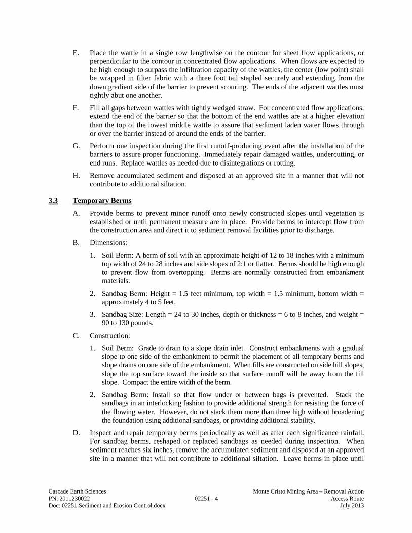
Cascade Earth Sciences Monte Cristo Mining Area – Removal Action PN: 2011230022 02251 - 4 Access Route Doc: 02251 Sediment and Erosion Control.docx July 2013
E. Place the wattle in a single row lengthwise on the contour for sheet flow applications, or perpendicular to the contour in concentrated flow applications. When flows are expected to be high enough to surpass the infiltration capacity of the wattles, the center (low point) shall be wrapped in filter fabric with a three foot tail stapled securely and extending from the down gradient side of the barrier to prevent scouring. The ends of the adjacent wattles must tightly abut one another.
F. Fill all gaps between wattles with tightly wedged straw. For concentrated flow applications, extend the end of the barrier so that the bottom of the end wattles are at a higher elevation than the top of the lowest middle wattle to assure that sediment laden water flows through or over the barrier instead of around the ends of the barrier.
G. Perform one inspection during the first runoff-producing event after the installation of the barriers to assure proper functioning. Immediately repair damaged wattles, undercutting, or end runs. Replace wattles as needed due to disintegrations or rotting.
H. Remove accumulated sediment and disposed at an approved site in a manner that will not contribute to additional siltation.
3.3 Temporary Berms
A. Provide berms to prevent minor runoff onto newly constructed slopes until vegetation is established or until permanent measure are in place. Provide berms to intercept flow from the construction area and direct it to sediment removal facilities prior to discharge.
B. Dimensions:
1. Soil Berm: A berm of soil with an approximate height of 12 to 18 inches with a minimum top width of 24 to 28 inches and side slopes of 2:1 or flatter. Berms should be high enough to prevent flow from overtopping. Berms are normally constructed from embankment materials.
2. Sandbag Berm: Height = 1.5 feet minimum, top width = 1.5 minimum, bottom width = approximately 4 to 5 feet.
3. Sandbag Size: Length = 24 to 30 inches, depth or thickness = 6 to 8 inches, and weight = 90 to 130 pounds.
C. Construction:
1. Soil Berm: Grade to drain to a slope drain inlet. Construct embankments with a gradual slope to one side of the embankment to permit the placement of all temporary berms and slope drains on one side of the embankment. When fills are constructed on side hill slopes, slope the top surface toward the inside so that surface runoff will be away from the fill slope. Compact the entire width of the berm.
2. Sandbag Berm: Install so that flow under or between bags is prevented. Stack the sandbags in an interlocking fashion to provide additional strength for resisting the force of the flowing water. However, do not stack them more than three high without broadening the foundation using additional sandbags, or providing additional stability.
D. Inspect and repair temporary berms periodically as well as after each significance rainfall. For sandbag berms, reshaped or replaced sandbags as needed during inspection. When sediment reaches six inches, remove the accumulated sediment and disposed at an approved site in a manner that will not contribute to additional siltation. Leave berms in place until

Cascade Earth Sciences Monte Cristo Mining Area – Removal Action PN: 2011230022 02251 - 5 Access Route Doc: 02251 Sediment and Erosion Control.docx July 2013
all upstream areas are stabilized and accumulated sediment has been removed. Remove sandbags by hand.
3.4 Sedimentation Basins
A. Provide sediment basins where physical site conditions or land ownership restrictions preclude the effective use of barrier-type erosion control measures. Provide sediment basins for disturbed areas of more than 10 acres within the same drainage basin or where operations expose critical areas to soil erosion.
B. Volume and Configuration of Basin:
1. Small Areas: Provide at least 65 cubic yards/acre of total drainage area.
2. Larger Areas: For areas greater than 10 acres within the same drainage basin provide at least 130 cubic yards/acre of total drainage area.
3. Baffles and Spillway: Install baffles or other deflectors to spread the flow throughout the basin. Install an emergency spillway and riser pipe(s).
4. Depth and Surface Area: Determine the surface area based on the Standard Drawing with a minimum of three feet of sediment storage and 3:1 side slopes
5. Approval: Submit design of the sediment basin and obtain ENGINEER’S approval prior to construction.
C. Construction Requirements:
1. Placement: Install the temporary sediment basin before clearing and grading is undertaken. Locate the dam to provide maximum volume capacity for sediment behind the structure. It should not be built within an active stream channel. Install fencing around the basin, as necessary to endure public safety.
2. Preparation: Prepare the dam site by clearing vegetation and removing topsoil before beginning dam construction. For areas under the embankment and any structural works, lea, grub, strip topsoil to remove all trees, vegetation, roots and other objectionable material. To facilitate clean out and restoration, clear the pool area of all brush, tress or other debris.
3. Spillway Bed: Level the bed for the pipe spillway to provide uniform support through its entire length under the dam.
4. Spillway: Construct an emergency spillway on undisturbed soil and not on fill. Line the spillway with four inches of concrete, reinforced with 6 inch x 6 inch, 6 inch x 6 inch diameter W1.4 each way wire mesh extending to a minimum of 36 inches down each face of the embankment. The spillway should be at lease 18 inches deep with 1:1:5 side slopes.
5. Piping: Secure all pipe joints and fasten watertight. Fasten the riser rigidly and securely to the barrel and seal watertight. Place the barrel on a firm foundation according to the lines and grades shown on the approved CONTRACT DOCUMENTS.
6. Backfill: Place at least 24 inches of hand-compacted backfill (maximum 6 inch lifts) over the pipe spillway before crossing it with construction equipment. Control the movement of the hauling and spreading equipment over the fill so that the entire surface of each lift will be traversed by not less than one tread tract of the equipment.
7. Discharge: The pipe spillway should discharge at ground elevation below the dam, and not more than 12 inches above any streambed.

Cascade Earth Sciences Monte Cristo Mining Area – Removal Action PN: 2011230022 02251 - 6 Access Route Doc: 02251 Sediment and Erosion Control.docx July 2013
8. Placement of Fill: Scarify areas on which fill is to be placed prior to placement of fill. Place fill materials in 6-inch maximum lifts, compacted by construction equipment. Provide continuous horizontal lifts over the entire length of the fill.
9. Stabilization: Stabilize the embankment and emergency spillway with vegetation or other stabilization measures.
D. Sediment basins should be readily accessible for maintenance and sediment removal. Inspect after each rainfall and clean out when half the available sediment storage volume has been filled with sediment. Dispose of removed sediment and stabilize in an approved location such that sediment does not re-enter waters. Sediment may not be dumped into any water of the U.S without appropriate permitting.
E. Operate and maintain the sediment basin until the drainage area is permanently stabilized by vegetation or other permanent controls.
3.5 Silt Fence Barriers
A. Provide silt fences near the perimeter of a disturbed area to intercept sediment while allowing water to percolate through.
B. Provide silt fences along the toe of fills, on the downhill side of large through-cut areas, along streams, at natural drainage areas and above interceptor dikes and as indicated in the CONTRACT DOCUMENTS.
C. Construct the silt fence after cutting and slashing of trees and before excavating haul roads, fill benches, or any soil disturbing construction activity in the drainage areas.
D. The silt fences must remain in place until the disturbed areas are permanently stabilized.
E. Configuration:
1. Maximum Drainage Area: 0.25 acres/100 feet of fence length.
2. Maximum Fence Length: 300 feet for 100-foot slope length.
3. Maximum Slope Length (Upstream Drainage Distance) to Fence: a. 100 feet for slopes flatter than 5:1. b. 15 feet for slopes steeper than 2:1.
4. Maximum Slope Steepness Above Fence: 1:1 grade.
5. Minimum Toe-in Depth: 6 inches.
6. Post Spacing: a. With wire support fence – 10 feet maximum. b. Without wire fence – 6 feet maximum.
7. Post Depth (Below Ground Surface): 18 inches minimum.
8. Undisturbed Buffer Zone: 3 feet minimum between fence and surface waters.
F. Construction Requirements:
1. Maximum Height of the Filter Fence: Between 1.5 feet and 3 feet above the ground surface (depending on the amount of upslope ponding expected).

Cascade Earth Sciences Monte Cristo Mining Area – Removal Action PN: 2011230022 02251 - 7 Access Route Doc: 02251 Sediment and Erosion Control.docx July 2013
2. Post Spacing: 10 feet apart when a wire mesh support fence is used and no more than 6 feet apart when using extra-strength filter fabric (without a wire fence). The posts should extend at least 18 inches into the ground.
3. Trench: Excavate a trench about 6 inches wide and 4 to 12 inches deep along the upslope side of the line of posts.
4. Fastening: If standard strength filter fabric is to be used, fasten the optional wire mesh support fence to the upslope side of the posts using heavy duty wire staples, tie wires, or hog rings. Extend the wire mesh support to the bottom of the trench.
5. Extra Strength Filter Fabric: Does not require a wire mesh support fence. Staple or wire the filter fabric directly to the posts and extend 8 to 18 inches of the fabric into the trench.
6. Trees: Do not attach filter fabric to trees.
7. Joints: Splice fabric together only at a support post, with a minimum 6 inches overlap, and securely seal the joint.
8. Backfill: Backfill the trench with compacted soil or ¾ inch minimum diameter gravel placed over the filter fabric.
G. Inspect silt fences periodically for damage (such as tearing by wind, animals, or equipment) and for the amount of sediment, which has accumulated. Remove the sediment when it reaches one-half the height of the silt fence. In situations where access is available, machinery can be used. Otherwise, the silt must be removed manually.
H. Remove sediment deposits when heavy rain or high water is anticipated. Place the sediment deposits in an area where there is little danger of erosion.
3.6 Culvert Risers
A. Provide risers at culvert inlet that receive runoff from upstream construction sites or from other erodible areas at indicated on the DRAWINGS. Do not use for drainage areas larger than a 1.25 acres.
B. Determine the volume of the water storage for the culvert riser based on the total drainage area upstream in accordance with the specifications for Sediment Basins. Ensure water impoundment will not extend to private property unless authorized in writing by the property owner.
C. Install the culvert riser according to the CONTRACT DOCUMENTS. Fasten the riser pipe rigidly and securely to the culvert barrel. Seal the joint so that it is watertight.
D. Inspect the rise periodically and following runoff-producing storms. Remove accumulated sediments to restore the design capacity of the sediment deposit area. Dispose of sediment where they are not likely to reenter stream flow or surface runoff.
E. Remove culvert risers after permanent erosion control measure are in place.
END OF SECTION

Cascade Earth Sciences Monte Cristo Mining Area – Removal Action PN: 2011230022 02255 - 1 Access Route Doc: 02255 Armored Fords.docx July 2013
DIVISION 02
SECTION 02255
ARMORED FORDS Section 02255, which is not a Standard Specification, is included in this Project by Special Provision.
PART 1 - GENERAL
1.1 Description
Complete armored crossings at sites designated in the DRAWINGS to pass ephemeral streams. Armored fords will be completed at the following locations:
Stream Crossing Station Work Area Crossing Designation
84 + 70 New Access Route Armored Ford Armored Ford #1 99 + 70 Python Logging Road Armored Ford Armored Ford #2 148 + 00 New Access Route Armored Ford Armored Ford #3 N/A County Road Upgrade Armored Ford Repair Site 2 N/A County Road Upgrade Armored Ford Repair Site 7
PART 2 - PRODUCTS (NOT APPLICABLE)
PART 3 - EXECUTION
3.1 Installation
Utilize locally available rock from the approved borrow source, located approximately one mile southeasterly from the south of Haps Hill along the existing Monte Cristo (County) Road. Size rock appropriately as specified by the ENGINEER. Rock used for this work shall be durable, angular, quarry stones, which are sound, hard, and free from laminations, fractures, or other structural defects. They shall be of such quality that they will not disintegrate on exposure to water or weathering. Use a minimum of 100 cubic yards of riprap through the access route prism at each crossing, unless otherwise directed by the ENGINEER. Construct the armored ford ensuring it is deep enough with the rock placement to accommodate increased storm flows.
END OF SECTION

Cascade Earth Sciences Monte Cristo Mining Area – Removal Action PN: 2011230022 02801 - 1 Access Route Doc: 02801 Seeding and Mulching.docx July 2013
DIVISION 02
SECTION 02801
SEEDING AND MULCHING
PART 1 - GENERAL
1.1 Description
This item shall consist of broadcast seeding designated areas using seed mixtures provided by the Forest Service. The areas to be seeded shall be all cut slopes, fill slopes and other disturbed areas.
PART 2 - PRODUCTS
2.1 Seed
The seed mix shall be supplied by the Forest Service
2.2 Mulch
Mulch shall consist of materials salvaged from clearing (shredded), 100% agricultural straw certified as weed free, or Woodstraw™.
PART 3 - EXECUTION
3.1 General
The specified seed mixture shall be uniformly spread on the designated areas to the density in pounds of live seed per acre as specified. Each area or suitable section of the area to be seeded shall be seeded in the fall or as directed by the ENGINEER. Seeding shall be done before the ground has become packed or hardened. No seeding shall be done during windy weather or when the ground is excessively wet or deeply frozen.
3.2 Preparation of Seeding Area
Cut slopes, fill slopes, embankments or other areas to be seeded shall be shaped and finished as specified under the Sections involved. The area, where necessary, shall be worked such that the surface is loose to a depth of at least one inch. Each area shall be approved for seeding by the ENGINEER before seed is applied.
3.3 Seeding and Mulching
The seed or seed mixtures shall be accurately proportioned as stipulated and thoroughly mixed. They shall be remixed as necessary so that a uniform mixture will result as each loading of the seeder is made. Seed shall be applied with a rotary hand seeder or other approved type

Cascade Earth Sciences Monte Cristo Mining Area – Removal Action PN: 2011230022 02801 - 2 Access Route Doc: 02801 Seeding and Mulching.docx July 2013
commercial seeder or by an agreed upon method. All portions of the area shall be uniformly covered to the required density. Seeding shall be by Method (b) Dry Method. Mulch straw be applied at a depth of two to four inches using certified weed-free straw, or or Woodstraw™ will be applied according to manufacturer’s recommendations, except for areas located in shady areas, in which case mulching is not required. The Contractor shall install mulch on the embankment slopes and other exposed areas when they are finished and after seeding. All mulched areas will be thoroughly wetted following application. Mulching shall be by Method (b) Dry Method
3.4 Maintenance of Seeded Area
The CONTRACTOR will not be required to maintain an area which has been satisfactorily seeded except that he shall protect the area against traffic by warning signs or barricades or other methods approved by the ENGINEER. When a seeded area has become damaged by storm or otherwise prior to final acceptance of the project, the ENGINEER may order the area reworked. The damage shall then be repaired as directed and the area reseeded.
END OF SECTION

Cascade Earth Sciences Monte Cristo Mining Area – Removal Action PN: 2011230022 13002 - 1 Access Route Doc: 13002 Earthwork Geotextiles.docx July 2013
DIVISION 13
SECTION 13002
EARTHWORK GEOTEXTILES
PART 1 - GENERAL
1.1 Scope
This specification covers the technical requirements for the Manufacturing and Installation of the nonwoven geotextile. All materials shall meet or exceed the requirements of this specification, and all work will be performed in accordance with the procedures provided in these project specifications.
1.2 References
American Society for Testing and Materials (ASTM)
• ASTM D 5261, Standard Test Method for Measuring Mass per Unit Area of Geotextiles
• ASTM D 4632, Standard Test Method for Grab Breaking Load and Elongation of Geotextiles
• ASTM D 4533, Standard Test Method for Index Trapezoidal Tearing Strength of Geotextiles
• ASTM D 4833, Standard Test Method for Index Puncture Resistance of Geotextiles, Geomembranes and Related Products
• ASTM D 4491, Standard Test Method for Water Permeability of Geotextiles by Permittivity
• ASTM D 4751, Standard Test Method for Determining Apparent Opening Size of a Geotextile
• ASTM D 4354, Standard Practice for Sampling of Geosynthetics for Testing
• ASTM D 4759, Standard Practice for Determining the Specifications Conformance of Geosynthetics
1.3 Submittals
A. Prior to material delivery to project site, the CONTRACTOR shall provide the ENGINEER with a written certification or manufacturers quality control data which displays that the geotextile meets or exceeds minimum average roll values (MARV) specified herein.
B. The CONTRACTOR shall submit, if required by the ENGINEER, manufacturer’s quality control manual for the geotextile to be delivered to the site.

Cascade Earth Sciences Monte Cristo Mining Area – Removal Action PN: 2011230022 13002 - 2 Access Route Doc: 13002 Earthwork Geotextiles.docx July 2013
PART 2 - 2.0 PART II - PRODUCT
2.1 Geotextile
A. The non-woven needle punched geotextile specified herein shall be made from polypropylene staple fiber.
B. The geotextile shall be manufactured from prime quality virgin polymer.
C. The geotextile shall be able to withstand direct exposure to ultraviolet radiation from Sun for up to 30 days without any noticeable effect on index or performance properties.
D. Geotextile shall meet or exceed all material properties listed in Table 1.
Recommended Geotextile Fabric Specifications
Property Unit Minimum Average Roll Value (MARV)
Grab Tensile Strength (ASTM D 4632) Lbs. 300 Trapezoidal Tear Strength (ASTM D 4533) Lbs. 115 Puncture Resistance (ASTM D 6241) Lbs. 800 Apparent Opening Size (AOS) U.S. Sieve U.S. No. 30 max Permittivity (ASTM D 4491) Sec-1 0.02 min UV Resistance (ASTM D 4355) % Strength Retained 70%
2.2 Manufacture
All rolls of the geotextile shall be identified with permanent marking on the roll or packaging, with the manufacturers name, product identification, roll number and roll dimensions. Geotextile shall be Mirafi 1120N 12 oz. non-woven fabric or approved equal.
2.3 Transport
A. Transportation of the geotextile shall be the responsibility of the CONTRACTOR.
B. During shipment, the geotextile shall be protected from ultraviolet light exposure, precipitation, mud, dirt, dust, puncture, or other damaging or deleterious conditions.
C. Upon delivery at the job site, the CONTRACTOR shall ensure that the geotextile rolls are handled and stored in accordance with the manufacturer’s instructions as to prevent damage.
PART 3 - EXECUTION
3.1 Quality Assurance
A. The ENGINEER shall examine the geotextile rolls upon delivery to the site and report any deviations from project specifications to the CONTRACTOR.
B. The ENGINEER may decide to arrange conformance testing of the rolls delivered to the job site. For this purpose, the ENGINEER shall take a sample three feet (along roll length) by

Cascade Earth Sciences Monte Cristo Mining Area – Removal Action PN: 2011230022 13002 - 3 Access Route Doc: 13002 Earthwork Geotextiles.docx July 2013
roll width according to ASTM Practice D 4354 The sample shall be properly marked, wrapped and sent to an independent laboratory for conformance testing.
C. The pass or fail of the conformance test results shall be determined according to ASTM Practice D 4759.
3.2 Installation
A. The geotextile shall be handled in such a manner as to ensure that it is not damaged in any way. Should the CONTRACTOR damage the geotextile to the extent that it is no longer usable as determined by these specifications or by the ENGINEER, the CONTRACTOR shall replace the geotextile at his own cost.
B. The geotextile shall be installed to the lines and grades as shown on the contract drawings and as described herein.
C. The geotextile shall be rolled down the slope in such a manner as to continuously keep the geotextile in tension by self-weight. The geotextile shall be securely anchored in an anchor trench where applicable, or by other approved or specified methods.
D. In the presence of wind, all geotextiles shall be weighted by sandbags or approved equivalent. Such anchors shall be installed during placement and shall remain in place until replaced with cover material.
E. The CONTRACTOR shall take necessary precautions to prevent damage to adjacent or underlying materials during placement of the geotextile. Should damage to such material occur due to the fault of the CONTRACTOR, the latter shall repair the damaged materials at his own cost and to the satisfaction of the ENGINEER.
F. During placement of the geotextile, care shall be taken not to entrap soil, stones or excessive moisture that could hamper subsequent seaming of the geotextile as judged by the ENGINEER.
G. The geotextile shall not be exposed to precipitation prior to being installed and shall not be exposed to direct Sun light for more than 15 days after installation.
H. The geotextile shall be seamed using heat seaming or stitching methods as recommended by the manufacturer and approved by the ENGINEER. Sewn seams shall be made using polymeric thread with chemical resistance equal to or exceeding that of the geotextile. All sewn seams shall be continuous. Seams shall be oriented down slopes perpendicular to grading contours unless otherwise specified. For heat seaming, fusion welding techniques recommended by the manufacturer shall be used.
I. The CONTRACTOR shall not use heavy equipment to traffic above the geotextile without approved protection.
J. The geotextile shall be covered as soon as possible after installation and approval. Installed geotextile shall not be left exposed for more than 15 days.
K. Material overlying the geotextile shall be carefully placed to avoid wrinkling or damage to the geotextile.
END OF SECTION

Cascade Earth Sciences Monte Cristo Mining Area – Removal Action PN: 2011230022 15050 - 1 Access Route Doc: 15050 Pipe and Fittings.docx July 2013
DIVISION 15
SECTION 15050
PIPE AND FITTINGS
PART 1 - GENERAL
1.1 General
A. Scope: The CONTRACTOR shall furnish and install pipe, fittings and related items, complete as specified herein and as indicated on the DRAWINGS. Special pipe, fittings or installation requirements may be specified with the particular equipment involved.
B. DRAWINGS: The DRAWINGS indicated the general arrangement of pipe, fixtures, etc. It is desired that the indicated positions be followed as closely as possible. The exact location of the various items is subject to building construction and the actual equipment furnished by the CONTRACTOR. The CONTRACTOR shall verify the location of all items furnished, installed or connected by him.
PART 2 - PRODUCTS
2.1 Pipe Materials
A. General: All pipe and fittings shall be of the type and size indicated on the DRAWINGS. The culvert pipe, as shown on the DRAWINGS, shall be 18” HDPE.
B. HDPE Pipe:
1. High Density Polyethylene (HDPE) dual wall pipe shall be ADS N-12 pipe, meeting or exceeding ASTM F2736 and AASHTO MP-21.
2. Bolts and nuts used at buried joints shall be of materials suitable to resist corrosion by outside media, and electrolytically compatible with the flange unit to which the HDPE pipe may be connected, or alternatively, the nuts and bolts shall be insulated from the same.
3. HDPE pipe connected to heavy fittings, valves, and rigid structures shall be supported in such a manner that no subsequent relative movement between the HDPE pipe at the flanged joint and rigid structure is possible.
2.2 Joints
A. Culvert installations with lengths longer than the 20 ft. manufactured length of the pipe shall utilize the gasketed bell ends for all joints. Pipe joints shall utilize the reinforced bell with polymer composite band and dual gaskets.
PART 3 - EXECUTION (NOT APPLICABLE)
END OF SECTION

Monte Cristo Road Special Project Specifications Section 206 Structural Excavation for Major Structures 206.12 Method. Delete paragraph (a) and replace with the following paragraph:
(a) Material excavated outside vertical planes located 1 foot outside and parallel to the neat lines of footings or foundations. Use these vertical planes to determine pay quantities, regardless of the amount of material excavated inside or outside these planes.
Delete the paragraph that begins "Measure structural backfill…" and replace with the following paragraph: Measure structural backfill, and structural backfill for walls, by the cubic yard in place. Limit the volume of structural backfill measured to that placed inside vertical planes located 1 foot outside and parallel to the neat lines of footings or foundations. Use these vertical planes to determine pay quantities, regardless of the amount of backfill material placed outside these planes. Section 251 - Riprap 251.02 Requirements. The row beginning "Geotextile…" is replaced with the following:
Rirpap Geotextile, Type 2 ....................................................................................714.01 The following is added to the end of this subsection: Furnish woven or non-woven geotextile, at the Contractor's option. 251.13 Basis. Pay Item 251 (13) is replaced with the following Pay Item:
251 (13) Riprap geotextile, type ___ ......................................................... Square Yard The follow is added after the list of Pay Items: Payment for excavation required to place riprap will be included in payment for the item "Structural excavation" under Section 206. Section 553A – Precast Concrete Structures 553A.02 Requirements. Furnish preformed expansion joint filler conforming to AASHTO M213 for separation of precast footings and backwalls.

Section 559 - Log Bridges 559.03 Logs. Log stringers for bridges will be furnished by the Prime Contractor at the Mowich Camp staging area. Contact the Prime Contractor's Authorized Representative not less than 14 days prior to intended use of log stringers to coordinate delivery. Unloading stringers at the staging area, transporting them to their sites of intended use and unloading will be the responsibility of the Bridge Contractor. Section 714 - Geotextile, Geocomposite Drain Material, & Geogrids 714.01 Geotextiles. The following row is added to subsection (a) Physical Requirements:
(7) Riprap geotextile ................................................................................... Table 714-7 The following table is added after Table 714-6:
Table 714-7 Geotextile Property Values for Riprap Geotextile *
Geotextile Property ASTM Test Method Units
Geotextile Property Requirements
Type 1 Type 2
Woven Nonwoven Woven Nonwoven
Grab Tensile Strength (minimum) Machine and Cross Machine Directions
D 4632 lb 250 160 315 200
Grab Failure Strain (minimum) Machine and Cross Machine Directions
D 4632 % < 50 ≥ 50 < 50 ≥ 50
Tear Strength (minimum) D 4533 lb 90 56 110 80
Puncture Strength (minimum) D 6241 lb 495 310 620 430
Apparent Opening Size (AOS) (maximum) U.S. Standard Sieve
D 4751 — 40 40 40 40
Permittivity (minimum) D 4491 sec-1 0.5 0.5 0.5 0.5
Ultraviolet Stability Retained Strength (minimum)
D 4355 (at 500 hours) % 70 70 70 70
* Woven slit film geotextiles (geotextiles that are made from yarns of a flat, tape-like character) are not acceptable.


