2013 02 06 Kenfig - Cynffig SAC Management Plan Eng SAC... · the two main SAC features represented...
48
CYNGOR CEFN GWLAD CYMRU COUNTRYSIDE COUNCIL FOR WALES CORE MANAGEMENT PLAN (INCLUDING CONSERVATION OBJECTIVES) FOR Kenfig/Cynffig SAC Date: 9 th April 2008 (Minor map edit, February 2013) Approved by: David Mitchell More detailed maps of management units can be provided on request. A Welsh version of all or part of this document can be made available on request.
Transcript of 2013 02 06 Kenfig - Cynffig SAC Management Plan Eng SAC... · the two main SAC features represented...
CYNGOR CEFN GWLAD CYMRU COUNTRYSIDE COUNCIL FOR WALES
CORE MANAGEMENT PLAN (INCLUDING CONSERVATION OBJECTIVES)
FOR
Kenfig/Cynffig SAC
Date: 9th April 2008 (Minor map edit, February 2013) Approved by: David Mitchell More detailed maps of management units can be provided on request. A Welsh version of all or part of this document can be made available on request.
2
CONTENTS PREFACE: Purpose of this document 1. VISION FOR THE SITE 2. SITE DESCRIPTION
2.1 Area and Designations Covered by this Plan 2.2 Outline Description 2.3 Outline of Past and Current Management 2.4 Management Units
3. The Special Features
3.1 Confirmation of Special Features 3.2 Special Features and Management Units
4. Conservation Objectives Background to Conservation Objectives 4.1 Conservation Objective for Feature 1:
2170 Dunes with Salix repens ssp. argentea (Salicion arenariae) &
Conservation Objective for Feature 2: 2190 Humid dune slacks
4.2 Conservation Objective for Feature 2:
2130 Fixed dunes with herbaceous vegetation (`grey dunes`) 4.3 Conservation Objective for Feature 4:
3140 Hard oligo-mesotrophic waters with benthic vegetation of Chara spp. 4.4 Conservation objective for Feature 5:
1330 Atlantic salt meadows (Glauco-Puccinellietalia maritimae) 4.5 Conservation Objective for feature 6: 1395 Petalwort Petalophyllum ralfsii 4.6 Conservation Objective for feature 7: 1903 Fen orchid Liparis loeselii 5. Assessment of Conservation Status and Management Requirements:
5.1 Conservation Status and Management Requirements of Feature 1: 2170 Dunes with Salix repens ssp. argentea (Salicion arenariae) Conservation Status and Management Requirements of Feature 2: 2190 Humid dune slacks
5.2 Conservation Status and Management Requirements of Feature 3:
2130 Fixed dunes with herbaceous vegetation (`grey dunes`) 5.3 Conservation Status and Management Requirements of Feature 4:
3140 Hard oligo-mesotrophic waters with benthic vegetation of Chara spp. 5.4 Conservation Status and Management Requirements of Feature 5:

3
1330 Atlantic salt meadows (Glauco-Puccinellietalia maritimae) 5.5 Conservation Status and Management Requirements of Feature 6:
1395 Petalwort Petalophyllum ralfsii 5.6 Conservation Status and Management Requirements of Feature 7:
1903 Fen orchid Liparis loeselii
6. Action Plan: Summary 7. Glossary 8. References and Annexes

4
PREFACE This document provides the main elements of the CCW’s management plan for the site named. It sets out what needs to be achieved on the site, the results of monitoring and advice on the action required. This document is made available through the CCW’s web site and may be revised in response to changing circumstances or new information. This is a technical document that supplements summary information on the web site. One of the key functions of this document is to provide the CCW’s statement of the Conservation Objectives for the relevant Natura 2000 site. This is required to implement the Conservation (Natural Habitats, &c.) Regulations 1994, as amended (Section 4). As a matter of Welsh Assembly Government Policy, the provisions of those regulations are also to be applied to Ramsar sites in Wales.
5
1. VISION FOR THE SITE
This is a descriptive overview of what needs to be achieved for conservation on the site. It brings together and summarises the Conservation Objectives (part 4) into a single, integrated statement about the site. The overall aim for the SAC is that the natural coastal and dune-forming processes that determine the dynamics and proportions of habitats at Kenfig should be allowed to continue. Existing habitats should be maintained where possible by management of factors within human control. Approximately 57% of the site comprises sand dunes, supporting a broad range of plant community types. Natural processes largely govern the area of the dunes, which grade from shifting embryonic dunes with an abundance of bare sand (between a quarter and a half of the dune area), to a more fixed stable dune community. This range of communities, with a high proportion of sparsely vegetated and open dune slacks or wet hollows, should be maintained or increased. The condition of these habitats is dependant on a number of factors including the nutrient state of the aquatic system and quantity of water, as well as the management regime. Although salt marsh makes up less than 2% of the site, this habitat is rare along the Glamorgan coast. Here it includes plant species such as sea heath and samphire (Salicornia spp.). Natural processes, largely determine the area of the salt marsh but where possible the area should be maintained or increased. Nationally rare and scarce plants, such as petalwort and fen orchid, which are associated with the dunes, should not reduce in range within their habitats, or lose the ability to reproduce and sustain themselves through factors within human control. Populations of other national and local rarities such as rough stonewort, hair-like pondweed, Irish ruffwort, chalk hook-moss, variegated horsetail, maiden pink, sea stock, rock sea-lavender, round-leaved wintergreen and dune fescue should also be maintained. Populations of rare invertebrates including shrill carder bee, grizzled skipper and small blue butterflies, medicinal leech, strandline beetle (Eurynebria complanata) and the weevils Pachytychius quinquepunctatus, Glocianus pilosellus should be maintained. The site should also support a diverse invertebrate assemblage such as solitary wasps, stiletto flies, robber flies and mining bees, which are associated with the range of sand dune habitats present. The site should also support nationally and locally rare fungi, associated with the sand dune habitats, including the nail fungus Poronia punctata, the ink cap fungus Coprinus ammophilae, the stalked puffball Tulostoma brumale and the milk-cap fungus Lactarius controversus, as well as a diverse assemblage of other macrofungi. Several nationally important and species rich intertidal communities are found within the coastal front of the SAC, such as rock pools, soft piddock bored substrata and sand influenced biogenic reefs, including honeycomb worm Sabellaria reefs. The inter-tidal communities should remain mainly undisturbed, with sustainable populations maintained by maritime influences, and tidal movement. Management of the site should promote the natural diversity of the sand dune and salt marsh habitats. Due to the nature of the site this will involve clearance of scrub, as natural seral progression would otherwise result in the dune system becoming dominated by scrub and woodland. In the case of the Merthyr Mawr section, this will include control of sea buckthorn.

6
Kenfig pool is a fine example of a moderately nutrient rich lake with a rich bottom-growing flora of stoneworts. This habitat type is characterised by water with a high base content usually confined to areas of limestone and other base-rich substrates from which the dissolved minerals are derived. Such water bodies are characterised by very clear water and low nutrient status. They are therefore largely restricted to situations where the catchment or aquifer from which they are supplied with water remains relatively unaffected by intensive land-use or other sources of nutrients, and they are most often found in areas supporting mosaics of semi-natural vegetation. The stoneworts are the most prominent component of the vegetation at Kenfig Pool and they occur as dense beds that cover a significant part of the lake bottom over sandy and muddy marl deposits. Kenfig Pool contains a number of rare and local stonewort species. This element of the site may need to be managed to ensure the nutrient state of the lake is maintained and that there are no detrimental impacts from existing or future management activities.
7
2. SITE DESCRIPTION
2.1 Area and Designations Covered by this Plan
Grid references: Eastings and Northings 279070, 181910 (Kenfig centre of site) 286280, 176890 (Merthyr Mawr centre) Unitary authorities: Bridgend County Borough Council Vale of Glamorgan Neath and Port Talbot Area (hectares): 1191.67 Designations covered: SAC consisting of 2 separate SSSI. 2 National Nature Reserves (NNR), a Local Nature Reserve (LNR), and a proposed LNR: Kenfig/Cynffig SSSI Kenfig Pool and Dunes NNR Kenfig Pool and Dunes LNR Merthyr Mawr SSSI Merthyr Mawr Warren NNR Newton Burrows LNR (proposed)
Detailed maps of the designated sites are available on the web site. http://www.ccw.gov.uk/interactive-maps/protected-areas-map.aspx
2.2 Outline Description
This plan covers the Kenfig SAC, which consists of two SSSI (Cynffig/Kenfig and Merthyr Mawr).
2.3 Outline of Past and Current Management
Natural succession to mature habitats within the dune systems can be detrimental to the plant communities of the dune grassland and humid dune slacks, including species of early successional habitats such as Liparis loeselii and Petalophyllum ralfsii. Kenfig and Merthyr Mawr have a long history of human land use, including grazing, aggregate extraction and military training, although the latter activities ceased a long time ago. Offshore aggregate extraction continues to the present day. Both component parts of the SAC are National Nature Reserves and therefore used as a public open space, with recreational activities including walking, fishing and horse riding, which can impact on management. Livestock grazing at Kenfig was practised under a commons type regime during the period of medieval township, and rabbits were present from the 13th Century onwards, although myxamatosis and viral haemorrhagic disease later reduced the population. In recent years Kenfig Pool and Dunes NNR has predominantly been grazed by sheep, although cattle have been re-introduced to part of the site in the last few years. The grazing as a whole is currently under review. Selected dune slacks are mown to provide appropriate conditions for maintenance of these particular habitats. Other management takes place to encourage rabbit grazing; this includes mowing and burrow creation on drier areas adjacent to dune slacks. Overall, Kenfig is similar to many dune systems in the UK in that it has become over-stabilised and is losing much of the successionally young habitat types. There has been some management to restore this habitat, with the creation of three ‘scrapes’ in dune slacks adjacent
8
to those containing L. loeselii and P. ralfsii populations, where the vegetation was taken back to bare sand. At Merthyr Mawr NNR, the main focus of ongoing management is control of Hippophae rhamnoides, which is an introduced species here, and scrub. This management will benefit the two main SAC features represented on this component of the site - dune grassland and P. ralfsii. Merthyr Mawr is currently grazed by rabbits, with cattle also grazing on part of the site. It is thought that the dune slacks at Kenfig and Merthyr Mawr as well as Kenfig Pool are mainly fed by groundwater, and possibly a deep Carboniferous Limestone aquifer (Davidson & Appleby, 2003). There are also three small ephemeral streams that enter Kenfig Pool. Maintenance of the natural hydrological regime of both dune systems is critical for the maintenance of the character, composition and condition of the features.
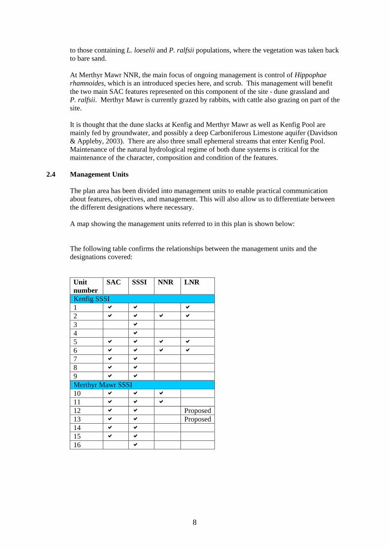
2.4 Management Units
The plan area has been divided into management units to enable practical communication about features, objectives, and management. This will also allow us to differentiate between the different designations where necessary. A map showing the management units referred to in this plan is shown below: The following table confirms the relationships between the management units and the designations covered:
Unit number
SAC SSSI NNR LNR
Kenfig SSSI 1 a a a 2 a a a a 3 a 4 a 5 a a a a 6 a a a a 7 a a 8 a a 9 a a Merthyr Mawr SSSI 10 a a a 11 a a a 12 a a Proposed 13 a a Proposed 14 a a 15 a a 16 a
9
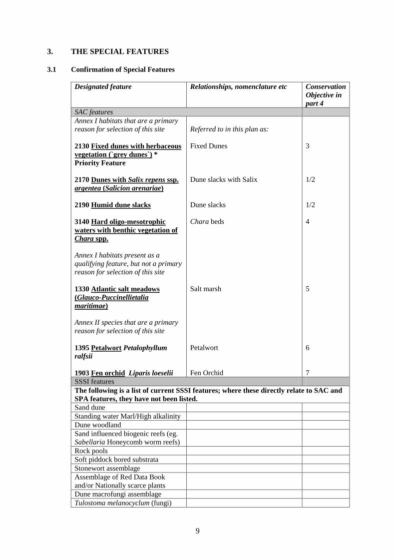
3. THE SPECIAL FEATURES 3.1 Confirmation of Special Features
Designated feature Relationships, nomenclature etc Conservation Objective in part 4
SAC features Annex I habitats that are a primary reason for selection of this site 2130 Fixed dunes with herbaceous vegetation (`grey dunes`) * Priority Feature 2170 Dunes with Salix repens ssp. argentea (Salicion arenariae) 2190 Humid dune slacks
3140 Hard oligo-mesotrophic waters with benthic vegetation of Chara spp.
Annex I habitats present as a qualifying feature, but not a primary reason for selection of this site 1330 Atlantic salt meadows (Glauco-Puccinellietalia maritimae) Annex II species that are a primary reason for selection of this site 1395 Petalwort Petalophyllum ralfsii 1903 Fen orchid Liparis loeselii
Referred to in this plan as: Fixed Dunes Dune slacks with Salix Dune slacks Chara beds Salt marsh Petalwort Fen Orchid
3 1/2 1/2 4 5 6 7
SSSI features The following is a list of current SSSI features; where these directly relate to SAC and SPA features, they have not been listed. Sand dune Standing water Marl/High alkalinity Dune woodland Sand influenced biogenic reefs (eg. Sabellaria Honeycomb worm reefs)
Rock pools Soft piddock bored substrata Stonewort assemblage Assemblage of Red Data Book and/or Nationally scarce plants
Dune macrofungi assemblage Tulostoma melanocyclum (fungi)
10
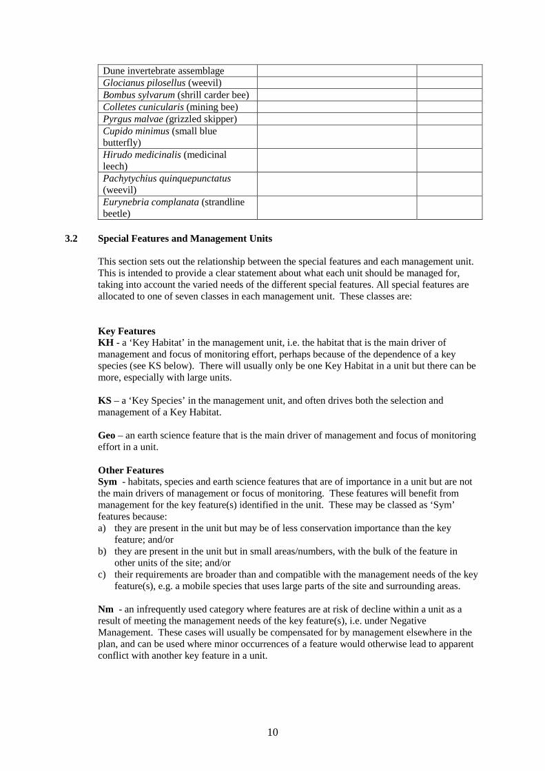
Dune invertebrate assemblage Glocianus pilosellus (weevil) Bombus sylvarum (shrill carder bee) Colletes cunicularis (mining bee) Pyrgus malvae (grizzled skipper) Cupido minimus (small blue butterfly)
Hirudo medicinalis (medicinal leech)
Pachytychius quinquepunctatus (weevil)
Eurynebria complanata (strandline beetle)
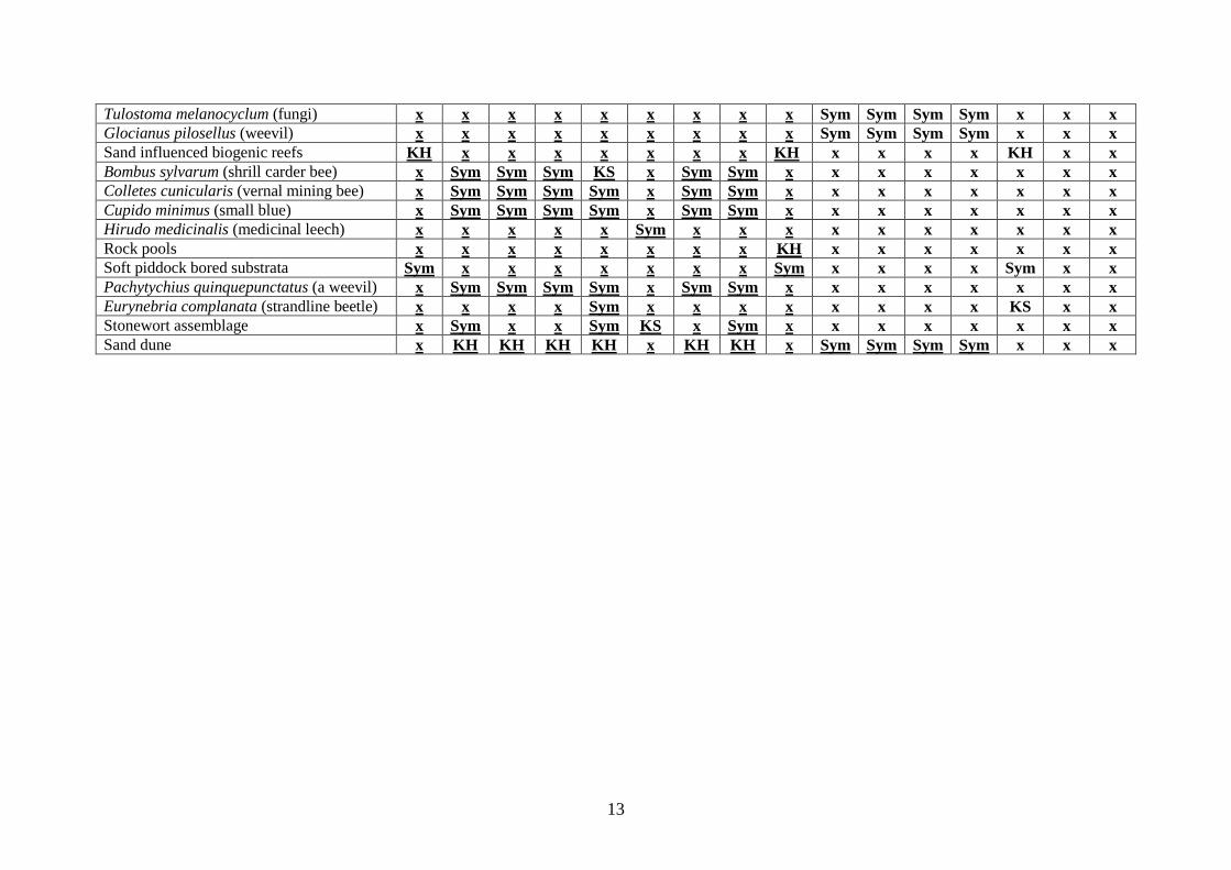
3.2 Special Features and Management Units
This section sets out the relationship between the special features and each management unit. This is intended to provide a clear statement about what each unit should be managed for, taking into account the varied needs of the different special features. All special features are allocated to one of seven classes in each management unit. These classes are:
Key Features KH - a ‘Key Habitat’ in the management unit, i.e. the habitat that is the main driver of management and focus of monitoring effort, perhaps because of the dependence of a key species (see KS below). There will usually only be one Key Habitat in a unit but there can be more, especially with large units. KS – a ‘Key Species’ in the management unit, and often drives both the selection and management of a Key Habitat. Geo – an earth science feature that is the main driver of management and focus of monitoring effort in a unit. Other Features Sym - habitats, species and earth science features that are of importance in a unit but are not the main drivers of management or focus of monitoring. These features will benefit from management for the key feature(s) identified in the unit. These may be classed as ‘Sym’ features because: a) they are present in the unit but may be of less conservation importance than the key
feature; and/or b) they are present in the unit but in small areas/numbers, with the bulk of the feature in
other units of the site; and/or c) their requirements are broader than and compatible with the management needs of the key
feature(s), e.g. a mobile species that uses large parts of the site and surrounding areas. Nm - an infrequently used category where features are at risk of decline within a unit as a result of meeting the management needs of the key feature(s), i.e. under Negative Management. These cases will usually be compensated for by management elsewhere in the plan, and can be used where minor occurrences of a feature would otherwise lead to apparent conflict with another key feature in a unit.

11
Mn - Management units that are essential for the management of features elsewhere on a site e.g. livestock over-wintering area included within designation boundaries, buffer zones around water bodies, etc. x – Features not known to be present in the management unit. The tables below sets out the relationship between the special features and management units identified in this plan:
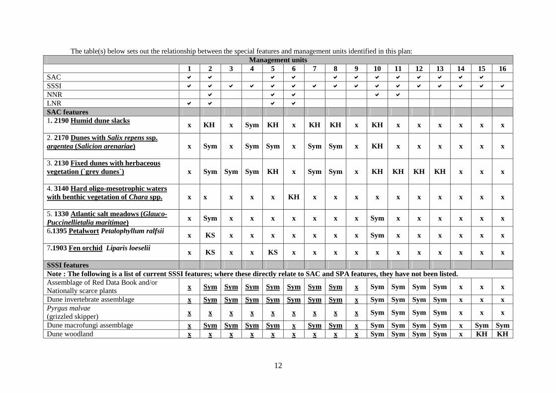
12
The table(s) below sets out the relationship between the special features and management units identified in this plan: Management units
1 2 3 4 5 6 7 8 9 10 11 12 13 14 15 16 SAC a a a a a a a a a a a a SSSI a a a a a a a a a a a a a a a a NNR a a a a a LNR a a a a SAC features 1. 2190 Humid dune slacks x KH x Sym KH x KH KH x KH x x x x x x
2. 2170 Dunes with Salix repens ssp. argentea (Salicion arenariae)
x Sym x Sym Sym x Sym Sym x KH x x x x x x
3. 2130 Fixed dunes with herbaceous vegetation (`grey dunes`)
x Sym Sym Sym KH x Sym Sym x KH KH KH KH x x x
4. 3140 Hard oligo-mesotrophic waters with benthic vegetation of Chara spp.
x x x x x KH x x x x x x x x x x
5. 1330 Atlantic salt meadows (Glauco-Puccinellietalia maritimae) x Sym x x x x x x x Sym x x x x x x
6.1395 Petalwort Petalophyllum ralfsii x KS x x x x x x x Sym x x x x x x
7.1903 Fen orchid Liparis loeselii x KS x x KS x x x x x x x x x x x
SSSI features Note : The following is a list of current SSSI features; where these directly relate to SAC and SPA features, they have not been listed. Assemblage of Red Data Book and/or Nationally scarce plants x Sym Sym Sym Sym Sym Sym Sym x Sym Sym Sym Sym x x x
Dune invertebrate assemblage x Sym Sym Sym Sym Sym Sym Sym x Sym Sym Sym Sym x x x Pyrgus malvae (grizzled skipper) x x x x x x x x x Sym Sym Sym Sym x x x
Dune macrofungi assemblage x Sym Sym Sym Sym x Sym Sym x Sym Sym Sym Sym x Sym Sym Dune woodland x x x x x x x x x Sym Sym Sym Sym x KH KH
13
Tulostoma melanocyclum (fungi) x x x x x x x x x Sym Sym Sym Sym x x x Glocianus pilosellus (weevil) x x x x x x x x x Sym Sym Sym Sym x x x Sand influenced biogenic reefs KH x x x x x x x KH x x x x KH x x Bombus sylvarum (shrill carder bee) x Sym Sym Sym KS x Sym Sym x x x x x x x x Colletes cunicularis (vernal mining bee) x Sym Sym Sym Sym x Sym Sym x x x x x x x x Cupido minimus (small blue) x Sym Sym Sym Sym x Sym Sym x x x x x x x x Hirudo medicinalis (medicinal leech) x x x x x Sym x x x x x x x x x x Rock pools x x x x x x x x KH x x x x x x x Soft piddock bored substrata Sym x x x x x x x Sym x x x x Sym x x Pachytychius quinquepunctatus (a weevil) x Sym Sym Sym Sym x Sym Sym x x x x x x x x Eurynebria complanata (strandline beetle) x x x x Sym x x x x x x x x KS x x Stonewort assemblage x Sym x x Sym KS x Sym x x x x x x x x Sand dune x KH KH KH KH x KH KH x Sym Sym Sym Sym x x x
4. CONSERVATION OBJECTIVES
Background to Conservation Objectives:
a. Outline of the legal context and purpose of conservation objectives. Conservation objectives are required by the 1992 ‘Habitats’ Directive (92/43/EEC). The aim of the Habitats Directives is the maintenance, or where appropriate the restoration of the ‘favourable conservation status’ of habitats and species features for which SAC and SPA are designated (see Box 1). In the broadest terms, 'favourable conservation status' means a feature is in satisfactory condition and all the things needed to keep it that way are in place for the foreseeable future. CCW considers that the concept of favourable conservation status provides a practical and legally robust basis for conservation objectives for Natura 2000 and Ramsar sites. Achieving these objectives requires appropriate management and the control of factors that may cause deterioration of habitats or significant disturbance to species. As well as the overall function of communication, Conservation objectives have a number of specific roles: • Conservation planning and management.
The conservation objectives guide management of sites, to maintain or restore the habitats and species in favourable condition.
Box 1 Favourable conservation status as defined in Articles 1(e) and 1(i) of the Habitats Directive “The conservation status of a natural habitat is the sum of the influences acting on it and its typical species that may affect its long-term natural distribution, structure and functions as well as the long term survival of its typical species. The conservation status of a natural habitat will be taken as favourable when:
• Its natural range and areas it covers within that range are stable or increasing, and • The specific structure and functions which are necessary for its long-term
maintenance exist and are likely to continue to exist for the foreseeable future, and • The conservation status of its typical species is favourable.
The conservation status of a species is the sum of the influences acting on the species that may affect the long-term distribution and abundance of its populations. The conservation status will be taken as ‘favourable’ when:
• population dynamics data on the species indicate that it is maintaining itself on a
long-term basis as a viable component of its natural habitats, and • the natural range of the species is neither being reduced nor is likely to be reduced
for the foreseeable future, and • There is, and will probably continue to be, a sufficiently large habitat to maintain
its populations on a long-term basis.”
15
• Assessing plans and projects.
Article 6(3) of the ‘Habitats’ Directive requires appropriate assessment of proposed plans and projects against a site's conservation objectives. Subject to certain exceptions, plans or projects may not proceed unless it is established that they will not adversely affect the integrity of sites. This role for testing plans and projects also applies to the review of existing decisions and consents.
• Monitoring and reporting.
The conservation objectives provide the basis for assessing the condition of a feature and the status of factors that affect it. CCW uses ‘performance indicators’ within the conservation objectives, as the basis for monitoring and reporting. Performance indicators are selected to provide useful information about the condition of a feature and the factors that affect it.
The conservation objectives in this document reflect the CCW’s current information and understanding of the site and its features and their importance in an international context. The conservation objectives are subject to review by CCW in light of new knowledge.
b. Format of the conservation objectives There is one conservation objective for each feature listed in part 3. Each conservation objective is a composite statement representing a site-specific description of what is considered to be the favourable conservation status of the feature. These statements apply to a whole feature as it occurs within the whole plan area, although section 3.2 sets out their relevance to individual management units. Each conservation objective consists of the following two elements:
1. Vision for the feature 2. Performance indicators
As a result of the general practice developed and agreed within the UK Conservation Agencies, conservation objectives include performance indicators, the selection of which should be informed by JNCC guidance on Common Standards Monitoring1. There is a critical need for clarity over the role of performance indicators within the conservation objectives. A conservation objective, because it includes the vision for the feature, has meaning and substance independently of the performance indicators, and is more than the sum of the performance indicators. The performance indicators are simply what make the conservation objectives measurable, and are thus part of, not a substitute for, the conservation objectives. Any feature attribute identified in the performance indicators should be represented in the vision for the feature, but not all elements of the vision for the feature will necessarily have corresponding performance indicators. As well as describing the aspirations for the condition of the feature, the Vision section of each conservation objective contains a statement that the factors necessary to maintain those desired conditions are under control. Subject to technical, practical and resource constraints, factors that have an important influence on the condition of the feature are identified in the performance indicators.
1 Web link: http://www.jncc.gov.uk/page-2199
16
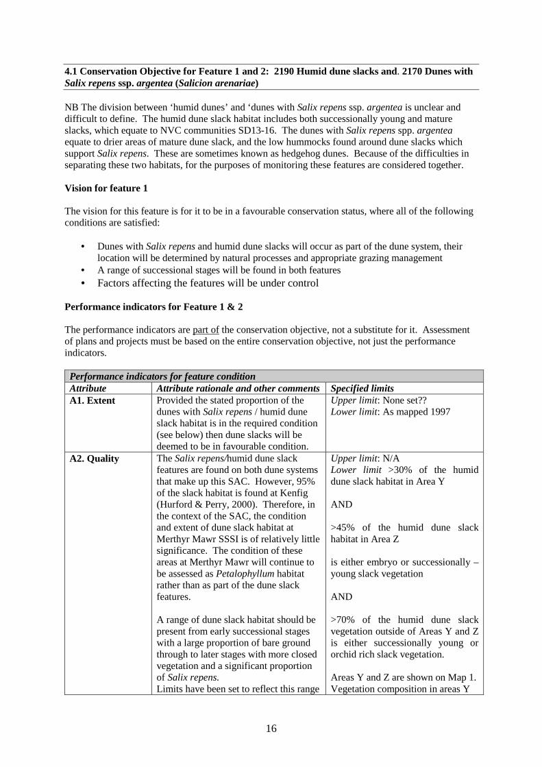
4.1 Conservation Objective for Feature 1 and 2: 2190 Humid dune slacks and. 2170 Dunes with Salix repens ssp. argentea (Salicion arenariae) NB The division between ‘humid dunes’ and ‘dunes with Salix repens ssp. argentea is unclear and difficult to define. The humid dune slack habitat includes both successionally young and mature slacks, which equate to NVC communities SD13-16. The dunes with Salix repens spp. argentea equate to drier areas of mature dune slack, and the low hummocks found around dune slacks which support Salix repens. These are sometimes known as hedgehog dunes. Because of the difficulties in separating these two habitats, for the purposes of monitoring these features are considered together. Vision for feature 1 The vision for this feature is for it to be in a favourable conservation status, where all of the following conditions are satisfied:
• Dunes with Salix repens and humid dune slacks will occur as part of the dune system, their location will be determined by natural processes and appropriate grazing management
• A range of successional stages will be found in both features • Factors affecting the features will be under control
Performance indicators for Feature 1 & 2 The performance indicators are part of the conservation objective, not a substitute for it. Assessment of plans and projects must be based on the entire conservation objective, not just the performance indicators. Performance indicators for feature condition Attribute Attribute rationale and other comments Specified limits A1. Extent Provided the stated proportion of the
dunes with Salix repens / humid dune slack habitat is in the required condition (see below) then dune slacks will be deemed to be in favourable condition.
Upper limit: None set?? Lower limit: As mapped 1997
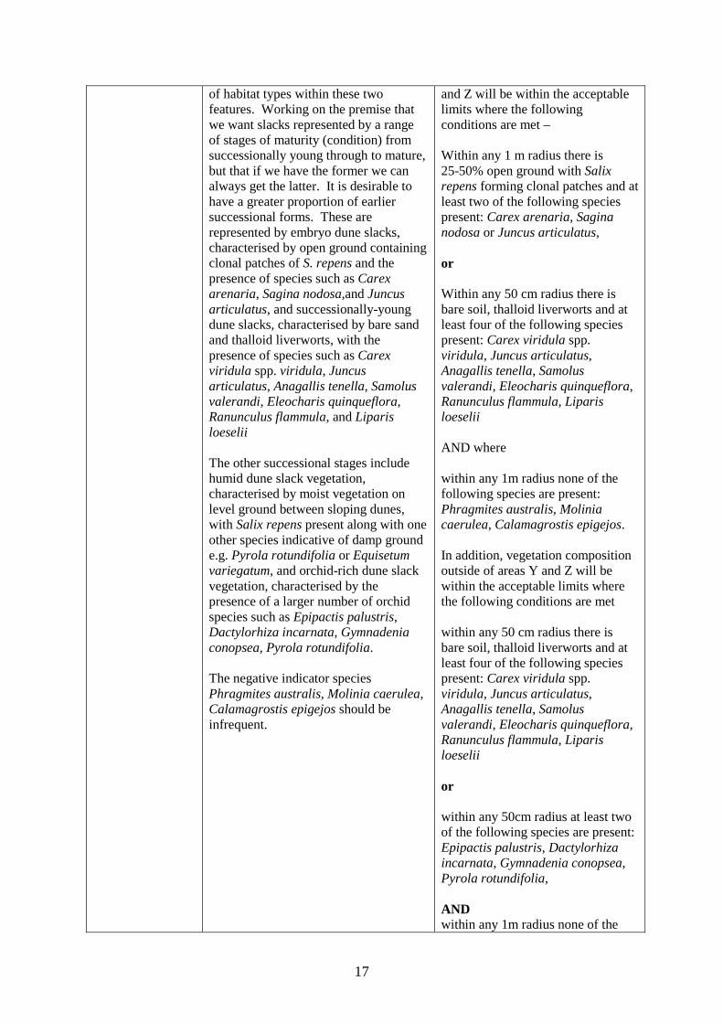
A2. Quality The Salix repens/humid dune slack features are found on both dune systems that make up this SAC. However, 95% of the slack habitat is found at Kenfig (Hurford & Perry, 2000). Therefore, in the context of the SAC, the condition and extent of dune slack habitat at Merthyr Mawr SSSI is of relatively little significance. The condition of these areas at Merthyr Mawr will continue to be assessed as Petalophyllum habitat rather than as part of the dune slack features. A range of dune slack habitat should be present from early successional stages with a large proportion of bare ground through to later stages with more closed vegetation and a significant proportion of Salix repens. Limits have been set to reflect this range
Upper limit: N/A Lower limit >30% of the humid dune slack habitat in Area Y AND >45% of the humid dune slack habitat in Area Z is either embryo or successionally –young slack vegetation AND >70% of the humid dune slack vegetation outside of Areas Y and Z is either successionally young or orchid rich slack vegetation. Areas Y and Z are shown on Map 1. Vegetation composition in areas Y
17
of habitat types within these two features. Working on the premise that we want slacks represented by a range of stages of maturity (condition) from successionally young through to mature, but that if we have the former we can always get the latter. It is desirable to have a greater proportion of earlier successional forms. These are represented by embryo dune slacks, characterised by open ground containing clonal patches of S. repens and the presence of species such as Carex arenaria, Sagina nodosa,and Juncus articulatus, and successionally-young dune slacks, characterised by bare sand and thalloid liverworts, with the presence of species such as Carex viridula spp. viridula, Juncus articulatus, Anagallis tenella, Samolus valerandi, Eleocharis quinqueflora, Ranunculus flammula, and Liparis loeselii The other successional stages include humid dune slack vegetation, characterised by moist vegetation on level ground between sloping dunes, with Salix repens present along with one other species indicative of damp ground e.g. Pyrola rotundifolia or Equisetum variegatum, and orchid-rich dune slack vegetation, characterised by the presence of a larger number of orchid species such as Epipactis palustris, Dactylorhiza incarnata, Gymnadenia conopsea, Pyrola rotundifolia. The negative indicator species Phragmites australis, Molinia caerulea, Calamagrostis epigejos should be infrequent.
and Z will be within the acceptable limits where the following conditions are met – Within any 1 m radius there is 25-50% open ground with Salix repens forming clonal patches and at least two of the following species present: Carex arenaria, Sagina nodosa or Juncus articulatus, or Within any 50 cm radius there is bare soil, thalloid liverworts and at least four of the following species present: Carex viridula spp. viridula, Juncus articulatus, Anagallis tenella, Samolus valerandi, Eleocharis quinqueflora, Ranunculus flammula, Liparis loeselii AND where within any 1m radius none of the following species are present: Phragmites australis, Molinia caerulea, Calamagrostis epigejos. In addition, vegetation composition outside of areas Y and Z will be within the acceptable limits where the following conditions are met within any 50 cm radius there is bare soil, thalloid liverworts and at least four of the following species present: Carex viridula spp. viridula, Juncus articulatus, Anagallis tenella, Samolus valerandi, Eleocharis quinqueflora, Ranunculus flammula, Liparis loeselii or within any 50cm radius at least two of the following species are present: Epipactis palustris, Dactylorhiza incarnata, Gymnadenia conopsea, Pyrola rotundifolia, AND within any 1m radius none of the
18
following are present: Phragmites australis, Molinia caerulea, Calamagrostis epigejos
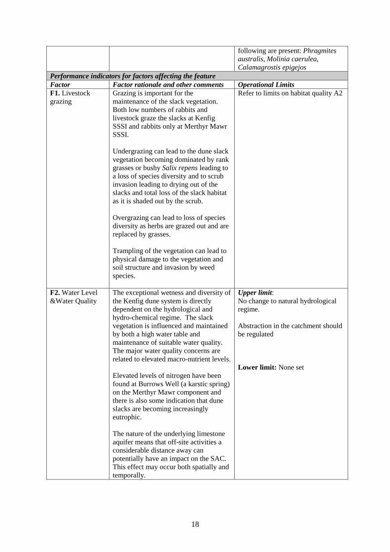
Performance indicators for factors affecting the feature Factor Factor rationale and other comments Operational Limits F1. Livestock grazing
Grazing is important for the maintenance of the slack vegetation. Both low numbers of rabbits and livestock graze the slacks at Kenfig SSSI and rabbits only at Merthyr Mawr SSSI. Undergrazing can lead to the dune slack vegetation becoming dominated by rank grasses or bushy Salix repens leading to a loss of species diversity and to scrub invasion leading to drying out of the slacks and total loss of the slack habitat as it is shaded out by the scrub. Overgrazing can lead to loss of species diversity as herbs are grazed out and are replaced by grasses. Trampling of the vegetation can lead to physical damage to the vegetation and soil structure and invasion by weed species.
Refer to limits on habitat quality A2
F2. Water Level &Water Quality
The exceptional wetness and diversity of the Kenfig dune system is directly dependent on the hydrological and hydro-chemical regime. The slack vegetation is influenced and maintained by both a high water table and maintenance of suitable water quality. The major water quality concerns are related to elevated macro-nutrient levels. Elevated levels of nitrogen have been found at Burrows Well (a karstic spring) on the Merthyr Mawr component and there is also some indication that dune slacks are becoming increasingly eutrophic. The nature of the underlying limestone aquifer means that off-site activities a considerable distance away can potentially have an impact on the SAC. This effect may occur both spatially and temporally.
Upper limit: No change to natural hydrological regime. Abstraction in the catchment should be regulated Lower limit: None set
19
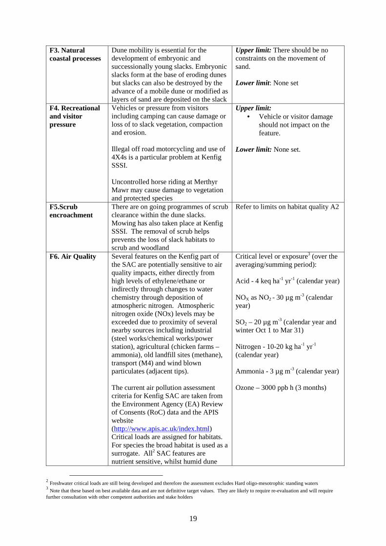
F3. Natural coastal processes
Dune mobility is essential for the development of embryonic and successionally young slacks. Embryonic slacks form at the base of eroding dunes but slacks can also be destroyed by the advance of a mobile dune or modified as layers of sand are deposited on the slack
Upper limit: There should be no constraints on the movement of sand. Lower limit: None set
F4. Recreational and visitor pressure
Vehicles or pressure from visitors including camping can cause damage or loss of to slack vegetation, compaction and erosion. Illegal off road motorcycling and use of 4X4s is a particular problem at Kenfig SSSI. Uncontrolled horse riding at Merthyr Mawr may cause damage to vegetation and protected species
Upper limit: • Vehicle or visitor damage
should not impact on the feature.
Lower limit: None set.
F5.Scrub encroachment
There are on going programmes of scrub clearance within the dune slacks. Mowing has also taken place at Kenfig SSSI. The removal of scrub helps prevents the loss of slack habitats to scrub and woodland
Refer to limits on habitat quality A2
F6. Air Quality Several features on the Kenfig part of the SAC are potentially sensitive to air quality impacts, either directly from high levels of ethylene/ethane or indirectly through changes to water chemistry through deposition of atmospheric nitrogen. Atmospheric nitrogen oxide (NOx) levels may be exceeded due to proximity of several nearby sources including industrial (steel works/chemical works/power station), agricultural (chicken farms – ammonia), old landfill sites (methane), transport (M4) and wind blown particulates (adjacent tips). The current air pollution assessment criteria for Kenfig SAC are taken from the Environment Agency (EA) Review of Consents (RoC) data and the APIS website (http://www.apis.ac.uk/index.html) Critical loads are assigned for habitats. For species the broad habitat is used as a surrogate. All2 SAC features are nutrient sensitive, whilst humid dune
Critical level or exposure3 (over the averaging/summing period): Acid - 4 keq ha-1 yr-1 (calendar year) NOX as NO2 - 30 µg m-3 (calendar year) SO2 – 20 µg m-3 (calendar year and winter Oct 1 to Mar 31) Nitrogen - 10-20 kg ha-1 yr-1 (calendar year) Ammonia - 3 µg m-3 (calendar year) Ozone – 3000 ppb h (3 months)
2 Freshwater critical loads are still being developed and therefore the assessment excludes Hard oligo-mesotrophic standing waters 3 Note that these based on best available data and are not definitive target values. They are likely to require re-evaluation and will require further consultation with other competent authorities and stake holders

20
slacks, fixed dunes with herbaceous vegetation, and L. loeselii are also acid sensitive.
Owner/occupier objectives
All parts of the Kenfig Dunes SSSI are owned by a charitable organisation, the Kenfig Corporation Trust, dedicated to holding the site in trust for the benefit and enjoyment of the community of Kenfig, allowing unrestricted access in time and space. Bridgend County Borough Council manages the site, in consultation with other parties through the Kenfig NNR management committee. Their aim is to maintain and enhance its value for nature conservation, including the provision of educational and public interpretation resources, run from the visitor centre. CCW manage the grazing licences. Fishing is a traditional activity and is dealt with through a separate lease with The Kenfig Hill and District Angling Association.
Maintain regular communication with the Kenfig Corporation Trust, Bridgend County Borough Council, Kenfig Hill and District Angling Association, and graziers Manage grazing leases
4.2 Conservation Objective for Feature 3: 2130 Fixed dunes with herbaceous vegetation (`grey dunes`) Vision for feature 3 The vision for this feature is for it to be in a favourable conservation status, where all of the following conditions are satisfied:
• Fixed dunes with herbaceous vegetation (grey dunes) will occur where older, shifting dunes become more stabilised and in early successional stages become colonised by lichens and other species indicative of the transition from less mobile habitat.
• The habitat will encompass a range of successional stages throughout the area, determined by patterns of natural factors and grazing.
• Grey dunes will comprise a significant part of the dune system but will increase and decrease in extent and location as natural processes determine the landscape of the dune systems
• All factors are under management control Performance indicators for Feature 3 The performance indicators are part of the conservation objective, not a substitute for it. Assessment of plans and projects must be based on the entire conservation objective, not just the performance indicators. Performance indicators for feature condition Attribute Attribute rationale and other comments Specified limits A1. Extent Grey dunes should be distributed
throughout this SAC. To ensure this, a target has been included that states that all SSSI within this SAC, that contain
Upper limit: None set?? Lower limit: As mapped 1997

21
these features have to be in good condition for this SAC feature to be considered favourable overall. Some fluctuations are likely in the extent due to losses to other components of the dune system or increases at the expense of other components. These losses and gains where due to natural factors will be accepted, but there must be no loss due to direct or indirect human activities.
A2. Quality Sampling is targeted at the successionally young stages on the premise that if we have these it is always possible to get more mature communities. Grey dunes should cover a range of steps to maturity from successionally young through to mature. It is desirable to have a greater proportion of earlier successional forms characterised by bare sand or the moss Thymus polytrichus and the presence of species such as Phleum arenarium, Vulpia membranacea, Cladonia foliacea, Arenaria serpyllifolia, Sedum acre, Anthyllis vulneraria, Erodium maritimum, Aira praecox, Arenaria serpyllifolia, Sedum acre and Catapodium marina, Pilosella officinarum, Geranium molle and Viola tricolor. In more species rich closed sward the species can also include Lotus corniculatus, Leontodon autumnalis, Polygala vulgaris Rhinanthus minor, Ranunculus bulbosa, Euphrasia sp., Trifolium arvense, Linum catharticum, and Lotus corniculatus Presence of negative indicator species show that there is a problem with one, or a combination of the following factors, grazing, over stabilisation, or eutrophication. Species indicative of negative change include – Rosa pimpinellifolia >50cm in height, Arrhenatherum elatius, Chamerion angustifolium, Clematis vitalba and Heracleum sphondylium
Upper limit: N/A Lower limit At Kenfig NNR – within Area X 40% of the fixed dune grassland is referable to successionally young grassland or closed rich grassland AND within Area Y 70% of the fixed dune grassland is referable to successionally young grassland or closed rich grassland AND within Area Z 75% of the fixed dune grassland is referable to successionally young grassland or closed rich grassland. Vegetation composition in areas Y, Z and X will be within the acceptable limits where the following conditions are met – within 50cm of any point there is 10-30% bare sand/ or >10% moss or Thymus polytrichus with at least three of the following species present: Phleum arenarium, Vulpia membranacea, Cladonia foliacea, Arenaria serpyllifolia, Sedum acre or Thymus polytrichus or within 50cm of any point there is a closed sward dominated by forbs, where six of the following species are present; Anthyllis vulneraria,
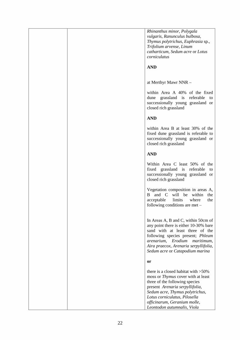
22
Rhinanthus minor, Polygala vulgaris, Ranunculus bulbosa, Thymus polytrichus, Euphrasia sp., Trifolium arvense, Linum catharticum, Sedum acre or Lotus corniculatus AND at Merthyr Mawr NNR – within Area A 40% of the fixed dune grassland is referable to successionally young grassland or closed rich grassland AND within Area B at least 30% of the fixed dune grassland is referable to successionally young grassland or closed rich grassland AND Within Area C least 50% of the fixed grassland is referable to successionally young grassland or closed rich grassland Vegetation composition in areas A, B and C will be within the acceptable limits where the following conditions are met – In Areas A, B and C, within 50cm of any point there is either 10-30% bare sand with at least three of the following species present; Phleum arenarium, Erodium maritimum, Aira praecox, Arenaria serpyllifolia, Sedum acre or Catapodium marina or there is a closed habitat with >50% moss or Thymus cover with at least three of the following species present Arenaria serpyllifolia, Sedum acre, Thymus polytrichus, Lotus corniculatus, Pilosella officinarum, Geranium molle, Leontodon autumnalis, Viola
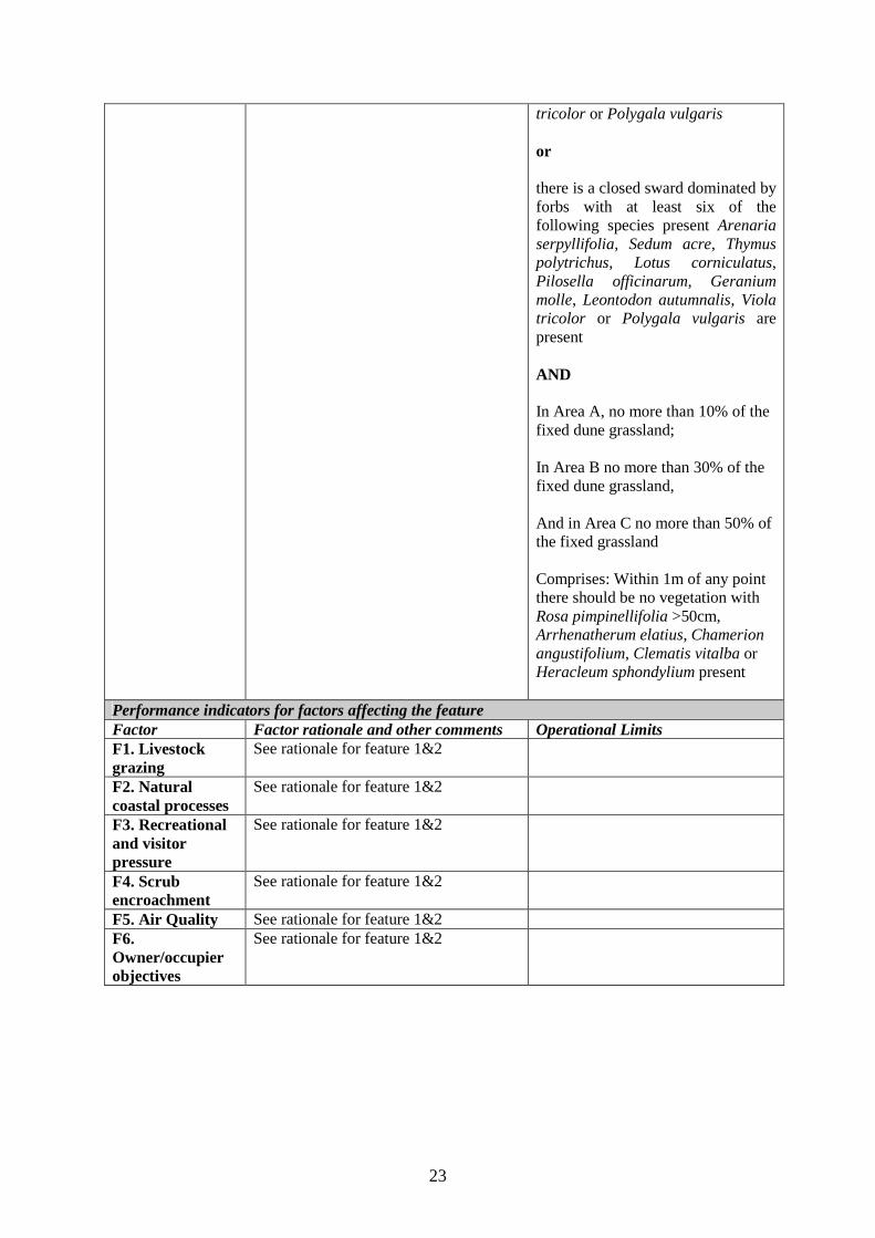
23
tricolor or Polygala vulgaris or there is a closed sward dominated by forbs with at least six of the following species present Arenaria serpyllifolia, Sedum acre, Thymus polytrichus, Lotus corniculatus, Pilosella officinarum, Geranium molle, Leontodon autumnalis, Viola tricolor or Polygala vulgaris are present AND In Area A, no more than 10% of the fixed dune grassland; In Area B no more than 30% of the fixed dune grassland, And in Area C no more than 50% of the fixed grassland Comprises: Within 1m of any point there should be no vegetation with Rosa pimpinellifolia >50cm, Arrhenatherum elatius, Chamerion angustifolium, Clematis vitalba or Heracleum sphondylium present
Performance indicators for factors affecting the feature Factor Factor rationale and other comments Operational Limits F1. Livestock grazing
See rationale for feature 1&2
F2. Natural coastal processes
See rationale for feature 1&2
F3. Recreational and visitor pressure
See rationale for feature 1&2
F4. Scrub encroachment
See rationale for feature 1&2
F5. Air Quality See rationale for feature 1&2 F6. Owner/occupier objectives
See rationale for feature 1&2
24
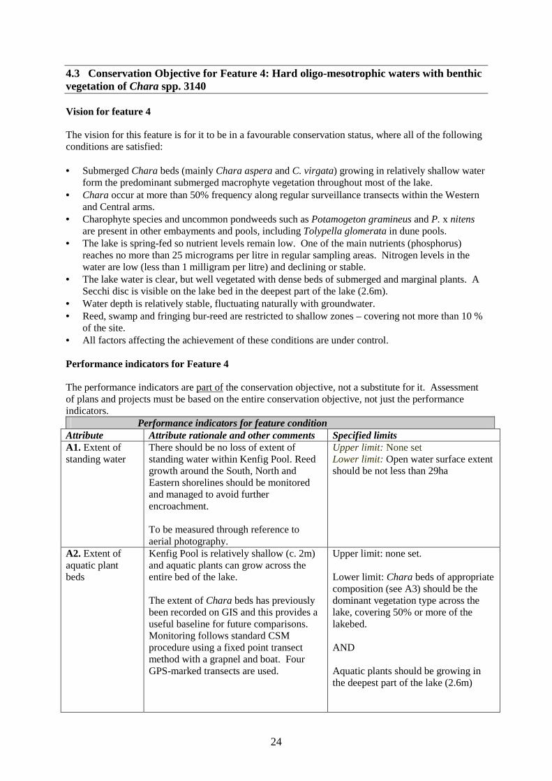
4.3 Conservation Objective for Feature 4: Hard oligo-mesotrophic waters with benthic vegetation of Chara spp. 3140 Vision for feature 4 The vision for this feature is for it to be in a favourable conservation status, where all of the following conditions are satisfied: • Submerged Chara beds (mainly Chara aspera and C. virgata) growing in relatively shallow water
form the predominant submerged macrophyte vegetation throughout most of the lake. • Chara occur at more than 50% frequency along regular surveillance transects within the Western
and Central arms. • Charophyte species and uncommon pondweeds such as Potamogeton gramineus and P. x nitens
are present in other embayments and pools, including Tolypella glomerata in dune pools. • The lake is spring-fed so nutrient levels remain low. One of the main nutrients (phosphorus)
reaches no more than 25 micrograms per litre in regular sampling areas. Nitrogen levels in the water are low (less than 1 milligram per litre) and declining or stable.
• The lake water is clear, but well vegetated with dense beds of submerged and marginal plants. A Secchi disc is visible on the lake bed in the deepest part of the lake (2.6m).
• Water depth is relatively stable, fluctuating naturally with groundwater. • Reed, swamp and fringing bur-reed are restricted to shallow zones – covering not more than 10 %
of the site. • All factors affecting the achievement of these conditions are under control. Performance indicators for Feature 4 The performance indicators are part of the conservation objective, not a substitute for it. Assessment of plans and projects must be based on the entire conservation objective, not just the performance indicators.
Performance indicators for feature condition Attribute Attribute rationale and other comments Specified limits A1. Extent of standing water
There should be no loss of extent of standing water within Kenfig Pool. Reed growth around the South, North and Eastern shorelines should be monitored and managed to avoid further encroachment. To be measured through reference to aerial photography.
Upper limit: None set Lower limit: Open water surface extent should be not less than 29ha
A2. Extent of aquatic plant beds
Kenfig Pool is relatively shallow (c. 2m) and aquatic plants can grow across the entire bed of the lake. The extent of Chara beds has previously been recorded on GIS and this provides a useful baseline for future comparisons. Monitoring follows standard CSM procedure using a fixed point transect method with a grapnel and boat. Four GPS-marked transects are used.
Upper limit: none set. Lower limit: Chara beds of appropriate composition (see A3) should be the dominant vegetation type across the lake, covering 50% or more of the lakebed. AND Aquatic plants should be growing in the deepest part of the lake (2.6m)
25
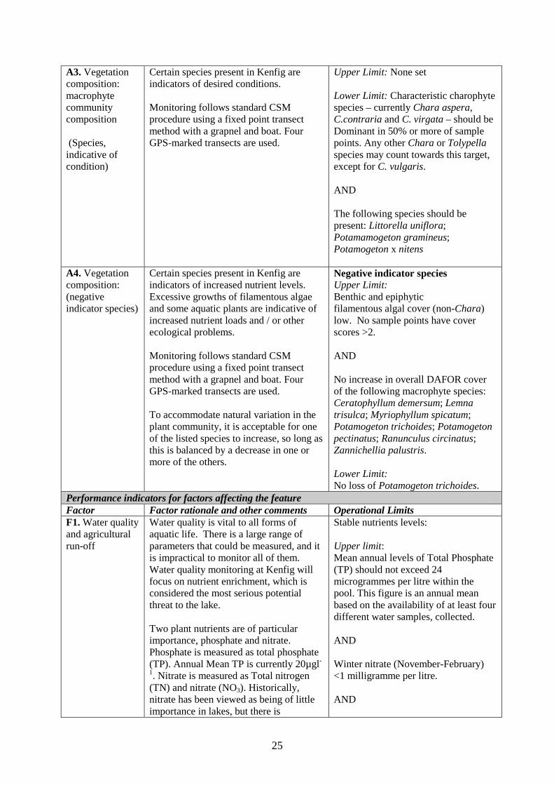
A3. Vegetation composition: macrophyte community composition (Species, indicative of condition)
Certain species present in Kenfig are indicators of desired conditions. Monitoring follows standard CSM procedure using a fixed point transect method with a grapnel and boat. Four GPS-marked transects are used.
Upper Limit: None set Lower Limit: Characteristic charophyte species – currently Chara aspera, C.contraria and C. virgata – should be Dominant in 50% or more of sample points. Any other Chara or Tolypella species may count towards this target, except for C. vulgaris. AND The following species should be present: Littorella uniflora; Potamamogeton gramineus; Potamogeton x nitens
A4. Vegetation composition: (negative indicator species)
Certain species present in Kenfig are indicators of increased nutrient levels. Excessive growths of filamentous algae and some aquatic plants are indicative of increased nutrient loads and / or other ecological problems. Monitoring follows standard CSM procedure using a fixed point transect method with a grapnel and boat. Four GPS-marked transects are used. To accommodate natural variation in the plant community, it is acceptable for one of the listed species to increase, so long as this is balanced by a decrease in one or more of the others.
Negative indicator species Upper Limit: Benthic and epiphytic filamentous algal cover (non-Chara) low. No sample points have cover scores >2. AND No increase in overall DAFOR cover of the following macrophyte species: Ceratophyllum demersum; Lemna trisulca; Myriophyllum spicatum; Potamogeton trichoides; Potamogeton pectinatus; Ranunculus circinatus; Zannichellia palustris. Lower Limit: No loss of Potamogeton trichoides.
Performance indicators for factors affecting the feature Factor Factor rationale and other comments Operational Limits F1. Water quality and agricultural run-off
Water quality is vital to all forms of aquatic life. There is a large range of parameters that could be measured, and it is impractical to monitor all of them. Water quality monitoring at Kenfig will focus on nutrient enrichment, which is considered the most serious potential threat to the lake. Two plant nutrients are of particular importance, phosphate and nitrate. Phosphate is measured as total phosphate (TP). Annual Mean TP is currently 20µgl-
1. Nitrate is measured as Total nitrogen (TN) and nitrate (NO3). Historically, nitrate has been viewed as being of little importance in lakes, but there is
Stable nutrients levels: Upper limit: Mean annual levels of Total Phosphate (TP) should not exceed 24 microgrammes per litre within the pool. This figure is an annual mean based on the availability of at least four different water samples, collected. AND Winter nitrate (November-February) <1 milligramme per litre. AND
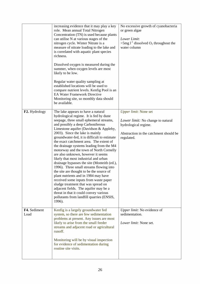
26
increasing evidence that it may play a key role. Mean annual Total Nitrogen Concentration (TN) is used because plants can utilise N at various stages of the nitrogen cycle. Winter Nitrate is a measure of nitrate loading to the lake and is correlated with aquatic plant species richness. Dissolved oxygen is measured during the summer, when oxygen levels are most likely to be low. Regular water quality sampling at established locations will be used to compare nutrient levels. Kenfig Pool is an EA Water Framework Directive Monitoring site, so monthly data should be available.
No excessive growth of cyanobacteria or green algae Lower Limit: >5mg l-1 dissolved O2 throughout the water column
F2. Hydrology
The lake appears to have a natural hydrological regime. It is fed by dune seepage, three small ephemeral streams, and possibly a deep Carboniferous Limestone aquifer (Davidson & Appleby, 2003). Since the lake is mainly groundwater-fed, it is difficult to estimate the exact catchment area. The extent of the drainage systems leading from the M4 motorway and the town of North Cornelly are also unknown, however it seems likely that most industrial and urban drainage bypasses the site (Monteith (ed.), 1996). Three small streams flowing into the site are thought to be the source of plant nutrients and in 1984 may have received some inputs from waste paper sludge treatment that was spread on adjacent fields. The aquifer may be a threat in that it could convey various pollutants from landfill quarries (ENSIS, 1996).
Upper limit: None set Lower limit: No change to natural hydrological regime. Abstraction in the catchment should be regulated.
F4. Sediment Load
Kenfig is a largely groundwater fed system, so there are few sedimentation problems at present. Any issues are most likely to arise from the small feeder streams and adjacent road or agricultural runoff. Monitoring will be by visual inspection for evidence of sedimentation during routine site visits.
Upper limit: No evidence of sedimentation. Lower limit: None set.
27
F5. Fishery management
Large populations of coarse fish (such as introduced carp for example) can distort the balance between the plant community, nutrient levels and the coarse fish population by eating small microscopic animals (zooplankton) that feed on tiny algae (phytoplankton). Overall the presence of a fishery at Kenfig pool poses little or no threat to the macrophyte communities apart from the continued presence of large carp in the pool. The risk arises from the possibility of carp spawning and resultant rise in population leading to damage through excessive turbidity as a result of the benthic feeding habits of carp. It is hoped that the carp will be removed through agreement with the KHDAA.
Upper limit: No further fish species introductions. AND No use of live bait. Lower limit: All fish stocking events and other fishery management to be based on existing fishery management plan.
F6. Introduced alien/exotic species
Non-native invasive species can fundamentally and irreversibly disrupt ecosystem structure and function. Non-native invasive species often out compete native counterparts, especially under disturbed conditions. A list of the most serious non-native invasive species is published by the UK Technical Advisory Group for the Water Framework Directive. Monitoring for these species will take place during regular monitoring visits, but site wardens and members of the local community will also be encouraged to notify CCW so that prompt action can be taken.
Upper Limit: No increase in Elodea canadensis. This species is currently rare. AND No common carp (Cyprinus carpio) present. AND No new non-native invasive species on the UKTAG Red List present. Lower Limits: Maintain vigilance regular routine site inspections and wardening.
F7. Changes in access and recreation
Kenfig pool has a high recreational worth, educational interest and landscape value. Close contact with the local community is also important to encourage interest in the site and to explain management issues that have to be tackled.
Maintain regular routine site inspections and wardening.
28
4.4 Conservation Objective for Feature 5: 1330 Atlantic salt meadows (Glauco-Puccinellietalia maritimae) Vision for feature 5 The vision for this feature is for it to be in a favourable conservation status, where all of the following conditions are satisfied:
• The quality of the saltmarsh is within specified limits • There is no increase in erosion along the length of the transition from salt marsh to sand dune • The saltmarsh flora will continue to include the following scarce species; Limonium
binervosum, and Frankenia laevis • Light grazing by rabbits and /or stock will continue to be tolerated within limits • The damaging effects of pony riding will have been reduced or eliminated
Performance indicators for Feature 5 The performance indicators are part of the conservation objective, not a substitute for it. Assessment of plans and projects must be based on the entire conservation objective, not just the performance indicators. Performance indicators for feature condition Attribute Attribute rationale and other comments Specified limits A1. Extent The performance indicators state that it
is necessary to maintain the area of salt marsh mapped in 2000. However, it is suspected that there has been recent erosion of the eastern side of the marsh, by the River Ogmore. The 1981 survey recorded presence of a ‘riverbank’ (as opposed to a more gently sloping profile) along the edge of the middle marsh. This now extends along the length of the middle marsh, and further slumping was noted during Autumn 2004. It is proposed that, in the future, the extent of the salt marsh is determined by habitat mapping, using up to date aerial photography. However, it is noted that a change in extent is difficult to detect between the 1991 and 2000 aerial photographs, because the latter were taken at high tide. Also note that any change in extent as a result of river erosion is likely to result from natural change rather than through anthropogenic causes. It will be necessary to consider any future loss within the wider context; there is a small amount of un-notified habitat on the opposite river bank which appears to be accreting rather than eroding. It is acknowledged that this will be difficult
Upper limit: None set but should not impinge on the other Annex 1 habitat types Lower limit: None set but there should be no losses as a result of human intervention, directly or indirectly, but if these happen as a result of natural processes, then that is acceptable.
29
because of the limited opportunity for salt marsh development along this stretch of coastline. There was 11.46 ha of saltmarsh present at Merthyr Mawr when mapped for the Merthyr Mawr Warren SSSI Vegetation Survey 2001. Much of the saltmarsh is being lost at Kenfig due to natural erosion and this should be seen as acceptable given that it is a ‘natural process’.
A2. Quality Within the performance indicators targets have been set to enable us to determine if erosion from excessive trampling and an increase in the extent and distribution of Frankenia laevis, which are the other two main factors that could alter the quality of the salt marsh at Merthyr Mawr, are having an effect. Targets have been set for each of these based on the current situation. If trampling becomes an issue, a limit may be required for bare ground as well. The saltmarsh habitat at Kenfig has been subject to natural changes due to erosion and changes to the river geomorphology. There should be surveillance of the habitat although it is accepted that these natural processes may lead to loss or change.
Upper limit: None set Lower limit: The Atlantic salt marsh habitat at both Kenfig AND Merthyr Mawr is described as favourable Merthyr Mawr 50% of the vegetation within Area A (see map 3, draft SAC report) is referable to ‘good condition middle marsh vegetation’ AND There is no increase in erosion along the length of the transition from salt marsh to sand dune Vegetation composition in areas A will be within the acceptable limits where the following conditions are met for “Good condition middle marsh vegetation” defined as: Within a 50cm radius in: Puccinellia maritima is present along with three of the following species: Aster tripolium, Suaeda maritima, Cochlearia officinalis, Spergularia media, Plantago maritima or Glaux maritima AND Frankenia laevis is absent from the sward.
Performance indicators for factors affecting the feature Factor Factor rationale and other comments Operational Limits F1. Livestock grazing
Cattle belonging to the tenant of Ogmore Castle Farm previously grazed the saltmarsh. There are no plans to re-introduce grazing at the present time by either the tenant or CCW.
Upper limit: Damage to vegetation due to grazing should be rare or absent Lower limit: No limits set
30
Rabbits grazing occurs across the saltmarsh
F2. Nitrogen deposition
See rationale for Features 1&2
See Feature 1&2
F3. River bank erosion / sediment deposition
Currently, the river / saltmarsh interface is a hard bank for much of its length with only mild slumping. The opposite bank is generally a more gentle and even gradient from saltmarsh through a narrow band of mud to the river. The current SSSI boundary is the middle of the river. Bank erosion / deposition may result due to changes in the river channel, and peak river flow caused by upstream canalisation. Historical maps and aerial photographs seem to suggest limited meandering about a fairly fixed axis. Further investigation is required to provide an indication of future changes and to establish limits.
Upper limit: To be determined Lower limit: To be determined
F4. Trampling by horses
The saltmarsh is regularly used by pony riders, both individual riders and strings of up to 20+ horses from the trekking centre at Ogmore Castle Farm. Riders tend to stay to the upper edge of the saltmarsh in the southern half, and follow the route of the sewage pipeline in the northern half. However, tracks made by pony riders straying from this route and occasional vehicles (off road vehicles, coastguard, farm and sewage works staff) are clearly visible on other areas of the saltmarsh. It is agreed that there has been a loss of habitat since 1991, due to an increase in use of the track that runs along the western edge of the marsh by horse riders. Comparison of 1991 and 2000 aerial photographs show a decrease in vegetation cover and an increase in the amount of bare sand, principally within the middle marsh. The increased use has occurred as the result of an attempt to reduce the amount of erosion throughout the dune system by ensuring the majority of use is targeted to this one track. In many ways this represents a decision to prioritise features of
Limits are incorporated into the limits for extent and quality of the feature
31
conservation interest across the site. Targets have been set within the performance indicators to ensure that this track does not become too wide – there is potential for riders to encroach further into the marsh, particularly during wet conditions when the track can be more difficult to negotiate.
F5. Pollution Salt marsh communities are sensitive to water chemistry, with increased nutrient levels leading to increased algal growth. They are also susceptible to toxic pollution from marine sources such as oil spills. There have been instances of pollution in the River Ogmore but there has been no record of consequential damage to the saltmarsh vegetation. Overflow from sewage works may be an issue but we have no data. Large-scale rubbish, particularly wheels with tyres, regularly migrates from the river and onto the saltmarsh causing local damage to the vegetation.
Upper limit: Damage due to pollution / litter should be absent Lower limit: No limits set
F6. Frankenia laevis
It is appears F. laevis has increased its extent and distribution at Merthyr Mawr since it was first discovered in 1981. There is some dispute as to whether it is native to this site or not. Further work e.g. genetic finger printing may help to establish its status but until this is known Andy Jones, CCW Higher Plants Specialist, has recommended that it is not eradicated. With this in mind it is difficult to know 1) whether there should be concern about increasing extent and distribution of this species, and therefore suitable targets need to be incorporated 2) presence of the species is simply accepted as a natural part of the salt marsh. Research suggests that it is associated with salt marsh and sand dune transition zones, favouring freely draining soils (ref: Ecological Flora of the BS, University of York). Therefore it may be reaching the limit of its expansion. Other species associated with the transition zone e.g. Armeria maritima and Limonium spp. continue to be present at least occasionally within the dense patches of F. laevis. In consideration of this, it has been agreed
Limits are incorporated into the limits for the quality of the feature (above)
32
a target should be set based on the current level of ‘invasion’, with the caveat that further surveillance work will be undertaken to confirm the presumption that it is unlikely to encroach any further into the salt marsh.
4.5 Conservation Objective for Feature 6: 1395 Petalwort Petalophyllum ralfsii Vision for feature 6 Petalophyllum ralfsii will continue to be found at its current locations in each of the two SSSI within the SAC. The vision for this feature is for it to be in a favourable conservation status, where all of the following conditions are satisfied:
• The species will be found where conditions are suitable in sufficient numbers to form a viable and sustainable population
• The population will vary from year to year depending on conditions, especially in drier years, but the long term population will remain steady and sustainable
• Suitable dune slacks will have patches of bare ground that is being colonised by jelly lichens (Collema spp.) and Barbula mosses.
• The factors affecting the feature are under control Performance indicators for Feature 6 The performance indicators are part of the conservation objective, not a substitute for it. Assessment of plans and projects must be based on the entire conservation objective, not just the performance indicators. Performance indicators for feature condition Attribute Attribute rationale and other
comments Specified limits
A1. Extent + distribution P. ralfsii is present at each of the two component SSSI. Baseline survey and previous surveillance show that the species is locally distributed at each site. Where it occurred the density of thalli was > 50 per m2. The assumption is that if we have at least two patches of habitat with a relatively high density of thalli, that the species will also be present at a lower density elsewhere. Surveillance at Kenfig and Merthyr Mawr suggests that the thalli are numerous only one year in every fix or six. Monitoring of thalli should be carried out in patches of habitat where thalli are obviously numerous using a 1 x 1 metre quadrat, divided into 16 cells, with counts made at
Lower limit: P. ralfsii is present at a density of >50 thalli per m2
in at least two locations more than 10 m apart in two humid dune slacks
33
cell level. Concentrating the search over a small area at a time means thalli are less likely to be overlooked. Thalli counts should only be carried out in years when thalli are numerous.
A2. Habitat Quality P. ralfsii is a poor competitor and requires open vegetation to persist. It is most frequently found among successionally young, open dune slack vegetation. Limits for presence of this habitat at Kenfig have been set under feature 1/2 above. In optimum habitat it is found in association with other thalloid liverworts such as Pellia endiviifolia, Aneura pinguis and Pressia quadrata, the latter being a particularly good indicator of the presence of suitable habitat. The combination of bare ground is supported by the requirement for species such as Carex viridula ssp. viridula, Juncus articulatus, Anagallis tenella, Samolus valerandi, Eleocharis quinqueflora, and Ranuculus flammula to be present. The presence of negative indicator species such as Phragmites australis, Hippophae rhamnoides, Molinia caerulea and Calamagrostis epigejos is a direct threat. The requirement for at least one sizeable slack at each site to be in an embryonic state of development ensures that the local Petalophyllum population has the opportunity to persist into the foreseeable future.
Lower limit at each site >25% of at least one humid dune slack (>20 x 30m in area) is represented by embryo slack vegetation AND at each site >50% of at least one humid dune slack (> 30 x 20m in area) is represented by successionally-young slack vegetation: Vegetation composition in humid dune slack habitat suitable for Petalophyllum ralfsii will be within the acceptable limits where the following conditions are met – In more than 25% of at least one humid dune slack there is open vegetation with Salix repens forming clonal patches AND within any 1 m radius there is 25-50% bare ground with at least two of the following species present Carex arenaria, Sagina nodosa or Juncus articulatus AND >10% bare soil or thalloid liverwort cover, with at least one species of thalloid liverwort present within a 50 cm radius AND >2 of the following species are present within a 50cm radius; Carex viridula ssp. viridula, Juncus articulatus, Anagallis tenella, Samolus valerandi, Eleocharis quinqueflora,
34
Ranunculus flammula, Liparis loeselii AND Phragmites australis, Hippophae rhamnoides, Molinia caerulea, Calamagrostis epigejos are absent within any 1m radius
Performance indicators for factors affecting the feature Factor Factor rationale and other
comments Operational Limits
F1. Habitat The species requires early successional dune slack; this is the most significant factor. Low rates of sand accretion mean there are few opportunities for colonisation of newly formed habitats, while stabilisation is resulting in loss of suitable habitat in those areas already occupied by the species.
See above and feature 1&2
F2. Recreation and Access
Horse riding across the dunes at Merthyr Mawr has previously resulted in tracks passing through one of the main slacks where Petalophyllum occurs. This track has been ‘diverted’ through use of restrictions. In one slack where Petalophyllum is found, pedestrian visitor pressure is ‘creating’ suitable habitat at the edge of paths through trampling. This may also allow for spread of the species to other areas of suitable habitat within the slack. At Kenfig, scrambling bikes are cutting deep tracks through former Petalophyllum habitat. Although some return to bare ground would benefit this species, tracks in many places are deep and ridged, and do not give rise to suitable habitat.
Maintain vigilance regular routine site inspections and wardening
F3. Air Quality See rationale for Features 1&2 above
35
4.1 Conservation Objective for Feature 7: 1903 Fen orchid Liparis loeselii Vision for feature 7 The vision for this feature is for it to be in a favourable conservation status, where all of the following conditions are satisfied: • Sufficient suitable habitat is present to support the populations • The factors affecting the feature are under control Performance indicators for Feature 7 The performance indicators are part of the conservation objective, not a substitute for it. Assessment of plans and projects must be based on the entire conservation objective, not just the performance indicators. Performance indicators for feature condition Attribute Attribute rationale and other comments Specified limits A1.Extent and distribution
L. loeselii is found only on the Kenfig NNR part of the SAC. Presence in a number of discrete dune slacks ensures that the species is well distributed.
Extent: Lower limit: L. loeselii is present in >15 discrete dune slacks (see Map)
A2.Species population
L. loeselii is currently found within 9 slacks at Kenfig NNR (2007), although not all slacks contained flowering spikes. The main population is found within slacks managed by mowing. Numbers of flowering spikes within the more successionally young habitat have been declining with stabilisation of this habitat. This is not thought to be secure in the long term. Long-term surveillance indicates that L. loeselii used to have a wider distribution, with numbers >200 in certain slacks. The target has been set to reflect this. In good years flowering spikes can be numerous in suitable habitat, and counts of > 200 should be obtained within around 20 minutes.
Distribution: Lower limit: The number of flowering L. loeselii spikes is >200 in at least two humid slacks and >20 in a successionally-young humid dune slack and >5 in >14 other humid dune slacks
Performance indicators for factors affecting the feature Factor Factor rationale and other comments Operational Limits F1. Habitat Habitat is the most significant factor; the
species requires early successional dune slacks. Refer to feature 1/2 for dune slack objective.
See Features 1and 2
F2. Recreation and Access
At Kenfig, scrambling bikes are cutting deep tracks through Liparis habitat. Although some return to bare ground would benefit this species, tracks in many places are deep and ridged, and do not give rise to suitable habitat.
36
5. ASSESSMENT OF CONSERVATION STATUS AND MANAGEMENT REQUIREMENTS This part of the document provides: • A summary of the assessment of the conservation status of each feature. • A summary of the management issues that need to be addressed to maintain or restore each feature. 5.1 Conservation Status and Management Requirements of Feature 1 & 2: Dunes with Salix repens ssp. argentea (Salicion arenariae) (EU habitat code 2170) and Humid dune slacks (EU habitat code 2190) These two features have been considered together as the issues and management of both are intimately linked. Conservation Status of Feature 1 & 2 No distinction has been made between the Humid dune slacks and Dunes with Salix repens ssp. argentea as outlined in Section 1, and this monitoring data will be used to determine the condition of both features. Results show that the proportion of early successional stages in Areas Y and Z is below that required. Therefore, vegetation in both areas is considered to be unfavourable. Areas Y and Z contained the largest blocks of embryo and successionally young habitat in 1997. As the system is stabilising and no new natural areas of habitat have been created, we can assume that the slack habitats outside of the sample plots are also unfavourable, despite mowing and scraping has artificially created areas of habitat (see comments below). Therefore, the Humid dune slacks and Dunes with Salix repens ssp. argentea at Kenfig SAC are considered to be in unfavourable declining condition (August 2006 SAC Monitoring Report). Management Requirements of Features 1 and 2 Management issues for this feature are the lack of creation of new dune slacks, excessive dune stabilisation and succession of older slacks to scrub in some areas, though this is variable over the SAC. Natural coastal processes The type and cover of vegetation communities present on the dune system at any given time is largely dependent on geomorphological processes. Management should be aimed at minimising any constraints to the natural movement of sand. This should allow the continued process of slack formation, maintaining a presence of embryo and successionally young slacks on site. Modelling of coastal processes should be considered. Liaison with other interested parties should continue, to ensure coastal strategies such as the Marine Aggregate Dredging Policy for south Wales and the Swansea Bay Shoreline Management Plan consider accretion/erosion issues at Kenfig and Merthyr Mawr. A program of mechanical destabilisation of dunes, involving cutting, scarification and excavation of blowouts should be considered in targeted areas. Grazing Humid dune slacks and dunes with Salix repens are maintained by the seasonally high water table, grazing and scrub control. Grazing by domestic stock facilitates rabbit and hare grazing since rabbits tend to graze where the sward is already short. Grazing levels should be set to allow the maintenance of a low, species rich sward throughout the majority of the dune slacks and to reduce the spread of scrub.
37
Dune slacks should be lightly grazed, preferably by cattle during the summer. Grazing by cattle in winter is acceptable provided supplementary feeding and poaching do not take place. Winter sheep grazing is generally benign provided there is no supplementary feeding, however, sheep do not graze coarser vegetation, which gives this vegetation a competitive advantage. Use of mineral licks should be considered to target grazing in particular areas. Liaison with stakeholders and neighbours should be maintained to ensure suitable grazing regimes are implemented. Management aimed at encouraging the return of rabbits and hares at Kenfig, such as mowing and burrow creation, should be continued, and rabbit grazing should be maintained at Merthyr Mawr. Manage grazing licences/leases Scrub Continued scrub clearance is necessary at Merthyr Mawr and Kenfig since scrub encroachment has been considerable over the last 30 years and grazing alone cannot keep scrub in check. Where natural processes such as mobility, erosion, and wind scour are significant, scrub invasion is not an issue. Where slacks are more mature, scrub can become a problem especially when grazing ceases or is reduced for a period and early scrub encroachment is not controlled. As scrub becomes established shelter and seeding increases and the problem is then exacerbated as stock cannot gain easy access to graze. The scrub clearance programmes at Merthyr Mawr, including removal of H. rhamnoides, needs to continue as set out in the Merthyr Mawr NNR Mangement Plan. Identified areas of mature coastal woodland may be retained. Mowing Mowing has taken place within certain dune slacks at Kenfig on a regular basis over the past few years, to facilitate the spread of grazing and to some extent to control dense low willow scrub growth and re-growth following initial clearance management. Mowing has achieved good results by reducing the competitive advantage of coarse and woody growth thereby favouring desirable species such as marsh helleborine Epipactis palustris. Mowing may be considered as an option in certain targeted areas within Merthyr Mawr dune system. Mowing may continue only as consented. Hydrological regime The dune slack communities are dependent on a high water table, particularly in the winter. The depth of the water table and degree of inundation throughout the winter months affects the type and composition of dune slack communities. Management should aim to protect and maintain the natural hydrological regime of the dune slacks. Onsite monitoring of dip wells needs to be reviewed and continued at appropriate intervals. Water and air quality Several features on the Kenfig part of the SAC are potentially sensitive to air and water quality impacts. Management should aim to protect and maintain the required air and water quality.
38
Recreation and access People and vehicle access should be managed so that it does not adversely affect the dune slack SAC features. Dune stabilisation works should only be considered in exceptional cases where severe erosion has been caused by vehicle or visitor pressure. The first action should be to manage the source of the problem. Wardening and surveillance of camping, vehicle and visitor access that causes damage to the vegetation communities and physical damage to the dune slacks, needs to be continued. Vehicle restrictions to the dunes need to be continued, and be reviewed as problems arise. Wardening and surveillance of access for horse riders among certain areas of the dune slacks at Merthyr Mawr where it is impacting on P. ralfsii habitat should be continued, with access to sensitive habitats discouraged via deviation onto other less sensitive habitat. Instances of inappropriate recreation leading to damage should be logged and reported to the appropriate Authorities including CCW. 5.2 Conservation Status and Management Requirements of Feature 3: Fixed dunes with herbaceous vegetation (`grey dunes`) ( EU habitat code 2130) Conservation Status of Feature 3 The fixed dune with herbaceous vegetation feature of Kenfig/Cynffig SAC is considered to be in Unfavourable declining conservation status (August 2006 SAC Monitoring Report). This is due primarily to over-stabilisation, undergrazing and scrub development. Management Requirements of Feature 3 Active management in the form of livestock grazing, preceded by mechanical excavation or scarification where appropriate, is required to reverse this trend and thereafter maintain (at least a proportion of) the herbaceous dune vegetation in a more open, early successional and mobile form. In some particularly stabilised areas the creation of dune blowouts may be considered. Natural coastal processes – see management of Features 1&2 above Grazing - see management of Features 1&2 above substituting fixed dune grassland for dune slack. Additionally, management within the fixed dune grassland for creation of burrows to encourage rabbit grazing should be continued in targeted areas. Creation of burrows may continue only as consented. Scrub- see management of Features 1&2 above substituting fixed dune grassland for dune slack Mowing– Mowing has taken place in selected areas of fixed dune grassland at Kenfig on a regular basis over the past few years, to facilitate rabbit grazing and to control bracken growth and re-growth following initial clearance management. Mowing has achieved good results in these areas and this management should be continued. Mowing may be considered as an option in certain targeted areas within Merthyr Mawr dune system. Mowing may continue only as consented. Water and air quality - see management of Features 1&2 above Recreation and access see management of Features 1&2 above
39
5.3 Conservation Status and Management Requirements of Feature 4: Hard oligo-mesotrophic waters with benthic vegetation of Chara spp. 3140 Conservation Status of Feature 4 The Hard oligo-mesotrophic waters with benthic vegetation of Chara spp. feature of Kenfig/Cynffig SAC is considered to be in unfavourable recovering conservation status (2006). The main reason for the unfavourable condition is the presence of introduced fish (carp). If carp removal can be carried out favourable condition should follow. (Burgess et al., 2006) This analysis is based on the most recent Site Condition Assessments of Welsh SAC and SSSI Standing Water Features (Burgess et al., 2006). To make this assessments, data from CCW Contract Science Report no. 704 (Goldsmith et al. 2006) was employed, alongside further chemical and biological data collected by ENSIS Ltd. and the Environment Agency (EA) between 2003-2005. Data from previous reports and surveys was also utilised where available to provide a longer-term perspective and possible evidence of trends. Management Requirements of Features 4 Fishery Removal of the few remaining carp is an essential prerequisite to the site achieving favourable status.
• All fish stocking events and other fishery management to be assessed in light of advice within the fishery management plan (Giles, 2003) and in line with consultation protocols in place between landlords and tenants at Kenfig NNR.
Hydrology Management should aim to protect and maintain the natural hydrological regime of Kenfig pool.
• No change to natural hydrological regime. • Onsite monitoring of the Pool water levels needs to be reviewed and continued at appropriate
intervals • Abstraction in the catchment should be regulated.
Alien plant species There should be no new non-native invasive species on the UKTAG Red List present.
• Maintain vigilance regular routine site inspections and wardening. • No increase in Elodea canadensis. This species is currently rare.
Other Alien species
• The numbers of Canada geese present on the pool and surrounding land should be monitored. Water and air quality Water quality monitoring at Kenfig will focus on nutrient enrichment, which is considered the most serious potential threat to the lake
• Regular water quality sampling at established locations will be used to compare nutrient levels. Kenfig Pool is an EA Water Framework Directive Monitoring site, so monthly data should be available.
• Monitoring will be by visual inspection for evidence of sedimentation during routine site visits.
• No evidence of sedimentation.
40
• No excessive growth of cyanobacteria or green algae 5.4 Conservation Status and Management Requirements of Feature 5: Atlantic salt meadows (Glauco-Puccinellietalia maritimae) 1330 Conservation Status of Feature 5 The condition of the Atlantic salt meadows at Merthyr Mawr were assessed as favourable condition on the basis of SAC monitoring carried out in December, 2004?. In addition the SSSI salt marsh feature was assessed as being in favourable condition (December, 2004). Management Requirements of Feature 5 Trampling by horses It is likely that surface erosion caused by trampling by stock and/or horse riding has affected the saltmarsh for hundreds of years. However, the extent of this factor has probably increased in the last decade as horse riding has become more popular. The saltmarsh gets a concentrated use as it is one of the main access points to the foreshore and is used on a frequent basis by the Ogmore Castle Farm trekking centre and stabling facility. This has resulted in a broad band 10m -15m wide of bare, trampled silty sand at the top of the saltmarsh. Unfortunately, this zone is one of the more interesting parts of the saltmarsh. In 2004 CCW introduced a Horse Riding Permit Scheme, primarily for public safety reasons. The scheme included confining riding to selected routes avoiding sensitive areas and has incidentally, in the first instance at least, reduced the numbers of riding visits to the Warren as a whole. In the future, it may be necessary in the future to dictate the route or areas used for horse riding on the saltmarsh to prevent damage to the feature. Actions required
• Liase landowner / stakeholders to reduce/eliminate damage by horses. • Monitor loss/development of saltmarsh • Monitor horse riding numbers • Continue Merthyr Mawr Horse Riding Permit scheme / riding routes
Grazing (cattle and rabbits) The 1981 report Merthyr Mawr vegetation report describes the lower marsh as being ‘a patchwork of vegetation dominated by Puccinellia which is kept short by grazing cattle.’ It also describes a domed part of the middle marsh with a dryer surface with abundant bare soil probably caused by cattle trampling. Significantly, this was also the location of the first Frankenia colony. Patches of ‘abundant Agrostis stolonifera and Festuca rubra’ are mentioned as occurring in the upper saltmarsh ‘away from the river’. Patches also occur near the river now and this may reflect the lack of cattle grazing. Overall, however, the saltmarsh appears to exhibit the diverse mosaic of communities described in 1981 in spite of the absence of stock grazing. There is little indication of over-dominance of any species, with the possible exception of Frankenia. Since cattle trampling may have assisted the establishment and spread of this species, this is a good reason for not rushing into re-introducing this form of management.
41
The early report does not mention rabbit grazing although they do appear to be making a contribution now. This needs to be critically assessed since they may be making a significant contribution to the maintenance of the vegetation mosaic - and without creating the bare ground favoured by Frankenia. Actions required
• Monitor rabbit numbers • Determine and put in place optimal sward management.
Pollution / rubbish A watching brief should be maintained on pollution sources / incidents in case of accumulative effects and on any catchment management proposals that may impact on the river. The Estate has carried out rubbish collection from the saltmarsh for many years and more recently by CCW. This practise should continue. The appropriate authority should be encouraged to keep the river clear. Actions required
• Maintain watching brief on pollution sources / incidents, remove damaging rubbish from saltmarsh and promote clearing rubbish from the river.
• Liase with B.C.B.C., and Welsh Water Damage from vehicles Although incidents of unauthorised access onto the saltmarsh using vehicles are few, access should be continued to be discouraged due to the damage that can be caused from such events.
• Vehicle restrictions on the saltmarsh to continue. • Instances of inappropriate recreation leading to damage should be logged and reported to the
appropriate Authorities including CCW.
5.5 Conservation Status and Management Requirements of Feature 6: Petalwort Petalophyllum ralfsii 1395 Conservation status of Feature 6 The Petalophyllum ralfsii of Kenfig/Cynffig SAC is considered to be in unfavourable declining conservation status (November 2007). This analysis is based on the most recent SAC monitoring report for the feature, which shows that the performance indicators for the habitat and the extent, distribution and numbers of thalli were not met. Long-term surveillance indicates that P. ralfsii used to have a much wider distribution and that it was regularly found with greater than 50 thalli per m2 in more than two discrete locations within more than two dune slacks. A full version of the monitoring data is available. Management Requirements of Petalophyllum ralfsii Management of P. ralfsii is entirely dependant on the presence of the required habitat, early successional dune slacks. Therefore for management requirements of the species, refer to section 1 & 2, management for Humid dune slacks. 5.6 Conservation Status and Management Requirements of Feature 6: Fen Orchid Liparis
loeselii 1903 Conservation status of Feature 6
42
The Liparis loeselii of Kenfig/Cynffig SAC is considered to be in unfavourable declining conservation status (July 2007). This analysis is based on the most recent SAC monitoring report for the feature, which shows that the number of plants and the number of slacks within which it occurs have decreased dramatically. Long-term surveillance indicates that L. loeselii used to have a much wider distribution and that on any occasion it was regularly found in six or more discrete dune slacks with numbers of flowering spikes greater than 200. A full version of the monitoring data is available. Management Requirements of Liparis loeselii Management of Liparis is entirely dependant on the presence of the required habitat, early successional dune slacks. Therefore for management requirements of the species, refer to section 1 & 2, management for Humid dune slacks. 6. ACTION PLAN: SUMMARY This section takes the management requirements outlined in Section 5 a stage further, assessing the specific management actions required on each management unit. This information is a summary of that held in CCW’s Actions Database for sites, and the database will be used by CCW and partner organisations to plan future work to meet the Wales Environment Strategy targets for sites. Unit Number
CCW Database Number
Unit Name
Summary of Conservation Management Issues
Action needed?
1 001977 Unit 1 Kenfig Sands, also known as Sker Beach. Within SSSI and SAC but not NNR. However, Bridgend CBC's NNR team oversee it. Sand tends to diminish in winter and return in summer but the the sand supply is not sufficient for new embryo dunes to be created in the adjacent compartment (Kenfig 5).
No
2 001978 Unit 2 Kenfig northern dunes. In SAC and Cynffig/Kenfig SSSI, and in NNR managed by Bridgend CBC. Unit boundary follows fence, erected in Spring 2006 to permit cattle grazing. This compartment was grazed by cattle in summer 2006 for the first time for many years. Previous regime of sheep grazing now ended. Very few rabbits. Scrub control ongoing. Unit includes grey dunes, humid dune slacks, dunes with creeping willow and petalwort. Fen orchid was present in 1990s.
Yes
5 001979 Unit 5 Kenfig main compartment. In SAC, SSSI, and in NNR managed by Bridgend CBC. Includes grey dunes, humid dune slacks, dunes with creeping willow and fen orchid. Grazed by sheep in winter 2007-08 following approx 18 months without grazing. Previously grazed by sheep for much of the year but this was ended as summer grazing by sheep resulted in the preferential grazing of flowers. Cattle grazing is desirable but not practical at present because of un-fenced boundary with golf course, car park and road. Very few rabbits. NNR staff mow areas of grey dune in summer and selected dune slacks in late summer and autumn. Scrub control ongoing.
Yes
43
Unit Number
CCW Database Number
Unit Name
Summary of Conservation Management Issues
Action needed?
6 001980 Unit 6 Kenfig pool. SAC feature is hard oligo-mesotrophic waters with benthic vegetation of Chara spp. Important community of aquatic macrophytes. To maintain clear water it is desirable to remove the few remaining mature carp, which currently do not breed but might in future if temperatures rise. This unit includes reedbed on the northern and western margins of the pool, which was not present before about1930 but is now important for birds. It should not be allowed to encroach significantly onto open water, but should be maintained at approximately its current extent. Willow scrub in the reedbed requires control.
Yes
7 001981 Unit 7 Within SSSI but not SAC or NNR. Not fenced from the adjacent unit, compartment 5, which is part of the NNR. Very little grazing and few rabbits. Sheep have always tended to keep away from this area because of disturbance, although they could access it.
No
8 001982 Unit 8 Sker dunes. Boundary defined by ownership. Closely grazed, and so this relatively small area provides a marked contrast to the rest of the SSSI. This grazing regime benefits some species such as autumn ladies tresses orchid which is rare elsewhere on the site.
Yes
9 001983 Unit 9 Sker Point rocks. Much is now known about this inter-tidal area following research by Bridgend CBC over several years, with a view to future designation as a marine LNR.
No
10 001984 Unit 10 The main compartment of Merthyr Mawr SAC and SSSI, managed directly by CCW under a lease from the owner. Includes grey dunes, humid dune slacks, Atlantic salt meadows and petalwort. Grazed only by rabbits. Generally recovering following clearance of extensive areas of sea buckthorn, but petalwort slacks have encroaching creeping willow. CCW is investigating control of creeping willow by mowing. Control of ragwort and willowherb in areas from which scrub has been cleared is ongoing. Scrub clearance work must take account of Scheduled Ancient Monument. CCW is investigating fencing up to a third of the compartment in order to introduce grazing.
Yes
11 001985 Unit 11 Merthyr Mawr high dunes. SAC feature is grey dunes. Compartment boundary is a fence erected in 2005 to permit grazing by cattle. First grazed by cattle in winter 2005-06 and subsequently in summer. Need to maintain grazing and monitor results. Rabbits also present. Need to prevent any spread of scrub beyond the existing areas and perhaps clear more, but some will be retained. Scrub control must take account of Scheduled Ancient Monument.
Yes
12 001986 Unit 12 Compartment boundary follows ownership boundary but is not defined on the ground. Not grazed except by rabbits but this is possibly adequate. In the absence of fencing on the ownership boundary, which would be visually intrusive, cattle grazing could only take place together with adjacent land.
No
44
Unit Number
CCW Database Number
Unit Name
Summary of Conservation Management Issues
Action needed?
13 001987 Unit 13 Newton Burrows. In SAC and Merthyr Mawr SSSI. Proposed LNR managed by Bridgend CBC. Not grazed except by rabbits but this is considered adequate. Heavy recreational use would make any other grazing difficult to introduce. Some scrub control desirable, including small amounts of sea buckthorn.
Yes
14 001988 Unit 14 Merthyr Mawr beach. In SAC and SSSI. No 15 001989 Unit 15 South-facing slope of Cwm y Gaer. In SAC and Merthyr
Mawr SSSI. A small unit with no immediate management issues
No
7. GLOSSARY This glossary defines the some of the terms used in this Core Management Plan. Some of the definitions are based on definitions contained in other documents, including legislation and other publications of CCW and the UK nature conservation agencies. None of these definitions is legally definitive. Action A recognisable and individually described act, undertaking or project of any kind,
specified in section 6 of a Core Management Plan or Management Plan, as being required for the conservation management of a site.
Attribute A quantifiable and monitorable characteristic of a feature that, in combination with
other such attributes, describes its condition. Common Standards Monitoring A set of principles developed jointly by the UK conservation
agencies to help ensure a consistent approach to monitoring and reporting on the features of sites designated for nature conservation, supported by guidance on identification of attributes and monitoring methodologies.
Condition A description of the state of a feature in terms of qualities or attributes that are
relevant in a nature conservation context. For example the condition of a habitat usually includes its extent and species composition and might also include aspects of its ecological functioning, spatial distribution and so on. The condition of a species population usually includes its total size and might also include its age structure, productivity, relationship to other populations and spatial distribution. Aspects of the habitat(s) on which a species population depends may also be considered as attributes of its condition.
Condition assessment The process of characterising the condition of a feature with
particular reference to whether the aspirations for its condition, as expressed in its conservation objective, are being met.
Condition categories The condition of feature can be categorised, following condition
assessment as one of the following4: Favourable: maintained; Favourable: recovered;
4 See JNCC guidance on Common Standards Monitoring http://www.jncc.gov.uk/page-2272
45
Favourable: un-classified Unfavourable: recovering; Unfavourable: no change; Unfavourable: declining; Unfavourable: un-classified Partially destroyed; Destroyed. Conservation management Acts or undertaking of all kinds, including but not necessarily limited
to actions, taken with the aim of achieving the conservation objectives of a site. Conservation management includes the taking of statutory and non-statutory measures, it can include the acts of any party and it may take place outside site boundaries as well as within sites. Conservation management may also be embedded within other frameworks for land/sea management carried out for purposes other than achieving the conservation objectives.
Conservation objective The expression of the desired conservation status of a feature,
expressed as a vision for the feature and a series of performance indicators. The conservation objective for a feature is thus a composite statement, and each feature has one conservation objective.
Conservation status A description of the state of a feature that comprises both its condition and
the state of the factors affecting or likely to affect it. Conservation status is thus a characterisation of both the current state of a feature and its future prospects.
Conservation status assessment The process of characterising the conservation status of a
feature with particular reference to whether the aspirations for it, as expressed in its conservation objective, are being met. The results of conservation status assessment can be summarised either as ‘favourable’ (i.e. conservation objectives are met) or unfavourable (i.e. conservation objectives are not met). However the value of conservation status assessment in terms of supporting decisions about conservation management, lies mainly in the details of the assessment of feature condition, factors and trend information derived from comparisons between current and previous conservation status assessments and condition assessments.
Core Management Plan A CCW document containing the conservation objectives for a site
and a summary of other information contained in a full site Management Plan.
Factor Anything that has influenced, is influencing or may influence the condition of a
feature. Factors can be natural processes, human activities or effects arising from natural process or human activities, They can be positive or negative in terms of their influence on features, and they can arise within a site or from outside the site. Physical, socio-economic or legal constraints on conservation management can also be considered as factors.
Favourable condition See condition and condition assessment
46
Favourable conservation status See conservation status and conservation status assessment.5
Feature The species population, habitat type or other entity for which a site is designated.
The ecological or geological interest which justifies the designation of a site and which is the focus of conservation management.
Integrity See site integrity Key Feature The habitat or species population within a management unit that is the primary focus
of conservation management and monitoring in that unit. Management Plan The full expression of a designated site’s legal status, vision, features,
conservation objectives, performance indicators and management requirements. A complete management plan may not reside in a single document, but may be contained in a number of documents (including in particular the Core Management Plan) and sets of electronically stored information.
Management Unit An area within a site, defined according to one or more of a range of criteria,
such as topography, location of features, tenure, patterns of land/sea use. The key characteristic of management units is to reflect the spatial scale at which conservation management and monitoring can be most effectively organised. They are used as the primary basis for differentiating priorities for conservation management and monitoring in different parts of a site, and for facilitating communication with those responsible for management of different parts of a site.
Monitoring An intermittent (regular or irregular) series of observations in time, carried out to
show the extent of compliance with a formulated standard or degree of deviation from an expected norm. In Common Standards Monitoring, the formulated standard is the quantified expression of favourable condition based on attributes.
Operational limits The levels or values within which a factor is considered to be acceptable in
terms of its influence on a feature. A factor may have both upper and lower operational limits, or only an upper limit or lower limit. For some factors an upper limit may be zero.
Performance indicators The attributes and their associated specified limits, together with
factors and their associated operational limits, which provide the standard against which information from monitoring and other sources is used to determine the degree to which the conservation objectives for a feature are being met. Performance indicators are part of, not the same as, conservation objectives. See also vision for the feature.
Plan or project Project: Any form of construction work, installation, development or other
intervention in the environment, the carrying out or continuance of which is subject to a decision by any public body or statutory undertaker. Plan: a document prepared or adopted by a public body or statutory undertaker, intended to influence decisions on the carrying out of projects. Decisions on plans and projects which affect Natura 2000 and Ramsar sites are subject to specific legal and policy procedures.
5 A full definition of favourable conservation status is given in Section 4.
47
Site integrity The coherence of a site’s ecological structure and function, across its whole area, that
enables it to sustain the habitat, complex of habitats and/or the levels of populations of the species for which it is designated.
Site Management Statement (SMS) The document containing CCW’s views about the management
of a site issued as part of the legal notification of an SSSI under section 28(4) of the Wildlife and Countryside Act 1981, as substituted.
Special Feature See feature. Specified limit The levels or values for an attribute which define the degree to which the
attribute can fluctuate without creating cause for concern about the condition of the feature. The range within the limits corresponds to favourable, the range outside the limits corresponds to unfavourable. Attributes may have lower specified limits, upper specified limits, or both.
Unit See management unit. Vision for the feature The expression, within a conservation objective, of the aspirations
for the feature concerned. See also performance indicators. Vision Statement The statement conveying an impression of the whole site in the state that is
intended to be the product of its conservation management. A ‘pen portrait’ outlining the conditions that should prevail when all the conservation objectives are met. A description of the site as it would be when all the features are in favourable condition.
8. REFERENCES Burgess, A., Bennion, H. & Clarke, G. (2005). Assessing reference conditions and ecological status
for lakes using subfossil diatoms. Final report to the Environment Agency under contract no. SC030103. ECRC Research Report No. 105.
Burgess, A., Goldsmith, B., and Hatton-Ellis, T. (2006). Site Condition Assessments of Welsh SAC
and SSSI Standing Water Features. CCW Contract Science Report No: 705 Davidson, T. & Appleby, P.G. (2003). The environmental history of Kenfig Pool, cSAC. CCW
Contract Science Report No. 561. Countryside Council for Wales, Bangor Environment Agency (2005). http://www.environment-agency.gov.uk/http://maps.environment-
agency.gov.uk/wiyby/data (to search for individual lake risk assessment details and maps) Hurford, C. & Perry, K. (2000). Habitat Monitoring for Conservation Management and Reporting, 1:
Case studies. Life - Nature, CCW Joint Nature Conservation Committee (JNCC) (2005a). Common Standards Monitoring Guidance for
Standing Waters Version March 2005. JNCC Report, JNCC, Peterborough. An electronic version of this report is available at: http://www.jncc.gov.uk/pdf/CSM_standingwaters_Mar05.pdf
JNCC (2005b). http://www.jncc.gov.uk/ProtectedSites/SACselection/SAC_habitats.asp
48
Monteith, D.T., Hildrew, A.G., Flower, R.J., Raven, P.J., Beaumont, W.R.B., Collen, P., Kreiser, A.M., Shilland, E.M. & Winterbottom, J.H. (2005). Biological responses to the chemical recovery of acidified freshwaters in the UK. Environmental Pollution, 137, 83-101.
Giles, N. (2003). A fishery management plant for Kenfig Pool, cSAC. CCW Contract Science Report
no. 527. Countryside Council for Wales, Bangor Goldsmith, B., Bennion, H., Hughes, M., Jones, V., Rose, C. & Simpson, G.L. (2006). Integrating
Habitats Directive and Water Framework Directive monitoring: Baseline survey of Natura 2000 standing water habitats in Wales. CCW Contract Science Report No. 704. Countryside Council for Wales, Bangor
Newberry, C. (2007) Kenfig/Cynffig SAC Monitoring Report: Petalwort Petalophyllum ralfsii Westwood, S., and Newberry, C. (2007) Kenfig/Cynffig SAC Monitoring Report: Fen orchid Liparis
loeselii The Ecological Flora of the British Isles at the University of York
http://www.york.ac.uk/res/ecoflora/cfm/ecofl/index.cfm Wilkinson, K. (2006). Kenfig SAC: Summary SAC Monitoring Report. UK Air Pollution Information System http://www.apis.ac.uk/index.html UK Technical Advisory Group for the Water Framework Directive.
http://www.wfduk.org/tag_guidance/