2012 ANNUAL DIRECT OBSERVATION SURVEY OF SAFETY BELT … · ii 2012 ANNUAL DIRECT OBSERVATION...
44
2012 ANNUAL DIRECT OBSERVATION SURVEY OF SAFETY BELT USE Prepared for: Office of Highway Safety Planning 333 South Grand Avenue Lansing, MI Prepared by: Wayne State University Transportation Research Group Detroit, MI Date: December 2012
-
Upload
doannguyet -
Category
Documents
-
view
219 -
download
1
Transcript of 2012 ANNUAL DIRECT OBSERVATION SURVEY OF SAFETY BELT … · ii 2012 ANNUAL DIRECT OBSERVATION...

2012 ANNUAL DIRECT
OBSERVATION SURVEY OF SAFETY BELT USE
Prepared for: Office of Highway Safety Planning
333 South Grand Avenue Lansing, MI
Prepared by:
Wayne State University Transportation Research Group
Detroit, MI
Date: December 2012

ii
2012 ANNUAL DIRECT OBSERVATION SURVEY OF
SAFETY BELT USE
Prepared for: Office of Highway Safety Planning
333 South Grand Avenue Lansing, MI
Prepared by: Wayne State University
Transportation Research Group Detroit, MI
Date: December 2012 The opinions, findings, and conclusions expressed in this publication are those of the author(s) and not necessarily those of the Michigan Office of Highway Safety and Planning, the U.S. Department of Transportation, or the National Highway Transportation Safety Administration. This report was prepared in cooperation with the Michigan Office of Highway Safety Planning and the U.S. Department of Transportation, and the National Highway Traffic Safety Administration.

3
Technical Report Documentation Page
1. Report No.
2. Government Accession No. 3. Recipient’s Catalog No.
4. Title and Subtitle 2012 Annual Direct Observation Survey of Safety Belt Use
5. Report Date December 2012
6. Performing Organization Code
7. Author(s) Tapan K. Datta, Peter T. Savolainen, Timothy Gates, and Brendan J. Russo.
8. Performing Organization Report No.
9. Performing Organization Name and Address Wayne State University-Transportation Research Group Department of Civil and Environmental Engineering 5050 Anthony Wayne Drive, Room #0504 Detroit, MI 48202
10. Work Unit No. (TRAIS)
11. Contract or Grant No.
12. Sponsoring Agency Name and Address Office of Highway Safety Planning 333 South Grand Avenue Lansing, MI 48909
13. Type of Report and Period Covered Final Report
14. Sponsoring Agency Code
15. Supplementary Notes
16. Abstract This report documents the results of the 2012 Annual Direct Observation Survey of safety belt use. Safety belt use by drivers and front seat passengers was monitored at a total of 191 intersection/interchange sites during September of 2012. In addition to belt use, data were collected for vehicle type and use, as well as the gender, age and race of each observed occupant. The results of this survey show that the safety belt usage rate in the State of Michigan is 93.6 percent. Males and pick-up truck drivers continue to trail in the use of safety belts.
17. Key Words
Safety belt use, use rate by vehicle type, gender and demographic characteristics
18. Distribution Statement Unlimited
19. Security Classification (report) Unclassified
20. Security Classification (Page) Unclassified
21. No of Pages
38
22. Price

i
TABLE OF CONTENTS
PAGE 1.0 INTRODUCTION ................................................................................................................... 1 1.1 Study Purpose and Objectives ........................................................................................ 3 1.2 Study Area ...................................................................................................................... 3 2.0 METHODOLOGY .................................................................................................................. 4 3.0 OBSERVATIONAL STUDY DATA COLLECTION ........................................................... 9 4.0 OBSERVER TRAINING .......................................................................................................10 5.0 QUALITY CONTROL ...........................................................................................................11 6.0 DATA ANALYSIS .................................................................................................................11 6.1 Weighted Safety Belt Use Calculations .........................................................................11 6.2 Overall Statewide Safety Belt Use Calculations ............................................................13 6.3 Non-Response Rate ........................................................................................................14 7.0 RESULTS AND CONCLUSIONS.........................................................................................14 REFERENCES ..............................................................................................................................33 APPENDIX I – COMPLETE LISTING OF THE OBSERVATIONAL SITES IN MICHIGAN BY STRATUM AND COUNTY, INCLUDING OBSERVATIONAL DATA FOR EACH SITE ..................................................34

ii
LIST OF FIGURES PAGE Figure 1. 32-County Statewide Sample for the Direct Observation Safety Belt Surveys ............. 5 Figure 2. 2004 through 2012 Safety Belt Use Rate Trends ..........................................................32
LIST OF TABLES Table 1. Population Data for the Selected Counties in Michigan .................................................. 6 Table 2. 2011 Vehicle Miles of Travel by Stratum ....................................................................... 7 Table 3. Statewide Weighted Safety Belt Use Rate for Drivers and Front-Seat Passengers ........15 Table 4. Weighted Safety Belt Use Rate for Drivers and Front-Seat Passengers by Stratum ......15 Table 5. Statewide Descriptive Statistics ......................................................................................16 Table 6. Statewide Safety Belt Use Summary ..............................................................................17 Table 7. Statewide Safety Belt Use Rates by Stratum and County ..............................................17 Table 8. All Vehicles Statewide Summary ...................................................................................19 Table 9. Passenger Cars Statewide Summary ...............................................................................21 Table 10. Sport Utility Vehicles Statewide Summary ..................................................................23 Table 11. Vans/Minivans Statewide Summary .............................................................................25 Table 12. Pick-up Trucks Statewide Summary .............................................................................27 Table 13. All Vehicles Statewide Demographic Summary ..........................................................30

1
1.0 INTRODUCTION Increasing the use of safety restraint systems among motor vehicle occupants is one of the most
effective means of reducing injuries and fatalities on the nation’s highways. Efforts have been
made to increase the use of safety belts over three decades, yet according to the 2011 nationwide
safety belt surveys, approximately 16 percent of drivers and front-seat passengers continue to
travel unrestrained [1]. The national safety belt use rate of 84% is statistically unchanged from
the use rate of 85% observed in 2010 [1]. In Michigan, past statewide safety belt use studies
indicate that the overall use by drivers and front-seat passengers has generally increased from
2004 to 2009, and then decreased in 2010 and 2011. The past eight years’ statewide safety
restraint use experience is as follows:
2004 - 90.5%
2005 - 92.9%
2006 - 94.3%
2007 - 93.7%
2008 - 97.2%
2009 - 97.9%
2010 - 95.2%
2011 - 94.5%
The above data indicate that the safety belt use rate in Michigan is ahead of the national average
and Michigan is one of twenty states and territories with reported safety belt use rates greater
than 90 percent [2]. It is important to recognize that Michigan is a “primary law” state, which
means a motorist can be stopped and cited for the sole reason of not wearing a safety belt while
driving or riding as a front-seat passenger. In “secondary law” states, motorists must be stopped
for another traffic-related offense in order to be ticketed for not wearing a safety belt. The
“primary law” states averaged a safety belt use rate of 87 percent as compared to the “secondary
law” states, which only averaged 76 percent in 2011 [1].
The use of safety belts is the single most effective means of reducing fatal and non-fatal injuries
in vehicular crashes. In 2011, 21,253 passenger vehicle occupants were killed in traffic crashes

2
in the USA [3]. Among these fatalities, approximately 52 percent of the occupants were
unrestrained [3]. The National Highway Traffic Safety Administration (NHTSA) estimates that
an 80 percent safety belt use rate saves more than 15,000 lives per year and an overall societal
cost of 50 billion dollars in the country each year [4]. NHTSA estimated that 12,546 lives were
saved in 2010 due to the use of safety belts [5] among passenger vehicle occupants over age 4.
Currently, airbag systems are a part of standard equipment in all vehicles. Vehicles equipped
with airbags need the occupants to be restrained by safety belts in order to be effective in saving
lives and reducing injuries in the event of a severe crash. Safety belts protect vehicle occupants
in the following ways:
Reduces the chance of being in contact with the interior of the vehicle,
Prevents the occupants from ejection, and
Prevents occupants from being too close to the deployed airbags, thus avoiding severe
injuries from the airbags, ejection from the vehicle and vehicle interior contacts.
Past research indicates that the use of safety belts reduces the risk of fatal injury for the driver
and front seat passengers by approximately 45 percent for passenger vehicles and 60 percent for
light trucks. Moreover, the use of safety belts reduces the risk of moderate to critical injury by
50 percent for occupants of passenger vehicles and 65 percent for the occupants of light trucks
[5]. Therefore, a small increase in safety belt use often results in a large overall savings to
society.
The non-use of safety belts is a behavioral issue; therefore programs aimed at changing driver
behavior related to the use of safety belts often leave a long lasting impact on the affected drivers
and front seat passengers. Various safety belt use improvement programs are often targeted to
specific areas within a state. Knowing the areas within a state that have lower safety belt use
rates may assist the program coordinators in the Office of Highway Safety Planning (OHSP) to
allocate enforcement funding to specific areas, which may result in higher rates of safety belt
use. There are, of course, statewide initiatives which are expected to impact the entire state.

3
The safety belt use data can be used for the following:
To fulfill reporting requirements to NHTSA.
To allocate statewide safety funding to specific program areas.
To provide targeted funding to specific areas within the state where use rates are lower
than the statewide average.
To provide targeted programs for certain segments of the population.
1.1 Study Purpose and Objectives
The purpose of this study was to perform an annual observational survey at 191 intersections and
interchanges to determine the percentage of drivers and front-seat passengers utilizing their
safety belts.
The specific objectives of this study were as follows:
Finalize the methodology for collecting data for a representative sample of sites
throughout the State, which ensured reliable statewide statistics, in an economically
feasible manner.
Provide training to all staff conducting the observation surveys and conduct quality
assurance/quality control (QA/QC) of the data collection efforts.
Conduct the annual observational surveys of safety belt use for two weeks following the
Labor Day holiday.
Summarize and cross-tabulate the observational data in a spreadsheet format indicating
overall safety belt use, safety belt use by strata, safety belt use by time of day and day of
week, and safety belt use by various demographic characteristics.
Continue to track changes in safety belt use and generate necessary comparative data and
statistical analyses to assess the relevancy of the 2012 data and results to previous
observational results.
1.2 Study Area
The study area for the statewide observational survey included counties that represent at least
85 percent of the population in the State of Michigan.

4
2.0 METHODOLOGY
In order to develop targeted policies and programs to increase safety belt use, it is necessary to
determine the distribution of safety belt use rates in various parts of the state and among various
demographic groups. Furthermore, the statewide use rate must be determined by following a
sampling strategy and data collection procedure that will result in data that are representative of
the statewide population as required by NHTSA.
The site selection methodology for this study followed the general procedures used in the Direct
Observation of Safety Belt Use in Michigan surveys from 2005 to 2011. Those studies were
based upon the uniform criteria as presented in the Federal Register and the National Highway
Traffic Safety Administration documents. The areas selected for the 2012 observation surveys
included 32 counties in the State of Michigan which represented 86.9 percent of the state’s
population based upon 2011 U.S. Bureau of Census Data estimates as shown in Table 1. The
geographic locations of the counties included in the sampling frame are depicted in Figure 1.
These counties were partitioned into four strata based upon historical safety belt use rates and
vehicle miles of travel (VMT). Counties with similar belt use rates were aggregated into strata
while attempting to balance the VMT between each stratum. Wayne County was retained as a
separate stratum given its disproportionate VMT in comparison to other counties. The number
of observation sites within each stratum was determined proportionally based on VMT. Table 2
provides details of county and stratum-level VMT, as well as the number of observation sites in
each stratum. Forty-eight (48) sites were observed for Stratum 1, 53 sites for Stratum 2, 53 sites
for Stratum 3, and 37 sites for Stratum 4. The use of 191 sites allows for a precise estimate of
safety belt use. A complete listing of the 191 sites is provided in Appendix I.

5
Figure 1. 32-County Statewide Sample for the Direct Observation Safety Belt Surveys
Ionia
St.Joseph
Montcalm
Isabella Midland Bay
Saginaw
Genesee Lapeer St. Clair
MacombOakland
Shiawassee Clinton
Muskegon
Grand Traverse
Marquette
Livingston
OttawaKent
Allegan
Van Buren Kalamazoo Calhoun Jackson Washtenaw
Wayne
InghamEaton
BerrienLenawee
Monroe

6
Table 1. Population Data for the Selected Counties in Michigan [Source: U.S. Census Bureau 2011 Estimates]
Name of County Population Percent of Statewide
Population
Cumulative Percentage of
Statewide Population
County Ranking by Population
Wayne County 1,802,096 18.25% 18.25% 1
Oakland County 1,210,145 12.25% 30.50% 2
Macomb County 842,145 8.53% 39.03% 3
Kent County 608,453 6.16% 45.19% 4
Genesee County 422,080 4.27% 49.46% 5
Washtenaw County 347,962 3.52% 52.98% 6
Ingham County 281,613 2.85% 55.84% 7
Ottawa County 266,300 2.70% 58.53% 8
Kalamazoo County 252,074 2.55% 61.08% 9
Saginaw County 199,088 2.02% 63.10% 10
Livingston County 181,722 1.84% 64.94% 11
Muskegon County 171,302 1.73% 66.68% 12
St Clair County 161,642 1.64% 68.31% 13
Jackson County 159,748 1.62% 69.93% 14
Berrien County 156,941 1.59% 71.52% 15
Monroe County 151,560 1.53% 73.05% 16
Calhoun County 135,490 1.37% 74.43% 17
Allegan County 111,234 1.13% 75.55% 18
Eaton County 108,056 1.09% 76.65% 19
Bay County 107,110 1.08% 77.73% 20
Lenawee County 99,440 1.01% 78.74% 21
Grand Traverse County 88,349 0.89% 79.63% 22
Lapeer County 88,082 0.89% 80.52% 23
Midland County 84,063 0.85% 81.37% 24
Van Buren County 76,131 0.77% 82.15% 25
Clinton County 75,469 0.76% 82.91% 26
Isabella County 70,622 0.72% 83.62% 27
Shiawassee County 69,841 0.71% 84.33% 28
Marquette County 67,694 0.69% 85.02% 29
Ionia County 63,979 0.65% 85.66% 30
Montcalm County 63,185 0.64% 86.30% 31
St Joseph County 61,136 0.62% 86.92% 32
State of Michigan Total 9,876,187

7
Table 2. 2011 Vehicle Miles of Travel by Stratum [Source: Michigan Department of Transportation]
Ingham 2,068,200Kalamazoo 2,409,510Oakland 12,331,819Washtenaw 3,722,432Total Stratum 1 VMT
Bay 1,259,849Eaton 1,175,013Gd Traverse 839,375Jackson 1,566,039Kent 5,755,429Macomb 6,323,855Midland 793,392Monroe 1,857,158Ottawa 2,016,164Van Buren 930,526Total Stratum 2 VMT
Allegan 1,267,572Berrien 1,923,016Calhoun 1,595,161Clinton 1,064,829Genesee 4,090,373Ionia 695,611Isabella 634,847Lapeer 888,846Lenawee 880,831Livingston 2,149,895Marquette 566,584Montcalm 562,968Muskegon 1,570,279Saginaw 2,021,755Shiawasee 739,937St Clair 1,500,987St Joseph 527,050Total Stratum 3 VMT
Wayne 15,623,729Total Stratum 4 VMT
Total Strata VMT 81,353,031 100% 191
Stratum 4
15,623,729 19.20% 37
VMT (2011) (in Thousands)
Stratum VMT (in Thousands)
Percent of Total Strata VMT
Number of Sites
22,516,801 27.68% 53Stratum 3
22,680,541 27.88% 53
Stratum and County
Stratum 1
20,531,961 25.24% 48Stratum 2

8
The locations of the 191 observation sites were randomly selected from candidate intersections
and limited access highway interchanges. The sites were randomly chosen using a method that
ensured an equal probability for each location in each stratum being selected as a candidate study
location. For the selection of the candidate locations, large scale (3/8 inch = 1 mile) road maps
were obtained for each county. A computerized grid was overlaid on each county map at
0.5-mile intervals in the horizontal and vertical directions of the map. These squares represented
a square area of 0.25 square miles. For the selection of the intersections, each grid on the county
map was assigned two numbers representing an X and Y coordinate and was also assigned a
number by stratum. For each stratum, a random number was chosen between one and the
number of grids covering the stratum. Then two additional random numbers were selected
representing the X and Y coordinates of the selected grid. Random coordinates were chosen
until an intersection was found located at the grid coordinates. This process was repeated until
the required number of intersection observation sites were selected for all four strata. In
addition, alternative secondary intersections were also selected for each primary intersection.
Secondary intersections were selected within a 16 square mile area from the primary intersection
location. For the selection of observation sites along limited access highways, exit ramps were
selected. This was done by sequentially numbering all the exit ramps on limited access
highways located within each stratum. Random numbers were then selected between one and
the number of ramps to determine which exit ramps would be considered as candidate
observation locations. An alternate exit ramp was also selected for each candidate observation
location.
Upon the selection of the sites, the direction of traffic flow, day of the week and time of day at
each observation location was determined through a similar random sampling method ensuring
equal probability. For each intersection, the direction of traffic flow for observation was also
randomly selected. Random numbers between one and four were assigned for each primary and
secondary intersection’s direction of traffic movement. The selected random numbers
represented “1” for eastbound, “2” for southbound, “3” for westbound and “4” for northbound.
This process allowed a random selection of the direction of traffic flow as well as the roadway
for inclusion in the observation study. In order to minimize the travel time and distance required

9
to conduct this study, the observation sites were clustered into geographic regions upon final
selection without compromising the randomness of the data.
3.0 OBSERVATIONAL STUDY DATA COLLECTION
For each selected observation site, vehicles were observed for exactly 50 minutes. These
observations were appropriately weighted, as explained in the Data Analysis Section of this
report. The data collected for the 191 observation sites provided a representative sample for each
day of the week and each hour of the day for the safety belt use characteristics of the state.
Only stopped vehicles were observed at each site, due to the difficulty of accurately observing
the safety belt use data while the target vehicle is moving. These vehicles were observed at stop-
controlled and signalized intersections. Since it is often not possible to accurately observe all
vehicles passing the observation site while collecting the safety belt use data, a 10-minute traffic
count of all vehicles passing the observation point was the basis for estimating the total number
of vehicles passing the observation site per unit of time. This data introduced a weighting factor
for each observation site. The 10-minute count was collected in two 5-minute intervals; five
minutes prior to the safety belt use observational period and five minutes following the
observational period.
The driver of each vehicle and the passenger in the front right seat of the vehicle were observed
for safety belt use, non-use and misuse. The driver and passenger belt observation categories
included ‘belted correctly’, ‘not belted correctly’, and ‘unknown belt use’. The ‘unknown belt
use’ category was marked if an observer was unable to determine an occupant’s belt use. These
observations are not included in the final sample but a record was kept to calculate the non-
response rate which is discussed in the data analysis section of this report. In the surveys, both
the driver and front-seat passenger were separately identified based upon their gender, estimated
age and race. The driver age categories included 16-29, 30-59, and 60 and over. The passenger
age categories included 0-15, 16-29, 30-59, and 60 and over. The driver and passenger races
were categorized as Caucasian, African American, Asian or Pacific Islander, Hispanic, and
Native American. The vehicles were categorized into four groups: Passenger Cars, Sport Utility

10
Vehicles, Vans or Minivans, and Pick-up Trucks. The vehicles were also identified as being
Commercial or Non-commercial vehicles.
Observations were manually recorded in the field on survey forms and returned back to the
office within 24 hours of the data collection. The data were then entered electronically into
spreadsheets by office staff.
4.0 OBSERVER TRAINING Members of the WSU-TRG staff participated in data collection for this project. Each of these
staff members has received or is pursuing an engineering degree and has been trained in general
traffic data collection methods and procedures. For this project, each data collector received
specific training composed of a day-long workshop, technical assistance, and multiple days of
field data collection exercises.
The reliability and repeatability studies were performed at various intersections near the Wayne
State University campus, as well as additional locations in southeastern Michigan. These
intersections represented various site characteristics that could be challenging for observational
data collection. Over a period of several weeks, observers were randomly divided into groups
and assigned to collect safety belt observational data independently.
The data was then summarized and compared among the observers in each group to determine
the accuracy of their observations. Upon completion of the training for the data collection, each
member of the data collection team received a training manual composed of the information
received during the training session, the schedule of data collection and all necessary field
supplies. Two field supervisors monitored the performance of the field observers. The field data
collectors submitted their observational data on a daily basis and it was immediately entered and
compiled on computer spreadsheets at the WSU campus office.

11
5.0 QUALITY CONTROL The policies and procedures utilized during the conduct of each wave of direct observation
surveys of safety belt use are based upon the Uniform Criteria for State Observational Surveys of
Seat Belt Use from Title 23, Part 1240.12 of the Code of Federal Regulations. The study design
for the Annual Survey is consistent with these criteria, which establish that observations should
be conducted on specific dates and times and in particular directions of travel, all of which are
determined randomly in advance of the studies. Further, the criteria state that policies should be
in place in the event that observations cannot be made due to unanticipated events, such as road
construction. In such situations, data collectors are instructed to observe at a pre-assigned
alternate location. Policies must also be established for the case where traffic flow is too heavy
to observe all vehicles or traffic is moving too quickly for observation. In most instances, high
traffic volumes prohibit data collectors from observing all vehicles. Consequently, data
collectors are instructed to observe as many vehicles as is feasible for observation under such
conditions for the required time period of 50 minutes.
During the full-scale data collection activities, independent auditors were sent out to the field to
covertly observe the data collectors. These field audits were conducted to ensure compliance
with the data collection procedures. No major violations of policies or procedure were observed
as a part of these audits. The random checks were conducted at least twice for each observer and
at 5% of all observational sites.
6.0 DATA ANALYSIS The data collected in the field were entered into a spreadsheet by the observer at the conclusion
of the data collection activities for each day and verified for accuracy. Rates for safety belt use
were determined for each survey stratum, county, location, etc., as well as the statewide average.
A 95-percent confidence interval for the estimate of safety belt use was determined according to
the NHTSA guidelines.

12
6.1 Weighted Safety Belt Use Calculations
A weighting procedure was performed when determining the belt use rates as described in the
following sample calculations. The number of vehicles observed during the 10-minute volume
count was multiplied by 5 to estimate the total number of vehicles that passed the observation
location during a standard 50-minute survey period. The total number of vehicles available for
observation was then divided by the number of vehicles that were actually observed. The
resulting calculation produced the volume weighting factor for that particular site. The total
number of drivers and passengers belted and not belted were then multiplied by the weighting
factor to obtain the total number of weighted drivers and passengers that were belted and not
belted. The weighted overall safety belt use rate by stratum was then determined by dividing the
total (weighted) number of belted drivers and passengers by the total (weighted) number of
drivers and passengers. The following calculations further describe the procedure outlined
above.
Kalamazoo County, Sprinkle and Centre,
Survey length = 50 minutes
Number of vehicles observed in 50 minutes = 27 vehicles
10-minute volume count = 10 vehicles
Total number of vehicles available for observation = 10-minute vehicle count x 5 =
10 vehicles x 5 intervals = 50 vehicles in 50 minutes
Intersection volume weighting factor = 85.127
50
VehiclesofNumberObserved
VehiclesofNumberTotal
The variance for each stratum was determined by following Cochran’s techniques [6] using the
following equation:

13
Where,
nj = number of observation locations stratum j
gij = number of observations at location i in stratum j
ri = safety belt use rate for location i in stratum j
rj = overall safety belt use rate for stratum j
6.2 Overall Statewide Safety Belt Use Calculations
The weighted safety belt use rate was calculated by summing up the strata safety belt use rates,
each multiplied by a vehicle miles of travel weighting factor for that stratum, divided by the sum
of the vehicle miles of travel weighting factor. The 2011 vehicle miles of travel from the
Michigan Department of Transportation, as shown previously in Table 2, were used for these
calculations. The four vehicle miles of travel totals were compared and Stratum 3 had the
highest total, 22,680,541,000, and was assigned a weight factor of 1.0. The other three strata’s
weight factors were determined by dividing the vehicle miles of travel for that stratum by
Stratum 3’s vehicle miles of travel. Stratum 1 was assigned a weight factor equal to 0.905
(20,531,961,000 divided by 22,680,541,000). Stratum 2 was assigned a weight factor equal to
0.993 (22,516,801,000 divided by 22,680,541,000). Stratum 4 was assigned a weight factor
equal to 0.689 (15,623,729,000 divided by 22,680,541,000). The sum of the weight factors for
all four strata equaled 3.587.
The overall statewide variance was calculated using the following formula:
2
2
j jjTOTAL
jj
w VarVariance
w

14
Where, wj = VMT weight factor for stratum j.
The 95 percent confidence interval is equal to the weighted safety belt use rate plus/minus 1.96
(for the Z-test at alpha = 0.05) multiplied by the square root of the stratum’s or statewide
variance expressed as a percent. The standard error is equal to the square root of the variance.
The data were also analyzed and compared with studies from previous years to assess the
progress of the safety belt campaign in the State of Michigan.
6.3 Non-Response Rate
According to NHTSA’s guidelines, the non-response rate for the annual safety belt survey cannot
exceed 10%. A non-response occurs when the observer is not able to determine the safety belt
use of a front seat vehicle occupant. This can occur due to a variety of reasons such as tinted
windows, sun glare, ect... Observers in the field marked either ‘vehicle not observable’ or
‘unknown belt use’ to keep a record of the non-response rate. There were a total of 250 non-
response observations which represents 1.7% of the total number of observations. This non-
response rate is well below the allowable maximum of 10% and, as such, there was no need to
collect additional data.
7.0 RESULTS AND CONCLUSIONS
The Annual Direct Observational Survey was performed between Tuesday, September 4th and
Monday, September 17th of 2012. During this observation period, a total of 14,798 occupants
were observed at 191 observation sites randomly selected to represent statewide safety belt use.
The overall weighted statewide safety belt use rate, determined on a strata-basis, is shown in
Table 3. The overall weighted statewide safety belt use rate was calculated based upon the
procedure described in the “Overall Statewide Safety Belt Use Calculations” section in the Data
Analysis section of the report. When the safety belt usage rates were calculated, belted
occupants included all drivers and front-seat passengers who were belted correctly. The “not

15
belted” occupants included drivers and front-seat passengers who were not belted or who were
wearing the belt either under their arm or behind their back.
Table 3. Statewide Weighted Safety Belt Use Rate for Drivers and Front-Seat Passengers
Observational Wave Safety Belt Use Rate* Standard
Error Annual Direct
Observational Survey 93.6% 0.5% 0.3%
* Weighted Safety Belt Usage 95% Confidence Band
The findings for the Annual Observational Survey for each stratum are shown in Table 4. It
should be noted that the stratus-based estimate may not be directly comparable to data from
previous years due to the reassignment of some counties to different strata and the changing of
some study sites. Complete details of the observations on an intersection level are provided in
Appendix I.
Table 4. Weighted Safety Belt Use Rate for Drivers and Front-Seat Passengers by Stratum
Stratum Annual Direct Observational Survey
Safety Belt Usage Rate*
Standard Error
Stratum 1 95.4% ± 0.8% 0.4%
Stratum 2 93.8% ± 1.1% 0.5%
Stratum 3 92.5% ± 1.1% 0.6%
Stratum 4 92.5% ± 1.3% 0.7%
* Weighted Safety Belt Usage 95% Confidence Band
Stratum 1 exhibited the highest weighted safety belt use rate at 95.4%, while strata 3 and 4 both
exhibited the lowest weighted safety belt use rate at 92.5%. Table 5 summarizes the descriptive

16
statistics regarding the Annual Observation Survey for all vehicles, in terms of day of the week
and time of the day.
Table 5. Statewide Descriptive Statistics
Day of the Week
Annual Safety Belt Observations
No. of Sites
Observed
Percent of Sites in Day
of Week
Actual Total No. of
Observations (Occupants)
Percent of Observations
in Day of Week
(Occupants)
Sunday 19 9.9% 1,495 10.1%
Monday 24 12.6% 1,969 13.3%
Tuesday 23 12.0% 1,702 11.5%
Wednesday 32 16.8% 2,048 13.8%
Thursday 35 18.3% 2,725 18.4%
Friday 36 18.8% 2,958 20.0%
Saturday 22 11.5% 1,901 12.8%
Total 191 100% 14,798 100%
Time of the Day
Annual Safety Belt Observations
No. of Sites
Observed
Percent of Sites in
Time of Day
Actual Total No. of
Observations (Occupants)
Percent of Observations
in Time of Day
(Occupants)
7 am - 8 am 7 3.7% 546 3.7%
8 am - 9 am 9 4.7% 690 4.7%
9 am - 10 am 11 5.8% 812 5.5%
10 am - 11 am 16 8.4% 1,607 10.9%
11 am - 12 pm 22 11.5% 1,480 10.0%
12 pm - 1 pm 20 10.5% 1,299 8.8%
1 pm - 2 pm 23 12.0% 1,619 10.9%
2 pm - 3 pm 19 9.9% 1,380 9.3%

17
3 pm - 4 pm 18 9.4% 1,739 11.8%
4 pm - 5 pm 19 9.9% 1,526 10.3%
5 pm - 6 pm 16 8.4% 1,269 8.6%
6 pm - 7 pm 11 5.8% 831 5.6%
Total 191 100% 14,798 100%

18
The safety belt use rate can be described by the overall use rate, as well as by vehicle type and
various demographics. Table 6 summarizes the safety belt use rate for the statewide survey by
driver, front-seat passenger and total observations. It should be noted that the overall safety belt
use rates presented in Tables 6 through 13 vary from those provided in Tables 3 and 4. The
overall statewide and stratum-level weighted safety belt use percentages provided in Tables 3
and 4 were calculated by weighting the safety belt use rates at each location by an intersection
weighting factor and then by a strata-based VMT weighting factor (as described in Section 6.2
Overall Statewide Safety Belt Use Calculations). The safety belt use rates provided in Tables 6
through 13 are un-weighted and represent the actual number of observations.
Table 6. Statewide Safety Belt Use Summary
Belt Use Actual Total
# of Obs. Actual Belted
# of Obs. % Safety Belt Use
Drivers 11,975 11,213 93.6%
Passengers 2,823 2,582 91.5%
Total 14,798 13,795 93.2%
Table 7 summarizes the statewide driver and front-seat passenger safety belt use rates by county.
In Table 7, the counties are listed by stratum. Because of the relatively low number of sites
and/or observations in many counties, the safety belt use rates listed may not be fully
representative of each county.
Table 7. Statewide Safety Belt Use Rates by Stratum and County
Stratum 1 Actual Total # of
Obs. Actual Belted #
of Obs. % Safety Belt
Use
Ingham County 1,047 992 94.7%
Kalamazoo County 684 645 94.3%
Oakland County 1,325 1,259 95.0%
Washtenaw County 998 957 95.9%
Total 4,054 3,853 95.0%

19
Table 7. Statewide Safety Belt Use Rates by Stratum and County (Continued)
Stratum 2 Actual Total # of
Obs. Actual Belted #
of Obs. % Safety Belt
Use
Bay County 331 317 95.8%
Eaton County 479 433 90.4%
Grand Traverse County 97 93 95.9%
Jackson County 365 338 92.6%
Kent County 555 518 93.3%
Macomb County 711 653 91.8%
Midland County 228 216 94.7%
Monroe County 511 475 93.0%
Ottawa County 109 104 95.4%
Van Buren County 222 211 95.0%
Total 3,608 3,358 93.1%
Stratum 3 Actual Total # of
Obs. Actual Belted #
of Obs. % Safety Belt
Use
Allegan County 297 278 93.6%
Berrien County 211 200 94.8%
Calhoun County 331 314 94.9%
Clinton County 269 236 87.7%
Genesee County 584 531 90.9%
Ionia County 129 122 94.6%
Isabella County 57 53 93.0%
Lapeer County 43 38 88.4%
Lenawee County 136 125 91.9%
Livingston County 518 482 93.1%
Marquette County 95 89 93.7%
Montcalm County 120 100 83.3%
Muskegon County 138 122 88.4%
Saginaw County 43 38 88.4%
Shiawassee County 160 149 93.1%
St. Clair County 174 167 96.0%
St. Joseph County 116 111 95.7%
Total 3,421 3,155 92.2%
Stratum 4 Actual Total # of
Obs. Actual Belted #
of Obs. % Safety Belt
Use
Wayne County 3,715 3,429 92.3%
Total 3,715 3,429 92.3%
Grand Strata Total 14,798 13,795 93.2%

20
Tables 8 through 12 summarize occupant safety belt use for drivers and front-seat passengers by
vehicle type for the day of the week, time of the day, gender, age and race for the Annual
Observation Survey.
Table 8. All Vehicles Statewide Summary
Day of the Week
All Vehicle Safety Belt Use
Actual Total # of Obs.
Actual Belted # of Obs.
% Safety Belt Use
Sunday 1,495 1,401 93.7%
Monday 1,969 1,803 91.6%
Tuesday 1,702 1,585 93.1%
Wednesday 2,048 1,901 92.8%
Thursday 2,725 2,568 94.2%
Friday 2,958 2,757 93.2%
Saturday 1,901 1,780 93.6%
Total 14,798 13,795 93.2%
Time of the Day Actual Total #
of Obs. Actual Belted #
of Obs. % Safety Belt
Use
7 am - 8 am 546 513 94.0%
8 am - 9 am 690 649 94.1%
9 am - 10 am 812 771 95.0%
10 am - 11 am 1,607 1,484 92.3%
11 am - 12 pm 1,480 1,378 93.1%
12 pm - 1 pm 1,299 1,204 92.7%
1 pm - 2 pm 1,619 1,497 92.5%
2 pm - 3 pm 1,380 1,282 92.9%
3 pm - 4 pm 1,739 1,639 94.2%
4 pm - 5 pm 1,526 1,417 92.9%
5 pm - 6 pm 1,269 1,184 93.3%
6 pm - 7 pm 831 777 93.5%
Total 14,798 13,795 93.2%

21
Table 8. All Vehicles Statewide Summary (Continued)
Vehicle Type Actual Total
# of Obs. Actual Belted
# of Obs. % Safety Belt
Use
Passenger Cars 6,944 6,535 94.1%
Sport Utility 3,691 3,474 94.1%
Vans/Minivans 1,846 1,727 93.6%
Pick-Up Trucks 2,317 2,059 88.9%
Total 14,798 13,795 93.2%
Gender Actual Total
# of Obs. Actual Belted
# of Obs. % Safety Belt
Use
Male 7,913 7,250 91.6%
Female 6,880 6,540 95.1%
Unknown 5 5 100.0%
Total 14,798 13,795 93.2%
Age Actual Total
# of Obs. Actual Belted
# of Obs. % Safety Belt
Use
0-15 265 242 91.3%
16-29 3,733 3,438 92.1%
30-59 8,401 7,849 93.4%
60+ 2,398 2,265 94.5%
Unknown 1 1 100.0%
Total 14,798 13,795 93.2%
Race Actual Total
# of Obs. Actual Belted
# of Obs. % Safety Belt
Use
Caucasian 12,564 11,770 93.7%
African American 1,767 1,588 89.9%
Asian or Pacific Islander 301 292 97.0%
Hispanic 148 131 88.5%
Native American 6 5 83.3%
Unknown 12 9 75.0%
Total 14,798 13,795 93.2%

22
Table 9. Passenger Cars Statewide Summary
Day of the Week
Passenger Cars Safety Belt Use
Actual Total # of Obs.
Actual Belted # of Obs.
% Safety Belt Use
Sunday 677 632 93.4%
Monday 1,014 940 92.7%
Tuesday 762 711 93.3%
Wednesday 1,005 948 94.3%
Thursday 1,251 1,198 95.8%
Friday 1,352 1,264 93.5%
Saturday 883 842 95.4%
Total 6,944 6,535 94.1%
Time of the Day
Passenger Cars Safety Belt Use
Actual Total # of Obs.
Actual Belted # of Obs.
% Safety Belt Use
7 am - 8 am 280 266 95.0%
8 am - 9 am 355 340 95.8%
9 am - 10 am 347 335 96.5%
10 am - 11 am 750 701 93.5%
11 am - 12 pm 630 597 94.8%
12 pm - 1 pm 641 598 93.3%
1 pm - 2 pm 734 691 94.1%
2 pm - 3 pm 622 586 94.2%
3 pm - 4 pm 838 796 95.0%
4 pm - 5 pm 752 700 93.1%
5 pm - 6 pm 606 561 92.6%
6 pm - 7 pm 389 364 93.6%
Total 6,944 6,535 94.1%

23
Table 9. Passenger Cars Statewide Summary (Continued)
Gender
Passenger Cars Safety Belt Use
Actual Total # of Obs.
Actual Belted # of Obs.
% Safety Belt Use
Male 3,469 3,229 93.1%
Female 3,472 3,303 95.1%
Unknown 3 3 100.0%
Total 6,944 6,535 94.1%
Age Passenger Cars Safety Belt Use
Actual Total # of Obs.
Actual Belted # of Obs.
% Safety Belt Use
0-15 92 86 93.5%
16-29 2,219 2,058 92.7%
30-59 3,494 3,310 94.7%
60+ 1,138 1,080 94.9%
Unknown 1 1 100.0%
Total 6,944 6,535 94.1%
Race
Passenger Cars Safety Belt Use
Actual Total # of Obs.
Actual Belted # of Obs.
% Safety Belt Use
Caucasian 5,681 5,391 94.9%
African American 1,033 934 90.4%
Asian or Pacific Islander 155 148 95.5%
Hispanic 67 56 83.6%
Native American 4 3 75.0%
Unknown 4 3 75.0%
Total 6,944 6,535 94.1%

24
Table 10. Sport Utility Vehicles Statewide Summary
Day of the Week
Sport Utility Vehicles Safety Belt Use
Actual Total # of Obs.
Actual Belted # of Obs.
% Safety Belt Use
Sunday 385 367 95.3%
Monday 452 418 92.5%
Tuesday 446 414 92.8%
Wednesday 450 419 93.1%
Thursday 665 634 95.3%
Friday 784 736 93.9%
Saturday 509 486 95.5%
Total 3,691 3,474 94.1%
Time of the Day
Sport Utility Vehicles Safety Belt Use
Actual Total # of Obs.
Actual Belted # of Obs.
% Safety Belt Use
7 am - 8 am 134 127 94.8%
8 am - 9 am 169 156 92.3%
9 am - 10 am 184 177 96.2%
10 am - 11 am 391 371 94.9%
11 am - 12 pm 380 356 93.7%
12 pm - 1 pm 295 276 93.6%
1 pm - 2 pm 394 367 93.1%
2 pm - 3 pm 366 347 94.8%
3 pm - 4 pm 448 421 94.0%
4 pm - 5 pm 369 344 93.2%
5 pm - 6 pm 353 336 95.2%
6 pm - 7 pm 208 196 94.2%
Total 3,691 3,474 94.1%

25
Table 10. Sport Utility Vehicles Statewide Summary (Continued)
Gender
Sport Utility Vehicles Safety Belt Use
Actual Total # of Obs.
Actual Belted # of
Obs.
% Safety Belt Use
Male 1,639 1,516 92.5%
Female 2,051 1,957 95.4%
Unknown 1 1 100.0%
Total 3,691 3,474 94.1%
Age
Sport Utility Vehicles Safety Belt Use
Actual Total # of Obs.
Actual Belted # of
Obs.
% Safety Belt Use
0-15 87 82 94.3%
16-29 767 715 93.2%
30-59 2,265 2,133 94.2%
60+ 572 544 95.1%
Unknown 0 0 N/A
Total 3,691 3,474 94.1%
Race
Sport Utility Vehicles Safety Belt Use
Actual Total # of Obs.
Actual Belted # of
Obs.
% Safety Belt Use
Caucasian 3,153 2,983 94.6%
African American 416 375 90.1%
Asian or Pacific Islander 94 92 97.9%
Hispanic 22 20 90.9%
Native American 2 2 100.0%
Unknown 4 2 50.0%
Total 3,691 3,474 94.1%

26
Table 11. Vans/Minivans Statewide Summary
Day of the Week
Vans/Minivans Safety Belt Use
Actual Total # of Obs.
Actual Belted # of Obs.
% Safety Belt Use
Sunday 191 186 97.4%
Monday 244 220 90.2%
Tuesday 189 177 93.7%
Wednesday 259 237 91.5%
Thursday 390 370 94.9%
Friday 381 363 95.3%
Saturday 192 174 90.6%
Total 1,846 1,727 93.6%
Time of the Day
Vans/Minivans Safety Belt Use
Actual Total # of Obs.
Actual Belted # of Obs.
% Safety Belt Use
7 am - 8 am 57 52 91.2%
8 am - 9 am 81 77 95.1%
9 am - 10 am 125 116 92.8%
10 am - 11 am 212 190 89.6%
11 am - 12 pm 195 179 91.8%
12 pm - 1 pm 155 149 96.1%
1 pm - 2 pm 214 200 93.5%
2 pm - 3 pm 178 161 90.4%
3 pm - 4 pm 219 210 95.9%
4 pm - 5 pm 178 169 94.9%
5 pm - 6 pm 136 131 96.3%
6 pm - 7 pm 96 93 96.9%
Total 1,846 1,727 93.6%

27
Table 11. Vans/Minivans Statewide Summary (Continued)
Gender
Vans/Minivans Safety Belt Use
Actual Total # of Obs.
Actual Belted # of
Obs.
% Safety Belt Use
Male 925 850 91.9%
Female 920 876 95.2%
Unknown 1 1 100.0%
Total 1,846 1,727 93.6%
Age
Vans/Minivans Safety Belt Use
Actual Total # of Obs.
Actual Belted # of
Obs.
% Safety Belt Use
0-15 59 52 88.1%
16-29 271 256 94.5%
30-59 1,179 1,096 93.0%
60+ 337 323 95.8%
Unknown 0 0 N/A
Total 1,846 1,727 93.6%
Race
Vans/Minivans Safety Belt Use
Actual Total # of Obs.
Actual Belted # of
Obs.
% Safety Belt Use
Caucasian 1,557 1,463 94.0%
African American 213 189 88.7%
Asian or Pacific Islander 45 45 100.0%
Hispanic 30 29 96.7%
Native American 0 0 N/A
Unknown 1 1 100.0%
Total 1,846 1,727 93.6%

28
Table 12. Pick-up Trucks Statewide Summary
Day of the Week
Pickup Trucks Safety Belt Use
Actual Total # of Obs.
Actual Belted # of Obs.
% Safety Belt Use
Sunday 242 216 89.3%
Monday 259 225 86.9%
Tuesday 305 283 92.8%
Wednesday 334 297 88.9%
Thursday 419 366 87.4%
Friday 441 394 89.3%
Saturday 317 278 87.7%
Total 2,317 2,059 88.9%
Time of the Day
Pickup Trucks Safety Belt Use
Actual Total # of Obs.
Actual Belted # of Obs.
% Safety Belt Use
7 am - 8 am 75 68 90.7%
8 am - 9 am 85 76 89.4%
9 am - 10 am 156 143 91.7%
10 am - 11 am 254 222 87.4%
11 am - 12 pm 275 246 89.5%
12 pm - 1 pm 208 181 87.0%
1 pm - 2 pm 277 239 86.3%
2 pm - 3 pm 214 188 87.9%
3 pm - 4 pm 234 212 90.6%
4 pm - 5 pm 227 204 89.9%
5 pm - 6 pm 174 156 89.7%
6 pm - 7 pm 138 124 89.9%
Total 2,317 2,059 88.9%

29
Table 12. Pick-up Trucks Statewide Summary (Continued)
Gender
Pickup Trucks Safety Belt Use
Actual Total # of Obs.
Actual Belted # of
Obs.
% Safety Belt Use
Male 1,880 1,655 88.0%
Female 437 404 92.4%
Unknown 0 0 N/A
Total 2,317 2,059 88.9%
Age
Pickup Trucks Safety Belt Use
Actual Total # of Obs.
Actual Belted # of
Obs.
% Safety Belt Use
0-15 27 22 81.5%
16-29 476 409 85.9%
30-59 1,463 1,310 89.5%
60+ 351 318 90.6%
Unknown 0 0 N/A
Total 2,317 2,059 88.9%
Race
Pickup Trucks Safety Belt Use
Actual Total # of Obs.
Actual Belted # of
Obs.
% Safety Belt Use
Caucasian 2,173 1,933 89.0%
African American 105 90 85.7%
Asian or Pacific Islander 7 7 100.0%
Hispanic 29 26 89.7%
Native American 0 0 N/A
Unknown 3 3 100.0%
Total 2,317 2,059 88.9%

30
Occupants of passenger cars and sport utility vehicles both exhibited the highest safety belt use
rate among vehicle types at 94.1%. Occupants of vans and minivans exhibited a use rate of
93.2%, while occupants of pickup trucks exhibited the lowest use rate at 88.9%. Safety belt use
rates were relatively consistent among the different days of the week, except for Monday which
experienced the lowest safety belt usage rate at 91.6%. Safety belt use rates were highest on
Thursdays with a rate of 94.2% The late morning hour from 10:00 am to 11:00 am experienced
lower usage rates then all other times of the day at 92.3%.
Female occupants had higher use rates than their male counterparts by 3.5 percent (95.1% use
rate for females vs. 91.6% use rate for males), a finding consistent with past years. The safety
belt usage rate was the highest for occupants above the age of 60 at 94.5%. Safety belt use rates
were lowest for occupants age 0-15 with a use rate of 91.3%, followed by occupants age 16-29
with a use rate of 92.1%. In general, belt use was lower among African American, Hispanic, and
Native American occupants.
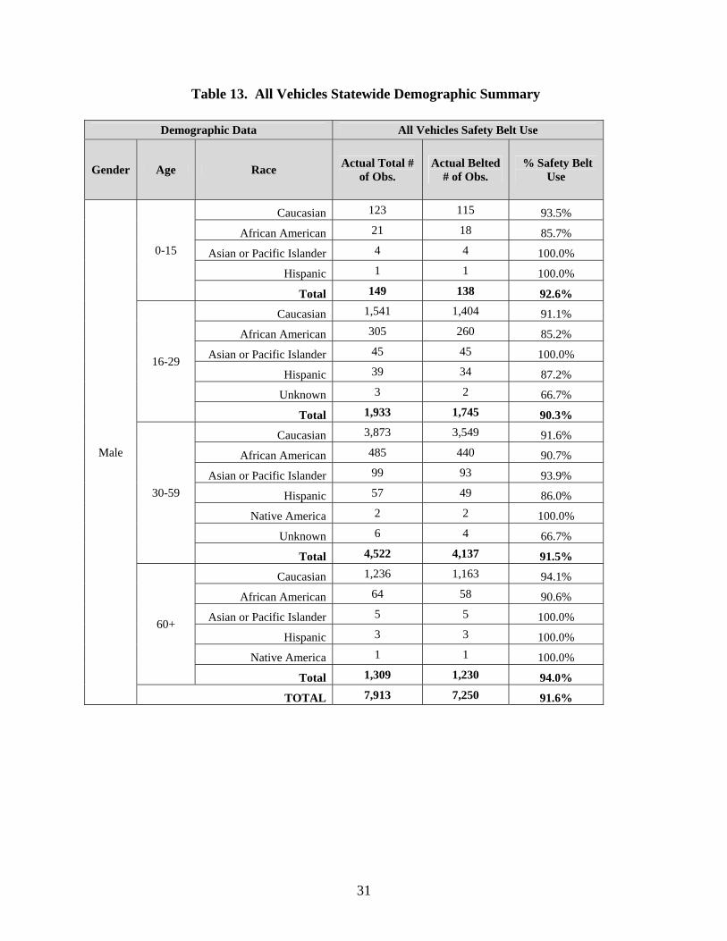
Table 13 summarizes occupant safety belt use rates by gender, age, and race. Male African
Americans age 16-29 exhibited the lowest belt use of any demographic group with a use rate of
85.2%. Female occupants age 0-15 also exhibited a low belt use rate with 89.7%. Females age
30-59 exhibited the highest safety belt use rate at 95.7%. Young and male pickup truck
occupants exhibited low safety belt use rates, consistent with past findings.
31
Table 13. All Vehicles Statewide Demographic Summary
Demographic Data All Vehicles Safety Belt Use
Gender Age Race Actual Total #
of Obs. Actual Belted
# of Obs. % Safety Belt
Use
Male
0-15
Caucasian 123 115 93.5%
African American 21 18 85.7%
Asian or Pacific Islander 4 4 100.0%
Hispanic 1 1 100.0%
Total 149 138 92.6%
16-29
Caucasian 1,541 1,404 91.1%
African American 305 260 85.2%
Asian or Pacific Islander 45 45 100.0%
Hispanic 39 34 87.2%
Unknown 3 2 66.7%
Total 1,933 1,745 90.3%
30-59
Caucasian 3,873 3,549 91.6%
African American 485 440 90.7%
Asian or Pacific Islander 99 93 93.9%
Hispanic 57 49 86.0%
Native America 2 2 100.0%
Unknown 6 4 66.7%
Total 4,522 4,137 91.5%
60+
Caucasian 1,236 1,163 94.1%
African American 64 58 90.6%
Asian or Pacific Islander 5 5 100.0%
Hispanic 3 3 100.0%
Native America 1 1 100.0%
Total 1,309 1,230 94.0%
TOTAL 7,913 7,250 91.6%

32
Table 13. All Vehicles Statewide Demographic Summary (Continued)
Demographic Data All Vehicles Safety Belt Use
Gender Age Race Actual Total #
of Obs. Actual Belted
# of Obs. % Safety Belt
Use
Female
0-15
Caucasian 92 81 88.0%
African American 19 18 94.7%
Asian or Pacific Islander
4 4 100.0%
Hispanic 1 1 100.0%
Total 116 104 89.7%
16-29
Caucasian 1,453 1,381 95.0%
African American 292 259 88.7%
Asian or Pacific Islander
39 38 97.4%
Hispanic 12 11 91.7%
Unknown 1 1 100.0%
Total 1,797 1,690 94.0%
30-59
Caucasian 3,226 3,107 96.3%
African American 523 480 91.8%
Asian or Pacific Islander
95 94 98.9%
Hispanic 32 29 90.6%
Native American 3 2 66.7%
Total 3,879 3,712 95.7%
60+
Caucasian 1,018 968 95.1%
African American 58 55 94.8%
Asian or Pacific Islander
10 9 90.0%
Hispanic 2 2 100.0%
Total 1,088 1,034 95.0%
TOTAL 6,880 6,540 95.1%

33
Figure 2 summarizes the findings of the 2004 through 2012 Annual Observation Surveys. The
2012 Annual Survey resulted in a 1% decrease in safety belt use as compared to the 2011
observational survey. This continues a decreasing trend dating back to 2009.
Based upon these safety belt use rate trends, continued public awareness and enforcement efforts
are warranted to increase safety belt use. Continued evaluation of these media and enforcement
efforts will allow for the identification of at-risk vehicle occupants and geographic areas that are
prone to low belt use rates.
Figure 2. 2004 through 2012 Safety Belt Use Rate Trends
As shown in this study, males and pick-up truck drivers continue to exhibit lower use rate. Belt
use was also found to lag behind the state average in urban and lowly populated rural areas.
These areas should be emphasized in subsequent program efforts.
90.5
92.9
94.3
93.7
97.2
97.9
95.294.6
93.6
85
87
89
91
93
95
97
99
2004 2005 2006 2007 2008 2009 2010 2011 2012
Safety Belt Use Rate (%)
Observational Survey Year

34
REFERENCES
1. NHTSA’s National Center for Statistics and Analysis, “Traffic Safety Facts - Safety Belt Use
in 2011 – Overall Results”, U.S. Department of Transportation, DOT HS 811 544, December
2011.
2. NHTSA’s National Center for Statistics and Analysis, “Traffic Safety Facts - Safety Belt Use
in 2011 - Use Rates in the States and Territories”, U.S. Department of Transportation, DOT
HS 811 651, August 2012.
3. NHTSA’s National Center for Statistics and Analysis, “Traffic Safety Facts – 2011 Motor
Vehicle Crashes: Overview”, U.S. Department of Transportation, NHTSA, DOT HS 811
701, December 2012.
4. “The National Initiative for Increasing Safety Belt Use Buckle Up America Campaign,”
Eight Report to Congress, Sixth Report to the President, U.S. Department of Transportation,
NHTSA, September 2005.
5. NHTSA’s National Center for Statistics and Analysis, “Traffic Safety Facts - 2010 Data –
Occupant Protection”, U.S. Department of Transportation, NHTSA, DOT HS 811 619.
6. Cochran, W.W., (1977). Sampling Techniques, 3rd Edition. New York, New York. Wiley
Publishing.

35
APPENDIX I – COMPLETE LISTING OF THE OBSERVATIONAL
SITES IN MICHIGAN BY STRATUM AND COUNTY, INCLUDING
OBSERVATIONAL DATA FOR EACH SITE

36
Stratum County Observational SiteActual Total
ObservationsActual Belted Observations
Weighted Total
Observations
Weighted Belted
Observations
1 Ingham Haslett and Zimmer 49 47 49 471 Ingham Barnes and Eden 27 26 27 261 Ingham Marsh and Tihart 50 46 56 521 Ingham M-36 and M-52 32 30 41 391 Ingham Oak St. (Rossman) and South Onondaga Rd. 55 46 72 601 Ingham Cedar and US-127 105 104 147 1451 Ingham M-106 and M-52 37 30 65 531 Ingham M-52 and M-43 89 84 231 2181 Ingham North Hagadorn and East Lake Lansing 76 74 276 2691 Ingham M-43 and Williamston 88 81 440 4051 Ingham I-496 and Dunckel 83 80 492 4751 Ingham Cavanaugh and Pennsylvania 84 82 506 4941 Ingham Michigan and Waverly 127 124 288 2811 Ingham US-127 and Saginaw 145 138 1888 17971 Kalamazoo U Ave. and 8th 41 40 55 541 Kalamazoo M-89 and 34th St. 37 33 54 481 Kalamazoo G and Riverview 99 88 151 1341 Kalamazoo Sprinkle and Centre 33 32 61 591 Kalamazoo M-89 and M-43 61 55 133 1201 Kalamazoo Sprinkle and H 57 53 151 1411 Kalamazoo 8th and Q Ave. 77 74 260 2501 Kalamazoo M-43 and 9th 87 83 364 3481 Kalamazoo G Ave. and 32nd-33rd St. 143 140 768 7521 Kalamazoo Sprinkle and Zylman 49 47 308 2951 Oakland 9 Mile Rd. and Taft Rd. 105 102 213 2071 Oakland Dixie and Davisburg 140 132 337 3171 Oakland Holly and Grange Hall 196 184 672 6311 Oakland Baldwin and Clarkston 106 101 371 3541 Oakland Lapeer and Walton 86 84 304 2971 Oakland I-75 and Sashabaw 94 86 403 3691 Oakland Northwestern and Middlebelt 90 85 392 3701 Oakland 8 Mile Rd. and M-10 86 81 555 5221 Oakland Grand River Ave. and Taft Rd. 100 96 671 6441 Oakland I-696 (Eastbound Service Dr.) and Woodward 75 68 609 5531 Oakland Rochester and Snell 77 75 727 7081 Oakland 14 Mile and Main St. 68 64 709 6681 Oakland I-696 and Orchard Lake Rd. 102 101 1196 11841 Washtenaw Dixboro and Territorial 15 15 15 151 Washtenaw Zeeb Rd. and North Territorial 4 4 4 41 Washtenaw Saline-Milan and Mooreville 44 44 45 451 Washtenaw Austin and Schneider 66 60 129 1171 Washtenaw Mooreville and Stony Creek 78 76 160 1551 Washtenaw Geddes and Dixboro 130 125 367 3531 Washtenaw North Maple Rd. and Miller 129 124 532 5111 Washtenaw Ann Arbor-Saline and South Main St. 154 149 686 6641 Washtenaw I-94 and Jackson Ave. 96 92 437 4191 Washtenaw I-94 and Huron 141 133 1066 10061 Washtenaw I-94 Eastbound Exit Ramp and South State St. 141 135 1152 1103

37
Stratum County Observational SiteActual Total
ObservationsActual Belted Observations
Weighted Total
Observations
Weighted Belted
Observations
2 Bay I-75 and Pinconning 35 33 35 332 Bay M-61 and M-30 110 102 110 1022 Bay Adams and Kochville 122 120 165 1622 Bay Munger and M-15 (Tuscola) 64 62 111 1072 Eaton Nixon and Willow 84 77 107 982 Eaton Royston Rd. and Island Highway 42 37 57 502 Eaton M-43 and M-50 56 53 82 782 Eaton Washington St. and East Lawrence Ave. 59 49 90 752 Eaton Ainger Rd. and Battle Creek Rd. 18 12 28 192 Eaton West Kalamo Hwy. and Battle Creek Rd. 25 22 49 432 Eaton M-43 and Canal 195 183 1181 11092 Grand Traverse US-31 and M-72 97 93 502 4822 Jackson Cady and Wolflake 40 36 40 362 Jackson Rosehill and Elm 80 75 91 852 Jackson US-127 and East Michigan Ave. 97 92 146 1392 Jackson Michigan and Lake 78 70 205 1842 Jackson US-127 and Page 70 65 191 1772 Kent 17 Mile and Myers Lake 36 28 36 282 Kent 14 Mile and Harvard 37 34 37 342 Kent 10 mile and Wabasis 20 19 23 222 Kent Barfield and Glen Echo 38 35 48 442 Kent Sparta and Ball Creek 49 41 64 542 Kent Walker and 4 Mile 94 89 153 1452 Kent 36th St. and Paris 39 38 108 1052 Kent US-131 and 68th 94 92 506 4952 Kent US-131 and 10 Mile 67 67 376 3762 Kent US-131 and 84th 81 75 497 4602 Macomb 34 Mile and Van Dyke 61 53 61 532 Macomb Martin and Jefferson 43 37 51 442 Macomb 27 Mile and Romeo Plank 55 48 79 692 Macomb 22 Mile and Heydenreich 102 94 152 1402 Macomb Moravian and Harrington 69 66 257 2462 Macomb Clinton River and Hayes 60 59 447 4402 Macomb 23 Mile and Van Dyke 112 104 849 7882 Macomb I-696 and Groesbeck 112 105 864 8102 Macomb 19 Mile and Mound 97 87 762 6842 Midland M-20 and Homer Rd. 46 45 46 452 Midland Redstone and 11 Mile 61 58 67 642 Midland Curtis and Lake Sanford 38 36 44 422 Midland Redstone and Coleman 44 38 55 482 Midland Badour and Pine River Rd. 39 39 111 1112 Monroe US-23 and Plank Rd. 54 54 54 542 Monroe Hull and Dunbar 70 60 83 712 Monroe Ostrander and Plank 55 49 75 672 Monroe US-23 and US-233 48 44 92 852 Monroe Ann Arbor and Tecumseh 164 154 352 3312 Monroe Telegraph and Seventh 120 114 526 4992 Ottawa 104th and Quincy 21 20 21 202 Ottawa Olive and Lake Michigan 88 84 137 1312 Van Buren CR-681 and CR-384 44 41 44 412 Van Buren CR-681 and CR-380 35 34 40 382 Van Buren I-196 and Phoenix 79 76 154 1482 Van Buren M-51 and North Phelps St. 64 60 200 188

38
Stratum County Observational SiteActual Total
ObservationsActual Belted Observations
Weighted Total
Observations
Weighted Belted
Observations
3 Allegan US-131 and M-89 94 86 145 1333 Allegan 30th and 128th 21 21 33 333 Allegan Bridge and Main 85 79 213 1983 Allegan US-131 and 135th 97 92 387 3673 Berrien Union Pier and Lakeside 36 34 36 343 Berrien I-94 and I-139 100 96 204 1963 Berrien Sodus/Nickerson and Pipestone 75 70 214 2003 Calhoun Michigan Ave. and 15 Mile Rd. 68 66 68 663 Calhoun Evanston and Michigan Ave. 16 15 16 153 Calhoun I-94 and Beckley 60 57 141 1343 Calhoun Beckley and Capital 187 176 830 7823 Clinton Upton and Clark 27 26 27 263 Clinton M-21 and Shepardsville 44 36 61 503 Clinton Main and Westphalia 73 66 133 1213 Clinton Hyde and Welling 58 48 107 893 Clinton M-21 and Clinton (Alternate) 67 60 283 2543 Genesee Grand Blanc and Duffield 31 29 36 333 Genesee Elms and Beecher 170 158 435 4043 Genesee Flushing and Balleuges 120 101 485 4083 Genesee Vassar and M-57 6 6 30 303 Genesee M-57 and I-75 151 139 940 8663 Genesee Chavez and Court 106 98 755 6983 Ionia Cross and Main 44 41 66 623 Ionia Bridge and State Street 85 81 247 2363 Isabella Winn and Blanchard 57 53 60 563 Lapeer M-24 and Coulter 7 5 20 143 Lapeer M-24 and Otter Lake 36 33 273 2503 Lenawee US-12 and Brooklyn 62 57 62 573 Lenawee Pentecost and Monroe 16 14 20 183 Lenawee Clinton Macon and Macon 58 54 137 1273 Livingston M-36 and M-106 46 43 54 513 Livingston Grand River and Pleasant Valley Rd. 121 115 277 2633 Livingston US-23 and Clyde Rd. 91 88 269 2613 Livingston Grand River and Kensington Rd. 102 91 338 3013 Livingston M-36 and Dexter 91 85 357 3333 Livingston M-59 and Old US-23 67 60 869 7783 Marquette M-95 and CR-LG 9 7 11 93 Marquette Washington and McClellan 86 82 899 8573 Montcalm M-91 and Sidney 60 57 60 573 Montcalm Main and Sibley 42 29 42 293 Montcalm Main and Condensery 18 14 28 223 Muskegon Blackmer and Heights Ravenna 33 25 33 253 Muskegon Heights Ravenna and Moorland 30 27 39 363 Muskegon Heights Ravenna and Maple Island 75 70 107 1003 Saginaw Fergus and Bueche 43 38 43 383 Shiawasee M-52 and I-69 64 58 69 623 Shiawasee Juddville and Chipman 63 59 90 843 Shiawasee Grand River and M-52 33 32 47 463 St. Clair M-19 and Bordman 49 47 70 673 St. Clair I-69 and Riley Center Rd 46 44 77 733 St. Clair M-29 and Palms 79 76 216 2083 St. Joseph Klinger Lake and Banker St. 30 30 55 553 St. Joseph US-131 and Millard 86 81 1061 999

39
Stratum County Observational SiteActual Total
ObservationsActual Belted Observations
Weighted Total
Observations
Weighted Belted
Observations
4 Wayne Waltz and Willow 130 118 130 1184 Wayne Huron River and Waltz 32 23 36 264 Wayne Van Horn and Inkster 114 109 171 1644 Wayne Sumpter and Oakville Waltz 50 50 82 824 Wayne Ecourse and Haggerty 89 86 146 1414 Wayne Rawsonville and Willis 78 70 139 1254 Wayne Ecorse and Monroe 89 79 177 1574 Wayne McNichols and Evergreen 101 85 253 2134 Wayne Geddes and Canton Center 157 148 445 4204 Wayne East Huron River and Haggerty 102 92 291 2634 Wayne Wayne and Wick 97 92 289 2744 Wayne Main and Sumpter 122 117 394 3784 Wayne Schaefer and Grand River 104 91 336 2944 Wayne 7 Mile and Van Dyke 86 77 307 2754 Wayne Vernier and Lake Shore Dr. 121 113 444 4144 Wayne Warren and Woodward 57 51 218 1954 Wayne Middlebelt and Eureka 135 131 517 5024 Wayne Plymouth and Greenfield 103 84 396 3234 Wayne I-96 and Livernois 111 98 455 4024 Wayne Fort St. and Goddard St. 108 101 553 5174 Wayne 8 Mile Rd. and Randolph 111 108 588 5724 Wayne Farmington and Plymouth 76 73 423 4074 Wayne Rawsonville and Textile 87 81 487 4544 Wayne Warren and Evergreen 91 85 553 5164 Wayne Eureka and Telegraph 141 134 861 8184 Wayne 9 Mile and Greenfield 89 80 544 4894 Wayne Vernier and Mack 158 147 984 9164 Wayne I-94 and Vernier 144 136 999 9434 Wayne I-75 and Southfield Rd. 101 98 754 7324 Wayne Ford and Sheldon 119 112 906 8534 Wayne Northline and I-75 102 97 900 8564 Wayne Jefferson and Randolph 128 116 1196 10844 Wayne Greenfield and Michigan Ave 86 72 951 7964 Wayne 8 Mile and Grand River 82 77 988 9284 Wayne I-96 and Middlebelt (Service Dr.) 73 70 982 9424 Wayne Outer Drive and Rotunda Village 69 62 1041 9354 Wayne M-10 (Service Dr.) and Greenfield 72 66 1378 1263


![Conveyor System Utilizing Safety Observation Function · Conveyor System Utilizing Safety Observation Function [System Configuration] ... Engineering environment: MELSOFT MT Works2](https://static.fdocuments.net/doc/165x107/60243d5f1f8eb736204fae91/conveyor-system-utilizing-safety-observation-function-conveyor-system-utilizing.jpg)